Azores International Research Center
52
Towards a Science and Technology agenda for an integrative approach to the Atlantic: Climate Change and Energy Systems, Space and Ocean Sciences, through North-South cooperation Azores International Research Center (AIR Center) A work in progress towards a white paper to be developed by an International Scientific Committee promoted by the Fundação para a Ciência e a Tecnologia (FCT), together with an open international consultation process and a series of research workshops: Preparatory events: Workshop 1, Institute of International Education (IIE), New York City – US, June 10 th Workshop 2, University of Azores (UAç), Ponta Delgada, Azores – PT, June 27 th Workshop 3, “Ciência 2016”, Lisbon – PT, July 4 th Workshop 4, European Space Agency (ESA), Paris – FR, August 29 th Workshop 5, Parque Tecnológico de São José dos Campos, BR, September 6th Workshop 6, Portuguese Permanent Representation to the EU, Brussels – BE, September 19 th Workshop 7, Maloka, Bogotá, COL, October 5 th Workshop 8, Brasilia - BR, October, 31 st Forthcoming events, to be confirmed: United States of America, Morocco, South Africa; November and December 2016 Fundação para a Ciência e a Tecnologia (FCT), Portugal October 2016 – Draft version for discussion
-
Upload
truonghanh -
Category
Documents
-
view
231 -
download
1
Transcript of Azores International Research Center
Towards a Science and Technology agenda
for an integrative approach to the Atlantic:
Climate Change and Energy Systems, Space and Ocean
Sciences, through North-South cooperation
Azores International Research Center (AIR Center)
A work in progress towards a white paper to be developed by an International Scientific Committee
promoted by the Fundação para a Ciência e a Tecnologia (FCT),together
with an open international consultation process and a series of research workshops:
Preparatory events:
Workshop 1, Institute of International Education (IIE), New York City – US, June 10th
Workshop 2, University of Azores (UAç), Ponta Delgada, Azores – PT, June 27th
Workshop 3, “Ciência 2016”, Lisbon – PT, July 4th
Workshop 4, European Space Agency (ESA), Paris – FR, August 29th
Workshop 5, Parque Tecnológico de São José dos Campos, BR, September 6th
Workshop 6, Portuguese Permanent Representation to the EU, Brussels – BE, September 19th
Workshop 7, Maloka, Bogotá, COL, October 5th
Workshop 8, Brasilia - BR, October, 31st
Forthcoming events, to be confirmed:
United States of America, Morocco, South Africa; November and December 2016
Fundação para a Ciência e a Tecnologia (FCT), Portugal
October 2016 – Draft version for discussion

This page was intentionally left blank
Towards a research and technological agenda for an Azores International Research Center (AIR)
2
Scientific Committee (preliminary, invitations in progress):
• Paulo Ferrão, FCT- Portuguese Science and Technology Foundation, PT (Chair)
• Eric Lindstrom, NASA, USA (Co-Chair)
• Ana Colaço, IMAR Azores, PT
• Byron Tapley, The University of Texas at Austin, USA
• Daniel Stanzione, The University of Texas at Austin, USA
• Eduardo Brito de Azevedo, University of Azores, PT
• Helene Hurby, AIRBUS Innovation, FR
• Jean Jacques Dordain, MCTES, FR
• João Tasso de Sousa, University of Porto, PT
• John Cortinas, NOAA, USA
• José Manuel Fonseca de Moura, Carnegie Mellon University, USA
• Juan Sanchez, The University of Texas at Austin, USA
• Karl Stromssen, Global Maritime, NO
• Manuela Veloso, Carnegie Mellon University, USA
• Marco Bravo, The University of Texas at Austin, USA
• Michael Webber, The University of Texas at Austin, USA
• Miguel Miranda, IPMA, PT
• Miguel Bello Mora, Elecnor-Deimos, SP
• Ned Dwyer, EurOcean, IE
• Patrick Heimbach, The University of Texas at Austin, USA
• Robert Peterson, The University of Texas at Austin, USA
• Sally MacFarlane, US Dept of Energy, USA
• Scott Van Broekhoven, MIT Lincoln Lab, USA
• Zong-Liang Yang , The University of Texas at Austin, USA

Towards a research and technological agenda for an Azores International Research Center (AIR)
3
This page was intentionally left blank

Towards a research and technological agenda for an Azores International Research Center (AIR)
4
Preface
A commitment to knowledge towards future transatlantic and north-south cooperation
The preparation of this white paper has been associated with an open and new debate about
multilateral cooperation in complex systems engineering and science towards an integrative
approach to space, climate change and energy, earth and ocean science in the Atlantic,
together with emerging methods of data science. The ultimate goal is to help building the
future through an effective commitment to science and knowledge and North-South
cooperation.
Our commitment is to foster networks of opportunity to help future generations build a better
future.
We are entering critical times that require the creation of conditions able to strengthen
knowledge-based international cooperation. Lessons learned over the last decades with
international partnerships in science, technology and higher education, including those
established over the last decade between Portuguese and US universities, among many other
intergovernmental scientific ventures, have clearly shown that the future can only be built
with more knowledge, more culture and more exchange of ideas.
A new paradigm of structured international research relationships is emerging shaped by a
new era of government and industry intervention in association with knowledge. Cross-
disciplinary new frontier research should be the result of ambitious initiatives yet to be
developed or stimulated from the huge potential of intergovernmental research laboratories
and joint ventures. It is under this context that the debate of the potential installation of an
Azores International Research Center (AIR Centre) is focused on. This debate is centered under
two main priorities: i) new data collection for innovative research; and ii) synergies Sea/Space
towards new knowledge production and diffusion.
Our ambition is driven by an increased perception by society of the growing evidence for the
potential benefits resulting from the human, social and economic appropriation of the results
and methods of science. We aim to stimulate the necessary knowledge-driven conditions to
build in Azores an intergovernmental research center with strong international cooperation
and better use the strategic Atlantic positioning of Azores and Portugal to foster North-South
cooperation in science and technology. By promoting new knowledge on climate change and
Towards a research and technological agenda for an Azores International Research Center (AIR)
5
related issues in the Atlantic, we are fostering conditions to provide the world with more
science, more knowledge and more scientific culture. By facilitating the access to space from
the unique position of Azores we are promoting access to new frontiers of knowledge,
together with the development of new space industries. Also, by promoting new research in
the Azores´s deep-sea we facilitate the access to a better understanding of living organisms in
extreme environments and new energy sources.
The sustainable future of our society requires more knowledge and more scientific culture,
ensuring the access to science and education as an inalienable right of all. More science and
the systematic democratization of access to knowledge means more equal opportunities,
more social mobility and a new stimulus for entrepreneurial activities and well-being.
Manuel Heitor
Minister for Science, Technology and Higher Education, Portugal

Towards a research and technological agenda for an Azores International Research Center (AIR)
6
Table of Contents TABLE OF CONTENTS ............................................................................................................. 6PART I - A VISION TO EXPLORE THE NORTH AND SOUTH ATLANTIC THROUGH AN AZORES INTERNATIONAL RESEARCH CENTER ...................................................................................... 7
1 THE ATLANTIC.........................................................................................................................................72 ISLAND RESEARCH STATIONS..................................................................................................................103 THE AZORES ARCHIPELAGO.....................................................................................................................12
PART II - A RESEARCH AND TECHNOLOGICAL AGENDA FOR AN AZORES INTERNATIONAL RESEARCH CENTER ............................................................................................................... 16
4 ATMOSPHERIC SCIENCE AND CLIMATE CHANGE FOR THE ATLANTIC.............................................................164.1 UNIQUENESS OF THE AZORES...............................................................................................................164.2 KEY RESEARCH CHALLENGES...............................................................................................................164.3. INFRASTRUCTURES AND OTHER RESOURCES..........................................................................................19
4.3.1. Existing Infrastructures.............................................................................................................194.3.2. Potential additional resources..................................................................................................20
5 ENERGY SYSTEMS FOR THE ATLANTIC......................................................................................................215.1 UNIQUENESS OF THE AZORES...............................................................................................................215.2 KEY RESEARCH CHALLENGES...............................................................................................................225.3 INFRASTRUCTURES AND OTHER RESOURCES...........................................................................................24
5.3.1 Existing infrastructures..............................................................................................................245.3.2 Potential additional resources...................................................................................................24
6 OCEAN SCIENCE AND TECHNOLOGY FOR THE ATLANTIC.............................................................................266.1 UNIQUENESS OF THE AZORES...............................................................................................................266.2 KEY RESEARCH CHALLENGES...............................................................................................................266.3 INFRASTRUCTURES AND OTHER RESOURCES...........................................................................................29
6.3.1 Existing Infrastructures..............................................................................................................296.3.2 Potential additional resources...................................................................................................30
7 DATA SCIENCE FOR THE ATLANTIC...........................................................................................................317.1. UNIQUENESS OF THE AZORES..............................................................................................................317.2 KEY RESEARCH CHALLENGES................................................................................................................317.3 INFRASTRUCTURES AND OTHER RESOURCES...........................................................................................32
7.3.1 Potential additional resources....................................................................................................328 SPACE SCIENCE AND TECHNOLOGY FOR THE ATLANTIC..............................................................................338.1 UNIQUENESS OF THE AZORES...............................................................................................................338.2 OPPORTUNITIES FOR INTERNATIONAL COLLABORATION..........................................................................35
8.3.1 Existing infrastructures..............................................................................................................408.3.2 Open Portugal´s Space sector to international players and “New Space Industries”.................408.3.3. Potential additional resources..................................................................................................41
PART III – PROMOTING INTERNATIONAL NORTH-SOUTH COOPERATION FOR KNOWLEDGE, RESEARCH AND BUSINESS ACROSS THE ATLANTIC .............................................................. 42
9 TOWARDS AN INTERGOVERNMENTAL ORGANIZATION, FOSTERING NORTH-SOUTH COOPERATION.................4210 TOWARDS DEVELOPING NEW NORTH-SOUTH ATLANTIC RESEARCH AGENDA.............................................4310. 1 EXPANDING AND COMPLEMENTING ATLANTOS TOWARDS NEW HORIZONS IN NORTH-SOUTH ATLANTIC
COOPERATION..........................................................................................................................................4310.2 OPPORTUNITY FOR A NEW RESEARCH INFRASTRUCTURES OF PAN-EUROPEAN INTEREST...........................43
10.2.1. Research Infrastructure on Sustainable Energy Systems........................................................4510.2.2. North-South Atlantic Interdisciplinary Research Infrastructure..............................................46
10.3 PATHWAYS TOWARDS NEW NORTH-SOUTH ATLANTIC RESEARCH INFRASTRUCTURES..............................4711 KNOWLEDGE FOR SPACE – SPACE FOR KNOWLEDGE: AN OPPORTUNITY FOR COOPERATION.........................49
ANNEX: LIST OF CONTRIBUTORS TO THE DRAFT DOCUMENT ............................................... 51

Towards a research and technological agenda for an Azores International Research Center (AIR)
7
Part I - A vision to explore the North and South Atlantic through an Azores International Research Center
1 The Atlantic
Science is an essential tool for rationally addressing critical societal challenges such as those
concerning climate change by intertwining space, ocean and energy systems. The importance
of an integrative approach drives the current efforts to establish an International Research
Center in the Azores as it offers a unique location in the middle of the Atlantic Ocean, bridging
the American, European and African continents, particularly suited to provide unique data on
the Ocean and to study its interactions with atmosphere and space.
The Atlantic Ocean comprises about 20% of the Earth´s surface. It borders the Americas,
Europe, Africa and the Arctic region and is today still understudied in terms of its natural
resources, ecosystems dynamics and interdependences with human activities. It is clear that a
better understanding of the Atlantic in terms of its response to climate change and for the
sustainable management of common resources entails the alignment of research strategies
through international cooperation. In this regard, the Azores International Research (AIR)
Center enables that cooperation and will provide an ideally located center of excellence and a
unique venue to address issues that impact society on a global level.
Climate Change research is one area that will benefit the most from the establishment of an
AIR Center since a changing climate is directly associated with a dynamic Ocean and benefits
from Space driven observation and monitoring systems. In particular, it is estimated that 90%
of the excess energy accumulated in the climate system since 1971 is stored in the Ocean, and
that 30% of human-emitted carbon has ended up in the Ocean, causing ocean acidification.
Significant heat absorbed by the ocean through spatially and temporally varying atmosphere-
ocean energy and momentum exchanges has been redistributed internally and sequestered at
depth through complex dynamic mechanisms involving waves, ocean currents, small-scale
eddies, and other processes. Biogeochemical tracers transferred to the ocean through
air-sea-gas exchanges and, in particular, carbon dioxide and oxygen, have been redistributed
in similar ways. That absorbed energy has caused thermal expansion of the oceans, which is
responsible for about half of the rise in sea level to date.
Towards a research and technological agenda for an Azores International Research Center (AIR)
8
Accurately projecting the future path of climate change and monitoring whether current
mitigation efforts are reversing unsustainable pathways requires a sustained, globally
distributed ocean-observing system, especially at depths where very few observations
currently exist, as well as detailed measurement of atmospheric circulation changes, along
with the determination of the Earth’s net radiative imbalance from space. Seasonal to decadal
climate information is needed to improve seasonal predictions, El Niño forecasts, and other
climate phenomena manifest that are crucial for agriculture, water management, and disaster
risk reduction. Operational climate information (days to months) is needed because sustained
ocean observations underpin early warnings for ocean-related coastal hazards, such as storm
surges and hurricane predictions, as well as more accurate medium-range weather forecasts
that can improve the safety and efficiency of the maritime economy.
We also need to develop better models that clarify human impact on the oceans ecosystems
and the basic ecosystem services of coastal protection, food security, and tourism that enable
coastal livelihoods and the blue economy. Our knowledge here is still evolving through
research and leaps forward when we have sustained ocean observations to validate our
theories.
Energy dependency is another great challenge that cannot be disassociated from Climate
change. There is a growing need for more efficient, more renewable, more cost-effective
Energy systems which can allow the crescent diminish of our dependency from non-
renewable fuel energy sources while maintaining energy security, economic growth, and
environmental goals.
Space science and technology can play a major role in the Atlantic, and includes the provision
of access to space through safe and reliable spaceports, satellite control and data
transmission and collection. Satellite data processing opens opportunities for new ventures
with economic, environmental and social impact, namely in areas such climate change and
sustainable energy systems design, fisheries and aquaculture, maritime safety and security,
managing marine resources including the support required for deep-sea mining, as well as
characterizing the renewable energy potential in the Atlantic islands and coastal environment.
Space is thus critical to address climate change and sustainable energy systems design
challenges as well as for ocean exploitation.

Towards a research and technological agenda for an Azores International Research Center (AIR)
9
Permanent and persisting observation systems are required to observe, monitor and collect
reliable data in order to improve local and global models. Such models should improve
understanding of the complex earth system, enable the assessment and monitoring of human
activities, and inform decision-making in a number of different areas of key importance that
lead to human well-being and to sustainable growth of nations. Integrated large-scale
environmental observations are absolutely critical for producing an efficient and effective
data system in any environment. Therefore, there is a need to develop advanced data and
network systems that include space, air, ground, and ocean-integrated instruments allowing
sustained data gathering to produce better, more accurate models that serve all the
disciplines involved.
Addressing these challenges mandates international cooperation and interdisciplinary
collaboration. This white paper proposes an international research center committed to the
study of climate change, energy, space, and oceans issues in the Atlantic Ocean as a key
enabling infrastructure to successfully tackle these pressing challenges.

Towards a research and technological agenda for an Azores International Research Center (AIR)
10
2 Island Research Stations
Island research stations are well placed to enable the advances of frontier research in the 21st
century. Darwin’s expedition to the Galapagos Islands had a paramount influence on the
practice of modern science and highlighted the importance of islands and archipelagos for
scientific progress.
For research purposes, an island has the advantage of making available relatively small but
complete, and for the most part closed, ecosystems that are perfectly suitable for holistic
studies through experiment and observation of natural processes. In other words, they
represent natural laboratories enabling and facilitating the design of scientific studies of
international relevance. In this sense island research stations are perfect for designing and
achieving those direct and precise observations especially required for studying biophysical
phenomena, but also for validating concepts, techniques, and methodologies, particularly in
remote places or in circumstances of scarcity of reliable platforms.
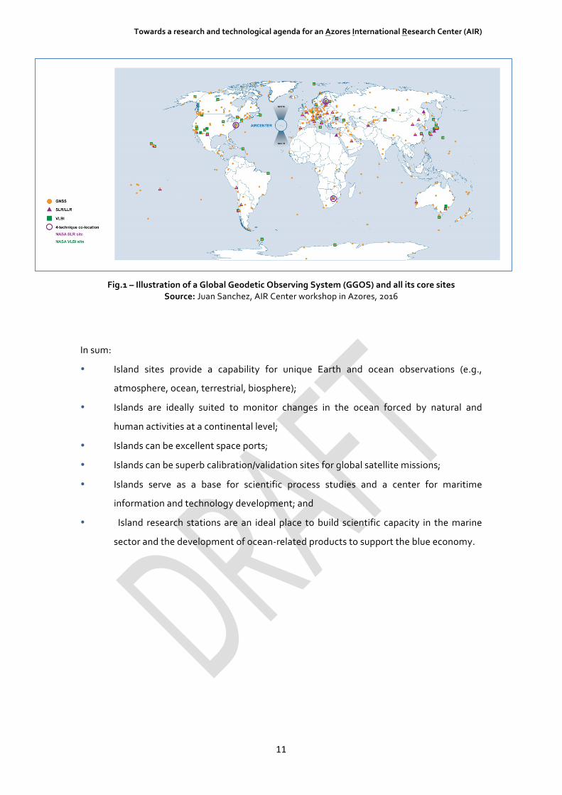
As an example, Figure 1 illustrates the composition of a global geodetic observing system
(GGOS) and all its core sites. Including the AIR Center as one reference point in this global
network of geodetic science incorporates both infrastructure and data to support global
change research in Earth system sciences. And, when combined with space and ground
segments, opens new research areas such as global reference frames (a basis for precision
metrology – positioning, and gravimetry), regional coastal hazard assessment (measurement,
vulnerability, and science), global sea-level measurement (climate and Earth system science),
global essential climate variables, and space weather and signal propagation (ionosphere,
troposphere, scintillation, etc.). This combination would be symbiotic with the development
of new capabilities and state of the art technologies and a space port for small satellite
launching.
Towards a research and technological agenda for an Azores International Research Center (AIR)
11
Fig.1 – Illustration of a Global Geodetic Observing System (GGOS) and all its core sites Source: Juan Sanchez, AIR Center workshop in Azores, 2016
In sum:
• Island sites provide a capability for unique Earth and ocean observations (e.g.,
atmosphere, ocean, terrestrial, biosphere);
• Islands are ideally suited to monitor changes in the ocean forced by natural and
human activities at a continental level;
• Islands can be excellent space ports;
• Islands can be superb calibration/validation sites for global satellite missions;
• Islands serve as a base for scientific process studies and a center for maritime
information and technology development; and
• Island research stations are an ideal place to build scientific capacity in the marine
sector and the development of ocean-related products to support the blue economy.

Towards a research and technological agenda for an Azores International Research Center (AIR)
12
3 The Azores Archipelago
The Azores Archipelago’s privileged location (as depicted in Fig. 2) in the middle of the
Atlantic Ocean, with its unique environmental characteristics, biodiversity and accessibility to
the different ecosystems, provides an undeniable competitive advantage for studying oceanic
attributes and processes, Energy, Climate change and Space.
Fig.2 – Island Research Stations across the world and the Azores archipelago location
The Azores archipelago is located in the northeast Atlantic in the midst of complex ocean
currents which transport important water masses impacting climate; moreover, symbiotic
datasets among the Azores, Madeira and Portugal can provide flux measurements which
single point data sets cannot.
Hereby are highlighted some of its main unique features
• The marine ecosystems and oceanographic conditions associated with the Mid-
Atlantic-Ridge confers a unique opportunity for deep-sea research (ecosystem
science, biodiversity and geodiversity; economic activities). The Azores Exclusive
Economic Zone (EEZ) covers about 1 million km2, of which about 99% is deep sea
(defined here as below 200 meters depth), with more than 450 seamounts, several
known hydrothermal vent fields, deep fracture zones and trenches, deep and isolated

Towards a research and technological agenda for an Azores International Research Center (AIR)
13
holes and basins, and a considerable extension of the Mid-Atlantic Ridge (MAR) and
abyssal areas;
• It sits over the Azores Triple Junction (ATJ) where the North American, Eurasian and
African tectonic plates meet over a divergent tectonic system that is of fundamental
importance in geology and geophysics, as well as provides an avenue to explore sub-
seafloor processes. The chemical and biological processes that are impacted by the
geological processes at the Ridge are of potential global significance. Establishment
of a long-term observing presence on the Azores would be of great value scientifically;
• The proximity and accessibility to the open ocean and to the diverse ecosystems of
the deep sea present unique possibilities in the Azores region for ocean observation
systems and research on ocean-atmosphere interaction and other climate change-
related issues
• The Azores are located in the path of intense meteorological and oceanographic
activity that arises from the collision of warm air and sea water coming from the
south, against colder air and colder water that comes from north, in evolution along
the Gulf Stream and Polar Front;
• As part of the Meridional Overturning Circulation in the North Atlantic, which has
been identified as a highly important but poorly understood aspect of the Earths
climate system, the Azores Current is a topic of significance in physical oceanography;
• The geostrategic position of the Azores is serving space missions through a range of
ground segment infrastructures presently operating. This small infrastructure cluster
contributes to a new growth paradigm for the upstream and downstream space
industry in relation to the “newspace” market (e.g., implementing a European
spaceport in the Azores or promote the development of small launchers);
• The archipelago of the Azores offers a set of unique features for studying the
transition from prototype to sustainable energy systems. First, it is composed of nine
independent energy systems with different dimensions and contexts, which makes
the Azores a unique multiple scale system. The systems range from Corvo, a small
rural island with 500 inhabitants, to São Miguel, a “services” island with 130,000
inhabitants. Hence, it is possible to test different transition solutions with a diverse
set of socio-economic characteristics and sizes in the controlled environment of the
archipelago;
Towards a research and technological agenda for an Azores International Research Center (AIR)
14
• The Azores has a large and diverse set of renewable endogenous energy resources,
which enables testing different conversion technologies and as well as posing
different integration challenges. Two islands have geothermal resources (São Miguel
and Terceira); all islands in general have high wind resources – in fact some wind parks
in the islands of Terceira and Pico possess very large capacity factors for onshore wind
park (above 30%); some islands possess good solar resources like Santa Maria and
Graciosa; some islands present good biomass resources; and finally all islands face the
challenge of managing their waste.
• The degree of innovation in the energy systems is fostered by the Regional
Government and the local utility (EDA). For many years the island of Flores has
utilized an integrated hydro-wind system with a flywheel that enables it to operate a
significant number of hours in the winter only on renewables. The island of Graciosa
has a very recent project on the integration of batteries and wind and solar. The
islands of São Miguel and Terceira will have pump-hydro storage systems to transfer
excess renewable electricity production from wind and geothermal from off-peak
periods to peak periods; the island of Corvo has a 100% deployment of solar thermal
systems for domestic hot water generation that can be used to integrate renewable
energy resources like wind. There are also a significant number of programs in other
areas, like the promotion of electric vehicles in the islands, which already has some
charging stations, to energy efficiency promotion in the dairy industry.
• As islands’ systems, the set of socio-economic pressures create an environment that is
very prone to develop innovation. The fact that the systems are isolated introduces
an additional constraint of robustness in the development of solutions. Further,
because the distance to the mainland has a large impact on the cost of importing
energy, this facilitates the economics and therefore the business case of most of
green technologies.
The unique “living laboratory” characteristics of the Azores, together with the already existing
infrastructures in the archipelago, make the Azores a prime location for the proposed
international research center that will focus on atmospheric science and climate change,
energy systems, space, and ocean interactions. A dimension of particular relevance that
emerges from these areas is the monitoring and modeling of natural hazards and the related
capacities that have been developed over the years at the University of the Azores.

Towards a research and technological agenda for an Azores International Research Center (AIR)
15
A better understanding of the Atlantic Ocean and the sustainable management of this
common resource require the alignment of research strategies through international
cooperation. Interdisciplinary research able to face the ocean challenges and the economic
transitions, in particular environmental changes, security conditions, and other human
dimensions, almost by definition calls for the design of an international partnership that aims
for resilience and leadership for the Atlantic Ocean and related north-south cooperation in the
following five thematic areas (Figure 3):
i. Atmospheric Science and Climate Change
ii. Energy Systems
iii. Ocean Science and Technology
iv. Data Science
v. Space Science and Technology
Fig. 3 – Five thematic areas for a research agenda towards an AIR Center
Part II of the document elaborates on these five areas and is organized to highlight the
following topics:
• Uniqueness of the Azores
• Key research challenges
• Infrastructures and other potential additional resources
Space andapplications
Energy systems
Ocean Science andTechnology
AtmosphericScience and
ClimateChangeData

Towards a research and technological agenda for an Azores International Research Center (AIR)
16
Part II - A research and technological agenda for an Azores International Research Center
4 Atmospheric Science and Climate Change for the Atlantic
4.1 Uniqueness of the Azores
• Azores sits at a geographic confluence of critical geophysical phenomena close to the
triple junction of the Eurasian, North American, and African plates. The Azores
atmospheric high pressure system constitutes one pole of the North Atlantic Oscillation, a
leading climate phenomenon; the Azores Current is an important branch of the Atlantic
Ocean’s subtropical gyre circulation.
• The local maxima of the subtropical time-averaged wind speed (jet stream) downstream
of the Rocky Mountains over the North Atlantic and associated mid-latitude storm tracks
play a key role in the annual variation of precipitation and northward fluxes of heat and
moisture.
• The richness of marine boundary layer clouds makes the location ideal for maintaining
long-term observations of the responses of shallow marine cloud systems to aerosols and
greenhouse gases, which are a source of uncertainty in global climate models.
• Situated at the southern demarcation of the North Atlantic storm track, the downwind
location from the North American continent, and its impact by continental pollution
aerosol, the air circulation properties of the Azores turns it into a uniquely suited place for
the monitoring of the influx of pollutants into Europe.
• The orographic diversity of the nine islands makes them ideally suited for cloud studies
(e.g., Graciosa) or pollution monitoring (e.g., Pico).
• The proximity of land and deep sea make for an optimal platform to study ocean-
atmosphere interactions, as well as deep-sea ecosystems.
• The Azores is a rare platform for ground-based reference measurements for satellite
comparisons, with few alternatives in the North Atlantic.
4.2 Key Research Challenges
• Understanding local climate and climate change impacts
Small Islands worldwide are highly dependent on their climate and have been identified as
one of the major targets of climate change impacts (IPCC WGII TAR, 2001; IPCC AR4, 2007,
AR5, 2014). Current and future climate-related drivers of risk for small islands during the 21st

Towards a research and technological agenda for an Azores International Research Center (AIR)
17
century include sea-level rise, tropical and extra-tropical cyclones activity, increasing air and
sea surface temperatures and changing rainfall patterns (high confidence, robust evidence,
high agreement). The future risks associated with these drivers include loss of adaptive
capacity and ecosystem services critical to lives and livelihoods in small islands.
However, the analysis of present spatial diversity of climate, climate change scenarios and
impacts in small islands is a difficult task. Islands with horizontal scales of the order of tens of
km are subscale orographic features for most of the Climate Models since the horizontal
scales of these models are too coarse to give a detailed representation of the islands’
topography.
• Understanding the effects of aerosols in the cloud condensation nuclei (CCN) budget
A quantitative understanding of the effects of aerosols in the cloud condensation nuclei (CCN)
budget is currently lacking for some of the processes underlying perturbations of CCN
population by aerosols. Remote marine low cloud systems are particularly susceptible to
perturbations in CCN associated with anthropogenic emissions because of their relatively low
optical thickness and low background CCN concentrations. The CCN population is driven by a
range of processes, including generation of sea spray aerosol through breaking waves,
entrainment of free tropospheric aerosol, and removal of aerosol particles by drizzle. The
indirect effects of aerosols in CCN budget is one of the main research themes at the Eastern
North Atlantic (ENA) Atmospheric Radiation Measurement (ARM) site at Graciosa Island
(28ºW 39ºN).
• Understanding cloudiness transitions, through the integration of in situ ground based,
airborne and satellite data
Marine low cloud fields display coherent mesoscale organization (“mesoscale cellular
convection” or MCC) on horizontal scales of 5 - 100 kilometers. Key processes controlling
MCC are currently not well understood. The horizontal scales of MCC present a significant
modelling challenge to global change models, as the dominant scales are comparable to the
horizontal resolution in the next generation of climate models. There is currently no
consensus on how to characterize MCC in observations and in models that are able to resolve
the relevant scales.
Towards a research and technological agenda for an Azores International Research Center (AIR)
18
Ground-based remote sensing techniques, including ENA-ARM’s new scanning radar and lidar
capabilities, offer new ways to probe mesoscale structure and dynamics. Combining newly
available ground-based views with aircraft and broader-scale satellite data will provide insight
into the structure and dynamics of MCC and how it impacts cloudiness transitions.
• Monitoring the influx of atmospheric pollutants into Europe
The air pollution observatory station at Pico mountain in Pico Island (PICO-NARE, see section
3.3.1), which is located at 2225 meters above sea level, provides a ground base for free
tropospheric measurements on the central North Atlantic region and is suitable for
observation of air pollution and boreal fire plumes from North America, occasional African
dust, and European air pollutant emissions. On the other hand, simultaneously the ENA-ARM
site (Graciosa Island) is downwind of the North American continent and is periodically
impacted by continental pollution aerosol.
• Integration of the atmospheric and ocean information in global climate models
The responses of shallow cloud systems to changes in atmospheric greenhouse gases and
aerosols are major sources of uncertainty that limits the accuracy of predictions of future
climate. Low cloud systems over the remote oceans are a key research challenge because
they are poorly represented in climate models. Interactions between cloud microphysical and
macrophysical processes play a fundamental role in modulating cloud dynamics and,
entrainment and precipitation, which all of which help determine cloud radiative properties
that impact global climate. The ENA-ARM site at Graciosa Island provides unprecedented
conditions as an International research platform dedicated to the understanding of key
processes of ocean atmospheric interactions in a remote marine environment along the
boundary between the subtropics and mid-latitudes, and the southern demarcation of the
North Atlantic storm track, where great diversity of meteorological conditions can be
observed.
• Towards developing a regional earth system model for the Atlantic Ocean
Climate variability over the Atlantic Ocean ranges from seasonal migration of storm tracks to
inter annual and decadal-scale North Atlantic oscillations and to long-term climate trends. On
weather scales, hurricanes can influence the Gulf Stream and associated oceanic eddies. On
paleoclimatic and global warming scales, ice sheet melt from Greenland and glacier melt from
nearby continents can affect the thermohaline circulation, which in turn changes climate on
time scales from decades to millenniums. Understanding and predicting such a wide-range
variability from weather to climate scales requires a dedicated regional earth system model

Towards a research and technological agenda for an Azores International Research Center (AIR)
19
(RESM) for the Atlantic Ocean, coupling the atmosphere, oceans (including waves and ice),
land (soil, vegetation, snow, glaciers, ice sheet, and rivers). This RESM must be versatile for
various configurations, such as a high-resolution for ocean eddy-resolving simulations or a
coarse-resolution capable of long-term integrations. The RESM can include biogeochemical
processes in land, the atmosphere and the oceans to study the impacts of coastal
eutrophication and ocean acidification.
• Towards developing a sophisticated data analysis and modeling capability for the
Atlantic Ocean
Vast data sets from various fields, different satellite platforms, and in situ sources must be
synthesized, stored, catalogued, and processed. A data distribution center must be
established to support model development, testing, and validation. Data assimilation
capabilities must be developed to assimilate atmospheric, oceanic, geophysical, and
biogeochemical data into a RESM. This data assimilation effort is critical for effective
monitoring and predicting the atmospheric, climatic, oceanic, and geophysical phenomena in
the Atlantic Ocean and surrounding continents.
4.3. Infrastructures and other Resources
4.3.1. Existing Infrastructures The text table below presents existing research infrastructures in the Azores as well as the
specific island on which they reside. These should be considered resources when considering
the development and implementation of the AIR Center.
Existing Infrastructures Island
Eastern North Atlantic (ENA) Atmospheric Radiation Measurement (ARM) facility,
U.S. Department of Energy & University of Azores
Graciosa
Pico Mountain Air Pollution Observatory - North Atlantic Regional Experiment, University of Azores
Pico
Center for Volcanology and Geological Risk Assessment , University of Azores São Miguel
Center for Climate, Meteorology and Global Change - Center for Agriculture
Research and Technology, University of Azores
Terceira

Towards a research and technological agenda for an Azores International Research Center (AIR)
20
In addition to institutional resources, the Azores have numerous non-institutional resources
that can potentially be utilized in developing and implementing the AIR Center. As indicated
below, these potential resources include human as well as intellectual resources. For example,
there is a robust cyber-infrastructure that allows accelerating the pace of scientific discovery
in climate change research and large scale monitoring, modelling and simulation of Earth
phenomena. The proliferation of datasets, modelling tools and the convergence of diverse
disciplinary expertise calls for an integrated and efficient approach to data curating, analysis
and visualization.
Furthermore, there are existing relationships such as integration into the European and Global
Research Infrastructure Landscape, namely, the integration of PICO-NARE in the World
Meteorological Organization - Global Atmospheric Watch and integration of existing
Infrastructures in Azores for atmosphere science and climate in the European infrastructures
of ACTRIS (observation of aerosol, clouds, and trace gases), IAGOS (long-term observations
of atmospheric composition, aerosol and cloud particles), ICOS (carbon cycle and greenhouse
gas budget and perturbations), and InGOS (improving observation of non-CO2 greenhouse
gases). Even so, additional resources will be required in climate modeling, land surface
modeling, observations (from space), computing and data science, and mass data storage to
fully operationalize the AIR Center Specialized human resources.
4.3.2. Potential additional resources
Potential resources
A robust cyber-infrastructure that allows accelerating the pace of scientific discovery in climate
change research and large scale monitoring, modelling and simulation of Earth phenomena. The
proliferation of datasets, modelling tools and the convergence of diverse disciplinary expertise calls
for an integrated and efficient approach to data curating, analysis and visualization.
Integration in the European and Global Research Infrastructure Landscape, namely:
- the integration of PICO-NARE in the World Meteorological Organization - Global
Atmospheric Watch;
- integration of existing infrastructures in Azores for Atmosphere Science and Climate in the
European Infrastructures ACTRIS (Aerosols, Clouds, and Trace gases), IAGOS (In-Service
Aircrat for a Global Obervating System), ICOS (Integrated non-CO2Greenhouse GAs
Observing System) and InGOS (Integrated non-CO2Greenhouse GAs Observing System)
Specialized human resources
Long-term sustainability considerations: Industry involvement and international
commitment/support.
Laboratory for detailed measurement of over 40 greenhouse gases, at high altitude (over 2000 m)
at the Pico Island

Towards a research and technological agenda for an Azores International Research Center (AIR)
21
5 Energy Systems for the Atlantic
5.1 Uniqueness of the Azores
The world is facing critical challenges to meet growing energy needs while maintaining energy
security, economic growth, and environmental goals. The isolation and small-scale of island
energy systems offer an even greater challenge for energy planning, since fluctuations in local
energy supply and demand dynamics are magnified within a small network, requiring
additional accommodations to ensure reliability and key technical performance factors.
Because of these additional constraints, island communities make an ideal testbed for
evaluating the integration of new energy solutions.
The Azores have several unique characteristics that are particularly valuable for international,
collaborative research. For instance:
• The Azores archipelago possesses a diverse set of endogenous energy resources, which
across the chain of islands include geothermal, wind, hydro, solar and biomass.
• The geographic isolation and dispersion of the Azores have led to the formation of unique
cultural, socioeconomic, and ecological identities for each of the islands, and therefore
unique energy system structures, environmental conditions, and requirements when
conducting and interpreting analyses.
• The Azores are ideal when establishing international cooperation due to their special
circumstances regarding the energy sector, together with other outermost regions (i.e.
Guadeloupe, French Guiana, Martinique, Réunion, Saint-Barthélemy, Saint-Martin,
Madeira and the Canary Islands) in the context of Article 349 of the Treaty on the
Functioning of the European Union.
This unique combination of natural and anthropogenic factors allows the creation of high-
level technology centers in the area of renewable energies and complementary technologies
(such as the existing one in the Canary Islands) and connecting research and development
directed toward enhancing the exchange of knowledge and experiences.
Overall, the Azores are an example of the modern challenges faced by energy systems around
the world: a relatively high penetration of renewable resources and modernization of energy
grids, the need for efficient storage systems, increased adoption of energy efficiency,
increasingly distributed generation, and the electrification of energy systems and sector,
particularly in the transportation sector.

Towards a research and technological agenda for an Azores International Research Center (AIR)
22
5.2 Key Research Challenges
• Micro-grid management tool to exploit the use of high penetration of renewable
resources, including distributed generation
The penetration of renewables in the Azores in primary energy represents, in some periods of
the year, 40% in electricity generation, mainly coming from geothermal sources, followed by
wind, hydroelectric and biomass (residual). In some islands, like Sao Miguel, the renewable
penetration is beyond 50% and in Flores for some periods of the year; it has been observed
100% penetration for several hours.
In such isolated grids, to grow from 50 to 70% requires the use of storage systems, but
increasing the penetration beyond 70% will require the development of a new grid
management tool and the enabling technologies to implement it. Thus, a key research
challenge is to develop a new set of software to manage the grid operation that must
integrate new multiple features: highly accurate demand forecast models depending on
weather forecast, and occupation forecast (hotels and plane reservations); renewable energy
resource (wind and solar) forecast tools; demand response technologies for industrial systems
(mainly large heating and cooling systems), buildings (HVAC systems in hotels and retail) and
transportation systems (electric vehicles) and operate in a fully integrated way the operation
of all generation power plants (thermal and renewable), the storage systems (hydro pump-
storage, batteries) and the distributed generation (mostly small PV power plants for self-
consumption).
• Integration of multiple efficient and flexible storage systems
The operation of the grids under such high renewables penetration requires the need for
storage system that transfer consumption from off-peak periods to peak periods but also
storage systems that can contribute to the voltage and frequency regulation of the grid,
improving the overall reliability and robustness of the power networks. This includes
traditional storage systems like pump-hydro, batteries and flywheels, already available in
Azores, but also the use of electric vehicle charge and discharge and demand response in
buildings and industry as flexible storage systems This may also include the use of small scale
storage systems integrated at the substation level and the use of distributed storage systems
at the residential level to support the distributed generation with PV for self-consumption.
All these storage technologies are commercially available but its full deployment and
integration in the networks still requires the development of additional technologies and
services.

Towards a research and technological agenda for an Azores International Research Center (AIR)
23
In addition to serving as a useful testbed for electricity storage from batteries, the Azores can
also be used for other storage approaches, such as compressed air energy storage (CAES),
pumped hydro, and thermal storage. Proxies for storage, such as flexible desalination and
production of hydrogen or methane with excess wind, can be tested in an island setting as a
way to balance the grid and provide other value resources as, instance, freshwater and fuels.
• Demand response in buildings and large facilities
Matching the demand of energy at the building level to the availability of renewable energy
resources constitutes a major target for the sustainability of an energy system. It requires
extensive research in the development of new monitoring, metering, sensing devices and
software tools to communicate with intelligent control systems in order to manage energy
use while maintaining acceptable environmental conditions within buildings. In particular, it
addresses issues on the design of operational control systems to optimize energy use across
the urban area, including the scheduling capabilities to enable use of ventilation, lighting, air
conditioning to reflect closely the needs of the area while distributing our energy use as
optimally as possible.
The full potential of technological excellence are exploited by analyzing in detail specific
buildings, which are modeled and instrumented in order to enable the monitoring of human
activity as an innovative feature in the formulation of new and advanced energy efficient
predictive control strategies that correlate human behavior with the use of energy in the
context of dynamic thermal building models.
• The electrification of energy systems, in particular in the transportation sector
The transportation sector is not only one of the largest energy consumers but is the sector
where the transition to renewable based technologies is also more challenging. The massive
Implementation of electric vehicles is definitely a key aspect to achieve the transition. But
other technologies are available, mainly the ones associated with the power- to-gas (P2G)
paradigm which basically consists of using the excess renewable resources to generate gas
fuel, spanning from the traditional electrolysis to generate hydrogen for fuel cell vehicles , but
also fuel synthesis. In any case, these technologies need to be coupled with the development
of new mobility models, taking advantage of use of information technologies and the shared
economy models.

Towards a research and technological agenda for an Azores International Research Center (AIR)
24
5.3 Infrastructures and other Resources The Azores have a diverse range of existing infrastructures and systems that will make for
valuable research conditions and can be expanded as part of a multi-national collaboration.
These are summarized in the in-text table below.
5.3.1 Existing infrastructures
Existing infrastructure Island
A wave energy pilot plant run by WavEC: OWC Pico Power Plant (www.pico-
owc.net) Pico
High penetration of geothermal and wind energy, with pump storage: ”Central
Geotérmica do Pico Vermelho” and “Central Geotérmica da Ribeira Grande” in
São Miguel; Wind under construction
São Miguel
The “Most” Hydro Flywheels on Flores: “Central Hidroeléctrica da Ribeira
Grande” and “Central Hidroeléctrica de Além Fazenda” Flores
Flores PowerStore Flywheel Project
Graciosa PowerStore Flywheel Project
Graciosa System of hybrid power (wind and solar), supported by an innovative battery
system, that will enable uninterrupted power supply, to be constructed in
Graciosa.
5.3.2 Potential additional resources The Azores also have a range of resources that can be leveraged for experimentation and
analysis. As set forth below, some of these resources can be integrated for unique solutions.
Potential resources Island
Geothermal exploration on Terceira: “Central Geotérmica do Pico Alto” planned
for 2017 Terceira
Electric Vehicle Deployment Demonstration
Flexible, efficient and resilient storage systems (i.e. Integration of power grids
hardware to be efficient and resilient; grids that are able to cope with the erratic
nature of wind and solar power)
All
Renewable energy technologies deployment demonstration in a confined
environment
All
Full scale smart grid management of full scale laboratory aiming at 100%
renewable energy
Corvo, Flores e
Graciosa
Integration of renewable energy with desalination technologies for
simultaneously balancing the grid and providing freshwater.
Towards a research and technological agenda for an Azores International Research Center (AIR)
25
Potential resources Island
Integration of renewable energy with hydrogen production (via electrolysis) or
methane production (via methanation) for simultaneously balancing the grid and
providing domestic fuels.
All
Ocean thermal energy conversion (OTEC), which uses temperature differences
between the ocean surface and depths to generate electricity.
All
Osmotic power, which uses salinity gradients between freshwater onshore with
saltwater offshore to generate electricity.
All

Towards a research and technological agenda for an Azores International Research Center (AIR)
26
6 Ocean Science and Technology for the Atlantic
6.1 Uniqueness of the Azores
• The Azores EEZ covers about 1 million square kilometers of which about 99% is deep sea,
with more than 450 seamounts, several known hydrothermal vent fields, deep fracture
zones and trenches, deep and isolated holes and basins, and a considerable extension of
the MAR and abyssal areas;
• It sits on the Mid-Atlantic Ridge over the Azores Triple Junction (ATJ) where the North
American, Eurasian and African tectonic plates meet with an average abyssal plane depth
of 3000 meters;
• Moreover, situated at the eastern margin of the Sargasso Sea, the regional oceanography
of the Azores is determined by several distinct ocean circulation features, notably the
subtropical gyre and the Azores Current;
• A high diversity of open and deep sea ecosystems and habitats are hosted by the ATJ, one
of the most interesting and singular areas on the planet and an international reference for
testing oceanic scientific instruments and platforms;
• The Azores islands with its steep topography far from anthropogenic sources of nutrients
are of particular interest to carry out interdisciplinary studies involving vertical transport;
• Finally, the proximity and accessibility of the open ocean and the different ecosystems of the
deep sea render the region a unique and strategic position in the middle of the Atlantic
Ocean for maintaining ocean observation systems, conducting research on ocean-
atmosphere interaction, and for studying other climate change-related issues.
6.2 Key Research Challenges
• Monitoring the large-scale Atlantic subtropical gyre circulation variability and change
The Azores is situated at the eastern perimeter of the Sargasso Sea, a sea not bounded by
land but by one of two large, basin-scale ocean gyres in the North Atlantic, the Subtropical
Gyre. It is also influenced by the Azores Current, a rather unique and energetic current that is
strongly connected to Mediterranean dense water outflow into the Atlantic Ocean. Because
of their critical role in regulating regional (and ultimately global) climate through heat and
greenhouse gas uptake, lateral redistribution and vertical sequestration, monitoring these
circulation features is an important task of the proposed global ocean and climate observing
systems (GCOS and GOOS). On a regional scale, the Azores can play an important role in
contributing to the implementation of such observing systems through deployment and

Towards a research and technological agenda for an Azores International Research Center (AIR)
27
maintenance of required ocean-observing platforms combined with basin-scale analysis and
forecasting systems.
• Observation and monitoring of seamount, open ocean and deep-sea ecosystems
The potential to receive, process, and analyze data from complementary satellite, surface,
and sub-surface ocean observatories at a mid-Atlantic location, as the Azores, would be a
unique contribution to improving knowledge and understanding of the Atlantic Ocean. The
circulation in the Atlantic Ocean can be understood as a component of a global-scale
turbulent, yet strongly organized system of ocean currents. Local processes at small scales
play an important role for lateral and vertical redistribution of water masses and associated
nutrients. As such, a multi-scale approach is considered the most suitable to study the
Atlantic Ocean circulation, with the global-scale circulation and climate influencing – and
being influenced by – regional and local processes. Local-scale manifestations of global
change provide the strongest link between science and society. They also provide the most
direct ways for verification and validation of scientific projections.
The Azores archipelago constitutes a strategic location for establishing an advanced marine
monitoring post in the north Atlantic, possibly complementing other marine monitoring posts
in mainland, in the scope of a north Atlantic monitoring grid framework.
This would be particularly relevant for the surveillance of biological communities, as for
example looking at changes in species ranges, detection of potential invasive species, links
between benthic communities and associated planktonic larvae, monitoring of adults and
planktonic larvae of fisheries resources.
A suitable action in this context would be to devise Azores as a pilot site for developing and
exploring the application of state of the art biological monitoring tools, such as environmental
DNA (eDNA) monitoring, based on new generation DNA sequencing technology.
• Building knowledge on the deep ocean biology, resources, environmental services
It is especially important to increase knowledge of the deep sea ecosystems, which less than
10% has been fully mapped so far. There is an urgent need to invest in areas that are clearly
understudied, such as mapping of the seabed and its habitats, understanding the functioning of
deep-sea ecosystems, and their resilience and interactions through the development of
continuous deep-sea observing systems. Similarly, there is an increasing interest in accessing
deep ocean resources beyond the continental shelf. Emerging areas of activity include deep sea
mining for rare earth elements and minerals as well as the exploration of the potential economic
value of organisms found in extreme environments under the influence of hydrothermal vents.

Towards a research and technological agenda for an Azores International Research Center (AIR)
28
• Conservation of marine biodiversity
The Azores are the perfect locations to study patterns and processes of oceanic functioning and
biodiversity at multiple scales, from bacteria to top predators, relevant to the Atlantic basin
(amphi-Atlantic population connectivity) and large scale migrations.
Isolation of populations and limited connectivity and gene flow with mainland and other
Macaronesian archipelagos, suggests that the Azores would constitute a key location for
biological conservation programs focused on local endemism, or unique genetic variants and
gene pools, of multiple marine species from the north Atlantic.
• Oceanic governance for a sustainable use of the oceans and blue growth
To understand and predict the effects and impacts of climate change and human reactions it is
first necessary to understand environmental dynamics and natural variability. The Azores MAR
region profits from long-term observations made either at seamounts (Condor) or hydrothermal
vent fields (EMSO-Azores observatory), two habitats very likely to be directly and indirectly
impacted by human activities. A continuous and improved study and monitoring of these
habitats is critical as is the development of new capacities for open-ocean monitoring and will
promote best practices for the many baseline and environmental impact assessment studies
thatcannot obtain long-term observations.
• To foster marine technology development
From a technical point of view, there is a need to further develop systems, sensors, robots and
deep-sea observatories, as well as systems for capturing and maintaining deep sea organisms.
The Azores provide perfect locations as a testbed for these instruments. Their oceanic harbors
and proximity of the deep sea extreme environments afford scientists with opportunities to
explore a unique part of the world ocean.
• Water availability
Study how island ecosystems integrate new technologies and systems that may lead to future
perspectives related to the water availability complex issues.
Unmanned vehicles now are valuable tools for research especially for sampling small scale
ocean processes and the biological environments and their diversity over extents which match
their speed and endurance. Intelligent and autonomous sampling of ocean properties such as
the usual temperature, depth, conductivity (salinity) and O2 around the island can provide fine
scale oceanographic data. UUV’s can also infer currents with ADCP’s (acoustic Doppler current
profiler) as well as particulates of low concentrations. Side scan sonars and high frequency

Towards a research and technological agenda for an Azores International Research Center (AIR)
29
multibeam echo sounders can provide very high resolution images of the bottom which can
be repeatably mapped for changes induced by volcanic activity. Biologic sampling for
phytoplankton activity. Flow cytometers for cellular identification are now being deployed on
UUV’s which opens many opportunities in biological oceanography. Since this can be very
dynamic, simultaneous mapping could be powerful for creating images of the biologic
activity.
6.3 Infrastructures and other resources
6.3.1 Existing Infrastructures There are numerous infrastructure-related resources available in the Azores that can be
applied in the context of the AIR Center. For example, there is a critical mass of skilled human
resources that work in the Department of Oceanography and Fisheries (DOP) based in Faial.
There is Oceanic harbor of Horta and the Deep Sea Laboratory and Hydrothermal Vent
Observatory for studying deep-sea animals from hydrothermal vents.
In addition, there is an experimental laboratory to research scenarios of climate change on
deep-sea organisms, a pressurized vessel with 20 liters’ capacity that can simulate depth to
4000 meters to conduct studies on the effect of scenarios under pressure, and multi-
instrumented permanent deep-sea observatories such as EMSO. Finally, there is the Condor
Observatory located in the first seamount marine reserve for scientific purposes and a deep-
sea array of acoustic receivers for tracking and monitoring of marine animals.
Existing infrastructures
High skilled critical mass in terms of human resources working in the Department of Oceanography
and Fisheries (DOP) based in Faial
Oceanic harbor of Horta
Deep Sea Lab facility to study deep sea animals from hydrothermal vents
Experimental laboratory to research scenarios of climate change on deep sea organisms
Pressurized vessel with 20 liters’ capacity that can simulate depth to 4000 meters to conduct studies
on the effect of scenarios under pressure.
Multi-instrumented permanent deep sea observatories – EMSO
Hydrothermal vent observatory
Condor observatory located in the first seamount marine reserve for scientific purposes
Deep sea array of acoustic receivers for the tracking and monitoring of marine animals

Towards a research and technological agenda for an Azores International Research Center (AIR)
30
6.3.2 Potential additional resources Similarly, there are numerous existing potential resources such as skilled workers and
specialized equipment. Other resources include land-based facilities (e.g., laboratories,
experimentation stations, and monitoring stations) and remote platforms (e.g., vessels,
satellites, drifting floats, autonomous underwater vehicles, gliders, underwater robots,
receiving devices (and sources) for passive (and/or active) ocean acoustic
tomography/thermometry, cabled seabed observatories, instrumented marine mammals.
Finally, there are deep-sea and open-ocean long-term fixed point observatories for such
targeted contributions as the European Union Horizon 2020 project AtlantOS (Optimizing and
Enhancing the Integrated Atlantic Ocean Observing Systems).
Potential resources
Land based facilities : laboratories, experimental stations and monitoring stations
Remote platforms: vessels, satellites and underwater robots
Deep sea and open ocean long term fixed point observatories
Equipment: sensors, vehicles and sensors that can operate below 200m
Secure and reinforce high skilled critical mass of researchers through international collaboration

Towards a research and technological agenda for an Azores International Research Center (AIR)
31
7 Data Science for the Atlantic
7.1. Uniqueness of the Azores
The Azores offer a unique set of challenges and opportunities to contribute to the design of
sustainable energy systems and for the exploitation of large sets of data originating from
different levels and sources of research.
7.2 Key Research Challenges
• Integrating at scale, data collection, curation, and storage with advanced computing
and analysis
Regarding the development of an innovative electronic science environment, it is possible to
implement a specific cyber-infrastructure deemed essential to the success of AIR: a Research
Cloud dedicated to the AIR Center, and a portal, iAtlantic, which would be designed and
deployed to integrate a comprehensive set of tools and technologies linking the science and
engineering relevant to the Azores and the North Atlantic. The vision for iAtlantic is that it
will become a widely used and indispensable site of reference for the international research
community, policy makers, and the public in general.
An Azores Maritime Cloud can support all the thematic areas of the AIR Center as a
technological platform and data hub responsible for providing:
• A portal, iAtlantic for web access to hosted applications providing data and services for
science and engineering applications including a directory for search and browse;
• Real-time data collection from several , existing and to be developed, maritime sensors
and information sources (land, sea, air and space);
• Data correlation and fusion through advanced computational models;
• Data storage and retrieval capabilities enabled by big data distributed databases;
• Open interfaces allowing the research and commercial stakeholders build their own
services on top of collected data, core cloud services and third parties hosted services;
• Rapid prototyping environment providing core functionalities such as imagery processing,
machine learning and business intelligence;
• Application and services hosting;
• Reliable electronic information exchange between Maritime stakeholders (including
connection to national and international data exchange networks)

Towards a research and technological agenda for an Azores International Research Center (AIR)
32
Fig.4 – High-levelarchitecturerepresentationforanAzoresMaritimeCloud
The Figure 4 above can be efficiently set-up based on existing assets to support maritime
related operations such as data collection from several maritime sensors (land, sea, air and
space), data fusion through advanced computational models, storage and dissemination.
7.3 Infrastructures and other Resources
7.3.1 Potential additional resources
The research community engaged in climate change research and large scale monitoring,
modeling and simulation of earth phenomena is keenly aware of the need for a robust cyber-
infrastructure in order to accelerate the pace of scientific discovery. In particular, the
proliferation of datasets, modeling tools and the convergence of diverse disciplinary expertise
calls for an integrated and efficient approach to collecting, curating, analyzing and visualizing
data.
The ultimate goal and objective of a robust cyber-infrastructure is to support the mission of
the Azores International Research Center and to provide enabling tools to researchers in order
to maximize their ability to navigate across data sets, computational models, and a variety of
disciplines. Ideally, the tools should be components accessible and of demonstrated value to
policy makers and to non-experts in the general public.
.

Towards a research and technological agenda for an Azores International Research Center (AIR)
33
8 Space Science and Technology for the Atlantic
8.1 Uniqueness of the Azores
Access to space has been ranked among the main priorities of many nations with all the
challenges that this entails. Portugal has been consolidating its space sector for sixteen years
since it joined the European Space Agency (ESA). Portugal´s space industry is almost a 100%
exporter of its technologies, products and services to both the European and international
space markets.
Certain space activities are founded on developing capabilities for launching and operating
satellites, and receiving and processing the observations of the Earth that are collected by
satellites. The overall program objectives take advantage of the unique Azorean North
Atlantic geostrategic position (EU territory in Schengen area, close to Continental Europe,
extensive ocean coverage—more than 1500 kilometers in any direction). The Azores location
provides critical advantages for the space industry for implementing a demonstration
platform for launching satellites (large, medium, mini-nano) and processing satellite data in
close interaction with entities located there as well as monitoring the ocean from air, sea, and
subsea vehicles.
• Space “ecosystem” in the Azores:
Santa Maria has a regional space capability that has excellent potential for expansion into a
significant regional space research hub. The current capabilities include:
• European Space Agency (ESA) Tracking Station: The Santa Maria S-band station, also
known as (Hill of Flowers), is one of the first Estrack stations with launcher tracking
capability. Currently, it is used to receive real-time telemetry from launches originating
from ESA´s spaceport in Kourou, French Guiana. This station monitors launching vehicles
such as the Ariane 5 and the new generation of small launchers such as Vega and Soyuz.
• Galileo Sensor Station (GSS): This sensor station is part of a worldwide network of
stations monitoring signal quality, clock timings, and positioning of the Galileo satellites
orbiting Earth. The station also hosts a reference beacon used for assessing Galileo´s
search and rescue system. For scientific research activity, the facility can receive the
signals from the US GPS and the Russian GLONASS satellites. The combined GSS, GPS
and GLONASS data, acquired from signals from a more than 80-satellite configuration,
provide a basis for determining regional atmospheric temperature and water vapour
measurements to support both regional scientific investigations and global weather
prediction services (e.g., ECMWF weather predictions). The unique geographical location

Towards a research and technological agenda for an Azores International Research Center (AIR)
34
of the AIR Center provides an important regional stat set for assimilation into operational
weather models.
• Copernicus Collaborative Station: The Sentinels, a fleet of ESA satellites, are delivering a
wealth of data and imagery that are central to Europe´s Copernicus program. The
Sentinel-1 (first in the series) carries an advanced radar instrument to provide an all-
weather, day-and-night supply of imagery of the Earth´s surface. An ongoing project is
concerned with implementing an SMA (Santa Maria Azores) ground station for receiving,
processing, and archiving Sentinel data. The direct data reception enables rapid response
services that can support early warning hazard and response activities and include
maritime storm monitoring and response, early detection of oil spills/discharges, illegal
fishing activities in oceanic areas, earthquake assessment and tsunami warning, and so
forth. The AIR Center capability will provide a unique opportunity for interacting with
each of the six Sentinel missions. The opportunity for developing unique geophysical or
oceanographic products for mission data product validation, along with the use of the
data from these missions for scientific and application studies, will lead to a rich suite of
scientifically important data products.
• Earth Observation (EO) station: The applications potential for ASIRS can be increased
through the EO station, which receives RADARSAT 2 data. These data support several
operational and pre-operational services, namely CleanSeaNet1 (daily operations to
supply the European Maritime Safety Agency – EMSA – with near-real time data on
maritime pollution service). The data from RADARSAT is applied to support safe marine
application and improved weather forcasting. It also contributes to international
hurricane monitoring and provides all weather-wind-speed and direction to improve
hurricane predictions. The data products possible from analysis of the C-band radar data
for RADARSAT are candidates for commercial exploitation through a new business
activity.
• Project RAEGE (Atlantic Network of Geodynamical and Space stations): This project
consists of a network of four geodetic fundamental stations as part of the development
needed to establish a Very Long Baseline Interferometry (VLBI) Geodetic Observing
system (VGOS). The applications of these stations are the monitoring of the Earth
system (shape, gravity, and rotational motion) and global change research and would be
a proposed part of the Global Geodetic Observing System station.
1 CleanSeaNet – European satellite-based oil spill and vessel detection service. It offers assistance to participating states for the following activities (identifying and tracing oil pollution on the sea surface, monitoring accidental pollution during emergencies, contributing to the identification of polluters)

Towards a research and technological agenda for an Azores International Research Center (AIR)
35
• The NAV Portugal Air Traffic Control Center (named Oceanic FIR): This is a flight
information center east of the North Atlantic (between 18 and 45º N) for approach
control for the Lisbon, Porto, Faro, Funchal, and Porto Santo airports and a modern
communications center for effective long distance coverage (using an HF system). This
facility would be important as a staging area for the use of unmanned aircraft to conduct
regional sea surface measurements for both scientific and hazard monitoring activities.
8.2 Opportunities for international collaboration
• Establishment of an Atlantic Spaceport for low cost access to Space including launchers for mega constellations and small satellites in the Azores
“New Space” and the related democratization of the access to space has become a research
and development-intensive sector open to many players, with significant opportunities for
science-based innovation and “new space industries” in a wide range of applications. With the
development of a number of non-governmental firms that are developing satellite launch
vehicles, there is a competing need for launch sites, or space ports, to accommodate this
need. The need will see a major expansion with the maturation of the nanosat and microsat
bus and instrument capabilities. The need for global coverage by these satellites emphasizes
the need for a polar launch capability, which because of its unique geographical location
would be a very appropriate role for the AIR Center. The extensive runway capability would
provide capability for both take off and return-to-earth for horizontal launch vehicles.
Consequently, a future Spaceport in the Azores for mega constellations and small satellites
will provide many new opportunities, as, for example:
• It will create a pull effect for new companies working on new propulsion systems,
small launcher development, ground segment for space, lower cost launches, and
satellite validation and calibration, among other themes;
• It can serve as a launch and landing facility for an orbital space plane (long runways (+3
kilometers long). Example: Lages airfield was a backup landing site for the U.S. space
shuttle;
• It will provide a comprehensive launch capability for nano/micro satellites (payload
development, testing and integration services; satellite platform production,
integration, testing; constellation networking and operation services; data reception,
storage, analysis and dissemination;;
• It will facilitate series production of satellites and subsystems;

Towards a research and technological agenda for an Azores International Research Center (AIR)
36
• Spacecraft design and testing and the development of novel technology and
experiments for the International Space Station (ISS) will be possible;
• It can serve as a data-hub for data processing for EO satellites in close interaction with
on-site observation capabilities with aircraft, unmanned aerial vehicles (UAVs), ships,
and remotely operated vehicles/autonomous underwater vehicles (AUV);
• It can serve as a research hub for conception and development of human spaceflight
demonstration projects — development and improvement of materials and
manufacturing processes for the purpose of space exploration (protection of
spaceships, astronaut protection, protection against corrosion and wear, exposure to
extreme conditions) and science- specific experiments that utilize the orbiting
spacecraft environment.
• Establishment of an Atlantic Surveillance Center based in the Azores to leverage the scientific leadership in the Atlantic (North and South)
This center would cover the following activities:
• Monitoring piracy, illegal and narco activities in Gulf of Guinea & Africa west coast;
• Supporting search and rescue (SAR) Atlantic activities;
• Supporting scientific missions and new economic endeavors concerning the Portuguese
extended continental shelf;
• Conducting research and testing for UAVs for maritime applications, including a staging
and deployment site for regional campaigns.
• Establishment of a North Atlantic station integrated in NASA Space Geodesy project for Global Geodetic Observing System (GGOS)
The Group on Earth Observations (GEO) has detailed an assessment of the requirements for
geodetic earth observations to satisfy nine societal benefit areas (SBA). Paramount among
these are the requirements for establishing and maintaining the Terrestrial Reference Frame
(TRF) and describing its essential role in fulfilling the mission objectives of current, past, and
future satellite missions such as ENVISAT, CryoSAT-2, Jason 1, and 3, ICESat 1 and 2, which
observe sea and ice surfaces and gravity-mapping missions such as GRACE and GRACE FO,
which observe the mass transport involved in the water cycle. These observations provide the
ability to detect, monitor, and predict global change signals, if the observations are properly
referenced in a consistent reference frame. Synthetic Aperture Radar (SAR) missions provide
measurements of land surface displacements that help to detect active volcanoes and
earthquakes, unstable slopes, and subsidence due to groundwater withdrawal. Full utilization

Towards a research and technological agenda for an Azores International Research Center (AIR)
37
of the potential of these observations for research and application will require that an
acceptable TRF exists.
In response to this need, the international community is collaborating in the implementation
of a set of globally distributed tracking stations to establish the Global Geodetic Observation
System (GGOS), whose responsibility will be to determine and maintain the Terrestrial
Reference System. At a minimum, each GGOS will have the next generation Satellite Laser
Ranging System, VLBI radar, Global Positioning System, and DORIS Doppler tracking system.
The unique geographic location of the AIR Center makes it a very desirable location for a
GGOS. In addition to the contributions to the definition of the TRF, the data collected at the
site would support a number of related studies in solid earth science (tectonics and earth
rotation), oceanography (sea level change) and atmospheric science( atmospheric
temperature and water vapor from GPS occultation measurements) and support real time
hazard-monitoring activities.
The implementation would be a candidate for international collaboration through
participation in both European and NASA contributions to the implementation of GGOS. The
unique geographic location of the AIR Center makes it an important site for inclusion.
• Implementation of an upgrade program for the existing ground segment stations and infrastructure to support Space missions
AIR Center activities would include development and implementation of a larger antenna of
15.5 meters in the ESA tracking station infrastructure, development of a new infrastructure to
accommodate activities for the Space Surveillance and Tracking (SST) program and NATO’s
Future Surveillance Control Project/AGS.
• Establishment of an ESA/NASA/Azores Launchpad Technology Incubation facility This facility would be characterized as a “start-up campus” for NewSpace companies that are
“high-risk, high-reward” from an investment view point.
• Installation of an operational network/platform for an efficient “Azores ocean monitoring and environmental management”
Basic characteristics of the Azores waters, such as seasonal temperature variability, mean
anomaly fields, and biological activity need to be precisely measured to better understand the
impact of climate change in the North Atlantic. Past, current, and future satellite remote
sensing data have been successfully processed to produce daily-to-monthly composites of
these parameters on both regional and global scales. In addition to being decisive

Towards a research and technological agenda for an Azores International Research Center (AIR)
38
information for studies of regional and global climate change – weather and climate
monitoring and forecasting, time-series of SST (sea surface temperature) composites, SSH
(sea surface height) and most recently SSS (sea surface salinity) – this information is
applicable to a number of application areas such as providing support for the analysis of
mesoscale variability at the scale of ocean basins affecting fishing activities in the Azores area
and ocean current and wave height as an aid in maritime ship routing. Synthesis of these
diverse observational data streams into a unifying modeling, analysis, and prediction
framework centered in the Azores would provide a powerful way to enhance the value of
these data.
The data reception capability discussed in the previous sections allows a near real time
reception of the satellite data. By establishing the capability to produce the application topics
in near real time, the means for responding to both anthropogenic and natural hazards could
be developed. In addition, the near real time products would provide a basis for commercial
exploitation of the data that can be developed and could be one basis for the small business
startup envisioned in previous discussions.
The real-time data activity would be a candidate for collaboration with both US (NASA and
NOAA) and European activities, such as a consortium that formed the European Gravity
Service for Improved Emergency Management. The EGSIEM is a multi-instiutional effort to
improve response time for regional emergencies. The effort is funded by through the EO-1
Space Call of the Horizon 2020 Framework Program for Research and Innovation for 2015-
2017 . The AIR Center capabilities would be important in similar regional remote sense-data
applications.
• Establish a center to assess/improve the efficiency of the renewable energy resources in the Azores
The integration of in-situ data into models providing more precise and reliable regional
predictions will help to improve decisions leading to an effective management of energy
resources. Due to the unique conditions of the Azores, different renewable systems can be
integrated and the AIR Center can serve as the seed for a deployable system that can be
replicated in other similar areas.
• Establish the capabilities and resources to ensure innovative geo-information services based on EO data for adoption and enhancement of the EU Atlantic Strategy (in particular EU Horizon 2020 project “AtlantOS”) and its action plan and of the Portuguese National Ocean Strategy
Promote a transversal initiative with applicability in many areas related to coastal and ocean
management that will allow Portugal to meet the challenges for the promotion, growth, and
competitiveness of the maritime economy, in particular, the important changes to the
political and strategic framework at both the European and worldwide level. This objective is

Towards a research and technological agenda for an Azores International Research Center (AIR)
39
consistent with the activities discussed in the applications of the Sentinal program, the
RADARSAT data acquisition, and the NewSpace discussion above as well as both research
and application programs implemented by NASA and NOAA.
• Installation of a ground facility incorporating high resolution radars
The AIR center could manage a ground facility with high resolution radars for the monitoring
of active and obsolete satellites (space junk/debris). This facility could be a “mirror site” for
example of the Haystack radar of MIT Lincoln Laboratory imaging at W band for NORAD
(North American Radar Air Defense). The availability of high resolution images of virtually
everything in orbit could be managed as a service.
• Installation of a reception satellite station in Natal (Brazil) and Azores
Through the AIR Center a new cooperative intergovernamental agenda for satellite data
collection could be installed in both countries, whereas a very large and comprehensive Near
Real Time (NRT) satellite coverage of the North and South tropical and sub-tropical Atlantic
and Eastern Mediterranean regions could be envisaged.
Fig.5 – IllustrationofpossiblePortugal-Brazilcooperativeagendaforsatellitedatacollection

Towards a research and technological agenda for an Azores International Research Center (AIR)
40
8.3 Infrastructures and other Resources
8.3.1 Existing infrastructures There are several space-related agencies in the Azores that can support the space theme in
the AIR Center, especially on Santa Maria. These include the European Space Agency (ESA)
Tracking Station, the Galileo Sensor Station, the Copernicus Collaborative Earth Observation
(EO) Station, the Atlantic Network of Geodynamical and Space Stations, and the NAV
Portugal Air Traffic Control Center. Collectively they constitute a support infrastructure for
AIR Center space activities.
Existing infrastructures Island
European Space Agency (ESA) Tracking Station
Santa Maria
Galileo Sensor Station
Copernicus Collaborative station
Earth Observation (EO) station
Atlantic Network of Geodynamical and Space stations
NAV Portugal Air Traffic Control Center
8.3.2 Open Portugal´s Space sector to international players and “New Space Industries”
The Fundação para a Ciência e Tecnologia (FCT) manages policies and activities related to the
Portuguese space program, including activities through ESA. One of the pillars of the FCT
mission is to monitor the participation of Portuguese academia and industry in European and
international space programs while providing recommendations relevant to the
implementation of a national scientific and technological space initiative. The main
Portuguese academic and industrial organizations that comprise the national space sector are
represented in Figure 6.

Towards a research and technological agenda for an Azores International Research Center (AIR)
41
Fig. 6 – Main industrial and academic Portuguese Space sector
8.3.3. Potential additional resources In addition to the existing space-related infrastructure, there are resources that could be
potentially complementary throughout the Azores archipelago. For instance, an Atlantic
spaceport for low cost access to space and a NASA space geodesy project location for the
Global Geodetic Observing System could be situated on the islands of Terceira or Santa
Maria. Likewise, Santa Maria could host an Atlantic surveillance center, a space surveillance
and tracking program, or a high data rate direct broadcast reception facility, and any of the
islands could serve as the location of an ESA/NASA/Azores launchpad technology incubation
facility.
Potential Resources Island
Atlantic Spaceport for low cost access to Space Terceira or Santa
Maria
Atlantic Surveillance Center Santa Maria
NASA Space Geodesy project for Global Geodetic Observing System Terceira or Santa
Maria
Space Surveillance and Tracking programme Santa Maria
ESA/NASA/Azores Launchpad Technology Incubation facility All

42
Part III – Promoting International North-South cooperation for knowledge, research and business across the Atlantic
9 Towards an Intergovernmental Organization, fostering North-South cooperation
As an integrative and distributed research platform, the AIR Center can provide a shared and
international environment to support and foster new climate, earth, space, and marine
research activities benefiting decision makers, public users, universities and industry as well
contribute to retain highly skilled human resources and contribute to regional growth.
In particular, the AIR Center may provide a unique opportunity to drive multilateral
cooperation in complex systems engineering and science through an integrative approach to
climate and energy, earth, space, and ocean research and development in the Atlantic Ocean.
The Center, through a flexible international governance model with international statue and
international legal status (i.e., emulating the CERN experience in Geneva or that of INL in
Braga, Portugal, among others), would provide a solid legal context to overcome potential
national constraints as well as providing an appropriate regulatory framework to efficiently
and effectively address operational issues such as staff regulations, financial contributions and
definition of the several scientific programs.
Potential advantages to building an intergovernmental research station in the Azores includes
the following:
§ It can offer a global-scale research site, capable of attracting scientists and technicians
from around the world and can stimulate different forms of collaboration with other
countries as well as public or private entities in a wide range of areas associated with
research and education or commercial applications.
§ It can be exempted from direct and indirect taxes for its official buildings and movable
goods and from customs duties for importations part of its official use.
§ Member states delegations can have diplomatic status.

43
10 Towards developing new North-South Atlantic Research Agenda
10. 1 Expanding and complementing AtlantOs towards new horizons in North-South Atlantic Cooperation
The AtlantOS project (Optimizing and Enhancing the Integrated Atlantic Ocean Observing
System; 2015-2019) has been recently promoted under the EU H2020 program with the
overarching goal to integrate existing ocean observing activities to a more sustainable, more
efficient, and fit-for-purse integrated Atlantic Ocean Observing System in terms of the
“Framework of Ocean Observing” (FOO). It contributes to achieving the aims of the Galway
Statement on Atlantic Ocean Cooperation signed in 2013 by the EU, Canada and the US,
launching an Atlantic Ocean Research Alliance to enhance collaboration to better understand
the Atlantic Ocean and sustainably manage and use its resources. The AtlantOS project,
running from April 2015 to June 2019, joins the efforts of 57 European and 5 non-European
partners (research institutes, universities, marine service providers, multi-institutional
organizations.
The Air Center is aimed to expand, complement and extend the AtlantOS initiative through a
new multi- and inter-disciplinary approach to research. It will act in terms of an international
organization that will foster new horizons for Atlantic research through multilateral
cooperation and will promoted a network of research centers and technology-based
businesses in north and south Atlantic. It should take advantage of a new cooperative agenda
to be established between Europe, USA and Canada with South Atlantic countries
contributing for the expansion of the Galway Declaration to the South Atlantic.
10.2 Opportunity for a new Research Infrastructures of pan-European interest
The AIR Center is envisaged as a major hub of an international network of Atlantic research
centers, which needs to consider with particular attention the landscape of European-scale
Research Infrastructures (ERIs), namely those that are part of the ESFRI Roadmap, as well as
the transnational Projects for new ERIs currently funded by Horizon 2020 (or FP7).
The landscape of existing RIs, is illustrated in Figure 7.

44
Fig.7 - Illustration of the existing European Infrastructures2 within the AIR Center thematic areas
This landscape illustrates a comprehensive coverage of specific topics in dedicated research
infrastructures, and allows the identification of gaps that may be filled by new research
infrastructure networks, such as:
I. Research infrastructure on Sustainable Energy Systems;
II. North-South Atlantic Interdisciplinary Research Infrastructure.
These potential initiatives are described in the next paragraphs.
22EMBRC–EuropeanMarineBiologicalResourceCentre:adistributedresearchinfrastructurethataimstoprovideastrategic
deliverymechanismforexcellentandlarge-scalemarinescienceinEurope.EMSO–EuropeanMultidisciplinarySeafloorandwatercolumnObservatory:mainscientificobjectiveoflong-termmonitoring,
mainlyinreal-time,ofenvironmentalprocessesrelatedtotheinteractionbetweenthegeosphere,biosphere,andhydrosphere,ACTRIS–Aerosols,Clouds,andTracegasesResearchInfrastructureNetwork:AtlanticcirculationofAerosolsandtracegases;studyshallowmarineclouds
IAGOS–IAGOSisanewEuropeanResearchInfrastructureconductinglong-termobservationsofatmosphericcomposition,aerosolandcloudparticlesonaglobalscalefromcommercialaircraftofinternationallyoperatingairlines
InGOS–InGOSisanEUFP7fundedIntegratingActivity(IA)projecttargetedatimprovingandextendingtheEuropeanobservationcapacityfornon-CO2greenhousegases.
ICOS–TheIntegratedCarbonObservingSystem(ICOS)isapan-EuropeanResearchInfrastructurewhichprovidesharmonizedandhighprecisionscientificdataonCarbonCycleandGreenhouseGasbudgetandperturbations.
ARISE–TheaimofARISEistoprovideobservationsandmodelsforfutureassimilationofdatabyoperationalweatherforecastingmodelsintheperspectiveofimprovingweatherforecastingtomonthlyorseasonaltimescales.
JERICO-Next–ThevisionofJERICO-NextistoimproveandinnovatethecooperationincoastalobservatoriesinEuropebyimplementingthecoastalpartofaEuropeanOceanObservingSystem,tocooperatewithotherEuropeaninitiatives
EPOS–EuropeanPlateObservingSystem:TheactivitiesoftheEuropeanPlateObservingSystemspanawiderangeofthemesrelatedtoSolidEarthScience,suchasNear-FaultandGeomagneticObservations,Seismology,GeologicalModeling,Volcanology,GNSSandSatellitedata,amongothers.
EURO-ARGO–activecoordinationandstrengtheningoftheEuropeancontributiontotheinternationalArgoprogram.

45
10.2.1. Research Infrastructure on Sustainable Energy Systems
The “ESFRI 2016 landscape analysis” identifies the need for a new Centre of Excellence for
energy-related topics, working closely with associated experimental and industrial groups, is
expected to have a multiscale integrating character and this motivates this proposal that
contribute filling this gap along with databases and research platforms.
The AIR center provides significant opportunities starting from access to a comprehensive set
of renewable energies (i.e.: wind, hydro, geothermal, complex and diversified storage
systems), satellite measurements for sustainable energy systems and a 15m antenna to be
installed in the Azores, that will collect large flows of relevant data from different satellites.
The main goal would be to develop an array of satellite based techniques that will provide
spatial and time resolved information on renewable energy resources, namely solar and wind
and combine this information with energy systems modeling models that could provide a
globally applicable method to design sustainable energy solutions. The research infrastructure
will include different sets of local measurements and sensors that will enable the calibration of
the satellite based data sets.

46
10.2.2. North-South Atlantic Interdisciplinary Research Infrastructure
The development of a new interdisciplinary research infrastructure could be considered in
order to extend the capabilities of research centers around Europe and North Atlantic Nations
to the South Atlantic in addressing the synergies between Energy, Climate Change and
Ocean and Space Sciences.
This research infrastructure will act as a catalyst for research and innovation in multiple
domains ranging from Renewable Energies, to the interactions of the Ocean with the
Atmosphere & Climate, the impacts of Global Changes on the open Ocean and the deep Sea,
including their biodiversity, as well as blue biotechnologies, etc..
A new infrastructure based at the AIR Center, given the central geographical position of the
Azores in the Atlantic, would be a complementary capability to the already existing European
RIs in the domains of Atmosphere Science, Climate Change, Ocean Science, and Energy
(especially Renewable Energies). This new Global RI would focus on disciplines that combine
more than one of these scientific areas, or else the application of enhanced Earth Observation
(EO) systems to those areas. Some examples would be:
§ Ocean-Atmosphere interactions and Climate (species that provide natural carbon
sequestration, model and simulations of Air and Ocean currents);
§ Study theAtlantic Meridional Overturning Circulation (AMOC);
§ Offshore wind farms, and tidal / wave energy systems;
§ Ocean thermal energy (study of gulf stream);
§ Study the effect of climate change in hydropower, energy demand;
§ Develop and implement weather models and the algorithms that convert weather
predictions into power forecasts;
§ Research satellites for targeted Climate applications/ studies;
§ GNSS measurements of atmospheric properties over the North Atlantic;
§ Pollutants circulation over the Atlantic and their impact on Climate;
§ Other renewable Energies (on-shore wind, geothermal);
§ Inland Carbon sequestraton.

47
The Air Center would take advantage of the existing Infrastructures in the different Azores
Islands, and of the coast of Azores, for the multiple thematic areas involved and would be
expected to provide a Global context by having among its Members European partners
(Ireland, UK, France, Spain, etc.) as well as other Atlantic Countries such as the USA, Canada,
Brazil, South Africa and Cape Verde, among others, as represented in Figure 8.
Fig.8 - Illustration of research stations identified as potential partners in the new Atlantic North-South research infrastructure
10.3 Pathways towards new North-South Atlantic Research Infrastructures
The research infrastructures discussed in the previous section will provide enhanced
opportunities with the participation of south Atlantic countries, such as Morocco, Cape Verde,
Brazil or South Africa, by including different research stations (Figure 8).
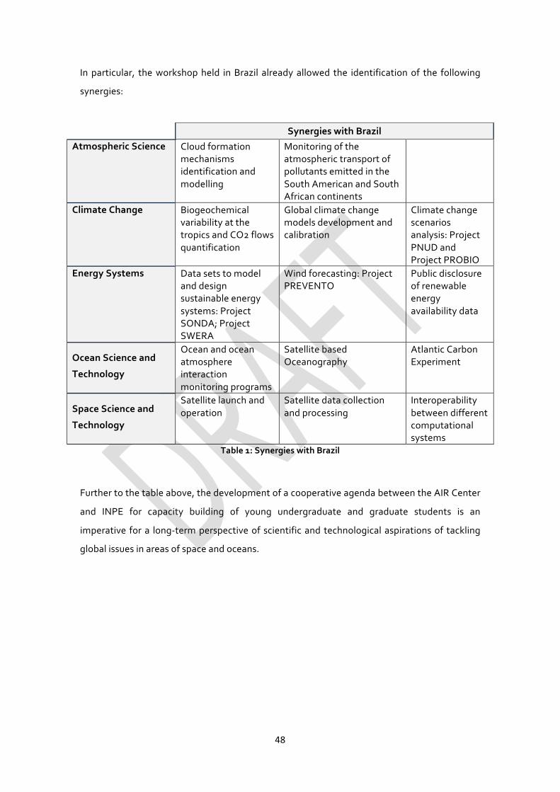
48
In particular, the workshop held in Brazil already allowed the identification of the following
synergies:
Table 1: Synergies with Brazil
Further to the table above, the development of a cooperative agenda between the AIR Center
and INPE for capacity building of young undergraduate and graduate students is an
imperative for a long-term perspective of scientific and technological aspirations of tackling
global issues in areas of space and oceans.
Synergies with Brazil
Atmospheric Science
Cloud formation mechanisms identification and modelling
Monitoring of the atmospheric transport of pollutants emitted in the South American and South African continents
Climate Change Biogeochemical variability at the tropics and CO2 flows quantification
Global climate change models development and calibration
Climate change scenarios analysis: Project PNUD and Project PROBIO
Energy Systems Data sets to model and design sustainable energy systems: Project SONDA; Project SWERA
Wind forecasting: Project PREVENTO
Public disclosure of renewable energy availability data
Ocean Science and
Technology
Ocean and ocean atmosphere interaction monitoring programs
Satellite based Oceanography
Atlantic Carbon Experiment
Space Science and
Technology
Satellite launch and operation
Satellite data collection and processing
Interoperability between different computational systems

49
11 Knowledge for Space – Space for Knowledge: an opportunity for cooperation
The AIR Center agenda will include and foster an education and knowledge agenda aimed to
promote “knowledge for space” and its integration with ocean, earth and climate education in
a fully holistic approach, but it will also extend traditional education and science awareness
programs to consider new horizons of space technologies to foster the access to education for
all. This will be achieved by involving telecom operators, broadcast services and space
providers in a “space for knowledge” network.
Although “star wars” program days are gone, in today’s world space activities are still very
much perceived by the general public as a dispute for outer space conquests of “Rocket”
scientists. The majority of the world’s population is unaware of the importance of space
activities in our daily lives.
This is important in today’s societies because space science involves a series of disciplines that
provide new insights on the Universe (physics; astronomy), allows perceiving earth dynamics
which helps in the prediction and preparation for emerging threats; foster new advancements
in satellites and robotic engineering, as well as in related technology allowing the exploration
of outer space and find new materials and new knowledge of the Universe.
It is under this context that several major initiatives have been launched worldwide in the last
decades to foster education for space in an effort to bridging the knowledge gap between
people and space science. For example, in 2002 UNESCO launched a Space Education
programme following recommendations from the 1999 World Conference on Science and the
Third United Nations Conference on the Peaceful Uses of Outer Space. It is aimed to enhance
space subjects and disciplines in schools and university curricula, the improvement of teaching
methodologies to raise awareness about the importance of space and space related activities
to human development. Three disciplines are mainly addressed:
• Astronomy;
• Aeronautic engineering, satellite design, robotic engineering;
• Space technology applications;
To carry out these objectives UNESCO develops space education workshops and other
initiatives that show the importance of the peaceful uses of outer space and the part played

50
by space uses and technology in protecting, monitoring, documenting, and sharing our
common heritage, both cultural and natural.
In a related action, ESA launched the ESERO initiative (European Space Education Resource
Office) with several nations, including several activities to help teachers to introduce space in
the classroom and raise awareness in schools of the importance of space science and
technology. Among other initiatives, it has provided teacher-training courses, with special
emphasis to primary level education and the reinforcement of the communication between
the scientific community, enterprises and schools.
By using space as an engaging multidisciplinary challenge, these initiatives are contributing to
promote the interest and mobilization of younger generations for science and technology.
The importance of an integrative approach in science drives the current efforts to establish an
International Research Center in the Azores, bridging the American, European and African
continents, particularly suited to provide unique data on the ocean and to study its
interactions with atmosphere and space.
Through the initiative “Education for Space – Space for Education”, the AIR Center will aim to
expand and complement existing activities at UNESCO, ESA, NASA and other major players
worldwide to raise awareness for the sciences among all children, but also to deliver new
educational and cultural contents in developing countries through space technologies.
Specific activities will be aimed to promote the diffusion of endogenous knowledge of local
cultural and natural heritages and contributing for educating more children everywhere,
anytime.
A sustainable future requires more knowledge and more scientific culture, ensuring the access
to science and education as an inalienable right of all.

51
Annex: List of contributors to the draft document
• Ana Colaço, Institute of Marine Research – Azores (IMAR Azores), PT
• Arthur Baggeroer, Massachusetts Institute of Technology (MIT), US
• Carlos Santos Silva, Instituto Superior Técnico (IST), Universidade de Lisboa (UL), PT
• Eduardo Brito de Azevedo, Universidade dos Açores (UAç), PT
• Eric Lindstrom, National Aeronautics and Space Administration (NASA) US
• Fausto Brito e Abreu, Regional Government of the Azores, PT
• Filipe Costa, Universidade do Minho, PT
• FranciscoCunha,CEIIA,PT
• Frederico Cardigos, Marine and Environmental Sciences Centre – Azores (MARE – Azores), PT
• João Tasso de Sousa, Universidade do Porto (UP), PT
• José Manuel Fonseca de Moura, Carnegie Mellon University (CMU), US
• Juan Sanchez, University of Texas at Austin (UTAustin), US
• Karl Strømsem, Global Maritime Group, NO
• Luis Santos, Regional Government of the Azores, PT
• Manuela Veloso, Carnegie Mellon University (CMU), US
• Marija D. Ilic, Carnegie Mellon University (CMU), US
• Maria João Bebianno, Centro de Investigação Marinha e Ambiental (CIMA) – Universidade do Algarve (UAlg), PT
• Miguel Belló Mora, Elecnor-Deimos, ES
• Ned Dwyer, European Center for Information on Marine Science and Technology (EurOcean)
• Nuno Ávila, Elecnor-Deimos, PT
• Paulo Fialho, Universidade dos Açores (UAç), PT
• PavlosKollias, Atmospheric Radiation Measurement (ARM) Climate Research Facility, US
• Pedro Afonso, Guest Scientist at Woods Hole Oceanographic Institution (WHOI), PT
• Piero Messina, European Space Agency (ESA)
• Ramiro Neves, Instituto Superior Técnico (IST), Universidade de Lisboa (UL), PT
• Robert Peterson, IC2 Institute – University of Texas at Austin (UT Austin), US
• Sally MacFarlane, US Department of Energy, US
• Sérgio Barbedo, Edisoft, PT
• Scott Van Broekhoven, Massachusetts Institute of Technology (MIT) Lincoln Laboratory, US
• Teresa Ferreira, Universidade dos Açores, PT