AW Solutions PCAP4 EA ECA M-1093
221
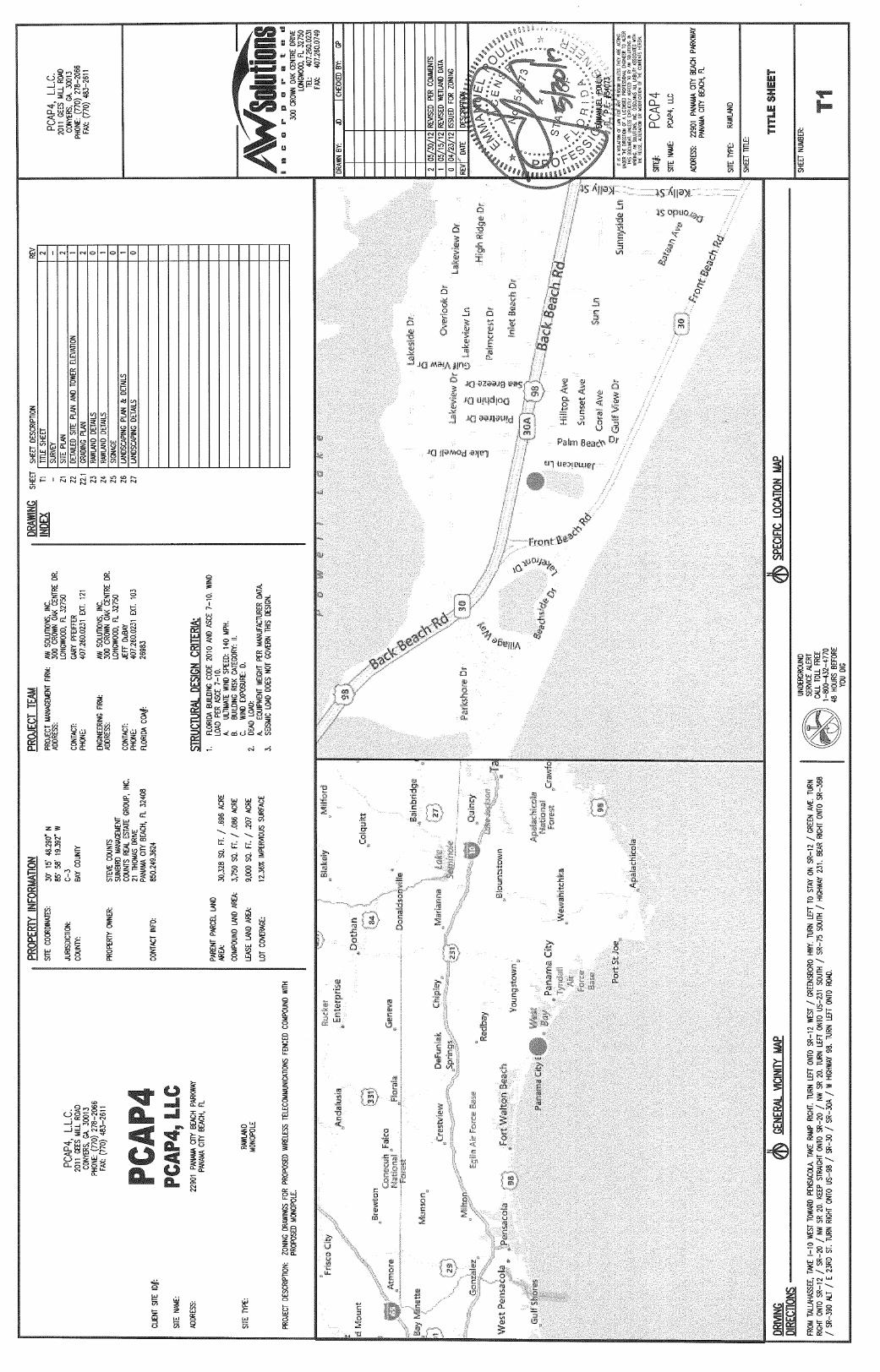
Environmental Assessment Proposed 180-Foot Monopole Telecommunications Facility 184-Foot Overall Height With Appurtenances AW Solutions (PCAP4) 22901 Panama City Beach Parkway Panama City Beach, Florida Bay County ECA Project No. M-1093 SUBMITTED TO: AW Solutions, Inc. 300 Crown Oak Centre Drive Longwood, FL 32750 PREPARED BY: Environmental Corporation of America 1375 Union Hill Industrial Court, Suite A Alpharetta, GA 30004
Transcript of AW Solutions PCAP4 EA ECA M-1093

Environmental Assessment Proposed 180-Foot Monopole Telecommunications Facility 184-Foot Overall Height With Appurtenances
AW Solutions (PCAP4) 22901 Panama City Beach Parkway Panama City Beach, Florida Bay County ECA Project No. M-1093
SUBMITTED TO: AW Solutions, Inc. 300 Crown Oak Centre Drive Longwood, FL 32750
PREPARED BY: Environmental Corporation of America 1375 Union Hill Industrial Court, Suite A Alpharetta, GA 30004

Mr. Russ Azar Page 2
July 23, 2012 AW Solutions, Inc. 300 Crown Oak Centre Drive Longwood, FL 32750 Attention: Mr. Russ Azar Subject: Environmental Assessment Proposed 180-Foot Monopole Telecommunications Structure (184-Foot Overall Height with Appurtenances)
AW Solutions (PCAP4) 22901 Panama City Beach Panama City Beach, Bay County, Florida ECA Project Number: M-1093
Dear Mr. Azar: Environmental Corporation of America (ECA) is pleased to provide this Environmental Assessment report for the proposed AW Solutions, Inc. telecommunications facility in Panama City Beach, Bay County, Florida. The federal undertaking includes construction of a telecommunications facility including a 50-foot by 75-foot fenced, gravel-covered compound within a 100-foot by 90-foot lease area and a proposed 184-foot monopole telecommunications structure (overall height). The facility would be accessible over an existing parking lot. A review of environmental and cultural resource issues revealed that the subject facility would be located in a federally designated Special Flood Hazard Area of the 100-year floodplain, Zone AE. Zone AE consists of areas of the 100-year floodplain where the base flood elevation (BFE) has been determined. Additionally, the project area would be located within jurisdictional waters of the United States. The subject facility would result in impacts to 0.08 acres of jurisdictional wetlands. No other FCC National Environmental Policy Act (NEPA) issues have been identified in connection with the subject facility. Based on our professional opinion, no significant adverse environmental impacts would occur as a result of the undertaking (the construction and operation of the facility). We base our opinion on the following:
Bay County, Florida is a National Flood Insurance Program participating community. According to the appropriate FEMA FIRM panel, the base flood elevation (BFE) at the subject site is 8.0 feet above mean sea level (AMSL) referenced to the North American
Mr. Russ Azar Page 2
Vertical Datum 1988 (NAVD 88). Federal standards require that buildings be constructed at least 1 foot above the BFE. Bay County, Florida requires that all commercial structures, as well as all mechanical equipment and utilities be built at least 1 foot above BFE. For the subject facility, this translates to an elevation of 9.0 feet AMSL (NAVD 8). The proposed equipment for the subject telecommunications facility would be built at a finished floor elevation at or above 9.0 feet AMSL (NAVD 88) or at least 1 foot above BFE. In our opinion, we find no adverse effect to federal floodplains.
Construction of the facility would require the placement of fill material over 0.08 acres of
jurisdictional wetlands. AW Solutions is currently seeking authorization from US Army Corps of Engineers (USACE) and Northwest Florida Water Management District (NWFWMD) for the proposed wetland impacts. A Request for Jurisdictional Determination and Nationwide Permit/Environmental Resources Permit was submitted to USACE and NWFWMD on July 9, 2012. Due to the small areas of impacts (less than 1/10th acre) and the fact that these impacts are unavoidable in order to construct the project, no mitigation is required by USACE. However, mitigation is required by NWFWMD. In order to satisfy mitigation requirements, AW Solutions proposes to purchase 0.06 wetland mitigation credits from the Breakfast Point Mitigation Bank. This mitigation strategy has been approved by NWFWMD. USACE and NWFWMD authorizations will be forwarded to the FCC upon receipt. In our opinion, the proposed project would not result in any unmitigated impacts to wetlands.
Our finding is subject to review by the Federal Communications Commission (FCC). Upon review, the FCC will issue its finding. This finding will consist of an official agency position regarding environmental consequences of the undertaking. We appreciate this opportunity to provide you with these professional services. If you have any questions regarding this report or the project in general, please call. Sincerely yours, Environmental Corporation of America Andrew Tankel, EIT Ben Salter, REP Project Scientist Principal Scientist
TABLE OF CONTENTS
1.0 INTRODUCTION................................................................................................... 1
1.1 SITE LOCATION........................................................................................................ 1 1.2 SITE DESCRIPTION ................................................................................................... 1
2.0 SITE INFORMATION........................................................................................... 1
2.1 ZONING.................................................................................................................... 1 2.2 LOCAL COMMUNITY ................................................................................................ 2 2.3 SITE SELECTION AND ALTERNATIVE CONSIDERED .................................................. 2
3.0 ENVIRONMENTAL ISSUES ............................................................................... 2
3.1 WILDERNESS AREAS................................................................................................ 2 3.2 WILDLIFE PRESERVES.............................................................................................. 3 3.3 LISTED THREATENED AND ENDANGERED SPECIES AND CRITICAL HABITAT............ 3 3.4 PROPOSED THREATENED OR ENDANGERED SPECIES AND PROPOSED CRITICAL
HABITAT .................................................................................................................. 3 3.5 MIGRATORY BIRDS.................................................................................................. 3 3.6 SITES OF HISTORIC AND ARCHEOLOGICAL SIGNIFICANCE........................................ 3 3.7 INDIAN RELIGIOUS SITES ......................................................................................... 4 3.8 FLOODPLAINS .......................................................................................................... 4 3.9 SURFACE FEATURES................................................................................................. 4 3.10 HIGH INTENSITY LIGHTING ...................................................................................... 4 3.11 RADIO FREQUENCY RADIATION............................................................................... 5
4.0 FINDINGS, ISSUES, AND RECOMMENDATIONS......................................... 5
5.0 SUMMARY ............................................................................................................. 6
6.0 LIMITATIONS....................................................................................................... 6
APPENDICES APPENDIX A - FIGURES APPENDIX B – FEMA FLOOD INSURANCE RATE MAP APPENDIX C – WETLAND INFORMATION APPENDIX D – PROTECTED SPECIES DOCUMENTATION APPENDIX E – HISTORIC AND ARCHEOLOGICAL DOCUMENTATION APPENDIX F – NATIVE AMERICAN DOCUMENTATION
APPENDIX G – BUILDING PERMIT

1
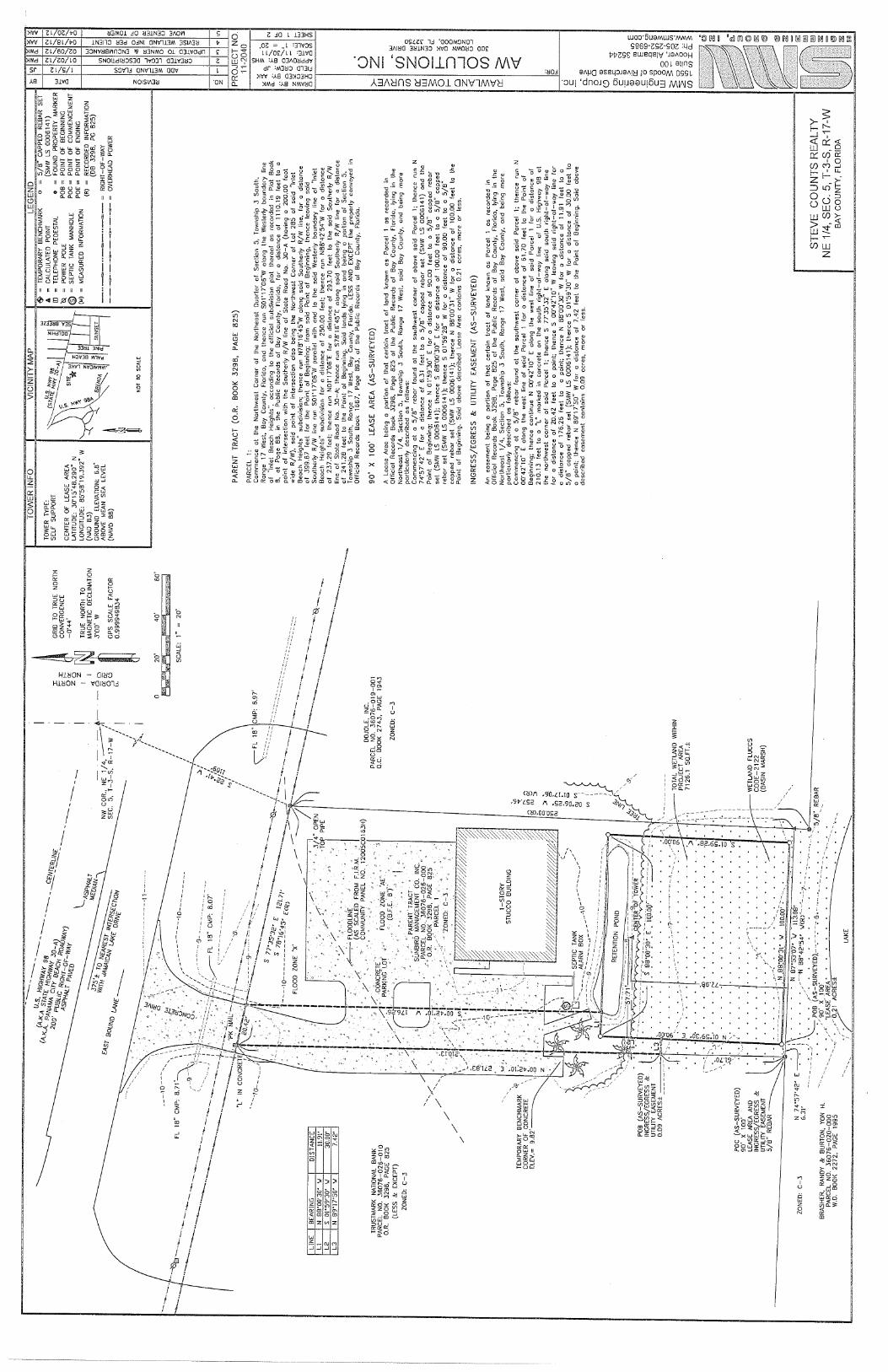
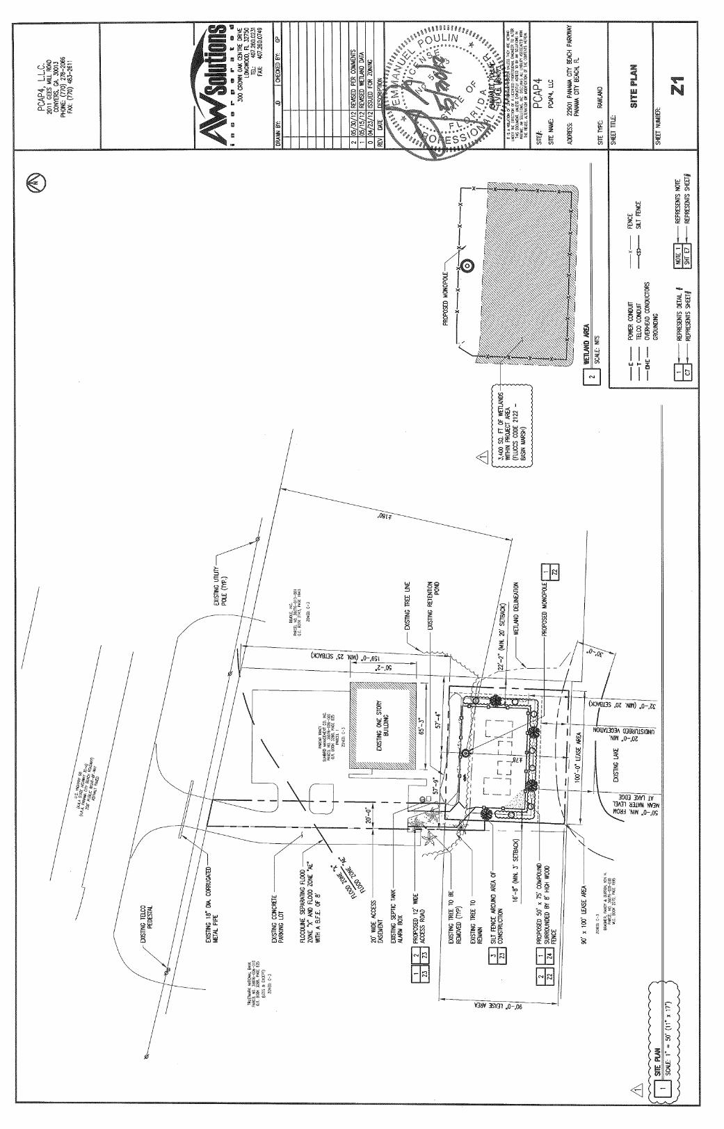
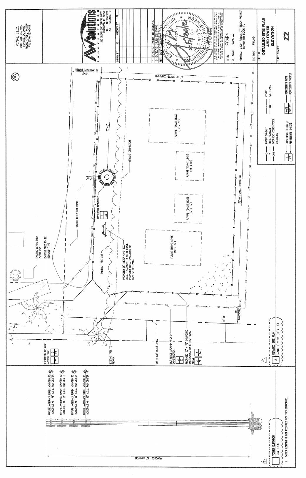
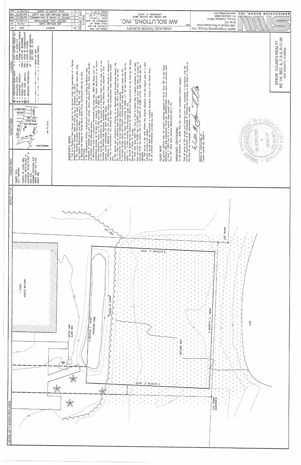
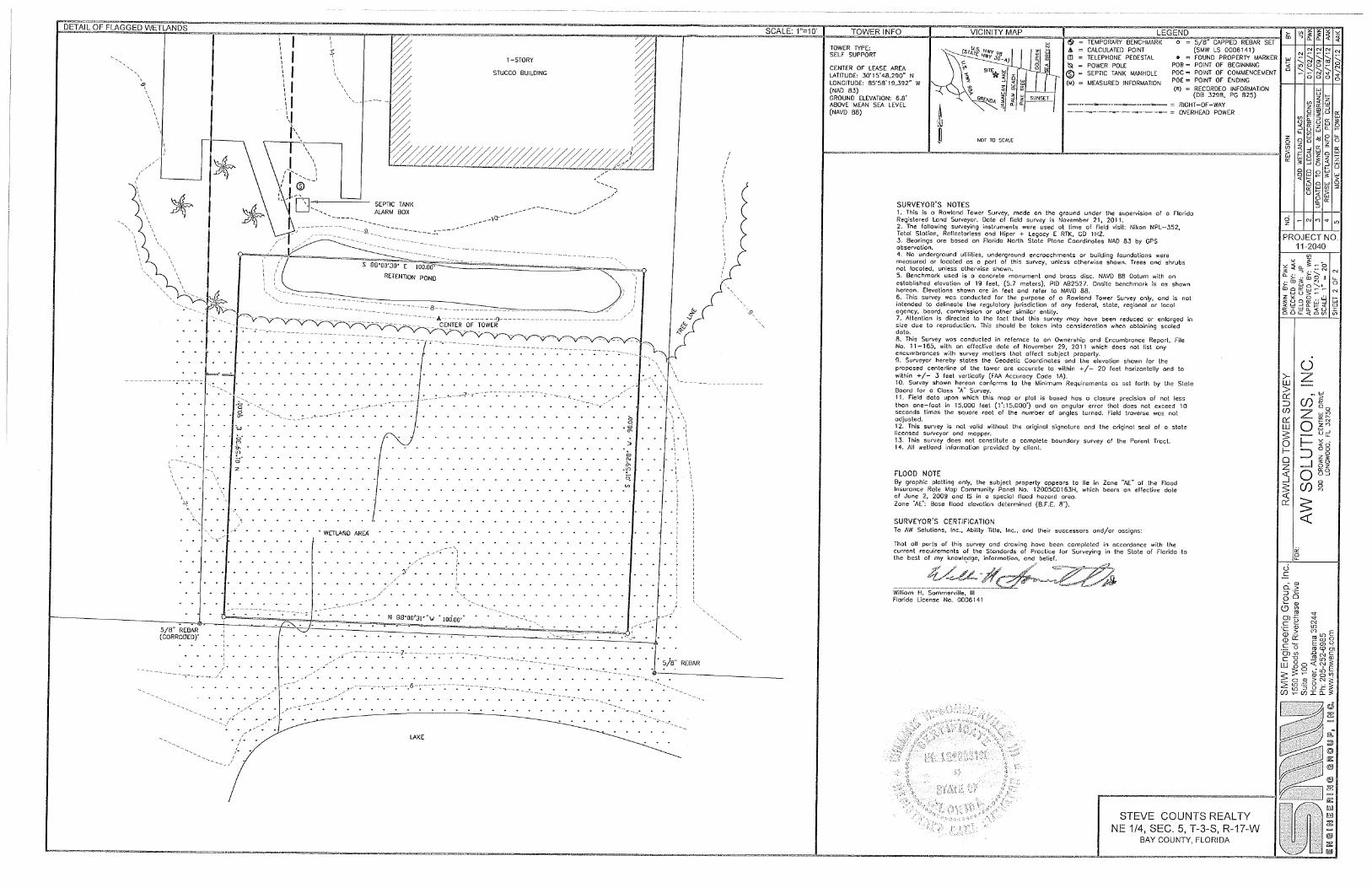
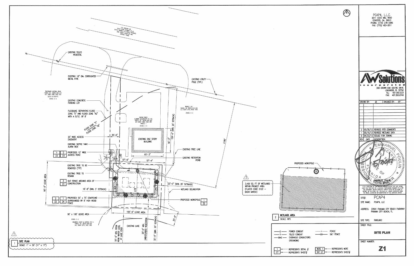
1.0 INTRODUCTION AW Solutions, Inc. has proposed to construct a telecommunications facility at the subject site. The subject facility would consist of a 184-foot tall monopole telecommunications structure (overall height) and its associated ground level equipment. A review of environmental and cultural resource issues revealed that the proposed facility would be located in a federally designated Special Flood Hazard Area of the 100-year floodplain, Zone AE. Areas located within Zone AE are defined as areas within the base floodplain where base flood elevation (BFE) has been determined. The BFE for the subject site is 8.0 feet above mean sea level (AMSL) (NAVD 88). Additionally, 0.08 acres of jurisdictional wetlands would be impacted by construction of the proposed equipment compound. No other FCC National Environmental Policy Act (NEPA) issues have been identified in connection with the subject facility. In accordance with 47 CFR, Section 1.1307, et. seq., this environmental assessment has been prepared to address environmental effects associated with the construction and operation of the subject facility. 1.1 Site Location The site is located at 22901 Panama City Beach Parkway, Panama City Beach, Bay County, Florida as shown on Figure 1 of Appendix A. The subject site is located on a 0.696-acre parent tract that contains a one-story real estate management building. 1.2 Site Description The subject site is situated in the southern portion of a larger parent tract and is currently occupied by relatively dense shrub and grass/forb understory with scattered young and intermediate pines. A site plan of the subject facility is included in Figure 2 of Appendix A. 2.0 SITE INFORMATION 2.1 Zoning The parcel is zoned for General Commercial (C-3). AW Solutions, Inc. has submitted an application for a Building Permit. Bay County, Florida has not yet granted a Building Permit for the proposed facility; however, it will be forwarded when received.

2
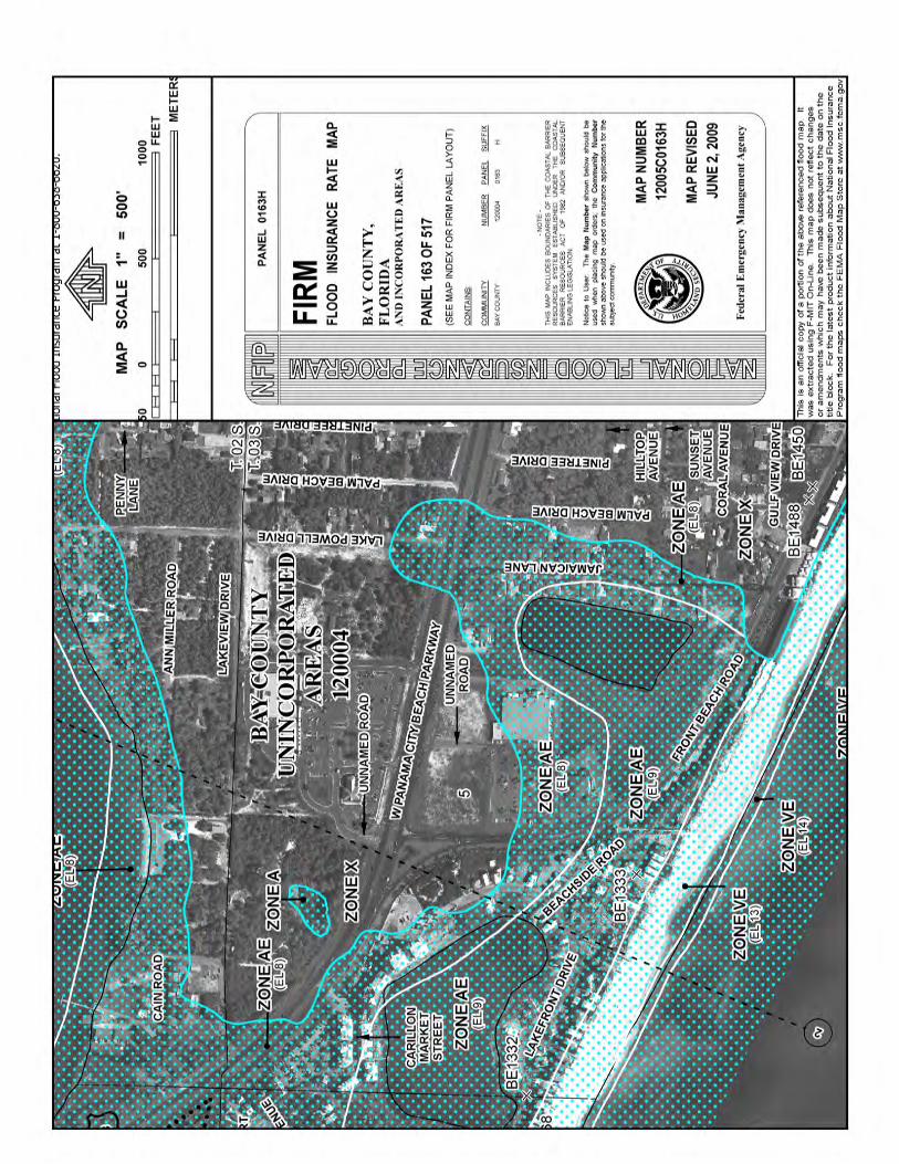
2.2 Local Community The Applicant is not aware of any concerns regarding environmental effects of the project area that have been expressed by planning or zoning officials or members of the local community, other than the acknowledgement that the facility is located in a floodplain and that impacts to jurisdictional wetlands would result from the proposed undertaking. The Applicant does not consider this acknowledgement as opposition. 2.3 Site Selection and Alternative Considered The selection of wireless telecommunications facilities is based primarily on the established grid within a specific service area. Within the service area, antenna structures have been previously constructed at specific nodes. As such, there is limited flexibility when selecting the exact locations of new facilities to allow for factors such as acceptable coverage, available sites, and sites which are environmentally sensitive. A number of possible candidate sites were evaluated and considered for acquisition to meet the carrier’s radio frequency (RF) coverage objective. Factors considered included RF coverage objectives, existing land use considerations, zoning requirements, environmentally sensitive sites, and the willingness of individual land owners to enter into a contract for sale or lease of a suitable parcel of real estate for construction of the proposed project. Based on these considerations, the subject Property at 22901 Panama City Beach Parkway was selected as the preferred alternative. During the analysis of the various candidates, it was discovered that the proposed facility is located in a federally designated 100-year floodplain and that 0.08 acres of jurisdictional wetlands would be disturbed (filled) as a result of the proposed project construction. This determination was made using the appropriate Federal Emergency Management Agency (FEMA) Flood Insurance Rate Map (FIRM) Community Map Panel, 12005C0163H, dated June 2, 2009, a review of the National Wetlands Inventory (NWI) Map, and a wetlands and waters delineation. 3.0 ENVIRONMENTAL ISSUES In accordance with 47 CFR, Section 1.1307, the following issues must be addressed in an Environmental Assessment. Included in these regulations is the requirement to investigate each of the following items and provide a determination as to whether significant environmental impacts or effects are likely. 3.1 Wilderness Areas The USGS Topographic Quadrangle Map, 7.5 Minute Series, Seminole Hills, FL (1982), and Nationalatlas.gov GIS mapper, Federal Lands and Wilderness Preservation System layers, indicate the project area is not located within an officially designated wilderness area.
3
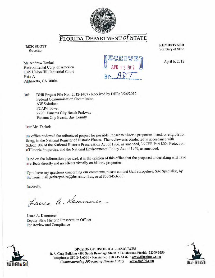
3.2 Wildlife Preserves The USGS Topographic Quadrangle Map, 7.5 Minute Series, Seminole Hills, FL (1982), and Nationalatlas.gov GIS mapper, Federal Lands and Wilderness Preservation System layers, indicate the project area is not located within an officially designated wildlife preserve. 3.3 Listed Threatened and Endangered Species and Critical Habitat The United States Fish and Wildlife (USFWS) has determined that the proposed project should have minimal impacts to fish and wildlife resources and is unlikely to impact federally listed species protected under the Endangered Species Acts. See Appendix D. 3.4 Proposed Threatened or Endangered Species and Proposed Critical Habitat Based on the information reviewed, there are no proposed threatened or endangered species or proposed critical habitats within the project area. It is our opinion that the undertaking would not jeopardize proposed threatened or endangered species or result in the destruction or adverse modification of a proposed Critical Habitat. 3.5 Migratory Birds The proposed facility would be located within a Principal Migration Route of the Mississippi Flyway. Collocation of antennas would not be feasible and a new tower must be constructed to meet the carrier’s coverage objectives. The proposed structure would be unlit and would not exceed the height of 184 feet and guy wires would not be used. Additionally, the tower will be designed to accommodate the antennas of multiple federal licensees. Based upon the proposed tower design, significant impacts to migratory birds are not anticipated. 3.6 Sites of Historic and Archeological Significance The New Tower Submission Packet (FCC Form 620), Section 106 Review documentation was prepared for the proposed undertaking. The Section 106 Review documentation found that the proposed facility would have no effect on any Historic Properties (as described in the March 7, 2005 NPA). The Section 106 review documentation was submitted to the Florida Division of Historical Resources on March 20, 2012. The Florida Division of Historical Resources responded in a letter dated April 6, 2012 concurring with our finding of “No Effect” for the proposed undertaking (See Appendix E). Therefore, according to Section VII.B.2 of the Nationwide Programmatic Agreement, we conclude that the proposed undertaking will have no effect on any Historic Properties.

4
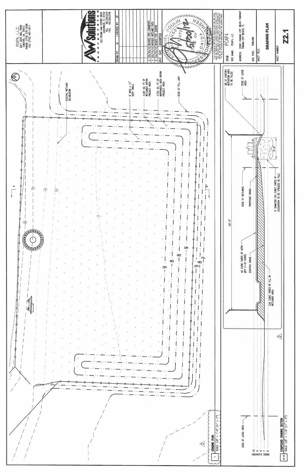
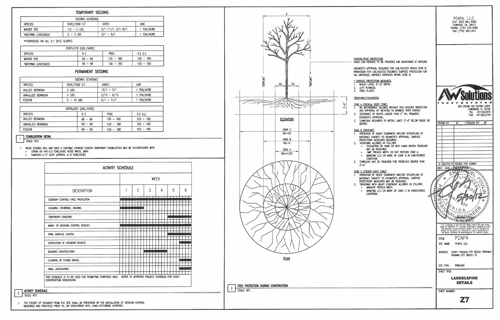
3.7 Indian Religious Sites According to the Tower Construction Notification System (TCNS), 8 tribes were listed as having ancestral associations with lands within Bay County, Florida. Initial notification was accomplished on November 29, 2011 and final clearance was received on April 23, 2012. Documentation is included in Appendix F. 3.8 Floodplains According to the FEMA FIRM Community panel 12005C0163H, dated June 2, 2009, the subject facility is located within a Special Flood Hazard Area of the 100-year floodplain, Zone AE. Zone AE is defined as areas of the 100-year floodplain where base flood elevation (BFE) has been determined. The BFE for the subject site is 8.0 feet above mean sea level (AMSL) (NAVD 88). See Appendix B for documentation. The subject facility would be located in the jurisdiction of Bay County, Florida, a National Flood Insurance Program participating community. Federal standards and Bay County require that finished floors of buildings and equipment cabinets be constructed at least one (1) foot above the BFE. For the subject facility, this translates to an elevation of 9 feet (NAVD 88) AMSL or higher. Finished floor elevations of equipment within the proposed facility would be at least 9 feet AMSL (NAVD 88) or 1 foot above BFE (minimum), thereby meeting federal and Bay County standards for projects located within a Special Flood Hazard Area. Bay County, Florida has not yet granted a Building Permit for the proposed facility; however, it will be forwarded when received. 3.9 Surface Features The proposed 50-foot by 75-foot fenced, gravel-covered compound would be located within jurisdictional wetlands. The proposed project would result in 0.08 acres of wetland impacts associated with the construction of the fenced equipment compound. A Request for Jurisdictional Determination and Nationwide Permit/Environmental Resources Permit was submitted to USACE and NWFWMD on July 9, 2012. Due to the small areas of impacts (less than 1/10th acre) and the fact that these impacts are unavoidable in order to construct the project, no mitigation is required by USACE. However, mitigation is required by NWFWMD. In order to satisfy mitigation requirements, AW Solutions proposes to purchase 0.06 wetland mitigation credits from the Breakfast Point Mitigation Bank. This mitigation strategy has been approved by NWFWMD. USACE and NWFWMD authorizations will be forwarded to the FCC upon receipt. See Appendix C for documentation. 3.10 High Intensity Lighting High Intensity White Lights would not be deployed in conjunction with the undertaking.

5
3.11 Radio Frequency Radiation For RF Exposure assessment, ECA has relied solely on the project RF Engineers to determine that antennas located at the facility would result in RF exposures levels which fall within the FCC categorical exclusions and are not subject to routine environmental evaluation under Section 1.1307(b) of the Commission’s rules. 4.0 FINDINGS, ISSUES, AND RECOMMENDATIONS Federal Floodplains Findings: According to the FEMA FIRM Community panel 12005C0163H, dated
June 2, 2009, the subject facility would be located within a Special Flood Hazard Area of the 100-year floodplain, Zone AE. Zone AE is defined as areas within the 100-year floodplain where base flood elevation (BFE) has been determined. According to the referenced FEMA FIRM Panel and the site survey (Appendix B), the BFE at the subject site is 8.0 feet AMSL (NAVD 88). Federal and Bay County standards require that buildings be constructed at least 1 foot above BFE. For the proposed undertaking, this translates to an elevation of 9.0 feet AMSL (NAVD 88) or higher.
Issues: According to the FCC Environmental Rules, an Environmental Assessment must be prepared for facilities that are located within a Special Flood Hazard Area of the 100-year floodplain. FCC guidelines specify that avoiding adverse effects to floodplains may be accomplished by complying with local flood protection and building code ordinances within National Flood Insurance Program participating communities/ jurisdictions.
Recommendation: The equipment for the proposed undertaking will be placed on an elevated
steel platform with a topside elevation at or above 9.0 feet AMSL (NAVD 88) or at least 1 foot above BFE. AW Solutions, Inc. has applied for a building permit from Bay County, Florida, a National Flood Insurance Program participating community which will be forwarded when received. In our opinion, we find no material impact to the flood storage capacity of the local floodplain. Therefore, we recommend that a finding of no significant impact (FONSI) be issued by the FCC relative to floodplains.
Wetlands Findings: Based on the proposed project design, the undertaking would result in
permanent impacts to 0.08 acres of jurisdictional wetlands.

6
Issues: According to the FCC Environmental Rules, an Environmental Assessment must be prepared for facilities that require a significant change in surface features (i.e. wetland fill). FCC guidelines specify that adverse effects to wetlands must be authorized by the US Army Corps of Engineers and that any required mitigation must be executed.
Recommendation: It is our opinion that no adverse wetland impacts or effects would result
from the undertaking (the construction and operation of the facility). We base our opinion on the fact that authorizations will be obtained from USACE and NWFWMD prior to construction activities at the site. In addition, based on the area of proposed wetland impact (less than 1/10th acre) and the fact that wetland impacts are unavoidable in order to construct the project, USACE will not require that compensatory mitigation be provided. However, NWFWMD will require mitigation which will be accomplished through the purchase 0.06 wetland mitigation credits from the Breakfast Point Mitigation Bank. A Request for Jurisdictional Determination and Nationwide Permit/Environmental Resources Permit was submitted to USACE and NWFWMD on July 9, 2012. The authorizations will be forwarded to the FCC when received.
It is our opinion that the proposed project would not result in any unmitigated impacts to wetlands; therefore, we recommend that a finding of no significant impact (FONSI) be issued by the FCC relative to wetlands.
Other Items contained in 41 CFR 1.1307 Finding: No other findings of environmental significance were identified. Issue: No further issues were identified. Recommendation: No further action is recommended. 5.0 SUMMARY In summary, it is our opinion that no adverse environmental impacts or effects would result from the proposed undertaking. We seek Commission concurrence with this finding. 6.0 LIMITATIONS This Environmental Assessment was conducted in accordance with generally accepted practices of the profession for such studies, conducted during the same time period and in the geographical area as this study. ECA has exercised the same degree of care and skill generally exercised by

7
environmental professionals under similar circumstances and conditions. No other warranty is expressed or implied. The observations, opinions and conclusions presented are not scientific certainties, but are solely opinions based upon the information available to us and our professional judgment based upon that information. The services provided herein are in no way intended to be legal advice and should not be relied upon in any way for legal interpretations.
APPENDIX A Figures

SITE
2000 0 2000 Feet
N
Source: USGS Topographic Quadrangle Maps, 7.5 Minute Series, Seminole Hills, FL (1982).
ECA Proj. #: M-1093
AW Solutions (PCAP4)
22901 Panama City Beach ParkwayPanama City Beach, Bay County, Florida
Figure 1: Site Location Plan


N
Source: 2012 Google Earth Aerial Photograph
ECA Proj. #: M-1093
AW Solutions (PCAP4)
22901 Panama City Beach ParkwayPanama City Beach, Bay County, Florida
Figure 3: 2012 Google Aerial Photograph
andrewt
Callout
SITE
APPENDIX B FEMA Flood Insurance Rate Map and Pertinent Documentation
andrewt
Callout
SITE
FLORIDACommunities Participating in the National Flood Program
CID Community Name CountyInit FHBMIdentified
Init FIRMIdentified
Curr EffMap Date
Reg-EmerDate Tribal
120001# ALACHUA COUNTY* ALACHUA COUNTY 09/28/84 06/16/06 09/28/84 No
120664# ALACHUA, CITY OF ALACHUA COUNTY 02/02/96 06/16/06 02/21/94 No
USE THE ALACHUA COUNTY [120001]FIRM
120580# ALFORD, TOWN OF JACKSON COUNTY 02/09/79 12/15/90 12/17/10 07/14/05 No
120290# ALTAMONTE SPRINGS, CITY OF SEMINOLE COUNTY 02/15/74 03/18/80 09/28/07 03/18/80 No
125087# ANNA MARIA, CITY OF MANATEE COUNTY 02/01/84 02/01/84 06/11/71 No
120089# APALACHICOLA, CITY OF FRANKLIN COUNTY 03/30/73 07/18/83 06/17/02 07/18/83 No
120180# APOPKA, CITY OF ORANGE COUNTY 07/19/74 09/29/78 09/25/09 09/29/78 No
120073# ARCADIA, CITY OF DESOTO COUNTY 06/21/74 06/03/88 06/03/88 06/03/88 No
120670# ARCHER, CITY OF ALACHUA COUNTY 08/02/95 06/16/06 06/09/94 No
120581# ASTATULA, TOWN OF LAKE COUNTY 08/24/79 08/15/84 07/03/02 03/04/98 No
120075# ATLANTIC BEACH, CITY OF DUVAL COUNTY 06/28/74 03/15/77 04/17/89 03/15/77 No
120193# ATLANTIS, CITY OF PALM BEACH COUNTY 12/06/74 11/01/78 11/01/78 11/01/78 No
120262# AUBURNDALE, CITY OF POLK COUNTY 02/01/74 05/11/79 11/19/03 05/11/79 No
120676# AVENTURA, CITY OF MIAMI-DADE COUNTY 07/30/72 09/11/09 10/22/97 No
THE CITY OF AVENTURA HASADOPTED THE DADE COUNTY(120635) FIRM DATED 3-2-94 PANELS82 AND 84
125161 AVON PARK, CITY OF HIGHLANDS COUNTY 01/01/50 06/18/02(E) No
120419# BAKER COUNTY * BAKER COUNTY 01/27/78 07/16/91 06/17/08 07/16/91 No
120636# BAL HARBOUR, TOWN OF MIAMI-DADE COUNTY 09/29/72 09/11/09 09/29/72 No
120076 BALDWIN, TOWN OF DUVAL COUNTY 02/06/76 (NSFHA) 06/30/76 No
120263# BARTOW, CITY OF POLK COUNTY 01/23/74 12/16/80 11/19/03 12/16/80 No
120004# BAY COUNTY* BAY COUNTY 01/17/75 07/02/81 06/02/09 07/02/81 No
120637# BAY HARBOR ISLANDS, TOWN OF MIAMI-DADE COUNTY 09/29/72 09/11/09 09/29/72 No
120194# BELLE GLADE, CITY OF PALM BEACH COUNTY 07/19/74 05/15/78 09/30/82 05/15/78 No
120181# BELLE ISLE, CITY OF ORANGE COUNTY 07/19/74 09/15/78 09/25/09 09/15/78 No
125089# BELLEAIR BEACH, CITY OF PINELLAS COUNTY 05/14/71 08/18/09 05/14/71 No
120239# BELLEAIR BLUFFS, CITY OF PINELLAS COUNTY 06/28/74 08/15/77 08/18/09 08/15/77 No
125090# BELLEAIR SHORE, TOWN OF PINELLAS COUNTY 09/03/03 08/18/09 05/15/71 No
125088# BELLEAIR, TOWN OF PINELLAS COUNTY 07/17/70 05/14/71 08/18/09 05/14/71 No
120383# BELLEVIEW, CITY OF MARION COUNTY 06/18/85 08/28/08 (NSFHA) 06/18/85 No
120569# BEVERLY BEACH, TOWN OF FLAGLER COUNTY 06/24/77 01/03/86 07/17/06 01/03/86 No
120638# BISCAYNE PARK, VILLAGE OF MIAMI-DADE COUNTY 09/29/72 09/11/09 09/29/72 No
120060# BLOUNTSTOWN,CITY OF CALHOUN COUNTY 05/24/74 05/01/80 12/06/00 05/01/80 No
120195# BOCA RATON, CITY OF PALM BEACH COUNTY 01/24/75 06/01/78 09/19/84 06/01/78 No
120116# BONIFAY, CITY OF HOLMES COUNTY 11/16/73 12/05/90 12/17/10 08/01/87 No
120680# BONITA SPRINGS, CITY OF LEE COUNTY 09/19/84 08/28/08 08/16/02 No
THE CITY OF BONITA SPRINGS HASADOPTED THE LEE COUNTY (125124)FIRM DATED 9/19/84, PANELNUMBERS 0530C; 0510D; 0505E;0503E; 0501D; 0444D; 0463C; 0465C;0475B; AND 0500B.
120104# BOWLING GREEN, CITY OF HARDEE COUNTY 12/28/73 05/04/88 05/04/88 05/04/88 No
120196# BOYNTON BEACH, CITY OF PALM BEACH COUNTY 03/08/74 01/03/79 09/30/82 01/03/79 No
125091# BRADENTON BEACH, CITY OF MANATEE COUNTY 07/01/70 06/11/71 05/18/92 06/11/71 No
120155# BRADENTON, CITY OF MANATEE COUNTY 03/01/74 06/01/81 11/16/83 06/01/81 No
120015# BRADFORD COUNTY * BRADFORD COUNTY 02/14/75 11/15/89 05/02/12(>) 11/15/89 No
120301# BRANFORD, TOWN OF SUWANNEE COUNTY 01/09/74 01/16/87 09/28/07 01/16/87 No
125092# BREVARD COUNTY * BREVARD COUNTY 09/22/72 11/19/97 09/22/72 No
120197# BRINY BREEZES, TOWN OF PALM BEACH COUNTY 01/23/74 05/15/78 09/30/82 05/15/78 No
Page 1 of 12 02/02/2012
http://www.fema.gov/cis/FL.html
1 of 12 2/2/2012 8:15 AM
andrewt
Highlight
andrewt
Rectangle

Andrew Tankel
From: Jennifer S. Bowes [[email protected]]
Sent: Tuesday, July 17, 2012 9:44 AM
To: Andrew Tankel
Subject: RE: Bay County flood Zone Requirements:
Page 1 of 2
7/17/2012
The FZ is AE (8) so the FFE elevation of any structure and/or mechanical equipment must be at Elevation 9 ft NAVD. Jennifer Bowes Bay County Planning & Zoning 840 W. 11th Street, Room 2350 Panama City, FL 32401 Phone: (850) 248-8250 Fax: (850) 248-8267 Email: [email protected]
From: Andrew Tankel [mailto:[email protected]] Sent: Tuesday, July 17, 2012 8:21 AM To: Jennifer S. Bowes Subject: RE: Bay County flood Zone Requirements: Thank you for the quick response. The Parcel # is 36076-026-000. Thank you. Andrew Tankel, EIT Project Engineer Environmental Corporation of America (ECA) 770‐667‐2040 x. 118 (office) 770‐667‐2041 (fax) andrew.tankel@eca‐usa.com www.eca‐usa.com Alpharetta, GA / Asheville, NC / Chicago, IL / Nashville, TN / West Palm Beach, FL
From: Jennifer S. Bowes [mailto:[email protected]] Sent: Tuesday, July 17, 2012 9:09 AM To: Andrew Tankel Subject: RE: Bay County flood Zone Requirements: Good Morning, The same rules that apply for residential structures also apply for commercial. So you are right the structure will need to be 1 foot above BFE as well as all mechanical equipment and utilities. If you want to send me the parcel # and I can take a look at the site and let you know what specific requirements would be. Also, these regulations would be for the unincorporated County only. Each municipality has its own rules. Let me know if you have any more questions. Thanks, Jennifer Bowes Bay County Planning & Zoning 840 W. 11th Street, Room 2350
Panama City, FL 32401 Phone: (850) 248-8250 Fax: (850) 248-8267 Email: [email protected]
From: Andrew Tankel [mailto:[email protected]] Sent: Tuesday, July 17, 2012 7:53 AM To: Jennifer S. Bowes Subject: Bay County flood Zone Requirements: Importance: High Good Morning Ms. Bowes, I am contacting you in regards to the Flood Zone requirements for a proposed cell tower. I understand that Bay County, Florida is a National Flood Insurance Program participating community. The Federal Communications Commission (FCC) requires that the finished floor elevation of all buildings be constructed at least one (1) foot above the BFE. Does Bay County, Florida have any additional elevation requirements that would need to be incorporated into the design of the finished floor elevation? I searched Bay County, Florida’s website, but was unsuccessful in locating any relevant information. I was able to locate the 2010 Community Rating System report. However, this report only addressed residential homes. “Homes built in A and AE zones require one foot of freeboard, meaning the bottom of the lowest floor must be at least one foot above base flood elevation (BFE).” Do these same rules apply to non-residential structures as well? Thanks, Andrew Tankel, EIT Project Engineer Environmental Corporation of America (ECA) 770‐667‐2040 x. 118 (office) 770‐667‐2041 (fax) andrew.tankel@eca‐usa.com www.eca‐usa.com Alpharetta, GA / Asheville, NC / Chicago, IL / Nashville, TN / West Palm Beach, FL Please Note: Under Florida law, e-mail addresses are public records. If you do not want your e-mail address released in response to a public records request, do not send electronic mail to this entity. Instead, contact this office by phone or in writing. Please Note: Under Florida law, e-mail addresses are public records. If you do not want your e-mail address released in response to a public records request, do not send electronic mail to this entity. Instead, contact this office by phone or in writing.
Page 2 of 2
7/17/2012
Hurricane Dennis of July, 2005 caused flooding to a significant number of homes and businesses along the coast in Bay County in Panama City, Panama City Beach and Lynn Haven (CNN.com).
Both Ivan and Dennis caused considerable erosion to the project area, and the erosion losses appear to have been comparable to the losses sustained during Opal of 1995; however, in comparison to the very severe coastal construction damage that was caused by Opal, Ivan and Dennis inflicted only a minor erosion, even though the storm tide conditions were essentially the same. The beach restoration project proved to provide adequate protection. (Keehn and Armbruster, 2005)
Hurricane Katrina
Hurricane Katrina of August, 2005 exacerbated the coastal erosion situation. No damage to any structures was reported. (Coastal Planning and Engineering, Inc., 2005 Hurricane Impact and 2007 Renourishment Project Design Analysis Panama City Beaches, May 2007)
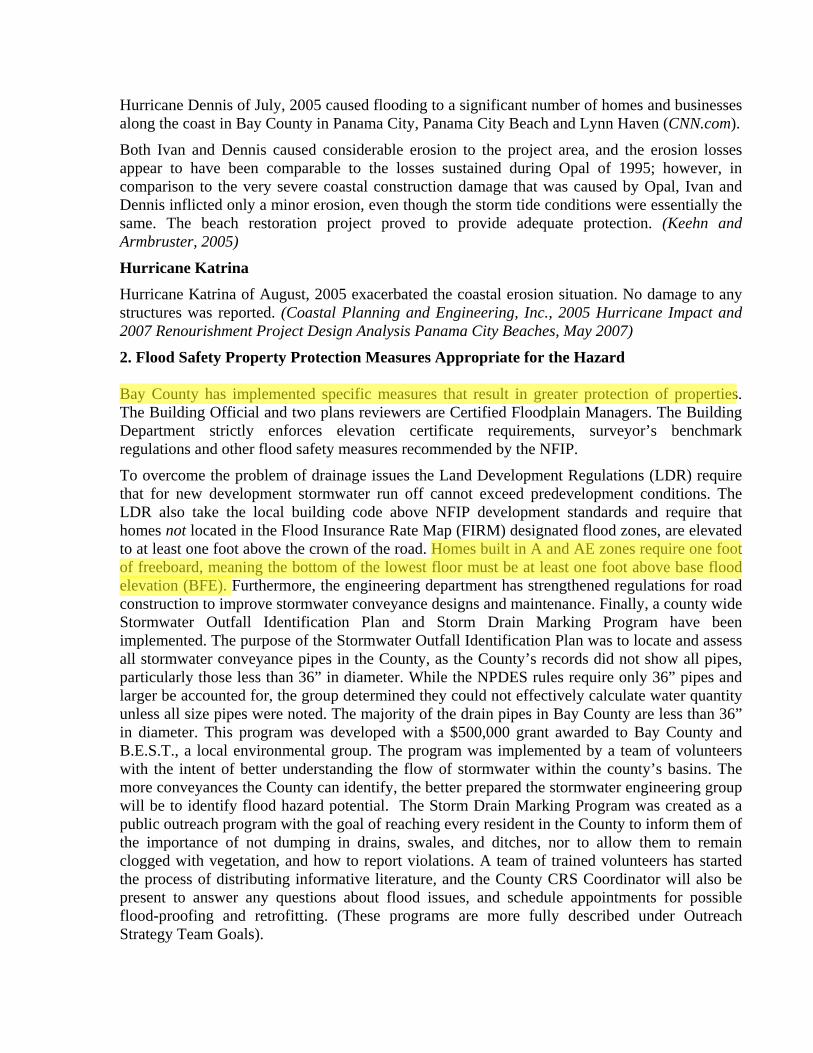
2. Flood Safety Property Protection Measures Appropriate for the Hazard Bay County has implemented specific measures that result in greater protection of properties. The Building Official and two plans reviewers are Certified Floodplain Managers. The Building Department strictly enforces elevation certificate requirements, surveyor’s benchmark regulations and other flood safety measures recommended by the NFIP.
To overcome the problem of drainage issues the Land Development Regulations (LDR) require that for new development stormwater run off cannot exceed predevelopment conditions. The LDR also take the local building code above NFIP development standards and require that homes not located in the Flood Insurance Rate Map (FIRM) designated flood zones, are elevated to at least one foot above the crown of the road. Homes built in A and AE zones require one foot of freeboard, meaning the bottom of the lowest floor must be at least one foot above base flood elevation (BFE). Furthermore, the engineering department has strengthened regulations for road construction to improve stormwater conveyance designs and maintenance. Finally, a county wide Stormwater Outfall Identification Plan and Storm Drain Marking Program have been implemented. The purpose of the Stormwater Outfall Identification Plan was to locate and assess all stormwater conveyance pipes in the County, as the County’s records did not show all pipes, particularly those less than 36” in diameter. While the NPDES rules require only 36” pipes and larger be accounted for, the group determined they could not effectively calculate water quantity unless all size pipes were noted. The majority of the drain pipes in Bay County are less than 36” in diameter. This program was developed with a $500,000 grant awarded to Bay County and B.E.S.T., a local environmental group. The program was implemented by a team of volunteers with the intent of better understanding the flow of stormwater within the county’s basins. The more conveyances the County can identify, the better prepared the stormwater engineering group will be to identify flood hazard potential. The Storm Drain Marking Program was created as a public outreach program with the goal of reaching every resident in the County to inform them of the importance of not dumping in drains, swales, and ditches, nor to allow them to remain clogged with vegetation, and how to report violations. A team of trained volunteers has started the process of distributing informative literature, and the County CRS Coordinator will also be present to answer any questions about flood issues, and schedule appointments for possible flood-proofing and retrofitting. (These programs are more fully described under Outreach Strategy Team Goals).
andrewt
Highlight
andrewt
Highlight

APPENDIX C Wetland Information

No
v 29
, 201
1
Th
is
map
is
fo
r g
ener
al
refe
ren
ce
on
ly.
Th
e U
S
Fis
h
and
W
ildlif
e S
ervi
ce
is
no
tre
spo
nsi
ble
fo
r th
e ac
cura
cy o
r cu
rren
tnes
s o
f th
e b
ase
dat
a sh
ow
n o
n t
his
map
. A
llw
etla
nd
s re
late
d d
ata
sho
uld
be
use
d i
n a
cco
rdan
ce w
ith
th
e la
yer
met
adat
a fo
un
d o
nth
e W
etla
nd
s M
app
er w
eb s
ite.
Use
r R
emar
ks:
andrewt
Callout
SITE

Main Menu Log Out
Northwest Florida Water Management District
Environmental Resource Permitting
Individual Permit
Submittal Receipt
Applicant Information
Applicant Name : Gary PfeifferCompany Name : AW Solutions IncorporatedStreet : 300 Crown Oak Centre DriveCity : Longwood State : FL Zip : 32750
Application for Stormwater Permit in Northwest Florida
Application Number : 1953Payment Date : 07/08/2012Amount Paid : 710.00
Dear Applicant:
Thank you for submitting an Application for Stormwater Permit in Northwest Florida under Chapter 62-346, Florida Administrative Code. The District will send all correspondence regarding this application to the email address you have provided. We will forward your reviewer’s contact information upon assignment.
The offical date of receipt is the day this information is received and processed into the District’s database, which may not be the date of submittal.
If you have any questions at this time, please contact the District Environmental Resource Permitting Program by telephone at 850-921-2986.
Page 1 of 1Northwest Florida Water Management District
7/8/2012https://epermitting.nwfwmd.state.fl.us/proderp/payment/processResult.do?remittance_id=37...

Northwest Florida Water Management District
Jonathan P. SteversonExecutive Director
800 Hospital Drive, Crestview, Florida 32539850-683-5044 (Fax) 850-683-5050
July 19, 2012
Gary PfeifferAW Solutions Incorporated300 Crown Oak Centre DriveLongwood, FL 32750
Re: Request for Additional InformationAW Solutions PCAP4 (Sunbird Management)Project Name:
1953Bay
Application Number:County:
Dear Gary Pfeiffer:
The Northwest Florida Water Management District has received your submittal related to the abovereferenced application. A review of the information provided has prompted questions related to potentialerrors and omissions, which are included in the Attachments. Please submit the information requested by October 17, 2012, within 90 days of the issuance of this letter. Details concerning the informationrequested can be found in the attachments to this letter. Please note that changes you may make to theproject design in order to fulfill this request for information may require additional requests forinformation.
In order to expedite the review of your responses and application, please indicate the application numberreferenced in the subject line on all correspondence. Please provide complete responses to each questionand submit your responses to the District at the address above. If plans require revision as a result of theinformation requested, please submit 2 complete sets of plans when responding.
If you have any questions or require clarification, please direct your questions to the reviewer indicatedat the top of the attachment.
Sincerely,
Michael Bateman, P.E., ChiefBureau of Environmental Resource Regulation
cc:Ben Salter

Gary PfeifferJuly 19, 2012
1AttachmentRequest for Administrative Information
Please direct any questions you may have concerning this information to Dana Palermo, P.E., 850-683-5044,[email protected]. A final response to this request for information should include responses for allinformation requested on all attachments.
Please clearly identify the entity that will be responsible for operating and maintaining the permitted project.Please provide all of the entity’s contact information including (but not limited to) the name of the individual,name of business, physical address, and phone number. [Subsection 62-346.095(4), F.A.C., (Effective November 1,2010)]
Please note that the submitted survey is an electronic copy that does not appear to be signed and/or sealed. Pleasesubmit a hard copy of the site survey with an original signature and raised seal by the registered professional whodid the survey. [Subsection 62-346.070(7) F.A.C. and Part II, Section 2.3, ERP A.H. Vol. II, (Effective November1, 2010)]
Please submit a hard copy of the manifest for the submitted construction plan sheets and applicable documentswith an original signature and raised seal/inked stamp by the registered professional that performed the work.[Subsection 62-346.070(7), F.A.C. and Part II, Section 2.3, ERP A.H. Vol. II, (Effective November 1, 2010)]
Please submit a hard copy of the originally executed signature pages under Section A (pages 5-7) of the JointApplication form. [Part 7, Section A, Form 62-346.900(1), (Effective November 1, 2010)]
1.
2.
3.
4.
1AttachmentPage 2 of 5

Gary PfeifferJuly 19, 2012
2AttachmentRequest for Engineering Information
Please direct any questions you may have concerning this information to Dana Palermo, P.E., 850-683-5044,[email protected]. A final response to this request for information should include responses for allinformation requested on all attachments.
Please include within the construction plan sheets the party responsible for monitoring construction, and forsubmitting the notice of construction commencement and as-built certifications for the project when completed.[Part IV.K., Section D, Form 62-346.900(1), (Effective November 1, 2010)]
Please note, the provided project area of 0.08 acres appears to be smaller than the limits of disturbance. Theproject area appears to extend to the outer limits of the 10 foot landscape buffers with the addition of the area forthe proposed driveway connection. Please clarify the proposed project area and revise all supporting informationaccordingly. By definition, “project area” means the area being modified or altered in conjunction with a proposedactivity requiring a permit. [Section 62-346.030(37), F.A.C.; Part III.A., Section D, Form 62-346.900(1),(Effective November 1, 2010)]
1.
2.
2AttachmentPage 3 of 5
Gary PfeifferJuly 19, 2012
3AttachmentRequest for Environmental Information
Please direct any questions you may have concerning this information to Ted Reese, 850-683-5044,[email protected]. A final response to this request for information should include responses for allinformation requested on all attachments.
The District has reviewed, and concurs with, the UMAM assessment information and the mitigation proposalsubmitted with the application to purchase 0.06 mitigation credits from the Breakfast Point Mitigation Bank tooffset the proposed impacts to wetlands. Please provide what type of credits are to be purchased, and providedocumentation from the Bank that credits of this type are available and have been reserved for this project. Proofof final sale of credits may be provided prior to or after permit issuance, but must be provided prior to the start ofconstruction. Please note that based on the mitigation bank permit documents, the Breakfast Point Mitigation Bankis authorized to sell credits of various ecosystem types. It appears that palustrine marsh credits, if available wouldbe most appropriate. [Section 10.3, ERP A.H. Vol. I, and Part II.G., Section D, Form 62-346.900(1), effectiveNovember 01, 2010]
1.
3AttachmentPage 4 of 5
Gary PfeifferJuly 19, 2012
4AttachmentAdditional Information
The following comment(s), although not required by district rule, is (are) provided for your consideration andinformation.
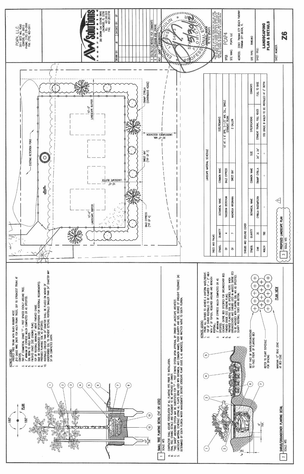
Having reviewed the planting plan for the vegetative buffer, the District recommends the use of wax myrtle(Myrica cerifera) shrubs in the place of swamp Cyrilla. Wax myrtle is more suitable for the system, is readilyavailable, and will be less likely to spread to and become a nuisance in the adjacent wetland areas. [Part III,Section 10.3.3.2(h), ERP A.H. Vol. I, effective November 01, 2010]
1.
4AttachmentPage 5 of 5
July 9, 2012
US Army Corps of Engineers 1002 West 23rd Street, Suite 350 Panama City, FL 32405 Attention: Ms. Melinda Witgenstein Subject: Request for Jurisdictional Determination and Nationwide Permit/Environmental Resource Permit AW Solutions – PCAP4 22901 Panama City Beach Pkwy Panama City Beach, Bay County, Florida ECA Project Number: M-1093 Dear Ms. Witgenstein: Environmental Corporation of America’s (ECA) client, AW Solutions, Inc. plans to construct a 184-foot monopole telecommunications structure (overall height with appurtenances) and a 50-foot by 75-foot fenced, gravel-covered compound within a 100-foot by 90-foot lease area, which is shown on Sheet Z1 included in Appendix A. Background Based on the presence of mapped wetlands and hydric soils within the project area, ECA conducted a wetlands delineation at the project site. The purpose of the wetlands and waters delineation was to delineate and characterize waters and wetlands that may be located within the proposed project area in accordance with accepted US Army Corps of Engineers (USACE) and State of Florida guidance. Wetland and waters boundaries within the project area of the parent tract were identified by ECA on April 3, 2012. The apparent wetland boundaries were confirmed by the USACE and Northwest Florida Water Management District (NWFWMD) in the field and placed on the site survey by a Florida Registered Land Surveyor. Wetland boundaries based on the boundary agreed upon by ECA, USACE, and NWFWMD are shown on the Site Plans in Appendix A. Based on the presence of wetlands within the proposed project area and the proposed placement of fill material within wetlands, ECA understands that authorizations would be required by USACE and NWFWMD. ECA also understands that per F.A.C. 62-346.051 (16)(f), construction of cell tower facilities is exempt from stormwater permitting. Therefore, portions of the permit application related to stormwater have been excluded.

Page 2
Purpose ECA’s client, AW Solutions, Inc., is proposing to place granular (gravel) fill material in 3,400 square feet of jurisdictional mixed forested wetlands as part of the construction of a telecommunications facility equipment compound. ECA has prepared this documentation to aid AW Solutions, Inc. in obtaining the proper USACE and NWFWMD authorizations for placement of fill material into jurisdictional wetlands. Location and Site Description The subject site location is shown on the site plans Appendix A. The project site is a proposed 100-foot by 90-foot lease area within which a 184-foot telecommunications tower (overall height) and 50-foot by 75-foot equipment compound would be constructed. Scope of Work – Wetland Delineation A review of available soils data, topographic maps, surveys, and aerial photographs was
conducted to obtain background information regarding site elevations, soil characteristics, site drainage, and vegetative cover.
A field investigation was conducted to examine the project site for jurisdictional waters and
to delineate jurisdictional waters and wetland boundaries, if jurisdictional areas were determined to be located on or immediately adjacent to the project site.
Jurisdictional waters and wetlands were identified in accordance with the U.S. Army Corps of
Engineers Wetlands Delineation Manual, 1987, the Regional Supplement to the Corps of Engineers Wetland Delineation Manual: Atlantic and Gulf Coastal Plain Region, and the Florida Wetlands Delineation Manual.
This report was prepared. The report contains documentation of our work, our findings, and
our conclusions. Onsite Determination – Florida DEP Boundary Determination Within the State of Florida, Wetlands are delineated in accordance with Department of Environmental Protection (DEP) Regulation 62-340 and the Florida Wetland Delineation Manual. The field determination that a particular area is a wetland requires positive identification in accordance with DEP 62-340.300. ECA investigated the project area for the presence of wetlands as defined by the DEP regulations. The wetlands determination was performed by Ben Salter of ECA on April 3, 2012. Northern portions of the project area are occupied by a stormwater retention area which is bounded on the north, east, and west by an apparently filled and graded area and on the south by a berm which separates the retention area from the remainder of the project area. A majority of the project area lies at an elevation of 7
Page 3 feet above mean sea level (amsl), while the top of the berm and filled areas lie at approximately 9 feet amsl. The lowest point of the site appears to be near the southeastern corner of the lease area. The ground surface slopes sharply up to the east of this point to an apparent wooded upland area. ECA collected data on ecological characteristics within the site area and access. The locations of our data points, which included soil test pits, are shown on Figure 2 in Appendix A. Florida Wetland Delineation Manual Data Forms are included in Appendix B. A discussion of our wetlands determination in accordance with Florida regulations is provided in the following paragraphs. Soils To determine if wetland soils and hydrology were present, one data point, inclusive of a soil test hole (DP-1) was made in the approximate location shown on Figure 2 of Appendix A. DP-1 was representative of the entire project area not located on a man-made berm or within a stormwater retention area, therefore, data was collected from only one data point. Soils data collected from all Data Point is included on the Florida Data Sheets and on the Federal Wetland Data Forms in Appendix B. Soil was removed to a depth of approximately 18 inches. A profile of the surface strata to a depth of approximately 18 inches was then cut from the edge of each soil test hole using a shovel. The Munsell color of the soil removed from each test hole was determined and recorded. At DP-1, approximately 80% organic coated sand grains (10YR 2/1) and muck were present in the top 3 inches. Soil from 3 to 10 inches was a light gray medium sand (10YR 7/1) with approximately 5% brownish yellow (10YR 6/6) mottles and oxidized root channels and approximately 20% dark grayish brown (10YR 4/2) diffuse splotches. Soils from 10 to 18 inches was a gray (10YR 5/1) medium sand. Based on the observations, soils at DP-2 would be considered hydric. Hydrology ECA allowed each test hole to remain open for approximately 20 minutes. Saturation was encountered at the surface with groundwater at approximately 6 inches beneath the surface. At DP-1, oxidized root channels, algal crust, adventitious roots, and geomorphic position were observed. In addition, the FAC-Neutral test would qualify as a secondary wetland hydrology indicatory. Vegetation
Page 4 ECA conducted a survey of the vegetative community surrounding all Data Points. The vegetative community present was catalogued on the Florida Data Forms and on the Federal Wetland Data Forms included in Appendix B. ECA identified the species within the appropriate vegetation layer, which were most dominant on the basis of aerial extent. The indicator status of plants that inhabit wetland environments in the State of Florida are published in the Vegetative Index of the Florida Wetlands Delineation Manual. Based on the published wetland indicator status of the plants, a prevalence of wetland vegetation was observed surrounding DP-1, using the “B Test” (Obligate + FACW ≥ 80%). Vegetation at DP-1 contained 100% FAC or wetter dominant species. Based on the US Army Corps of Engineers delineation guidelines, vegetation at DP-1 would be considered wetland vegetation. Onsite Determination - Federal USACE Boundary Determination Under federal regulations, field determination that a particular area is a wetland requires positive identification of three wetland characteristics (wetland hydrology, hydric soils, and hydrophytic vegetation). The same Data Point used for the State determination were used for the Federal Determination. The location is shown on Figure 2 of Appendix A. Soils and Hydrology characteristics at this Data Point are discussed above and are indicated on the Wetland Data Forms contained in Appendix B. For the Federal determination, the indicator status of plants that inhabit wetland environments are published in the National List of Vascular Plant Species that Occur in Wetlands: 1996 National Summary. Based on the published wetland indicator status of the plants, a prevalence of wetland vegetation was observed surrounding all data points. Therefore, ECA concluded that areas represented by DP-1 contained wetland vegetation. Boundary and Buffer Determination ECA determined that the appropriate criteria for a positive wetland determination under both Florida and Federal regulations were present within the community represented by DP-1. Based on consultation with USACE and NWFWMD during our site visit, it was determined that the wetland boundary followed the toe of slope of the berm to the north and slope to the east and extended outside the project area to the west and to the man-made lake to the south. Based on this finding, ECA had the site surveyor place the wetland boundary along the 8-foot contour, which is representative of the berm and slope toe of slope. The wetland boundaries as agreed upon by ECA, USACE, and NWFWMD are shown on Figure 2 in Appendix A. Based on the survey, 0.16 acres of wetlands are located within the proposed lease area. However, only 0.08 acres of wetland would be disturbed (filled) as a result of the proposed project construction.
Page 5
Avoidance and Minimization The selection of wireless telecommunications facilities is based primarily on the established grid within a specific service area. Within the service area, antenna structures have been previously constructed at specific nodes. As such, there is limited flexibility when selecting the exact locations of new facilities to allow for factors such as acceptable coverage, available sites, and sites which are environmentally sensitive. Factors considered in choosing the site location included RF coverage objectives, existing land use considerations, environmentally sensitive sites, and the willingness of individual land owners to enter into a contract for sale or lease of a suitable parcel of real estate for construction of the subject facility. Based on these considerations, the subject property at 22901 Panama City Beach Parkway was selected as the preferred alternative. No other willing landowners were identified within the coverage objective area or property constraints were such that a tower would not be feasible (lot size, zoning considerations, etc.). Based on the narrow nature of the parent tract, the current location was the only option for development of the facility on this tract. Wetlands were identified within almost the all of the proposed lease area to the south of the man-made retention area berm. In order to minimize impacts to wetlands, the proposed equipment compound was designed to be as small as possible (75-feet by 50-feet) to accomodate future carrrier equipment and shifted as far as possible to the north without impacting the existing retention area. In addition, AW Solutions is proposing to install a 10-foot wide native plant buffer around the east, south, and west sides of the compound as enhancement of the surrounding wetland. Existing native vegetation would left in place where present. Non-native vegetation (Chinese tallow) would be removed from this buffer area and replaced with native wetland vegetation. Plantings would include bald cypress, sweet bay, and swamp cyrilla. Plantings would be monitored for one year after installation for success and any failures replaced. Based on the information provided above, it is apparent that impacts to wetlands cannot be avoided if the project is constructed on the parent tract, is to meet the wireless coverage objectives, and is to accommodate the equipment of future carrier collocations within the compound. In addition, impacts have been minimized and avoided to the extent possible by minimizing the size of the compound as much as possible, shifting the compound as far the north as possible, and by enhancing a 10-foot buffer around the east, south, and west sides of the compound with native wetland vegetation. Mitigation Based on the area of proposed impact (less then 1/10th acre) and the fact that the proposed wetland impacts are unavoidable (in order to construct the project), ECA understands that no compensatory mitigation would be required by USACE. However, ECA understands that mitigation would be required by the NWFWMD. Uniform Mitigation Assessment Method (UMAM) worksheets
Page 6 (Appendix C) were used to determine the proposed functional loss and required mitigation. Based on the worksheets, the project would result in a functional loss of 0.06 acres of mixed forested wetlands. Based on these findings, AW Solutions proposes to purchase 0.06 UMAM credits from the Breakfast Point Mitigation Bank. Additional Information This document has been prepared and included as an attachment to the Individual Environmental Resource Permit Application prepared through the NWFWMD E-Permitting program. The Lease Agreement between AW Solutions and the parent parcel land owner is included as an attachment in the E-Permitting program. Per the lease agreement, AW Solutions has been granted the authority to obtain the necessary permits in order to construct the project. ECA consulted with the US Fish and Wildlife Service (USFWS) regarding impacts of the proposed project on threatened or endangered species. In a response dated March 29, 2012, the USFWS indicated that the proposed project should have minimal impacts to fish and wildlife resources and is not likely to adversely affect any species under the Endangered Species Act. USFWS consultation is included in Appendix C and as an attachment in the E-Permitting program. ECA evaluated the proposed project for effects on Historic Resources per the Federal Communications Commission (FCC) and Florida Division of Historic Resources (DHR) guidelines. Based on research performed and consultation with DHR, ECA concluded that the proposed project will have no effect of Historic Resources listed in or eligible for listing in the National Register of Historic Places. DHR consultation related to Historic Resources is included in Appendix C and as an attachment in the E-Permitting program. Conclusions and Recommendations Based on the information collected during this project, the resources reviewed, and our site inspections, ECA has determined that wetlands are present over the entire lease area to the south of the retention area berm (see Appendix A). Based on the proposed project design, 3,400 square feet of wetlands would be covered with fill material in order to construct a fenced equipment compound. An approximate 10 foot wide native wetland vegetation buffer would be established within wetland surrounding the compound as a visual screen and as wetland enhancement. Silt fencing would be installed around the proposed work area to minimize the potential for impacts to the surrounding wetlands. AW Solutions, Inc. is seeking authorization from USACE and NWFWMD for impacts (fill) to wetlands. In order to obtain NWFWMD authorization, mitigation would be provided through the purchase of 0.06 UMAM credits from the Breakfast Point Mitigation Bank. It is our understanding that USACE would not require mitigation since the impacts would be less than 1/10th acre and would be unavoidable in order to construct the project. In addition, avoidance
Page 7 and minimization measures have been incorporated into the project design. Closure If you have any questions about the contents of this report or would like to discuss, please contact Ben Salter of ECA at (828) 505-0755 or [email protected]. Sincerely, Environmental Corporation of America Mitch Clark Ben Salter Project Scientist Principal Wetland Scientist

APPENDIX A FIGURES
SITE
2000 0 2000 Feet
N
Source: USGS Topographic Quadrangle Map, 7.5 Minute Series, Seminole Hills, FLA. (1982)
ECA Proj. #: M-1093
AW Solutions - Sunbird Management
22901 Panama City Beach Parkway
Panama City Beach, Bay County, Florida
Figure 1: Site Location Plan
ebs
Rectangle
ebs
Callout
Proposed Lease Area
ebs
Rectangle
ebs
Callout
Proposed Compound/Fill Area
ebs
Text Box
AW Solutions - PCAP4 Site Plan Aerial Overlay


APPENDIX B WETLAND DATA FORMS
Ben Salter
Typewritten Text
AW Solutions - Sunbird Management
Ben Salter
Typewritten Text
Panama City Beach/Bay
Ben Salter
Typewritten Text
04/03/12
Ben Salter
Typewritten Text
FL
Ben Salter
Typewritten Text
DP-1
Ben Salter
Typewritten Text
AW Solutions, Inc.
Ben Salter
Typewritten Text
EBS
Ben Salter
Typewritten Text
Depression
Ben Salter
Typewritten Text
concave
Ben Salter
Typewritten Text
LRR T
Ben Salter
Typewritten Text
Rutledge sand
Ben Salter
Typewritten Text
x
Ben Salter
Typewritten Text
x
Ben Salter
Typewritten Text
x
Ben Salter
Typewritten Text
x
Ben Salter
Typewritten Text
x
Ben Salter
Typewritten Text
x
Ben Salter
Typewritten Text
Ben Salter
Typewritten Text
NAD 83
Ben Salter
Typewritten Text
x
Ben Salter
Typewritten Text
x
Ben Salter
Typewritten Text
x
Ben Salter
Typewritten Text
x
Ben Salter
Typewritten Text
x
Ben Salter
Typewritten Text
x
Ben Salter
Typewritten Text
x
Ben Salter
Typewritten Text
x
Ben Salter
Typewritten Text
x
Ben Salter
Typewritten Text
x
Ben Salter
Typewritten Text
6 inches
Ben Salter
Typewritten Text
0 inches
Ben Salter
Typewritten Text
30d 15' 48.3" N
Ben Salter
Typewritten Text
85d 58' 19.2" W
Ben Salter
Typewritten Text
20 feet
Ben Salter
Typewritten Text
Taxodium ascendens
Ben Salter
Typewritten Text
30
Ben Salter
Typewritten Text
yes
Ben Salter
Typewritten Text
FACW
Ben Salter
Typewritten Text
Ben Salter
Typewritten Text
Andropogon glomeratus
Ben Salter
Typewritten Text
20 feet
Ben Salter
Typewritten Text
23
Ben Salter
Typewritten Text
9
Ben Salter
Typewritten Text
45
Ben Salter
Typewritten Text
40
Ben Salter
Typewritten Text
20
Ben Salter
Typewritten Text
15
Ben Salter
Typewritten Text
Ben Salter
Typewritten Text
yes
Ben Salter
Typewritten Text
yes
Ben Salter
Typewritten Text
no
Ben Salter
Typewritten Text
FACW
Ben Salter
Typewritten Text
OBL
Ben Salter
Typewritten Text
FACW
Ben Salter
Typewritten Text
90
Ben Salter
Typewritten Text
45
Ben Salter
Typewritten Text
18
Ben Salter
Typewritten Text
x
Ben Salter
Typewritten Text
6
Ben Salter
Typewritten Text
6
Ben Salter
Typewritten Text
100
Ben Salter
Typewritten Text
x
Ben Salter
Typewritten Text
DP-1
Ben Salter
Typewritten Text
Saururus cernuus
Ben Salter
Typewritten Text
Spartina patens
Ben Salter
Typewritten Text
Osmunda cinnomomea
Ben Salter
Typewritten Text
FACW
Ben Salter
Typewritten Text
15
Ben Salter
Typewritten Text
no
Ben Salter
Typewritten Text
Pinus elliottii
Ben Salter
Typewritten Text
Triadica sebifera
Ben Salter
Typewritten Text
10
Ben Salter
Typewritten Text
5
Ben Salter
Typewritten Text
no
Ben Salter
Typewritten Text
yes
Ben Salter
Typewritten Text
OBL
Ben Salter
Typewritten Text
FAC
Ben Salter
Typewritten Text
Cephalanthus occidentalis
Ben Salter
Typewritten Text
Myrica cerifera
Ben Salter
Typewritten Text
OBL
Ben Salter
Typewritten Text
FAC
Ben Salter
Typewritten Text
40
Ben Salter
Typewritten Text
10
Ben Salter
Typewritten Text
yes
Ben Salter
Typewritten Text
yes
Ben Salter
Typewritten Text
50
Ben Salter
Typewritten Text
25
Ben Salter
Typewritten Text
10
Ben Salter
Typewritten Text
DP-1
Ben Salter
Typewritten Text
0-3
Ben Salter
Typewritten Text
10YR 2/1
Ben Salter
Typewritten Text
80
Ben Salter
Typewritten Text
80% coated grains
Ben Salter
Typewritten Text
3-10
Ben Salter
Typewritten Text
10YR 7/1
Ben Salter
Typewritten Text
75
Ben Salter
Typewritten Text
10YR 6/6
Ben Salter
Typewritten Text
5
Ben Salter
Typewritten Text
C
Ben Salter
Typewritten Text
M, PL
Ben Salter
Typewritten Text
sandy redox
Ben Salter
Typewritten Text
Mucky sand
Ben Salter
Typewritten Text
sand
Ben Salter
Typewritten Text
sand
Ben Salter
Typewritten Text
x
Ben Salter
Typewritten Text
x
Ben Salter
Typewritten Text
10YR 4/2
Ben Salter
Typewritten Text
20
Ben Salter
Typewritten Text
10-18
Ben Salter
Typewritten Text
10YR 5/1
Ben Salter
Typewritten Text
x
Ben Salter
Typewritten Text
x
Ben Salter
Typewritten Text
Mapped soils are characterized as very poorly drained
ebs
Typewritten Text
C
ebs
Typewritten Text
M
ebs
Typewritten Text
splotches (Stripped Matrix)
ebs
Typewritten Text
x
ebs
Typewritten Text
Ben Salter
Typewritten Text
x
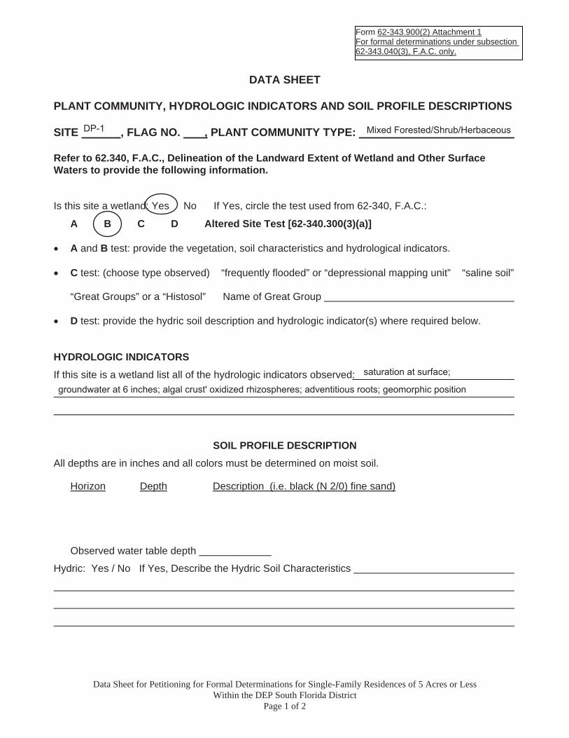
Form 62-343.900(2) Attachment 1For formal determinations under subsection 62-343.040(3), F.A.C. only.
DATA SHEET
PLANT COMMUNITY, HYDROLOGIC INDICATORS AND SOIL PROFILE DESCRIPTIONS
SITE , FLAG NO. , PLANT COMMUNITY TYPE:
Refer to 62.340, F.A.C., Delineation of the Landward Extent of Wetland and Other Surface Waters to provide the following information.
Is this site a wetland: Yes No If Yes, circle the test used from 62-340, F.A.C.:
A B C D Altered Site Test [62-340.300(3)(a)]
� A and B test: provide the vegetation, soil characteristics and hydrological indicators.
� C test: (choose type observed) “frequently flooded” or “depressional mapping unit” “saline soil”
“Great Groups” or a “Histosol” Name of Great Group
� D test: provide the hydric soil description and hydrologic indicator(s) where required below.
HYDROLOGIC INDICATORS If this site is a wetland list all of the hydrologic indicators observed:
SOIL PROFILE DESCRIPTION All depths are in inches and all colors must be determined on moist soil.
Horizon Depth Description (i.e. black (N 2/0) fine sand)A1 0-4
E 4-8
C 8-22+
Observed water table depth
Hydric: Yes / No If Yes, Describe the Hydric Soil Characteristics
Data Sheet for Petitioning for Formal Determinations for Single-Family Residences of 5 Acres or Less Within the DEP South Florida District
Page 1 of 2
DP-1 Mixed Forested/Shrub/Herbaceous
saturation at surface;
groundwater at 6 inches; algal crust' oxidized rhizospheres; adventitious roots; geomorphic position
ebs
Typewritten Text
A
ebs
Typewritten Text
0-3
ebs
Typewritten Text
10YR 2/1 (mucky medium sand w/ 80% coated grains)
ebs
Typewritten Text
B
ebs
Typewritten Text
3-10
ebs
Typewritten Text
10YR 7/1 (75%); 10YR 6/6 ox roots (5%); 10YR 6/2 (20%)
ebs
Typewritten Text
C
ebs
Typewritten Text
10-18
ebs
Typewritten Text
10YR 5/1
ebs
Typewritten Text
6 inches
ebs
Oval
ebs
Typewritten Text
presence of muck at surface; stripped matrix; oxidation in low value/low chroma sandy soils
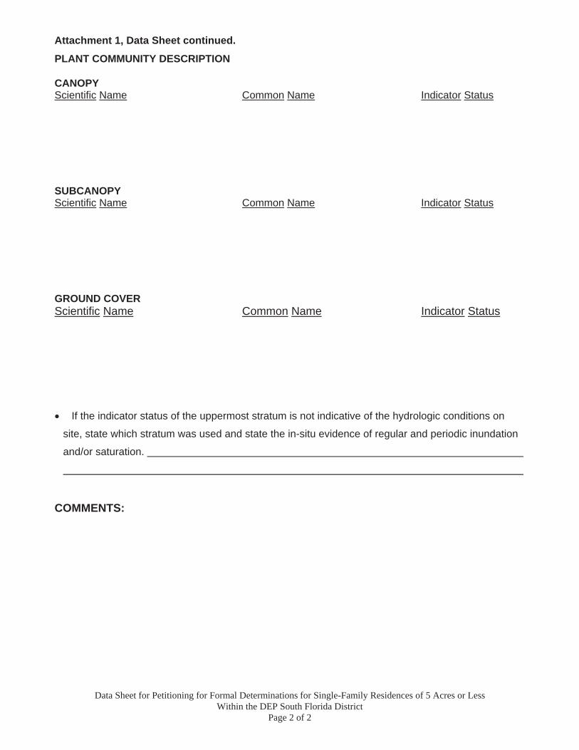
Attachment 1, Data Sheet continued.
PLANT COMMUNITY DESCRIPTION
CANOPYScientific Name Common Name Indicator Status
SUBCANOPYScientific Name Common Name Indicator Status
GROUND COVER Scientific Name Common Name Indicator Status
� If the indicator status of the uppermost stratum is not indicative of the hydrologic conditions on
site, state which stratum was used and state the in-situ evidence of regular and periodic inundation
and/or saturation.
COMMENTS:
Data Sheet for Petitioning for Formal Determinations for Single-Family Residences of 5 Acres or Less Within the DEP South Florida District
Page 2 of 2
ebs
Typewritten Text
Pinus elliottii
ebs
Typewritten Text
Slash Pine
ebs
Typewritten Text
UPL
ebs
Typewritten Text
Taxodium ascendens
ebs
Typewritten Text
Pond Cypress
ebs
Typewritten Text
OBL
ebs
Typewritten Text
Sapium sebifera
ebs
Typewritten Text
Chinese tallow
ebs
Typewritten Text
FAC
ebs
Typewritten Text
Cephalanthus occidentalisButtonbushOBL Myrica ceriferaWax myrtleFAC
ebs
Typewritten Text
Spartina patensSaltmeadow cordgrassFACW Saururus cernuusLizard's tailOBL Osmunda cinnamomeaCinnamon FernFACW Andropogon glomeratusBushy bluestemFACW
APPENDIX C
SUPPORTING DOCUMENTATION
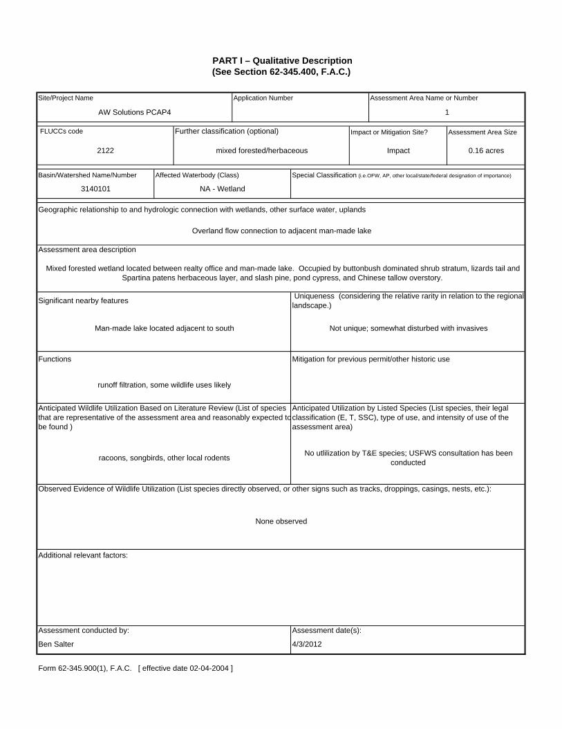
Site/Project Name Application Number Assessment Area Name or Number
Impact or Mitigation Site? Assessment Area Size
Assessment conducted by: Assessment date(s):
Geographic relationship to and hydrologic connection with wetlands, other surface water, uplands
Functions Mitigation for previous permit/other historic use
Significant nearby features
Assessment area description
Mixed forested wetland located between realty office and man-made lake. Occupied by buttonbush dominated shrub stratum, lizards tail and Spartina patens herbaceous layer, and slash pine, pond cypress, and Chinese tallow overstory.
Uniqueness (considering the relative rarity in relation to the regional landscape.)
Overland flow connection to adjacent man-made lake
1
2122 mixed forested/herbaceous Impact 0.16 acres
Further classification (optional)
(See Section 62-345.400, F.A.C.)
3140101 NA - Wetland
Special Classification (i.e.OFW, AP, other local/state/federal designation of importance)Affected Waterbody (Class)Basin/Watershed Name/Number
AW Solutions PCAP4
FLUCCs code
None observed
Observed Evidence of Wildlife Utilization (List species directly observed, or other signs such as tracks, droppings, casings, nests, etc.):
Anticipated Utilization by Listed Species (List species, their legal classification (E, T, SSC), type of use, and intensity of use of the assessment area)
Anticipated Wildlife Utilization Based on Literature Review (List of species that are representative of the assessment area and reasonably expected tobe found )
PART I – Qualitative Description
Form 62-345.900(1), F.A.C. [ effective date 02-04-2004 ]
Ben Salter 4/3/2012
Not unique; somewhat disturbed with invasives
Additional relevant factors:
racoons, songbirds, other local rodentsNo utlilization by T&E species; USFWS consultation has been
conducted
Man-made lake located adjacent to south
runoff filtration, some wildlife uses likely

w/o pres orcurrent
w/o pres or
current
w/o pres or
current
currentor w/o pres
Not Present (0)
4/3/2012
Moderate(7) Minimal (4)
1
Scoring GuidanceThe scoring of each
indicator is based on what would be suitable for the
type of wetland or surface water assessed
7
PART II – Quantification of Assessment Area (impact or mitigation)
Form 62-345.900(2), F.A.C. [effective date 02-04-2004]
0.7
Preservation adjustment factor =
Adjusted mitigation delta =
Delta = [with-current]
0.7
with
Minimal level of support of wetland/surface water
functions
Optimal (10)
(See Sections 62-345.500 and .600, F.A.C.)
AW Solutions PCAP4
Impact Ben Salter
Site/Project Name Application Number Assessment Area Name or Number
Impact or Mitigation Assessment date:Assessment conducted by:
.500(6)(a) Location and Landscape Support
with
Vicinity is occupied by commercial and residential development, natural areas are present to the east and west along the adjacent man-made lake which is immediately south of the project area
Condition is insufficient to provide wetland/surface
water functions
Condition is optimal and fully supports
wetland/surface water functions
Condition is less than optimal, but sufficient to
maintain most wetland/surface waterfunctions
with
with
.500(6)(c)Community structure
8
.500(6)(b)Water Environment (n/a for uplands)
1. Vegetation and/or 2. Benthic Community
6
Score = sum of above scores/30 (if uplands, divide by 20)
Inundation appears rare; near surface saturation appears to be present through only portions of the growing season; wetland likely provides some filtration of surrounding runoff
Mix of native and invasive species
Time lag (t-factor) =
Risk factor =
If mitigation
For impact assessment areas
FL = delta x acres = 0.06
For mitigation assessment areas
RFG = delta/(t-factor x risk) =
If preservation as mitigation,
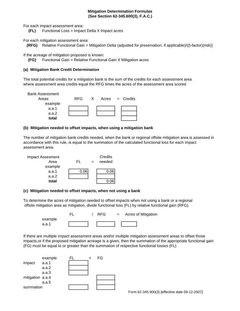
For each impact assessment area:(FL) Functional Loss = Impact Delta X Impact acres
For each mitigation assessment area:(RFG) Relative Functional Gain = Mitigation Delta (adjusted for preservation, if applicable)/((t-factor)(risk))
(FG)
(a) Mitigation Bank Credit Determination
The total potential credits for a mitigation bank is the sum of the credits for each assessment areawhere assessment area credits equal the RFG times the acres of the assessment area scored
RFG X Acres = Creditsexample
a.a.1a.a.2total
(b) Mitigation needed to offset impacts, when using a mitigation bank
Area FL =example
a.a.1 0.06 0.06a.a.2total 0.06
(c) Mitigation needed to offset impacts, when not using a bank
To determine the acres of mitigation needed to offset impacts when not using a bank or a regional offsite mitigation area as mitigation, divide functional loss (FL) by relative functional gain (RFG).
FL / RFG =examplea.a.1
example FL < FGimpact a.a.1
a.a.2a.a.3
mitigation a.a.4a.a.5
summation Form 62-345.900(3) [effective date 09-12-2007]
The number of mitigation bank credits needed, when the bank or regional offsite mitigation area is assessed in accordance with this rule, is equal to the summation of the calculated functional loss for each impact assessment area.
If there are multiple impact assessment areas and/or multiple mitigation assessment areas to offset those impacts,or if the proposed mitigation acreage is a given, then the summation of the appropriate functional gain (FG) must be equal to or greater than the summation of respective functional losses (FL)
Credits needed
Mitigation Determination Formulas(See Section 62-345.600(3), F.A.C.)
Acres of Mitigation
If the acreage of mitigation proposed is known:Functional Gain = Relative Functional Gain X Mitigation acres
Bank Assessment Areas
Impact Assesment

APPENDIX D Protected Species Information


Page 1
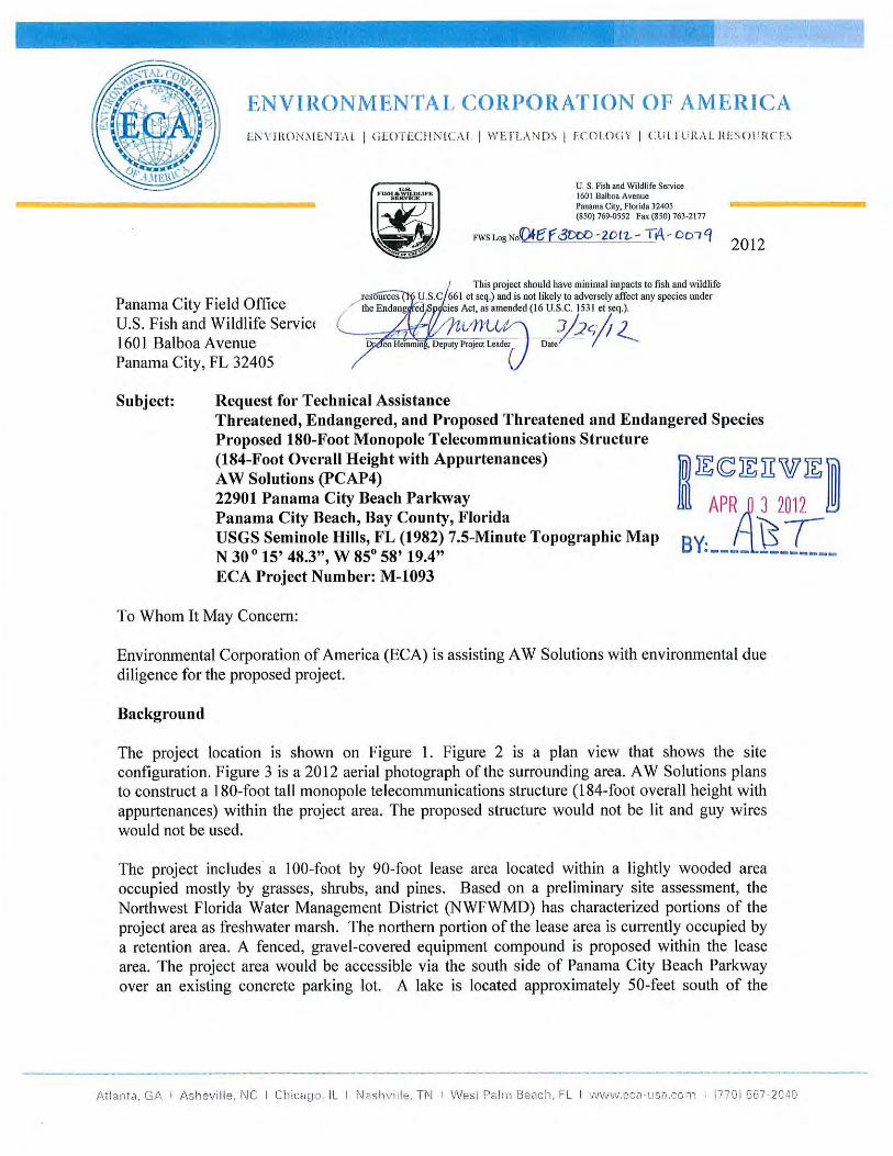
March 21, 2012 Panama City Field Office U.S. Fish and Wildlife Service 1601 Balboa Avenue Panama City, FL 32405 Subject: Request for Technical Assistance Threatened, Endangered, and Proposed Threatened and Endangered Species
Proposed 180-Foot Monopole Telecommunications Structure (184-Foot Overall Height with Appurtenances)
AW Solutions (PCAP4) 22901 Panama City Beach Parkway Panama City Beach, Bay County, Florida USGS Seminole Hills, FL (1982) 7.5-Minute Topographic Map
N 30 o 15’ 48.3”, W 85o 58’ 19.4” ECA Project Number: M-1093
To Whom It May Concern: Environmental Corporation of America (ECA) is assisting AW Solutions with environmental due diligence for the proposed project. Background The project location is shown on Figure 1. Figure 2 is a plan view that shows the site configuration. Figure 3 is a 2012 aerial photograph of the surrounding area. AW Solutions plans to construct a 180-foot tall monopole telecommunications structure (184-foot overall height with appurtenances) within the project area. The proposed structure would not be lit and guy wires would not be used. The project includes a 100-foot by 90-foot lease area located within a lightly wooded area occupied mostly by grasses, shrubs, and pines. Based on a preliminary site assessment, the Northwest Florida Water Management District (NWFWMD) has characterized portions of the project area as freshwater marsh. The northern portion of the lease area is currently occupied by a retention area. A fenced, gravel-covered equipment compound is proposed within the lease area. The project area would be accessible via the south side of Panama City Beach Parkway over an existing concrete parking lot. A lake is located approximately 50-feet south of the
Page 2
proposed lease area. Photographs of the project area are provided in Attachment B. Descriptions of the photographs are provided underneath each photograph and photograph locations are graphically depicted on Figure 2. Based on National Wetlands Inventory data, portions of the project area appear to be mapped as a wetland area. Based on our site visit, evidence of hydric soils and hydrophytic vegetation were noted in portions of the project area as shown on Figure 2 of Attachment A. ECA conducted a formal wetlands delineation to determine the jurisdictional status and extent of wetlands within the project area. Based on a delineation conducted by ECA, wetlands appear to be present in portions of the proposed lease area. Efforts are currently underway to obtain jurisdictional determinations from the NWFWMD and US Army Corps of Engineers (USACE). If impacts to wetlands and/or waters are proposed, AW Solutions will obtain the necessary authorizations prior to site development. Purpose The purpose of this letter is to provide you with documentation of our investigations and findings relative to federally protected species within the project area and to request US Fish and Wildlife (USFWS) technical assistance with our documentation. Review of Available Documentation and Site Inspection ECA has reviewed the most current U.S. Fish and Wildlife Service State and Federal Threatened, Endangered, and Other Species of Concern Likely to Occur in Bay County, Florida, the USFWS Information, Planning, and Conservation (IPaC) System, the USFWS Critical Habitat Mapper, Bald Eagle Nest Map, and Florida Wood Stork Colonies Core Foraging Areas. ECA has also reviewed information from various sources pertaining to the habitat requirements of the listed species. Habitat at the site was evaluated during our December 2, 2011 site visit, which was conducted by Andrew Tankel of ECA. Discussion of Findings
Although portions of the project area would occur in apparent wetlands, aquatic species are not a concern for this undertaking. The reticulated flatwoods salamander (Ambystoma bishopi), red-cockaded woodpecker (Picoides borealis), woodstork (Mycteria americana), piping plover (Charadrius melodus), Harper’s beauty (Harperocallis flava), white birds-in-a-nest (Macbridea alba), papery whitlow-wort (Paronychia chartacea), telephus spurge (Euphorbia telephioides), Godfrey’s butterwort (Pinguicula ionantha), Florida skullcap (Scutellaria floridana), and eastern indigo snake (Drymarchon corais couperi) are the only non-aquatic species listed by USFWS as federally protected in Bay County, Florida. Additionally, these species were identified as potentially present within the vicinity of the project area by the USFWS IPaC System. No designated critical habitat was identified within the project area vicinity. Reticulated flatwoods salamander (Ambystoma bishopi) is found in topographically flat or slightly rolling wiregrass-dominated grassland that has little to no midstory and an open overstory of widely scattered longleaf pine. The project area is located within an area of

Page 3
relatively dense shrub and grass/forb understory with scattered young and intermediate pines and would not provide suitable habitat for the reticulated flatwoods salamander. Red-cockaded woodpecker (Picoides borealis) is found in open stands of pines, with a minimum age of 80 to 120 years. Dense stands are avoided. The project area is located within an area of relatively dense shrub and grass/forb understory with scattered young and intermediate pines and would not provide suitable habitat for the red-cockaded woodpecker. Wood stork (Mycteria americana) nests in cypress and other wooded swamps. The project area is located within an area of relatively dense shrub and grass/forb understory with scattered young and intermediate pines and would not provide suitable habitat for the wood stork. Further, ECA did not observe evidence of any wood storks within or near the project area during our site inspection. The piping plover (Charadrius melodus) is found in sand dunes, shorelines, and coastlines areas in general. The project area is located within an area of relatively dense shrub and grass/forb understory with scattered young and intermediate pines and would not provide suitable habitat for the piping plover. Harper’s beauty (Harperocallis flava) is typically found in wet prairies, seepage slopes, pitcherplant bogs, transitions to shrub zones, and in nearby roadside ditches. The project area is located within an area of relatively dense shrub and grass/forb understory with scattered young and intermediate pines and would not provide suitable habitat for Harper’s beauty. White birds-in-a-nest (Macbridea alba) is typically found in Gulf coastal lowlands near the mouth of the Apalachicola River in the Florida Panhandle near wet areas occupied by grassy seepage bogs on gentle slopes at the edge of forested or shrubby wetlands. The project area is located within an area of relatively dense shrub and grass/forb understory with scattered young and intermediate pines and would not provide suitable habitat for white birds-in-a-nest. Papery whitlow-wort (Paronychia chartacea) is typically found in sand scrub of ancient dunes, in pure, white sand clearings or blowouts, and on the sandy shores of sinkhole lakes. The project area is located within an area of relatively dense shrub and grass/forb understory with scattered young and intermediate pines and would not provide suitable habitat for the papery whitlow-wort. Telephus spurge (Euphorbia telephioides) is typically found in wiregrass dominated, longleaf pine-slash pine savanna/flatwoods and on contiguous low, sandy rises dominated by pine-scrub oak near the coast. The project area is located within an area of relatively dense shrub and grass/forb understory with scattered young and intermediate pines and would not provide suitable habitat for the telephus spurge. Godfrey’s butterwort (Pinguicula ionantha) is typically found in open, acidic soils of seepage bogs on gentle slopes, deep quagmire bogs, ditches, and depressions in grassy pine flatwoods and grassy savannas. The project area is located within an area of relatively dense shrub and
Page 4
grass/forb understory with scattered young and intermediate pines and would not provide suitable habitat for Godfrey’s butterwort. Florida skullcap (Scutellaria floridana) is typically found in dark, humus rich sands of pine-palmetto flatwoods, wet prairies, and savannahs. The project area is located within an area of relatively dense shrub and grass/forb understory with scattered young and intermediate pines and would not provide suitable habitat for the Florida skullcap. Eastern indigo snake (Drymarchon corais couperi) is found in mesic flatwoods, upland pine forest, sandhills, and scrubby flatwoods, among other habitats. The project area is located within an area of relatively dense shrub and grass/forb understory with scattered young and intermediate pines and would not provide suitable habitat for the Eastern indigo snake. Conclusions Based on the information reviewed and our site inspection, ECA has found no evidence that the project area would provide suitable habitat for any federally listed species identified by USFWS as occurring within Bay County, Florida or that any critical habitat is present within the project vicinity. Based on these findings and recommendations, it is our opinion that the proposed project would not affect federally threatened or endangered species or designated critical habitat and would not be located in the proximity of documented wood stork colonies or bald eagle nesting sites. We have included a Tower Site Evaluation Form in Appendix D. Closure Andrew Tankel of ECA conducted the site visit, collected the applicable information, and compiled this report. Ben Salter reviewed this report. Mr. Salter is a degreed biologist. His resume is included in Attachment E. We appreciate your assistance with this undertaking. Please advise us if there are questions or if the U.S. Fish and Wildlife Service has additional information which may be useful in our evaluation of the project area for federally protected species. Sincerely yours, Environmental Corporation of America Andrew Tankel, EIT Ben Salter, REP Project Scientist Principal Biologist
APPENDIX A Figures

SITE
2000 0 2000 Feet
N
Source: USGS Topographic Quadrangle Maps, 7.5 Minute Series, Seminole Hills, FL (1982).
ECA Proj. #: M-1093
AW Solutions (PCAP4)
22901 Panama City Beach ParkwayPanama City Beach, Bay County, Florida
Figure 1: Site Location Plan
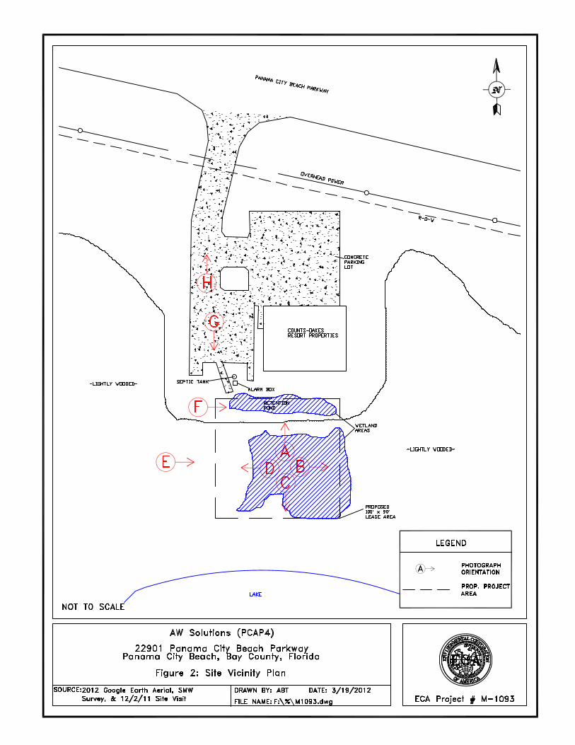
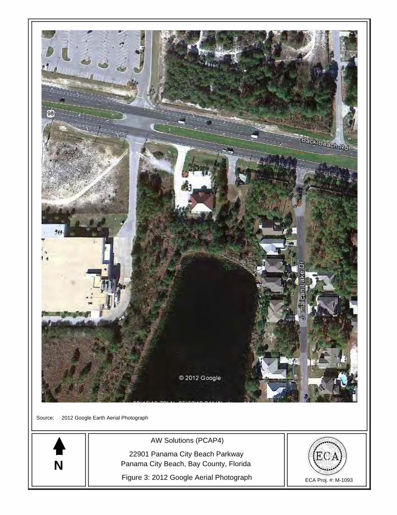
N
Source: 2012 Google Earth Aerial Photograph
ECA Proj. #: M-1093
AW Solutions (PCAP4)
22901 Panama City Beach ParkwayPanama City Beach, Bay County, Florida
Figure 3: 2012 Google Aerial Photograph
andrewt
Callout
SITE
No
v 29
, 201
1
Th
is
map
is
fo
r g
ener
al
refe
ren
ce
on
ly.
Th
e U
S
Fis
h
and
W
ildlif
e S
ervi
ce
is
no
tre
spo
nsi
ble
fo
r th
e ac
cura
cy o
r cu
rren
tnes
s o
f th
e b
ase
dat
a sh
ow
n o
n t
his
map
. A
llw
etla
nd
s re
late
d d
ata
sho
uld
be
use
d i
n a
cco
rdan
ce w
ith
th
e la
yer
met
adat
a fo
un
d o
nth
e W
etla
nd
s M
app
er w
eb s
ite.
Use
r R
emar
ks:
andrewt
Callout
SITE

Panama City Beach Pkwy
Panama City Beach Pkwy
£¤98
29
27
45
99
598840
598840
598860
598860
598880
598880
598900
598900
598920
598920
598940
598940
598960
598960
3348
380
3348
380
3348
400
3348
400
3348
420
3348
420
3348
440
3348
440
3348
460
3348
460
3348
480
3348
480
3348
500
3348
500
3348
520
3348
520
3348
540
3348
540
3348
560
3348
560
0 70 140 21035Feet
0 10 20 305Meters
±
30° 15' 53''
85°
58' 1
6''
30° 15' 46''
85°
58' 1
6''
30° 15' 46''
30° 15' 53''85
° 58
' 21'
'85
° 58
' 21'
'
Map Scale: 1:958 if printed on A size (8.5" x 11") sheet.
Soil Map—Bay County, Florida
Natural ResourcesNatural ResourcesNatural ResourcesNatural ResourcesConservation ServiceConservation ServiceConservation ServiceConservation Service
Web Soil SurveyNational Cooperative Soil Survey
11/29/2011Page 1 of 3
andrewt
Callout
SITE

MA
P LE
GEN
DM
AP
INFO
RM
ATI
ON
Are
a of
Inte
rest
(AO
I)A
rea
of In
tere
st (A
OI)
Soils
Soi
l Map
Uni
ts
Spec
ial P
oint
Fea
ture
sB
low
out
Bor
row
Pit
Cla
y S
pot
Clo
sed
Dep
ress
ion
Gra
vel P
it
Gra
velly
Spo
t
Land
fill
Lava
Flo
w
Mar
sh o
r sw
amp
Min
e or
Qua
rry
Mis
cella
neou
s W
ater
Per
enni
al W
ater
Roc
k O
utcr
op
Sal
ine
Spo
t
San
dy S
pot
Sev
erel
y E
rode
d S
pot
Sin
khol
e
Slid
e or
Slip
Sod
ic S
pot
Spo
il A
rea
Sto
ny S
pot
Ver
y S
tony
Spo
t
Wet
Spo
t
Oth
er
Spec
ial L
ine
Feat
ures
Gul
ly
Sho
rt S
teep
Slo
pe
Oth
er
Polit
ical
Fea
ture
sC
ities
Wat
er F
eatu
res
Stre
ams
and
Can
als
Tran
spor
tatio
nR
ails
Inte
rsta
te H
ighw
ays
US
Rou
tes
Maj
or R
oads
Loca
l Roa
ds
Map
Sca
le: 1
:958
if p
rinte
d on
A s
ize
(8.5
" × 1
1") s
heet
.
The
soil
surv
eys
that
com
pris
e yo
ur A
OI w
ere
map
ped
at 1
:20,
000.
War
ning
: Soi
l Map
may
not
be
valid
at t
his
scal
e.
Enl
arge
men
t of m
aps
beyo
nd th
e sc
ale
of m
appi
ng c
an c
ause
mis
unde
rsta
ndin
g of
the
deta
il of
map
ping
and
acc
urac
y of
soi
l lin
epl
acem
ent.
The
map
s do
not
sho
w th
e sm
all a
reas
of c
ontra
stin
gso
ils th
at c
ould
hav
e be
en s
how
n at
a m
ore
deta
iled
scal
e.
Ple
ase
rely
on
the
bar s
cale
on
each
map
she
et fo
r acc
urat
e m
apm
easu
rem
ents
.
Sou
rce
of M
ap:
Nat
ural
Res
ourc
es C
onse
rvat
ion
Ser
vice
Web
Soi
l Sur
vey
UR
L:
http
://w
ebso
ilsur
vey.
nrcs
.usd
a.go
vC
oord
inat
e S
yste
m:
UTM
Zon
e 16
N N
AD
83
This
pro
duct
is g
ener
ated
from
the
US
DA
-NR
CS
cer
tifie
d da
ta a
s of
the
vers
ion
date
(s) l
iste
d be
low
.
Soi
l Sur
vey
Are
a:
Bay
Cou
nty,
Flo
rida
Sur
vey
Are
a D
ata:
V
ersi
on 1
1, J
an 2
9, 2
010
Dat
e(s)
aer
ial i
mag
es w
ere
phot
ogra
phed
: 9
/29/
2007
The
orth
opho
to o
r oth
er b
ase
map
on
whi
ch th
e so
il lin
es w
ere
com
pile
d an
d di
gitiz
ed p
roba
bly
diffe
rs fr
om th
e ba
ckgr
ound
imag
ery
disp
laye
d on
thes
e m
aps.
As
a re
sult,
som
e m
inor
shi
fting
of m
ap u
nit b
ound
arie
s m
ay b
e ev
iden
t.
Soi
l Map
–Bay
Cou
nty,
Flo
rida
Nat
ural
Res
ourc
esC
onse
rvat
ion
Serv
ice
Web
Soi
l Sur
vey
Nat
iona
l Coo
pera
tive
Soi
l Sur
vey
11/2
9/20
11P
age
2 of
3

Map Unit Legend
Bay County, Florida (FL005)
Map Unit Symbol Map Unit Name Acres in AOI Percent of AOI
27 Mandarin sand 1.0 20.2%
29 Rutlege sand 3.0 61.0%
45 Kureb sand, 0 to 5 percent slopes 0.5 10.2%
99 Water 0.4 8.6%
Totals for Area of Interest 5.0 100.0%
Soil Map–Bay County, Florida
Natural ResourcesConservation Service
Web Soil SurveyNational Cooperative Soil Survey
11/29/2011Page 3 of 3
APPENDIX B Photographs

B: Easterly View from the Center of the Proposed Lease Area
A: Northerly View from the Center of the Proposed Lease Area
ECA Proj. #: M-1093
AW Solutions (PCAP4)
22901 Panama City Beach ParkwayPanama City Beach, Bay County, Florida
Photographs
D: Westerly View from the Center of the Proposed Lease Area
C: Southerly View from the Center of the Proposed Lease Area
ECA Proj. #: M-1093
AW Solutions (PCAP4)
22901 Panama City Beach ParkwayPanama City Beach, Bay County, Florida
Photographs

F: Easterly Overview of the Retention Pond Located Within the Northern Portion of the Proposed Lease Area
E: Easterly Overview of the Proposed Lease Area
ECA Proj. #: M-1093
AW Solutions (PCAP4)
22901 Panama City Beach ParkwayPanama City Beach, Bay County, Florida
Photographs

H: Northerly View of the Existing Access Easement
G: Southerly View of the Existing Access Easement
ECA Proj. #: M-1093
AW Solutions (PCAP4)
22901 Panama City Beach ParkwayPanama City Beach, Bay County, Florida
Photographs

APPENDIX C Protected Species Information
Gro
upN
ame
Pop
ulat
ion
Sta
tus
Lead
Offi
ceR
ecov
ery
Pla
n N
ame
Rec
over
y P
lan
Sta
ge
Am
phib
ians
Ret
icul
ated
flat
woo
dsE
ndan
gere
dM
issi
ssip
pi E
colo
gica
l Ser
vice
s
Bird
sR
ed-c
ocka
ded
woo
dpec
ker
End
ange
red
Mis
siss
ippi
Eco
logi
cal S
ervi
ces
Red
-coc
kade
d W
oodp
ecke
rF
inal
Rev
isio
n 2
Bird
sW
ood
stor
k (M
ycte
riaA
L, F
L, G
A, S
CE
ndan
gere
dN
orth
Flo
rida
Eco
logi
cal
Rev
ised
Rec
over
y P
lan
for
the
Fin
al R
evis
ion
1
Bird
sP
ipin
g P
love
r (C
hara
driu
sex
cept
Gre
at L
akes
wat
ersh
edT
hrea
tene
dO
ffice
Of T
he R
egio
nal D
irect
orG
reat
Lak
es &
Nor
ther
n G
reat
Fin
al
Bird
sP
ipin
g P
love
r (C
hara
driu
sex
cept
Gre
at L
akes
wat
ersh
edT
hrea
tene
dO
ffice
Of T
he R
egio
nal D
irect
orP
ipin
g P
love
r A
tlant
ic C
oast
Fin
al R
evis
ion
1
Bird
sR
ed k
not (
Cal
idris
can
utus
ruf
a)C
andi
date
New
Jer
sey
Eco
logi
cal S
ervi
ces
Cla
ms
Ova
l pig
toe
(Ple
urob
ema
End
ange
red
Pan
ama
City
Eco
logi
cal
Rec
over
y P
lan
for
7 m
usse
lsF
inal
Cla
ms
Gul
f moc
casi
nshe
ll (M
edio
nidu
sE
ndan
gere
dP
anam
a C
ity E
colo
gica
lR
ecov
ery
Pla
n fo
r 7
mus
sels
Fin
al
Fis
hes
Gul
f stu
rgeo
n (A
cipe
nser
Thr
eate
ned
Pan
ama
City
Eco
logi
cal
Gul
f Stu
rgeo
nF
inal
Flo
wer
ing
Pla
nts
Har
per's
bea
uty
(Har
pero
calli
sE
ndan
gere
dP
anam
a C
ity E
colo
gica
lH
arpe
r's B
eaut
yF
inal
Flo
wer
ing
Pla
nts
Whi
te b
irds-
in-a
-nes
tT
hrea
tene
dP
anam
a C
ity E
colo
gica
lA
pala
chic
ola
Pla
nts
(4 s
pp.)
Fin
al
Flo
wer
ing
Pla
nts
Pap
ery
whi
tlow
-wor
tT
hrea
tene
dS
outh
Flo
rida
Eco
logi
cal
Sou
th F
lorid
a M
ulti-
Spe
cies
Fin
al
Flo
wer
ing
Pla
nts
Tel
ephu
s sp
urge
(E
upho
rbia
Thr
eate
ned
Pan
ama
City
Eco
logi
cal
Apa
lach
icol
a P
lant
s (4
spp
.)F
inal
Flo
wer
ing
Pla
nts
God
frey
's b
utte
rwor
t (P
ingu
icul
aT
hrea
tene
dP
anam
a C
ity E
colo
gica
lA
pala
chic
ola
Pla
nts
(4 s
pp.)
Fin
al
Flo
wer
ing
Pla
nts
Flo
rida
skul
lcap
(S
cute
llaria
Thr
eate
ned
Pan
ama
City
Eco
logi
cal
Apa
lach
icol
a P
lant
s (4
spp
.)F
inal
Mam
mal
sW
est I
ndia
n m
anat
eeE
ndan
gere
dN
orth
Flo
rida
Eco
logi
cal
Flo
rida
Man
atee
Rec
over
y P
lan,
Fin
al R
evis
ion
3
Mam
mal
sW
est I
ndia
n m
anat
eeE
ndan
gere
dN
orth
Flo
rida
Eco
logi
cal
Rec
over
y P
lan
Pue
rto
Ric
anF
inal
Mam
mal
sC
hoct
awha
tche
e be
ach
mou
seE
ndan
gere
dP
anam
a C
ity E
colo
gica
lB
each
Mic
e (3
spp
.)F
inal
Mam
mal
sS
t. A
ndre
w b
each
mou
seE
ndan
gere
dP
anam
a C
ity E
colo
gica
lF
inal
Rec
over
y P
lan
for
the
St.
Fin
al
Rep
tiles
Haw
ksbi
ll se
a tu
rtle
End
ange
red
Nor
th F
lorid
a E
colo
gica
lR
ecov
ery
Pla
n fo
r U
.S. P
acifi
cF
inal
Rev
isio
n 1
Rep
tiles
Haw
ksbi
ll se
a tu
rtle
End
ange
red
Nor
th F
lorid
a E
colo
gica
lR
ecov
ery
Pla
n fo
r th
e H
awks
bill
Fin
al R
evis
ion
1
Rep
tiles
Leat
herb
ack
sea
turt
leE
ndan
gere
dN
orth
Flo
rida
Eco
logi
cal
Rec
over
y P
lan
for
Leat
herb
ack
Fin
al R
evis
ion
1
Rep
tiles
Leat
herb
ack
sea
turt
leE
ndan
gere
dN
orth
Flo
rida
Eco
logi
cal
Rec
over
y P
lan
for
U.S
. Pac
ific
Fin
al R
evis
ion
1
Rep
tiles
Kem
p's
ridle
y se
a tu
rtle
End
ange
red
Cor
pus
Chr
isti
Eco
logi
cal
Dra
ft B
i-Nat
iona
l Rec
over
y P
lan
Dra
ft R
evis
ion
2
Rep
tiles
Gre
en s
ea tu
rtle
(C
helo
nia
FL,
Mex
ico
nest
ing
pops
.E
ndan
gere
dN
orth
Flo
rida
Eco
logi
cal
Rec
over
y P
lan
for
U.S
. Pac
ific
Fin
al R
evis
ion
1
Rep
tiles
Gre
en s
ea tu
rtle
(C
helo
nia
FL,
Mex
ico
nest
ing
pops
.E
ndan
gere
dN
orth
Flo
rida
Eco
logi
cal
Rec
over
y P
lan
for
U.S
.F
inal
Rev
isio
n 1
Rep
tiles
Logg
erhe
ad s
ea tu
rtle
(C
aret
taT
hrea
tene
dN
orth
Flo
rida
Eco
logi
cal
Rec
over
y P
lan
for
U.S
. Pac
ific
Fin
al R
evis
ion
1
Rep
tiles
Logg
erhe
ad s
ea tu
rtle
(C
aret
taT
hrea
tene
dN
orth
Flo
rida
Eco
logi
cal
Rec
over
y P
lan
for
the
Nor
thw
est
Fin
al R
evis
ion
2
Rep
tiles
Eas
tern
indi
go s
nake
Thr
eate
ned
Mis
siss
ippi
Eco
logi
cal S
ervi
ces
Eas
tern
Indi
go S
nake
Fin
al
Rep
tiles
Gop
her
tort
oise
(G
ophe
rus
east
ern
Can
dida
te
andrewt
Typewritten Text
BAY COUNTY, FLORIDA SPECIES LIST
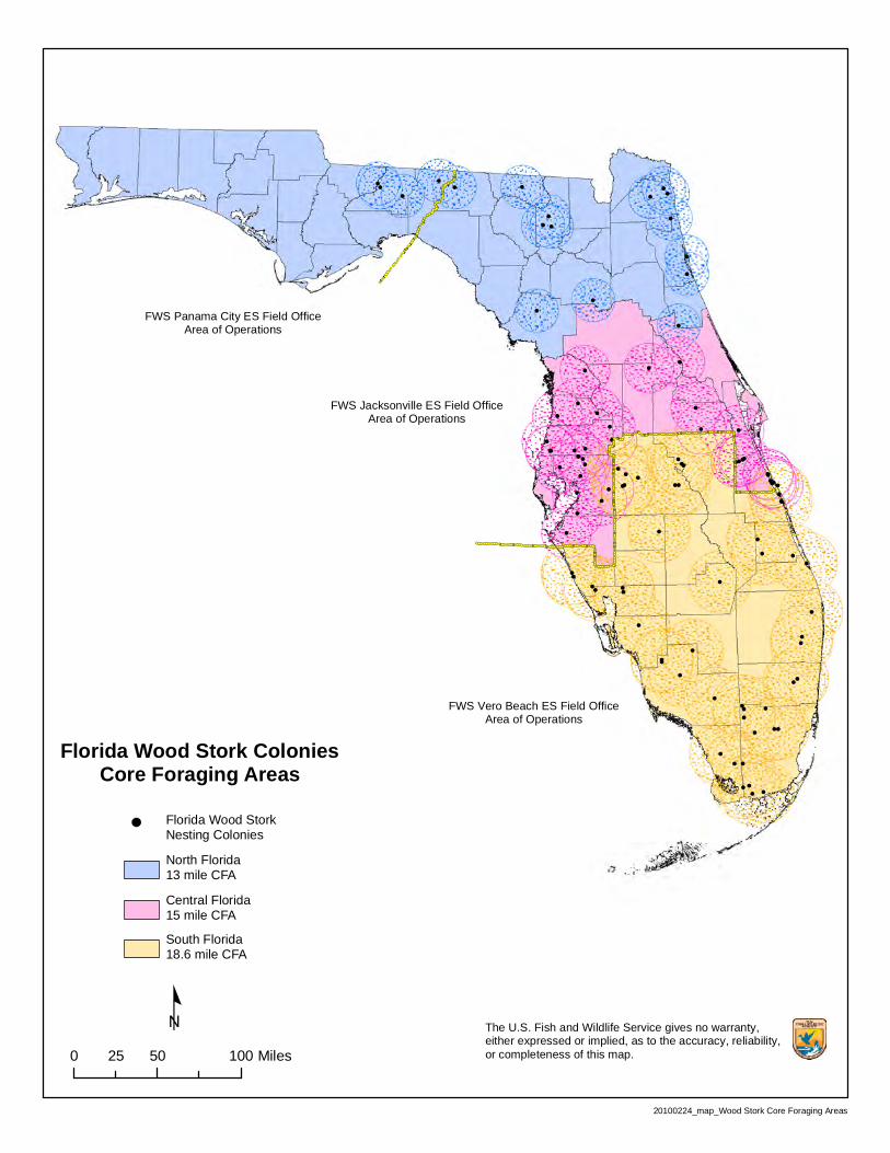
!
!
!!!!
!!!!! !
!!
! !!
!
!
!!
!
!
!
! !
! !!
!
!!!
!
!!!!
!!
!
!
!
!
!
!
!
!!
!
!
!!
!
!
!
!
!!
!
!
!
!!
!
!!
!
!
!
!
!
!
!
!
!
!
!
!
!
!
!
!! !
!
!
!!!
!!
!! !!
!
!
!
!
!
!
! !
º
Florida Wood Stork ColoniesCore Foraging Areas
0 50 10025 Miles
The U.S. Fish and Wildlife Service gives no warranty, either expressed or implied, as to the accuracy, reliability,or completeness of this map.
Florida Wood StorkNesting Colonies
North Florida13 mile CFA
Central Florida15 mile CFA
South Florida18.6 mile CFA
20100224_map_Wood Stork Core Foraging Areas
FWS Panama City ES Field OfficeArea of Operations
FWS Jacksonville ES Field OfficeArea of Operations
FWS Vero Beach ES Field OfficeArea of Operations
andrewt
Callout
SITE
Print Preview
Data to print Data range Nest history
Data Table and Map
Data Table Only
All Search Results
Current Page Only
Yes
No
This report was generated using the bald eagle nest locator at https://public.myfwc.com/FWRI/EagleNests/nestlocator.aspx on 12/1/2011 6:30:24 AM.
Search Entered: Within 1 miles of latitude 30.2634166666667 and longitude -85.9720555555556; All Search Results
0 record(s) were found; 0 record(s) are shown
Bald Eagle Nest Map:
Bald Eagle Nest Data Search Results: Results per page:
"Y" denotes an active nest "U" denotes a nest that was visited but status was undetermined"N" denotes an inactive nest "*" denotes a nest that was not surveyed"-" denotes an unobserved nest
Print Bald Eagle Nest Data https://public.myfwc.com/FWRI/EagleNests/PrintData.aspx
1 of 1 12/1/2011 6:28 AM
andrewt
Callout
SITE

Generated by the Information, Planning, and Conservation (IPaC) System on 03/21/2012 04:48 AM Page 1
Official Species-list: AW Solutions (PCAP4)
Panama City Ecological Services Field Office
Following is an official U.S. Fish and Wildlife Service species-list from the Panama City
Ecological Services Field Office. The species-list identifies listed and proposed species and
designated and proposed critical habitat that may be affected by the project "AW Solutions
(PCAP4)". You may use this list to meet the requirements of section 7(c) of the Endangered
Species Act of 1973, as amended (ESA).
This species-list has been generated by the Service's on-line Information, Planning, and
Conservation (IPaC) decision support system based on project type and location information
you provided on March 21, 2012, 4:48 AM. This information is summarized below.
Please reference our tracking number, 04EF3000-2012-SLI-0077, in future reference to this
project to assist in expediting the process.
Newer information based on updated surveys, changes in the abundance and distribution of
listed species, changed habitat conditions, or other factors could change this list. Please feel free
to contact the office(s) identified below if you need more current information or assistance
regarding the potential presence of federally proposed, listed, or candidate species, or proposed
or designated critical habitat. Please note that under the ESA, a species-list is valid for 90 days.
Therefore, the Service recommends that you visit the IPaC site at regular intervals during
project planning and implementation for updates to species-lists and information. An updated
list may be requested through the IPaC system by completing the same process used to receive
this list. More information on the regulations and procedures for section 7 consultation,
including the role of permit or license applicants, can be found in the "Endangered Species
Consultation Handbook" at:
http://www.fws.gov/endangered/esa-library/pdf/TOC-GLOS.PDF
This list below only addresses federally proposed, listed, or candidate species and federally
designated critical habitat. Please contact the appropriate State agencies for information
regarding State species of special designation. Also, please feel free to contact the office(s)
identified below if you would like information on other important trust resources (such as
migratory birds) in your project area.
United States Department of InteriorFish and Wildlife Service
Project name: AW Solutions (PCAP4)

Generated by the Information, Planning, and Conservation (IPaC) System on 03/21/2012 04:48 AM Page 2
This Species-list document is provided by: PANAMA CITY ECOLOGICAL SERVICES FIELD OFFICE
1601 BALBOA AVENUE
PANAMA CITY, FL 32405
(850) 769-0552
http://www.fws.gov/panamacity/specieslist.html
http://www.fws.gov/panamacity/pcdata.html TAILS consultation code: 04EF3000-2012-SLI-0077 Project type: Communications Tower
United States Department of InteriorFish and Wildlife Service
Project name: AW Solutions (PCAP4)

Generated by the Information, Planning, and Conservation (IPaC) System on 03/21/2012 04:48 AM Page 3
Project location map:
Project coordinates: MULTIPOLYGON (((-85.97257 30.2641134, -85.9711538 30.2638988, -85.9711323
30.2631049, -85.97257 30.2631478, -85.97257 30.2641134))) Project counties: Bay, FL
United States Department of InteriorFish and Wildlife Service
Project name: AW Solutions (PCAP4)

Generated by the Information, Planning, and Conservation (IPaC) System on 03/21/2012 04:48 AM Page 4
Endangered Species Act Species-listEastern Indigo snake (Drymarchon corais couperi)
Listing Status: Threatened Florida skullcap (Scutellaria floridana)
Listing Status: Threatened Godfrey's butterwort (Pinguicula ionantha)
Listing Status: Threatened Green sea turtle (Chelonia mydas)
Population: FL, Mexico nesting pops.
Listing Status: Endangered Gulf moccasinshell (Medionidus penicillatus)
Listing Status: Endangered Gulf sturgeon (Acipenser oxyrinchus desotoi)
Listing Status: Threatened Harper's beauty (Harperocallis flava)
Listing Status: Endangered Hawksbill sea turtle (Eretmochelys imbricata)
Listing Status: Endangered Kemp's Ridley sea turtle (Lepidochelys kempii)
Listing Status: Endangered Leatherback sea turtle (Dermochelys coriacea)
Listing Status: Endangered Loggerhead sea turtle (Caretta caretta)
Listing Status: Threatened Oval pigtoe (Pleurobema pyriforme)
Listing Status: Endangered Papery whitlow-wort (Paronychia chartacea)
Listing Status: Threatened
United States Department of InteriorFish and Wildlife Service
Project name: AW Solutions (PCAP4)
Generated by the Information, Planning, and Conservation (IPaC) System on 03/21/2012 04:48 AM Page 5
Piping Plover (Charadrius melodus)
Population: except Great Lakes watershed
Listing Status: Threatened Red-Cockaded woodpecker (Picoides borealis)
Listing Status: Endangered Reticulated flatwoods salamander (Ambystoma bishopi)
Listing Status: Endangered Telephus spurge (Euphorbia telephioides)
Listing Status: Threatened West Indian manatee (Trichechus manatus)
Listing Status: Endangered White birds-in-a-nest (Macbridea alba)
Listing Status: Threatened Wood stork (Mycteria americana)
Population: AL, FL, GA, SC
Listing Status: Endangered
United States Department of InteriorFish and Wildlife Service
Project name: AW Solutions (PCAP4)

APPENDIX D Tower Site Evaluation Form

TOWER SITE EVALUATION FORM
1. Location (Provide maps if possible): State: FL County: Bay Latitude/Longitude/GPS Grid: N 30 15’ 48.3” W 85 58’ 19.4” Directions: From Tallahassee, Take I-10 West toward Pensacola. Turn left onto SR-12 West / Greensboro Hwy. Turn left to stay on SR-12 / Green Ave. Turn right onto SR-12 / SR-20 / NW Sr 20. Keep straight onto SR-20 / NW Sr 20. Turn left onto US-231 South / SR-75 South / Highway 231. Bear right onto SR-368 / SR-390 ALT / E 23rd St. Turn right onto US-98 / SR-30 / SR-30A / W Highway 98. Site will be on left.
2. Elevation above mean sea level: ~7 feet 3. Will the equipment be co-located on an existing FCC licensed tower or other existing
structure (building, billboard, etc.)? (y/n) No If yes, type of structure: If yes, no further information is required.
4. If no, provide proposed specifications for new tower: Height: 184’ Construction type (lattice, monopole, etc.): Monopole Guy-wired? (y/n) No Bands: n/a Total No. Wires: n/a Lighting (Security & Aviation): No
If tower will be lighted or guy-wired, complete items 5-19. If not, complete only items 19 and 20. 5. Area of tower footprint in acres or square feet: 6. Length and width of access road in feet: 7. General description of terrain – mountainous, rolling hills flat to undulation, etc.
Photographs of the site and surrounding area are beneficial:
8. Meteorological conditions (incidence of fog, low ceilings, etc.): 9. Soil type(s): 10. Habitat types and land use on and adjacent to the site, by acreage and percentage of total:
11. Dominant vegetative species in each habitat:
12. Average diameter breast height of dominant tree species in forested areas: 13. Will construction at this site cause fragmentation of a larger block of habitat into two or more
smaller blocks? (y/n) If yes, describe: 14. Is evidence of birds roosts or rookeries present? (y/n) If yes, describe: 15. Distance to nearest wetland area (forested swamp, march, riparian, marine, etc.), and
coastline if applicable: 16. Distance to nearest telecommunications tower: 17. Potential for co-location of antennas on existing towers or other structures: 18. Have measures been incorporated to minimizing impacts to migratory birds? (y/n) 19. Has an evaluation been made to determine if proposed facility may affect listed or proposed
endangered or threatened species or their habitat as required by FCC regulation at 47 CFR 1.1307(a)(3)? (y/n) Yes If, yes present findings: View report.
20. Additional information required:
APPENDIX E Qualified Biologist Resume
EDUCATION
Western Carolina University Cullowhee, NC
Master of Biology, August 2004 Georgia College & State University Milledgeville, GA
Bachelor of Science, Biology, December 1998 Chemistry Minor
Short Courses/Specialized Training
GA DOT Coastal Wetland Plant Identification w/ Dr. Bob Mohlenbrock, 2010 Brunswick, GA Airports Council International – North American NEPA Workshop, 2009 Kansas City, MO NC State Stream Restoration Design Principles, 2007 Asheville, NC Southeastern Watershed Roundtable, 2006 Asheville, NC Rosgen Level 1 – Applied Fluvial Geomorphology, 2006 Asheville, NC VDEQ Stream Impact and Compensation Assessment Manual Workshop, 2006 Norfolk, VA VIMS Perennial Stream Workshop, 2005 Gloucester, VA VA Association of Wetlands Professionals Regulatory Update, 2005 Williamsburg, VA
PROFESSIONAL REGISTRATIONS National Registry of Environmental Professionals, Registered Environmental Professional, 2007 to present
PROFESSIONAL EXPERIENCE
November 2007 – Present Environmental Corporation of America Asheville, NC Position: Principal Scientist, Office Manager Responsibilities:
Principal Scientist for Phase I ESA, NEPA, Ecological, and Wetlands related projects; Manager of ECA’s Asheville, NC office; Responsible for client management, final review, oversight, and/or field effort for ecological and wetlands related projects, preparation of wetlands and ecological permitting documents; review of Phase I ESA, environmental, and NEPA documents.
April 2006 – November 2007 Blue Ridge Ecological Waynesville, NC Position: Principal Scientist, Partner Responsibilities:
Partner/Principal Scientist in natural resource management firm focused on fisheries/lake management, watershed assessment, water quality monitoring, and biological assessment.
January 2005 – November 2007 Malcolm Pirnie, Inc. Newport News, VA Position: Project Environmental Scientist Responsibilities:
Wetland and Stream Scientist, National Environmental Policy Act Specialist, and Environmental Scientist; Primary responsibilities included EA and EIS writer, wetland and stream field scientist, and environmental site assessor.
August 2002 – December 2004 Western Carolina University Cullowhee, NC Position: Research and Teaching Assistant Responsibilities:
Fisheries Scientist and Biology/Ecology Laboratory Instructor
Ben SalterPrincipal Scientist
1340 Patton Avenue, Suite K, Asheville, NC 28806(828) 505‐0755
ben.salter@eca‐usa.com

May 2003 – September 2003 United States Forest Service Asheville, NC Position: Biological Science Technician Responsibilities:
Fisheries scientist for southern Appalachian brook trout project. Collected brook trout tissue samples in headwater streams throughout Western North Carolina and conducted genetic analysis for determining origin.
January 1999 – May 2001 Environmental Corporation of America Alpharetta, GA Position: Project Scientist/Manager Responsibilities:
Project manager for various environmental projects including Phase I and II Environmental Assessments, FCC NEPA assessment, asbestos and lead‐based paint inspection and abatement monitoring, cultural resource assessments, threatened and endangered species surveys, groundwater monitoring and remediation system installation, geotechnical investigation, construction materials testing, and telecommunications tower construction plan review.
JOURNAL PUBLICATIONS Miller, JR, EB Salter, JB Anderson, PJ Lechler, SL Kondrad, PF Galbreath. 2005. Influence of Temporal Variations in Water Chemistry on the Pb Isotopic Compositions of Rainbow Trout (Oncorhynchus mykiss). Science of the Total Environment, 350, p. 204‐224.
REPRESTATIVE EXPERIENCE
USACE and NC DWQ Individual Section 404/401 Permits and CAMA Consistency Proposed Telecommunications Facility, Carteret County, North Carolina US Forest Service Biological Evaluation Proposed Eastern Band of Cherokee Indians Snowbird Community Center, Nantahala National Forest, Robbinsville, North Carolina Bureau of Land Management Biological Assessment Right of Way Assignment Effects on Sclerocactus glaucus, Grand Junction, Colorado Indiana Bat Roosting Habitat Surveys Multitude of Proposed Telecommunications Tower Sites throughout the Southeastern United States Environmental Impact Statement / Feasibility Study for Flood Damage Reduction and Ecosystem Restoration, US Army Corps of Engineers and James River Water Development District, James River, South Dakota Critical Habitat Consultation Proposed Telecommunications Tower Facility, Norman, Oklahoma US Department of Housing and Urban Development NEPA Environmental Assessment Proposed Old #4 Sewer Line Replacement, Cherokee, North Carolina US Army Corps of Engineers and Virginia Port Authority Environmental Impact Statement Craney Island Dredged Material Disposal Area Expansion and Subsequent Virginia Port Authority Craney Island Terminal Construction, Portsmouth, Virginia EPA 319 Watershed Management Plan Chestatee‐Chattahoochee RC&D Mud and Little Mud Creek, Habersham County, Georgia USACE Wetland/Stream Delineations and USACE/State Section 404/401 Permitting Alabama, Delaware, Georgia, Florida, Illinois, Louisiana, Mississippi, North Carolina, New York, Ohio, South Carolina, South Dakota, Virginia, and West Virginia US Department of Justice NEPA Environmental Assessment Proposed Eastern Band of Cherokee Indians Correctional Facility, Cherokee, NC Wetlands Delineation Over 2000 acres, City of Jacksonville Land Treatment System Expansion, Onslow County, North Carolina

Bureau of Indian Affairs NEPA Environmental Assessment Mary Lambert Farm Road Improvement Project, Cherokee, North Carolina FCC NEPA Evaluation and Environmental Assessment and USACE Section 404 Permitting Proposed Telecommunications Facility, Mecklenburg County, North Carolina US Economic Development Administration, NEPA Environmental Assessment Proposed Eastern Band of Cherokee Indians Lower Soco Creek Sewer Line Replacement, Cherokee, North Carolina Bureau of Indian Affairs NEPA Environmental Assessment Old River Road Improvement Project, Cherokee, NC US Forest Service NEPA Environmental Assessment Proposed Eastern Band of Cherokee Indians Snowbird Community Center, Nantahala National Forest, Robbinsville, North Carolina MultiDay Active Osprey Nest Monitoring Telecommunications Tower Activities, Wilmington Island, GA Individual Permit Application and State Environmental Policy Act Documentation City of Jacksonville Land Treatment System Expansion, Onslow County, North Carolina USACE and FDEP Wetlands Individual Permit and Mitigation Proposed Telecommunications Facility, Walton County, Florida USACE and St. Johns River Water Management District Wetlands Permitting and Mitigation Proposed Telecommunications Facility, Fellsmere, FL USACE and St. Johns River Water Management District Wetlands Permitting and Mitigation Proposed Telecommunications Facility, Jacksonville, FL Bureau of Indian Affairs NEPA Environmental Assessment Hunting Boy Branch Road Improvement Project, Graham County, North Carolina Federal Communications Commission NEPA Investigations Combined Project Manager and Project Principal Participation in Thousands of Projects Nationwide Protected Species Evaluations/ USFWS and State Wildlife Agency Consultations Combined Project Manager and Project Principal Participation in Thousands of Projects Nationwide Intensive Survey for the Federally Threatened DwarfFlowered Heartleaf Multiple Projects, Western North Carolina Evaluation of Ecosystem Restoration and Flood Damage Reduction Measures on the Federally Endangered Topeka Shiner James River Basin, South Dakota Wetland Delineation and Mapping of Eastern Band of Cherokee Indians Reservation Cherokee, North Carolina Telecommunications Tower Osprey Nesting Survey Greensboro, North Carolina Phase I Environmental Site Assessments Combined Project Manager and Project Principal Participation in Thousands of Projects Nationwide Phase II Environmental Assessments, UST Removals, Groundwater Monitoring Events, and Petroleum and Chlorinated Solvent Remediation System Installations Multiple Projects in Southeastern and Midwest United States

Water Quality Testing and Benthic and Fish Assessment City of Hiawassee, Hiawassee, Georgia Ecological Risk Assessment Brown’s Lake, Fort Eustis, Newport News, Virginia Benthic, Geomorphology, and Water Quality Evaluation Upper Occoquan Sewage Authority, Bull Run, Manassas, Virginia Fisheries Assessment and Management Plan Development Lake Lure, North Carolina Fisheries Assessment and Management Plan Development Lake Ravenel, Highlands, North Carolina Brook Trout Genetic Typing, Population Estimate, Habitat Survey, and Restoration Multiple Projects throughout Western North Carolina VA Environmental Impact Reports Multiple Projects for Virginia Port Authority and Virginia Department of Juvenile Justice Evaluation of Lead Isotopic Composition of Freshwater Snails of Richland Creek Basin Masters Thesis, Waynesville, North Carolina Asbestos and LeadBased Paint Inspections, Abatement Monitoring, and Preparation of Abatement Specifications Multiple Projects throughout Georgia Geotechnical Investigations and Construction Material Testing Cell Tower and Fiber Optic Communications Infrastructure – Multiple Projects Nationwide
APPENDIX E Historic and Archaeological Documentation

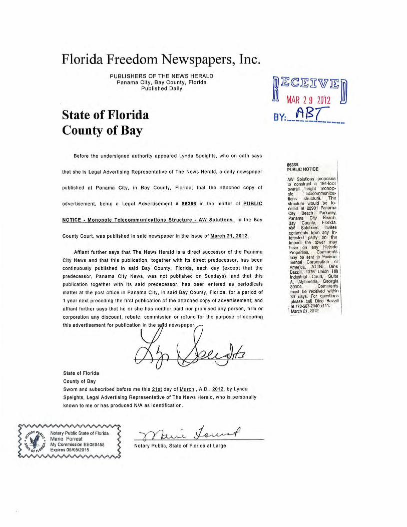
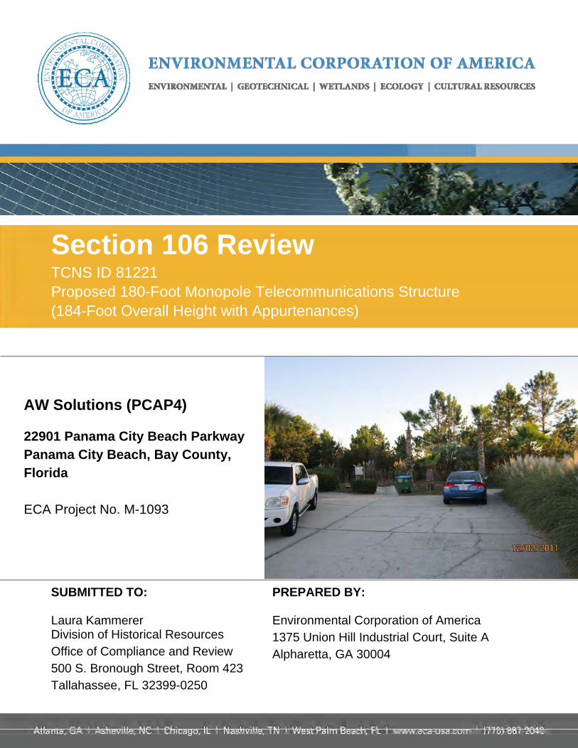
Section 106 Review TCNS ID 81221 Proposed 180-Foot Monopole Telecommunications Structure (184-Foot Overall Height with Appurtenances)
AW Solutions (PCAP4) 22901 Panama City Beach Parkway Panama City Beach, Bay County, Florida ECA Project No. M-1093
SUBMITTED TO: Laura Kammerer Division of Historical Resources Office of Compliance and Review 500 S. Bronough Street, Room 423 Tallahassee, FL 32399-0250
PREPARED BY: Environmental Corporation of America 1375 Union Hill Industrial Court, Suite A Alpharetta, GA 30004

March 20, 2012
Division of Historical Resources Office of Compliance and Review 500 S. Bronough Street, Room 423 Tallahassee, FL 32399-0250 Attention: Ms. Laura Kammerer Historic Preservation Supervisor Subject: Section 106 Review TCNS # 81221 Proposed 180-Foot Monopole Telecommunications Structure (184-Foot Overall Height with Appurtenances) AW Solutions (PCAP4) 22901 Panama City Beach Parkway Panama City Beach, Bay County, Florida ECA Project # M-1093 Dear Ms. Kammerer: Environmental Corporation of America’s (ECA) client, AW Solutions, is proposing to lease a 100-foot by 90-foot (30-meter by 27-meter) area for the construction of a telecommunications facility as described in the following FCC Form 620, New Tower (NT) Submission Packet. The facility would consist of a fenced compound surrounding a 184-foot (56-meter) tall overall height monopole telecommunications structure, and associated ground-level support equipment. The facility would be accessible by an existing parking lot. ECA has identified and evaluated Historic Properties within the Area of Potential Effect (APE) for visual and direct effects as directed in Sections VI.D.1 and 2 of the Nationwide Programmatic Agreement, effective on March 7, 2005. We have found no properties listed in or eligible for the National Register of Historic Places (NRHP) within either APE. A search of the Florida Master Site File (FMSF) identified no previously recorded historic structures within the ½-mile APE for visual effects. An Archaeological Assessment was conducted within the APE for direct effects. During our research with the FMSF, we found three previously identified archaeological sites (BY00191, BY-00870, and BY00957), but no surveys, located within a ¾-mile background research radius
Laura Kammerer Page 2
of the project area. The previously recorded archaeological sites are located outside the APE for direct effects. During our fieldwork, we discovered no archaeological sites and uncovered no archaeological cultural artifacts (see Attachment E-1c). Based on our findings, we recommend no further consultation under Section 106 Review of the National Historic Preservation Act for this proposed undertaking. Based on this documentation, prepared in accordance with the Nationwide Programmatic Agreement effective March 7, 2005, ECA believes that this proposed facility would have no effect on any Historic Properties identified in accordance with the NPA. Therefore, we recommend a finding of "No Effect" for the proposed undertaking. We are submitting this letter, on behalf of AW Solutions, to seek concurrence with this finding and to comply with Federal Communications Commission (FCC) requirements as identified in 47 CFR 1.1307. We request your concurrence with our finding. Please contact our office with any questions or comments. Sincerely, Environmental Corporation of America Andrew Tankel, EIT Autumn DuBois, MA, RPA Project Manager Senior Archaeologist

FCC Form 620 September 2008 – Page 1
FCC Form 620 FCC Wireless Telecommunications Bureau Approved by OMB
New Tower (“NT”) Submission Packet 3060 – 1039
See instructions for
public burden estimates
General Information 1) (Select only one) ( )
NE – New UA – Update of Application WD – Withdrawal of Application
2) If this application is for an Update or Withdrawal, enter the file number of the pending application currently on file. File Number:
Applicant Information 3) FCC Registration Number (FRN):
4) Name:
Contact Name
5) First Name: 6) MI: 7) Last Name: 8) Suffix:
9) Title:
Contact Information
10) P.O. Box: And /Or 11) Street Address:
12) City: 13) State: 14) Zip Code:
15) Telephone Number: 16) Fax Number:
17) E-mail Address:
Consultant Information
18) FCC Registration Number (FRN):
19) Name:
Principal Investigator
20) First Name: 21) MI: 22) Last Name: 23) Suffix:
24) Title:
Principal Investigator Contact Information
25) P.O. Box: And /Or 26) Street Address:
27) City: 28) State: 29) Zip Code:
30) Telephone Number: 31) Fax Number:
32) E-mail Address:
NE
AW Solutions, Inc.
Russ Azar
300 Crown Oak Centre Drive
Longwood FL 32750
407-260-0231
0011662921
Environmental Corporation of America
Dina M Bazzill
MA, RPA - Principal Archaeologist / Principal Historian
1375 Union Hill Industrial Court, Suite A
Alpharetta GA 30004
770-667-2040 x 111 770-667-2041

FCC Form 620 September 2008 – Page 2
Professional Qualification
33) Does the Principal Investigator satisfy the Secretary of the Interior’s Professional Qualification Standards? ( ) Yes ( ) No
34) Areas of Professional Qualification:
( ) Archaeologist
( ) Architectural Historian
( ) Historian
( ) Architect
( ) Other (Specify) __________________________________________________
Additional Staff
35) Are there other staff involved who meet the Professional Qualification Standards of the Secretary of the Interior? ( ) Yes ( ) No
If “Yes”, complete the following:
36) First Name: 37) MI: 38) Last Name: 39) Suffix:
40) Title:
41) Areas of Professional Qualification:
( ) Archaeologist
( ) Architectural Historian
( ) Historian
( ) Architect
( ) Other (Specify) __________________________________________________
This page may be copied to include additional staff. Consultant Information Attachments required – See instructions for details.
✔
✔
✔
✔
Autumn A DuBois
MA, RPA - Senior Archaeologist/Senior Historian
✔
✔
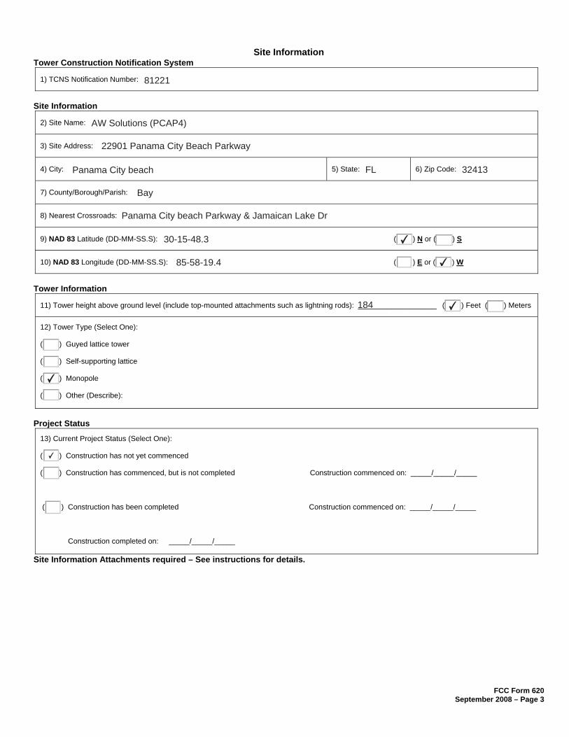
FCC Form 620 September 2008 – Page 3
Site Information Tower Construction Notification System
1) TCNS Notification Number:
Site Information
2) Site Name:
3) Site Address:
4) City: 5) State: 6) Zip Code:
7) County/Borough/Parish:
8) Nearest Crossroads:
9) NAD 83 Latitude (DD-MM-SS.S): ( ) N or ( ) S
10) NAD 83 Longitude (DD-MM-SS.S): ( ) E or ( ) W
Tower Information
11) Tower height above ground level (include top-mounted attachments such as lightning rods): ___________________ ( ) Feet ( ) Meters
12) Tower Type (Select One):
( ) Guyed lattice tower
( ) Self-supporting lattice
( ) Monopole
( ) Other (Describe):
Project Status
13) Current Project Status (Select One):
( ) Construction has not yet commenced
( ) Construction has commenced, but is not completed Construction commenced on: _____/_____/_____
( ) Construction has been completed Construction commenced on: _____/_____/_____
Construction completed on: _____/_____/_____
Site Information Attachments required – See instructions for details.
81221
AW Solutions (PCAP4)
22901 Panama City Beach Parkway
Panama City beach FL 32413
Bay
Panama City beach Parkway & Jamaican Lake Dr
30-15-48.3 ✔
85-58-19.4 ✔
184 ✔
✔
✔
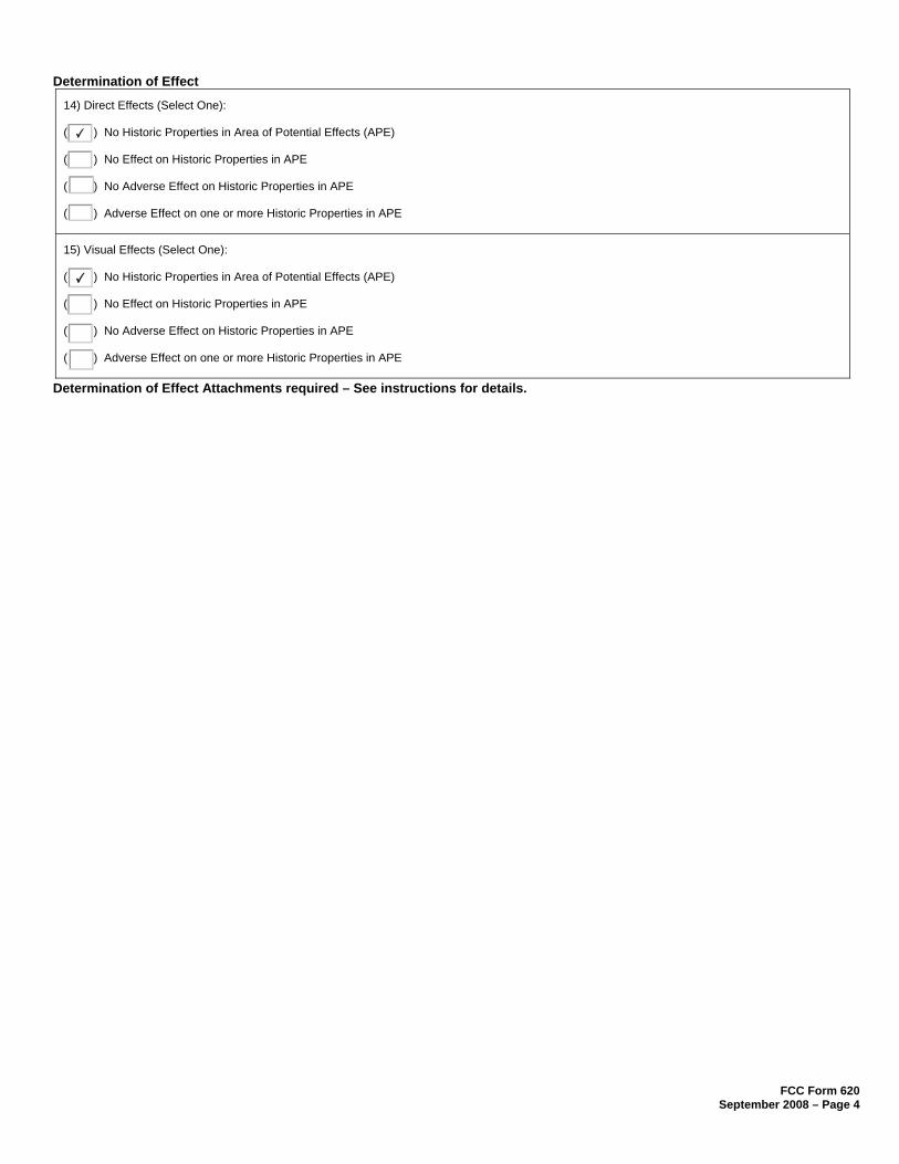
FCC Form 620 September 2008 – Page 4
Determination of Effect
14) Direct Effects (Select One):
( ) No Historic Properties in Area of Potential Effects (APE)
( ) No Effect on Historic Properties in APE
( ) No Adverse Effect on Historic Properties in APE
( ) Adverse Effect on one or more Historic Properties in APE
15) Visual Effects (Select One):
( ) No Historic Properties in Area of Potential Effects (APE)
( ) No Effect on Historic Properties in APE
( ) No Adverse Effect on Historic Properties in APE
( ) Adverse Effect on one or more Historic Properties in APE
Determination of Effect Attachments required – See instructions for details.
✔
✔

FCC Form 621 September 2008 – Page 5
Tribal/NHO Involvement
1) Have Indian Tribes or Native Hawaiian Organizations (NHOs) been identified that may attach religious and cultural significance to historic properties which may be affected by the undertaking within the APEs for direct and visual effects? ( ) Yes ( ) No
2a) Tribes/NHOs contacted through TCNS Notification Number: ___________________ Number of Tribes/NHOs: _________________
2b) Tribes/NHOs contacted through an alternate system: Number of Tribes/NHOs: _________________
Tribe/NHO Contacted Through TCNS
3) Tribe/NHO FRN:
4) Tribe/NHO Name:
Contact Name
5) First Name: 6) MI: 7) Last Name: 8) Suffix:
9) Title:
Dates & Response
10) Date Contacted _______________ 11) Date Replied _______________
( ) No Reply
( ) Replied/No Interest
( ) Replied/Have Interest
( ) Replied/Other ______________________________________________________________________________________________
This page may be copied to include additional Tribes/NHOs contacted. Tribal/NHO Involvement Attachments may be required – See instructions for details.
✔
81221 8
None NA
Alabama-Coushatta Tribe of Texas
Bryant J Celestine
Historic Preservation Officer
12/2/11
✔ Requested Section 106 Review Documentation and Review Fee

FCC Form 621 September 2008 – Page 5
Tribal/NHO Involvement
1) Have Indian Tribes or Native Hawaiian Organizations (NHOs) been identified that may attach religious and cultural significance to historic properties which may be affected by the undertaking within the APEs for direct and visual effects? ( ) Yes ( ) No
2a) Tribes/NHOs contacted through TCNS Notification Number: ___________________ Number of Tribes/NHOs: _________________
2b) Tribes/NHOs contacted through an alternate system: Number of Tribes/NHOs: _________________
Tribe/NHO Contacted Through TCNS
3) Tribe/NHO FRN:
4) Tribe/NHO Name:
Contact Name
5) First Name: 6) MI: 7) Last Name: 8) Suffix:
9) Title:
Dates & Response
10) Date Contacted _______________ 11) Date Replied _______________
( ) No Reply
( ) Replied/No Interest
( ) Replied/Have Interest
( ) Replied/Other ______________________________________________________________________________________________
This page may be copied to include additional Tribes/NHOs contacted. Tribal/NHO Involvement Attachments may be required – See instructions for details.
✔
81221 8
None NA
Coushatta Indian Tribe
Linda P Langley
THPO
12/2/11
✔ Requested Section 106 Review Documentation and review fee

FCC Form 621 September 2008 – Page 5
Tribal/NHO Involvement
1) Have Indian Tribes or Native Hawaiian Organizations (NHOs) been identified that may attach religious and cultural significance to historic properties which may be affected by the undertaking within the APEs for direct and visual effects? ( ) Yes ( ) No
2a) Tribes/NHOs contacted through TCNS Notification Number: ___________________ Number of Tribes/NHOs: _________________
2b) Tribes/NHOs contacted through an alternate system: Number of Tribes/NHOs: _________________
Tribe/NHO Contacted Through TCNS
3) Tribe/NHO FRN:
4) Tribe/NHO Name:
Contact Name
5) First Name: 6) MI: 7) Last Name: 8) Suffix:
9) Title:
Dates & Response
10) Date Contacted _______________ 11) Date Replied _______________
( ) No Reply
( ) Replied/No Interest
( ) Replied/Have Interest
( ) Replied/Other ______________________________________________________________________________________________
This page may be copied to include additional Tribes/NHOs contacted. Tribal/NHO Involvement Attachments may be required – See instructions for details.
✔
81221 8
None NA
Jena Band of Choctaw Indians
Dana M Masters
Tribal Historic Preservation Officer
12/2/11
✔ Requested Section 106 Review Documentation and review fee

FCC Form 621 September 2008 – Page 5
Tribal/NHO Involvement
1) Have Indian Tribes or Native Hawaiian Organizations (NHOs) been identified that may attach religious and cultural significance to historic properties which may be affected by the undertaking within the APEs for direct and visual effects? ( ) Yes ( ) No
2a) Tribes/NHOs contacted through TCNS Notification Number: ___________________ Number of Tribes/NHOs: _________________
2b) Tribes/NHOs contacted through an alternate system: Number of Tribes/NHOs: _________________
Tribe/NHO Contacted Through TCNS
3) Tribe/NHO FRN:
4) Tribe/NHO Name:
Contact Name
5) First Name: 6) MI: 7) Last Name: 8) Suffix:
9) Title:
Dates & Response
10) Date Contacted _______________ 11) Date Replied _______________
( ) No Reply
( ) Replied/No Interest
( ) Replied/Have Interest
( ) Replied/Other ______________________________________________________________________________________________
This page may be copied to include additional Tribes/NHOs contacted. Tribal/NHO Involvement Attachments may be required – See instructions for details.
✔
81221 8
None NA
Miccosukee Tribe of Indians of Florida
Fred Dayhoff
NAGPRA & Section 106 Representative
12/2/11
✔ Requested 30-day Response Limit Agreement
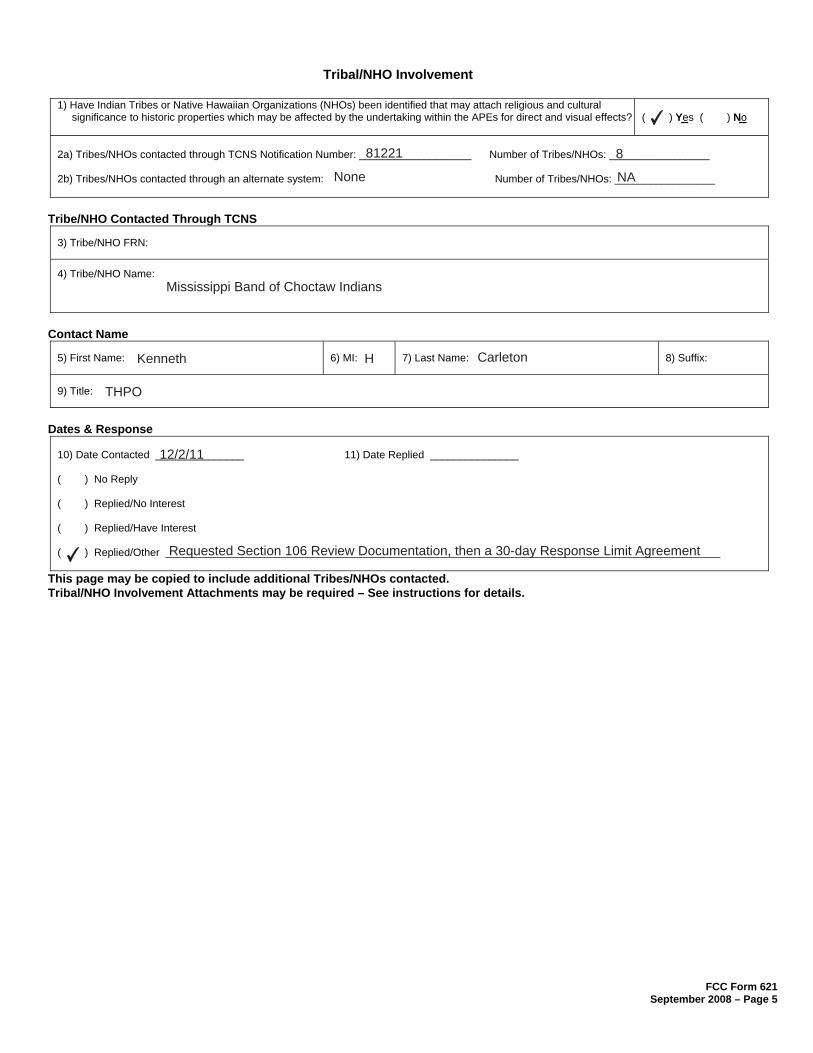
FCC Form 621 September 2008 – Page 5
Tribal/NHO Involvement
1) Have Indian Tribes or Native Hawaiian Organizations (NHOs) been identified that may attach religious and cultural significance to historic properties which may be affected by the undertaking within the APEs for direct and visual effects? ( ) Yes ( ) No
2a) Tribes/NHOs contacted through TCNS Notification Number: ___________________ Number of Tribes/NHOs: _________________
2b) Tribes/NHOs contacted through an alternate system: Number of Tribes/NHOs: _________________
Tribe/NHO Contacted Through TCNS
3) Tribe/NHO FRN:
4) Tribe/NHO Name:
Contact Name
5) First Name: 6) MI: 7) Last Name: 8) Suffix:
9) Title:
Dates & Response
10) Date Contacted _______________ 11) Date Replied _______________
( ) No Reply
( ) Replied/No Interest
( ) Replied/Have Interest
( ) Replied/Other ______________________________________________________________________________________________
This page may be copied to include additional Tribes/NHOs contacted. Tribal/NHO Involvement Attachments may be required – See instructions for details.
✔
81221 8
None NA
Mississippi Band of Choctaw Indians
Kenneth H Carleton
THPO
12/2/11
✔ Requested Section 106 Review Documentation, then a 30-day Response Limit Agreement

FCC Form 621 September 2008 – Page 5
Tribal/NHO Involvement
1) Have Indian Tribes or Native Hawaiian Organizations (NHOs) been identified that may attach religious and cultural significance to historic properties which may be affected by the undertaking within the APEs for direct and visual effects? ( ) Yes ( ) No
2a) Tribes/NHOs contacted through TCNS Notification Number: ___________________ Number of Tribes/NHOs: _________________
2b) Tribes/NHOs contacted through an alternate system: Number of Tribes/NHOs: _________________
Tribe/NHO Contacted Through TCNS
3) Tribe/NHO FRN:
4) Tribe/NHO Name:
Contact Name
5) First Name: 6) MI: 7) Last Name: 8) Suffix:
9) Title:
Dates & Response
10) Date Contacted _______________ 11) Date Replied _______________
( ) No Reply
( ) Replied/No Interest
( ) Replied/Have Interest
( ) Replied/Other ______________________________________________________________________________________________
This page may be copied to include additional Tribes/NHOs contacted. Tribal/NHO Involvement Attachments may be required – See instructions for details.
✔
81221 8
None NA
Seminole Tribe of Florida
Elliott York
Archaeological Data Analyst
12/2/11
✔ Requested Section 106 Review Documentation and review fee
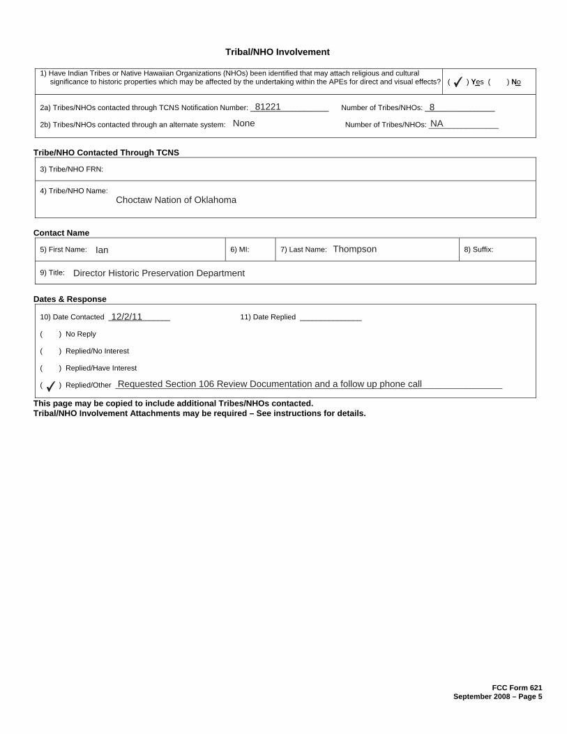
FCC Form 621 September 2008 – Page 5
Tribal/NHO Involvement
1) Have Indian Tribes or Native Hawaiian Organizations (NHOs) been identified that may attach religious and cultural significance to historic properties which may be affected by the undertaking within the APEs for direct and visual effects? ( ) Yes ( ) No
2a) Tribes/NHOs contacted through TCNS Notification Number: ___________________ Number of Tribes/NHOs: _________________
2b) Tribes/NHOs contacted through an alternate system: Number of Tribes/NHOs: _________________
Tribe/NHO Contacted Through TCNS
3) Tribe/NHO FRN:
4) Tribe/NHO Name:
Contact Name
5) First Name: 6) MI: 7) Last Name: 8) Suffix:
9) Title:
Dates & Response
10) Date Contacted _______________ 11) Date Replied _______________
( ) No Reply
( ) Replied/No Interest
( ) Replied/Have Interest
( ) Replied/Other ______________________________________________________________________________________________
This page may be copied to include additional Tribes/NHOs contacted. Tribal/NHO Involvement Attachments may be required – See instructions for details.
✔
81221 8
None NA
Choctaw Nation of Oklahoma
Ian Thompson
Director Historic Preservation Department
12/2/11
✔ Requested Section 106 Review Documentation and a follow up phone call

FCC Form 621 September 2008 – Page 5
Tribal/NHO Involvement
1) Have Indian Tribes or Native Hawaiian Organizations (NHOs) been identified that may attach religious and cultural significance to historic properties which may be affected by the undertaking within the APEs for direct and visual effects? ( ) Yes ( ) No
2a) Tribes/NHOs contacted through TCNS Notification Number: ___________________ Number of Tribes/NHOs: _________________
2b) Tribes/NHOs contacted through an alternate system: Number of Tribes/NHOs: _________________
Tribe/NHO Contacted Through TCNS
3) Tribe/NHO FRN:
4) Tribe/NHO Name:
Contact Name
5) First Name: 6) MI: 7) Last Name: 8) Suffix:
9) Title:
Dates & Response
10) Date Contacted _______________ 11) Date Replied _______________
( ) No Reply
( ) Replied/No Interest
( ) Replied/Have Interest
( ) Replied/Other ______________________________________________________________________________________________
This page may be copied to include additional Tribes/NHOs contacted. Tribal/NHO Involvement Attachments may be required – See instructions for details.
✔
81221 8
None NA
Seminole Nation of Oklahoma
Historic Preservation Officer
12/2/11
✔ Requested 30-day Response Limit Agreement
FCC Form 620 September 2008 – Page 6
Other Tribes/NHOs Contacted
Tribe/NHO Information
1) FCC Registration Number (FRN):
2) Name:
Contact Name
3) First Name: 4) MI: 5) Last Name: 6) Suffix:
7) Title:
Contact Information
8) P.O. Box: And /Or 9) Street Address:
10) City: 11) State: 12) Zip Code:
13) Telephone Number: 14) Fax Number:
15) E-mail Address:
16) Preferred means of communication:
( ) Letter
( ) Both
Dates & Response
17) Date Contacted _____/_____/_____ 18) Date Replied _____/_____/_____
( ) No Reply
( ) Replied/No Interest
( ) Replied/Have Interest
( ) Replied/Other ___________________________________________________________________________________________
This page may be copied to include additional Tribes/NHOs.
NA
NA

FCC Form 620 September 2008 – Page 7
Historic Properties Properties Identified
1) Have any historic properties been identified within the APEs for direct and visual effect? ( ) Yes ( ) No
2) Has the identification process located archaeological materials that would be directly affected, or sites that are ofcultural or religious significance to Tribes/NHOs? ( ) Yes ( ) No
3) Are there more than 10 historic properties within the APEs for direct and visual effect? If “Yes”, you are required to attach a Cultural Resources Report in lieu of adding the Historic Property below. ( ) Yes ( ) No
Historic Property
4) Property Name:
5) SHPO Site Number:
Property Address
6) Street Address:
7) City: 8) State: 9) Zip Code:
10) County/Borough/Parish:
Status & Eligibility
11) Is this property listed on the National Register?
Source: _______________________________________________________________________________________ ( ) Yes ( ) No
12) Is this property eligible for listing on the National Register?
Source: _______________________________________________________________________________________ ( ) Yes ( ) No
13) Is this property a National Historic Landmark? ( ) Yes ( ) No
14) Direct Effects (Select One):
( ) No Effect on this Historic Property in APE
( ) No Adverse Effect on this Historic Property in APE
( ) Adverse Effect on this Historic Property in APE
15) Visual Effects (Select One):
( ) No Effect on this Historic Property in APE
( ) No Adverse Effect on this Historic Property in APE
( ) Adverse Effect on this Historic Property in APE
This page may be copied to include additional Historic Properties. Historic Property Attachments required – See instructions for details.
✔
✔
✔
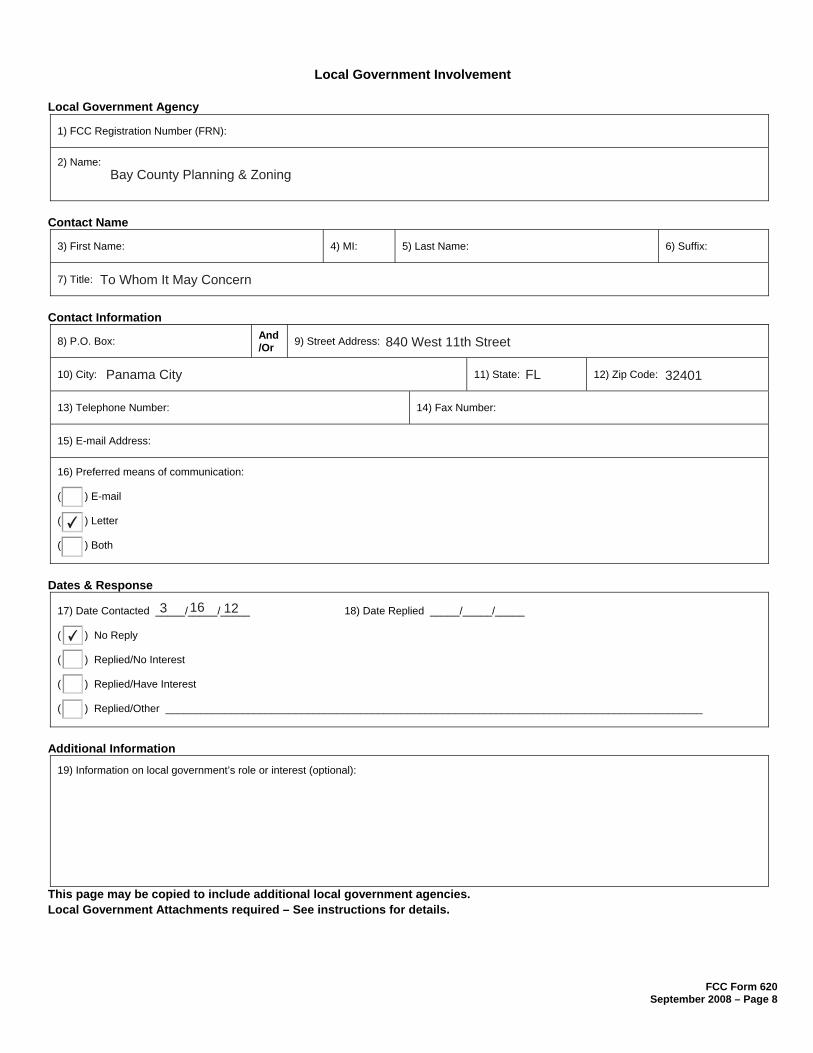
FCC Form 620 September 2008 – Page 8
Local Government Involvement
Local Government Agency
1) FCC Registration Number (FRN):
2) Name:
Contact Name
3) First Name: 4) MI: 5) Last Name: 6) Suffix:
7) Title:
Contact Information
8) P.O. Box: And /Or 9) Street Address:
10) City: 11) State: 12) Zip Code:
13) Telephone Number: 14) Fax Number:
15) E-mail Address:
16) Preferred means of communication:
( ) Letter
( ) Both
Dates & Response
17) Date Contacted _____/_____/_____ 18) Date Replied _____/_____/_____
( ) No Reply
( ) Replied/No Interest
( ) Replied/Have Interest
( ) Replied/Other ___________________________________________________________________________________________
Additional Information
19) Information on local government’s role or interest (optional):
This page may be copied to include additional local government agencies. Local Government Attachments required – See instructions for details.
Bay County Planning & Zoning
To Whom It May Concern
840 West 11th Street
Panama City FL 32401
✔
3 16 12
✔
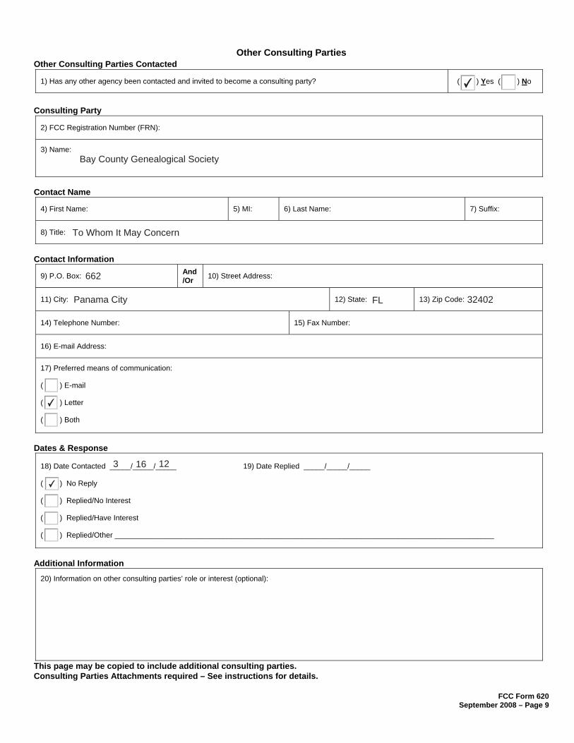
FCC Form 620 September 2008 – Page 9
Other Consulting Parties Other Consulting Parties Contacted
1) Has any other agency been contacted and invited to become a consulting party? ( ) Yes ( ) No
Consulting Party
2) FCC Registration Number (FRN):
3) Name:
Contact Name
4) First Name: 5) MI: 6) Last Name: 7) Suffix:
8) Title:
Contact Information
9) P.O. Box: And /Or 10) Street Address:
11) City: 12) State: 13) Zip Code:
14) Telephone Number: 15) Fax Number:
16) E-mail Address:
17) Preferred means of communication:
( ) Letter
( ) Both
Dates & Response
18) Date Contacted _____/_____/_____ 19) Date Replied _____/_____/_____
( ) No Reply
( ) Replied/No Interest
( ) Replied/Have Interest
( ) Replied/Other ___________________________________________________________________________________________
Additional Information
20) Information on other consulting parties’ role or interest (optional):
This page may be copied to include additional consulting parties. Consulting Parties Attachments required – See instructions for details.
✔
Bay County Genealogical Society
To Whom It May Concern
662
Panama City FL 32402
✔
3 16 12
✔

FCC Form 620 September 2008 – Page 9
Other Consulting Parties Other Consulting Parties Contacted
1) Has any other agency been contacted and invited to become a consulting party? ( ) Yes ( ) No
Consulting Party
2) FCC Registration Number (FRN):
3) Name:
Contact Name
4) First Name: 5) MI: 6) Last Name: 7) Suffix:
8) Title:
Contact Information
9) P.O. Box: And /Or 10) Street Address:
11) City: 12) State: 13) Zip Code:
14) Telephone Number: 15) Fax Number:
16) E-mail Address:
17) Preferred means of communication:
( ) Letter
( ) Both
Dates & Response
18) Date Contacted _____/_____/_____ 19) Date Replied _____/_____/_____
( ) No Reply
( ) Replied/No Interest
( ) Replied/Have Interest
( ) Replied/Other ___________________________________________________________________________________________
Additional Information
20) Information on other consulting parties’ role or interest (optional):
This page may be copied to include additional consulting parties. Consulting Parties Attachments required – See instructions for details.
✔
Bay County Historical Society
To Whom It May Concern
1476
Panama City FL 32402
✔
3 16 12
✔

Attachment A Applicant’s Name: AW Solutions Page 1 of 7 Project Name: AW Solutions (PCAP4)
Project Number: M-1093
Attachment A
Consultant Information
Resume/Curriculum Vitae

Attachment A Applicant’s Name: AW Solutions Page 2 of 7 Project Name: AW Solutions (PCAP4)
Project Number: M-1093
EDUCATION
East Carolina University Greenville, NC M.A., Maritime Studies Graduated: May 2007 GPA: 3.89/4.0 Southwest Missouri State University Springfield, MO B.A., Anthropology, minor in Antiquities Graduated: May 2004, Magna Cum Laude GPA: 3.8/4.0
PROFESSIONAL CERTIFICATIONS
Secretary of the Interior’s 36CFR61 Professional Qualification Standards for Archaeology and History since 2007 Register of Professional Archaeologist since 2007 Section 106 Training Certification from SRI Foundation, 2009 Advanced Section 106 Training Certification from the Advisory Council on Historic Preservation, 2009 NEPA Compliance and Cultural Resources Training Certification from the National Preservation Institute, 2009 Section 4 (f) Compliance for Historic Properties Training Certification from the National Preservation Institute, 2009 Identification and Management of Traditional Cultural Properties Training Certification from the National Preservation Institute, 2009 Tribal Consultation Training Certification from the SRI Foundation, 2010
RELATED EMPLOYMENT
June 2007 – Present Environmental Corporation of America Alpharetta, GA Position: Principal Investigator Responsibilities:
Archaeological and historical research. Conducting archaeological and historical site assessments for Section 106 compliance. Authoring Section 106/archaeological assessment/phase one environmental impact reports for submission to
clients, SHPO offices, tribes, consulting parties, and other state agencies.
REPRESENTATIVE EXPERIENCE
June 2007 - Present Section 106 Cell Tower Evaluations USA Dina M. Bazzill, Principal Archaeologist/Historian Goals: The scope of work for these projects has included over 100 archaeological and historic standing structures site assessments for the Section 106 review process in forty different states. May/June 2011 Chicago and North Western Railway Bridge Replacement: Phase I Underwater Archaeological Survey Oshkosh, WI Dina M. Bazzill, Principal Archaeologist/Historian Goals: The scope of work for this project included a Phase I side-scan sonar survey for the replacement of the Chicago and North Western Railway Line over the Fox River in Oshkosh, Winnebago County, Wisconsin. The side-scan sonar survey was performed by Jerry Guyer of Pirate’s Cove Diving Inc. Dina M. Bazzill performed the necessary research, analyzed the side-scan sonar data, and prepared a report in conformance with Wisconsin Historical Society Guidelines.
Dina M. Bazzill, MA, RPAPrincipal Archaeologist/Historian
1375 Union Hill Industrial Court, Suite A, Alpharetta, GA 30004
(770) 667-2040 Ext. [email protected]
Attachment A Applicant’s Name: AW Solutions Page 3 of 7 Project Name: AW Solutions (PCAP4)
Project Number: M-1093
April/May 2010 Snowbird Youth Center Phase I Robbinsville, NC Dina M. Bazzill, Field Director and John P. McCarthy, Principal Investigator Goals: The scope of work for this project included a survey for a proposed Eastern Band of Cherokee Indians Youth Center located on Forest Service land in Robbinsville, North Carolina. High probability landforms were tested as per Forest Service archaeological testing guidelines. Shovel tests were excavated at 65-foot intervals, where appropriate. Key staff members included Dina M. Bazzill, Field Director and John P. McCarthy, Principal Director. Dina M. Bazzill authored the report, with the assistance of John P. McCarthy. April/May 2010 CabeJail Phase I - EBCI Reservation Cherokee, NC Dina M. Bazzill, Project Archaeologist and John P. McCarthy, Principal Investigator Goals: The scope of work for this project included a survey for a proposed jail located on the Eastern Band of Cherokee Indians reservation in Cherokee, North Carolina. The entire proposed property was systematically surveyed utilizing guidelines provided by the EBCI THPO office. Shovel tests were excavated at 65-foot intervals, where appropriate. Key staff members included Dina M. Bazzill, Project Archaeologist and John P. McCarthy, Principal Director. John P. McCarthy authored the report, with the assistance of Dina M. Bazzill. October /November 2009 Old #4 Sewer Line Replacement - EBCI Indian Reservation Cherokee, NC Dina M. Bazzill, Field Director and John P. McCarthy, Principal Investigator Goals: The scope of work for this project included a systematic survey for a proposed sewer line replacement located on the Eastern Band of Cherokee Indian Reservation in Cherokee, North Carolina. A pedestrian survey was conducted, and shovel tests were conducted as per EBCI THPO office guidelines. This entailed excavating shovel tests at 65-foot intervals, where appropriate. Crew members included Dina M. Bazzill, Field Director, who supervised Mary E. Seagrave, field technician, Dave McGlothlin, field technician, and Landon Abernethy, field technician. John P. McCarthy oversaw the fieldwork and the report preparations, with assistance from Dina M. Bazzill. July 2009 Phase II Archaeological Site Delineation Lewis Creek, IN Dina M. Bazzill, Principal Investigator Goals: The scope of work for this project included delineating a circa 1840 pioneer homestead located in Lewis Creek, Indiana in order to determine National Register of Historic Places eligibility. Dina M. Bazzill served as Principal Investigator and supervised Mary E. Seagrave, Project Archaeologist. Artifacts recovered from the field work were analyzed and photographed by Dina M. Bazzill. A Section 106 Review was prepared by Dina M. Bazzill and submitted to the Indiana State Historic Preservation Office for their review and comment. May 2008 Underwater Preliminary Survey of Bluefields Bay Jamaica Dina M. Bazzill, Principal Investigator Goals: The scope of work for this project included a preliminary tow board survey of Bluefields Bay, Jamaica. In addition, crew members investigated submerged artifacts identified by local fishermen. This Bay was a known center for commercial and illicit activity from the 17th to the 19th centuries. Results from the survey were assimilated into a comprehensive report on the cultural resources of the Bay and surrounding areas. Due to recent development interests in the area, this information is necessary to protect both submerged and terrestrial resources before they are lost to new development. Fieldwork for the preliminary survey was completed in May, and the report is pending. April/May 2008 City of Norcross – Proposed Greenspace Park Norcross, GA Dina M. Bazzill, Field Director and Principal Investigator Goals: The scope of work for this project includes a Phase I survey of a seven acre tract of land in the City of Norcross, Georgia. ECA evaluated archaeological and historic resources present within the survey area and advise the City of Norcross on how best to preserve these resources and utilize them for educational purposes. In addition, a comprehensive user friendly report was produced. November 2007 Deep Testing for Archaeological Deposits Nashville, TN Artis West, Principal Investigator Goals: The scope of work for this project included placing 10-foot deep two trenches with the proposed APE for direct effects for a proposed cell tower located adjacent to the Harpeth River in Nashville, Tennessee. Backfill soil was selectively sampled and negative findings were recorded. A report summarizing the findings was prepared and accepted by the Tennessee Historical Commission, Division of Archaeology.

Attachment A Applicant’s Name: AW Solutions Page 4 of 7 Project Name: AW Solutions (PCAP4)
Project Number: M-1093
Autumn A. DuBois, M.A.,R.P.A. Project Manager/Archaeologist
1375 Union Hill Industrial Court, Suite A, Alpharetta, GA 30004 (770) 667-2040 x 107
[email protected] EDUCATION Northern Arizona University Flagstaff, AZ M.A., Anthropology
Graduated: May 2008 GPA: 3.80
University of North Florida Jacksonville, FL B.A., Anthropology, Psychology minor, Graduated: 2004 Cum Laude GPA: 3.5
PROFESSIONAL CERTIFICATIONS
Secretary of the Interior’s 36CFR61 Professional Qualification Standards for Archaeology and History since 2009 Register of Professional Archaeologist since 2010
RELATED EMPLOYMENT
June 2010 – Present Environmental Corporation of America Alpharetta, GA Position: Archaeologist/ Project Manager Responsibilities:
Archaeological and historical research. Conducting archaeological and historical site assessments for Section 106 compliance. Authoring Section 106/Archaeological Assessment/Phase I Environmental Assessment reports for submission to clients, SHPO offices, tribes, consulting parties, and other state agencies. Reviewing Section 106 reports. Authoring Fish and Wildlife species impact reports. Producing NEPA reports
REPRESENTATIVE EXPERIENCE
June 2010 - Present Section 106 Cell Tower Evaluations USA Autumn DuBois Archaeologist/Historian Goals: The scope of work for these projects has included over 100 archaeological and historic standing structures site assessments for the Section 106 review process in forty different states. August 2009-December 2010 Field Crew Supervisor Rockville, IN Conducted Phase I surveys for four months at a base decommissioning in Indiana. Responsibilities consisted of Phase I survey, site recording and documentation, and eligibility assessment. 2007/2009 Cabin Bluff Kingsland, GA Conducted Phase I and II surveys over a period of two years. Responsibilities included mapping, site documentation, and artifact identification. 2008 Cemetery Delineation Darien, GA Project consisted of mapping and documenting cemetery. Responsibilities included documenting known graves, recording grave markers, and conducting ground probing to locate previously undocumented/acknowledge graves.

Attachment A Applicant’s Name: AW Solutions Page 5 of 7 Project Name: AW Solutions (PCAP4)
Project Number: M-1093
2008 GPR Cemetery Identification McIntosh County, GA I assisted in using Ground Penetrating Radar to locate burial vaults at known plantation site.
2008 GPR Survey Tybee Island, GA Project surveyed locations surrounding Tybee Island Lighthouse searching for possible underground walls. 2008 GPR Survey Savannah, GA Project surveyed locations in a city park looking for underground vaults. 2009 Phase I and II Archaeological Survey Fort Knox, KY Responsibilities consisted of Phase I survey, site recording and documentation, and eligibility assessment.
2009 Phase I Archaeological Survey Stennis Space Center, LA Responsibilities consisted of Phase I survey, site recording and documentation, and eligibility assessment.
2009 Phase I Archaeological Survey-Power line Corridor Expansion Multi-county, KY Phase I archaeological survey of power line corridor. 2008 Phase II Archaeological Survey Darien County, GA Excavation at a prehistoric, Mocama site, responsibilities consisted of Phase I survey, site recording and documentation, and eligibility assessment. 2008 Phase II Archaeological Survey Fort Benning, GA Phase II excavations at an early 20th century site, responsibilities consisted of Phase I survey, site recording and documentation, and eligibility assessment.
2008 Phase III Archaeological Survey South Carolina Conducted Phase III survey at DuPont Plantation site
2008 Phase III Archaeological Survey Panama City, Florida Conducted Phase III at early 20th century hospital 2005 NAU Mapping Field School Flagstaff, AZ This field school, directed by Dr. Christopher Downum, consisted of gradates students conducting pedestrian surveys at Wupatki National Monument, mapping and documentation of agro-field wind breaks, mapping of a field house, and the mapping and documentation of a pueblito. 2005 Walnut Canyon Field School Flagstaff, AZ Field work consisted of the documentation and excavation of a pit house at Walnut Canyon National Monument for the expansion of a septic pond. 2004 Cedar Point Field School Jacksonville, FL Project consisted of the excavation of a pre-contact Mocama villiage on Black Hammock Island. Students conducted Phase I and II excavations of prehistoric shell middens, conducted artifact identification, and mapped units.
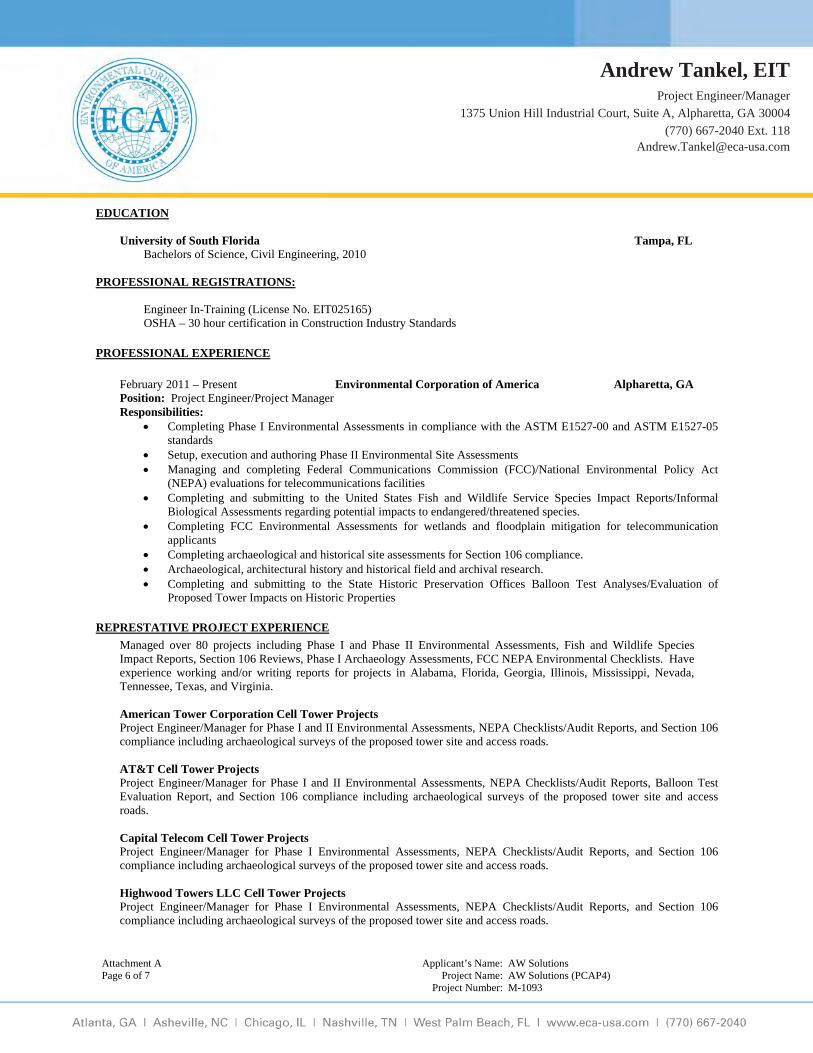
Attachment A Applicant’s Name: AW Solutions Page 6 of 7 Project Name: AW Solutions (PCAP4)
Project Number: M-1093
EDUCATION
University of South Florida Tampa, FL Bachelors of Science, Civil Engineering, 2010
PROFESSIONAL REGISTRATIONS:
Engineer In-Training (License No. EIT025165) OSHA – 30 hour certification in Construction Industry Standards
PROFESSIONAL EXPERIENCE
February 2011 – Present Environmental Corporation of America Alpharetta, GA Position: Project Engineer/Project Manager Responsibilities:
Completing Phase I Environmental Assessments in compliance with the ASTM E1527-00 and ASTM E1527-05 standards
Setup, execution and authoring Phase II Environmental Site Assessments Managing and completing Federal Communications Commission (FCC)/National Environmental Policy Act
(NEPA) evaluations for telecommunications facilities Completing and submitting to the United States Fish and Wildlife Service Species Impact Reports/Informal
Biological Assessments regarding potential impacts to endangered/threatened species. Completing FCC Environmental Assessments for wetlands and floodplain mitigation for telecommunication
applicants Completing archaeological and historical site assessments for Section 106 compliance. Archaeological, architectural history and historical field and archival research. Completing and submitting to the State Historic Preservation Offices Balloon Test Analyses/Evaluation of
Proposed Tower Impacts on Historic Properties
REPRESTATIVE PROJECT EXPERIENCE
Managed over 80 projects including Phase I and Phase II Environmental Assessments, Fish and Wildlife Species Impact Reports, Section 106 Reviews, Phase I Archaeology Assessments, FCC NEPA Environmental Checklists. Have experience working and/or writing reports for projects in Alabama, Florida, Georgia, Illinois, Mississippi, Nevada, Tennessee, Texas, and Virginia.
American Tower Corporation Cell Tower Projects Project Engineer/Manager for Phase I and II Environmental Assessments, NEPA Checklists/Audit Reports, and Section 106
compliance including archaeological surveys of the proposed tower site and access roads. AT&T Cell Tower Projects
Project Engineer/Manager for Phase I and II Environmental Assessments, NEPA Checklists/Audit Reports, Balloon Test Evaluation Report, and Section 106 compliance including archaeological surveys of the proposed tower site and access roads.
Capital Telecom Cell Tower Projects
Project Engineer/Manager for Phase I Environmental Assessments, NEPA Checklists/Audit Reports, and Section 106 compliance including archaeological surveys of the proposed tower site and access roads.
Highwood Towers LLC Cell Tower Projects
Project Engineer/Manager for Phase I Environmental Assessments, NEPA Checklists/Audit Reports, and Section 106 compliance including archaeological surveys of the proposed tower site and access roads.
Andrew Tankel, EITProject Engineer/Manager
1375 Union Hill Industrial Court, Suite A, Alpharetta, GA 30004
(770) 667-2040 Ext. [email protected]

Attachment A Applicant’s Name: AW Solutions Page 7 of 7 Project Name: AW Solutions (PCAP4)
Project Number: M-1093
Lafarge Building Materials, Inc. Project Engineer for Phase I Environmental Assessments for three real estate transactions involving quarries totaling 850
acres.
Nsoro MasTec, LLC Cell Towers/Building Collocation Projects Project Engineer/Manager for Phase I and II Environmental Assessments, NEPA Checklists/Audit Reports, and Section 106
compliance including archaeological surveys of the proposed tower site and access roads. RGP Tower Partners Cell Tower Projects
Project Engineer/Manager for Phase I Environmental Assessments, NEPA Checklists/Audit Reports, and Section 106 compliance including archaeological surveys of the proposed tower site and access roads.
SBA Networks Cell Tower Projects
Project Engineer/Manager for Phase I Environmental Assessments, NEPA Checklists/Audit Reports, and Section 106 compliance including archaeological surveys of the proposed tower site and access roads. Site Concepts Cell Tower Projects
Project Engineer/Manager for Phase I Environmental Assessments, NEPA Checklists/Audit Reports, and Section 106 compliance including archaeological surveys of the proposed tower site and access roads. T-Mobile Cell Tower Projects
Project Engineer/Manager for Phase I and II Environmental Assessments, NEPA Checklists/Audit Reports, and Section 106 compliance including archaeological surveys of the proposed tower site and access roads.
Xcell Towers Cell Tower Projects
Project Engineer/Manager for Phase I and II Environmental Assessments, NEPA Checklists/Audit Reports, Balloon Test Evaluation Report, and Section 106 compliance including archaeological surveys of the proposed tower site and access roads.
PROFESSIONAL ASSOCIATIONS
American Society of Civil Engineers (ASCE)
Attachment B Applicant’s Name: AW Solutions Page 1 of 12 Project Name: AW Solutions (PCAP4)
Project Number: M-1093
Attachment B
Site Information
Attachment B Applicant’s Name: AW Solutions Page 2 of 12 Project Name: AW Solutions (PCAP4)
Project Number: M-1093
1: Photographs
The following photographs were taken using a digital camera from a height of 5’11”. a: Directional photographs taken from the Proposed Tower Site and of the
associated access road.
b: Photographs of all listed or eligible properties within the Areas of Potential Effects, if any.
c: Photographs from listed or eligible properties within the Area of Potential
Effects looking toward the proposed tower site, if any.
d: 2012 Aerial photograph showing APE for visual effects.

B: Easterly View from the Center of the Proposed Lease Area
A: Northerly View from the Center of the Proposed Lease Area
ECA Proj. #: M-1093
AW Solutions (PCAP4)
22901 Panama City Beach ParkwayPanama City Beach, Bay County, Florida
Page 3 of 12
Attachment B-1a: Photographs

D: Westerly View from the Center of the Proposed Lease Area
C: Southerly View from the Center of the Proposed Lease Area
ECA Proj. #: M-1093
AW Solutions (PCAP4)
22901 Panama City Beach ParkwayPanama City Beach, Bay County, Florida
Page 4 of 12
Attachment B-1a: Photographs

F: Easterly Overview of the Retention Pond Located Within the Northern Portion of the Proposed Lease Area
E: Easterly Overview of the Proposed Lease Area
ECA Proj. #: M-1093
AW Solutions (PCAP4)
22901 Panama City Beach ParkwayPanama City Beach, Bay County, Florida
Page 5 of 12
Attachment B-1a: Photographs
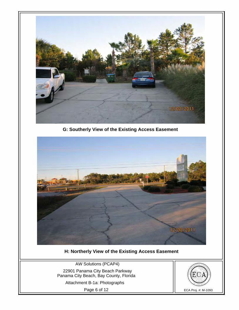
H: Northerly View of the Existing Access Easement
G: Southerly View of the Existing Access Easement
ECA Proj. #: M-1093
AW Solutions (PCAP4)
22901 Panama City Beach ParkwayPanama City Beach, Bay County, Florida
Page 6 of 12
Attachment B-1a: Photographs

J: Soil Profile of STP1
I: Overview of Shovel Test Pit One (STP1)
ECA Proj. #: M-1093
AW Solutions (PCAP4)
22901 Panama City Beach ParkwayPanama City Beach, Bay County, Florida
Page 7 of 12
Attachment B-1a: Photographs
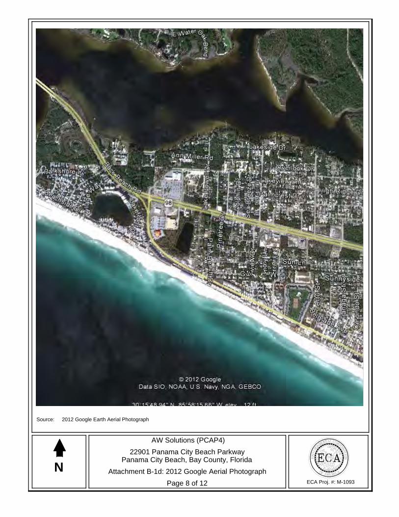
N
Source: 2012 Google Earth Aerial Photograph
ECA Proj. #: M-1093
AW Solutions (PCAP4)
22901 Panama City Beach ParkwayPanama City Beach, Bay County, Florida
Page 8 of 12
Attachment B-1d: 2012 Google Aerial Photograph
andrewt
Callout
SITE
Attachment B Applicant’s Name: AW Solutions Page 9 of 12 Project Name: AW Solutions (PCAP4)
Project Number: M-1093
2: Maps
a: 7.5-Minute topographic map showing the Area of Visual Effects and the location of any identified historic properties
b: 7.5-Minute topographic map showing the Area of Direct Effects including
any new access roads or other easements c: Site Vicinity Plan showing the location of the proposed tower site, any
new access roads, easements, additional structures, utility lines, fences, and excavations.
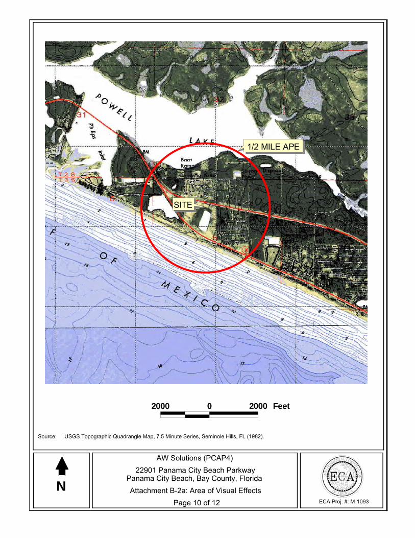
SITE
1/2 MILE APE
2000 0 2000 Feet
N
Source: USGS Topographic Quadrangle Map, 7.5 Minute Series, Seminole Hills, FL (1982).
ECA Proj. #: M-1093
AW Solutions (PCAP4)22901 Panama City Beach Parkway
Panama City Beach, Bay County, Florida
Page 10 of 12Attachment B-2a: Area of Visual Effects
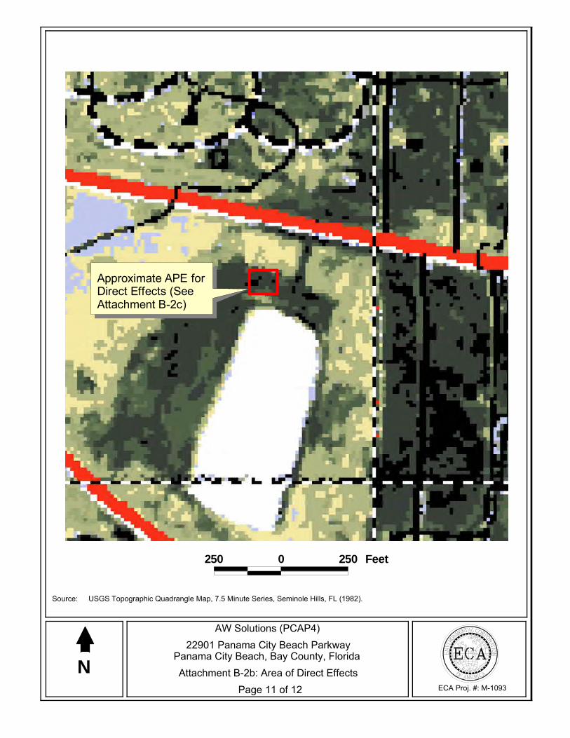
Approximate APE forDirect Effects (SeeAttachment B-2c)
250 0 250 Feet
N
Source: USGS Topographic Quadrangle Map, 7.5 Minute Series, Seminole Hills, FL (1982).
ECA Proj. #: M-1093
AW Solutions (PCAP4)22901 Panama City Beach Parkway
Panama City Beach, Bay County, Florida
Page 11 of 12Attachment B-2b: Area of Direct Effects
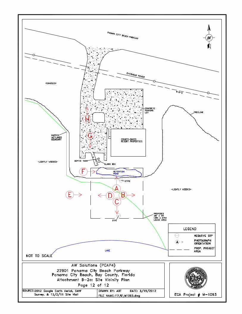
Attachment C Applicant’s Name: AW Solutions Page 1 of 2 Project Name: AW Solutions (PCAP4)
Project Number: M-1093
Attachment C
Determination of Effect

Attachment C Applicant’s Name: AW Solutions Page 2 of 2 Project Name: AW Solutions (PCAP4)
Project Number: M-1093
1: Areas of Potential Effects
a: Direct Effects
The APE for direct effects is limited to the site of the proposed tower and surrounding easements, as described in the Nationwide Programmatic Agreement.1 For this particular undertaking the area of disturbance would include the proposed 100-foot by 90-foot (30-meter by 27-meter) lease area and all of the immediately adjacent areas. The general APE for direct effects is shown in Attachment B-2b and Attachment B-2c.
b: Visual Effects
The APE for visual effects is the geographic area or areas within which the facility may directly or indirectly cause alterations in the character or use of Historic Properties.2 Unless otherwise noted, the area of potential effect for visual effect is as described in the Nationwide Programmatic Agreement:
If the proposed tower is 200 feet or less in overall height, the APE is ½ mile in
radius from the proposed tower.
If the proposed tower is more than 200 feet in height and no more than 400 feet in height, the APE is ¾-mile in radius from the proposed tower.
If the proposed tower is more than 400 feet in height, the APE is 1 ½ miles in
radius from the proposed tower.3
The APE for visual effects is shown in Attachment B-2a: Area of Visual Effect.
2: Mitigation of Effect
a: Copies of correspondence and summaries of oral communications with SHPO/THPO and any consulting parties including descriptions of alternatives that have been considered in order to avoid, minimize, or mitigate any adverse effects
Not Applicable
1 Section VI.C.2 of the Nationwide Programmatic Agreement (WT Docket No. 03-128; FCC-222). 2 Section II.3 of the Nationwide Programmatic Agreement (WT Docket No. 03-128; FCC-222). 3 Section VI.C.4.a-c of the Nationwide Programmatic Agreement (WT Docket No. 03-128; FCC-222).

Attachment D Applicant’s Name: AW Solutions Page 1 of 12 Project Name: AW Solutions (PCAP4)
Project Number: M-1093
Attachment D
Tribal and NHO Involvement ECA made notification through the FCC Tower Construction Notification System (TCNS) in order to identify Indian Tribes and NHOs that may attach religious and cultural significance to Historic Properties that may be affected by the tower project within the APE for direct or visual effects. ECA identified eight federally recognized tribes that may be interested in participating in the Section 106 Review process in the county where the undertaking would occur. Any Tribe listed on the TCNS that does not respond within 14 and 30 days of initial notification will receive a follow up letter. Any Tribes requesting to be involved in the Section 106 Review consultation process will be provided a copy of this submission packet and will be provided an opportunity to comment on the proposed undertaking. Copies of all relevant documents received to date, including correspondence, are provided in the following pages.

Attachment D Applicant’s Name: AW Solutions Page 2 of 12 Project Name: AW Solutions (PCAP4)
Project Number: M-1093
TRIBAL INVOLVEMENT TCNS #81221– INITIAL CONTACT December 2, 2011
INDIAN TRIBE OR NATION
SECOND TRIBAL CONTACT DATE
RESPONSE RECEIVED FROM TRIBE REFER TO FCC
TRIBAL CLEARANCE
ALABAMA- COUSHATTA TRIBE
OF TEXAS
12/2/11 & 12/9/11 via TCNS Requested Section 106 Review Documentation and review fee
NA
COUSHATTA INDIAN TRIBE
11/30/11 via mailed letter requested Section 106 Review
Documentation and review fee NA
JENA BAND OF CHOCTAW INDIANS
12/7/11 via mailed letter requested Section 106 Review
Documentation and review fee NA
MICCOSUKEE TRIBE OF INDIANS OF
FLORIDA NA
12/2/11 via TCNS 30-Day Response Limit Agreement
NA 1/2/12
MISSISSIPPI BAND OF CHOCTAW INDIANS
12/2/11 via TCNS Requested Section 106 Review Documentation & then a 30-day Response Limit
Agreement NA
SEMINOLE TRIBE OF FLORIDA
12/2/11 via TCNS requested Section 106 Review
Documentation and review fee NA
CHOCTAW NATION OF OKLAHOMA
12/2/11 via TCNS requested Section 106 Review
Documentation & then a follow-up phone call if no reply within 30 days
NA
SEMINOLE NATION OF OKLAHOMA
NA 12/2/11 via TCNS 30-Day Response Limit Agreement
NA 1/2/12
* Federal Communications Commission Declaratory Ruling – October 6, 2005

Attachment D Applicant’s Name: AW Solutions Page 3 of 12 Project Name: AW Solutions (PCAP4)
Project Number: M-1093
-----Original Message----- From: [email protected] [mailto:[email protected]] Sent: Tuesday, November 29, 2011 1:03 PM To: tribal notify Subject: Proposed Tower Structure Info - Email ID #2924138 Dear Dina M Bazzill, Thank you for submitting a notification regarding your proposed construction via the Tower Construction Notification System. Note that the system has assigned a unique Notification ID number for this proposed construction. You will need to reference this Notification ID number when you update your project's Status with us. Below are the details you provided for the construction you have proposed: Notification Received: 11/29/2011 Notification ID: 81221 Tower Owner Individual or Entity Name: Environmental Corporation of America Consultant Name: Dina M Bazzill Street Address: 1375 Union Hill Industrial Court Suite A City: Alpharetta State: GEORGIA Zip Code: 30004 Phone: 770-667-2040 Email: [email protected] Structure Type: POLE - Any type of Pole Latitude: 30 deg 15 min 48.3 sec N Longitude: 85 deg 58 min 19.4 sec W Location Description: 22901 Panama City Beach Parkway City: Panama City Beach State: FLORIDA County: BAY Ground Elevation: 2.1 meters Support Structure: 54.9 meters above ground level Overall Structure: 56.1 meters above ground level Overall Height AMSL: 58.2 meters above mean sea level

Attachment D Applicant’s Name: AW Solutions Page 4 of 12 Project Name: AW Solutions (PCAP4)
Project Number: M-1093
-----Original Message----- From: [email protected] [mailto:[email protected]] Sent: Friday, December 02, 2011 3:01 AM To: tribal notify Cc: [email protected]; [email protected] Subject: NOTICE OF ORGANIZATION(S) WHICH WERE SENT PROPOSED TOWER CONSTRUCTION NOTIFICATION INFORMATION - Email ID #2924455 Dear Sir or Madam: Thank you for using the Federal Communications Commission's (FCC) Tower Construction Notification System (TCNS). The purpose of this electronic mail message is to inform you that the following authorized persons were sent the information you provided through TCNS, which relates to your proposed antenna structure. The information was forwarded by the FCC to authorized TCNS users by electronic mail and/or regular mail (letter). Persons who have received the information that you provided include leaders or their designees of federally-recognized American Indian Tribes, including Alaska Native Villages (collectively "Tribes"), Native Hawaiian Organizations (NHOs), and State Historic Preservation Officers (SHPOs). For your convenience in identifying the referenced Tribes and in making further contacts, the City and State of the Seat of Government for each Tribe and NHO, as well as the designated contact person, is included in the listing below. We note that Tribes may have Section 106 cultural interests in ancestral homelands or other locations that are far removed from their current Seat of Government. Pursuant to the Commission's rules as set forth in the Nationwide Programmatic Agreement for Review of Effects on Historic Properties for Certain Undertakings Approved by the Federal Communications Commission (NPA), all Tribes and NHOs listed below must be afforded a reasonable opportunity to respond to this notification, consistent with the procedures set forth below, unless the proposed construction falls within an exclusion designated by the Tribe or NHO. (NPA, Section IV.F.4). The information you provided was forwarded to the following Tribes and NHOs who have set their geographic preferences on TCNS. If the information you provided relates to a proposed antenna structure in the State of Alaska, the following list also includes Tribes located in the State of Alaska that have not specified their geographic preferences. For these Tribes and NHOs, if the Tribe or NHO does not respond within a reasonable time, you should make a reasonable effort at follow-up contact, unless the Tribe or NHO has agreed to different procedures (NPA, Section IV.F.5). In the event such a Tribe or NHO does not respond to a follow-up inquiry, or if a substantive or procedural disagreement arises between you and a Tribe or NHO, you must seek guidance from the Commission (NPA, Section IV.G). These procedures are further set forth in the FCC's Declaratory Ruling released on October 6, 2005 (FCC 05-176). 1. Historic Preservation Officer Bryant J Celestine - Alabama-Coushatta Tribe of Texas - Livingston, TX - electronic mail Details: Please consider this notification as our interest for consultation regarding your proposal. The Alabama-Coushatta Tribe of Texas requests an administrative fee of $300.00 for our services including internal file searches, elder consultations, and if necessary, travel expenses for a site visit to complete our determination regarding your proposal. TAKE NOTE of the

Attachment D Applicant’s Name: AW Solutions Page 5 of 12 Project Name: AW Solutions (PCAP4)
Project Number: M-1093
following procedures as this will assist our efforts to provide your firm with the most efficient process in returning our determinations: 1. Submit your Form 620 or 621 by email to [email protected]. Each submission is logged and within 10 days of receipt, an invoice will be returned to the email account we receive your supplemental information. IF YOU HAVE NOT RECEIVED THIS BY 15DAYS, PLEASE INQUIRE. 2. INCLUDE your invoice number on your payment and submit according to the Invoice instructions. We cannot track your payment by project number so please do not submit without an invoice number. 3. Within 20 days of your original submission, you will receive an email response from our Office relating to our determinations for your proposal. This may occur despite a delay in fee payment. If you have not received our determination within 25 days, PLEASE INQUIRE. 4. IN THE EVENT OF AN OUTSTANDING BALANCE, a detailed invoice will be submitted in place of our determination. In this manner, your Section 106 obligations withour Tribe ARE NOT complete until we have forwarded our written response indicating our determination. 5. If the applicant/tower builder decides to withdraw a proposal, please advise our office as soon as possible to avoid an outstanding balance in the future and any unnecessary research by our office. Thank you, Bryant J. Celestine - Historic Preservation Officer 2. THPO Linda P Langley Dr - Coushatta Indian Tribe - Elton, LA - electronic mail and regular mail 3. Tribal Historic Preservation Officer Dana M Masters - Jena Band of Choctaw Indians - Jena, LA - electronic mail and regular mail 4. NAGPRA & Section 106 Representative Fred Dayhoff - Miccosukee Tribe of Indians of Florida - Miami, FL - regular mail Details: Please DO NOT contact me prior to the end of the 30-day period to inquire about the proposed site. I really need this time to review the TCNS notifications. If, however, the proposed site is on undisturbed land, and you are aware of something that may be of interest to our Tribe, please feel free to telephone me or send documentation to me prior to the end of the 30-day period. Please send this information to me via regular mail or via UPS. Please do not use Federal Express, since they deliver toa general mailbox for our Tribe. Please send via reg. mail or UPS to: Fred Dayhoff NAGPRA & Section 106 Representative Miccosukee Tribe of Indians of Florida P.O. Box 440021 Tamiami Station Miami, Florida 33144

Attachment D Applicant’s Name: AW Solutions Page 6 of 12 Project Name: AW Solutions (PCAP4)
Project Number: M-1093
At the end of the 30 days, if there is an inadvertent find during construction, IMMEDIATELY contact me at 239-695-4360 (phone). If the number is busy, immediately send a Fax to my attention at 239-695-4344 (fax). Thank you. Fred Dayhoff NAGPRA & Section 106 Representative Miccosukee Tribe of Indians of Florida [email protected] If the applicant/tower builder receives no response from the Miccosukee Tribe of Indians of Florida within 30 days after notification through TCNS, the Miccosukee Tribe of Indians of Florida has no interest in participating in pre-construction review for the proposed site. The Applicant/tower builder, however, must immediately notify the Miccosukee Tribe of Indians of Florida in the event archaeological properties or human remains are discovered during construction, consistent with Section IX of the Nationwide Programmatic Agreement and applicable law. 5. THPO Kenneth H Carleton - Mississippi Band of Choctaw Indians - Choctaw, MS - electronic mail Details: Please send all information via e-mail (and only via e-mail - no paper copies please) to: [email protected] (9 meg attachment limit) The Mississippi Band of Choctaw Indians wishes to see full information packets for all towers within the designated areas for consultation. Form 620, if it includes the a full text of the cultural resource survey with maps, is adequate for our needs. If your 620 does not include the text of the cultural resource survey, then attach it seperately. Please include the tower identification (TCNS#, name, and any other information that may help us identify this site) and the county and state where the facility is proposed in the subject line. If the applicant/tower builder receives no response from the Mississippi Band of Choctaw Indians within 30 days AFTER YOU HAVE E-MAILED THE AFOREMENTIONED INFORMATION TO US (begin counting the 30 day period AFTER the e-mail with all of the information has been sent), then the Mississippi Band of Choctaw Indians has no interestin participating in pre-construction review for the proposed site. The Applicant/tower builder, however, must immediately notify the Mississippi Band of Choctaw Indians in the event archaeological properties or human remains are discovered during construction, consistent with Section IX of the Nationwide Programmatic Agreement and applicable law. 6. Archaeological Data Analyst Elliott York - Seminole Tribe of Florida - Clewiston, FL - electronic mail Details: Effective on June 3rd, 2011, the Seminole Tribe of Florida (STOF) is charging an administrative review fee of $300 per tower. Upon receipt of the 620/621 form with attachments requested STOF will issue an invoice. Consultants will need to provide companyname, primary contact person, mailing address (or e-mail), and business phone for invoice purposes. Please specify whether you would prefer the invoice physically mailed or e-mailed to you. The determination will be given upon payment of the review fee. Checks should be made payable to Seminole Tribe of Florida and mailed to:
Attachment D Applicant’s Name: AW Solutions Page 7 of 12 Project Name: AW Solutions (PCAP4)
Project Number: M-1093
Seminole Tribe of Florida, Accounts Receivable, 6300 Stirling Road, Hollywood, FL 33024. Please include the TCNS numbers and invoice number on the memo line of the check in order forus to track your project payment. For requests involving multiple towers, a single check in the sum of $300 per tower is acceptable. The following additional items should be submitted for each review request: 620/621 form with attachments associated with cultural resources to include archaeological assessment/report that includes methodology, findings and field survey results, and project area geomorphology and soils. Please limit submittal of architectural surveys (unless embedded with archaeologicalinformation), engineering/construction drawings, and excessive photos. All correspondence shall be conducted via email and email attachments. Should you have any questions, please feel free to contact [email protected] or (863) 983-6549 ext. 12216. Thank you. 7. Director Historic Preservation Dept. Ian Thompson - Choctaw Nation of Oklahoma - Durant, OK - electronic mail and regular mail Details: The Applicant may conclude that the Choctaw Nation of Oklahoma has no interest in a site if there is existing disturbance wherein the depth of the previous disturbance exceeds the proposed construction depth (excluding footing and other anchoring mechanisms) by at least 2 feet (Applying VI - D(2)(c)(i) of the Nationwide Programmatic Agreement concerning Field Surveys; 'In the Matter of Nationwide Programmatic Agreement Regarding the Section 106 National Historic Preservation Act Review Process,' Report and Order, 20 FCC Rcd. 1073, WT Docket No. 03-128, October 5, 2004). Furthermore, the Choctaw Nation of Oklahoma does not have an interest in a Tower that will be constructed on an existing structure, developed land, or within city limits. However, any of the above mentioned criteria should be communicated to us if not evident in the initial Notification Details. For all other towers, we request a signed field survey report that meets the Federal guidelines set forth by the Department of the Interiorand a site location map along with pictures for each project. Additionally, the Choctaw Nation of Oklahoma has informed FCC Staff that if the Applicant does not receive a response from the Tribe within 30 days of a TCNS notification, then the Applicant SHOULD MAKE A GOOD FAITH EFFORT WITH A FOLLOW-UP PHONE CALL to make sure that the tribe is aware of the proposed tower project. However, should construction expose buried archaeological or building materials such as chipped stone, tools, pottery, bone,historical crockery, glass or metal items, this office should be contacted immediately @ 1-800-522-6170 ext. 2137. [n.b. Please reference the TCNS number in all communications that follow the initial notification.] 8. Historic Preservation Officer Seminole Nation - Seminole Nation of Oklahoma - Wewoka, OK - electronic mail Details: If the Applicant/tower builder receives no response from the Seminole Nation of Oklahoma within 30 days after notification through TCNS, the Seminole Nation of Oklahoma has no interest in participating in pre-construction review for the site. The Applicant/tower builder, however, must
Attachment D Applicant’s Name: AW Solutions Page 8 of 12 Project Name: AW Solutions (PCAP4)
Project Number: M-1093
IMMEDIATELY notify the Seminole Nation of Oklahoma in the event archaeological properties or human remains are discovered during construction, consistent with Section IX of the Nationwide Programmatic Agreement and applicable law. The information you provided was also forwarded to the additional Tribes and NHOs listed below. These Tribes and NHOs have NOT set their geographic preferences on TCNS, and therefore they are currently receiving tower notifications for the entire United States. For these Tribes and NHOs, you are required to use reasonable and good faith efforts to determine if the Tribe or NHO may attach religious and cultural significance to historic properties that may be affected by its proposed undertaking. Such efforts may include, but are not limited to, seeking information from the relevant SHPO or THPO, Indian Tribes, state agencies, the U.S. Bureau of Indian Affairs, or, where applicable, any federal agency with land holdings within the state (NPA, Section IV.B). If after such reasonable and good faith efforts, you determine that a Tribe or NHO may attach religious and cultural significance to historic properties in the area and the Tribe or NHO does not respond to TCNS notification within a reasonable time, you should make a reasonable effort to follow up, and must seek guidance from the Commission in the event of continued non-response or in the event of a procedural or substantive disagreement. If you determine that the Tribe or NHO is unlikely to attach religious and cultural significance to historic properties within the area, you do not need to take further action unless the Tribe or NHO indicates an interest in the proposed construction or other evidence of potential interest comes to your attention. None The information you provided was also forwarded to the following SHPOs in the State in which you propose to construct and neighboring States. The information was provided to these SHPOs as a courtesy for their information and planning. You need make no effort at this time to follow up with any SHPO that does not respond to this notification. Prior to construction, you must provide the SHPO of the State in which you propose to construct (or the Tribal Historic Preservation Officer, if the project will be located on certain Tribal lands), with a Submission Packet pursuant to Section VII.A of the NPA. 9. SHPO Lee Warner - Alabama Historical Commission - Montgomery, AL - electronic mail 10. Deputy SHPO Elizabeth Ann Brown - Alabama Historical Commission - Montgomery, AL - electronic mail 11. Deputy SHPO Compliance Review Laura A Kammerer - Div of Historical Resources, Dept of State - Tallahassee, FL - electronic mail
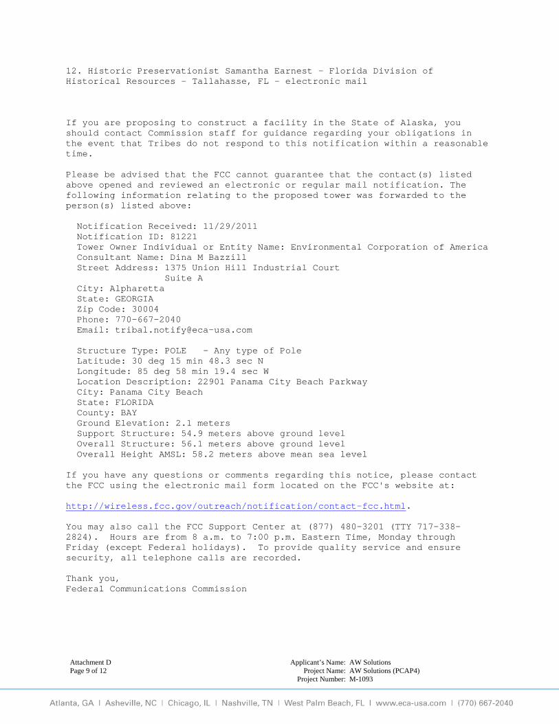
Attachment D Applicant’s Name: AW Solutions Page 9 of 12 Project Name: AW Solutions (PCAP4)
Project Number: M-1093
12. Historic Preservationist Samantha Earnest - Florida Division of Historical Resources - Tallahasse, FL - electronic mail If you are proposing to construct a facility in the State of Alaska, you should contact Commission staff for guidance regarding your obligations in the event that Tribes do not respond to this notification within a reasonable time. Please be advised that the FCC cannot guarantee that the contact(s) listed above opened and reviewed an electronic or regular mail notification. The following information relating to the proposed tower was forwarded to the person(s) listed above: Notification Received: 11/29/2011 Notification ID: 81221 Tower Owner Individual or Entity Name: Environmental Corporation of America Consultant Name: Dina M Bazzill Street Address: 1375 Union Hill Industrial Court Suite A City: Alpharetta State: GEORGIA Zip Code: 30004 Phone: 770-667-2040 Email: [email protected] Structure Type: POLE - Any type of Pole Latitude: 30 deg 15 min 48.3 sec N Longitude: 85 deg 58 min 19.4 sec W Location Description: 22901 Panama City Beach Parkway City: Panama City Beach State: FLORIDA County: BAY Ground Elevation: 2.1 meters Support Structure: 54.9 meters above ground level Overall Structure: 56.1 meters above ground level Overall Height AMSL: 58.2 meters above mean sea level If you have any questions or comments regarding this notice, please contact the FCC using the electronic mail form located on the FCC's website at: http://wireless.fcc.gov/outreach/notification/contact-fcc.html. You may also call the FCC Support Center at (877) 480-3201 (TTY 717-338-2824). Hours are from 8 a.m. to 7:00 p.m. Eastern Time, Monday through Friday (except Federal holidays). To provide quality service and ensure security, all telephone calls are recorded. Thank you, Federal Communications Commission
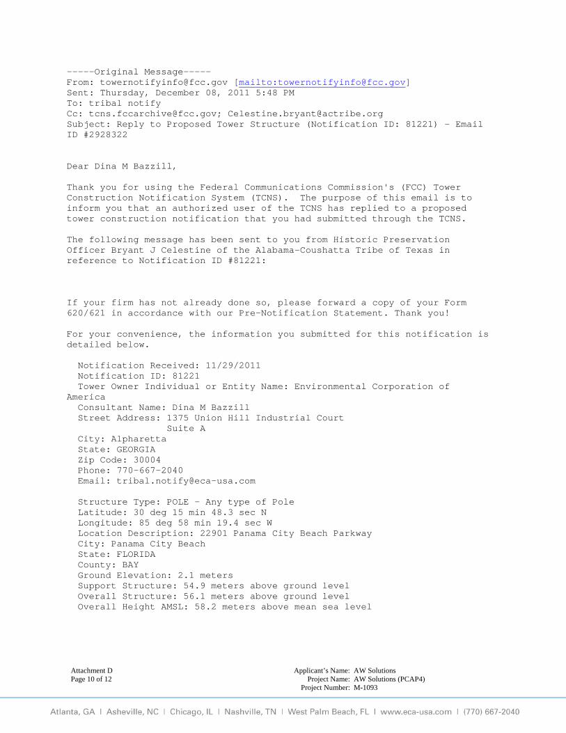
Attachment D Applicant’s Name: AW Solutions Page 10 of 12 Project Name: AW Solutions (PCAP4)
Project Number: M-1093
-----Original Message----- From: [email protected] [mailto:[email protected]] Sent: Thursday, December 08, 2011 5:48 PM To: tribal notify Cc: [email protected]; [email protected] Subject: Reply to Proposed Tower Structure (Notification ID: 81221) - Email ID #2928322 Dear Dina M Bazzill, Thank you for using the Federal Communications Commission's (FCC) Tower Construction Notification System (TCNS). The purpose of this email is to inform you that an authorized user of the TCNS has replied to a proposed tower construction notification that you had submitted through the TCNS. The following message has been sent to you from Historic Preservation Officer Bryant J Celestine of the Alabama-Coushatta Tribe of Texas in reference to Notification ID #81221: If your firm has not already done so, please forward a copy of your Form 620/621 in accordance with our Pre-Notification Statement. Thank you! For your convenience, the information you submitted for this notification is detailed below. Notification Received: 11/29/2011 Notification ID: 81221 Tower Owner Individual or Entity Name: Environmental Corporation of America Consultant Name: Dina M Bazzill Street Address: 1375 Union Hill Industrial Court Suite A City: Alpharetta State: GEORGIA Zip Code: 30004 Phone: 770-667-2040 Email: [email protected] Structure Type: POLE - Any type of Pole Latitude: 30 deg 15 min 48.3 sec N Longitude: 85 deg 58 min 19.4 sec W Location Description: 22901 Panama City Beach Parkway City: Panama City Beach State: FLORIDA County: BAY Ground Elevation: 2.1 meters Support Structure: 54.9 meters above ground level Overall Structure: 56.1 meters above ground level Overall Height AMSL: 58.2 meters above mean sea level
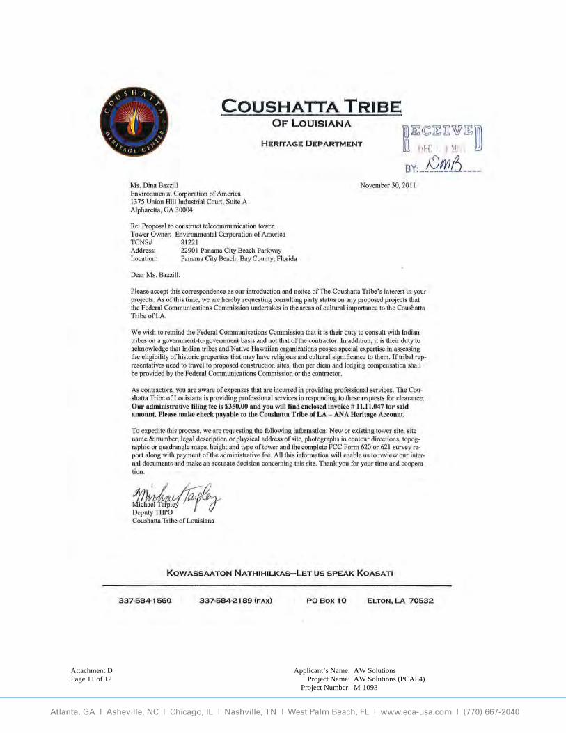
Attachment D Applicant’s Name: AW Solutions Page 11 of 12 Project Name: AW Solutions (PCAP4)
Project Number: M-1093

Attachment D Applicant’s Name: AW Solutions Page 12 of 12 Project Name: AW Solutions (PCAP4)
Project Number: M-1093

Attachment E Applicant’s Name: AW Solutions Page 1 of 11 Project Name: AW Solutions (PCAP4)
Project Number: M-1093
Attachment E
Historic Properties
Method of Identification:
The following sources and records were reviewed to identify Historic Properties within the Area of Potential Effect (APE) for visual and direct effects:
i. Properties listed in the National Register; ii. Properties formally determined eligible for listing by the Keeper of the National
Register; iii. Properties that the SHPO/THPO certifies are in the process of being nominated to
the Nation Register; iv. Properties previously determined eligible as part of a consensus determination of
eligibility between the SHPO/THPO and a Federal Agency or local government representing the Department of Housing and Urban Development (HUD); and
v. Properties listed in the SHPO/THPO Inventory that the SHPO/THPO has previously evaluated and found to meet the National Register Criteria, and that are identified accordingly in the SHPO/THPO Inventory.1
1 Section VI.D.1.a.i-v of the Nationwide Programmatic Agreement (WT Docket No. 03-128; FCC-222)
Attachment E Applicant’s Name: AW Solutions Page 2 of 11 Project Name: AW Solutions (PCAP4)
Project Number: M-1093
1: Historic Properties Identified in the APE for Direct Effects a: Historic Properties identified within the APE for direct effects
If any Historic Properties were identified, see Historic Properties pages within the FCC Form 620, Page 7.
b: Historic Properties within the APE, not listed in “a”, that ECA Considers to be Eligible for Listing in the National Register as a result of ECA’s research.
ECA has identified no Historic Properties within the area for direct effects.
c: Description of techniques and methodology used to identify Historic Properties within the APE for direct effects.
See Archaeological Assessment, Attachment E-1c.
Attachment E Applicant’s Name: AW Solutions Page 3 of 11 Project Name: AW Solutions (PCAP4)
Project Number: M-1093
2: Historic Properties Identified in the APE for Visual Effects a: Historic Properties Identified in the APE for visual effects that are listed in the
National Register, have been formally determined eligible by the Keeper of the National Register, or have been evaluated and found to meet NR criteria for listing by the SHPO/THPO and are identified as such in the SHPO/THPO inventory.
If any historic resources were identified, see Historic Properties pages within the FCC Form 620, Page 7 or if more than ten identified historic resources see Cultural Resource Report, Attachment E-2a.
b: Historic Properties, not listed in part “a,” that are in the APE for visual effects that
were identified through the comments of Indian Tribes, NHOs, local government, or members of the public.
See Historic Properties pages within the FCC Form 620, Page 7.
c: Properties listed in part “a,” which ECA considers no longer eligible for inclusion in the National Register
Not applicable.
Attachment E Applicant’s Name: AW Solutions Page 4 of 11 Project Name: AW Solutions (PCAP4)
Project Number: M-1093
Attachment E-1c
Archaeological Assessment
CONFIDENTIAL NOTICE: Attachment E-1c and Attachment H may contain information on historic and/or prehistoric archaeological cultural resources. This information is to be regarded as strictly confidential and is not for public dissemination or distribution and is not to be published in the public domain or provided to any unauthorized parties.
Attachment E Applicant’s Name: AW Solutions Page 5 of 11 Project Name: AW Solutions (PCAP4)
Project Number: M-1093
Archaeological Assessment TCNS ID #81221
Proposed 184-Foot (Overall Height) Monopole Telecommunications Structure Within an Approximate 100-Foot by 90-Foot (30-meter by 27-meter) Lease Area
AW Solutions (PCAP4) 22901 Panama City Beach Parkway
Panama City Beach, Bay County, Florida
Submitted to
Ms. Laura Krammerer
Division of Historical Resources Office of Compliance and Review 500 S. Bronough Street, Room 423
Tallahassee, FL 32399-0250
By
________________________ ______________________ Andrew Tankel, EIT Autumn DuBois, MA, RPA Project Manager Senior Investigator
March 20, 2012
ENVIRONMENTAL CORPORATION OF AMERICA 1375 UNION HILL INDUSTRIAL COURT, SUITE A
ALPHARETTA, GEORGIA 30004
ECA Project #: M-1093

Attachment E Applicant’s Name: AW Solutions Page 6 of 11 Project Name: AW Solutions (PCAP4)
Project Number: M-1093
Executive Summary
Environmental Corporation of America (ECA) has completed an Archaeological Assessment for
the federal undertaking at the project area. The project area includes a proposed 100-foot by 90-
foot (30-meter by 27-meter) lease area and would be accessed over an existing parking lot. The
facility would include a 184-foot (56-meter) overall height monopole telecommunications
structure and associated ground level support equipment. The project area is located at 22901
Panama City Beach Parkway, Panama City Beach, Bay County, Florida.
This archaeological assessment was conducted in order to ascertain whether the proposed
undertaking, on the project area, might directly or indirectly affect cultural resources, if any such
resources exist. Through our review of available cultural records and databases within our
standard ¾-mile background search radius, three previously recorded archaeological sites
(BY00191, BY-00870, and BY00957), but no surveys, were identified. The previously
identified archaeological sites are located outside the APE for direct effects. During the course
of the Phase I intensive field survey portion of this archaeological assessment, no archaeological
sites were discovered and no archaeological cultural resources were encountered.
We conclude that the undertaking would not affect any historic or prehistoric archaeological
resources that are listed in or eligible for listing in the National Register of Historic Places.
Therefore, for archaeological cultural resources, we recommend a finding of No Effect for the
proposed undertaking at the project area.

Attachment E Applicant’s Name: AW Solutions Page 7 of 11 Project Name: AW Solutions (PCAP4)
Project Number: M-1093
An Archaeological Assessment of a Proposed 100-Foot by 90-Foot (30-meter by 27-meter) Lease Area
Near Panama City Beach, Bay County, Florida
Background
Environmental Corporation of America was contracted by AW Solutions to perform an
archaeological assessment as part of the Section 106 Review process for a proposed
telecommunications facility. The proposed facility would be located at 22901 Panama City
beach Parkway, Panama City Beach, Bay County, Florida. The purpose of our work was to
determine whether any archaeological cultural resources might exist within the project area.
The proposed project area is located within the limits of the Seminole Hills, FL United States
Geological Survey (USGS) 7.5-minute Topographic Quadrangle Map1, as shown in Attachment
B-2a. Attachment B-2c is a site vicinity plan that shows the site configuration. Attachment B-1d
is an aerial photograph2 of the project area. The proposed facility would be located at an
approximate elevation of 7 feet Above Mean Sea Level (AMSL). The nearest drainage features
are mapped wetlands located within the project area and a lake located approximately 50 feet
(15-meter) south of the proposed lease area.
The proposed undertaking, located on a larger approximate 1-acre parent tract, is currently a
grassy, lightly wooded pasture and contains a retention pond within the northern portion of the
project area. The compound would be accessible over an existing parking lot. The proposed
telecommunications compound would be located within a 100-foot by 90-foot (30-meter by 27-
meter) lease area with the center located at approximately N30° 15’ 48.3” W85° 58’ 19.4”
(UTM: Zone 16 598883E 3348422N). Photographs of the project area are provided in
Attachment B-1a. Descriptions of the photographs are provided underneath each photograph.
2 USGS, 7.5-minute Topographic Quadrangle Map for Seminole Hills, FL, (1982) 3 Google Earth 2012 Aerial Photograph
Attachment E Applicant’s Name: AW Solutions Page 8 of 11 Project Name: AW Solutions (PCAP4)
Project Number: M-1093
Geologically, the Property is located within the Coastal Plain Physiographic Province of Florida,
which is characterized karst topography containing interbedded sand and clay deposits and
limestone. Soils in the Coastal Plain are the result of deposition of sediments in a former marine
environment. According to the USDA Bay County Soil Survey, soils found at the project area
are Rutlege Sand (29). The Rutlege series consists of very deep, very poorly drained, very
shallow, rapidly permeable soils on flats, depressions, and floodplains. They formed in marine
and fluvial sediments.
The Area of Potential Effect (APE) is defined as “the geographic area or areas within which an
undertaking may directly or indirectly cause changes in the character or use of historic
properties, if any such properties exist”3. For the purposes of this work, the APE for direct
effects is the actual physical impact area. The impact area includes the proposed approximate
100-foot by 90-foot (30-meter by 27-meter) lease area and all immediately adjacent areas.
Literature and Documents Search
National Register of Historic Places
The National Register of Historic Places (NRHP)4 is the Nation’s official list of cultural
resources worthy of preservation. Authorized under the National Historic Preservation Act of
1966, the National Register is part of a national program to coordinate and support public and
private efforts to identify, evaluate, and protect historic and archaeological resources. Properties
listed in the National Register include districts, sites, buildings, structures, and objects that are
significant in American history, architecture, archaeology, engineering, and culture. The
National Park Service, which is part of the U.S. Department of the Interior, administers the
National Register. ECA conducted a review of the National Register of Historic Places to
determine whether any listed archaeological sites were located within a ¾-mile radius of the
project site. The document search revealed no sites within this radius.
4 47 CFR Part 1 Nationwide Programmatic Agreement for Review Under the National Historic Preservation Act: Final Rule, January 4, 2005; Federal Register Vol.70, No. 2, Page 582. 4 National Register Information System, retrieved from http://www.nps.gov/nr/.
Attachment E Applicant’s Name: AW Solutions Page 9 of 11 Project Name: AW Solutions (PCAP4)
Project Number: M-1093
Florida Master Site File
The Florida Master Site File (FASF)6 is the official repository for information about known
archaeological sites from all periods within the state of Florida. It has become the primary
source for documentation about Florida Archaeology. The FASF contains many different types
of information about archaeological sites, including locations, cultural periods, and information
relating to the National Register of Historic Places. The document search of these files included
our ¾-mile background research radius that revealed three previously recorded archaeological
sites (BY00191, BY-00870, and BY00957), but no surveys, within a ¾-mile radius of the project
area. The previously recorded archaeological sites were determined by SHPO to be ineligible for
listing on the NRHP and are located outside the APE for direct effects.
Site BY00191 is located approximately 3,900 feet (1,189 meters) northwest of the proposed
undertaking at its closest point. This site is a prehistoric campsite. Florida SHPO determined this
site ineligible for listing on the National Register.
Site BY00870 is located approximately 3,900 feet (1,189 meters) northeast of the proposed
undertaking at its closest point. This site is a shell midden with an absence of cultural material.
Florida SHPO determined this site ineligible for listing on the National Register.
Site BY00957 is located approximately 3,950 feet (1,204 meters) northwest of the proposed
undertaking at its closest point. This site is a prehistoric shell midden and a prehistoric campsite.
Florida SHPO determined this site ineligible for listing on the National Register.
Field Methods
The Phase I intensive field survey implemented standard survey techniques and was performed
by Andrew Tankel of ECA on December 2, 2011. Pedestrian survey was conducted throughout
6 Florida Department of Archives and History
Attachment E Applicant’s Name: AW Solutions Page 10 of 11 Project Name: AW Solutions (PCAP4)
Project Number: M-1093
the 100-foot by 90-foot (30-meter by 27-meter) proposed lease area and along the existing
access.
ECA determined that two shovel tests would be an adequate sampling of the 100-foot by 90-foot
(30-meter by 27-meter) proposed lease area. The subsurface tests consisted of shovel test pits
measuring approximately 20 inches by 20 inches (51cm), excavated to a depth of approximately
40 inches (102cm) or until the sterile subsoil, bedrock, or the water table was encountered. The
locations of the shovel tests are shown in Attachment B-2c. Photographs I and J in Attachment
B-1a show an overview and profile of Shovel Test Pit One (STP1). All excavated soils were
screened through a six-millimeter wire mesh screen to isolate any cultural artifacts.
Field Survey Results
Visual inspection revealed that the project area is currently a grassy, lightly wooded pasture that
contains a retention pond within the northern portion of the project area. The project area would
be accessible from the south side of Panama City Beach Parkway via an existing parking lot.
Ground visibility was near 15 percent within the project area.
Soil colors were generally consistent throughout both STPs. The Munsell soil colors observed
consisted of approximately 0 to 9 inches (23cm) of 10YR 2/1 (black) loamy sand, followed by
10YR 4/1 (dark gray) sand from approximately 9 to 20 inches (23cm to 51cm). Excavation was
terminated at 20 inches (51cm) when water was encountered. No artifacts were discovered and
no evidence of potential archeological resources was observed.
Laboratory Methods and Collection Curation
For archaeological sites identified within the State of Florida, ECA will curate all photographs,
field notes, maps and documentation pertinent to the archaeological assessment at the Curation
Lab of the Bureau of Archaeological Research, Tallahassee, Florida. This repository meets
Department of the Interior curation standards as defined under 36CFR Part 79.
Attachment E Applicant’s Name: AW Solutions Page 11 of 11 Project Name: AW Solutions (PCAP4)
Project Number: M-1093
Recommendations
During the course of this archaeological assessment, no historic or prehistoric artifacts, or other
evidence of archeological resources, were located within the APE for direct effects. We believe
that no National Register eligible archaeological cultural resources will be affected by the
proposed project. Therefore, we recommend a finding of No Effect for the proposed undertaking
as it relates to archaeology. We request your concurrence with our finding.
Closure
We are submitting this report, on behalf of AW Solutions, to seek concurrence with our finding
and to comply with Federal Communications Commission (FCC) requirements as identified in
47 CFR 1.1307. Andrew Tankel of ECA performed the fieldwork, conducted the research, and
authored this assessment. Dina M. Bazzill, MA, RPA, Principal Investigator, reviewed this
assessment. We request your concurrence with our finding. Please contact our office with
questions or comments or if additional information is required.
Attachment F Applicant’s Name: AW Solutions Page 1 of 3 Project Name: AW Solutions (PCAP4)
Project Number: M-1093
Attachment F
Local Government Involvement
Contact Information a: List of all government agencies contacted and a summary of contact including copies of
relevant documents. Please see the Local Government pages of the FCC Form 620 for a list of agencies contacted.
Documentation of our correspondence follows this page. b: Local government agencies that will be contacted, but have not as of this date. Not Applicable

ENVIRONMENTAL CORPORATION OF AMERICA
1375 Union Hill Industrial Court, Suite A, Alpharetta, Georgia 30004, (770) 667-2040, fax (770) 667-2041, www.eca-usa.com
March 16, 2012 Bay County Planning & Zoning 840 West 11th Street Panama City, FL 32401 Subject: Section 106 Review
Proposed 180-Foot Monopole Telecommunications Structure (184-Foot Overall Height) AW Solutions (PCAP4) 22901 Panama City Beach Parkway Panama City Beach, Bay County, Florida ECA Project # M-1093
To Whom It May Concern:
AW Solutions proposes to construct a 184-foot overall height monopole telecommunications structure at 22901 Panama City Beach Parkway, Panama City Beach, Bay County, Florida. A map is included for your reference. In accordance with the Federal Communications Commission regulation at 47 C.F.R. 1.1307(a)(4), we are providing notice to you and seeking any comments that you may have regarding the effect of the action described above on Historic Properties in your community. Based on your level of interest in the project, you may wish to become a consulting party. This notice is not intended to supplant any local zoning or permitting requirements, but is necessary before we can request review of the action by the State Historic Preservation Office.
We welcome any comments that you may have regarding any Historic Properties located in the area that could have been affected by the undertaking. Please direct your comments to Dina Bazzill, Environmental Corporation of America, 1375 Union Hill Industrial Court, Suite A, Alpharetta, Georgia 30004, 770-667-2040 x 111. As we would like to submit the project to the SHPO for review as soon as possible, we request that you provide any documents that you may have within 30 days. Thank you for your cooperation. Sincerely,
Andrew Tankel, EIT Project Manager
Attachment F Page 2 of 3
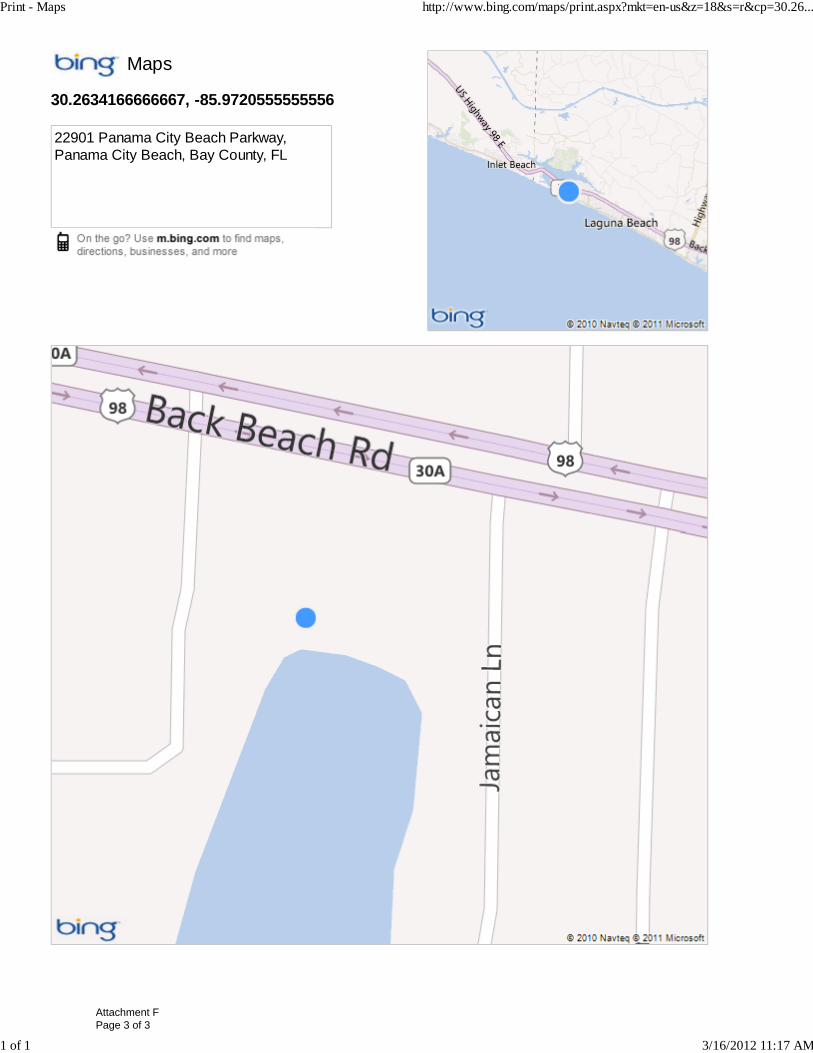
Maps
30.2634166666667, -85.9720555555556
22901 Panama City Beach Parkway,Panama City Beach, Bay County, FL
Print - Maps http://www.bing.com/maps/print.aspx?mkt=en-us&z=18&s=r&cp=30.26...
1 of 1 3/16/2012 11:17 AM
Attachment F Page 3 of 3
Attachment G Applicant’s Name: AW Solutions Page 1 of 5 Project Name: AW Solutions (PCAP4)
Project Number: M-1093
Attachment G
Consulting Parties
Public Involvement by Legal Notices, Letters, or Public Meetings Copies of all relevant documents, including correspondence and legal notices, are provided in the following pages.

Andrew Tankel
From: Andrew Tankel [[email protected]]
Sent: Friday, March 16, 2012 11:37 AM
To: '[email protected]'
Subject: Legal Notice for a proposed cell tower:
Importance: High
Page 1 of 1
3/16/2012
Hi, I am looking to run the following notice in The News Herald for one time only at the next available date. Please let me know what the cost would be and what day it could run. I will also need an affidavit & tear sheet. I have attached the notice as a word document as well. Feel free to call me for immediate payment. I will also need an invoice. Please let me know if you need any other information. Thanks,
AW Solutions proposes to construct a 184-foot overall height monopole telecommunications structure. The structure would be located at 22901 Panama City Beach Parkway, Panama City Beach, Bay County, Florida. AW Solutions invites comments from any interested party on the impact the tower may have on any HistoricProperties. Comments may be sent to Environmental Corporation of America, ATTN: Dina Bazzill, 1375 Union Hill Industrial Court, Suite A, Alpharetta, Georgia 30004. Comments must be received within 30 days. For questions please call Dina Bazzill at770-667-2040 x111. Andrew Tankel, EIT Project Engineer Environmental Corporation of America (ECA) 770‐667‐2040 x. 118 (office) 770‐667‐2041 (fax) andrew.tankel@eca‐usa.com www.eca‐usa.com Alpharetta, GA / Asheville, NC / Chicago, IL / Nashville, TN / West Palm Beach, FL
Attachment G Page 2 of 5
andrewt
Text Box
Ad Runs 3/21/12
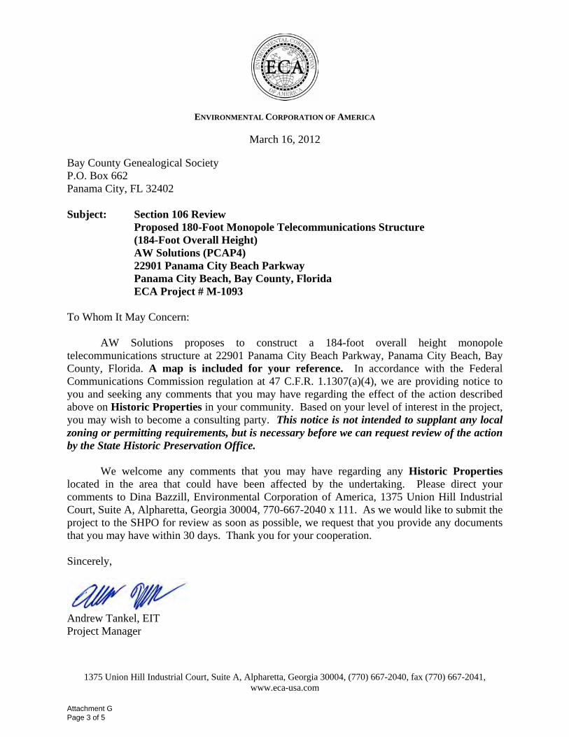
ENVIRONMENTAL CORPORATION OF AMERICA
1375 Union Hill Industrial Court, Suite A, Alpharetta, Georgia 30004, (770) 667-2040, fax (770) 667-2041, www.eca-usa.com
March 16, 2012 Bay County Genealogical Society P.O. Box 662 Panama City, FL 32402 Subject: Section 106 Review
Proposed 180-Foot Monopole Telecommunications Structure (184-Foot Overall Height) AW Solutions (PCAP4) 22901 Panama City Beach Parkway Panama City Beach, Bay County, Florida ECA Project # M-1093
To Whom It May Concern:
AW Solutions proposes to construct a 184-foot overall height monopole telecommunications structure at 22901 Panama City Beach Parkway, Panama City Beach, Bay County, Florida. A map is included for your reference. In accordance with the Federal Communications Commission regulation at 47 C.F.R. 1.1307(a)(4), we are providing notice to you and seeking any comments that you may have regarding the effect of the action described above on Historic Properties in your community. Based on your level of interest in the project, you may wish to become a consulting party. This notice is not intended to supplant any local zoning or permitting requirements, but is necessary before we can request review of the action by the State Historic Preservation Office.
We welcome any comments that you may have regarding any Historic Properties located in the area that could have been affected by the undertaking. Please direct your comments to Dina Bazzill, Environmental Corporation of America, 1375 Union Hill Industrial Court, Suite A, Alpharetta, Georgia 30004, 770-667-2040 x 111. As we would like to submit the project to the SHPO for review as soon as possible, we request that you provide any documents that you may have within 30 days. Thank you for your cooperation. Sincerely,
Andrew Tankel, EIT Project Manager
Attachment G Page 3 of 5

ENVIRONMENTAL CORPORATION OF AMERICA
1375 Union Hill Industrial Court, Suite A, Alpharetta, Georgia 30004, (770) 667-2040, fax (770) 667-2041, www.eca-usa.com
March 16, 2012 Bay County Historical Society P.O. Box 1476 Panama City, FL 32402 Subject: Section 106 Review
Proposed 180-Foot Monopole Telecommunications Structure (184-Foot Overall Height) AW Solutions (PCAP4) 22901 Panama City Beach Parkway Panama City Beach, Bay County, Florida ECA Project # M-1093
To Whom It May Concern:
AW Solutions proposes to construct a 184-foot overall height monopole telecommunications structure at 22901 Panama City Beach Parkway, Panama City Beach, Bay County, Florida. A map is included for your reference. In accordance with the Federal Communications Commission regulation at 47 C.F.R. 1.1307(a)(4), we are providing notice to you and seeking any comments that you may have regarding the effect of the action described above on Historic Properties in your community. Based on your level of interest in the project, you may wish to become a consulting party. This notice is not intended to supplant any local zoning or permitting requirements, but is necessary before we can request review of the action by the State Historic Preservation Office.
We welcome any comments that you may have regarding any Historic Properties located in the area that could have been affected by the undertaking. Please direct your comments to Dina Bazzill, Environmental Corporation of America, 1375 Union Hill Industrial Court, Suite A, Alpharetta, Georgia 30004, 770-667-2040 x 111. As we would like to submit the project to the SHPO for review as soon as possible, we request that you provide any documents that you may have within 30 days. Thank you for your cooperation. Sincerely,
Andrew Tankel, EIT Project Manager
Attachment G Page 4 of 5

Maps
30.2634166666667, -85.9720555555556
22901 Panama City Beach Parkway,Panama City Beach, Bay County, FL
Print - Maps http://www.bing.com/maps/print.aspx?mkt=en-us&z=18&s=r&cp=30.26...
1 of 1 3/16/2012 11:17 AM
Attachment G Page 5 of 5
Attachment H Applicant’s Name: AW Solutions Project Name: AW Solutions (PCAP4) Project Number: M-1093
Attachment H
Designation of SHPO/THPO
SHPO/THPO Specific Forms
The following pages include copies of all additional forms specific to the Section 106 Review process for the lead SHPO/THPO reviewing this filing.
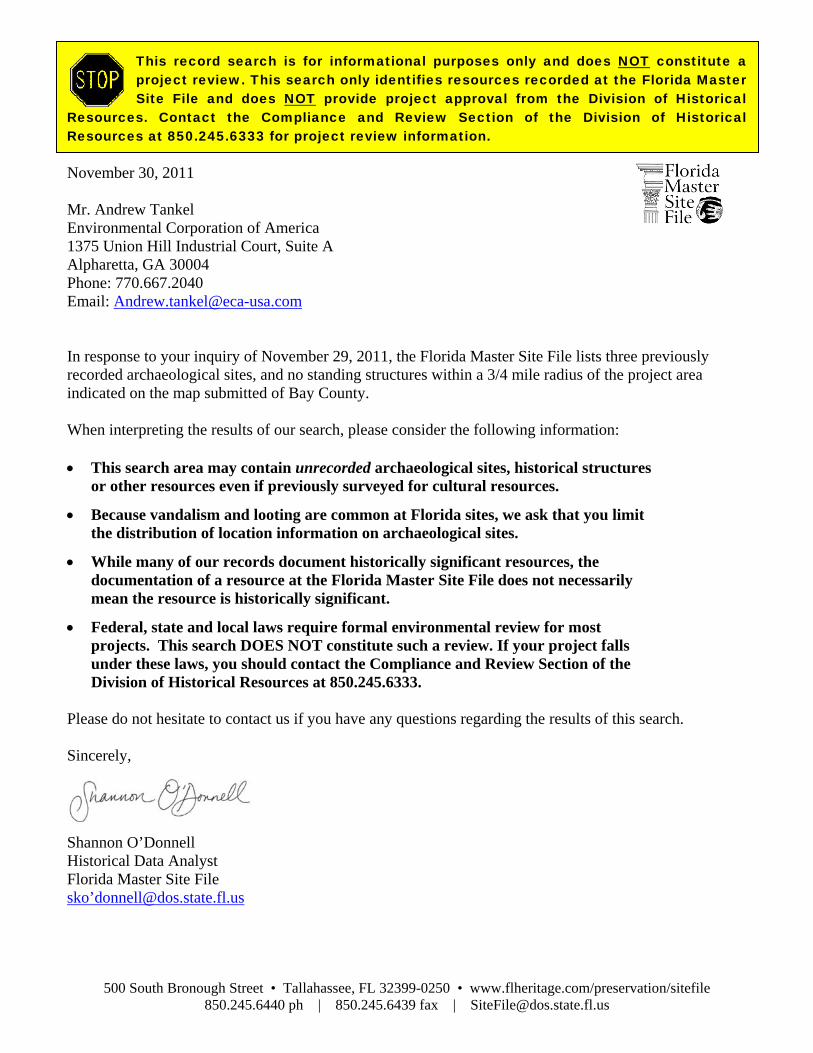
500 South Bronough Street • Tallahassee, FL 32399-0250 • www.flheritage.com/preservation/sitefile 850.245.6440 ph | 850.245.6439 fax | [email protected]
This record search is for informational purposes only and does NOT constitute a project review. This search only identifies resources recorded at the Florida Master Site File and does NOT provide project approval from the Division of Historical
Resources. Contact the Compliance and Review Section of the Division of Historical Resources at 850.245.6333 for project review information. November 30, 2011 Mr. Andrew Tankel Environmental Corporation of America 1375 Union Hill Industrial Court, Suite A Alpharetta, GA 30004 Phone: 770.667.2040 Email: [email protected] In response to your inquiry of November 29, 2011, the Florida Master Site File lists three previously recorded archaeological sites, and no standing structures within a 3/4 mile radius of the project area indicated on the map submitted of Bay County. When interpreting the results of our search, please consider the following information: • This search area may contain unrecorded archaeological sites, historical structures
or other resources even if previously surveyed for cultural resources.
• Because vandalism and looting are common at Florida sites, we ask that you limit the distribution of location information on archaeological sites.
• While many of our records document historically significant resources, the documentation of a resource at the Florida Master Site File does not necessarily mean the resource is historically significant.
• Federal, state and local laws require formal environmental review for most projects. This search DOES NOT constitute such a review. If your project falls under these laws, you should contact the Compliance and Review Section of the Division of Historical Resources at 850.245.6333.
Please do not hesitate to contact us if you have any questions regarding the results of this search. Sincerely,
Shannon O’Donnell Historical Data Analyst Florida Master Site File sko’[email protected]
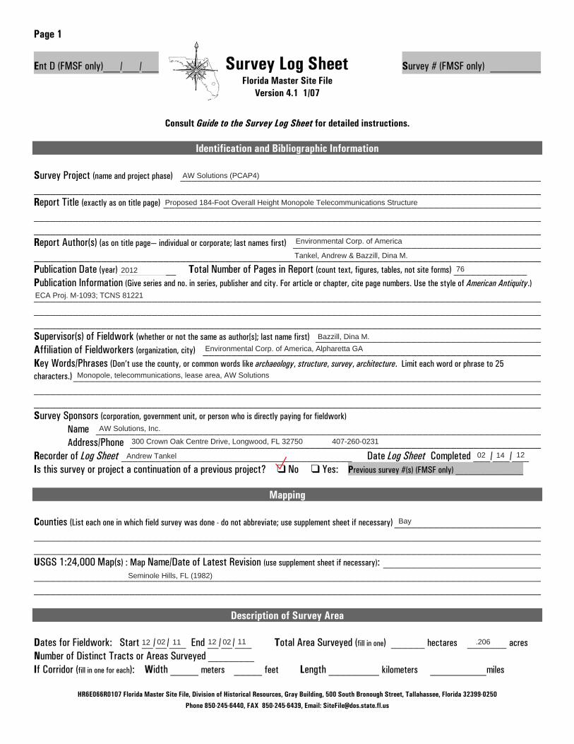
HR6E066R0107 Florida Master Site File, Division of Historical Resources, Gray Building, 500 South Bronough Street, Tallahassee, Florida 32399-0250
Phone 850-245-6440, FAX 850-245-6439, Email: [email protected]
Page 1
Ent D (FMSF only)___/___/___ Survey Log Sheet Survey # (FMSF only) _________ Florida Master Site File
Version 4.1 1/07
Consult Guide to the Survey Log Sheet for detailed instructions.
Identification and Bibliographic Information Survey Project (name and project phase) ________________________________________________________________ __________________________________________________________________________________________ Report Title (exactly as on title page) ___________________________________________________________________ __________________________________________________________________________________________ __________________________________________________________________________________________ Report Author(s) (as on title page— individual or corporate; last names first) ____________________________________________ __________________________________________________________________________________________ Publication Date (year) __________ Total Number of Pages in Report (count text, figures, tables, not site forms) _____________ Publication Information (Give series and no. in series, publisher and city. For article or chapter, cite page numbers. Use the style of American Antiquity.) __________________________________________________________________________________________ __________________________________________________________________________________________ __________________________________________________________________________________________ Supervisor(s) of Fieldwork (whether or not the same as author[s]; last name first) ________________________________________ Affiliation of Fieldworkers (organization, city) ____________________________________________________________ Key Words/Phrases (Don’t use the county, or common words like archaeology, structure, survey, architecture. Limit each word or phrase to 25 characters.)___________________________________________________________________________________ __________________________________________________________________________________________ __________________________________________________________________________________________ Survey Sponsors (corporation, government unit, or person who is directly paying for fieldwork)
Name _______________________________________________________________________________ Address/Phone _________________________________________________________________________
Recorder of Log Sheet _________________________________________ Date Log Sheet Completed ___/___/___ Is this survey or project a continuation of a previous project? � No � Yes: Previous survey #(s) (FMSF only) ________________
Mapping
Counties (List each one in which field survey was done - do not abbreviate; use supplement sheet if necessary) __________________________ __________________________________________________________________________________________ __________________________________________________________________________________________ USGS 1:24,000 Map(s) : Map Name/Date of Latest Revision (use supplement sheet if necessary): ____________________________ __________________________________________________________________________________________ __________________________________________________________________________________________
Description of Survey Area Dates for Fieldwork: Start __/__/___ End __/__/___ Total Area Surveyed (fill in one) ______ hectares _______ acres Number of Distinct Tracts or Areas Surveyed _________ If Corridor (fill in one for each): Width _____ meters _____ feet Length _________ kilometers __________miles
AW Solutions (PCAP4)
Proposed 184-Foot Overall Height Monopole Telecommunications Structure
Environmental Corp. of America
Tankel, Andrew & Bazzill, Dina M.
2012 76
ECA Proj. M-1093; TCNS 81221
Bazzill, Dina M.Environmental Corp. of America, Alpharetta GA
Monopole, telecommunications, lease area, AW Solutions
AW Solutions, Inc.
300 Crown Oak Centre Drive, Longwood, FL 32750 407-260-0231
Andrew Tankel 02 14 12
Bay
Seminole Hills, FL (1982)
12 11 02 11 .2061202

HR6E066R0107 Florida Master Site File, Division of Historical Resources, Gray Building, 500 South Bronough Street, Tallahassee, Florida 32399-0250
Phone 850-245-6440, FAX 850-245-6439, Email: [email protected]
Page 2 Survey Log Sheet Survey #_________
Research and Field Methods
Types of Survey (check all that apply): � archaeological � architectural � historical/archival � underwater � other:_____________________ Preliminary Methods (�Check as many as apply to the project as a whole.) � Florida Archives (Gray Building) � library research- local public � local property or tax records � other historic maps � Florida Photo Archives (Gray Building) � library-special collection - nonlocal � newspaper files � soils maps or data � Site File property search � Public Lands Survey (maps at DEP) � literature search � windshield survey � Site File survey search � local informant(s) � Sanborn Insurance maps � aerial photography � other (describe) ___________________________________________________________________________________________________________
Archaeological Methods (�Check as many as apply to the project as a whole.) � Check here if NO archaeological methods were used. � surface collection, controlled � other screen shovel test (size: ____) � block excavation (at least 2x2 M) � surface collection, uncontrolled � water screen (finest size: ____) � soil resistivity � shovel test-1/4”screen � posthole tests � magnetometer � shovel test-1/8” screen � auger (size:____) � side scan sonar � shovel test 1/16”screen � coring � unknown � shovel test-unscreened � test excavation (at least 1x2 M) � other (describe): __________________________________________________________________________________________________________
Historical/Architectural Methods (�Check as many as apply to the project as a whole.) � Check here if NO historical/architectural methods were used. � building permits � demolition permits � neighbor interview � subdivision maps � commercial permits � exposed ground inspected � occupant interview � tax records � interior documentation � local property records � occupation permits � unknown � other (describe): __________________________________________________________________________________________________________
Scope/Intensity/Procedures _______________________________________________________________________ __________________________________________________________________________________________ __________________________________________________________________________________________
Survey Results (cultural resources recorded) Site Significance Evaluated? � Yes � No If Yes, circle NR-eligible/significant site numbers below. Site Counts: Previously Recorded Sites ________________________ Newly Recorded Sites ______________________ Previously Recorded Site #’s with Site File Update Forms (List site #’s without “8.” Attach supplementary pages if necessary) _____________ __________________________________________________________________________________________ Newly Recorded Site #’s (Are you sure all are originals and not updates? Identify methods used to check for updates, i.e., researched Site File records. List site #’s without “8.” Attach supplementary pages if necessary.) ___________________________________________________________________ __________________________________________________________________________________________ __________________________________________________________________________________________ Site Form Used: � Site File Paper Form � SmartForm II Electronic Recording Form
REQUIRED: ATTACH PLOT OF SURVEY AREA ON PHOTOCOPIES OF USGS 1:24,000 MAP(S)
DO NOT USE SITE FILE USE ONLY DO NOT USE BAR Related BHP Related � 872 � 1A32 #____________________ � State Historic Preservation Grant � CARL � UW � Compliance Review: CRAT #______________________
Section 106 Review - Pedestrian survey & Phase I Archeological Survey
0 0

Bibliography Applicant’s Name: AW Solutions Project Name: AW Solutions (PCAP4)
Project Number: M-1093
Bibliography Federal Communications Commission Federal Register, 47 CFR Part 1, Nationwide
Programmatic Agreement for Review Under the National Historic Preservation Act; Final Rule, WT Docket No. 03-128; FCC 04-222, January 4, 2005.
Florida Archaeological Site Files at the Florida Dept of Historical Resources. Google Earth 2012 Aerial Photograph National Register Information System, retrieved from
http://www.nr.nps.gov/. Natural Resources Conservation Service, Soil Survey retrieved from
http://websoilsurvey.nrcs.usda.gov United States Geological Survey, 7.5-minute Topographic Quadrangle Map for Seminole Hills,
FL (1982).

APPENDIX F Native American Documentation
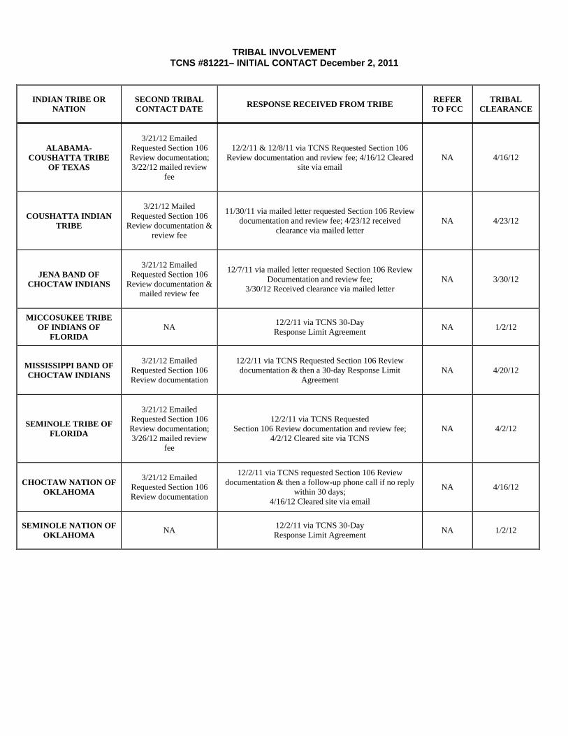
TRIBAL INVOLVEMENT TCNS #81221– INITIAL CONTACT December 2, 2011
INDIAN TRIBE OR NATION
SECOND TRIBAL CONTACT DATE
RESPONSE RECEIVED FROM TRIBE REFER TO FCC
TRIBAL CLEARANCE
ALABAMA- COUSHATTA TRIBE
OF TEXAS
3/21/12 Emailed
Requested Section 106 Review documentation; 3/22/12 mailed review
fee
12/2/11 & 12/8/11 via TCNS Requested Section 106 Review documentation and review fee; 4/16/12 Cleared
site via email NA 4/16/12
COUSHATTA INDIAN TRIBE
3/21/12 Mailed
Requested Section 106 Review documentation &
review fee
11/30/11 via mailed letter requested Section 106 Review documentation and review fee; 4/23/12 received
clearance via mailed letter NA 4/23/12
JENA BAND OF CHOCTAW INDIANS
3/21/12 Emailed
Requested Section 106 Review documentation &
mailed review fee
12/7/11 via mailed letter requested Section 106 Review
Documentation and review fee; 3/30/12 Received clearance via mailed letter
NA 3/30/12
MICCOSUKEE TRIBE OF INDIANS OF
FLORIDA NA
12/2/11 via TCNS 30-Day Response Limit Agreement
NA 1/2/12
MISSISSIPPI BAND OF CHOCTAW INDIANS
3/21/12 Emailed
Requested Section 106 Review documentation
12/2/11 via TCNS Requested Section 106 Review documentation & then a 30-day Response Limit
Agreement NA 4/20/12
SEMINOLE TRIBE OF FLORIDA
3/21/12 Emailed
Requested Section 106 Review documentation; 3/26/12 mailed review
fee
12/2/11 via TCNS Requested Section 106 Review documentation and review fee;
4/2/12 Cleared site via TCNS NA 4/2/12
CHOCTAW NATION OF OKLAHOMA
3/21/12 Emailed
Requested Section 106 Review documentation
12/2/11 via TCNS requested Section 106 Review documentation & then a follow-up phone call if no reply
within 30 days; 4/16/12 Cleared site via email
NA 4/16/12
SEMINOLE NATION OF OKLAHOMA
NA 12/2/11 via TCNS 30-Day Response Limit Agreement
NA 1/2/12

TCNS Notification Statements
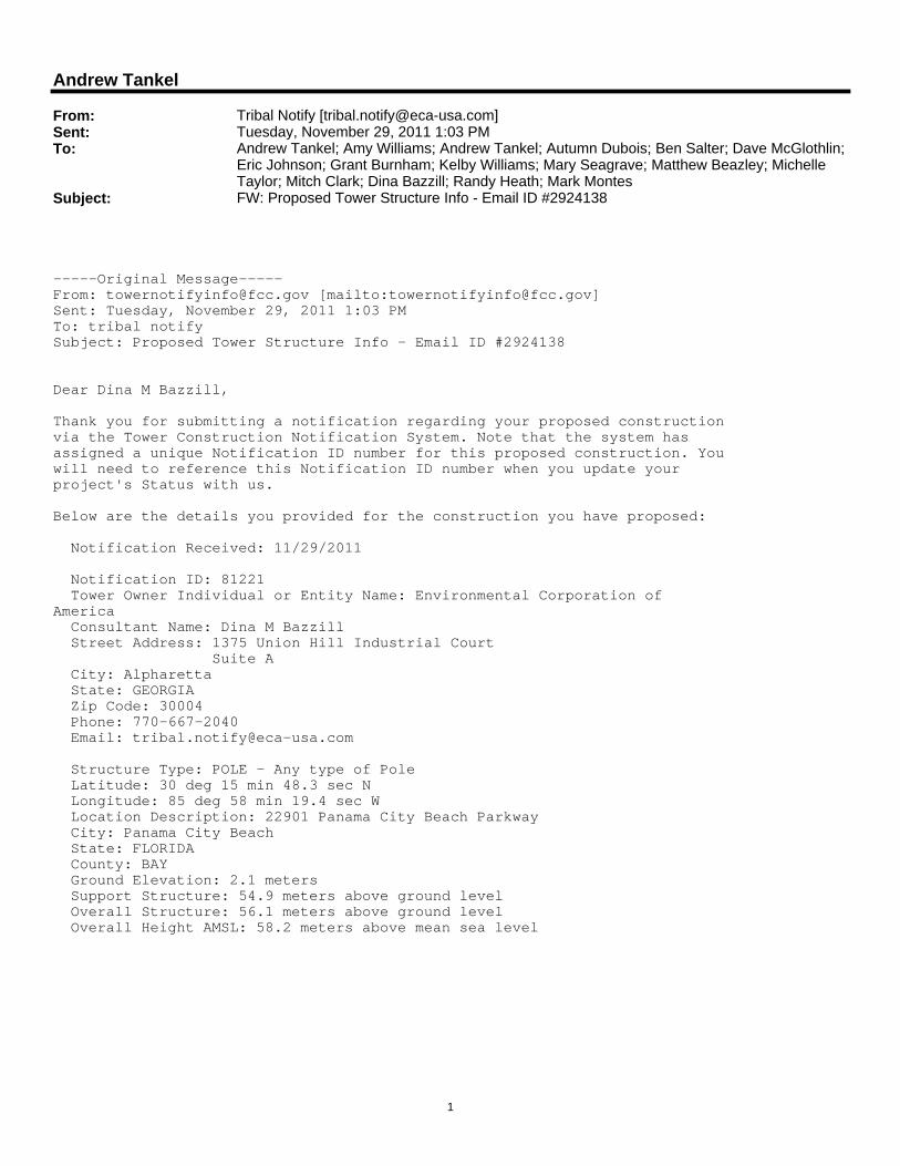
1
Andrew Tankel
From: Tribal Notify [[email protected]]Sent: Tuesday, November 29, 2011 1:03 PMTo: Andrew Tankel; Amy Williams; Andrew Tankel; Autumn Dubois; Ben Salter; Dave McGlothlin;
Eric Johnson; Grant Burnham; Kelby Williams; Mary Seagrave; Matthew Beazley; Michelle Taylor; Mitch Clark; Dina Bazzill; Randy Heath; Mark Montes
Subject: FW: Proposed Tower Structure Info - Email ID #2924138
-----Original Message-----From: [email protected] [mailto:[email protected]]Sent: Tuesday, November 29, 2011 1:03 PMTo: tribal notifySubject: Proposed Tower Structure Info - Email ID #2924138
Dear Dina M Bazzill,
Thank you for submitting a notification regarding your proposed constructionvia the Tower Construction Notification System. Note that the system hasassigned a unique Notification ID number for this proposed construction. Youwill need to reference this Notification ID number when you update yourproject's Status with us.
Below are the details you provided for the construction you have proposed:
Notification Received: 11/29/2011
Notification ID: 81221 Tower Owner Individual or Entity Name: Environmental Corporation ofAmerica Consultant Name: Dina M Bazzill Street Address: 1375 Union Hill Industrial Court Suite A City: Alpharetta State: GEORGIA Zip Code: 30004 Phone: 770-667-2040 Email: [email protected]
Structure Type: POLE - Any type of Pole Latitude: 30 deg 15 min 48.3 sec N Longitude: 85 deg 58 min 19.4 sec W Location Description: 22901 Panama City Beach Parkway City: Panama City Beach State: FLORIDA County: BAY Ground Elevation: 2.1 meters Support Structure: 54.9 meters above ground level Overall Structure: 56.1 meters above ground level Overall Height AMSL: 58.2 meters above mean sea level
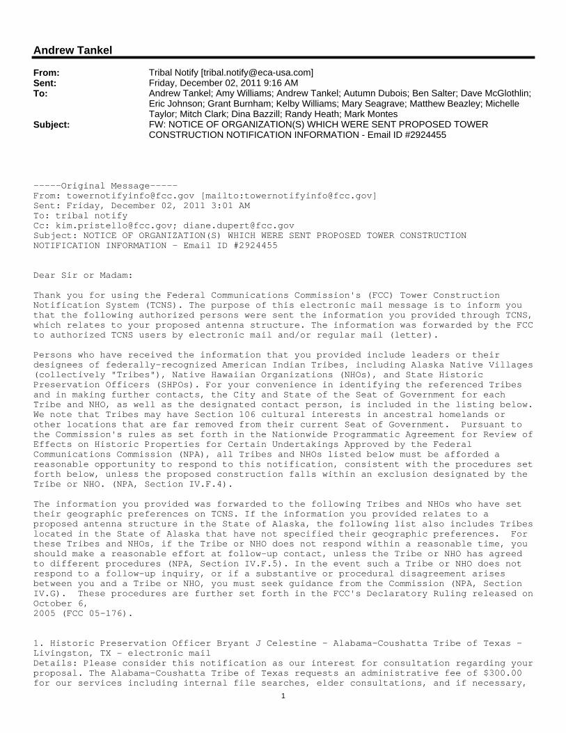
1
Andrew Tankel
From: Tribal Notify [[email protected]]Sent: Friday, December 02, 2011 9:16 AMTo: Andrew Tankel; Amy Williams; Andrew Tankel; Autumn Dubois; Ben Salter; Dave McGlothlin;
Eric Johnson; Grant Burnham; Kelby Williams; Mary Seagrave; Matthew Beazley; Michelle Taylor; Mitch Clark; Dina Bazzill; Randy Heath; Mark Montes
Subject: FW: NOTICE OF ORGANIZATION(S) WHICH WERE SENT PROPOSED TOWER CONSTRUCTION NOTIFICATION INFORMATION - Email ID #2924455
-----Original Message-----From: [email protected] [mailto:[email protected]]Sent: Friday, December 02, 2011 3:01 AMTo: tribal notifyCc: [email protected]; [email protected]: NOTICE OF ORGANIZATION(S) WHICH WERE SENT PROPOSED TOWER CONSTRUCTION NOTIFICATION INFORMATION - Email ID #2924455
Dear Sir or Madam:
Thank you for using the Federal Communications Commission's (FCC) Tower Construction Notification System (TCNS). The purpose of this electronic mail message is to inform you that the following authorized persons were sent the information you provided through TCNS,which relates to your proposed antenna structure. The information was forwarded by the FCCto authorized TCNS users by electronic mail and/or regular mail (letter).
Persons who have received the information that you provided include leaders or their designees of federally-recognized American Indian Tribes, including Alaska Native Villages(collectively "Tribes"), Native Hawaiian Organizations (NHOs), and State Historic Preservation Officers (SHPOs). For your convenience in identifying the referenced Tribes and in making further contacts, the City and State of the Seat of Government for each Tribe and NHO, as well as the designated contact person, is included in the listing below.We note that Tribes may have Section 106 cultural interests in ancestral homelands or other locations that are far removed from their current Seat of Government. Pursuant to the Commission's rules as set forth in the Nationwide Programmatic Agreement for Review ofEffects on Historic Properties for Certain Undertakings Approved by the Federal Communications Commission (NPA), all Tribes and NHOs listed below must be afforded a reasonable opportunity to respond to this notification, consistent with the procedures setforth below, unless the proposed construction falls within an exclusion designated by the Tribe or NHO. (NPA, Section IV.F.4).
The information you provided was forwarded to the following Tribes and NHOs who have set their geographic preferences on TCNS. If the information you provided relates to a proposed antenna structure in the State of Alaska, the following list also includes Tribeslocated in the State of Alaska that have not specified their geographic preferences. For these Tribes and NHOs, if the Tribe or NHO does not respond within a reasonable time, you should make a reasonable effort at follow-up contact, unless the Tribe or NHO has agreed to different procedures (NPA, Section IV.F.5). In the event such a Tribe or NHO does not respond to a follow-up inquiry, or if a substantive or procedural disagreement arises between you and a Tribe or NHO, you must seek guidance from the Commission (NPA, Section IV.G). These procedures are further set forth in the FCC's Declaratory Ruling released onOctober 6,2005 (FCC 05-176).
1. Historic Preservation Officer Bryant J Celestine - Alabama-Coushatta Tribe of Texas - Livingston, TX - electronic mailDetails: Please consider this notification as our interest for consultation regarding yourproposal. The Alabama-Coushatta Tribe of Texas requests an administrative fee of $300.00 for our services including internal file searches, elder consultations, and if necessary,
2
travel expenses for a site visit to complete our determination regarding your proposal. TAKE NOTE of the following procedures as this will assist our efforts to provide your firmwith the most efficient process in returning our determinations:
1. Submit your Form 620 or 621 by email to [email protected] submission is logged and within 10 days of receipt, an invoice will be returned to the email account we receive your supplemental information. IF YOU HAVE NOT RECEIVED THIS BY 15DAYS, PLEASE INQUIRE.2. INCLUDE your invoice number on your payment and submit according to the Invoice instructions. We cannot track your payment by project number so please do not submit without an invoice number.3. Within 20 days of your original submission, you will receive an email response from ourOffice relating to our determinations for your proposal.This may occur despite a delay in fee payment. If you have not received our determination within 25 days, PLEASE INQUIRE.4. IN THE EVENT OF AN OUTSTANDING BALANCE, a detailed invoice will be submitted in place of our determination. In this manner, your Section 106 obligations withour Tribe ARE NOT complete until we have forwarded our written response indicating our determination.5. If the applicant/tower builder decides to withdraw a proposal, please advise our officeas soon as possible to avoid an outstanding balance in the future and any unnecessary research by our office.
Thank you, Bryant J. Celestine - Historic Preservation Officer
2. THPO Linda P Langley Dr - Coushatta Indian Tribe - Elton, LA - electronic mail and regular mail
3. Tribal Historic Preservation Officer Dana M Masters - Jena Band of Choctaw Indians - Jena, LA - electronic mail and regular mail
4. NAGPRA & Section 106 Representative Fred Dayhoff - Miccosukee Tribe of Indians of Florida - Miami, FL - regular mailDetails: Please DO NOT contact me prior to the end of the 30-day period to inquire about the proposed site. I really need this time to review the TCNS notifications.
If, however, the proposed site is on undisturbed land, and you are aware of something thatmay be of interest to our Tribe, please feel free to telephone me or send documentation tome prior to the end of the 30-day period. Please send this information to me via regular mail or via UPS.Please do not use Federal Express, since they deliver toa general mailbox for our Tribe. Please send via reg. mail or UPS to:
Fred DayhoffNAGPRA & Section 106 RepresentativeMiccosukee Tribe of Indians of FloridaP.O. Box 440021Tamiami StationMiami, Florida 33144
At the end of the 30 days, if there is an inadvertent find during construction, IMMEDIATELY contact me at 239-695-4360 (phone). If the number is busy, immediately send a Fax to my attention at 239-695-4344 (fax).
Thank you.Fred DayhoffNAGPRA & Section 106 RepresentativeMiccosukee Tribe of Indians of [email protected]
If the applicant/tower builder receives no response from the Miccosukee Tribe of Indians
3
of Florida within 30 days after notification through TCNS, the Miccosukee Tribe of Indiansof Florida has no interest in participating in pre-construction review for the proposed site. The Applicant/tower builder, however, must immediately notify the Miccosukee Tribe of Indians of Florida in the event archaeological properties or human remains are discovered during construction, consistent with Section IX of the Nationwide Programmatic Agreement and applicable law.
5. THPO Kenneth H Carleton - Mississippi Band of Choctaw Indians - Choctaw, MS - electronic mailDetails: Please send all information via e-mail (and only via e-mail - no paper copies please) to: [email protected] (9 meg attachment limit)
The Mississippi Band of Choctaw Indians wishes to see full information packets for all towers within the designated areas for consultation.
Form 620, if it includes the a full text of the cultural resource survey with maps, is adequate for our needs. If your 620 does not include the text of the cultural resource survey, then attach it seperately.
Please include the tower identification (TCNS#, name, and any other information that may help us identify this site) and the county and state where the facility is proposed in thesubject line.
If the applicant/tower builder receives no response from the Mississippi Band of Choctaw Indians within 30 days AFTER YOU HAVE E-MAILED THE AFOREMENTIONED INFORMATION TO US (begincounting the 30 day period AFTER the e-mail with all of the information has been sent), then the Mississippi Band of Choctaw Indians has no interestin participating in pre-construction review for the proposed site. The Applicant/tower builder, however, must immediately notify the Mississippi Band of Choctaw Indians in the event archaeological properties or human remains are discovered during construction, consistent with Section IXof the Nationwide Programmatic Agreement and applicable law.
6. Archaeological Data Analyst Elliott York - Seminole Tribe of Florida - Clewiston, FL - electronic mailDetails: Effective on June 3rd, 2011, the Seminole Tribe of Florida (STOF) is charging an administrative review fee of $300 per tower. Upon receipt of the 620/621 form with attachments requested STOF will issue an invoice.Consultants will need to provide companyname, primary contact person, mailing address (or e-mail), and business phone for invoice purposes. Please specify whether you would prefer the invoice physically mailed or e-mailed to you. The determination will be given upon payment of the review fee.Checks should be made payable to Seminole Tribe of Florida and mailed to:Seminole Tribe of Florida, Accounts Receivable, 6300 Stirling Road, Hollywood, FL 33024. Please include the TCNS numbers and invoice number on the memo line of the check in order forus to track your project payment. For requests involving multiple towers, a single check in the sum of $300 per tower is acceptable.
The following additional items should be submitted for each review request:620/621 form with attachments associated with cultural resources to include archaeologicalassessment/report that includes methodology, findings and field survey results, and project area geomorphology and soils. Please limit submittal of architectural surveys (unless embedded with archaeologicalinformation), engineering/construction drawings, and excessive photos. All correspondence shall be conducted via email and email attachments.
Should you have any questions, please feel free to contact [email protected] or (863) 983-6549 ext. 12216. Thank you.
7. Director Historic Preservation Dept. Ian Thompson - Choctaw Nation of Oklahoma - Durant, OK - electronic mail and regular mailDetails: The Applicant may conclude that the Choctaw Nation of Oklahoma has no interest ina site if there is existing disturbance wherein the depth of the previous disturbance exceeds the proposed construction depth (excluding footing and other anchoring mechanisms)
4
by at least 2 feet (Applying VI -D(2)(c)(i) of the Nationwide Programmatic Agreement concerning Field Surveys; 'In the Matter of Nationwide Programmatic Agreement Regarding the Section 106 National Historic Preservation Act Review Process,' Report and Order, 20 FCC Rcd. 1073, WT Docket No. 03-128, October 5, 2004).
Furthermore, the Choctaw Nation of Oklahoma does not have an interest in a Tower that willbe constructed on an existing structure, developed land, or within city limits. However, any of the above mentioned criteria should be communicated to us if not evident in the initial Notification Details. For all other towers, we request a signed field survey report that meets the Federal guidelines set forth by the Department of the Interiorand a site location map along with pictures for each project.
Additionally, the Choctaw Nation of Oklahoma has informed FCC Staff that if the Applicant does not receive a response from the Tribe within 30 days of a TCNS notification, then theApplicant SHOULD MAKE A GOOD FAITH EFFORT WITH A FOLLOW-UP PHONE CALL to make sure that the tribe is aware of the proposed tower project. However, should construction expose buried archaeological or building materials such as chipped stone, tools, pottery, bone,historical crockery, glass or metal items, this office should be contacted immediately @ 1-800-522-6170 ext. 2137. [n.b. Please reference the TCNS number in all communications that follow the initial notification.]
8. Historic Preservation Officer Seminole Nation - Seminole Nation of Oklahoma - Wewoka, OK - electronic mailDetails: If the Applicant/tower builder receives no response from the Seminole Nation of Oklahoma within 30 days after notification through TCNS, the Seminole Nation of Oklahoma has no interest in participating in pre-construction review for the site. The Applicant/tower builder, however, must IMMEDIATELY notify the Seminole Nation of Oklahoma in the event archaeological properties or human remains are discovered during construction, consistent with Section IX of the Nationwide Programmatic Agreement and applicable law.
The information you provided was also forwarded to the additional Tribes and NHOs listed below. These Tribes and NHOs have NOT set their geographic preferences on TCNS, and therefore they are currently receiving tower notifications for the entire United States. For these Tribes and NHOs, you are required to use reasonable and good faith efforts to determine if the Tribe or NHO may attach religious and cultural significance to historic properties that may be affected by its proposed undertaking. Such efforts may include, butare not limited to, seeking information from the relevant SHPO or THPO, Indian Tribes, state agencies, the U.S. Bureau of Indian Affairs, or, where applicable, any federal agency with land holdings within the state (NPA, Section IV.B). If after such reasonable and good faith efforts, you determine that a Tribe or NHO may attach religious and cultural significance to historic properties in the area and the Tribe or NHO does not respond to TCNS notification within a reasonable time, you should make a reasonable effortto follow up, and must seek guidance from the Commission in the event of continued non-response or in the event of a procedural or substantive disagreement. If you determine that the Tribe or NHO is unlikely to attach religious and cultural significance to historic properties within the area, you do not need to take further action unless the Tribe or NHO indicates an interest in the proposed construction or other evidence of potential interest comes to your attention.
None
The information you provided was also forwarded to the following SHPOs in the State in which you propose to construct and neighboring States. The information was provided to these SHPOs as a courtesy for their information and planning. You need make no effort at this time to follow up with any SHPO that does not respond to this notification. Prior toconstruction, you must provide the SHPO of the State in which you propose to construct (orthe Tribal Historic Preservation Officer, if the project will be located on certain Triballands), with a Submission Packet pursuant to Section VII.A of the NPA.

5
9. SHPO Lee Warner - Alabama Historical Commission - Montgomery, AL - electronic mail
10. Deputy SHPO Elizabeth Ann Brown - Alabama Historical Commission - Montgomery, AL - electronic mail
11. Deputy SHPO Compliance Review Laura A Kammerer - Div of Historical Resources, Dept of State - Tallahassee, FL - electronic mail
12. Historic Preservationist Samantha Earnest - Florida Division of Historical Resources -Tallahasse, FL - electronic mail
If you are proposing to construct a facility in the State of Alaska, you should contact Commission staff for guidance regarding your obligations in the event that Tribes do not respond to this notification within a reasonable time.
Please be advised that the FCC cannot guarantee that the contact(s) listed above opened and reviewed an electronic or regular mail notification. The following information relating to the proposed tower was forwarded to theperson(s) listed above:
Notification Received: 11/29/2011 Notification ID: 81221 Tower Owner Individual or Entity Name: Environmental Corporation of America Consultant Name: Dina M Bazzill Street Address: 1375 Union Hill Industrial Court Suite A City: Alpharetta State: GEORGIA Zip Code: 30004 Phone: 770-667-2040 Email: [email protected]
Structure Type: POLE - Any type of Pole Latitude: 30 deg 15 min 48.3 sec N Longitude: 85 deg 58 min 19.4 sec W Location Description: 22901 Panama City Beach Parkway City: Panama City Beach State: FLORIDA County: BAY Ground Elevation: 2.1 meters Support Structure: 54.9 meters above ground level Overall Structure: 56.1 meters above ground level Overall Height AMSL: 58.2 meters above mean sea level
If you have any questions or comments regarding this notice, please contact the FCC using the electronic mail form located on the FCC's website at:
http://wireless.fcc.gov/outreach/notification/contact-fcc.html.
You may also call the FCC Support Center at (877) 480-3201 (TTY 717-338-2824). Hours are from 8 a.m. to 7:00 p.m. Eastern Time, Monday through Friday (except Federal holidays). To provide quality service and ensure security, all telephone calls are recorded.
Thank you,Federal Communications Commission
Follow Up Letters to Tribes
Andrew Tankel
From: Andrew Tankel [[email protected]]
Sent: Wednesday, March 21, 2012 11:23 AM
To: 'Bryant J. Celestine'
Subject: TCNS # 81221 Requested Section 106 Review Documentation:
Page 1 of 1
3/21/2012
Dear Mr. Celestine, Please see the attached Requested Section 106 Review Documentation for TCNS # 81221 in Panama City Beach, Bay County, Florida. Please let me know if the Alabama Coushatta Tribe of Texas have any questions. Thanks, Andrew Tankel, EIT Project Engineer Environmental Corporation of America (ECA) 770‐667‐2040 x. 118 (office) 770‐667‐2041 (fax) andrew.tankel@eca‐usa.com www.eca‐usa.com Alpharetta, GA / Asheville, NC / Chicago, IL / Nashville, TN / West Palm Beach, FL
Environmental Corporation of America, 1375 Union Hill Industrial Court, Suite A, Alpharetta, GA 30004
Environmental Corp. of America Phone: 770-667-2040 ext. 118 1375 Union Hill Industrial Court Fax No.: 770-667-2041 Suite A Alpharetta, GA 30004 From: Andrew Tankel
[email protected] To: Mr. Bryant J. Celestine Alabama-Coushatta Tribe of Texas 571 State Park Road 56 Livingston, TX 77351
TRANSMITTAL COVER SHEET ________________________________________________________________________________________
Date: March 22, 2012 Subject: Section 106 Review Invoice # HP-2221 TCNS # 81221 Proposed 180-Foot Monopole Telecommunications Structure (184-Foot Overall Height with Appurtenances) AW Solutions (PCAP4) 22901 Panama City Beach Parkway Panama City Beach, Bay County, Florida ECA Project # M-1093 Notes: Dear Mr. Celestine:
Attached is the Section 106 review fee. Please feel free to contact me if you need any additional information. Please feel free to respond by mail, TCNS, fax, or email. Thank you for your time!
Sincerely,
Andrew Tankel
Environmental Corporation of America, 1375 Union Hill Industrial Court, Suite A, Alpharetta, GA 30004
Environmental Corp. of America Phone: 770-667-2040 x. 118 1375 Union Hill Industrial Court Fax No.: 770-667-2041 Suite A Alpharetta, GA 30004 From: Andrew Tankel [email protected] To: Ms. Linda P. Langley,THPO Phone: 337-584-1560
Coushatta Indian Tribe Coushatta Heritage Department PO Box 10 Elton, Louisiana 70532
TRANSMITTAL COVER SHEET
________________________________________________________________________________________
Date: March 21, 2012 Subject: Section 106 Review TCNS # 81221 Proposed 180-Foot Monopole Telecommunications Structure (184-Foot Overall Height with Appurtenances) AW Solutions (PCAP4) 22901 Panama City Beach Parkway Panama City Beach, Bay County, Florida ECA Project # M-1093 Notes: Ms. Langley,
Attached is the requested Section 106 Review Documentation and review fee. Please feel free to contact me if you need any additional information. Please feel free to respond by mail, TCNS, fax, or email. Thank you for your time!
Sincerely,
Andrew Tankel
Andrew Tankel
From: Andrew Tankel [[email protected]]
Sent: Wednesday, March 21, 2012 11:24 AM
To: 'CHAPMAN CANDESS'
Subject: TCNS # 81221 Requested Section 106 Review Documentation:
Page 1 of 1
3/21/2012
Dear Ms. Chapman, Please see the attached Requested Section 106 Review Documentation for TCNS # 81221 in Panama City Beach, Bay County, Florida. The requested review fee will be mailed today. Please let me know if the Jena Band of Choctaw Indians have any questions. Thanks, Andrew Tankel, EIT Project Engineer Environmental Corporation of America (ECA) 770‐667‐2040 x. 118 (office) 770‐667‐2041 (fax) andrew.tankel@eca‐usa.com www.eca‐usa.com Alpharetta, GA / Asheville, NC / Chicago, IL / Nashville, TN / West Palm Beach, FL

Environmental Corporation of America, 1375 Union Hill Industrial Court, Suite A, Alpharetta, GA 30004
Environmental Corp. of America Phone: 770-667-2040 x. 118 1375 Union Hill Industrial Court Fax No.: 770-667-2041 Suite A Alpharetta, GA 30004 From: Andrew Tankel [email protected] To: Ms. Dana Masters, THPO Phone: 318-992-1205
Jena Band of Choctaw Indians PO Box 14 Jena, Louisiana 71342
TRANSMITTAL COVER SHEET
________________________________________________________________________________________
Date: March 21, 2012 Subject: Section 106 Review TCNS # 81221 Proposed 180-Foot Monopole Telecommunications Structure (184-Foot Overall Height with Appurtenances) AW Solutions (PCAP4) 22901 Panama City Beach Parkway Panama City Beach, Bay County, Florida ECA Project # M-1093 Notes: Ms. Masters,
Attached is the requested Section 106 review fee. Please feel free to contact me if you need any additional information. Please feel free to respond by mail, TCNS, fax, or email. Thank you for your time!
Sincerely,
Andrew Tankel

Andrew Tankel
From: Andrew Tankel [[email protected]]
Sent: Wednesday, March 21, 2012 11:34 AM
To: '[email protected]'
Subject: TCNS # 81221 Requested Section 106 Review Documentation:
Page 1 of 1
3/21/2012
Dear Mr. Carleton, Please see the attached Requested Section 106 Review Documentation for TCNS # 81221 in Panama City Beach, Bay County, Florida. Please let me know if the Mississippi Band of Choctaw Indians have any questions. Thanks, Andrew Tankel, EIT Project Engineer Environmental Corporation of America (ECA) 770‐667‐2040 x. 118 (office) 770‐667‐2041 (fax) andrew.tankel@eca‐usa.com www.eca‐usa.com Alpharetta, GA / Asheville, NC / Chicago, IL / Nashville, TN / West Palm Beach, FL

Andrew Tankel
From: Andrew Tankel [[email protected]]
Sent: Wednesday, March 21, 2012 11:25 AM
To: 'Elliott York'
Subject: TCNS # 81221 Requested Section 106 Review Documentation:
Page 1 of 1
3/21/2012
Dear Mr. York, Please see the attached Requested Section 106 Review Documentation for TCNS # 81221 in Panama City Beach, Bay County, Florida. Can you please email me an invoice as well at your earliest convenience? Please let me know if the Seminole Tribe of Florida have any questions. Thanks, Andrew Tankel, EIT Project Engineer Environmental Corporation of America (ECA) 770‐667‐2040 x. 118 (office) 770‐667‐2041 (fax) andrew.tankel@eca‐usa.com www.eca‐usa.com Alpharetta, GA / Asheville, NC / Chicago, IL / Nashville, TN / West Palm Beach, FL

Environmental Corporation of America, 1375 Union Hill Industrial Ct, Suite A, Alpharetta, GA 30004
Environmental Corp. of America Phone: 770-667-2040 ext. 118 1375 Union Hill Industrial Ct, Ste A Fax No.: 770-667-2041 Alpharetta, GA 30004 From: Andrew Tankel [email protected] To: Seminole Tribe of Florida Phone: 954-966-6300 Attn: Accounts Receivable 6300 Stirling Road Hollywood, FL 33024
TRANSMITTAL COVER SHEET
________________________________________________________________________________________
Date: March 26, 2012 Subject: Section 106 Review Invoice # HP232 TCNS # 81221 Proposed 180-Foot Monopole Telecommunications Structure (184-Foot Overall Height with Appurtenances) AW Solutions (PCAP4) 22901 Panama City Beach Parkway Panama City Beach, Bay County, Florida ECA Project # M-1093 Notes: Please Find Attached the Requested Review Fee for TCNS # 81221 in Panama City Beach, Bay County, Florida. Sincerely,
Andrew Tankel
Andrew Tankel
From: Andrew Tankel [[email protected]]
Sent: Wednesday, March 21, 2012 11:36 AM
To: 'Caren Johnson'
Subject: TCNS # 81221 Requested Section 106 Review Documentation:
Page 1 of 1
3/21/2012
Dear Ms. Johnson, Please see the attached Requested Section 106 Review Documentation for TCNS # 81221 in Panama City Beach, Bay County, Florida. Please let me know if the Choctaw Nation of Oklahoma have any questions. Thanks, Andrew Tankel, EIT Project Engineer Environmental Corporation of America (ECA) 770‐667‐2040 x. 118 (office) 770‐667‐2041 (fax) andrew.tankel@eca‐usa.com www.eca‐usa.com Alpharetta, GA / Asheville, NC / Chicago, IL / Nashville, TN / West Palm Beach, FL
Responses/Standing Requests Received From Tribes
1
Andrew Tankel
From: Tribal Notify [[email protected]]Sent: Friday, December 09, 2011 9:31 AMTo: Andrew Tankel; Amy Williams; Andrew Tankel; Autumn Dubois; Ben Salter; Dave McGlothlin;
Eric Johnson; Grant Burnham; Kelby Williams; Mary Seagrave; Matthew Beazley; Michelle Taylor; Mitch Clark; Dina Bazzill; Randy Heath; Mark Montes
Subject: FW: Reply to Proposed Tower Structure (Notification ID: 81221) - Email ID #2928322
-----Original Message-----From: [email protected] [mailto:[email protected]]Sent: Thursday, December 08, 2011 5:48 PMTo: tribal notifyCc: [email protected]; [email protected]: Reply to Proposed Tower Structure (Notification ID: 81221) - Email ID #2928322
Dear Dina M Bazzill,
Thank you for using the Federal Communications Commission's (FCC) TowerConstruction Notification System (TCNS). The purpose of this email is toinform you that an authorized user of the TCNS has replied to a proposedtower construction notification that you had submitted through the TCNS.
The following message has been sent to you from Historic PreservationOfficer Bryant J Celestine of the Alabama-Coushatta Tribe of Texas inreference to Notification ID #81221:
If your firm has not already done so, please forward a copy of your Form620/621 in accordance with our Pre-Notification Statement. Thank you!
For your convenience, the information you submitted for this notification isdetailed below.
Notification Received: 11/29/2011 Notification ID: 81221 Tower Owner Individual or Entity Name: Environmental Corporation ofAmerica Consultant Name: Dina M Bazzill Street Address: 1375 Union Hill Industrial Court Suite A City: Alpharetta State: GEORGIA Zip Code: 30004 Phone: 770-667-2040 Email: [email protected]
Structure Type: POLE - Any type of Pole Latitude: 30 deg 15 min 48.3 sec N Longitude: 85 deg 58 min 19.4 sec W Location Description: 22901 Panama City Beach Parkway City: Panama City Beach State: FLORIDA County: BAY Ground Elevation: 2.1 meters Support Structure: 54.9 meters above ground level Overall Structure: 56.1 meters above ground level Overall Height AMSL: 58.2 meters above mean sea level
Andrew Tankel
From: Bryant J. Celestine [[email protected]]
Sent: Monday, April 16, 2012 4:40 PM
To: Andrew Tankel
Subject: RE: TCNS # 81221 Requested Section 106 Review Documentation:
Page 1 of 1
4/17/2012
Dear Mr. Tankel: On behalf of Mikko Oscola Clayton Sylestine and the Alabama-Coushatta Tribe, our appreciation is expressed on your efforts to consult us regarding TCNS #81221 in Bay County. Our Tribe maintains ancestral associations within the state of Florida despite the absence of written records to completely identify Tribal activities, villages, trails, or burial sites. However, it is our objective to ensure significances of American Indian ancestry, especially of Alabama-Coushatta origin, are administered with the utmost considerations. Upon review of your March 21, 2012 submission, no known impacts to cultural assets of the Alabama-Coushatta Tribe of Texas are anticipated in conjunction with this proposal. In the event of inadvertent discovery of human remains and/or archaeological artifacts, activity in proximity to the location must cease and appropriate authorities, including our office, notified without delay for additional consultations. Should you require further assistance, please do not hesitate to contact us. Sincerely,
Bryant J. Celestine Historic Preservation Officer Alabama-Coushatta Tribe of Texas 571 State Park Rd 56 Livingston, Texas 77351 936 - 563 – 1181 (office) 936 - 933 – 7297 (cell) [email protected] =
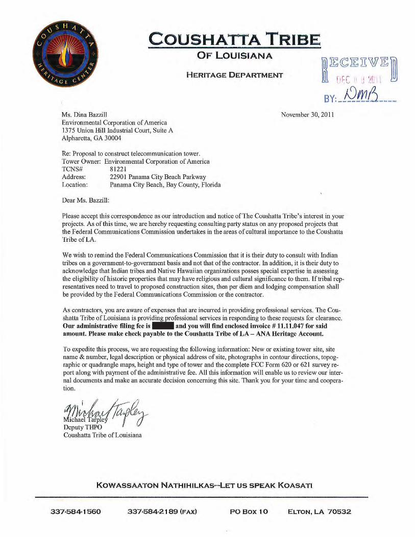
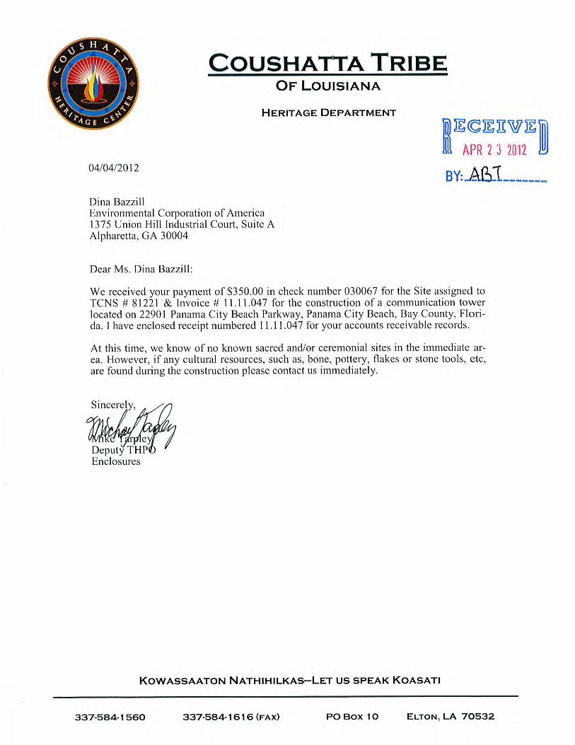
andrewt
Rectangle
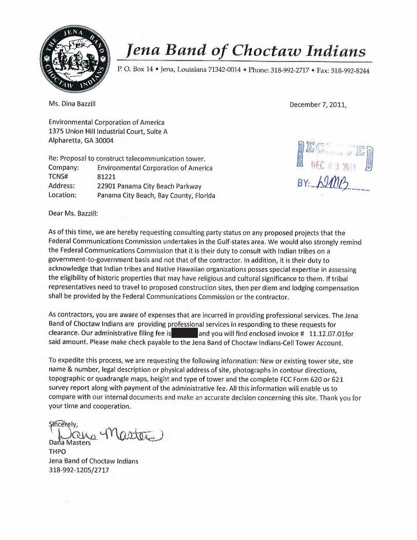

andrewt
Rectangle

1
Andrew Tankel
From: Tribal Notify [[email protected]]Sent: Monday, April 02, 2012 9:17 AMTo: Andrew Tankel; Amy Williams; Andrew Tankel; Autumn Dubois; Ben Salter; Dave McGlothlin;
Eric Johnson; Grant Burnham; Kelby Williams; Mary Seagrave; Matthew Beazley; Michelle Taylor; Mitch Clark; Dina Bazzill; Randy Heath; Mark Montes
Subject: FW: Reply to Proposed Tower Structure (Notification ID: 81221) - Email ID #2999088
-----Original Message-----From: [email protected] [mailto:[email protected]]Sent: Monday, April 02, 2012 9:14 AMTo: tribal notifyCc: [email protected]; [email protected]: Reply to Proposed Tower Structure (Notification ID: 81221) - Email ID #2999088
Dear Dina M Bazzill,
Thank you for using the Federal Communications Commission's (FCC) TowerConstruction Notification System (TCNS). The purpose of this email is toinform you that an authorized user of the TCNS has replied to a proposedtower construction notification that you had submitted through the TCNS.
The following message has been sent to you from Archaeological Data AnalystElliott York of the Seminole Tribe of Florida in reference to NotificationID #81221:
To Whom It May Concern,
The Seminole Tribe of Florida Tribal Historic Preservation Office(STOF-THPO) has received your email correspondence concerning theaforementioned project. The STOF-THPO has no objection to your findings atthis time. However, the STOF-THPO would like to be informed should anyarchaeological and/or historic resources be discovered inadvertently duringthe construction process. We thank you for the opportunity to review theinformation that has been sent to date regarding this project.
We look forward to working with you in the future.
Sincerely,Paul N. Backhouse, Ph.D. Acting Tribal Historic Preservation Officer
For your convenience, the information you submitted for this notification isdetailed below.
Notification Received: 11/29/2011 Notification ID: 81221 Tower Owner Individual or Entity Name: Environmental Corporation ofAmerica Consultant Name: Dina M Bazzill Street Address: 1375 Union Hill Industrial Court Suite A City: Alpharetta State: GEORGIA Zip Code: 30004 Phone: 770-667-2040 Email: [email protected]

2
Structure Type: POLE - Any type of Pole Latitude: 30 deg 15 min 48.3 sec N Longitude: 85 deg 58 min 19.4 sec W Location Description: 22901 Panama City Beach Parkway City: Panama City Beach State: FLORIDA County: BAY Ground Elevation: 2.1 meters Support Structure: 54.9 meters above ground level Overall Structure: 56.1 meters above ground level Overall Height AMSL: 58.2 meters above mean sea level
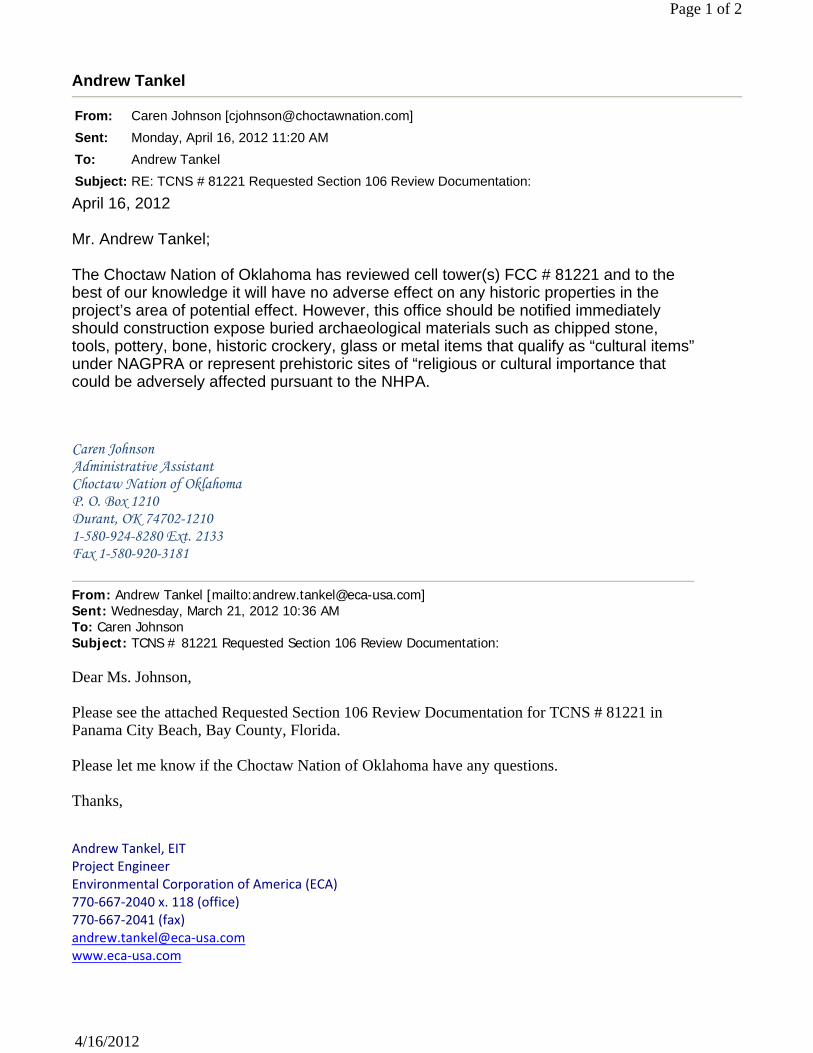
Andrew Tankel
From: Caren Johnson [[email protected]]
Sent: Monday, April 16, 2012 11:20 AM
To: Andrew Tankel
Subject: RE: TCNS # 81221 Requested Section 106 Review Documentation:
Page 1 of 2
4/16/2012
April 16, 2012 Mr. Andrew Tankel; The Choctaw Nation of Oklahoma has reviewed cell tower(s) FCC # 81221 and to the best of our knowledge it will have no adverse effect on any historic properties in the project’s area of potential effect. However, this office should be notified immediately should construction expose buried archaeological materials such as chipped stone, tools, pottery, bone, historic crockery, glass or metal items that qualify as “cultural items”under NAGPRA or represent prehistoric sites of “religious or cultural importance that could be adversely affected pursuant to the NHPA. Caren Johnson Administrative Assistant Choctaw Nation of Oklahoma P. O. Box 1210 Durant, OK 74702-1210 1-580-924-8280 Ext. 2133 Fax 1-580-920-3181
From: Andrew Tankel [mailto:[email protected]] Sent: Wednesday, March 21, 2012 10:36 AM To: Caren Johnson Subject: TCNS # 81221 Requested Section 106 Review Documentation: Dear Ms. Johnson, Please see the attached Requested Section 106 Review Documentation for TCNS # 81221 in Panama City Beach, Bay County, Florida. Please let me know if the Choctaw Nation of Oklahoma have any questions. Thanks, Andrew Tankel, EIT Project Engineer Environmental Corporation of America (ECA) 770‐667‐2040 x. 118 (office) 770‐667‐2041 (fax) andrew.tankel@eca‐usa.com www.eca‐usa.com

Alpharetta, GA / Asheville, NC / Chicago, IL / Nashville, TN / West Palm Beach, FL
This message is intended only for the use of the individual or entity to which it is addressed and may contain information that is privileged, confidential and exempt from disclosure. If you have received this message in error, you are hereby notified that we do not consent to any reading, dissemination, distribution or copying of this message. If you have received this communication in error, please notify the sender immediately and destroy the transmitted information. Please note that any view or opinions presented in this email are solely those of the author and do not necessarily represent those of the Choctaw Nation.
Page 2 of 2
4/16/2012
APPENDIX G Building Permit
(Will be provided when granted)


![1093 gilchrist[2]](https://static.fdocuments.us/doc/165x107/559116061a28ab0b168b4730/1093-gilchrist2.jpg)