automatic extraction and building change detection from digital surface model and multispectral
18
28 Geodetski vestnik 55/1 (2011) IZ ZNANOSTI IN STROKE AUTOMATIC EXTRACTION AND BUILDING CHANGE DETECTION FROM DIGITAL SURFACE MODEL AND MULTISPECTRAL ORTHOPHOTO SAMODEJEN ZAJEM IN ISKANJE SPREMEMB V TOPOGRAFSKEM SLOJU STAVB IZ DIGITALNEGA MODELA POVRŠJA IN MULTISPEKTRALNEGA ORTOFOTA Dejan Grigillo, Mojca Kosmatin Fras, Dušan Petrovič UDK: 004.6:528.7:528.93:659.2 Klasifikacija prispevka po COBISS-u: 1.01 KLJUČNE BESEDE samodejni zajem stavb, iskanje sprememb, normalizirani digitalni model površja, multispektralni ortofoto, modificiran vegetacijski indeks automatic building extraction, change detection, normalised digital surface model, multispectral orthophoto, modified vegetation index KEY WORDS Dejan Grigillo, Mojca Kosmatin Fras, Dušan Petrovič - AUTOMATIC EXTRACTION AND BUILDING CHANGE DETECTION FROM DIGITAL SURFACE MODEL AND MULTISPECTRAL ORTHOPHOTO IZVLEČEK Vzdrževanje podatkov v topografskih bazah je ena od pomembnejših nalog organizacij, ki te podatkovne baze vodijo. Eden od pomembnih podatkovnih slojev v topografskih bazah so podatki o stavbah. V članku sta opisani metoda za samodejen zajem stavb iz digitalnega modela površja in multispektralnega ortofota ter uporaba rezultatov zajema za samodejno iskanje sprememb v topografskih bazah, v katerih se vodijo podatki o stavbah. Začetno masko stavb smo izdelali iz normaliziranega digitalnega modela površja (nDMP). Vegetacijo smo iz maske stavb izločili z modificiranim vegetacijskim indeksom, izračunanim iz infrardečega ortofota ob upoštevanju indeksa senc in teksture nDMP. Na končni maski smo stavbe vektorizirali z uporabo transformacije Radon. Rezultate samodejnega zajema stavb smo primerjali s katastrom stavb in dejanskim stanjem na terenu. S samodejnim postopkom smo našli 94,4 % vseh stavb na območju in ocenili, da je opisana metoda primerna za zajem podatkov o stavbah za topografske baze v merilih 1 : 10 000 in manj. Rezultat samodejnega iskanja sprememb (popolnost 93,5 % in pravilnost 78,4 %) kaže, da je opisana metoda primerna za iskanje sprememb med podatki o stavbah. ABSTRACT The update of topographic databases is an important task for organizations that maintain them. Building data are one of the important data types in topographic databases. The article describes a method for automatic building extraction from digital surface model and multispectral orthophoto and the use of extraction results for the building change detection in the topographic database. The initial building mask was created from the normalized digital surface model (nDSM).Vegetation was eliminated from the building mask using a modified vegetation index calculated from the infrared orthophoto and also considering the shadow index and the nDMP texture. The final building mask was vectorised using Radon transform. The results of the automatic building extraction were compared to the building cadastre and the actual situation on the ground. The automatic method detected 94.4% of all buildings in the area. We concluded that the described method is appropriate for capturing of the building data for the topographic database in scales 1 : 10 000 and smaller. Automatic change detection results (completeness 93.5% and correctness 78.4%) indicate that the described method is appropriate for building change detection.
Transcript of automatic extraction and building change detection from digital surface model and multispectral
28
Geo
dets
ki v
estn
ik 5
5/1
(201
1)IZ
ZN
AN
OST
I IN
STR
OK
E
AUTOMATIC EXTRACTION AND BUILDING CHANGE DETECTION FROM DIGITAL SURFACE MODEL AND
MULTISPECTRAL ORTHOPHOTOSAMODEJEN ZAJEM IN ISKANJE SPREMEMB V TOPOGRAFSKEM SLOJU STAVB IZ
DIGITALNEGA MODELA POVRŠJA IN MULTISPEKTRALNEGA ORTOFOTA
Dejan Grigillo, Mojca Kosmatin Fras, Dušan Petrovič
UDK: 004.6:528.7:528.93:659.2 Klasifikacija prispevka po COBISS-u: 1.01
KLJUČNE BESEDE
samodejni zajem stavb, iskanje sprememb, normalizirani digitalni model površja, multispektralni ortofoto, modificiran vegetacijski indeks
automatic building extraction, change detection, normalised digital surface model, multispectral orthophoto, modified vegetation index
KEY WORDS
Dejan
Grig
illo, M
ojca K
osma
tin Fr
as, D
ušan
Petro
vič -
AUTO
MAT
IC EX
TRAC
TION
AND
BUILD
ING
CHAN
GE D
ETEC
TION
FROM
DIG
ITAL S
URFA
CE M
ODEL
AND
MUL
TISPE
CTRA
L ORT
HOPH
OTO
IZVLEČEK
Vzdrževanje podatkov v topografskih bazah je ena od pomembnejših nalog organizacij, ki te podatkovne baze vodijo. Eden od pomembnih podatkovnih slojev v topografskih bazah so podatki o stavbah. V članku sta opisani metoda za samodejen zajem stavb iz digitalnega modela površja in multispektralnega ortofota ter uporaba rezultatov zajema za samodejno iskanje sprememb v topografskih bazah, v katerih se vodijo podatki o stavbah. Začetno masko stavb smo izdelali iz normaliziranega digitalnega modela površja (nDMP). Vegetacijo smo iz maske stavb izločili z modificiranim vegetacijskim indeksom, izračunanim iz infrardečega ortofota ob upoštevanju indeksa senc in teksture nDMP. Na končni maski smo stavbe vektorizirali z uporabo transformacije Radon. Rezultate samodejnega zajema stavb smo primerjali s katastrom stavb in dejanskim stanjem na terenu. S samodejnim postopkom smo našli 94,4 % vseh stavb na območju in ocenili, da je opisana metoda primerna za zajem podatkov o stavbah za topografske baze v merilih 1 : 10 000 in manj. Rezultat samodejnega iskanja sprememb (popolnost 93,5 % in pravilnost 78,4 %) kaže, da je opisana metoda primerna za iskanje sprememb med podatki o stavbah.
ABSTRACT
The update of topographic databases is an important task for organizations that maintain them. Building data are one of the important data types in topographic databases. The article describes a method for automatic building extraction from digital surface model and multispectral orthophoto and the use of extraction results for the building change detection in the topographic database. The initial building mask was created from the normalized digital surface model (nDSM).Vegetation was eliminated from the building mask using a modified vegetation index calculated from the infrared orthophoto and also considering the shadow index and the nDMP texture. The final building mask was vectorised using Radon transform. The results of the automatic building extraction were compared to the building cadastre and the actual situation on the ground. The automatic method detected 94.4% of all buildings in the area. We concluded that the described method is appropriate for capturing of the building data for the topographic database in scales 1 : 10 000 and smaller. Automatic change detection results (completeness 93.5% and correctness 78.4%) indicate that the described method is appropriate for building change detection.
GV_1_2011.indd 28GV_1_2011.indd 28 30.3.2011 9:31:1030.3.2011 9:31:10

29
Geo
dets
ki v
estn
ik 5
5/1
(201
1)IZ
ZN
AN
OST
I IN
STR
OK
E
1 INTRODUCTION
When Slovenia gained independence in 1991, the system of national topographic maps and databases was partially renovated and partially re-established. In 2000 the establishment of the topographic database DTK 5, which represents the most detailed topographic database in vector form, started as a substitute of the former basic topographic map TTN. Layer of buildings, as the object group in DTK 5, was adopted from the data in the building cadastre, and it was completed in the process of extracting the contents of DTK 5. The sources for the basic extraction of the building cadastre were photogrammetric procedures or field measurements, while the building layer within the establishment of DTK 5 was completed from the data obtained from the Cyclic aerial survey of Slovenia (CAS). After a decade of extraction, DTK 5 is established for about 60% of the area of Slovenia, although it comprises much larger share of settled areas and thus also buildings. An important task still not systematically regulated within DTK 5 is the updating of topographic data. Researches in the world are directed toward the development of semi-automatic and automatic procedures for the maintenance and extraction of topographic data with the integration of different data types, from aerial and satellite images, close-range images, data from aerial and terrestrial laser scanning and radar images. An overview of automatic procedures for the detection of topographic objects based on the combination of data from different sources, extracted between 2004 and 2008, was collected by Mayer, Hinz and Stilla (2008). Despite progress in the development of automatic procedures for the extraction of topographic data, the theoretically developed methods still have not found their place in practice (Mayer, 2008). More concrete results come from the researches of the systems that use semi-automatic or automatic procedures only to unveil the discrepancies between existing database and new sources. The resulting change is then dealt with by the operator, who makes the final decision and, when necessary, extracts the data into topographic database. Such procedure can save a lot of time compared to the classic detection of changes (Holland et al, 2008), which is most frequently carried out by visual comparison between topographic data and aerial photography or orthophoto. The organisation EuroSDR carried out an extensive research dealing with automatic building change detection in 2D topographic databases. It was found out that such procedure has significant economic effect, since it eliminates between 80% and 90% of the buildings in the database that the operator does not have to review (Champion, 2009). Such procedures are also useful to control the capturing of data for the topographic database.
To detect changes in the topographic database, mainly two types of procedures are used: comparison of data acquired from one type of sensors in two different time periods, or comparison of data in the existing database with the results from the new extraction (Vosselman et al, 2004). Our investigation focused on the second possibility. We were in the first place interested in the use of alternative sources for the extraction of data in the topographic database. We analysed what the precision is that can be achieved, for which scales or levels of detail the method is useful also for the extraction of data in the database, and finally, if the data of automatic extraction are also useful to detect changes in the topographic database.
Our research was focused on the automatic extraction of buildings. Slovenia keeps records on
Dejan
Grig
illo, M
ojca K
osma
tin Fr
as, D
ušan
Petro
vič -
AUTO
MAT
IC EX
TRAC
TION
AND
BUILD
ING
CHAN
GE D
ETEC
TION
FROM
DIG
ITAL S
URFA
CE M
ODEL
AND
MUL
TISPE
CTRA
L ORT
HOPH
OTO
GV_1_2011.indd 29GV_1_2011.indd 29 30.3.2011 9:31:1030.3.2011 9:31:10

30
Geo
dets
ki v
estn
ik 5
5/1
(201
1)IZ
ZN
AN
OST
I IN
STR
OK
E
buildings in DTK 5 and in building cadastre (BC). As the data source for the change detection in the existing databases we used the data of laser scanning as well as colour and near infrared orthophoto. The point cloud obtained together with attribute data by laser scanning allows by itself the use of various methods for automatic building extraction (e.g. Dorninger, Pfeifer, 2008; Pfeifer et al, 2007; Hofmann, Mass, Streilein, 2002; Vosselman, Dijkman, 2001), or the data from laser scanning are combined with other data sources, most frequently multispectral images (Rottensteiner et al, 2007; Sohn and Dowman, 2007). Special software equipment required to process the basic data from laser scanning is frequently not available. For this reason we used the derived data from the laser scanning: digital surface model (DSM) and digital terrain model (DTM), both in the raster format and with spatial resolution of 0.5 m. The emphasis is on the use of the derived data from laser scanning, where no data on various reflections are available, but only the final products are considered. The method is for this reason applicable also in the case where a precise DSM, obtained from a different source, is available (e.g. photogrammetric extraction; Demir and Baltsavias, 2007; Lu et al, 2006). The researches also describe the combination of height data and multispectral images used to detect changes in topographic database (Champion et al, 2008; Matikainen et al, 2010; Rottensteiner, 2008). This paper summarizes part of the procedures for automatic building extraction developed within the first author’s PhD thesis (Grigillo, 2010).
2 STUDY AREA AND DESCRIPTION OF DATA
The proposed approach was tested on the urban edge of Ljubljana. As existing data the data from the building cadastre (BC) were used, and as the source for recording changes the data from lidar survey, taken in 2007 at the southern part of Ljubljana and at the Ljubljana Marshland, as well as the national orthophoto. BC and orthophoto were provided by the Surveying and Mapping Authority of the Republic of Slovenia.
The data from laser scanning are represented by DSM and DTM, both in the raster format and with spatial resolution of 0.5 m. The original lidar data (point clouds with attributes) were not available. The used image data consist of the national colour orthophoto DOF050 with spatial resolution of 0.5 m and the national near infrared orthophoto DOF100IR with spatial resolution of 1 m. Both orthophotos were made from the images of CAS in 2006 and were recorded in the RGB colour space with radiometric resolution of 24 bits (8 bits each for red, green and blue layer). DOF100IR was pansharpened to the spatial resolution of 0.5 m by using DOF050, resampled into a grayscale image.
The region of testing the methods for the extraction of buildings has the area of 500 m × 350 m with boundary coordinates in the national coordinate system D48/GK:
Y: 460,725 m – 461,225 m; X: 99,200 m – 99,550 m.
The results of automatic building detection and extraction were compared to the graphic part of BC and the actual situation in nature, which we acquired by comparing the shapes of buildings at the orthophoto, DSM and BC, as well as with field inspection.
Dejan
Grig
illo, M
ojca K
osma
tin Fr
as, D
ušan
Petro
vič -
AUTO
MAT
IC EX
TRAC
TION
AND
BUILD
ING
CHAN
GE D
ETEC
TION
FROM
DIG
ITAL S
URFA
CE M
ODEL
AND
MUL
TISPE
CTRA
L ORT
HOPH
OTO
GV_1_2011.indd 30GV_1_2011.indd 30 30.3.2011 9:31:1130.3.2011 9:31:11

31
Geo
dets
ki v
estn
ik 5
5/1
(201
1)IZ
ZN
AN
OST
I IN
STR
OK
E
3 METHODOLOGY
The main steps of automatic building extraction are shown in Figure 1. The procedure can be summarised with the following steps:
- calculation of nDSM from DSM and DTM and elaboration of a nDSM high objects mask,
- elaboration of initial building mask by eliminating vegetation from the nDSM high objects mask, which includes the calculation of modified vegetation index and shadow index from the multispectral orthophoto and improvement of the shadow index by considering its homogeneity,
- elaboration of a mask for the building area test, the nDSM building mask and raster outlines of buildings,
- vectorisation of buildings from raster outlines of buildings by including the mask for the building area test.
Figure 1: Flowchart of the building extraction from DSM and orthophoto.
For the change detecting procedure the vector data from the automatic extraction and BC were rasterized. The change detection was carried out automatically by comparing binary images of automatic extraction, BC and the actual situation in nature.
3.1 Calculation of nDSM
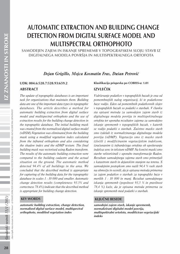
By calculating the difference between DSM and DTM a normalized digital surface model (nDSM) was generated. It includes only objects reaching above the earth’s surface. From nDSM a mask was made, which included only the areas with the possible locations of buildings. The mask was made with the threshold of 2 m. According to the Operative instructions for the building data extraction in topographic databases only buildings higher than two metres are maintained (GURS, 2001). Figure 2 shows DTM (a), DSM (b) and the nDSM high objects mask (c). Apart from buildings the mask also includes other objects higher than two metres. Such objects consist mainly of vegetation. De
jan G
rigillo
, Mojc
a Kos
matin
Fras
, Duš
an Pe
trovič
- AU
TOM
ATIC
EXTR
ACTIO
N AN
D BU
ILDIN
G CH
ANGE
DET
ECTIO
N FR
OM D
IGITA
L SUR
FACE
MOD
EL A
ND M
ULTIS
PECT
RAL O
RTHO
PHOT
O
GV_1_2011.indd 31GV_1_2011.indd 31 30.3.2011 9:31:1130.3.2011 9:31:11
32
Geo
dets
ki v
estn
ik 5
5/1
(201
1)IZ
ZN
AN
OST
I IN
STR
OK
E
Figure 2: Height data and initial building mask: DTM (a), DSM (b) and nDSM high objects mask (c).
3.2 Modified vegetation index and shadow index
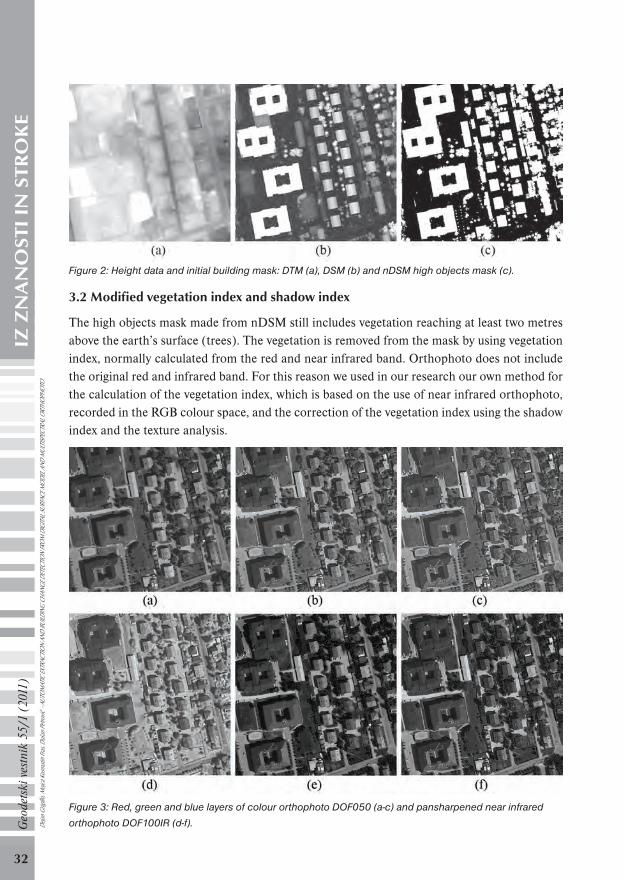
The high objects mask made from nDSM still includes vegetation reaching at least two metres above the earth’s surface (trees). The vegetation is removed from the mask by using vegetation index, normally calculated from the red and near infrared band. Orthophoto does not include the original red and infrared band. For this reason we used in our research our own method for the calculation of the vegetation index, which is based on the use of near infrared orthophoto, recorded in the RGB colour space, and the correction of the vegetation index using the shadow index and the texture analysis.
Figure 3: Red, green and blue layers of colour orthophoto DOF050 (a-c) and pansharpened near infrared
orthophoto DOF100IR (d-f).Dejan
Grig
illo, M
ojca K
osma
tin Fr
as, D
ušan
Petro
vič -
AUTO
MAT
IC EX
TRAC
TION
AND
BUILD
ING
CHAN
GE D
ETEC
TION
FROM
DIG
ITAL S
URFA
CE M
ODEL
AND
MUL
TISPE
CTRA
L ORT
HOPH
OTO
GV_1_2011.indd 32GV_1_2011.indd 32 30.3.2011 9:31:1130.3.2011 9:31:11

33
Geo
dets
ki v
estn
ik 5
5/1
(201
1)IZ
ZN
AN
OST
I IN
STR
OK
E
In the upper row of Figure 3 red (a), green (b) and blue (c) layer of DOF050 are shown, while the adequate layers of DOF100IR are shown in the bottom row (Figure 3 d-f). By visual interpretation of all the layers it can be established that the vegetation has the highest intensity values in the red layer of DOF100IR (d) and the lowest intensity values in the green layer of DOF100IR (e). These two are therefore used to calculate the normalized differential vegetation index (NDVI) (1):
(1)
where as band R the green layer of DOF100IR, and as band IR the red layer of DOF100IR are used, both pansharpened to the spatial resolution of 0.5 m. Since Equation (1) does not use classical bands to calculate NDVI (red and near infrared band), we can speak about the modified vegetation index NDVI.
Beside the vegetation also shadows have higher intensity values in the red layer as compared to the green layer. Therefore, the modified NDVI classifies them as vegetation. The use of modified NDVI for the elimination of vegetation from further data processing thus brings with it the risk that the shadowed parts of the buildings are also eliminated from the processing. For this reason, before further procedure the shadows appearing on the buildings shall be detected.
Shadows on images can be recognised by calculating the shadow index (SI). Ono et al (2007) propose the correction of vegetation index by normalizing bands in processing with their arithmetic means. The calculation of normalized values of bands R
d is given by Equation (2):
(2)
where rd represents the original reflection, i denotes the band and N is the number of bands
being processed. To calculate the normalized bands, all six layers of orthophoto were used. SI is obtained with the difference between normalized and original band (Ono et al, 2007). To calculate SI the pansharpened red layer of DOF100IR is used (3):
(3)
Before calculating SI, the noise was removed from normalized band using median filter with the size of 3 × 3 pixels.
Several steps were used to make the initial building mask and to repair the vegetation index due to shadows. Using modified NDVI a mask of the area that does not include vegetation is made (for the threshold the empirical value of 0.36 was used). With the conjunction of the mask that excludes vegetation and the nDSM high objects mask, a building mask is made, which does not include shadowed parts of the buildings. With further procedure this mask is completed. First the shadow index (SI) is calculated, and a shadow mask is made. For the shadow mask the empirically defined threshold of 0.08 was used. With the conjunction of the shadow mask and the nDSM high objects mask the shadows in the areas that reach above ground surface (buildings, vegetation, etc.) are obtained. The shadows that do not fall on buildings are eliminated De
jan G
rigillo
, Mojc
a Kos
matin
Fras
, Duš
an Pe
trovič
- AU
TOM
ATIC
EXTR
ACTIO
N AN
D BU
ILDIN
G CH
ANGE
DET
ECTIO
N FR
OM D
IGITA
L SUR
FACE
MOD
EL A
ND M
ULTIS
PECT
RAL O
RTHO
PHOT
O
GV_1_2011.indd 33GV_1_2011.indd 33 30.3.2011 9:31:1230.3.2011 9:31:12

34
Geo
dets
ki v
estn
ik 5
5/1
(201
1)IZ
ZN
AN
OST
I IN
STR
OK
E
by texture analysis, since the vegetation texture is coarser on nDSM than that of the shadowed roofs. To distinguish between shadows on buildings and those on vegetation, the homogeneity image is calculated. Homogeneity represents one of the texture measures. Homogeneity f is acquired from the matrix of relative frequencies P(i, j), which conveys the appearance of two neighbouring pixels on the image or part of the image, one with intensity i and the other with intensity j (Haralick et al, 1973). Homogeneity is calculated as follows (4):
(4)
Dejan
Grig
illo, M
ojca K
osma
tin Fr
as, D
ušan
Petro
vič -
AUTO
MAT
IC EX
TRAC
TION
AND
BUILD
ING
CHAN
GE D
ETEC
TION
FROM
DIG
ITAL S
URFA
CE M
ODEL
AND
MUL
TISPE
CTRA
L ORT
HOPH
OTO
Figure 4: Elaboration of initial building mask.
GV_1_2011.indd 34GV_1_2011.indd 34 30.3.2011 9:31:1230.3.2011 9:31:12

35
Geo
dets
ki v
estn
ik 5
5/1
(201
1)IZ
ZN
AN
OST
I IN
STR
OK
E
where Ng is the stock of intensities in the image and R is the constant used to normalise the image.
For the calculation a filter with the size of 3 × 3 pixels was used. As candidates for buildings the areas with homogeneity higher than or equal to 0.9 were preserved. At the same time the surfaces measuring less than 2 m2 were eliminated and the building edges were blurred using morphological closing with structural element »disk« (Matlab, 2010) with the size of 4 pixels. Then the building mask was completed by shadows with value 1 on the nDSM high objects mask and with large homogeneity (≥ 0.9).
Figure 4 shows the elaboration procedure of the initial building mask. The upper row shows colour orthophoto for the presentation of the area (a), NDVI (b) and the building mask that does not include shadowed parts of the buildings (c). The middle row shows SI (d) (for the presentation the contrast is improved by the linear histogram stretch with saturation of 2.5%), shadow mask (e) and conjunction of the shadow mask with the nDSM high objects mask (f). The bottom row shows the homogeneity image (g), the area that completes the building mask (h) (eliminated shadowed vegetation) and initial building mask (i).
3.3 Further processing of masks
For the final building extraction we will need a mask to test building areas and the outlines of buildings, developed from the nDSM high objects mask. The mask for the building area test contains only buildings in the test area. It is made with a series of morphological operations from the initial building mask, presented in Figure 4(i). The latter still includes some irregularities as the consequence of different objects, which are higher than two metres and do not represent buildings (fences, trucks), noise in DSM, errors in the calculation of the vegetation index and SI. The initial building mask is first corrected by filling up the holes in it. Attention should be paid not to fill up the holes that represent building interiors (only the holes with the area smaller than 3 m2 were eliminated). Then, from the initial building mask all objects thinner than 1.5 m were eliminated. The procedure was done by morphological opening using structural elements of the shapes —, |, / and \ with the dimension of three pixels. From the mask also all objects with smaller area than 4 m2 are removed (according to the Operative instruction for the building data extraction in the topographical bases only buildings with the area larger than 4 m2 are maintained; GURS, 2001). Thus, a mask is obtained that reliably contains only buildings with damaged shapes due to numerous morphological operations. The obtained mask is for this reason used only as marker in the operation of morphological opening by reconstruction, used to process the initial building mask, in which smaller holes were filled up. By morphological opening by reconstruction, unwanted objects are eliminated from the image, whereas the objects marked by the marker preserve the original shape (Gonzales et al, 2004).
Dejan
Grig
illo, M
ojca K
osma
tin Fr
as, D
ušan
Petro
vič -
AUTO
MAT
IC EX
TRAC
TION
AND
BUILD
ING
CHAN
GE D
ETEC
TION
FROM
DIG
ITAL S
URFA
CE M
ODEL
AND
MUL
TISPE
CTRA
L ORT
HOPH
OTO
GV_1_2011.indd 35GV_1_2011.indd 35 30.3.2011 9:31:1230.3.2011 9:31:12

36
Geo
dets
ki v
estn
ik 5
5/1
(201
1)IZ
ZN
AN
OST
I IN
STR
OK
E
Figure 5: Initial building mask (a), marker (b) and mask for the building area test (c).
Figure 5 shows the initial building mask with filled up holes (a), marker containing only buildings (b) and a reconstructed building mask, called mask for the building area test (c). Irregular building shapes at the final mask (c) are mainly the consequence of high vegetation covering some roofs, noise in the nDSM data and smaller errors in previous procedures. Errors are not disturbing, since the mask obtained in this way will only be used to test the areas within the building extraction procedure (description in 3.4) and for further preparation of the nDSM mask for the final building extraction.
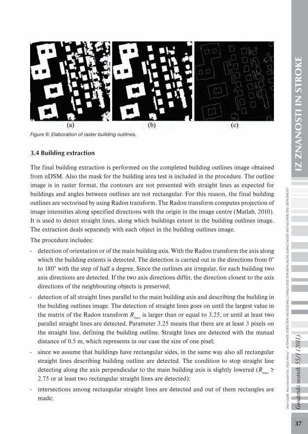
Further input data for the building extraction are building outlines, made from the nDSM high objects mask, as presented in Figure 2(c). In order to make building outlines, we need a nDSM high objects mask, where one object in the mask represents one building or several buildings, if these touch each other in the space. Therefore, the nDSM high objects mask is further processed. In the first step the objects in the mask connected only with one pixel are separated and the mask is opened by reconstruction using the above mentioned building marker. Other buildings in the mask are separated using the mask for the building area test. For this reason the mask for the building area test needs additionally processing: irregularities at the outside contours of the buildings are blurred using morphological erosion with the structural element »diamond, 1« (Matlab, 2010), once again objects and holes with the areas smaller than 4 m2 are removed, each object separately is closed with a square of dimensions 3 × 3 pixels (closing of each object separately is important, otherwise objects close to each other would be joined), and the objects are expanded by 2 m in all directions (only if this does not result in joining of objects). With the conjunction of the resulting building mask and the nDSM high objects mask, the nDSM building mask is obtained, where buildings are separated from each other. In the nDSM building mask the objects touching the image border are removed, as well as all objects and holes smaller than 4 m2, and external outlines of the objects are made. These outlines represent the main input data for the final building extraction.
Figure 6 shows a reconstructed nDSM high objects mask (a), a nDSM building mask (b) and building outlines image (c).
Dejan
Grig
illo, M
ojca K
osma
tin Fr
as, D
ušan
Petro
vič -
AUTO
MAT
IC EX
TRAC
TION
AND
BUILD
ING
CHAN
GE D
ETEC
TION
FROM
DIG
ITAL S
URFA
CE M
ODEL
AND
MUL
TISPE
CTRA
L ORT
HOPH
OTO
GV_1_2011.indd 36GV_1_2011.indd 36 30.3.2011 9:31:1330.3.2011 9:31:13
37
Geo
dets
ki v
estn
ik 5
5/1
(201
1)IZ
ZN
AN
OST
I IN
STR
OK
E
Figure 6: Elaboration of raster building outlines.
3.4 Building extraction
The final building extraction is performed on the completed building outlines image obtained from nDSM. Also the mask for the building area test is included in the procedure. The outline image is in raster format, the contours are not presented with straight lines as expected for buildings and angles between outlines are not rectangular. For this reason, the final building outlines are vectorised by using Radon transform. The Radon transform computes projection of image intensities along specified directions with the origin in the image centre (Matlab, 2010). It is used to detect straight lines, along which buildings extent in the building outlines image. The extraction deals separately with each object in the building outlines image.
The procedure includes:
- detection of orientation or of the main building axis. With the Radon transform the axis along which the building extents is detected. The detection is carried out in the directions from 0° to 180° with the step of half a degree. Since the outlines are irregular, for each building two axis directions are detected. If the two axis directions differ, the direction closest to the axis directions of the neighbouring objects is preserved;
- detection of all straight lines parallel to the main building axis and describing the building in the building outlines image. The detection of straight lines goes on until the largest value in the matrix of the Radon transform R
max is larger than or equal to 3.25, or until at least two
parallel straight lines are detected. Parameter 3.25 means that there are at least 3 pixels on the straight line, defining the building outline. Straight lines are detected with the mutual distance of 0.5 m, which represents in our case the size of one pixel;
- since we assume that buildings have rectangular sides, in the same way also all rectangular straight lines describing building outline are detected. The condition to stop straight line detecting along the axis perpendicular to the main building axis is slightly lowered (R
max ≥
2.75 or at least two rectangular straight lines are detected);
- intersections among rectangular straight lines are detected and out of them rectangles are made;
Dejan
Grig
illo, M
ojca K
osma
tin Fr
as, D
ušan
Petro
vič -
AUTO
MAT
IC EX
TRAC
TION
AND
BUILD
ING
CHAN
GE D
ETEC
TION
FROM
DIG
ITAL S
URFA
CE M
ODEL
AND
MUL
TISPE
CTRA
L ORT
HOPH
OTO
GV_1_2011.indd 37GV_1_2011.indd 37 30.3.2011 9:31:1330.3.2011 9:31:13

38
Geo
dets
ki v
estn
ik 5
5/1
(201
1)IZ
ZN
AN
OST
I IN
STR
OK
E
- all rectangles do not describe buildings, so each of them is tested. If the ratio between the surface area obtained by the intersection of the rectangle with the mask for the building area test and the surface area calculated from the rectangle’s corners is larger than 0.6, the rectangle is retained, otherwise it is discarded. When dealing with building interiors, the surface area test is carried out by negating the mask for the building area test;
- vectorised building is obtained using the outline of retained rectangles.
Dejan
Grig
illo, M
ojca K
osma
tin Fr
as, D
ušan
Petro
vič -
AUTO
MAT
IC EX
TRAC
TION
AND
BUILD
ING
CHAN
GE D
ETEC
TION
FROM
DIG
ITAL S
URFA
CE M
ODEL
AND
MUL
TISPE
CTRA
L ORT
HOPH
OTO
Figure 7: Building extraction procedure.
GV_1_2011.indd 38GV_1_2011.indd 38 30.3.2011 9:31:1330.3.2011 9:31:13

39
Geo
dets
ki v
estn
ik 5
5/1
(201
1)IZ
ZN
AN
OST
I IN
STR
OK
E
The building extraction procedure is shown in Figure 7. Only two buildings are selected for the representation. The upper row shows the main building axis in the building outlines image (a), the main building axis in nDSM (b) and the detected straight lines that describe the building outlines and their intersections (c). The middle row shows the elaborated rectangles in the building outlines image (d), the same rectangles in the mask for the building area test (e) and the retained rectangles in the building outlines image (f). The bottom row in Figure 7 shows the results of building extraction: at the building outlines image (g), in nDSM (h) and in the colour orthophoto DOF050 (i). The building contours seem slightly shifted in the colour orthophoto. Actually, the roofs of the buildings in the orthophoto are shifted. The shift is the consequence of producing the orthophoto by using DTM, which describes only the earth’s surface and does not include buildings (Kraus, 2007). Figures 7(a, c, d, e, f and g) are shown as negatives.
3.5 Change detection
To detect changes, the result of automatic vector buildings extraction and BC is rasterized. The change detection runs automatically by comparing objects (buildings) in binary images of the extraction and BC. With the conjunction between BC and automatic extraction we are able to detect buildings in BC and those detected by the automatic procedure. With the operator »exclusive OR« between buildings in BC and the mentioned conjunction it can be defined which buildings in the database were not detected or no longer exist in nature. With the operator »exclusive OR« carried out between the extraction results and the mentioned conjunction, new buildings not yet in the database are detected. For other changes the objects at the conjunction are compared. The objects are divided in 4 classes according to their ratio of surface areas in the binary images of BC and of automatic extraction:
- less than 10% of the object surface area in BC is covered by the object at the extraction => demolished/undiscovered building;
- less than 10% of the object surface area at the extraction is covered by an object in BC => new building;
- object in BC covers from 10% to THR object area at automatic extraction => enlarged building;
- above THR of the object in BC is covered by an object at automatic extraction => discovered old building.
THR represents the selected threshold. In our case we used THR = 70%. Matikainen et al (2004) propose to select the threshold of 80% for industrial areas, 70% for the apartment house areas and 60% for areas with smaller family houses. Our procedure also includes the possibility of notification in case of changes, when several objects in BC cover one object from automatic extraction. In this way we were able to detect correctly most of the enlarged building.
The efficiency of the automatic change detection is evaluated by comparing the actual situation in nature, the topographic database being updated (in our case BC) and the results of automatic extraction. We evaluated the completeness and correctness of the procedure (Heipke et al, 1997) (5):
Dejan
Grig
illo, M
ojca K
osma
tin Fr
as, D
ušan
Petro
vič -
AUTO
MAT
IC EX
TRAC
TION
AND
BUILD
ING
CHAN
GE D
ETEC
TION
FROM
DIG
ITAL S
URFA
CE M
ODEL
AND
MUL
TISPE
CTRA
L ORT
HOPH
OTO
GV_1_2011.indd 39GV_1_2011.indd 39 30.3.2011 9:31:1430.3.2011 9:31:14

40
Geo
dets
ki v
estn
ik 5
5/1
(201
1)IZ
ZN
AN
OST
I IN
STR
OK
E
;
(5)
Completeness describes the amount of actual changes detected by the automatic procedure. Correctness describes the amount of detected changes that agree to actual changes. RP is the number of objects (buildings) marked by the automatic procedure as change and which are actually changed. LN is the number of objects not detected by the automatic procedure as change, although these objects have actually changed. LP is the number of objects marked by the automatic procedure as change, although they have actually not changed.
4 RESULTS AND DISCUSSION
Once the thresholds for calculating the masks are set from different indices, the building extraction runs completely automatically. Except for the image that describes the homogeneity of the area, all other steps were programmed in the Matlab software. The image of homogeneity was made in the ENVI software. The image of homogeneity represents in the combination with the shadow index an original step in the procedure, with which we improved the building mask. Figure 8 shows the results of building extraction compared to nDSM (a) and colour orthophoto DOF050 (b).
Figure 8: Results of building extraction shown at nDSM and DOF050.
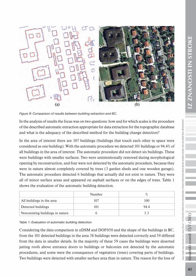
The results of automatic extraction were compared to the data from the current BC and the actual situation in nature. The reference map of the actual situation was made by manual repair of BC based on DOF050, DSM and field inspection. Figure 9 shows matching between the automatic extraction (red) and BC (blue) (a) and matching between BC and DOF050 (b). It is important to emphasise that BC was for this area made by terrestrial measurements. Within these the building circumferences were defined by measuring foundations, which differs from the photogrammetric extraction, where roof circumferences are detected. As a consequence, buildings in BC have smaller surface areas.De
jan G
rigillo
, Mojc
a Kos
matin
Fras
, Duš
an Pe
trovič
- AU
TOM
ATIC
EXTR
ACTIO
N AN
D BU
ILDIN
G CH
ANGE
DET
ECTIO
N FR
OM D
IGITA
L SUR
FACE
MOD
EL A
ND M
ULTIS
PECT
RAL O
RTHO
PHOT
O
completeness
correctness
GV_1_2011.indd 40GV_1_2011.indd 40 30.3.2011 9:31:1430.3.2011 9:31:14
41
Geo
dets
ki v
estn
ik 5
5/1
(201
1)IZ
ZN
AN
OST
I IN
STR
OK
E
Figure 9: Comparison of results between building extraction and BC.
In the analysis of results the focus was on two questions: how and for which scales is the procedure of the described automatic extraction appropriate for data extraction for the topographic database and what is the adequacy of the described method for the building change detection?
In the area of interest there are 107 buildings (buildings that touch each other in space were considered as one building). With the automatic procedure we detected 101 buildings or 94.4% of all buildings in the area of interest. The automatic procedure did not detect six buildings. These were buildings with smaller surfaces. Two were unintentionally removed during morphological opening by reconstruction, and four were not detected by the automatic procedure, because they were in nature almost completely covered by trees (3 garden sheds and one wooden garage). The automatic procedure detected 6 buildings that actually did not exist in nature. They were all of minor surface areas and appeared on asphalt surfaces or on the edges of trees. Table 1 shows the evaluation of the automatic building detection.
Number %
All buildings in the area 107 100
Detected buildings 101 94.4
Non-existing buildings in nature 6 5.3
Table 1: Evaluation of automatic building detection.
Considering the data comparison in nDSM and DOF050 and the shape of the buildings in BC, from the 101 detected buildings in the area 38 buildings were detected correctly and 59 differed from the data in smaller details. In the majority of these 59 cases the buildings were deserted jutting roofs above entrance doors to buildings or balconies not detected by the automatic procedures, and some were the consequence of vegetation (trees) covering parts of buildings. Two buildings were detected with smaller surface area than in nature. The reason for the loss of De
jan G
rigillo
, Mojc
a Kos
matin
Fras
, Duš
an Pe
trovič
- AU
TOM
ATIC
EXTR
ACTIO
N AN
D BU
ILDIN
G CH
ANGE
DET
ECTIO
N FR
OM D
IGITA
L SUR
FACE
MOD
EL A
ND M
ULTIS
PECT
RAL O
RTHO
PHOT
O
GV_1_2011.indd 41GV_1_2011.indd 41 30.3.2011 9:31:1430.3.2011 9:31:14

42
Geo
dets
ki v
estn
ik 5
5/1
(201
1)IZ
ZN
AN
OST
I IN
STR
OK
E
surface area was vegetation above these buildings. One building was detected incorrectly with wrong orientation. The building axis was defined wrongly due to trees that disabled the detection of the whole building. One building was detected incorrectly, since its shape in nature was not rectangular. Better result with this building could be obtained if the automatic procedure had a built-in detection of straight line describing the building outline with the angle of 45° according to the main axis. The estimation of accuracy of the automatic vector building extraction is shown in Table 2.
Number %
Detected correctly 38 37.6
Generalized 59 58.4
Wrong surface area 2 2.0
Wrong orientation 1 1.0
Other 1 1.0
Table 2: Estimation of accuracy of the automatic vector building extraction.
With regard to the adequacy of the described automatic procedure for data extraction in topographic database, it can be established that raster data DSM with spatial resolution of 0.5 m, which served as the source of nDSM, are not useful for automatic building extraction in topographic databases of larger scales (1 : 5000). The automatic procedure correctly detects buildings of simple form, only partially covered by vegetation, while more than half of the buildings are detected without smaller details (jutting roofs, balconies). The result could be improved significantly if DSM was available with better spatial resolution (e.g. 0.25 m). Considering the actual situation, the deviations of the data from automatic extraction do not exceed the lengths of four pixels (which is in our case 2 m). Therefore, these data and the described procedure are appropriate for the building extraction in topographic databases of the scale of 1 : 10,000 and smaller.
On the other hand, it can be concluded that the described method of automatic building extraction from DSM and DOF050 proved as appropriate for the change detection and to control the correctness of the data extraction in topographic databases of the scale 1 : 5000. With the automatic procedure we detected 6 buildings not yet recorded in BC. Further on, we correctly detected 22 enlarged buildings and one demolished building (RP=6+22+1=29). Two actual changes (2 enlargements) that actually happened in the space according to BC were not detected by the procedure (LN=2). In eight cases the procedure triggered »false alarm« (6 non-existing buildings in nature and two wrongly reported building enlargements, LP=8). These data allow the calculation of the completeness and correctness of the procedure for the automatic change detection:
completeness = 93.5%;
correctness = 78.4%.
The result is completely comparable to the results published in the research of the organisation
Dejan
Grig
illo, M
ojca K
osma
tin Fr
as, D
ušan
Petro
vič -
AUTO
MAT
IC EX
TRAC
TION
AND
BUILD
ING
CHAN
GE D
ETEC
TION
FROM
DIG
ITAL S
URFA
CE M
ODEL
AND
MUL
TISPE
CTRA
L ORT
HOPH
OTO
GV_1_2011.indd 42GV_1_2011.indd 42 30.3.2011 9:31:1530.3.2011 9:31:15

43
Geo
dets
ki v
estn
ik 5
5/1
(201
1)IZ
ZN
AN
OST
I IN
STR
OK
E
EuroSDR. In their procedure of automatic change detection they used different methods and different test data, but the published results show completeness from 78.9% to 98.8% and correctness from 45.1% to 76.1% (Champion, 2009) for the comparison of buildings as objects in the analysis. Better results for correctness were obtained with the pixel comparison between the extraction and the topographic data (up to 96.5%). Figure 10 shows the plot of results of automatic change detection in topographic database in the area where most of the changes appeared. Yellow circles mark buildings where the procedure detected building enlargements, green circles mark new buildings and red circles mark the buildings that the automatic procedure did not detect. Yellow contours represent the results of automatic building extraction before vectorisation. In the upper central part of Figure 10 an building enlargement can also be seen that the automatic procedure did not detect.
Figure 10: Results of automatic change detection.
The described research showed that the use of height data in combination with high-resolution image sources is important in detecting changes in topographic databases. With the used method the majority of actual changes in the space were detected and the method can be evaluated as appropriate for the change detection and for the control of correctness of data extraction in BC and DTK 5. A justified conclusion can be made that high level of automation also brings time savings in the change detection compared to the visual method, although this was not studied
Dejan
Grig
illo, M
ojca K
osma
tin Fr
as, D
ušan
Petro
vič -
AUTO
MAT
IC EX
TRAC
TION
AND
BUILD
ING
CHAN
GE D
ETEC
TION
FROM
DIG
ITAL S
URFA
CE M
ODEL
AND
MUL
TISPE
CTRA
L ORT
HOPH
OTO
GV_1_2011.indd 43GV_1_2011.indd 43 30.3.2011 9:31:1530.3.2011 9:31:15

44
Geo
dets
ki v
estn
ik 5
5/1
(201
1)IZ
ZN
AN
OST
I IN
STR
OK
E
in detail in this research. The proposed method is less appropriate for the direct data extraction in large scale topographic databases (larger than 1 : 10 000) or it should be tested also by using DSM with better spatial resolution.
Literature and sources:Champion, N. (2009). Detection of unregistered buildings for updating 2D databases. EuroSDR Official Publication N° 56. Asmterdam: Gopher.
Champion, N., Matikainen, L., Rottensteiner, F., Liang, X., Hyyppä, J. (2008). A test of 2d building change detection methods: Comparison, evaluation and perspectives. V: The International Archives of the Photogrammetry, Remote Sensing and Spatial Information Sciences, XXXVII/B4: 297-304.
Demir, N., Baltsavias, E. (2007). Object extraction at airport sites using DTMs/DSMs and multispectral image analysis. http://www.photogrammetry.ethz.ch/research/pegase/papers/PIA_DEMIR_BALTSAVIAS_eth__2.pdf (21.10.2010)
Dorninger, P., Pfeifer, N. (2008). A comprehensive automated 3D approach for building extraction, reconstruction and regularization from airborne laser scanning point clouds. Sensors 8(11): 7323-7343.
Gonzales, R. C., Woods, R. E., Eddins, S. L. (2004). Digital image processing using Matlab. New Jersey: Pearson Prentice-Hall.
Grigillo, D. (2010). Samodejno odkrivanje stavb na visokoločljivih slikovnih virih za potrebe vzdrževanja topografskih podatkov. Doktorska disertacija. Ljubljana: Fakulteta za gradbeništvo in geodezijo, Oddelek za geodezijo.
GURS (2001). Operativno navodilo za zajem podatkov o stavbah. Fotogrametrični zajem s povezavo z zemljiškim katastrom in registrom prostorskih enot, verzija 4.0. Geodetska uprava Republike Slovenije.
Haralick, R.M., Shanmugan, K., Dinstein, I. (1973). Textual features for image classification. IEEE Transactions on Systems, Man and Cybernetics 3(6): 610-621.
Heipke, C., Mayer, H.,Wiedemann, C., Jamet, O. (1997). Evaluation of automatic road extraction. V: International Archives of Photogrammetry and Remote Sensing, XXXII/3: 47–56.
Hofmann, A. D., Mass, H.-G., Streilein, A. (2002). Knowledge-based building detection based on laser scanner data and topographic map information. http://www.toposhop.admin.ch/pub/down/about/publi/ISPRS-2002.pdf (21.10.2010)
Holland, D. A., Sanchez-Hernandez, C., Gladstone, C. (2008). Detecting changes to topographic features using high resolution imagery. V: The International Archives of the Photogrammetry, Remote Sensing and Spatial Information Sciences, XXXVII/B4: 1153-1158.
Kraus, K. (2007). Photogrammetry: Geometry from images and laser scans. Second Edition. Berlin: Walter de Gruyter GmbH & Co.
Matikainen, L., Hyyppä, J., Ahokas, E., Markelin, L., Kaartinen, H. (2010). Automatic detection of buildings and changes in buildings for updating of maps. Remote Sensing, 2: 1217-1248.
Matikainen, L., Hyyppä, Kaartinen, H. (2004). Automatic detection of changes from laser scanner and aerial image data for updating building maps. Remote Sensing, V: The International Archives of the Photogrammetry, Remote Sensing and Spatial Information Sciences, XXXV/B2: 434-439.
Matlab (2010). Matlab documentation: Image processing toolbox. http://www.mathworks.com/help/toolbox/images/ (14.10.2010)
Mayer, H. (2008). Objects extraction in photogrammetric computer vision. ISPRS Journal of Photogrammetry and Remote Sensing, 63(2): 213-222.
Mayer, H., Hinz, S., Stilla, U. (2008). Automated extraction of roads, buildings and vegetation from multi-source data. V: Li, Z., Chen, J. and Baltsavias, E. (ur.) Advances in photogrammetry, remote sensing and spatial information sciences: 2008 ISPRS congress book. 213-226. London: CRC Press, Taylor & Francis Group.
Ono, Ak., Kajiwara, K., Honda, Y., Ono, At. (2007). Development of vegetation index using radiant spectra normalized by their arithmetic mean. V: Proceedings of the Asian Conference on Remote Sensing, Asian Association on Remote Sensing. Kuala Lumpur, Malezija, 12.-16. november 2007.
Pfeifer, N., Rutzinger, M., Rottensteiner, F., Muecke, W., Hollaus, M. (2007). Extraction of building footprints from
Dejan
Grig
illo, M
ojca K
osma
tin Fr
as, D
ušan
Petro
vič -
AUTO
MAT
IC EX
TRAC
TION
AND
BUILD
ING
CHAN
GE D
ETEC
TION
FROM
DIG
ITAL S
URFA
CE M
ODEL
AND
MUL
TISPE
CTRA
L ORT
HOPH
OTO
GV_1_2011.indd 44GV_1_2011.indd 44 30.3.2011 9:31:1530.3.2011 9:31:15
45
Geo
dets
ki v
estn
ik 5
5/1
(201
1)IZ
ZN
AN
OST
I IN
STR
OK
E
airborne laser scanning: Comparison and validation techniques. V: Proceedings of the Joint IEEE-GRSS/ISPRS Workshop on Remote Sensing and Data Fusion over Urban Areas, Urban 2007, Pariz, Francija.
Rottensteiner, F. (2008). Automated updating of building databases from digital surface models and multi-spectral images: Potential and limitations. V: The International Archives of the Photogrammetry, Remote Sensing and Spatial Information Sciences, Istanbul, Turčija, XXXVII/B3A: 265-270.
Rottensteiner, F., Trinder, J., Clode, S., Kubik, K. (2007). Building detection by fusion of airborne laser scanner data and multi-spectral images: Performance evaluation and sensitivity analysis. ISPRS Journal of Photogrammetry and Remote Sensing, 62(2): 135-149.
Sohn, G., Dowman, I. (2007). Data fusion of high-resolution satellite imagery and LIDAR data for automatic building extraction. ISPRS Journal of Photogrammetry and Remote Sensing, 62(1): 43-63.
Vosselman, G., Dijkman, S. (2001). 3D building model reconstruction from point clouds and ground plans. V: The International Archives of the Photogrammetry and Remote Sensing XXXIV, 3/W4: 37-44.
Vosselman, G., Gorte, B., Sithole, G. (2004). Change detection for updating medium scale maps using laser altimetry. V: The International Archives of the Photogrammetry, Remote Sensing and Spatial Information Sciences, Istanbul, Turčija, XXXV/B3: 207-212.
Automatic extraction and building change detection from digital surface model and multispectral orthophoto (2011).
Received for publication: 18 February 2011Accepted: 9 March 2011
Assist. Dr. Dejan Grigillo, Univ. Grad. of Geod. Eng.FGG – Department of Geodesy, Jamova 2, SI-1000 Ljubljana e-mail: [email protected], Tel.: (01) 4768 500
Assist. Prof. Dr. Mojca Kosmatin Fras, Univ. Grad. of Geod. Eng.FGG – Department of Geodesy, Jamova 2, SI-1000 Ljubljana e-mail: [email protected], Tel.: (01) 4768 500
Assist. Prof. Dr. Dušan Petrovič, Univ. Grad. of Geod. Eng.FGG – Department of Geodesy, Jamova 2, SI-1000 Ljubljana e-mail: [email protected], Tel.: (01) 4768 500 De
jan G
rigillo
, Mojc
a Kos
matin
Fras
, Duš
an Pe
trovič
- AU
TOM
ATIC
EXTR
ACTIO
N AN
D BU
ILDIN
G CH
ANGE
DET
ECTIO
N FR
OM D
IGITA
L SUR
FACE
MOD
EL A
ND M
ULTIS
PECT
RAL O
RTHO
PHOT
O
GV_1_2011.indd 45GV_1_2011.indd 45 30.3.2011 9:31:1630.3.2011 9:31:16