Author's personal copy - Museu do Côa · Author's personal copy ... the results obtained by the...
15
This article appeared in a journal published by Elsevier. The attached copy is furnished to the author for internal non-commercial research and education use, including for instruction at the authors institution and sharing with colleagues. Other uses, including reproduction and distribution, or selling or licensing copies, or posting to personal, institutional or third party websites are prohibited. In most cases authors are permitted to post their version of the article (e.g. in Word or Tex form) to their personal website or institutional repository. Authors requiring further information regarding Elsevier’s archiving and manuscript policies are encouraged to visit: http://www.elsevier.com/copyright
-
Upload
truonghanh -
Category
Documents
-
view
220 -
download
0
Transcript of Author's personal copy - Museu do Côa · Author's personal copy ... the results obtained by the...
This article appeared in a journal published by Elsevier. The attachedcopy is furnished to the author for internal non-commercial researchand education use, including for instruction at the authors institution
and sharing with colleagues.
Other uses, including reproduction and distribution, or selling orlicensing copies, or posting to personal, institutional or third party
websites are prohibited.
In most cases authors are permitted to post their version of thearticle (e.g. in Word or Tex form) to their personal website orinstitutional repository. Authors requiring further information
regarding Elsevier’s archiving and manuscript policies areencouraged to visit:
http://www.elsevier.com/copyright
Author's personal copy
Palaeolithic engravings and sedimentary environments in the Côa River Valley(Portugal): implications for the detection, interpretation and dating of open-airrock art
Thierry Aubry a,*, Luca Antonio Dimuccio b,c, M. Mercè Bergadà d, Jorge Davide Sampaio a, Farid Sellami e
a IGESPAR-IP, Instituto de Gestão do Património Arquitectónico e Arqueológico, Parque Arqueológico do Vale do Côa, Avenida Gago Coutinho e Sacadura Cabral, 19-A,5150-610 Vila Nova de Foz Côa, PortugalbCentro de Estudos de Geografia e Ordenamento do Território (CEGOT), Faculdade de Letras, Universidade de Coimbra, Praça da Porta Férrea, 3004-530 Coimbra, PortugalcDepartamento de Ciências da Terra, Faculdade de Ciências e Tecnologia, Universidade de Coimbra, Largo Marquês de Pombal, 3000-272 Coimbra, Portugald SERP, Departament de Prehistòria, Història Antiga i Arqueologia, Facultat de Geografia i Història. UBC/Montalegre 6-808001 Barcelona, Spaine INRAP, Direction interrégionale Grand-Sud-Ouest. BP 161, 210 cours Victor-Hugo, 33130 Bègles, France
a r t i c l e i n f o
Article history:Received 20 March 2010Received in revised form23 July 2010Accepted 29 July 2010
Keywords:Côa River valleyPalaeolithic rock artOpen-air engravingsFluvial sedimentary environmentRock art preservation
a b s t r a c t
The pre-Magdalenian phase of the Côa River Valley open-air rock art is mostly distributed at theboundary between the rocky valley slopes and the floodplain that correspond to the most favourablegeomorphological setting for the preservation of pecked and deeply superposed engravings of the mostfamous artistic phase of the area. The natural vertical panels of the engraved art located at thisgeomorphological interface have suffered weathering during two cold events of the Lateglacial. Theywere buried by several colluvial and alluvial deposits. The reconstruction of the sedimentary andarchaeological context of the CôaRiver Valley engraving permits a better assessment of the preservationprocesses and interpretation of Palaeolithic open-air rock art.
� 2010 Elsevier Ltd. All rights reserved.
1. Introduction
One century after the discovery of the first Palaeolithic repre-sentations in caves, the interpretation of the Mazouco open-airengravings as contemporaneous implied that rock art of this periodcouldbepreservedoutof caves or rock-shelters (Jorgeet al.,1981). Atthe end of the twentieth century, other open-air rock art panelsexposed to weathering in Iberia and southern France were alsoattributed to the Palaeolithic period (Fig. 1A). These petroglyphswere found in the Spanish sector of the Douro drainage basin, at theSiega Verde (Balbín Behrmann et al.,1991) andDomingoGárcia sites(Rippol andMunicio,1992) and in the SpanishGuadianawatershedsat Molino Manzanez (Collado, 2009). In Portugal, these engravingswere found in the lower valley of the Côa and Sabor rivers (Baptista,
1999, 2001; Baptista and Varela Gomes, 1995; Zilhão, 1997), alongthe Ocreza (Baptista, 2001) and the Zêzere rivers (Baptista, 2004)and along the right margin tributaries of the TagusRiver. The site ofFornols-Haut (Bahn, 1985; Sacchi et al., 1988) remained the onlyopen-air rock art site known north of the Pyrenees (Fig. 1A).
Despite a clear increase in the rate of its detection in recent years,thirty years after its first discovery open-air rock art represents onlya small percentage of all the rock art representations assigned to thePalaeolithic. Some researchers consider this proportion to reflect thePalaeolithic preference for cave and rock-shelter settings. Othersargue that it is not representative and that the open-air imageswerea common and permanent component of the Palaeolithic monu-mental art (Sacchi, 2002; Bahn, 1995), but were mostly destroyedbecause of their direct exposure to weathering (Zilhão, 1997).
The aim of this paper is to establish the relationship betweenthe oldest phase of the Palaeolithic rock art cycles recognised in theCôaRiver Valley and the associated Quaternary sediments in light ofthe floodplain deposit’s accumulation and its interrelation withpalaeoclimatic changes. From these data, we try to explain theprocess and mechanisms that have permitted the conservation ofthese engravings, despite episodes of weathering that have affected
* Corresponding author. Tel.: þ351 239443992. Urbanização São Bento, Lote 65,Casais do Campo, 3045-120 Coimbra, Portugal.
E-mail addresses: [email protected] (T. Aubry), [email protected] (L.A. Dimuccio),[email protected] (M.M. Bergadà), [email protected] (J.D. Sampaio), [email protected] (F. Sellami).
Contents lists available at ScienceDirect
Journal of Archaeological Science
journal homepage: http: / /www.elsevier .com/locate/ jas
0305-4403/$ e see front matter � 2010 Elsevier Ltd. All rights reserved.doi:10.1016/j.jas.2010.07.033
Journal of Archaeological Science 37 (2010) 3306e3319

Author's personal copy
the rocky outcrops used as support. Furthermore, we attempt todefine their visibility (or lack of visibility) during time. The resultsallow a new approach to the issue of open-air rock art and itsinterpretation in the context of the oldest European Palaeolithic arttestimonies.
2. Regional setting and Palaeolithic engraving location
The Côa River is a Portuguese left-bank tributary of the DouroRiver, one of the major watercourses that cross the NW Iberian
mountains from east to west. The 120-km long river basin, NeSaligned due to tectonic control, comprises two different geologicalsectors (Fig.1B). The upstream sector, down to the last 17 km beforethe confluence with the Douro River, is through Hercynian granit-oids. The downstream sector grades to a meandering pattern cut inPrecambrian, Palaeozoic and Ordovician metamorphic rocks(mostly schist).
Currently, the hydrologic regime of the river discharge is directlyimposed by rainfall and controlled by direct runoff induced by thesharp gradient and the scarce vegetation cover. However, the Last
Fig. 1. Open-air rock art of Iberia and southern France (a), geological setting of the low Côa River Valley (b), distribution of the Palaeolithic rock art phases and contemporary sites ofhabitat of the low valley of the CôaRiver (c).
T. Aubry et al. / Journal of Archaeological Science 37 (2010) 3306e3319 3307

Author's personal copy
Glacial Maximum (LGM) temperature reconstruction model for thecoldest month of the year implies that, at this time, precipitationaccumulated in the form of snow cover, and the annual dischargewas more evenly distributed due to the underground flow and thespring snowmelt (Aubry et al., 2002).
The Palaeolithic engraving art of the CôaRiver Valley wasdiscovered at the end of the 1990s, during the construction ofa dam project later discarded. The engravings, made by incision,scraping and pecking, are preserved on naturally vertical diaclaseson the schist and granitoids Hercynian basement. The stylisticallyPalaeolithic engravings are scattered over the 22 km of the Côa andDouro rivers and some tributaries near their confluence (Figs. 1Cand 3). However, the survey of the entire floodplain margin is notpossible because the lower portion (below 125 m of elevation) ofthe downstream 7 km of the Côa River Valley (from the Olgas daErvamoira site to the confluence with the Douro) is inundated bythe tail of the reservoir of the Pocinho dam, built a few kilometresdownstream from the confluence with the Douro (Fig. 1B).
The vertical joints were progressively open and exposed bytraction and tilting due to stress relief during the incision of theCôaRiver (Fernandes, 2009). The incision process is evidenced byterraces deposited on the Côa margins in the Late Pleistocene(Aubry et al., 2002).
2.1. CôaRiver valley Palaeolithic rock art phases
The engraved diaclases are covered by siliceous and metallicfilms subject to a constant process of re-deposition (Pope, 2000).Small fragments of organic material contained within the tracing,in and under these films, were subject to direct dating by the 14CAMS method, revealing Holocene origins (Watchman, 1995, 1996).However, the results obtained by the same method on the rock arttracing and the adjacent natural surfaces presented by Dorn (1997)confirmed the hypothesis advanced by Zilhão (1995) and provedthat the metallic and siliceous films of the engraved surface do notconstitute a closed and stable system.
Fig. 2. Detail of the Vale de José Esteves Rock 16 (aeb), portable art on schist slab from Fariseu. Stratigraphic unit FA-4 dated by luminescence to ca. 11 000e12 000 BP and by 14C to10 000e12 000 cal yr BP (c), and stratigraphic unit FA-7 dated by luminescence between 18 400e15 000 BP (d), Fariseu, scheme of the stratigraphical units conserved in front ofRock 1 representative of the older Palaeolithic rock art phase of the Côa River Valley, and fragment of the engraved panel recovered in the unit FA-8 dated by OSL ca. 18 400 yr BP (e).
T. Aubry et al. / Journal of Archaeological Science 37 (2010) 3306e33193308

Author's personal copy
Confirmation that the dates obtained by the 14Cmethodprovided,at best, only minimum ages, was obtained in December 1999. At thattime, maintenance work along the Douro River enabled a survey ofa section of the CôaRiver Valley usually covered by the Pocinhoreservoir. A test at the Fariseu site (Fig. 1B and C), at a meander of theleft bank of the river on the schist portion of the valley, revealeda sedimentary sequence preserved at the contact with an engravedpanel,Rock1ofFariseu(inventorynumberof the rockartpanelsof thesite of the Côa Valley Archaeological Park). A combination of thestratigraphic sequence, archaeological lithic assemblages (Aubry andBaptista, 2000; Aubry et al., 2002) and dating by Thermolumines-cence (TL) and Optically Stimulated Luminescence (OSL) (Mercieret al., 2006) has confirmed the stylistic and archaeological argu-ments advanced by Zilhão (1995) and contributes to the establish-ment of a relative and absolute chronology of the Côa Valley rock art.Thearchaeological data reveal twomainperiodsof artisticproductionin the valley during the Upper Palaeolithic. The more recent period,dated by TL between ca. 10 800 BP and 11 800 BP, is represented byrock art andportable art (Fig. 2A andB). The older period correspondsto the famous pecked and deeply incised representations of the Côa
Valley World Heritage (Fig. 2D; Baptista, 1999; Baptista et al., 2008,2009). These engravings were done before ca. 18 400 � 1600 BP, theageof theFA-8geoarchaeologicalfieldunitof theFariseu site datedbyOSL, where an engraved fragment of the rock panel was discovery in2007. Although it does not connect directly with the incompletefigures on Rock 1, the position of the engravings and their similaritieswith the engravings onRock 1 allowus to propose that this panelwasengraved before this layer formed (Fig. 2E; Aubryand Sampaio, 2008;Mercier et al., 2006). This evidence provides a minimum age for theengravings of this artistic phase that would be significantly older.
A prior human occupation of the site is suggested by the age of19 020 � 80 14C yr BP (22 581e23 174 cal yr BP) obtained froma charcoal fragment found at the bottom of the sequence excavatedin the central part of the Fariseu site. Nevertheless, the direct rela-tionship between this date and the older graphic phase, representedby the engraving of Rock 1, cannot be definitively established.
The survey carried out since 1995 in the CôaValley Archaeo-logical Park has revealed new engraved panels of different chro-nology. From 2004 to 2006, the total number of engraved panelsincreased from 330 to 664 (Baptista and Reis, 2009). Of these, 330
Fig. 3. Position of the sites according to the longitudinal profile of the Côa and Douro Rivers (a), distribution of the rock art of two Upper Palaeolithic artistic phases (L. Luís) (b).
T. Aubry et al. / Journal of Archaeological Science 37 (2010) 3306e3319 3309

Author's personal copy
panels could be stylistically attributed to the Palaeolithic (Fig. 1C).However, a stylistic comparison with the representations ofportable art on schist slabs, found in the Fariseu site geo-archaeological field units dated by TL, OSL and 14C AMS, shows thatthe majority Palaeolithic engravings discovered during the 21stcentury were realized by the fine incision technique during theYounger Dryas (Fig. 2A; Aubry, 2009; Aubry and Garcia Diez, 2001;Aubry and Sampaio, 2008). The panels ascribed to this late Palae-olithic artistic phase are distributed over the whole slope of thelower Côa hydrographic basin and show a stronger density towardsthe junction with the Douro River Valley (Figs. 1 and 3). A panel ofcervidae and capridae carved by the incision techniquewas found in2008 at the top of a schist plateau near the Vila Nova de Foz Côa city(Baptista and Reis, 2009). In contrast, despite the systematic survey,the pecked and deeply incised engravings of the older stylisticphase similar to the Fariseu Rock 1 (Baptista et al., 2008, 2009;Baptista and Santos, 2010) remained concentrated in the lowestportion of the valley slopes (below 200 m a.s.l.) and along 8 km ofmetamorphic rocks (Fig. 3). This geographical, topographical andlithological distribution enabled us to propose a differential pres-ervation according to the effect of meteoric agents varying withelevation and temperature, petrography of the bedrock and pre-engraving tectonic deformations (Aubry et al., 2002; Zilhão, 2003).
At the Fariseu site, in the FA-7 geoarchaeological field unit of thestratigraphical sequence at the Rock 1 interface (over the FA-8 unitdated by TL to 18 400 � 1600 BP and under the FA-6 unit dated15 200 � 1600 BP; Fig. 2), a fragment of engraved portable schistslabwas discovered. This fragment contained a representation of anincomplete animal with multiple incisions and tracings (Fig. 2C).This discovery not only proves the existence of an intermediaryartistic phase but also documents the use of this artistic conventionduring that phase.
3. Material and methods
The information presented here is derived from stratigraphicarchaeological remains and chronological data collected at theCôaRiver Valley sites, using the standard geoarchaeological field-work approach: a geomorphological study of the site surroundings,a field description of the site deposits and stratigraphic correlation,and finally the selection of sampling location for micromorphologyand dating. Fieldwork at the sites included the systematicdescription of exposed cross-sections and profiles to reconstructstratigraphic successions, their vertical and lateral variations andarchaeological contents (Table 1 and Fig. 4). The description wasmade using a comprehensive form addressing the sedimentary,pedogenic and anthropogenic characteristics of the deposits (e.g.,Keeley and Machail, 1981; FAO-Isric, 1990; Brown, 1997) to recog-nize the site formation processes. Informal geoarchaeological fieldunits (GFU) were identified on the basis of lithostratigraphic,pedological or archaeological criteria and used as field categories.
Data provided by the macroscopic approach of the GFU aresupported by the micromorphological study of samples collectedalong the Fariseu Rock 1 sequence (Sellami, 2009a), at Olga Grande4 and 14 sites located on the granitic plateau (Sellami, 2009b) and,on schist, at Cardina I site (Bergadà, 2009; Bergadà et al., 2009).
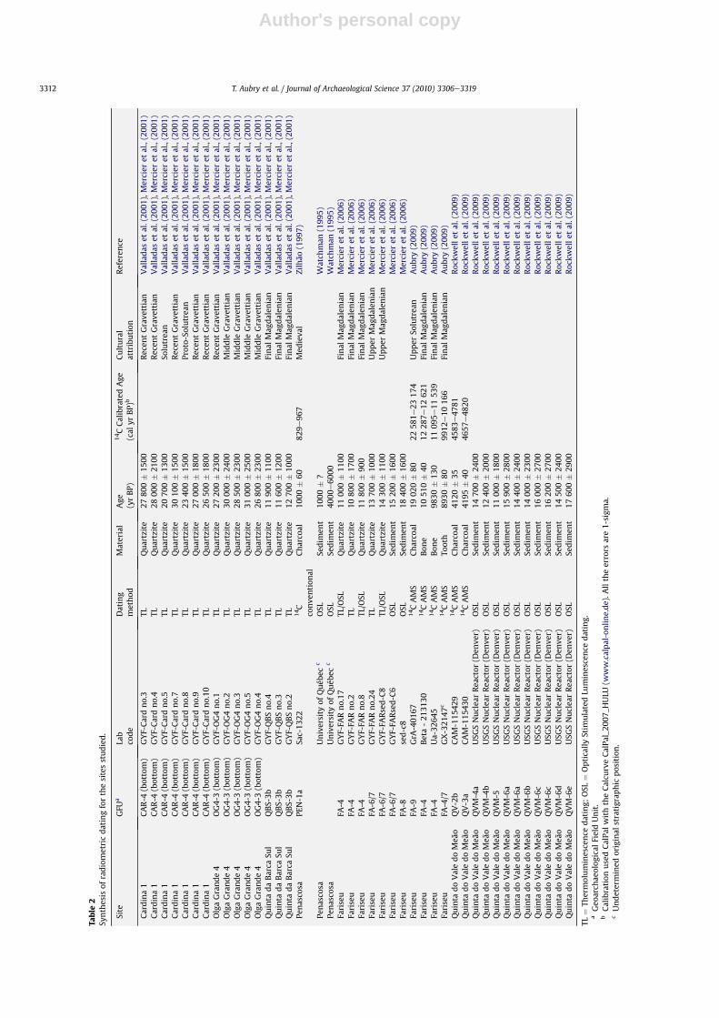
The correlation between GFU of the several sites rests upon thereconstruction of their genetic processes and the environment ofdeposition, based on particle size distribution, fabric and structure,archaeological contents and chronometric dating. The chronolog-ical data (Table 2) were obtained by Accelerator Mass Spectrometry(AMS) and conventional 14C analysis (Sacavém Laboratorye Sac), aswell as OSL and TL When appropriate, original 14C conventionaldata and AMS data were converted into calendar age (cal yr BP)using CalPal calibration from Weninger and Jöris (2004) with the
Calcurve CalPal_2007_HULU (www.calpal-online.de). All the errorsare 1-sigma.
In parallel with the interpretation of direct field observations onthe Côa River Valley, stratigraphical, sedimentological and chro-nometric data are provided by a mechanically-dug trial trench(orientated perpendicularly to the Vilariça fault zone and carriedout in the left margin of the Douro River, in the vineyard of Quintado Vale do Meão) (Fig. 1B) to date and assess fault displacements(Rockwell et al., 2009).
4. Stratigraphic and chronological data of the CôaRiver valleysites
4.1. Olga Grande 4
Locus 4 of the Olga Grande site (locally called Pedras Altas) isone of a cluster of sites located along the right bank of theRibeirinha Rivulet, a tributary of the Côa River draining the graniticplateau corresponding to the Pliocene erosional surface of theIberian Meseta (Aubry et al., 2002; Aubry, 2009; Fig. 1B and C). Thesequence observed at the Olga Grande 4 site during archaeologicalwork between 1999 and 2002 is composed of four GFU, corre-sponding to granitic sands accumulated on ledges and hollowscircumscribed by rock outcrops (Sellami, 2009b). Bronze Age andNeolithic ceramics and lithic remains are conserved in thedisturbed uppermost unit. The remaining undisturbed sequencecontain several chronological and cultural stages of the Middle andUpper Palaeolithic (Middle Gravettian, Upper Solutrean and UpperMagdalenian), established by the typology of lithic assemblagesand absolute dating methods (Tables 1 and 2).
4.2. Cardina 1
The sequence observed during archaeological work between1995 and 2001 is conserved on a rock terrace, 20 m above theCôaRiver bed level, which corresponds to a deviation of thewatercourse caused by a rhyolite dyke (Fig. 1B). The bottom of thesedimentary sequence is not known. Four GFU were defined duringthe archaeological work, accumulated by surface runoff (Bergadà,2009; Bergada et al., 2009). These range from the late Pleistoceneperiod, including Upper Palaeolithic (recent Gravettian, Solutrean,Magdalenian and final Magdalenian, respectively, at the bottom,middle and top of thee OG4-3 GFU), established by the typology oflithic assemblages and absolute dating methods, as well as themodern and Neolithic to Bronze Age ceramic fragments and flintbladelets recovered in the two uppermost GFU (Tables 1 and 2).
4.3. Quinta da Barca Sul
The site corresponds to a topographic break on a sharp schistoseslope 10 m above the riverbed, located on the left margin of theCôaRiver (Fig. 1B and C). The sedimentary sequence observedduring archaeological works between 1998 and 2001 (Aubry, 2009)is constituted by colluvial (QBS-1 to 3b units) and alluvial (QBS-4unit) deposits conserved on the top of a schist rock terrace,constituting a topographic break of slope favourable to the accu-mulation of fine sediments and weathering debris (Fig. 4). The QBS-3b unit contains flint and fine-grained siliceous rock curved backedpoints, characteristic of the final Magdalenian phase in Portugal(contemporaneous with the Azilian phase of the Pyrenean andsouthern France regions); it was dated by TL between ca. 11 600 BPand 12 700 BP (Table 2). A few lithic remains that could techno-logically be ascribed to an undefined Upper Palaeolithic phase wererecovered in the discontinuous alluvial QBS-4 unit (Aubry, 2009).
T. Aubry et al. / Journal of Archaeological Science 37 (2010) 3306e33193310
Author's personal copy
Table 1Geographical, geomorphological and archaeological contexts of the sites discussed in the text.
Archaeological Site Longitude Latitude Altitude(m)
Geomorphological context Cultural context References
Olga Grande 4 40�580 10,440 0N 7�03023, 430 0W 510 Topographic break on granitic bedrock betweentop slope and floodplain (Côa River)
N/B, UP, MP Aubry (2009)
Cardina 1 40�58046,110 0N 7�06001, 890 0W 165 Fluvial rock terrace on schist bedrock (Côa River) M, B, C, UP Zilhão (1997);Aubry et al. (2002);Aubry (2009);Valladas et al. (2001)
Quinta da Barca Sul 40�59054, 010 0N 7�060 14, 090 0W 143 Fluvial rock terrace on schist bedrock (Cõa River) N/C?, B?,ME, UP
Zilhão (1997);Aubry (2009);Valladas et al. (2001)
Penascosa 41�06030, 330 0N 7�060 017,080 0W 140 Fluvial rock terrace at the interface between schistbedrock slope and floodplain (Côa River)
M, N/C Zilhão (1997);Aubry (2009)
Colmeal 41�01017, 030 0N 7�06018, 390 0W 130 Fluvial rock terrace at the interface between schistbedrock slope and floodplain (Côa River)
M, UP? Aubry (2009)
Olgas da Quintade Ervamoira
41�01016, 430 0N 7�06033, 610 0W 135 Fluvial rock terrace at the interface betweenschist bedrock slope and floodplain (Côa River)
N/C, B?, UP?
Rocha 14 Piscos 41�01048, 170 0N 7�06058, 910 0W 130 Small topographic break on schist bedrockslope (Côa River)
UP?, RA Aubry (2009)
Fariseu 41�02016, 640 0N 7�06036,530 0W 125 Fluvial rock terrace at the interface between schistbedrock slope and floodplain (Côa River)
M, N/C?, B?,UP, RA
Aubry et al. (2002);Aubry (2009);Mercier et al. (2006);Aubry and Sampaio (2008)
Quinta do Vale do Meão 41�09059, 350 0N 7�06054, 700 0W 110 Fluvial rock terrace at the interface between schistbedrock slope and floodplain (Douro River)
M Rockwell et al. (2009)
M ¼ Modern/Medieval; B ¼ Bronze Age; N ¼ Neolithic; C ¼ Chalcolithic; ME ¼ Mesolithic; UP ¼ Upper Palaeolithic; MP ¼ Middle Palaeolithic; RA ¼ Palaeolithic Rock-Art.
Fig. 4. Correlative framework and description of the floodplain alluvial units (white) and colluvial and slope deposits (grey) of the Côa River Valley and at Quinta do Vale do Meão,in the Douro River Valley.
T. Aubry et al. / Journal of Archaeological Science 37 (2010) 3306e3319 3311
Author's personal copy
Table
2Sy
nthesis
ofradiometricdatingforthesitesstudied.
Site
GFU
aLab
code
Dating
method
Material
Age
(yrBP)
14CCalibratedAge
(cal
yrBP)
bCultural
attribution
Referen
ce
Cardina1
CAR-4
(bottom)
GYF-Cardno.3
TLQuartzite
2780
0�
1500
Recen
tGrave
ttian
Valladas
etal.(20
01),Mercier
etal.,(200
1)Cardina1
CAR-4
(bottom)
GYF-Cardno.4
TLQuartzite
2800
0�
2100
Recen
tGrave
ttian
Valladas
etal.(20
01),Mercier
etal.,(200
1)Cardina1
CAR-4
(bottom)
GYF-Cardno.5
TLQuartzite
2070
0�
1300
Solutrea
nValladas
etal.(20
01),Mercier
etal.,(200
1)Cardina1
CAR-4
(bottom)
GYF-Cardno.7
TLQuartzite
3010
0�
1500
Recen
tGrave
ttian
Valladas
etal.(20
01),Mercier
etal.,(200
1)Cardina1
CAR-4
(bottom)
GYF-Cardno.8
TLQuartzite
2340
0�
1500
Proto-So
lutrea
nValladas
etal.(20
01),Mercier
etal.,(200
1)Cardina1
CAR-4
(bottom)
GYF-Cardno.9
TLQuartzite
2700
0�
1800
Recen
tGrave
ttian
Valladas
etal.(20
01),Mercier
etal.,(200
1)Cardina1
CAR-4
(bottom)
GYF-Cardno.10
TLQuartzite
2650
0�
1800
Recen
tGrave
ttian
Valladas
etal.(20
01),Mercier
etal.,(200
1)OlgaGrande4
OG4-3(bottom)
GYF-OG4no.1
TLQuartzite
2720
0�
2300
Recen
tGrave
ttian
Valladas
etal.(20
01),Mercier
etal.,(200
1)OlgaGrande4
OG4-3(bottom)
GYF-OG4no.2
TLQuartzite
3000
0�
2400
Middle
Grave
ttian
Valladas
etal.(20
01),Mercier
etal.,(200
1)OlgaGrande4
OG4-3(bottom)
GYF-OG4no.3
TLQuartzite
2850
0�
2300
Middle
Grave
ttian
Valladas
etal.(20
01),Mercier
etal.,(200
1)OlgaGrande4
OG4-3(bottom)
GYF-OG4no.5
TLQuartzite
3100
0�
2500
Middle
Grave
ttian
Valladas
etal.(20
01),Mercier
etal.,(200
1)OlgaGrande4
OG4-3(bottom)
GYF-OG4no.4
TLQuartzite
2680
0�
2300
Middle
Grave
ttian
Valladas
etal.(20
01),Mercier
etal.,(200
1)Quinta
daBarca
Sul
QBS-3b
GYF-QBSno.4
TLQuartzite
1190
0�
1100
Final
Mag
dalen
ian
Valladas
etal.(20
01),Mercier
etal.,(200
1)Quinta
daBarca
Sul
QBS-3b
GYF-QBSno.3
TLQuartzite
1160
0�
1200
Final
Mag
dalen
ian
Valladas
etal.(20
01),Mercier
etal.,(200
1)Quinta
daBarca
Sul
QBS-3b
GYF-QBSno.2
TLQuartzite
1270
0�
1000
Final
Mag
dalen
ian
Valladas
etal.(20
01),Mercier
etal.,(200
1)Pe
nasco
saPE
N-1a
Sac-13
2214C
conve
ntion
alCharco
al10
00�
6082
9e96
7Med
ieva
lZilhão
(199
7)
Penasco
saUniversity
ofQuéb
ecc
OSL
Sedim
ent
1000
�?
Watch
man
(199
5)Pe
nasco
saUniversity
ofQuéb
ecc
OSL
Sedim
ent
4000
e60
00W
atch
man
(199
5)Fa
riseu
FA-4
GYF-FA
Rno.17
TL/O
SLQuartzite
1100
0�
1100
Final
Mag
dalen
ian
Mercier
etal.(20
06)
Fariseu
FA-4
GYF-FA
Rno.2
TLQuartzite
1080
0�
1700
Final
Mag
dalen
ian
Mercier
etal.(20
06)
Fariseu
FA-4
GYF-FA
Rno.8
TL/O
SLQuartzite
1180
0�
900
Final
Mag
dalen
ian
Mercier
etal.(20
06)
Fariseu
FA-6/7
GYF-FA
Rno.24
TLQuartzite
1370
0�
1000
Upper
Mag
dalen
ian
Mercier
etal.(20
06)
Fariseu
FA-6/7
GYF-FA
Rsed-C8
TL/O
SLQuartzite
1430
0�
1100
Upper
Mag
dalen
ian
Mercier
etal.(20
06)
Fariseu
FA-6/7
GYF-FA
Rsed-C6
OSL
Sedim
ent
1520
0�
1600
Mercier
etal.(20
06)
Fariseu
FA-8
sed-c8
OSL
Sedim
ent
1840
0�
1600
Mercier
etal.(20
06)
Fariseu
FA-9
GrA
-401
6714CAMS
Charco
al19
020�
8022
581e
2317
4Upper
Solutrea
nAubry(200
9)Fa
riseu
FA-4
Beta-21
3130
14CAMS
Bon
e10
510�
4012
287e
1262
1Final
Mag
dalen
ian
Aubry(200
9)Fa
riseu
FA-4
Ua-32
645
14CAMS
Bon
e98
30�
130
1109
5e11
539
Final
Mag
dalen
ian
Aubry(200
9)Fa
riseu
FA-4/7
GX-321
47c
14CAMS
Tooth
8930
�80
9912
e10
166
Final
Mag
dalen
ian
Aubry(200
9)Quinta
doValedoMeã
oQV-2b
CAM-115
429
14CAMS
Charco
al41
20�
3545
83e47
81Roc
kwellet
al.(20
09)
Quinta
doValedoMeã
oQV-3a
CAM-115
430
14CAMS
Charco
al41
95�
4046
57e48
20Roc
kwellet
al.(20
09)
Quinta
doValedoMeã
oQVM-4a
USG
SNuclea
rRea
ctor
(Den
ver)
OSL
Sedim
ent
1470
0�
2400
Roc
kwellet
al.(20
09)
Quinta
doValedoMeã
oQVM-4b
USG
SNuclea
rRea
ctor
(Den
ver)
OSL
Sedim
ent
1240
0�
2000
Roc
kwellet
al.(20
09)
Quinta
doValedoMeã
oQVM-5
USG
SNuclea
rRea
ctor
(Den
ver)
OSL
Sedim
ent
1100
0�
1800
Roc
kwellet
al.(20
09)
Quinta
doValedoMeã
oQVM-6a
USG
SNuclea
rRea
ctor
(Den
ver)
OSL
Sedim
ent
1590
0�
2800
Roc
kwellet
al.(20
09)
Quinta
doValedoMeã
oQVM-6a
USG
SNuclea
rRea
ctor
(Den
ver)
OSL
Sedim
ent
1440
0�
2400
Roc
kwellet
al.(20
09)
Quinta
doValedoMeã
oQVM-6b
USG
SNuclea
rRea
ctor
(Den
ver)
OSL
Sedim
ent
1400
0�
2300
Roc
kwellet
al.(20
09)
Quinta
doValedoMeã
oQVM-6c
USG
SNuclea
rRea
ctor
(Den
ver)
OSL
Sedim
ent
1600
0�
2700
Roc
kwellet
al.(20
09)
Quinta
doValedoMeã
oQVM-6c
USG
SNuclea
rRea
ctor
(Den
ver)
OSL
Sedim
ent
1620
0�
2700
Roc
kwellet
al.(20
09)
Quinta
doValedoMeã
oQVM-6d
USG
SNuclea
rRea
ctor
(Den
ver)
OSL
Sedim
ent
1450
0�
2400
Roc
kwellet
al.(20
09)
Quinta
doValedoMeã
oQVM-6e
USG
SNuclea
rRea
ctor
(Den
ver)
OSL
Sedim
ent
1760
0�
2900
Roc
kwellet
al.(20
09)
TL¼
Thermoluminescence
dating;
OSL
¼Optically
Stim
ulatedLu
minescence
dating.
aGeo
arch
aeolog
ical
FieldUnit.
bCalibration
usedCalPa
lwiththeCalcu
rveCalPa
l_20
07_H
ULU
(www.calpal-onlin
e.de).A
lltheerrors
are1-sigm
a.cUndetermined
original
stratigrap
hic
position.
T. Aubry et al. / Journal of Archaeological Science 37 (2010) 3306e33193312

Author's personal copy
4.4. Penascosa
The section studied is located on the right bank of the CôaRiver,downstream from the Penascosa engraving site (Fig. 1B and C). Thestratigraphic sequence of the floodplain at its contact with theschistose slope was obtained by a machine-dug trench perpendic-ular to the river (Zilhão, 1997). An archaeological test wascompleted near the slope in the trench. The sequence is composedof four alluvial GFU (PEN-1, 3, 4 and 5) intercalated with a slopedeposit (PEN-2 unit; Fig. 4). A sample of organic material recoveredin the PEN-1a unit, dated by the 14C conventional method (Table 2),could be correlated with a time of repopulation and agriculturalreuse of this region during the medieval period. The lithic remainsrecovered in the PEN-2 could be attributed to a Neolithic or Chal-colithic occupation of the floodplain.
4.5. Colmeal
The site is located 1 km downstream from the Penascosa trenchon the same bank of the river (Fig. 1B and C). Two test holescompleted in 1997 in the upstream limit of a large meander reveala sedimentary sequence composed of alluvial (COL-1a to 1c units)and slope deposits (COL-2 unit; Fig. 4). The layer of organic materialintercalated in the alluvial unit could be correlated to the PEN-1aunit of the Penascosa site. The bottom of the COL-2 unit, at theinterface with the schist outcrop, has yielded few non-diagnosticlithic remains (Aubry et al., 2002; Aubry, 2009).
4.6. Olga da Quinta de Ervamoira
The site is located a few hundred metres downstream of theColmeal test holes, in the floodplain of the opposite margin. Thefour machine-dug trial realized in 2009, forming an axis orientatedperpendicularly to the CôaRiver, have revealed a maximum ofeleven GFU of alluvial and colluvial deposits (S2 site). Fragments ofceramics were recovered in the alluvial OE S2-7 unit (Fig. 4),associated with some heated fire pit stone fragments. Their prob-able secondary position, the absence of decoration and thematerialused for the fabric do not permit the ascription of a precise chro-nology between the Neolithic and the Bronze age to these alluvialunits. Technologically, non-diagnostic lithic remains were recov-ered in the OE S1-5 and 6 units (Fig. 4).
4.7. Rocha 14 Piscos
The engraved Rock 14 Piscos site is located 3 m above theriverbed, at a place influenced by the Pocinho dam at the mouth ofthe Piscos Rivulet, a left-bank tributary of the CôaRiver (Fig. 1B andC). The rock art panel is located in a small topographic terrace at thebottom of an uneven schistose slope. Archaeological work wascompleted in 2000 and 2003 (Aubry, 2009) to establish the sedi-mentary sequence at the boundary of this panel preserving Palae-olithic engravings stylistically attributed to the Magdalenian(Baptista, 2008). The sequence is composed of a recent alluvialdeposit (R14-1 unit), related to recent flows resulting from the Côadam project, and four slope deposits (R14-2e5 units; Fig. 4). Non-diagnostic lithic remains (core and flakes of quartz and quartzite)were discovered in the R14-3 and 4 units. The R14-1e4 units arecovering the engravings that are stylistically attributed to the UpperMagdalenian (Baptista, 2008).
4.8. Fariseu
The site, localised on the central portion of the left bank ofa meander of the CôaRiver (Fig. 1B and C), was archaeologically
tested in 1999 (Aubry and Baptista, 2000) and excavated in 2005and 2007 (Aubry et al., 2002; Aubry, 2009). The 3 to 6 m-thick logsobserved were divided into ten GFU in the G-92/93 profile (FA-1a to10) and eight GFU in the Rock 1 profile (FA-1 to 8; Fig. 4). Thesediments were accumulated in an alluvial setting and throughgravity-driven slope processes (Sellami, 2009a). The sequenceconserved Upper Palaeolithic lithic and faunal remains typologi-cally attributed to and dated by 14C AMS and luminescencemethods (Table 2) as Final Magdalenian (FA-4 unit), UpperMagdalenian (FA-6 unit), Solutrean (FA-9 unit) and, probably,Gravettian (FA-10 unit).
4.9. Quinta do Vale do Meão
This mechanically trial trench was dug perpendicular to theVilariça fault zone in 2007 on the left bank of the Douro River,10 kmdownstream of the Côa mouth (Fig. 1B), to date and assess faultdisplacements (Rockwell et al., 2009). The sequence 10m above theriverbed is composed of slope (QV-1a to 3b; QVM-1a and 5) andalluvial (QVM-6a to 6e) GFUs (Fig. 4). This section did not revealedarchaeological remains, but it provided a complementary chrono-logical framework for several phases of Lateglacial and Holocenealluvial and slope sedimentation in the Douro floodplain.
5. Stratigraphical, archaeological and palaeoenvironmentalcorrelation
The geological, archaeological and chronometric data obtainedfor the studied deposits permit the elaboration of a chrono-strati-graphic framework and the correlation of sedimentary unconfor-mities corresponding to erosive or non-deposition phases (Fig. 4).The sequences preserved at the bottom of the Côa River (Fariseu,Colmeal, Olgas da Quinta de Ervamoira) and Douro valleys (Quintado Vale do Meão) reveal the existence of a main unconformitybetween the Pleistocene and Holocene record, in accord with themodel of two main alluvial units found in Mediterranean valleysand described by Vita-Finzi (1969): the ‘Younger Fill’ of historicalage, which cut into the ‘Older Fill’, regarded as being of LatePleistocene age.
This correlation framework also reveals a lack of sedimentaryrecord in the floodplain for the early Holocene. The 14C agesobtained from organic materials (badly preserved small charcoalfragments) recovered in the most recent alluvial unit at Penascosain the Côa Valley (PEN-1a: 829e967 cal yr BP) and at Quinta do Valedo Meão in the Douro Valley (QV-2b: 4583e4781 cal yr BP and inQV-3a: 4657e4820 cal yr BP; Table 2 and Fig. 4), as well as theprehistoric and historical ceramics recovered along all the thick-ness of the slope deposit of FA-2 unit at Fariseu site, indicate thatdeforestation and agriculture had a direct impact on the destabi-lisation of the soils, normally stabilised by the vegetation on theslopes, and on the increase in the alluvial clastic input. Sucha phenomenon could correspond to a repopulation of the area byfarmers at the beginning of the Neolithic and during severalhistorical periods. However, the complex interactive response ofthe drainage basin to climatic and land use changes remains to bedocumented in terms of processes and precise chronology.
The data obtained from the study of the Prazo site, located ona granitic plateau ca. 15 km to the east of the CôaRiver mouth, cancompensate partially the Holocene record missing in the flood-plain. This site yields a composite sequence that permits thereconstruction of environmental change of the early and middleHolocene, based on the macroscopic study of surface runoffdeposits over a granitic bedrock (Fig. 5; Monteiro-Rodrigues andAngelucci, 2004).
T. Aubry et al. / Journal of Archaeological Science 37 (2010) 3306e3319 3313
Author's personal copy
We compare the Côa River Valley data with the Greenland icecore climate proxy record (GRIP; Johnsen et al., 2001) plotted on theSFCP2004 time scale of Shackleton et al. (2004) where Heinrichevents (HE) 1e3, the Younger Dryas (YD) and Greenland intersta-dials (also called Dansgaard-Oeschger, D/O) 1e7 are highlighted(Fig. 5). This proposal also integrates the model proposed by Zilhãoand Almeida (2002), based on the study of the sequence of theLagar Velho rock-shelter site (Leiria, Central Portugal; Angelucci,2002) and other Gravettian occupations from Central Portugal(see Zilhão, 2003).
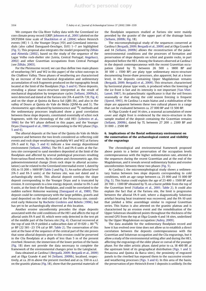
For the Pleistocene record, we can thus define two main phasesof weathering (W1 and W2 in this paper) of the schist outcrops inthe CôaRiver Valley. These phases of weathering are characterisedby an increase of the mechanical degradation and sedimentaryaccumulation of rock fragments produced on the topographic breaklocated at the limit of the floodplain (Figs. 5 and 6). These deposits,revealing a planar macro-structure interpreted as the result ofmechanical degradation by temperature cycles (Sellami, 2009a,b),were detected and dated at the Fariseu site (FA-4 and FA-7/8; Fig. 4)and on the slope at Quinta da Barca Sul (QBS-3b), and also in thevalley of Douro at Quinta do Vale do Meão (QVM-4a and 5). Thechronometric ages obtained by luminescence and 14C methods andthe sedimentary processes implicated show a good correlationbetween these slope deposits, constituted essentially of schist rockfragments, with the chronology of the cold HE1 (Lebreiro et al.,1996) for the W1 phase defined in this paper, and the YoungerDryas (Dansgaard et al., 1989) corresponding to theW2 phase (Figs.5 and 6).
The alluvial deposits at the base of the Quinta do Vale do Meãosequence and between the two levels considered as reflecting coldevents and rock slope weathering (probablyW1 andW2) at Fariseu(FA-5 and 6; Figs. 5 and 6) indicate a low energy depositionalenvironment (Sellami, 2009a). The FA-5 and FA-6 units at the Far-iseu site correspond to sand members deposited at the limit of thefloodplain and affected by several pedological processes resultingfrom various flood events. By its relative and chronometric age, thispaleoenvironmental change (from rock slope to alluvial accumu-lation) can be related to the Greenland interstadial event 1, dated byOSL to 15 200� 1600 BP (Table 2 and Fig. 5). An earlier alluvial level(FA-3 and FA-3 units) at the Fariseu site, was not dated and isarchaeologically sterile. This alluvial deposit overlays the slopedeposit corresponding to the Younger Dryas and is truncated byerosion. It corresponds to a low energy deposit, similar to FA-5 and6 units, at the limit of the floodplain, and could be correlated to thesudden earliest Holocene warming (Dansgaard et al., 1989). Thisdeposit could be contemporary with the large pebbles, gravels andsand deposited on the mid-channel at the Penascosa site, consid-ered early Holocene by Rochette Cordeiro and Rebelo (1996), buthas yet to be archaeologically observed at this location.
Another erosive unconformity precedes the slope depositsassociatedwith the cold conditions of the HE1 and affects the top ofalluvial units FA-9 and 10, which were only detected in the test pitof the middle part of the Fariseu site (Fig. 4). Charcoal recovered atthe top of unit FA-9 yielded a radiocarbon date of 19 020 � 80 14Cyr BP (22 581e23 174 cal yr BP; Table 2). The conservation of thisunit at the base of the sequence of the central part of the site provesthat some alluvial deposits prior to this erosion could be preservedin the Côa floodplain at a depth of less than 5 m of the presentriverbed. However, the immersion of the lower portion of the basin(Fig. 1B) does not provide the data necessary to complete theframework of the environmental changes prior to the Lateglacial.
Data obtained at Cardina I (Bergadà, 2009; Bergadà et al., 2009)and at Olga Grande 4 and 14 (Sellami, 2009b), localised, respec-tively, at ca. 20 m above the present riverbed and at ca. 550 m a.s.l.on the granitic plateau (Fig. 1B), show that the parental materials of
the floodplain sequences studied at Fariseu site were mainlyprovided by the granite of the upper part of the drainage basin(Sellami, 2009b; Fig. 1B).
The micromorphological study of the sequences conserved atCardina I (Bergadà, 2009; Bergadà et al., 2009) and at Olga Grande 4and 14 (Sellami, 2009b) allows the reconstruction of the palae-oenvironmental conditions and the processes of formation andpreservation of slope deposits on schist and granite rocks, in partdeposited before the HE1. Among the features observed at Cardina Iin the deposit contemporaneous with the recent Gravettian occu-pation (dated by TL between 26 500 � 1800 BP and30 100 � 1500 BP) are platy type sedimentary micro-structuredocumenting freeze-thaw processes, also apparent, but at a lesserlevel, in the deposits containing Upper Magdalenian remains(Bergadá, 2009; Bergadá et al., 2009). This structure, characterisedby horizontal planar type voids, is produced when the lowering ofthe ice front is fast and its intensity is not important (Van Vliet-Lanoë, 1987). Its palaeoclimatic significance is that the soil freezesseasonally or that during the cold season freezing is frequent(Sjoerd, 1993). At Cardina I a main hiatus and a stabilisation of theslope are apparent between these two cultural phases in a rangethat can be evaluated between ca. 27 000 BP and 13 500 BP.
At Olga Grande 4 and 14 sites, a seasonal accumulation of snowcover and slight frost is evidenced by the micro-structure in thesample studied of the deposit containing the Gravettian remains(Sellami, 2009b), dated by TL between 27 200 � 2300 BP and31 000 � 2500 BP.
6. Implications of the fluvial sedimentary environment onthe conservation of the archaeological context and visibilityof the engravings
The chronological and environmental framework proposedabove points to a better preservation of the occupation levelscontemporaneous with the higher sedimentation rate, attested inthe sequences during the recent Gravettian and at the end of theMagdalenian, and it reveals several sedimentary hiatus and erosiveunconformities between these two phases (Fig. 5).
At Cardina I, the micromorphological study shows a sedimen-tary hiatus between two slope deposits corresponding to coldconditions, with an age range between ca. 25 000 and 15 000 BP(Fig. 5). This hiatus could explain the age of 23 400 � 1500 BP and20 700 � 1300 BP obtained by TL on a burnt pebble from the top ofthe Gravettian level (Valladas et al., 2001; Table 2). It could alsoexplain the fact that at the Fariseu site, the limit is progressivebetween the alluvial FA-9 unit, where a diagnostically Solutreanartefact bearing heat treatment was recovered, and the FA-10 unitthat yielded a lithic assemblage similar to regional Gravettianseries. This hiatus is also attested on the granitic plateau and ischaracterised by an erosion event and the remobilisation of theUpper Solutrean shouldered points throughout the thickness of thesecond GFU from the top at Olga Grande 4 and 14 sites, underlinedby the Upper Magdalenian occupation (Aubry, 2009).
The data available for the sedimentary floodplain record andhow it has evolved over time does not allow us to establish a directcorrelation between the deposits contemporaneous with theGravettian and Solutrean occupation and the Côa engravings, but itallow a study of the environmental setting after and during the HE1,affecting the engravings of the older phase or coeval of the youngerphase. For the older artistic phase, dated prior to ca. 18 400 BP, atthe upstream limit of its geographical distribution (Figs. 1 and 3;Penascosa and Quinta da Barca sites), the proximity of engravedpanels to the riverbed has exposed them to the successive erosiveand weathering processes (Figs. 3 and 6). In this area of the basin,the preservation of pre-Heinrich Event 1 deposits is unlikely. On the
T. Aubry et al. / Journal of Archaeological Science 37 (2010) 3306e33193314

Author's personal copy
other hand, it is highly probable that most of the engravings at thePenascosa and Quinta da Barca sites were buried by Lateglacialalluvial deposits. For this reason, the topographical and geomor-phological conditions of the floodplain are unfavourable to yieldany remains of Palaeolithic humans in primary position, only evi-denced by engravings in the floodplain margin of this portion of thevalley (Zilhão, 1997).
The existence of engraved rocks entirely buried by Holocenedeposits younger than the erosion at the base of the section studiedat Penascosa and Colmeal sites (Fig. 3) cannot be completely dis-carded, considering the geophysical profile obtained in front of
Rocks 4 and 5 at Penascosa, which reveals the existence of morethan 5 m of deposits in front of the engravings (Zilhão, 1997).Nevertheless, the spatial distribution and density of the engravingsat the base of the slope may be considered an indication of theirlongitudinal distribution along the river and reveals two clusters atthe limits of the Penascosa/Quinta da Barcameander (Baptista et al.,2009; Fig. 1C). However, the localities with engravings stylisticallyassigned to the older artistic phase and yielding the higher degreeof rock weathering, are located on the slope at less than 70 m ofelevation above the current floodplain (Chauvière et al., 2009;Fig. 3). A differential preservation must be taken into account if we
Fig. 5. Proposal of deposition and sedimentary unconformity correlative framework established through data obtained in the Côa River Valley during the last ca. 35 000 yr BP andtentative correlations between the Greenland ice core climate proxy record, Heinrich Events and age of geoarchaeological studied sites samples. Greenland Ice Core Record (GRIP;Johnsen et al., 2001) plotted on the SFCP2004 time scale of Shackleton et al. (2004). Vertical stripes place Heinrich events (HE) 1e3 and the Younger Dryas (YD). Numbers 1e7 referto the Dansgaard-Oeschger (D/O) or Greenland interstadials, LGM ¼ Last Glacial Maximum, (a). Narrow white bars correspond to age error range (14C calibrated age) for samplesfrom the geoarchaeological field units studied (b).
T. Aubry et al. / Journal of Archaeological Science 37 (2010) 3306e3319 3315
Author's personal copy
try to interpret the distribution of rock art along the slope, notablyin terms of human choices (Baptista et al., 2009).
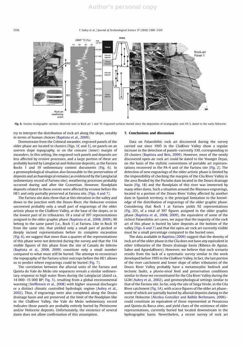
Downstream from the Colmeal meander, engraved panels of theolder phase are located in clusters (Figs. 1C and 3), on panels on anuneven slope topography, or on the concave (inner) margin ofmeanders. In this setting, the engraved rock panels and deposits areless affected by erosive processes, and a large portion of these areprobably buried by Lateglacial andHolocene deposits, as the FariseuRocks 1 and 19 sedimentary context documents (Fig. 6). Ina geomorphological situation also favourable to the preservation ofdeposits andarchaeological remains (as evidencedby the Lateglacialsedimentary record of Fariseu site), weathering processes probablyoccurred during and after the Gravettian. However, floodplaindeposits related to these events were affected by erosion before theHE1 and only partially preserved at Fariseu site, (Figs. 4 and 7).
The Fariseu site data show that at this elevation in the valley anddown to the junction with the Douro River, the Holocene erosionuncovered probably only a small part of engravings of the olderartistic phase in the CôaRiver Valley, at the base of the slopes, or inthe lowest part of its tributaries. Of a total of 397 representationsassigned to the older graphic phase (Baptista et al., 2008, 2009), 90belong to the same panel (i.e., Rock 1) at Fariseu. Like in Rock 19from the same site, that yielded only a small part of pecked ordeeply incised representations before its complete excavation(Fig. 6), we suggest that more than a quarter of the representationsof this phase were not detected during the survey and that the 114visible figures of this phase from the site of Canada do Inferno(Baptista et al., 2008, 2009) constitute only a small numbercompared to what must still be buried. The attempt to reconstructthe topography of the Fariseu schist outcrops before the HE1 allowsus to predict where engravings could be buried (Fig. 7).
The correlation between the alluvial units of the Fariseu andQuinta do Vale do Meão site sequences reveals a similar sedimen-tary response to high water flows during the Lateglacial (dated ca.14 000e15 000 BP; Fig. 5), resulting from a global environmentalwarming (Steffensen et al., 2008) with higher seasonal dischargesor a distinct climatic controlled hydrologic regime (Aubry et al.,2002). Thus, if engravings were also completed along the Dourodrainage basin and are preserved at the limit of the floodplain likein the CôaRiver Valley, the Vale do Meão sedimentary recordindicates those panels are probably entirely buried by Pleistoceneand/or Holocene deposits. Unfortunately, the existence of severaldams does not allow confirmation of this assumption.
7. Conclusions and discussion
Data on Palaeolithic rock art discovered during the surveycarried out since 1995 in the CôaRiver Valley show a regularincrease in the detection of panels–currently 330, corresponding to29 clusters (Baptista and Reis, 2009). However, most of the newlydiscovered open-air rock art could be dated to the Younger Dryas,on the basis of the stylistic conventions of portable art represen-tations recovered in the FA-4 unit of the Fariseu site (Fig. 2). Thedetection of new engravings of the older artistic phase is limited bythe impossibility of checking the margins of the Côa River Valley inthe area flooded by the Pocinho dam located in the Douro drainagebasin (Fig. 1B) and the floodplain of this river was immersed bymany other dams. Such a situation around theMazouco engravings,located in a portion of the Douro River Valley affected by anotherdam in Spanish territory, is the principal limitation to the knowl-edge of the distribution of engravings of the older graphic phase.Considering that Rock 1 at Fariseu yields 92 representations(Fig. 2D), of a total of 397 figures assigned to the older graphicphase (Baptista et al., 2008, 2009), the equivalent of some of therichest Palaeolithic art caves, we argue that the majority of the rockart of this phase is buried by later deposits at the bottom of thevalley (Figs. 6 and 7) and that the open-air rock art currently visiblemust be a small percentage compared to the buried ones.
The data available in Baptista (2009) suggest that the density ofrock art of the older phase in the Côa does not have any equivalent inother tributaries of the Douro drainage basin (Ribeira de Aguiar,Sabor and AguedaRivers). However, we believe that such scenarioresults from the lack of a systematic survey similar to the workdevelopedbefore1995 in theCôaRiverValley. In fact, the last portionof the river catchment and lower slope of other tributaries of theDouro River Valley probably have a metamorphic bedrock andtectonic faults, a pluvio-nival feed and preservation conditionssimilar to thosewe reconstituted for the Côa River Valley during theLGM (Aubry et al., 2002), and geomorphological settings similar tothat of the Fariseu site. So far, only the site of Siega Verde, in the CôaRiver catchment (Fig.1A), with scarce figures of the older art phase–some of which are partially buried by alluvial deposits dating to therecent Holocene (Alcolea González and Balbín Berhmann, 2006)–could constitute an equivalent of those represented at Penascosaand Quinta da Barca sites, and yield clues of the existence of olderrepresentations, currently buried but located downstream in thehydrographic basin. Nevertheless, a recent survey of rock art
Fig. 6. Fariseu stratigraphic sections observed next to Rock art 1 and 19. Engraved surfaces buried since the deposition of stratigraphic unit FA-3, dated to the early Holocene.
T. Aubry et al. / Journal of Archaeological Science 37 (2010) 3306e33193316

Author's personal copy
conducted byM. Reis (personal communication) in the lower valleyof theRibeira deAguiar, a tributarywith the confluence immediatelydownstream of the Côa River on the same left margin of the DouroRiver, did not reveal any engravings that could be attributed to theolder graphic phase represented by Rock 1 of the Fariseu site.
The setting of the most recent phase of Palaeolithic rock art isquite different. Engravings discovered within the last ten yearscould essentially be dated, by stylistic comparison with portableart, to the end of the Lateglacial or the very beginning of the EarlyHolocene. These engravings were detected along the slopes of theCôa and Douro River Valleys (Figs.1C and 3), and up to the top of theschist plateau (altitude over 500 m). Accordingly, the panels areapparently not affected by the Younger Dryas phase of weatheringevidenced at Fariseu site. The survey realized until 2000 clearlyincreased the number of rock art figures assigned to this chrono-logical phase, and not only at the bottom of the valley slopes. Thedistribution of the new finds on the Côa and Douro River Valleysand recent discoveries in other drainage basins of southern Iberia(Collado, 2009) reveal the large potential and the predictableincrease of rock art assigned to the Late Palaeolithic or initialHolocene artistic phase.
The most favourable geomorphological setting for the preser-vation of pecked and deeply superposed engravings of the mostfamous artistic phase of the CôaRiver Valley is the interfacebetween the rocky slope and the floodplain. Data revealedsuccessive burial/uncovering phases of the engraved panelspreserved on the CôaRiver margin during the Pleistocene, whichare related to a re-organisation of the drainage basin imposed bythe hydrological system (Aubry et al., 2002). The sedimentary coverof the engravings, combined with the characteristic siliceous-metallic films developed in the diaclases of metamorphic rocks(Chauvière et al., 2009; Fernandes, 2009; Pope, 2000), were prob-ably the most important factors in their preservation during theseveral phases of weathering related to the cold events of the LGMand Lateglacial.
Data accumulated over the last 15 years in Iberia suggest that theCôaRiver Valley was an unusual ecological mosaic of complementaryenvironments between the bottom valley and the Meseta plateauduring the LGM. The large variety of biotic resources in a smallterritory resulted in a permanent exploration by hunter-gatherersthroughout the Upper Palaeolithic (Aubry, 2009; Aubry et al., 2002).Specific geological and climatic conditions (Chauvière et al., 2009;
Fig. 7. Fariseu 3D slope profile reconstitution of the sedimentary filling prior to the Heinrich event 1, based on the section observed during the 1999, 2005 and 2007 excavations,showing the potential area of preservation of buried rock art (�) and the topography of the site during the older artistic phase.
T. Aubry et al. / Journal of Archaeological Science 37 (2010) 3306e3319 3317
Author's personal copy
Fernandes, 2009) allowed the partial preservation of a monumentalrock art made by Solutrean or (more probably) Gravettian humangroups (Aubry, 2009; Aubry and Sampaio, 2008). The sedimentaryrecord was a factor in its preservation, but it also constitutes a limi-tation in the detection of most of them that are still covered bysediment on the downstream 7 km of the CôaRiver Valley.
Better understanding of the environmental changes over time,and excavations based on a predictive model of the geomorpho-logical areas favourable for both the preservation of rock art panelsand prehistoric human occupation, could radically change thecorpus of data and our conception of the first artistic manifestationsin Europe.
Acknowledgements
Fieldwork and analyses were supported by the Instituto Por-tuguês de Arqueologia and the Instituto de Gestão do PatrimónioArquitectónico e Arqueológico of the PortugueseMinistry of Culture(IGESPAR-IP), text revision by the Centro de Estudos de Geografia eOrdenamento do Território (CEGOT). We thank our colleaguesChristophe Delage and J. Dinis (Departamento de Ciências da Terra,Faculdade de Ciências e Tecnologia, Universidade de Coimbra) andthe two anonymous reviewers of JAS for their stimulating reviewsand constructive improvement of the manuscript.
References
Alcolea González, J.J., Balbín Behrmann, R., 2006. Arte paleolítico al aire libre. El yaci-miento rupestre deSiegaVerde, Salamanca.Memorias16. In: León, Arqueología enCastilla y (Ed.), Junta de Castilla y León, p. 422.
Angelucci, D.E., 2002. The geoarchaeological context. In: Zilhão, J., Trinkaus, E. (Eds.),Portrait of the Artist as a Child. Portrait of the artist as a Child. The GravettianHuman Skeleton from the Abrigo do Lagar Velho and its Archaeological Context.Instituto Português de Arqueologia, Trabalhos de Arqueologia, vol. 22, pp. 58e91.
Aubry, T., 2009. 200 séculos da história do Vale do Côa: incursões na vida quotidianado caçadores-artistas do Paleolítico. In: Trabalhos de Arqueologia, vol. 52.IGESPAR-IP, Lisboa.
Aubry, T., Baptista, A.M., 2000. Une datation objective de l’art du Côa. La Recherche,Hors Série 4 (11), 54e55.
Aubry, T., Garcia Diez, M., 2001. Actualité sur la chronologie et l’interprétation del’art de la vallée du Côa (Portugal). Les Nouvelles de l’Archéologie 82, 52e57.
Aubry, T., Mangado Llach, X., Sellami, F., Sampaio, J.D., 2002. Open-air rock-art.Territories and modes of exploitation during the upper paleolithic in the Côavalley (Portugal). Antiquity 76 (291), 62e76.
Aubry, T., Sampaio, J.D., 2008. Fariseu: new chronological evidence for open-airPalaeolithic art in the Côa valley (Portugal). Project Gallery. Antiquity 82 (316).
Bahn, P., 1985. Ice Age drawing on open rock faces in the Pyrenees. Nature 313,530e531.
Bahn, P., 1995. Cave art without the caves. Antiquity 69, 231e237.Balbín Behrmann, R., Alcolea González, J.J., Santoja, M., Perez, R., 1991. Siega Verde
(Salamanca). Yacimiento artístico paleolítico al aire libre. Del Paleolítico a laHistoria. Museu de Salamanca, Salamanca, pp. 33e48.
Baptista, A.M., 1999. No Tempo sem Tempo. A arte dos caçadores paleolíticos doVale do Côa. Vila Nova Foz Côa. Ed. Parque Arqueológico do Vale do Côa.
Baptista, A.M., 2001. Ocreza (Evendos, Mação, Portugal Central). Um novo sítio comarte paleolítica de ar livre”. In: Cruz, A.R. e Oosterbeek, L., Territórios, mobi-lidade e povoamento no alto Ribatejo II e Santa Cita e o Quaternário da região,Tomar, CEIPHAR (Arkeos, 11), pp. 163e192.
Baptista, A.M., 2004. Arte paleolítica de ar livre no rio Zêzere (Barroca, Fundão),Ebvrobriga, 1, Fundão, Museu municipal José Monteiro, pp. 9e16.
Baptista, A.M., 2008. Aspecto da Arte Magdalenense e Tardiglaciar no Vale do Côa.Actas do Fórum Valorização e Promoção do Património Regional, Coord. AndréTomas Santos, Luís Luís, vol. 3, Do Paleolítico à Contemporaneidade, pp .16e31.
Baptista, A.M., 2009. Aspectos da Arte Magdalenense e Tardiglaciar no vale do Côa.In: Actas da sessão “Do Paleolítico à Contemporaneidade e estudos sobrea História da Ocupação Humana em Traz-os-Montes, Alto Douro e Beira Inte-rior”. Fórum Valorização e Promoção do Património Regional. pp. 14e31.
Baptista, A.M., Varela Gomes, M., 1995. Arte rupestre do Vale do Côa 1. Canada doInferno. Primeiras impressões. Trabalhos de Antropologia e Etnologia 35 (4),349e422.
Baptista, A.M., Santos, A.T., Correia, D., 2008. Estruturação simbólica da arteGravetto-Solutrense em torno do monte do Fariseu (Vale do Côa). In. III Con-gresso de arqueologia, Trás-os-Montes, alto Douro e beira interior, Actas dasessão, Pré-história, gestos intemporais, André Tomas Santos, Jorge DavideSampaio e João Muralha (coord.), pp. 38e61.
Baptista, A.M., Santos, A.T., Correia, D., 2009. O santuário arcaico do Vale do Côa:novas pistas para a compreensão da estruturação do Bestário Gravetense e/ouGravetto-solutrense. Arte Prehistórico al Aire libre en el Sur de Europa, Rodrigode Balbín Berhmann (ed.), Documentos PAHIS, pp. 89e144.
Baptista, A.M., Reis, M., 2009. Prospecção da Arte Rupestre na Vale do Côa e AltoDouro português. Arte Prehistórico al Aire libre en el Sur de Europa, Rodrigo deBalbín Berhmann (ed.), Documentos PAHIS, pp. 145e192.
Baptista, A.M., Santos, A.T., 2010. Confronting two sceneries on the same stage fromGravettian-Solutrean to Magdalenian in Penascosa/Quinta da Barca, Portugal.In: Bettencourt, Ana M.S., Jesus Sanches, M., Alves, Lara B., Valarce, RamonFábregas (Eds.), Proceedings of the XV World Congress of the InternationalUnion for Prehistoric and Protohistoric Sciences. Conceptualising Space andPlace. On the Role of Agency, Memory and Identity in the Construction of Spacefrom the Upper Palaeolithic to the Iron Age in Europe C41 and C72. BARInternational Series 2058, pp. 61e69.
Bergadà, M.M., 2009. Análisis micromorfológico de la secuencia sedimentaria de Car-dina I (Salto do Boi, Vila Nova de Foz Côa, Portugal). In: Aubry, Thierry (Ed.), 200séculos da história do Vale do Côa: incursões na vida quotidiana do caçadores-artistas do Paleolítico. Trabalhos de Arqueologia 52, pp. 112e127. Capítulo 4.4.
Bergadà, M.M., Mangado, X., Aubry, T., Fullola, J.M., 2009. Geoarqueología, micro-morfología y paleoambiente del Pleistoceno superior de Cardina I (Salto do Boi,Vila Nova de Foz Côa, Portugal). VII Reuniao del Cuaternario Ibérico. Faro, 2009,pp. 236e239.
Brown, A.G., 1997. Alluvial Geoarchaeology: Floodplain Archaeology and Envi-ronmental Change. Cambridge Manuals in Archaeology. Cambridge UniversityPress.
Chauvière, F.X., Tymula, S., Calame, A., Dechanez, I., 2009. Capítulo 7.3. Conservationet évolution des surfaces rocheuses gravées et piquetées de la Vallée du Côa: lesdonnées du projet “Quinta da Barca Sul”. In: Aubry, Thierry (Ed.), 200 séculos dahistória do Vale do Côa: incursões na vida quotidiana do caçadores-artistas doPaleolítico. Trabalhos de Arqueologia 52, pp. 443e477.
Collado, H., 2009. Arte rupestre prehistórico en Extremadura 1997e2006. In:Behrmann, Rodrigo de Balbín (Ed.), Arte Prehistórico al aire libre en el Sur deEuropa. PAHIS, Junta de Castilla e León, pp. 287e322.
Dansgaard, W., White, J.W.C., Johnson, S.J., 1989. The abrupt termination of theYounger Dryas event. Nature 339, 532e533.
Dorn, R.I., 1997. Constraining the age of the Côa valley (Portugal) engraving withradiocarbon dating. Antiquity 71, 105e115.
FAO-Isric, 1990. Guidelines for Soil Description, third ed.s. FAO, Roma.Fernandes, A.P.B., 2009. Conservation of the CôaValley rock art outcrops: a question
of urgency and priorities. Project Gallery. Antiquity 319.Johnsen, S.J., Dahl-Jensen, D., Gundestrup, N., Steffensen, J.P., Clausen, H.B.,
Miller, H., Masson-Delmotte, V., Sveinjörnsdottir, A.E., Whitte, J., 2001. Oxygenisotope and paleotemperature records from six Greenland ice-core stations:Camp-Century, dye-3, GRIP, GIPS2, Renland and NorthGRIP. Journal of Quater-nary Science 16 (4), 299e307.
Jorge, S.O., Jorge, V.O., Almeida, C.A.F., de Sanches, M.J., Soeiro, M.T., 1981. Gravurasrupestres de Mazouco (Freixo de Espada-à-Cinta). Arqueologia 3. Porto, 3e12.
Keeley, H.C.M., Machail, R.I., 1981. A Soil Handbook for Archaeologists, vol. 18.Institute of Archaeology Bulletin, London, pp. 225e243.
Lebreiro, S.M., Moreno, J.C., MacCave, I.N., Weaver, P.P.E., 1996. Evidence of Heinrichevent layers of Portugal (Tore Seamourth, 39�N,12�W).MarineGeology 131, 47e56.
Mercier, N., Valladas, H., Froget, L., Jorons, J.-L., Reyss, J.-L., Aubry, T. 2001. Appli-cation de la méthode de la thermoluminescence à la datation des occupationspaléolithiques de la vallée du Côa. Actes du Colloque : “Les premiers hommesmodernes de la Péninsule ibérique”, Vila Nova de Foz Côa, 22-24/10/1998,275–280.
Mercier, N., Valladas, H., Aubry, T., Zilhão, J., Jorons, J.L., Reyss, J.L., Sellami, F., 2006.Fariseu: first confirmed open-air paleolithic parietal art site in the Côa Valley(Portugal). Antiquity 80 (310).
Monteiro-Rodrigues, S., Angelucci, D., 2004. New data on the stratigraphy andchronology of the prehistoric site of Prazo. Revista Portuguesa de Arqueologia 7(1), 39e59.
Pope, G.A., 2000. Weathering of Petroglyphs: direct assessment and implications fordating methods. Antiquity 74, 33e43.
Rippol, S., Municio, L., 1992. Las representaciones de estilo paleolítico en el conjuntode Domingo Garcia (Segóvia). Espacio. Tiempo y Forma (UNED), Série I,Prehistória y Arqueologia 5, 107e138.
Rochette Cordeiro, A.M., Rebelo, F., 1996. Carta geomorfológica do Vale do Côaa jusante de Cidadelhe. Cadernos de Geografia 15, 11e33.
Rockwell, T., Fonseca, J., Madden, C., Dawson, T., Owen, L.A., Vilanova, S.,Figueiredo, P., 2009. Palaeoseismology of the Vilarica Segment of the Man-teigas-Braganca fault in northeastern Portugal. Geological Society, London,Special Publications 316 (1), 237e258.
Sacchi, D., 2002. Propos liminaires. In: Actes du Colloque “L’art Paléolithique à l’airlibre: le Paysagemodifié par l’image”, 07e09/10/1999. (Coor.) D. Sacchi, pp. 7e11.
Sacchi, D., Abelanet, J., Brulé, J.L., Massiac, Y., Rubiella, C., Vilette, P.,1988. Les gravuresrupestres de Fornols-Haut, Pyrénées-Orientales. L’Anthropologie 92 (1), 87e100.
Sellami, F., 2009a. Capítulo 4.2. Les données de la séquence stratigraphique du sitede Fariseu: processus de déposition et d’érosion des dépôts en limite de laplaine alluviale du Côa. In: Aubry, Thierry (Ed.), 200 séculos da história do Valedo Côa: incursões na vida quotidiana do caçadores-artistas do Paleolítico.Trabalhos de Arqueologia 52, pp. 103e108.
Sellami, F., 2009b. Capítulo 4.3. Les processus de formation, conservation etévolution des dépôts quaternaires sur les granites de Mêda-Escalhão: Olga
T. Aubry et al. / Journal of Archaeological Science 37 (2010) 3306e33193318
Author's personal copy
Grande 4 et 14 de Pedras Altas. In: Aubry, Thierry (Ed.), 200 séculos da históriado Vale do Côa: incursões na vida quotidiana do caçadores-artistas do Paleo-lítico. Trabalhos de Arqueologia 52, pp. 109e112.
Shackleton, N.J., Fairbanks, R.G., Chiu, T.-C., Parrenin, F., 2004. Absolute calibrationof the Greenland time scale: implications for Antarctic time scale and for D14C.Quaternary Science Reviews 23, 1513e1522.
Sjoerd, A., 1993. Cryogenic Microfabrics and Macrostructures: Interrelations,Processes and Palaeoenvironmental Significance. Thesis Vrije UniversiteitAmsterdam, The Netherlands.
Steffensen, P.D., Andersen, K.K., Bigler, M., Clausen, H.B., Dahl-Jensen, D., Fischer, H.,Goto-Azuma, K., Hansson, M., Johnsen, S.J., Jouzel, J., Masson-Delmotte, V.,Popp, T., Rasmussen, S.O., Röthlisberger, R., Ruth, U., Stauffer, B., Siggaard-Andersen, M.L., Sveinbjörnsdóttir, A.E., Svensson, A., James, W., White, C., 2008.High-Resolution Greenland ice core data show abrupt climate change Happensin few years. Science 321 (5889), 680e684.
Valladas, H., Mercier, N., Froget, L., Jorons, J.L., Reyss, J.L., Aubry, T., 2001. TL dating ofupper paleolithic sites in the Côa valley (Portugal). Quaternary Science Reviews20 (5e9), 939e943.
Van Vliet-Lanoë, B., 1987. Dynamique périglaciaire actuelle et passée apport del’étude micromorphologique et de l’experimentation. Bulletin de l’AssociationFrançaise pour l’étude du Quaternaire-3, 113e132.
Vita-Finzi, C., 1969. The MediterraneanValleys: Geological Changes in HistoricalTimes. CambridgeUniversity press, Cambridge.
Watchman, A., 1995. Recent petroglyphs, Foz Côa. Rock Art Research 12 (2),104e108.
Watchman, A., 1996. A review of the theory and assumption in the AMS dating ofthe Foz Côa petroglyphs, Portugal. Rock Art Research 13 (1), 21e30.
Weninger, B., Jöris, O., 2004. Glacial radiocarbon calibration: the CalPal program. In:Higham, T., Bronk Ramsey, C., Owen, C. (Eds.), Radiocarbon and Archaeology.Fourth International Symposium, Oxford.
Zilhão, J., 1995. The age of the Côa valley (Portugal) rock-art: validation of archae-ological dating to the Palaeolithic and refutation of “scientific” dating to historicor proto-historic times. Antiquity 69 (266), 883e901.
Zilhão, J., (coord.) 1997. Arte Rupestre e Pré-História do Vale do Côa. Trabalhos de1995 e 1996. Relatório Científico ao Governo da República portuguesa elabo-rado nos termos da resolução do Conselho de Ministros n� 4/96, de 17 deJaneiro.
Zilhão, J., 2003. Vers une chronologie plus fine du cycle ancien de l’art paléolithiquede la Côa: quelques hypothèses de travail. In: Balbín Behrmann, R, BuenaRamírez P. ed. El arte prehistórico desde los inicios des siglo XX: Primersymposium internacional de arte prehistórico de Ribadesella. Ribadessella:Associación Cultural Amigos de Ribadesella, pp. 75e90.
Zilhão, J., Almeida, F., 2002. Chapter 3, the Archeological framework. In: Zilhão, J.,Trinkaus, E. (Eds.), Portrait of the Artist as a Child. The Gravettian HumanSkeleton from the Abrigo do Lagar Velho. Lisboa, IPA. Trabalhos de Arqueologia22, pp. 29e57.
T. Aubry et al. / Journal of Archaeological Science 37 (2010) 3306e3319 3319