AUSTRALIAN DRILLING ASSOCIATES - Department of … · Australian Drilling Associates Pty Ltd ......
14
AUSTRALIAN DRILLING ASSOCIATES GEOTECHNICAL CORING SURVEY ENVIRONMENT PLAN EXECUTIVE SUMMARY Prepared by Enesar Pty Ltd
Transcript of AUSTRALIAN DRILLING ASSOCIATES - Department of … · Australian Drilling Associates Pty Ltd ......

AUSTRALIAN DRILLINGASSOCIATES
GEOTECHNICAL CORINGSURVEY
ENVIRONMENT PLAN
EXECUTIVE SUMMARYPrepared by
Enesar Pty Ltd


Australian Drilling Associates Pty Ltd
Offshore Consortium Drilling Program
Geotechnical Environment Plan
Executive Summary
October 2007 CR 1323_1_v6_ExSumm
Prepared by: Enesar Consulting Pty Ltd
126 Trenerry Crescent Abbotsford Victoria Australia 3067 p 61-3-9418 0600 f 61-3-9418 0650
e [email protected] www enesar.com.au

Project Director David Gywther Project Manager Greg Terrens Project Team Kane Blackman Draftsperson/graphic designer Hanna Blaszkiewicz WP/DTP Jill O’Neil Version/s: Distribution: CR 1323_1_v6_ExSumm DPI – 1 copy October 2007 DIER – 1 copy

i Enesar Consulting Pty Ltd 1323_1_ExSumm_v1.doc/October 15, 2007
Contents Executive Summary i
The Proponent i The Proposal i Stakeholder Consultation v Environmental Impact Assessment, Management and Mitigation vi
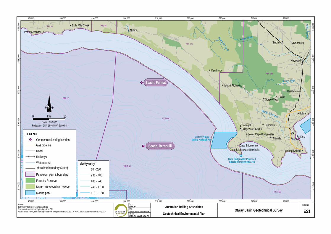
Figures ES1 Location of project- Otway Basin ii
ES2 Location of project- Gippsland Basin iii
ES3 Location of project- Bass Basin iv
Tables Table ES1 Stakeholder consultation v
Table ES2 Summary of environmental impact assessment results vii


i Enesar Consulting Pty Ltd 1323_1_ExSumm_v1.doc/October 15, 2007
Executive Summary
The Proponent Australian Drilling Associates Pty Ltd (ADA) is acting as the proponent for a consortium of oil and gas companies. The consortium participants include: Apache, Beach Petroleum, Nexus, 3DOil and Stuart Petroleum. ADA is a recognized international well engineering and project management company, with it’s head office in Melbourne.
The Proposal The proponent proposes to undertake an offshore geotechnical coring program in the following three locations:
• Otway Basin of western Bass Strait at two sites in Commonwealth waters, offshore Victoria (Figure ES1).
• Gippsland Basin of eastern Bass Strait at 11 sites in Commonwealth waters offshore Victoria (Figure ES2).
• Bass Basin of southern Bass Strait at two sites in Commonwealth waters offshore Tasmania (Figure ES3).
The geotechnical coring and sampling operations will be performed in preparation for a drilling program planned for early 2008. This Environment Plan covers the geotechnical coring activity. The coring program is expected to be approximately one month duration, commencing mid November 07.
The Fugro multi-purpose vessel ‘MV Markab’ will be contracted to undertake the coring operations and this vessel will complete coring at depths of up to 30 m max at each of the 15 well locations. The number of cores required at each well location may vary depending on soil conditions and expected stability but a nominal number of cores is expected to be between one and three at each location.
470 000 480 000 490 000 500 000 510 000 520 000 530 000 540 000 550 0005
790
000
PEL 82 Eight Mile Creek PEL 57
NelsonPort Macdonnell
Princes HighwayPortland Nelson Road Fitzroy River Sund
ay C
reek
5 79
0 00
0
PEP 151
Moleside Creek
Sinclair Drumborg
5 78
0 00
0
Heywood 5 78
0 00
0
KentbruckPEP 150
Surrey RiverBeach, Fermat
Mount Richmond
5 77
0 00
0
Heathmere
5 77
0 00
0
GoraeEPP 27 Gorae West
NWa
Bolwarrakm0 10
5 76
0 00
0 VIC/P 46
ttle Hill Creek
Scale 1:350,000Projection: GDA 1994 MGA Zone 54 Tarragal Cashmore 5
760
000
Bridgewater Caves
LEGEND Lower Cape BridgewaterDiscovery Bay Portland
TrewallaGeotechnical coring location Marine National Park
Gas pipeline Beach, Bernoulli Cape BridgewaterCape Bridgewater Blowholes
5 75
0 00
0 Road Portland Smelter
Railways 5 75
0 00
0
Cape Bridgewater Proposed
Watercourse Special Management AreaBathymetry
Maratime boundary (3 nm)VIC/P 50
10 - 230
Petroleum permit boundary 231 - 480
Forestry Reserve 481 - 740
5 74
0 00
0
Nature conservation reserve 741 - 1100
5 74
0 00
0
Marine park 1101 - 1800 VIC/P 51
470 000 480 000 490 000 500 000 510 000 520 000 530 000 540 000 550 000Source: Date: Figure No:Bathymetry from GeoScience Australia 12.06.07 Australian Drilling AssociatesPetroleum tenements and pipelines from DPI MXD:
Place names, roads, rail, drainage, reserves and parks from GEODATA TOPO 250K (optimum scale 1:250,000) Australian_Drilling_Associates.mxd Otway Basin Geotechnical Survey File No:
ES1Geotechnical Environmental Plan1323_01_ES001_GIS_AI

425 000 450 000 475 000 500 000 525 000 550 000 575 000 600 000 625 000 650 000 675 000 700 000
LEGEND
m R
iver
Geotechnical coring location Tambo River Cann River
Bem
RoadThomson River
5 82
5 00
0 OrbostRailways Bruthen Can
PEP155
n
5 82
5 00
0
Watercourse
Rive
Lindenow Marlo
r
Maratime boundary (3 nm) BairnsdaleBriagolong VIC/P40(V)
ces HighwayBeware ReefPetroleum permit boundary Coongulla Prin
Metung Lakes Entrance Marine Sanctuary Point Hicks MarineNational Park
5 80
0 00
0 PaynesvilleForeshore flatsRawson
Built up area Heyfield Maffra Stratford VIC/P47 5 80
0 00
0
VIC/P39(V)A VIC/P54Forestry Reserve
von River
Loch Sport
VIC/P57 Nexus, Longtom Upper 1Nature conservation reserve VIC/P55
SaleWestbury La Trobe River Nexus, Longtom 4
5 77
5 00
0 Marine parkMoe Tyers 3 D Oil, Sealion- Yallourn Rosedale Longford
Water supply reserve Traralgon 5 77
5 00
0
Yarragon PEP157Pipelines Morwell 3 D Oil, W SeahorsePEP162
Childers Gas - CurrentMerriman Cree
VIC/P41
Churchill Stuart, P53-AYinnar k
Gas / Oil - Current Ninety Mile Beach
5 75
0 00
0
PEP166 Boolarra Seaspray Marine National ParkVIC/P53 VIC/P56
Oil - CurrentMirboo North
Hig
hway
Stuart, Bazzard 1 5 75
0 00
0
Other - Current
Hyla
nd Apache, WasabiUnknown PEP158
WoodsideAlbert River
Greenmount Apache, Speke VIC/P49Yarram
5 72
5 00
0
Foster Apache, BullseyeToora 5
725
000
Port Albert Apache, Tarra Apache, Coelcanth Bathymetry Port Welshpool VIC/P58
VIC/P42VIC/P59 10 - 230
231 - 480VIC/P45
00 Corner Inlet Marine
5 70
0 0 Sandy Point National Park 481 - 740 00
5 70
0 0
N 741 - 1100
1101 - 1800km0 30
1801 - 2700Wilson Promontory Scale 1:1,100,000 VIC/P60
5 67
5 00
0 Marine National Park Projection: GDA 1994 MGA Zone 55 2701 - 3800
425 000 450 000 475 000 500 000 525 000 550 000 575 000 600 000 625 000 650 000 675 000 700 000
5 67
5 00
0
Date:Source: Figure No:11.09.07Bathymetry and Maritime boundaries from Geoscience Australia Australian Drilling AssociatesMXD:Petroleum tenements and pipelines from DPI XXXX Gippsland Basin Geotechnical Survey
Place names, roads, rail drainage, reserves and marine parks from GEODATA TOPO 250K (optimum scale 1:250,000) ES2File No:1323_01_ES002_GIS_AI Geotechnical Environmental Plan

275 000 300 000 325 000 350 000 375 000 400 000 425 000 450 000 475 000 500 000 525 000 550 000 575 000 600 000 625 000 650 000
VACANT T/L1LEGEND
5 57
5 00
0
T/18P VACANT T/RL1 Geotechnical coring locationN T/41P 5
575
000
T/18P T/37P RoadT/44P
km0 30 Railways
5 55
0 00
0
Scale1:1,500,000 Boags WatercourseProjection: GDA 1994 MGA Zone 55 Commonwealth 5
550
000
Marine Reserve Maratime boundary (3 nm)T/38P
Basslink alignment
5 52
5 00
0
T/43P Petroleum permit boundaryT/39P 5
525
000
Commonwealth marineprotected areasSpikey Beach 1 Pee Jay 1
T/42P Foreshore flats
5 50
0 00
0
Built up area
5 50
0 00
0
Forestry ReserveStanley
Nature conservation reserve
5 47
5 00
0
SmithtonWater supply reserve
Sisters Beach er
5 47
5 00
0
Bass Highway ivR
BridportWynyardBurnie
George Town at M
usse
lroe
Bathymetry
5 45
0 00
0 Low Head 10 - 230PenguinT06-5 G
re
Scottsdale 231 - 480 5 45
0 00
0
Frankland River
Rapid River
DevonportGawlerRidgley Port SorellPipers Riv
Branxholm
Emu R
iver Beaconsfield
Latrobe er Brid
Rive
r
481 - 740Lilydale RingaroomaArthur River
George River
5 42
5 00
0
r
Rubico Exeter 741 - 1100
Sava
ge R
iver
the R
ive
Railton
n Rive St HelensLegana 1101 - 1800 5
425
000
Bly Sheffield
r
Launceston 1801 - 2700Waratah Wilm
ot R
iver
Scamanderr Westbury
5 40
0 00
0
d RiveT/33P fiel
Hat PerthVale River Deloraine
Mole CreekNile River St Marys 5
400
000
er LongfordFury River se
y Ri
v Bracknell
er F
orth Fingal
Cressy
5 37
5 00
0 Pieman River
Mer
Tullah Riv
Esk Main Road
Rosebery
5 37
5 00
0
T/36P
ighw
ay
Main Line Rail er Bicheno
Riv
Zeehan
way
Pin
Lake River Swane River La
ke H
Campbell Town
275 000 300 000 325 000 350 000 375 000 400 000 425 000 450 000 475 000 500 000 525 000 550 000 575 000 600 000 625 000 650 000Date:Source: Figure No:11.09.07Bathymetry and Maritime boundaries from Geoscience Australia Australian Drilling AssociatesMXD:Petroleum tenements and pipelines from DPI XXXX Bass Basin Geotechnical Survey
Place names, roads, rail drainage, reserves and marine parks from GEODATA TOPO 250K (optimum scale 1:250,000) ES3File No:Basslink pipeline supplied by Barton Napier from information provided by Siemens and National Grid Australia. 1323_01_ES003_GIS_AI Geotechnical Environmental Plan

Australian Drilling Associates Geotechnical Environment Plan
Stakeholder Consultation Stakeholders associated with the survey that have been consulted are listed in Table ES1.
Table ES1 Stakeholder consultation Stakeholder Contact Date Matters Discussed DPI Terry McKinley 1/6/07 meeting EP requirements for geotech
Cynthia Crowe then ongoing. and drilling.
DIER Chris Boron 6/9/07 EP requirements for geotech and drilling
Border Protection bpliaison@customs. To be advised 2 Security advice. Command gov.au weeks prior. AFMA Bronwen Jones 20/8/07 Advice on locations of coring and fisher groups contact.
AMSA To be advised 2 Contact with Rescue Co- weeks prior. ordination Centre (RCC).
Commonwealth Peter Franklin 17/8/07 Advice on locations of coring Fisheries Assn and fisher groups contact. Warrnambool DSE Mandy Watson 7/8/07 Whale presence in Otway;
coring process. Seafood Industries Ross McGowan 17/8/07 Advice on geotech. program Vic and locations of coring. Victorian Scallop Steve Melissakis 16/8/07 Advice on geotech program Industry Association and locations of coring. Portland DPI Charlie Cooper 15/8/07 Advice on locations of coring Regional Fisheries and fisher groups contact. Portland Professl Steve Nathan 16/8/07 Advice on geotech program Fishermen’s Assocn and locations of coring. SE Trawl Fishing Gail Richie 16/8/07 Advice on geotech program Industry Association and locations of coring. SE Non-Trawl Charlie Farqhar 20/8/07 Advice on geotech program Fishing Indy. Assn and locations of coring. Lakes Entrance Peter Clark/Dale 16/8/07 Advice on geotech program Fishermens Coop Summer and locations of coring. VRFish Christopher Collins 16/8/07 Advice on geotech program
and locations of coring. Tasmanian Fishing Neil Stump 12/9/07 Advice on geotech program Industry Council and locations of coring. Tasmanian Assn of Anne Purtill 12/09/07 Advice on geotechnical Recreational program and locations of Fishing coring. Deakin University Peter Gill 21/8/07 Advice on locations of coring (Warrnambool) blue and fisher groups contact. whale research group
v Enesar Consulting Pty Ltd 1323_1_ExSumm_v1.doc/October 15, 2007

Australian Drilling Associates Geotechnical Environment Plan
Environmental Impact Assessment, Management and Mitigation The potential for environmental effects from the geotechnical survey include:
• Operation of the vessel and deployment of the coring system. • Interference with shipping and commercial fishing. • Seabed disturbance as a result of anchoring or grounding. • Accidental inpact from loss of corers and associated equipment. • Routine waste discharges from the survey vessel. • Accidental fuel spills from the survey vessel. • Collision with another vessel.
The Environment Plan provides a detailed assessment of potential impacts. The key points of the assessment, and management and mitigation measures, are summarised in Table ES2 below. The summary risk ranking is shown in Table ES2, there are a total of 12 environmental risk assessments and these have been assessed as low risk.
vi 1323_1_ExSumm_v1.doc/October 15, 2007 Enesar Consulting Pty Ltd

Australian Drilling Associates Geotechnical Environment Plan
Table ES2 Summary of environmental impact assessment results Impact Assessment Management and Risk
Mitigation Ranking Vessel presence: Impacts to commercial fisheries Liaison and communication Low Reduction in fish catches or interference with fishing with commercial fishing activities likely to be localised and short term. operators regarding
schedules and work plans during survey.
Vessel presence: Transfer of abalone virus from Markab will exchange ballast Low Victoria to adjacent coastal waters water as per vessel Markab route to Tasmanian sites will avoid known procedures, so that Victorian infected areas by travelling in deeper waters. ballast water will not be
released in Tasmanian waters.
Vessel presence: Impacts to commercial vessels Offshore Low and water based leisure craft distance/depth/timing/duration Temporary displacement of aquatic recreation activities; will reduce the extent of minor potential collision hazard. inconvenience; all vessel
operations will be conducted in compliance with the AMSA OSV Code.
Vessel presence: Collision, noise impact on large Whale sightings will be Low cetaceans logged. There are no sound sources involved in coring apart from generators on board the vessel; procedures to stop steaming when whales sighted within 1 km. Vessel presence: Impact to visual amenity Vessel not closer than 6 km Low Minor visual impact of vessel in nearshore areas. to the coast.
Coring operation: Lost equipment Geotech coring activity is Low Disruption to commercial fishing operations, minor short duration (approximately potential effect on seine and trawl fishing gear. 4 weeks): communications
with fishing groups.
Discharge of sewage and putrescible wastes: Sewage and putrescible Low Waste discharge to sea wastes macerated pre Minimal controlled discharges, remote locations discharge as per regulations. result in low impact. Discharge of solid and hazardous materials and Solid and hazardous waste Low waste: Waste discharge to sea will be returned to shore for Minimal, controlled discharges. disposal;
Ballast water discharge Introduction of marine Vessel masters will be made Low pests aware of the AQIS ‘Maritime Markab will exchange ballast water as per vessel Awareness Kit’. procedures. Accidental spill: Fuel spill Geotechnical vessel has an Low Minimal risk of pollution of marine environment. Oil Spill Contingency Plan
(OSCP) in place and staff are appropriately trained in its execution.
Deployment of coring system: Seabed Short term operation (less Low disturbance than 24hr per core). Minimal risk of loss of seabed habitat. Deployment of anchor: Seabed disturbance from Short term operation (less Low anchor dragging than 24hr per core). Localised and short term physical disturbance to benthic habitats and epibenthic organisms.
vii Enesar Consulting Pty Ltd 1323_1_ExSumm_v1.doc/October 15, 2007

Australian Drilling Associates Geotechnical Environment Plan
In summary, the offshore geotechnical survey is located in Bass Strait Commonwealth waters and is a relatively minor activity in preparation for a drilling program in 2008. The short duration of the survey (four weeks) away from marine protected areas has low impact to the marine environment.
Stakeholders have been consulted especially fishing groups and mitigation measures have been put in place to manage whale interaction.
Management and mitigation measures that will be followed during the project are provided in the Environment Plan. The implementation strategy for the Environment Plan specifically details the measures needed to ensure that the environmental performance objectives and standards are met, and identifies:
• Systems, practices and procedures. • Specific roles and responsibilities. • Employee training. • Monitoring, auditing and recording requirements. • Emergency response planning. • Consultation with government and stakeholders.
viii 1323_1_ExSumm_v1.doc/October 15, 2007 Enesar Consulting Pty Ltd