AUL OFFMAN ERIES - Harvard Universityprojects.iq.harvard.edu › files ›...
23
GEOSCIENCE CANADA Volume 39 2012 77 PAUL F. HOFFMAN SERIES Early Neoproterozoic Basin Formation in Yukon, Canada: Implications for the make-up and break-up of Rodinia Francis A. Macdonald 1 *, Galen P. Halverson 2 , Justin V. Strauss 1 , Emily F. Smith 1 , Grant Cox 2 , Erik A. Sperling 1 , Charles F. Roots 3 1 Department of Earth and Planetary Sciences, Harvard University, 20, Oxford St., Cambridge, MA 02138, U.S.A. 2 Department of Earth and Planetary Sciences, McGill University, Montreal, QC, Canada 3 Geological Survey of Canada, Whitehorse, YT, YIA 1B5, Canada *[email protected] SUMMARY Geological mapping and stratigraphic analysis of the early Neoproterozoic Fifteenmile Group in the western Ogilvie Mountains of Yukon, Canada, have revealed large lateral facies changes in both carbonate and silici- clastic strata. Syn-sedimentary NNW- side-down normal faulting, during dep- osition of the lower Fifteenmile Group, generated local topographic relief and wedge-shaped stratal geome- tries. These strata were eventually capped by platformal carbonate after the establishment of a NNW-facing stromatolitic reef complex that formed at the same time as reefs in the Little Dal Group of the Mackenzie Moun- tains, Northwest Territories. Correla- tions between specific formations within these groups and with equiva- lent strata in the Shaler Supergroup on Victoria Island are tested with carbon isotope chemostratigraphy. The basin- forming event that accommodated these strata was restricted to north- western Laurentia (present day coordi- nates) and does not represent wide- spread rifting of the entire western margin. Instead we propose that these strata were accommodated by exten- sion and localized subsidence associat- ed with the passing of Rodinia over a plume and the emplacement of the coeval Guibei (China) and Gairdner (Australia) large igneous provinces. Deposition culminated with the intru- sion of the Gunbarrel dykes. The northern margin of Laurentia was reactivated by renewed extension at ca. 720 Ma associated with the emplace- ment of the Franklin large igneous province. Significant crustal thinning and generation of a thermally subsid- ing passive margin on the western mar- gin of Laurentia may not have occurred until the late Ediacaran. RÉSUMÉ Le cartographiage géologique et l’analyse stratigraphique du groupe néoprotézoïque Fifteenmile situé à l’ouest des montagnes Ogilvie du Yukon, Canada, ont révélé de grands changements latéraux de faciès à la fois pour les strates carbonatées et silico- clastiques. La mise en place des failles normales syn-sédimentaires inclinées vers le NNW au cours du dépôt du groupe Fifteenmile inférieur, a entrainé la formation locale d’un relief topographique et une prisme des strates. Ces dernières ont finalement été recouvertes de carbonates de plate- forme issus de la mise en place d’un complexe récifal stromatolitique exposé NNW contigu à la formation de même âge du groupe Little Dal des montagnes Ogilvie, en Territoires du Nord-Ouest. Les corrélations existant entre des formations spécifiques de chacun de ces groupes, sont testées grâce à la chimiostratigraphie des iso- topes du carbone. De ce fait, cet événement ne correspond pas au large rifting s’étendant sur l’entière bordure ouest de la Laurentie et nous pro- posons à la place, que ces strates ont été localisées au cours d’un rift avorté généré par la mise en place simultanée des larges provinces ignées Guibei (Chine) et Gairdner (Australie). La bor- dure nord de la Laurentie a été réac- tivée par une nouvelle phase d’exten- sion à ca. 720 Ma associée à l’emplace- ment de la province ignée Franklin. L’amincissement crustal et la formation d’une marge passive thermiquement subsidente le long de la bordure ouest de la Laurentie ne se sont certainement pas produits avant l’Édiacarien supé- rieur. INTRODUCTION The supercontinent Rodinia was origi- nally conceived on the basis of 1.2–1.0 Ga orogenesis on several continents and Neoproterozoic–Cambrian-age rifting and development of passive margins surrounding Laurentia (Bond and Kominz 1984; Dalziel 1991; Hoff- man 1991; Moores 1991). However, the exact arrangement of cratons, the timing and geometry of break-up, the number of rifting events, and the rela- tionship to large igneous provinces (LIPs) have remained controversial
Transcript of AUL OFFMAN ERIES - Harvard Universityprojects.iq.harvard.edu › files ›...

GEOSCIENCE CANADA Volume 39 2012 77
PAUL F. HOFFMAN SERIES
Early Neoproterozoic BasinFormation in Yukon, Canada: Implications forthe make-up and break-upof Rodinia
Francis A. Macdonald1*, Galen P.Halverson2, Justin V. Strauss1, EmilyF. Smith1, Grant Cox2, Erik A. Sperling1, Charles F. Roots3
1Department of Earth and Planetary Sciences, Harvard University, 20, OxfordSt., Cambridge, MA 02138, U.S.A.2Department of Earth and Planetary Sciences, McGill University, Montreal, QC,Canada3Geological Survey of Canada, Whitehorse,YT, YIA 1B5, Canada*[email protected]
SUMMARYGeological mapping and stratigraphicanalysis of the early NeoproterozoicFifteenmile Group in the westernOgilvie Mountains of Yukon, Canada,have revealed large lateral facieschanges in both carbonate and silici-clastic strata. Syn-sedimentary NNW-side-down normal faulting, during dep-osition of the lower FifteenmileGroup, generated local topographicrelief and wedge-shaped stratal geome-tries. These strata were eventually
capped by platformal carbonate afterthe establishment of a NNW-facingstromatolitic reef complex that formedat the same time as reefs in the LittleDal Group of the Mackenzie Moun-tains, Northwest Territories. Correla-tions between specific formationswithin these groups and with equiva-lent strata in the Shaler Supergroup onVictoria Island are tested with carbonisotope chemostratigraphy. The basin-forming event that accommodatedthese strata was restricted to north-western Laurentia (present day coordi-nates) and does not represent wide-spread rifting of the entire westernmargin. Instead we propose that thesestrata were accommodated by exten-sion and localized subsidence associat-ed with the passing of Rodinia over aplume and the emplacement of thecoeval Guibei (China) and Gairdner(Australia) large igneous provinces.Deposition culminated with the intru-sion of the Gunbarrel dykes. Thenorthern margin of Laurentia wasreactivated by renewed extension at ca.720 Ma associated with the emplace-ment of the Franklin large igneousprovince. Significant crustal thinningand generation of a thermally subsid-ing passive margin on the western mar-gin of Laurentia may not haveoccurred until the late Ediacaran.
RÉSUMÉLe cartographiage géologique etl’analyse stratigraphique du groupenéoprotézoïque Fifteenmile situé àl’ouest des montagnes Ogilvie duYukon, Canada, ont révélé de grandschangements latéraux de faciès à la foispour les strates carbonatées et silico-clastiques. La mise en place des faillesnormales syn-sédimentaires inclinéesvers le NNW au cours du dépôt dugroupe Fifteenmile inférieur, a entrainé
la formation locale d’un relieftopographique et une prisme desstrates. Ces dernières ont finalementété recouvertes de carbonates de plate-forme issus de la mise en place d’uncomplexe récifal stromatolitiqueexposé NNW contigu à la formationde même âge du groupe Little Dal desmontagnes Ogilvie, en Territoires duNord-Ouest. Les corrélations existantentre des formations spécifiques dechacun de ces groupes, sont testéesgrâce à la chimiostratigraphie des iso-topes du carbone. De ce fait, cetévénement ne correspond pas au largerifting s’étendant sur l’entière bordureouest de la Laurentie et nous pro-posons à la place, que ces strates ontété localisées au cours d’un rift avortégénéré par la mise en place simultanéedes larges provinces ignées Guibei(Chine) et Gairdner (Australie). La bor-dure nord de la Laurentie a été réac-tivée par une nouvelle phase d’exten-sion à ca. 720 Ma associée à l’emplace-ment de la province ignée Franklin.L’amincissement crustal et la formationd’une marge passive thermiquementsubsidente le long de la bordure ouestde la Laurentie ne se sont certainementpas produits avant l’Édiacarien supé-rieur.
INTRODUCTION The supercontinent Rodinia was origi-nally conceived on the basis of 1.2–1.0Ga orogenesis on several continentsand Neoproterozoic–Cambrian-agerifting and development of passivemargins surrounding Laurentia (Bondand Kominz 1984; Dalziel 1991; Hoff-man 1991; Moores 1991). However,the exact arrangement of cratons, thetiming and geometry of break-up, thenumber of rifting events, and the rela-tionship to large igneous provinces(LIPs) have remained controversial

78
(e.g. Hoffman 1991; Moores 1991;Dalziel 1997; Sears and Price 2003;Goodge et al. 2008; Li et al. 2008b;Evans 2009). The construction of anaccurate Rodinian paleogeography andunderstanding the chronology ofbreakup is essential for testing pro-posed links between Neoproterozoictectonics, climate, and biogeochemistry.For example, enhanced weatherabilityand CO2 consumption during thebreak-up of Rodinia has been pro-posed as the background condition forthe cooling trend that culminated inCryogenian glaciation and SnowballEarth (Kirschvink 1992; Hoffman et al.1998; Hoffman and Schrag 2002;Schrag et al. 2002; Godderis et al.2003; Donnadieu et al. 2004).
Paleogeographic reconstruc-tions place Laurentia in the core ofRodinia (e.g. Li et al. 2008b). Multipleextensional events attributed to riftingof the western margin of Laurentia(present coordinates) have been previ-ously identified in the WindermereSupergroup (~0.78–0.54 Ga, SequenceC of Young et al. 1979), including atleast one in the ca. 780–660 Ma CoatesLake and Rapitan groups in the north-ern Cordillera (Jefferson and Parrish1989; Mustard 1991; Lund et al. 2003;Macdonald et al. 2010b), and anotherin the ca. 580–560 Ma Hamill-GogGroup in the southern Cordillera (Col-pron et al. 2002). However, earlier andpoorly understood early Neoprotero-zoic basin forming events (Sequence Bof Young et al. 1979) are also requiredto accommodate the Pinguicula andFifteenmile groups of the Yukon andthe equivalent Mackenzie MountainsSupergroup (MMSG) in the MackenzieMountains and Shaler Supergroup onVictoria Island (Figs. 1 and 2). Aitken(1981) documented facies patterns inthe Little Dal Group of the MMSGthat suggested a NNW-facing margin,including a stromatolitic buttress in thePlatform Assemblage that faces theBasinal Assemblage to the NNW. Cit-ing the lack of syn-sedimentary fault-ing, obvious syn-rift deposits and thecontinuity of early Neoproterozoicsequences between the MackenzieMountains and Victoria Island, Rain-bird et al. (1996) proposed thatSequence B strata were deposited in anintracratonic sag basin. Alternatively,Turner and Long (2008) inferred a
suite of NE–SW oriented transferfaults in the Katherine and Little Dalgroups based on abrupt lithofacies andthickness variations and suggested thatthe MMSG was accommodated bySW–NE extension on the westernmargin of Laurentia. This modelinvoked a simple shear, upperplate–lower plate detachment geometry(Lister et al. 1986) previously devel-oped for the early Paleozoic passivemargin, where margin-orthogonaltransfer faults were proposed (Cecile etal. 1997). Although strong lineamentsare present in the Ediacaran to earlyPaleozoic Selwyn Basin (Cecile et al.1997), their involvement in an earlierextension is speculative. None of theproposed early Neoproterozoic trans-fer faults were identified in surfaceexposures in the Mackenzie Mountains(Turner and Long 2008).
Early Neoproterozoic strata inthe Yukon and Alaska have been large-ly overlooked in tectonic models ofbasin development. Here we presentthe first detailed stratigraphic descrip-tion of the Fifteenmile Group in theCoal Creek inlier of Yukon, Canada.We further complement these strati-graphic descriptions with new geologi-cal mapping (Fig. 3), and detailed car-bon isotope chemostratigraphythrough large lateral facies changes.
Based on these data, we propose newcorrelations for Sequence B stratabetween Yukon and Northwest Terri-tories and a new model for the tectonicevolution of northwestern Laurentiafrom the formation to the break-up ofthe supercontinent Rodinia.
GEOLOGICAL BACKGROUNDTectonic SettingProterozoic strata in the northwesternCanadian Cordillera are preserved inerosional windows separated by 40–80km of Phanerozoic cover (termed‘inliers’; Fig. 1). The inliers of theOgilvie Mountains are situated on the‘Yukon block’ (Jeletsky 1962), which isan isostatically independent crustalblock separated on its eastern marginfrom the North American autochthonby the Cretaceous to PaleogeneRichardson Fault Array (Norris 1997;Hall and Cook 1998). ThisNNW–SSE zone of crustal weaknessroughly outlines large Paleozoic facieschanges that define the RichardsonTrough (Cecile 1982, 2000; Cecile et al.1997), large Neoproterozoic facieschanges in the Windermere andMackenzie Mountains Supergroups(Eisbacher 1981; Norris 1997), and theeasternmost extent of exposure of thePinguicula Group and WerneckeSupergroup (Delaney 1981; Eisbacher
Figure 1. Distribution of Proterozoic strata in the Ogilvie, Wernecke, and Macken-zie mountains of NW Canada, modified from Abbott (1997).

GEOSCIENCE CANADA Volume 39 2012 79
1981). To the east of the RichardsonFault Array, Neoproterozoic rocks out-crop in the arcuate Mackenzie Moun-
tains fold belt (Aitken and Long 1978;Park et al. 1989). The Yukon block isbound to the south by the Cretaceous
to Paleogene Dawson Fault, which sep-arates it from the Selwyn Basin(Gordey and Anderson 1993), and to
Figure 2. Proposed lithostratigraphic correlation of Neoproterozoic strata between the different Proterozoic inliers of theOgilvie Mountains, the Wernecke/Mackenzie Mountains, and Victoria Island. Stratigraphy of the Wernecke and MackenzieMountains adapted from Turner (2010) and stratigraphy of Victoria Island adapted from Long et al. (2009). Microfossil assem-blages of the lower Wynniatt Formation (Wynniatt assemblage) and Rusty Shale formation (Rusty assemblage) are described byButterfield (2005a, b) and Butterfield and Rainbird (1998). Scale microfossils from the Fifteenmile Group (formerly assigned tothe Tindir Group) are described by Cohen et al. (2011) and Cohen and Knoll (2012). Age constraints are discussed in text.

80
Fig
ure
3.G
eolo
gy o
f th
e Co
al Cr
eek
inlie
r of
the
sout
hwes
t Ogi
lvie
Mou
ntain
s, m
appe
d by
the
auth
ors w
ith c
ontri
butio
ns fr
om th
e 1:
50 0
00 m
ap o
f Th
omps
onet
al.
(199
4).

the north and west by the CenozoicKaltag Fault (Fig. 1). Early Neopro-terozoic strata equivalent to the plat-formal rocks exposed in the inliershave not been identified south of theDawson Fault (Abbott 1997). Abruptfacies changes occur across the Daw-son Fault in late Neoproterozoic andPaleozoic strata, suggesting that it wasalso a long-lived basement structurethat originated during the Proterozoicand was sporadically reactivated in thePhanerozoic (Thompson et al. 1987;Abbott 1997; Norris 1997).
Stratigraphic SettingSince the early recognition that similarstratigraphic sequences were exposedthroughout NW Canada (Fig. 2;Gabrielse 1972; Young 1977, 1981;Young et al. 1979), correlation of unitsbetween the Tatonduk (Young 1982),Coal Creek (Thompson et al.,1987),Hart River (Abbott 1997), and Wer-necke (Eisbacher 1981; Delaney 1981)inliers of the Ogilvie and WerneckeMountains of Yukon (Eisbacher 1981;Thorkelson 2000; Thorkelson et al.2005), the Mackenzie Mountains foldbelt of the Northwest Territories(NWT) (Aitken 1981), and the Amund-sen Basin of Nunavut and NWT(Young 1981; Rainbird et al. 1996) hasbeen a principal goal in geologicalmapping and stratigraphic analysis.Recent mapping and stratigraphic, geo-chemical, and geochronological analy-ses (Turner and Long 2008; Furlanettoet al. 2009; Jones et al. 2010; Macdon-ald and Roots 2010; Macdonald et al.2010b, 2011; Medig et al. 2010;Martell et al 2011; Turner 2011;Halverson et al. 2012) have resulted inimportant new constraints on thesesuccessions. However, a comprehen-sive regional synthesis of Proterozoicstratigraphy has remained elusive dueto the scarcity of isotopically dateablerock types, significant along-strikefacies changes, poorly understoodstructural complications betweeninliers, and the lack of detailed descrip-tions of Proterozoic stratigraphyexposed in Yukon.
No crystalline basement isexposed in the Ogilvie, Wernecke, orMackenzie mountains. The oldestexposed rocks belong to the Paleopro-terozoic Wernecke Supergroup, whichis only present on the Yukon block.
The Wernecke Supergroup corre-sponds to Sequence A of Young et al.(1979, 1981) and consists of over 10km of polydeformed carbonate andsiliciclastic rocks (Delaney 1981). TheWernecke Supergroup was previouslyconsidered to be pre-1.71 Ga (Thorkel-son et al. 2005); however, this con-straint has become ambiguous follow-ing the new geochronological data ofFurlanetto et al. (2009) which includeca. 1.65 Ga zircons in the FairchildLake, Quartet, and Gillespie Lakegroups. Thus, it appears that the Wer-necke Supergroup was deposited in asyn-tectonic basin immediately prior tothe ca. 1.60 Ga Racklan orogeny andemplacement of the mineralized Wer-necke breccia (Thorkelson et al. 2001a,2005). Mafic intrusions cutting theWernecke Supergroup are likely correl-ative with the ~1380 Ma Hart Riversills in the Hart River inlier (Abbott1997) or the ~1270 Ma Bear Riverdykes (Thorkelson 2000; Schwab et al.2004).
The Wernecke Supergroup isunconformably overlain by the Pin-guicula Group, which was originallyincluded with Sequence B strata ofnorthwest Canada and thought to beequivalent with part of the lowerMMSG (Young et al. 1979; Aitken andMcMechan 1991; Rainbird et al. 1996).The Pinguicula Group was originallydefined in the Wernecke Mountainsnear Pinguicula Lake and separatedinto units A–F (Eisbacher 1981).Abbott (1997) later described earlyNeoproterozoic strata in the HartRiver inlier of the eastern OgilvieMountains that rested with an angularunconformity on the Gillespie LakeGroup and Hart River sills and wereoverlain by the Callison Lake dolo-stone. He correlated these strata withunits A–D of the Pinguicula Group inthe Wernecke Mountains, but recog-nized an angular unconformitybetween units C and D. Refining earlierwork in the Wernecke Mountains,Thorkelson (2000) upheld units A–C inthe Pinguicula Group, but reassignedunits D–F to the Hematite CreekGroup. Turner (2011) subdivided theHematite Creek Group and reassignedthe uppermost units to the Katherineand Little Dal groups of the MMSG.The more restricted definition of unitsA–C of the Pinguicula Group permits
correlation with the pre-1270 Ma Dis-mal Lake Group in the Copperminehomocline (Kerans et al. 1981;Thorkelson et al. 2005). This correla-tion stemmed from the identificationof a dyke assigned to the ca. 1380 MaHart River Sills that cuts fine-grainedclastic strata assigned to Pinguicula Ain the Wernecke Mountains (Thorkel-son 2000). However, the intruded stra-ta were later reassigned to the Wer-necke Supergroup (Medig et al. 2010),which raised the possibility that Pin-guicula A–C is younger than 1270 Ma.
The Pinguicula Group isunconformably overlain by the MMSG.The MMSG correlates with the ShalerSupergroup on Victoria Island at a for-mation resolution (Rainbird et al. 1996;Jones et al. 2010), and as mentionedabove, a portion of the of the MMSGcan be correlated across the Richard-son Fault Array into eastern Yukon(Turner 2011), however, how thesestrata extend to inliers in the OgilvieMountains has remained uncertain.Age constraints on the lower MMSGand its equivalents (Fig. 2) are providedby 1050±5 and 1059±3 Ma detrital zir-cons from unit PD1 and 1001±2 Madetrital zircons from unit PD3 of theHart River inlier (both units areassigned to the lower FifteenmileGroup), a 1079 ±2 Ma detrital zirconin unit K7 of the Katherine Group ofthe Mackenzie Mountains, and a1077±2 Ma detrital zircon from theNelson Head Formation of VictoriaIsland (Rainbird et al. 1997). An addi-tional upper age constraint is given bythe ca. 780 Ma mafic intrusions(assigned to the Gunbarrel igneousevent) that cut the Little Dal Group upto the Gypsum Formation ( Jeffersonand Parrish 1989; Harlan et al. 2003).These intrusions have been correlatedgeochemically with the Little DalBasalt (Dudás and Lustwerk 1997),which separate the upper MMSG fromthe unconformably overlying CoatesLake Group and the Cryogenian–Edi-acaran Windermere Supergroup(Sequence C of Young et al. 1979).
STRATIGRAPHY OF THE COALCREEK INLIERPrevious StudiesNeoproterozoic strata in the CoalCreek inlier were originally separatedfrom the Wernecke Supergroup by
GEOSCIENCE CANADA Volume 39 2012 81

Norris (1978) and later mapped anddescribed as the Fifteenmile Group(named after the headwaters of Fif-teenmile River; Thompson et al. 1987,1994) and the Mount Harper Group(Mustard and Roots 1997). The Fif-teenmile Group was a provisional termused to distinguish older Neoprotero-zoic strata in the Coal Creek inlierfrom the Lower Tindir Group of theTatonduk inlier and the PinguiculaGroup in the Wernecke Mountains(Thompson et al. 1994). The Fifteen-mile Group was originally subdividedinto upper and lower subgroups, con-taining three (PF1–PF3) and five(PR1–PR5) informally defined mapunits, respectively (these units areshown on the regional map ofThompson et al. (1994); see Figure 11of Macdonald et al. (2011) for a chartcomparing the old and new strati-graphic nomenclature). Previousworkers suggested that the lower Fif-teenmile Group was intruded by brec-cia (referred to as the ‘Ogilvie breccia’)equivalent to the ca. 1600 Ma Wer-necke breccia (Thorkelson et al. 2001b)and hence was partly equivalent to thePinguicula Group and WerneckeSupergroup of the Wernecke inlier(Thompson et al., 1987, 1994). How-ever, Medig et al. (2010) demonstratedthat map unit PR1 overlies a regolithformed on top of the Ogilvie brecciaand that all of the lower FifteenmileGroup is younger. Moreover, a tuffrecovered within strata previouslymapped as PR4 (revised to PF1a toreconcile inconsistencies of previousmapping) was dated at 811.51 ± 0.25Ma (U/Pb ID-TIMS; Macdonald andRoots 2010; Macdonald et al. 2010a).We follow Medig et al.’s (2010) sugges-tion that units PR1–PR3 are largelycorrelative with units A–C of the Pin-guicula Group, which provides a dis-tinct separation of the remaining Fif-teenmile Group from the underlyingPinguicula Group.
Major revisions to the map-ping in the Coal Creek inlier, includingelimination of many inferred thrustfaults in the lower Fifteenmile Group,led Macdonald et al. (2011) to proposea new subdivision of the FifteenmileGroup into an informal ‘lower assem-blage’ of mixed shale and dolostone,overlain by the informal Craggy dolo-stone. Halverson et al. (2012) subse-
quently subdivided the lower assem-blage into the informal Gibben andChandindu formations and the overly-ing Reefal assemblage. Macdonald et al.(2011) also revised the stratigraphicnomenclature by removing the CallisonLake dolostone (Abbott 1997; Mac-donald and Roots 2010) from the Fif-teenmile Group. The Callison Lakedolostone is overlain by the MountHarper Group, which includes thelower Mount Harper Group (LMHG)and the Mount Harper volcanic com-plex (MHVC; Macdonald et al. 2011;Fig. 2). A minimum age constraint onthe Fifteenmile Group comes fromrhyolite flows in the upper MHVC,which were dated at 717.43 ± 0.14 Ma(U/Pb ID-TIMS; Macdonald et al.2010a). The MHVC is interbeddedwith and conformably succeeded by716.47 ± 0.24 Ma glacial deposits ofthe Rapitan Group (U/Pb ID-TIMS;Macdonald et al. 2010a). In the CoalCreek inlier, the Rapitan Group isoverlain by the Cryogenian Hay CreekGroup and the Ediacaran to EarlyCambrian ‘Upper’ Group (Macdonaldet al. 2011; Chapter 3.3.4 in Martel etal. 2011), which are in turn uncon-formably overlain by the Cambrian toDevonian Bouvette Formation.
MethodsWe measured 54 stratigraphic sectionsthrough the Pinguicula, Fifteenmile,Mount Harper, Rapitan, Hay Creek,and ‘Upper’ groups in the Coal Creekinlier. Carbonate lithofacies aredefined (Table 1) and used in thelithostratigraphic descriptions belowalong with siliciclastic lithofacies differ-entiated by grain size and composition.These lithofacies are then grouped intofacies assemblages (Table 2), which areused to track the evolving depositionalenvironments and sequence architec-ture of the Fifteenmile Group.Sequences described are composed ofparasequence sets that define systemstracts (Mitchum and Van Wagoner1991), but without further age con-straints, the order of these sequencesremains uncertain. In the descriptionsbelow we focus on the FifteenmileGroup, but to provide broadertectonostratigraphic context we alsodiscuss the bounding stratigraphy inthe Pinguicula Group, Callison Lakedolostone, and Mount Harper Group
in the Coal Creek inlier.
Pinguicula GroupIn the Coal Creek inlier, the PinguiculaGroup is exposed in a syncline to theNW of Mt. Gibben (Fig. 3, sectionE1003) and along ridges north ofMount Harper, where it uncon-formably overlies the Wernecke Super-group. The Pinguicula Group hasbeen divided into a siliciclastic-domi-nated unit and a carbonate-dominatedunit, referred to as Pinguicula A andPinguicula B/C, respectively (Macdon-ald et al. 2011). On the north limb ofthe syncline near Mt. Gibben, Pinguic-ula A is composed of a lower ~320 m-thick unit of weakly foliated, brown togrey-coloured siltstone and shale withirregularly dispersed large dolostoneblocks and conglomerates interpretedas olistostromes (Fig. 4a) and debrisflows, respectively (Macdonald et al.2011). On the south limb of the syn-cline, the distinct orange-coloureddolostone blocks are over 10 m indiameter and their internal bedding isdiscordant with the surrounding silici-clastic matrix. The olistostrome-bear-ing siliciclastic rocks are overlain by>500 m of yellow to blue-grey weath-ering dolostone of Pinguicula B/C.On the north side of the syncline, thecarbonate rocks consist predominantlyof grainstone and stromatolites (afacies characteristic of Pinguicula C inthe Hart River and Wernecke inliers),whereas on the south side of the syn-cline the dolostones are characterizedby laminated dolomicrite anddolosparite with rare lime mudstone (afacies characteristic of Pinguicula B inthe Hart River and Wernecke inliers).These facies are gradational in the CoalCreek inlier; hence we mapped themtogether and refer to this sequence asPinguicula B/C because they representone depositional package with distinctlateral facies changes. At the top ofPinguicula B/C, stromatolites withhigh synoptic relief are overlain withblack shale and minor dolomicrite, andgreen-weathering flat-laminated silt-stone, which we include with Pinguicu-la B/C.
North of Mount Harper (Fig.3; section G135), the Pinguicula Groupis represented by a thick dolostonecapped by a spectacular assemblage ofMinjaria, Tungussia, and Conophyton stro-
82

matolites (Halverson et al. 2012). Thestromatolitic dolostone in this sectionis overlain by green siltstone. The Pin-guicula Group tapers out to the NW ofsection G135 by a combination ofonlap onto the unconformably under-lying Gillespie Lake Group (upperWernecke Supergroup) and truncationbeneath an erosional unconformity atthe base of the Fifteenmile Group(section G130, Fig. 3).
Fifteenmile GroupThe Fifteenmile Group is exposed inthe Tatonduk, Coal Creek, and HartRiver inliers. We recently proposed arevised subdivision of the FifteenmileGroup into four informally definedformations: the Gibben and Chandin-du formations, which constitute thelower Fifteenmile Group, and the
Reefal assemblage and Craggy dolo-stone, which constitute the upper Fif-teenmile Group (Macdonald et al.2011; Halverson et al. 2012). Becauseof large lateral facies change within theFifteenmile Group, we use a sequencestratigraphic approach to attempt thecorrelation of time-equivalent surfacesacross the basin and help interpret thebasin fill. Where subaerial unconformi-ties are apparent, depositionalsequences are defined. Elsewhere, par-ticularly in more distal environments,the maximum regressive surface (MRS)is used as the correlative sequenceboundary.
Gibben FormationLithostratigraphyNorth of Mt. Harper (section G130;Figs. 3 and 5), the Gibben formationunconformably overlies a westward-
thinning wedge of the PinguiculaGroup. Locally, the basal Gibben for-mation includes a thin medium-grainedsandstone unit with abundant carbon-ate and slate lithic clasts. It is succeed-ed by a shoaling-upward interval ofgrey dolomitic ribbonite and wacke-stone that grade into oolitic grainstoneand eventually into microbialaminitewith tepee structures (see Table 1 fordescriptions of lithofacies). Here thetop of the formation is interpreted tobe a subaerial exposure surface withevidence of minor karsting. It is over-lain by maroon, mud-cracked shale andsiltstone of the basal Chandindu for-mation.
Near Mt. Gibben (E1002;Figs. 3 and 5), the basal sandstone ismissing and the lowermost Gibbenformation consists of a basal ~100 minterval of blue-grey oolitic and stro-
GEOSCIENCE CANADA Volume 39 2012 83
Table 1. Carbonate lithofacies and descriptions of lithology, bedding, and sedimentary structures that distinguish these facies.
Carbonate Lithofacies Lithology Bedding Comments
Rhythmite “Micrite, mostly limestone, “Flat-bedded, parallel-laminated, “Commonly associated minor dolostone” <10 cm-thick, commonly graded” with shale, marl, and
debris flows”
Ribbonite Micrite to grainstone Wavy laminated with or without “Molar tooth structure wave or current ripples or low- common in fetid, angle cross-lamination; commonly organic-rich facies”nodular; 20 cm-thick
Stromatolite Undulose and crinkly to “Discrete columnar to rounded Commonly associated fenestral laminated dolostone microbialite with >1 cm of synoptic with edgewise
relief, massive weathering bioherms conglomerate and (m-scale) and reefs (100 m-scale)” grainstone
Grainstone “Well-sorted sand to “With or without large-scale Recrystallization packestone, oolitic or cross-bedding, massively bedded commonly limitsintraclastic dolostone” >0.2 m thick, coarsely confident determination
recrystalized” of original grainsize
Microbialaminite Undulose and crinkly to Thin to massive beds “Commonly associatedfenestral laminated dolostone with shale and rhythmite,or limestone or with itraclast breccia
and rip-up clasts”
Intraclast breccia “Poorly sorted gravel to “Massive, resistant, upward buckling Associated with boulder clasts with void-fill teepee structures and karstic microbialminite and cement, angular to dissolution surfaces are common” grainstonesubrounded; silicified dolostone”
Debris flow breccia “Gravel to boulder, angular to Graded and imbricated Commonly associatedsubrounded, tabular clasts in with rhythmite or shale;micrite to grainstone matrix” includes massive
olistoliths

matolitic dolostone that is faultedagainst sheared and chloritized sills. Inthe northernmost exposures of theCoal Creek inlier (section E1001), theGibben formation thickens dramatical-ly, with up to several hundred metresof grey to black shale that transitionsup-section into muddy pink limestoneribbonite. This pink limestone is fol-lowed by oolitic and microbialaminitefacies of dolostone, typical of theupper Gibben formation in other sec-tions. The thick lower shale and pinklimestones decrease in thickness lateral-ly (Fig. 6), disappearing altogether inmany sections where the Gibben for-mation is represented by only a rela-tively thin interval of dolomitic micro-bialaminites (Fig. 6). The result is thatthe total thickness of the Gibben for-mation varies from <20 to >600 m asa result of expansion of the sectioninto fault-bound graben and condensa-tion on topographic highs.
Sequence StratigraphyIn the Coal Creek inlier, the Gibbenformation contains a thin, basal quartz-lithic arenite. The sandstone correlateswith the PD1 map unit in the Hart
River inlier defined by Abbott (1997)that was subsequently revised to theFifteenmile Group based on the con-formable contact at the top of thesandstone (Medig et al. 2010; Halver-son et al. 2012). In the Hart River inli-er, PD1 comprises a series of shale tosandstone cycles that broadly make upa single depositional sequence (S1, notshown here; see Halverson et al. 2012).Above the sandstone, the remainder ofthe Gibben formation spans a seconddepositional sequence (S2; Fig. 5 and6), which consists of a shale to carbon-ate highstand (regressive) systems tractbound by a subaerial unconformitythat marks the contact with the overly-ing Chandindu formation.
Chandindu FormationLithostratigraphyThe top of the Gibben formationmarks an abrupt transition from nearlypure carbonate sediment into an inter-val of maroon shale and siltstone withabundant mud-cracks, characteristic ofthe basal Chandindu formation. TheGibben formation thins laterally and isin places absent under this distinctivemud-cracked interval, suggesting that
an additional unconformity is presentat this level. Up-section, the mud-cracked interval transitions into cyclicpackages of shale, siltstone, and dolo-stone that are typically capped bygrainstone, stromatolites, or micro-bialaminite. However, the upperChandindu formation is overall quitevariable between sections, which weattribute to differential subsidenceassociated with protracted tectonicextension. This syn-Chandindu faultingis apparent from map relations (Fig. 3)and the presence of large olistolithswithin the upper part of the formation(Fig 4b). In some stratigraphic sec-tions, stromatolitic bioherms are rela-tively abundant, as are poorly sortedand massive coarse-grained sandstonebeds. The upper boundary of theChandindu formation is marked by amajor flooding surface, which effec-tively separates this heterogeneoussequence from the overlying shale- anddolomite-dominated Reefal assemblage.
Sequence StratigraphyThe basal mud-cracked interval of theChandindu formation records one offew, well-developed lowstand systems
84
Table 2. Facies assemblages and descriptions of lithofacies associations, sedimentary structures, and their potential depositionalenvironments.
Assemblage Lithofacies Associations Sedimentary Structures Depositional environments
FA1: Carbonate Platform / “Microbialaminite, grainstone, “Teepee structures, beach-rock, Periodically restricted and Tidal Flats intraclast breccia” pervasive void-fill cements, exposed intertidal to
ooils, edgewise conglomerate” supratidal lagoon
FA2: Back Reef Lagoon “Microbialaminite, grainstone, “Pin-stripe laminated Restricted lagoon adjascentribbonite, rhythmite, shale” microbialite and mudstone with to stromatolite reef
no scours, red, terestrialsiltstone”
FA3: Rim / Reef Core “Stromatolite, talus breccia” Massively recrystalized Protective stromatolite reef
FA4: Upper Foreslope “Ribbonite, rhythmite, siltstone, “Hummocky cross-lamination, Upper foreslope withshale, stromatolite bioherms” slumps, graded beds, olistoliths, longshore flow outboard of
molar tooth structure common a carbonate reef or platformin fetid lime mudstone”
FA5: Lower Foreslope “Shale, siltstone” “Graded beds, flat lamination, Lower foreslope outboard ofoccasional channelization” significant carbonate
deposition
FA6: Pro-delta “Shale, siltstone, sandstone, “Mudcracks, channels, large River delta with continentalrounded to sub-rounded cross-bed sets” source or alluvial fanconglomerate” adjacent to active fault
tracts (LST) in the lower FifteenmileGroup, marked by aggradational stacksof sandstone and conglomerate withabundant exposure surfaces, and isinterpreted to represent tidal-flat depo-sition as base level began to rise. Theoverlying mud, silt, and wackes as wellas the shale–carbonate cycles are inter-preted to record a gradual increase inbase level in sequence S3 (Figs. 5 and6) and possibly represent the develop-ment of a deltaic system, throughwhich the gritty sands were deliveredto the centre of the basin, and adjacentto which, the tidally influencedshale–carbonate cycles formed. Nor-mal faulting continued or resumed inthe Chandindu formation, resulting inlocal uplift and shedding of olistolithsinto the basin and flooding that culmi-
nated at the contact with the overlyingReefal assemblage.
Reefal AssemblageLithostratigraphyThe Reefal assemblage consists of~500 m of shale, siltstone, minorcoarse-grained sandstone, carbonatemudstone, grainstone, and massivestromatolitic boundstone (Figs. 5 and6), and is characterized by large lateralfacies change. The NNW-side downnormal faults cut the Gibben andChandindu formations, and are cappedby shale that marks the base of theReefal assemblage (Figs. 3, 6 and 7a).Stromatolitic buildups were preferen-tially established on inferred paleo-highs along the footwalls of the faults,marking the rim of the carbonate plat-
form. Carbonate olistoliths and slumpfolding in the adjacent shale (Fig. 4d)suggests that significant relief existedon the flanks of stromatolitic build-ups. We interpret large lateral facieschanges in the Reefal assemblage torepresent proximal platform and stro-matolite reef facies in the SE to moredistal foreslope and basin facies to theNW (Tables 1 and 2). Sections fromwithin the carbonate platform aredominated by stromatolitic biohermsand intertidal to supratidal carbonatefacies, including dark grey limestonemicrobialaminites (lagoonal), dolomiticmicrobialaminites (supratidal), andabundant grainstone (supratidal andproximal to the reef). To the NW, thesuccession is dominated by shale andgravitationally redeposited dolostone.
GEOSCIENCE CANADA Volume 39 2012 85
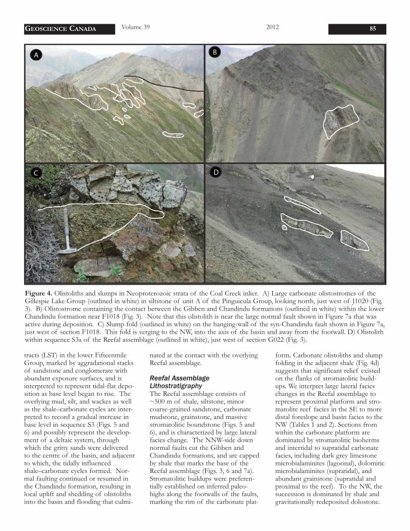
Figure 4. Olistoliths and slumps in Neoproterozoic strata of the Coal Creek inlier. A) Large carbonate olistostromes of theGillespie Lake Group (outlined in white) in siltstone of unit A of the Pinguicula Group, looking north, just west of J1020 (Fig.3). B) Olistostrome containing the contact between the Gibben and Chandindu formations (outlined in white) within the lowerChandindu formation near F1018 (Fig. 3). Note that this olistolith is near the large normal fault shown in Figure 7a that wasactive during deposition. C) Slump fold (outlined in white) on the hanging-wall of the syn-Chandindu fault shown in Figure 7a,just west of section F1018. This fold is verging to the NW, into the axis of the basin and away from the footwall. D) Olistolithwithin sequence S3a of the Reefal assemblage (outlined in white), just west of section G022 (Fig. 3).

Upper foreslope facies are dominatedby carbonate mudstone, which com-monly contain molar tooth structureand massive talus breccias that shedmaterial from the adjacent reefs. Basi-
nal facies include shale, sandstone, andre-sedimented carbonate. The complexgeometry of these facies assemblagesresults in significant variability betweenmeasured sections and abundant strati-
graphic repetition of lithologically sim-ilar shale-to-carbonate sequences (Figs.5 and 6) that was previously interpret-ed as the product of thrust faults (e.g.Thompson and Roots 1994).
86
Figure 5. Lithostratigraphy, sequence stratigraphy, and carbon isotope chemostratigraphy of the Fifteenmile Group along anESE–WNW transect of the southern belt of exposures, shown as A-A’ in Figure 3, which includes locations of the individualstratigraphic sections. Sequences S2-S7 are described in text.

Sequence StratigraphyAt the northwest end of the CoalCreek inlier, measured sections of theReefal assemblage reveal symmetrictransgressive–regressive sequencescapped by highstand stromatoliticbuildups (Fig. 7b). This architecturereflects a series of NNW-progradingstromatolite-cored reef tracts thatgrade distally into grey and black shale-dominated basinal deposits. The Reefalassemblage begins with the HST ofsequence S3 and contains four addi-tional sequences (S4–S7) that can becorrelated across the Coal Creek inlier.Several of these are compositesequence sets, which in some sectionscomprise 2 to 6 parasequences that arecorrelated with less confidence acrossthe basin (Figs. 5 and 6). The S3 HSTrecords the nucleation and growth ofthe first prominent reef system of the
Reefal assemblage on relict basementhighs, most prominently in sectionsF1018, G021, and G023 (‘ReeferCamp’). During the upper S3 HSTand subsequent HSTs, the reef systemprograded to the NNW, shedding car-bonate debris into and eventually over-riding the adjacent shale sub-basin.These episodes of progradation areinterrupted by abrupt flooding eventsmarking condensed transgressive sys-tems tracts (TSTs), the most prominentof which (base S6) flooded most ofthe basin following progradation ofthe stromatolite platform over much ofthe basin at the top of S5. Only at thecore of the reef system, in sectionG023, are carbonates nearly continu-ous. However, it is possible that depo-sition may have been interrupted dur-ing intermittent exposure of the plat-form. In the axes of the original fault-
controlled sub-basins, carbonates arefound in the form of talus breccia,slump breccia, grain flows, ribbonite,turbidite, and rhythmite (Tables 1 and2). The ~811 Ma ash bed occursbetween two carbonate sediment gravi-ty flows at the top of S6 (Fig. 5).
Throughout the Reefal assem-blage, sequences comprise coupledTSTs and HSTs, with little or no clearevidence of a significant base level fall.A superb example of a well-preservedTST–HST couplet occurs in sequenceS7b of section G021 (Fig. 6), in whichthe entire carbonate platform retro-grades over a minor subaerial discon-formity developed in suptratidal micro-bialaminites (Fig 8). The maximumflooding surface (MFS) lies in red shalejust above a minor flooding unconfor-mity, which is superseded by red marlyribbonite, followed by stromatolites
GEOSCIENCE CANADA Volume 39 2012 87
Figure 6. Lithostratigraphy, sequence stratigraphy, and carbon isotope chemostratigraphy of the Fifteenmile Group along anESE–WNW transect of northern belt of exposures near Reefer Camp, shown as B-B’ in Figure 3, which includes locations ofthe individual stratigraphic sections. Sequences S2-S7 are described in text.
and grainstone as the reef edge migrat-ed back across the platform. Theabsence of falling stage and lowstandsystems tracts in the Reefal assemblageis likely a result of broad and relativelyrapid subsidence rates across the basinthat far outpaced any eustatic sea levelfluctuations (Mitchum and Van Wag-oner 1991).
Craggy DolostoneThe uppermost sequence of the Reefalassemblage is capped by a distinct sub-aerial exposure surface overlain by theheavily silicified and informally namedCraggy dolostone. The Craggy dolo-stone forms a conspicuous, ridge-forming, >500-m-thick white dolo-stone and consists predominantly ofthick bedded and massively recrystal-lized and silicified sucrosic dolostone.
Microbialaminite and low-relief stro-matolites (up to 10 cm of relief) arevariably preserved through the perva-sive and multigenerational silicificationand recrystallization. Ooids, coatedgrains, brecciated teepee structures,tabular clast conglomerates, intraclastbreccia, and low-angle crossbeds havealso been observed. Silicification is par-ticularly intense near the upper uncon-formity that separates the Craggy dolo-stone from the overlying Callison Lakedolostone. Although the pervasive sili-cification and recrystallization chal-lenge any comprehensive facies andsequence stratigraphic analyses of theCraggy dolostone, it is evident that itrecords the development of a broadand stable carbonate platform follow-ing the filling of residual sub-basinbathymetry in the Reefal assemblage.
Callison Lake DolostoneThe Craggy dolostone is succeeded bythe Callison Lake dolostone (Abbott1997), which was recently separatedfrom the Fifteenmile Group (Macdon-ald et al. 2011) because it uncon-formably overlies the FifteenmileGroup (Macdonald and Roots 2010).Halverson et al. (2012) suggestedplacement in the Mt. Harper Group,but we leave it as an orphaned unithere awaiting formal formation andgroup designation. Near Mt. Gibben,the Callison Lake dolostone is ~500 mthick and consists of a basal siltstoneand shale sequence with laterally dis-continuous stromatolitic bioherms.This is overlain by medium-beddeddolostone interbedded with black shalethat consists almost exclusively of sedi-mentary talc (Tosca et al. 2011). Thesestrata (previously mapped as unit PF2;Thompson et al. 1994) are overlain by~200 m of a silicified dolostone char-acterized by domal stromatolites (pre-viously mapped as unit PF3). An addi-tional ~25 m interval of interbeddedblack shale and dolostone occurs justbelow the contact with the lowerMount Harper Group. We map theentire shale–carbonate sequence as theCallison Lake dolostone because thissuccession appears to form a genetical-ly continuous unit, minimizes new ter-minology and allows for straightfor-ward stratigraphic correlation betweenthe Coal Creek and Hart River inliers.
88
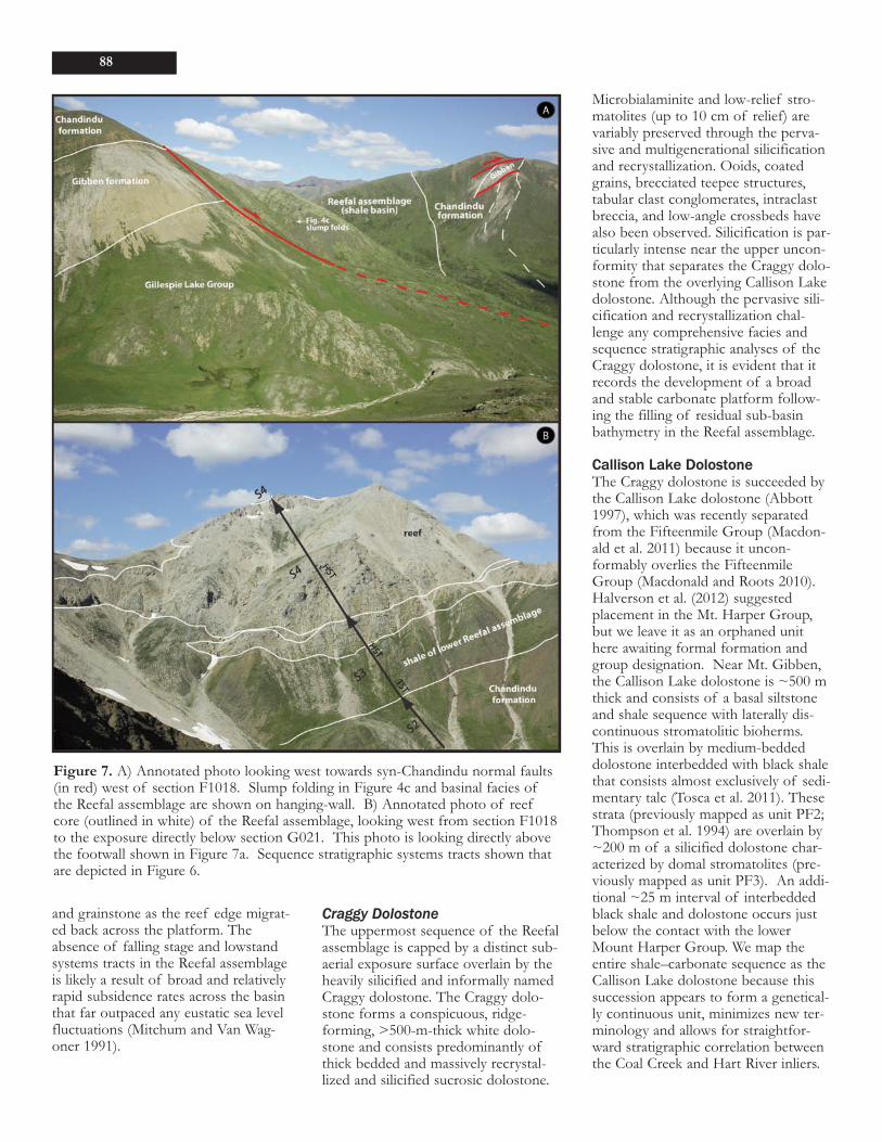
Figure 7. A) Annotated photo looking west towards syn-Chandindu normal faults(in red) west of section F1018. Slump folding in Figure 4c and basinal facies ofthe Reefal assemblage are shown on hanging-wall. B) Annotated photo of reefcore (outlined in white) of the Reefal assemblage, looking west from section F1018to the exposure directly below section G021. This photo is looking directly abovethe footwall shown in Figure 7a. Sequence stratigraphic systems tracts shown thatare depicted in Figure 6.

Mount Harper GroupLower Mount Harper GroupConglomerate and breccia of the lowerMount Harper Group overlie the Calli-son Lake dolostone north of theHarper Fault and overlie the WerneckeSupergroup and an undifferentiatedcarbonate unit to the south (Fig. 3).Near Mount Harper, the lower MountHarper Group is exposed on the northside of a syn-depositional fault scarpwhere it consists of up to 1100 m oftalus breccia and debris flow conglom-erate interpreted as coalescing alluvialfans (Mustard and Donaldson 1990;Mustard 1991). To the east, in the Mt.Gibben area, the Lower Mount HarperGroup is up to 300-m thick and con-sists predominantly of alluvial depositscommonly containing mud-cracks andconglomerate interbedded with minormarl that were deposited in a distal fanenvironment (Mustard 1991). Thelower Mount Harper Group thinsabruptly to the north away from theHarper Fault (Fig. 3).
Mount Harper Volcanic ComplexThe Mount Harper Volcanic Complex(MHVC) is divided into six informalunits that are defined both stratigraphi-cally and compositionally (Roots 1987;Mustard and Roots 1997). A lowerbasaltic suite, composed of membersA–C, comprises several hundreds ofmetres of pillowed and massive flowserupted into both subaqueous and sub-aerial settings. The lower flows overliesandstone, siltstone, and cobble con-glomerate north of the Harper Fault(Mustard and Roots 1997). Soft-sedi-ment deformation, dolostone rip-ups,and spiracles attest to the soft, dampsubstrate encountered by the initial lavaflow (Mustard and Roots 1997). Thebasal flows on the south side of theHarper fault disconformably overliethick bedded undifferentiated carbon-ates and quartzite of the PinguiculaGroup or Wernecke Supergroup,attesting to uplift and erosion of thefault block prior to volcanism.Volcanic members A and B form anedifice up to 1200 m thick. Some ofthe later eruptions were subaerial, pro-ducing agglutinated spatter cones andhematitic, autobrecciated massive flows(Mustard and Roots 1997). Holoceneerosion has provided cross-sectional
views of the edifice in which paleo-slopes and tapering flows dip awayfrom the volcanic edifice. Other steepexposures reveal that the edifice wasunevenly dissected during, or shortlyafter, members A and B were extruded,resulting in overlaps by tuff-breccia,lapilli tuff, and block-and-ash brecciadeposits of member C. The clasts areeither primary basaltic or derived fromerosion (Mustard and Roots 1997).
The upper suite consists ofthree members: D (rhyolite), E(andesite), and F (andesite). The rela-tive timing of eruption and originaldistribution of these distinct unitsremain unclear. In different localities,each unit unconformably overliesmembers A–C. Rhyolite of member Dforms thick flows and probable domes,and was dated at 717.43 ± 0.14 Ma(U/Pb CA-ID-TIMS zircon; Macdon-
GEOSCIENCE CANADA Volume 39 2012 89
Figure 8. Sequence stratigraphic systems tracts outlined in red and reefs outlinedin white; these are depicted in Figure 6 and described in text. A) Annotated photoof section G021, looking from the top peak shown in Figure 7b down the ridge tothe south. Tents are circled in yellow for scale. B) Same exposure of section G021as shown in Figure 8A, but looking east to show geometry of facies and systemstracts.

ald et al. 2010b). The age of the lowermembers of the MHVC are unknownso the temporal and spatial relationshipbetween the eruption of the lower andupper suites remains unconstrained(Mustard and Roots 1997). Member Eforms cliff exposures of columnar-jointed and shattered massive flows;these prograde over an apron of angu-lar flow shards (‘hydroclastic breccia’)that extend over an older edifice.Member F andesites form pillowedflows, breccias, tuffs, and invasiveflows that interfinger with and intrudeinto diamictites of the Rapitan Group,which includes a ~1-m thick, green topink, brecciated tuff that was dated at716.47 ± 0.24 Ma (U/Pb CA-ID-TIMSzircon; Macdonald et al. 2010b).
Mafic DykesTwo sets of mafic dykes are present inthe Coal Creek inlier. One set is ori-ented WSW–ENE and predominantlyintrudes the Wernecke Supergroup(Fig. 3). These dykes are likely correla-tive with the sheared mafic rocks thatare in fault contact with the Fifteen-mile Group near Mt. Gibben in sectionE1002 (Fig. 3) and multiple intrusionsassociated with the WSW–ENE orient-ed Ogilvie breccias. In section E1003(Fig. 3), an ESE–WNW oriented dykealso intrudes Pinguicula A.
A second set of dykes is ori-ented NNW–SSE and intrudes strataup through the lower MHVC. Thesedykes are associated with chaoticdeformation in the Lower MountHarper Group, indicating that theserocks were still soft sediments whenthe second suite was emplaced. Nodykes have been observed to intrudethe Rapitan Group. Thus, theNNW–SSE dykes appear to be associ-ated with the ca. 717 Ma upper MHVCand predate the ca. 716 Ma RapitanGroup.
STRUCTUREOur geological mapping has revealedtwo distinct sets of Precambrian struc-tures within the Coal Creek inlier (Fig.3). The oldest structures, predomi-nantly NNW-side down normal faultsoriented ~070°, cut the Chandinduformation and all of the underlyingstratigraphy and were active duringdeposition of the Pinguicula Groupand the Chandindu and Gibben forma-
tions of the Fifteenmile Group (yellowfaults, Fig. 3). These structures havethe same orientation as the Ogilviebreccias (Thompson et al. 1987, 1994)and one of the two major mafic dykesets, suggesting either a genetic rela-tionship or reactivation of earlierstructures that generated the Ogilviebreccias. It is also unclear if the fault-ing in the lower stratigraphy of the Fif-teenmile Group represents a continu-um of activity or the reactivation ofolder syn-Pinguicula structures. Thesefaults control the sedimentation pat-terns and stratal geometries between,and within, the Pinguicula Group andlower units of the Fifteenmile Group,forming two separate WSW–ENE ori-ented troughs (Figs. 3, 6 and 7). ThePinguicula Group stratigraphy appearsto thicken to the southwest into thebounding WSW–ENE faults and thesestrata do not appear farther to thesouth. The faults are truncated andcapped by the lowermost sequence ofthe Reefal assemblage of the Fifteen-mile Group, but the fault-generatedtopography was preserved throughdeposition of the remaining Reefalassemblage and is highlighted by thedistribution of stromatolite reef devel-opment.
A second set of WNW–ESEoriented, NNE-side down normalfaults cuts the entire FifteenmileGroup and underlying strata (Fig. 3).These faults were active during deposi-tion of the Mount Harper Group andare subparallel to the dykes thatintrude all of the Fifteenmile andMount Harper Group stratigraphy.Syn-extensional emplacement of thedykes is further demonstrated by soft-sediment deformation around many ofthe intrusions in the fault-controlledLower Mount Harper Group. A thirdset of normal faults, oriented ~E–W,cut the overlying Windermere Super-group and, in places, were reactivatedas structures that offset the Cambri-an–Devonian Bouvette Formation; theage and tectonic significance of thesefaults are unclear.
Cordilleran (Cretaceous) N-and NW-vergent thrust faults are com-mon south of the Dawson Thrust andon the western margin of the CoalCreek inlier, but largely absent withinthe core of the inlier. Early attempts atmapping the Proterozoic stratigraphy
in the Coal Creek inlier were con-founded by large lateral facies changein the Fifteenmile Group, in particularwithin the Reefal assemblage. Conse-quently, these earlier maps includemany inferred thrust faults (Thompsonet al. 1994), which we have reinterpret-ed as predominantly conformable con-tacts along abrupt lithological changes.
CHEMOSTRATIGRAPHYMethodsWe report 1386 new carbonate carbonand oxygen isotope measurements (seedata repository). Samples were cutperpendicular to lamination, revealinginternal textures and between 5 and 20mg of powder were micro-drilled fromthe individual laminations (where visi-ble), avoiding veining, fractures, andsiliciclastic components. Subsequentδ13Ccarb and δ18Ocarb analyses were per-formed on aliquots of this powder,acquired simultaneously on a VG Opti-ma dual inlet mass spectrometerattached to a VG Isocarb preparationdevice (Micromass, Milford, MA), inthe Harvard University Laboratory forGeochemical Oceanography. Micro-drilled samples were reacted in a com-mon, purified H3PO4 bath at 90°Cwhere evolved CO2 was collected cryo-genically and analyzed using an in-house reference gas. External error(1σ) from standards was better than ±0.1‰ for both δ13C and δ18O. Sampleswere calibrated to VPDB (Vienna Pee-Dee Belemnite) using the Carrara Mar-ble standard. Increasing the reactiontimes (~7 minutes) minimizes anypotential memory effect resulting fromthe common acid-bath system, whichis included in the precision estimatesnoted above. Carbon (δ13C) and oxy-gen (δ18O) isotopic results are reportedin per mil notation of 13C/12C and18O/16O, respectively, relative to thestandard VPDB.
Results Carbon isotope chemostratigraphy ofthe Fifteenmile Group was performedto test local, regional, and global corre-lations through large facies changes.In the basal Gibben formation of theFifteenmile Group, δ13C values risefrom ~0 to +4‰, and is a consistenttrend throughout the inlier (Figs. 5 and6). Carbon isotope values in thin car-bonate interbeds, within siliciclastic-
90
dominated strata of the overlyingChandindu formation and lower por-tion of the Reefal assemblage, arehighly variable. This is likely due, inpart, to local re-mineralization oforganic matter and proportionatelygreater contribution of 13C-depletedauthigenic cements to the whole-rockcarbonate content. Nonetheless, morecarbonate-rich facies at the top ofsequence 4b in the Mount Harpercomposite section (Fig. 5), show con-sistent values around 0‰ that risesteadily up-section to very heavy values(~+4‰).
The stromatolite reefs ofsequence 5 of the Reefal assemblagehave δ13C values that average ~+4‰.However, lateral gradients are presentin coeval strata. Above the basalflooding surface of sequence 6, δ13Cvalues increase further to ~+8‰. Thissequence contains the 811.5 ± 0.1 Maash bed (Macdonald et al. 2010b).Above the ash bed, ´13C valuesdecrease smoothly to values as low as -6‰ (Figs. 5 and 6). However, the full~14‰ isotope excursion is not presentin some sections because the interval isshale-dominated (e.g., in the MountHarper composite section, Fig. 5). Inother sections, the excursion is cut outby erosional surfaces (e.g., in the Mt.Gibben composite section, Fig. 5).The most complete section of theexcursion is exposed at Reefer Camp(section G021), which was measuredfrom a paleo-high developed above areef core (Fig. 6). There, the S7atransgression is carbonate dominated,so the whole excursion is preservedalong with two additional smallerexcursions in the S7a highstand andS7c (Fig. 6). Although a weak covari-ance between δ13C and δ18O can beobserved through these excursions (seedata repository), lateral reproducibilitythrough different facies precludeslarge-scale diagenetic alteration.
In the Craggy dolostone, δ13Cvalues increase steadily up-section andplateau at ~4‰. Although thesedolomites are dominated by cementand full of exposure surfaces, the δ13Ctrends are consistent along strike andshow no covariance with oxygen iso-topes (see data repository).
DISCUSSIONRegional CorrelationsTatonduk InlierYoung (1982) broadly divided Protero-zoic strata discontinuously exposed inthe Tatonduk inlier, a faulted anticlinenear the Yukon–Alaska border (~85km NW of Mount Harper), into theupper and lower Tindir Group. Thestratigraphically lowest exposed out-crop consists of ~150 m of grey todark brown shale, siltstone and sand-stone (‘mudstone’ unit of Young,1982). These strata are succeeded by~100 m of thin-bedded orange to lightblue dolomicrite, followed by ~275 mof shallow-water dolostone dominatedby stromatolitic buildups that are cor-relative with either Pinguicula B/C orthe Gibben formation (Macdonald etal. 2011). The carbonates are overlainby black shale and an additional 500 mor more of poorly exposed interbed-ded sandstone and shale.
At Mt. Slipper, near the north-ernmost exposures in the Tatondukinlier, carbonate strata previouslymapped as the Cambrian–OrdovicianJones Ridge Limestone (Norris 1982;Young 1982; Morrow 1999), were rein-terpreted based upon new mappingand carbon and strontiumchemostratigraphy to be part of theFifteenmile Group (Macdonald et al.,2010a, b, 2011). The exposures of theFifteenmile Group at Mount Slipperconsist of >350 m of predominantlystromatolitic dolostone and an addi-tional ~500 m of black shale withinterbedded quartz sandstone andminor carbonate that are assigned tothe Reefal assemblage. Scale microfos-sils were located within the top 10 mof the Reefal assemblage at Mt. Slipper(Macdonald et al. 2010a; Cohen et al.2011; Cohen and Knoll, 2012). Thesestrata are succeeded by a yellow-weath-ering dolostone with common intra-clast breccia, black chert nodules, andgreen siltstone and shale interbeds thatare assigned to the Craggy dolostone.The remaining stratigraphy on Mt.Slipper and the youngest exposed stra-ta in this part of the inlier consists ofheavily silicified dolostone, and it isunclear if this dolostone is temporallyequivalent to the Craggy dolostone orCallison Lake dolostone.
In the southern part of theinlier, the Fifteenmile Group is over-
lain by the Pleasant Creek Volcanics,which may be correlative with the ca.717 Ma Mount Harper Volcanic Com-plex (Macdonald et al. 2011). Glacialdiamictite with iron formation (Young1982) is correlative with the RapitanGroup in the Coal Creek inlier and theMackenzie Mountains (Macdonald et al2010b; Macdonald and Cohen 2011).Numerous mafic dykes intrude thepre-Rapitan Group strata, including theexposures at Mt. Slipper, whereas theRapitan Group and overlying stratigra-phy do not host these intrusions (Mac-donald et al. 2010a).
Hart River InlierAbbott (1997) defined six Pinguicula-correlative units beneath the CallisonLake dolostone in the Hart River inlier.The Pinguicula units include: A, B andC, and three discontinuous membersof unit D. Unit PD1 consists of aseries of shale to sandstone cycles thatbroadly make up a single depositionalsequence. Unit PD1 is conformablyoverlain by a carbonate sequencecapped by a thick, shoaling-upward,medium-bedded, bluish-grey dolostonewith abundant ooids and microbialami-nite (PD2), which is, in turn, succeededby mud-cracked siltstone and shale ofPD3 (Halverson et al. 2012). The basalsiltstone–sandstone sequence of PD1is regarded as the basal sequence ofthe Fifteenmile Group (S1), which isequivalent to the thin sandstone unit atthe base of the Gibben formation inthe Coal Creek inlier. Unit PD2 isequivalent to the carbonates of theGibben formation in the Coal Creekinlier. Unit PD3 is composed ofbrown sandstone with minor orangedolostone, which we correlate with theChandindu formation (Halverson et al.2012). Correlation between the CoalCreek and Hart River inliers indicatesthat all of the upper FifteenmileGroup is missing in the Hart River inli-er at the angular unconformity beneaththe Callison Lake dolostone (Abbott1997; Macdonald and Roots 2010).
Wernecke and Mackenzie Moun-tainsRecent stratigraphic studies in the Wer-necke Mountains (Thorkelson et al.2005; Medig et al. 2010; Turner 2011)have assigned various portions of unitsD–F of the Pinguicula Group of Eis-
GEOSCIENCE CANADA Volume 39 2012 91
bacher (1981) to the Hematite Creek,Katherine, and Little Dal groups.Moreover, Turner (2011) formallydivided the Hematite Creek Groupinto the Dolores Creek, Black CanyonCreek, and Tarn Lake formations. Thiswork facilitates correlation of the CoalCreek strata with particular formationsin the Mackenzie Mountains and Shalersupergoups. Extension of our pro-posed correlation scheme for the Pin-guicula and Fifteenmile groups in theTatonduk, Coal Creek and Hart Riverinliers to the Wernecke Mountains sug-gests that the Dolores Creek Forma-tion is equivalent to unit PD1 in theHart River inlier, that the BlackCanyon Creek Formation is equivalentto PD2 in the Hart River inlier and theGibben formation in the Coal Creek
inlier, and that the Tarn Lake Forma-tion and Katherine Group are equiva-lent to PD3 in the Hart River inlierand the Chandindu formation in theCoal Creek inlier (Figs 2 and 9).
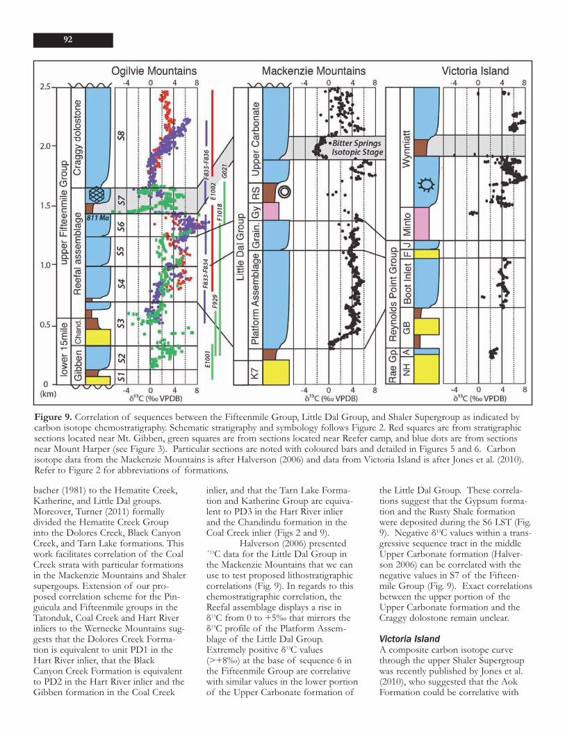
Halverson (2006) presented´13C data for the Little Dal Group inthe Mackenzie Mountains that we canuse to test proposed lithostratigraphiccorrelations (Fig. 9). In regards to thischemostratigraphic correlation, theReefal assemblage displays a rise inδ13C from 0 to +5‰ that mirrors theδ13C profile of the Platform Assem-blage of the Little Dal Group.Extremely positive δ13C values(>+8‰) at the base of sequence 6 inthe Fifteenmile Group are correlativewith similar values in the lower portionof the Upper Carbonate formation of
the Little Dal Group. These correla-tions suggest that the Gypsum forma-tion and the Rusty Shale formationwere deposited during the S6 LST (Fig.9). Negative δ13C values within a trans-gressive sequence tract in the middleUpper Carbonate formation (Halver-son 2006) can be correlated with thenegative values in S7 of the Fifteen-mile Group (Fig. 9). Exact correlationsbetween the upper portion of theUpper Carbonate formation and theCraggy dolostone remain unclear.
Victoria IslandA composite carbon isotope curvethrough the upper Shaler Supergroupwas recently published by Jones et al.(2010), who suggested that the AokFormation could be correlative with
92
Figure 9. Correlation of sequences between the Fifteenmile Group, Little Dal Group, and Shaler Supergroup as indicated bycarbon isotope chemostratigraphy. Schematic stratigraphy and symbology follows Figure 2. Red squares are from stratigraphicsections located near Mt. Gibben, green squares are from sections located near Reefer camp, and blue dots are from sectionsnear Mount Harper (see Figure 3). Particular sections are noted with coloured bars and detailed in Figures 5 and 6. Carbonisotope data from the Mackenzie Mountains is after Halverson (2006) and data from Victoria Island is after Jones et al. (2010).Refer to Figure 2 for abbreviations of formations.

the basal Little Dal Group. Here wefollow previous lithostratigraphic cor-relation schemes (e.g. Rainbird et al.1996), which correlate unit K6 of theKatherine Group with the Aok Forma-tion and, in turn, the Chandindu for-mation; however, these correlations arelimited by the lack of data in unit K6of the Katherine Group. Sequence S4of the Reefal assemblage is broadlycorrelative with the Platform Assem-blage in the Mackenzie Mountains andBoot Inlet Formation on VictoriaIsland. Sequence S5 can be correlatedwith the Grainstone formation and theFort Collinson and Jago formations onVictoria Island. Like the Gypsum For-mation, evaporites of the Minto InletFormation appear to record a periodof lowstand represented by prograda-tion of giant reef complexes in theLST of S3B. Extremely positive δ13Cvalues (>+8‰) in the lower portion ofthe Wynniatt Formation can be corre-lated with those at the base of S6 inthe Fifteenmile Group (Fig. 9). Wefollow Jones et al. (2010) and correlatethe δ13C downturn in the middle Wyn-niatt transgression with the BitterSprings isotopic stage. These correla-tions (Fig. 9) suggest that rich micro-fossil assemblages in the lower Wynni-att Formation (Butterfield and Rainbird1998; Butterfield, 2005a, b) and lessdiverse assemblages in the Rusty Shale(Butterfield and Rainbird, 1998) arestratigraphically below scale microfos-sils from the Fifteenmile Group(Cohen et al. 2011; Cohen and Knoll,2012).
Implications for NeoproterozoicCarbon Isotope ChemostratigraphyHalverson et al. (2006) suggested thatthe rise in δ13C values from 0‰ to+5‰ in the Platformal Assemblage ofthe Little Dal Group represents a glob-al rise from a carbon cycle that aver-aged 0‰ in the Mesoproterozoic toone that averaged +5‰ in the Neo-proterozoic. With no direct age con-straints on the base of these isotopicprofiles, the thickness of the strata upto the ~811 Ma ash bed is dependenton accumulation rates. It is likely thatplatformal and stromatolite dominatedfacies have higher sedimentation ratesthan basinal facies, and consequentlythe duration of the early Neoprotero-zoic +5‰ plateau (Halverson et al.
2010), which is based on the Platfor-mal Assemblage of the Little DalGroup, may be exaggerated. More-over, isotopically heavy intervals in theGibben formation (Figs. 6 and 10)indicate that this rise was not steadyand that there is probably significantvariability in late Mesoproterozoic andearly Neoproterozoic carbon isotoperecords that remains to be fully eluci-dated.
Macdonald et al. (2010) sug-gested that the 811.5 ± 0.1 Ma ash beddates the onset of the Bitter Springsisotopic stage. This interpretation isfurther supported by additional high-resolution chemostratigraphic sectionsthrough carbonate-rich strata of theupper Reefal assemblage; however, thiswork has revealed three carbon iso-topic excursions that do not have obvi-ous counterparts elsewhere (Fig. 6).The Bitter Springs anomaly in Svalbardand Australia has a double peak, withslightly positive values between themajor negative excursions (Halversonet al. 2007; Swanson-Hysell et al.2010). In this correlation scheme, thefirst downturn in the TST of S7a ofthe Reefal assemblage, which begins atca. 811.5 Ma, is equivalent to the G1surface in Svalbard, and the return topositive values in the HST of S7C atthe top of the Reefal assemblage isequivalent to the S1 surface.
Another interesting feature ofthe δ13C curve from the FifteenmileGroup is that the major negativedownturn at the base of the Reefalassemblage corresponds with the maxi-mum flooding surface of sequence S7.This can be interpreted in at least threeways: 1) there was a global decrease inthe percent of carbon buried as organ-ic carbon; 2) the transgression waseustatic and corresponded to the addi-tion and remineralization of isotopical-ly light carbon to the ocean/atmos-phere, which drove both a negativecarbon isotope excursion, warming,and transgression; or 3) isotopicallylight authigenic carbonate was prefer-entially formed locally during trans-gressive sequences. The data presentedhere demonstrates that not all of thetransgressive sequences in the succes-sion host negative isotope excursions,and that the negative δ13C excursion atthe base of S7 is broadly reproduciblein the basin where the sequence is pre-
served. Thus, if authigenesis isresponsible, it must have been wide-spread but episodic in the basin.
Basin Formation in the Coal CreekInlierBasin Event 1: The Pinguicula prel-udeActive tectonism during deposition ofthe Pinguicula Group is demonstratedby: 1) olistostromes of the GillespieLake Group within Pinguicula Groupstrata that increase in abundancetowards the south; 2) lateral facieschanges in Pinguicula B/C with stro-matolitic reefs built on paleo-highs thatgrade to the SSE into laminateddolomicrite; 3) lateral thickness varia-tions in all of the units of the Pinguic-ula Group. These thickness variationsdo not merely represent erosion associ-ated with the sub-Gibben unconformi-ty, but instead record internal thinningand truncation due to depositionalonlap of topographic relief.
The extent to which the over-lying Fifteenmile Group follows thesyn-tectonic depositional patterns ofthe Pinguicula Group in the CoalCreek inlier is remarkable. This couldbe interpreted in one of two ways: 1)the Pinguicula Group is an older basinand the Fifteenmile Group extensionand depositional patterns followed pre-existing crustal weaknesses; 2) the Pin-guicula Group was deposited in halfgraben along NNW-side down normalfaults and represents an early phase ofearly Neoproterozoic extension thatculminated in the deposition of theFifteenmile Group.
Basin Event 2: Lower FifteenmileextensionThe lowermost Fifteenmile Group ishighly variable in thickness with depo-sitional patterns defined by small fault-bounded sub-basins, resulting inwedge-shaped stratal geometries andinferred onlapping patterns (Figs. 5and 6). Northeast of Mount Harper,these faults cut through the Gibbenand Chandindu formations as NNW-side down normal faults (Fig. 3) thatare capped by the overlying Reefalassemblage.
The interpretation of thegeometry of these structures dependson the degree to which the Yukonblock has been affected by post-811
GEOSCIENCE CANADA Volume 39 2012 93

Ma vertical axis tectonic rotations. Alarge Neoproterozoic counterclockwise(CCW) rotation and dextral displace-ment between the Yukon block andLaurentia was first proposed by Eis-bacher (1981) and developed furtherby Aitken and McMechan (1991) andAbbott (1996) who incorporated paleo-magnetic evidence (Park and Jefferson1991; Park et al. 1992). The dextraldisplacement hypothesis originated as aresponse to abrupt facies changes inthe MMSG across the Snake RiverFault (Fig. 1) and paleocurrent direc-tions in the Wernecke Supergroup(Eisbacher 1981; Aitken andMcMechan 1991). Right-lateral dis-placement occurred in the late Neo-proterozoic along the Richardson FaultArray (Fig. 1) and these faults werereactivated during the Cretaceous(Norris 1997). A post-CryogenianCCW rotation was further suggestedby paleomagnetic studies on the MountHarper Volcanic Complex (Park et al.1992). Park et al. (1992) proposed an80° CCW rotation, however, he usedearlier dates with large error on theMount Harper Volcanic Complex andcorrelated the virtual pole with that ofthe Little Dal Basalt. The new ages onthe Mt. Harper Volcanic Complex andthe Franklin LIP (Macdonald et al.2010) suggest this pole should be cor-related with the grand mean pole onthe Franklin LIP (Denyszyn et al.2009) to refine this rotation. Thiswould reduce the rotation to 66° CCW.If the paleomagnetic pole on theMount Harper Volcanic Complex (Parket al. 1992) stands further scrutiny,then the pre-811 Ma WSW–ENEstructures in the Coal Creek inlierwould rotate roughly parallel with thestrike of the Mackenzie Arc and theFifteenmile Group would represent theconjugate margin of a graben formedopposite of the MMSG. If the paleo-magnetic pole cannot be reproducedand the Yukon block has not movedsubstantially relative to the autochthon,then the WSW–ENE structures wouldrepresent extension on the NW marginof Laurentia.
Basin Event 3: Mount Harper exten-sion As discussed above, the Craggy dolo-stone is unconformably overlain by theCallison Lake dolostone in the Coal
Creek inlier and this unconformityplaces the Callison Lake dolostone onthe lower Fifteenmile Group in theHart River inlier (Abbott 1997; Mac-donald and Roots 2010; Halverson etal. 2012). Silicification typicallyextends 100s of metres below thisunconformity surface, which also dis-plays evidence of localized paleokarsti-fication (Mustard and Donaldson,1990). Depositional patterns of theCallison Lake dolostone and theMount Harper Group are completelydivorced from those of the underlyingFifteenmile Group suggesting the com-mencement of an additional basin-forming episode. Locally, the lowerMount Harper Group paracon-formably overlies shale in the upper-most Callison Lake dolostone andunconformably overlies the QuartetGroup (Fig. 3), which suggests pro-nounced synsedimentary fault activity(Mustard, 1991). Clasts within theconglomerate display an invertedstratigraphy, with clasts of theyoungest units on the footwall domi-nating the lowest conglomerates on thehanging-wall, and clasts of older unitsbecoming more common upwards inthe congolomerate, demonstrating thatit formed while progressively erodingstrata on the footwall. Much of theoverlying Mount Harper VolcanicComplex formed via subaerial erup-tions, suggesting that the volcanicsfilled much of the graben (Fig. 9).Where the volcanics taper to the north,the overlying glacial diamictite of theRapitan Group thickens significantly.
The Callison Lake dolostoneand Mount Harper Group occupy anequivalent stratigraphic position withthe Coates Lake Group of theMackenzie Mountains (Macdonald andRoots, 2010). In the Mackenzie Moun-tains, the Coates Lake Group and LittleDal Basalt unconformably overlie theMMSG in NNW-oriented grabens thatformed in response to right-lateraltranstension (Jefferson 1978). CoatesLake- to Rapitan-age folding is alsopresent in the Mackenzie Mountainsand is responsible for paleohighs thatformed along transpressional segmentsof transfer zones (Jefferson 1978).
The Make-Up and Break-Up ofRodiniaThe exact timing and geometry for
both the formation and the breakup ofRodinia has remained elusive. Situatedat the NW corner of Laurentia, and inthe centre of Rodinia (Li et al. 2008b),the Yukon occupies an important posi-tion for distinguishing between tecton-ic events occurring on the northernand western margins of Laurentia.Recent paleomagnetic studies provide aRodinia reconstruction that is “longer-lasting and tighter-fitting” (Li andEvans 2011), and these data requirethat Australia and Laurentia cametogether after 1070 Ma with a ‘missinglink’ presiding in-between, and subse-quently separated between ca. 750 and650 Ma. Paleomagnetic andgeochronologic data indicate thatSouth China may be the ‘missing link’(Li et al., 1995, 2008b). South China isa composite Neoproterozoic continentconsisting of the Cathaysia andYangtze blocks, which converged dur-ing the ca. 835 Ma Sibao orogeny(Wang et al. 2012). In the ‘missinglink’ model, the Cathaysia Block was afragment of Mesoproterozoic Lauren-tia and the Yangtze Block providedwesterly-derived 1600–1490 Ma zirconsto the Belt Supergroup (Ross et al.1992; Ross and Villeneuve 2003). TheSibao Orogeny may have also provideda more local source of Grenville-age1.2–1.0 Ma zircons to the western mar-gin of Laurentia (Li et al. 2008a) thathave previously been attributed to atranscontinental river system (Rainbirdet al. 1997). However, no early Neo-proterozoic foreland basin or orogenhas been identified on the westernmargin of Laurentia to suggest a linkto this orogenic event. Possible excep-tions occur in the Coppermine homo-cline (Fig. 1), where two sets of struc-tures deform the ca. 1270 Ma Copper-mine River Group and predate theShaler Supergroup (Hildebrand andBaragar 1991), and in the WerneckeMountains, where NW-vergent folds inthe Hematite Creek and Katherinegroups have been assigned to the CornCreek Orogeny (Eisbacher 1981;Thorkelson 2000; Thorkelson et al.2005). Neoproterozoic folding hasalso been described in the Coates Lakeand Rapitan groups in the MackenzieMountains (Helmstaedt et al.1979; Eis-bacher 1981), and in the Shaler Super-group on Victoria Island (Heaman etal. 1992; Bedard et al. 2012), but these
94
structures appear to be too young tobe correlative with the Sibao orogeny.
The Fifteenmile Group andequivalent strata in the MackenzieMountains and Victoria Island, can bebroadly correlated to the ShihuidingFormation of the Cathaysia Block, andthe Ziajiang, Danzhou and Banxigroups of the Yangtzee Block (Wanget al. 2011), the lower Callana Group inSouth Australia, the Bitter Springs For-mation and equivalents in central Aus-tralia (Walter et al. 1995). Like the Fif-teenmile Group, these Chinese basinsalso contain ca. 810 Ma tuff horizons(Wang et al. 2012). The ‘missing link’model predicts that more ca. 800 Magrains from the Sibao orogeny will bediscovered in the uppermost Fifteen-mile Group or overlying strata. Inter-estingly, significant ca. 800 Ma popula-tions have been discovered in theUinta Mountains Group of Utah(Dehler et al. 2010), which may havebeen sourced from South China.Additionally, new age constraints onsuccessions in the western US indicatethat there are no known basins thatformed between 1.0 and 0.8 Gabetween 62° N and Mexico (Dehler etal., 2010, 2011), such that the basinforming event that accommodated theFifteenmile Group and equivalents inthe Shaler Supergroup and MMSG is aphenomenon of the NW margin ofLaurentia and cannot represent riftingon the whole of the western margin,contrary to the simple-shear rift modelproposed to accommodate the MMSG(Turner and Long 2008). We suggestinstead that the inferred NE–SW ori-ented faults in the MMSG of Turnerand Long (2008) are coeval with thefaults in the basal Fifteenmile Groupand also represent normal faults ratherthan transfer faults. This is consistentwith Aitken’s (1981) previous interpre-tation of the Little Dal Group, whichsuggested deepening to the NNW.
Based on the assumption thatthe early Neoproterozoic conjugatemargin to Laurentia was South China,we propose a new model for the earlyNeoproterozoic tectonic evolution ofnorthwest Canada. The coincidencebetween basin formation in SouthChina, Australia, and NW Canada atca. 830 Ma, and the emplacement ofthe Gubei and Gairdner LIPs in SouthChina and Australia between 830 and
810 (Wingate et al. 1998; Li et al. 1999;Wang et al., 2008) suggests a mechanis-tic link. We propose that these stratawere accommodated by extension andthe subsequent thermal decay associat-ed with the passing of Rodinia over aplume. In this model, the Reefalassemblage and Craggy dolostone areassociated with the thermal decay ofthis plume. Deposition culminatedwith the intrusion of the 780 Ma Gun-barrel dykes—the nature of thisigneous event remains poorly under-stood. This model is further consis-tent with the inference of Rainbird etal. (1996) that Sequence B formed inan intracratonic basin.
The ca. 717 Ma NNE-sidedown normal faults in the Coal Creekinlier represent a reactivation of theNW margin of Laurentia. Geologicaland geochronological data suggest thatSiberia occupied a position north ofthe Yukon during the Neoproterozoic(Rainbird et al. 1998). Moreover, dykesof approximately Franklin age arepresent in southwestern Siberia (Glad-kochub et al. 2006; Bedard et al. 2012;).Rainbird (1993) further documentedfault-bounded graben with coarse ter-restrial fill in the upper Shaler Super-group, immediately beneath the ca. 723Ma Natkusiak basalts. Although arecord of later Cryogenian thermalsubsidence is not present in VictoriaIsland where there is no section pres-ent above the Natkusiak basalts (Rain-bird 1993), a Cryogenian passive mar-gin succession on the northern marginof Laurentia may be recorded in thesubsurface west of Melville Island(Helwig et al. 2011) and in the Katak-turuk Dolomite on the parautochtho-nous North Slope subterrane (Mac-donald et al. 2009). Thus, a scenarioconsistent with all of these data is thatextension occurred in the early Neo-proterozoic between Siberia and north-west Laurentia, creating space betweenthe two cratons and separating theirrespective APW paths (Rainbird et al.1998; Khudoley et al. 2001; Evans2009); however this extension may nothave manifested itself in full riftingwith the development of oceanic crust,such that both margins were lateraffected by additional extension andthe emplacement of the ca. 720 MaFranklin LIP.
The nature of Cryogenian
basin formation on the western marginof Laurentia remains enigmatic. Asdiscussed above, the presence of bothCryogenian normal faults and foldingimplies a transtensional–transpressionalsetting for Windermere-age rifting (Jef-ferson and Parrish 1989). Transtensionmay further account for the irregulardistribution of Cryogenian strata inYukon (Macdonald et al. 2011) and thelack of significant crustal thinning untilthe latest Ediacaran (Colpron et al.2002), consistent with thermal subsi-dence models that indicate final riftingin the earliest Cambrian (Bond andKominz 1984). Full description ofCryogenian and Ediacaran basins isbeyond the scope of this paper and thelater Neoproterozoic tectonic evolu-tion of NW Laurentia remains to beelucidated with future work.
CONCLUSIONSGeological mapping, chemostratigra-phy and sequence stratigraphic analysisof Neoproterozoic strata in Yukonmotivate revised correlation of theearly Neoproterozoic deposits ofnorthwest Canada. These resultsdemonstrate that at least three andpossibly four basin-forming events arerecorded in Neoproterozoic strata ofYukon. The Pinguicula Group consti-tutes the oldest succession and its ageand accommodation history remainpoorly constrained. Subsidence anddeposition of the Fifteenmile Groupinitiated prior to ~811 Ma as a resultof NNW-side down normal faulting(present coordinates). The extensionthat accommodated the FifteenmileGroup is coincident with the passingof a plume under Rodinia and theemplacement of large igneousprovinces and the formation of failedintracontinental rift basins in SouthChina and Australia. Large stromato-lite-cored reef systems of the Reefalassemblage developed on these paleo-highs and prograded to the NNW in aseries of highstand systems tracts,shedding reworked carbonate into andgradually filling deep-water, shale sub-basins. The basin was reactivated withca. 717 Ma NNE-side down normalfaulting in the Yukon and the emplace-ment of the Franklin large igneousprovince on the northern margin ofLaurentia.
GEOSCIENCE CANADA Volume 39 2012 95
ACKNOWLEDGMENTSWe thank Paul Hoffman for inspirationand his stamina for discussing geologylate into the night. The Yukon Geolog-ical Survey (FM and GH), NSERC(GH), the MIT node of the NASAAstrobiology Institute (FM), and theAmerican Chemical Society PetroleumResearch Fund (GH) have supportedthis project. We thank Fireweed Heli-copters for reliable transportation, andMaurice Colpron and Don Murphy forhelpful conversations. We thank DanSchrag, Sasha Breus, and Greg Eis-chied for assistance in the Laboratoryfor Geochemical Oceanography atHarvard University. We would also liketo thank the Roots family for theirhospitality and generosity.
REFERENCES Abbott, G., 1996, Implications of probable
late Proteorozoic dextral strike-slipmovement on the Snake River fault, inProceedings Slave-Northern CordilleraLithosphere Experiment, LithoprobeReport #50.
Abbott, G., 1997, Geology of the UpperHart River Area, Eastern OgilvieMountains, Yukon Territory(116A/10, 116A/11): Exploration andGeological Services Division, YukonRegion, Bulletin 9, p. 1-76.
Aitken, J. D., 1981, Stratigraphy and Sedi-mentology of the Upper ProterozoicLittle Dal Group, Mackenzie Moun-tains, Northwest Territories, in Camp-bell, F. H. A., ed., Proterozoic Basinsof Canada, Geological Survey ofCanada Paper 81-10, p. 47-71.
Aitken, J. D., and Long, D. G. F., 1978,Mackenzie tectonic arc—Reflection ofearly basin configuration?: Geology, v.6, p. 626-629.
Aitken, J. D., and McMechan, M. E., 1991,Middle Proterozoic assemblages,Chapter 5, in Gabrielse, H., andYorath, C. J., eds., Geology of theCordilleran Orogen in Canada, Vol-ume 4, Geological Survey of Canada,p. 97-124.
Bedard, J. H., Naslund, H. R., Nabelek, P.,Winpenny, A., Hryciuk, M., Macdon-ald, W., Hayes, B., Steigerwaldt, K.,Hadlari, T., Rainbird, R. H., Dewing,K., and Girard, E., 2012, Fault-medi-ated melt ascent in a Neoproterozoiccontinental flood basalt province, theFranklin sills, Victoria Island, Canada:Geological Society of America Bul-letin, v. 124, no. 5/6, p. 723-736.
Bond, G. C., and Kominz, M. A., 1984,Construction of tectonic subsidence
curves for the early Paleozoic miogeo-cline, southern Canadian RockyMountains: implications for subsi-dence mechanisms, age of breakup,and crustal thinning: Geological Socie-ty of America Bulletin, v. 95, no. 2, p.155-173.
Butterfield, N. J., 2005a, Probable Protero-zoic fungi: Paleobiology, v. 31, no. 1,p. 165-182.
-, 2005b, Reconstructing a complex earlyNeoproterozoic eukaryote, WynniattFormation, Arctic Canada: Lethaia, v.38, no. 2, p. 155-169.
Butterfield, N. J., and Rainbird, R. H.,1998, Diverse organic-walled fossils,including “possible dinoflagellates,”from the early Neoproterozoic ofArctic Canada: Geology, v. 26, no. 11,p. 963-966.
Cecile, M. P., 1982, The lower PaleozoicMisty Creek Embayment, SelwynBasin, Yukon and Northwest Territo-ries: Geological Survey of CanadaBulletin, v. 335, p. 78.
Cecile, M.P., 2000, Geology of the north-eastern Niddery Lake map area, eastcentral Yukon and adjacent NorthwestTerritories: Geological Survey ofCanada Bulletin, v. 553, p. 120.
Cecile, M. P., Marrow, D. W., and Williams,G. K., 1997, Early Paleozoic (Cambri-an to Early Devonian) tectonic frame-work, Canadian Cordillera: Bulletin ofCanadian Petroleum Geology, v. 45, p.54-74.
Cohen, P. A., and Knoll, A. H., 2012, Scalemicrofossils from the mid-Neopro-terozoic Fifteenmile Group, YukonTerritory: Journal of Paleontology, v.86, no. 5, p. 775-800.
Cohen, P. A., Schopf, J. W., Kudryaytsev,A., Butterfield, N. J., and Macdonald,F. A., 2011, Phosphate biomineraliza-tion in mid-Neoproterozoic protists:Geology, v. 39, no. 6, p. 539-542.
Colpron, M., Logan, J. M., and Mortensen,J. K., 2002, U-Pb zircon age constraintfor late Neoproterozoic rifting and ini-tiation of the lower Paleozoic passivemargin of western Laurentia: Canadi-an Journal of Earth Sciences, v. 39, p.133-143.
Dalziel, I. W. D., 1991, Pacific margins ofLaurentia and East Antarctica-Aus-tralia as a conjugate rift pair: Evidenceand implications for an Eocambriansupercontinent: Geology, v. 19, p. 598-601.
Dalziel, I. W. D., 1997, Neoproterozoic-Paleozoic geography and tectonics:review, hypothesis, environmentalspeculation: Geological Society ofAmerica Bulletin, v. 109, p. 16-42.
Dehler, C. M., Crossey, L. J., Fletcher, K.
E. K., Karlstrom, K. E., Williams, M.L., Jercinovic, M. J., Gehrels, G.,Pecha, M., and Heizler, M. T., 2011,ChUMP Connection (Chuar-UintaMountain-Pahrump): Geochronologicconstraints for correlating ca. 750 MaNeoproterozoic successions of south-western Laurentia, in ProceedingsGeologiacl Society of AmericaAbstracts with Programs, Denver,2011, Volume 43, p. 55.
Dehler, C. M., Fanning, C. M., Link, P. K.,Kingsbury, E. M., and Rybczynski, D.,2010, Maximum depositional age andprovenance of the Uinta MountainGroup and Big Cottonwood Forma-tion, northern Utah: Paleogeographyof rifting western Laurentia: Geologi-cal Society of America Bulletin, v. 122,no. 9/10, p. 1686-1699.
Delaney, G. D., 1981, The mid-ProterozoicWernecke Supergroup, WerneckeMountains, Yukon Territory, in Camp-bell, F. H. A., ed., Proterozoic basinsof Canada: Ottawa, Geological Surveyof Canada Paper 81-10, p. 1-23.
Denyszyn, S. W., Davis, D. W., and Halls,H. C., 2009, Paleomagnetism and U-Pb geochronology of the ClarenceHead dykes, Arctic Canada: orthogo-nal emplacement of mafic dykes in alarge igneous province: Canadian Jour-nal of Earth Sciences, v. 46, p. 155-167.
Donnadieu, Y., Godderis, Y., Ramstein, G.,Nedelec, A., and Meert, J., 2004, A‘snowball Earth’ climate triggered bycontinental break-up through changesin runoff: Nature, v. 428, p. 303-306.
Dudás, F. O., and Lustwerk, R. L., 1997,Geochemistry of the Little Dalbasalts: continental tholeites from theMackenzie Mountains, Northwest Ter-ritories, Canada: Canadian Journal ofEarth Sciences, v. 34, p. 50-58.
Eisbacher, G. H., 1981, Sedimentary tec-tonics and glacial record in the Win-dermere Supergroup, MackenzieMountains, northwestern Canada:Geological Survey of Canada Paper80-27, p. 1-40.
Evans, D. A. D., 2009, The palaeomagneti-cally viable long-lived and all-inclusiveRodinia supercontinent reconstruc-tion, in Murphy, J. B., Keppie, J. D.,and Hynes, A., eds., Ancient Orogensand Modern Analogues, Volume 327:London, Geological Society of Lon-don Special Publication, p. 371-404.
Furlanetto, F., Thorkelson, D. J., Davis, W.J., Gibson, H. D., Rainbird, R. H., andMarshall, D. D., 2009, Preliminaryresults of detrital zircon geochronolo-gy, Wernecke Supergroup, Yukon, inWeston, L. H., Blackburn, L. R., and
96

Lewis, L. L., eds., Yukon Explorationand Geology 2008: Whitehorse, YT,Yukon Geological Survey, p. 125-135.
Gabrielse, H., 1972, Younger Precambrianof the Canadian Cordillera: AmericanJournal of Science, v. 272, p. 521-536.
Gladkochub, D. P., Wingate, M. T. D., Pis-arevsky, S. A., Donskaya, T. V.,Mazukabzov, A. M., Ponomarchuk, V.A., and Stanevich, A. M., 2006, Maficintrusions in southwestern Siberia andimplications for a Neoproterozoicconnection with Laurentia: Precambri-an Research, v. 147, p. 260-278.
Godderis, Y., Donnadieu, Y., Nedelec, A.,Dupre, B., Dessert, C., Grard, A.,Ramstein, G., and Francois, L. M.,2003, The Sturtian ‘snowball’ glacia-tion: fire and ice: Earth and PlanetaryScience Letters, v. 6648, p. 1-12.
Goodge, J. W., Vervoort, J. D., Fanning, C.M., Brecke, D. M., Farmer, G. L.,Williams, I. S., Myrow, P. M., andDePaulo, D. J., 2008, A positive test ofEast Antarctica-Laurentia juxtaposi-tion within the Rodinia superconti-nent: Science, v. 321, p. 235-240.
Gordey, S. P., and Anderson, R. G., 1993,Evolution of the northern Cordilleramiogeocline, Nahanni map area (105I) Yukon and Northwest Territories:Geological Survey of Canada Memoir,v. 428, p. 214.
Hall, K. W., and Cook, F. A., 1998, Geo-physical transect of the Eagle Plainsfoldbelt and Richardson Mountainsanticlinorium, northwestern Canada:Geological Society of America Bul-letin, v. 110, no. 3, p. 311-325.
Halverson, G. P., 2006, A Neoproterozoicchronology, in Xiao, S., and Kaufman,A. J., eds., Neoproterozoic Geobiologyand Paleobiology, Volume Topics inGeobiology 27: New York, NY,Springer, p. 231-271.
Halverson, G. P., Macdonald, F. A., Strauss,J. V., Smith, E. F., Cox, G. M., andHubert-Theou, L., 2012, Updated def-inition and correlation of the lowerFifteenmile Group in the central andeastern Ogilvie Mountains, in MacFar-lane, K. E., and Sack, P. J., eds., YukonExploration Geology 2011: White-horse, Yukon Geological Survey, p.75-90.
Halverson, G. P., Maloof, A. C., Schrag, D.P., Dudas, F. O., and Hurtgen, M. T.,2007, Stratigraphy and geochemistryof a ca 800 Ma negative carbon iso-tope interval in northeastern Svalbard:Chemical Geology, v. 237, p. 5-27.
Halverson, G. P., Wade, B. P., Hurtgen, M.T., and Barovich, K. M., 2010, Neo-proterozoic Chemostratigraphy: Pre-cambrian Research, v. 182, no. 4, p.
337-350.Harlan, S. S., Heaman, L. M., LeChemi-
nant, A. N., and Premo, W. R., 2003,Gunbarrel mafic magmatic event: akey 780 Ma time marker for Rodiniaplate reconstructions: Geology, v. 31,p. 1053-1056.
Heaman, L. M., LeCheminant, A. N., andRainbird, R. H., 1992, Nature and tim-ing of Franklin igneous events, Cana-da: Implications for a Late Proterozoicmantle plume and the break-up ofLaurentia: Earth and Planetary ScienceLetters, v. 109, p. 117-131.
Helmstaedt, H., Eisbacher, G. H., andMcGregor, J. A., 1979, Copper miner-alization near an intra-Rapitan uncon-formity, Nite copper prospect,Mackenzie Mountains, Northwest Ter-ritories, Canada: Canadian Journal ofEarth Sciences, v. 16, p. 50-59.
Helwig, J., Kumar, N., Emmet, P., andDinkelman, M. G., 2011, Regionalseismic interpretation of crustalframework, Canadian Arctic passivemargin, Beaufort Sea, with commentson petroleum potential, in Spencer, A.M., Embry, A. F., Gautier, D. L.,Stoupakova, A. V., and Sorensen, K.,eds., Arctic Petroleum Geology, Vol-ume 35: London, Geological Society,p. 527-543.
Hildebrand, R. S., and Baragar, W. R. A.,1991, On folds and thrusts affectingthe Coppermine River Group, north-western Canadian Shield: CanadianJournal of Earth Sciences, v. 28, p.523-531.
Hoffman, P. F., 1991, Did the breakout ofLaurentia turn Gondwanaland inside-out?: Science, v. 252, no. 5011, p.1409-1412.
Hoffman, P. F., Kaufman, A. J., Halverson,G. P., and Schrag, D. P., 1998, A Neo-proterozoic Snowball Earth: Science,v. 281, p. 1342-1346.
Hoffman, P. F., and Schrag, D. P., 2002,The snowball Earth hypothesis; test-ing the limits of global change: TerraNova, v. 14, no. 3, p. 129-155.
Jefferson, C. W., 1978, The Upper Protero-zoic Redstone Copper Belt, MackenzieMountains, Northwest Territories[Ph.D: University of Western Ontario,445 p.
Jefferson, C. W., and Parrish, R., 1989, LateProterozoic stratigraphy, U/Pb zirconages and rift tectonics, MackenzieMountains, northwestern Canada:Canadian Journal of Earth Sciences, v.26, p. 1784-1801.
Jeletsky, J. A., 1962, Pre-CretaceousRichardson Mountains Trough—itsplace in the tectonic framework ofArctic Canada and its bearing on some
geosynclinal concepts: Transactions ofthe Royal Society of Canada, v. 56, p.55-84.
Jones, D. S., Maloof, A. C., Hurtgen, M. T.,Rainbird, R. H., and Schrag, D. P.,2010, Regional and global chemostrati-graphic correlation of the early Neo-proterozoic Shaler Supergroup, ArcticCanda: Precambrian Research, v. 181,p. 43-63.
Kerans, C., Ross, G. M., Donaldson, J. A.,and Geldsetzer, H. J., 1981, Tectonismand depositional history of theHelikian Hornby Bay and Dismallakes groups, District of Mackenzie, inCampbell, F. H. A., ed., ProterozoicBasins, Volume Paper 81-10: Ottawa,Geological Survey of Canada, p. 157-182.
Khudoley, A. K., Rainbird, R. H., Stern, R.A., Kropachev, A. P., Heaman, L. M.,Zann, A. M., Podkovyrov, V. N., Belo-va, V. N., and Sukhorukov, V. I., 2001,Sedimentary evolution of the Riph-ean-Vendian basin of southeasternSiberia: Precambrian Research, v. 111,p. 129-163.
Kirschvink, J. L., 1992, Late Proterozoiclow-latitude global glaciation: thesnowball earth, in Schopf, J. W., andKlein, C., eds., The Proterozoic Bios-phere: Cambridge, Cambridge Univer-sity Press, p. 51-52.
Li, Z.-X., and Evans, D. A. D., 2011, LateNeoproterozoic 40° intraplate rotationwithin Australia allows for a tighter-fitting and longer lasting Rodinia:Geology, v. 39, no. 1, p. 39-42.
Li, Z.-X., Kinny, P. D., and Wang, J., 1999,The breakup of Rodinia: did it startwith a mantle plume beneath SouthChina?: Earth and Planetary ScienceLetters, v. 173, p. 171-181.
Li, Z.-X., Li, X.-H., Li, W.-X., and Ding, S.,2008a, Was Cathaysia part of Protero-zoic Laurentia?—new data fromHainan Island, south China: TerraNova, v. 20, p. 154-164.
Li, Z.-X., Zhang, L., and Powell, C. M.,1995, South China in Rodinia: Part ofthe missing link between Australia-East Antarctica and Laurentia?: Geol-ogy, v. 23, no. 5, p. 407-410.
Li, Z. X., Bogdanova, S. V., Collins, A. S.,Davidson, A., De Waele, B., Ernst, R.E., Fitzsimons, I. C. W., Fuck, R. A.,Gladkochub, D. P., Jacobs, J., Karl-strom, K. E., Lu, S., Natapov, L. M.,Pease, V., Pisarevsky, S. A., Thrane, K.,and Vernikovsky, V., 2008b, Assembly,configuration, and break-up history ofRodinia: A synthesis: PrecambrianResearch, v. 160, no. 1-2, p. 179-210.
Lister, G. S., Etheridge, M. A., andSymonds, P. A., 1986, Detachment
GEOSCIENCE CANADA Volume 39 2012 97
faulting and the evolution of passivecontinental margins: Geology, v. 14, p.246-250.
Lund, K., Aleinikoff, J. N., Evans, K. V.,and Fanning, C. M., 2003, SHRIMPgeochronology of NeoproterozoicWindermere Supergroup, centralIdaho: implications for rifting of west-ern Laurentia and synchroneity ofSturtian glacial deposits: GeologicalSociety of America Bulletin, v. 115, p.349-372.
Macdonald, F. A., and Cohen, P. A., 2011,The Tatonduk inlier, Alaska-Yukonborder, in E., A., Halverson, G. P., andShields-Zhou, G., eds., The GeologicalRecord of Neoproterozoic Glacia-tions, Volume 36: London, GeologicalSociety of London, p. 389-396.
Macdonald, F. A., Cohen, P. A., Dudás, F.O., and Schrag, D. P., 2010a, EarlyNeoproterozoic scale microfossils inthe Lower Tindir Group of Alaskaand the Yukon Territory: Geology, v.38, p. 143-146.
Macdonald, F. A., McClelland, W. C.,Schrag, D. P., and Macdonald, W. P.,2009, Neoproterozoic glaciation on acarbonate platform margin in ArcticAlaska and the origin of the NorthSlope subterrane: Geological Societyof America Bulletin, v. 121, p. 448-473.
Macdonald, F. A., and Roots, C. F., 2010,Upper Fifteenmile Group in theOgilvie Mountains and correlations ofearly Neoproterozoic strata in thenorthern Cordillera, in MacFarlane, K.E., Weston, L. H., and Blackburn, L.R., eds., Yukon Exploration and Geol-ogy 2009: Whitehorse, YT, YukonGeological Survey, p. 237-252.
Macdonald, F. A., Schmitz, M. D., Crowley,J. L., Roots, C. F., Jones, D. S., Maloof,A. C., Strauss, J. V., Cohen, P. A.,Johnston, D. T., and Schrag, D. P.,2010b, Calibrating the Cryogenian:Science, v. 327, p. 1241-1243.
Macdonald, F. A., Smith, E. F., Strauss, J.V., Cox, G. M., Halverson, G. P., andRoots, C. F., 2011, Neoproterozoicand early Paleozoic correlations in thewestern Ogilvie Moutnains, Yukon, inMacFarlane, K. E., Weston, L. H., andRelf, C., eds., Yukon Exploration andGeology 2010: Whitehorse, YukonGeological Survey, p. 161-182.
Martel, E., Turner, E. C., and Fischer, B. J.,2011, Geology of the central Macken-zie Mountains of the northern Cana-dian Cordillera, Sewki Mountain(105P), Mount Eduni (106A), andnorthwestern Wrigley Lake (95M)map-areas, Northwest Territories,NWT Special Volume, Volume 1: Yel-
lowknife, CA, NWT GeoscienceOffice, p. 423.
Medig, K. P., Thorkelson, D. J., and Dun-lop, R. L., 2010, The Proterozoic Pin-guicula Group: stratigraphy, contactrelations, and possible correlations, inMcFarlane, K. E., Weston, L. H., andBlackburn, L. R., eds., Yukon Explo-ration and Geology 2009: Whitehorse,YT, Yukon Geological Survey, p. 265-278.
Mitchum, R. M., Jr., and Van Wagoner, J.C., 1991, High-frequency sequencesand their stacking patterns: sequencestratigraphic evidence for high-fre-quency eustatic cycles: SedimentaryGeology, v. 70, p. 131-160.
Moores, E. M., 1991, Southwest US-EastAntarctic (SWEAT) connection: ahypothesis: Geology, v. 19, p. 425-428.
Mustard, P. S., 1991, Normal faulting andalluvial-fan deposition, basal Winder-mere Tectonic Assemblage, Yukon,Canada: Geological Society of Ameri-ca Bulletin, v. 103, p. 1346-1364.
Mustard, P. S., and Donaldson, J. A., 1990,Paleokarst breccias, calcretes, silcretesand fault talus breccias at the base ofupper Proterozoic “Windermere” stra-ta, northern Canadian Cordillera: Jour-nal of Sedimentary Petrology, v. 60,no. 4, p. 525-539.
Mustard, P. S., and Roots, C. F., 1997, Rift-related volcanism, sedimentation, andtectonic setting of the Mount HarperGroup, Ogilvie Mountains, YukonTerritory: Geological Survey of Cana-da Bulletin, v. 492, p. 0-92.
Norris, D. K., 1978, Preliminary geologicalmap of the Porcupine River area,Geological Survey of Canada MapSheets H6J and H6K (E1/2).
Norris, D. K., 1982, Geology, OgilvieRiver, Yukon Territory, GeologicalSurvey of Canada, Map 1526A,1:250,000 scale.
Norris, D. K., 1997, Geology and mineraland hydrocarbon potential of north-ern Yukon Territory and northwesternDistrict of Mackenzie, Ottawa, Geo-logical Survey of Canada, GeologicalSurvey of Canada, Bulletin 422, 397p.:
Park, J. K., and Jefferson, C. W., 1991,Magnetic and tectonic history of thelate Proterozoic upper Little Dal andCoates Lake Groups of northwesternCanada: Precambrian Research, v. 52,p. 1-35.
Park, J. K., Norris, D. K., and Larochelle,A., 1989, Paleomagnetism and the ori-gin of the Mackenzie Arc of north-western Canada: Canadian Journal ofEarth Sciences, v. 26, p. 2194-2203.
Park, J. K., Roots, C. F., and Brunet, N.,
1992, Paleomagnetic evidence forrotation in the Neoproterozoic MountHarper volcanic complex, OgilvieMountains, Yukon Territory: CurrentResearch, Part E: Geological Survey ofCanada Paper 92-1E, p. 1-10.
Rainbird, R. H., 1993, The sedimentaryrecord of mantle plume uplift preced-ing eruption of the NeoproterozoicNatkusiak flood basalt: Journal ofGeology, v. 101, p. 305-318.
Rainbird, R. H., Jefferson, C. W., andYoung, G. M., 1996, The early Neo-proterozoic sedimentary Succession Bof Northwestern Laurentia: Correla-tions and paleogeographic signifi-cance: Geological Society of AmericaBulletin, v. 108, p. 454-470.
Rainbird, R. H., McNicoll, V. J., Theriault,R. J., Heaman, L. M., Abbott, J. G.,Long, D. G. F., and Thorkelson, D. J.,1997, Pan-continental River SystemDraining Grenville Orogen Recordedby U-Pb and Sm-Nd Geochronologyof Neoproterozoic Quartzarenites andMudrocks, Northwestern Canada:Journal of Geology, v. 105, p. 1-17.
Rainbird, R. H., Stern, R. A., Khudoley, A.K., Kropachev, A. P., Heaman, L. M.,and Sukhorukov, V. I., 1998, U-Pbgeochronology of Riphean sandstoneand gabbro from southeast Siberia andits bearing on the Laurentia-Siberiaconnection: Earth and Planetary Sci-ence Letters, v. 164, p. 409-420.
Ross, G. M., Parrish, R. R., and Winston,D., 1992, Provenance and U-Pbgeochronology of the Mesoprotero-zoic Belt Supergroup (northwesternUnited States): implications for age ofdeposition and pre-Panthalassa platereconstructions: Earth and PlanetaryScience Letters, v. 113, p. 57-76.
Ross, G. M., and Villeneuve, M. E., 2003,Provenance of the Mesoproterozoic(1.45 Ga) Belt basin (western NorthAmerica): another piece in the pre-Rodinia paleogeographic puzzle: Geo-logical Society of America Bulletin, v.115, p. 1191-1217.
Schrag, D. P., Berner, R. A., Hoffman, P. F.,and Halverson, G. P., 2002, On theinitiation of snowball Earth: Geo-chemistry, Geophysics, Geosystems, v.3.
Schwab, D. L., Thorkelson, D. J.,Mortensen, J. K., Creaser, R. A., andAbbott, J. G., 2004, The Bear Riverdykes (1265-1269 Ma): westward con-tinuation of the Mackenzie dykeswarm into Yukon, Canada: Precam-brian Research, v. 133, no. 3-4, p. 175-186.
Sears, J. W., and Price, R. A., 2003, Tight-ening the Siberian connection to west-
98

ern Laurentia: Geological Society ofAmerica Bulletin, v. 115, p. 943-953.
Swanson-Hysell, N. L., Rose, C.V., Calmet,C.C., Halverson, G.P., Hurtgen, M.T.,Maloof, A.C., 2010, Cryogenian glacia-tion and the onset of carbon-isotopedecoupling: Science, v. 328, p. 608-611.
Thompson, R. I., Mercier, B., and Roots, C.F., 1987, Extension and its influenceon Canadian Cordilleran passive-mar-gin evolution, in Coward, M. P.,Dewey, J. F., and Hancock, P. L., eds.,Continental Extensional Tectonics,Volume 28: London, Geological Soci-ety Special Publication, p. 409-417.
Thompson, R. I., Roots, C. F., and Mus-tard, P. S., 1994, Geology of Dawsonmap area (116B, C, northeast of Tinti-na Trench), Geological Survey ofCanada, Open File 2849, scale1:50,000.
Thorkelson, D. J., 2000, Geology and min-eral occurences of the Slats Creek,Fairchild Lake and “Dolores Creek”areas, Wernecke Mountains, YukonTerritory (106D/16, 106C/13,106C/14): Exploration and GeologicalServices Division, Yukon Region, Bul-letin 10.
Thorkelson, D. J., Abbott, J. G., Mortensen,J. K., Creaser, R. A., Villeneuve, M. E.,McNicoll, V. J., and Layer, P. W., 2005,Early and Middle Proterozoic evolu-tion of Yukon, Canada: CanadianJournal of Earth Sciences, v. 42, p.1045-1071.
Thorkelson, D. J., Mortensen, J. K., Creas-er, R. A., Davidson, G. J., and Abbott,J. G., 2001a, Early Proterozoic mag-matism in Yukon, Canada: constraintson the evolution of northwesternLaurentia: Canadian Journal of EarthSciences, v. 38, p. 1479-1494.
Thorkelson, D. J., Mortensen, J. K., David-son, G. J., Creaser, R. A., Perez, W. A.,and Abbott, J. G., 2001b, Early Meso-proterozoic intrusive breccias inYukon, Canada: the role of hydrother-mal systems in reconstructions ofNorth America and Australia: Precam-brian Research, v. 111, p. 31-35.
Tosca, N. J., Macdonald, F. A., Strauss, J. V.,Johnston, D. T., and Knoll, A. H.,2011, Sedimentary talc in Neoprotero-zoic carbonate successions: Earth andPlanetary Science Letters, v. 306, p.11-22.
Turner, E. C., 2011, Stratigraphy of theMackenzie Mountains supergroup inthe Wernecke Mountains, Yukon, inMacFarlane, K. E., Weston, L. H., andRelf, C., eds., Yukon Exploration andGeology 2010: Whitehorse, Yukon,Yukon Geological Survey, p. 207-231.
Turner, E. C., and Long, D. G. F., 2008,Basin architecture and syndepositionalfault activity during deposition of theNeoproterozoic Mackenzie MountainsSupergroup, Northwest Territories,Canada: Canadian Journal of EarthSciences, v. 45, p. 1159-1184.
Walter, M. R., Veevers, J. J., Calver, C. R.,and Grey, K., 1995, Neoproterozoicstratigraphy of the Centralian Super-basin, Australia: PrecambrianResearch, v. 73, p. 173-196.
Wang, W., Zhou, M.-F., Yan, D.-P., and Li,J.-W., 2012, Depositional age, prove-nance, and tectonic setting of theNeoproterozoic Sibao Group, south-eastern Yangtze Block, South China:Precambrian Research, v. 192-195, p.107-124.
Wang, X.-C., Li, X.-H., Li, X.-W., Li, Z.-X.,Liu, Y., Yang, Y.-H., Liang, X.-R., andTu, X.-L., 2008, The Bikou basalts inthe northwestern Yangtze block,South China: Remnants of 820-810Ma continental flood basalts: Geologi-cal Society of America Bulletin, v. 120,no. 11/12, p. 1478-1492.
Wang, X.-C., Li, Z.-X., Li, X.-H., Li, Q.-L.,and Zhang, Q.-R., 2011, Geochemicaland Hf-Nd isotope data of Nanhuarift sedimentary and volcaniclasticrocks indicate a Neoproterozoic conti-nental flood basalt provenance: Lithos,v. 127, p. 427-440.
Wingate, M. T. D., Campbell, I. H., Comp-ston, W., and Gibson, G. M., 1998,Ion microprobe U-Pb ages for Neo-proterozoic basaltic magmatism insouth-central Australia and implica-tions for the breakup of Rodinia: Pre-cambrian Research, v. 87, p. 135-159.
Young, G. M., 1977, Stratigraphic correla-tion of upper Proterozoic rocks ofnorthwestern Canada: Canadian Jour-nal of Earth Sciences, v. 14, p. 1771-1787.
Young, G. M., 1981, Upper Proterozoicrocks of North America: A briefreview: Precambrian Research, v. 15, p.305-330.
Young, G. M., 1982, The late ProterozoicTindir Group, east-central Alaska;Evolution of a continental margin:Geological Society of America Bul-letin, v. 93, p. 759-783.
Young, G. M., Jefferson, C. W., Delaney, G.D., and Yeo, G. M., 1979, Middle andlate Proterozoic evolution of thenorthern Canadian Cordillera andShield: Geology, v. 7, p. 125-128.
Received ?? 2012Accepted as revised ?? 2012
GEOSCIENCE CANADA Volume 39 2012 99