
August 2016 District 9 State Route 167 Transportation ... Concept Report State Route 167 ... Mono...
24
rio, Transportation Concept Report State Route 167 District 9 August 2016 L a ‘p 4. % Disclaimer: The information and data contained in this document are for planning purposes only and should not be relied upon for final design of any project. Any information in this Transportation Concept Report (TCR) is subject to modification as conditions change and new information is obtained. Although planning information is dynamic and continually changing, the District 9 System Planning Division makes every effort to ensure the accuracy and timeliness of the information contained in the TCR. The information in the TCR does not constitute a standard, specification, or regulation, nor is it intended to address design policies and procedures. California Department of Transportation Provide a safe, sustainable, integrated, and efficient transportation system to enhance California’s economy and livability. Approvals: RYAN A. DERMODY District 9 Deputy Director Planning, Modal Programs, and Local Assistance 8/237/6 Date , BRENT L. GREEN District 9 Director Date
Transcript of August 2016 District 9 State Route 167 Transportation ... Concept Report State Route 167 ... Mono...

rio, Transportation Concept ReportState Route 167
District 9August 2016
La
‘p
4.%
Disclaimer: The information and data contained in this document are for planning purposes only and should notbe relied upon for final design of any project. Any information in this Transportation Concept Report (TCR) issubject to modification as conditions change and new information is obtained. Although planning information isdynamic and continually changing, the District 9 System Planning Division makes every effort to ensure theaccuracy and timeliness of the information contained in the TCR. The information in the TCR does not constitutea standard, specification, or regulation, nor is it intended to address design policies and procedures.
California Department of TransportationProvide a safe, sustainable, integrated, and efficient transportation system to enhance California’s economy and livability.
Approvals:
RYAN A. DERMODYDistrict 9 Deputy DirectorPlanning, Modal Programs, and Local Assistance
8/237/6Date
,BRENT L. GREENDistrict 9 Director
Date

State Route 167
Transportation Concept Report
Prepared By
Caltrans District 9 Office of System Planning
For additional information regarding the Transportation Concept Report for State Route 167, please contact:
California Department of Transportation Office of System Planning
500 South Main Street Bishop, California 93514
www.dot.ca.gov/dist9/planning/ (760) 872-0601
For individuals who need this information in a different format, it is available in various languages, Braille, large print, on audio-cassette, or computer disk. To obtain a copy in one of these alternate formats, please contact the Equal Employment Opportunity Officer at the above address or phone number.
i

TABLE OF CONTENTS
ABOUT THE TRANSPORTATION CONCEPT REPORT ................................................................................................. 1
STAKEHOLDER PARTICIPATION ............................................................................................................................... 1
EXECUTIVE SUMMARY ............................................................................................................................................ 2
CORRIDOR OVERVIEW ............................................................................................................................................. 3
Route Description ............................................................................................................................................... 3
Route Segment Map ........................................................................................................................................... 3
Community Characteristics ................................................................................................................................ 4
Land Use ............................................................................................................................................................. 5
System Characteristics ....................................................................................................................................... 5
Bicycle Facility .................................................................................................................................................... 6
Pedestrian Facility .............................................................................................................................................. 6
Transit Facility .................................................................................................................................................... 7
Environmental Considerations ........................................................................................................................... 8
CORRIDOR PERFORMANCE ..................................................................................................................................... 9
CORRIDOR CONCEPT ............................................................................................................................................. 10
Concept Rationale ............................................................................................................................................ 10
Planned and Programmed Projects and Strategies.......................................................................................... 10
Projects and Strategies to Achieve Concept .................................................................................................... 10
APPENDICES .......................................................................................................................................................... 11
Appendix A: Glossary of Terms and Acronyms ................................................................................................ 11
Appendix B: Factsheets .................................................................................................................................... 17
Appendix C: Resources ..................................................................................................................................... 20
ii

STATE ROUTE 167 LOCATION MAP
Caltrans District 9
iii

Page | 1
ABOUT THE TRANSPORTATION CONCEPT REPORT
System Planning is the long-range transportation planning process for the California Department of Transportation (Caltrans). The System Planning process fulfills Caltrans’ statutory responsibility as owner/operator of the State Highway System (SHS) (Gov. Code §65086) by evaluating conditions and proposing enhancements to the SHS. Through System Planning, Caltrans focuses on developing an integrated multimodal transportation system that meets Caltrans’ goals of safety and health; stewardship and efficiency; sustainability, livability, and economy; system performance; and organizational excellence.
The System Planning process is primarily composed of four parts: the District System Management Plan (DSMP), the Transportation Concept Report (TCR), the Corridor System Management Plan (CSMP), and the DSMP Project List. The district-wide DSMP is strategic policy and planning document that focuses on maintaining, operating, managing, and developing the transportation system. The TCR is a planning document that identifies the existing and future route conditions as well as future needs for each route on the SHS. The CSMP is a complex, multi-jurisdictional planning document that identifies future needs within corridors experiencing or expected to experience high levels of congestion. The CSMP serves as a TCR for segments covered by the CSMP. The DSMP Project List is a list of planned and partially programmed transportation projects used to recommend projects for funding. These System Planning products are also intended as resources for stakeholders, the public, and partner, regional, and local agencies.
STAKEHOLDER PARTICIPATION Internal and external stakeholder participation was sought throughout the development of the State Route (SR) 167 TCR. As information for the TCR was gathered, some of the stakeholders were contacted for input related to their particular specializations, verification of the data sources used, and data accuracy. Prior to document finalization, primary stakeholders were asked to review the document for consistency with existing plans, policies, and procedures. The process of including and working closely with stakeholders adds value to the TCR, allows for external input and ideas to be reflected in the document, increases credibility, and helps strengthen public support and trust. Stakeholders in the SR 167 planning area are community members and agencies, including, but not limited to:
Bureau of Land Management (BLM) • Mono Lake Committee California Department of Parks and Recreation • Native American Tribes Great Basin Unified Air Pollution Control District • Nevada Department of Transportation Mono Basin Regional Planning Advisory Committee (RPAC) • US Forest Service (USFS) Mono City Community Mono County Mono County Local Transportation Commission (LTC)
TCR Purpose California’s State Highway System needs long range planning documents to guide the logical development of transportation systems as required by CA Gov. Code §65086 and as necessitated by the public, stakeholders, and system users. Guided by Caltrans’ goals, the purpose of the TCR is to evaluate current and projected conditions along the route and communicate the vision for the development of each route in each Caltrans District during a 20-25 year planning horizon. The TCR is developed with the objectives of increasing safety, improving mobility, providing excellent stewardship, and meeting community and environmental needs along the corridor through integrated management of the transportation network, including the highway, transit, pedestrian, bicycle, freight, operational improvements and travel demand management components of the corridor.

Page | 2
EXECUTIVE SUMMARY Stage Route (SR) 167 begins at US 395, 6 miles north of the community of Lee Vining in Mono County. It is a two-lane conventional highway in flat terrain that is classified as a Rural Minor Arterial, and runs in an easterly direction for 21.33 miles to the Nevada state line. The majority of the route either abuts the northern boundary of the Mono Basin National Forest Scenic Area or traverses Bureau of Land Management (BLM) land. Near the last mile of the route (PM 20.66), it enters the Humboldt-Toiyabe National Forest. The Mono County 2015 Regional Transportation Plan includes SR 167 in the County Designated Scenic Highway System, which restricts the type of development that can occur along the corridor. However, the highway is currently not on the eligible list for state scenic highway designation. Recent traffic data was analyzed using 2014 as a Base Year (BY) and 2034 as a Horizon Year (HY) for projecting operational conditions.
Concept Summary
Segment Segment Description Existing Facility
20-Year Facility Concept
1 US 395 to the California/Nevada state, Mono/Mineral county line 2C 2C, Maintain
TABLE 1: CONCEPT SUMMARY
Concept Rationale
No significant growth or development is anticipated in the rural communities served by SR 167. The concept for the route is a two-lane conventional highway and it is projected that this will continue to meet the forecasted demand.
Proposed Projects and Strategies
Currently, there is a Poleline Right Turn Pocket project programmed at the intersection of US 395 and SR 167. Maintaining the facility is the long range strategy for this route. Route recommendations include shoulder widening, paving access aprons, and transportation amenities that facilitate multiple modes of travel.

Page | 3
CORRIDOR OVERVIEW
ROUTE SEGMENTATION This TCR addresses 21.33 miles of the route located within Caltrans District 9, Mono County.
Seg # Location Description County_Route_Beg.
PM County_Route_End
PM
1 US 395 to the California/Nevada state, Mono/Mineral county line
Mno−167−0.00 Mno−167−21.33
TABLE 2: ROUTE SEGMENTATION
ROUTE DESCRIPTION Route Location: SR 167 begins at US 395, 6 miles north of the community of Lee Vining in Mono County and runs in an easterly direction for 21.33 miles to the Nevada state line. Route Purpose: Primarily, the highway provides regional and interregional access for community members, recreational travelers, and goods movement. In the event of emergency closures on US 395, SR 167 functions as an easterly loop around US 395, diverting traffic into Nevada via Nevada SR 359. Major Route Features: SR 167 is a two-lane conventional highway that is functionally classified as a Minor Arterial. The elevation varies between 6,450 and 7,100 feet. The route becomes Nevada SR 359 which ends at its junction with US 95 in Hawthorne, Nevada. US 95 is a primary north/south corridor that intersects US 50 and Interstate 80. There are county, Forest Service and BLM roads that access the state highway. Furthermore, Cottonwood Canyon Road (PM 7.01) leads to Bodie State Historic Park. SR 167 is subject to seasonal road closure during periods of heavy snowfall in winter. There are two Mainline Detection (one full-time count station and one part-time count station) Transportation Management System (TMS) elements on the route. There are currently no electric vehicle charging stations on SR 167 and none are planned at this time.
SEGMENT MAP

Page | 4
Route Designations and Characteristics:
Segment # 1
Freeway & Expressway System – California Streets & Highways Code Section 250-257
No
National Highway System No
Strategic Highway Network No
Scenic Highway No
Interregional Road System No
Priority Interregional Facility No
Federal Functional Classification Minor Arterial
Goods Movement Route Yes
Truck Designation California Legal
Rural/Urban/Urbanized Rural
Regional Transportation Planning Agency Mono County Local Transportation
Commission
Local Agency Mono County
Tribes
Federally Recognized Bridgeport Indian Colony
Washoe Tribe of Nevada and California
Non-Federally Recognized Mono Lake Kutzadikaa Tribe
Air District Great Basin Unified Air Pollution Control
District
Terrain Flat
TABLE 3: ROUTE DESIGNATIONS
COMMUNITY CHARACTERISTICS SR 167 provides access to the small community of Mono City via both East Mono Lake Drive (PM 0.60) and Cemetery Road (PM 4.43). Mono City is a census-designated place that lies north of Mono Lake at the base of the Sierra Nevada Mountain Range at an elevation of 6,768 feet. At the time of the United States 2010 Census, the population was 172.

Page | 5
LAND USE Land use along the route is predominately resource management and open space with some low density residential. About 95% of the land is public owned and, as a result, there will be little private development. The Bureau of Management (BLM) and the US Forest Service (USFS) manage the majority of the public lands along the route. A large portion of the route abuts the northern boundary of the Mono Basin National Forest Scenic Area and Mono Lake. Mono Lake lies in the heart of the basin at 6,240 ft elevation and it is one of the oldest watersheds in North America. The lake is 13 miles wide and 8 miles long with highways SR 167, SR 120, and US 395 within the Scenic Area. In 1984, Congress designated the Mono Basin National Forest Scenic Area, the first in U.S. history, encompassing 116,000 acres of land. Mono Basin National Forest Scenic Area Comprehensive Management Plan (1989) provides specific direction for National Forest lands and management guidelines for non-federal lands within the Basin. At approximately the last mile of the route (PM 20.66), the route enters the Humboldt-Toiyabe National Forest. Mono County includes SR 167 in the County Designated Scenic Highway System, which restricts the type of development that can occur along the corridor. However, the highway is currently not on the eligible list for state scenic highway designation.
State Route 167 – Land Ownership Map
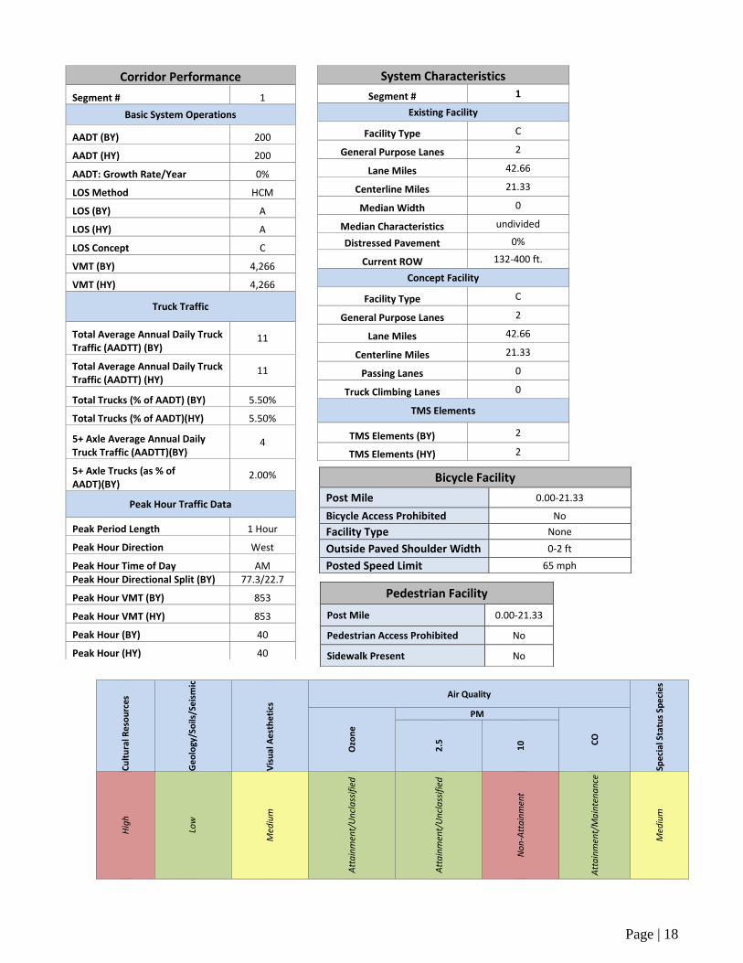
SYSTEM CHARACTERISTICS SR 167 is a two-lane conventional highway for its entire length. The majority of the road is smooth and well maintained with a posted speed limit of 65 mph. The average paved shoulder width is 0 to 2 feet. The average lane width is 11 feet and the facility is undivided. Retention of the count station at the California/Nevada state line will be analyzed.
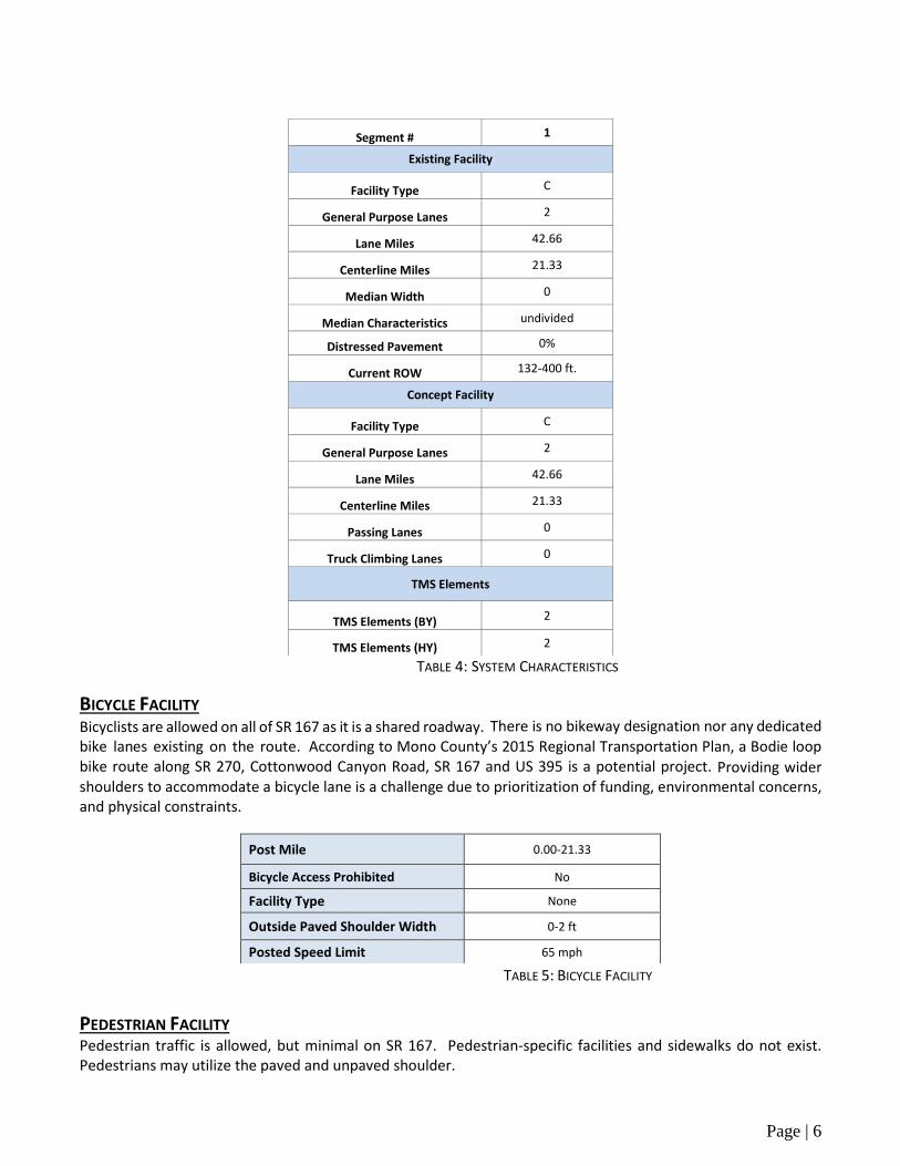
Page | 6
TABLE 4: SYSTEM CHARACTERISTICS
BICYCLE FACILITY Bicyclists are allowed on all of SR 167 as it is a shared roadway. There is no bikeway designation nor any dedicated bike lanes existing on the route. According to Mono County’s 2015 Regional Transportation Plan, a Bodie loop bike route along SR 270, Cottonwood Canyon Road, SR 167 and US 395 is a potential project. Providing wider shoulders to accommodate a bicycle lane is a challenge due to prioritization of funding, environmental concerns, and physical constraints.
TABLE 5: BICYCLE FACILITY
PEDESTRIAN FACILITY Pedestrian traffic is allowed, but minimal on SR 167. Pedestrian-specific facilities and sidewalks do not exist. Pedestrians may utilize the paved and unpaved shoulder.
Segment # 1
Existing Facility
Facility Type C
General Purpose Lanes 2
Lane Miles 42.66
Centerline Miles 21.33
Median Width 0
Median Characteristics undivided
Distressed Pavement 0%
Current ROW 132-400 ft.
Concept Facility
Facility Type C
General Purpose Lanes 2
Lane Miles 42.66
Centerline Miles 21.33
Passing Lanes 0
Truck Climbing Lanes 0
TMS Elements
TMS Elements (BY) 2
TMS Elements (HY) 2
Post Mile 0.00-21.33
Bicycle Access Prohibited No
Facility Type None
Outside Paved Shoulder Width 0-2 ft
Posted Speed Limit 65 mph

Page | 7
Post Mile 0.00-21.33
Pedestrian Access Prohibited No
Sidewalk Present No
TABLE 6: PEDESTRIAN FACILITY
TRANSIT FACILITY The Eastern Sierra Transit Authority (ESTA) provides roundtrip service between Lone Pine and Reno on Monday, Tuesday, Thursday, and Friday. Upon request, the bus will stop at the intersection of SR 167 and US 395 on those days. This route is expected to add service on Wednesdays in the near future.
FREIGHT SR 167 is a California Legal route within the California Legal Truck Network. California Legal trucks with a maximum overall length of 65 feet may utilize the route. While there are no freight generators on SR 167, the route continues as Nevada SR 359 leading to Hawthorne. Hawthorne is home to one of the largest U.S. Army munitions depots in the country and is a vital location for goods movement related to national security. Also, at Hawthorne, Nevada SR 359 joins with US 95, a primary north/south corridor, which intersects with US 50 and Interstate 80.

Page | 8
ENVIRONMENTAL CONSIDERATIONS The purpose of this environmental scan is to identify environmental factors that may need future analysis in the project development process. This information does not represent all possible environmental considerations that may exist within the area surrounding the route. Any SR 167 project being considered for programming would require environmental clearance in compliance with all federal, state, and local environmental laws and regulations. The environmental factors identified are scaled (high, medium or low) by district staff based on the probability of encountering such issues.
The following environmental factors were identified:
Air Quality: Mono County is a part of the Great Basin Valleys Air Basin under the stewardship of the Great Basin Unified Air Pollution Control District. SR 167 is classified as non-attainment for PM-10 due to blowing dust which results from the drying of Mono Lake.
Geology/Soils/Seismic: SR 167 crosses over one unnamed minor fault near Alkali Valley at PM 11.4.
Cultural Resources: There are several known prehistoric and historic archeological sites along SR 167 throughout its entire length; therefore, appropriate archaeological and historical studies, including Native American consultation may be required for most projects along this route.
Visual Aesthetics: There are stunning views of Mono Lake from SR 167. Any potential visual impacts on the section of the highway that abuts the Mono Basin National Forest Scenic Area boundary should be assessed. Aesthetic considerations for future projects could include color and/or texture treatment to highway facilities to help it blend into the natural environment as well as siting of proposed structures so they do not impact scenic vistas such as views of nearby mountains.
Special Status Species: Many “special status” species of flora and fauna can be found within a 1,000 foot-wide corridor centered along SR 167; however the primary species of concern is Bodie Hills Cusickiella (Cusickiella quadricostata) and Greater Sage-grouse (Centrocercus urophasianus).
Cu
ltu
ral R
eso
urc
es
Ge
olo
gy/S
oils
/Se
ism
ic
Vis
ual
Ae
sth
eti
cs
Air Quality
Spe
cia
l Sta
tus
Spe
cie
s
Ozo
ne
PM
CO
2.5
10
Hig
h
Low
Med
ium
Att
ain
men
t/U
ncl
ass
ifie
d
Att
ain
men
t/U
ncl
ass
ifie
d
No
n-A
tta
inm
ent
Att
ain
men
t/M
ain
ten
an
ce
Med
ium
TABLE 7: ENVIRONMENTAL CONSIDERATIONS
Page | 9
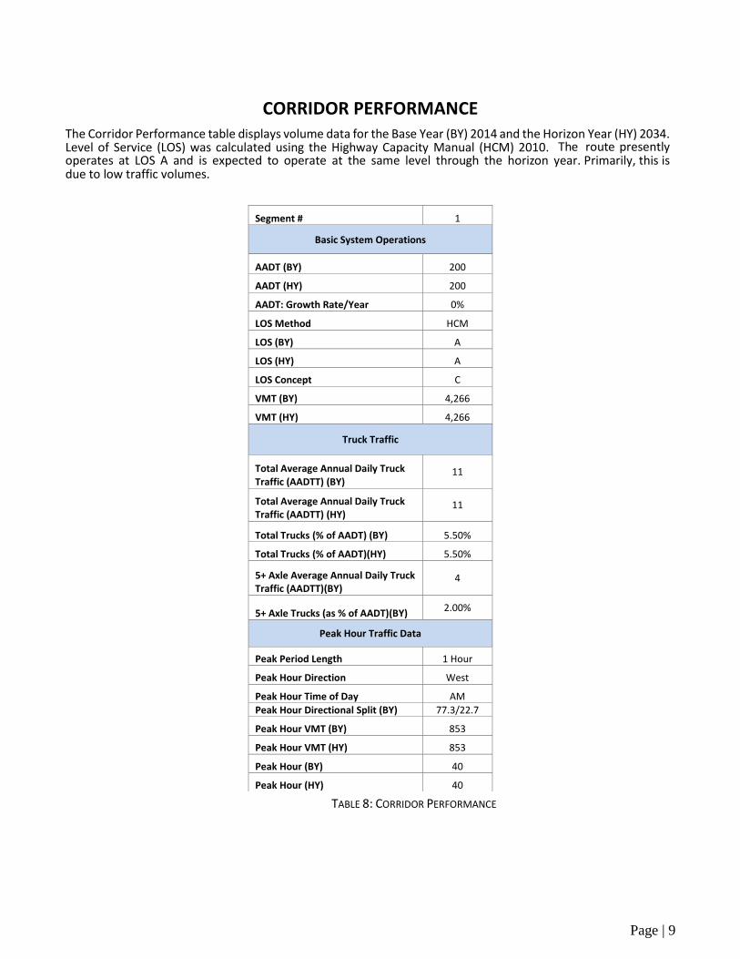
CORRIDOR PERFORMANCE The Corridor Performance table displays volume data for the Base Year (BY) 2014 and the Horizon Year (HY) 2034. Level of Service (LOS) was calculated using the Highway Capacity Manual (HCM) 2010. The route presently operates at LOS A and is expected to operate at the same level through the horizon year. Primarily, this is due to low traffic volumes.
TABLE 8: CORRIDOR PERFORMANCE
Segment # 1
Basic System Operations
AADT (BY) 200
AADT (HY) 200
AADT: Growth Rate/Year 0%
LOS Method HCM
LOS (BY) A
LOS (HY) A
LOS Concept C
VMT (BY) 4,266
VMT (HY) 4,266
Truck Traffic
Total Average Annual Daily Truck Traffic (AADTT) (BY)
11
Total Average Annual Daily Truck Traffic (AADTT) (HY)
11
Total Trucks (% of AADT) (BY) 5.50%
Total Trucks (% of AADT)(HY) 5.50%
5+ Axle Average Annual Daily Truck Traffic (AADTT)(BY)
4
5+ Axle Trucks (as % of AADT)(BY) 2.00%
Peak Hour Traffic Data
Peak Period Length 1 Hour
Peak Hour Direction West
Peak Hour Time of Day AM
Peak Hour Directional Split (BY) 77.3/22.7
Peak Hour VMT (BY) 853
Peak Hour VMT (HY) 853
Peak Hour (BY) 40
Peak Hour (HY) 40
Page | 10
CORRIDOR CONCEPT
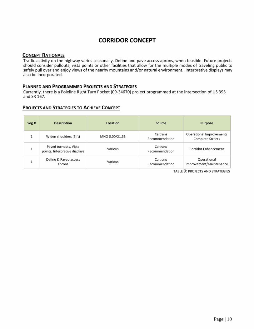
CONCEPT RATIONALE Traffic activity on the highway varies seasonally. Define and pave access aprons, when feasible. Future projects should consider pullouts, vista points or other facilities that allow for the multiple modes of traveling public to safely pull over and enjoy views of the nearby mountains and/or natural environment. Interpretive displays may also be incorporated.
PLANNED AND PROGRAMMED PROJECTS AND STRATEGIES Currently, there is a Poleline Right Turn Pocket (09-34670) project programmed at the intersection of US 395 and SR 167.
PROJECTS AND STRATEGIES TO ACHIEVE CONCEPT
Seg.# Description Location Source Purpose
1 Widen shoulders (5 ft) MNO 0.00/21.33 Caltrans
Recommendation Operational Improvement/
Complete Streets
1 Paved turnouts, Vista
points, Interpretive displays Various
Caltrans Recommendation
Corridor Enhancement
1 Define & Paved access
aprons Various
Caltrans Recommendation
Operational Improvement/Maintenance
TABLE 9: PROJECTS AND STRATEGIES
Page | 11
APPENDICES
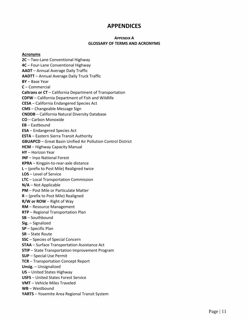
APPENDIX AGLOSSARY OF TERMS AND ACRONYMS
Acronyms 2C – Two-Lane Conventional Highway 4C – Four-Lane Conventional Highway AADT – Annual Average Daily Traffic AADTT – Annual Average Daily Truck Traffic BY – Base Year C – Commercial Caltrans or CT – California Department of Transportation CDFW – California Department of Fish and Wildlife CESA – California Endangered Species Act CMS – Changeable Message Sign CNDDB – California Natural Diversity Database CO – Carbon Monoxide EB – Eastbound ESA – Endangered Species Act ESTA – Eastern Sierra Transit Authority GBUAPCD – Great Basin Unified Air Pollution Control District HCM – Highway Capacity Manual HY – Horizon Year INF – Inyo National Forest KPRA – Kingpin-to-rear-axle distance L – (prefix to Post Mile) Realigned twice LOS – Level of Service LTC – Local Transportation Commission N/A – Not Applicable PM – Post Mile or Particulate Matter R – (prefix to Post Mile) Realigned R/W or ROW – Right of Way RM – Resource Management RTP – Regional Transportation Plan SB – Southbound Sig. – Signalized SP – Specific Plan SR – State Route SSC – Species of Special Concern STAA – Surface Transportation Assistance Act STIP – State Transportation Improvement Program SUP – Special Use Permit TCR – Transportation Concept Report Unsig. – Unsignalized US – United States Highway USFS – United States Forest Service VMT – Vehicle Miles Traveled WB – Westbound YARTS – Yosemite Area Regional Transit System
Page | 12
Definitions
Annual Average Daily Traffic (AADT) – The total volume for the year divided by 365 days. The traffic count year is from October 1st through September 30th. Traffic counting is generally performed by electronic counting instruments moved from location to location throughout the state in a program of continuous traffic count sampling. The resulting counts are adjusted to an estimate of annual average daily traffic by compensating for seasonal influence, weekly variation and other variables which may be present. AADT is necessary for presenting a statewide picture of traffic flow, evaluating traffic trends, computing accident rates, planning and designing highways and other purposes.
Attainment/Unclassified – A status designation that the California Air Resources Board is required to apply to areas of the State which signifies either that pollutant concentrations do not violate the standard for that pollutant in that area or that data does not support either an attainment or nonattainment status.
Base Year (BY) – The year that the most current data is available to the districts.
California Department of Fish and Wildlife (DFW) Nongame Wildlife Program – A conservation program which categorizes sensitive bird, mammal, reptile and amphibian species for the purposes of resource assessment, research, conservation planning, recovery planning, permitting, and outreach activities.
Fully Protected species may not be taken or possessed at any time and no licenses or permits may be issued for their take except for collecting these species for necessary scientific research and relocation of the species
Species of Special Concern designates a species, subspecies, or distinct population of an animal native to California that currently satisfies one or more of the following (not necessarily mutually exclusive) criteria:
is extirpated from the state or, in the case of birds, in its primary seasonal or breeding role;
is listed as Federally-, but not State-, threatened or endangered; meets the state definition of threatened or endangered but has not formally been listed;
is experiencing, or formerly experienced, serious (noncyclical) population declines or range retractions (not reversed) that, if continued or resumed, could qualify it for state threatened or endangered status;
has naturally small populations exhibiting high susceptibility to risk from any factor(s), that if realized, could lead to declines that would qualify it for state threatened or endangered status.
California Endangered Species Act (CESA) List – A list of species determined to be “rare”, “threatened” or “endangered” by the California Fish and Game Commission under the California Endangered Species Act. Listing is based on present or threatened modification or destruction of habitat, competition, predation, disease, overexploitation by collectors, or other natural occurrences or human-related activities.
Endangered In serious danger of becoming extinct throughout all, or a significant portion, of a species’ range due to one or more causes, including loss of habitat, over exploitation, competition, or disease.
Threatened Likely to become an endangered species in the foreseeable future in the absence of special protection and management efforts
Page | 13
Capacity – The maximum sustainable hourly flow rate at which persons or vehicles reasonably can be expected to traverse a point or a uniform section of a lane or roadway during a given time period under prevailing roadway, environmental, traffic, and control conditions.
Capital Facility Concept – The 20‐25 year vision of future development on the route to the capital facility. The capital facility can include capacity increasing, state highway, bicycle/pedestrian/transit facility, grade separation, and new managed lanes.
Census-Designated Place – A concentration of population identified by the United States Census Bureau for statistical purposes. Census-designated places are delineated for decennial census as the statistical counterparts of incorporated places, such as cities, towns, and villages.
Concept LOS – The minimum acceptable LOS over the next 20‐25 years.
Conventional Highway – A highway generally without controlled access. Grade separations at intersections or access control may be used at spot locations when justified.
Easement – An interest in real property that conveys use, but not ownership.
Facility Concept – Describes the facility and strategies that may be needed within 20‐25 years. This can include capacity increasing, state highway, bicycle/pedestrian/transit facility, non‐capacity increasing operational improvements, new managed lanes, conversion of existing managed lanes to another managed lane type or characteristic, TMS field elements, and transportation demand/incident management.
Facility Type – The facility type describes the state highway facility type. The facility could be freeway, expressway, conventional, or one‐way city street.
Fee Simple Title – Absolute ownership unencumbered by any other interest or estate.
Functional Classification – Guided by federal legislation, refers to a process by which streets and highways are grouped into classes or systems according to the character of the service that is provided, i.e. Principal and Minor Arterial Roads, Collector Roads, and Local Roads.
Principal Arterial A roadway that serves a large percentage of travel between cities and other activity centers, especially when minimizing travel time and distance is important. These roadways typically carry higher traffic volumes and are usually the route of choice for intercity buses and trucks.
Interstate A Principal Arterial roadway designed for mobility and long-distance travel. Characteristics include limited access, divided medians and emphasis on linking major urban areas of the United States.
Other Freeway or Expressway A Principal Arterial roadway with its directional travel lanes typically separated by some type of physical barrier, access and egress points that are limited to on- and off-ramp locations, and a very limited number of at-grade intersections. Abutting land uses are not directly served by this road type.
Other Principal Arterial A Principal Arterial roadway that serves major centers of metropolitan areas, provides a high degree of mobility and that can also provide mobility through rural areas. Abutting land uses can be directly served by this road type.
Page | 14
Minor Arterial A roadway that provides service for trips of moderate length, that serves geographic areas that are smaller than those served by the Principal Arterials, and that provides intra-community continuity and may carry local bus routes. In rural areas, Minor Arterials are typically designed to provide relatively high overall travel speeds, with minimum interference to through movement.
Collector A roadway which gathers traffic from Local Roads and funnels it to the Arterial Network. Primarily serves intra-county travel rather than statewide and constitutes those routes on which predominant travel distances are shorter than on Arterial Routes.
Major Collector A Collector that is longer in length, having a lower density of connecting driveways, higher speed limits and greater intervals of spacing than Minor Collectors. These roadways can serve a higher volume of traffic.
Minor Collector A Collector that is shorter in length, having a higher density of connecting driveways, lower speed limits and smaller intervals of spacing than Major Collectors. These roadways serve lower volumes of traffic.
Local Road A roadway not intended for long distance travel and that provides direct access to abutting land. This road type accounts for the largest percentage of all roadways in terms of mileage. Through traffic and Bus Routes are typically discouraged.
Horizon Year (HY) – The year that the future (20‐25 years) data is based on.
Interregional Road System Route (IRRS) – A route that is a part of the IRRS system of highways and a subset of the Freeway and Expressway System that is outside of any urbanized area and provides access to, and links between, the State’s economic centers, major recreation areas, and urban and rural regions.
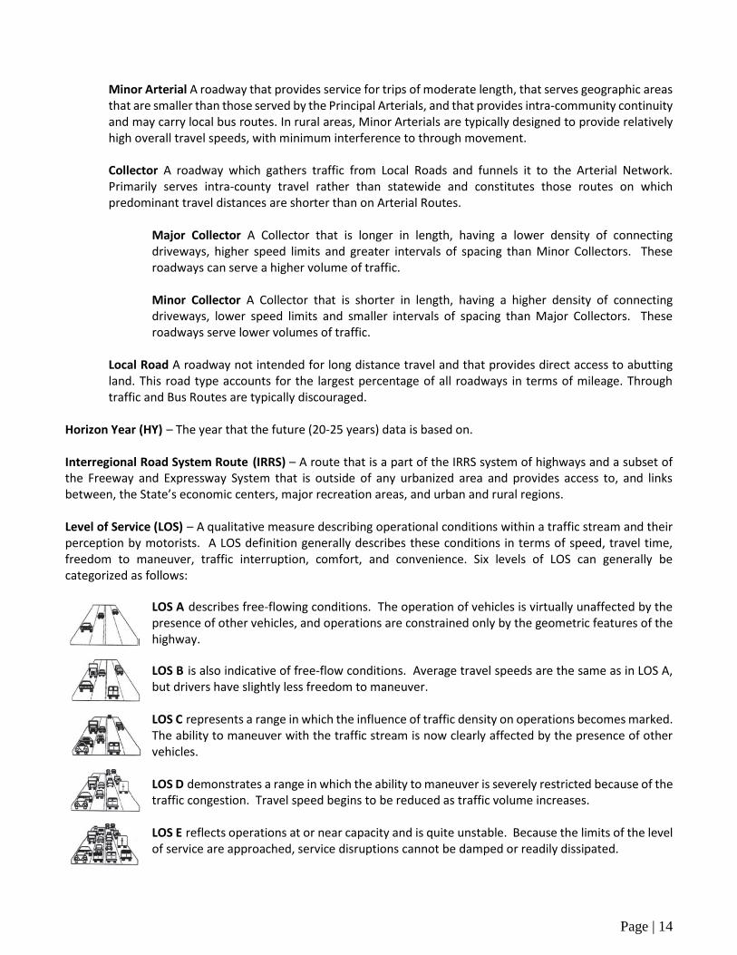
Level of Service (LOS) – A qualitative measure describing operational conditions within a traffic stream and their perception by motorists. A LOS definition generally describes these conditions in terms of speed, travel time, freedom to maneuver, traffic interruption, comfort, and convenience. Six levels of LOS can generally be categorized as follows:
LOS A describes free-flowing conditions. The operation of vehicles is virtually unaffected by the presence of other vehicles, and operations are constrained only by the geometric features of the highway.
LOS B is also indicative of free‐flow conditions. Average travel speeds are the same as in LOS A, but drivers have slightly less freedom to maneuver.
LOS C represents a range in which the influence of traffic density on operations becomes marked. The ability to maneuver with the traffic stream is now clearly affected by the presence of other vehicles.
LOS D demonstrates a range in which the ability to maneuver is severely restricted because of the traffic congestion. Travel speed begins to be reduced as traffic volume increases.
LOS E reflects operations at or near capacity and is quite unstable. Because the limits of the level of service are approached, service disruptions cannot be damped or readily dissipated.
Page | 15
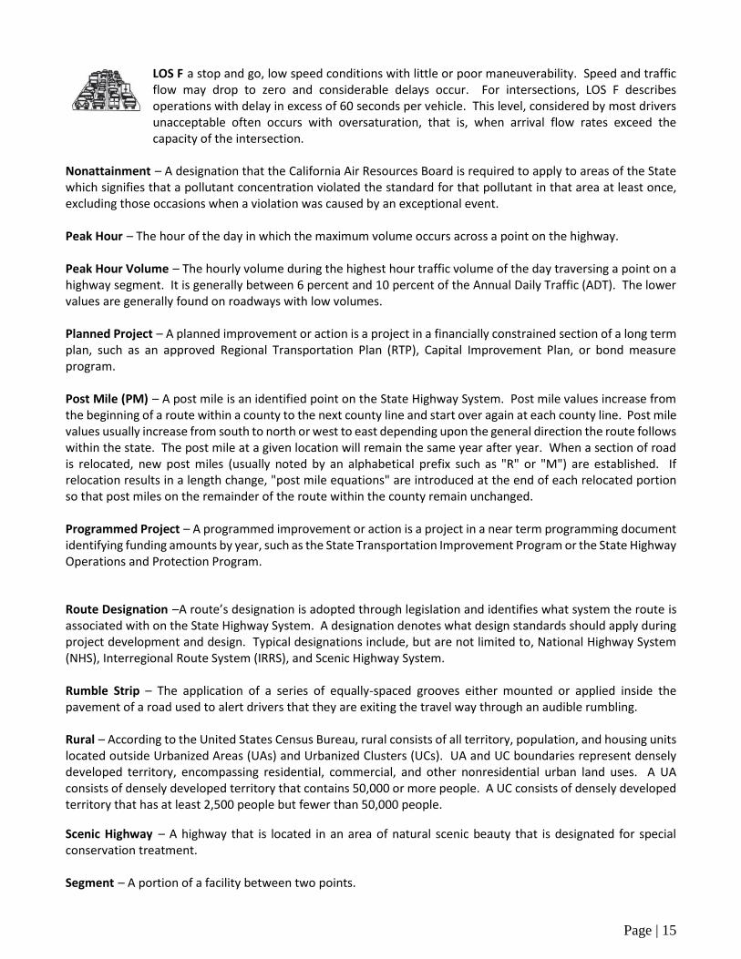
LOS F a stop and go, low speed conditions with little or poor maneuverability. Speed and traffic flow may drop to zero and considerable delays occur. For intersections, LOS F describes operations with delay in excess of 60 seconds per vehicle. This level, considered by most drivers unacceptable often occurs with oversaturation, that is, when arrival flow rates exceed the capacity of the intersection.
Nonattainment – A designation that the California Air Resources Board is required to apply to areas of the State which signifies that a pollutant concentration violated the standard for that pollutant in that area at least once, excluding those occasions when a violation was caused by an exceptional event.
Peak Hour – The hour of the day in which the maximum volume occurs across a point on the highway.
Peak Hour Volume – The hourly volume during the highest hour traffic volume of the day traversing a point on a highway segment. It is generally between 6 percent and 10 percent of the Annual Daily Traffic (ADT). The lower values are generally found on roadways with low volumes.
Planned Project – A planned improvement or action is a project in a financially constrained section of a long term plan, such as an approved Regional Transportation Plan (RTP), Capital Improvement Plan, or bond measure program.
Post Mile (PM) – A post mile is an identified point on the State Highway System. Post mile values increase from the beginning of a route within a county to the next county line and start over again at each county line. Post mile values usually increase from south to north or west to east depending upon the general direction the route follows within the state. The post mile at a given location will remain the same year after year. When a section of road is relocated, new post miles (usually noted by an alphabetical prefix such as "R" or "M") are established. If relocation results in a length change, "post mile equations" are introduced at the end of each relocated portion so that post miles on the remainder of the route within the county remain unchanged.
Programmed Project – A programmed improvement or action is a project in a near term programming document identifying funding amounts by year, such as the State Transportation Improvement Program or the State Highway Operations and Protection Program.
Route Designation –A route’s designation is adopted through legislation and identifies what system the route is associated with on the State Highway System. A designation denotes what design standards should apply during project development and design. Typical designations include, but are not limited to, National Highway System (NHS), Interregional Route System (IRRS), and Scenic Highway System.
Rumble Strip – The application of a series of equally-spaced grooves either mounted or applied inside the pavement of a road used to alert drivers that they are exiting the travel way through an audible rumbling.
Rural – According to the United States Census Bureau, rural consists of all territory, population, and housing units located outside Urbanized Areas (UAs) and Urbanized Clusters (UCs). UA and UC boundaries represent densely developed territory, encompassing residential, commercial, and other nonresidential urban land uses. A UA consists of densely developed territory that contains 50,000 or more people. A UC consists of densely developed territory that has at least 2,500 people but fewer than 50,000 people.
Scenic Highway – A highway that is located in an area of natural scenic beauty that is designated for special conservation treatment.
Segment – A portion of a facility between two points.

Page | 16
Seismic Design Category (SDC) – An earthquake hazard classification assigned to a structure based on its occupancy or use and on the level of expected soil modified seismic ground motion.
A denotes very small seismic vulnerability.
B denotes low to moderate seismic vulnerability.
C denotes moderate seismic vulnerability.
D denotes high seismic vulnerability.
E and F denote very high seismic vulnerability and near a major fault.
Special Flood Hazard Area (SFHA) – The land area covered by the floodwaters of the base flood on National Flood Insurance Program (NFIP) maps. These areas are subject to floodplain management regulations where the mandatory purchase of flood insurance applies.
100-Year Flood Zone – An area that will be inundated by a flood event having a 1-percent chance of being equaled or exceeded in any given year.
500-Year Flood Zone – An area that will be inundated by a flood event having a 0.2-percent chance of being equaled or exceeded in any given year.
Special Status Species – Any species which is listed or proposed for listing under ESA, CESA, or CDFW.
Special Use Permit – A permit which allows a specific exception to the zoning regulations from a list of acceptable exceptions for a particular parcel of land.
Surface Transportation Assistance Act (STAA) – A transportation funding and policy act which allows on a federally designated system of highways (National Network) and on Terminal Access Routes the use of semitrailers up to 48 feet in length with no KPRA restrictions and semitrailers up to 53 feet in length with certain KPRA restrictions.
System Operations and Management Concept – Describes the system operations and management elements that may be needed within 20‐25 years. This can include non‐capacity increasing operational improvements (auxiliary lanes, channelizations, turnouts, etc.), conversion of existing managed lanes to another managed lane type or characteristic, TMS field elements, transportation demand management, and incident management.
Terminal Access Route – A route which provides STAA trucks access to truck terminals to unload freight.
Vehicle Miles Traveled (VMT) – The total number of miles traveled by motor vehicles on a road or highway
Page | 17
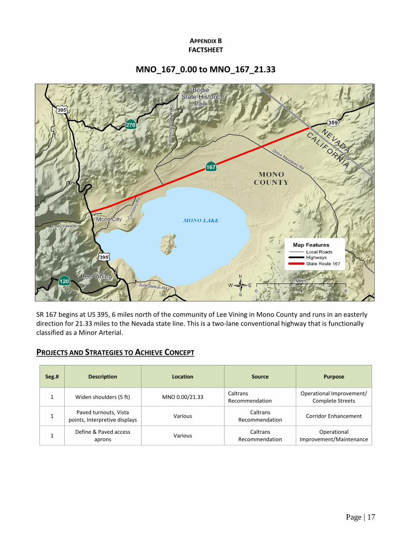
APPENDIX B FACTSHEET
MNO_167_0.00 to MNO_167_21.33
SR 167 begins at US 395, 6 miles north of the community of Lee Vining in Mono County and runs in an easterly direction for 21.33 miles to the Nevada state line. This is a two-lane conventional highway that is functionally classified as a Minor Arterial.
PROJECTS AND STRATEGIES TO ACHIEVE CONCEPT
Seg.# Description Location Source Purpose
1 Widen shoulders (5 ft) MNO 0.00/21.33 Caltrans Recommendation
Operational Improvement/ Complete Streets
1 Paved turnouts, Vista
points, Interpretive displays Various
Caltrans Recommendation
Corridor Enhancement
1 Define & Paved access
aprons Various
Caltrans Recommendation
Operational Improvement/Maintenance
Page | 18
Cu
ltu
ral R
eso
urc
es
Ge
olo
gy/S
oils
/Se
ism
ic
Vis
ual
Ae
sth
eti
cs
Air Quality
Spe
cial
Sta
tus
Spe
cie
s
Ozo
ne
PM
CO
2.5
10
Hig
h
Low
Med
ium
Att
ain
men
t/U
ncl
ass
ifie
d
Att
ain
men
t/U
ncl
ass
ifie
d
No
n-A
tta
inm
ent
Att
ain
men
t/M
ain
ten
an
ce
Med
ium
Corridor Performance
Segment # 1
Basic System Operations
AADT (BY) 200
AADT (HY) 200
AADT: Growth Rate/Year 0%
LOS Method HCM
LOS (BY) A
LOS (HY) A
LOS Concept C
VMT (BY) 4,266
VMT (HY) 4,266
Truck Traffic
Total Average Annual Daily Truck Traffic (AADTT) (BY)
11
Total Average Annual Daily Truck Traffic (AADTT) (HY)
11
Total Trucks (% of AADT) (BY) 5.50%
Total Trucks (% of AADT)(HY) 5.50%
5+ Axle Average Annual Daily Truck Traffic (AADTT)(BY)
4
5+ Axle Trucks (as % of AADT)(BY)
2.00%
Peak Hour Traffic Data
Peak Period Length 1 Hour
Peak Hour Direction West
Peak Hour Time of Day AM Peak Hour Directional Split (BY) 77.3/22.7
Peak Hour VMT (BY) 853
Peak Hour VMT (HY) 853
Peak Hour (BY) 40
Peak Hour (HY) 40
System Characteristics
Segment # 1
Existing Facility
Facility Type C
General Purpose Lanes 2
Lane Miles 42.66
Centerline Miles 21.33
Median Width 0
Median Characteristics undivided
Distressed Pavement 0%
Current ROW 132-400 ft.
Concept Facility
Facility Type C
General Purpose Lanes 2
Lane Miles 42.66
Centerline Miles 21.33
Passing Lanes 0
Truck Climbing Lanes 0
TMS Elements
TMS Elements (BY) 2
TMS Elements (HY) 2
Bicycle Facility
Post Mile 0.00-21.33
Bicycle Access Prohibited No
Facility Type None
Outside Paved Shoulder Width 0-2 ft
Posted Speed Limit 65 mph
Pedestrian Facility
Post Mile 0.00-21.33
Pedestrian Access Prohibited No
Sidewalk Present No

Page | 19
Route Designations and Characteristics
Segment # 1
Freeway & Expressway System – California Streets & Highways Code Section 250-257
No
National Highway System No
Strategic Highway Network No
Scenic Highway No
Interregional Road System No
Priority Interregional Facility No
Federal Functional Classification Minor Arterial
Goods Movement Route Yes
Truck Designation California Legal
Rural/Urban/Urbanized Rural
Regional Transportation Planning Agency Mono County Local Transportation
Commission
Local Agency Mono County
Tribes
Federally Recognized Bridgeport Indian Colony
Washoe Tribe of Nevada and California
Non-Federally Recognized Mono Lake Kutzadikaa Tribe
Air District Great Basin Unified Air Pollution Control
District
Terrain Flat
Page | 20
APPENDIX C RESOURCES
Bryant, W.A. (compiler), 2005, Digital Database of Quaternary and Younger Faults from the Fault Activity Map of California, version 2.0:
California Geological Survey Web Page, <http://www.consrv.ca.gov/CGS/information/publications/QuaternaryFaults_ver2.htm>
(12/18/13).
California Department of Fish and Wildlife, California Natural Diversity Database, <http://www.dfg.ca.gov/biogeodata/cnddb>, 2013
California Department of Fish and Wildlife, The Natural Resources Agency, Department of Fish and Game, Biogeographic Data Branch,
California Department of Parks and Recreation, Office of Historic Preservation, California Historic Resources
California Natural Diversity Database, Special Animals (898 taxa), January 2011
California Environmental Protection Agency, Air Resources Board, Air Quality Data Branch, Planning and Technical Support Division,
National Ambient Air Quality Area Designations Maps for CO; Ozone, PM 2.5, PM 10
Caltrans, District 9, GIS Data Library
Caltrans, District 9, Photolog, 2007
Caltrans, District 9, Planning Photo Library
Caltrans, District 9, Post Mile Log, 2007
Caltrans, District 9, R/W Record Maps
Caltrans, District 9, State Route 167 Transportation Concept Report, August 2009
Caltrans, Division of Maintenance GIS, Pavement Condition Survey
Caltrans, Division of Operations, Office of Traffic Engineering, Speed Zone Surveys
Caltrans, Division of Research, Innovation and System Information (DRISI), California Road System (CRS) Maps
Caltrans, Division of Transportation Planning
Caltrans Traffic Data Branch, 2014 AADT & 2014 Truck AADTT
Caltrans, Traffic Accident Surveillance and Analysis System (TASAS)
Caltrans, Smart Mobility Framework, February 2010
Eastern Sierra Transit Authority, http://www.estransit.com/CMS/
Highway Capacity Manual, 2010
Mammoth Mountain, <www.mammothmountain.com/winter/plan-a-vacation/area-transportation>
Mono County, Mono County Planning Department, Mono County General Plan: Land Use Element, 2015
Mono County, Mono County Local Transportation Commission, Mono County Regional Transportation Plan, December, 2015
National Academy of Sciences, Transportation Research Board, Highway Capacity Manual 2010
Town of Mammoth Lakes, General Bikeway Plan, February 2014
Town of Mammoth Lakes, Main Street Plan, February 2014
United States Census Bureau, 2010 Census
United States Department of the Interior, National Park Service, National Register of Historic Places
United States Department of Homeland Security, Federal Emergency Management Agency, National Flood Insurance Program
United States Geological Survey, Seismic Design Maps for International Residential Code (2006 & 2009), Coterminous US
Yosemite Area Regional Transit System, <http://yarts.com/>


![2012 ADT - Connecticut...2104 2111 2012 ADT 20 2011 [167] 133 110 9 29 131 2050 129 25 120 2038 [124] 134 [167] FROM ROUTE 115 IN SEYMOUR TO ROUTE 243 IN WOODBRIDGE (BASED ON STATION](https://static.fdocuments.us/doc/165x107/5f195efec3543a1519506eb1/2012-adt-connecticut-2104-2111-2012-adt-20-2011-167-133-110-9-29-131-2050.jpg)


