ATV10-MrnvlTmbrl-s1.pdf 1 4/20/10 3:47 PM...
1
ATV/OHM PERMIT SYSTEM A trail permit will be required for all terrain vehicles and off-highway motorcycles that use the designated trail system on the ANF. Permits are valid on a calendar year basis at a cost of $35.00 per vehicle for an annual permit or $10.00 per vehicle for a daily permit. The permit needs to be attached to the handlebars or cables of the machine. Fees will be used for the administration and maintenance of the existing trail system. Permits will be available at the Allegheny National Forest Supervisor's Office, Bradford and Marienville Ranger District Offices, and from local vendors. A list of vendor locations is available on our website: (www.fs.fed.us/r9/forests/allegheny) Irwin Run Crow Run Cole Run Run Big Red Lick Run T w i n L i c k Run Pine Maple Run Run Run Sprin g C r e e k Wagner East Run Branch Rappe Run Warner Run East Branch Millstone Creek Gilfoyle Run West Branch Watson Branch Creek Branch East RIVER Marienville & Timberline ATV/Bike Trail Allegheny National Forest 136 343 135 136 329 Highland Russell City 948 66 To Kane 10 mi. 130 226 337 124 124 Four Corners 521 221 Railroad Bluejay 1003 395 403 227 To Ridgway 16 mi. NAD83 UTM 17N: E 677825 N 4603275 Pigs Ear T313 66 66 Buehler Corner Marienville & Kinzua Knox, Kane Pigeon Owls Nest Sackett 339 NAD83 UTM 17N: E 676660 N 4587480 “E” LOOP “D” LOOP “A” LOOP “C” LOOP WARM-UP LOOP NAD83 UTM 17N: E 671990 N 4603000 NAD83 UTM 17N: E 668846 N 4603627 Main Trailhead UTM – NAD83: E 671080 N 4600740 NAD83 UTM 17N: E 659000 N 4596450 NAD83 UTM 17N: E 660090 N 4601410 125 401 take about 4-6 hours to complete. This trail is NOT recommended for inexperienced or novice riders. The trail is ONE-WAY travel except where otherwise posted. ATV TRAIL AREA – (Class I and II ATVs and OHMs) This 14.2 mile loop system is rated MORE DIFFICULT and is best suited to ATVs. The ATV Trail uses old roads and railroad grades. The trail is ONE-WAY travel except where otherwise posted. CAMPING – There is limited space for camping at the 221, 395, 401, and 521 Trailheads. Camping is not permitted at the Marienville and Pigs Ear Trailheads. INFORMATION For more information about this and other recreation opportunities, contact: Marienville Ranger District 131 Smokey Lane Marienville, PA 16239 • (814) 927-6628 NW Pennsylvania’s Great Outdoors Visitors Bureau 175 Main Street Brookville, PA 15825 800-348-9393 www.visitpago.com Chaffee 226 LOOP “B” Scale In Miles 0 1/2 1 2 Parking/Trailhead Toilets Trail Stream Forest Road State/Township Road Railroad Gate Lodging Legend 124 66 N Easiest SEASON Summer & Winter Timberline Two-Way Travel 39.0 mi. BIKE TRAIL AREA One-Way Travel* 23.1 mi. One-Way Travel* 14.2 mi. *Unless Otherwise Noted Most Difficult More Difficult SEASON Summer Summer/ Winter ATV TRAIL AREA Marienville Trails 219 219 6 6 6 62 62 66 66 321 346 Warren Ridgway Kane Marienville Bradford 948 TIMBERLINE ALL-TERRAIN VEHICLE (ATV) TRAIL CUSTOMER SERVICE – The Ridgway area offers food, lodging, gasoline, and medical facilities. EMERGENCY – Call 911. The nearest hospitals are located in Kane, PA, via SR 66, 10 miles north of the trailhead and 14 miles southeast of the trailhead in Ridgway, PA. The nearest pay telephone is located in Highland, PA, one mile south of the trailhead. If you note unsafe conditions on the trail, please report them to the Marienville Ranger Station. Things to report could trees across the trail, damaged or missing trail signs and blazes, dangerous stream crossings, damaged bridges, boggy areas, washouts, and other similar items. We appreciate your help. The trail is open, dependent on weather and trail conditions, from the Friday before Memorial Day through the last Sunday in September; and December 20 to April 1. Call ahead. Trails may be closed during adverse conditions. The Timberline ATV Trail is a system of 39 miles of interconnecting trails traversing scenic, forested hills of the Allegheny National Forest. The trails are designed for the enjoyment of ATV riders at the beginner skill level. The trail ties in to the Marienville ATV/Motorcycle Trail. FINDING THE TRAIL – The trailhead parking lot is located on Forest Road 232, one mile south of SR 948 and SR 66 intersection. Parking is also located along Township Road 458 (FR 136) near Beuhler Corner and Township Road 322 at Pigs Ear south of State Route 66. You may also access the trail anywhere it crosses a public road. This trail is located on the James City, Portland Mills, Hallton, and Russell City quadrangle maps. RIDING THE TRAIL – This trail is open to Class I and II ATVs, motorcycles, snowmobiles, horses, and mountain bikes. All ATV trails are marked with yellow diamonds. Consult the trailhead bulletin boards for more information and additional trails that may be open or closed. or or This trail is rated as EASIEST and is best suited to ATVs. The trail utilizes many old roads and railroad grades. Riding surfaces are generally level and wide (averaging 8 feet in width). Two-way travel is permitted on the trail. or or During the winter season, this trail provides snowmobile access from the south and southeast to the Allegheny Snowmobile Loop system. Because of concurrent use of ATVs and snowmobiles, the trail will not be groomed. or “YOU ARE HERE” maps are located at key trail junctions to aid riders in navigating the trail. CAMPING – There is limited space for camping at the Timberline and Beuhler Trailheads. Camping is not permitted at the Pigs Ear Trailhead. VOLUNTEERS The trails are a public recreation area provided by the US Forest Service with financial assistance from the Pennsylvania DCNR, Bureau of Recreation and Conservation, Pennsylvania Recreational Trails Program, and the Federal Highway Administration. Appreciation goes to our volunteers who help maintain and improve the trails in cooperation with the Forest Service. MARIENVILLE ALL-TERRAIN VEHICLE (ATV)/ MOTORCYCLE TRAIL CUSTOMER SERVICE – The Marienville area offers food, lodging, gas, and a small medical center. EMERGENCY – Call 911. The nearest hospital is located 15 miles north of the trailhead, in Kane, PA. The nearest pay telephone is located in Russell City, PA, four miles northeast of the trailhead. If you note unsafe conditions on the trail, please report them to the Marienville Ranger Station. Things to report could include trees across the trail, damaged or missing trail signs and blazes, dangerous stream crossings, damaged bridges, boggy areas, washouts, and other similar items. We appreciate your help. The trail is open, dependent on weather and trail conditions, from the Friday before Memorial Day through the last Sunday in September; and December 20 to April 1 (ATV Trail Area only). Call ahead. Trails may be closed during adverse conditions. The Marienville ATV/Motorcycle Trail is a system of 37 miles of interconnecting trails traversing scenic, forested hills of the Allegheny National Forest. It was designed for the enjoyment of ATV and motorcycle riders of intermediate and expert skill level. FINDING THE TRAIL – Main trailhead parking is located along State Route 66, about fifteen miles southwest of Kane and eleven miles northeast of Marienville (parking lot maintained for winter use). Secondary trailheads are noted on the map. You can also access the trail anywhere it crosses a public road. This trail is located on the Lynch and Russell City quadrangle maps. RIDING THE TRAIL – The trail system is divided into a motorcycle trail and an ATV trail, as shown on the map. This provides a variety of riding experiences and levels of difficulty for different types of machines. Class I and II ATVs, motorcycles (OHMs), horses, and mountain bikes are allowed on the ATV trail. OHMs, Class I ATVs, horses, and mountain bikes are allowed on the motorcycle trail. All ATV trails are marked with yellow diamonds. Consult the trailhead bulletin boards for more information and additional trails that may be open or closed. “YOU ARE HERE” maps are located at key trail junctions to aid riders in navigating the trail. MOTORCYCLE TRAIL AREA – (OHMs and Class I ATVs) This 23.1 mile loop is rated MOST DIFFICULT and is best suited to motorcycles. The Motorcycle Trail offers a very ROCKY trail surface that winds and twists through the forest. Motorcycle riders can finish the trail within a few hours. ATV’ers will find a very demanding and challenging ride that will ATV Trails Allegheny National Forest U.S. Department of Agriculture Forest Service 2010 This product produced with fee receipts. TREAD LIGHTLY! KEY REGISTRATION INFORMATION Definitions ATV CLASS I – Motorized off-highway vehicle that travels on three or more inflatable tires and has a maximum width of 50 inches and a maximum dry weight of 1000 pounds.(Sp CLASS II – Motorized off-highway vehicle that travels on three or more inflatable tires and has a width exceeding 50 inches or a dry weight exceeding 1000 pounds. Timberline and Marienville ATV Trails only.( Vehicle Registration REGISTRATION A TV – Operator must carry a registration certificate. Vehicle must display a registration decal and expiration sticker. (Effective October 23, 2001, the registration plate will be a metal plate with the expiration sticker already applied.)spae Liability Insurance Liability insurance required for a snowmobile or ATV for which registration is required. Proof of insurance shall be produced and displayed by the owner or operator upon request of a magistrate or law inforcement officer.space Commonwealth of PA Department of Conservation and Natural Resources Please conact www.dcnr.state.pa.us or 1-866-545-2476 for more information on state laws. REMEMBER If you abuse it, you’ll probably lose it! Careless operation of ATVs can cause damage and may result in closing of areas to riders. Respect the environment and other trail users. By using common sense and common courtesy, what is available today will be here to enjoy tomorrow. ENJOY THE TRAIL! Please reuse your brochure. Forest Supervisor’s Office 4 Farm Colony Drive Warren, PA 16365 • (814) 723-5150 Or visit us at our internet site: www.fs.fed.us/r9/forests/allegheny REGULATIONS Travel is permitted on designated, blazed routes only. The trail is clearly marked with yellow diamonds on trees. Off-trail travel may damage the forest resources or pose a safety hazard to other forest users. Please respect the rights of others. ATV riding on unmarked routes is a violation of federal law. Mountain bikes and horses are permitted to use the trails all year-round. ATV and motorcycle use during closed seasons is not permitted. All ATVs must be registered in accordance with State of Pennsylvania law or in a reciprocating state with recreational vehicle registration. Registration is available at local ATV dealers or all Pennsylvania Department of Environmental Resources Snowmobile/ATV units. The fees are used to help maintain the ATV trail system. It is illegal to drive an OHV while under the influence of any amount of drugs or alcohol. Mufflers and spark arresters are required on all ATVs and OHMs. Lights must be used between sunset and sunrise. Adults must accompany and supervise drivers under the age of 16. No child under the age of 8 is allowed to operate an ATV/OHM on ANF trails. All operators ages 8-15 must have an ATV training certificate in their possession. PRINTED ON RECYCLED PAPER Level Of Difficulty Level Of Difficulty • Become familiar with Forest Service regulations and State ATV Laws. • Wear a helmet and eye protection at all times when operating an ATV. • Carry passengers only if your ATV is designed for them. (i.e., a Class II ATV) • Speeds of over 25 mph are prohibited. • Drive within your level of skill and ability. • Be aware of other users of various ages and skill levels on the trail. • Riders in two-way travel areas should keep right and be alert for oncoming traffic. • Be alert for STOP, BRIDGE AHEAD, LOGGING AREA, and other signs on the trail. TREAD LIGHTLY! SAFETY MESSAGES
Transcript of ATV10-MrnvlTmbrl-s1.pdf 1 4/20/10 3:47 PM...
ATV/OHM PERMIT SYSTEMA trail permit will be required for all terrain vehicles and off-highway motorcycles that use the designated trail system on the ANF. Permits are valid on a calendar year basis at a cost of $35.00 per vehicle for an annual permit or $10.00 per vehicle for a daily permit. The permit needs to be attached to the handlebars or cables of the machine. Fees will be used for the administration and maintenance of the existing trail system. Permits will be available at the Allegheny National Forest Supervisor's Office, Bradford and Marienville Ranger District Offices, and from local vendors. A list of vendor locations is available on our website:
(www.fs.fed.us/r9/forests/allegheny)
Irwin
Run
Crow R
un
Cole Run
Run
BigRed Lick
RunTw
in Lick
Run
Pine
Maple
Run
Run
Run
Spring
Cre
ek
Wagner
East
Run
Branch
Rappe
Run
War
ner
Run
Spring Creek
East
Branch
Millstone
Creek
Gilfoyle
Run
WestBranch
Wat
son
Branch
Creek
Bran
ch
East
RIVER
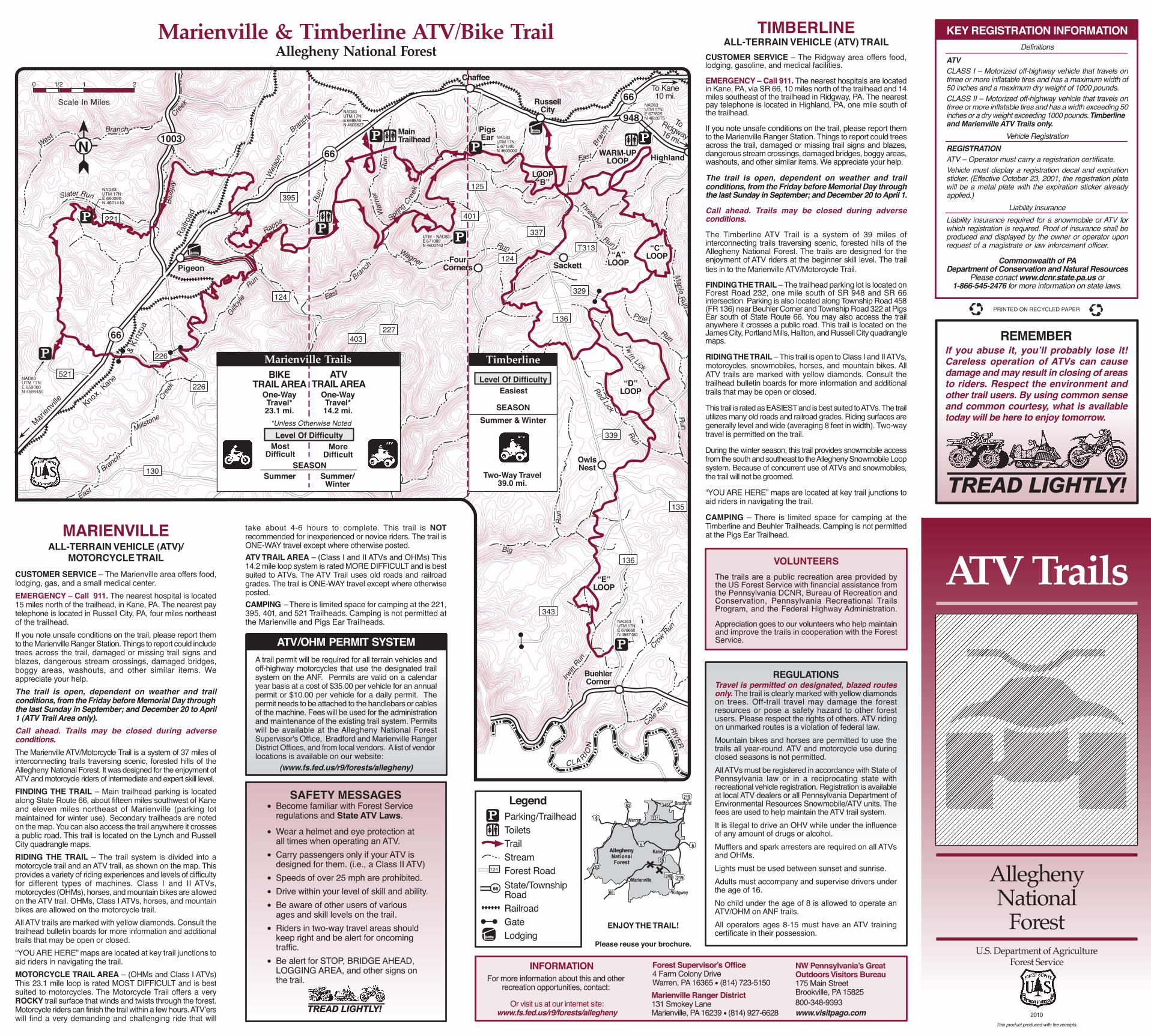
Marienville & Timberline ATV/Bike TrailAllegheny National Forest
136
343
135
136
329
Highland
RussellCity
948
66To Kane10 mi.
130
13
226
337
124
124
FourCorners
521
221
Railro
ad
Blue
jay
1003
395
403227
ToRidgway16 mi.
NAD83UTM 17N:E 677825N 4603275
PigsEar
T313
66
66
BuehlerCorner
Marien
ville
& K i
nzua
Knox, Kan
e
Pigeon
OwlsNest
Sackett
339
NAD83UTM 17N:E 676660N 4587480
“E”LOOP
“D”LOOP
“A”LOOP
“C”LOOP
WARM-UPLOOP
NAD83UTM 17N:E 671990N 4603000
NAD83UTM 17N:E 668846N 4603627
MainTrailhead
UTM – NAD83:E 671080N 4600740
NAD83UTM 17N:E 659000N 4596450
NAD83UTM 17N:E 660090N 4601410
125
401
take about 4-6 hours to complete. This trail is NOT recommended for inexperienced or novice riders. The trail is ONE-WAY travel except where otherwise posted.ATV TRAIL AREA – (Class I and II ATVs and OHMs) This 14.2 mile loop system is rated MORE DIFFICULT and is best suited to ATVs. The ATV Trail uses old roads and railroad grades. The trail is ONE-WAY travel except where otherwise posted.CAMPING – There is limited space for camping at the 221, 395, 401, and 521 Trailheads. Camping is not permitted at the Marienville and Pigs Ear Trailheads.
INFORMATIONFor more information about this and other
recreation opportunities, contact:Marienville Ranger District131 Smokey Lane Marienville, PA 16239 • (814) 927-6628
NW Pennsylvania’s GreatOutdoors Visitors Bureau175 Main StreetBrookville, PA 15825800-348-9393www.visitpago.com
Chaffee
226
LOOP“B”
Scale In Miles
0 1/2 1 2
Parking/TrailheadToiletsTrailStreamForest RoadState/TownshipRoadRailroadGateLodging
Legend
124
66
N
Easiest
SEASONSummer & Winter
Timberline
Two-Way Travel39.0 mi.
BIKETRAIL AREA
One-WayTravel*23.1 mi.
One-WayTravel*14.2 mi.
*Unless Otherwise Noted
MostDifficult
More Difficult
SEASONSummer Summer/
Winter
ATV TRAIL AREA
Marienville Trails
219
219
6
6 6
62
6266
66
321
346
Warren
Ridgway
Kane
Marienville
Bradford
948
TIMBERLINE ALL-TERRAIN VEHICLE (ATV) TRAIL
CUSTOMER SERVICE – The Ridgway area offers food, lodging, gasoline, and medical facilities.
EMERGENCY – Call 911. The nearest hospitals are located in Kane, PA, via SR 66, 10 miles north of the trailhead and 14 miles southeast of the trailhead in Ridgway, PA. The nearest pay telephone is located in Highland, PA, one mile south of the trailhead.
If you note unsafe conditions on the trail, please report them to the Marienville Ranger Station. Things to report could trees across the trail, damaged or missing trail signs and blazes, dangerous stream crossings, damaged bridges, boggy areas, washouts, and other similar items. We appreciate your help.
The trail is open, dependent on weather and trail conditions, from the Friday before Memorial Day through the last Sunday in September; and December 20 to April 1.
Call ahead. Trails may be closed during adverse conditions.
The Timberline ATV Trail is a system of 39 miles of interconnecting trails traversing scenic, forested hills of the Allegheny National Forest. The trails are designed for the enjoyment of ATV riders at the beginner skill level. The trail ties in to the Marienville ATV/Motorcycle Trail.
FINDING THE TRAIL – The trailhead parking lot is located on Forest Road 232, one mile south of SR 948 and SR 66 intersection. Parking is also located along Township Road 458 (FR 136) near Beuhler Corner and Township Road 322 at Pigs Ear south of State Route 66. You may also access the trail anywhere it crosses a public road. This trail is located on the James City, Portland Mills, Hallton, and Russell City quadrangle maps.
RIDING THE TRAIL – This trail is open to Class I and II ATVs, motorcycles, snowmobiles, horses, and mountain bikes. All ATV trails are marked with yellow diamonds. Consult the trailhead bulletin boards for more information and additional trails that may be open or closed. or or
This trail is rated as EASIEST and is best suited to ATVs. The trail utilizes many old roads and railroad grades. Riding surfaces are generally level and wide (averaging 8 feet in width). Two-way travel is permitted on the trail. or or
During the winter season, this trail provides snowmobile access from the south and southeast to the Allegheny Snowmobile Loop system. Because of concurrent use of ATVs and snowmobiles, the trail will not be groomed. or
“YOU ARE HERE” maps are located at key trail junctions to aid riders in navigating the trail.
CAMPING – There is limited space for camping at the Timberline and Beuhler Trailheads. Camping is not permitted at the Pigs Ear Trailhead.
VOLUNTEERSThe trails are a public recreation area provided by the US Forest Service with financial assistance from the Pennsylvania DCNR, Bureau of Recreation and Conservation, Pennsylvania Recreational Trails Program, and the Federal Highway Administration.
Appreciation goes to our volunteers who help maintain and improve the trails in cooperation with the Forest Service.
MARIENVILLEALL-TERRAIN VEHICLE (ATV)/
MOTORCYCLE TRAIL CUSTOMER SERVICE – The Marienville area offers food, lodging, gas, and a small medical center. EMERGENCY – Call 911. The nearest hospital is located 15 miles north of the trailhead, in Kane, PA. The nearest pay telephone is located in Russell City, PA, four miles northeast of the trailhead.If you note unsafe conditions on the trail, please report them to the Marienville Ranger Station. Things to report could include trees across the trail, damaged or missing trail signs and blazes, dangerous stream crossings, damaged bridges, boggy areas, washouts, and other similar items. We appreciate your help. The trail is open, dependent on weather and trail conditions, from the Friday before Memorial Day through the last Sunday in September; and December 20 to April 1 (ATV Trail Area only).Call ahead. Trails may be closed during adverse conditions. The Marienville ATV/Motorcycle Trail is a system of 37 miles of interconnecting trails traversing scenic, forested hills of the Allegheny National Forest. It was designed for the enjoyment of ATV and motorcycle riders of intermediate and expert skill level. FINDING THE TRAIL – Main trailhead parking is located along State Route 66, about fifteen miles southwest of Kane and eleven miles northeast of Marienville (parking lot maintained for winter use). Secondary trailheads are noted on the map. You can also access the trail anywhere it crosses a public road. This trail is located on the Lynch and Russell City quadrangle maps.RIDING THE TRAIL – The trail system is divided into a motorcycle trail and an ATV trail, as shown on the map. This provides a variety of riding experiences and levels of difficulty for different types of machines. Class I and II ATVs, motorcycles (OHMs), horses, and mountain bikes are allowed on the ATV trail. OHMs, Class I ATVs, horses, and mountain bikes are allowed on the motorcycle trail. All ATV trails are marked with yellow diamonds. Consult the trailhead bulletin boards for more information and additional trails that may be open or closed. “YOU ARE HERE” maps are located at key trail junctions to aid riders in navigating the trail.MOTORCYCLE TRAIL AREA – (OHMs and Class I ATVs) This 23.1 mile loop is rated MOST DIFFICULT and is best suited to motorcycles. The Motorcycle Trail offers a very ROCKY trail surface that winds and twists through the forest. Motorcycle riders can finish the trail within a few hours. ATV’ers will find a very demanding and challenging ride that will
ATV Trails
AlleghenyNational
ForestU.S. Department of Agriculture
Forest Service
2010This product produced with fee receipts.
TREAD LIGHTLY!
KEY REGISTRATION INFORMATIONDefinitions
ATVCLASS I – Motorized off-highway vehicle that travels on three or more inflatable tires and has a maximum width of 50 inches and a maximum dry weight of 1000 pounds.(Sp CLASS II – Motorized off-highway vehicle that travels on three or more inflatable tires and has a width exceeding 50 inches or a dry weight exceeding 1000 pounds. Timberline and Marienville ATV Trails only.(
Vehicle RegistrationREGISTRATIONATV – Operator must carry a registration certificate.Vehicle must display a registration decal and expiration sticker. (Effective October 23, 2001, the registration plate will be a metal plate with the expiration sticker already applied.)spae
Liability InsuranceLiability insurance required for a snowmobile or ATV for which registration is required. Proof of insurance shall be produced and displayed by the owner or operator upon request of a magistrate or law inforcement officer.space
Commonwealth of PADepartment of Conservation and Natural Resources
Please conact www.dcnr.state.pa.us or 1-866-545-2476 for more information on state laws.
REMEMBERIf you abuse it, you’ll probably lose it! Careless operation of ATVs can cause damage and may result in closing of areas to riders. Respect the environment and other trail users. By using common sense and common courtesy, what is available today will be here to enjoy tomorrow.
ENJOY THE TRAIL!
Please reuse your brochure.
Forest Supervisor’s Office4 Farm Colony DriveWarren, PA 16365 • (814) 723-5150
Or visit us at our internet site: www.fs.fed.us/r9/forests/allegheny
REGULATIONS Travel is permitted on designated, blazed routes only. The trail is clearly marked with yellow diamonds on trees. Off-trail travel may damage the forest resources or pose a safety hazard to other forest users. Please respect the rights of others. ATV riding on unmarked routes is a violation of federal law.Mountain bikes and horses are permitted to use the trails all year-round. ATV and motorcycle use during closed seasons is not permitted.All ATVs must be registered in accordance with State of Pennsylvania law or in a reciprocating state with recreational vehicle registration. Registration is available at local ATV dealers or all Pennsylvania Department of Environmental Resources Snowmobile/ATV units. The fees are used to help maintain the ATV trail system.It is illegal to drive an OHV while under the influence of any amount of drugs or alcohol.Mufflers and spark arresters are required on all ATVs and OHMs.Lights must be used between sunset and sunrise.Adults must accompany and supervise drivers under the age of 16.No child under the age of 8 is allowed to operate an ATV/OHM on ANF trails.All operators ages 8-15 must have an ATV training certificate in their possession.
PRINTED ON RECYCLED PAPER
Level Of Difficulty
Level Of Difficulty
• Become familiar with Forest Service regulations and State ATV Laws.
• Wear a helmet and eye protection at all times when operating an ATV.• Carry passengers only if your ATV is designed for them. (i.e., a Class II ATV)• Speeds of over 25 mph are prohibited.• Drive within your level of skill and ability. • Be aware of other users of various ages and skill levels on the trail.• Riders in two-way travel areas should keep right and be alert for oncoming traffic.• Be alert for STOP, BRIDGE AHEAD, LOGGING AREA, and other signs on the trail.
TREAD LIGHTLY!
SAFETY MESSAGES
C
M
Y
CM
MY
CY
CMY
K
ATV10-MrnvlTmbrl-s1.pdf 1 4/20/10 3:47 PM