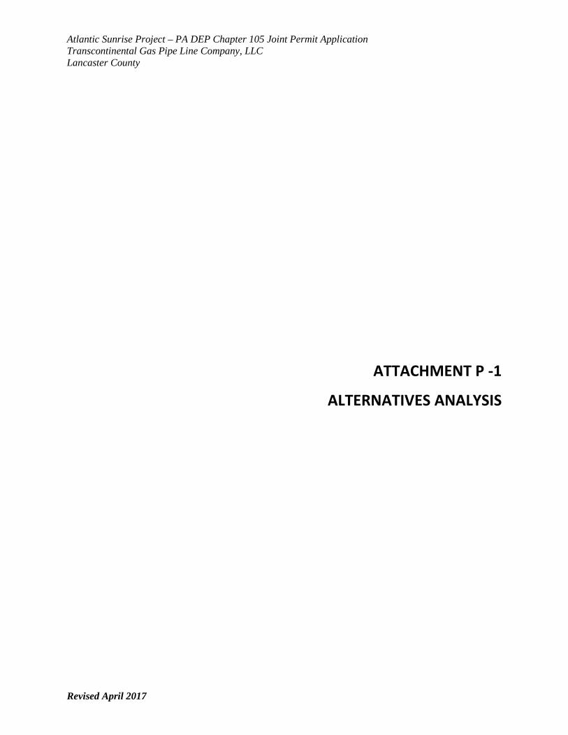
ATTACHMENT P -1 ALTERNATIVES ANALYSISfiles.dep.state.pa.us/ProgramIntegration/PA Pipeline...
71
Atlantic Sunrise Project – PA DEP Chapter 105 Joint Permit Application Transcontinental Gas Pipe Line Company, LLC Lancaster County Revised April 2017 ATTACHMENT P -1 ALTERNATIVES ANALYSIS
Transcript of ATTACHMENT P -1 ALTERNATIVES ANALYSISfiles.dep.state.pa.us/ProgramIntegration/PA Pipeline...
Atlantic Sunrise Project – PA DEP Chapter 105 Joint Permit Application Transcontinental Gas Pipe Line Company, LLC Lancaster County
Revised April 2017
ATTACHMENT P -1
ALTERNATIVES ANALYSIS
Atlantic Sunrise Project – PA DEP Chapter 105 Joint Permit Application Transcontinental Gas Pipe Line Company, LLC Lancaster County
Revised April 2017 i
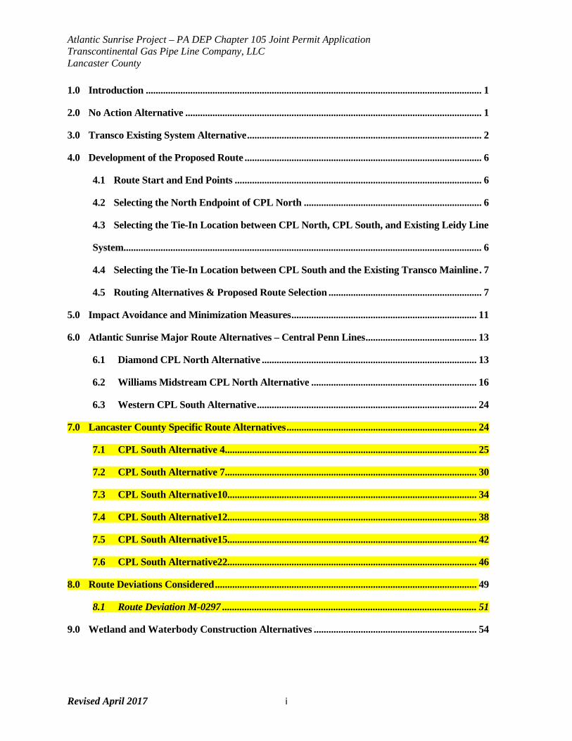
1.0 Introduction ........................................................................................................................................ 1
2.0 No Action Alternative ........................................................................................................................ 1
3.0 Transco Existing System Alternative ............................................................................................... 2
4.0 Development of the Proposed Route ................................................................................................ 6
4.1 Route Start and End Points .................................................................................................... 6
4.2 Selecting the North Endpoint of CPL North ........................................................................ 6
4.3 Selecting the Tie-In Location between CPL North, CPL South, and Existing Leidy Line
System................................................................................................................................................. 6
4.4 Selecting the Tie-In Location between CPL South and the Existing Transco Mainline . 7
4.5 Routing Alternatives & Proposed Route Selection .............................................................. 7
5.0 Impact Avoidance and Minimization Measures ........................................................................... 11
6.0 Atlantic Sunrise Major Route Alternatives – Central Penn Lines ............................................. 13
6.1 Diamond CPL North Alternative ....................................................................................... 13
6.2 Williams Midstream CPL North Alternative ................................................................... 16
6.3 Western CPL South Alternative ......................................................................................... 24
7.0 Lancaster County Specific Route Alternatives ............................................................................. 24
7.1 CPL South Alternative 4 ...................................................................................................... 25
7.2 CPL South Alternative 7 ...................................................................................................... 30
7.3 CPL South Alternative10..................................................................................................... 34
7.4 CPL South Alternative12..................................................................................................... 38
7.5 CPL South Alternative15..................................................................................................... 42
7.6 CPL South Alternative22..................................................................................................... 46
8.0 Route Deviations Considered .......................................................................................................... 49
8.1 Route Deviation M-0297 ....................................................................................................... 51
9.0 Wetland and Waterbody Construction Alternatives .................................................................. 54
Atlantic Sunrise Project – PA DEP Chapter 105 Joint Permit Application Transcontinental Gas Pipe Line Company, LLC Lancaster County
Revised April 2017 ii
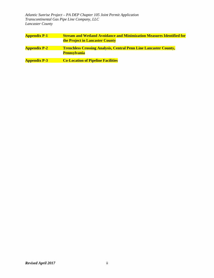
Appendix P-1 Stream and Wetland Avoidance and Minimization Measures Identified for the Project in Lancaster County
Appendix P-2 Trenchless Crossing Analysis, Central Penn Line Lancaster County, Pennsylvania
Appendix P-3 Co-Location of Pipeline Facilities
Atlantic Sunrise Project – PA DEP Chapter 105 Joint Permit Application Transcontinental Gas Pipe Line Company, LLC Lancaster County
Revised April 2017 1
1.0 INTRODUCTION This Alternatives Analysis report describes the alternatives considered or currently under
consideration for the proposed Atlantic Sunrise Project. This report discusses the following
categories of alternatives: the no-action alternative, system alternatives, route alternatives, and
construction alternatives. Additionally, there sections 7 and 8 herein consider Lancaster County
minor route alternatives and deviations.
The objective of Transcontinental Gas Pipe Line Company’s (Transco’s) alternatives analysis is
to develop proposed pipeline routes that will be constructible, accomplish the Project’s purpose,
and will avoid or minimize potential adverse environmental impacts. This alternatives analysis
was also developed to be consistent with the Federal Energy Regulatory Commission’s
regulatory requirements as set forth in 18 Code of Federal Regulations 380.15 and 25 PA. Code
§ 105.13(e)(viii). Thus, it contains a detailed analysis of alternatives to the proposed action,
including alternative locations, routings or designs to avoid or minimize environmental impacts.
The information contained in this report is based upon field surveys, desktop review of available
literature, stakeholder input, and publicly available information regarding existing pipeline
infrastructure. Comparison analysis of the alternatives discussed in this report is based on
rights-of-way (ROW) width assumptions and available data sets for desktop analysis.
2.0 NO-ACTION ALTERNATIVE This section describes the benefits and consequences of not constructing the Project. For
example, if Transco does not construct the Project, temporary and permanent environmental
impacts associated with construction and operation would be avoided. However, by not
constructing the Project, Transco would not be able to provide the natural gas transportation
service requested by the customers that have executed binding agreements for Transco to
provide 1.7 million dekatherms per day (MMDth/d) of incremental firm transportation of natural
gas from the Marcellus Shale production areas in northern Pennsylvania to its existing market
areas, extending to as far south as the Station 85 Pooling Point1 in Choctaw County, Alabama.
The no-action alternative would not result in increased access to reliable, domestic natural gas
supplies from the Marcellus Shale production areas. Transco’s review of existing and available
energy sources indicates that natural gas is the best fuel source to provide clean, reliable
energy necessary to meet existing and future demand while minimizing environmental impacts.
Atlantic Sunrise Project – PA DEP Chapter 105 Joint Permit Application Transcontinental Gas Pipe Line Company, LLC Lancaster County
Revised April 2017 2
The existing Transco facilities in or near the Project area are not currently designed to transport
natural gas from north to south and do not provide adequate pipeline takeaway capacity for
transportation of natural gas to meet current transportation demand. If the no-action alternative
is selected, Transco’s customers will need to:
• Seek other transportation services;
• Forgo meeting their natural gas demand until energy conservation measures stabilize or
decrease demand, possibly limiting their growth and the growth of the local economies
they serve; and
• Depend on other future development projects with unpredictable schedules and
undetermined environmental impacts.
For the reasons described above, the no-action alternative does not meet the Project objectives
of providing the additional transportation capacity of natural gas requested by its customers
within the time frame required.
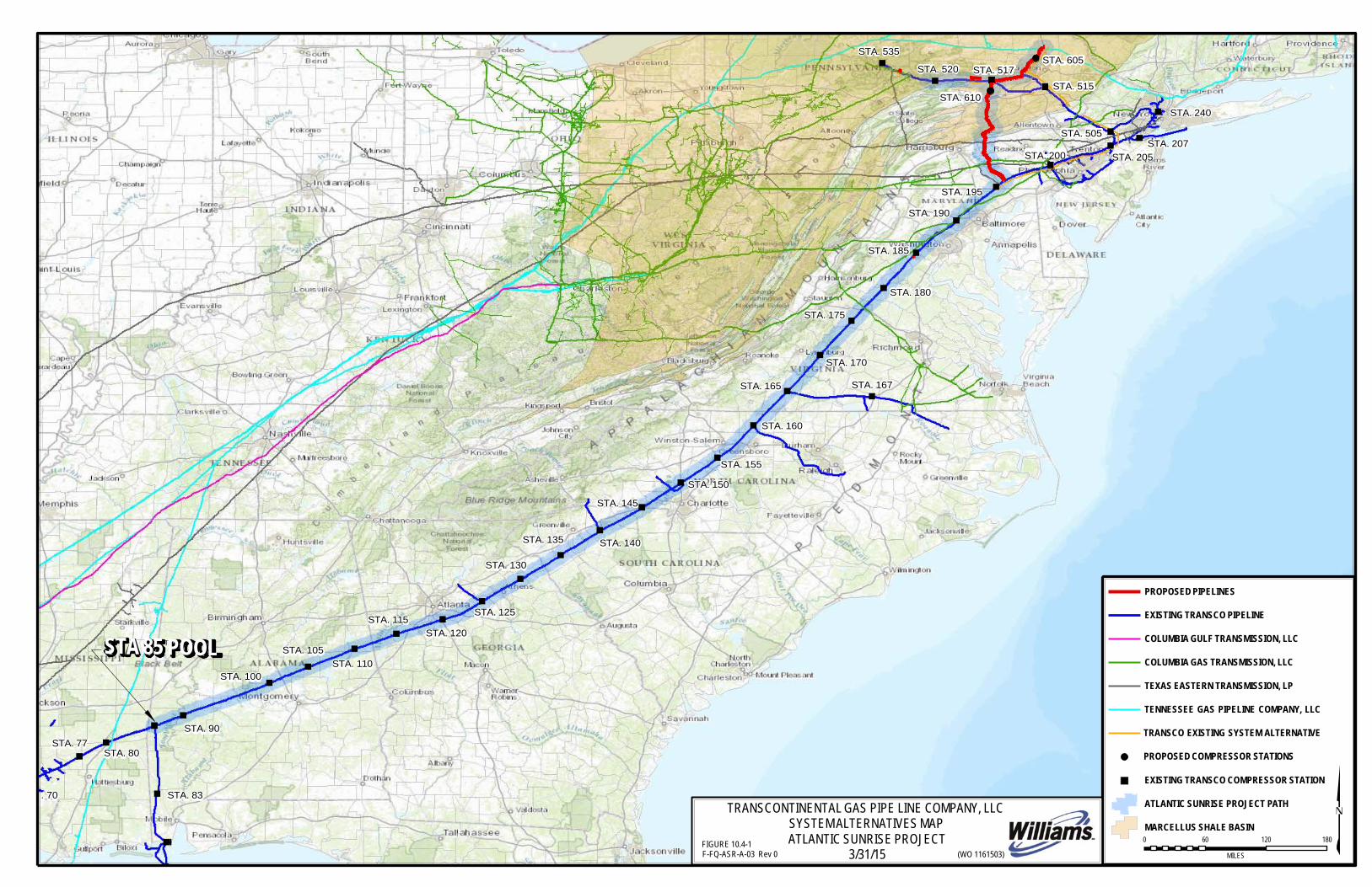
3.0 TRANSCO EXISTING SYSTEM ALTERNATIVE The Transco Existing System Alternative (Figure P-1) would utilize the existing ROWs of
Transco’s Leidy Line and Mainline systems to the extent practicable by installing noncontiguous
pipeline looping and other facilities along these systems. This alternative incorporates a
segment of the current proposed CPL North route, from the Zick Meter Station at about milepost
(MP) 57.33, to the proposed North Diamond Regulator Station near MP L92.7 in Luzerne
County, Pennsylvania. From this point, the alternative route runs east along the Leidy Line
system to existing Compressor Station 515 in Luzerne County, Pennsylvania. An additional
Leidy Line loop would be required between existing Compressor Stations 517 and 515 to
accommodate volumes moving eastward. East of Compressor Station 515, several sections of
looping would be required to transport the incremental volumes along the Leidy Line and
Transco Mainline systems.
The proposed Unity Loop, Chapman Loop, and horsepower additions at Compressor Stations
517, 520 and 190 would still be required. Similarly, facilities located south of Compressor
Station 195 (i.e., pipeline replacements in Virginia and aboveground facility modifications in
Maryland, Virginia, North Carolina, and South Carolina) would also be required for the Transco
Atlantic Sunrise Project – PA DEP Chapter 105 Joint Permit Application Transcontinental Gas Pipe Line Company, LLC Lancaster County
Revised April 2017 3
Existing System Alternative to meet the purpose and need for the Project. Facilities that are
common between the Project and the Transco Existing System Alternative are presented below
in underlined text to distinguish them from the facilities unique to the Transco Existing System
Alternative. This alternative is depicted as Figure P-1.
The following facilities would be necessary for the Transco Existing System Alternative:
• Greenfield Pipeline
• 36.2 miles of new 30-inch-diameter greenfield pipeline in Pennsylvania from the
Zick Meter Station to the North Diamond Regulator Station.
• Looping Pipeline
• 8.6 miles of new 42-inch-diameter looping in Lycoming County, Pennsylvania
(Unity Loop).
• 2.9 miles of new 36-inch-diameter looping in Clinton County, Pennsylvania
(Chapman Loop).
• 23.7 miles of new 42-inch-diameter loop from MP L92.7 to Station 515 in Luzerne
County, Pennsylvania.
• 8.6 miles of new 42-inch-diameter loop from MP LL7.7 4 to MP LL9.0 in Luzerne
County, Pennsylvania.
• 8.3 miles of new 42-inch-diameter loop from Station 515 to L60.7 in Luzerne
County and Monroe County, Pennsylvania.
• 14.8 miles of new 42-inch-diameter loop from L57.5 to L42.7 in Monroe County,
Pennsylvania.
• 30.3 miles of new 42-inch-diameter loop from Transco Delaware Regulator
Station to Centerville Regulator Station (includes Delaware River Crossing) in
Northampton County, Somerset County, and Warren County, New Jersey, and
Northampton County, Pennsylvania.
• 16.6 miles of new 42-inch-diameter loop from Transco Centerville Regulator
Station to Transco Station 205 in Somerset County and Mercer County, New
Jersey.
• 7.7 miles of new 42-inch-diameter loop from MP 1765.7 to Station 205 in
Mercer County, New Jersey.
• 43.0 miles of new 42-inch-diameter loop from Station 200 to MP 1765.3 in
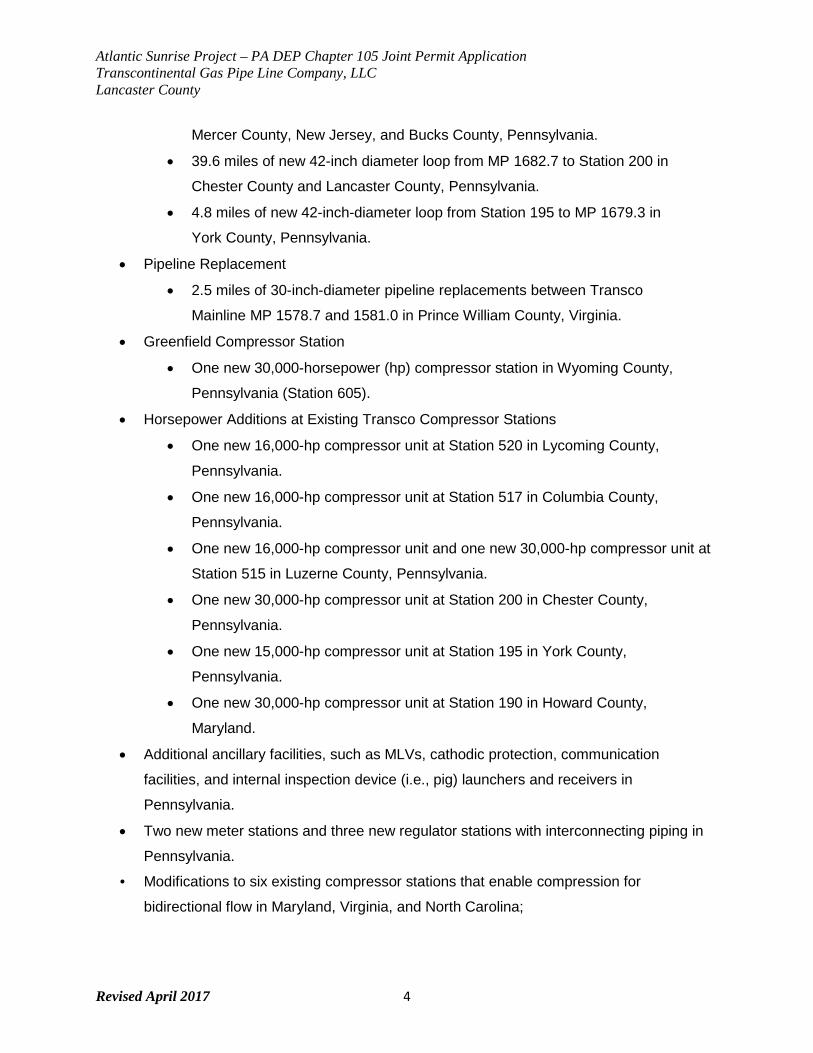
Atlantic Sunrise Project – PA DEP Chapter 105 Joint Permit Application Transcontinental Gas Pipe Line Company, LLC Lancaster County
Revised April 2017 4
Mercer County, New Jersey, and Bucks County, Pennsylvania.
• 39.6 miles of new 42-inch diameter loop from MP 1682.7 to Station 200 in
Chester County and Lancaster County, Pennsylvania.
• 4.8 miles of new 42-inch-diameter loop from Station 195 to MP 1679.3 in
York County, Pennsylvania.
• Pipeline Replacement
• 2.5 miles of 30-inch-diameter pipeline replacements between Transco
Mainline MP 1578.7 and 1581.0 in Prince William County, Virginia.
• Greenfield Compressor Station
• One new 30,000-horsepower (hp) compressor station in Wyoming County,
Pennsylvania (Station 605).
• Horsepower Additions at Existing Transco Compressor Stations
• One new 16,000-hp compressor unit at Station 520 in Lycoming County,
Pennsylvania.
• One new 16,000-hp compressor unit at Station 517 in Columbia County,
Pennsylvania.
• One new 16,000-hp compressor unit and one new 30,000-hp compressor unit at
Station 515 in Luzerne County, Pennsylvania.
• One new 30,000-hp compressor unit at Station 200 in Chester County,
Pennsylvania.
• One new 15,000-hp compressor unit at Station 195 in York County,
Pennsylvania.
• One new 30,000-hp compressor unit at Station 190 in Howard County,
Maryland.
• Additional ancillary facilities, such as MLVs, cathodic protection, communication
facilities, and internal inspection device (i.e., pig) launchers and receivers in
Pennsylvania.
• Two new meter stations and three new regulator stations with interconnecting piping in
Pennsylvania.
• Modifications to six existing compressor stations that enable compression for
bidirectional flow in Maryland, Virginia, and North Carolina;
Atlantic Sunrise Project – PA DEP Chapter 105 Joint Permit Application Transcontinental Gas Pipe Line Company, LLC Lancaster County
Revised April 2017 5
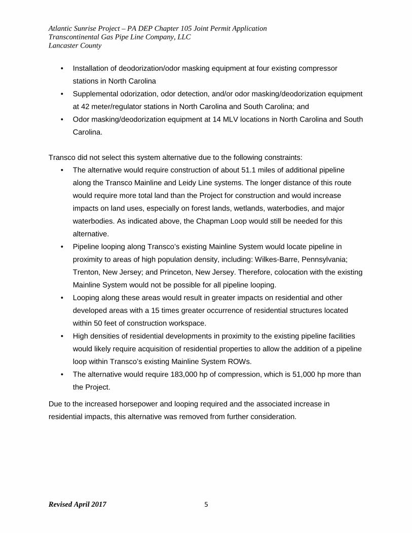
• Installation of deodorization/odor masking equipment at four existing compressor
stations in North Carolina
• Supplemental odorization, odor detection, and/or odor masking/deodorization equipment
at 42 meter/regulator stations in North Carolina and South Carolina; and
• Odor masking/deodorization equipment at 14 MLV locations in North Carolina and South
Carolina.
Transco did not select this system alternative due to the following constraints:
• The alternative would require construction of about 51.1 miles of additional pipeline
along the Transco Mainline and Leidy Line systems. The longer distance of this route
would require more total land than the Project for construction and would increase
impacts on land uses, especially on forest lands, wetlands, waterbodies, and major
waterbodies. As indicated above, the Chapman Loop would still be needed for this
alternative.
• Pipeline looping along Transco’s existing Mainline System would locate pipeline in
proximity to areas of high population density, including: Wilkes-Barre, Pennsylvania;
Trenton, New Jersey; and Princeton, New Jersey. Therefore, colocation with the existing
Mainline System would not be possible for all pipeline looping.
• Looping along these areas would result in greater impacts on residential and other
developed areas with a 15 times greater occurrence of residential structures located
within 50 feet of construction workspace.
• High densities of residential developments in proximity to the existing pipeline facilities
would likely require acquisition of residential properties to allow the addition of a pipeline
loop within Transco’s existing Mainline System ROWs.
• The alternative would require 183,000 hp of compression, which is 51,000 hp more than
the Project.
Due to the increased horsepower and looping required and the associated increase in
residential impacts, this alternative was removed from further consideration.
Atlantic Sunrise Project – PA DEP Chapter 105 Joint Permit Application Transcontinental Gas Pipe Line Company, LLC Lancaster County
Revised April 2017 6
4.0 DEVELOPMENT OF THE PROPOSED ROUTE Based on the commercial aspects of the Project, Transco evaluated start and endpoints for the
Project and identified potential route alternatives between the start and endpoints of the Central
Penn Line. This section provides the framework used to define the route start and endpoints of
the Central Penn Line, as well as selection of the proposed route.
4.1 Route Start and Endpoints
The locations that Transco evaluated for start and endpoints were based on the need to
meet the stated purpose of the Project while maximizing the use of existing Transco
infrastructure for efficiency and reliability and to minimize the amount of incremental facilities
required. Using these parameters, Transco designed the Project to have the capacity to
receive up to 1.7 MMDth/d of natural gas from both new receipt points on CPL North and
from existing receipt points along the Leidy Line system.
4.2 Selecting the North Endpoint of CPL North
New receipt points on CPL North include the Zick and Springville Meter Station in
Susquehanna County, Pennsylvania, which can provide approximately 850,000 dekatherms
per day (Dth/d) from interconnecting midstream pipelines. As it is the northernmost receipt
point, Transco determined that the Zick Meter Station will serve as the northern endpoint of
the pipeline route.
4.3 Selecting the Tie-In Location between CPL North, CPL South, and Existing Leidy Line
System
In addition to the 850,000 Dth/d received on CPL North, the remaining 850,000 Dth/d will be
received through various receipt points along Transco’s existing Leidy Line system, and the
full 1.7 MMDth/d will be aggregated into CPL South. CPL North and existing Leidy Line A
share a corridor that rejoins Leidy Line system pipelines B, C, and D at MP L113.7. This is
the easternmost location of the preferred aggregation point. Compressor Station 517 is
located at MP L115.2 and defines the westernmost location of the aggregation point.
Aggregating volumes on the discharge (east) side of Compressor Station 517 optimizes the
horsepower at the station, providing higher pressure into CPL South. Therefore, an
aggregation point between MP L113.7 and L115.2 is preferred. Transco determined MP
L114.0 to be the ideal point within this range, as it would shorten the length of the CPL North
Atlantic Sunrise Project – PA DEP Chapter 105 Joint Permit Application Transcontinental Gas Pipe Line Company, LLC Lancaster County
Revised April 2017 7
pipeline. Furthermore, if the aggregation point were located west of Compressor Station 517
at approximately MP L123.0, an additional 25,000 hp would be required at proposed
Compressor Station 610 as lower suction pressure gas would be entering the station piping.
Consequently, this reinforces Transco’s proposed tie-in location between MP L113.7 and
MP L115.2.
4.4 Selecting the Tie-In Location between CPL South and the Existing Transco Mainline
The southern endpoint of CPL South must tie into Transco’s existing Mainline system in
order to serve its existing market areas. To minimize the amount of additional facilities
needed to meet the Project’s purpose, Transco determined that the optimal hydraulic
endpoint of the pipeline route is between MP 1674.6 (existing Compressor Station 195) and
MP 1683.7 of the Transco Mainline system. However, extending south of MP 1679.8 would
necessitate an additional crossing of the Susquehanna River, for which Transco was not
able to find a suitable crossing location. Therefore, Transco determined the optimal range to
be between MP 1679.8 and 1683.7. The proposed route for CPL South ties into the existing
Transco Mainline system at MP 1683.3.
Any system tie-ins north of MP 1683.7 would require additional mainline facilities (mainline
looping and/or compression) between existing Compressor Station 195 and the tie-in
location. For example, Transco evaluated a tie-in point near MP 1686.4, located 3.10 miles
northeast of the current proposed tie-in. Transco’s hydraulic study determined that a tie-in at
this location would require an additional 4,000 hp at existing Compressor Station 195, as
well as compressor re-wheeling and modifications to two existing reciprocating compressors
to operate the higher differential pressure. Alternatively, an approximately 4-mile-long loop
would be required between MP 1682.4 and MP 1686.4. Any tie-in point further northeast
than MP 1686.4 would necessitate additional incremental facilities, such as additional
compression, looping, or some combination of the two.
4.5 Routing Alternatives & Proposed Route Selection
Transco identified certain routing constraints and sensitive areas requiring detailed analysis
to ensure avoidance or minimization of impacts when evaluating alternatives and selecting
the proposed pipeline routes.
Atlantic Sunrise Project – PA DEP Chapter 105 Joint Permit Application Transcontinental Gas Pipe Line Company, LLC Lancaster County
Revised April 2017 8
When identifying routing options, Transco attempted to co-locate the pipeline with existing
utility corridors and ROWs while considering impacts on other environmental factors. The
use of co-location as a principal design element is consistent with the FERC guidelines,
which stress the corridor concept, and complements the existing land use characteristics in
the Project area. Siting pipeline facilities along existing corridors reduces the need to
establish new corridors in previously undisturbed areas, which reduces the amount of
fragmentation of interior forest and minimizes the number of affected landowners. Transco
defines co-location as siting a pipeline right-of-way (ROW) that:
• Lies within an existing ROW or easement; or
• Abuts an existing ROW or easement.
The following routing considerations also influenced the development of the proposed
routes:
• Identifying crossing locations of the Susquehanna River where, based on terrain,
horizontal directional drilling (HDD) appeared to be technically feasible;
• Minimizing visual impacts on the Appalachian Trail;
• Crossing areas of significant topographic relief where technically feasible;
• Avoiding state lands, including state parks, state forests, and state game lands to the
maximum extent practicable; and
• Avoiding densely populated areas to the extent practicable.
Transco’s pipeline route selection process considered three types of route alternatives:
• Major route alternative – a route that differs substantially in both length and distance
from the proposed route, which are described in Section 6.0 and are presented on an
entire Project basis for the overall Atlantic Sunrise Project;
• Minor route alternative – a route that deviates from short segments of the proposed
route which are described in Section 7.0 and are presented on a County basis
related to the specific permit application for which this Attachment P is prepared for;
and
• Route deviation – minor adjustments to the proposed route, typically to avoid specific
features (e.g., topography, sensitive habitat, structures), summarized in Table P-1 for
CPL North and CPL South.
Atlantic Sunrise Project – PA DEP Chapter 105 Joint Permit Application Transcontinental Gas Pipe Line Company, LLC Lancaster County
Revised April 2017 9
After taking the above into consideration, Transco narrowed its analysis to 600-foot-wide
study corridors for the CPL North and CPL South pipeline routes, which were determined
based on desktop data and aerial reconnaissance (helicopter overflights). Once this initial
routing process was complete, Transco began field routing efforts within these study
corridors. These field efforts began in May 2014 and continued up to the submittal of this
application. A detailed discussion on the field routing process and impact avoidance and
minimization measures undertaken as part of the Project are described in Section 5.0 of this
Alternatives Analysis.
In addition to route adjustments based on field routing, biological and cultural resource
surveys, Transco considered alternatives requested by landowners and other stakeholders
through stakeholder outreach, commencing with Transco’s open houses held in May and
June of 2014. Transco reviewed each requested route adjustment for feasibility as a viable
alternative based on the Project route, constructability, and the minimization of impacts on
sensitive resources.
Transco used various data sources to identify and evaluate pipeline route alternatives,
including: observations made during routing surveys and field reconnaissance; Google
Earth™; geographic information system databases from county, state, and federal sources;
recently produced aerial photography; U.S. Geological Survey (USGS) topographic maps;
National Wetland Inventory maps; and remote-sensing data. The factors used to select the
proposed routes over the alternative routes focused on FERC scoping information,
landowner concerns, minimizing the number of affected landowners, minimizing adverse
environmental impacts, ensuring constructability, and promoting safety.
Atlantic Sunrise Project – PA DEP Chapter 105 Joint Permit Application Transcontinental Gas Pipe Line Company, LLC Lancaster County
Revised April 2017 10
FIGURE 1
STA. 535
STA. 520
STA. 517
STA. 605
STA. 515
STA. 610 STA. 240
STA. 505
STA. 207 STA. 200 STA. 205
STA. 195
STA. 190
STA. 185
STA. 180
STA. 175
STA. 170
STA. 165 STA. 167
STA. 160
STA. 155
STA. 145
STA. 150
STA. 135 STA. 140
STA. 130
STA. 100
STA. 105
STA. 115
STA. 110
STA. 120
STA. 125
PROPOSED PIPELINES
EXISTING TRANSCO PIPELINE
COLUMBIA GULF TRANSMISSION, LLC
COLUMBIA GAS TRANSMISSION, LLC
TEXAS EASTERN TRANSMISSION, LP
STA. 77
STA. 80
STA. 90
TENNESSEE GAS PIPELINE COMPANY, LLC
TRANSCO EXISTING SYSTEM ALTERNATIVE
PROPOSED COMPRESSOR STATIONS
. 70
STA. 83
TRANSCONTINENTAL GAS PIPE LINE COMPANY, LLC SYSTEM ALTERNATIVES MAP
EXISTING TRANSCO COMPRESSOR STATION
ATLANTIC SUNRISE PROJECT PATH
MARCELLUS SHALE BASIN FIGURE 10.4-1 F-FQ-ASR-A-03 Rev 0
ATLANTIC SUNRISE PROJECT 3/31/15
(WO 1161503)
0 60 120 180
MILES
STA 85 POOL
Atlantic Sunrise Project – PA DEP Chapter 105 Joint Permit Application Transcontinental Gas Pipe Line Company, LLC Lancaster County
Revised April 2017 11
5.0 IMPACT AVOIDANCE AND MINIMIZATION MEASURES Due to the linear nature of the Project, it is not possible to completely avoid impacts to wetlands,
waterbodies, or other sensitive resources. Therefore, Transco used a comprehensive field
routing process to identify a constructible alignment for CPL North and CPL South that would
minimize impacts to wetlands, waterbodies, or other sensitive resources to the extent
practicable. A similar approach was taken on the Chapman and Unity Loops; however, in these
cases routing options were limited to the north or south side of the existing right-of-way to
maximize opportunities for co-location. Impact minimization and avoidance has been
accomplished with field routing teams comprised of engineering, construction, and
environmental specialists. These teams are assessing the routes with regard to the following
considerations:
Engineering
• Avoiding general engineering and constructability constraints;
• Minimizing route distance along steep slopes and side slopes;
• Reducing the number of severe pipeline bends and turning angles;
• Identifying and avoiding, where practicable, areas of karst topography;
• Identifying and evaluating opportunities for utilizing trenchless technology such as
HDD and boring; and
• Identifying and avoiding, where practicable, locations with a potential need for
blasting.
Environmental
• Minimizing impacts at any single wetland crossing to 1 acre or less wherever
practicable;
• Avoiding or minimizing impacts on forested wetlands and other wetlands;
• Avoiding or minimizing impacts on known threatened and endangered species
habitat, such as:
• Rocky talus slopes potentially used as habitat by the timber rattlesnake
(Crotalus horridus), Allegheny woodrat (Neotoma magister), and small-footed
bat (Myotis leibii);
• Wetland complexes with features suggesting potential suitability as bog turtle
habitat; and
Atlantic Sunrise Project – PA DEP Chapter 105 Joint Permit Application Transcontinental Gas Pipe Line Company, LLC Lancaster County
Revised April 2017 12
• Palustrine emergent wetlands surrounded by woodlands, which may be
suitable habitat for the northeastern bulrush (Scirpus ancistrochaetus)
• Forest stands containing trees greater than 5 inches diameter at breast
height with exfoliating bark, cracks, crevices, and/or hollows. Prime examples
would include live shagbark hickory trees (Carya ovata) and shellbark hickory
trees (C. laciniosa), dead elms (Ulmus spp.), dead poplars (Populus spp.), or
any tree with a rotted-out cavity, which may be potential roosting trees or
suitable habitat for the Indiana bat (Myotis sodalis) and northern long-eared
bat (Myotis septentrionalis).
• Crossing waterbodies at 90 degree angles to minimize in-stream disturbance
wherever practicable;
• Avoiding or minimizing crossings of major waterbodies;
• Minimizing impacts on contiguous upland forest by routing the centerline along tree
lines or through existing cleared areas to the greatest extent practicable; and
• Identifying and avoiding, where practicable, groundwater springs/seeps.
Land
• Minimizing impacts on private property and structures;
• Minimizing conflicts with land use; and
• Minimizing impacts on residential water wells and septic systems.
Cultural
• Avoiding or minimizing impacts on sites listed on or potentially eligible for listing on
the National Register of Historic Places; and
• Identifying and avoiding, where practicable, aboveground structures that appeared to
be over 50 years old.
Transco initiated routing surveys within the 600-foot-wide study corridors in May 2014 and has
continued the routing process through 2016 as survey permission has been granted. At the time of the submission of this application, field survey of the proposed Project footprint within Lancaster County is 100 percent complete – no outstanding parcels or remotely sensed resources remain to be surveyed.
Atlantic Sunrise Project – PA DEP Chapter 105 Joint Permit Application Transcontinental Gas Pipe Line Company, LLC Lancaster County
Revised April 2017 13
The routing survey crews started with a preliminary pipeline route centered within the 600-foot-
wide study corridors. The preliminary pipeline route was either confirmed as adequate or
adjusted to avoid and/or minimize, to the extent practicable, any issues encountered during the
routing surveys according to the considerations noted above. The routing survey teams
documented the reasons for the adjustments and classified them according to the engineering,
environmental, land, and cultural considerations evaluated. Appendix P-1 provides the results
of stream and wetland avoidance and minimization measures identified for the Project in
Lancaster County by the routing survey crews.
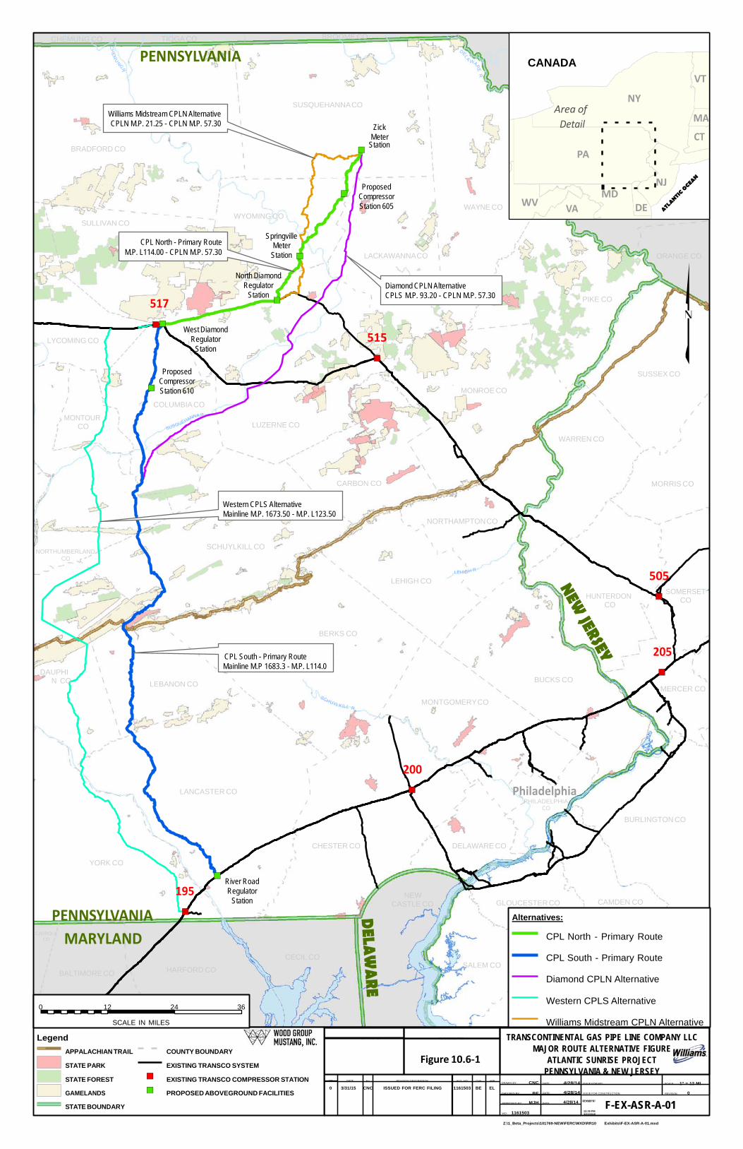
6.0 ATLANTIC SUNRISE MAJOR ROUTE ALTERNATIVES – CENTRAL PENN LINES Major route alternatives differ substantially in both length and distance from the proposed route.
During the Project development process, Transco considered three major route alternatives
before selecting its 600-foot-wide study corridors and proposed routes: the Diamond CPL North
Alternative, Williams Midstream CPL North Alternative, and Western CPL South Alternative.
Each of the major route alternatives is described below. Transco did not complete full hydraulic
modeling, nor did it evaluate costs for any of the major alternatives, because those alternatives
have significantly greater environmental impacts than proposed routes for CPL North and CPL
South. Figure P-2 shows the major alternatives in relation to the proposed routes.
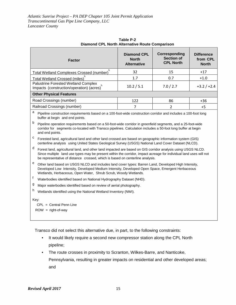
6.1 Diamond CPL North Alternative
The Diamond CPL North Alternative6 starts at the Zick Meter Station in Susquehanna
County, Pennsylvania. The route continues south for approximately 80 miles, bisecting
Transco’s existing Leidy Line A to the north and Leidy Lines B and C to the south and
terminates near MP 93.2 of the CPL South route in Columbia County, Pennsylvania.
Approximately 48 miles of the route is co-located with other ROW, with the remaining
approximately 32 miles being primarily greenfield. The Diamond CPL North Alternative is an
alternative route for CPL North, as the entire length of CPL South would still be required for
this alternative, including the segment of the proposed route between MP 125.1 and MP
93.2. CPL South MP 93.2 would become the new aggregation point for Leidy Line system
volumes and CPL North volumes.
Atlantic Sunrise Project – PA DEP Chapter 105 Joint Permit Application Transcontinental Gas Pipe Line Company, LLC Lancaster County
Revised April 2017 14
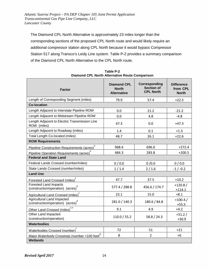
The Diamond CPL North Alternative is approximately 23 miles longer than the
corresponding sections of the proposed CPL North route and would likely require an
additional compressor station along CPL North because it would bypass Compressor
Station 517 along Transco’s Leidy Line system. Table P-2 provides a summary comparison
of the Diamond CPL North Alternative to the CPL North route.
Table P-2 Diamond CPL North Alternative Route Comparison
Factor
Diamond CPL North
Alternative
Corresponding Section of CPL North
Difference from CPL
North
Length of Corresponding Segment (miles) 79.9 57.4 +22.5 Co-location Length Adjacent to Interstate Pipeline ROW ( )
0.0 21.2 -21.2 Length Adjacent to Midstream Pipeline ROW ( )
0.0 4.8 -4.8 Length Adjacent to Electric Transmission Line ROW (miles) 47.3 0.0 +47.3
Length Adjacent to Roadway (miles) 1.4 0.1 +1.3 Total Length Co-located (miles) 48.7 26.1 +22.6 ROW Requirements
Pipeline Construction Requirements (acres)a 968.4 696.0 +272.4
Pipeline Operation Requirements (acres)b 484.3 283.8 +200.5
Federal and State Land Federal Lands Crossed (number/miles) 0 / 0.0 0 /0.0 0 / 0.0 State Lands Crossed (number/miles) 1 / 1.4 2 / 1.6 -1 / -0.2 Land Use
Forested Land Crossed (miles)c 47.7 37.5 +10.2
Forested Land Impacts (construction/operation) (acres)
d 577.4 / 288.8 456.6 / 174.7 +120.8 /
+114.1 Agricultural Land Crossed (miles)
c 23.1 15.0 +8.1
Agricultural Land Impacted (construction/operation) (acres)
d 281.0 / 140.3 180.6 / 84.8 +100.4./
+55.5 Other Land Crossed (miles)
c,e 9.1 4.9 +4.2
Other Land Impacted (construction/operation)
110.0 / 55.2 58.8 / 24.3 +51.2 / +30.9
Waterbodies
Waterbodies Crossed (number)f 72 51 +21
Major Waterbody Crossings (number >100 feet)g 8 2 +6
Wetlands
Atlantic Sunrise Project – PA DEP Chapter 105 Joint Permit Application Transcontinental Gas Pipe Line Company, LLC Lancaster County
Revised April 2017 15
Table P-2 Diamond CPL North Alternative Route Comparison
Factor
Diamond CPL North
Alternative
Corresponding Section of CPL North
Difference from CPL
North
Total Wetland Complexes Crossed (number)h 32 15 +17
Total Wetland Crossed (miles)h 1.7 0.7 +1.0
Palustrine Forested Wetland Complex Impacts (construction/operation) (acres)
h 10.2 / 5.1 7.0 / 2.7 +3.2 / +2.4
Other Physical Features Road Crossings (number) 122 86 +36 Railroad Crossings (number) 7 2 +5 a Pipeline construction requirements based on a 100-foot-wide construction corridor and includes a 100-foot long
buffer at begin and end points. b Pipeline operation requirements based on a 50-foot-wide corridor in greenfield segments, and a 25-foot-wide
corridor for segments co-located with Transco pipelines. Calculation includes a 50-foot long buffer at begin and end points.
c Forested land, agricultural land and other land crossed are based on geographic information system (GIS) centerline analysis using United States Geological Survey (USGS) National Land Cover Dataset (NLCD).
d Forest land, agricultural land, and other land impacted are based on GIS corridor analysis using USGS NLCD. Since multiple land use types may be present within the corridor, impact acreage for individual land uses will not be representative of distance crossed, which is based on centerline analysis.
e Other land based on USGS NLCD and includes land cover types: Barren Land, Developed High Intensity, Developed Low Intensity, Developed Medium Intensity, Developed Open Space, Emergent Herbaceous Wetlands, Herbaceous, Open Water, Shrub Scrub, Woody Wetlands.
f Waterbodies identified based on National Hydrography Dataset (NHD). g Major waterbodies identified based on review of aerial photography. h Wetlands identified using the National Wetland Inventory (NWI).
Key:
CPL = Central Penn Line ROW = right-of-way
Transco did not select this alternative due, in part, to the following constraints:
• It would likely require a second new compressor station along the CPL North
pipeline;
• The route crosses in proximity to Scranton, Wilkes-Barre, and Nanticoke,
Pennsylvania, resulting in greater impacts on residential and other developed areas;
and
Atlantic Sunrise Project – PA DEP Chapter 105 Joint Permit Application Transcontinental Gas Pipe Line Company, LLC Lancaster County
Revised April 2017 16
• Total mileage of CPL North would increase by about 23 miles, and the length of CPL
South would not be reduced.
Any configuration of the Diamond CPL North Alternative would still require construction of
the portion of the alternative north of the intersection with the Leidy Line System. Due to the
high density of populated areas north of the Leidy Line System, Transco did not evaluate
additional configurations of the Diamond CPL North Alternative.
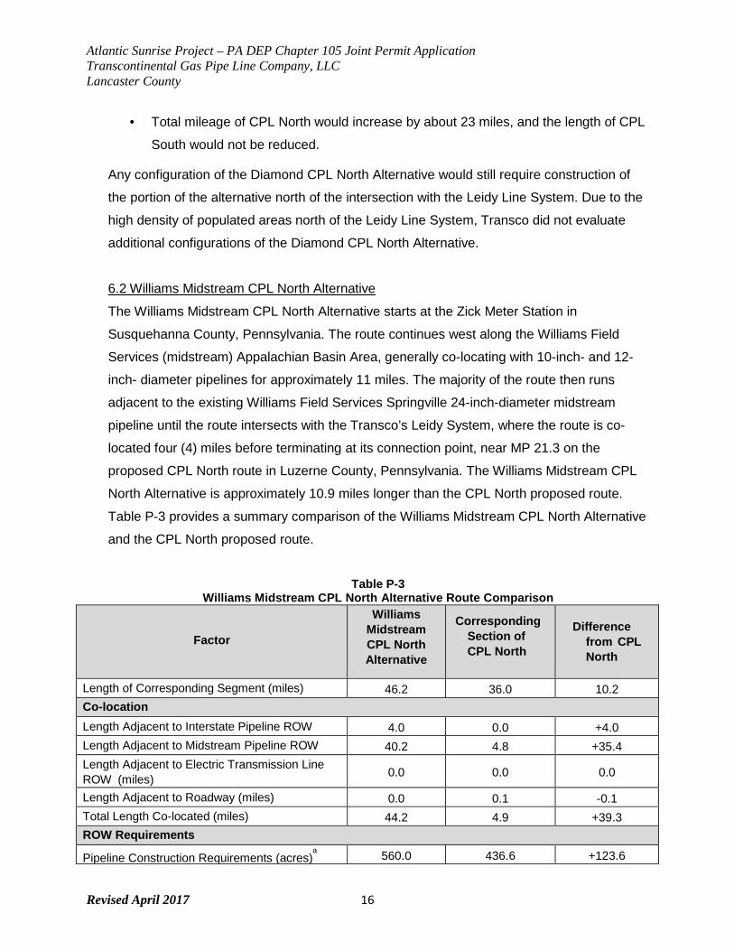
6.2 Williams Midstream CPL North Alternative
The Williams Midstream CPL North Alternative starts at the Zick Meter Station in
Susquehanna County, Pennsylvania. The route continues west along the Williams Field
Services (midstream) Appalachian Basin Area, generally co-locating with 10-inch- and 12-
inch- diameter pipelines for approximately 11 miles. The majority of the route then runs
adjacent to the existing Williams Field Services Springville 24-inch-diameter midstream
pipeline until the route intersects with the Transco’s Leidy System, where the route is co-
located four (4) miles before terminating at its connection point, near MP 21.3 on the
proposed CPL North route in Luzerne County, Pennsylvania. The Williams Midstream CPL
North Alternative is approximately 10.9 miles longer than the CPL North proposed route.
Table P-3 provides a summary comparison of the Williams Midstream CPL North Alternative
and the CPL North proposed route.
Table P-3
Williams Midstream CPL North Alternative Route Comparison
Factor
Williams Midstream CPL North Alternative
Corresponding Section of CPL North
Difference
from CPL North
Length of Corresponding Segment (miles) 46.2 36.0 10.2 Co-location Length Adjacent to Interstate Pipeline ROW
4.0 0.0 +4.0
Length Adjacent to Midstream Pipeline ROW ( )
40.2 4.8 +35.4 Length Adjacent to Electric Transmission Line ROW (miles) 0.0 0.0 0.0
Length Adjacent to Roadway (miles) 0.0 0.1 -0.1 Total Length Co-located (miles) 44.2 4.9 +39.3 ROW Requirements
Pipeline Construction Requirements (acres)a 560.0 436.6 +123.6
Atlantic Sunrise Project – PA DEP Chapter 105 Joint Permit Application Transcontinental Gas Pipe Line Company, LLC Lancaster County
Revised April 2017 17
Factor
Williams Midstream CPL North Alternative
Corresponding Section of CPL North
Difference
from CPL North
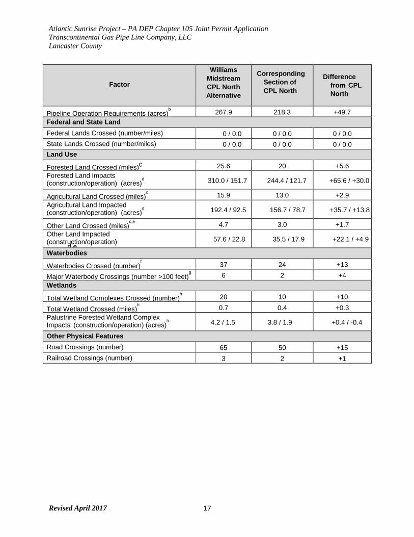
Pipeline Operation Requirements (acres)b 267.9 218.3 +49.7
Federal and State Land Federal Lands Crossed (number/miles) 0 / 0.0 0 / 0.0 0 / 0.0 State Lands Crossed (number/miles) 0 / 0.0 0 / 0.0 0 / 0.0 Land Use
Forested Land Crossed (miles)c 25.6 20 +5.6 Forested Land Impacts (construction/operation) (acres)
d 310.0 / 151.7 244.4 / 121.7 +65.6 / +30.0
Agricultural Land Crossed (miles)c 15.9 13.0 +2.9
Agricultural Land Impacted (construction/operation) (acres)
d 192.4 / 92.5 156.7 / 78.7 +35.7 / +13.8
Other Land Crossed (miles)c,e
4.7 3.0 +1.7 Other Land Impacted (construction/operation) ( )d e
57.6 / 22.8 35.5 / 17.9 +22.1 / +4.9
Waterbodies
Waterbodies Crossed (number)f 37 24 +13
Major Waterbody Crossings (number >100 feet)g 6 2 +4
Wetlands
Total Wetland Complexes Crossed (number)h 20 10 +10
Total Wetland Crossed (miles)h 0.7 0.4 +0.3
Palustrine Forested Wetland Complex Impacts (construction/operation) (acres)
h 4.2 / 1.5 3.8 / 1.9 +0.4 / -0.4
Other Physical Features Road Crossings (number) 65 50 +15 Railroad Crossings (number) 3 2 +1
Atlantic Sunrise Project – PA DEP Chapter 105 Joint Permit Application Transcontinental Gas Pipe Line Company, LLC Lancaster County
Revised April 2017 18
Factor
Williams Midstream CPL North Alternative
Corresponding Section of CPL North
Difference
from CPL North
a Pipeline construction requirements based on a 100-foot-wide construction corridor and includes a 100-foot long buffer at begin and end points.
b Pipeline operation requirements based on a 50-foot-wide corridor in greenfield segments, and a 25-foot-wide corridor for segments co-located with Transco pipelines. Calculation includes a 50-foot long buffer at begin and end points.
c Forested land, agricultural land and other land crossed are based on geographic information system (GIS) centerline analysis using United States Geological Survey (USGS) National Land Cover Dataset (NLCD).
d Forest land, agricultural land, and other land impacted are based on GIS corridor analysis using USGS NLCD. Since multiple land use types may be present within the corridor, impact acreage for individual land uses will not be representative of distance crossed, which is based on centerline analysis.
e Other land based on USGS NLCD and includes land cover types: Barren Land, Developed High Intensity, Developed Low Intensity, Developed Medium Intensity, Developed Open Space, Emergent Herbaceous Wetlands, Herbaceous, Open Water, Shrub Scrub, Woody Wetlands.
f Waterbodies identified based on National Hydrography Dataset (NHD). g Major waterbodies identified based on review of aerial photography. h Wetlands identified using the National Wetland Inventory (NWI).
Key: CPL = Central Penn Line
ROW = right-of-way
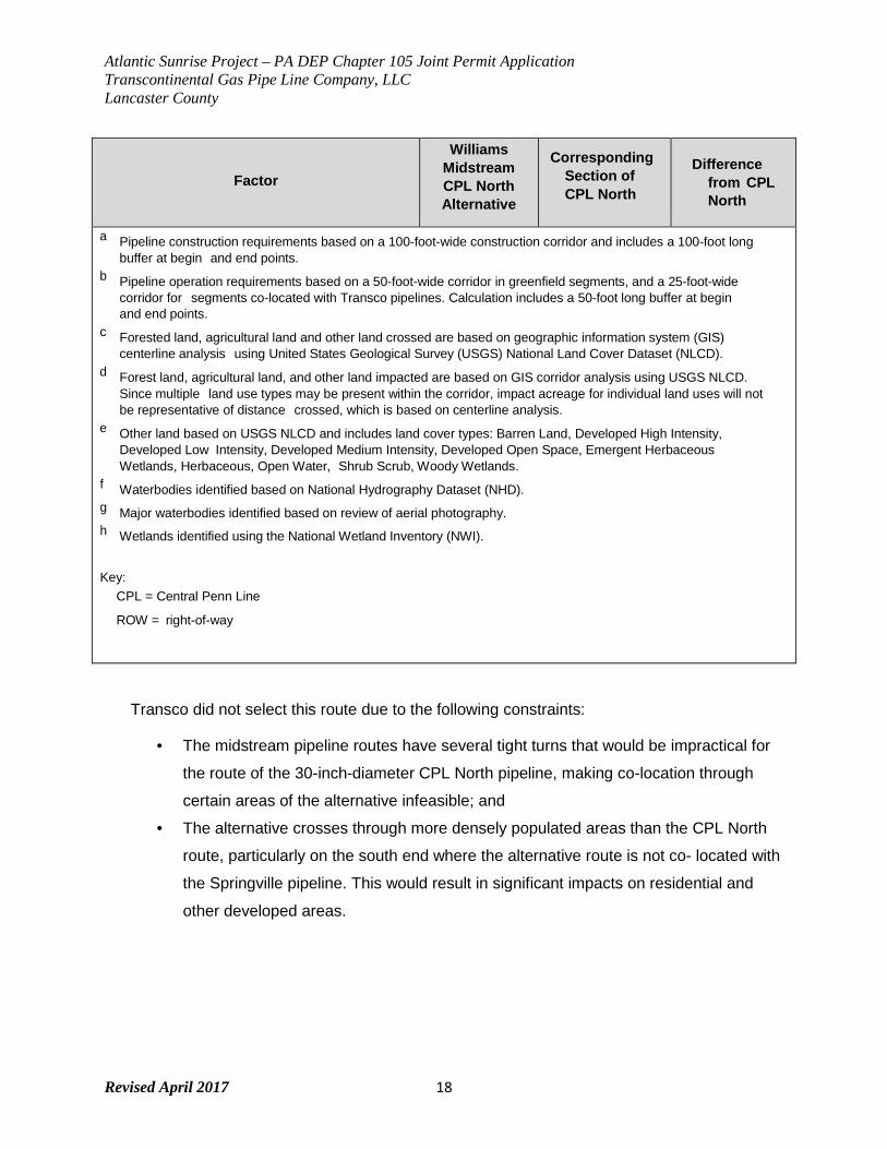
Transco did not select this route due to the following constraints:
• The midstream pipeline routes have several tight turns that would be impractical for
the route of the 30-inch-diameter CPL North pipeline, making co-location through
certain areas of the alternative infeasible; and
• The alternative crosses through more densely populated areas than the CPL North
route, particularly on the south end where the alternative route is not co- located with
the Springville pipeline. This would result in significant impacts on residential and
other developed areas.
Atlantic Sunrise Project – PA DEP Chapter 105 Joint Permit Application Transcontinental Gas Pipe Line Company, LLC Lancaster County
Revised April 2017 19
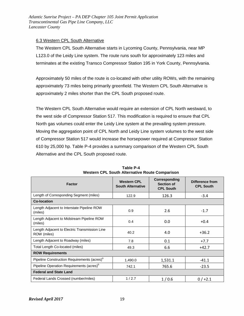
6.3 Western CPL South Alternative
The Western CPL South Alternative starts in Lycoming County, Pennsylvania, near MP
L123.0 of the Leidy Line system. The route runs south for approximately 123 miles and
terminates at the existing Transco Compressor Station 195 in York County, Pennsylvania.
Approximately 50 miles of the route is co-located with other utility ROWs, with the remaining
approximately 73 miles being primarily greenfield. The Western CPL South Alternative is
approximately 2 miles shorter than the CPL South proposed route.
The Western CPL South Alternative would require an extension of CPL North westward, to
the west side of Compressor Station 517. This modification is required to ensure that CPL
North gas volumes could enter the Leidy Line system at the prevailing system pressure.
Moving the aggregation point of CPL North and Leidy Line system volumes to the west side
of Compressor Station 517 would increase the horsepower required at Compressor Station
610 by 25,000 hp. Table P-4 provides a summary comparison of the Western CPL South
Alternative and the CPL South proposed route.
Table P-4 Western CPL South Alternative Route Comparison
Factor Western CPL
South Alternative
Corresponding Section of CPL South
Difference from CPL South
Length of Corresponding Segment (miles) 122.9 126.3 -3.4 Co-location
Length Adjacent to Interstate Pipeline ROW (miles) 0.9 2.6 -1.7
Length Adjacent to Midstream Pipeline ROW (miles) 0.4 0.0 +0.4
Length Adjacent to Electric Transmission Line ROW (miles) 40.2 4.0 +36.2
Length Adjacent to Roadway (miles) 7.8 0.1 +7.7 Total Length Co-located (miles) 49.3 6.6 +42.7 ROW Requirements
Pipeline Construction Requirements (acres)a 1,490.0 1,531.1 -41.1
Pipeline Operation Requirements (acres)b 742.1 765.6 -23.5
Federal and State Land
Federal Lands Crossed (number/miles) 1 / 2.7 1 / 0.6 0 / +2.1
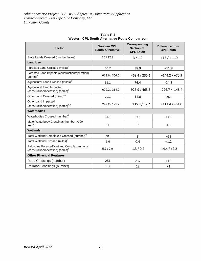
Atlantic Sunrise Project – PA DEP Chapter 105 Joint Permit Application Transcontinental Gas Pipe Line Company, LLC Lancaster County
Revised April 2017 20
Table P-4 Western CPL South Alternative Route Comparison
Factor Western CPL
South Alternative
Corresponding Section of CPL South
Difference from CPL South
State Lands Crossed (number/miles) 15 / 12.9 3 / 1.9 +13 / +11.0 Land Use
Forested Land Crossed (miles)c 50.7 38.9 +11.8
Forested Land Impacts (construction/operation) (acres)d
613.6 / 306.0 469.4 / 235.1 +144.2 / +70.9
Agricultural Land Crossed (miles)c 52.1 76.4 -24.3
Agricultural Land Impacted (construction/operation) (acres)d
629.2 / 314.9 925.9 / 463.3 -296.7 / -148.4
Other Land Crossed (miles)c,e 20.1 11.0 +9.1
Other Land Impacted (construction/operation) (acres)d,e
247.2 / 121.2 135.8 / 67.2 +111.4 / +54.0
Waterbodies
Waterbodies Crossed (number)f 148 99 +49
Major Waterbody Crossings (number >100 feet)g
11 3 +8
Wetlands
Total Wetland Complexes Crossed (number)h 31 8 +23
Total Wetland Crossed (miles)h 1.6 0.4 +1.2
Palustrine Forested Wetland Complex Impacts (construction/operation) (acres)h
5.7 / 2.9 1.3 / 0.7 +4.4 / +2.2
Other Physical Features Road Crossings (number) 251 232 +19 Railroad Crossings (number) 13 12 +1

Atlantic Sunrise Project – PA DEP Chapter 105 Joint Permit Application Transcontinental Gas Pipe Line Company, LLC Lancaster County
Revised April 2017 21
Table P-4 Western CPL South Alternative Route Comparison
Factor Western CPL
South Alternative
Corresponding Section of CPL South
Difference from CPL South
a Pipeline construction requirements based on a 100-foot-wide construction corridor and includes a 100-foot long buffer at begin and end points.
b Pipeline operation requirements based on a 50-foot-wide corridor in greenfield segments, and a 25-foot-wide corridor for segments co-located with Transco pipelines. Calculation includes a 50-foot long buffer at begin and end points.
c Forested land, agricultural land and other land crossed are based on geographic information system (GIS) centerline analysis using United States Geological Survey (USGS) National Land Cover Dataset (NLCD).
d Forest land, agricultural land, and other land impacted are based on GIS corridor analysis using USGS NLCD. Since multiple land use types may be present within the corridor, impact acreage for individual land uses will not be representative of distance crossed, which is based on centerline analysis.
e Other land based on USGS NLCD and includes land cover types: Barren Land, Developed High Intensity, Developed Low Intensity, Developed Medium Intensity, Developed Open Space, Emergent Herbaceous Wetlands, Herbaceous, Open Water, Shrub Scrub, Woody Wetlands.
f Waterbodies identified based on National Hydrography Dataset (NHD). g Major waterbodies identified based on review of aerial photography. h Wetlands identified using the National Wetland Inventory (NWI).
Key: CPL = Central Penn Line
ROW = right-of-way
Transco did not select this route due to the following constraints:
• This route crosses 15 state lands, compared to three crossings of state lands for the
proposed route;
• Transco engineers flew the length of the Susquehanna River as it borders Lancaster
County, Pennsylvania and were unable to find a suitable location to install the
pipeline across the river using HDD. A crossing of the Susquehanna River in
Lancaster County would be necessary for this alternative to interconnect with the
southern endpoint for the Project on the Transco Mainline system;
• The route is in proximity to Harrisburg and Hershey, Pennsylvania, resulting in
increased impacts on residential and other developed areas;
• The route is in proximity to the Three Mile Island Nuclear Generating Station in
Dauphin County, Pennsylvania; and
Atlantic Sunrise Project – PA DEP Chapter 105 Joint Permit Application Transcontinental Gas Pipe Line Company, LLC Lancaster County
Revised April 2017 22
• The alternative would require an additional 25,000 hp at proposed Compressor
Station 610.
Atlantic Sunrise Project – PA DEP Chapter 105 Joint Permit Application Transcontinental Gas Pipe Line Company, LLC Lancaster County
Revised April 2017 23
FIGURE 2
ULSTER CO
SULLIVAN CO
MULLICA RIVER
MULLICA RIVER
ATLANTIC CO
COHANSEY RIVER
GREAT EGG CUMBERLAND CO HARBOR RIVER
12:39 PM
CHEMUNG CO
TIOGA CO
PENNSYLVANIA
Williams Midstream CPLN Alternative CPLN M.P. 21.25 - CPLN M.P. 57.30
BROOME CO
SUSQUEHANNA CO
Zick
Meter
CANADA VT
NY Area of Detail
MA CT
BRADFORD CO Station PA
SULLIVAN CO
CPL North - Primary Route
WYOMING CO
Springville Meter
Proposed
Compressor Station 605
WAYNE CO WV
NJ MD
VA DE
M.P. L114.00 - CPLN M.P. 57.30
517 WE ST D IA MO N D RE GU LA T OR
ST AT IO N
Station
North Diamond Regulator
Station
LACKAWANNA CO
Diamond CPLN Alternative CPLS M.P. 93.20 - CPLN M.P. 57.30
PIKE CO
ORANGE CO
LYCOMING CO West Diamond
Regulator Station
515
MONTOUR
CO
Proposed Compressor Station 610
COLUMBIA CO
LUZERNE CO
MONROE CO
WARREN CO
SUSSEX CO
CARBON CO MORRIS CO
Western CPLS Alternative Mainline M.P. 1673.50 - M.P. L123.50
NORTHAMPTON CO
NORTHUMBERLAND CO
SCHUYLKILL CO
LEHIGH CO
HUNTERDON CO
505 SOMERSET
CO
CPL South - Primary Route
BERKS CO
205 DAUPHI
N CO
LEBANON CO
Mainline M.P 1683.3 - M.P. L114.0
MONTGOMERY CO
BUCKS CO
MERCER CO
LANCASTER CO
200 Philadelphia
PHILADELPHIA CO
BURLINGTON CO
CHESTER CO DELAWARE CO
YORK CO
PENNSYLVANIA 195
River Road Regulator
Station
NEW CASTLE CO
GLOUCESTER CO
Alternatives:
CAMDEN CO
CARROLL
CO MARYLAND BALTIMORE CO
HARFORD CO
CECIL CO
SALEM CO
CPL North - Primary Route
CPL South - Primary Route
Diamond CPLN Alternative
0 12 24 36
SCALE IN MILES
Legend
DRAWING NO.
REFERENCE TITLE
Western CPLS Alternative
Williams Midstream CPLN Alternative TRANSCONTINENTAL GAS PIPE LINE COMPANY LLC
APPALACHIAN TRAIL
STATE PARK
COUNTY BOUNDARY
EXISTING TRANSCO SYSTEM Figure 10.6‐1
MAJOR ROUTE ALTERNATIVE FIGURE ATLANTIC SUNRISE PROJECT
PENNSYLVANIA & NEW JERSEY STATE FOREST EXISTING TRANSCO COMPRESSOR STATION NO. DATE BY REVISION DESCRIPTION W.O. NO. CHK. APP.
DRAWN BY: CNC DATE: 4/28/14 ISSUE FOR BID: SCALE: 1" = 12 MI
GAMELANDS PROPOSED ABOVEGROUND FACILITIES 0 3/31/15 CNC ISSUED FOR FERC FILING 1161503 BE EL
CHECKED BY:
BE DATE: 4/28/14 ISSUE FOR CONSTRU CTION:
REVISION: 0
STATE BOUNDARY
APPROVED BY: MJH DATE: 4/28/14
DRAWING NUMBE R: F-EX-ASR-A-01
WO: 1161503 3/23/2015
Z:\1_Beta_Projects\101769-NEW\FERC\MXD\RR10 Exhibits\F-EX-ASR-A-01.mxd
Atlantic Sunrise Project – PA DEP Chapter 105 Joint Permit Application Transcontinental Gas Pipe Line Company, LLC Lancaster County
Revised April 2017 24
7.0 LANCASTER COUNTY SPECIFIC ROUTE ALTERNATIVES As part of developing the proposed route, Transco considered six minor alternatives for the
Project in Lancaster County. Minor route alternatives have been developed in response to
comments received from landowners, stakeholders, or to attempt to avoid or minimize impacts
to sensitive resources. Identification and evaluation of minor route alternatives has been on-
going since the inception of the Project. Options for co-location has been reviewed on an
ongoing basis (see Appendix P-3 for additional information on co-located areas). Alternatives
were developed as they arose during the development phase of the Project, therefore
alternative numbering is not sequential per county. Furthermore, mileposts may have changed
and should only be considered reference points as they may not be reflective of the current
Project alignment.
In addition to the minor alternatives that were evaluated for Lancaster County, Transco
completed geotechnical analyses to determine the feasibility of crossing two waterbodies within
Lancaster County: the Conestoga River and Tucquan Creek. Trenchless construction method
for the crossing of the Conestoga River is preferred due to the presence of identified cultural
resources in the vicinity of the crossing area. The geotechnical analysis completed at this
location determined that a horizontal directional drill (HDD) was a feasible technique to be used
at this crossing. Therefore, Transco has adopted an HDD crossing of the Conestoga River.
A trenchless construction method was preferred for the crossing of Tucquan Creek as it is
designated as a State Scenic River. Geotechnical testing was completed at the crossing
location to determine the feasibility of a conventional bore. The geotechnical investigation
involved three (3) geotechnical borings conducted between September and December, 2014.
The borings were completed to depths between 80 feet to 160 feet below ground surface (bgs).
The subsurface materials noted in the boring logs consisted predominantly of sand overlying
generally highly fractured schist bedrock. Based on geotechnical boring data and topography,
the bore would require at least a 29-foot deep pit on the south side and a 38-foot deep pit on the
north side of the waterbody to achieve the recommended minimum 15-foot crossing depth
beneath Tucquan Creek. These pit depths would require additional side-wall reinforcements,
major dewatering and longer construction duration than a typical dam-and-pump method.
Atlantic Sunrise Project – PA DEP Chapter 105 Joint Permit Application Transcontinental Gas Pipe Line Company, LLC Lancaster County
Revised April 2017 25
To prevent undermining the streambed, the engineering design determined that the bore must
be completed at a depth of at least 15 feet under the creek. A bore depth of 15 feet is atypical of
a conventional bore crossing, as crossings are typically installed to cross features that are at or
above the typical horizon (i.e. road crossings and railroad crossings). Undermining the
streambed occurs when the bore crosses under the stream and into unconsolidated soils.
Because submerged unconsolidated weak soils in the stream bed can collapse without warning,
the pipe used for the bore crossing can allow water to flow through the pipe and into the bore
pits. As the water flows, sediment is transported with the water and water flows can inundate the
bore pits to levels that may make the pits unusable for the stream crossing. While a steady
change in pore pressure could be monitored to keep the crew in the pit safe, due to the nature
of these unconsolidated soils, large instantaneous and catastrophic changes in flow could trap
the crew within the bore pit. Because of this safety hazard, Transco engineering has determined
that a conventional bore construction methodology is impractical and recommends that Tucquan
Creek be crossed using the dam-and-pump crossing method.
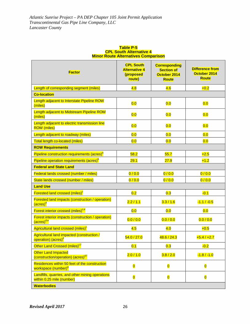
7.1 CPL South Alternative 4
CPL South Alternative 4 was developed in response to comments received from the
Meadowview Homeowners Group and to avoid the construction of a future housing
development. The alternative begins at MP 29.6 and ends near MP 34.4 in Rapho
Township. Figure P-3 and Table P-5 provide a comparison of CPL South Alternative 4 with
the corresponding segment of the proposed route.
CPL South Alternative 4 (proposed route) is approximately 0.2 mile longer than the October
2014 route. CPL South Alternative 4 (proposed route) slightly reduces the amount of forest
land crossed and eliminates two road crossings. This alternative avoids affecting a PEM
wetland crossing and has the same number of waterbody crossings when compared to the
corresponding segment of the October 2014 route. CPL South Alternative 4 (proposed
route) was accepted and is part of the proposed route as discussed in this application.
Atlantic Sunrise Project – PA DEP Chapter 105 Joint Permit Application Transcontinental Gas Pipe Line Company, LLC Lancaster County
Revised April 2017 26
Table P-5
CPL South Alternative 4 Minor Route Alternatives Comparison
Factor
CPL South Alternative 4 (proposed
route)
Corresponding Section of
October 2014 Route
Difference from October 2014
Route
Length of corresponding segment (miles) 4.8 4.6 +0.2
Co-location
Length adjacent to Interstate Pipeline ROW (miles) 0.0 0.0 0.0
Length adjacent to Midstream Pipeline ROW (miles) 0.0 0.0 0.0
Length adjacent to electric transmission line ROW (miles) 0.0 0.0 0.0
Length adjacent to roadway (miles) 0.0 0.0 0.0
Total length co-located (miles) 0.0 0.0 0.0
ROW Requirements
Pipeline construction requirements (acres)a 58.2 55.7 +2.5
Pipeline operation requirements (acres)b 29.1 27.9 +1.2
Federal and State Land
Federal lands crossed (number / miles) 0 / 0.0 0 / 0.0 0 / 0.0
State lands crossed (number / miles) 0 / 0.0 0 / 0.0 0 / 0.0
Land Use
Forested land crossed (miles)c 0.2 0.3 -0.1
Forested land impacts (construction / operation) (acres)d
2.2 / 1.1 3.3 / 1.6 -1.1 / -0.5
Forest interior crossed (miles)c,e 0.0 0.0 0.0
Forest interior impacts (construction / operation) (acres)d,e
0.0 / 0.0 0.0 / 0.0 0.0 / 0.0
Agricultural land crossed (miles)c 4.5 4.0 +0.5
Agricultural land impacted (construction / operation) (acres)d
54.0 / 27.0 48.6 / 24.3 +5.4 / +2.7
Other Land Crossed (miles)c,f 0.1 0.3 -0.2
Other Land Impacted (construction/operation) (acres)d,f
2.0 / 1.0 3.8 / 2.0 -1.8 / -1.0
Residences within 50 feet of the construction workspace (number)g
0 0 0
Landfills, quarries, and other mining operations within 0.25 mile (number) 0 0 0
Waterbodies
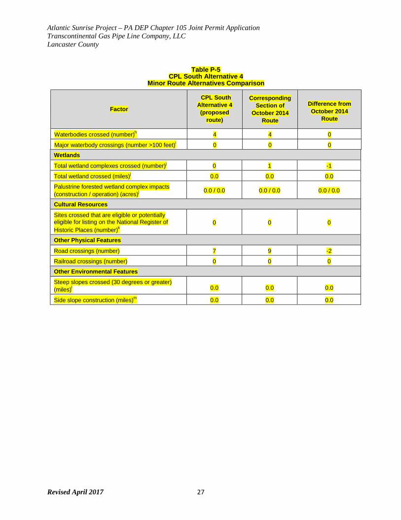
Atlantic Sunrise Project – PA DEP Chapter 105 Joint Permit Application Transcontinental Gas Pipe Line Company, LLC Lancaster County
Revised April 2017 27
Table P-5 CPL South Alternative 4
Minor Route Alternatives Comparison
Factor
CPL South Alternative 4 (proposed
route)
Corresponding Section of
October 2014 Route
Difference from October 2014
Route
Waterbodies crossed (number)h 4 4 0
Major waterbody crossings (number >100 feet)i 0 0 0
Wetlands
Total wetland complexes crossed (number)j 0 1 -1
Total wetland crossed (miles)j 0.0 0.0 0.0
Palustrine forested wetland complex impacts (construction / operation) (acres)j
0.0 / 0.0 0.0 / 0.0 0.0 / 0.0
Cultural Resources
Sites crossed that are eligible or potentially eligible for listing on the National Register of Historic Places (number)k
0 0 0
Other Physical Features
Road crossings (number) 7 9 -2
Railroad crossings (number) 0 0 0
Other Environmental Features
Steep slopes crossed (30 degrees or greater) (miles)l
0.0 0.0 0.0
Side slope construction (miles)m 0.0 0.0 0.0
Atlantic Sunrise Project – PA DEP Chapter 105 Joint Permit Application Transcontinental Gas Pipe Line Company, LLC Lancaster County
Revised April 2017 28
Table P-5 CPL South Alternative 4
Minor Route Alternatives Comparison
Factor
CPL South Alternative 4 (proposed
route)
Corresponding Section of
October 2014 Route
Difference from October 2014
Route
a Pipeline construction requirements based on a 100-foot-wide construction corridor and includes a 100-foot long buffer at begin and end points.
b Pipeline operation requirements based on a 50-foot-wide corridor in greenfield segments, and a 25-foot-wide corridor for segments co-located with Transco pipelines. Calculation includes a 50-foot long buffer at begin and end points.
c Forested land, forest interior, agricultural land and other land crossed are based on geographic information system (GIS) centerline analysis using United States Geological Survey (USGS) National Land Cover Dataset (NLCD).
d Forest land, forest interior, agricultural land, and other land impacted are based on GIS corridor analysis using USGS NLCD. Since multiple land use types may be present within the corridor, impact acreage for individual land uses will not be representative of distance crossed, which is based on centerline analysis.
e Forest interior determined by assessment of forest cover from USGS NLCD, where forest interior was considered 300 feet from forest breaks and outer forest edge. Interior forest is a sub-type of Forested Land.
f Other land based on USGS NLCD and includes land cover types: Barren Land, Developed High Intensity, Developed Low Intensity, Developed Medium Intensity, Developed Open Space, Emergent Herbaceous Wetlands, Herbaceous, Open Water, Shrub Scrub, Woody Wetlands.
g Residences identified based on review of aerial photography; in cases where it was not clear whether a structure was a residence or other built feature (e.g., barn, storage facility), the structure was assumed to be a residence.
h Waterbodies identified based on National Hydrography Dataset. i Major waterbodies identified based on review of aerial photography. j Wetlands identified using the National Wetland Inventory. k National Register of Historic Places sites were identified using desktop data. l Length determined perpendicular to slope contour. m Length determined parallel with slope contour. Developed using USGS 10-foot contours.
Key:
CPL = Central Penn Line ROW = right-of-way
Atlantic Sunrise Project – PA DEP Chapter 105 Joint Permit Application Transcontinental Gas Pipe Line Company, LLC Lancaster County
Revised April 2017 29
FIGURE 3
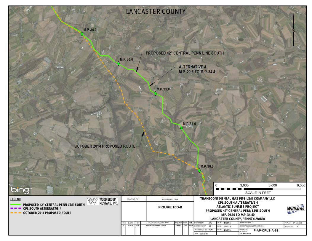
LANCASTER COUNTY
0 3,000 6,000 9,000
LEGEND
PROPOSED 42" CENTRAL PENN LINE SOUTH CPL SOUTH ALTERNATIVE 4 OCTOBER 2014 PROPOSED ROUTE
DRAWING NO.
REFERENCE TITLE
FIGURE 10D-8
SCALE IN FEET
TRANSCONTINENTAL GAS PIPE LINE COMPANY LLC CPL SOUTH ALTERNATIVE 4
ATLANTIC SUNRISE PROJECT PROPOSED 42" CENTRAL PENN LINE SOUTH
M.P. 29.60 TO M.P. 34.40 LANCASTER COUNTY, PENNSYLVANIA
NO. DATE BY REVISION DESCRIPTION W.O. NO. CHK. APP. DRAWN BY: JTN DATE: 3/10/15 ISSUE FOR BID: SCALE: 1" = 3000' 0 3/31/15 JTN ISSUED FOR FERC FILING 1161503 DP MJH CHECKED BY: DP DATE: 3/10/15 ISSUE FOR CONSTRUCTION: REVISION: 0
APPROVED BY: MJH DATE: 3/10/15 DRAWING NUMBER: F-AP-CPLS-A-63
WO: 1161503 3:10 PM 3/23/2015
Atlantic Sunrise Project – PA DEP Chapter 105 Joint Permit Application Transcontinental Gas Pipe Line Company, LLC Lancaster County
Revised April 2017 30
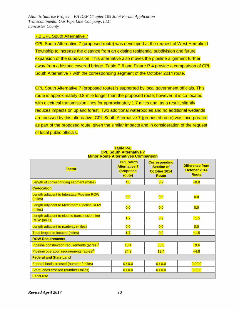
7.2 CPL South Alternative 7
CPL South Alternative 7 (proposed route) was developed at the request of West Hempfield
Township to increase the distance from an existing residential subdivision and future
expansion of the subdivision. This alternative also moves the pipeline alignment further
away from a historic covered bridge. Table P-6 and Figure P-4 provide a comparison of CPL
South Alternative 7 with the corresponding segment of the October 2014 route.
CPL South Alternative 7 (proposed route) is supported by local government officials. This
route is approximately 0.8-mile longer than the proposed route; however, it is co-located
with electrical transmission lines for approximately 1.7 miles and, as a result, slightly
reduces impacts on upland forest. Two additional waterbodies and no additional wetlands
are crossed by this alternative. CPL South Alternative 7 (proposed route) was incorporated
as part of the proposed route, given the similar impacts and in consideration of the request
of local public officials.
Table P-6 CPL South Alternative 7
Minor Route Alternatives Comparison
Factor
CPL South Alternative 7 (proposed
route)
Corresponding Section of
October 2014 Route
Difference from October 2014
Route
Length of corresponding segment (miles) 4.0 3.2 +0.8
Co-location
Length adjacent to Interstate Pipeline ROW (miles) 0.0 0.0 0.0
Length adjacent to Midstream Pipeline ROW (miles) 0.0 0.0 0.0
Length adjacent to electric transmission line ROW (miles) 1.7 0.2 +1.5
Length adjacent to roadway (miles) 0.0 0.0 0.0
Total length co-located (miles) 1.7 0.2 +1.5
ROW Requirements
Pipeline construction requirements (acres)a 48.4 38.8 +9.6
Pipeline operation requirements (acres)b 24.2 19.4 +4.8
Federal and State Land
Federal lands crossed (number / miles) 0 / 0.0 0 / 0.0 0 / 0.0
State lands crossed (number / miles) 0 / 0.0 0 / 0.0 0 / 0.0
Land Use
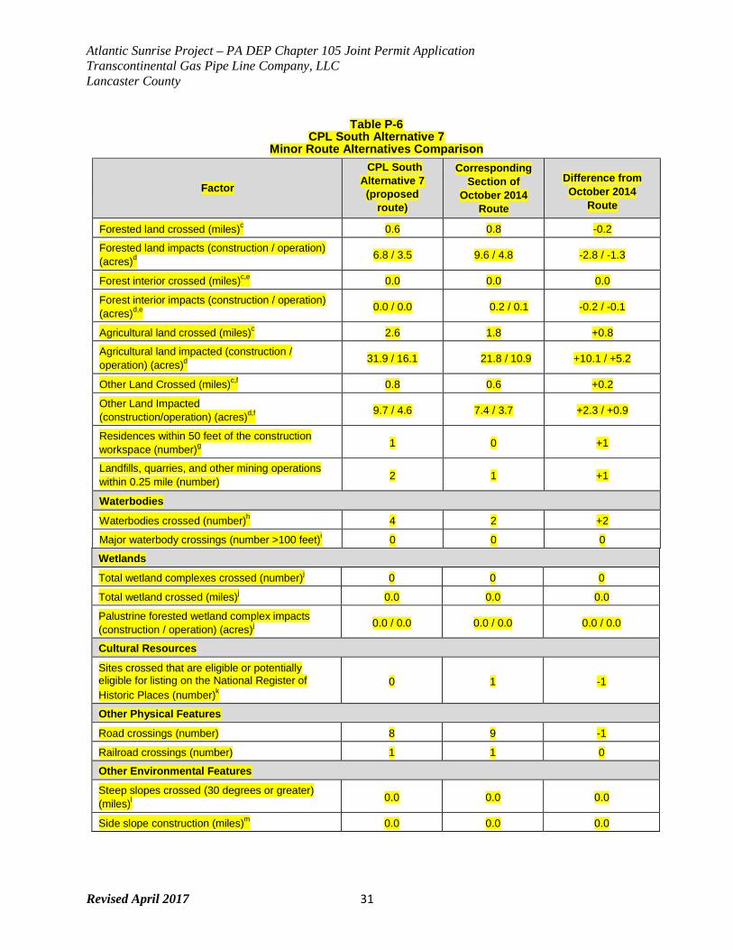
Atlantic Sunrise Project – PA DEP Chapter 105 Joint Permit Application Transcontinental Gas Pipe Line Company, LLC Lancaster County
Revised April 2017 31
Table P-6 CPL South Alternative 7
Minor Route Alternatives Comparison
Factor
CPL South Alternative 7 (proposed
route)
Corresponding Section of
October 2014 Route
Difference from October 2014
Route
Forested land crossed (miles)c 0.6 0.8 -0.2
Forested land impacts (construction / operation) (acres)d
6.8 / 3.5 9.6 / 4.8 -2.8 / -1.3
Forest interior crossed (miles)c,e 0.0 0.0 0.0
Forest interior impacts (construction / operation) (acres)d,e
0.0 / 0.0 0.2 / 0.1 -0.2 / -0.1
Agricultural land crossed (miles)c 2.6 1.8 +0.8
Agricultural land impacted (construction / operation) (acres)d
31.9 / 16.1 21.8 / 10.9 +10.1 / +5.2
Other Land Crossed (miles)c,f 0.8 0.6 +0.2
Other Land Impacted (construction/operation) (acres)d,f
9.7 / 4.6 7.4 / 3.7 +2.3 / +0.9
Residences within 50 feet of the construction workspace (number)g
1 0 +1
Landfills, quarries, and other mining operations within 0.25 mile (number) 2 1 +1
Waterbodies
Waterbodies crossed (number)h 4 2 +2
Major waterbody crossings (number >100 feet)i 0 0 0
Wetlands
Total wetland complexes crossed (number)j 0 0 0
Total wetland crossed (miles)j 0.0 0.0 0.0
Palustrine forested wetland complex impacts (construction / operation) (acres)j
0.0 / 0.0 0.0 / 0.0 0.0 / 0.0
Cultural Resources
Sites crossed that are eligible or potentially eligible for listing on the National Register of Historic Places (number)k
0 1 -1
Other Physical Features
Road crossings (number) 8 9 -1
Railroad crossings (number) 1 1 0
Other Environmental Features
Steep slopes crossed (30 degrees or greater) (miles)l
0.0 0.0 0.0
Side slope construction (miles)m 0.0 0.0 0.0
Atlantic Sunrise Project – PA DEP Chapter 105 Joint Permit Application Transcontinental Gas Pipe Line Company, LLC Lancaster County
Revised April 2017 32
Table P-6 CPL South Alternative 7
Minor Route Alternatives Comparison
Factor
CPL South Alternative 7 (proposed
route)
Corresponding Section of
October 2014 Route
Difference from October 2014
Route a Pipeline construction requirements based on a 100-foot-wide construction corridor and includes a 100-foot long buffer at begin
and end points. b Pipeline operation requirements based on a 50-foot-wide corridor in greenfield segments, and a 25-foot-wide corridor for
segments co-located with Transco pipelines. Calculation includes a 50-foot long buffer at begin and end points. c Forested land, forest interior, agricultural land and other land crossed are based on geographic information system (GIS)
centerline analysis using United States Geological Survey (USGS) National Land Cover Dataset (NLCD). d Forest land, forest interior, agricultural land, and other land impacted are based on GIS corridor analysis using USGS NLCD.
Since multiple land use types may be present within the corridor, impact acreage for individual land uses will not be representative of distance crossed, which is based on centerline analysis.
e Forest interior determined by assessment of forest cover from USGS NLCD, where forest interior was considered 300 feet from forest breaks and outer forest edge. Interior forest is a sub-type of Forested Land.
f Other land based on USGS NLCD and includes land cover types: Barren Land, Developed High Intensity, Developed Low Intensity, Developed Medium Intensity, Developed Open Space, Emergent Herbaceous Wetlands, Herbaceous, Open Water, Shrub Scrub, Woody Wetlands.
g Residences identified based on review of aerial photography; in cases where it was not clear whether a structure was a residence or other built feature (e.g., barn, storage facility), the structure was assumed to be a residence.
h Waterbodies identified based on National Hydrography Dataset. i Major waterbodies identified based on review of aerial photography. j Wetlands identified using the National Wetland Inventory. k National Register of Historic Places sites were identified using desktop data. l Length determined perpendicular to slope contour. m Length determined parallel with slope contour. Developed using USGS 10-foot contours.
Key:
CPL = Central Penn Line ROW = right-of-way

Atlantic Sunrise Project – PA DEP Chapter 105 Joint Permit Application Transcontinental Gas Pipe Line Company, LLC Lancaster County
Revised April 2017 33
FIGURE 4
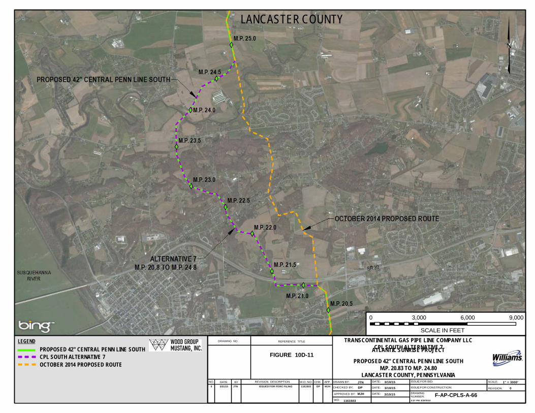
LANCASTER COUNTY
0 3,000 6,000 9,000
LEGEND
PROPOSED 42" CENTRAL PENN LINE SOUTH
DRAWING NO.
REFERENCE TITLE
SCALE IN FEET
TRANSCONTINENTAL GAS PIPE LINE COMPANY LLC CPL SOUTH ALTERNATIVE 7 ATLANTIC SUNRISE PROJECT
CPL SOUTH ALTERNATIVE 7 FIGURE 10D-11 OCTOBER 2014 PROPOSED ROUTE
PROPOSED 42" CENTRAL PENN LINE SOUTH
M.P. 20.83 TO M.P. 24.80 LANCASTER COUNTY, PENNSYLVANIA
NO. DATE BY REVISION DESCRIPTION W.O. NO. CHK. APP. DRAWN BY: JTN DATE: 3/10/15 ISSUE FOR BID: SCALE: 1" = 3000' 0 3/31/15 JTN ISSUED FOR FERC FILING 1161503 DP MJH CHECKED BY: DP DATE: 3/10/15 ISSUE FOR CONSTRUCTION: REVISION: 0
APPROVED BY: MJH DATE: 3/10/15 DRAWING NUMBER: F-AP-CPLS-A-66
WO: 1161503 2:27 PM 3/20/2015
Atlantic Sunrise Project – PA DEP Chapter 105 Joint Permit Application Transcontinental Gas Pipe Line Company, LLC Lancaster County
Revised April 2017 34
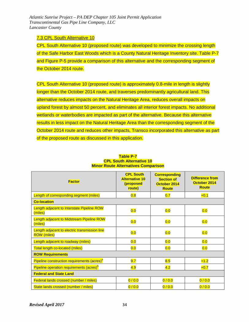
7.3 CPL South Alternative 10
CPL South Alternative 10 (proposed route) was developed to minimize the crossing length
of the Safe Harbor East Woods which is a County Natural Heritage Inventory site. Table P-7
and Figure P-5 provide a comparison of this alternative and the corresponding segment of
the October 2014 route.
CPL South Alternative 10 (proposed route) is approximately 0.8-mile in length is slightly
longer than the October 2014 route, and traverses predominantly agricultural land. This
alternative reduces impacts on the Natural Heritage Area, reduces overall impacts on
upland forest by almost 50 percent, and eliminates all interior forest impacts. No additional
wetlands or waterbodies are impacted as part of the alternative. Because this alternative
results in less impact on the Natural Heritage Area than the corresponding segment of the
October 2014 route and reduces other impacts, Transco incorporated this alternative as part
of the proposed route as discussed in this application.
Table P-7 CPL South Alternative 10
Minor Route Alternatives Comparison
Factor
CPL South Alternative 10
(proposed route)
Corresponding Section of
October 2014 Route
Difference from October 2014
Route
Length of corresponding segment (miles) 0.8 0.7 +0.1
Co-location
Length adjacent to Interstate Pipeline ROW (miles) 0.0 0.0 0.0
Length adjacent to Midstream Pipeline ROW (miles) 0.0 0.0 0.0
Length adjacent to electric transmission line ROW (miles) 0.0 0.0 0.0
Length adjacent to roadway (miles) 0.0 0.0 0.0
Total length co-located (miles) 0.0 0.0 0.0
ROW Requirements
Pipeline construction requirements (acres)a 9.7 8.5 +1.2
Pipeline operation requirements (acres)b 4.9 4.2 +0.7
Federal and State Land
Federal lands crossed (number / miles) 0 / 0.0 0 / 0.0 0 / 0.0
State lands crossed (number / miles) 0 / 0.0 0 / 0.0 0 / 0.0
Atlantic Sunrise Project – PA DEP Chapter 105 Joint Permit Application Transcontinental Gas Pipe Line Company, LLC Lancaster County
Revised April 2017 35
Table P-7 CPL South Alternative 10
Minor Route Alternatives Comparison
Factor
CPL South Alternative 10
(proposed route)
Corresponding Section of
October 2014 Route
Difference from October 2014
Route
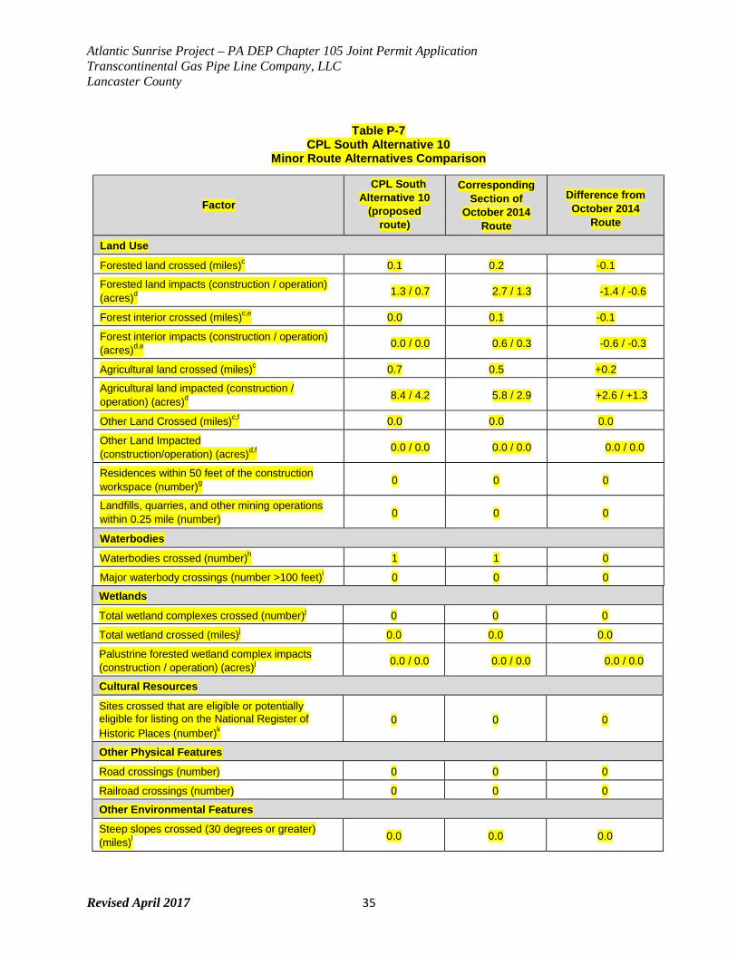
Land Use
Forested land crossed (miles)c 0.1 0.2 -0.1
Forested land impacts (construction / operation) (acres)d
1.3 / 0.7 2.7 / 1.3 -1.4 / -0.6
Forest interior crossed (miles)c,e 0.0 0.1 -0.1
Forest interior impacts (construction / operation) (acres)d,e
0.0 / 0.0 0.6 / 0.3 -0.6 / -0.3
Agricultural land crossed (miles)c 0.7 0.5 +0.2
Agricultural land impacted (construction / operation) (acres)d
8.4 / 4.2 5.8 / 2.9 +2.6 / +1.3
Other Land Crossed (miles)c,f 0.0 0.0 0.0
Other Land Impacted (construction/operation) (acres)d,f
0.0 / 0.0 0.0 / 0.0 0.0 / 0.0
Residences within 50 feet of the construction workspace (number)g
0 0 0
Landfills, quarries, and other mining operations within 0.25 mile (number) 0 0 0
Waterbodies
Waterbodies crossed (number)h 1 1 0
Major waterbody crossings (number >100 feet)i 0 0 0
Wetlands
Total wetland complexes crossed (number)j 0 0 0
Total wetland crossed (miles)j 0.0 0.0 0.0
Palustrine forested wetland complex impacts (construction / operation) (acres)j
0.0 / 0.0 0.0 / 0.0 0.0 / 0.0
Cultural Resources
Sites crossed that are eligible or potentially eligible for listing on the National Register of Historic Places (number)k
0 0 0
Other Physical Features
Road crossings (number) 0 0 0
Railroad crossings (number) 0 0 0
Other Environmental Features
Steep slopes crossed (30 degrees or greater) (miles)l
0.0 0.0 0.0
Atlantic Sunrise Project – PA DEP Chapter 105 Joint Permit Application Transcontinental Gas Pipe Line Company, LLC Lancaster County
Revised April 2017 36
Table P-7 CPL South Alternative 10
Minor Route Alternatives Comparison
Factor
CPL South Alternative 10
(proposed route)
Corresponding Section of
October 2014 Route
Difference from October 2014
Route
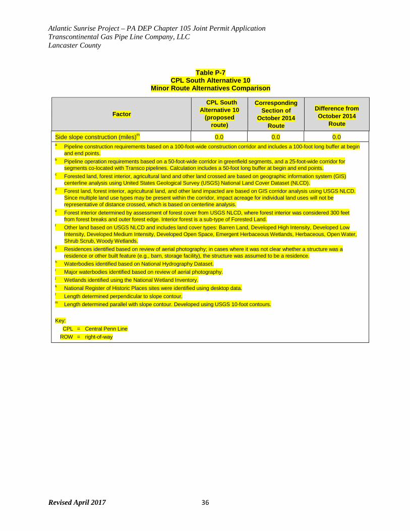
Side slope construction (miles)m 0.0 0.0 0.0
a Pipeline construction requirements based on a 100-foot-wide construction corridor and includes a 100-foot long buffer at begin and end points.
b Pipeline operation requirements based on a 50-foot-wide corridor in greenfield segments, and a 25-foot-wide corridor for segments co-located with Transco pipelines. Calculation includes a 50-foot long buffer at begin and end points.
c Forested land, forest interior, agricultural land and other land crossed are based on geographic information system (GIS) centerline analysis using United States Geological Survey (USGS) National Land Cover Dataset (NLCD).
d Forest land, forest interior, agricultural land, and other land impacted are based on GIS corridor analysis using USGS NLCD. Since multiple land use types may be present within the corridor, impact acreage for individual land uses will not be representative of distance crossed, which is based on centerline analysis.
e Forest interior determined by assessment of forest cover from USGS NLCD, where forest interior was considered 300 feet from forest breaks and outer forest edge. Interior forest is a sub-type of Forested Land.
f Other land based on USGS NLCD and includes land cover types: Barren Land, Developed High Intensity, Developed Low Intensity, Developed Medium Intensity, Developed Open Space, Emergent Herbaceous Wetlands, Herbaceous, Open Water, Shrub Scrub, Woody Wetlands.
g Residences identified based on review of aerial photography; in cases where it was not clear whether a structure was a residence or other built feature (e.g., barn, storage facility), the structure was assumed to be a residence.
h Waterbodies identified based on National Hydrography Dataset. i Major waterbodies identified based on review of aerial photography. j Wetlands identified using the National Wetland Inventory. k National Register of Historic Places sites were identified using desktop data. l Length determined perpendicular to slope contour. m Length determined parallel with slope contour. Developed using USGS 10-foot contours.
Key:
CPL = Central Penn Line ROW = right-of-way
Atlantic Sunrise Project – PA DEP Chapter 105 Joint Permit Application Transcontinental Gas Pipe Line Company, LLC Lancaster County
Revised April 2017 37
FIGURE 5
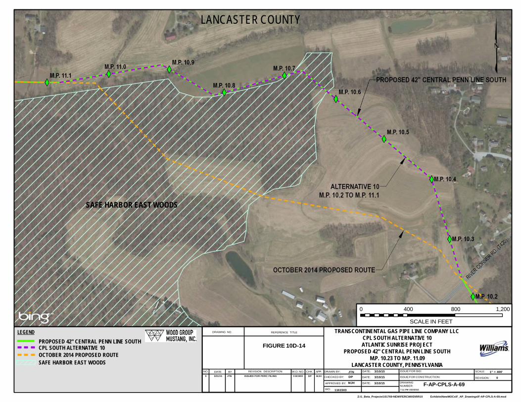
Z:\1_Beta_Projects\101769-NEW\FERC\MXD\RR10 Exhibits\NewMOCs\F_AP_Drawings\F-AP-CPLS-A-69.mxd
LANCASTER COUNTY
SAFE HARBOR EAST WOODS
0 400 800 1,200
LEGEND
PROPOSED 42" CENTRAL PENN LINE SOUTH CPL SOUTH ALTERNATIVE 10 OCTOBER 2014 PROPOSED ROUTE SAFE HARBOR EAST WOODS
DRAWING NO.
REFERENCE TITLE
FIGURE 10D-14
SCALE IN FEET
TRANSCONTINENTAL GAS PIPE LINE COMPANY LLC CPL SOUTH ALTERNATIVE 10 ATLANTIC SUNRISE PROJECT
PROPOSED 42" CENTRAL PENN LINE SOUTH M.P. 10.23 TO M.P. 11.09
LANCASTER COUNTY, PENNSYLVANIA NO. DATE BY REVISION DESCRIPTION W.O. NO. CHK. APP. DRAWN BY: JTN DATE: 3/10/15 ISSUE FOR BID: SCALE: 1" = 400'
0 3/31/15 JTN ISSUED FOR FERC FILING 1161503 DP MJH CHECKED BY: DP DATE: 3/10/15 ISSUE FOR CONSTRUCTION: REVISION: 0
APPROVED BY: MJH DATE: 3/10/15 DRAWING NUMBER: F-AP-CPLS-A-69
WO: 1161503 7:11 PM 3/23/2015
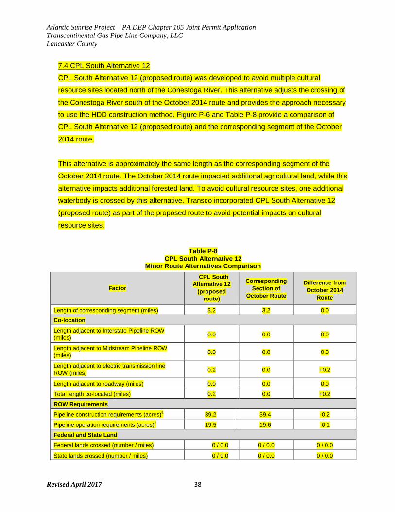
Atlantic Sunrise Project – PA DEP Chapter 105 Joint Permit Application Transcontinental Gas Pipe Line Company, LLC Lancaster County
Revised April 2017 38
7.4 CPL South Alternative 12
CPL South Alternative 12 (proposed route) was developed to avoid multiple cultural
resource sites located north of the Conestoga River. This alternative adjusts the crossing of
the Conestoga River south of the October 2014 route and provides the approach necessary
to use the HDD construction method. Figure P-6 and Table P-8 provide a comparison of
CPL South Alternative 12 (proposed route) and the corresponding segment of the October
2014 route.
This alternative is approximately the same length as the corresponding segment of the
October 2014 route. The October 2014 route impacted additional agricultural land, while this
alternative impacts additional forested land. To avoid cultural resource sites, one additional
waterbody is crossed by this alternative. Transco incorporated CPL South Alternative 12
(proposed route) as part of the proposed route to avoid potential impacts on cultural
resource sites.
Table P-8 CPL South Alternative 12
Minor Route Alternatives Comparison
Factor
CPL South Alternative 12
(proposed route)
Corresponding
Section of October Route
Difference from October 2014
Route
Length of corresponding segment (miles) 3.2 3.2 0.0
Co-location
Length adjacent to Interstate Pipeline ROW (miles) 0.0 0.0 0.0
Length adjacent to Midstream Pipeline ROW (miles) 0.0 0.0 0.0
Length adjacent to electric transmission line ROW (miles) 0.2 0.0 +0.2
Length adjacent to roadway (miles) 0.0 0.0 0.0
Total length co-located (miles) 0.2 0.0 +0.2
ROW Requirements
Pipeline construction requirements (acres)a 39.2 39.4 -0.2
Pipeline operation requirements (acres)b 19.5 19.6 -0.1
Federal and State Land
Federal lands crossed (number / miles) 0 / 0.0 0 / 0.0 0 / 0.0
State lands crossed (number / miles) 0 / 0.0 0 / 0.0 0 / 0.0
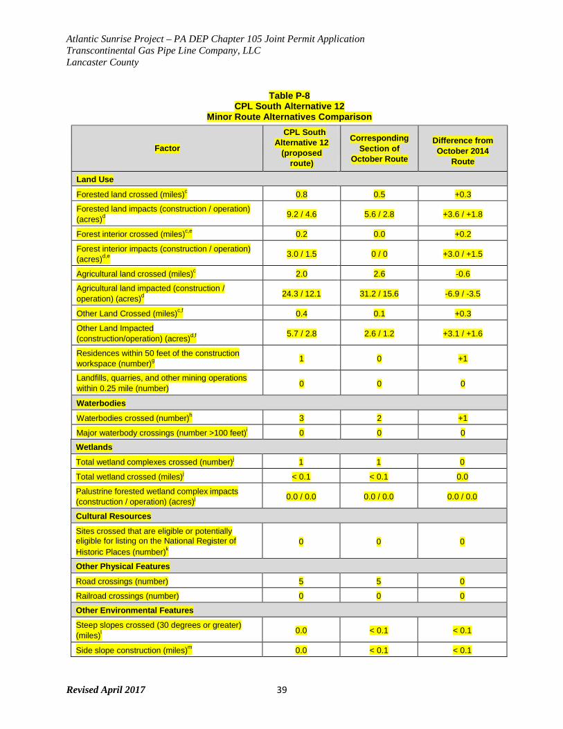
Atlantic Sunrise Project – PA DEP Chapter 105 Joint Permit Application Transcontinental Gas Pipe Line Company, LLC Lancaster County
Revised April 2017 39
Table P-8 CPL South Alternative 12
Minor Route Alternatives Comparison
Factor
CPL South Alternative 12
(proposed route)
Corresponding
Section of October Route
Difference from October 2014
Route
Land Use
Forested land crossed (miles)c 0.8 0.5 +0.3
Forested land impacts (construction / operation) (acres)d
9.2 / 4.6 5.6 / 2.8 +3.6 / +1.8
Forest interior crossed (miles)c,e 0.2 0.0 +0.2
Forest interior impacts (construction / operation) (acres)d,e
3.0 / 1.5 0 / 0 +3.0 / +1.5
Agricultural land crossed (miles)c 2.0 2.6 -0.6
Agricultural land impacted (construction / operation) (acres)d
24.3 / 12.1 31.2 / 15.6 -6.9 / -3.5
Other Land Crossed (miles)c,f 0.4 0.1 +0.3
Other Land Impacted (construction/operation) (acres)d,f
5.7 / 2.8 2.6 / 1.2 +3.1 / +1.6
Residences within 50 feet of the construction workspace (number)g
1 0 +1
Landfills, quarries, and other mining operations within 0.25 mile (number) 0 0 0
Waterbodies
Waterbodies crossed (number)h 3 2 +1
Major waterbody crossings (number >100 feet)i 0 0 0
Wetlands
Total wetland complexes crossed (number)j 1 1 0
Total wetland crossed (miles)j < 0.1 < 0.1 0.0
Palustrine forested wetland complex impacts (construction / operation) (acres)j
0.0 / 0.0 0.0 / 0.0 0.0 / 0.0
Cultural Resources
Sites crossed that are eligible or potentially eligible for listing on the National Register of Historic Places (number)k
0 0 0
Other Physical Features
Road crossings (number) 5 5 0
Railroad crossings (number) 0 0 0
Other Environmental Features
Steep slopes crossed (30 degrees or greater) (miles)l
0.0 < 0.1 < 0.1
Side slope construction (miles)m 0.0 < 0.1 < 0.1
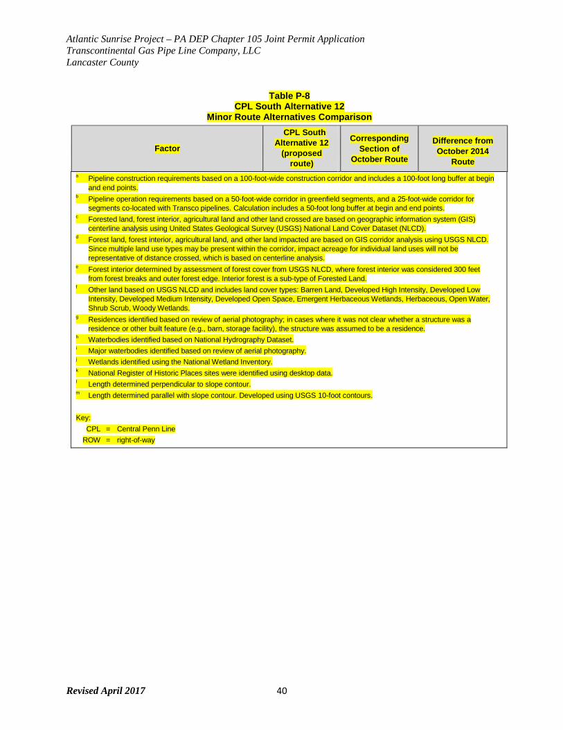
Atlantic Sunrise Project – PA DEP Chapter 105 Joint Permit Application Transcontinental Gas Pipe Line Company, LLC Lancaster County
Revised April 2017 40
Table P-8 CPL South Alternative 12
Minor Route Alternatives Comparison
Factor
CPL South Alternative 12
(proposed route)
Corresponding
Section of October Route
Difference from October 2014
Route a Pipeline construction requirements based on a 100-foot-wide construction corridor and includes a 100-foot long buffer at begin
and end points. b Pipeline operation requirements based on a 50-foot-wide corridor in greenfield segments, and a 25-foot-wide corridor for
segments co-located with Transco pipelines. Calculation includes a 50-foot long buffer at begin and end points. c Forested land, forest interior, agricultural land and other land crossed are based on geographic information system (GIS)
centerline analysis using United States Geological Survey (USGS) National Land Cover Dataset (NLCD). d Forest land, forest interior, agricultural land, and other land impacted are based on GIS corridor analysis using USGS NLCD.
Since multiple land use types may be present within the corridor, impact acreage for individual land uses will not be representative of distance crossed, which is based on centerline analysis.
e Forest interior determined by assessment of forest cover from USGS NLCD, where forest interior was considered 300 feet from forest breaks and outer forest edge. Interior forest is a sub-type of Forested Land.
f Other land based on USGS NLCD and includes land cover types: Barren Land, Developed High Intensity, Developed Low Intensity, Developed Medium Intensity, Developed Open Space, Emergent Herbaceous Wetlands, Herbaceous, Open Water, Shrub Scrub, Woody Wetlands.
g Residences identified based on review of aerial photography; in cases where it was not clear whether a structure was a residence or other built feature (e.g., barn, storage facility), the structure was assumed to be a residence.
h Waterbodies identified based on National Hydrography Dataset. i Major waterbodies identified based on review of aerial photography. j Wetlands identified using the National Wetland Inventory. k National Register of Historic Places sites were identified using desktop data. l Length determined perpendicular to slope contour. m Length determined parallel with slope contour. Developed using USGS 10-foot contours.
Key:
CPL = Central Penn Line ROW = right-of-way

Atlantic Sunrise Project – PA DEP Chapter 105 Joint Permit Application Transcontinental Gas Pipe Line Company, LLC Lancaster County
Revised April 2017 41
FIGURE 6
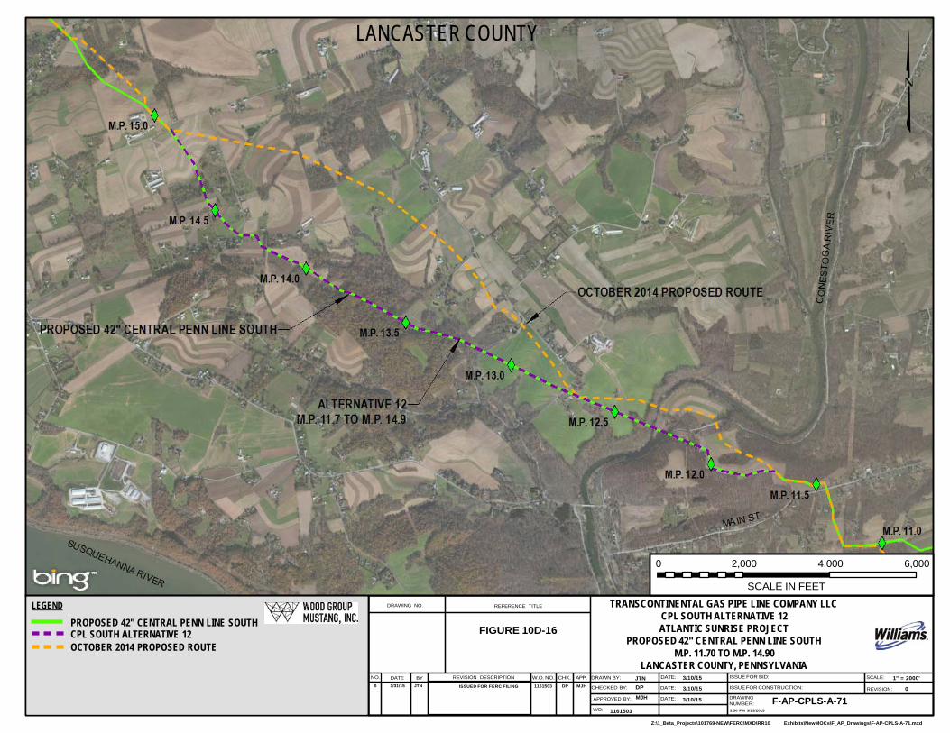
Z:\1_Beta_Projects\101769-NEW\FERC\MXD\RR10 Exhibits\NewMOCs\F_AP_Drawings\F-AP-CPLS-A-71.mxd
LANCASTER COUNTY
0 2,000 4,000 6,000
LEGEND
PROPOSED 42" CENTRAL PENN LINE SOUTH CPL SOUTH ALTERNATIVE 12 OCTOBER 2014 PROPOSED ROUTE
DRAWING NO.
REFERENCE TITLE
FIGURE 10D-16
SCALE IN FEET
TRANSCONTINENTAL GAS PIPE LINE COMPANY LLC CPL SOUTH ALTERNATIVE 12 ATLANTIC SUNRISE PROJECT
PROPOSED 42'' CENTRAL PENN LINE SOUTH M.P. 11.70 TO M.P. 14.90
LANCASTER COUNTY, PENNSYLVANIA NO. DATE BY REVISION DESCRIPTION W.O. NO. CHK. APP. DRAWN BY: JTN DATE: 3/10/15 ISSUE FOR BID: SCALE: 1" = 2000'
0 3/31/15 JTN ISSUED FOR FERC FILING 1161503 DP MJH CHECKED BY: DP DATE: 3/10/15 ISSUE FOR CONSTRUCTION: REVISION: 0
APPROVED BY: MJH DATE: 3/10/15 DRAWING NUMBER: F-AP-CPLS-A-71
WO: 1161503 3:30 PM 3/23/2015
Atlantic Sunrise Project – PA DEP Chapter 105 Joint Permit Application Transcontinental Gas Pipe Line Company, LLC Lancaster County
Revised April 2017 42
7.5 CPL South Alternative 15
CPL South Alternative 15 (proposed route) was developed in response to a request from the
Pennsylvania Turnpike Commission (PTC) to relocate the crossing of Interstate I-76,
Pennsylvania Turnpike, operated by the PTC as shown on Figure P-7. Table P-8 presents a
comparison of CPL South Alternative 15 (proposed route) and the October 2014 route.
CPL South Alternative 15 (proposed route) is the same length as the corresponding segment of
the October 2014 route. Although approximately 3 acres of additional upland forest is affected
by this alternative when compared to the October 2014 route, minor adjustments to the initial
alternative were completed during field routing to improve waterbody crossing locations and
minimize impacts on waterbodies and wetlands. No additional wetlands or waterbodies are
crossed when compared to the October 2014 route. In response to the PTC request, and
considering the similar environmental impacts, Transco incorporated CPL South Alternative 15
(proposed route) as part of the proposed route as discussed in this application.
Table P-9 CPL South Alternative 15
Minor Route Alternatives Comparison
Factor
CPL South Alternative 15
(proposed route)
Corresponding Section of
October 2014 Route
Difference from October 2014
Route
Length of corresponding segment (miles) 2.1 2.1 0.0
Co-location
Length adjacent to Interstate Pipeline ROW (miles) 0.0 0.0 0.0
Length adjacent to Midstream Pipeline ROW (miles) 0.0 0.0 0.0
Length adjacent to electric transmission line ROW (miles) 0.0 1.0 -1.0
Length adjacent to roadway (miles) 0.0 0.0 0.0
Total length co-located (miles) 0.0 1.0 -1.0
ROW Requirements
Pipeline construction requirements (acres)a 26.1 26.2 -0.1
Pipeline operation requirements (acres)b 13.0 13.1 -0.1
Federal and State Land
Federal lands crossed (number / miles) 0 / 0.0 0 / 0.0 0 / 0.0
State lands crossed (number / miles) 0 / 0.0 0 / 0.0 0 / 0.0
Land Use
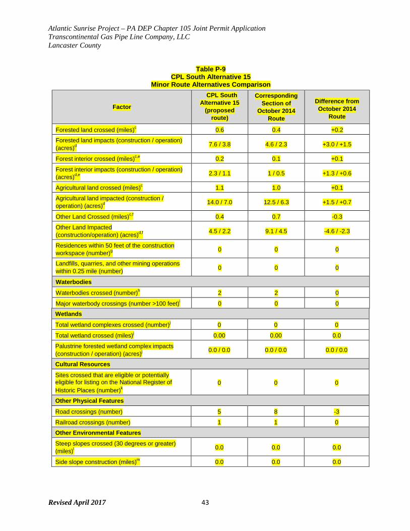
Atlantic Sunrise Project – PA DEP Chapter 105 Joint Permit Application Transcontinental Gas Pipe Line Company, LLC Lancaster County
Revised April 2017 43
Table P-9 CPL South Alternative 15
Minor Route Alternatives Comparison
Factor
CPL South Alternative 15
(proposed route)
Corresponding Section of
October 2014 Route
Difference from October 2014
Route
Forested land crossed (miles)c 0.6 0.4 +0.2
Forested land impacts (construction / operation) (acres)d
7.6 / 3.8 4.6 / 2.3 +3.0 / +1.5
Forest interior crossed (miles)c,e 0.2 0.1 +0.1
Forest interior impacts (construction / operation) (acres)d,e
2.3 / 1.1 1 / 0.5 +1.3 / +0.6
Agricultural land crossed (miles)c 1.1 1.0 +0.1
Agricultural land impacted (construction / operation) (acres)d
14.0 / 7.0 12.5 / 6.3 +1.5 / +0.7
Other Land Crossed (miles)c,f 0.4 0.7 -0.3
Other Land Impacted (construction/operation) (acres)d,f
4.5 / 2.2 9.1 / 4.5 -4.6 / -2.3
Residences within 50 feet of the construction workspace (number)g
0 0 0
Landfills, quarries, and other mining operations within 0.25 mile (number) 0 0 0
Waterbodies
Waterbodies crossed (number)h 2 2 0
Major waterbody crossings (number >100 feet)i 0 0 0
Wetlands
Total wetland complexes crossed (number)j 0 0 0
Total wetland crossed (miles)j 0.00 0.00 0.0
Palustrine forested wetland complex impacts (construction / operation) (acres)j
0.0 / 0.0 0.0 / 0.0 0.0 / 0.0
Cultural Resources
Sites crossed that are eligible or potentially eligible for listing on the National Register of Historic Places (number)k
0 0 0
Other Physical Features
Road crossings (number) 5 8 -3
Railroad crossings (number) 1 1 0
Other Environmental Features
Steep slopes crossed (30 degrees or greater) (miles)l
0.0 0.0 0.0
Side slope construction (miles)m 0.0 0.0 0.0
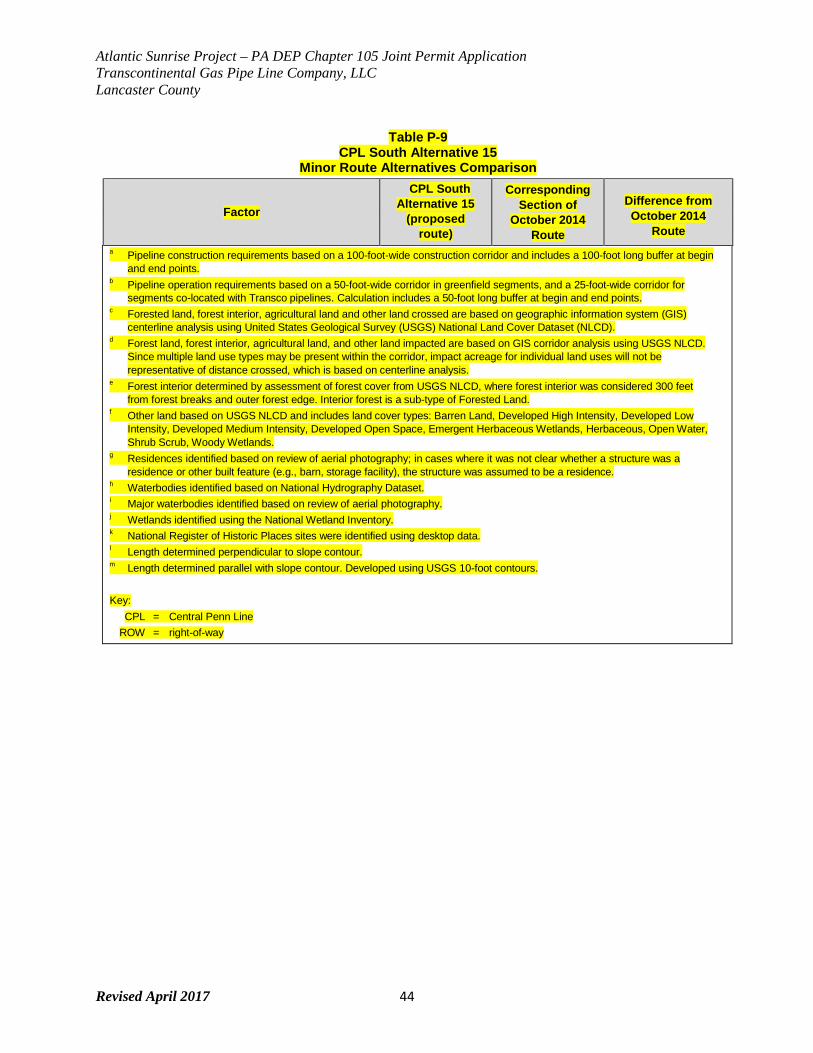
Atlantic Sunrise Project – PA DEP Chapter 105 Joint Permit Application Transcontinental Gas Pipe Line Company, LLC Lancaster County
Revised April 2017 44
Table P-9 CPL South Alternative 15
Minor Route Alternatives Comparison
Factor
CPL South Alternative 15
(proposed route)
Corresponding Section of
October 2014 Route
Difference from October 2014
Route a Pipeline construction requirements based on a 100-foot-wide construction corridor and includes a 100-foot long buffer at begin
and end points. b Pipeline operation requirements based on a 50-foot-wide corridor in greenfield segments, and a 25-foot-wide corridor for
segments co-located with Transco pipelines. Calculation includes a 50-foot long buffer at begin and end points. c Forested land, forest interior, agricultural land and other land crossed are based on geographic information system (GIS)
centerline analysis using United States Geological Survey (USGS) National Land Cover Dataset (NLCD). d Forest land, forest interior, agricultural land, and other land impacted are based on GIS corridor analysis using USGS NLCD.
Since multiple land use types may be present within the corridor, impact acreage for individual land uses will not be representative of distance crossed, which is based on centerline analysis.
e Forest interior determined by assessment of forest cover from USGS NLCD, where forest interior was considered 300 feet from forest breaks and outer forest edge. Interior forest is a sub-type of Forested Land.
f Other land based on USGS NLCD and includes land cover types: Barren Land, Developed High Intensity, Developed Low Intensity, Developed Medium Intensity, Developed Open Space, Emergent Herbaceous Wetlands, Herbaceous, Open Water, Shrub Scrub, Woody Wetlands.
g Residences identified based on review of aerial photography; in cases where it was not clear whether a structure was a residence or other built feature (e.g., barn, storage facility), the structure was assumed to be a residence.
h Waterbodies identified based on National Hydrography Dataset. i Major waterbodies identified based on review of aerial photography. j Wetlands identified using the National Wetland Inventory. k National Register of Historic Places sites were identified using desktop data. l Length determined perpendicular to slope contour. m Length determined parallel with slope contour. Developed using USGS 10-foot contours.
Key:
CPL = Central Penn Line ROW = right-of-way
Atlantic Sunrise Project – PA DEP Chapter 105 Joint Permit Application Transcontinental Gas Pipe Line Company, LLC Lancaster County
Revised April 2017 45
FIGURE 7
LANCASTER & LEBANON COUNTIES
0 2,000 4,000 6,000
LEGEND
PROPOSED 42" CENTRAL PENN LINE SOUTH CPL SOUTH ALTERNATIVE 15 OCTOBER 2014 PROPOSED ROUTE TOWNSHIP/COUNTY BOUNDARY
DRAWING NO.
REFERENCE TITLE
FIGURE 10D-19
SCALE IN FEET
TRANSCONTINENTAL GAS PIPE LINE COMPANY LLC CPL SOUTH ALTERNATIVE 15
ATLANTIC SUNRISE PROJECT PROPOSED 42" CENTRAL PENN LINE SOUTH
M.P. 35.70 TO M.P. 37.82 LANCASTER & LEBANON COUNTIES, PENNSYLVANIA
NO. DATE BY REVISION DESCRIPTION W.O. NO. CHK. APP. DRAWN BY: JTN DATE: 3/10/15 ISSUE FOR BID: SCALE: 1" = 2000' 0 3/31/15 JTN ISSUED FOR FERC FILING 1161503 DP MJH CHECKED BY: DP DATE: 3/10/15 ISSUE FOR CONSTRUCTION: REVISION: 0
APPROVED BY: MJH DATE: 3/10/15 DRAWING NUMBER: F-AP-CPLS-A-74
WO: 1161503 3:09 PM 3/20/2015
Atlantic Sunrise Project – PA DEP Chapter 105 Joint Permit Application Transcontinental Gas Pipe Line Company, LLC Lancaster County
Revised April 2017 46
7.6 CPL South Alternative 22
CPL South Alternative 22 was developed in response to landowner comments. The alternative
is located in Conestoga Township, Lancaster County, Pennsylvania. The alternative begins near
MP 8.4 and continue to about MP 10.2. Table P-# provides a comparison of the alternatives and
the corresponding segment of the June 2015 proposed route. CPL South Alternative 22 is
approximately 1.9 miles in length, slightly longer than the June 2015 proposed route, and
traverses largely agricultural lands. This alternative slightly increases impacts on forested land
and crosses more roads than the corresponding segment of the June 2015 proposed route. No
additional wetland or waterbody crossings are anticipated along the alternative. Transco
adopted this alternative as recommended by FERC in the DEIS.
Table 10G-7 CPL South Alternative 22
Minor Route Alternatives Comparison
Factor CPL South Alternative 22
Corresponding Section of CPL
South
Difference from Proposed Route
Length of corresponding segment (miles) 1.9 1.8 +0.1
Co-location
Length adjacent to Interstate Pipeline ROW (miles)
0.0 0.0 0.0
Length adjacent to Midstream Pipeline ROW (miles)
0.0 0.0 0.0
Length adjacent to electric transmission line ROW (miles)
0.0 0.0 0.0
Length adjacent to roadway (miles) 0.0 0.0 0.0
Total length co-located (miles) 0.0 0.0 0.0
ROW Requirements
Pipeline construction requirements (acres)a 23.3 22.0 +1.3
Pipeline operation requirements (acres)b 11.6 11.0 +0.6
Federal and State Land
Federal lands crossed (number / miles) 0 / 0.0 0 / 0.0 0 / 0.0
State lands crossed (number / miles) 0 / 0.0 0 / 0.0 0 / 0.0
Land Use
Forested land crossed (miles)c 0.5 0.4 +0.1
Forested land impacts (construction / operation) (acres)d
6.6 / 3.3 5.2 / 2.7 +1.4 / +0.6
Forest interior crossed (miles)c,e 0.0 0.0 0.0
Atlantic Sunrise Project – PA DEP Chapter 105 Joint Permit Application Transcontinental Gas Pipe Line Company, LLC Lancaster County
Revised April 2017 47
Table 10G-7 CPL South Alternative 22
Minor Route Alternatives Comparison
Factor CPL South Alternative 22
Corresponding Section of CPL
South
Difference from Proposed Route
Forest interior impacts (construction / operation) (acres)d,e
0.0 / 0.0 0.0 / 0.0 0.0 / 0.0
Agricultural land crossed (miles)c 1.2 1.3 -0.1
Agricultural land impacted (construction / operation) (acres)d
14.8 / 7.3 15.6 / 7.7 -0.8 / -0.4
Other Land Crossed (miles)c,f 0.2 0.1 +0.1
Other Land Impacted (construction / operation) (acres)d,f
1.9 / 1.0 1.2 / 0.6 +0.7 / +0.4
Residences within 50 feet of the construction workspace (number)g
0 0 0
Landfills, quarries, and other mining operations within 0.25 mile (number)
0 0 0
Waterbodies
Waterbodies crossed (number)h 1 1 0
Major waterbody crossings (number >100 feet)i 0 0 0
Wetlands
Total wetland complexes crossed (number)j 0 0 0
Total wetland crossed (miles)j 0.0 0.0 0.0
Palustrine forested wetland complex impacts (construction / operation) (acres)j
0.0 / 0.0 0.0 / 0.0 0.0 / 0.0
Cultural Resources
Sites crossed that are eligible or potentially eligible for listing on the National Register of Historic Places (number)k
0 0 0
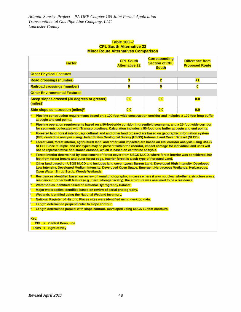
Atlantic Sunrise Project – PA DEP Chapter 105 Joint Permit Application Transcontinental Gas Pipe Line Company, LLC Lancaster County
Revised April 2017 48
Table 10G-7 CPL South Alternative 22
Minor Route Alternatives Comparison
Factor CPL South Alternative 22
Corresponding Section of CPL
South
Difference from Proposed Route
Other Physical Features
Road crossings (number) 3 2 +1
Railroad crossings (number) 0 0 0
Other Environmental Features
Steep slopes crossed (30 degrees or greater) (miles)l
0.0 0.0 0.0
Side slope construction (miles)m 0.0 0.0 0.0 a Pipeline construction requirements based on a 100-foot-wide construction corridor and includes a 100-foot long buffer
at begin and end points. b Pipeline operation requirements based on a 50-foot-wide corridor in greenfield segments, and a 25-foot-wide corridor
for segments co-located with Transco pipelines. Calculation includes a 50-foot long buffer at begin and end points. c Forested land, forest interior, agricultural land and other land crossed are based on geographic information system
(GIS) centerline analysis using United States Geological Survey (USGS) National Land Cover Dataset (NLCD). d Forest land, forest interior, agricultural land, and other land impacted are based on GIS corridor analysis using USGS
NLCD. Since multiple land use types may be present within the corridor, impact acreage for individual land uses will not be representative of distance crossed, which is based on centerline analysis.
e Forest interior determined by assessment of forest cover from USGS NLCD, where forest interior was considered 300 feet from forest breaks and outer forest edge. Interior forest is a sub-type of Forested Land.
f Other land based on USGS NLCD and includes land cover types: Barren Land, Developed High Intensity, Developed Low Intensity, Developed Medium Intensity, Developed Open Space, Emergent Herbaceous Wetlands, Herbaceous, Open Water, Shrub Scrub, Woody Wetlands.
g Residences identified based on review of aerial photography; in cases where it was not clear whether a structure was a residence or other built feature (e.g., barn, storage facility), the structure was assumed to be a residence.
h Waterbodies identified based on National Hydrography Dataset. i Major waterbodies identified based on review of aerial photography. j Wetlands identified using the National Wetland Inventory. k National Register of Historic Places sites were identified using desktop data. l Length determined perpendicular to slope contour. m Length determined parallel with slope contour. Developed using USGS 10-foot contours. Key: CPL = Central Penn Line ROW = right-of-way
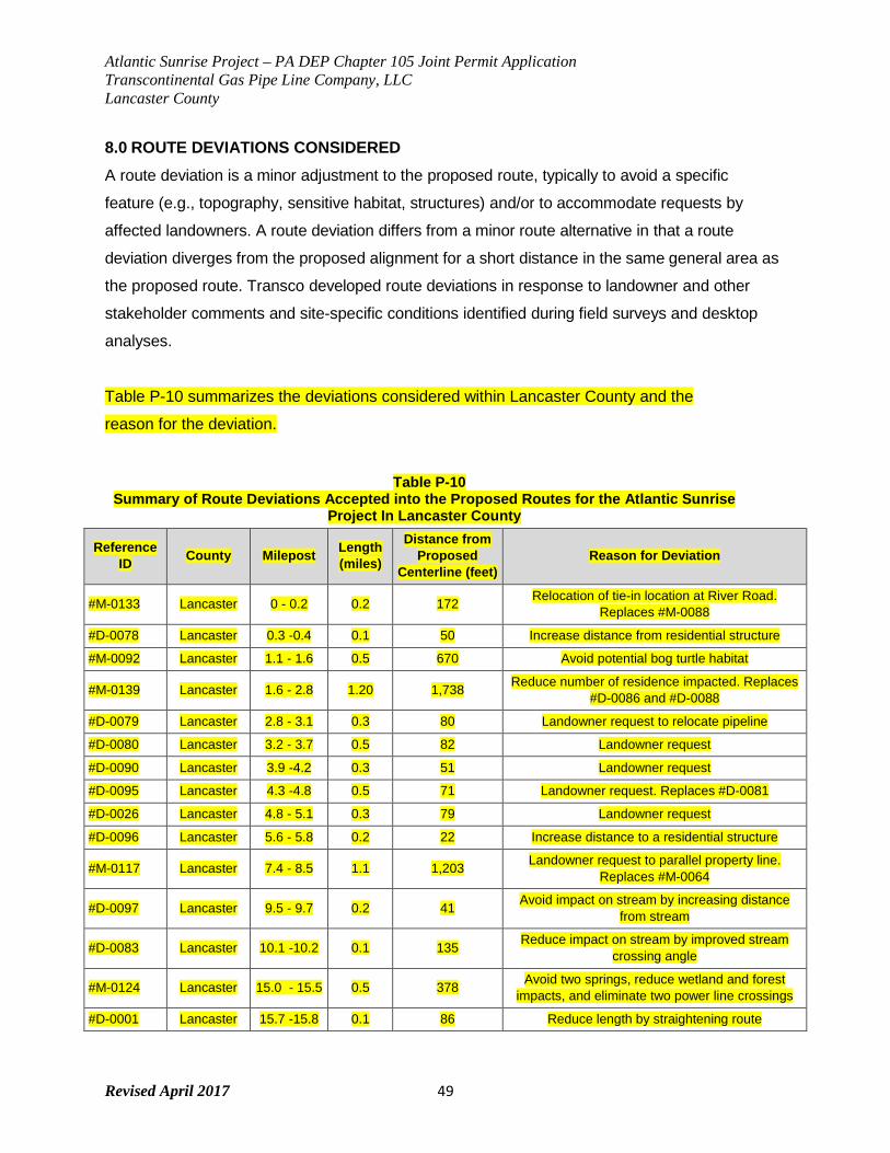
Atlantic Sunrise Project – PA DEP Chapter 105 Joint Permit Application Transcontinental Gas Pipe Line Company, LLC Lancaster County
Revised April 2017 49
8.0 ROUTE DEVIATIONS CONSIDERED A route deviation is a minor adjustment to the proposed route, typically to avoid a specific
feature (e.g., topography, sensitive habitat, structures) and/or to accommodate requests by
affected landowners. A route deviation differs from a minor route alternative in that a route
deviation diverges from the proposed alignment for a short distance in the same general area as
the proposed route. Transco developed route deviations in response to landowner and other
stakeholder comments and site-specific conditions identified during field surveys and desktop
analyses.
Table P-10 summarizes the deviations considered within Lancaster County and the
reason for the deviation.
Table P-10 Summary of Route Deviations Accepted into the Proposed Routes for the Atlantic Sunrise
Project In Lancaster County
Reference ID County Milepost Length
(miles)
Distance from Proposed
Centerline (feet) Reason for Deviation
#M-0133 Lancaster 0 - 0.2 0.2 172 Relocation of tie-in location at River Road. Replaces #M-0088
#D-0078 Lancaster 0.3 -0.4 0.1 50 Increase distance from residential structure
#M-0092 Lancaster 1.1 - 1.6 0.5 670 Avoid potential bog turtle habitat
#M-0139 Lancaster 1.6 - 2.8 1.20 1,738 Reduce number of residence impacted. Replaces #D-0086 and #D-0088
#D-0079 Lancaster 2.8 - 3.1 0.3 80 Landowner request to relocate pipeline
#D-0080 Lancaster 3.2 - 3.7 0.5 82 Landowner request
#D-0090 Lancaster 3.9 -4.2 0.3 51 Landowner request
#D-0095 Lancaster 4.3 -4.8 0.5 71 Landowner request. Replaces #D-0081
#D-0026 Lancaster 4.8 - 5.1 0.3 79 Landowner request
#D-0096 Lancaster 5.6 - 5.8 0.2 22 Increase distance to a residential structure
#M-0117 Lancaster 7.4 - 8.5 1.1 1,203 Landowner request to parallel property line. Replaces #M-0064
#D-0097 Lancaster 9.5 - 9.7 0.2 41 Avoid impact on stream by increasing distance from stream
#D-0083 Lancaster 10.1 -10.2 0.1 135 Reduce impact on stream by improved stream crossing angle
#M-0124 Lancaster 15.0 - 15.5 0.5 378 Avoid two springs, reduce wetland and forest impacts, and eliminate two power line crossings
#D-0001 Lancaster 15.7 -15.8 0.1 86 Reduce length by straightening route
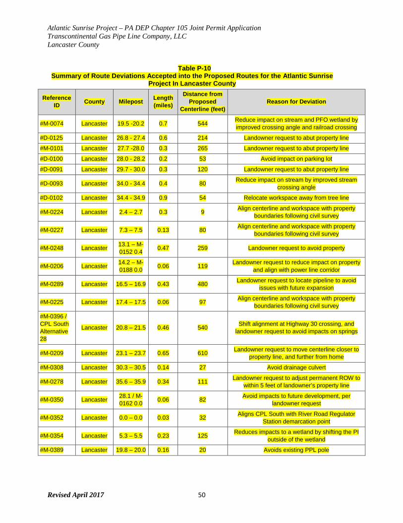
Atlantic Sunrise Project – PA DEP Chapter 105 Joint Permit Application Transcontinental Gas Pipe Line Company, LLC Lancaster County
Revised April 2017 50
Table P-10 Summary of Route Deviations Accepted into the Proposed Routes for the Atlantic Sunrise
Project In Lancaster County
Reference ID County Milepost Length
(miles)
Distance from Proposed
Centerline (feet) Reason for Deviation
#M-0074 Lancaster 19.5 -20.2 0.7 544 Reduce impact on stream and PFO wetland by improved crossing angle and railroad crossing
#D-0125 Lancaster 26.8 - 27.4 0.6 214 Landowner request to abut property line
#M-0101 Lancaster 27.7 -28.0 0.3 265 Landowner request to abut property line
#D-0100 Lancaster 28.0 - 28.2 0.2 53 Avoid impact on parking lot
#D-0091 Lancaster 29.7 - 30.0 0.3 120 Landowner request to abut property line
#D-0093 Lancaster 34.0 - 34.4 0.4 80 Reduce impact on stream by improved stream crossing angle
#D-0102 Lancaster 34.4 - 34.9 0.9 54 Relocate workspace away from tree line
#M-0224 Lancaster 2.4 – 2.7 0.3 9 Align centerline and workspace with property boundaries following civil survey
#M-0227 Lancaster 7.3 – 7.5 0.13 80 Align centerline and workspace with property boundaries following civil survey
#M-0248 Lancaster 13.1 – M-0152 0.4 0.47 259 Landowner request to avoid property
#M-0206 Lancaster 14.2 – M-0188 0.0 0.06 119 Landowner request to reduce impact on property
and align with power line corridor
#M-0289 Lancaster 16.5 – 16.9 0.43 480 Landowner request to locate pipeline to avoid issues with future expansion
#M-0225 Lancaster 17.4 – 17.5 0.06 97 Align centerline and workspace with property boundaries following civil survey
#M-0396 / CPL South Alternative 28
Lancaster 20.8 – 21.5 0.46 540 Shift alignment at Highway 30 crossing, and landowner request to avoid impacts on springs
#M-0209 Lancaster 23.1 – 23.7 0.65 610 Landowner request to move centerline closer to property line, and further from home
#M-0308 Lancaster 30.3 – 30.5 0.14 27 Avoid drainage culvert
#M-0278 Lancaster 35.6 – 35.9 0.34 111 Landowner request to adjust permanent ROW to within 5 feet of landowner’s property line
#M-0350 Lancaster 28.1 / M-0162 0.0 0.06 82 Avoid impacts to future development, per
landowner request
#M-0352 Lancaster 0.0 – 0.0 0.03 32 Aligns CPL South with River Road Regulator Station demarcation point
#M-0354 Lancaster 5.3 – 5.5 0.23 125 Reduces impacts to a wetland by shifting the PI outside of the wetland
#M-0389 Lancaster 19.8 – 20.0 0.16 20 Avoids existing PPL pole
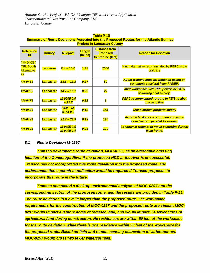
Atlantic Sunrise Project – PA DEP Chapter 105 Joint Permit Application Transcontinental Gas Pipe Line Company, LLC Lancaster County
Revised April 2017 51
Table P-10 Summary of Route Deviations Accepted into the Proposed Routes for the Atlantic Sunrise
Project In Lancaster County
Reference ID County Milepost Length
(miles)
Distance from Proposed
Centerline (feet) Reason for Deviation
#M- 0405 / CPL South Alternative 22
Lancaster 8.4 – 10.0 1.71 2006 Minor alternative recommended by FERC in the draft EIS
#M-0434 Lancaster 13.6 – 13.8 0.27 50 Avoid wetland impacts wetlands based on comments received from PADEP.
#M-0365 Lancaster 14.7 – 15.1 0.36 27 Abut workspace with PPL powerline ROW following civil survey.
#M-0475 Lancaster M-0209 0.0 – 23.7 0.22 9 FERC recommended reroute in FEIS to abut
property line.
#M-0486 Lancaster 34.0 – M-0164 0.0 0.12 145 Cross stream perpendicularly
#M-0484 Lancaster 21.7 – 21.9 0.13 130 Avoid side slope construction and avoid construction parallel to stream.
#M-0503 Lancaster M-0405 0.6 M-0405 0.9 0.23 120 Landowner request to move centerline further
from home.
8.1 Route Deviation M-0297
Transco developed a route deviation, MOC-0297, as an alternative crossing location of the Conestoga River if the proposed HDD at the river is unsuccessful. Transco has not incorporated this route deviation into the proposed route, and understands that a permit modification would be required if Transco proposes to incorporate this route in the future.
Transco completed a desktop environmental analysis of MOC-0297 and the corresponding section of the proposed route, and the results are provided in Table P-11. The route deviation is 0.2 mile longer than the proposed route. The workspace requirements for the construction of MOC-0297 and the proposed route are similar. MOC-0297 would impact 4.9 more acres of forested land, and would impact 3.4 fewer acres of agricultural land during construction. No residences are within 50 feet of the workspace for the route deviation, while there is one residence within 50 feet of the workspace for the proposed route. Based on field and remote sensing delineation of watercourses, MOC-0297 would cross two fewer watercourses.
Atlantic Sunrise Project – PA DEP Chapter 105 Joint Permit Application Transcontinental Gas Pipe Line Company, LLC Lancaster County
Revised April 2017 52
Transco also evaluated available cultural resources information along the route deviation. Based on the review of predictive site modeling, historic mapping, and previously recorded archaeological resources identified in the area, there exists a high potential to encounter archaeological sites along MOC-0297. These sites could vary from minor isolated findspots unassociated with larger cultural deposits, to more substantial resources that could contribute further information regarding local prehistory and/or history.
Transco has also completed geotechnical investigations of both crossings to evaluate subsurface conditions for a proposed HDD. Data indicates that there is competent bedrock beneath the Conestoga River at the proposed crossing location. In addition, at the HDD entry and exit locations, there is sufficient area to site the needed workspace with minimal grading required. There is an approximately 10-foot elevation differential between the entry and exit locations which minimizes the risk for dry hole conditions. Transco determined that the HDD along the proposed route is feasible, and the preferable location for the HDD.
Transco is not proposing to incorporate MOC-0297 into the proposed route at this time. The proposed route is preferable based on the engineering assessment of the Conestoga River HDD, and less impacts to forested land.
Table P-11 Route Variation MOC-0297
Factor MOC-0297 Corresponding Section of CPL
South
Difference from Proposed Route
Length of corresponding segment (miles) 1.3 1.1 +0.2 Co-location
Length adjacent to Interstate Pipeline ROW (miles) 0.0 0.0 0.0
Length adjacent to Midstream Pipeline ROW (miles) 0.0 0.0 0.0
Length adjacent to electric transmission line ROW (miles) 0.0 0.0 0.0
Length adjacent to roadway (miles) 0.0 0.0 0.0
Total length co-located (miles) 0.0 0.0 0.0
ROW Requirements
Pipeline construction requirements (acres)a 17.0 17.1 -0.1
Atlantic Sunrise Project – PA DEP Chapter 105 Joint Permit Application Transcontinental Gas Pipe Line Company, LLC Lancaster County
Revised April 2017 53
Table P-11 Route Variation MOC-0297
Factor MOC-0297 Corresponding Section of CPL
South
Difference from Proposed Route
Pipeline operation requirements (acres)b 8.1 6.7 +1.4 Federal and State Land
Federal lands crossed (number / miles) 0 / 0.0 0 / 0.0 0 / 0.0
State lands crossed (number / miles) 0 / 0.0 0 / 0.0 0 / 0.0
Land Use
Forested land crossed (miles)c 0.6 0.2 +0.4 Forested land impacts (construction / operation) (acres)d 6.4 / 3.6 1.5 / 1.4 +4.9 / +2.2
Forest interior crossed (miles)c,e 0.0 0.0 0.0 Forest interior impacts (construction / operation) (acres)d,e 0.2 / 0.0 0.0 / 0.0 +0.2 / 0.0
Agricultural land crossed (miles)c 0.6 0.6 0.0 Agricultural land impacted (construction / operation) (acres)d 9.5 / 3.6 12.9 / 3.9 -3.4 / -0.3
Other Land Crossed (miles)c,f 0.1 0.2 -0.1 Other Land Impacted (construction / operation) (acres)d,f 1.1 / 0.9 2.7 / 1.4 -1.6 / -0.5
Residences within 50 feet of the construction workspace (number)g 0 1 -1
Landfills, quarries, and other mining operations within 0.25 mile (number) 0 0 0
Waterbodies
Waterbodies crossed (number)h 2 4 -2 Major waterbody crossings (number >100 feet)i 1 1 0
Wetlands
Total wetland complexes crossed by centerline (number)j 0 0 0
Total wetland crossed (feet)j 0 0 0 Palustrine forested wetland complex impacts (construction / operation) (acres)j 0.0 / 0.0 0.0 / 0.0 0.0 / 0.0
Cultural Resources
Sites crossed that are eligible or potentially eligible for listing on the National Register of Historic Places (number)k
0 0 0
Other Physical Features
Road crossings (number) 2 2 0 Railroad crossings (number) 0 0 0
Atlantic Sunrise Project – PA DEP Chapter 105 Joint Permit Application Transcontinental Gas Pipe Line Company, LLC Lancaster County
Revised April 2017 54
Table P-11 Route Variation MOC-0297
Factor MOC-0297 Corresponding Section of CPL
South
Difference from Proposed Route
Other Environmental Features
Steep slopes crossed (30 degrees or greater) (miles)l
0.0 0.0 0.0
Side slope construction (miles)m 0.0 0.0 0.0 a Pipeline construction requirements based on a preliminary footprint identified for the route deviation, and the current
proposed workspace for the corresponding section of CPL South. b Pipeline operation requirements based on a preliminary footprint identified for the route deviation, and the current
proposed workspace for the corresponding section of CPL South. c Forested land, forest interior, agricultural land and other land crossed are based on geographic information system
(GIS) centerline analysis using United States Geological Survey (USGS) National Land Cover Dataset (NLCD). d Forest land, forest interior, agricultural land, and other land impacted are based on GIS corridor analysis using USGS
NLCD. Since multiple land use types may be present within the corridor, impact acreage for individual land uses will not be representative of distance crossed, which is based on centerline analysis.
e Forest interior determined by assessment of forest cover from USGS NLCD, where forest interior was considered 300 feet from forest breaks and outer forest edge. Interior forest is a sub-type of Forested Land.
f Other land based on USGS NLCD and includes land cover types: Barren Land, Developed High Intensity, Developed Low Intensity, Developed Medium Intensity, Developed Open Space, Emergent Herbaceous Wetlands, Herbaceous, Open Water, Shrub Scrub, Woody Wetlands.
g Residences identified based on review of aerial photography; in cases where it was not clear whether a structure was a residence or other built feature (e.g., barn, storage facility), the structure was assumed to be a residence.
h Waterbodies identified based on field surveys and remote sensing. i Major waterbodies identified based on review of aerial photography and field surveys. j Wetlands identified using field surveys and remote sensing. k National Register of Historic Places sites were identified using desktop data. l Length determined perpendicular to slope contour. m Length determined parallel with slope contour. Developed using USGS 10-foot contours. Key: CPL = Central Penn Line ROW = right-of-way
9.0 WETLAND AND WATERBODY CONSTRUCTION ALTERNATIVES During design of the Project, Transco attempted to avoid and minimize wetland and waterbody
impacts that would result from construction and installation of the Project by reducing the
construction right-of-way to 75 feet in most wetlands and by proposing to maintain the right-of-
way in accordance with the FERC Wetland and Waterbody Construction and Mitigation
Procedures. Transco is also addressing feasibility of trenchless installation measures at major
waterbody crossings and in locations where wetlands or waterbodies are located in close
proximity to a road crossing. Some of the critical factors taken into consideration to determine if
trenchless construction methods would be successful include surface conditions, workspace
Atlantic Sunrise Project – PA DEP Chapter 105 Joint Permit Application Transcontinental Gas Pipe Line Company, LLC Lancaster County
Revised April 2017 55
requirements, subsurface conditions, ground surface elevation, water allocations, inadvertent
returns, drilling fluid disposal, risks, constructability, schedule and post-construction
accessibility. The following details generally discusses the factors considered when determining
the crossing method for certain resources.
Horizontal Directional Drill The Horizontal Directional Drill (HDD) method allows for trenchless construction across an area
by drilling a hole below the conventional pipeline depth and pulling the pipeline through a pre-
drilled hole. A number of factors need to be evaluated when considering use of the HDD method
including: minimum drill length, typical area of disturbance for set-up of an HDD, and
feasibility/risk factors.
Minimum Drill Length
The pipeline radius of curvature for the drill path is proportional to the diameter of the pipeline,
which affects how tight the bend in the drill hole can be and, thus, the minimum length of the
crossing. The exit and entry angles are relatively flat (8 to 12 degrees from horizontal) to avoid
excessive lifting heights to install the pipe and to avoid buckling the pipe at the inflection point in
the entry hole. A number of factors determine the minimum drill hole length, with the key factors
being:
• Required clearance depth below the obstacle(s) to be crossed;
• Pipeline radius of curvature;
• Adjacent terrain and/or topography;
• Desired entry/exit angles; and
• Required layout for the drilling equipment and pullback string.
Deeper drill holes require longer drill hole lengths to achieve minimum necessary clearance.
Similarly, the minimum drill hole length is longer for larger pipe, which has a greater radius of
curvature. The depths can also be dictated by the site geology. Transco typically designs the
radius of curvature to be 1,200 times the pipe diameter (i.e., a 42-inch-diameter pipeline will have
a design radius of curvature of 4,200 feet). The exit and entry points are chosen to be installed in
a relatively flat, open area at similar elevations. The HDD will produce a minimum drill hole length
of approximately 1,600 feet and profile depth of 75 feet below the entry point (at entry angle of 10
Atlantic Sunrise Project – PA DEP Chapter 105 Joint Permit Application Transcontinental Gas Pipe Line Company, LLC Lancaster County
Revised April 2017 56
degrees). At entry angles greater than 10 degrees, the minimum depth from the entry point
increases, (i.e., 92 feet for a 12 degree entry angle), and hence increases the minimum length
(i.e., 1,800 feet for a 12 degree entry angle). The drill hole lengths can vary due to actual site
conditions, such as subsurface conditions and topography. The topography of the Project area
requires a minimum drill hole length of 1,900 to 2,300 feet. The duration of drilling and construction
will vary due to subsurface geologic and hydrologic conditions, layout, and drill hole length. For
example, the rate of penetration of the drill bit through hard rock such as granite will be slower
than through a softer material such as shale.
Typical HDD Disturbance Areas
HDDs may still require portions of the ROW to be cleared to allow the pipeline pullback section
to be assembled (strung) and pulled through the drill hole. Similarly, clearing vegetation may be
necessary to provide a line-of-sight to the pipeline ROW for both construction and long-term
operation. For example, a 2,100-foot-long drill hole would require a minimum of approximately 5
acres to be cleared and graded to provide adequate and safe workspace at the entry and exit
points to accommodate the HDD equipment, drilling mud pits, ancillary support equipment, and
a 2,200-foot by 40- or 60-foot work strip for pipe stringing/pullback operations. Temporary
workspace areas at the entry and exit workspaces typically measure 200 feet by 250 feet for
pipelines with a 24-inch diameter or greater. The pipe stringing workspace must be aligned with
the drill hole so that lateral forces are minimized during the pipeline pullback. If a pipeline ROW
curves on the approach to an HDD crossing, the pullback section will have an additional impact
on areas outside of the ROW where the pullback workspace deviates at an angle to the
construction ROW. Additional heavy equipment would be required to handle the pipe around
any curves. There would also be an added risk of damaging the pipe coating if the pipe were to
slide off the roller assemblies.
HDD Feasibility & Risk Factors
Site-specific geotechnical factors have a substantial effect on HDD feasibility. Subsurface
characteristics must be fully evaluated with on-site borings and sample testing to determine
whether the HDD would be deemed technically infeasible. Furthermore, geotechnical factors,
including but not limited to rock hardness, rock quality, and borehole stability, have a substantial
effect on the duration of construction for an HDD.
Atlantic Sunrise Project – PA DEP Chapter 105 Joint Permit Application Transcontinental Gas Pipe Line Company, LLC Lancaster County
Revised April 2017 57
HDD risks increase as pipe diameter increases. The risks increase disproportionately for larger
diameter pipelines, such as the 42-inch-diameter pipeline proposed for portions of the Project.
Drill hole failure (collapse of the drill hole) during pipeline pullback operations is one of the
greatest risks to the successful completion of an HDD. A drill hole failure can cause an
accidental release of drilling mud. The loss of tooling downhole also poses a substantial risk of
failure for large-diameter HDD installations. The risk of lost tooling downhole increases
disproportionately with increased hole diameter because of the higher rotary torque required to
ream a larger-diameter hole. HDDs are often used to avoid direct impacts on a sensitive
environmental resource, such as a wetland, waterbody, or special status species habitat. If the
impact of a release is greater than the risk of an open-cut crossing, and the risk of release
cannot be reduced to an appropriate level, then an open-cut crossing may be preferable to an
HDD crossing.
Methods to reduce HDD failure risks include the following:
• Ensuring that the geologic formation through which the drill is planned is stable and
suitable for HDD. For example, a formation containing flowing sand or cobbles and
boulders will often result in a borehole collapse or a stuck pipe, and thus is unsuitable for
drilling.
• Minimizing the number of pipeline strings required to be welded during the pullback
process (where the pipeline is pulled back through the drilled borehole). A single-string
pullback is preferred for HDDs because it avoids the need to stop the pullback activity in
order to weld up two or more separate pipe strings. A single string pullback allows for a
continuous force to be applied to the pipe during the pullback, and reduces the risk of
the pipeline becoming stuck in the borehole (due to the potential for a localized collapse
of the borehole around the pipeline).
• Designing the entry and exit point at or near the same elevation. When a significant
elevation difference exists between the entry and exit points, a portion of the drilled hole
will not be filled with drilling fluid. In rock formations, the risk of drill tool failure increases
because the tools may not be adequately cooled and lubricated through the dry section
of the hole despite drilling fluid being pumped during operations. In soil formations, the
risk of hole collapse is highly elevated, which may lead to ground surface settlement
along the HDD alignment, damage to structures, drilling fluid release, or a stuck pipe
during pullback operations.
Atlantic Sunrise Project – PA DEP Chapter 105 Joint Permit Application Transcontinental Gas Pipe Line Company, LLC Lancaster County
Revised April 2017 58
Other Construction Limitations HDDs for large-diameter pipelines (e.g., 30- to 42-inch) typically require 20,000 to 30,000
gallons of water per day for use in the creation of drilling mud. If surface water is not available at
the site, it must be identified and trucked in daily from a municipal water source. Duration from
site preparation to pipe tie-in following the HDD can be at least 6 months. Furthermore, the
number of HDDs on a project can be limited due to the number of available drilling rigs in the
United States. For these and other resons, Transco limits its use of HDDs to crossings of highly
sensitive resources.
Operations Implications Due to the radius of curvature required to install a large diameter pipeline using the HDD
technique, the pipe is usually installed at depths greater than 70 feet below the ground surface,
which poses substantial operational implications. If in-line inspection activities indicate that
maintenance or repairs are needed for a section of pipe that has been installed using the HDD
technique, the pipeline’s installation depth would render it inaccessible for repairs. In these
cases, the section of pipe would have to be replaced. Replacement would result in additional
environmental impacts, usually from having to install a second HDD parallel and adjacent to the
original HDD section, assuming adequate clearance (space) is available for a replacement HDD
section to be installed. As an industry practice, for long-term operations and maintenance
purposes, an HDD is only utilized where no other construction method is deemed feasible and
where adequate space exists for a replacement pipeline in the event the HDD section must be
replaced (e.g., at very large river crossings).
Conventional Bore The conventional bore method for cased or uncased pipeline crossings is typically employed
under roads or railroad crossings, but may also be employed at shallow wetland or waterbody
crossings. Soil conditions, the length of the flight auger string, and equipment torque generally
limit this method to a maximum length of approximately 400 feet. This installation method
involves digging a bore pit on each side of the feature to be crossed and typically requires a
minimum setback from the feature for worker safety and slope stability purposes. The bore pit
and receiving pit vary in size but are usually about 20 feet wide by 60 feet long. This provides
the necessary space for the boring machine to insert a pipe joint or pipe string (two or more
Atlantic Sunrise Project – PA DEP Chapter 105 Joint Permit Application Transcontinental Gas Pipe Line Company, LLC Lancaster County
Revised April 2017 59
joints welded together) into the borehole. The bore pit depth generally ranges from 10 to 12 feet
but may be greater, depending on topography, to accommodate the minimum of 5 feet of cover
over the bored pipeline segment. The depth would be greater for wetlands or waterbodies with
an adjacent slope.
Auger boring equipment is usually track-mounted. The track is set to the required line and grade
for the proposed bore path and requires a stable bore pit bottom. The bore pit bottom is often
stabilized with crushed stone or other material. Minor adjustments can be made by setting the
track and keeping it stable, which is critical for a successful bore. As such, keeping groundwater
out of the bore pit is important. Once the bore pit is excavated, the boring machine is placed in
the bore pit and conventional horizontal auger drilling commences to ream the borehole before
the pipe can be installed. The boring machine rides along the track as the bore pipe is advanced
(or pushed) into the borehole. The boring machine generates thrust by pushing from either the
back wall of the bore pit lined with sheet piles or piles driven behind the track.
A rotating auger cutting bit attached to the lead bore pipe section cuts the soil ahead of the bore
pipe as it advances. The rotating auger inside the bore pipe discharges the soil out the rear of
the pipe. After the lead bore pipe section has reached its maximum distance, a second auger
section is coupled (or pinned) to the first auger section. The second bore pipe section is then
placed over the second auger section and welded to the first bore pipe section. The bore pipe is
then advanced again by applying thrust and simultaneously rotating the auger bit inside the bore
pipe. This process is repeated until the desired bore length is achieved and the bore pipe
extends into the receiving pit. The auger cutting head is then removed, and the remaining soil is
removed from within the bore pipe section.
A conventional bore method may be “dry” (no water or drilling fluid used) or “wet” (requiring the
use of water or a bentonite-based drilling fluid), depending on soil conditions. No wet
conventional bores are proposed for the Project. After the bored pipeline section is installed,
additional excavation is necessary to tie the bored pipeline section to the pipeline section
conventionally installed by open trench.
While the pipeline industry considers this a dependable method for crossing under elevated
road beds, highways, and railroad beds, it is not generally preferred for use in areas with
Atlantic Sunrise Project – PA DEP Chapter 105 Joint Permit Application Transcontinental Gas Pipe Line Company, LLC Lancaster County
Revised April 2017 60
shallow or near-surface groundwater. These crossings require large bore pits adjacent to
saturated areas with potentially low soil shear strength, particularly near wetlands. Large bore
pits in these areas would require shoring of pit walls and implementation of significant
dewatering measures. Crossings of these features also would result in an increased risk of the
bore-pit walls slumping and/or borehole misalignment due to track settlement. The duration of
construction for bored crossings of wetlands and waterbodies typically ranges from 3 to more
than 4 weeks, depending on the crossing length, topography, soil conditions, and the need for
blasting in areas of shallow bedrock. A conventional open-cut crossing of wetlands and
waterbodies is generally much quicker, taking days rather than weeks, which minimizes the
duration of disturbance of the feature. For these reasons, Transco rejected the conventional
auger bore method as a preferred construction method for crossing wetlands, forested areas,
and waterbodies where conventional trenching construction is feasible.
Summary of Trenchless Installation Methods As described in Appendix P-2, a successful HDD or bore may have certain environmental
benefits, but the overall environmental impact can be greater, particularly if the stream is small
and can be crossed using dry crossing methods in a short period of time (i.e., 24 to 48 hours).
Also, trenchless crossings may not be feasible at all locations because of suboptimal substrate
or geologic conditions. For these reasons, Transco plans to use conventional construction
methods to cross the majority of waterbodies along the Atlantic Sunrise Project.
In the absence of environmental or construction concerns requiring the use of other crossing
methods, conventional open cut methods are is the most efficient construction method for
crossing wetlands and waterbodies. Dry-crossing construction techniques will be implemented
on the majority of streams crossed by the Project. Dry-crossing techniques minimize impacts to
fisheries by reducing the potential for sediment to mix with the existing flow of stream water and
by allowing unobstructed stream flow during construction.
Atlantic Sunrise Project – PA DEP Chapter 105 Joint Permit Application Transcontinental Gas Pipe Line Company, LLC Lancaster County
Revised April 2017 61
Open-Cut In the absence of environmental or construction concerns requiring the use of other crossing
methods, conventional open cut methods are the most efficient construction method for crossing
waterbodies. Dry-crossing construction techniques will be implemented on the majority of
waterbodies crossed by the Project. Dry-crossing techniques minimize impacts to fisheries by
reducing the potential for increases in turbidity and by allowing unobstructed stream flow during
construction.
The dry open-cut crossing method is an approved installation method in the DEP Erosion and
Sediment Control Best Management Practice (BMP) Manual and has been proposed at
locations where engineering has determined the method is appropriate, feasible and safe to
construct. However, a dry crossing method is not viable for number of stream crossings due to
technical restrictions, site-specific environmental factors, or safety concerns.
These installations would be scheduled around storm events, since the construction duration is
limited and can be completed where water flows and depths are slightly greater, where other
conventional methods may not be feasible. In addition, ROW impacts are reduced since there is
less need for additional temporary workspace.
The Open-Cut installation method provides for the optimal pipeline configuration with respect to
operation and maintenance. The proposed pipe would be installed a minimum of five feet below
the streambed and is therefore easily accessible for routine maintenance or emergency access
during operation. Trenchless methods, such as HDD and conventional bore installations, do not
offer this operational benefit due to the installation depth and would require replacement of the
entire pipe segment should an integrity issue arise during operation.
In some specific cases the Open-Cut installation is the most practical and environmentally
preferable option. Transco carefully evaluated all of the streams crossed by the Project; the
open-cut installation method is only proposed for crossings where it represents the safest, most
reliable and environmentally-sound method for pipeline installation. Each crossing will be
completed in accordance with the ECP, including the installation of BMPs and immediate bank
stabilization to reduce turbidity.