BAAQMD CEQA Guidelines Update Supervisor Haggerty Informational Workshop SCS & CEQA

!
Ma y 2 0 1 7
City of Oxnard
CEQA
Guidelines

CEQA Guidelines
City of Oxnard Page i
CEQA GUIDELINES
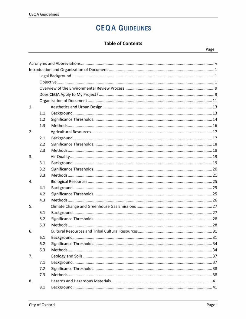
Table of Contents Page
Acronyms and Abbreviations ........................................................................................................................ v Introduction and Organization of Document ............................................................................................... 1
Legal Background ................................................................................................................................ 1 Objective .............................................................................................................................................. 1 Overview of the Environmental Review Process ................................................................................. 9 Does CEQA Apply to My Project? ........................................................................................................ 9 Organization of Document ................................................................................................................ 11
1. Aesthetics and Urban Design .................................................................................................. 13 1.1 Background ............................................................................................................................. 13 1.2 Significance Thresholds ........................................................................................................... 14 1.3 Methods .................................................................................................................................. 16
2. Agricultural Resources ............................................................................................................. 17 2.1 Background ............................................................................................................................. 17 2.2 Significance Thresholds ........................................................................................................... 18 2.3 Methods .................................................................................................................................. 18
3. Air Quality ................................................................................................................................ 19 3.1 Background ............................................................................................................................. 19 3.2 Significance Thresholds ........................................................................................................... 20 3.3 Methods .................................................................................................................................. 21
4. Biological Resources ................................................................................................................ 25 4.1 Background ............................................................................................................................. 25 4.2 Significance Thresholds ........................................................................................................... 25 4.3 Methods .................................................................................................................................. 26
5. Climate Change and Greenhouse Gas Emissions .................................................................... 27 5.1 Background ............................................................................................................................. 27 5.2 Significance Thresholds ........................................................................................................... 28 5.3 Methods .................................................................................................................................. 28
6. Cultural Resources and Tribal Cultural Resources................................................................... 31 6.1 Background ............................................................................................................................. 31 6.2 Significance Thresholds ........................................................................................................... 34 6.3 Methods .................................................................................................................................. 34
7. Geology and Soils .................................................................................................................... 37 7.1 Background ............................................................................................................................. 37 7.2 Significance Thresholds ........................................................................................................... 38 7.3 Methods .................................................................................................................................. 38
8. Hazards and Hazardous Materials ........................................................................................... 41 8.1 Background ............................................................................................................................. 41
CEQA Guidelines
City of Oxnard Page ii
8.2 Significance Thresholds ........................................................................................................... 41 8.3 Methods .................................................................................................................................. 43
9. Hydrology and Water Quality .................................................................................................. 45 9.1 Background ............................................................................................................................. 45 9.2 Significance Thresholds ........................................................................................................... 46 9.3 Methods .................................................................................................................................. 46
10. Land Use and Planning ............................................................................................................ 49 10.1 Background ............................................................................................................................. 49 10.2 Significance Thresholds ........................................................................................................... 50 10.3 Methods .................................................................................................................................. 50
11. Mineral Resources ................................................................................................................... 53 11.1 Background ............................................................................................................................. 53 11.2 Significance Thresholds ........................................................................................................... 53 11.3 Methods .................................................................................................................................. 54
12. Noise ........................................................................................................................................ 55 12.1 Background ............................................................................................................................. 55 12.2 Significance Thresholds ........................................................................................................... 56 12.3 Methods .................................................................................................................................. 57
13. Population, Education, and Housing ....................................................................................... 59 13.1 Background ............................................................................................................................. 59 13.2 Significance Thresholds ........................................................................................................... 60 13.3 Methods .................................................................................................................................. 61
14. Public Services and Recreation ................................................................................................ 63 14.1 Background ............................................................................................................................. 63 14.2 Significance Thresholds ........................................................................................................... 64 14.3 Methods .................................................................................................................................. 64
15. Transportation and Circulation ............................................................................................... 67 15.1 Background ............................................................................................................................. 67 15.2 Significance Thresholds ........................................................................................................... 67 15.3 Methods .................................................................................................................................. 68
16. Utilities and Energy ................................................................................................................. 71 16.1 Background ............................................................................................................................. 71 16.2 Significance Thresholds ........................................................................................................... 72 16.3 Methods .................................................................................................................................. 73
17. Cumulative impacts ................................................................................................................. 77 17.1 Background ............................................................................................................................. 77 17.2 Significance Thresholds ........................................................................................................... 77 17.3 Methods .................................................................................................................................. 77
References 79
CEQA Guidelines
City of Oxnard Page iii
Figures and Tables Figure 1 Environmental Review Process Flowchart ................................................................................ 2 Figure 2 Environmental Review Process Checklist .................................................................................. 3 Figure 3 City of Oxnard Scenic Routes................................................................................................... 15 Table 1 Criticality Classifications of Upset Hazards .............................................................................. 42 Table 2 Frequency Classifications of Upset Hazards ............................................................................ 42 Table 3 Significance Risk Matrix of Upset Hazards .............................................................................. 43 Table 4 Adopted and Proposed Specific Plans (as of 2015) ................................................................. 49 Table 5 Significance of Changes in Operational Roadway Noise Exposure ......................................... 57 Table 6 Exterior Sound Standards ........................................................................................................ 58 Table 7 Population: City of Oxnard and Ventura County ..................................................................... 59 Table 8 2015 and Projected Water Deliveries by Customer Type (AFY) .............................................. 71
Attachments Attachment A CEQA Initial Study Checklist Attachment B City of Oxnard General Plan Goals and Policies Related to CEQA Sections

CEQA Guidelines
City of Oxnard Page iv
This page intentionally left blank.
CEQA Guidelines
City of Oxnard Page v
ACRONYMS AND ABBREVIATIONS
AAQS Ambient Air Quality Standards
ACOE Army Corps of Engineers
AFY Acre-‐Feet per Year
AQMP Air Quality Management Plan
BAU Business as Usual
BEACON Beach Erosion Authority for Clean Oceans and Nourishment
BMP Best Management Practice
CalEEMod California Emissions Estimator Model
Caltrans California Department of Transportation
CARB California Air Resources Board
CAT Climate Action Team
CEQA California Environmental Quality Act
CERCLIS Comprehensive Environmental Response, Compensation, and Liability Information System
CHP California Highway Patrol
CMP Congestion Management Program
CMWD Calleguas Municipal Water District
CNDDB California Natural Diversity Database
CNEL Community Noise Equivalent Level
CRHR California Register of Historical Resources
dBA A-‐weighted decibels
DOF Department of Finance
EIR Environmental Impact Report
ESA Environmental Site Assessment
FEMA Federal Emergency Management Agency
FIRM Flood Insurance Rate Map
CEQA Guidelines
City of Oxnard Page vi
FTA Federal Transit Administration
GHG Greenhouse Gas
GPD Gallons per Day
HPMS Highway Performance Monitoring System
HRA Health Risk Assessment
IS Initial Study
ITE Institute of Transportation Engineers
LID Limited Impact Development
LOS Level of Service
LUST Leaking Underground Storage Tank
MAC Mobile Activity Center
MGD Million Gallons per Day
MLD Most Likely Descendant
MND Mitigated Negative Declaration
MRF Materials Recovery Facility
ND Negative Declaration
NESHAP National Emissions Standards for Hazardous Air Pollutants
NFIP National Flood Insurance Program
NOx Nitrogen Oxides
NPDES National Pollutant Discharge Elimination System
OWWTP Oxnard Wastewater Treatment Plant
PAL Police Activities League
PRC Public Resources Code
RECS Recognized Environmental Conditions
ROC Reactive Organic Compounds
RWQCB Regional Water Quality Control Board
SCAG Southern California Association of Governments
SCS Sustainable Communities Strategy
CEQA Guidelines
City of Oxnard Page vii
SHPO State Office of Historic Preservation
SWRCB State Water Resources Control Board
TAC Toxic Air Contaminants
TDM Transportation Demand Management
TRC Tribal Cultural Resource
UAS Upper Aquifer System
U.S. United States
UWCD United Water Conservation District
UWMP Urban Water Management Plan
VCAPCD Ventura County Air Pollution Control District
VMT Vehicle Miles Traveled
WSA Water Supply Assessment

CEQA Guidelines
City of Oxnard Page viii
This page intentionally left blank.
CEQA Guidelines
City of Oxnard Page 1
INTRODUCTION AND ORGANIZATION OF DO CUMENT
LEGAL BACKGROUND
The City of Oxnard California Environmental Quality Act (CEQA) Significance Threshold Guidelines (Threshold Guidelines) inform the public, project applicants, consultants, and City staff of the threshold criteria and methodologies used in determining whether or not a project (individually or cumulatively with other projects) could have a significant effect on the environment. These Threshold Guidelines also provide direction for completing Initial Studies (ISs) and determining the environmental documentation process for individual projects subject to CEQA. CEQA is more fully described in Section 21000 of the Public Resources Code (PRC) and the State CEQA Guidelines (Section 15000 of Title 14, Chapter 3 of the California Code of Regulations), both of which are incorporated by reference into the Threshold Guidelines.
According to Section 15022 of the State CEQA Guidelines, each public agency shall adopt objectives, criteria and specific procedures consistent with CEQA and the State CEQA Guidelines for administering its responsibilities under CEQA. The Threshold Guidelines are to be used in conjunction with the State Guidelines. If there is a conflict between the State CEQA Guidelines and the Threshold Guidelines, the more specific criteria or procedure shall apply. The City’s Threshold Guidelines comply with CEQA requirements in that they establish methodologies and thresholds to be used in the preparation of negative declarations/mitigated negative declarations (NDs/MNDs), draft and final environmental impact reports (EIRs), responding to comments, filing of documents and providing time periods for performing functions under CEQA.
OBJECTIVE
The purpose of the Threshold Guidelines is to identify the specific procedures and provisions adopted by the City of Oxnard to implement and comply with the requirements of CEQA and consistent with the State CEQA Guidelines.
CEQA requires the analysis of discretionary projects to disclose their potential effects on the environment and to allow public participation in the environmental review process. Figure 1 provides a generalized flow chart of the environment review process. Of primary importance to the implementation of CEQA is the identification of "significant" or "potentially significant" impacts that would occur as a result of a proposed project, as this determines the level of review required and the need for mitigation measures to reduce or eliminate significant adverse project impacts. Figure 2 is a process checklist that corresponds to the flow chart, providing detailed guidance regarding the CEQA project-‐specific environmental review process.
For projects needing discretionary approval from the City, the department granting the primary approval generally prepares the CEQA documentation and administers the CEQA process. The “City of Oxnard” is named as the Lead Agency on behalf of all CEQA documents prepared by the City. Technical oversight of the CEQA process is typically provided by the Planning Division of the Development Services Department. The City may also be a Responsible Agency and/or provide comments on CEQA documents prepared by other agencies. The Threshold Guidelines may be considered in preparing comments on CEQA documents prepared by other agencies.
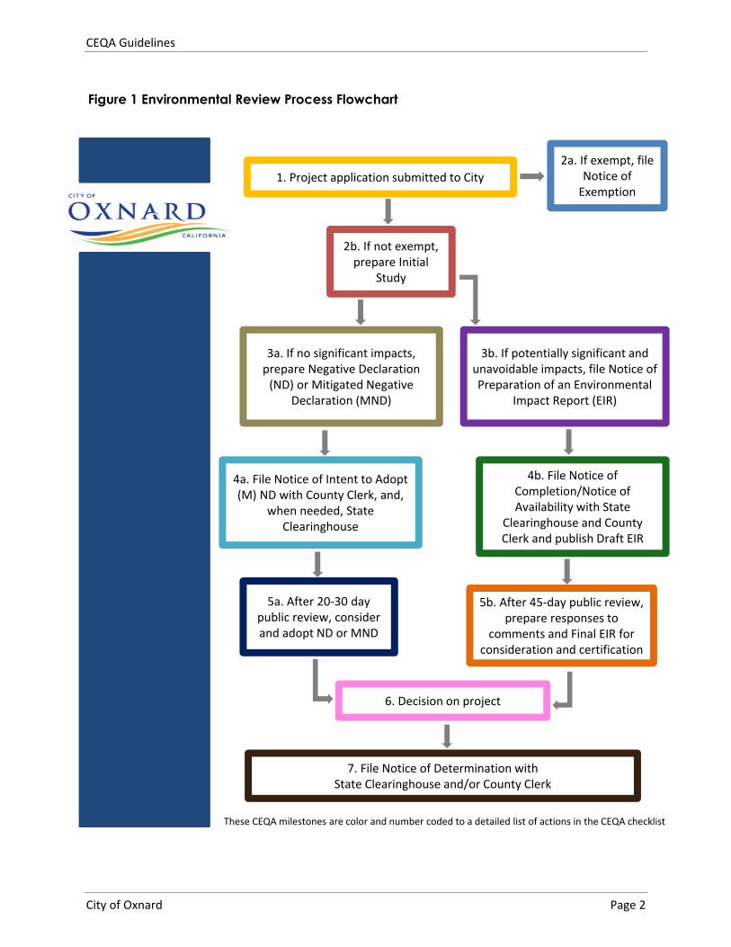
1. Project application submitted to City2a. If exempt, file
Notice ofExemption
2b. If not exempt,prepare Initial
Study
3a. If no significant impacts,prepare Negative Declaration(ND) or Mitigated Negative
Declaration (MND)
3b. If potentially significant andunavoidable impacts, file Notice ofPreparation of an Environmental
Impact Report (EIR)
4a. File Notice of Intent to Adopt(M) ND with County Clerk, and,
when needed, StateClearinghouse
4b. File Notice ofCompletion/Notice ofAvailability with State
Clearinghouse and CountyClerk and publish Draft EIR
5a. After 20 30 daypublic review, considerand adopt ND or MND
5b. After 45 day public review,prepare responses to
comments and Final EIR forconsideration and certification
6. Decision on project
7. File Notice of Determination withState Clearinghouse and/or County Clerk
These CEQA milestones are color and number coded to a detailed list of actions in the CEQA checklist
Figure 1 Environmental Review Process Flowchart
CEQA Guidelines
City of Oxnard Page 2
CEQA Guidelines
City of Oxnard Page 3
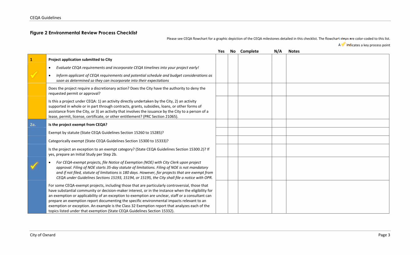
Figure 2 Environmental Review Process Checklist Please see CEQA flowchart for a graphic depiction of the CEQA milestones detailed in this checklist. The flowchart steps are color coded to this list.
A indicates a key process point
Yes No Complete N/A Notes
1 Project application submitted to City
Evaluate CEQA requirements and incorporate CEQA timelines into your project early!
Inform applicant of CEQA requirements and potential schedule and budget considerations assoon as determined so they can incorporate into their expectations
Does the project require a discretionary action? Does the City have the authority to deny therequested permit or approval?
Is this a project under CEQA: 1) an activity directly undertaken by the City, 2) an activitysupported in whole or in part through contracts, grants, subsidies, loans, or other forms ofassistance from the City, or 3) an activity that involves the issuance by the City to a person of alease, permit, license, certificate, or other entitlement? (PRC Section 21065).
2a. Is the project exempt from CEQA?
Exempt by statute (State CEQA Guidelines Section 15260 to 15285)?
Categorically exempt (State CEQA Guidelines Section 15300 to 15333)?
Is the project an exception to an exempt category? (State CEQA Guidelines Section 15300.2)? Ifyes, prepare an Initial Study per Step 2b.
For CEQA exempt projects, file Notice of Exemption (NOE) with City Clerk upon projectapproval. Filing of NOE starts 35 day statute of limitations. Filing of NOE is not mandatoryand if not filed, statute of limitations is 180 days. However, for projects that are exempt fromCEQA under Guidelines Sections 15193, 15194, or 15195, the City shall file a notice with OPR.
For some CEQA exempt projects, including those that are particularly controversial, those thathave substantial community or decision maker interest, or in the instance when the eligibility foran exemption or applicability of an exception to exemption are unclear, staff or a consultant canprepare an exemption report documenting the specific environmental impacts relevant to anexemption or exception. An example is the Class 32 Exemption report that analyzes each of thetopics listed under that exemption (State CEQA Guidelines Section 15332).
CEQA Guidelines
City of Oxnard Page 4
Yes No Complete N/A Notes
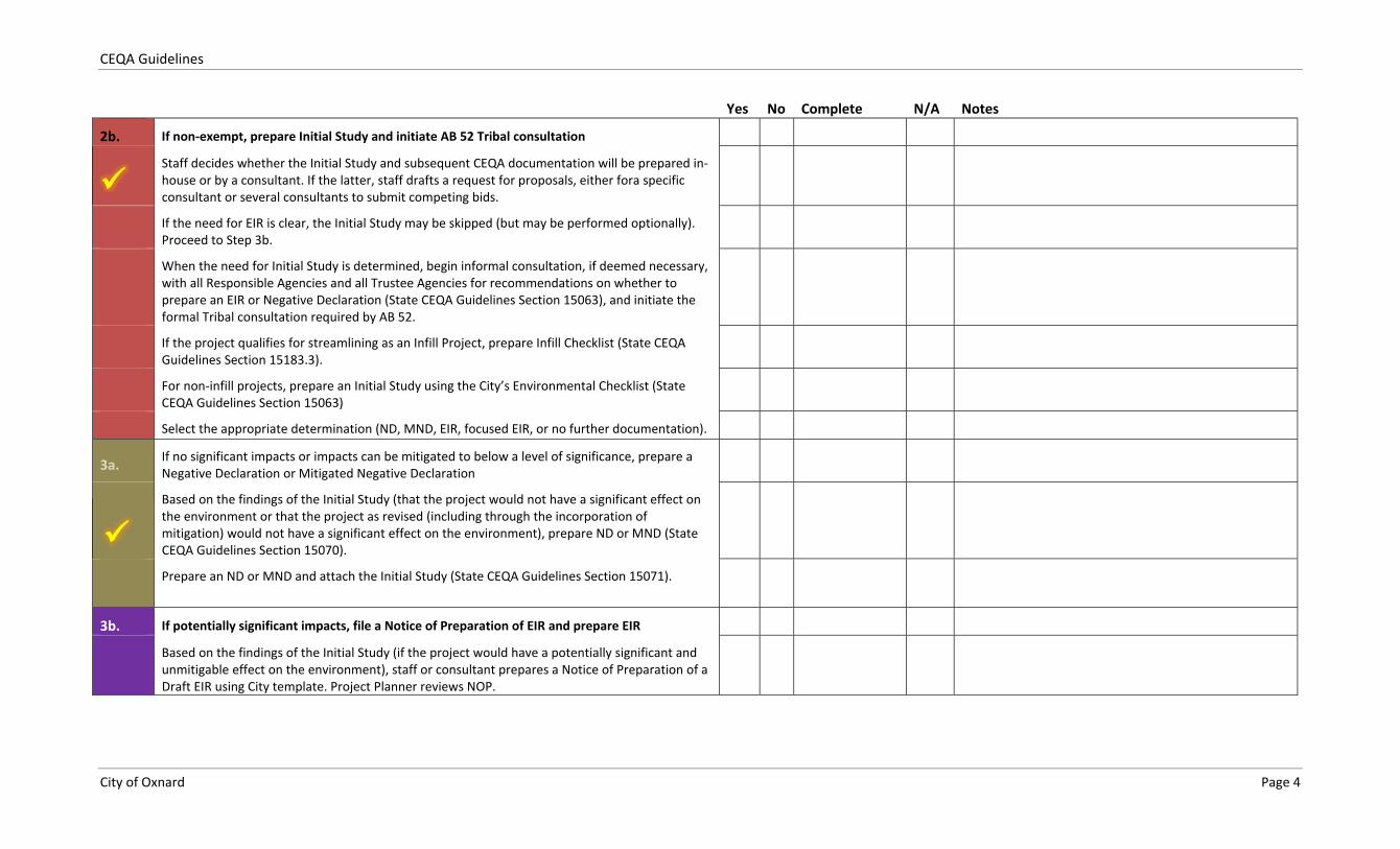
2b. If non exempt, prepare Initial Study and initiate AB 52 Tribal consultation
Staff decides whether the Initial Study and subsequent CEQA documentation will be prepared inhouse or by a consultant. If the latter, staff drafts a request for proposals, either fora specificconsultant or several consultants to submit competing bids.
If the need for EIR is clear, the Initial Study may be skipped (but may be performed optionally).Proceed to Step 3b.
When the need for Initial Study is determined, begin informal consultation, if deemed necessary,with all Responsible Agencies and all Trustee Agencies for recommendations on whether toprepare an EIR or Negative Declaration (State CEQA Guidelines Section 15063), and initiate theformal Tribal consultation required by AB 52.
If the project qualifies for streamlining as an Infill Project, prepare Infill Checklist (State CEQAGuidelines Section 15183.3).
For non infill projects, prepare an Initial Study using the City�’s Environmental Checklist (StateCEQA Guidelines Section 15063)
Select the appropriate determination (ND, MND, EIR, focused EIR, or no further documentation).
3a. If no significant impacts or impacts can be mitigated to below a level of significance, prepare aNegative Declaration or Mitigated Negative Declaration
Based on the findings of the Initial Study (that the project would not have a significant effect onthe environment or that the project as revised (including through the incorporation ofmitigation) would not have a significant effect on the environment), prepare ND or MND (StateCEQA Guidelines Section 15070).
Prepare an ND or MND and attach the Initial Study (State CEQA Guidelines Section 15071).
3b. If potentially significant impacts, file a Notice of Preparation of EIR and prepare EIR
Based on the findings of the Initial Study (if the project would have a potentially significant andunmitigable effect on the environment), staff or consultant prepares a Notice of Preparation of aDraft EIR using City template. Project Planner reviews NOP.
CEQA Guidelines
City of Oxnard Page 5
Yes No Complete N/A Notes
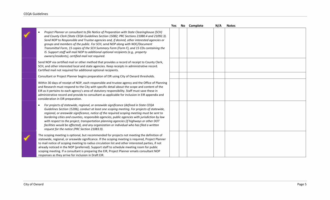
Project Planner or consultant to file Notice of Preparation with State Clearinghouse (SCH)and County Clerk (State CEQA Guidelines Section 15082; PRC Sections 21080.4 and 21092.3).Send NOP to Responsible and Trustee agencies and, if desired, other interested agencies orgroups and members of the public. For SCH, send NOP along with NOC/DocumentTransmittal Form, 15 copies of the SCH Summary Form (Form F), and 15 CDs containing theIS. Support staff will mail NOP to additional optional recipients (e.g,. propertyowners/residents), certified mail not required.
Send NOP via certified mail or other method that provides a record of receipt to County Clerk,SCH, and other interested local and state agencies. Keep receipts in administrative record.Certified mail not required for additional optional recipients.
Consultant or Project Planner begins preparation of EIR using City of Oxnard thresholds.
Within 30 days of receipt of NOP, each responsible and trustee agency and the Office of Planningand Research must respond to the City with specific detail about the scope and content of theEIR as it pertains to each agency's area of statutory responsibility. Staff must save these inadministrative record and provide to consultant as applicable for inclusion in EIR appendix andconsideration in EIR preparation.
For projects of statewide, regional, or areawide significance (defined in State CEQAGuidelines Section 15206), conduct at least one scoping meeting. For projects of statewide,regional, or areawide significance, notice of the required scoping meeting must be sent tobordering cities and counties, responsible agencies, public agencies with jurisdiction by lawwith respect to the project, transportation planning agencies (if highways or other DOTfacilities would be affected), and any organization or individual who has filed a writtenrequest for the notice (PRC Section 21083.9).
The scoping meeting is optional, but recommended for projects not meeting the definition ofstatewide, regional, or areawide significance. If the scoping meeting is required, Project Plannerto mail notice of scoping meeting to radius circulation list and other interested parties, if notalready noticed in the NOP (preferred). Support staff to schedule meeting room for publicscoping meeting. If a consultant is preparing the EIR, Project Planner emails consultant NOPresponses as they arrive for inclusion in Draft EIR.
CEQA Guidelines
City of Oxnard Page 6
Yes No Complete N/A Notes
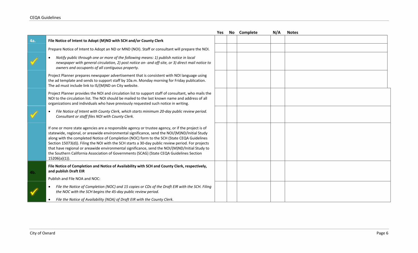
4a. File Notice of Intent to Adopt (M)ND with SCH and/or County Clerk
Prepare Notice of Intent to Adopt an ND or MND (NOI). Staff or consultant will prepare the NOI.
Notify public through one or more of the following means: 1) publish notice in localnewspaper with general circulation, 2) post notice on and off site, or 3) direct mail notice toowners and occupants of all contiguous property.
Project Planner prepares newspaper advertisement that is consistent with NOI language usingthe ad template and sends to support staff by 10a.m. Monday morning for Friday publication.The ad must include link to IS/(M)ND on City website.
Project Planner provides the NOI and circulation list to support staff of consultant, who mails theNOI to the circulation list. The NOI should be mailed to the last known name and address of allorganizations and individuals who have previously requested such notice in writing.
File Notice of Intent with County Clerk, which starts minimum 20 day public review period.Consultant or staff files NOI with County Clerk.
If one or more state agencies are a responsible agency or trustee agency, or if the project is ofstatewide, regional, or areawide environmental significance, send the NOI/(M)ND/Initial Studyalong with the completed Notice of Completion (NOC) form to the SCH (State CEQA GuidelinesSection 15073(d)). Filing the NOI with the SCH starts a 30 day public review period. For projectsthat have regional or areawide environmental significance, send the NOI/(M)ND/Initial Study tothe Southern California Association of Governments (SCAG) (State CEQA Guidelines Section15206(a)(1)).
4b.File Notice of Completion and Notice of Availability with SCH and County Clerk, respectively,and publish Draft EIR
Publish and File NOA and NOC:
File the Notice of Completion (NOC) and 15 copies or CDs of the Draft EIR with the SCH. Filingthe NOC with the SCH begins the 45 day public review period.
File the Notice of Availability (NOA) of Draft EIR with the County Clerk.
CEQA Guidelines
City of Oxnard Page 7
Yes No Complete N/A Notes
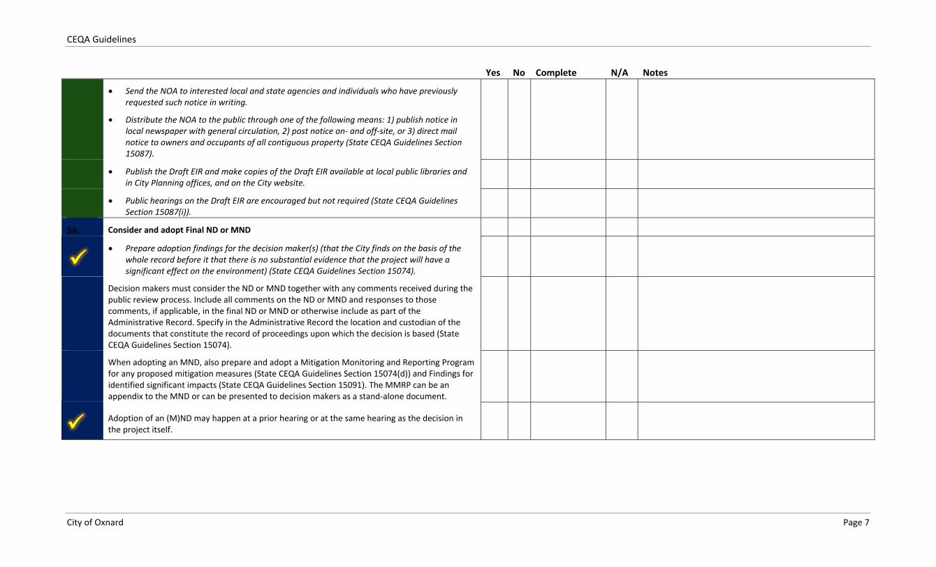
Send the NOA to interested local and state agencies and individuals who have previouslyrequested such notice in writing.
Distribute the NOA to the public through one of the following means: 1) publish notice inlocal newspaper with general circulation, 2) post notice on and off site, or 3) direct mailnotice to owners and occupants of all contiguous property (State CEQA Guidelines Section15087).
Publish the Draft EIR and make copies of the Draft EIR available at local public libraries andin City Planning offices, and on the City website.
Public hearings on the Draft EIR are encouraged but not required (State CEQA GuidelinesSection 15087(i)).
5a. Consider and adopt Final ND or MND
Prepare adoption findings for the decision maker(s) (that the City finds on the basis of thewhole record before it that there is no substantial evidence that the project will have asignificant effect on the environment) (State CEQA Guidelines Section 15074).
Decision makers must consider the ND or MND together with any comments received during thepublic review process. Include all comments on the ND or MND and responses to thosecomments, if applicable, in the final ND or MND or otherwise include as part of theAdministrative Record. Specify in the Administrative Record the location and custodian of thedocuments that constitute the record of proceedings upon which the decision is based (StateCEQA Guidelines Section 15074).
When adopting an MND, also prepare and adopt a Mitigation Monitoring and Reporting Programfor any proposed mitigation measures (State CEQA Guidelines Section 15074(d)) and Findings foridentified significant impacts (State CEQA Guidelines Section 15091). The MMRP can be anappendix to the MND or can be presented to decision makers as a stand alone document.
Adoption of an (M)ND may happen at a prior hearing or at the same hearing as the decision inthe project itself.
CEQA Guidelines
City of Oxnard Page 8
Yes No Complete N/A Notes
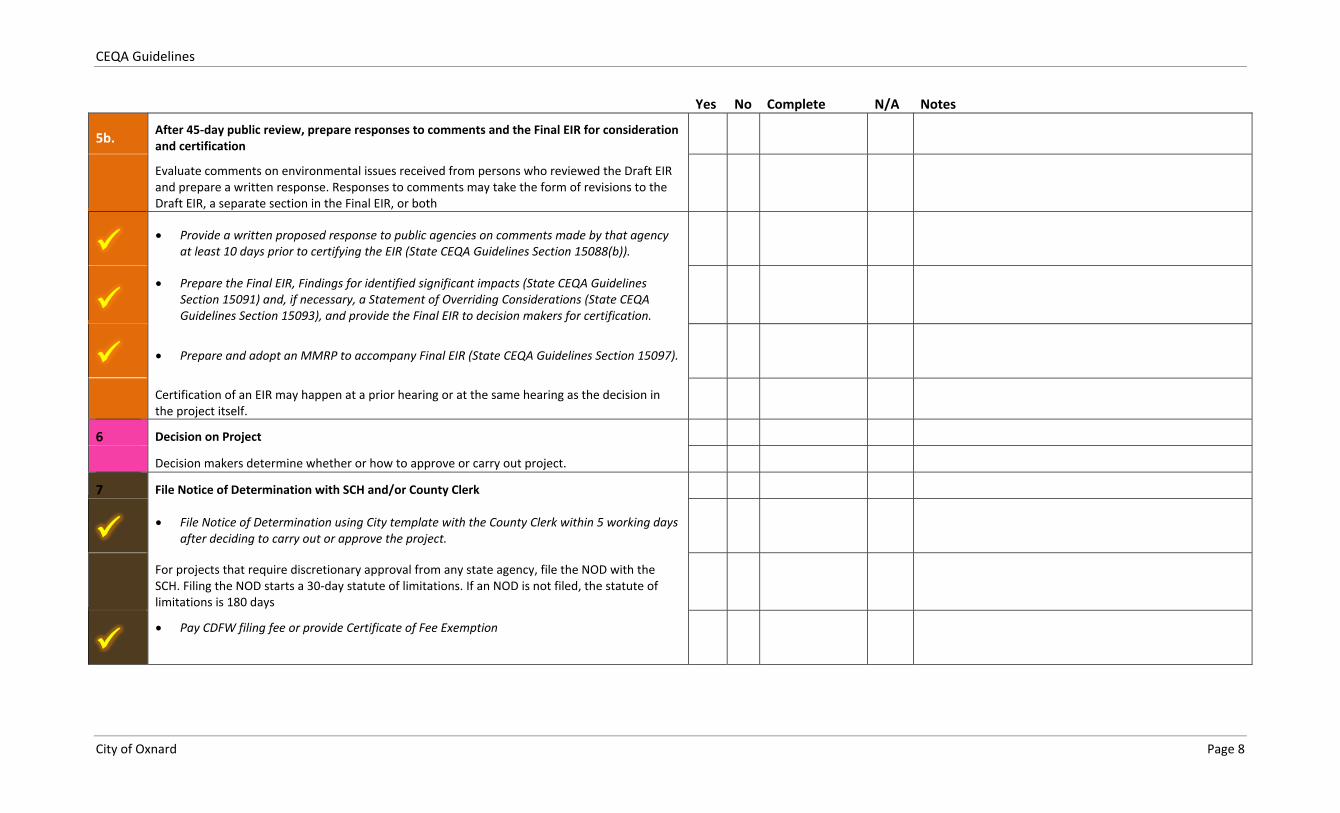
5b. After 45 day public review, prepare responses to comments and the Final EIR for considerationand certification
Evaluate comments on environmental issues received from persons who reviewed the Draft EIRand prepare a written response. Responses to comments may take the form of revisions to theDraft EIR, a separate section in the Final EIR, or both
Provide a written proposed response to public agencies on comments made by that agencyat least 10 days prior to certifying the EIR (State CEQA Guidelines Section 15088(b)).
Prepare the Final EIR, Findings for identified significant impacts (State CEQA GuidelinesSection 15091) and, if necessary, a Statement of Overriding Considerations (State CEQAGuidelines Section 15093), and provide the Final EIR to decision makers for certification.
Prepare and adopt an MMRP to accompany Final EIR (State CEQA Guidelines Section 15097).
Certification of an EIR may happen at a prior hearing or at the same hearing as the decision inthe project itself.
6 Decision on Project
Decision makers determine whether or how to approve or carry out project.
7 File Notice of Determination with SCH and/or County Clerk
File Notice of Determination using City template with the County Clerk within 5 working daysafter deciding to carry out or approve the project.
For projects that require discretionary approval from any state agency, file the NOD with theSCH. Filing the NOD starts a 30 day statute of limitations. If an NOD is not filed, the statute oflimitations is 180 days
Pay CDFW filing fee or provide Certificate of Fee Exemption
CEQA Guidelines
City of Oxnard Page 9
The Guidelines apply only to those non-‐exempt projects subject to CEQA that require an IS, ND, MND, or EIR. The Guidelines apply to both public and private residential, commercial, institutional, industrial, and infrastructure projects. Most screening criteria and significance thresholds also apply to broader planning-‐related activities or master-‐planned developments, specific plans, and zone changes.
The Guidelines are presumed to be authoritative with exceptions allowed based on evidence in the record where: 1) the preponderance of qualified expert independent judgment relevant to the project at hand conclusively establishes an alternative threshold; 2) new substantive and authoritative information would lead to updating the threshold; or 3) a legislative or pre-‐emptive threshold supersedes the present Threshold Guideline. These Threshold Guidelines, the State CEQA Guidelines, and other references describe the requirements of the CEQA process for projects in Oxnard and should be consulted as part of the CEQA review of projects in the City.
OVERVIEW OF THE ENVIRONMENTAL REVIEW PRO CESS
As previously described, Figure 1 generally identifies the environmental review process. Any activity that meets the criteria for a project as defined by the State CEQA Guidelines (Section 15378) and is either directly undertaken by, or will need a discretionary approval from a public agency must undergo the environmental review process (unless exempt by CEQA).
DOES CEQA APPLY TO MY PROJECT?
As a preliminary step in the environmental review process, a proposed project is reviewed to determine whether CEQA applies. CEQA does not apply to, and therefore no environmental document is required for, an activity that:
Is not considered a “project” as defined in the State CEQA Guidelines (Section 15378 of the StateCEQA Guidelines),
Is exempt from CEQA by statute or categorical exemption (Section 15260 – 15329 of the StateCEQA Guidelines),
Is of such a type or scope that one can see with certainty there is no possibility that the projectwill have a significant effect on the environment (Section 15061(b)(3) of the State CEQAGuidelines),
Does not involve the exercise of discretionary powers by a public agency (Section 15060 (c)(1) ofthe State CEQA Guidelines), or
Will not result in a direct or reasonably foreseeable indirect physical change in the environment(Section 15060 (c)(2) of the State CEQA Guidelines.
If preliminary review indicates that CEQA applies, the proposed project must undergo further environmental review, including one or more of the following activities.
Assess Potential Significant Impacts
Once it has been determined that CEQA applies to a proposed action, the CEQA environmental review process continues with the preparation of an IS using State CEQA Guidelines, the Initial Study checklist (Attachment A to these Guidelines) to determine whether the proposed project would result in a
CEQA Guidelines
City of Oxnard Page 10
significant effect on the environment. If the IS determines that the proposed project would not have a significant impact on the environment, a ND can be prepared. If the Initial Study determines that the proposed project could have a significant impact on the environment, but all identified significant adverse environmental impacts could be avoided or reduced to a less-‐than-‐significant level through modifications in the project description and/or the adoption of mitigation measures as conditions of approval for the project, a MND is prepared and the project proponent agrees to revisions and/or mitigation measures in writing. Conversely, if the applicant disagrees with these project revisions and/or mitigation measures or if the IS results in a determination that there is substantial evidence that the project, individually or cumulatively, would or may cause a significant effect on the environment, an EIR is required.
The City of Oxnard adopted the 2030 General Plan in October 2011. The 2030 General Plan Final EIR was certified at that same time. The EIR provides a programmatic environmental review of the 2030 General Plan that serves as a first tier environmental document for projects within the City that are consistent with the 2030 General Plan. To the degree feasible, the 2030 General Plan EIR can be used to wholly or partially meet the CEQA environmental review requirements for individual projects. In instances where a project is entirely consistent with the 2030 General Plan and would not have any site-‐specific environmental impacts not identified in the 2030 General Plan EIR, the City may determine that additional CEQA review is not required. In instances where a project only involves “minor technical changes” from what is envisioned in the 2030 General Plan and the project would not have any new or increased severity significant environmental impacts, an Addendum to the Final EIR may be prepared in accordance with Section 15164 of the State CEQA Guidelines. In instances where a project would or may have site-‐specific significant environmental impacts not identified in the 2030 General Plan EIR, a supplemental or subsequent MND or EIR would typically be required in accordance with section 15162 and 15163 of the State CEQA Guidelines. The Statement of Overriding Considerations adopted for the 2030 General Plan can be used for future projects in the City that are consistent with the General Plan when the project’s impacts are part of the unavoidably significant impact identified in the 2030 General Plan EIR.
Prepare Appropriate Environmental Document
For projects where an Addendum is to be prepared, the City will prepare (or oversee the preparation of) a document that describes the nature of the minor technical changes to the previously approved project, describes how the changed project would not have any new or increased severity significant impacts, and briefly explains the decision not to prepare a supplemental or subsequent MND or EIR. The addendum does not need to be circulated for public review, but must be considered by City decision makers prior to making a decision on the project.
For projects where a ND or MND is to be prepared, the City will prepare (or oversee the preparation of) a document that includes:
1. A brief description of the project
2. The location of the project and the name of the project proponent
3. A statement explaining why the project would not have a significant impact on the environment
4. An attached copy of the CEQA Initial Study Checklist
5. Changes in the project description and/or mitigation measures, if any, included in the project toavoid potentially significant effects (MND only).
If an EIR is required, the City will prepare (or oversee the preparation of) a document describing all potentially significant environmental effects of the proposed project and the mitigation measures and
CEQA Guidelines
City of Oxnard Page 11
alternatives considered to lessen or avoid those effects (consistent with the State CEQA Guidelines). The EIR must include all of the components described in Article 9 of the State CEQA Guidelines.
Public Review of Environmental Document and Final Document
Upon completion of a draft ND/MND or EIR, copies are circulated to all interested public agencies and private individuals for review and comment. Typical review periods are 20-‐30 days for a ND or MND and 45 days for an EIR. Upon completion of the public review period, the lead agency is responsible for compiling all written comments in accordance with the State CEQA Guidelines, preliminarily determining whether the environmental document contains all the necessary elements and analysis as set forth in the State CEQA Guidelines and complies with other procedural and substantive CEQA requirements, drafting the necessary findings for each of the significant impacts, and finalizing the EIR document. In the case of an ND/MND, written responses to written comments are not required, but City decision makers must consider the comments received. For EIRs, written responses must be prepared for all written comments received during the public review period for the Draft EIR.
The final environmental document is submitted to the advisory body required by statute or ordinance to review the project, if any, and then to the decision-‐making body, as well as all responsible agencies, for consideration during the approval phase of the project. The decision-‐making body must certify that it has reviewed and considered the information contained in the environmental document and, if it is the lead agency, that the document has been prepared in compliance with CEQA. The decision-‐making body must make certain findings related to the environmental document (State CEQA Guidelines Sections 15074, 15090, 15091, and 15093) before it can approve or carry out a project.
ORGANIZATION OF DO CUMENT
The Oxnard Threshold Guidelines are arranged by issue area, generally in the same order in which the issues appear in the State CEQA Guidelines Appendix G Initial Study Checklist. The environmental issues addressed in this document and the corresponding section numbers from the Appendix G Checklist are listed below.
1. Aesthetics and Urban Design (I) 2. Agricultural Resources (II) 3. Air Quality (III) 4. Biological Resources (IV) 5. Climate Change and Greenhouse Gas
Emissions (V) 6. Cultural Resources and Tribal Cultural
Resources (VI, VII) 7. Geology and Soils (VIII) 8. Hazards and Hazardous Materials (IX)
9. Hydrology and Water Quality (X) 10. Land Use and Planning (XI) 11. Mineral Resources (XII) 12. Noise (XIII) 13. Population, Education, and Housing (XIV) 14. Public Services and Recreation (XV, XVI) 15. Transportation and Circulation (XVII) 16. Utilities and Energy (XVIII, XIX)
For each environmental issue area, the following information is provided:
Background. This section summarizes key resources for the topic and identifies references or background information that may be consulted for more information. The goals and policy statements from the 2030 General Plan that apply to each environmental topic, are listed in Attachment B.
Significance Thresholds. This section describes the criteria for each environmental issue area that can be used to determine whether a project impact could be significant.
CEQA Guidelines
City of Oxnard Page 12
Methods. This section describes possible evaluation methodologies and other factors to assist inthe determination of a significant impact.
The thresholds and methods contained herein are aimed primarily at “project-‐level” environmental reviews that address specific private development projects or City projects. In some cases, project-‐level thresholds and methods may not apply to program-‐level environmental reviews and may need to be adjusted as appropriate on a case-‐by-‐case basis. City staff will maintain discretion over the use of thresholds contained herein on program-‐level reviews.
CEQA Guidelines
City of Oxnard Page 13
1. AESTHETICS AND URBAN DESIGN
1.1 BACKGROUND
The 2030 General Plan Goals and Policies document identifies three broad categories of aesthetic resources (in Section 1.7, City Overview):
Local Waterways. The primary waterway in the Planning Area is the Santa Clara River, which forms part of the northern boundary of the City. Over 4,000 acres of high-‐quality riparian habitat are present along the entire length of the river, whose large sediment deposits contribute to Pacific Ocean beaches. Smaller waterways and drainage channels traverse the Planning Area, providing natural scenery and wildlife habitat. Many of these local waterways are visible from several viewpoints along local roadways.
Agricultural Greenbelts. The Oxnard-‐Camarillo Greenbelt and the Oxnard-‐Ventura Greenbelt largely define the City’s northern, eastern, and western boundaries. These areas are intended for long-‐term agricultural use and generally cannot convert to urban development without voter approval.
Beaches and Coastline. Oxnard’s beaches and coastline are recognized as the City’s primary natural scenic resource, with two State beaches located within the Planning Area: McGrath State Beach and Mandalay Beach State Park. City, County, and State beaches provide views of the Pacific Ocean and the offshore Channel Islands on clear days. Other visual resources in the Coastal Zone include tall sand dunes near Mandalay Beach and the wetlands in the Ormond Beach area. In order to preserve the aesthetic quality of the Planning Area’s coastline, the City’s Coastal Land Use Plan guides development along the Coastal Zone.
With respect to scenic highways, the General Plan Background Report notes that there are no California Department of Transportation (Caltrans) Designated Scenic Routes in the Oxnard Planning Area. The General Plan Background Report lists several other roadway segments that (City of Oxnard 2006: 5-‐26, 5-‐41):
“…the City, in conjunction with Ventura County and the City of Port Hueneme has selected routes for the City’s Scenic Highway System.”
Most of these routes have scenic value because they allow views into the regionally important scenic resources – waterways, agricultural greenbelts, beaches and coastline. Other routes are also identified as important view corridors by virtue of providing important access routes in the community (City of Oxnard 2006: 5-‐25). The routes identified as scenic are shown in Figure 3, and listed below.
Los Angeles Avenue through Oxnard’s Sphere of Influence
Vineyard Avenue between Los Angeles Avenue and Patterson Road
Oxnard Boulevard between U.S. Route 101 (Ventura Freeway) and Point Mugu
Victoria Avenue between the Santa Clara River and Channel Islands Boulevard, continuing east on Channel Islands Boulevard to Victoria Avenue
U.S. Route 101 through Oxnard’s Sphere of Influence
CEQA Guidelines
City of Oxnard Page 14
Fifth Street between Mandalay Beach Road and Revolon Slough
Central Avenue between Vineyard Avenue and Santa Clara Avenue
Santa Clara Avenue between U.S. Route 101 and the Sphere of Influence boundary
Gonzales Road between Harbor Boulevard and Del Norte Boulevard
Wooley Road between Harbor Boulevard and Rice Avenue
Channel Islands Boulevard between Ventura Road and Rice Avenue
Pleasant Valley Road between Port Hueneme city limits and State Route 1
Hueneme Road between Port Hueneme city limits and State Route 1
Del Norte Boulevard between U.S. Route 101 and Fifth Street
Rose Avenue between U.S. Route 101 and State Route 1
Rice Avenue between U.S. Route 101 and State Route 1
Saviers Road between Oxnard Boulevard and Channel Islands Boulevard
Ventura Road between U.S. Route 101 and Teakwood Street
Patterson Road between Fifth Street and Hemlock Street and between Vineyard Avenue andDoris Avenue
Doris Avenue between Victoria Avenue and Patterson Road
Urban landscape areas are also considered an important visual resource; particularly where neighborhoods have retained many of their original buildings and architectural features and where park or plaza features provide open space (City of Oxnard 2006: 5-‐41, 5-‐42, Figure 5-‐7, 5-‐8).
Policies from the 2030 General Plan that relate to maintaining and enhancing scenic resources are found throughout the various chapters in the General Plan. Those relating to the evaluation of aesthetic resources are summarized in Table 1of Attachment B.
1.2 SIGNIFICANCE THRESHOLDS
An affirmative answer to any of the following questions typically indicates a potentially significant aesthetic impact. A “no” response to all questions indicates that there would be no significant impact with respect to aesthetics.
1. Would the project have a substantial adverse effect on a scenic vista such as an ocean ormountain view from an important view corridor or location as identified in the 2030 GeneralPlan or other City planning documents?
2. Would the project substantially damage scenic resources, including, but not limited to, trees,rock outcroppings, and historic buildings within a state scenic highway, or route identified asscenic by the County of Ventura or City of Oxnard?
3. Would the project substantially degrade the existing visual character or quality of the site or itssurroundings such as by creating new development or other physical changes that are visuallyincompatible with surrounding areas or that conflict with visual resource policies contained inthe 2030 General Plan or other City planning documents?

CEQA Guidelines
City of Oxnard Page 16
4. Would the project add to or compound an existing negative visual character associated with the project site?
5. Would the project create a source of substantial light or glare that would adversely affect day or nighttime views in the area?
Note that per the PRC, aesthetic impacts of a residential, mixed-‐use residential, or employment center project on an infill site within a transit priority area are not considered significant impacts on the environment. Transit priority areas those areas within one-‐half mile of an existing or planned major transit stop.
1.3 METHODS
Include a discussion of the effect of the proposed project on scenic resources, and evaluation to determine whether the effect would be significant. Several systems for evaluating visual resources are in use by various agencies. Depending on the nature of the resource and the complexity of the project, these systems can range from simple informal evaluations to complex analyses. They all involve describing three essential items or components of the visual resource analysis:
The nature and quality of the visual resource. Any of the significant visual resources, as identified in the 2030 General Plan Goals and Policies or in the General Plan Background Report, that may be affected by the proposed project should be noted and described. This would include local waterways, agricultural greenbelts, beaches and coast lines, scenic roadways, and well preserved urban landscapes associated with historic neighborhoods and parks and open plazas.
The viewpoint and the identity of the viewers and their sensitivity to changes in the view. Viewers who would be the most sensitive to alterations in the landscape or existing views would be residents or visitors enjoying the recreational uses in open spaces, beaches, coastal areas, or scenic roadways viewing these areas. People using smaller parks, open spaces, or plazas within urban areas would also be sensitive to the views of urban landscapes in the area.
The effect of the proposed project in altering the nature of the view. A project component that introduces a manmade feature that contrasts strongly with the existing natural or cultural landscape affecting sensitive viewers would normally have a significant impact. The impact may be project-‐specific if the project is inharmonious or discordant with the existing landscape, or if it would introduce a feature that blocks views of important resources, even if the view is already partially blocked. The effect may also be part of a cumulative impact if it occurs in combination with similar projects or man-‐made features that adversely affect the same visual resource.
CEQA Guidelines
City of Oxnard Page 17
2. AGRICULTURAL RESOURCES
2.1 BACKGROUND
Ventura County is recognized as one of the principal agricultural counties in the State, with annual gross revenues from the sales of agricultural commodities of approximately 2.2 billion dollars (Ventura County 2011, Ventura County 2016). Ventura County consistently ranks among the highest in agricultural revenues of the 58 counties in the State. Agriculture generates a substantial number of jobs ranging from crop production to processing, shipping and other related industries.
The seasonal row crop production pattern throughout west Ventura County is divided into two general categories: cool season and warm season crops. The cool season crops are generally harvested from fall through spring or early summer and include: broccoli, cauliflower, celery, lettuce and spinach. The warm season crops are harvested from mid-‐summer through fall and include: Fordhook green lima beans, snap beans, cucumbers, peppers and tomatoes. Year around crops include: cabbage (all year), strawberries (early spring to early summer) and lemons (January to mid-‐June). Fruit and nut crops and vegetable crops comprise the most valuable crop groups. Strawberries are consistently among the leading crops in revenue. Other high value crops include citrus fruits, raspberries, and nursery stock. Based on information in the General Plan Background Report (City of Oxnard 2006: Table 3-‐5), over 24,500 acres within the Planning Area was designated for Agricultural use, which is just over half of the entire Planning Area.
The California Department of Conservation prepares maps of important farmland throughout the state, based on categories of agricultural land defined by the U.S. Department of Agriculture land inventory and monitoring criteria, and regularly reports on the conversion of farmland to other uses (pursuant to Government Code Section 65570). The categories of Prime Farmland, Farmland of Statewide Importance, Unique Farmland, and Farmland of Local Importance designations are often referred to collectively as “Important Farmlands”. The General Plan Background Report (City of Oxnard 2006, Table 5-‐7) indicates that there are approximately 23,000 acres of land meeting this definition within the Oxnard Planning Area.
The 2030 General Plan EIR concluded that the ultimate development of land, consistent with the land use designations of the 2030 General Plan, would result in the conversion of 2,215 acres of Important Farmlands to other uses (City of Oxnard 2009: 2.3-‐2, Table 5-‐1,Figure 5-‐1). This anticipated conversion of land was identified as a significant impact (Impact 5.5-‐1). Several aspects of the 2030 General Plan Goals and Policies were identified as contributing to the preservation of agricultural lands. Even with implementation of these goals and policies, however, the 2030 General Plan EIR concluded that the conversion of important farmland to non-‐agricultural uses would still be considered a significant and unmitigable impact.
The 2030 General Plan EIR analyzed several other issues related to the preservation of agricultural lands, and concluded for each of these issues that there would be a less than significant impact associated with implementing the General Plan. The conclusion is based primarily on implementation of policies within the General Plan, and associated requirements of the zoning ordinance and other programs designed to minimize conflicts between other land uses and agriculture and to address the planned conversion of agricultural lands to other uses within the structure of land use planning in the City of Oxnard.
The Agricultural Greenbelts between Oxnard and Camarillo to the east, and between Oxnard and the unincorporated areas of Ventura County, figure prominently in growth management, land use planning,
CEQA Guidelines
City of Oxnard Page 18
and other resource values described in the General Plan. Goals and policies from the 2030 General Plan that relate to agricultural resources and their preservation are listed in Table 2 of Attachment B.
2.2 SIGNIFICANCE THRESHOLDS
An affirmative answer to any of the following questions typically indicates a potentially significant agricultural resource impact. A “no” response to all questions indicates that there would be no significant impact to agricultural resources.
1. Would the project convert Prime Farmland, Unique Farmland, or Farmland of Statewide Importance to non-‐agricultural use?
2. Would the project conflict with existing zoning for agricultural use or an existing Williamson Act contract?
3. Would the project involve other changes in the existing environment that, due to their location or nature, could result in conversion of off-‐site farmland to non-‐agricultural use?
2.3 METHODS
A project may have direct and/or indirect effects related to the conversion of agricultural land to other uses. Direct effects would occur if the project would occur on existing farmland and would result in the development of a different use such as a residential neighborhood or shopping center. The identification of important farmland should be based on City mapping (City of Oxnard 2009: Figure 5-‐1) or on mapping available from the California Department of Conservation (http://www.conservation.ca.gov/dlrp/fmmp/Pages/Ventura.aspx).
The determination of whether a specific project would have a significant and not mitigable impact relative to the direct conversion of important farmland requires judgment and the consideration of factors unique to the specific project. For most projects – those consistent with the General Plan land use designations – no new analysis or discussion will be necessary. Reference may be made to the following 2030 General Plan EIR conclusion:
Impact 5.5-‐1 The Project would result in the conversion of important farmland to non-‐agricultural uses, which was determined to be a significant and not mitigable impact at the General Plan level”
If the project site is within a Williamson Act contract preserve, then development is not possible without removing the property from the preserve status. The 2030 General Plan EIR assumes that the normal regulatory procedures for ending preserve status under the Williamson Act would be followed and in that case no additional mitigation would be necessary and the potential impact would be less than significant.
Indirect effects that may lead to conversion of nearby farmlands to developed uses are usually caused by land use compatibility issues. Policies from the 2030 General Plan intended to reduce such incompatibility include CD-‐6.1 and ER-‐12.11, related to providing adequate agricultural buffer areas, and ER-‐12.2 that involves supporting right-‐to-‐farm policies in Ventura County. Examples of measures that could be used to help minimize the potential for incompatibility with agricultural uses may be found in the County of Ventura Agricultural/Urban Buffer Policy (Ventura County 2006) and in the Ventura County right-‐to-‐farm ordinance (Ordinance No. 4151 adopted in 1997).
CEQA Guidelines
City of Oxnard Page 19
3. AIR QUALITY
3.1 BACKGROUND
Background information regarding air quality and the regulation of air pollutants is provided in the General Plan Background Report (City of Oxnard 2006: Section 5.7), the most recent Ventura County Air Pollution Control District (VCAPCD) Air Quality Management Plan (AQMP), (VCAPCD 2008: 5), and the Air Quality Assessment Guidelines (VCAPCD 2003: Sections 1 and 2). For regulatory purposes, air pollutants are generally divided into two categories: those for which federal and California Ambient Air Quality Standards (AAQS) have been established (known as criteria air pollutants), and those for which no specific numerical standards are established, but which are known to cause acute or chronic health effects (toxic air contaminants, or TACs). For criteria pollutants, each air basin in the state, including Ventura County, is classified as being in “attainment” or “non-‐attainment” with respect to the various federal and California AAQS. The purpose of the AQMP is to identify the strategy and measures intended to achieve attainment with the applicable federal ozone standard, and to document other compliance efforts as required by both the Federal and California Clean Air Acts.
The criteria pollutants ozone and particulate matter are of most concern in California. Ozone is an oxidant that can directly affect the lungs causing respiratory irritation and possible changes in lung functions, and can also damage vegetation and other materials. It is formed in the atmosphere by precursors that are emitted primarily from man-‐made sources. Vehicle exhaust is a substantial source of ozone precursors, including nitrogen oxides (NOx) and reactive organic compounds (ROC).
Particulate matter includes dust and other small particles originating from man-‐made and natural sources. It is further classified by size: PM10 includes particulate matter with a diameter less than 10 microns and PM2.5 refers to dust/particulates that are 2.5 microns in diameter or smaller.
For the major pollutants of concern, the most recent (2015) status of the air basin – in terms of attaining the federal and California ambient air quality standards – is summarized as follows:
Federal standard for:
8-‐hour Ozone: Nonattainment
PM10: Unclassified
PM2.5: Unclassified/Attainment
State standard for:
Ozone: Nonattainment
PM10: Nonattainment
PM2.5: Attainment
As of 2015, the Ventura County air basin is in attainment with, or is unclassified with respect to, all other federal and state ambient air quality standards. VCAPCD or California Air Resources Board (CARB) should be consulted for updated information. Current designations are maintained by CARB at: https://www.arb.ca.gov/desig/adm/adm.htm.
CEQA Guidelines
City of Oxnard Page 20
Sources of air pollution are divided into two main categories: stationary and mobile. Stationary sources are those emission sources, such as industrial processes, burning crop residuals, and exposed soils/minerals (source of dust or PM10) that are fixed in place. Within Oxnard, stationary-‐source pollutants include ozone precursors associated with local industrial processes and PM10 emissions associated with road dust, burning, construction and demolition activities, and fuel combustion (at stationary locations, such as industry and residences). Wildfires are natural sources of PM10 emissions. Many stationary sources are subject to permit requirements under federal and state law, and in Oxnard these permits are administered by the VCAPCD. See the most recent version of the VCAPCD Air Quality Assessment Guidelines for a listing of common equipment and processes that require permit review by the VCAPCD.
The primary source of mobile emissions is vehicles (automobiles, passenger trucks, trucks, and buses). Vehicle exhaust is a major source of ozone precursors, and is regulated by federal and state laws governing vehicle emissions. Review procedures and planning programs are designed to assure that vehicle use and travel distances are minimized, as a way of minimizing vehicle emissions.
The 2030 General Plan Program EIR concluded that buildout of the General Plan land use designations, and traffic volumes as predicted in the modeling performed for the General Plan, would have a significant and unavoidable impact with respect to two air quality issues:
Impact 5.7-‐2 The Project would result in a cumulative increase of criteria pollutants in a non-‐attainment basin.
Impact 5.7-‐4 The Project could expose sensitive receptors to substantial pollutant concentrations.
Other potential air quality effects considered in the 2030 General Plan EIR, but considered less than significant with the application of routine mitigation measures included the exposure of sensitive land uses to construction-‐related air quality emissions (Impact 5.7-‐1), potential conflict with implementation of the applicable air quality plan (Impact 5.7-‐3), and the potential to create objectionable odors affecting a substantial number of people (Impact 5.7-‐5).
The 2030 General Plan contains a number of policy statements that related directly or indirectly to reducing emissions of air pollutants. Policies related to minimizing energy consumption and to developing alternative energy sources are considered part of the overall approach to reducing air pollution. The same is true for policies designed to reduce vehicle trips and to minimize vehicle trip distances. Many of these policies are intended primarily to reduce greenhouse gas emissions, but also help to reduce emissions of criteria pollutants as well. These policies are listed in Table 3 of Attachment B.
3.2 SIGNIFICANCE THRESHOLDS
An affirmative answer to any of the following questions typically indicates a significant air quality impact. A “no” response to all questions indicates that there would be no significant impact with respect to utilities.
1. Would the project conflict with population or other growth forecasts contained in the Ventura County AQMP or otherwise obstruct implementation of the Ventura County AQMP?
2. Would the project violate any federal or state air quality standard or contribute substantially to an existing or projected air quality standard violation?
3. Would the project result in a net increase of any criteria air pollutant in excess of quantitative thresholds recommended by the VCAPCD?
CEQA Guidelines
City of Oxnard Page 21
4. Would the project expose sensitive receptors to pollutant concentrations exceeding state or federal standards or in excess of applicable health risk criteria for toxic air contaminants?
5. Would the project create objectionable odors affecting a substantial number of people?
3.3 METHODS
Additional guidance in determining the potential significance of air emissions from a project is provided by the VCAPCD Air Quality Assessment Guidelines (Section 3.3). Specific numerical criteria applicable to the City of Oxnard planning area and other guidance in determining significance are summarized below.
Ozone and Ozone Precursors
For both Reactive Organic Compounds (ROC) and Nitrogen Oxides (NOx), the VCAPCD recommends use of a threshold of 25 pounds per day. An emissions inventory program (such as the latest version of the California Emissions Estimator Model [CalEEMod]) should be used to estimate the amounts of pollutants that may be associated with a project. As a screening tool, the Air Quality Assessment Guidelines provide a listing of project sizes that are likely to result in emissions above the 25 pounds per day thresholds. For example, a development involving single family detached housing for the year 2020 with 284 dwelling units or more would likely exceed the threshold. The screening limits for other land uses and for future years are found in the most recent version of the VCAPCD Air Quality Assessment Guidelines.
Cumulative Impacts
The cumulative effect of a project with respect to compliance with the ozone standard is based on a determination of project-‐specific AQMP Consistency. The general approach is described in the VCAPCD Guidelines for Air Quality Assessment (page 3-‐3) as follows:
A project with emissions of two pounds per day or greater of ROC, or two pounds per day or greater of NOx that is found to be inconsistent with the AQMP will have a significant cumulative adverse air quality impact. A project with emissions below two pounds per day of ROC, and below two pounds per day of NOx, is not required to assess consistency with the AQMP.
Guidance for determining consistency with the AQMP is also provided in the VCAPCD Air Quality Assessment Guidelines (Section 4.2). For projects located in the City of Oxnard, which is one of the “growth areas” identified in the Air Quality Assessment Guidelines, this determination occurs in two steps:
1. Determine whether the project conforms to the General Plan.
2. Determine the estimated population of the City of Oxnard and compare this estimate with the population “target” used in the most recent AQMP Population Forecasts. Regional forecasts for the City population, which are used for transportation and air quality planning purposes, may be a more current example. These forecasts are available from the Southern California Association of Governments (SCAG – at http://www.scag.ca.gov/DataAndTools/Pages/GrowthForecasting.aspx).
Fugitive Dust
The VCAPCD has not recommended a specific numerical criterion for fugitive dust. The qualitative threshold is described in the VCAPCD Air Quality Assessment Guidelines:
CEQA Guidelines
City of Oxnard Page 22
A project that may be reasonably expected to generate fugitive dust emissions in such quantities as to cause injury, detriment, nuisance, or annoyance to any considerable number of persons or to the public, or which may endanger the comfort, repose, health, or safety of any such person or the public, or which may cause, or have a natural tendency to cause, injury or damage to business or property (see California Health and Safety Code, Division 26, §41700) will have a significant adverse air quality impact.
Most of the concern regarding fugitive dust focuses on construction activities, and measures to minimize dust generation from grading and construction. More information is provided in the VCAPCD Air Quality Assessment Guidelines (Sections 6.2 and 7.4.1).
San Joaquin Valley Fever
From the Air Quality Assessment Guidelines (Section 6.3):
VCAPCD has not recommended a quantitative threshold for a significant San Joaquin Valley Fever impact. However, listed below are factors that may indicate a project’s potential to create significant Valley Fever impacts:
Disturbance of the top soil of undeveloped land (to a depth of about 12 inches)
Dry, alkaline, sandy soils
Virgin, undisturbed, non-‐urban areas
Windy areas
Archaeological resources probable or known to exist in the area (Native American midden sites)
Special events (fairs, concerts) and motorized activities (motocross track, All Terrain Vehicle activities) on unvegetated soil (non-‐grass)
Non-‐native population (i.e., out-‐of-‐area construction workers)
The lead agency should consider the factors above that are applicable to the project or the project site.
Asbestos
The U.S. EPA and the State of California list asbestos as a toxic air contaminant. Potential exposure to asbestos is most likely to occur in conjunction with the demolition of buildings constructed before 1979. Demolition or renovation activities involving asbestos materials are subject to the National Emissions Standards for Hazardous Air Pollutants (NESHAP) regulations. Rule 62.7 in the VCAPCD Rules and Regulations relates to demolition and renovation activities involving asbestos.
Other Toxic Air Contaminants
Most projects will not involve a substantial source of TACs. Those that would emit TACs are likely subject to the permit authority of the VCAPCD and the analysis of any TACs and their potential impact should be coordinated with the VCAPCD permit requirements. One source of TACs that is not directly regulated by the VCAPCD is diesel exhaust from heavy trucks. If a project would create a major concentration of heavy truck traffic for a long period of time or involves sensitive receptors that may be exposed to substantial concentrations of truck traffic or other sources of TACs (e.g., within 500 feet of U.S. 101), then the toxic effects of diesel particulate matter may be of concern. If TACs are a concern then a health risk
CEQA Guidelines
City of Oxnard Page 23
assessment (HRA) may need to be conducted. The HRA involves the use of an air quality dispersion model and procedures and input values approved by the VCAPCD. The following criteria are used to determine the significance of a potential health risk impact:
For cancer causing contaminants: a lifetime probability of contracting cancer is greater than 10 in one million as identified in the HRA.
For non-‐carcinogenic pollutants: a Hazard Index of greater than 1, as identified in the HRA.
Odors
VCAPCD has not recommended a specific numerical criterion or procedure for odors. The qualitative threshold is described in the VCAPCD Air Quality Assessment Guidelines:
A qualitative assessment indicating that a project may reasonably be expected to generate odorous emissions in such quantities as to cause detriment, nuisance, or annoyance to any considerable number of persons or to the public, or which may endanger the comfort, repose, health, or safety of any such person or the public, or which may cause, or have a natural tendency to cause, injury or damage to business or property (see California Health and Safety Code, Division 26, §41700) will have a significant adverse air quality impact.
The Air Quality Assessment Guidelines provide a definition of significant odor impact in terms of the numbers of complaints received – but this is of no predictive value in assessing new projects. There is a tabulation of “screening distances” in the Air Quality Assessment Guidelines (Table 6-‐3) for various odorous land uses that may cause an odor impact at receptor locations. The distances are all one or two miles, and they are associated with a wide variety of industrial, agricultural, and waste management facilities.

CEQA Guidelines
City of Oxnard Page 24
This page intentionally left blank.
CEQA Guidelines
City of Oxnard Page 25
4. BIOLO GICAL RESOURCES
4.1 BACKGROUND
Oxnard contains a variety of biological communities that provide habitat for both rare and common species. These habitats are mostly human-‐modified habitats, with the vast majority of the City including mostly urban, industrial, or agricultural production areas. In some areas (especially in the northern part of the City), a series of industrial oil fields within agricultural lands exists. Native habitats exist mostly on the edges of the City (i.e., Santa Clara River, coastal areas, etc.).
For the purposes of these guidelines, a sensitive biological resource is defined as follows:
A plant or animal that is currently listed by a state or federal agency(ies) as endangered, threatened, rare, protected, sensitive or a Species of Special Concern or federally listed critical habitat;
A plant or animal that is currently listed by a state or federal agency(ies) as a candidate species or proposed for state or federal listing;
A habitat that is under the jurisdiction of a state or federal resource agency responsible that is responsible for resource protection (e.g., California Department of Fish and Wildlife, U.S. Fish and Wildlife Services, U.S. Army Corps of Engineers, National Marine Fisheries Service); or
A locally designated or recognized species or habitat.
The 2030 General Plan includes a number of policies that address avoiding impacts to the unique sensitive biological resources of the Planning Area. These are listed in Table 4 of Attachment B.
4.2 SIGNIFICANCE THRESHOLDS
An affirmative answer to any of the following questions typically indicates a potentially significant biological resource impact. A “no” response to all questions indicates that there would be no significant impact to biological resources.
1. Would the project have a substantial adverse effect, either directly or through habitat modifications, on any species identified as a candidate, sensitive, or special-‐status species in local or regional plans, policies, or regulations, or by the California Department of Fish and Wildlife or U.S. Fish and Wildlife Service?
2. Would the project have a substantial adverse effect on any riparian habitat or other sensitive natural community identified in local or regional plans, policies, or regulations adopted by the California Department of Fish and Wildlife or U.S. Fish and Wildlife Service?
3. Would the project have a substantial adverse effect on federally protected waters of the U.S. as defined by Section 404 of the federal Clean Water Act or protected waters of the state as defined by Section 1600 et seq. of the California Fish and Game Code (including, but not limited to, marshes, vernal pools, and coastal wetlands) through direct removal, filling, hydrological interruption, or other means?
CEQA Guidelines
City of Oxnard Page 26
4. Would the project interfere substantially with the movement of any native resident or migratory fish or wildlife species or with established native resident or migratory wildlife corridors, or impede the use of native wildlife nursery sites?
5. Would the project conflict with any local policies or ordinances protecting biological resources?
6. Would the project conflict with an adopted Habitat Conservation Plan, Natural Community Conservation Plan, or other approved local, regional, or state habitat conservation plan?
4.3 METHODS
A physical description of the project site should be provided, including acreage, topography, presence of sensitive features (e.g., wetlands, flowing, standing or ephemeral water sources, rock outcroppings, caves, etc.), major habitats and vegetation communities present, potential presence of wildlife populations, sensitive resources, migration corridors, and relationship to the surrounding land should be included in the analysis. This should include the following:
In marine environments, description of the presence or absence of tidal wetlands, the bottom topography and depth, access to open ocean systems, information on existing biota, and the existence of movement or migration corridors of marine mammals;
Description of the potential for existing sensitive resources, based upon review of current biological reference documents, including the California Natural Diversity Database (CNDDB), federal and state agency lists, regulatory statutes, and applicable City documents;
Preparation of or reference to baseline assessments of potential occurrence of sensitive resources (from literature and existing resource data bases) and conduct a field reconnaissance survey, as needed
Surveys should be performed during appropriate seasons, and should include all significant resource elements, including corridor and habitat linkages, with an assessment of the nature of their occurrence (e.g., resident, transient, migratory, etc.). Species inventories should include organisms observed during surveys, along with those reasonably expected to occur over time, with a listing of sensitive biological elements and their agency status.
The following questions should be considered as part of the analysis.
Do known individuals or populations of a sensitive species use or inhabit the site during one or more seasons of the year, according to readily available published accounts, the project proponent and/or property owner?
Is the project site immediately adjacent to undeveloped natural open space containing native vegetation or does the site appear to serve as a buffer between existing development and more natural habitat areas? Could it be part of a movement corridor or habitat linkage system?
Is a natural water source, such as a lake, river, vernal pool, ephemeral stream, marsh or the ocean present on or adjacent to the site?
Is the project site relatively undisturbed or undeveloped, that is, free of structures, agricultural fields, pavement, etc.? Is it free of regular maintenance activities such as disking or clearing, maintenance and repair of linear utilities, maintenance or repair of roads, or maintenance and repair of municipal reservoirs and associated infrastructure?
CEQA Guidelines
City of Oxnard Page 27
5. CLIMATE CHANGE AND GREENHOUSE GAS EMISSIONS
5.1 BACKGROUND
The 2030 General Plan Goals and Policies discuss the issue of greenhouse gas emissions and climate change in Chapter 2 Sustainable Community. The General Plan discussion includes a review of key planning terms involved in sustainability concepts, many of which relate to greenhouse gas (GHG) emissions, their effect on global climate change, and the resulting environmental conditions that require planning and adaptation in coastal communities.
GHG emissions – mainly carbon dioxide from the burning of fossil fuels for energy production and for powering motor vehicles – are contributing toward global climate change. Among other effects, this climate change is expected to lead to a rise in sea level that will increase the potential for flooding in coastal areas. The State of California, through both Executive Orders by the Governor and through legislation, has adopted a number of policies and programs intended to reduce GHG emissions. These policies involve actions in a number of areas, including additional energy conservation through building design, increased fuel efficiency in motor vehicles, and measures to reduce the use of motor vehicles through land use and transportation strategies that promote alternative means of travel.
As of 2015, the City of Oxnard has adopted the 2030 General Plan, which includes a Sustainable Community chapter. The 2030 General Plan contains numerous statements of goals, policies, and implementation measures that relate to complying with the state direction to respond to the issue of GHG emissions and climate change. The policies are directed at improving energy conservation, and at reducing the consumption of energy for vehicle travel and other common urban purposes (the provision of water service, management of solid waste). In addition, the 2030 General Plan includes several policies to address the need for updated coastal planning in response to anticipated sea level rise (SLR).
Over the next few hundred years, global seal level is expected to rise because, at present, Earth’s radiation budget is out of balance and Earth, especially the oceans, is still heating. Also, in the foreseeable future, projected increases in GHGs and associated increases in temperature are expected to further warm the oceans as well as increase the amount of ground-‐based ice melt. Projections of global SLR range from approximately six to 32 centimeters above 1990 levels by 2035-‐2064, with an increase from 10 to 72 centimeters projected by 2070-‐2100 (Cayan 2008). As of 2017, Oxnard’s Local Coastal Program (LCP) does not include a specific discussion of SLR, which is identified in the 2030 General Plan as a necessary update as of 2017 an LCP update is being undertaken. The current LCP identifies the coastal zone and coastal areas of the city and policies that impact the coastal zone identified. The policies relate to resources, such as agriculture, habitat areas, commercial fishing, visual resources, hazards, access and recreation, as well as development, that includes diking, dredging, filling, and shoreline structures, industrial and energy development, commercial visitor-‐serving facilities, as well as housing (City of Oxnard 2002).
The 2030 General Plan EIR concluded that development of the Oxnard Planning Area consistent with the land uses and policies in the General Plan would have a significant and unavoidable impact relative to the issue of GHG emissions and climate change. The major reason for this conclusion is the current (2015) lack of specific criteria with which to judge the effects of GHG emissions and the evolving nature of plans and programs to address the issue, as well as the fact that the EIR was addressing the cumulative development of the City of Oxnard within its Planning Area. The impact statement is as follows:
CEQA Guidelines
City of Oxnard Page 28
Impact 5.7-‐6 The Project would potentially conflict with implementation of state goals for reducing greenhouse emissions.
For land use and transportation related projects, the degree of compliance with policies intended to minimize GHG emissions will remain an important element of assessing their impacts. The lists of related policies are long, but not all policies would apply to all projects. Many of the goals and policies related to reducing GHG emissions through energy conservation and minimizing vehicle use also relate to reducing air pollution in general. These policies are presented above and are not repeated here. The additional policies identified in the 2030 General Plan EIR, which apply to the issue of GHG emissions and climate change, are summarized in Table 5 of Attachment B.
5.2 SIGNIFICANCE THRESHOLDS
An affirmative answer to any of the following questions typically indicates a potentially significant impact with respect to GHG emissions. A “no” response to all questions indicates that there would be no significant impact with respect to GHG emissions.
1. Would the project generate greenhouse gas emissions, either directly or indirectly, that may have a significant impact on the environment?
2. Would the project conflict with an applicable plan, policy, or regulation adopted for the purpose of reducing the emissions of greenhouse gases or otherwise conflict with state goals for reducing GHG emissions in California?
3. Would the project contribute or be subject to potential secondary effects of climate change (e.g., sea level rise, increase fire hazard)?
The assessment of GHG emissions elsewhere in California has followed various procedures with some agencies adopting specific numerical criteria to define a significant impact (such as in excess of 10,000 metric tons of carbon dioxide equivalent per year), while others continue to use qualitative approaches. The qualitative approaches focus on the degree of compliance with applicable policies or consistency with adopted plans for the purpose of conserving energy and reducing GHG emissions. Even if a specific numerical threshold is not used, a quantitative estimate of GHG emissions can and should be prepared for most projects. The routine emissions inventories prepared for air quality assessment purposes usually also provide an estimate of GHG emissions. At the present time (2017), there is no adopted numerical threshold in use by the VCAPCD. For this reason, performing a qualitative assessment of the degree of consistency with applicable policies is used in Oxnard and should form the basis for assessing GHG emissions.
It should be recognized that climate change and GHG policy and thresholds are rapidly changing. The above thresholds may change if the VCAPCD or other oversight agency adopts specific thresholds to which the City of Oxnard would be subject.
5.3 METHODS
Calculate GHG emissions using CalEEMod or a similar analysis tool. Emissions can be compared to the statewide inventory and/or any of various quantitative thresholds that have been adopted by other air pollution control districts. Another option is to compare “business as usual” (BAU) emissions (emissions that would occur without any GHG reducing measures in place) to emissions that would occur with implementation of state and local measures as well as any project-‐specific measures to reduce emissions. Using this BAU approach, the project’s impact would typically be less than significant if emission
CEQA Guidelines
City of Oxnard Page 29
reductions were equal to or greater than the emissions reductions mandated in AB 32. However, this method needs to be based on substantial evidence between the project’s individual emissions and the statewide Scoping Plan reduction goal.
On April 29, 2015, the governor issued an executive order establishing a statewide mid-‐term GHG reduction target of 40 percent below 1990 levels by 2030. SB 32 codified this interim reduction target on September 8, 2016. According to CARB, reducing GHG emissions by 40 percent below 1990 levels in 2030 ensures that California will continue its efforts to reduce carbon pollution and help to achieve federal health-‐based air quality standards. Setting clear targets also provides market certainty to foster investment and growth in a wide array of industries throughout the State, including clean technology and clean energy. An updated Scoping Plan is expected to be completed and adopted by CARB in 2017 that would provide State guidance in meeting long-‐term reduction targets (CARB 2016).
Compare project characteristics to applicable state, regional, and local policies aimed at GHG emission reduction. These include, but are not limited to:
2030 General Plan
California Climate Action Team (CAT) strategies
California Attorney General recommended reduction measures
Southern California Association of Governments’ Sustainable Communities Strategy (SCS)

CEQA Guidelines
City of Oxnard Page 30
This page intentionally left blank.
CEQA Guidelines
City of Oxnard Page 31
6. CULTURAL RESOURCES AND TRIBAL CULTURAL RESOURCES
6.1 BACKGROUND
The earliest residents of the region were the Chumash Indians, known for their well-‐constructed canoes, fine basket work, and one of the most complex hunter-‐gatherer cultures. The Ventureno Chumash occupied the area from Topanga Canyon northwest to San Luis Obispo. European presence began in 1542 when Portuguese explorer Juan Rodriquez Cabrillo sailed into Point Mugu lagoon and described the area as “the land of everlasting summers.” After a number of Spanish explorations, Mission San Buenaventura was established in 1782 as a midway point between the San Diego and Monterey Missions.
By the late 19th century, the agriculture potential of the Oxnard Plain became more and more evident. More crops were rotated in with lima beans, including sugar beets, barley and citrus. In addition, this success in the sugar beet industry led to the construction of the America Sugar Beet Factory in La Colonia. The local farming industry quickly reoriented to focus on the sugar beet industry, which created unprecedented economic growth.
A town quickly developed in close proximity to the beet factory to provide services for the factory and its workers. The Oxnard Improvement Company was created in 1898 to design the town site, focused around a town square called “the Plaza” (presently Plaza Park). Businesses and residences were constructed around the town square, followed by schools and churches. Incorporated in 1903, the City of Oxnard took its name from the Oxnard Brothers who founded the local sugar beet factory.
Cultural Resource Regulation
California Register of Historical Resources
The California Register of Historical Resources (California Register or CRHR) is a guide to cultural resources that must be considered when a government agency undertakes a discretionary action subject to CEQA. The California Register helps government agencies identify, evaluate, and protect California’s historical resources, and indicates which properties are to be protected from substantial adverse change (Pub. Resources Code, Section 5024.1(a)). The California Register is administered through the State Office of Historic Preservation (SHPO), which is part of the California State Parks system.
A cultural resource is evaluated under four California Register criteria to determine its historical significance. A resource must be significant at the local, state, or national level in accordance with one or more of the following criteria set forth in the State CEQA Guidelines at Section 15064.5(a)(3):
1. It is associated with events that have made a significant contribution to the broad pattern of California’s history and cultural heritage;
2. It is associated with the lives of persons important in our past;
3. It embodies the distinctive characteristics of a type, period, region, or method of construction, or represents the work of an important creative individual, or possesses high artistic values; or
4. It has yielded, or may be likely to yield, information important in prehistory or history.
In addition to meeting one or more of the above criteria, the California Register requires that sufficient time must have passed to allow a “scholarly perspective on the events or individuals associated with the
CEQA Guidelines
City of Oxnard Page 32
resource.” Fifty years is used as a general estimate of the time needed to understand the historical importance of a resource according to SHPO publications. The California Register also requires a resource to possess integrity, which is defined as “the authenticity of a historical resource’s physical identity evidenced by the survival of characteristics that existed during the resource’s period of significance. Integrity is evaluated with regard to the retention of location, design, setting, materials, workmanship, feeling, and association.” Archaeological resources can sometimes qualify as “historical resources” [State CEQA Guidelines, Section 15064.5(c)(1)]. In addition, PRC Section 5024 requires consultation with SHPO when a project may impact historical resources located on State-‐owned land.
Two other programs are administered by the state: California Historical Landmarks and California “Points of Historical Interest.” California Historical Landmarks are buildings, sites, features, or events that are of statewide significance and have anthropological, cultural, military, political, architectural, economic, scientific or technical, religious, experimental, or other historical value. California Points of Historical Interest are buildings, sites, features, or events that are of local (city or county) significance and have anthropological, cultural, military, political, architectural, economic, scientific or technical, religious, experimental, or other historical value.
Native American Consultation
Prior to the adoption or amendment of a general plan, Government Code Sections 65352.3 and 65352.4 require a city or county to consult with local Native American tribes that are on the contact list maintained by the Native American Heritage Commission. The purpose is to preserve or mitigate impacts to places, features, and objects described in PRC Sections 5097.9 and 5097.993 (Native American sanctified cemetery, place of worship, religious or ceremonial site, or sacred shrine located on public property) that are located within a city or county’s jurisdiction.
In addition, AB 52 (2014), as codified in PRC Sections 5097, 21073, 21074, 21080, 21082, 21083, and 21084, is to:
1. Establish a new classification of resources called Tribal Cultural Resources (TRCs) which considers the value of a resource to tribal cultural traditions, heritages, and identifies;
2. Establish potential mitigation options for TCRs; and
3. Recognize that California Native American tribes have expertise concerning their tribal history and practices.
AB 52 is intended to help identify impacts to TCRs as early as possible during the CEQA process so that appropriate mitigation measures may be developed. Under this legislation, when a project is initiated, the lead agency must formally notify interested tribes that have requested to be on the agency’s consultation list. AB 52 consultation should inform the need for a ND, MND, or EIR and must be initiated prior to the release of an ND, MND, or EIR, so it is important to build AB 52 consultation into project schedules.
Tribes must be given written notification by the lead agency within 14 days of the decision by the lead agency themselves to undertake a project or the lead agency’s determination that a project application is complete for a private project. If a tribe does not respond to a request within a 30-‐day timeframe, the agency may move forward with the project having made a good faith effort to open consultation. However, if the tribe(s) responds after 30 days, the lead agency may elect to begin consultation with the tribe(s), despite the passing of the legal deadline. The lead agency can and should make follow-‐up calls after the consultation letters are sent to try to get responses as soon as possible. Note, however, that if the tribes do not respond to follow-‐up telephone calls, they must still be afforded the 30-‐day window to respond.

CEQA Guidelines
City of Oxnard Page 33
Human Remains
Section 7050.5 of the California Health and Safety Code states that in the event of discovery or recognition of any human remains in any location other than a dedicated cemetery, there shall be no further excavation or disturbance of the site or any nearby area reasonably suspected to overlie adjacent remains until the coroner of the county in which the remains are discovered has determined whether or not the remains are subject to the coroner’s authority. If the human remains are of Native American origin, the coroner must notify the Native American Heritage Commission within 24 hours of this identification. The Native American Heritage Commission will identify a Native American Most Likely Descendant (MLD) to inspect the site and provide recommendations for the proper treatment of the remains and associated grave goods. State CEQA Guidelines Section 15064.5 directs the lead agency (or applicant), under certain circumstances, to develop an agreement with the Native Americans for the treatment and disposition of the remains.
California PRC Section 5097.5
California PRC Section 5097.5 prohibits excavation or removal of any “vertebrate paleontological site…or any other archaeological, paleontological or historical feature, situated on public lands, except with express permission of the public agency having jurisdiction over such lands.” Public lands are defined to include lands owned by or under the jurisdiction of the state or any city, county, district, authority or public corporation, or any agency thereof. Section 5097.5 states that any unauthorized disturbance or removal of archaeological, historical, or paleontological materials or sites located on public lands is a misdemeanor.
CEQA
CEQA requires that historical resources and unique archaeological resources be taken into consideration during the CEQA review process (PRC Section 21083.2). If feasible, adverse effects to the significance of historical resources must be avoided, or significant effects mitigated (State CEQA Guidelines Section 15064.5[b][4]).
CEQA requires a lead agency to determine whether a project may have a significant effect on historical resources (PRC Section 21084.1). A historical resource is a resource listed, or determined to be eligible for listing, in the CRHR; a resource included in a local register of historical resources; or any object, building, structure, site, area, place, record, or manuscript that a lead agency determines to be historically significant (State CEQA Guidelines, Section 15064.5[a][1-‐3]).
According to CEQA, all buildings constructed over 50 years ago and that possess architectural or historical significance may be considered potential historic resources. Most resources must meet the 50-‐year threshold for historic significance; however, resources less than 50 years in age may be eligible for listing on the CRHR if it can be demonstrated that sufficient time has passed to understand their historical importance.
2030 General Plan
Policies from the 2030 General Plan designed to preserve and maintain City historic places and neighborhoods are listed in Table 6 of Attachment B.
CEQA Guidelines
City of Oxnard Page 34
6.2 SIGNIFICANCE THRESHOLDS
An affirmative answer to any of the following questions typically indicates a potentially significant cultural resource impact. A “no” response to all questions indicates that there would be no significant impact to cultural resources.
1. Would the project cause a substantial adverse change in the significance of an historical resource as defined in State CEQA Guidelines Section 15064.5?
2. Would the project cause a substantial adverse change in the significance of a unique archaeological resource pursuant to State CEQA Guidelines Section 15064.5?
3. Would the project directly or indirectly destroy a unique paleontological resource or site or unique geologic feature?
4. Would the project disturb any human remains, including those interred outside of formal cemeteries?
6.3 METHODS
Questions that should be considered in developing responses to the above thresholds include:
Could implementation of the project result in the disturbance of surface or subsurface fossils, either through site preparation, construction or operational activities, or through an increase in human activities at or near the fossil site?
Would the proposed project occur in an area with archaeological resources, human remains having archaeological associations, an archaeological study area, or a Native American sacred place, and involve grading, excavation, accelerated erosion, or other activities or changes to the site that could affect archaeological resources?
Are there historical resources on the project site or in the vicinity, which would be adversely impacted by the project through, for example, demolition, construction, conversion, rehabilitation, relocation, or alteration?
Is the resource included on the California Register maintained by the SHPO and ranked with an evaluation code of 1 (National Register listed resource) or 2 (determined eligible for listing in the National Register)?
Is the resource subject to other federal, state, or local preservation guidelines or restrictions?
Does the resource have known associations with an architect, master builder or person or event important in history such that the resource may be of exceptional importance?
Is the resource over 50 years old and a substantially intact example of an architectural style significant in Oxnard?
Paleontological Resources
Evaluate the degree of disturbance to the project site. Consider whether the site has been vacant or covered by surfaces that required little or no excavation or grading, such that there has been little surface or subsurface disturbance. Sites, from which native topsoil has been removed, such as landfills, are unlikely to retain paleontological resource potential.
CEQA Guidelines
City of Oxnard Page 35
Review the description of the project and the construction/operation activities. Assess the amount of grading, excavation, erosion, and increased human activity (e.g., opening of previously closed lands, new access routes through sensitive areas, or removal of vegetation that could disturb surface and subsurface fossils).
Archaeological Resources
The following sources may provide assistance in identifying the presence or potential presence of archaeological resources:
Existing archaeological surveys and documented historical accounts
South Central Coastal Information Center, California State University, Fullerton
Native American Heritage Commission
Caltrans
Army Corps of Engineers (ACOE)
State Park Service
National Register
Local, county, and state landmarks lists
Sanborn Fire Insurance maps
Where sufficient information or research is not available to determine the presence or absence of archaeological resources, consider whether features of the area would create a favorable environment for prehistoric or historical use, such as:
A water source, travel corridor, native plants or animals, or sources of rock for construction, making tools, or artwork; or
Location in an area with unusual views, a defensive position or other values for ceremonial, ritual or astronomical observances.
Evaluate the degree of disturbance to the project site. Consider if the site has been vacant or covered by surfaces that required little or no excavation or grading, such that there has been little surface or subsurface disturbance (sites from which native topsoil has been removed, such as landfills, are unlikely to retain archaeological resource potential).
Historic Resources
Review the description of the proposed project and determine the type of activities proposed during site preparation, construction, and operation. Projects that affect historical resources, such as demolition, relocation, rehabilitation, conversion, alteration, or construction, may have a significant impact if the project results in a substantial adverse change which would impair historical significance. Insensitive rehabilitation, conversion, alteration or construction may also result in a significant impact.

CEQA Guidelines
City of Oxnard Page 36
This page intentionally left blank.
CEQA Guidelines
City of Oxnard Page 37
7. GEOLO GY AND SO ILS
7.1 BACKGROUND
Oxnard is situated on the Oxnard Plain which is located near the western edge of the Transverse Range Province. The Coastal Mountains and the Sierra Nevada Range are located to the north and the peninsular ranges to the south. Local geologic conditions of the City consist of coastal lowland areas that range in elevation from sea level to about 115 feet above sea level. These areas are comprised of alluvial deposits of silt, sands and gravel, which extend to a depth of approximately 500 feet beneath the City. The history of alluviation is related to the Santa Clara River and its flood patterns. Beneath the alluvium lies the San Pedro formation (approximately 4,000 feet thick beneath the City), which consists of moderately indurated sandstones and conglomerates. The potential earthquake-‐induced hazards that may affect the City of Oxnard consist of fault rupture and strong ground motions, and the secondary effects of ground motion, such as liquefaction and tsunamis.
Tsunamis
A tsunami is a rapidly moving wave or series of waves caused by earthquakes or undersea landslides. Given its location along the Pacific Ocean coastline, the City of Oxnard could potentially be struck or impacted by a tsunami; however, the 2005 Multi-‐Jurisdictional Hazard Mitigation Plan for Ventura County, California considers this hazard to pose a remote threat to life and property in Ventura County due to the low likelihood of occurrence. Since 1946, only five major tsunamis have impacted the California coast, the most recent in 1964. Areas that are affected by flooding are also at risk for tsunamis. Oxnard’s projected tsunami impact area extends inland from the shoreline approximately one mile.
The City’s Channel Islands Harbor and Mandalay Bay could potentially be impacted by seiches. Seiches are oscillating waves in enclosed or partially enclosed bodies of water (e.g., lakes, bays, or gulfs) for varying lengths of time as a result of seismic or atmospheric disturbances.
Coastal Wave and Beach Erosion
Development and shoreline use from Point Mugu to Point Conception have been attributed to the loss of natural sand beaches and resulting beach erosion problems. Manmade structures such as breakwalls, piers, and oil platforms interrupt the natural cycle of sand being eroded and deposited along the shoreline. In response to the widespread impacts of beach erosion along the entire length of Southern California, the Beach Erosion Authority for Clean Oceans and Nourishment (BEACON) was formed. BEACON is a California Joint Powers agency established to deal with coastal erosion and beach problems on the Central Coast of California. Member agencies include the Cities of Carpinteria, Goleta, Oxnard, Port Hueneme, San Buenaventura, Santa Barbara, and the Counties of Santa Barbara and Ventura.
Damage to Oxnard Shores, Oxnard’s beachfront homes, flooding, as well as loss of beach sand and formation of extensive dunes due to blowing sand are some of the problems associated with the City of Oxnard’s beach erosion.
Excessive soil erosion (both beach and upland) can lead to damage of building foundations, roadways, dam embankments, and result in increased sedimentation to local drainage ways. Several locations within Oxnard are identified as areas easily susceptible to erosion processes. However, the development
CEQA Guidelines
City of Oxnard Page 38
of structures consistent with local building regulations and the implementation of a variety of commonly used post-‐construction best management practices minimize the negative effects of erosion.
Policies from the 2030 General Plan that relate to geology are listed in Table 7 of Attachment B.
7.2 SIGNIFICANCE THRESHOLDS
An affirmative answer to any of the following questions typically indicates a potentially significant geologic or soils impact. A “no” response to all questions indicates that there would be no significant impact related to geology or soils.
1. Would the project expose people or structures to potential substantial adverse effects, including the risk of loss, injury, or death involving:
a. Rupture of a known earthquake fault, as delineated on the most recent Alquist-‐Priolo Earthquake Fault Zoning Map issued by the State Geologist or based on other substantial evidence of a known fault?
b. Strong seismic groundshaking that cannot be addressed through compliance with standard Code requirements?
2. Would the project be located on a geologic unit or soil that is unstable or that could become unstable as a result of the project and potentially result in an on-‐site or off-‐site landslide, lateral spreading, subsidence, liquefaction, or collapse that cannot be addressed through compliance with standard Code requirements?
3. Would the project be located on expansive soil, creating substantial risks to life or property that cannot be addressed through compliance with standard Code requirements?
4. Would the project expose people or structures to inundation by seiche or tsunami?
5. Would the project rely on dredging or other maintenance activity by another agency that is not guaranteed to continue?
7.3 METHODS
Review the description of the proposed project, project site, and surrounding area. To assist in determining whether the project is located in an area of known or suspected geologic hazards, consult the following maps and databases as appropriate:
Alquist-‐Priolo Special Study Zones and Fault Rupture Study Areas
Inundation and Tsunami Hazard Areas
Areas Susceptible to Liquefaction (and other hazardous soils conditions)
Areas Containing Significant Mineral Deposits
Oil Field and Oil Drilling Areas
Federal Emergency Management Agency (FEMA) Flood Insurance Rate Maps (FIRM) for tsunami hazards
Using the above information, conduct field research, published reports, or other appropriate maps or studies, as available, assess whether the project is located in an area susceptible to geologic hazards.
CEQA Guidelines
City of Oxnard Page 39
Consider past episodes on site or in the surrounding area; steepness/height of slopes; physical properties of the soil; the presence of fill; or extraction of resources below the surface. Indications of high and very high levels of erosion hazard indicate known or suspected erosion hazard. Determine whether the project includes grading, clearing or excavation activities that could result in sedimentation and erosion impacts.
Considerations in determining the significance of impacts include:
Is the project located in an area that is susceptible to unusual geologic hazards (including tsunamis) as designated on official maps and databases; historic episodes on-‐site or in the surrounding area; or physical properties of the site prone to geologic hazard conditions?
Would the project result in grading, clearing or excavation of more than 20,000 cubic yards of material on a slope of ten percent or more?
Does the project include grading, clearing, or excavation activities in an area of known or suspected erosion hazard (based upon designation on official maps and databases)?
Does the project site contain any distinct or prominent geologic or physical features that may be physically altered by project implementation?

CEQA Guidelines
City of Oxnard Page 40
This page intentionally left blank.
CEQA Guidelines
City of Oxnard Page 41
8. HAZARDS AND HAZARDOUS MATERIALS
8.1 BACKGROUND
Hazardous wastes generated by both residents and businesses within the City contribute to environmental and human health hazards that have become an increasing public concern. However, proper waste management and disposal practices can minimize public concern over toxicity and the contamination of soils, water, and the air. Locations known to contain hazardous materials or conditions include those facilities with operations that incorporate the use of underground or aboveground storage tanks. Additional facilities within the City include landfills, transfer stations, material recovery facilities, transformation facilities, waste tire sites, and closed disposal facilities.
The City of Oxnard Fire Department administers the Certified Unified Program Agency / Hazardous Materials Ordinance and has regulatory authority over the local Underground Storage Tank Program. The Leaking Underground Storage Tank (LUST) Incident Report contains an inventory of reported leaking underground tank incidents and is compiled from data provided by the SWRCB Leaking Underground Storage Tank Information System. LUST sites are predominately clustered around the City’s primary transportation corridors, including Oxnard Boulevard and Hueneme Road and are predominately associated with retail and commercial uses (e.g., gas stations, convenience stores, car washes, etc.). However, additional sites are associated with local industrial and agricultural uses.
Other potential hazards affecting the City include earthquake, geologic, flooding, tsunami, coastal waves, noise, hazardous materials and potential terrorist acts. These hazards require an emergency response to inform the public and often generally redirect or evacuate residents to safer locations. City policies for safety and the evacuation of residents during a large scale incident are managed through the Oxnard Fire Department. Transportation hazards involving interstates or California maintained facilities, such as State routes, are managed through the State of California Department of Transportation (Caltrans) District 7 located in Los Angeles with the California Highway Patrol (CHP) usually the first to respond to the location of the hazard.
Key 2030 General Plan goals and policies are listed in Table 8 of Attachment B.
8.2 SIGNIFICANCE THRESHOLDS
An affirmative answer to any of the following questions typically indicates a potentially significant hazards or hazardous materials impact. A “no” response to all questions indicates that there would be no significant impact with respect to hazards or hazardous materials.
1. Would the project create a significant hazard to the public or the environment through the routine transport, use, or disposal of hazardous materials that cannot be addressed through compliance with standard regulatory requirements?
2. Would the project create a substantial hazard to the public or the environment through reasonably foreseeable upset or accident conditions involving the release of hazardous materials into the environment?
3. Would the project emit hazardous substances or involve handling hazardous or acutely hazardous substances or waste within one-‐quarter mile of an existing or proposed school, in quantities or a manner that would create a substantial hazard?
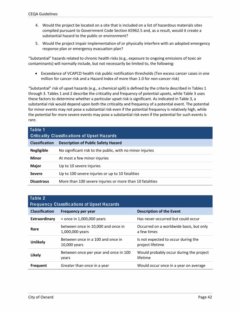
CEQA Guidelines
City of Oxnard Page 42
4. Would the project be located on a site that is included on a list of hazardous materials sites compiled pursuant to Government Code Section 65962.5 and, as a result, would it create a substantial hazard to the public or environment?
5. Would the project impair implementation of or physically interfere with an adopted emergency response plan or emergency evacuation plan?
“Substantial” hazards related to chronic health risks (e.g., exposure to ongoing emissions of toxic air contaminants) will normally include, but not necessarily be limited to, the following:
Exceedance of VCAPCD health risk public notification thresholds (Ten excess cancer cases in one million for cancer risk and a Hazard Index of more than 1.0 for non-‐cancer risk)
“Substantial” risk of upset hazards (e.g., a chemical spill) is defined by the criteria described in Tables 1 through 3. Tables 1 and 2 describe the criticality and frequency of potential upsets, while Table 3 uses these factors to determine whether a particular upset risk is significant. As indicated in Table 3, a substantial risk would depend upon both the criticality and frequency of a potential event. The potential for minor events may not pose a substantial risk even if the potential frequency is relatively high, while the potential for more severe events may pose a substantial risk even if the potential for such events is rare.
Table 1 Critica lity C lassifications of Upset Hazards
Classification Description of Public Safety Hazard
Negligible No significant risk to the public, with no minor injuries
Minor At most a few minor injuries
Major Up to 10 severe injuries
Severe Up to 100 severe injuries or up to 10 fatalities
Disastrous More than 100 severe injuries or more than 10 fatalities
Table 2 Frequency C lassifications of Upset Hazards
Classification Frequency per year Description of the Event
Extraordinary < once in 1,000,000 years Has never occurred but could occur
Rare between once in 10,000 and once in 1,000,000 years
Occurred on a worldwide basis, but only a few times
Unlikely Between once in a 100 and once in 10,000 years
Is not expected to occur during the project lifetime
Likely Between once per year and once in 100 years
Would probably occur during the project lifetime
Frequent Greater than once in a year Would occur once in a year on average
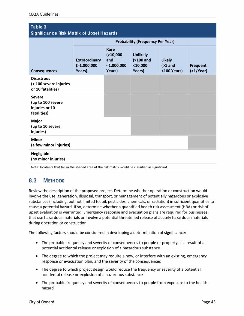
CEQA Guidelines
City of Oxnard Page 43
Table 3 Significance Risk Matrix of Upset Hazards
Consequences
Probability (Frequency Per Year)
Extraordinary (>1,000,000 Years)
Rare (>10,000 and <1,000,000 Years)
Unlikely (>100 and <10,000 Years)
Likely (>1 and <100 Years)
Frequent (>1/Year)
Disastrous (> 100 severe injuries or 10 fatalities)
Severe (up to 100 severe injuries or 10 fatalities)
Major (up to 10 severe injuries)
Minor (a few minor injuries)
Negligible (no minor injuries)
Note: Incidents that fall in the shaded area of the risk matrix would be classified as significant.
8.3 METHODS
Review the description of the proposed project. Determine whether operation or construction would involve the use, generation, disposal, transport, or management of potentially hazardous or explosive substances (including, but not limited to, oil, pesticides, chemicals, or radiation) in sufficient quantities to cause a potential hazard. If so, determine whether a quantified health risk assessment (HRA) or risk of upset evaluation is warranted. Emergency response and evacuation plans are required for businesses that use hazardous materials or involve a potential threatened release of acutely hazardous materials during operation or construction.
The following factors should be considered in developing a determination of significance:
The probable frequency and severity of consequences to people or property as a result of a potential accidental release or explosion of a hazardous substance
The degree to which the project may require a new, or interfere with an existing, emergency response or evacuation plan, and the severity of the consequences
The degree to which project design would reduce the frequency or severity of a potential accidental release or explosion of a hazardous substance
The probable frequency and severity of consequences to people from exposure to the health hazard
CEQA Guidelines
City of Oxnard Page 44
The degree to which project design would reduce the frequency of exposure or severity of consequences of exposure to the health hazard
For Threshold 4, the following databases at a minimum should be checked:
U.S. Environmental Protection Agency CERCLIS Superfund Site Search https://cumulis.epa.gov/supercpad/CurSites/srchsites.cfm
State Water Resources Control Board GeoTracker http://geotracker.waterboards.ca.gov/
California Department of Toxic Substances Control EnviroStor database http://www.envirostor.dtsc.ca.gov/public/
For projects involving sites where it is suspected that hazardous materials may be present in soil or groundwater, preparation of a Phase I environmental site assessment (ESA) may be warranted in support of the environmental documentation. If a Phase I ESA identifies recognized environmental conditions (RECs), preparation of Phase II soil or groundwater sampling may be warranted in order identify the extent of potential hazards and possible methods to remediate any identified hazards.
For projects involving the generation of airborne hazards or that may be subject to airborne hazards, preparation of a health risk assessment (HRA) may be warranted. Such a study would typically quantify the extent of the potential health hazard and compare the identified hazard to City thresholds.
CEQA Guidelines
City of Oxnard Page 45
9. HYDROLO GY AND WATER QUALITY
This section addresses hydrological and water quality issues. Water supply issues are addressed in Section 16, Utilities and Energy.
9.1 BACKGROUND
The Santa Clara River is the primary surface water feature in the City and the longest free-‐flowing river in Southern California. The river is also one of the few remaining rivers in the area that remains in a relatively natural state. The total river length is approximately 70 miles, extending from its headwaters at Mount Pinos to the Santa Clara River Estuary adjacent to McGrath State Beach.
The Oxnard Plain groundwater Hydrographic sub-‐unit includes the Oxnard and Pleasant Valley Hydrographic Sub areas, each of which receives natural recharge from a system of nine groundwater basins along the Santa Clara River Basin. The Oxnard Hydrographic Sub area is located in the southwest corner of the Santa Clara River Basin and consists of the Montalvo, Mound, and Oxnard Plain Basins.
The Oxnard Plain Basin is the most important to the City of Oxnard and is composed of two aquifer systems known as the Upper Aquifer System (UAS) and the Lower Aquifer System (LAS). The UAS consists of the Oxnard Aquifer, and the Mugu Aquifer. The LAS is comprised of the Hueneme, Fox Canyon, and Grimes Canyon Aquifers.
Due to its low land profile, the City of Oxnard became a member of the National Flood Insurance Program (NFIP). The City also adopted a Master Plan of Drainage (2003) and a Floodplain Management Ordinance (Chapter 35 of the Oxnard City Code) to protect its residents and businesses. The City of Oxnard falls within the Santa Clara River’s 1,600 square mile watershed. Flooding in Oxnard caused by rain water is most likely to occur in the winter months when Ventura County receives most of it precipitation. In 2005, the majority of Oxnard’s rain fell between late January and mid-‐March. On average, however, rainfall in the Oxnard area increases sharply in early November and does not decrease until mid/late-‐March. High winds or tides can cause seawater surges resulting in coastal flooding beyond the high tide line. Wave action can directly impact seaside homes and infrastructure. Indirectly, wave action can cause beach and bluff erosion resulting in damage to seaside homes and infrastructure.
Several dams are located at least 35 miles to the east and northeast of Oxnard within Ventura and Los Angeles counties. These include the Santa Felicia Dam at Lake Piru, the Castaic Lake Dam and the Pyramid Lake Dam. The major threat to Oxnard is upstream along the Santa Clara River corridor. Although the potential for a dam failure is considered low, should one or more of these dams fail, the entire city is located within the Dam Inundation Zone, also called Dam Failure Hazard Area. Damage to the city could be in the form of a wall of fast-‐moving water, mud, and debris. Residential and commercial buildings as well as critical facilities could be impacted by a dam failure.
The City of Oxnard is a participant with other local governments in the Ventura Countywide Stormwater Quality Management Plan. This is a comprehensive regional effort to implement federal and state requirements for reducing water pollution from uncontrolled stormwater runoff. This program defines the Best Management Practices applicable to management of stormwater runoff, and the prevention of dry weather runoff. It also establishes the design requirements for Low Impact Development to minimize the volume of stormwater discharge and pollutant levels that originate from newly developed areas. Compliance with these principles by construction and land development projects that may affect
CEQA Guidelines
City of Oxnard Page 46
stormwater quality in the City stormwater drainage system is a requirement of the National Pollutant Discharge Elimination System (NPDES) Permit No. CAS004002, issued by the California Regional Water Quality Control Board, Los Angeles Region in 2010.
Discussions and background information related to Hydrology and Water Quality are found in two chapters of the 2030 General Plan EIR (Infrastructure and Community Services and Safety and Hazards). The first chapter addresses water quality issues that may be associated with wastewater treatment discharges or other discharges that may involve water pollution, including the management of stormwater discharges. The Safety and Hazards chapter addresses hydrology issues associated with flooding, affecting the 100-‐year flood plain, and potential development in these areas. For all of the issues within this topic, it was determined that the application of existing statutory and regulatory requirements and compliance with existing City and agency programs would address potential significant impacts.
Policies from the 2030 General Plan that address issues related to Hydrology and Water Quality are listed in Table 9 of Attachment B.
9.2 SIGNIFICANCE THRESHOLDS
An affirmative answer to any of the following questions typically indicates a significant hydrologic or water quality impact. A “no” response to all questions indicates that there would be no significant hydrology or water quality impact.
1. Would the project cause a violation of any adopted water quality standards or waste discharge or treatment requirements?
2. Would the project substantially deplete groundwater supplies or interfere with groundwater recharge such that there would be a net deficit in aquifer volume or a lowering of the local groundwater table level (e.g., the production rate of pre-‐existing nearby wells would drop to a level that would not support existing land uses or planned uses for which permits have been granted)?
3. Would the project substantially alter the existing drainage pattern of the site or area, including through the alteration of the course of a stream or river, in a manner that would result in on-‐ or off-‐site flooding or exceed the capacity of existing or planned stormwater drainage systems?
4. Would the project place new structures within a 100-‐year flood hazard area as mapped on a federal Flood Hazard Boundary or Flood Insurance Rate Map or other flood hazard delineation map?
5. Would the project impede or redirect flood flows such that it would increase on-‐ or off-‐site flood potential?
6. Would the project expose people or structures to a significant risk of loss, injury or death involving flooding, including flooding as a result of the failure of a levee or dam?
7. Would the project be exposed to a substantial risk related to inundation by seiche, tsunami, or mudflow?
9.3 METHODS
For water quality issues in most development projects, the key evaluation of potential impacts will relate to how a project complies with applicable stormwater Best Management Practices (BMPs) and Low
CEQA Guidelines
City of Oxnard Page 47
Impact Development (LID) principles. Guidance from the Countywide Stormwater Quality Management Program identifies measures and requirements that apply to different kinds of projects (Ventura County Stormwater Quality Management Program 2015). Applicable federal, state, and local standards will typically be described and information demonstrating compliance with standards will be provided. Compliance with applicable National Pollutant Discharge Elimination System (NPDES) and associated local standards and requirements will normally suffice to reduce water quality impacts to below a level of significance.
Impacts to hydrological and storm drain systems will also consider NPDES and associated local requirements pertaining to limiting increases in surface runoff. Again, compliance with applicable requirements needs to be demonstrated. For smaller infill projects that would not substantially increase impervious surface area, citing of requirements may suffice. For larger projects involving substantial changes in surface runoff and the need for onsite detention/retention, a preliminary hydrological study will normally be needed in support of the CEQA document.
The potential for flooding may be evaluated with the relevant FEMA FIRMs. In addition, Figure 2-‐1 in the 2030 General Plan Goals and Policies shows the approximate extent of the 100-‐year flood level in the beach and coastal areas, and how that level may change with rising sea level. Projects within the 100-‐year flood zone typically require flood insurance unless a Letter of Map Revision (LOMR) is approved by FEMA.

CEQA Guidelines
City of Oxnard Page 48
This page intentionally left blank.
CEQA Guidelines
City of Oxnard Page 49
10. LAND USE AND PLANNING
10.1 BACKGROUND
Oxnard’s historic land use pattern reflects the City’s central location in the Oxnard plain with surrounding agriculture, as Oxnard grew in all directions from the original small town. Land within the City limits is currently classified into one of five broad categories: residential, commercial, industrial, open space, and other. Each of these categories is further subdivided into uses correlated with specific standards. With the exception of several high rise buildings in north Oxnard, the City is characterized by one or two story residential and commercial buildings and several industrial areas. Most of the City’s higher intensity development lies adjacent to primary thoroughfares such as Highway 101, Gonzales Road, Rose Avenue, Rice Avenue, Oxnard Boulevard, Hueneme Road, Ventura Road, Victoria Avenue, Saviers Road, and in the central business district.
Beginning in the 1980s, the City planned its larger expansions by use of specific plans. Specific Plans in Oxnard are summarized in Table 4 below.
Table 4 Adopted and Proposed Specific Plans (as of 2015)
Specific Plan Acreage Land Use Mix Northfield/ Seagate Business Park 252 Light Industrial, Limited Industrial
Mandalay Bay 220 Residential and Coastal Visitor Service
Rose-‐Santa Clara Corridor 204 Auto Sales and Service, Business Park, Retail Commercial, Commercial/ Manufacturing
Northwest Community 255 Residential, Golf Course
McInnes Ranch Business Park 236 Industrial, Business / Research, Industrial Service Centers
Northwest Golf Course Community 324 Golf course, Institutional, Residential, Public School
Northeast Community 737 Residential, Industrial, Commercial, Schools, Park, and Hospital
Riverpark 701 Residential, Commercial, Parks, Open Space, Schools
Camino Real Business Park 40 Business and Research, Light Industrial
The Village (Wagon Wheel) 56 Residential, Mixed Use, Commercial, Parks
Teal Club (proposed) 175 Residential, Commercial, Industrial, Park
Sakioka Farms 390 Business and Research, Light Industrial
Total 3,590
Source: City of Oxnard General Plan Background Report 2006
Key land use policies related to environmental protection are listed in Table 10 of Attachment B. Additional policies throughout the 2030 General Plan also related to land use decisions may apply on a case-‐by-‐case basis.
CEQA Guidelines
City of Oxnard Page 50
10.2 SIGNIFICANCE THRESHOLDS
An affirmative answer to any of the following questions typically indicates a significant land use impact. A “no” response to all questions indicates that there would be no significant impact with respect to land use.
1. Would the project conflict with an applicable land use plan, policy or regulation of the City or other agency with jurisdiction over the project adopted for the purpose of avoiding or mitigating a significant environmental effect?
2. Would the project involve land uses that are not allowed under an applicable airport land use compatibility plan?
3. Would the project conflict with an applicable habitat conservation plan or natural community conservation plan?
4. Would the project physically divide an established community?
With respect to Threshold 1, formally adopted land use plans, policies, and regulations must be considered and inconsistencies with adopted policies may be considered significant environmental effects. Consistency with draft plans, policies, and regulations that have not yet been adopted may also be discussed in CEQA documents for informational purposes, but inconsistencies with such plans, policies, and regulations typically would not be considered significant effects.
10.3 METHODS
Review the proposed project for consistency with the 2030 General Plan and other adopted environmental goals and policies. Potential areas of inconsistency include, but are not limited to: land use type; height, bulk, design or density; waste or wastewater generation; resource consumption or degradation; and other plan policies that relate to the physical environment. Use the most recent specific plan maps or zoning data to identify ordinances and plan areas that may pertain to the project site. As appropriate, evaluate the 2030 General Plan and its elements, specific plans, local coastal plans, Zoning Code, utility plans, and resource management plans. Identify and assess the project's consistency with applicable habitat conservation plans or natural community conservation plans. Consider whether policies are mandatory or guidance, and which agency has primary jurisdiction.
Review the description of the proposed project, including the proposed land use or activity, and the size, density and intensity of the operation. Noise, odor, signage, safety hazards, traffic or other impacts may indicate an incompatibility with existing adjacent or surrounding land uses or current zoning for those sites, if vacant. Also, consider the types of land uses surrounding the project and the typical activities that occur at these sites compared to those that would occur at the proposed project. Indicate the presence or lack of buffers between the project and adjacent land uses of other types. Note that a zone change required to implement the project may indicate a potential incompatibility with adjacent existing land uses. Review specific plans for urban design compatibility programs or regulations and their relevance to project design.
If the project includes elements such as a roadway, aboveground infrastructure or an easement, identify the existing land uses that would be removed or that would be adjacent to the new infrastructure. Determine the duration of any disruption of the physical arrangement of an established neighborhood or community.
CEQA Guidelines
City of Oxnard Page 51
The following factors should be considered:
Whether the proposed project is inconsistent with the adopted land use/density designation in the redevelopment plan or specific plan for the site
Whether the proposed project is inconsistent with the 2030 General Plan or adopted environmental goals or policies contained in other applicable plans
The extent of the area that would be impacted, the nature and degree of impacts, and the type of land uses within that area
The extent to which existing neighborhoods, communities, or land uses would be disrupted, divided or isolated, and the duration of the disruptions
The number, degree, and type of secondary impacts to surrounding land uses that could result from implementation of the proposed project

CEQA Guidelines
City of Oxnard Page 52
This page intentionally left blank.
CEQA Guidelines
City of Oxnard Page 53
11. MINERAL RESOURCES
11.1 BACKGROUND
Important mineral/sand/gravel deposits are primarily located along the Santa Clara River channel, along Route 101 (Ventura Freeway) corridor and along the eastern edge of the City extending as far west as Oxnard Boulevard in several areas. Additional important mineral resources include oil and gas fields. The General Plan Background Report (City of Oxnard 2006: Section 5.6) contains an explanation of mineral resources, terms, and regulations that apply to mineral resources.
Sand and Gravel Resources
Areas of significant mineral deposits within the City are identified as MRZ-‐2 and MRZ-‐3 areas. The City’s MRZ-‐2 area encompasses the course of the Santa Clara River through the City and also a corridor of land along U.S. Route 101 (Ventura Freeway) from the Santa Clara River eastward to approximately Del Norte Avenue. MRZ-‐3 areas are located south of the Santa Clara River (west of Ventura Freeway) and a large area bordering State Route 1 through the center of the City.
O il and G as Resources
Four oil and gas fields are located within the City. The West Montalvo Field includes the area along the coastline and upstream from the mouth of the Santa Clara River and currently contains 29 active wells and 24 inactive or shut-‐in wells. The West Montalvo Field is the only local field to increase the number of active wells in recent years. The Santa Clara Avenue Field, located near Nyeland Acres, contains approximately 18 active oil and gas wells and 12 inactive wells. The Oxnard Field contains 38 active oil and gas wells and 59 inactive wells. The El Rio Field is located at the crossing of Ventura Freeway and the Santa Clara River.
The 2030 General Plan EIR did not identify any significant impacts related to mineral resources in the City. Policies from the General Plan that apply to mineral resources are listed in Table 11 of Attachment B.
11.2 SIGNIFICANCE THRESHOLDS
An affirmative answer to any of the following questions typically indicates a potentially significant mineral resource impact. A “no” response to all questions indicates that there would be no significant mineral resource impact.
1. Would the project result in the loss of availability of a known mineral resource of value to the region or state?
2. Would the project result in the loss of availability of a locally important mineral resource recovery site delineated in the 2030 General Plan or other adopted land use plan?

CEQA Guidelines
City of Oxnard Page 54
11.3 METHODS
In considering how the above issues apply to a proposed project, use maps showing the locations of identified mineral resources (for example, the General Plan Background Report, Figure 5-‐16). If a project would occur within, or block access to, an area classified as MRZ-‐2 (areas that contain identified mineral resources) or known other potential mineral resource area then it may have a significant impact.
CEQA Guidelines
City of Oxnard Page 55
12. NOISE
12.1 BACKGROUND
The General Plan Background Report (City of Oxnard 2006: Section 6.4) provides overview and definitions related to noise, and presents information on noise regulations and standards.
The main noise generators within the City consist of vehicular traffic along the Ventura Freeway, other major roadways, the Oxnard Airport, the Union Pacific Railroad line, and a variety of stationary noise sources. Each of these noise sources is described in greater detail below.
Vehicle Noise
As in most typical urbanized areas, the most pervasive noise sources in the City are motor vehicles, including automobiles, trucks, buses, and motorcycles. The noise generated from vehicles using roads within the Planning Area is governed primarily by the number of vehicles, type of vehicles (mix of automobiles, trucks, and other large vehicles), and their speed.
The highest noise levels are adjacent to the Ventura Freeway. Noise levels that would affect noise sensitive land uses such as residences, schools, and hospitals also occur along major arterials including Victoria Avenue, Channel Islands Boulevard, Ventura Road, and Oxnard Boulevard.
Railroad Noise
The Union Pacific Railroad line running across the City is the only railroad line utilized on a regular basis. The line enters the City at its eastern boundary, runs west along East Fifth Street to the Transportation Center where it turns north and runs adjacent to Oxnard Boulevard, and eventually crosses the northern City boundary at the Ventura Freeway.
Several factors combine to produce railroad noises, including length of train, speed, grade, type of track, number of engines, and number of trips. The Union Pacific Railroad line operates approximately eight trains in the City within a 24-‐hour period. Four trains are scheduled Amtrak passenger trains and the other four are nonscheduled freight trains that could pass through the City anytime during a 24-‐hour period. The older residential neighborhoods within the central portion of the City are subject to the greatest noise effects from local railroad activity, particularly the nighttime freight trains.
Aircraft or Airport
The greatest potential for noise intrusion occurs when aircraft land, take off, or run their engines while on the ground. There are three primary sources of noise in a jet engine: the exhaust, the turbo machinery, and the fan. The noise associated with general aviation propeller aircraft (piston and turbo-‐prop) is produced primarily by the propellers and secondarily from the engine and exhaust.
Aircraft noise affecting the City is primarily generated by Oxnard Airport and the Naval Base, Ventura County at Point Mugu. Oxnard Airport is situated upon 216 acres of land located in the southwest corner of the City. Oxnard Airport is served primarily by general aviation and commuter aircraft. In 2000, the last year for which figures are available, the Airport was base to approximately 150 aircraft and 88,277 annual operations.
CEQA Guidelines
City of Oxnard Page 56
The Naval Base, Ventura County at Point Mugu is located within the jurisdictional boundaries of the County of Ventura, which designates the site as “Institutional Use.” The property is also within the Oxnard Planning Area. While no major established flight patterns pass over the City, infrequently used patterns do pass over residential areas of the City.
Camarillo Airport is also located within Ventura County. According to the Ventura County, Camarillo Airport does not have any flight paths over Oxnard. However, the northeast portion of the City may experience noise generated by Camarillo Airport operations.
The 2030 General Plan EIR concluded that buildout of the Oxnard Planning Area in a pattern consistent with the General Plan would result in some instances where noise and related impacts would be significant and unavoidable. These include the following impacts:
Impact 6.4-‐2 The 2030 Plan could expose a variety of noise-‐sensitive land uses to traffic noise.
Impact 6.4-‐3 The Project could expose a variety of noise-‐sensitive land uses to railroad noise. Impact 6.4-‐6 The Project could expose a variety of noise-‐sensitive land uses to excessive
groundborne vibration or groundborne noise levels.
The 2030 General Plan EIR also concluded that other potential noise impacts could be mitigated through the implementation of regulatory controls and measures present in the City Noise Ordinance and other policies. These issues included: Impact 6.4-‐1 related to temporary construction noise, Impact 6.4-‐4 related to changes in traffic patterns or locations of noise effects, and Impact 6.4-‐5 related to stationary noise sources, which are subject to regulation under the City Noise Ordinance.
Goals and policies in the 2030 General Plan that are related to noise are summarized in Table 12 of Attachment B
12.2 SIGNIFICANCE THRESHOLDS
An affirmative answer to any of the following questions typically indicates a significant noise impact. A “no” response to all questions indicates that there would be no significant noise impact.
1. Would the project generate or expose persons to noise levels exceeding standards established in the Oxnard 2030 General Plan or Noise Ordinance, or applicable standards of other agencies?
2. Would the project generate or expose persons to excessive groundborne vibration or groundborne noise levels?
3. Would the project generate a substantial temporary or periodic increase in ambient noise in the project vicinity above levels existing without the project?
4. Would the project generate a substantial permanent increase in ambient noise in the project vicinity above levels existing without the project?
5. For a project located within the airport land use plan for Oxnard Airport or within two miles of Naval Base, Ventura County at Point Mugu, would the project expose people residing or working in the project area to excessive noise levels?
6. Would the project expose non-‐human species to excessive noise?
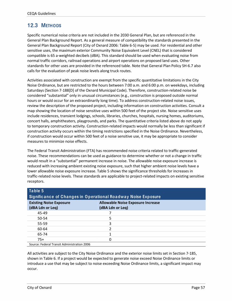
CEQA Guidelines
City of Oxnard Page 57
12.3 METHODS
Specific numerical noise criteria are not included in the 2030 General Plan, but are referenced in the General Plan Background Report. As a general measure of compatibility the standards presented in the General Plan Background Report (City of Oxnard 2006: Table 6-‐5) may be used. For residential and other sensitive uses, the maximum exterior Community Noise Equivalent Level (CNEL) that is considered compatible is 65 a-‐weighted decibels (dBA). This standard should be used when evaluating noise from normal traffic corridors, railroad operations and airport operations on proposed land uses. Other standards for other uses are provided in the referenced table. Note that General Plan Policy SH-‐6.7 also calls for the evaluation of peak noise levels along truck routes.
Activities associated with construction are exempt from the specific quantitative limitations in the City Noise Ordinance, but are restricted to the hours between 7:00 a.m. and 6:00 p.m. on weekdays, including Saturdays (Section 7-‐188[D] of the Oxnard Municipal Code). Therefore, construction-‐related noise be considered “substantial” only in unusual circumstances (e.g., construction is proposed outside normal hours or would occur for an extraordinarily long time). To address construction-‐related noise issues, review the description of the proposed project, including information on construction activities. Consult a map showing the location of noise sensitive uses within 500 feet of the project site. Noise sensitive uses include residences, transient lodgings, schools, libraries, churches, hospitals, nursing homes, auditoriums, concert halls, amphitheaters, playgrounds, and parks. The quantitative criteria listed above do not apply to temporary construction activity. Construction-‐related impacts would normally be less than significant if construction activity occurs within the timing restrictions specified in the Noise Ordinance. Nevertheless, if construction would occur within 500 feet of a noise sensitive use, it may be appropriate to consider measures to minimize noise effects.
The Federal Transit Administration (FTA) has recommended noise criteria related to traffic-‐generated noise. These recommendations can be used as guidance to determine whether or not a change in traffic would result in a “substantial” permanent increase in noise. The allowable noise exposure increase is reduced with increasing ambient existing noise exposure, such that higher ambient noise levels have a lower allowable noise exposure increase. Table 5 shows the significance thresholds for increases in traffic-‐related noise levels. These standards are applicable to project-‐related impacts on existing sensitive receptors.
Table 5 Significance of Changes in Operationa l Roadway Noise Exposure Existing Noise Exposure (dBA Ldn or Leq)
Allowable Noise Exposure Increase (dBA Ldn or Leq)
45-‐49 7 50-‐54 5 55-‐59 3 60-‐64 2 65-‐74 1 75+ 0
Source: Federal Transit Administration 2006
All activities are subject to the City Noise Ordinance and the exterior noise limits set in Section 7-‐185, shown in Table 6. If a project would be expected to generate noise exceed Noise Ordinance limits or introduce a use that may be subject to noise exceeding Noise Ordinance limits, a significant impact may occur.
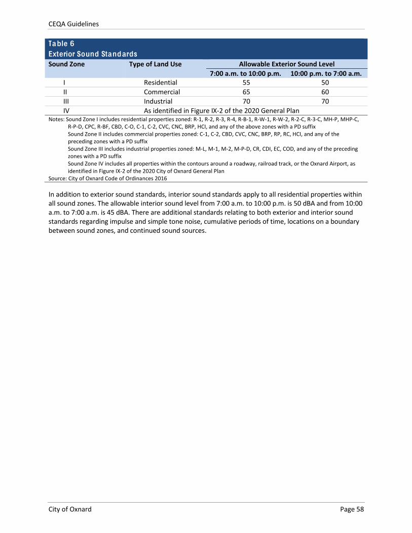
CEQA Guidelines
City of Oxnard Page 58
Table 6 Exterior Sound Standards Sound Zone Type of Land Use Allowable Exterior Sound Level
7:00 a.m. to 10:00 p.m. 10:00 p.m. to 7:00 a.m. I Residential 55 50 II Commercial 65 60 III Industrial 70 70 IV As identified in Figure IX-‐2 of the 2020 General Plan
Notes: Sound Zone I includes residential properties zoned: R-‐1, R-‐2, R-‐3, R-‐4, R-‐B-‐1, R-‐W-‐1, R-‐W-‐2, R-‐2-‐C, R-‐3-‐C, MH-‐P, MHP-‐C, R-‐P-‐D, CPC, R-‐BF, CBD, C-‐O, C-‐1, C-‐2, CVC, CNC, BRP, HCI, and any of the above zones with a PD suffix Sound Zone II includes commercial properties zoned: C-‐1, C-‐2, CBD, CVC, CNC, BRP, RP, RC, HCI, and any of the preceding zones with a PD suffix Sound Zone III includes industrial properties zoned: M-‐L, M-‐1, M-‐2, M-‐P-‐D, CR, CDI, EC, COD, and any of the preceding zones with a PD suffix Sound Zone IV includes all properties within the contours around a roadway, railroad track, or the Oxnard Airport, as identified in Figure IX-‐2 of the 2020 City of Oxnard General Plan
Source: City of Oxnard Code of Ordinances 2016
In addition to exterior sound standards, interior sound standards apply to all residential properties within all sound zones. The allowable interior sound level from 7:00 a.m. to 10:00 p.m. is 50 dBA and from 10:00 a.m. to 7:00 a.m. is 45 dBA. There are additional standards relating to both exterior and interior sound standards regarding impulse and simple tone noise, cumulative periods of time, locations on a boundary between sound zones, and continued sound sources.
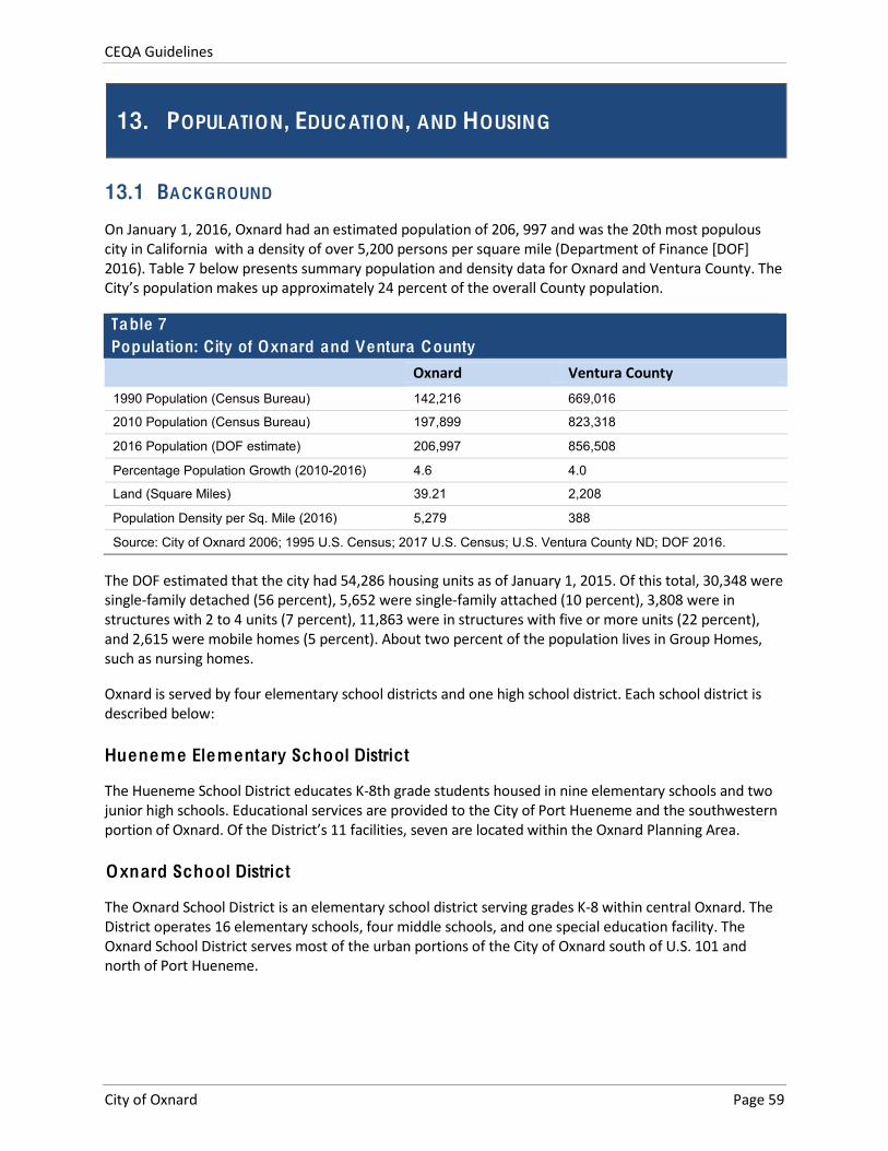
CEQA Guidelines
City of Oxnard Page 59
13. POPULATION, EDUCATION, AND HOUSING
13.1 BACKGROUND
On January 1, 2016, Oxnard had an estimated population of 206, 997 and was the 20th most populous city in California with a density of over 5,200 persons per square mile (Department of Finance [DOF] 2016). Table 7 below presents summary population and density data for Oxnard and Ventura County. The City’s population makes up approximately 24 percent of the overall County population.
Table 7 Population: C ity of Oxnard and Ventura County
Oxnard Ventura County 1990 Population (Census Bureau) 142,216 669,016
2010 Population (Census Bureau) 197,899 823,318
2016 Population (DOF estimate) 206,997 856,508
Percentage Population Growth (2010-2016) 4.6 4.0
Land (Square Miles) 39.21 2,208
Population Density per Sq. Mile (2016) 5,279 388
Source: City of Oxnard 2006; 1995 U.S. Census; 2017 U.S. Census; U.S. Ventura County ND; DOF 2016.
The DOF estimated that the city had 54,286 housing units as of January 1, 2015. Of this total, 30,348 were single-‐family detached (56 percent), 5,652 were single-‐family attached (10 percent), 3,808 were in structures with 2 to 4 units (7 percent), 11,863 were in structures with five or more units (22 percent), and 2,615 were mobile homes (5 percent). About two percent of the population lives in Group Homes, such as nursing homes.
Oxnard is served by four elementary school districts and one high school district. Each school district is described below:
Hueneme Elementary School District
The Hueneme School District educates K-‐8th grade students housed in nine elementary schools and two junior high schools. Educational services are provided to the City of Port Hueneme and the southwestern portion of Oxnard. Of the District’s 11 facilities, seven are located within the Oxnard Planning Area.
Oxnard School District
The Oxnard School District is an elementary school district serving grades K-‐8 within central Oxnard. The District operates 16 elementary schools, four middle schools, and one special education facility. The Oxnard School District serves most of the urban portions of the City of Oxnard south of U.S. 101 and north of Port Hueneme.
CEQA Guidelines
City of Oxnard Page 60
Ocean View School District
The Ocean View School District boundary encompasses 80 square miles from the Pacific Ocean inland to the City of Oxnard and from the Los Angeles County line near Malibu north to the City of Port Hueneme. Providing services in a mostly rural area, the District operates three K-‐5th grade elementary schools and one 6-‐8th grade junior high school. District buses travel more than 750 miles per day, providing transportation for more than 80 percent of the District’s enrollment with approximately one-‐third of the total enrollment residing at the Point Mugu Navy base. All of the facilities within the Ocean View School District are located within the Oxnard Planning Area.
Rio Elementary School District
Serving the northern Oxnard and the El Rio area, Rio Elementary School District facilities include six elementary schools and one junior high school.
Oxnard Union High School District
Providing educational services since 1901, the Oxnard Union High School District serves the cities of Camarillo, Oxnard, and Port Hueneme. The District operates comprehensive high school campuses, one continuation high school, and various alternative educational programs. Seven of the District’s facilities are located within the Oxnard Planning Area. The remaining facilities are located in Camarillo.
The 2030 General Plan includes the following policies related to schools, summarized in Table 13 of Attachment B.
13.2 SIGNIFICANCE THRESHOLDS
With the exception of Threshold 5, an affirmative answer to any of the following questions would typically indicate a potentially significant impact. With respect to schools, Section 65995(h) of the California Government Code states that payment of statutory school impact fees “...is deemed to be full and complete mitigation of the impacts of any legislative or adjudicative act, or both, involving, but not limited to, the planning, use, or development of real property, or any change in governmental organization or reorganization.” Consequently, even when a project may contribute to an exceedance of local public school capacity, its impact may not be significant under CEQA. A “no” response to all questions indicates that there would be no significant impact related to population, housing, or education.
1. Would the project involve a General Plan amendment that could result in an increase in population beyond that projected in the 2030 General Plan that may result in one or more significant physical environmental effects?
2. Would the project induce substantial growth on the project site or surrounding area, resulting in one or more significant physical environmental effects?
3. Would the project result in a substantial (15 single-‐family or 25 multi-‐family dwelling units – about one-‐half block) net loss of housing units through demolition, conversion, or other means that may necessitate the development of replacement housing?
4. Would the project result in a net loss of existing housing units affordable to very low-‐ or low-‐income households (as defined by federal and/or City standards), through demolition, conversion, or other means that may necessitate the development of replacement housing?
CEQA Guidelines
City of Oxnard Page 61
5. Would the project cause an increase in enrollment at local public schools that would exceed capacity and necessitate the construction of new or expanded facilities?
6. Would the project directly or indirect interfere with the operation of an existing or planned school?
13.3 METHODS
Review the description of the proposed project and the surrounding area. Determine whether the project includes a General Plan amendment and identify the potential to induce substantial growth. General Plan amendments that could result in an increase in population are those for which the population associated with the project site would exceed the population forecast in the 2030 General Plan after buildout to the maximum amount permitted under the General Plan amendment. The potential to induce substantial growth that may have significant physical environmental effects may be indicated by the introduction of a project in an undeveloped area or the extension of major infrastructure. Examples of major infrastructure systems include: major roads, highways, or bridges; major utility or service lines; major drainage improvements; or grading that would make accessible a previously inaccessible area.
Review the project description and determine the number and type of housing units that would be eliminated and added as a result of the proposed project. Calculate the net change in the number of habitable housing units, as well as units affordable to very low-‐ or low income households. In addition to direct conversion or demolition, affordable units can be lost through conversion to market rate units.
With respect to schools, estimate the new students generated by the project based on students/household factors provided by local school districts and compare the number of new students to available school capacity (overall capacity minus current school enrollment). Also, determine whether a project may affect operations at an existing school (e.g., by placing a noise-‐generating facility near an existing school and disrupting school activities). As noted above, with respect to school enrollment, a project typically would not have a significant impact if the developer pays state-‐mandated school impact fees per Government Code Section 65995(h); therefore, the information about how a project may affect school capacity will normally be provided for informational purposes only.
The following factors should be considered in making a determination of significance:
The degree to which the project would cause growth (i.e., new housing or employment generators) or accelerate development in an undeveloped area that exceeds projected/planned levels for the year of project occupancy/build out, and that would result in an adverse physical change in the environment
Whether the project would introduce unplanned infrastructure that was not previously evaluated in a specific plan area or the 2030 General Plan
The extent to which growth would occur without implementation of the project
The total number of residential units to be demolished, converted to market rate, or removed through other means as a result of the proposed project, in terms of net loss of market-‐rate and affordable units
The current and anticipated housing demand and supply of market rate and affordable housing units in the project area
The land use and demographic characteristics of the project area and the appropriateness of housing in the area
CEQA Guidelines
City of Oxnard Page 62
Whether the project is consistent with adopted City and regional housing policies such as the Housing Element and other applicable regulatory policies
The demand for school services anticipated at the time of project buildout compared to the expected level of service available, considering, as applicable, scheduled improvements to school district services (facilities, equipment and personnel) and the project's proportional contribution to the demand;
Whether (and the degree to which) accommodation of the increased demand would require construction of new facilities, a major reorganization of students or classrooms, major revisions to the school calendar (such as year-‐round sessions), or other actions which would create a temporary or permanent impact on the school(s)
CEQA Guidelines
City of Oxnard Page 63
14. PUBLIC SERVICES AND RECREATION
14.1 BACKGROUND
City public services are described below.
Fire Prevention and Response
The Oxnard Fire Department provides a full range of emergency and non-‐emergency services to the community. The mission of the Oxnard Fire Department is: to serve the public and safeguard the community by preventing or minimizing the impact of emergency situations to life, the environment, and property by responding to both emergency and non-‐emergency calls for service. The Oxnard Fire Department is currently rated as a Class 2 fire department by the Insurance Services Office. The Insurance Service Office rating evaluates the fire department, the City’s water system, and the fire departments communication capabilities. Insurance Services Office rating is important to communities since most property insurance companies determine the fire risk portion of property insurance premiums on the City’s Insurance Services Office rating. Oxnard was last rated by the Insurance Services Office in 1994. Although commercial businesses might see benefits in a Class 1 rating, residential structures would not (City of Oxnard 2011a).In 2011, the staffing ratio was 0.46 firefighters per 1,000 residents, below the national average of 1.5 firefighters per 1,000, and below the California average of 1.0 per 1,000 residents.
Law Enforcement
Within the City limits, law enforcement and police protection services are provided by the Oxnard Police Department. In the unincorporated area, the Ventura Sheriff’s Department provides patrol services and the California Highway Patrol provides traffic control on U.S. Highway 101. As of 2015, 254 sworn officers and over 150 civilians provided law enforcement services in the City.
Parks and Recreation
Oxnard offers a variety of recreational opportunities through its parks and recreation facilities under the Recreation and Community Services Department and Parks and Public Grounds Department. The Recreation and Community Services’ mission statement is: to strive to enrich the quality of life for people of all ages by providing safe, positive and active opportunities within our community that embrace diversity and promote social connections, wellness, civic pride, and lifelong learning. In 2011, the City had a total of approximately 759 acres of existing, under development, or planned parks. Traditional city and county parks, beaches, a golf course, and parks under construction in 2011 totaled approximately 1,637 acres, giving a ratio per 1,000 residents of 8.1 acres.
Oxnard also offers a wide variety of youth and adult recreational programs designed to meet the needs of residents of all ages. Programs include: After School Program, Mobile Activity Center (MAC), Oxnard Police Activities League (PAL), and the City Corps Program. The City of Oxnard maintains eight community facilities that provide a variety of programs and services to the community. The City also provides specialized services for youth and senior residents at its three Youth Centers and three Senior Centers. Table 14 in Attachment B summarizes the 2030 General Plan goals and policies related to public services and recreation.
CEQA Guidelines
City of Oxnard Page 64
14.2 SIGNIFICANCE THRESHOLDS
An affirmative answer to any of the following questions typically indicates a potentially significant public service or recreation impact. A “no” response to all questions indicates that there would be no significant impact with respect to public services or recreation.
1. Would the project increase demand for fire protection service such that new or expanded facilities would be needed to maintain acceptable service levels, the construction of which may have significant environmental effects?
2. Would the project increase demand for law enforcement service such that new or expanded facilities would be needed to maintain acceptable service levels, the construction of which may have significant environmental effects?
3. Would the project increase the use of existing park facilities such that substantial physical deterioration of the facilities would occur or be accelerated or that new or expanded park facilities would be needed to maintain acceptable service levels?
4. Would the project increase the need for or use of existing library or other community facilities such that substantial physical deterioration of the facilities would occur or be accelerated?
14.3 METHODS
The following questions should be considered in the analysis:
Would implementation of the proposed project cause the 2030 General Plan area to exceed the projected growth in population, housing, or employment for the year of project occupancy/build out?
Is the project site outside the current service area of fire protection/emergency medical response/law enforcement providers?
Would the project or directly affect existing or planned recreation or park services and/or facilities due to the project's proximity to, or expected usage of, those facilities or services?
Would the project increase demand for parks or recreation facilities/services such that new or expanded facilities/services are needed?
Fire /Emergency Medical /Law Enforcement
For fire protection/emergency medical response/law enforcement, use appropriate service generation factors or input from service providers to determine the anticipated demand of the project for these public services. Determine whether the increase in demand is within the capabilities of existing facilities or whether new or expanded facilities would be needed. Note that the need for new personnel would constitute a potentially significant environmental impact only if the need for new personnel may necessitate the construction of new facilities or expansion of existing facilities, the construction of which may have significant environmental effects.
CEQA Guidelines
City of Oxnard Page 65
Recreation/Parks
For recreation and park facilities, estimate demand based on standard factors and/or input from service providers. Compare this demand to the facility capacity and/or established service ratio goals of the 2030 General Plan. Based on this information, determine whether or not new or expanded facilities would be needed to maintain or achieve desired service levels.

CEQA Guidelines
City of Oxnard Page 66
This page intentionally left blank.
CEQA Guidelines
City of Oxnard Page 67
15. TRANSPORTATION AND C IRCULATION
15.1 BACKGROUND
Descriptions of the roadway network, transit service, bicycle path network, and other transportation components are provided in the General Plan Background Report (Section 4.2). This material includes a description and map of the various functional classifications for roadways in the City. Existing traffic Levels of Service (LOS) for many roadways are also listed, along with the identification of those roadways considered to be deficient with respect to their LOS. Movement of goods by truck and rail is also addressed in the General Plan Background Report (Section 4.2.3). Passenger rail service (Section 4.2.4) and transit service (Section 4.2.5) are also described (City of Oxnard 2006).
Non-‐motorized transportation (bicycle and pedestrian movement) is also described in the General Plan Background Report (Section 4.2.6) and additional information is provided in the City Bicycle & Pedestrian Facilities Master Plan (City of Oxnard 2011b).
The 2030 General Plan EIR provides additional information related to traffic and transportation systems, and concluded that implementation of the General Plan would result in significant and unavoidable traffic impacts:
Impact 4.2-‐1 The Project would result in five intersections operating below LOS C
In all other respects, the 2030 General Plan EIR concluded that traffic and transportation effects would be less than significant.
All of the goals and policies cited in the 2030 General Plan EIR as being related to traffic and circulation are from the Infrastructure and Community Services chapter of the 2030 General Plan Goals and Policies. These are summarized in Table 15 of Attachment B.
15.2 SIGNIFICANCE THRESHOLDS
An affirmative answer to any of the following questions typically indicates a potentially significant impact related to transportation and circulation. A “no” response to all questions indicates that there would be no significant impact with respect to transportation and circulation.
1. Would the project cause an increase in traffic that is substantial in relation to the existing traffic load and capacity of the street system (i.e., result in a substantial increase in either the number of vehicle trips, the volume to capacity ratio on roads, or congestion at intersections) based on adopted City of Oxnard level of service (LOS) standards?
2. Would the project exceed, either individually or cumulatively, an LOS standard established by the Ventura County Congestion Management Program (CMP) for designated roads or highways?
3. Would the project result in a change in air traffic patterns, including either an increase in traffic levels or a change in location that results in substantial safety risks?
4. Would the project substantially increase hazards due to a design feature (e.g., sharp curves or dangerous intersections) or incompatible uses (e.g., farm equipment)?
5. Would the project result in inadequate emergency access?
CEQA Guidelines
City of Oxnard Page 68
6. Would the project conflict with adopted policies, plans, or programs supporting alternative transportation (e.g., bus turnouts, bicycle racks)?
Note that as of 2017 the State CEQA Guidelines are undergoing revisions that may remove traffic level of service (LOS) as a consideration in determining the significance of transportation-‐related impacts under CEQA and replace LOS with other metrics, such as vehicle miles traveled (VMT). When such revisions are adopted, thresholds/methods described in the State CEQA Guidelines will either replace or augment thresholds 1 and 2 related to LOS.
15.3 METHODS
The Traffic Engineering and Operations section of the Development Services Department has specific requirements for traffic impact studies which are part of determining specific traffic impact fees for new development. Evaluations in an Initial Study or EIR performed for CEQA purposes should be coordinated with the Traffic Engineering and Operations section.
Temporary construction-‐related traffic impacts are not typically subject to the City’s LOS standards, but construction traffic may be considered for large projects with the potential to disrupt traffic patterns. For such projects, review project construction plans to determine whether construction activities would result in street closures, blocked access, or the loss or relocation of transit stops. Identify and transportation controls needed to minimize temporary disruption of transportation facilities. Contact the Traffic Engineering and Operations section for assistance.
To estimate new vehicle trips associated with project operation, apply the appropriate trip generation rates to the proposed project land uses. Trip rates can be determined from the following sources:
Standard trip generation rates/equations contained in the latest edition of Trip Generation, published by the Institute of Transportation Engineers (ITE); or
Use of rates empirically derived from trip generation studies of similar developments or facilities.
Consistent with Goal ICS-‐3 and its related policies, the fundamental LOS criteria used for most City streets is LOS C. For most projects, generation of traffic volumes that would directly lead to a degradation of LOS to D or worse would warrant appropriate project conditions in order to comply with the goal and policies under ICS-‐3. The city allows as an exception level of service “D” either in the AM or PM periods, or both, at the five intersections listed below and level of service “F” at Five Points or in instances where allowing LOS “D” would be required to avoid adversely impacting private homes and/or businesses resulting from additional mitigations, or preserve or enhance aesthetic integrity.
1. C Street and Wooley Road
2. Oxnard Boulevard and Vineyard Avenue
3. Oxnard Boulevard and Gonzales Road
4. Gonzales Road and Rose Avenue
5. Five Points (Oxnard Boulevard/Saviers Road/Wooley Road)
Accurate VMT forecasts are important for developing emissions estimates in the analysis. Any methodology to forecast future VMT requires an accurate estimate of current VMT (and often historic VMT and socio-‐economic factors as well). Data from the Highway Performance Monitoring System
CEQA Guidelines
City of Oxnard Page 69
(HPMS) are typically used in small urban and rural areas to estimate VMT for the current year. However, the accuracy of HPMS-‐based estimates may be limited in small urban and rural areas and for local roadways in particular (as opposed to arterials and other higher functional classifications), given the sparse sample sizes at the county level. As a result, some areas have developed detailed inventories of local road mileage and supplemented the HPMS sample with additional traffic counts, and some have developed detailed traffic monitoring systems in order to develop more accurate estimates of VMT at the county level (FHWA 2017).
A basic process for estimating VMT using a sample of traffic count data for use in emissions analysis is as follows:
1. Calculate the sum of counts in each facility type
2. Determine the sample size in each facility type (i.e., the number of count sites)
3. Determine the average volume for a facility type by dividing total count by sample size
4. Obtain total centerline miles of each facility type in the modeling domain
5. Multiply average volume by the number of centerline miles for each facility type to estimate total VMT for each facility type
Moreover, although many areas use annual average daily VMT (based on estimates of annual average daily traffic, on roadways), a seasonal adjustment is sometimes applied so the resulting VMT used in the conformity analysis reflects either an average summer or winter weekday, depending on the pollutant of concern (summer for ozone, winter for carbon monoxide). This seasonal adjustment is most important in areas with large seasonal variations in traffic patterns, and is more often applied in areas that have regional travel demand forecasting models (FHWA 2017).
To address potential impacts to non-‐vehicle-‐related circulation, individual projects should consider the amount of pedestrian activity at project access points; design features/physical configurations that affect the visibility of pedestrians and bicyclists to drivers entering and exiting the site, and the visibility of cars to pedestrians and bicyclists; the type of bicycle facility the project driveway(s) crosses and the level of utilization; and the physical conditions of the site and surrounding area, such as curves, slopes, walls, landscaping or other barriers, that could result in vehicle/pedestrian, vehicle/ bicycle or vehicle/vehicle impacts. For projects in areas of potentially high pedestrian activity, consider performing a pedestrian capacity or level of service analysis. Otherwise, consistency with the programs identified in the Bicycle and Pedestrian Facilities Master Plan would ordinarily be used to evaluate the level of impacts.

CEQA Guidelines
City of Oxnard Page 70
This page intentionally left blank.
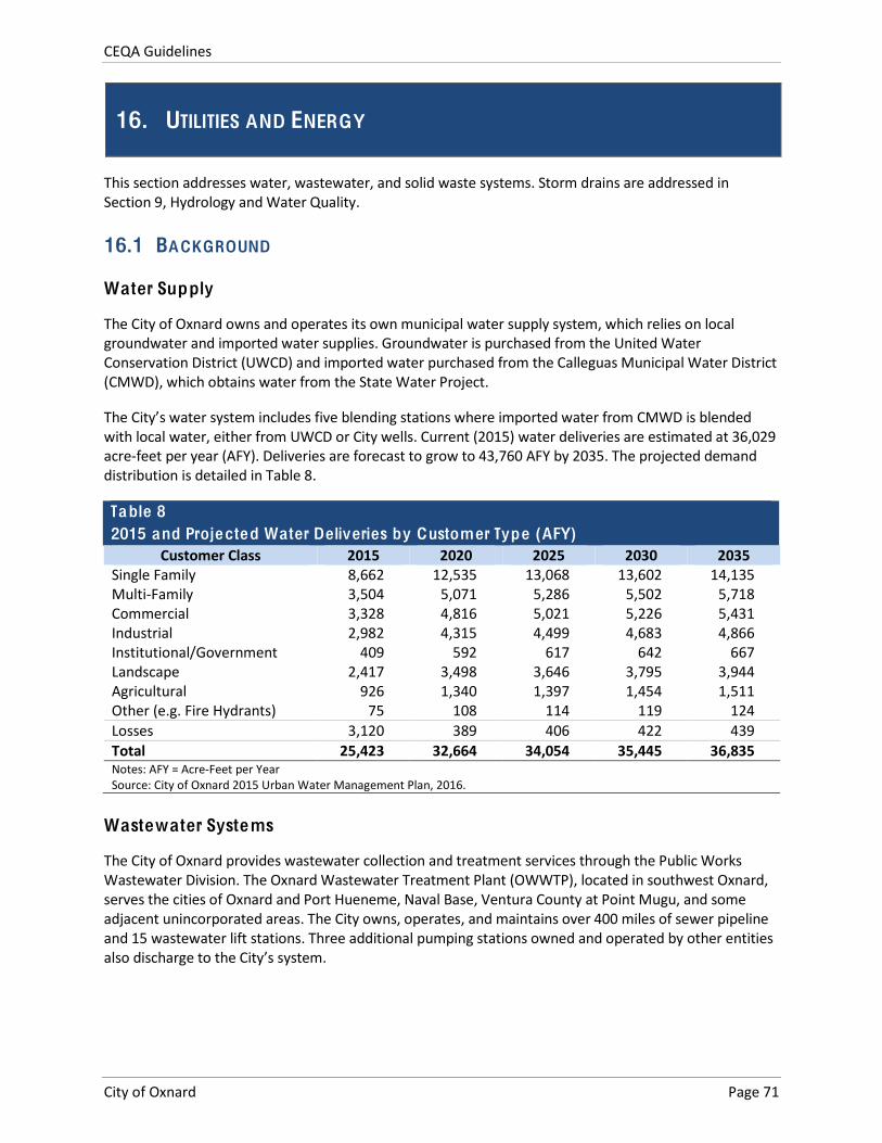
CEQA Guidelines
City of Oxnard Page 71
16. UTILITIES AND ENERGY
This section addresses water, wastewater, and solid waste systems. Storm drains are addressed in Section 9, Hydrology and Water Quality.
16.1 BACKGROUND
Water Supply
The City of Oxnard owns and operates its own municipal water supply system, which relies on local groundwater and imported water supplies. Groundwater is purchased from the United Water Conservation District (UWCD) and imported water purchased from the Calleguas Municipal Water District (CMWD), which obtains water from the State Water Project.
The City’s water system includes five blending stations where imported water from CMWD is blended with local water, either from UWCD or City wells. Current (2015) water deliveries are estimated at 36,029 acre-‐feet per year (AFY). Deliveries are forecast to grow to 43,760 AFY by 2035. The projected demand distribution is detailed in Table 8.
Table 8 2015 and Projected Water Deliveries by Customer Type (AFY)
Customer Class 2015 2020 2025 2030 2035 Single Family 8,662 12,535 13,068 13,602 14,135 Multi-‐Family 3,504 5,071 5,286 5,502 5,718 Commercial 3,328 4,816 5,021 5,226 5,431 Industrial 2,982 4,315 4,499 4,683 4,866 Institutional/Government 409 592 617 642 667 Landscape 2,417 3,498 3,646 3,795 3,944 Agricultural 926 1,340 1,397 1,454 1,511 Other (e.g. Fire Hydrants) 75 108 114 119 124 Losses 3,120 389 406 422 439 Total 25,423 32,664 34,054 35,445 36,835 Notes: AFY = Acre-‐Feet per Year Source: City of Oxnard 2015 Urban Water Management Plan, 2016.
Wastewater Systems
The City of Oxnard provides wastewater collection and treatment services through the Public Works Wastewater Division. The Oxnard Wastewater Treatment Plant (OWWTP), located in southwest Oxnard, serves the cities of Oxnard and Port Hueneme, Naval Base, Ventura County at Point Mugu, and some adjacent unincorporated areas. The City owns, operates, and maintains over 400 miles of sewer pipeline and 15 wastewater lift stations. Three additional pumping stations owned and operated by other entities also discharge to the City’s system.
CEQA Guidelines
City of Oxnard Page 72
Solid Waste
The City’s Environmental Resources Division oversees solid waste programs in the City, including residential waste collection and various recycling programs. Commercial facilities in the City contract with private waste haulers for waste collection. Residential waste collection includes waste, recyclables, and yard waste. The City operates the Del Norte Regional Recycling & Transfer Station, also known as the Materials Recovery Facility or “MRF”, which serves as the central hub of the City’s overall solid waste management system and as a regional resource. Waste that is not recycled is disposed of at local landfills, most commonly Toland Road Landfill.
As of 2017, the City meets or exceeds state-‐mandated rates for diversion of solid waste from landfills via waste reduction, reuse, and recycling. The Environmental Resources Division is developing a Zero Waste strategic plan that will serve as a roadmap to reduce waste going to the landfill, increase reuse and recycling opportunities, generate clean energy, and explore new policies and technologies in order to conserve natural resources and reduce greenhouse gas emissions.
Energy
As of 2017, the City of Oxnard has adopted an Energy Action Plan (City of Oxnard 2013), which establishes an overall, realistic, net energy consumption reduction target and identifies as well as scopes programs to achieve the target over time. The Energy Action Plan builds upon existing energy conservation efforts and identifies energy conservation and production programs consistent with the 2030 General Plan goals and policies, utility company programs, and State and Federal legislation and initiatives. The Energy Action Plan utilizes a 2005 energy use baseline and establishes a net reduction target for 2020 for electricity and natural gas by considering future growth projections under a business as usual (BAU) scenario, current energy and GHG regulations, existing and ongoing local community and City Government energy efficiency and conservation activities, opportunities for renewable energy production, and estimated energy reductions from implementing additional programs identified by the Energy Action Plan. Lastly, the Energy Action Plan describes the processes how these policies and goals will be implemented through programs and how the programs will be monitored and measured for success.
Table 16 in Attachment B summarizes the 2030 General Plan goals and policies related to water supply, wastewater systems, solid waste, and energy.
16.2 SIGNIFICANCE THRESHOLDS
An affirmative answer to any of the following questions typically indicates a potentially significant impact related to utilities. A “no” response to all questions indicates that there would be no significant impact with respect to utilities.
1. Would the project need new or expanded water supply entitlements that are not anticipated in the current Urban Water Management Plan?
2. Would additional wastewater conveyance or treatment capacity be required to serve project demand and existing commitments?
3. Would the project generate solid waste that would exceed the permitted capacity of a landfill serving the City?
4. Would the project conflict with federal, state, or local statutes or regulations related to solid waste?
CEQA Guidelines
City of Oxnard Page 73
Although “Energy” is not an explicit topic in the State CEQA Guidelines Appendix G checklist, it still must be addressed as part of CEQA documents (for example, see Section 15126.4 in the State CEQA Guidelines). The State CEQA Guidelines also retain Appendix F, Energy Conservation, which provides some direction on how the subject of energy conservation may be addressed. With respect to energy, an affirmative answer to any of the following questions typically indicates a potentially significant impact.
5. Would the project involve wasteful, inefficient, or unnecessary consumption of energy during project construction, operation, maintenance, and/or removal?
6. Would the project require additional energy facilities, the provision of which may have a significant effect on the environment?
7. Would the project be inconsistent with existing energy standards?
8. Would the project preempt future energy development or future energy conservation, or inhibit the future use of renewable energy or energy storage?
16.3 METHODS
The following questions should be considered in the analysis:
Is the project’s water accounted for in the 2030 General Plan EIR and/or the current UWMP?
Would implementation of the proposed project cause an exceedance of the projected growth in population, housing, or employment for the year of project occupancy/buildout?
Would the project involve more than 500 dwelling units; a shopping center or business establishment employing more than 1,000 persons or having more than 500,000 square feet of floor space; a commercial office building employing more than 1,000 persons or having more than 250,000 square feet of floor space; a hotel or motel having more than 500 rooms; an industrial, manufacturing, or processing plant, or ndustrial park planned to house more than 1,000 persons, occupying more than 40 acres of land, or having more than 650,000 square feet of floor area; a mixed-‐use project that includes one or more of the projects specified in this subdivision; a development that would demand an amount of water equivalent to or greater than the amount of water required by a 500 dwelling unit project? Such projects would require a Water Supply Assessment (WSA) in accordance with SB 610.Does the proposed project include a change in land use limitations (such as a zone change, variance or General Plan amendment) that could allow greater average daily wastewater flow or solid waste generation than could be generated under the current land use limitations?
Does the project conform to current energy conservation standards of Title 24 of the California Administrative Code or other applicable regulations?
Water
For water supply, determine whether new off-‐site water infrastructure would be required to meet project needs. Infrastructure could include water mains, storage tanks, reservoirs, filtration plants, pumps, wells, and other connections or distribution facilities. Forecast water demand for the project based on standard factors and determine whether the increase in demand is within the supply and demand forecasts contained in the most recent version of the City’s Urban Water Management Plan (UWMP). Water demand can be estimated using rates from the California Emissions Estimator Model (CalEEMod) or other verifiable source(s). Confirm water neutrality (i.e., no net increase in water demand) for projects not included in the 2030 General Plan EIR or the latest version of the UWMP).
CEQA Guidelines
City of Oxnard Page 74
The City’s water neutrality policy is not codified, which means that Oxnard may choose to approve a project regardless of its water neutrality status. However, the City has been making planning and permitting decisions pursuant to the water neutrality policy since 2008 and it is therefore assumed that a project needs to present a plan for water neutrality. The neutrality policy requires that all new development approved in the city must offset its water demand with a supplemental water supply. “New development” includes all planned (anticipated in the current General Plan) and any unplanned future development occurring in the city. Under the policy, a development can be water neutral by meeting its projected demand through: existing Fox Canyon Groundwater Management Agency (FCGMA) groundwater allocations that are transferred to the city; contributing to increased efficiency by funding water conservation or recycled water retrofit projects; providing additional water supplies; or any combination of these options.
Senate Bill 610 amended state law to improve the link between information on water supply availability and certain land use decisions made by cities and counties. SB 610 seeks to promote more collaborative planning between local water suppliers and cities and counties. Detailed information regarding water availability is to be provided to the city and county decision-‐makers prior to approval of specified large development projects (California Department of Water Resources 2003).
Under SB 610, water supply assessments (WSAs) must be provided to local governments for inclusion in any environmental documentation for certain projects (as defined in Water Code 10912 [a]) subject to CEQA. A foundational document for compliance with SB 610 is the UWMP. The UWMP is identified as a planning document that, if properly prepared, can be used by a water supplier to meet the standards set forth in SB 610. Thorough and complete UWMPs will allow water suppliers to use UWMPs as a foundation to fulfill the specific requirements of these two statutes. Cities, counties, water districts, property owners, and developers will all be able to utilize this document when planning for and proposing new projects (California Department of Water Resources 2003). Information about the specific requirements of SB 610 can be found in the Department of Water Resources SB 610 guidebook at http://www.water.ca.gov/pubs/use/sb_610_sb_221_guidebook/guidebook.pdf.
Wastewater
For wastewater system requirements, determine the wastewater generation that would be expected with full implementation of the project based on standard generation factors. Wastewater generation can be estimated based on water demand (typically wastewater generation is from about 80-‐100% of water demand depending on the use) or other verifiable generation factors. Compare projected average daily flow to the available capacity of the OWWTP (overall capacity minus current wastewater flow) to determine whether OWWTP project-‐generated wastewater would exceed plant capacity.
Solid Waste
For solid waste, estimate typical project waste generation using standard generation factors and compare daily solid waste generation to available daily capacity (overall daily capacity minus current daily throughput) at the landfill that serves the project. Solid waste generation can be estimated using rates from CalEEMod or other verifiable source(s). Determine whether the project would conflict with local or state-‐mandated recycling requirements.

CEQA Guidelines
City of Oxnard Page 75
Energy
For energy, Appendix F of the State CEQA Guidelines require that EIRs include a discussion of the potential energy consumption and/or conservation impacts of proposed projects, with particular emphasis on avoiding or reducing inefficient, wasteful or unnecessary consumption of energy. Compliance with applicable energy conservation requirements should be confirmed. Energy use can be estimated using CalEEMod or demand factors from energy providers. For EIRs, confirm the ability of energy providers to meet estimated project demands.

CEQA Guidelines
City of Oxnard Page 76
This page intentionally left blank.
CEQA Guidelines
City of Oxnard Page 77
17. CUMULATIVE IMPA CTS
This section addresses cumulative impacts.
17.1 BACKGROUND
CEQA requires a discussion of cumulative impacts, which are defined as two or more individual effects that, when considered together, are considerable or that compound or increase other environmental impacts. The cumulative impact from the proposed project is the change in the environment that results from the incremental impact of the project when added to the impacts of closely related past, present, and reasonably foreseeable future projects.
17.2 SIGNIFICANCE THRESHOLDS
Generally speaking, the thresholds identified for project impacts will also be used to determine whether a cumulative impact is significant. Whether the proposed project’s contribution to a significant cumulative impact is “cumulatively considerable” (and therefore “significant”) will need to be determined on a case-‐by-‐case basis. A finding that the project’s impact would not exceed a particular project-‐specific threshold would not necessarily mean that the project’s contribution to a significant cumulative impact would not “cumulatively considerable” (significant). However, if a project’s contribution to a cumulative impact would be considered trivial or minor, its contribution to a significant cumulative impact normally would not be considered cumulatively considerable (i.e., the contribution would be “less than significant”).
17.3 METHODS
Cumulative impact analysis will typically consider either:
The forecast of future growth considered in the 2030 General Plan EIR
A list of planned and pending developments in the City, County, or nearby cities focusing on projects in the general vicinity of the project site.
In certain cases, it may be appropriate to use a combination of the above methods. The most appropriate approach will need to be determined on a case-‐by-‐case basis and will depend on the nature, size, and location of the project. For certain types of projects (e.g., infrastructure improvements), neither of the above approaches may be appropriate unless the project would somehow contribute to cumulative impacts associated with planned growth.
If a list of planned and pending developments approach is utilized, in part or whole, the City shall typically consider a cumulative project to be “planned and pending,” and therefore a reasonably foreseeable “probable future project” pursuant to State CEQA Guidelines section 15065(a)(3), in the following circumstances:
The cumulative project is under construction;
The City, or other pertinent agency, has approved the cumulative project even if it has not yet been constructed;
CEQA Guidelines
City of Oxnard Page 78
The City or other pertinent agency is conducting its environmental review of the cumulative project;
The application for the cumulative project has been received and deemed complete by the City or other pertinent agency at the time the City issues the Notice of Preparation for the project under review;
The cumulative project is included in an adopted capital improvements program or in an adopted general, regional, transportation, or other plan;
The cumulative project is anticipated as a future phase of a previously-‐approved project; or
The City or other pertinent agency has devoted significant time and financial resources to prepare for any regulatory review of the cumulative project.
When utilizing a “planned and pending” project list approach, the City will define the “general vicinity” of the area affected by the cumulative impact of the project and provide a reasonable explanation for its determination. In doing so, the City may consider the nature of each environmental resource being examined, the location of the project, and its type.
The following questions should be considered in the analysis:
Would cumulative impact of the project in combination with the impacts of past, present, and reasonably foreseeable future projects exceed a City significance threshold?
If so, would the project’s contribution to the significant cumulative impact be cumulatively considerable?
Generally, “cumulatively considerable” means that the incremental effect of the proposed project is significant when viewed in connection with the effects of other past, present, and future projects. In practice, past projects are usually part of the existing condition and will be part of the baseline against which cumulative impacts are analyzed. Exceptions may be projects that have been previously approved, but not yet built and thus are not accounted for in the baseline condition.
CEQA Guidelines
City of Oxnard Page 79
REFERENCES
California Air Resource Board (CARB). 2016. “AB 32 Scoping Plan.” https://www.arb.ca.gov/cc/scopingplan/scopingplan.htm. (Accessed March 2017).
California Department of Water Resources. 2003. Guidebook for Implementation of Senate Bill 610 and Senate Bill 221 of 2001. Sacramento, CA. October 8, 2003. http://www.water.ca.gov/pubs/use/sb_610_sb_221_guidebook/guidebook.pdf.
Cayan, D., P. Bromirski, K. Hayhoe, M. Tyree, M. Dettinger, R. Flick. 2008. Climate change projections of sea level extremes along the California coast. Climatic Change, March 2008. Volume 87, Supplement 1, pp 57-‐73. https://www.broward.org/NaturalResources/ClimateChange/Documents/cccc08_slr.pdf.
Department of Finance (DOF). 2016. “Report E-‐1 Population Estimates for Cities, Counties, and the State January 1, 2016 and 2016.” State of California. Last modified: May 1, 2016. http://www.dof.ca.gov/Forecasting/Demographics/Estimates/E-‐1/documents/E-‐1_2016_InternetVersion.xls. (Accessed March 2017).
Federal Highway Administration (FHWA). 2017. “VMT Estimation and Forecasting Examples.” U.S. Department of Transportation. Last modified: January 2017. https://www.fhwa.dot.gov/environment/air_quality/conformity/research/sample_methodologies/emismeth02.cfm. (Accessed March 2017).
Federal Transit Administration (FTA). 2006. Transit Noise and Vibration Impact Assessment. FTA-‐VA-‐90-‐1003-‐06. May 2006. Washington, D.C. https://www.transit.dot.gov/sites/fta.dot.gov/files/docs/FTA_Noise_and_Vibration_Manual.pdf.
Oxnard, City of. 2002. Coastal Land Use Plan. Planning & Environmental Services. Oxnard, CA. May 2002. https://www.oxnard.org/wp-‐content/uploads/2016/03/CoastalLandUsePlan.pdf.
_____. 2006. Draft Background Report: City of Oxnard General Plan. Oxnard, CA. April 2006. https://www.oxnard.org/wp-‐content/uploads/2016/08/OxnardDraftBackgroundReport2006_04.21.06.pdf.
_____. 2009. City of Oxnard 2030 General Plan: Program Environmental Report. [Recirculated Draft.] Oxnard, CA. November 2009. https://www.oxnard.org/wp-‐content/uploads/2016/08/Oxnard_2030_Draft_General_Plan_PEIR_Recirculatation_Nov_09.pdf.
_____. 2011a. 2030 General Plan: Goals and Policies. Oxnard, CA. October 2011. https://www.oxnard.org/wp-‐content/uploads/2016/08/2030GeneralPlanGoalsPoliciesOctober2011W.pdf.
_____. 2011b. Final City of Oxnard Bicycle & Pedestrian Facilities Master Plan. Oxnard, CA. February 2015. https://www.oxnard.org/wp-‐content/uploads/2016/03/Oxnard-‐BPMP-‐Feb12-‐1.pdf.
_____. 2013. Energy Action Plan: A Component of the Oxnard Climate Action and Adaptation Plan. Oxnard, CA. April 2013. https://www.oxnard.org/wp-‐content/uploads/2016/04/OxnardEAP4.2013.pdf.
CEQA Guidelines
City of Oxnard Page 80
_____. 2016a. 2015 Urban Water Management Plan. Oxnard, CA. July 1, 2016. https://www.oxnard.org/wp-‐content/uploads/2016/09/CITY-‐OF-‐OXNARD-‐2015-‐URBAN-‐WATER-‐MANAGEMENT-‐PLAN-‐Final.pdf.
_____. 2016b. “Oxnard, California Codified Ordinances.” American Legal Publishing. Last modified: December 2016. http://library.amlegal.com/nxt/gateway.dll/California/oxnard/oxnardcaliforniacodifiedordinances?f=templates$fn=default.htm$3.0$vid=amlegal:oxnard_ca. (Accessed April 2017).
United States Census Bureau. 1995. “California Population of Counties by Decennial Census: 1900 to 1990.” Last modified: March 1995. https://www.census.gov/population/cencounts/ca190090.txt. (Accessed March 2017).
_____. 2017. “QuickFacts Ventura County, California.” https://www.census.gov/quickfacts/table/POP010210/06111,0654652. (Accessed March 2017).
Ventura County Air Pollution Control District (VCAPCD). 2003. Ventura County Air Quality Assessment Guidelines. Ventura, CA. October 2003. http://www.vcapcd.org/pubs/Planning/VCAQGuidelines.pdf.
_____. 2008. Final Ventura County 2007 Air Quality Management Plan. Ventura CA. May 13, 2008. http://www.vcapcd.org/pubs/Planning/AQMP/FinalVenturaCounty2007AQMP.pdf.
_____. 2017. “About Us.” http://www.vcapcd.org/about.htm. (Accessed March 2017).
Ventura Countywide Stormwater Quality Management Program. 2015. Ventura County Technical Guidance Manual for Stormwater Quality Control Measures. Ventura, CA. May 29, 2015. http://vcstormwater.org/images/stories/NPDES_Documents/TGM/Ventura_TGM_Errata_Update_2015-‐paginated_20150806_reduced.pdf.
Ventura, County of. ND. “Historical Census Populations of Places, Towns, and Cities in California, 1850-‐2000.” http://vcrma.org/pdf/demograghics/Census_Pop_Ventura_Co_1850-‐2000.pdf. (Accessed March 2017).
_____. 2006. County of Ventura Agricultural/Urban Buffer Policy. Santa Paula, CA. July 2006. http://vcportal.ventura.org/AgComm/onestoppermitting/docs/APAC_AgriculturalUrban_Buffer_Policy.pdf.
_____. 2011. Ventura County General Plan Resources Appendix. Ventura, CA. June 28, 2011. http://vcrma.org/planning/pdf/plans/General-‐Plan-‐Resources-‐Appendix-‐6-‐28-‐11.pdf.
_____. 2016. Ventura County’s 2015 Crop & Livestock Report. Camarillo, CA. December 2016. http://vcportal.ventura.org/AgComm/docs/crop-‐reports/2015_Ag_Crop_Report_12-‐19-‐16.pdf.
Attachment A CEQA Initial Study Checklist
C ITY OF OXNARD CEQA INITIAL STUDY CHECKLIST
Project Title
City of Oxnard Contact Person and Phone Number
Project Location
Project Sponsor’s Name and Address
General Plan Designation
City Zoning
Description of Project
Surrounding Land Uses and Setting
Planned and Pending Projects in the Site Vicinity
Other Public Agencies Whose Approval is Required
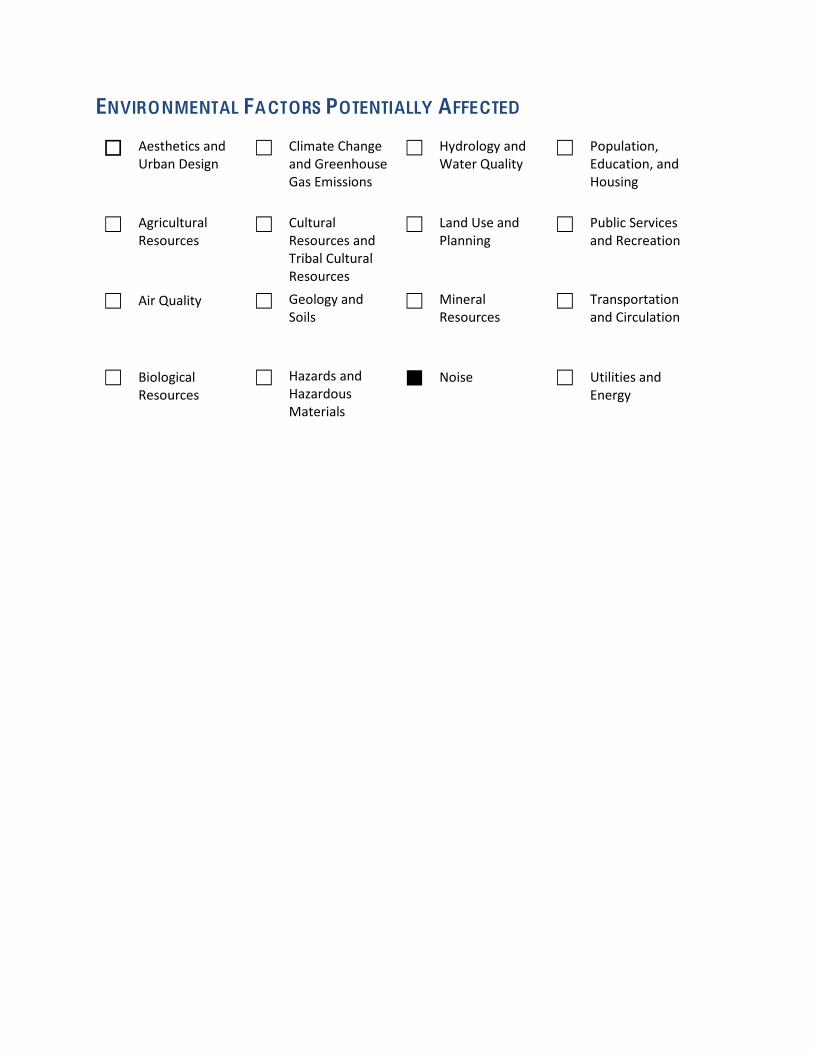
ENVIRONMENTAL FACTORS POTENTIALLY AFFECTED
Aesthetics and ڧUrban Design
܆ Climate Change and Greenhouse Gas Emissions
܆ Hydrology and Water Quality
܆ Population, Education, and Housing
܆ Agricultural Resources
܆ Cultural Resources and Tribal Cultural Resources
܆ Land Use and Planning
܆ Public Services and Recreation
܆ Air Quality ܆ Geology and Soils
܆ Mineral Resources
܆ Transportation and Circulation
܆ Biological Resources
܆ Hazards and Hazardous Materials
ڦ Noise ܆ Utilities and Energy
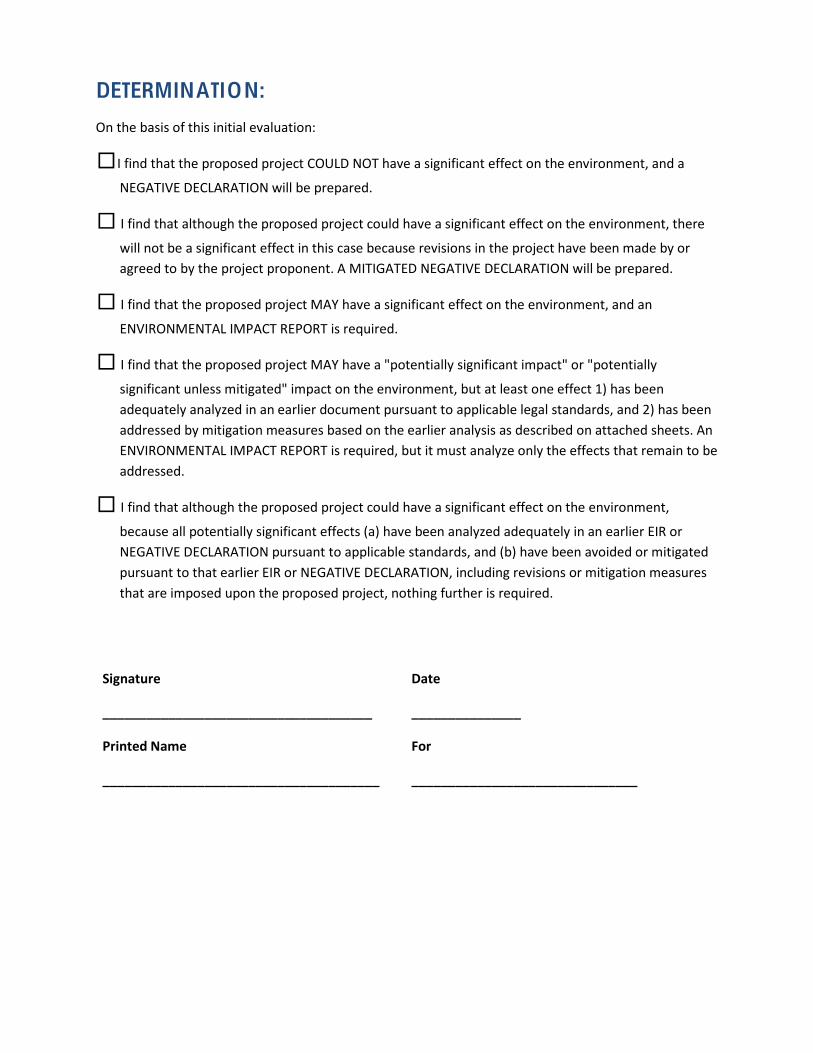
DETERMINATION:
On the basis of this initial evaluation:
I find that the proposed project COULD NOT have a significant effect on the environment, and aڧ
NEGATIVE DECLARATION will be prepared.
I find that although the proposed project could have a significant effect on the environment, there ڧ
will not be a significant effect in this case because revisions in the project have been made by or agreed to by the project proponent. A MITIGATED NEGATIVE DECLARATION will be prepared.
I find that the proposed project MAY have a significant effect on the environment, and an ڧ
ENVIRONMENTAL IMPACT REPORT is required.
I find that the proposed project MAY have a "potentially significant impact" or "potentially ڧ
significant unless mitigated" impact on the environment, but at least one effect 1) has been adequately analyzed in an earlier document pursuant to applicable legal standards, and 2) has been addressed by mitigation measures based on the earlier analysis as described on attached sheets. An ENVIRONMENTAL IMPACT REPORT is required, but it must analyze only the effects that remain to be addressed.
,I find that although the proposed project could have a significant effect on the environment ڧ
because all potentially significant effects (a) have been analyzed adequately in an earlier EIR or NEGATIVE DECLARATION pursuant to applicable standards, and (b) have been avoided or mitigated pursuant to that earlier EIR or NEGATIVE DECLARATION, including revisions or mitigation measures that are imposed upon the proposed project, nothing further is required.
Signature
_____________________________________
Date
_______________
Printed Name
______________________________________
For
_______________________________
EVALUATION OF ENVIRONMENTAL IMPACTS:
1. When the answer to a checklist question is “yes”, either the “Potentially Significant Impact” or “Less than Significant Impact with Mitigation Incorporated” box will typically be checked. When the answer to a checklist question is “no,” either the “Less than Significant Impact” or “No Impact” box will typically be checked.
2. A brief explanation is required for all answers except "No Impact" answers that are adequately supported by the information sources a lead agency cites in the parentheses following each question. A "No Impact" answer is adequately supported if the referenced information sources show that the impact simply does not apply to projects like the one involved (e.g., the project falls outside a fault rupture zone). A "No Impact" answer should be explained where it is based on project-‐specific factors as well as general standards (e.g., the project will not expose sensitive receptors to pollutants, based on a project-‐specific screening analysis).
3. All answers must take account of the whole action involved, including off-‐site as well as on-‐site, cumulative as well as project-‐level, indirect as well as direct, and construction as well as operational impacts.
4. Once the lead agency has determined that a particular physical impact may occur, then the checklist answers must indicate whether the impact is potentially significant, less than significant with mitigation, or less than significant. "Potentially Significant Impact" is appropriate if there is substantial evidence that an effect may be significant. If there are one or more "Potentially Significant Impact" entries when the determination is made, an EIR is typically required.
5. "Negative Declaration: Less Than Significant With Mitigation Incorporated" applies where the incorporation of mitigation measures has reduced an effect from "Potentially Significant Impact" to a "Less Than Significant Impact." The lead agency must describe the mitigation measures, and briefly explain how they reduce the effect to a less than significant level (mitigation measures from "Earlier Analyses," as described in (5) below, may be cross-‐referenced).
6. Earlier analyses may be used where, pursuant to the tiering, program EIR, or other CEQA process, an effect has been adequately analyzed in an earlier EIR or negative declaration. Section 15063(c)(3)(D). In this case, a brief discussion should identify the following:
a. Earlier Analysis Used. Identify and state where they are available for review.
b. Impacts Adequately Addressed. Identify which effects from the above checklist were within the scope of and adequately analyzed in an earlier document pursuant to applicable legal standards, and state whether such effects were addressed by mitigation measures based on the earlier analysis.
c. Mitigation Measures. For effects that are "Less than Significant with Mitigation Measures Incorporated," describe the mitigation measures which were incorporated or
refined from the earlier document and the extent to which they address site-‐specific conditions for the project.
7. Lead agencies are encouraged to incorporate into the checklist references to information sources for potential impacts (e.g., general plans, zoning ordinances). Reference to a previously prepared or outside document should, where appropriate, include a reference to the page or pages where the statement is substantiated.
8. Supporting Information Sources: A source list should be attached, and other sources used or individuals contacted should be cited in the discussion.
9. This is only a suggested form, and lead agencies are free to use different formats; however, lead agencies should normally address the questions from this checklist that are relevant to a project's environmental effects in whatever format is selected.
10. The explanation of each issue should identify:
a. The significance criteria or threshold, if any, used to evaluate each question; and
b. The mitigation measure identified, if any, to reduce the impact to less than significance
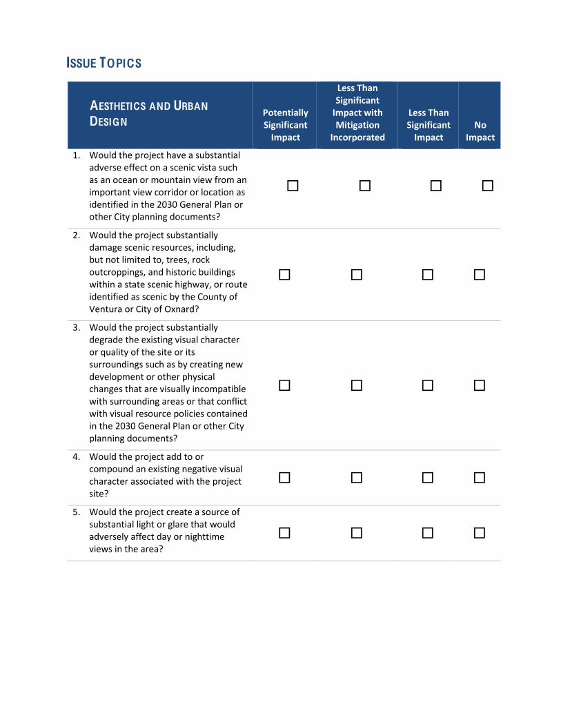
ISSUE TOPICS
AESTHETICS AND URBAN
DESIGN Potentially Significant Impact
Less Than Significant Impact with Mitigation
Incorporated
Less Than Significant Impact
No Impact
1. Would the project have a substantial adverse effect on a scenic vista such as an ocean or mountain view from an important view corridor or location as identified in the 2030 General Plan or other City planning documents?
ڧ ڧ ڧ ڧ
2. Would the project substantially damage scenic resources, including, but not limited to, trees, rock outcroppings, and historic buildings within a state scenic highway, or route identified as scenic by the County of Ventura or City of Oxnard?
ڧ ڧ ڧ ڧ
3. Would the project substantially degrade the existing visual character or quality of the site or its surroundings such as by creating new development or other physical changes that are visually incompatible with surrounding areas or that conflict with visual resource policies contained in the 2030 General Plan or other City planning documents?
ڧ ڧ ڧ ڧ
4. Would the project add to or compound an existing negative visual character associated with the project site?
ڧ ڧ ڧ ڧ
5. Would the project create a source of substantial light or glare that would adversely affect day or nighttime views in the area?
ڧ ڧ ڧ ڧ
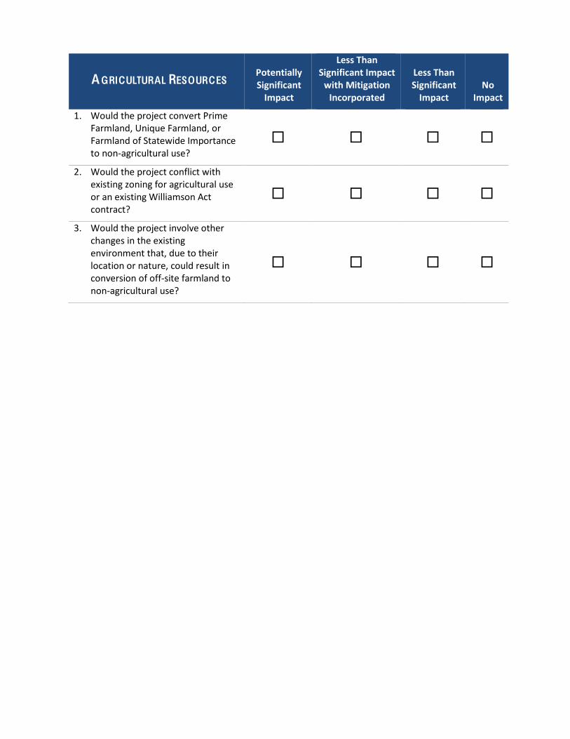
AGRICULTURAL RESOURCES Potentially Significant Impact
Less Than Significant Impact with Mitigation Incorporated
Less Than Significant Impact
No Impact
1. Would the project convert Prime Farmland, Unique Farmland, or Farmland of Statewide Importance to non-‐agricultural use?
ڧ ڧ ڧ ڧ
2. Would the project conflict with existing zoning for agricultural use or an existing Williamson Act contract?
ڧ ڧ ڧ ڧ
3. Would the project involve other changes in the existing environment that, due to their location or nature, could result in conversion of off-‐site farmland to non-‐agricultural use?
ڧ ڧ ڧ ڧ
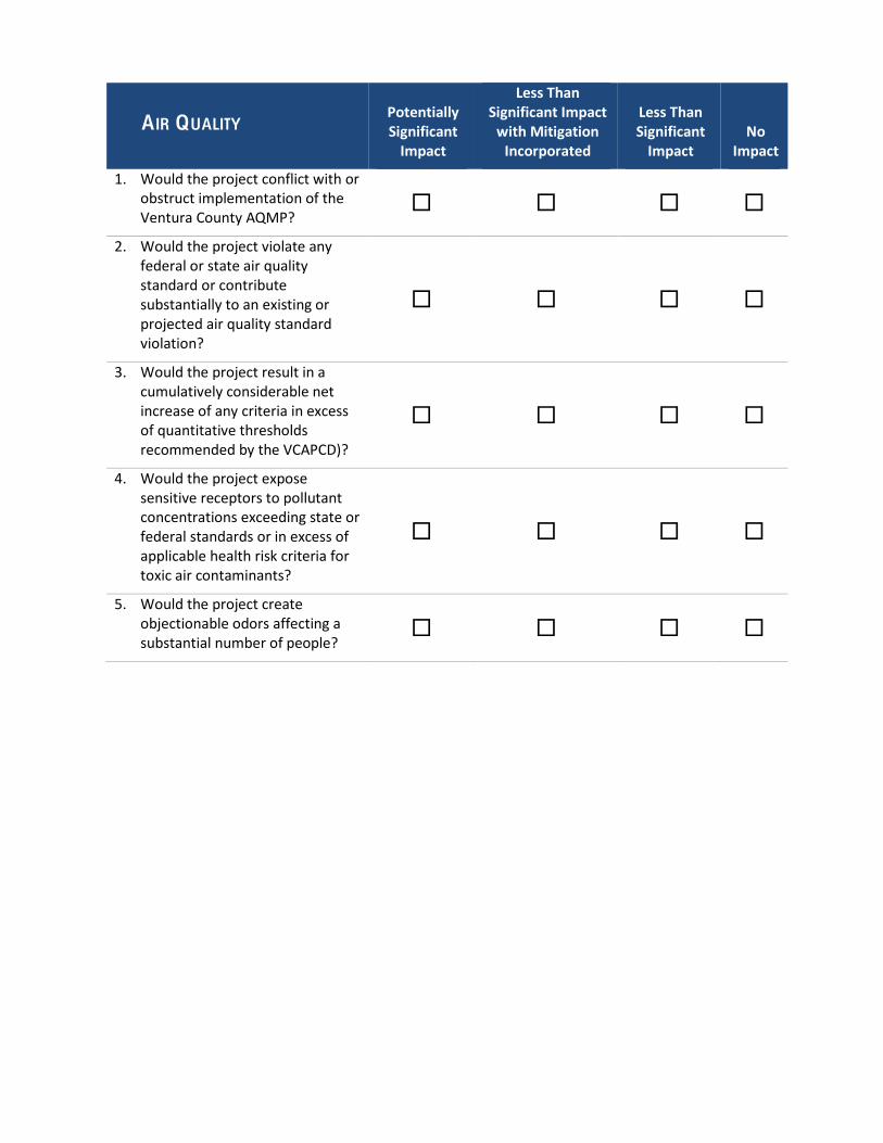
AIR QUALITY Potentially Significant Impact
Less Than Significant Impact with Mitigation Incorporated
Less Than Significant Impact
No Impact
1. Would the project conflict with or obstruct implementation of the Ventura County AQMP?
ڧ ڧ ڧ ڧ
2. Would the project violate any federal or state air quality standard or contribute substantially to an existing or projected air quality standard violation?
ڧ ڧ ڧ ڧ
3. Would the project result in a cumulatively considerable net increase of any criteria in excess of quantitative thresholds recommended by the VCAPCD)?
ڧ ڧ ڧ ڧ
4. Would the project expose sensitive receptors to pollutant concentrations exceeding state or federal standards or in excess of applicable health risk criteria for toxic air contaminants?
ڧ ڧ ڧ ڧ
5. Would the project create objectionable odors affecting a substantial number of people?
ڧ ڧ ڧ ڧ
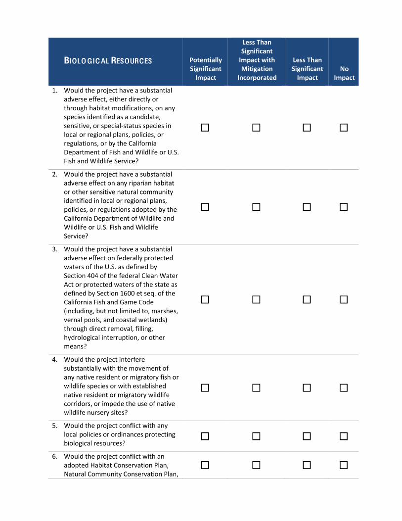
BIOLO GICAL RESOURCES Potentially Significant Impact
Less Than Significant Impact with Mitigation
Incorporated
Less Than Significant Impact
No Impact
1. Would the project have a substantial adverse effect, either directly or through habitat modifications, on any species identified as a candidate, sensitive, or special-‐status species in local or regional plans, policies, or regulations, or by the California Department of Fish and Wildlife or U.S. Fish and Wildlife Service?
ڧ ڧ ڧ ڧ
2. Would the project have a substantial adverse effect on any riparian habitat or other sensitive natural community identified in local or regional plans, policies, or regulations adopted by the California Department of Wildlife and Wildlife or U.S. Fish and Wildlife Service?
ڧ ڧ ڧ ڧ
3. Would the project have a substantial adverse effect on federally protected waters of the U.S. as defined by Section 404 of the federal Clean Water Act or protected waters of the state as defined by Section 1600 et seq. of the California Fish and Game Code (including, but not limited to, marshes, vernal pools, and coastal wetlands) through direct removal, filling, hydrological interruption, or other means?
ڧ ڧ ڧ ڧ
4. Would the project interfere substantially with the movement of any native resident or migratory fish or wildlife species or with established native resident or migratory wildlife corridors, or impede the use of native wildlife nursery sites?
ڧ ڧ ڧ ڧ
5. Would the project conflict with any local policies or ordinances protecting biological resources?
ڧ ڧ ڧ ڧ
6. Would the project conflict with an adopted Habitat Conservation Plan, Natural Community Conservation Plan,
ڧ ڧ ڧ ڧ

or other approved local, regional, or state habitat conservation plan?
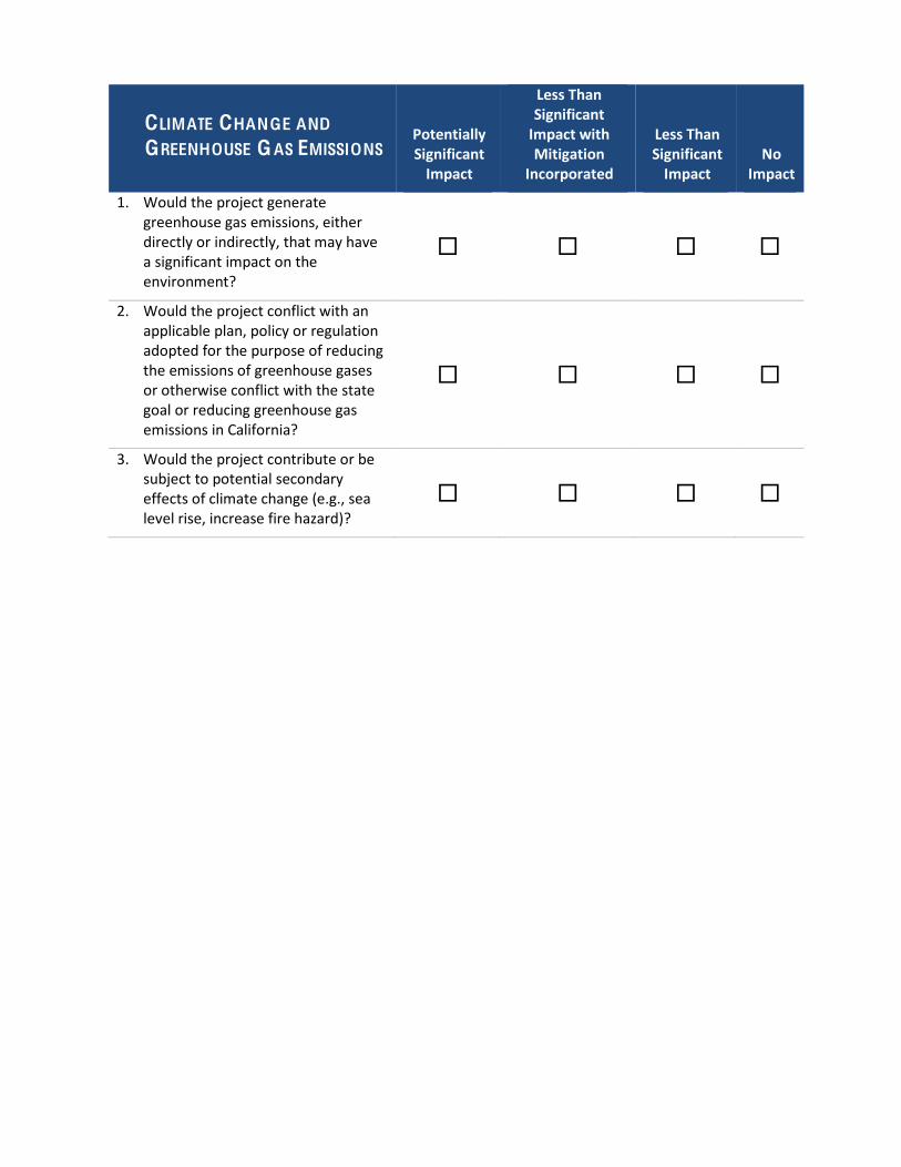
CLIMATE CHANGE AND
GREENHOUSE GAS EMISSIONS Potentially Significant Impact
Less Than Significant Impact with Mitigation
Incorporated
Less Than Significant Impact
No Impact
1. Would the project generate greenhouse gas emissions, either directly or indirectly, that may have a significant impact on the environment?
ڧ ڧ ڧ ڧ
2. Would the project conflict with an applicable plan, policy or regulation adopted for the purpose of reducing the emissions of greenhouse gases or otherwise conflict with the state goal or reducing greenhouse gas emissions in California?
ڧ ڧ ڧ ڧ
3. Would the project contribute or be subject to potential secondary effects of climate change (e.g., sea level rise, increase fire hazard)?
ڧ ڧ ڧ ڧ
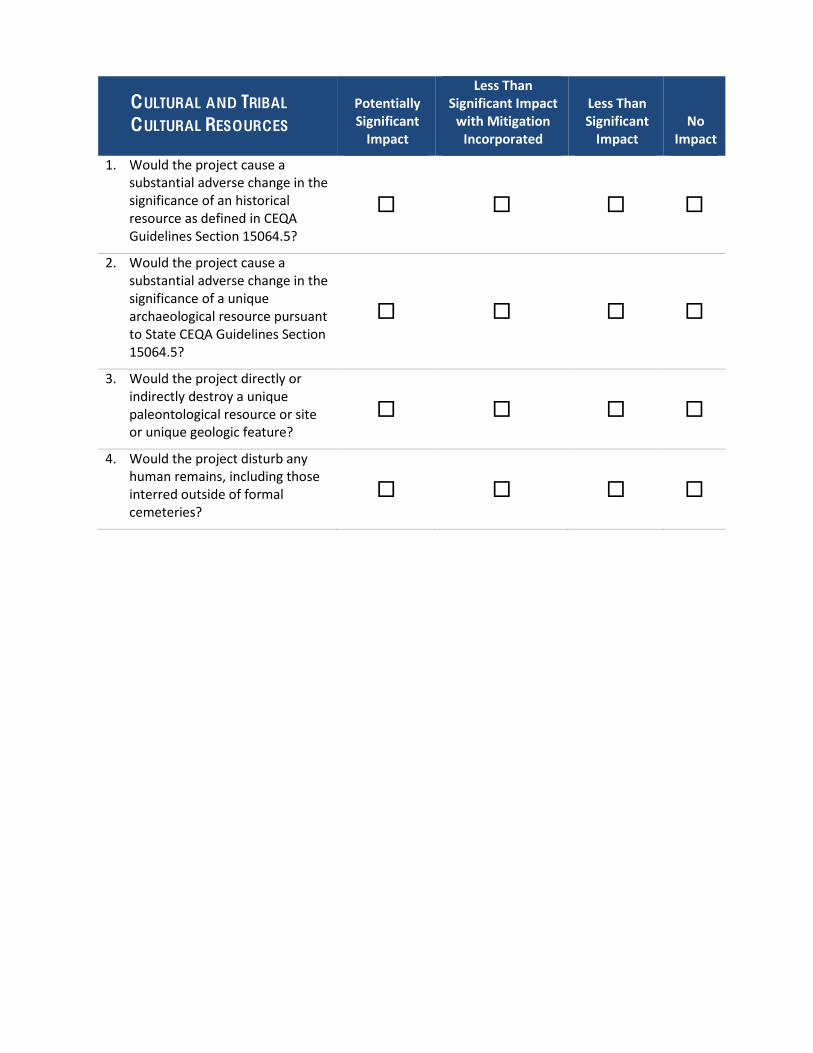
CULTURAL AND TRIBAL
CULTURAL RESOURCES Potentially Significant Impact
Less Than Significant Impact with Mitigation Incorporated
Less Than Significant Impact
No Impact
1. Would the project cause a substantial adverse change in the significance of an historical resource as defined in CEQA Guidelines Section 15064.5?
ڧ ڧ ڧ ڧ
2. Would the project cause a substantial adverse change in the significance of a unique archaeological resource pursuant to State CEQA Guidelines Section 15064.5?
ڧ ڧ ڧ ڧ
3. Would the project directly or indirectly destroy a unique paleontological resource or site or unique geologic feature?
ڧ ڧ ڧ ڧ
4. Would the project disturb any human remains, including those interred outside of formal cemeteries?
ڧ ڧ ڧ ڧ
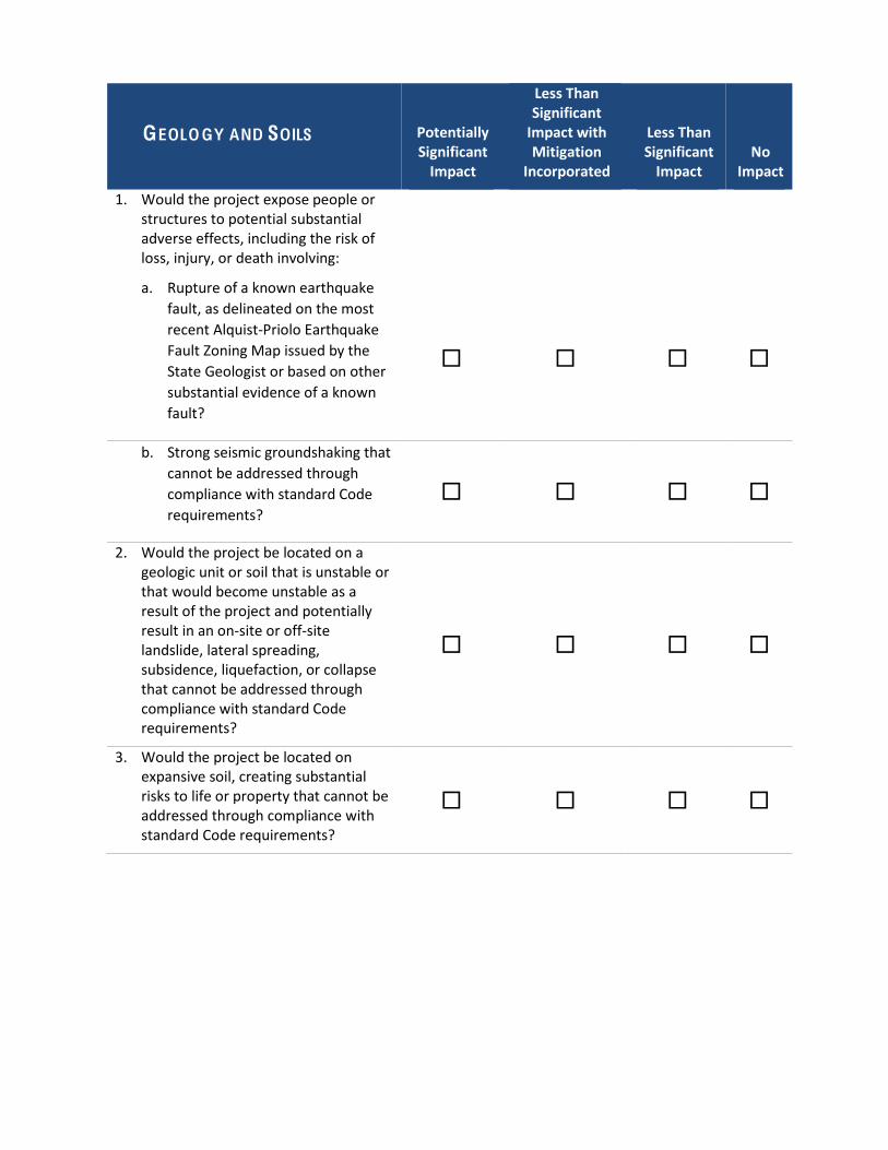
GEOLO GY AND SOILS Potentially Significant Impact
Less Than Significant Impact with Mitigation
Incorporated
Less Than Significant Impact
No Impact
1. Would the project expose people or structures to potential substantial adverse effects, including the risk of loss, injury, or death involving:
a. Rupture of a known earthquake fault, as delineated on the most recent Alquist-‐Priolo Earthquake Fault Zoning Map issued by the State Geologist or based on other substantial evidence of a known fault?
ڧ ڧ ڧ ڧ
b. Strong seismic groundshaking that cannot be addressed through compliance with standard Code requirements?
ڧ ڧ ڧ ڧ
2. Would the project be located on a geologic unit or soil that is unstable or that would become unstable as a result of the project and potentially result in an on-‐site or off-‐site landslide, lateral spreading, subsidence, liquefaction, or collapse that cannot be addressed through compliance with standard Code requirements?
ڧ ڧ ڧ ڧ
3. Would the project be located on expansive soil, creating substantial risks to life or property that cannot be addressed through compliance with standard Code requirements?
ڧ ڧ ڧ ڧ

4. Would the project expose people or structures to inundation by seiche or tsunami?
ڧ ڧ ڧ ڧ
5. Would the project rely on dredging or other maintenance activity by another agency that is not guaranteed to continue?
ڧ ڧ ڧ ڧ
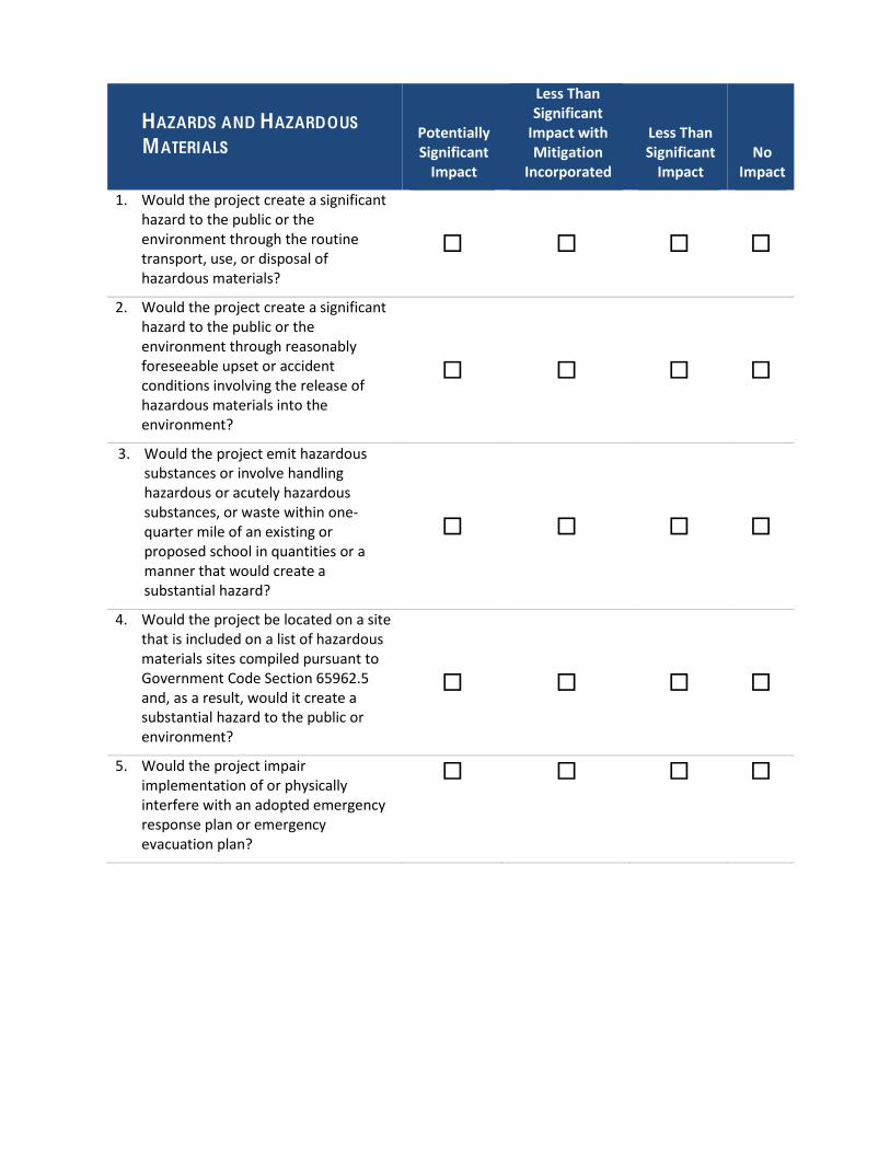
HAZARDS AND HAZARDOUS
MATERIALS Potentially Significant Impact
Less Than Significant Impact with Mitigation
Incorporated
Less Than Significant Impact
No Impact
1. Would the project create a significant hazard to the public or the environment through the routine transport, use, or disposal of hazardous materials?
ڧ ڧ ڧ ڧ
2. Would the project create a significant hazard to the public or the environment through reasonably foreseeable upset or accident conditions involving the release of hazardous materials into the environment?
ڧ ڧ ڧ ڧ
3. Would the project emit hazardous substances or involve handling hazardous or acutely hazardous substances, or waste within one-‐quarter mile of an existing or proposed school in quantities or a manner that would create a substantial hazard?
ڧ ڧ ڧ ڧ
4. Would the project be located on a site that is included on a list of hazardous materials sites compiled pursuant to Government Code Section 65962.5 and, as a result, would it create a substantial hazard to the public or environment?
ڧ ڧ ڧ ڧ
5. Would the project impair implementation of or physically interfere with an adopted emergency response plan or emergency evacuation plan?
ڧ ڧ ڧ ڧ
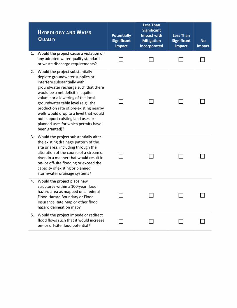
HYDROLO GY AND WATER
QUALITY Potentially Significant Impact
Less Than Significant Impact with Mitigation
Incorporated
Less Than Significant Impact
No Impact
1. Would the project cause a violation of any adopted water quality standards or waste discharge requirements?
ڧ ڧ ڧ ڧ
2. Would the project substantially deplete groundwater supplies or interfere substantially with groundwater recharge such that there would be a net deficit in aquifer volume or a lowering of the local groundwater table level (e.g., the production rate of pre-‐existing nearby wells would drop to a level that would not support existing land uses or planned uses for which permits have been granted)?
ڧ ڧ ڧ ڧ
3. Would the project substantially alter the existing drainage pattern of the site or area, including through the alteration of the course of a stream or river, in a manner that would result in on-‐ or off-‐site flooding or exceed the capacity of existing or planned stormwater drainage systems?
ڧ ڧ ڧ ڧ
4. Would the project place new structures within a 100-‐year flood hazard area as mapped on a federal Flood Hazard Boundary or Flood Insurance Rate Map or other flood hazard delineation map?
ڧ ڧ ڧ ڧ
5. Would the project impede or redirect flood flows such that it would increase on-‐ or off-‐site flood potential?
ڧ ڧ ڧ ڧ

6. Would the project expose people or structures to a significant risk of loss, injury or death involving flooding, including flooding as a result of the failure of a levee or dam?
ڧ ڧ ڧ ڧ
7. Would the project be exposed to a substantial risk related to inundation by seiche, tsunami, or mudflow?
ڧ ڧ ڧ ڧ
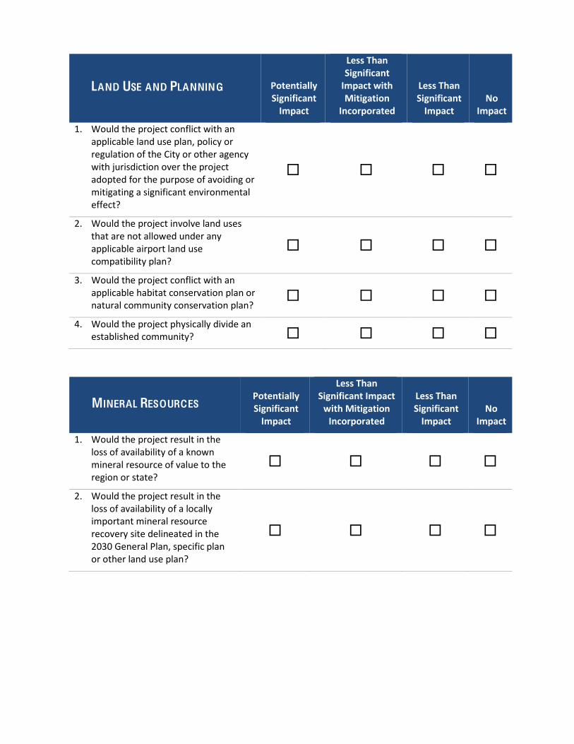
LAND USE AND PLANNING Potentially Significant Impact
Less Than Significant Impact with Mitigation
Incorporated
Less Than Significant Impact
No Impact
1. Would the project conflict with an applicable land use plan, policy or regulation of the City or other agency with jurisdiction over the project adopted for the purpose of avoiding or mitigating a significant environmental effect?
ڧ ڧ ڧ ڧ
2. Would the project involve land uses that are not allowed under any applicable airport land use compatibility plan?
ڧ ڧ ڧ ڧ
3. Would the project conflict with an applicable habitat conservation plan or natural community conservation plan?
ڧ ڧ ڧ ڧ
4. Would the project physically divide an established community? ڧ ڧ ڧ ڧ
MINERAL RESOURCES Potentially Significant Impact
Less Than Significant Impact with Mitigation Incorporated
Less Than Significant Impact
No Impact
1. Would the project result in the loss of availability of a known mineral resource of value to the region or state?
ڧ ڧ ڧ ڧ
2. Would the project result in the loss of availability of a locally important mineral resource recovery site delineated in the 2030 General Plan, specific plan or other land use plan?
ڧ ڧ ڧ ڧ
NOISE Potentially Significant Impact
Less Than Significant Impact with Mitigation Incorporated
Less Than Significant Impact
No Impact
1. Would the project generate or expose persons to noise levels in excess of standards established in the Oxnard 2030 General Plan or Noise Ordinance, or applicable standards of other agencies?
ڧ ڧ ڧ ڧ
2. Would the project generate or expose persons to excessive groundborne vibration or groundborne noise levels?
ڧ ڧ ڧ ڧ
3. Would the project generate a substantial temporary or periodic increase in ambient noise in the project vicinity above levels existing without the project?
ڧ ڧ ڧ ڧ
4. Would the project generate a substantial permanent increase in ambient noise in the project vicinity above levels existing without the project?
ڧ ڧ ڧ ڧ
5. For a project located within the airport land use plan for Oxnard Airport or within two miles of Naval Base, Ventura County at Point Mugu, would the project expose people residing or working in the project area to excessive noise levels?
ڧ ڧ ڧ ڧ
6. Would the project expose non-‐human species to excessive noise? ڧ ڧ ڧ ڧ
POPULATION, EDUCATION, AND HOUSING
Potentially Significant Impact
Less Than Significant Impact with Mitigation
Incorporated
Less Than Significant Impact
No Impact
1. Would the project involve a General Plan amendment that could result in an increase in population over that projected in the 2030 General Plan that may result in one or more significant physical environmental effects?
ڧ ڧ ڧ ڧ
2. Would the project induce substantial growth on the project site or surrounding area, resulting in one or more significant physical environmental effects?
ڧ ڧ ڧ ڧ
3. Would the project result in a substantial (15 single-‐family or 25 multi-‐family dwelling units – about one-‐half block) net loss of housing units through demolition, conversion, or other means that may necessitate the development of replacement housing?
ڧ ڧ ڧ ڧ
4. Would the project result in a net loss of existing housing units affordable to very low-‐ or low-‐income households (as defined by federal and/or City standards), through demolition, conversion, or other means that may necessitate the development of replacement housing?
ڧ ڧ ڧ ڧ
5. Would the project cause an increase in enrollment at local public schools that would exceed capacity and necessitate the construction of new or expanded facilities?
ڧ ڧ ڧ ڧ
6. Would the project directly or indirect interfere with the operation of an existing or planned school?
ڧ ڧ ڧ ڧ
PUBLIC SERVICES AND
RECREATION Potentially Significant Impact
Less Than Significant Impact with Mitigation
Incorporated
Less Than Significant Impact
No Impact
1. Would the project increase demand for fire protection service such that new or expanded facilities would be needed to maintain acceptable service levels, the construction of which may have significant environmental effects?
ڧ ڧ ڧ ڧ
2. Would the project increase demand for law enforcement service such that new or expanded facilities would be needed to maintain acceptable service levels, the construction of which may have significant environmental effects?
ڧ ڧ ڧ ڧ
3. Would the project increase the use of existing park facilities such that substantial physical deterioration of the facilities would occur or be accelerated or that new or expanded park facilities would be needed to maintain acceptable service levels?
ڧ ڧ ڧ ڧ
4. Would the project increase the need for or use of existing library or other community facilities such that substantial physical deterioration of the facilities would occur or be accelerated?
ڧ ڧ ڧ ڧ
TRANSPORTATION AND
C IRCULATION Potentially Significant Impact
Less Than Significant Impact with Mitigation
Incorporated
Less Than Significant Impact
No Impact
1. Would the project cause an increase in traffic that is substantial in relation to the existing traffic load and capacity of the street system (i.e., result in a substantial increase in either the number of vehicle trips, the volume to capacity ratio on roads, or congestion at intersections) based on adopted City of Oxnard level of service (LOS) standards?
ڧ ڧ ڧ ڧ
2. Would the project exceed, either individually or cumulatively, and LOS standard established by the Ventura County Congestion Management Program (CMP) for designated roads or highways?
ڧ ڧ ڧ ڧ
3. Would the project result in a change in air traffic patterns, including either an increase in traffic levels or a change in location that results in substantial safety risks?
ڧ ڧ ڧ ڧ
4. Would the project substantially increase hazards due to a design feature (e.g., sharp curves or dangerous intersections) or incompatible uses (e.g., farm equipment)?
ڧ ڧ ڧ ڧ
5. Would the project result in inadequate emergency access? ڧ ڧ ڧ ڧ
6. Would the project conflict with adopted policies, plans, or programs supporting alternative transportation (e.g., bus turnouts, bicycle racks)?
ڧ ڧ ڧ ڧ
UTILITIES AND ENERGY Potentially Significant Impact
Less Than Significant Impact with Mitigation Incorporated
Less Than Significant Impact
No Impact
With respect to Utilities:
1. Would the project need new or expanded water supply entitlements that are not anticipated in the current Urban Water Management Plan?
ڧ ڧ ڧ ڧ
2. Would additional wastewater conveyance or treatment capacity be required to serve project demand and existing commitments?
ڧ ڧ ڧ ڧ
3. Would the project generate solid waste that would exceed the permitted capacity of a landfill serving the City?
ڧ ڧ ڧ ڧ
4. Would the project conflict with federal, state, or local statutes or regulations related to solid waste?
ڧ ڧ ڧ ڧ
With respect to Energy:
5. Would the project involve wasteful, inefficient, or unnecessary consumption of energy during project construction, operation, maintenance, and/or removal?
ڧ ڧ ڧ ڧ
6. Would the project require additional energy facilities, the provision of which may have a significant effect on the environment?
ڧ ڧ ڧ ڧ
7. Would the project be inconsistent with existing energy standards?
ڧ ڧ ڧ ڧ
8. Would the project preempt future energy development ڧ ڧ ڧ ڧ

or future energy conservation, or inhibit the future use of renewable energy or energy storage?
CUMULATIVE IMPACTS Potentially Significant Impact
Less Than Significant Impact with Mitigation Incorporated
Less Than Significant Impact
No Impact
1. Would cumulative impact of the project in combination with the impacts of past, present, and reasonably foreseeable future projects exceed a City significance threshold?
ڧ ڧ ڧ ڧ
2. If so, would the project’s contribution to the significant cumulative impact be cumulatively considerable?
ڧ ڧ ڧ ڧ
Attachment B City of Oxnard General Plan Goals and Policies Related to CEQA
Sections
C ITY OF OXNARD GENERAL PLAN G OALS AND POLICIES RELATED TO CEQA SECTIONS
Table 1 2030 General Plan Goals and Policies Related to Aesthetic Resources ........................................... 2
Table 2 2030 General Plan Goals and Policies Related to Preservation of Agricultural Land....................... 4
Table 3 2030 General Plan Goals and Policies Related to Air Quality .......................................................... 5
Table 4 2030 General Plan Goals and Policies Related to Preservation of Biological Resources ................. 8
Table 5 2030 General Plan Goals and Policies Related to Greenhouse Gas Emissions and Global Climate Change ........................................................................................................................................................ 10
Table 6 2030 General Plan Goals and Policies Related to Cultural and Tribal Cultural Resources ............. 13
Table 7 2030 General Plan Goals and Policies Related to Geology and Soils ............................................. 14
Table 8 2030 General Plan Goals and Policies Related to Hazards and Hazardous Materials.................... 15
Table 9 2030 General Plan Goals and Policies Related to Hydrology and Water Quality .......................... 17
Table 10 2030 General Plan Goals and Policies Related to Land Use and Planning ................................... 19
Table 11 2030 General Plan Goals and Policies Related to Mineral Resources .......................................... 22
Table 12 2030 General Plan Goals and Policies Related to Noise .............................................................. 23
Table 13 2030 General Plan Goals and Policies Related to Population Growth, Education, and Housing . 25
Table 14 2030 General Plan Goals and Policies Related to Public Services and Recreation ...................... 26
Table 15 2030 General Plan Goals and Policies Related to Circulation, Traffic, and Transportation ......... 29
Table 16 2030 General Plan Goals and Policies Related to Water Supply, Wastewater Systems, Solid Waste, and Energy ...................................................................................................................................... 32
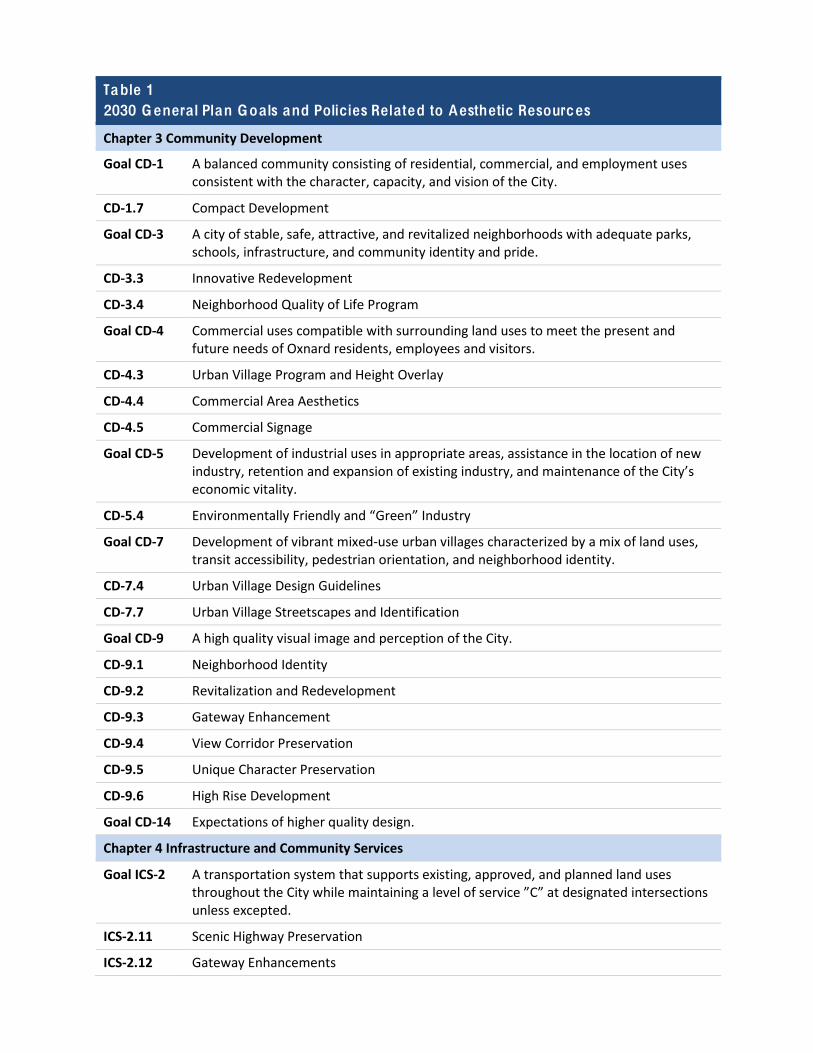
Table 1 2030 Genera l Plan Goa ls and Policies Related to Aesthetic Resources
Chapter 3 Community Development
Goal CD-‐1 A balanced community consisting of residential, commercial, and employment uses consistent with the character, capacity, and vision of the City.
CD-‐1.7 Compact Development
Goal CD-‐3 A city of stable, safe, attractive, and revitalized neighborhoods with adequate parks, schools, infrastructure, and community identity and pride.
CD-‐3.3 Innovative Redevelopment
CD-‐3.4 Neighborhood Quality of Life Program
Goal CD-‐4 Commercial uses compatible with surrounding land uses to meet the present and future needs of Oxnard residents, employees and visitors.
CD-‐4.3 Urban Village Program and Height Overlay
CD-‐4.4 Commercial Area Aesthetics
CD-‐4.5 Commercial Signage
Goal CD-‐5 Development of industrial uses in appropriate areas, assistance in the location of new industry, retention and expansion of existing industry, and maintenance of the City’s economic vitality.
CD-‐5.4 Environmentally Friendly and “Green” Industry
Goal CD-‐7 Development of vibrant mixed-‐use urban villages characterized by a mix of land uses, transit accessibility, pedestrian orientation, and neighborhood identity.
CD-‐7.4 Urban Village Design Guidelines
CD-‐7.7 Urban Village Streetscapes and Identification
Goal CD-‐9 A high quality visual image and perception of the City.
CD-‐9.1 Neighborhood Identity
CD-‐9.2 Revitalization and Redevelopment
CD-‐9.3 Gateway Enhancement
CD-‐9.4 View Corridor Preservation
CD-‐9.5 Unique Character Preservation
CD-‐9.6 High Rise Development
Goal CD-‐14 Expectations of higher quality design.
Chapter 4 Infrastructure and Community Services
Goal ICS-‐2 A transportation system that supports existing, approved, and planned land uses throughout the City while maintaining a level of service ”C” at designated intersections unless excepted.
ICS-‐2.11 Scenic Highway Preservation
ICS-‐2.12 Gateway Enhancements
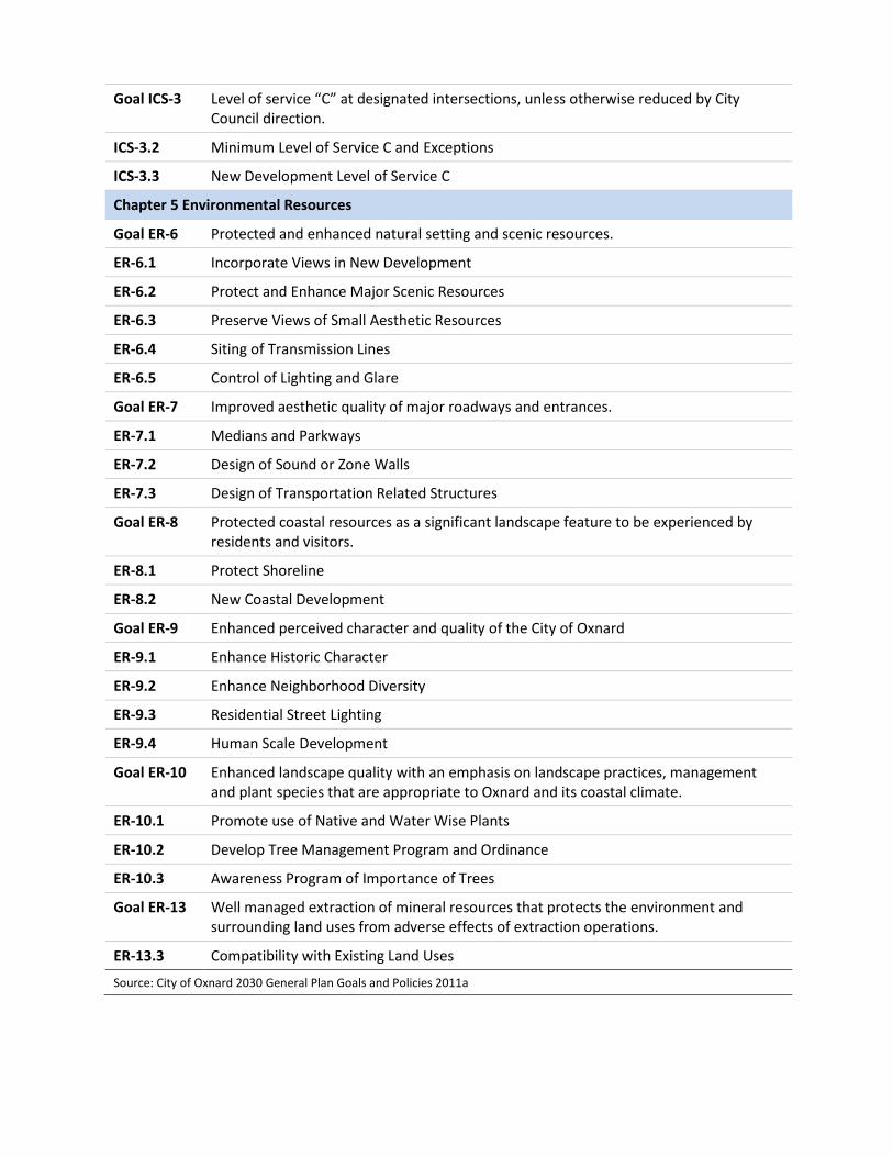
Goal ICS-‐3 Level of service “C” at designated intersections, unless otherwise reduced by City Council direction.
ICS-‐3.2 Minimum Level of Service C and Exceptions
ICS-‐3.3 New Development Level of Service C
Chapter 5 Environmental Resources
Goal ER-‐6 Protected and enhanced natural setting and scenic resources.
ER-‐6.1 Incorporate Views in New Development
ER-‐6.2 Protect and Enhance Major Scenic Resources
ER-‐6.3 Preserve Views of Small Aesthetic Resources
ER-‐6.4 Siting of Transmission Lines
ER-‐6.5 Control of Lighting and Glare
Goal ER-‐7 Improved aesthetic quality of major roadways and entrances.
ER-‐7.1 Medians and Parkways
ER-‐7.2 Design of Sound or Zone Walls
ER-‐7.3 Design of Transportation Related Structures
Goal ER-‐8 Protected coastal resources as a significant landscape feature to be experienced by residents and visitors.
ER-‐8.1 Protect Shoreline
ER-‐8.2 New Coastal Development
Goal ER-‐9 Enhanced perceived character and quality of the City of Oxnard
ER-‐9.1 Enhance Historic Character
ER-‐9.2 Enhance Neighborhood Diversity
ER-‐9.3 Residential Street Lighting
ER-‐9.4 Human Scale Development
Goal ER-‐10 Enhanced landscape quality with an emphasis on landscape practices, management and plant species that are appropriate to Oxnard and its coastal climate.
ER-‐10.1 Promote use of Native and Water Wise Plants
ER-‐10.2 Develop Tree Management Program and Ordinance
ER-‐10.3 Awareness Program of Importance of Trees
Goal ER-‐13 Well managed extraction of mineral resources that protects the environment and surrounding land uses from adverse effects of extraction operations.
ER-‐13.3 Compatibility with Existing Land Uses
Source: City of Oxnard 2030 General Plan Goals and Policies 2011a
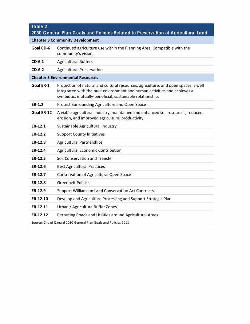
Table 2 2030 Genera l Plan Goa ls and Policies Related to Preservation of Agricultura l Land
Chapter 3 Community Development
Goal CD-‐6 Continued agriculture use within the Planning Area, Compatible with the community’s vision.
CD-‐6.1 Agricultural Buffers
CD-‐6.2 Agricultural Preservation
Chapter 5 Environmental Resources
Goal ER-‐1 Protection of natural and cultural resources, agriculture, and open spaces is well integrated with the built environment and human activities and achieves a symbiotic, mutually-‐beneficial, sustainable relationship.
ER-‐1.2 Protect Surrounding Agriculture and Open Space
Goal ER-‐12 A viable agricultural industry, maintained and enhanced soil resources, reduced erosion, and improved agricultural productivity.
ER-‐12.1 Sustainable Agricultural Industry
ER-‐12.2 Support County Initiatives
ER-‐12.3 Agricultural Partnerships
ER-‐12.4 Agricultural Economic Contribution
ER-‐12.5 Soil Conservation and Transfer
ER-‐12.6 Best Agricultural Practices
ER-‐12.7 Conservation of Agricultural Open Space
ER-‐12.8 Greenbelt Policies
ER-‐12.9 Support Williamson Land Conservation Act Contracts
ER-‐12.10 Develop and Agriculture Processing and Support Strategic Plan
ER-‐12.11 Urban / Agriculture Buffer Zones
ER-‐12.12 Rerouting Roads and Utilities around Agricultural Areas
Source: City of Oxnard 2030 General Plan Goals and Policies 2011
Table 3 2030 Genera l Plan Goa ls and Policies Related to Air Qua lity
Chapter 2 Sustainable Community
Goal SC-‐3 Energy efficiency performance standards and generation from renewable sources.
SC-‐3.1 New Residential Development
SC-‐3.2 Develop a City Energy Action Plan
SC-‐3.3 Develop a Community Energy Action Plan
SC-‐3.4 Alternative Energy for Public Buildings
SC-‐3.5 Load Shifting Devices
SC-‐3.7 Renewable Energy Production Requirement
SC-‐3.8 Require Use of Passive Energy Conservation Design
SC-‐3.9 Promote Voluntary Incentive Programs
SC-‐3.10 Alternatives to Power Plant Generation
SC-‐3.11 Waste Conversion to Energy Facility
SC-‐3.12 Encourage Natural Ventilation
Goal SC-‐4 Implementation of the California Green Building Code.
SC-‐4.1 Green Building Code Implementation
Chapter 3 Community Development
Goal CD-‐1 A balanced community consisting of residential, commercial, and employment uses consistent with the character, capacity, and vision of the City.
CD -‐1.7 Compact Development
CD-‐1.9 Commute Reduction
Goal CD-‐5 Development of industrial uses in appropriate areas, assistance in the location of new industry, retention and expansion of existing industry, and maintenance of the City’s economic vitality.
CD-‐5.2 Compatible Land Use
CD-‐5.4 Environmentally Friendly and “Green” Industry
CD-‐5.5 “Green” Major Transportation Routes
Goal CD-‐8 Sensible urban development and redevelopment based on the City’s ability to provide necessary governmental services and municipal utilities.
CD-‐8.5 Impact Mitigation
CD-‐8.9 Jobs/Housing Balance & Sustainable Communities Strategy (SB 375)
Chapter 4 Infrastructure and Community Services
Goal ICS-‐5 A passenger railroad system that serves the needs of the residents, visitors, and workers.
ICS-‐5.1 Enhanced Passenger Rail Service
ICS-‐5.2 Passenger Rail Service Expansion
ICS-‐5.3 Sub Regional Transportation Centers
Goal ICS-‐6 Public transit system that serves the needs of the residents and workers of Oxnard.
ICS-‐6.1 Transit Facilities for New Developments
ICS-‐6.6 Alternative Transit Options
Goal ICS-‐7 Effective Transportation Demand Management (TDM) programs that help achieve air quality goals and minimize congestion.
ICS-‐7.1 Require Transportation Demand Management Programs (TDM)
ICS-‐7.2 Reduce Single-‐Occupancy Automobile Dependency
ICS-‐7.3 Travel Patterns
ICS-‐7.4 Park and Ride Lots
Goal ICS-‐8 Safe bicycle and pedestrian circulation throughout the City.
ICS-‐8.2 Bicycle Route Plan
ICS-‐8.4 New Development Requires Bicycle Improvements
ICS-‐8.5 Public Sidewalks and Pedestrian Orientation
ICS-‐8.11 Bicycle Parking and Storage
ICS-‐8.13 Importance of Pedestrian and Bicycle Access in Site Planning
Goal ICS-‐10
Improved and safe commercial air carrier services.
ICS-‐10.3 Airport Operations Monitoring
Goal ICS-‐15
Managed development adjacent to closed landfill areas that mitigate health and safety hazards.
ICS-‐15.2 Avoiding Sensitive Land Uses in Areas Adjacent to Landfills
Chapter 5 Environmental Resources
Goal ER-‐14 Improved air quality and minimized adverse effects of air pollution on human health and the economy.
ER-‐14.1 Incorporate Ventura County AQMP Mitigations
ER-‐14.2 Transportation Demand Management (TDM)
ER-‐14.3 Reducing Carbon Monoxide Exposure at Congested Intersections
ER-‐14.4 Emission Control Devices
ER-‐14.5 Reducing Construction Impacts during Smog Season
ER-‐14.6 Minimizing Dust and Air Emissions through Permitting Requirements
ER-‐14.7 Mitigation Monitoring
ER-‐14.8 Regional Cooperation and SB 375
ER-‐14.9 Participate in Regional Partnerships

ER-‐14.10 Consultation with Ventura County Air Pollution Control District
ER-‐14.11 Support Regional Attainment Plans
ER-‐14.12 Use VCAPCD Air Quality Assessment Guidelines
ER-‐14.13 Co-‐locate Ancillary Services
Source: City of Oxnard 2030 General Plan Goals and Policies 2011
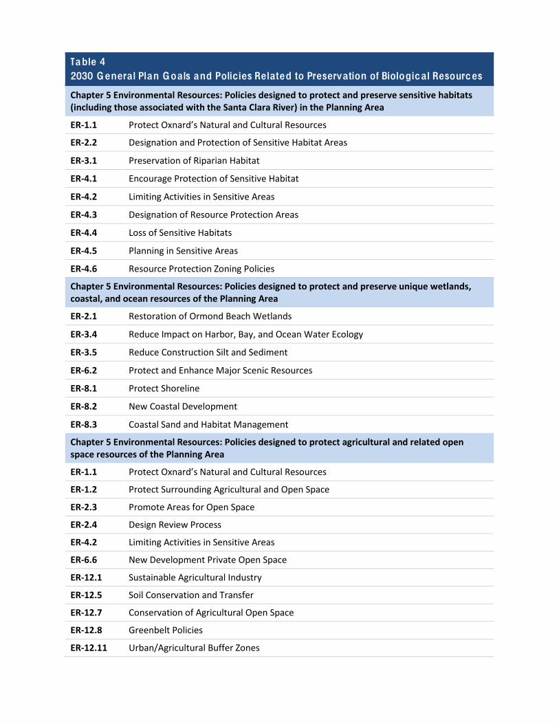
Table 4 2030 Genera l Plan Goa ls and Policies Related to Preservation of Biologica l Resources
Chapter 5 Environmental Resources: Policies designed to protect and preserve sensitive habitats (including those associated with the Santa Clara River) in the Planning Area
ER-‐1.1 Protect Oxnard’s Natural and Cultural Resources
ER-‐2.2 Designation and Protection of Sensitive Habitat Areas
ER-‐3.1 Preservation of Riparian Habitat
ER-‐4.1 Encourage Protection of Sensitive Habitat
ER-‐4.2 Limiting Activities in Sensitive Areas
ER-‐4.3 Designation of Resource Protection Areas
ER-‐4.4 Loss of Sensitive Habitats
ER-‐4.5 Planning in Sensitive Areas
ER-‐4.6 Resource Protection Zoning Policies
Chapter 5 Environmental Resources: Policies designed to protect and preserve unique wetlands, coastal, and ocean resources of the Planning Area
ER-‐2.1 Restoration of Ormond Beach Wetlands
ER-‐3.4 Reduce Impact on Harbor, Bay, and Ocean Water Ecology
ER-‐3.5 Reduce Construction Silt and Sediment
ER-‐6.2 Protect and Enhance Major Scenic Resources
ER-‐8.1 Protect Shoreline
ER-‐8.2 New Coastal Development
ER-‐8.3 Coastal Sand and Habitat Management
Chapter 5 Environmental Resources: Policies designed to protect agricultural and related open space resources of the Planning Area
ER-‐1.1 Protect Oxnard’s Natural and Cultural Resources
ER-‐1.2 Protect Surrounding Agricultural and Open Space
ER-‐2.3 Promote Areas for Open Space
ER-‐2.4 Design Review Process
ER-‐4.2 Limiting Activities in Sensitive Areas
ER-‐6.6 New Development Private Open Space
ER-‐12.1 Sustainable Agricultural Industry
ER-‐12.5 Soil Conservation and Transfer
ER-‐12.7 Conservation of Agricultural Open Space
ER-‐12.8 Greenbelt Policies
ER-‐12.11 Urban/Agricultural Buffer Zones
ER-‐12.12 Rerouting Roads and Utilities around Agricultural Areas
Chapter 5 Environmental Resources: Policies designed to mitigate the impact of development on key biological resources
ER-‐2.2 Designation and Protection of Sensitive Habitat Areas
ER-‐2.4 Design Review Process
ER-‐3.1 Preservation of Riparian Habitat
ER-‐3.2 Review of Development Proposals
ER-‐3.3 Request Mitigation Measures from Other Agencies
ER-‐3.4 Reduce Impact on Harbor, Bay, and Ocean Water Ecology
ER-‐3.5 Reduce Construction Silt and Sediment
ER-‐4.5 Planning in Sensitive Areas
ER-‐10.2 Develop Tree Management Program and Ordinance
Chapter 7 Military Compatibility
Goal MC-‐3 Mitigated and/or avoided encroachment associated with land uses and development.
MC-‐3.3 Protect Mugu and Ormond Beach Wetlands
Source: City of Oxnard 2030 General Plan Goals and Policies 2011
Table 5 2030 Genera l Plan Goa ls and Policies Related to Greenhouse G as Emissions and G loba l C limate Change
Chapter 2 Sustainable Community
Goal SC-‐1 Supporting and Participating in Global Warming and Climate Change Adaptation analysis and programs.
SC-‐1.1 Inventory and Monitor GHG Emissions
SC-‐1.2 Support Statewide Global Warming and Climate Change Mitigation
SC-‐1.3 Develop a Climate Action and Adaptation Plan (CAAP) That Supports the Regional SB 375 Sustainable Communities Strategy
Goal SC-‐2 Sea level rise is routinely considered relative to coastal areas and other City decisions, as relevant.
SC-‐2.1 Sea-‐Level Rise and Updating the Local Coastal Program
SC-‐2.2 Sea Level Monitoring System
SC-‐2.3 Sea Level Rise Consideration in Decision-‐Making
SC-‐2.4 Avoidance of Coastal Armoring or Hardening
Goal SC-‐3 Energy efficiency performance standards and generation from renewable sources.
SC-‐3.6 Targets for Zero-‐Emission Vehicles
SC-‐3.7 Renewable Energy Production Requirement
SC-‐3.9 Promote Voluntary Incentive Programs
SC-‐3.10 Alternatives to Power Plan Generation
Goal SC-‐4 Implementation of the California Green Building Code
SC-‐4.1 Green Building Code Implementation
Chapter 3 Community Development
Goal CD-‐1 A balanced community consisting of residential, commercial, and employment uses consistent with the character, capacity, and vision of the City.
CD-‐1.2 Infill Development, Priority to Mixed Use
CD-‐1.4 Transportation Choices
CD-‐1.9 Commute Reduction
Goal CD-‐5 Development of industrial uses in appropriate areas, assistance in the location of new industry, retention and expansion of existing industry, and maintenance of the City’s economic vitality.
CD-‐5.2 Compatible Land Use
CD-‐5.4 Environmentally Friendly and “Green” Industry
Goal CD-‐7 Development of vibrant mixed-‐use urban villages characterized by a mix of land uses, transit accessibility, pedestrian orientation, and neighborhood identity.
CD-‐7.1 Establishment of Urban Villages
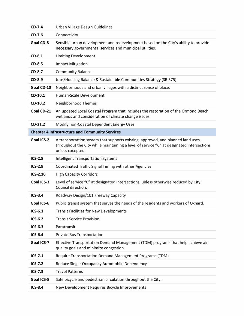
CD-‐7.4 Urban Village Design Guidelines
CD-‐7.6 Connectivity
Goal CD-‐8 Sensible urban development and redevelopment based on the City’s ability to provide necessary governmental services and municipal utilities.
CD-‐8.1 Limiting Development
CD-‐8.5 Impact Mitigation
CD-‐8.7 Community Balance
CD-‐8.9 Jobs/Housing Balance & Sustainable Communities Strategy (SB 375)
Goal CD-‐10 Neighborhoods and urban villages with a distinct sense of place.
CD-‐10.1 Human-‐Scale Development
CD-‐10.2 Neighborhood Themes
Goal CD-‐21 An updated Local Coastal Program that includes the restoration of the Ormond Beach wetlands and consideration of climate change issues.
CD-‐21.2 Modify non-‐Coastal Dependent Energy Uses
Chapter 4 Infrastructure and Community Services
Goal ICS-‐2 A transportation system that supports existing, approved, and planned land uses throughout the City while maintaining a level of service ”C” at designated intersections unless excepted.
ICS-‐2.8 Intelligent Transportation Systems
ICS-‐2.9 Coordinated Traffic Signal Timing with other Agencies
ICS-‐2.10 High Capacity Corridors
Goal ICS-‐3 Level of service “C” at designated intersections, unless otherwise reduced by City Council direction.
ICS-‐3.4 Roadway Design/101 Freeway Capacity
Goal ICS-‐6 Public transit system that serves the needs of the residents and workers of Oxnard.
ICS-‐6.1 Transit Facilities for New Developments
ICS-‐6.2 Transit Service Provision
ICS-‐6.3 Paratransit
ICS-‐6.4 Private Bus Transportation
Goal ICS-‐7 Effective Transportation Demand Management (TDM) programs that help achieve air quality goals and minimize congestion.
ICS-‐7.1 Require Transportation Demand Management Programs (TDM)
ICS-‐7.2 Reduce Single-‐Occupancy Automobile Dependency
ICS-‐7.3 Travel Patterns
Goal ICS-‐8 Safe bicycle and pedestrian circulation throughout the City.
ICS-‐8.4 New Development Requires Bicycle Improvements
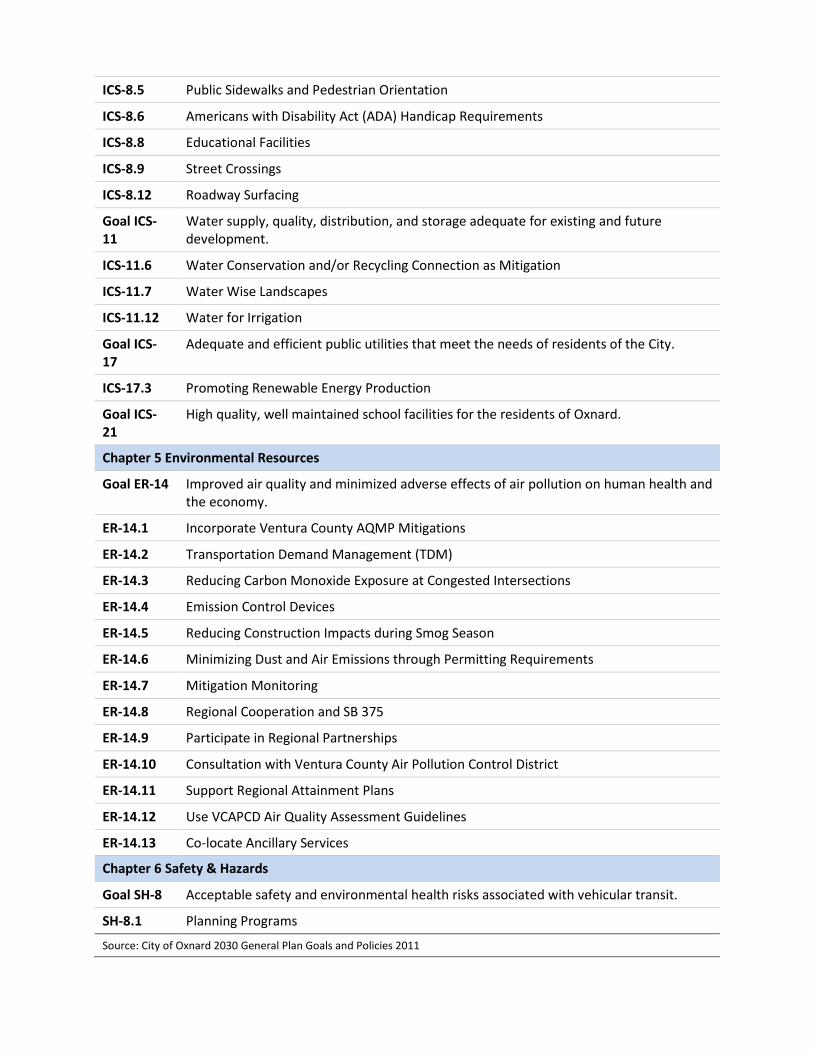
ICS-‐8.5 Public Sidewalks and Pedestrian Orientation
ICS-‐8.6 Americans with Disability Act (ADA) Handicap Requirements
ICS-‐8.8 Educational Facilities
ICS-‐8.9 Street Crossings
ICS-‐8.12 Roadway Surfacing
Goal ICS-‐11
Water supply, quality, distribution, and storage adequate for existing and future development.
ICS-‐11.6 Water Conservation and/or Recycling Connection as Mitigation
ICS-‐11.7 Water Wise Landscapes
ICS-‐11.12 Water for Irrigation
Goal ICS-‐17
Adequate and efficient public utilities that meet the needs of residents of the City.
ICS-‐17.3 Promoting Renewable Energy Production
Goal ICS-‐21
High quality, well maintained school facilities for the residents of Oxnard.
Chapter 5 Environmental Resources
Goal ER-‐14 Improved air quality and minimized adverse effects of air pollution on human health and the economy.
ER-‐14.1 Incorporate Ventura County AQMP Mitigations
ER-‐14.2 Transportation Demand Management (TDM)
ER-‐14.3 Reducing Carbon Monoxide Exposure at Congested Intersections
ER-‐14.4 Emission Control Devices
ER-‐14.5 Reducing Construction Impacts during Smog Season
ER-‐14.6 Minimizing Dust and Air Emissions through Permitting Requirements
ER-‐14.7 Mitigation Monitoring
ER-‐14.8 Regional Cooperation and SB 375
ER-‐14.9 Participate in Regional Partnerships
ER-‐14.10 Consultation with Ventura County Air Pollution Control District
ER-‐14.11 Support Regional Attainment Plans
ER-‐14.12 Use VCAPCD Air Quality Assessment Guidelines
ER-‐14.13 Co-‐locate Ancillary Services
Chapter 6 Safety & Hazards
Goal SH-‐8 Acceptable safety and environmental health risks associated with vehicular transit.
SH-‐8.1 Planning Programs
Source: City of Oxnard 2030 General Plan Goals and Policies 2011
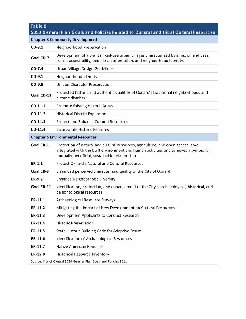
Table 6 2030 Genera l Plan Goa ls and Policies Related to Cultura l and Triba l Cultura l Resources
Chapter 3 Community Development
CD-‐3.1 Neighborhood Preservation
Goal CD-‐7 Development of vibrant mixed-‐use urban villages characterized by a mix of land uses, transit accessibility, pedestrian orientation, and neighborhood identity.
CD-‐7.4 Urban Village Design Guidelines
CD-‐9.1 Neighborhood Identity
CD-‐9.5 Unique Character Preservation
Goal CD-‐11 Protected historic and authentic qualities of Oxnard’s traditional neighborhoods and historic districts.
CD-‐11.1 Promote Existing Historic Areas
CD-‐11.2 Historical District Expansion
CD-‐11.3 Protect and Enhance Cultural Resources
CD-‐11.4 Incorporate Historic Features
Chapter 5 Environmental Resources
Goal ER-‐1 Protection of natural and cultural resources, agriculture, and open spaces is well integrated with the built environment and human activities and achieves a symbiotic, mutually-‐beneficial, sustainable relationship.
ER-‐1.1 Protect Oxnard’s Natural and Cultural Resources
Goal ER-‐9 Enhanced perceived character and quality of the City of Oxnard.
ER-‐9.2 Enhance Neighborhood Diversity
Goal ER-‐11 Identification, protection, and enhancement of the City’s archaeological, historical, and paleontological resources.
ER-‐11.1 Archaeological Resource Surveys
ER-‐11.2 Mitigating the Impact of New Development on Cultural Resources
ER-‐11.3 Development Applicants to Conduct Research
ER-‐11.4 Historic Preservation
ER-‐11.5 State Historic Building Code for Adaptive Reuse
ER-‐11.6 Identification of Archaeological Resources
ER-‐11.7 Native American Remains
ER-‐12.8 Historical Resource Inventory Source: City of Oxnard 2030 General Plan Goals and Policies 2011
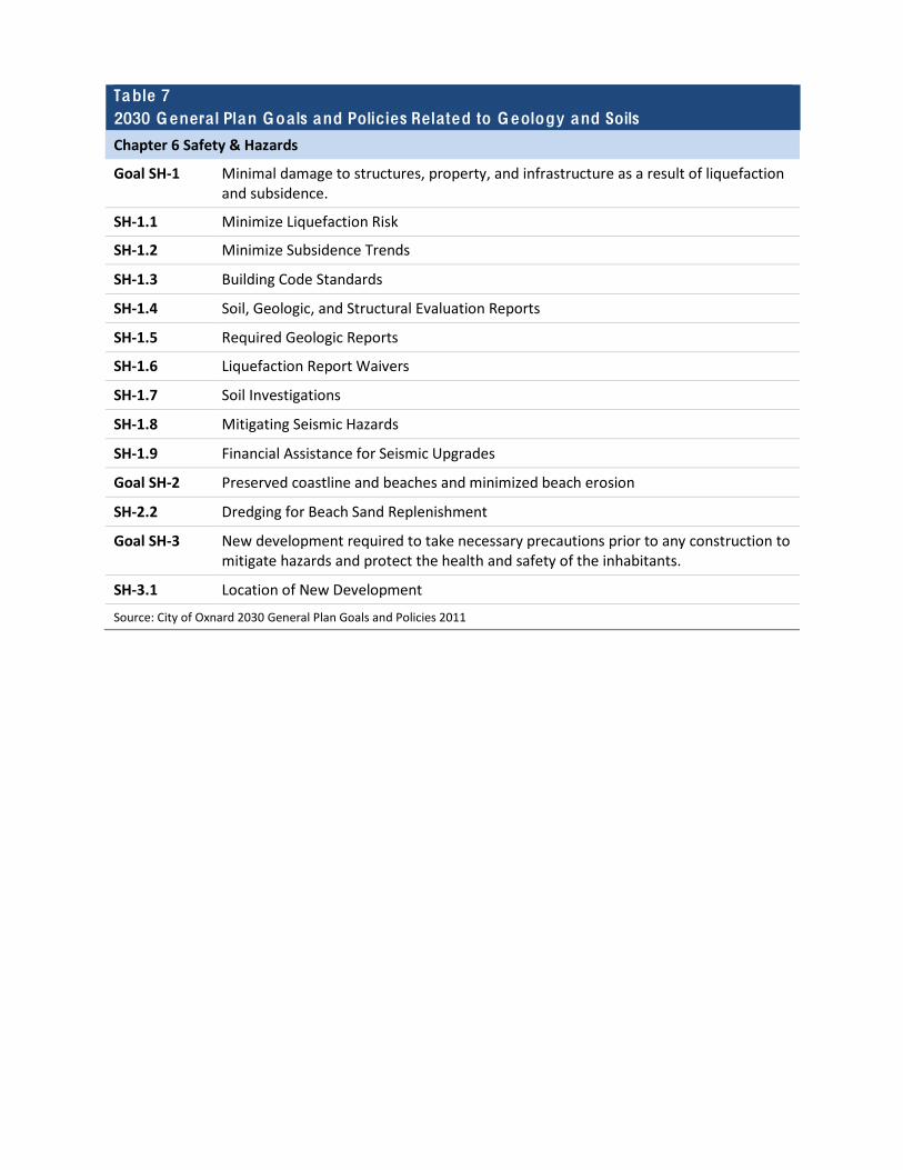
Table 7 2030 Genera l Plan Goa ls and Policies Related to Geology and Soils
Chapter 6 Safety & Hazards
Goal SH-‐1 Minimal damage to structures, property, and infrastructure as a result of liquefaction and subsidence.
SH-‐1.1 Minimize Liquefaction Risk
SH-‐1.2 Minimize Subsidence Trends
SH-‐1.3 Building Code Standards
SH-‐1.4 Soil, Geologic, and Structural Evaluation Reports
SH-‐1.5 Required Geologic Reports
SH-‐1.6 Liquefaction Report Waivers
SH-‐1.7 Soil Investigations
SH-‐1.8 Mitigating Seismic Hazards
SH-‐1.9 Financial Assistance for Seismic Upgrades
Goal SH-‐2 Preserved coastline and beaches and minimized beach erosion
SH-‐2.2 Dredging for Beach Sand Replenishment
Goal SH-‐3 New development required to take necessary precautions prior to any construction to mitigate hazards and protect the health and safety of the inhabitants.
SH-‐3.1 Location of New Development
Source: City of Oxnard 2030 General Plan Goals and Policies 2011
Table 8 2030 Genera l Plan Goa ls and Policies Related to Hazards and Hazardous Materials
Chapter 3 Community Development
Goal CD-‐5 Development of industrial uses in appropriate areas, assistance in the location of new industry, retention and expansion of existing industry, and maintenance of the City’s economic vitality.
CD-‐5.4 Environmentally Friendly and “Green” Industry
Chapter 4 Infrastructure and Community Services
Goal ICS-‐15 Managed development adjacent to closed landfill areas that mitigate health and safety hazards.
ICS-‐15.1 Environmental and Health Impacts of Closed Landfills
ICS-‐15.2 Avoiding Sensitive Land Uses in Areas Adjacent to Landfills
ICS-‐15.3 Development Near Bailard Landfill
Goal ICS-‐16 Residents and property protected from the use, transport, and disposal of hazardous materials.
ICS-‐16.1 Underground Storage Program
ICS-‐16.2 Hazardous Waste Audits
ICS-‐16.3 Recycling of Hazardous Materials
Goal ICS-‐21 High quality, well maintained school facilities for the residents of Oxnard.
ICS-‐21.7 Buffer Areas Around Schools
Chapter 6 Safety & Hazards
Goal SH-‐4 Emergency preparedness through the provision of adequate fire and police protection, infrastructure, emergency supply stockpiling, public education, EOC planning and procedures, and outreach programs.
SH-‐4.4 Location of Private Emergency Response Facilities
SH-‐4.6 Access and Evacuation Corridors
SH-‐4.7 Infrastructure Homeland Security Programs
SH-‐4.8 Hazard Awareness and Preparedness Education
Goal SH-‐7 Minimized risk associated with the transport distribution, use, and storage of hazardous materials.
SH-‐7.1 Hazardous Waste Minimization Audit Requirements
SH-‐7.2 Handling of Hazardous Materials
SH-‐7.3 Designated Hazardous Materials Routes
SH-‐7.4 Limiting High Risk Land Uses
SH-‐7.5 Implementing the Ventura County Hazardous Waste Management Plan
SH-‐7.6 Attraction/Retention of Clean Industries
SH-‐7.7 Increase Public Awareness

SH-‐7.9 Sensitive Land Use Planning
SH-‐7.10 Establishment of Hazardous Waste Facility
SH-‐7.12 Hazardous Materials Studies
Source: City of Oxnard 2030 General Plan Goals and Policies 2011
Table 9 2030 Genera l Plan Goa ls and Policies Related to Hydrology and Water Qua lity
Chapter 3 Community Development
Goal CD-‐5 Development of industrial uses in appropriate areas, assistance in the location of new industry, retention and expansion of existing industry, and maintenance of the City’s economic vitality.
CD-‐5.3 Available Services
Goal CD-‐8 Sensible urban development and redevelopment based on the City’s ability to provide necessary governmental services and municipal utilities.
CD-‐8.10 Timing of Large-‐Scale Development
Goal CD-‐16 Coordinated land use and infrastructure decisions with economic development.
CD-‐16.4 Evaluate Fiscal Impacts
Chapter 4 Infrastructure and Community Services
Goal ICS-‐1 Provision of adequate facilities and services that maintain service levels, with adequate funding.
ICS-‐1.1 Maintain Existing Service Levels
ICS-‐1.2 Development Impacts to Existing Infrastructure
ICS-‐1.4 Infrastructure Conditions of Approval
Goal ICS-‐11 Water supply, quality, distribution, and storage adequate for existing and future development.
ICS-‐11.5 Sustainability of Groundwater Supply
ICS-‐11.8 Channel Islands Harbor and Offshore Water Quality
ICS-‐11.9 Groundwater Extractions
ICS-‐11.11 Water Quality
ICS-‐11.13 Water Neutral Policy and Urban Water Management Plans
Goal ICS-‐12 Adequate capacity at the City Waste Water Treatment Plant to accommodate existing and future development.
ICS-‐12.3 Wastewater Discharge Monitoring
ICS-‐12.4 Wastewater Discharge
ICS-‐12.5 Sedimentation Control
Goal ICS-‐13 Adequately sized storm drain systems and discharge treatment, certified levees, and implementation of appropriate National Pollutant Discharge Elimination System (NPDES) permits and regulations.
ICS-‐13.1 100-‐year Floodplain
ICS-‐13.2 Adequate Storm Drains and NPDES Discharge Treatment
ICS-‐13.3 Stormwater Detention Basins
ICS-‐13.4 Low Impact Development
Chapter 5 Environmental Resources
Goal ER-‐5 Well managed water supply and wastewater treatment programs that together meet expected demand, prevent groundwater overdraft, and ensure water quality.
ER-‐5.1 Wastewater Treatment
ER-‐5.2 208 Wastewater Control Plan
ER-‐5.3 Reducing Dependence of Groundwater
ER-‐5.4 Wastewater Monitoring
ER-‐5.6 208 Groundwater Plan
ER-‐5.7 Minimizing Paved Surfaces
Chapter 6 Safety & Hazards
Goal SH-‐1 Minimal damage to structures, property, and infrastructure as a result of liquefaction and subsidence.
SH-‐1.2 Minimize Subsidence Trends
Goal SH-‐3 New development required to take necessary precautions prior to any construction to mitigate hazards and protect the health and safety of the inhabitants.
SH-‐3.1 Location of New Development
SH-‐3.2 New Development Flood Mitigation
SH-‐3.3 Updating Flood Insurance Rate Maps
SH-‐3.4 Avoiding Blockage of Natural Drainage
Source: City of Oxnard 2030 General Plan Goals and Policies 2011
Table 10 2030 Genera l Plan Goa ls and Policies Related to Land Use and Planning
Chapter 3 Community Development
Goal CD-‐1 A balanced community consisting of residential, commercial, and employment uses consistent with the character, capacity, and vision of the City.
CD-‐1.2 Infill Development, Priority to Mixed Use
CD-‐1.3 Redevelopment to Mixed Use
CD-‐1.4 Transportation Choices
CD-‐1.5 Housing Variety
CD-‐1.6 Public Facilities
CD-‐1.7 Compact Development
CD-‐1.8 Natural Resource Conservation
CD-‐1.9 Commute Reduction
CD-‐1.10 Jobs-‐Housing Balance
CD-‐1.12 Avoiding Encroaching the Oxnard Airport
Goal CD-‐3 A city of stable, safe, attractive, and revitalized neighborhoods with adequate parks, schools, infrastructure, and community identity and pride.
CD-‐3.1 Neighborhood Preservation
CD-‐3.2 Encourage Planned Development Code Previsions for Revitalization
CD-‐3.3 Innovative Redevelopment
CD-‐3.6 Barrier-‐Free Housing and Reasonable Accommodation
CD-‐3.7 Senior In-‐Place Housing Opportunities
Goal CD-‐4 Commercial uses compatible with surrounding land uses to meet the present and future needs of Oxnard residents, employees, and visitors.
CD-‐4.1 Mitigate Land Use Conflicts
CD-‐4.2 Commercial Revitalization and Redevelopment
CD-‐4.3 Urban Village Program and Height Overlay
CD-‐4.4 Commercial Area Aesthetics
CD-‐4.5 Commercial Signage
Goal CD-‐5 Development of industrial uses in appropriate areas, assistance in the location of new industry, retention and expansion of existing industry, and maintenance of the City’s economic vitality.
CD-‐5.1 Industrial Clustering
CD-‐5.2 Compatible Land Use
CD-‐5.3 Available Services
CD-‐5.4 Environmentally Friendly and “Green” Industry
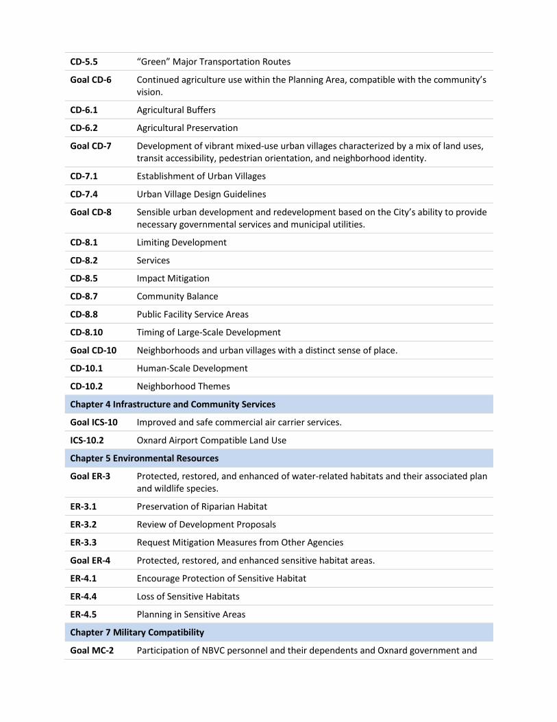
CD-‐5.5 “Green” Major Transportation Routes
Goal CD-‐6 Continued agriculture use within the Planning Area, compatible with the community’s vision.
CD-‐6.1 Agricultural Buffers
CD-‐6.2 Agricultural Preservation
Goal CD-‐7 Development of vibrant mixed-‐use urban villages characterized by a mix of land uses, transit accessibility, pedestrian orientation, and neighborhood identity.
CD-‐7.1 Establishment of Urban Villages
CD-‐7.4 Urban Village Design Guidelines
Goal CD-‐8 Sensible urban development and redevelopment based on the City’s ability to provide necessary governmental services and municipal utilities.
CD-‐8.1 Limiting Development
CD-‐8.2 Services
CD-‐8.5 Impact Mitigation
CD-‐8.7 Community Balance
CD-‐8.8 Public Facility Service Areas
CD-‐8.10 Timing of Large-‐Scale Development
Goal CD-‐10 Neighborhoods and urban villages with a distinct sense of place.
CD-‐10.1 Human-‐Scale Development
CD-‐10.2 Neighborhood Themes
Chapter 4 Infrastructure and Community Services
Goal ICS-‐10 Improved and safe commercial air carrier services.
ICS-‐10.2 Oxnard Airport Compatible Land Use
Chapter 5 Environmental Resources
Goal ER-‐3 Protected, restored, and enhanced of water-‐related habitats and their associated plan and wildlife species.
ER-‐3.1 Preservation of Riparian Habitat
ER-‐3.2 Review of Development Proposals
ER-‐3.3 Request Mitigation Measures from Other Agencies
Goal ER-‐4 Protected, restored, and enhanced sensitive habitat areas.
ER-‐4.1 Encourage Protection of Sensitive Habitat
ER-‐4.4 Loss of Sensitive Habitats
ER-‐4.5 Planning in Sensitive Areas
Chapter 7 Military Compatibility
Goal MC-‐2 Participation of NBVC personnel and their dependents and Oxnard government and
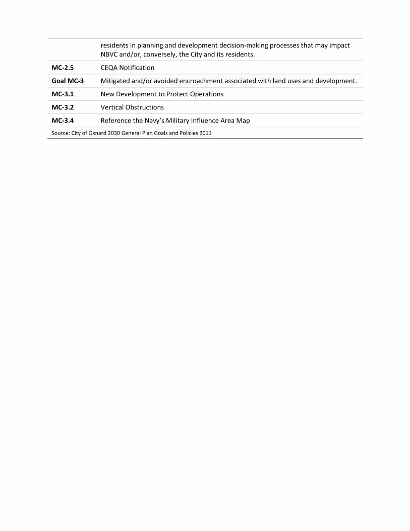
residents in planning and development decision-‐making processes that may impact NBVC and/or, conversely, the City and its residents.
MC-‐2.5 CEQA Notification
Goal MC-‐3 Mitigated and/or avoided encroachment associated with land uses and development.
MC-‐3.1 New Development to Protect Operations
MC-‐3.2 Vertical Obstructions
MC-‐3.4 Reference the Navy’s Military Influence Area Map
Source: City of Oxnard 2030 General Plan Goals and Policies 2011
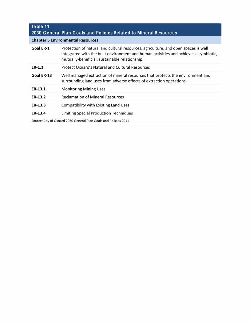
Table 11 2030 Genera l Plan Goa ls and Policies Related to Minera l Resources
Chapter 5 Environmental Resources
Goal ER-‐1 Protection of natural and cultural resources, agriculture, and open spaces is well integrated with the built environment and human activities and achieves a symbiotic, mutually-‐beneficial, sustainable relationship.
ER-‐1.1 Protect Oxnard’s Natural and Cultural Resources
Goal ER-‐13 Well managed extraction of mineral resources that protects the environment and surrounding land uses from adverse effects of extraction operations.
ER-‐13.1 Monitoring Mining Uses
ER-‐13.2 Reclamation of Mineral Resources
ER-‐13.3 Compatibility with Existing Land Uses
ER-‐13.4 Limiting Special Production Techniques
Source: City of Oxnard 2030 General Plan Goals and Policies 2011
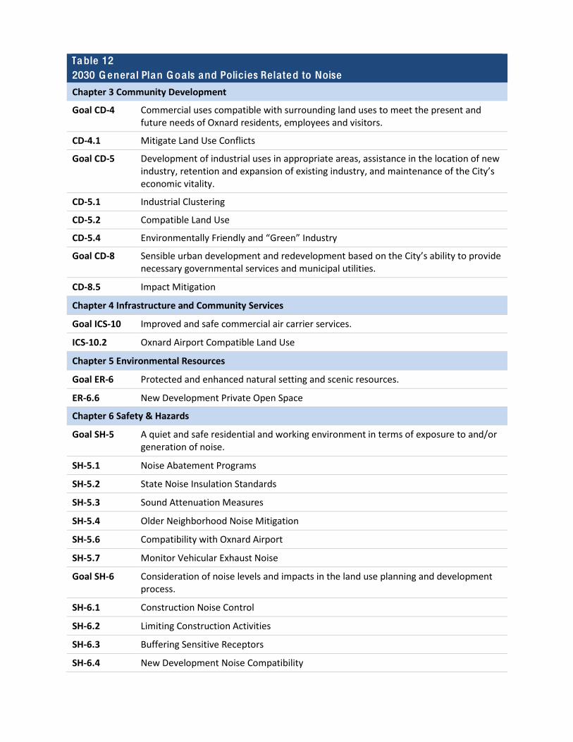
Table 12 2030 Genera l Plan Goa ls and Policies Related to Noise
Chapter 3 Community Development
Goal CD-‐4 Commercial uses compatible with surrounding land uses to meet the present and future needs of Oxnard residents, employees and visitors.
CD-‐4.1 Mitigate Land Use Conflicts
Goal CD-‐5 Development of industrial uses in appropriate areas, assistance in the location of new industry, retention and expansion of existing industry, and maintenance of the City’s economic vitality.
CD-‐5.1 Industrial Clustering
CD-‐5.2 Compatible Land Use
CD-‐5.4 Environmentally Friendly and “Green” Industry
Goal CD-‐8 Sensible urban development and redevelopment based on the City’s ability to provide necessary governmental services and municipal utilities.
CD-‐8.5 Impact Mitigation
Chapter 4 Infrastructure and Community Services
Goal ICS-‐10 Improved and safe commercial air carrier services.
ICS-‐10.2 Oxnard Airport Compatible Land Use
Chapter 5 Environmental Resources
Goal ER-‐6 Protected and enhanced natural setting and scenic resources.
ER-‐6.6 New Development Private Open Space
Chapter 6 Safety & Hazards
Goal SH-‐5 A quiet and safe residential and working environment in terms of exposure to and/or generation of noise.
SH-‐5.1 Noise Abatement Programs
SH-‐5.2 State Noise Insulation Standards
SH-‐5.3 Sound Attenuation Measures
SH-‐5.4 Older Neighborhood Noise Mitigation
SH-‐5.6 Compatibility with Oxnard Airport
SH-‐5.7 Monitor Vehicular Exhaust Noise
Goal SH-‐6 Consideration of noise levels and impacts in the land use planning and development process.
SH-‐6.1 Construction Noise Control
SH-‐6.2 Limiting Construction Activities
SH-‐6.3 Buffering Sensitive Receptors
SH-‐6.4 New Development Noise Compatibility
SH-‐6.5 Land Use Compatibility with Noise
SH-‐6.6 Locating Education Institutions to Avoid Noise Disruption
SH-‐6.7 Peak Noise Evaluation along Truck Routes
SH-‐6.8 Noise Contour Maps
SH-‐6.9 Minimize Noise Exposure to Sensitive Receptors
SH-‐6.10 Point Mugu NAS (Naval Base, Ventura County at Point Mugu) Awareness
SH-‐6.11 Exceptions to Noise Standards
SH-‐6.12 Development Near Railroads and Oxnard Airport
SH-‐6.13 Noise Acceptable for Open Windows and Patios
Goal SH-‐8 Acceptable safety and environmental health risks associated with vehicular transit.
SH-‐8.3 New Roadways and Expanding Existing Streets
Chapter 7 Military Compatibility
Goal MC-‐2 Participation of NBVC personnel and their dependents and Oxnard government and residents in planning and development decision-‐making processes that may impact NBVC and/or, conversely, the City and its residents.
MC-‐2.3 Development Permitting Process
Goal MC-‐3 Mitigated and/or avoided encroachment associated with land uses and development.
MC-‐3.4 Reference the Navy’s Military Influence Area Map
Source: City of Oxnard 2030 General Plan Goals and Policies 2011
Table 13 2030 Genera l Plan Goa ls and Policies Related to Population Growth, Education, and Housing
Chapter 3 Community Development
Goal CD-‐1 A balanced community consisting of residential, commercial, and employment uses consistent with the character, capacity, and vision of the City.
CD-‐1.5 Housing Variety
CD-‐1.10 Jobs-‐Housing Balance
Goal CD-‐3 A city of stable, safe, attractive, and revitalized neighborhoods with adequate parks, schools, infrastructure, and community identity and pride.
CD-‐3.1 Neighborhood Preservation
CD-‐3.2 Encourage Planned Development Code Provisions for Revitalization
CD-‐3.3 Innovative Redevelopment
Goal CD-‐4 Commercial uses compatible with surrounding land uses to meet the present and future needs of Oxnard residents, employees, and visitors.
CD-‐4.2 Commercial Revitalization and Redevelopment
Goal CD-‐5 Development of vibrant mixed-‐use urban villages characterized by a mix of land uses, transit accessibility, pedestrian orientation, and neighborhood identity.
CD-‐7.1 Establishment of Urban Villages
CD-‐7.4 Urban Village Design Guidelines
Goal CD-‐9 A high quality visual image and perception of the City.
CD-‐9.1 Neighborhood Identity
CD-‐9.6 High Rise Development
Chapter 4 Infrastructure and Community Service
Goal ICS-‐21 High quality, well maintained school facilities for the residents of Oxnard.
ICS-‐21.1 Accommodating City Growth
ICS-‐21.2 Development Fees
ICS-‐21.3 Siting of Schools
ICS-‐21.4 Mitigation of Impacts
ICS-‐21.5 Expansion of Existing Facilities
ICS-‐21.6 Monitor Enrollment Needs
Chapter 7 Military Compatibility
Goal MC-‐4 Continued active status for NBVC should another Base Closure and Realignment Commission (BRAC) be established.
MC-‐4.4 Affordable Housing
Note: See Chapter 8 of the 2030 Oxnard General Plan for the Housing Element, including applicable goals and policies.
Source: City of Oxnard 2030 General Plan Goals and Policies 2011
Table 14 2030 Genera l Plan Goa ls and Policies Related to Public Services and Recreation
Chapter 3 Community Development
Goal CD-‐1 A balanced community consisting of residential, commercial, and employment uses consistent with the character, capacity, and vision of the City.
CD-‐1.6 Public Facilities
CD-‐1.8 Natural Resource Conservation
CD-‐1.11 Recreation Opportunities
Goal CD-‐4 Commercial uses compatible with surrounding land uses to meet the present and future needs of Oxnard residents, employees, and visitors.
CD-‐4.1 Mitigate Land Use Conflicts
Goal CD-‐7 Development of vibrant mixed-‐use urban villages characterized by a mix of land uses, transit accessibility, pedestrian orientation, and neighborhood identity.
CD-‐7.12 Urban Village Collocation with Schools
CD-‐7.13 Urban Village Trial and Open Space Connections
Goal CD-‐8 Sensible urban development and redevelopment based on the City’s ability to provide necessary governmental services and municipal utilities.
CD-‐8.2 Services
CD-‐8.8 Public Facility Service Areas
Goal CD-‐15 A strong economic and fiscal base critical to sustaining long-‐term prosperity for Oxnard residents and businesses.
CD-‐15.1 Quality of Life
Chapter 4 Infrastructure and Community Service
Goal ICS-‐1 Provision of adequate facilities and services that maintain service levels, with adequate funding.
ICS-‐1.1 Maintain Existing Service Levels
ICS-‐1.2 Development Impacts to Existing Infrastructure
ICS-‐1.3 Funding for Public Facilities
ICS-‐1.4 Infrastructure Conditions of Approval
Goal ICS-‐13 Adequately sized storm drain systems and discharge treatment, certified levees, and implementation of appropriate National Pollutant Discharge Elimination System (NPDES) permits and regulations.
ICS-‐13.1 100-‐year Floodplain
ICS-‐13.3 Stormwater Detention Basins
Goal ICS-‐19 Adequate and effective law enforcement and the incorporation of crime prevention features in developments.
ICS-‐19.1 Additional and/or Enlarged Police Facilities
ICS-‐19.2 Police Review of Development Projects

ICS-‐19.4 Crime Prevention Device Requirements
ICS-‐19.5 Incorporating Security Design Principles
ICS-‐19.7 New Development
ICS-‐19.8 Response Time
Goal ICS-‐20 Protected public through effective fire prevention services and the incorporation of fire safety features in new development.
ICS-‐20.1 Fire Response Time
ICS-‐20.2 Provision of Fire Station Facilities and Equipment
ICS-‐20.3 Commercial and Industrial Sprinkler Requirements
ICS-‐20.4 Fire Prevention Mitigation Fee
ICS-‐20.5 Fire Services to New Development
ICS-‐20.7 Adherence to City Standards
ICS-‐20.8 Development Review
Goal ICS-‐22 A full service, high quality public library system.
ICS-‐22.3 Expansion of Library Services
Goal ICS-‐23 A full range of recreational facilities and services accessible to all Oxnard residents, workers, and visitors.
ICS-‐23.1 City Park and Recreation Standards
ICS-‐23.3 Identifying Additional Parklands
ICS-‐23.4 Collocation of Parks and Schools
ICS-‐23.8 Buffering Neighborhood Parks
ICS-‐23.9 Regional Park Accessibility
ICS-‐23.10 Park Siting and Design to Maximize Security
Goal ICS-‐24 Optimized public investment in parks and recreation by reduced costs and funding alternatives.
ICS-‐24.3 Review Quimby Fee Formula
Chapter 5 Environmental Resources
Goal ER-‐2 Maintenance and enhancement of natural resources and open space.
ER-‐2.3 Promote Areas for Open Space
Goal ER-‐4 Protected, restored, and enhanced sensitive habitat areas.
ER-‐4.2 Limiting Activities in Sensitive Areas
Goal ER-‐12 A viable agricultural industry, maintained and enhanced soil resources, reduced erosion, and improved agricultural productivity.
ER-‐12.11 Urban/Agricultural Buffer Zones
Chapter 6 Safety & Hazards
Goal SH-‐4 Emergency preparedness through the provision of adequate fire and police

protection, infrastructure, emergency supply stockpiling, public education, EOC planning and procedures, and outreach programs.
Source: City of Oxnard 2030 General Plan Goals and Policies 2011
Table 15 2030 Genera l Plan Goa ls and Policies Related to C irculation, Traffic, and Transportation
Chapter 3 Community Development
Goal CD-‐1 A balanced community consisting of residential, commercial, and employment uses consistent with the character, capacity, and vision of the City.
CD-‐1.4 Transportation Choices
Goal CD-‐5 Development of industrial uses in appropriate areas, assistance in the location of new industry, retention and expansion of existing industry, and maintenance of the City’s economic vitality.
CD-‐5.3 Available Services
CD-‐5.5 “Green” Major Transportation Routes
Goal CD-‐7 Development of vibrant mixed-‐use urban villages characterized by a mix of land uses, transit accessibility, pedestrian orientation, and neighborhood identity.
CD-‐7.4 Urban Village Design Guidelines
CD-‐7.5 Pedestrian and Transit Scale
CD-‐7.6 Connectivity
CD-‐7.7 Urban Village Streetscapes and Identification
CD-‐7.8 Road Design
Goal CD-‐8 Sensible urban development and redevelopment based on the City’s ability to provide necessary governmental services and municipal utilities.
CD-‐8.1 Limiting Development
CD-‐8.5 Impact Mitigation
Chapter 4 Infrastructure and Community Services
Goal ICS-‐1 Provision of adequate facilities and services that maintain service levels, with adequate funding.
ICS-‐1.1 Maintain Existing Service Levels
ICS-‐1.2 Development Impacts to Existing Infrastructure
ICS-‐1.3 Funding for Public Facilities
ICS-‐1.4 Infrastructure Conditions of Approval
Goal ICS-‐2 A transportation system that supports existing, approved, and planned land uses throughout the City while maintaining a level of service ”C” at designated intersections unless excepted.
ICS-‐2.1 Coordinate with Regional Transportation Planning
ICS-‐2.2 Improved Port of Hueneme Access
ICS-‐2.5 Mitigated Impacts on County Roads
ICS-‐2.6 Reduction of Construction Impacts
ICS-‐2.7 Consistent Roadway Signage
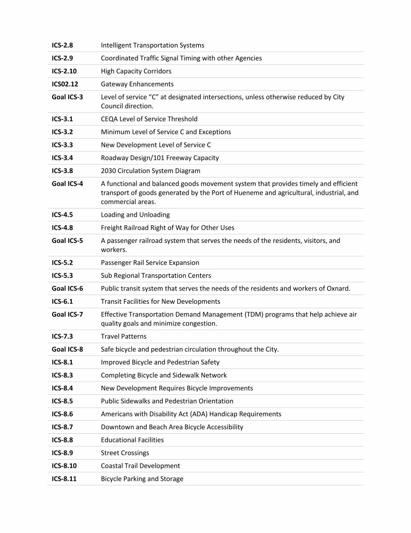
ICS-‐2.8 Intelligent Transportation Systems
ICS-‐2.9 Coordinated Traffic Signal Timing with other Agencies
ICS-‐2.10 High Capacity Corridors
ICS02.12 Gateway Enhancements
Goal ICS-‐3 Level of service “C” at designated intersections, unless otherwise reduced by City Council direction.
ICS-‐3.1 CEQA Level of Service Threshold
ICS-‐3.2 Minimum Level of Service C and Exceptions
ICS-‐3.3 New Development Level of Service C
ICS-‐3.4 Roadway Design/101 Freeway Capacity
ICS-‐3.8 2030 Circulation System Diagram
Goal ICS-‐4 A functional and balanced goods movement system that provides timely and efficient transport of goods generated by the Port of Hueneme and agricultural, industrial, and commercial areas.
ICS-‐4.5 Loading and Unloading
ICS-‐4.8 Freight Railroad Right of Way for Other Uses
Goal ICS-‐5 A passenger railroad system that serves the needs of the residents, visitors, and workers.
ICS-‐5.2 Passenger Rail Service Expansion
ICS-‐5.3 Sub Regional Transportation Centers
Goal ICS-‐6 Public transit system that serves the needs of the residents and workers of Oxnard.
ICS-‐6.1 Transit Facilities for New Developments
Goal ICS-‐7 Effective Transportation Demand Management (TDM) programs that help achieve air quality goals and minimize congestion.
ICS-‐7.3 Travel Patterns
Goal ICS-‐8 Safe bicycle and pedestrian circulation throughout the City.
ICS-‐8.1 Improved Bicycle and Pedestrian Safety
ICS-‐8.3 Completing Bicycle and Sidewalk Network
ICS-‐8.4 New Development Requires Bicycle Improvements
ICS-‐8.5 Public Sidewalks and Pedestrian Orientation
ICS-‐8.6 Americans with Disability Act (ADA) Handicap Requirements
ICS-‐8.7 Downtown and Beach Area Bicycle Accessibility
ICS-‐8.8 Educational Facilities
ICS-‐8.9 Street Crossings
ICS-‐8.10 Coastal Trail Development
ICS-‐8.11 Bicycle Parking and Storage
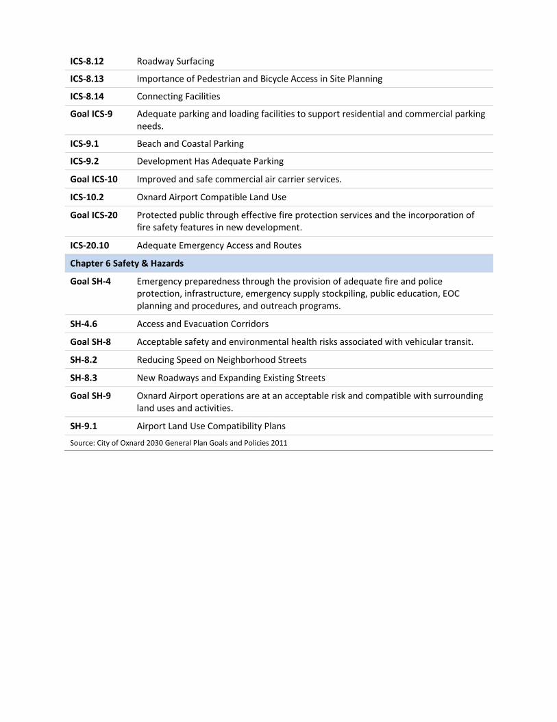
ICS-‐8.12 Roadway Surfacing
ICS-‐8.13 Importance of Pedestrian and Bicycle Access in Site Planning
ICS-‐8.14 Connecting Facilities
Goal ICS-‐9 Adequate parking and loading facilities to support residential and commercial parking needs.
ICS-‐9.1 Beach and Coastal Parking
ICS-‐9.2 Development Has Adequate Parking
Goal ICS-‐10 Improved and safe commercial air carrier services.
ICS-‐10.2 Oxnard Airport Compatible Land Use
Goal ICS-‐20 Protected public through effective fire protection services and the incorporation of fire safety features in new development.
ICS-‐20.10 Adequate Emergency Access and Routes
Chapter 6 Safety & Hazards
Goal SH-‐4 Emergency preparedness through the provision of adequate fire and police protection, infrastructure, emergency supply stockpiling, public education, EOC planning and procedures, and outreach programs.
SH-‐4.6 Access and Evacuation Corridors
Goal SH-‐8 Acceptable safety and environmental health risks associated with vehicular transit.
SH-‐8.2 Reducing Speed on Neighborhood Streets
SH-‐8.3 New Roadways and Expanding Existing Streets
Goal SH-‐9 Oxnard Airport operations are at an acceptable risk and compatible with surrounding land uses and activities.
SH-‐9.1 Airport Land Use Compatibility Plans
Source: City of Oxnard 2030 General Plan Goals and Policies 2011
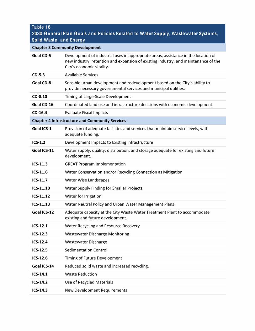
Table 16 2030 Genera l Plan Goa ls and Policies Related to Water Supply, Wastewater Systems, Solid Waste, and Energy
Chapter 3 Community Development
Goal CD-‐5 Development of industrial uses in appropriate areas, assistance in the location of new industry, retention and expansion of existing industry, and maintenance of the City’s economic vitality.
CD-‐5.3 Available Services
Goal CD-‐8 Sensible urban development and redevelopment based on the City’s ability to provide necessary governmental services and municipal utilities.
CD-‐8.10 Timing of Large-‐Scale Development
Goal CD-‐16 Coordinated land use and infrastructure decisions with economic development.
CD-‐16.4 Evaluate Fiscal Impacts
Chapter 4 Infrastructure and Community Services
Goal ICS-‐1 Provision of adequate facilities and services that maintain service levels, with adequate funding.
ICS-‐1.2 Development Impacts to Existing Infrastructure
Goal ICS-‐11 Water supply, quality, distribution, and storage adequate for existing and future development.
ICS-‐11.3 GREAT Program Implementation
ICS-‐11.6 Water Conservation and/or Recycling Connection as Mitigation
ICS-‐11.7 Water Wise Landscapes
ICS-‐11.10 Water Supply Finding for Smaller Projects
ICS-‐11.12 Water for Irrigation
ICS-‐11.13 Water Neutral Policy and Urban Water Management Plans
Goal ICS-‐12 Adequate capacity at the City Waste Water Treatment Plant to accommodate existing and future development.
ICS-‐12.1 Water Recycling and Resource Recovery
ICS-‐12.3 Wastewater Discharge Monitoring
ICS-‐12.4 Wastewater Discharge
ICS-‐12.5 Sedimentation Control
ICS-‐12.6 Timing of Future Development
Goal ICS-‐14 Reduced solid waste and increased recycling.
ICS-‐14.1 Waste Reduction
ICS-‐14.2 Use of Recycled Materials
ICS-‐14.3 New Development Requirements
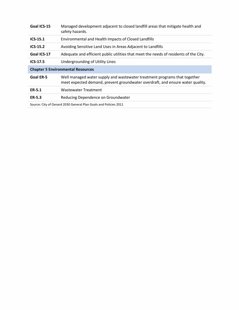
Goal ICS-‐15 Managed development adjacent to closed landfill areas that mitigate health and safety hazards.
ICS-‐15.1 Environmental and Health Impacts of Closed Landfills
ICS-‐15.2 Avoiding Sensitive Land Uses in Areas Adjacent to Landfills
Goal ICS-‐17 Adequate and efficient public utilities that meet the needs of residents of the City.
ICS-‐17.5 Undergrounding of Utility Lines
Chapter 5 Environmental Resources
Goal ER-‐5 Well managed water supply and wastewater treatment programs that together meet expected demand, prevent groundwater overdraft, and ensure water quality.
ER-‐5.1 Wastewater Treatment
ER-‐5.3 Reducing Dependence on Groundwater Source: City of Oxnard 2030 General Plan Goals and Policies 2011