ATOU RESEARCH BULLETIN The Hydrology of the Northern Marshall Ted
18
ATOU RESEARCH BULLETIN The Hydrology of the Northern Marshall Islands Ted Arnow Issued by THE PACIFIC SCIENCE BOARD National Academy of Sciences-National Research Council Washington, D. C. May 31, 1954
Transcript of ATOU RESEARCH BULLETIN The Hydrology of the Northern Marshall Ted

ATOU RESEARCH BULLETIN
The Hydrology of the Northern Marshall Islands
Ted Arnow
Issued by
THE PACIFIC SCIENCE BOARD
National Academy of Sciences-National Research Council
Washington, D. C.
May 31, 1954

Page
Introduction . . . . . . . . . . . . . . . . . . . . . . . . . 1 . . . . . . . . . . . . . . .
Climate . . . . . . . . . . . . . . . . . . . . . . . . . . . 1 General statement . . . . . . . . . . . . . . . . . . 1 S t a t i s t i c a l data . . . . 1 . . . . . . . . . . . . . . 2
. . .. ~ Tides . . . . . . . . . . . . . . . . . , . . . . : . . . . . . 2
RaterSupply . . . . . . . . . . . . . . . . . . . . . . . . 2 Rain water . . . . . . . . . . . . . . . . . . . . . . . 2 . . . . . . . . . . . . . . . . . . . . . Ground water 3
. . . . . . Physical nature . . . . : . . . . . . . . . . . . 2 Qual i ty of water . . . . . . . . . . . . . . . . 5 . . . . . . . . . . . . . . . . . . . . . . Use 6
R e f e r e n c e s . . . . . . . . . . . . . . . . . . . . . . . . . 7
ILLUSTRATIONS
Figure 1. Ou%line map of the hkrshall Islands 2. Variation of r a i n f a l l with l a t i t u d e i n the Marshall
Islands 3. Relation of t o t a l hardness and calcium hardness t o
distance from shoreline i n the ground ~ !a t e r of Ailuk Island, Ailuk Atoll, Marshall Islands
. Relation of t o t a l hardness and calcium hardness to distance from shoreline in the ground water of Lae Island, Lee Atoll , Marshell Islands
5. Relation of chloride content to distance from shore- l i n e i n the ground water of A3luk Island, Ailuk Atoll, and Lae Island, Lae Atoll, Marshall Islands
6 . Histogram of 50 pH determinations of ground mater in the Marshall Is lands
TABLES
Table 1. Comparative precipi ta t ion data for Eniwetok, Ujelang, and Kwajalein Atolls , Marshall Islands
2. Comparison of t i d a l f luctuations i n the ocean and i n the ground-water l ens of four is lands in the northern Marshall Islands
3. Chemical analyses of mater from selected wells i n the northern Marshall Islands

THE HYDROLOGY OF THE NORTHERN EARSHALL ISLANDS .1/ BY
Ted Arnow
INTRODUCTION
The f i e l d work on which t h i s paper i s based was carr ied out in conjunction with an engineering survey of the northern Marshall Islands d b y the 71.st f igi- neering Survey Liaison Detachment, General Headquarters, Far East Command. The hydrologic studies, which were made by th.e U . S. Geological Survey, were p a r t of a comprehensive investigation of a t o l l features. The f i e l d work was done i n December 1951 and January, February, and August, 1952 during which time the following a t o l l s were vis i ted: Utirik, Taka, Likiep, Ailuk, Lae, Kwajalein, Ujelang, notho, Ujae, Taongi, and Bikar ( f ig . 1). An average of 4 working da.ys was spent a t each a t o l l . The author wishes t o acknowledge the assistance of the Narshallese guides and well diggers who aided in col lect ing ground-water data. In par t icular he wishes t o express appreciation t o h i s colleagues F. S. MacNeil and F. R. Fosberg, who collected water samples on Utir ik and Likiep, and C. G. Johnson, who collected water samples on Taongi and Bikar. The author did not v i s i t Likiep, Taongi, o r Bikar. Groundwater data f o r Eniwetok Atoll were furnished by Harry Ladd of the Geological Survey. Appreciation i s expressed also t o Dan A. Davis, d i s t r i c t geologist of the Ground Water Branch, Geological Survey, a t Honolulu, Hawaii, nho reviewed the report and made numerous valuable comments and suggestions.
A comprehensive report of hydrologic conditions i n the northern Marshalls, including a discussion of the pr inciples of the occurrence of ground water on s m a l l occanic islands, i s t o be incorporated i n an extensive report which w i l l include a l l phases of the investigation. The main purpose of t h i s paper, there- fore , i s to present fac tua l data collected i n the Marshall Is lanas ra ther than t o give a discussion of principles.
CLIMATE
General Statement
The northern Marshall Islands have a t rop ica l marine climate characterized by uniformity of a i r pressure, temperature, cloudiness, and humidity. Wind con- d i t ions are somewhat more variable, de~ending upon the season, and precipi ta t ion shows considerable variation depending upon the season and la t i tude . The pre- dominant weather condition is one of moderate eas te r ly t rade mkds and pa r t l y cloudy skys. This i s usually broken by r e l a t i ve ly br ief showers o r infrequent thunderstorms. Strong winds and long periods of continuous ra in are infrequent, and hurricanes (typhoons) a r e r e l a t i ve ly uncommon.
.1/ Publication authorized by the Director, U. S. Geological Survey. Geologist, Ground Water Branch, Yiater Resources Division, U. S.
Geological Survey, Agana, Guam. d In t h i s report the "northern Pharshall Islandstt are considered a s com-
pr is ing ICwaj a le in Atoll and a l l a t o l l s north of Kwaj a le in .

S t a t i s t i c a l Data
Meteorological records are comparatively scarce f o r the northern Xarshall Islands. The only continuous long-term data available t'nat v:ere collected be- fore F.'orld V&r I1 are from Ujelang f o r the period. 189L to 191.3. Since Korld War 11, data have been collected almost continuously a t Eniwetok and Kwajalein. Because of the extremely short period of time spent on each a t o l l , no s ign i f i - cant climatological data were collected during the work reported here.
The meteorological factor t h a t has the most bearing on water supply i s precipi ta t ion. The presence of the equatorial f ront , which seasonally may ex- tend-as f a r a s 11 degrees north l a t i t ude , r e s u l t s i n a marked. gradation of r a i n f a l l fron south t o north i n the northern Marshalls becausett ie southern islands a r e deeper within the f r o n t whereas, t o the north, ' t h e e f f ec t of the f ron t becomes progressively weaker. (See fig.. 2.) Comparative r a i n f a l l data f o r Ujelaig, Kwajalein, and Enivietok a re shown i n tab le 1. :
Other climatic data have been published previously. (See references 1 and 4 a t end of paper.)
TIDES
Tidal data were obtained a t each of the a t o l l s v i s i ted , by contract per- sonnelof the 71st Engineers. The da tawere obtained by hourly observations a t a s t a f f gage placed i n thelagoon. Approximately 2* days o f observations were made a t each a t o l l . Because of the short term of observat,ions and par t icu la r ly because of the method of observation, the t i d e data a r e unreliable for the de- termination of a datum plane and therefore can be usedonly f o r generalcom-
. . parisons.
Tide data for seven of the a t o l l s v i s i t ed are published by the U. 'S. Coast and Geodetic Survey i n i t s annuaL "Tide Tables f o r the Central and Western Pacif ic Ocean." These data are based on a primary s ta t ion established a t Kwaj- a le in Island, Kwajalein Atoll. A t Kwajalein the mean t ide range, a s measured i n the a t o l l lagoon, i s 3.5 fee t ; the spring range i s 5.0 f ee t . There a r e some differences between the ranges a t Kv~ajalein and those of some of the other a to l l s . The grea'test difference from the average i s a t Ujelang where the mean range is 2.8 f e e t and the spring range i s 3.9 fee t .
ViATER SUPPLY
Rain Vu'ater
Rain water i s the most important source of f resh water for the Marshellese people. They prefer t o use it f o r a l l purposes, but during the dry season the available r a in water i s reserved f o r drinking purposes end water from wells is used f o r washing and cooking.
The bulk of the rain water i s caught on corrugated iron sheets hung over concrete c i s t e rns o r corrugated i ron roofs of houses o r other buildings. The

Ailuk & W A o Jams 6- , Mej i t
?.
~irirpU Wotje
Loe
+ .Lib 5, 9 y o m u r, Q ~ u c
<, -l.
Mojuro Ailinglapolop gnO 5,
Figure I. - - Outline map of the Marshal l Islands. Islands covered in report are underlined.

4 0
Figure 2
Annual R a i n f a l l (inches)
. - - V a r i a t i o n of r a i n f a l l w i th l a t i t u d e in the M a r s h a l l I s lands .
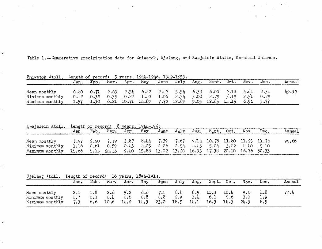
Table 1.--Comparative precipi ta t ion data f o r Zniwetok, Ujelang, and Kwaialein A t o l l s , Marshall Islands.
Eniwetok A t o l l . Length of record: 5 years, 14LL-l?L6, lQL9-1?53. . . Jm.. Feb. a . r . .,.iy June July u . %pt. 0ct . lev. aec. annual
Hean monthly 0.80 0.71 2.63 2.54 6.22 2.117 5.54 6.38 6.00 9.18 4.61 2.31 49.39 hinimum monthly 0.12 0.39 0.39 0.22 l . h O 1.06 2.34 3.00 2.79 5.19 2 . 1 0.79 14aximum monthly 1.57 1.30 6.21 10.71 14.89 7.72 12.89 9.05 12.85 14.15 6.56 3.77
Kwajalein - Atoll. Length of record: 8 years, 1944-1953 -- Jan . Feb. a Apr. Nay June Ju ly Aug. S,pt. Oct. Nov. Dec. Annual
Xean mnth ly 3.97 2.20 7.39 3.87 8 A 4 7.39 7.67 9.14 10.78 11.80 11.25 11.76 95.66 Minimun monthly 1.16 0.61 0.55, 0 . 0 h.25 2.26 2.54 5 5.04 3.02 4.40 5 .lo &ximum monthly 15.66 5 . 1 24.33 9.b0 15.88 13.02 1 3 . 2 16.95 17.38 20.10 16.76 30.33
Ujelang Atoll . Length of record: 16 years, 1094-1913. Jan. Feb. i%r. Apr. May June July Aug. Sept. Oct. Nov. Dec. Annual
Mean monthly 2.1 1.8 2.6 5.2 6.6 7.1 8.h 8.5 1013 10.4 9.6 4.8 77 I5nimummonthly 0.7 0.3 O.b 0.6 0.8 0.8 2.9 3.k 6.1 5.6 3.0 1-9 i"iaximunr monthly 7.3 6.6 10.6 1L.2 14.3 23.2 18.5 1L.1 16.3 lL.3 2L.3 8.5

water i s stored i n the c i s te rns and ir, o i l drums. Flhere corrugated iron i s not available, ra in water i s obtained by collecting the water t ha t f a l l s on coconut palms, o r occasionally, Pandanus t rees . The water caught on t r ee s i s stored i n drums o r any other available receptacle, such as paint cans o r wash basins.
No determined e f fo r t i s made by the Marshallese people to insure a year- round supply of rain water. Ektensive roof areas are unguttered and some of the c is terns are fed by catchment areas t h a t a r e not large enough to supply the maxi- mum amount of mater t ha t could be handled by the cistern. I f maximum use were made of exis t ing f a c i l i t i e s there would be much l e s s l ikelihood of the exhaus- t ion of rain-water supplies t ha t nov! occurs frequently during the dry season.
No samples of rain water were caught on a surface previously tes ted t o make sure it was f r ee of s a l t . Samples obtained d i rec t ly from c is te rns ranged i n chloride content from 20 pa r t s per mill ion on Lae t o 60 pa r t s per million on Gotho. The t o t a l hardness of these two samples was 80 and 70 pa r t s per million, respectively. A sample obtained on Lae from an o i l drum fed from catchment on a palm t r ee had a chloride content of 60 par t s per million and a t o t a l hardness of 40 par t s per million.
Ground Water
Physical nabs. - -The only source of f resh water on any is land i n the northern Marshalls i s the ra in t ha t f a l l s d i r e c t l y on t h a t island. Pa r t of the r a in fa l l evaporates o r is transpired by plants, and the remainder, because of the high permeability of the island sediments, seeps d i rec t ly in to the ground. There is no s ignif icant surface runoff. The fresh water, which i s about 4 0 / ~ a s heavy a s s a l t water, f l o a t s on the surface of the sait water roughly i n the shape of a dome, the edges cf which coincide with the edges of the island. The fresh water displaces a volume of s a l t water equal t o i t s ovm weight and depresses the fresh-salt-water interface below sea l eve l under the island. Under idea l con- d i t ions i n a homogeneous island, because of the L+0/41 weight re la t ionship of f resh t o s a l t water, the interface extends about 40 times a s f a r below sea leve l a s the dome stands above sea level . Actually, the shape of the fresh-water body varies, depending upon loca l geologic: conditions, and the 40-to-1 depth r a t i o is modified by a t ransi t ion zone of variable thickness i n which there i s a mix- tu re of f resh and s a l t water. This double-convex fresh-water body f loa t ing on sea xrater i s known a s the Ghyben-Herzberg lens. It i s the only source of pot- able ground water in the northern Marshall Islands.
The average height of f resh ~ a t e r above mean sea l eve l i n the northern Marshall islands i s l e s s than 1 foot . A t well 7, on Lae Island, Lae Atoll, which i s about 1,035 f e e t from the lagoon shore, the mean height of water above mean sea leve l was found to be 1.41 fee t . This f igure i s based an the deter- mination of mean sea leve l by t i d e gage. Unfortunately, the tide-gage deter- minations were such tha t the accuracy of the calculated heights of l eve ls i n the well i s highly questionable. Theoretically, therefore, the depth of fresh viater below sea leve l i n the is lands of the a t o l l s generally i s not more than about 40 f e e t a t the deepest point, tapering t o zero a t the edges of the lenses. Because of the mixing e f fec t in the zone of t ransi t ion, ho~tever, only the upper pa r t of the lens i s f resh enough f o r human consumption.

Fresh water is miscible with s a l t water, and the Ghyben-Herzberg lens v i i l . 1 not form o r w i l l be destroyed unless cer ta in prerequisites of permeability, water-level f luctuation, and precipi ta t ion a re fu l f i l l ed . The permeability of the s o i l and rocks consti tuting the is land must be great enough to a l l on the fresh water t o i n f i l t r a t e rapidly enough t o maintain a posit ive hydrostatic pressure against the s a l t water, but must not be so great a s t o allow, f r ee mix- ing of the f resh and s a l t water. The is lands i n the northern Marsballs consis t mostly of sand overlying rubble deposits, both of which have a degree of per- meab i l i t y tha t i s conducive to t he formation of a Ghyben-hemberg lens. The windward s ide of many of the islands, however, i s composed of coarse-grained materials ranging in s ize . up t o boulders, and because of the high permeability of these materials the lens may not be developed a s well on the viindward s ide a s it is on the leeward side or i n the central pa r t of an island. A t Taka Island, Taka Atoll , water from well 6, which i s on the windward s ide of the island, had a 'chloride content of 6,480 pa r t s per million, whereas water from wells 1 and 7, on the leeward side, had chloride contents of 840 and 2,480 par t s per million, respectively. This condition existed in. s p i t e of the f a c t t h a t well 6 , a t 400 fee t , is fa r ther from the windward shore than wells laand 7, at, 300 and 55 f e e t respectively, a r e from the lagoon shore.
The second prerequisite f o r a functioning Ghyben-Herzberg lens i s t h a t t i d a l and seasonal f luctuations i n the ground-water l eve l be small, thereby reducing the mixing of fresh and s a l t water. The magnitude of the t i d a l fluc- tuations i n the ground-water body a t a given point i n an is land i s inversely proportional t o the distance t o the shoreline and d i rec t ly proportional t o t h e permeability of the s o i l and rocks const i tut ing the island. A comparison of t i d a l f luctuat ions i n the ocean and i n the ground-water body i n four is lands indicates t h a t the ocean t ides are damped by approximately nine-tenths a s they move through the land (see tab le 2). Presumably i n smaller islands there would be considerably l e s s damping of the ocean t ides . Inasmuch as each a t o l l was v i s i ted only once i t w w not possible t o obtain any data concerning the magni- tude of seasonal or annual f luctuat ions of the leve ls of the fresh-water lens .
The th i rd prerequisite f o r the existence of a Ghyben-Herzberglens i s t h a t the precipi ta t ion be su f f i c i en t t o provide adequat,e in f iz t ra t ion of water t o the ground-water body a f t e r losses due t o evaporation andt rdnspi ra t ion a re deducted. It i s estimated tha t l e s s than half and perhaps only about a quar- t e r of the r a i n f a l l i s available a f t e r evapo-transpiration losses a r e deducted. The i n f i l t r a t i o n areas are small, owing t o the s ize of the islands, and, i n addition as shown i n figure 2, the precipi ta t ion i n the northernmost Marshall Islands i s l i g h t . The t o t a l recharge t o the ground-water lens , therefore, i s so small i n the northernmost is lands tha t a permanent Ghyben-Iierzberg lens probably does not ex i s t on any is land north of the l a t i t u d e of Enirretok Atol l . South of Eniwetok i n f i l t r a t i o n from r a i n f a l l i s adequate to maintain a perma- nent l ens i f the is land i s a t l e a s t 0.1 square mile i n area. This area i s great enough t o provide suf f ic ien t catchment area, and adequa.te width for the damping of t i d a l f luctuations. During the rainy season smaller islands south of Eniwetok and la rger islands north of Eniwetok may receive enough precipita- t ion t o build up small fresh-water lenses, but these lenses deter iorate o r are destroyed during the dry season because of the lack of suf f ic ien t m t e r from precipi ta t ion to maintain them aga ins tna tu ra l discharge and mixing with the ocean water.

Table 2.--%inparisan of t i d a l f luctuet ions i n the oceaxx and in t?e ~round-water l ens of four is lands i n the northern Marshall Islands.
Oistance to f - i a u i m n t i d a l hiean t i d a l Xaximu!n t i d a l Piean ti.dal Sat io of mean t i d a l Period of Chloride content Well lagoon shore range in well range i n well range i n ocean ra-ige in ocean range i n well to mean observation of v e l l water
Island number ( feet) (feet! ( fee t ) (feet,) ( fee t ) t i d a l range i n ocean (4ays) ( p p d
Uiluk 1 115 0.62 0.32 5 -6 & .O 0.08 5 272
Lae 7 1,035 -22 .16 3.5 2.1 .OR 3 15
Ujelang 2 1 LO 2 3 .20 3 -0 1.7 -12 3 100
NO wo & 330 -26 -22 5 .I I;.@ .05 1.5 130

'uality of water.--The extent of development of the Ghyben-Herzberg l ens con- t r o l s the qua l i ty of the ground water found in the is lands of the northern Marshalls. Khere there i s a combination of such factors a s low r a i n f a l l and small. i s land area (conditions inimical t o the development of a Ghybm-Herzberg lens) a s i s found f o r example on Bogallua Island, Eniwetolr Ato:Ll, the ground vater i s very similar to sea water i n composition. On a la rger is land such as Lae Island, Lae Atoll, however, where the precipitation i s considerably greater, the ground water in the central p a r t of the island i s comparable, i n cer ta in
-, dissolved constituents, to water obtained by ra in catchment. Between these ex- tremes may be found ground water having varying cherrical character is t ics , de- pending upon the development of the Ghyben-Herzberg lens and the location with respect t o the shoreline. (See t ab l e 3 . )
Al.l the 53 ground-water samples tes ted i n the orthern Marshalls had a d' t o t a l hardness of more than 200 pa r t s per million and 50 exceeded 300 par t s per million. The re la t ion of t o t a l hardness t o distance from t.he shoreline was not the same i n every island. Two examples are shown in f igures 3 end L. A t Ailuk Island, Ailuk Atoll, the t o t a l hardness varied inversely with distance from the lagoon shore, whereas a t Lae Island, Lae Atoll, the t o t a l lisrdness of the samples tes ted remained approximately uniform and showed no re la t ion t o distance from the s h o r e l i n e d The increase i n t o t a l hardness a t Ailuk toward the lagoon shore is apparently due t o contamination by sea water mixing v:ith the ground water. A t Ailuk the calcium hardness of the ground xater remained re la t ive ly constant, regardless of distance t o the shoreline, udhereas a t Lae the calcium hardness seemed t o decrease tov;.ard the shore ( f igs . 3 and 4 ) . The increase i n t o t a l hardness a t Ailuk, where the calcium hardness remained con- s tant , and the decrease in calcium hardness a t Lae, v:here the t o t a l hardness remained constant, must be accounted f o r by an increase in magnesium hardness.
The chloride content of the ground prater var ies widely, depending upon the amount of contamination by sea water. The chloride content of sea vater i s approxinately 18,000 to 20,000 pa r t s per million, vjhereas tha t of ra in water . theoret ical ly i s zero. The ra in vater, however, dissolves s a l t c rys ta l s f loat ing i n the a i r and deposited on the vegetation and so i l . Therefore, a "base" chloride content i s alvrays present regardless of v;hether tine ground water has been contaminated by sea water. The loviest chloride determination obtained, 15 par t s per million, was a t well 7 i n Lae Island (see tab le 31, and t h i s may be considered a s the base chloride content i n the northern Marshalls u n t i l and unless a lovier determination i s obtained. The highest value obtained was f o r a well on Bogallua Island, Ehiwetok Atoll, nhere the chloride content of a well sampled was 19,300 par t s Ser million (see table 3 ) . Chloride of about t h i s magnitude, of course, is present i n the ground water of most of the small is lands i n the northern Marshalls on ~ h i c h fresh-water lenses have not formed. In places the ground water on the main islands i n Likiep, Lae, Ailuk,
Eater having a hardness of l e s s than 50 o r 60 par t s per million i s generally ra ted as soft . !<here the hardness i s 200 o r 300 par t s per million it i s common practice in the United States to soften water for houaehold use.
Ailuk and Lae are used a s type examples because the most sa t i s fac tory well d i s t r ibu t ion was obtained on these islands.

Rotho, ~niwetok, and Ujae a t o l l s was found t o contain l e s s than ,250 pa r t s per million of chloride, and on Utirik, Ujelang, and Kwajalein Atolls t o contain l e s s than 500 par t s per miliion of chloride. ' Such waters a r e de f in i t e ly pot- able and contain considerably l e s s dissolved mineral matter than i s present i n public water supplies in pa r t s of Guam and i n certain other is lands i n the Pacific.
On some of the la rger is lands the chloride content of the gt'07Und water was * found t o be controlled by the distance of the point of sampling from the shore-
l ine . On both Ailuk and Lae Is lands there was an inverse re la t ionship between chloride content and distance t o Lagoon shore ( f i g . 5). On other islands, notably Kotho Island, Wotho Atoll, and Lado Island, Likiep Atoll, however, no such re la t ionship was observed.
As voold be expected i n is lands 'composed almostexclusively of limestone o r limestone derivatives, the ground water i s s l i gh t ly alkaline (see f ig . 6 ) . The average pH of 50 samples tes ted was 7.4: Of the t o t a l , 45 had.2 pH be- t~reen 7.0 and 8.0 and 39, between 7:2 and 7.6. Two of the samples had a pH of 6.7, ?hich i s s l i gh t ly on the acid side. Both samples were obtained from p i t s on Lae Island dug in taro p lo t s where the soiL was a mucky peat containing much decaying vegetalmat ter . TWO of the samples had a pH of 8.3. This, however, mas due t o the influence of sea water. The tT!o samples were obtained from wells on Sibyl la Island, Taongi Atoll, chere the ground water had sal ini t ief i corres- ponding t o 65 and 85 percent of t h a t of ocean water, which may be expected t o have a pH ranging from 8.1 to 8.3. One sample, ?:ith a pH of 8.2, vtas from a well on Ehgebi Island, Eniwetok Atoll. The high pH value probably was caused by the concrete l i n ing i n the well. This e f f ec t of concrete, which evidently s t i l l i s curing, was noted also i n several samples of rain water collected from concrete c is terns . Five such samples showed pH values ranging from 8.0 to 8.5, whereas one sample of ra in water' t h a t had been s tored i n a discarded o i l drum had a pH of 7.L.
The temperature of the ground viater i n the northern Marshall 1slmd.s averaged 810 Fahrenheit. This i s 1 degree l e s s than the mean annual a i r tem- perature (based on records f o r U j elang Atoll) . No rela t ionship between tem- perature of the. ground water and l a t i t u d e of the a t o l l was observed.
Use.--G-round water i s used by the Marshallese people for a l l domestic purposes. - Although ra in water i s preferred, ground va te r i s used f o r washing and cooking during the dry season and for drinking purposes when the rain c i s te rns a r e com- p le te ly empty.
A l l the ground water i s obtained from dug wells. Most of the v e l l s a r e l e s s than 10 f e e t deep and penetrate about 1 foot below the viater table . Many of the wells are cased with limestone blocks or discarded. o i l drums, but some of the. very shallow ones are not cased a t a l l . None of the weEs was reported t o antedate the German period of contYol and it i s unlikely t h a t the Marshallese people were aware of the presence of fresh water under t h e i r islands before the German period. Even today dn Lae Island, where there is an excellent Ghyben- Herzberg lens , some of the Marshallese were skeptical of the widespread exis- tence of f resh water beneath the island. They showed considerable surpr ise when a well dug through thn boulder rampart near the ocean s ide of the is land yielded fresh water.

Table 3.--Chemical analyses of water from selected wel ls i n the northern Marshall Is lands (Analyses by U. S . Geological Survey. Dissolved const i tuents in par t s per mill ion)
Island b e l l no. A t o l l
Distance from shore (ft .)
Area of i s l and (sq. mi.)
Spec i f i c conductano (micromhos a t 25OC)
Dissolved s o l i d s
Hardness ( t o t a l , a s CaCO3)
S i l i c a
Iron
Calcium
Magnesium
Sodium
Potassium
Sul fa te
Chloride
N i t r a t e
Phosphate
pH
Temperature (OF)
- Engeb:
3 Xniwe P
no
..
1,040
a5 70
388
8 .i
.I
--- ---
77
5.1
lo 88
h6
.(
7 .: 79
B i i j i k i 1
miwetol,
45
.O(
4, 200
~9,800
1,800
8.5
--- --- ---
2,700
70
36
k,8@
10
.1
---
77
Bogallua 1
E ~ w e t o k
40
.03
42,500
01,900
6, LOO
4.1
--- --- ---
10,600
200
132
19,300
2 -0
.2
7.8
82
-Lac 7
Lae
$35
.21
589
406
380
--- .02
145
2.7
--- ---
9.1
15
--- --- 6.7
80
a Calculated from spec i f i c conductance.

Distance from shore ( fee t )
F igure 3 . - -Relot ion o f Potol hardness and colcium hardness to distance f rom shoreline in the ground wotrr of Ailuk Islond, Ailuk Atoll, Morsholl Islands.

Distance from shore ( feet )
F igure 4 . - -Re la t ion of tota l hardness and colcium hardness to distonce f rom shoreline in the ground water of L a e Island, Loe Atoll , Marshal l Is lands.

e Ailuk Island X,Lae cr lond
I
Distance from shore (feet)
F i g u r e 5 . - -Re la t ion of chloride content t o distance f r o m shoreline in the ground water of Ailuk Island. Ailuk Atoll , and L a e Island, L a e Ato l l , M a r s h a l Islands.

Figore 6.-- H is top iam of 50 pH determinat ions of ground water in the Marshal l lslonds.

1. Bryan, E. H., Jr., 194.6, A geographic summary of Micronesi.a and notes on the climate of iflicronesia: U. S. Comoercial. Coiupar~y Gem. Survey, Honolulu.
2. Cox, Doak C. , 1951, The hydrology of Arno Atoll, Marshall Islands: Atoll Research B u l l . 8 , December.
3. Ohrt, Frederick, 19/,'1, Water developri~ent and s a l t water i n t r i~s ion on Pacif ic islands: Am. Water Works Assoc. Jour., v. 39, no. 10, October.
b. U. S. \&'eather Bureau and A i r Weather Service, U . S. A. F., 1.948, Eeather conditions i n the Marshall Islands, with special emphasis on the mi- wotok area, Special Study No. 40, February.
5. Wenkorth, Chester K. , l 9 U , Factors i n the behavior of ground water in a Ghyben-Heraberg system: Pac i f ic Sci., v. 1, no. 3, J-uly.


![[Hydrology] Groundwater Hydrology - David K. Todd (2005)](https://static.fdocuments.us/doc/165x107/548ce7beb47959e2288b45f9/hydrology-groundwater-hydrology-david-k-todd-2005.jpg)
![A R I G ATOU - soltecviet.comsoltecviet.com/wp/wp-content/uploads/2014/07/410809f57ee2dff77dfea...bussiness. [COMPANY PROFILE] ... Contraction Term:Plant Work/ March. ... Currently](https://static.fdocuments.us/doc/165x107/5adf322a7f8b9a1c248bbde4/a-r-i-g-atou-company-profile-contraction-termplant-work-march-.jpg)