Nanotechnology and chiroptical spectroscopy to characterise optically active chiral metamaterials
Upload
vuongkhanhCategory
view
222download
1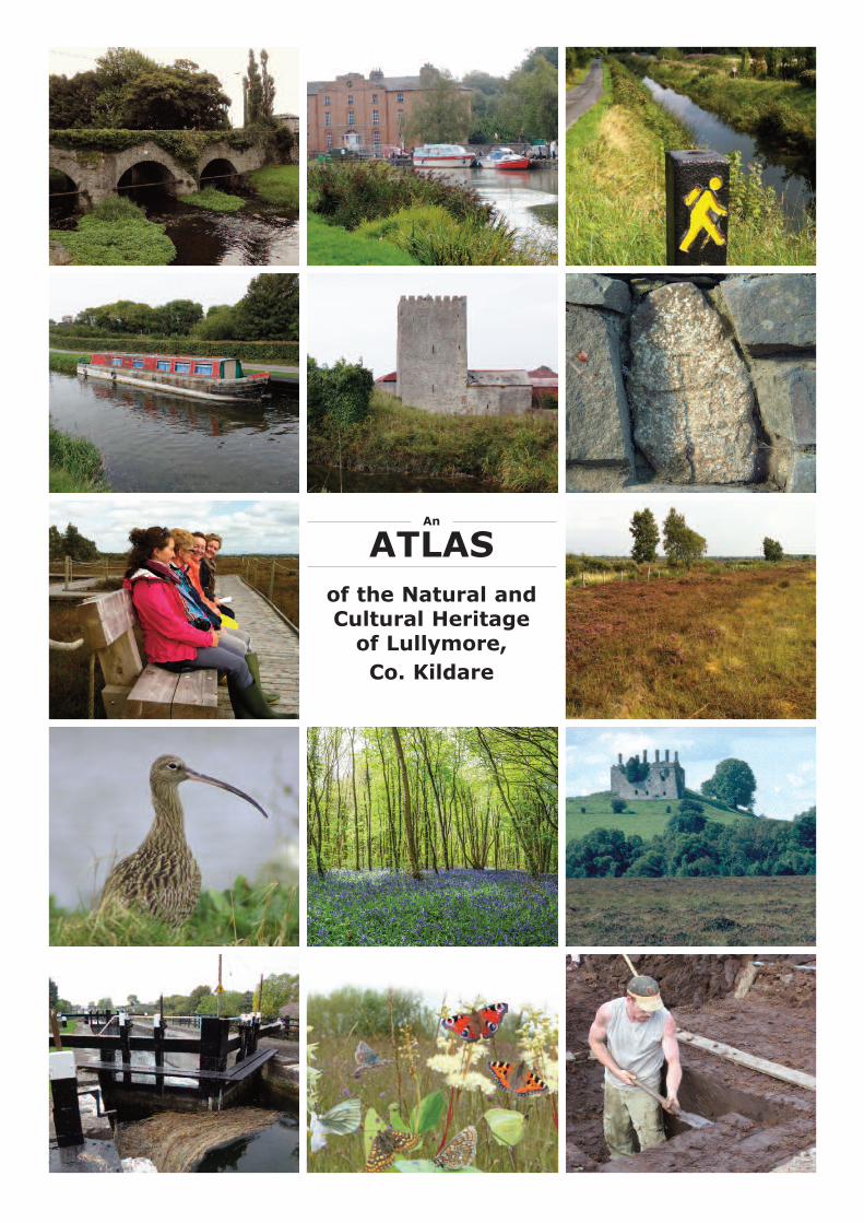
An
ATLASof the Natural andCultural Heritage
of Lullymore, Co. Kildare

An Atlas of the Natural and Cultural Heritage of Lullymore, Co. KildareResearched and developed by Dr Catherine O’Connell, IPCC
© 2014 Irish Peatland Conservation Council, Lullymore, Rathangan, Co. Kildare, Irelandwww.ipcc.ie
Cover Images from the top left (note all photographs © Catherine O’Connell unless oth-erwise stated): Bridge over the Slate River in Rathangan; The Grand Canal atRobertstown; The Barrow Way near Harberton Bridge; Barge near the old 19th Lock on
the Barrow Canal; Ballyteige Castle; Decorated Cross Slab from Lullymore Monastic Site at the Bog ofAllen Nature Centre; The Boardwalk on Lodge Bog; The Living Surface of Lodge Bog; Curlew Breed onLodge Bog; The Bluebell Woods at Killinthomas © Greig Houghton; Carbury Hill and Castle © Peter Foss;The old 19th Lock on the Barrow Canal; Lullymore West Butterfly Haven; Turf Cutting Competition Bogof Allen © Stacey Anderson.
IRISH PEATLAND IRISH PEATLANDCONSERVATION COUNCILCONSERVATION COUNCIL
Acknowledgement
IPCC wish to thank and acknowledge Kildare County Council for supporting this project under the Community Heritage Grant Scheme2014
We wish to thank Miss Claire Sullivan from Allenwood South for her helpwith this project. We also wish to thank the local community members
who assisted us in compiling this inventory.
Contents Introduction . . . . . . . . . . . 3Map of Physical Features . . .. . . . . . 4Map of Habitats and Wildlife . . . . . . . . . 5Map of Tourist Attractions and Heritage . . . . . . . 6Rivers . . . . . . . . . . . . 7Canals . . . . . . . . . . . . 8Frogs . . . . . . . . . . . . . 9Habitats . . . . . . . . . . . . 10Wetlands . . . . . . . . . . . . 11Heritage Buildings . . . . . . . . . . 13Bridges and Aqueducts . . . . . . . . . . 14Tourist Attractions . . . . . . . . . . 16Notable People . . . . . . . . . . . 18Towns . . . . . . . . . . . 19Wildlife Species . . . . . . . . . . . 21Birds . . . . . . . . . . . . . 22Rare Species of Plant and Animal . . . . . . . . 24
Atlas of the Natural and Cultural Heritage of Lullymore, Co. Kildare 2

Introduction
Lullymore is an area of Kildare located in the Bog of Allen that is steeped in heritage and culture. ThisAtlas is the result of a project supported by Kildare County Council. The project aimed to characterisethe unique meaning and value of Lullymore to the people who live and work there. The first outcome ofthis process is to present an inventory of the natural, cultural and tourist resources of Lullymore. Theproject is an initiative of the Irish Peatland Conservation Council.
This Atlas covers an area of land within 8km of the Bog of Allen Nature Centre, Co. Kildare. It extendsfrom the towns of Derrinturn and Carbury in the north, to Rathangan in the south; from Clonbulloge inthe west to Robertstown in the east. The land includes parts of both Counties Kildare to the east andOffaly to the west. The Grand Canal forks near Allenwood in this area with a branch to the west joiningthe River Shannon at Shannon Harbour and another to the south to join up with the Barrow River atAthy. Most of the land in this area lies below 100m and its natural habitat would have been raised bogprior to its extensive development for fuel from the 19th century to the present day. Two significantareas of bogland are identified in the study area - Lullymore and Timahoe. Both of these would be partof the greater Bog of Allen landscape. Three land “islands” occur within the bog complexes that were notswallowed by the growing boglands - Lullymore, Lullybeg and Derrybrennan. There are four hills in thearea: Carbury (142m) to the north; Kilmeague (133m), Hill of Allen (219m) and Boston Hill (159m)along the south eastern boundary of the area being studied.
Three maps are presented in this Atlas. The features on each map are described in the tables which follow. The maps include: Physical Features (Figure 1), Habitats and Wildlife (Figure 2) and TouristAttractions and Heritage (Figure 3). The maps and this Inventory are available to download as a pdffrom www.ipcc.ie.
During Heritage Week 2014, the IPCC organised an open day on the topic of the development of thisAtlas. The event which was well attended by the local community included a slide show on the development of the Atlas which was followed by a walk along the Lullymore Biodiversity Trail to LodgeBog (see Figure 4).
Atlas of the Natural and Cultural Heritage of Lullymore, Co. Kildare 3
Figure 4: participantsfrom LullymoreCommunity and theBog of Allen walkingon the LullymoreBiodiversity Trailwith Tadhg ÓCorcora from theIPCC during HeritageWeek 2014. Photo: S.Sheridan

Figure 1: Map of the physical features of the study area for the Atlas of the Natural and Cultural Heritage ofLullymore, Co. Kildare.
Map of Physical Features
Atlas of the Natural and Cultural Heritage of Lullymore, Co. Kildare 4

Map of Habitats and Wildlife
Atlas of the Natural and Cultural Heritage of Lullymore, Co. Kildare 4
Figure 2: Map of the wildlife sites and habitats of the study area for the Atlas ofthe Natural and Cultural Heritage of Lullymore, Co. Kildare.
Key to Symbols Used
Island Boundary
Town
River
Wetland Habitat
Forest & Woodland
Frog Record
Bogland Habitats

Atlas of the Natural and Cultural Heritage of Lullymore, Co. Kildare 6
Map of Tourist Attractions and Heritage
Key to Symbols Used
Town
Town
Town
Town
Town
Town
Town
Tourist Attraction
Notable Person (male)
Notable Person (female)
Heritage Building
Bridge/Aqueduct
Figure 3: Map of the tourist attractions and heritage of the study area for theAtlas of the Natural and Cultural Heritage of Lullymore, Co. Kildare.
River Name Description
Abbeylough River A tributary of the Cushaling River.
Barrow River
The Barrow (Irish: An Bhearú) is a river in Ireland. It is one of The Three Sisters;the other two being the River Suir and the River Nore. The Barrow is the longestand most prominent of the three rivers. At 192 km (120 mi), it is the second-longest river in Ireland, behind the River Shannon. The River Barrow forms amajor part of Ireland's inland waterways network, providing an inland linkbetween the port of Waterford and the Grand Canal, which in turn connectsDublin to the River Shannon The Barrow Line of the Grand Canal connects to theriver at Athy and continues northwards a further 45km (28 miles) with 9 locks,connecting to the mainline of the Grand Canal at Lowtown.
Black River
The Cushaling, the Crabtree River, and the Black River, all unite on the westernboundary of county Kildare and form the Figile, which flows first through Offaly,then crossing an angle of Kildare, it forms the boundary between Kildare andLaois, until it joins the Barrow beside Monasterevin.
Boyne RiverThe Boyne rises in Trinity Well, at Carbury Hill, in the northwest of the county;flows first through Kildare.
Crabtree River
The Cushaling, the Crabtree River, and the Black River, all unite on the westernboundary of county Kildare and form the Figile, which flows first through Offaly,then crossing an angle of Kildare, it forms the boundary between Kildare andLaois, till it joins the Barrow beside Monasterevin. The Crabtree river/Lullybegbutterfly reserve is located along the river.
Cushaling River
The Cushaling, the Crabtree River, and the Black River, all unite on the westernboundary of county Kildare and form the Figile, which flows first through Offaly,then crossing an angle of Kildare, it forms the boundary between Kildare andLaois, until it joins the Barrow beside Monasterevin.
Lugherra River A tributary of the Cushaling River.
Slate River
The Slate River is a narrow tributary of the River Figile. It has undergonedrainage work and the banks are high and difficult in many places. Pike, perchand some trout can be found in the short stretch of river. The Slate River, risingnear Prosperous, flows westward by Rathangan, then forms the boundarybetween Kildare and Offaly for about a mile, when it enters Offaly to join theFigile.
RiversSee Figure 1
Atlas of the Natural and Cultural Heritage of Lullymore, Co. Kildare 7

CanalsSee Figure 1
Canal Name Description
Grand Canal
The Grand Canal crosses Leinster linking Dublin to the River Shannon in Co. Offaly,with a branch linking the canal to the River Barrow Navigation. Wonderful fishing,nature and wildlife abound along the canal. Work commenced on the Grand CanalScheme in 1756 and it took 47 years for the Canal to reach the Shannon in 1803.The Main Line is 131km long and there are 43 locks on it. The Grand Canal is one ofIreland’s greatest engineering achievements. The construction was made very difficultas a large portion of the canal was built though bogland. Lime rich soil was importedinto the area being dug for the canal to build up a tow path. In the 18th century thecanal was essential for industry. Nowadays it is just as important for wildlife andleisure.
Grand Canal - Barrow Line
This links the Grand Canal with the River Barrow Navigation System at Athy. The lineis 45km long while the link from Robertstown to Rathangan is 12.5km. New and oldchannels for the link were constructed and the waters of the two join close to theSkew bridge. The Features along the Barrow Line include Ballyteige Castle, the 20th,21st, 22nd and 23rd locks, the Griffith Aqueduct, Glenaree and Spencer bridges.From Rathangan the canal heads into the watershed of the River Barrow.
Grand Canal - MilltownFeeder
This links to Pollardstown Fen which is the source of much of the Grand Canal's watersupply. The Milltown Feeder is next to Hill of Allen and is 9.43km long. The feederbegins on the east bank of the old' Barrow line link from Lowtown beside the old 19thlock. A plaque on the chamber wall recites the history of the old 19th lock. A bridge(named both Huband Bridge and Greene's Bridge) marks the junction of the narrower, shallower feeder with the canal proper. The waterway curves around thefoot of the Hill of Allen passing through Milltown and on to Pollardstown Fen.
Atlas of the Natural and Cultural Heritage of Lullymore, Co. Kildare 8

Fro
g R
eco
rd
s h
eld
wit
hin
th
e I
PC
C N
ati
on
al H
op
to
It
Fro
g S
urvey D
ata
base
Data
Search
19
th A
ug
ust
20
14
Sit
e N
o.
Lo
cati
on
of
Fro
g R
eco
rd
Hab
itat
Fro
g L
ife S
tag
e
No
. o
f
Reco
rd
s
for s
ite
1Ballynakill Low
er
Bogla
nd
Adult
1
2Ballysooghan n
ort
hD
rain
in r
ais
ed b
og
Adult
2
3Bog o
f Allen N
atu
re C
entr
e G
ard
ens
Art
ific
ial pond a
nd g
ard
ens
Adult,
Spaw
n23
4Clo
ncannon
Ditches in f
arm
land a
nd o
n b
ogla
nd
Adult,
Spaw
n2
5Cushaling B
og
Bogla
nd
Adult
1
6Cushaling S
outh
Bog
Ditch a
nd d
rain
Adult
2
7D
err
ies B
og
Bogla
nd
Adult
1
8D
err
ym
ullen
Ditch,
gard
en a
nd f
arm
land
Adult
9
9D
rum
sru
Bog
Rais
ed B
og
Adult
2
10
Inchanearl
Wet
gra
ssla
nd
Adult
2
11
Killy
guire D
rain
Dra
inAdult
1
12
Lodge B
og N
ort
h a
nd S
outh
Rais
ed B
og a
nd b
og d
rain
Adult,
Spaw
n &
Tadpole
s32
13
Lullym
ore
Ditch a
nd d
rain
in f
arm
land
Adult,
Spaw
n3
14
Lullym
ore
Bla
dBogla
nd
Adult
1
15
Lullym
ore
East
Dra
ins a
nd b
ogla
nd
Adult
6
16
Lullym
ore
Farm
Gra
ssla
nd
Adult
1
17
Lullym
ore
West
Bog
Gra
ssla
nd a
nd w
etland p
ool
Adult,
Spaw
n &
Tadpole
s17
18
Rath
angan V
illa
ge
Waste
gro
und
Adult
1
19
West
of
Lugera
gh R
iver
Heath
land
Adult
2
To
tal N
um
ber o
f R
eco
rd
s1
09
So
urce:
ww
w.i
pcc.i
e
FrogsSee Figure 2
Atlas of the Natural and Cultural Heritage of Lullymore, Co. Kildare 9

HabitatsSee Figure 2
Map
Reference
Number Site Name Habitats Present
5 Lodge Bog, Kildare
Raised Bog, Drainage Ditches,
Neutral Grassland
6
Lullymore East Bog (Lodge Bog
South), Kildare Raised Bog, Bog Woodland
9 Drumsru Bog, Kildare Raised Bog
10 Lullymore East Cutaway, Kildare
Cutaway Bog, Tall Herb Swamp,
Calcareous Semi-natural Grassland
11 Timahoe Cutaway, Kildare
Cutover Bog - Bog Cotton
Community, Wet Heath, Bog
Woodland, Scrub, Dystrophic Lake,
Conifer Plantation
12 Allenwood South-East, Kildare Raised Bog
13 Allenwood South-West, Kildare Raised Bog
14 Ballyteige South, Kildare Raised Bog
15 Lullymore West Cutaway
Cutover Bog, Mixed Broad-leaved
Woodland, Neutral Grassland
16 West of Lugherra River, Offaly Wet Heath
18
Ballysooghan North, Kildare &
Offaly Raised Bog, Bog Woodland
21 Cushaling East, Kildare Wet Heath, Drainage Ditches
22 Cushaling South, Kildare Wet Heath, Drainage Ditches
23 Ballybrack, Kildare
Raised Bog, Cutover Bog, Bog
Woodland, Neutral Grassland
24 Ballynakill Lower, Kildare Raised Bog
27 Rathmore, Kildare Raised Bog, Wet Heath
32 Cushaling West, Offaly
Wet Heath, Drainage Ditches,
Neutral Semi-natural Grassland
33 Cloncannon, Offaly
Raised Bog, Wet Heath, Drainage
Ditches, Neutral Grassland
34 The Long Derries Heath, Offaly
Wet Heath, Drainage Ditches, Bog
Woodland
39 Grand Canal NHA, Kildare & Offaly
Open Water, Reed Fringe, Tall
Herbs, Calcareous Grassland,
Hedgerow, Scrub, Woodland
43 Lullymore West, Kildare
Wet Grassland, Poor Fen, Bog
Woodland
44 The Long Derries SAC, Offaly Calcareous Grassland, Heathland
Source: Hurley, C. (2005) Bog of Allen Habitat and Heritage Survey, Irish Peatland
Conservation Council, Kildare.
Bog of Allen Survey 2005: Sites and Habitats Identified
Atlas of the Natural and Cultural Heritage of Lullymore, Co. Kildare 10

WetlandsSee Figure 2
Map
Reference
Number Wetland Site Name Habitats Present
1 Brockagh
Cutover Bog, Dystrophic Lake and Bog
Woodland
2 Allenwood Road Wood Bog Woodland
3
Allenwood North East
Cutover
Raised Bog, Cutover Bog, Bog Woodland, Poor
Fen
4
Allenwood North -
Timahoe South Bog Woodland, Cutover bog
5 Timahoe South
Cutover Bog, Artificial Pond, Raised bog Bog
Woodland
6 Ballynakill Lower Bog
Raised Bog, Cutover Bog, Bog Woodland, Poor
Fen
7
Drumcahon Cutaway -
Timahoe South Cutaway
Cutover Bog, Bog Woodland, Poor Fen, Wet
Heath
8
Loughnacush - Timahoe
South Bog Woodland, Scrub, Cutover Bog
9 Rathmore Bog Raised Bog, Cutover Bog
10 Ballyhagan Wet Grassland
11 Grand Canal NHA
Reed Swamp, Wet Grassland, Cutover Bog,
Marsh
12 Ticknevin Cutover Bog
13 Cloncannon Raised Bog, wet Heath
14 The Long Derries SAC
Raised Bog, Cutover Bog, Alkaline Fen, Poor
Fen
15 Cushaling River Valley
River, Wet Grassland, Marsh, Bog Wodland,
Scrub
16
Cushaling East Wet Heath -
Ballydermot Wet Heath, Cutover Bog
17 Cushaling West Cutover Cutover bog
18 Cushaling South Bog Cutover Bog
19 West of Lugherra River Wet Heath, Cutover Bog
20
Ballydermot
(Derrybrennan) Cutover Bog
21 Lullymore West
Cutover Bog, Poor Fen, Alkaline Fen, Bog
Woodland
22 Lullymore Cutover Bog
23 Bog of Allen Nature Centre Artificial Pon
24 Lodge Bog
Raised Bog, Cutover Bog, Wet Grassland,
Scrub, Dystrophic Lake
25 Allenwood South West Bog Cutover Bog, Raised bog
26 Allenwood South East Bog Raised Bog, Cutover Bog
27 Lodge Cutover Bog, Raised Bog, Bog Woodland
28 Drumsru Bog - Lodge Raised bog, Bog Woodland
29 Lullymore East Cutaway Cutover bog, Wet Heath, Tall Herb swamp
30 Lodge bog South - Lodge Raised bog, Cutover bog, Bog Woodland
31
Lullymore East Bog
Woodland Cutover Bog, Fen, Bog Woodland, Scrub
32
North of Lullymore
Heritage Park Bog Woodland, Cutover Bog
Wetland Surveys Ireland, Kildare Wetland Survey 2012
Source www.wetlandsurveysireland.com
Atlas of the Natural and Cultural Heritage of Lullymore, Co. Kildare 11

WetlandsSee Figure 2
Map
Reference
Number Wetland Site Name Habitats Present
33
Heritage Park Wood
(Foran's Wood) Bog Woodland, Cutover Bog
34
Plantation Fen -
Ballydermot (Lullymore) Cladium Fen, Poor Fen
35
Lullymore Wetlands -
Ballydermot (Lullymore) Cutover Bog, Alkaline Fen, Lake
36 Ballydermot (Lullymore) Cutover Bog
37
Lullymore Cutaway
Ballydermot (Lullymore) Cutover Bog, Artificial Pond
38
Lullybeg Butterfly Reserve -
Ballydermot (Lullymore) Cutover Bog
39
Crabtree River -
Ballydermot Wet Woodland, Bog Woodland, Cutover Bog
40 Ballydermot Cutover Bog, Bog Woodland
41
Bog of Allen Killinthomas -
Ballydermot Dystrophic Lake, Bog Woodland, Scrub
42
Ballysooghan North
(Offaly) Raised bog
43
Ballysooghan Bog
Ballydermot (Kildare) Raised bog, Cutover Bog, Bog Woodland
44
Rathangan Grand Canal
NHA Wet Grassland, Tall Herb Swamp
45 Ballybrack Bog Raised bog, Cutover bog, Bog Woodland
46 Pluckerstown Bog Woodland
47 Ballyteige South Bog Cutover Bog
48 Punchers Grange Wet Grassland
49 Hill of Allen Artifical Pond
Atlas of the Natural and Cultural Heritage of Lullymore, Co. Kildare 12

Heritage Buildings See Figure 3
Heritage Building Description
1. Allenwood Thatched CottageDetached five-bay single-storey lobby-entry thatched house, built circa 1800.Byre added to the east circa 1900 and a front entrance porch circa 1950.Hipped oaten straw thatched roof. Concrete floors and open hearth.
2. Allenwood North ThatchedCottage
Detached six-bay single-storey thatched house, built circa 1800. Hippedoaten thatched roof over a sawn timber roof structure. Whitewashed claywalls.
3. Carbury Castle
A 17th century (circa 1625) building, a transitional house combining elements of the fortified tower house and features of a gentleman's residence. The building is now in ruins on top of Carbury Hill. It is a wellknown landmark with its many sided chimney stacks against the skyline.
4. Church of Ireland Rectory,Carbury
The rectory at Carbury is a substantial house with classical proportions thatwas built circa 1800.
5. Grand Hotel Robertstown
Located on the bank of the Grand Canal, the hotel at Robertstown is anattractive and understated exercise in Classical style that was built in 1801.With the closing of the canal to commercial traffic in 1961 the building wassubsequently converted to use as a training centre, a role it serves to thepresent.
6. Grangeclare/Ballyteige CastleMedieval Castle. The rebel leader, Silken Thomas of the great KildareFitzgerald family, is said to have taken refuge here after the Battle of Allen in1535.
7. Kilmeague School
Built in 1830. A compact red sandstone building, the former school inKilmeague is afforded prominence through the use of Gothic-style motifs anda high pitched roof. The building incorporates lancet surrounds in yellow brickto the windows together with a small gable-fronted porch. Converted to residential use in the late 20th century.
8. Kilpatrick Burial Ground Burial ground. The ancestors of Sinead Flanagan, wife of President Eamon deValera are buried here.
9. Lullymore 1798 Monument Memorial to 1798 Rebellion and to Captain John Doorley (1771-1798). He leda battalion that captured the town of Rathangan from crown forces.
10. Lullymore East Monastic Site Monastic settlement established by St Erc in 5th century and modern burialground. Stone with footprint of Saint Patrick
11. Lullymore Lodge Built in 1860 by the family of Major Brundell Murphy. The house was a hunting lodge.
12. Newberry Hall Carbury Palladian style house, designed by amateur architect Nathaniel Clements.Lord Arthur Haberton obtained lands through marriage to Mary Colley in1747. The Colley family were living in Carbury Castle at the time.
13. Robertstown Thatched Cottage Cottage attached to a building possibly a local school. It faces onto the canaltow path.
14. Windmill CrossroadsDerrinturn Remains of a windmill.
Atlas of the Natural and Cultural Heritage of Lullymore, Co. Kildare 13
Information Sources: Anonymous, An Introduction to the Architectural Heritage of County Kildare. Department of the Environmentand Local Government, Dúchas the Heritage Service and National Inventory of Architectural Heritage.Duggan, C. The Thatched Houses of County Kildare. Kildare County Council, Naas.

Bridge or Aqueduct Description
1. Abbeylough Bridge Used by Bord na Móna to transport peat over the canal into their factory.
2. Agar Bridge Located on the Slate River.
3. Ballyteige Bridge Located on the Barrow Line.
4. Binn's Bridge Located in Robertstown on the Grand Canal Way.
5. Blundell Aqueduct "The Tunnel"Located on the Grand Canal Shannon Line in Co. Offaly. It consists of asquared masonry aqueduct, built in 1793, carrying the Grand Canal over theEdenderry to Rathangan road. It is known locally as the “The Tunnel”.
6. Bond Bridge Located on the Shannon Line of the Grand Canal Way south of Allenwood.
7. Cushaling Bridge Located on the Cushaling River which flows through the Lullymore BogComplex.
8. Dillons Bridge Located on the Cushaling River.
9. Fenton Bridge Fenton Bridge 1799 Grand Canal County Kildare. Located on the Grand CanalWay at the junction of the Shannon and Barrow Lines.
10. Foot Bridge Located on the new Barrow Line of the Grand Canal near Lowtown.
11. Ford Bridge Located south of Allenwood on the Slate River.
12. Glenaree Bridge Located on the Barrow Line.
13. Grace’s Bridge Located in Derrinturn village on the Ballyshannon River.
14. Griffith AqueductThe Griffith Aqueduct was named after Sir Richard Griffith (c. 1784-1878),one of the Bog Commissioners and a Director of the Grand Canal Company. Itis located on the Barrow Line of the Grand Canal.
Bridges and AqueductsSee Figure 3
Atlas of the Natural and Cultural Heritage of Lullymore, Co. Kildare 14
Bridge or Aqueduct Description
15. Hamilton.s Bridge Markings from barges used to transport turf. Located on the Shannon Line ofthe Grand Canal Way.
16. Huband or Green Bridge Located at the junction of the Milltown Feeder off the Grand Canal.
17. Iron Bridge Located on the Abbeylough River and providing road access into the old Bordna Móna briquette factory.
18. Lifting BridgeBetween shee bridge and hamiltons bridge, used for transport of peat on theBord na Móna narrow gauge railway line. Located on the Shannon Line of theGrand Canal Way.
19. Littletown or New Bridge Located on the old Barrow Line beside the Traveller's Rest Bar.
20. Harberton Bridge Located south of Allenwood on the Barrow Line of the Grand Canal.
21. Old River Bridge West of the Hill of Allen on a tributary of the Slate River.
22. Pims Bridge Located on the Milltown Feeder of the Grand Canal.
23. Pluckerstown Bridge Located on the Milltown Feeder of the Grand Canal.
24. Shee or Scow Bridge Located on the Shannon Line of the Grand Canal Way west of Allenwood.
25. Skew Bridge
A skew arch bridge is one where the bridge deck is at an angle to the obstacle it is crossing. Skew stone arch bridges are extremely difficult to construct as the joints between the cut stone blocks are not at right anglesand every block used is uniquely shaped. one of the few surviving examplesof Skew bridges on the canals of Ireland. Located on the Barrow Line.
26. Spencer Bridge On the Barrow Line in Rathangan dates to 1784. It was named after a prominent family in Rathangan at the time.
27. Ticknevin or Hartley Bridge Located on the Grand Canal Shannon Line.
Bridges and AqueductsSee Figure 3
Atlas of the Natural and Cultural Heritage of Lullymore, Co. Kildare 15
Tourist AttractionsSee Figure 3
Attraction Description
1. Barrow Way The start point of the 100km long Barrow Way is in Robertstown. It follows towpaths andriverside roads along its length passing through the town of Rathangan.
2. Bog of Allen
The Bog of Allen (Móin Alúine in Irish) is a large raised bog complex in the centre of Irelandbetween the rivers Liffey and Shannon. The bog's 958 square kilometers (370 square miles)stretch into Counties Offaly, Meath, Kildare, Laois and Westmeath. Peat is mechanically harvested on a large scale by Bord na Móna, the government-owned peat production industry.The area has miles of narrow gauge industrial railways for transporting milled peat to powerstations at Clonbollogue, and briquette factories in Lullymore. The bog is crossed by theGrand Canal and the Royal Canal.
3. Bog of AllenNature Centre
The Bog of Allen Nature Centre is located in the heart of the bog where visitors can learnabout the wildlife, heritage and archaeology of Irish bogs through a series of exhibitions and amuseum. Wildlife friendly gardens surround the centre and thre is a fascinating greenhouse ofinsect eating plants from bogs across the world. Finish your tour by visiting nearby Lodge Bogin the Bog of Allen, to feel the squelchy peat beneath your feet.
4. Carbury Hilland Castle
Carbury Hill is close to the source of the River Boyne that runs by Brú na Bóinne. There arethe two barrows on the hill that are dated to the Bronze Age, a motte and a tower house indicating multiple usage and settlement over time. The hill was at the centre of the ancientterritory known as Cairbre Uí Chiardha (which may still be seen on signposts in the area) ofthe Ó Ciardha sept of the Southern Uí Néill (anglicised Carey and Keary) who were Lords ofCarbury, first mentioned in the Annals of the Four Masters in 952. It was also a camping siteused by the Irish during the United Irishmen Rebellion of 1798. The central scenic focus ofCarbury Hill is the ruins of the 17th century Tudor mansion of the Colleys.
5. Derrinturn Slína Sláinte The Derrinturn Slí na Sláinte is 4.3km distance and forms a circuit around the village.
6. Grand CanalWay
The Grand Canal Way is a walking route linking Dublin with the River Shannon (and with abranch line to link with the Barrow Navigation). Wonderful fishing, nature and wildlife aboundalong the canal. Work commenced on the Grand Canal Scheme in 1756 and it took 47 yearsfor the Canal to reach the Shannon in 1803. The Main Line is 131km long and there are 43locks on it.
7. Hill of Allen
The Hill of Allen is 219m tall and is an ancient volcano. The tower on the hill was constructedbetween 1859 and 1863 by Gerald George Aylmer (1798-1878). The Hill is located beside thevillage of Allen. According to Irish Mythology it was the seat of the hunter-warrior Fionn macCumhaill and the Fianna. During the construction of the tower a large coffin containing humanbones was unearthed which were said to be those of Fionn mac Cumhaill. These were re-interred under the site. The site is currently part-owned by Roadstone Dublin Ltd andextensive quarrying has noticeably changed the profile of the hill. The hill is situated at theeasternmost point of the Bog of Allen from which it gets its name.
8. Kildare-Wicklow GrandTour
The Grand Tour is a 200km circuit of Kildare and Wicklow, taking in spectacular scenery,beautiful big houses and gardens and the intriguing Early Christian heritage sites of bothcounties.
9. KillinthomasWoods
Killinthomas is an old woodland site with forest cover present since the 1830s. It is locatednorth of Rathangan. The woods have a good proportion of native broadleaf trees and structural diversity in the woodland is rich. The bluebell way in the woods is a highlight inSpring. These woods are owned and managed by Coillte.
Atlas of the Natural and Cultural Heritage of Lullymore, Co. Kildare 16

Attraction Description
10. Lodge Bog
A raised bog habitat, part of the great Lullymore Bog. The site is a breeding habitat forCurlew in Spring and for the Large Heath butterfly in mid summer. A 100m boardwalk, seatand interpretive sign are located on site for visitors. The bog is owned and managed by theIrish Peatland Conservation Council.
11. LowtownJunction on theGrand Canal
Lowtown Junction is a triangular link between the main line of the Grand canal (heading west)which links up with the Shannon and the Barrow branch of the canal (heading south). It is aninland dockyard where pleasure boats are moored.
12. LullybegButterfly Site onthe CrabtreeRiver
This site next to the Crabtree River is rich in butterfly biodiversity because of the variety ofhabitats present. The site is managed by Butterfly Ireland.
13. LullymoreBiodiversity Trail
2.5km walking trail between three biodiversity hot spots in the Bog of Allen. These are located in Lullymore and include Lodge Bog, the Bog of Allen Nature Centre and LullymoreWest Bog.
14. LullymoreGraveyard
This graveyard was also the location of a monastery, established in the 5th century by St. Erc.The ground surface is undulating with a low mound in the middle and bumps. A modern rubble stone wall enclosure houses upright headstones which date from the 19th to the 21stcentury. There is a cross and altar in the middle of the back eastern wall. There is oneunlocked gate in the western wall. A stone in the field outside the enclosure reputedly bearsthe footprint of St Patrick.
15. LullymoreHeritage andDiscovery Park
Lullymore Heritage and Discovery Park is set on 60 acres of breath-taking landscape andexplores Irish heritage, culture and environment with woodland/peat land trails, gardens andexhibitions.
16. LullymoreWest Bog
A cutover bog that has regenerated with wetland and woodland habitat. A breeding habitat forMarsh Fritillary butterflies. As many as 22 of the Irish butterfly fauna can be seen on this sitethroughout the year. The bog is owned and managed by the Irish Peatland ConservationCouncil.
17. Magic Tour ofAllen
The writer Anita Hendy created this 20km cycling or driving tour of the Bog of Allen aroundsome of the sites that inspired her "Magic" book for children about Irish heritage. The loopedroute runs from Robertstown to Ballyteague Castle to the Hill of Allen, to Allen and Kilmeaguevillages before returning to Robertstown.
18. Rathangan Village
Rathangan (Irish: Ráth Iomgháin, meaning "Iomghan's Fort") is a town in the west Kildarewith a population of 2,374. The Slate River and the Grand Canal run through the town. Prideof place is the 'Rath' or 'Ringfort' which dates back to at least 1400 years.
19. RobertstownVillage
Robertstown is a small village situated on the banks of the Grand Canal in Co. Kildare. Itgrew in importance on the arrival of the canal in 1784. In 1801 the Grand Canal Hotel wasopened to cater for the passenger traffic along the canal and this building dominates thecanal bank.
Tourist AttractionsSee Figure 3
Atlas of the Natural and Cultural Heritage of Lullymore, Co. Kildare 17

Notable PeopleSee Figure 3
Name Details
1. Tony Adams
Anthony Patrick "Tony" Adams (15 February 1953 – 22 October 2005) was an Irish film andtheatrical producer. He was born in Derrinturn, Carbury, Co. Kildare, one of nine siblings. Hisfather had opened one of the first cinemas in rural Ireland, in Derrinturn, in the 1940s. TonyAdams attended Derrinturn National school before moving at the age of 12 to Dún Laoghaire,Dublin. He produced numerous films for writer/director Blake Edwards, including six PinkPanther films. He produced Victor/Victoria as a film and a Broadway musical. Off-Broadway,he produced The Immigrant and Minor Demons.
2. Monica de BathMonica de Bath is a visual artist whose work is drawn from the emotive resonances of ruralsites. Her studio - Rath Studio - is located in Rathangan. Her exhibitions include: Plot1/Ceapach 1 (2010)
3. William AByrne
William A. Byrne (William Dara) was an Irish poet and educator born in Rathangan, Co.Kildare. He often wrote under the pen name William Dara. He was educated at Carlow Collegeand Maynooth College. He became a teacher in St. Mary's Knockbeg College, Carlow, wherehe was Professor of English. In 1916 he became assistant professor of English at UniversityCollege Dublin and went on to be professor of English Literature at University College Galway.He died in Galway, on the 13th of May, 1933, aged 59. His works include: A light of theBroom - A collection of Poems by William A. Byrne (1901)
4. Christy Daly
Christy Daly, the fastest turf cutter in Ireland lived in Lullymore for a time. A Kerryman, heearned titles such as Ireland’s Greatest Turfcutter and Sleansman of the Millennium. Heworked in the Bog of Allen in 1944, and his natural talent as a turf-cutter soon singled himout. Christy had developed his bog skills as a boy growing up in the Kilcummin andGneeveguilla areas of east Kerry and was described by his contemporaries in the midlands asa ‘human machine’, establishing records that have never been broken. In July 1945, he cut600 cubic metres of turf in 48 hours, regarded as a remarkable feat. When timed by TDBengineers, he was recorded as throwing up sods at a rate of 98 per minute, equal to an output of around 600 tonnes of dry turf in a week. “Which means that this amazing youngman had cut at the rate of one ton of raw turf every five minutes for six, eight-hour days,surely a record that will never be broken,” An Slan, the TDB journal, reported. Christy left theKildare bogs soon afterwards and emigrated to England where he died in 1973.
5. Captain JohnDoorley
Captain John Doorley was active in the 1798 Rebellion in County Kildare. At 3 pm onSaturday 26th May 1798, around 5,000 rebels, led by John Doorley of Lullymore, occupiedand fortified the town of Rathangan. Nineteen loyalists were killed by the rebels in cold blood.
6. Anita HendyAnita Hendy is a children’s book writer. Her works which are inspired by the heritage of theBog of Allen include: The Magic of an Irish Cottage, The Magic of an Irish Bog, The Magic ofan Irish Castle among others. She lives in Ballyteague, Co Kildare.
7. Alison KennedyHurst Portrait artist of children and animals. Her studio is in Lowtown, Kilmeague, Co. Kildare.
8. Sam Holt Born in Carbury Sam Holt is a local historian.
9. Edward Molloy Mont Prospect Rathangan. Fought at Rathangan, subsequently hanged from a gate pier
Atlas of the Natural and Cultural Heritage of Lullymore, Co. Kildare 18

Town Description Facilities
Allen
The village is overlooked by Hill of Allen, which is subject to quarrying. This hill, visible over much of Kildare and the surrounding counties, is regarded as the ancient seat of Fionn macCumhaill. In 722AD The Battle of Allen took place between theLeinstermen, commanded by their King, Murchad mac Brain Mutand the northern and southern Uí Néill, commanded by Fergal macMáele Dúin, along with his son Aedh Allen, and Aedh Laighean, Kingof Uí Maine in Connacht.
Church, School, GAA pitch
Allenwood
Allenwood developed in the 19th century as a coaching post on theEdenderry Road. It is the location of a former electricity power station which was fueled by peat from the surrounding boglands.The station was built in 1952 by the Electricity Supply Board (ESB).The cooling tower which could be seen from over 30km distant, wasdemolished shortly after the station was retired in 1994.The industrial park located to the north-west of the village has grownaround the location of the former ESB power plant.
Glennons pub and restaurant, Glennons funeral directors, Carrollsfuneral directors, anglingand fishing on the canal, aswell as walking and boating. Hall, Church, GAApitch, PO. Kildare WicklowGrand Tour route.
Carbury
This small town is famous for Carbury Hill on top of which are theruins of the Tudor mansion of the Colleys. The hill is close to thesource of the River Boyne. There are the two barrows on the hilldating to the Bronze Age, a motte and a tower house. These indicate multiple usage and settlement over time in this area. Thehill was at the centre of the ancient territory known as Cairbre UíChiardha of the Ó Ciardha sept of the Southern Uí Néill who wereLords of Carbury, first mentioned in the Annals of the Four Mastersin 952. It was also a camping site used by the Irish during theUnited Irishmen Rebellion of 1798.
Carbury Hot Rod racing,Kellys pub, Woodstocknurseries, Church, School,PO, GAA pitch, Turn innpub and restaurant, GAApub
Coill Dubh
The town was established in 1952 in the townland of Blackwood("Coill Dubh"), to accommodate workers in the Bord na Móna workssupplying the peat fired power station in Allenwood. It replaced temporary workers camps at Killinthomas, Mucklon and Timahoe.160 houses and 4 shops were built. The village is home to one ofthe strongest hurling clubs in Kildare. The cutover area of TimahoeBog which formerly supplied sod peat to Allenwood power stationhas recolonised naturally and is a focal point for naturalists.
Credit Union, Golf Course,Soccer Pitch, Hurling ClubSchool, Church, Bus stop.
Derrinturn There is a ruin of a windmill at Derrinturn. The village had a population of 1,541 in 2011.
Holy Trinity Church,Community Centre, GAAGrounds, Shops andCommercial Services. Slína Sláinte.
Kilmeague Kilmeague: ‘The Church of St Maedhoc or Mogue.’ It is not certainto which saint of that name the church of this place is dedicated.
Church, CoilÓg EquestrianCentre, pub and shop
Lullymore
Lullymore is a community area located on an island in the midst ofthe extensive Lullymore Bog complex. The name Lullymore comesfrom Loilgheach Mor meaning 'Good place for a cow to calve'.Nearby the Lullymore Briquette factory opened in 1936 but closedin 1992. On the island are the remains of a 5th century monasteryand graveyard and an old water pump.
Equestrian Centre,Nurseries, Bog of AllenNature Centre, LullymoreHeritage Park, MonasticSite, Lodge Bog, LullymoreWest Bog, LullymoreBiodiversity Trail, KildareWicklow Grand Tour route.
Rathangan
Rathangan (Irish: Ráth Iomgháin, meaning "Iomghan's Fort") getsits name from the 'Rath' or 'Ringfort' which dates back to at least1400 years. The Slate River and the Grand Canal run through thetown. The town has a population of 2,374. It was the birth place ofthe poet William A Byrne (1872-1933). The artist Monica de Bathhas her studio here.
Grand canal way, Caravanand camping site, TanneryPark, Killinthomas Woods,Kildare Wicklow Grand Tourroute, pubs and shops,Angling and fishing,Church, School, PO, GAApitch, Drama hall.
TownsSee Figure 3
Atlas of the Natural and Cultural Heritage of Lullymore, Co. Kildare 19

Town Description Facilities
Robertstown
Robertstown is a small village situated on the banks of theGrand Canal in County Kildare. It grew in importance uponthe arrival of the canal, at the highest level, 85 metres(279 ft) above sea level, of which it lies, in 1784. In 1801the Grand Canal Hotel was opened to cater for the passenger traffic along the canal and an extension wasadded in 1804. For a time business was good, with thecanal carrying 100,000 passengers per year, but revenuesbegan and with increased taxes on windows and hearthsthe hotel eventually closed to business in 1849. It wasused as a barracks for the Irish Constabulary between1869 and 1905 and has recently been used as a community centre.
Holiday Homes, LowtownMarina, Grand Canal Way,Navigational barrow way,Kildare wicklow grand tourroute, angling and fishing
Ticknevin
Ticknevin is a townland in the parish of Carbury. TheGrand Canal Shannon Link runs through Ticknevin and the19th canal lock is located here. A humpback bridge builtby the English engineer Thomas Hartley in the 18th century is located here. Willie Pender was one of the lockkeepers at Ticknevin. People working on barges used thevillage as a stopover point. A Holy Well, Burial ground andthe remains of a church are found here.
St Brigid’s School
TownsSee Figure 3
Atlas of the Natural and Cultural Heritage of Lullymore, Co. Kildare 20

Wildlife Species
Some species data for this Atlas is presentedin relation to the 10km squares grid system.Six squares cover the study area with the following numbers: N61, N62, N63, N71, N72and N73 (see Figure 5).
Data is presented for birds, rare plants andmammals in this format where this is known.While a record exists for a 10km square, itdoes not necessarily follow that the speciesin question occurs within the specific bound-ary of the study area for this Atlas.
Figure 5: Map of the 10km squares covering the study areaincluded in this Atlas and Inventory. Each square has a uniquenumber.
Atlas of the Natural and Cultural Heritage of Lullymore, Co. Kildare 21

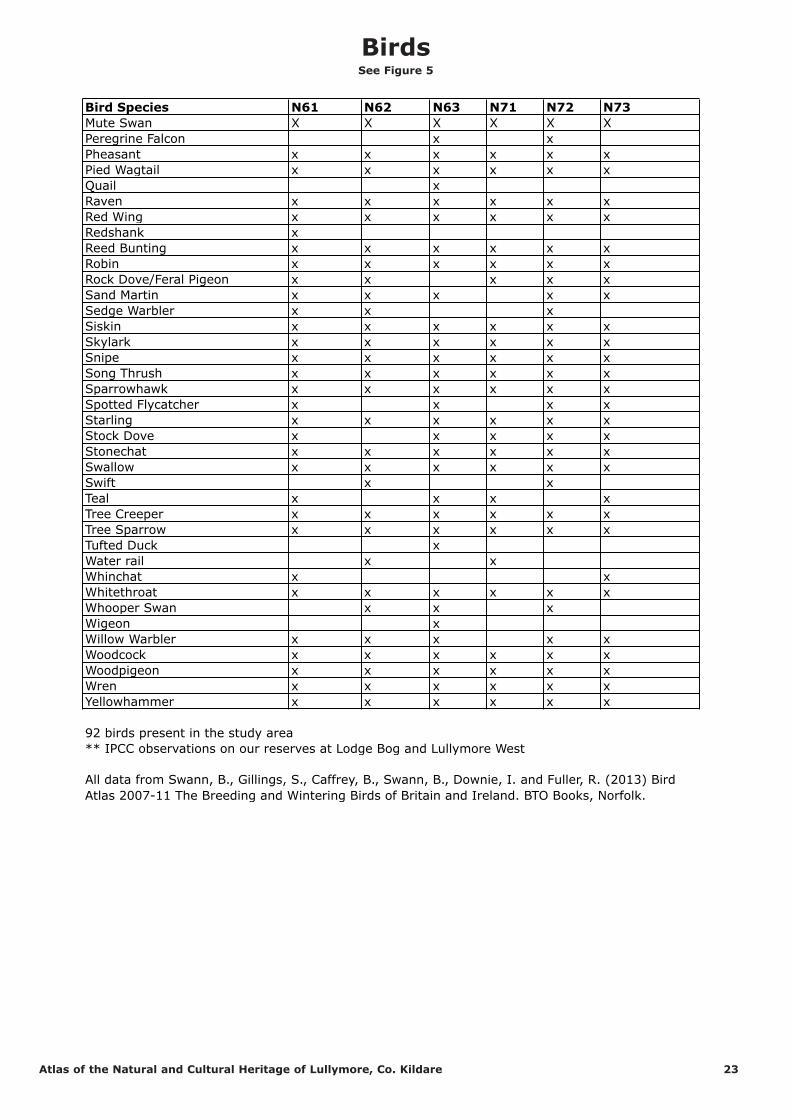
Bird Species N61 N62 N63 N71 N72 N73
Barn Owl x x
Blackbird x x x x x x
Blackcap x x x x x
Black-headed Gull x x x
Blue Tit x x x x x x
Brambling x x
Bullfinch x x x x x x
Buzzard x x x x x x
Carrion Crow x
Chaffinch x x x x x x
Chiffchaff x x x
Coal Tit x x x x x x
Collared Dover x x x x x x
Common Gull x
Coot x x
Cormorant x x x
Cuckoo ** x x
Curlew x x x x
Dunnock x x x x x x
Fieldfare x x x x x x
Goldcrest x x x x x x
Golden Plover x x x x
Goldfinch x x x x x x
Grasshopper Warbler x
Great Tit x x x x x x
Green Sandpiper x
Greenfinch x x x x x x
Grey Heron x x x x x x
Grey Partridge x
Grey Wagtail x x x x
Hen Harrier x x x
Herring Gull x
Hooded Crow x x x x x x
House Martin x x x x x x
House Sparrow x x x x x x
Jackdaw x x x x x x
Jay x x x x x
Kestrel x x x x x x
Kingfisher X x x x x
Lapwing x x x x x
Lesser Black-backed Gull x x x
Lesser Redpoll x x x x x x
Linnet x x x x x x
Little Egret x x x
Little Grebe x x x x x x
Long-eared Owl x x x x
Long-tailed Tit x x x x x x
Magpie x x x x x x
Mallard x x x x x x
Marsh Harrier x
Meadow Pipit x x x x x x
Merlin x x x x
Mistle Thrush x x x x x x
Moorhen x x x x x x
Bird Species Present in the six 10km squares covering the
geographical area studied
Birds See Figure 5
Atlas of the Natural and Cultural Heritage of Lullymore, Co. Kildare 22
Bird Species N61 N62 N63 N71 N72 N73
Mute Swan X X X X X X
Peregrine Falcon x x
Pheasant x x x x x x
Pied Wagtail x x x x x x
Quail x
Raven x x x x x x
Red Wing x x x x x x
Redshank x
Reed Bunting x x x x x x
Robin x x x x x x
Rock Dove/Feral Pigeon x x x x x
Sand Martin x x x x x
Sedge Warbler x x x
Siskin x x x x x x
Skylark x x x x x x
Snipe x x x x x x
Song Thrush x x x x x x
Sparrowhawk x x x x x x
Spotted Flycatcher x x x x
Starling x x x x x x
Stock Dove x x x x x
Stonechat x x x x x x
Swallow x x x x x x
Swift x x
Teal x x x x
Tree Creeper x x x x x x
Tree Sparrow x x x x x x
Tufted Duck x
Water rail x x
Whinchat x x
Whitethroat x x x x x x
Whooper Swan x x x
Wigeon x
Willow Warbler x x x x x
Woodcock x x x x x x
Woodpigeon x x x x x x
Wren x x x x x x
Yellowhammer x x x x x x
92 birds present in the study area
** IPCC observations on our reserves at Lodge Bog and Lullymore West
All data from Swann, B., Gillings, S., Caffrey, B., Swann, B., Downie, I. and Fuller, R. (2013) Bird
Atlas 2007-11 The Breeding and Wintering Birds of Britain and Ireland. BTO Books, Norfolk.
BirdsSee Figure 5
Atlas of the Natural and Cultural Heritage of Lullymore, Co. Kildare 23

Pla
nt
an
d A
nim
al S
pecie
s o
f N
ote
Sp
ecie
s N
am
e
10
km
sq
uare
No
. 6
11
0km
sq
uare N
62
10
km
sq
uare
N6
31
0km
sq
uare N
71
10
km
sq
uare
N7
2
10
km
sq
uare N
73
Acin
os a
rven
sis
(B
asil
Th
ym
e)
Cro
ssm
orr
is
sand p
it A
ugust
1992 a
nd 1
898
Road S
outh
of
Cushaling B
ridge,
17/6
/91.
Long D
err
ies
17/6
/91 a
nd L
ong
Derr
ies 1
928
Curr
agh G
AA c
lub 1
897.
Loughbro
wn S
and P
it 2
6/6
/91.
New
bridge S
and P
its 3
0/6
/91.
Curr
agh G
AA C
lub 1
6/6
/92.
Erig
ero
n a
cer
Long D
err
ies,
17/6
/91
New
bridge s
and p
its 3
0/6
/91.
Loughbro
wn s
and p
it 2
6/6
/91.
Gale
op
sis
an
gu
sti
foli
a
(R
ed
Hem
p N
ett
le)
Sheridan's
Sand P
it,
9/1
990
Curr
agh G
AA c
lub 1
6/6
/92 a
nd
record
fro
m 1
897.
Curr
agh G
AA
Clu
b 2
3/7
/92.
Loughbro
wn S
and
Pit 2
6/6
/91.
Loughbro
wn S
and P
it
June 1
991.
Gro
en
lan
dia
den
sa
(O
pp
osit
e-l
eaved
Po
nd
weed
)
Gra
nd C
anal
Monaste
revin
1985,
Rath
angan
1898
Gra
nd C
anal
Kilm
eage 1
898,
1992
Ham
marb
ya p
alu
do
sa
(B
og
Orch
id)
1894
Lu
tra l
utr
a (
Ott
er)
Clo
nm
ore
,
Clo
nbullogue,
18/2
/91
Ballynanum
,
Edenderr
y
1/1
/91
Fennor
26/1
1/9
1
Drinnansto
wn,
Rath
angan 3
/3/9
2
Marte
s m
arte
s (
Pin
e
Marte
n)
Fennor
26/1
1/9
1
Sciu
ru
s v
ulg
aris
(R
ed
Sq
uir
rel)
Fennor
26/1
1/9
1
So
rex m
inu
tus (
Pyg
my
Sh
rew
)
Ballynanum
,
Edenderr
y
1/1
/91
So
urce:
ww
w.n
pw
s.i
e
NP
WS
Map
Vie
wer S
pecie
s D
ata
Search
fo
r e
ach
10
km
sq
uare 1
9th
Au
gu
st
20
14
Rare Species of Plant and AnimalSee Figure 5
Atlas of the Natural and Cultural Heritage of Lullymore, Co. Kildare 24