AtlantOS D4.4 Sustained transatlantic coastal …...AtlantOS D4.4 Sustained transatlantic coastal...
38
AtlantOS D4.4 Sustained transatlantic coastal observations Project AtlantOS – 633211 Deliverable number 4.4 Deliverable title Sustained transatlantic coastal observations Report: Strategy for transatlantic sustained measurements in the coastal ocean, based on the strengthened forum for interaction between US IOOS, GOOS regional alliances and EuroGOOS. Description DoA: Task 4.4 Transatlantic cooperation and sustainability This task will enhance the European Forum for Coastal Technologies and establish a formal link between the US Alliance for Coastal Technologies and the European Forum for Coastal Technologies. We will strengthen links with coastal observing initiatives around the Atlantic basin including links between EuroGOOS ROOSes, and the regional operational oceanographic systems in the US and Canada. In doing so, we will create a forum for interaction between US IOOS, GOOS regional alliances, and EuroGOOS. The task will develop a strategy for transatlantic sustained measurements in the coastal ocean, building on developments such as OceanObs, Coastal GOOS and JERICO FP7 project, to deliver data for social and economic benefit. Work Package number 4 Work Package title Interfaces with coastal ocean observing systems Lead beneficiary Marine Institute, Rinville, Oranmore, Co. Galway, Ireland. Web: wwww.marine.ie; Email: [email protected] Lead authors Caroline Cusack, Kieran Reilly & Eleanor O'Rourke (MI) Glenn Nolan & Vicente Fernández (EuroGOOS) Kevin Horsburgh (NOC) Patrick Farcy, Guillaume Chiarria and Laurent Delauney (Ifremer) Contributors (in Alphabetical order) SWOT workshop participants; people who reviewed document and/or contributed to examples presented in the document Moacyr Araujo (LOFEC), Anil Ahpinar (Ifremer), Luas Paulo Assad (COPPE UFRJ), Barbara Berx (MSS), Bernard Bourles (Ifremer), Eva-Maria Brodte (AWI), Mark Bushnell (US IOOS/QARTOD), Angelika Brandt (Senckenberg), Edmo Campos (Uni São Paulo) Aurélien Carbonnière (Ifremer), Bernadette Ní Chonghaile (MI), Brad De Young (Memorial Uni) Janice R. T. Duhá (STI of the Brazilian Navy), Luiz Paulo de Freitas Assad (Federal University of Rio de Janeiro), Deirdre Fitzhenry (MI), Paul Gaughan, Alessandra Giorgett (OGS), Sandra Ketelhake (GEOMAR), Diarmuid O'Conchubhair (MI), Matthew Palmer (NOC), Maria Paz Chidichimo (CONICET), Jay Pearlman (IEEE), Isabel Sousa Pinto (Uni Porto), Andrei Polejack (MCTIC), Margaret Rae (MI), Lesley Rickards (BODC NOC) Rodrigo Roubach (LOFEC), Manuel Ruiz Villarreal (IEO), Maurício da Rocha Fragoso (Proocean & CLS), Tim Smyth (PML), Christoph Waldmann (MARUM), Zdenka Willis (Veraision Consultine) Submission date 23 rd March 2019 Due date 31 st December 2018 Comments Deliverable report was delayed due to issues of working schedules related with the deadline coinciding with the end of the year and ensuring the community had a chance to review the document.
Transcript of AtlantOS D4.4 Sustained transatlantic coastal …...AtlantOS D4.4 Sustained transatlantic coastal...

AtlantOS D4.4 Sustained transatlantic coastal observations
Project AtlantOS – 633211
Deliverable number 4.4
Deliverable title Sustained transatlantic coastal observations Report: Strategy for transatlantic sustained measurements in the coastal ocean, based on the strengthened forum for interaction between US IOOS, GOOS regional alliances and EuroGOOS.
Description DoA: Task 4.4 Transatlantic cooperation and sustainability This task will enhance the European Forum for Coastal Technologies and establish a formal link between the US Alliance for Coastal Technologies and the European Forum for Coastal Technologies. We will strengthen links with coastal observing initiatives around the Atlantic basin including links between EuroGOOS ROOSes, and the regional operational oceanographic systems in the US and Canada. In doing so, we will create a forum for interaction between US IOOS, GOOS regional alliances, and EuroGOOS. The task will develop a strategy for transatlantic sustained measurements in the coastal ocean, building on developments such as OceanObs, Coastal GOOS and JERICO FP7 project, to deliver data for social and economic benefit.
Work Package number 4
Work Package title Interfaces with coastal ocean observing systems
Lead beneficiary Marine Institute, Rinville, Oranmore, Co. Galway, Ireland. Web: wwww.marine.ie; Email: [email protected]
Lead authors Caroline Cusack, Kieran Reilly & Eleanor O'Rourke (MI)
Glenn Nolan & Vicente Fernández (EuroGOOS) Kevin Horsburgh (NOC) Patrick Farcy, Guillaume Chiarria and Laurent Delauney (Ifremer)
Contributors (in Alphabetical order) SWOT workshop participants; people who reviewed document and/or contributed to examples presented in the document
Moacyr Araujo (LOFEC), Anil Ahpinar (Ifremer), Luas Paulo Assad (COPPE UFRJ), Barbara Berx (MSS), Bernard Bourles (Ifremer), Eva-Maria Brodte (AWI), Mark Bushnell (US IOOS/QARTOD), Angelika Brandt (Senckenberg), Edmo Campos (Uni São Paulo) Aurélien Carbonnière (Ifremer), Bernadette Ní Chonghaile (MI), Brad De Young (Memorial Uni) Janice R. T. Duhá (STI of the Brazilian Navy), Luiz Paulo de Freitas Assad (Federal University of Rio de Janeiro), Deirdre Fitzhenry (MI), Paul Gaughan, Alessandra Giorgett (OGS), Sandra Ketelhake (GEOMAR), Diarmuid O'Conchubhair (MI), Matthew Palmer (NOC), Maria Paz Chidichimo (CONICET), Jay Pearlman (IEEE), Isabel Sousa Pinto (Uni Porto), Andrei Polejack (MCTIC), Margaret Rae (MI), Lesley Rickards (BODC NOC) Rodrigo Roubach (LOFEC), Manuel Ruiz Villarreal (IEO), Maurício da Rocha Fragoso (Proocean & CLS), Tim Smyth (PML), Christoph Waldmann (MARUM), Zdenka Willis (Veraision Consultine)
Submission date 23rd March 2019
Due date 31st December 2018
Comments Deliverable report was delayed due to issues of working schedules related with the deadline coinciding with the end of the year and ensuring the community had a chance to review the document.

AtlantOS D4.4 Sustained transatlantic coastal observations
This project has received funding from the European Union’s Horizon 2020 research and
innovation programme under grant agreement no 633211.
Stakeholder engagement relating to this task*
WHO are your most important stakeholders?
Coastal Ocean Observing Community; scientists (operational and research)
WHERE is/are the company(ies) or organization(s) from?
All national and regional coastal ocean observing communities around the Atlantic, e.g., the GRAs (Global Ocean Observing System Regional Alliances)
Is this deliverable a success story? If yes, why?
If not, why?
This deliverable can only be considered a success story if the recommendations are seriously considered by the target audience, i.e., State agencies (policy), governance/coordinators of regional systems, Industry, Government, Policymakers) & Funders. This deliverable is considered a success in terms of getting the Coastal Ocean Observing Community involved and actively contributing to the document content.
Will this deliverable be used?
If yes, who will use it?
If not, why will it not be used?
The target audience of this document include State agencies (policy), governance/coordinators of regional systems, Industry, Government, Policymakers), Funders and the ocean observing community in the Atlantic.

AtlantOS D4.4 Sustained transatlantic coastal observations
Strengthening pan-Atlantic linkages of coastal ocean observing communities
A strategy to strengthen pan-Atlantic collaboration between coastal ocean observing communities focused on
achieving sustained measurements in the coastal ocean

AtlantOS D4.4 Sustained transatlantic coastal observations
Table of Contents
1. Executive Summary 1
2. Recommendations 2
3. How the Strategy Framework was developed 3
4. Introduction 5
5. Context: Why do coastal observations matter? 7
6. Benefits of strengthened cooperation and inter-regional collaboration 10
7. Existing Coordination of Atlantic coastal ocean observing system 15
8. North Atlantic Coastal Technology Alliances 17
9. Planning and Governance Initiatives to strengthen Atlantic alliances 18
10. Strategic enabling actions and expected outcomes 23
11. References 24
Annex 1: Glossary 26
Annex 2: Environmental scan of existing coastal ocean observations in the Atlantic 28

AtlantOS D4.4 Sustained transatlantic coastal observations
1 | P a g e
1. Executive Summary
Information on Essential Ocean Variables gathered by operators and researchers can address the societal
needs of coastal nations and Atlantic basin coastal communities. Scientific information from coastal to open
ocean areas advance knowledge to provide significant improvements to the number of products available to
assist societal benefit areas (e.g., climate, disasters, ecosystems, health). The physical, chemical and
biological marine data collected is critical to understand and address the needs and issues of governments
and civil society such as weather forecasting, climate change impacts, water quality issues, food security
and renewable energy resources. This report looks at ways to continue to build and strengthen connections
between Atlantic regional communities and provide recommendations to maximize future community
cooperation in the Atlantic.
This report highlights the importance of coastal ocean observations and the need to strengthening linkages
between Atlantic communities. Civil society need coastal ocean observations (near coast to open ocean) to
understand and address issues such as hurricane tracking, flooding of coastal areas, clean water, sustainable
fisheries and renewable energy. A strategic framework was developed by gathering information from
several sources (AtlantOS reports, recent OOS strategies documents and the literature, discussions with
community experts, AtlantOS team meetings, a Strengths, Weaknesses, Opportunities & Threats / SWOT analysis
workshop and at external meeting). An overview of existing initiatives working to strengthen pan-Atlantic
links between coastal ocean observing communities is provided in the report. There is a requirement for
greater connectivity and collaboration among the Atlantic Ocean observing community (Strategic Focus
Priority 1 & 3). Sustained funding and resources (infrastructure and human) must be assured to allow
sustainable coastal ocean observations (Strategic Focus Priority 1 & 2). Information gaps remain for some
Atlantic regions. The analysis in this report shows that, to ensure pan-Atlantic collaborative success, support
should be initiated at national level (coordinated across all relevant agencies and institutions) with ocean
policies linked to national development plans and harmonized at regional to Atlantic basin scale.
To facilitate this process, it is recommended that the following key strategic enabling actions are used to
help guide future efforts, continue to build and strengthen a pan-Atlantic community cooperation in coastal
ocean observing.

AtlantOS D4.4 Sustained transatlantic coastal observations
2 | P a g e
2. Recommendations
Strategic enabling actions to strengthen links for sustained transatlantic coastal observations
1. Increase the number of, and empower the Atlantic Coastal Ocean Observing National Focal
Points1 to represent national ocean observing activities and interests; leading to an increased
communication within and between countries and, help nations address and act on global
issues, e.g., implementation of the 2030 UN SDGs Agenda.
2. Facilitate a sustained funding structure to enhance and strengthen observations and ensure the
coastal ocean observing infrastructure is fit-for purpose.
3. Capacity Retention and Development
- Support the use of shared pan-Atlantic infrastructure and resources, e.g., through
International transnational access grants, an exchange of ideas and trained personnel
working to build new partnerships.
- Support data and information sharing based on the FAIR2 principles of digital assets and
support the harmonization of quality assurance and quality control procedures building on
existing initiatives like the US QARTOD and in Europe, JERICO.
- Support the implementation of common best practices across the Atlantic basin through
leveraging the AtlantOS supported Ocean Best Practices System to facilitate
interoperability and capacity building.
4. Implement the All Atlantic Ocean Observing System Strategy (aka the BluePrint) to strengthen
alliances within the Atlantic Coastal Ocean Observing Community, build a fit-for-purpose
integrated Atlantic Ocean Observing System and continue to enhance measurement of
biological and biogeochemical observing abilities, track progress and monitor improvements.
Vision: “A lasting cooperative and thriving pan-Atlantic coastal ocean observing community committed to
sharing ocean monitoring activities and innovations, delivering products and services that help protect
marine ecosystems and support sustainable marine economic activities”
Mission: “Foster, develop and strengthen integral partnerships between coastal ocean observing
communities in the Atlantic and identify the steps needed to enable an optimised and integrated coastal
ocean observing system”
1 The GOOS National Focal Points are the appropriate contact points in each Member State for affairs regarding the implementation of the Global Ocean Observing System at national and global levels. 2 Guidelines that provide and improve the findability, accessibility, interoperability and re-use

AtlantOS D4.4 Sustained transatlantic coastal observations
3 | P a g e
3. How the Strategy Framework was developed
The purpose of this report is to recommend strategic enabling actions that will strengthen linkages among the Atlantic Coastal Ocean Observing Community, who are working to accomplish sustained observations in the coastal ocean. Partnerships and collaborative relationships are critical to deliver results. The AtlantOS Task Team 4.4 (T4.4) include the MI, the WP4 co-leaders (Ifremer & NOC) and EuroGOOS who became a member of the team, in February 2016, to help connect task activities with the Atlantic Global Ocean Observing System Regional Alliances (GRAs) community. In 2017, the T4.4 team connected with the wider Atlantic Coastal Ocean Observing Community by organising a Strengths, Weaknesses, Opportunities and Threats (SWOT) analysis workshop at the AtlantOS 3GA, in Plocan, Grand Canaria. The workshop was attended by community experts from Brazil, Argentina, USA, Canada and several European countries. A community contact list was generated, with 35+ members, and this group was given the opportunity to review the report prior to deliverable submission. Other colleagues in the wider community reviewed the document and/or supplied examples on “why coastal observations matter” and on “the benefits that arise from partnerships”. The main actors in this task are members of the Coastal Ocean Observing Community; scientists (operational and research). These stakeholders are the key contributors to the strategy document and their involvement is essential to help build and strengthen transatlantic linkages between their region and other coastal observing initiatives around the Atlantic basin. The Coastal Ocean Observing Community are the future advocates of collaborative initiatives, and if provided support from funders and governments they will succeed to implement the recommendations put forward in this report. The target audience of this document include State agencies, governance/coordinators of regional systems, Industry, Government, Policymakers & Funders. To determine the key Strategic Drivers (external and internal forces), information was gathered from
a) AtlantOS reports, recent OOS strategies documents and the literature e.g., Benedetti-Cecchi et al. 2018, Larkin and Heymans 2018, Anil et al. 2018, Buch et al. 2017, UNESCO 2005, De Young et al. 2018, Buch et al. 2017 and 2019, Morin et al. 2015, internal JERICO-next documents.
b) Discussions with community experts at internal T4.4 AtlantOS meetings (in person and VC) and at wider AtlantOS meetings and external meetings, e.g., EuoGOOS, AGU OS, G7 meetings.
c) AtlantOS activities related to gap analyses, best practice, data management (flow and integration), societal benefits from observing /information systems etc.
The Strategic focus priorities i.e. initiatives the community should focus on in order to succeed in the future were identified through
a) The SWOT analysis weaknesses & threat results (47 % community; 33 % Sustained Observing; 21 % Best Practices).
b) Discussions with AtlantOS WP4 task team (MI, EuroGOOS, Ifremer, NOC). The strategic enablers were determined through
a) Task 4.4 team discussions. b) other AtlantOS workshop/meeting discussions c) the literature d) from the SWOT analyses results

AtlantOS D4.4 Sustained transatlantic coastal observations
4 | P a g e
Figure 1: Strategy Framework for sustained transatlantic coastal observations

AtlantOS D4.4 Sustained transatlantic coastal observations
5 | P a g e
4. Introduction
A shared goal of Atlantic coastal communities is to accomplish sustained long-term coastal ocean observing
abilities. Partnerships at national up to international level are deemed important to achieve success. The
aim of this report is to guide ways to foster, develop and strengthen links with coastal ocean observing
initiatives around the Atlantic basin including links between all Atlantic Global Ocean Observing System
Regional Alliances (GRAs).
AtlantOS WP4 “Interfaces with coastal ocean observing systems” seeks to build on collaborations that can
be realised in terms of harmonized observing strategies to more completely monitor the shelf seas with
stronger links between coastal and open-ocean observing systems. Task 4.4 aimed to provide a context on
existing cooperative activities and links between coastal observing communities in the Atlantic. Initially
activities in this task were focused on establishing a formal link between the US Alliance for Coastal
Technologies and the European Forum for Coastal Technologies. However, the European Forum for Coastal
Technologies was not active during the AtlantOS project and it was, therefore, impossible to establish a
formal link between the US Alliance for Coastal Technologies and the European Forum for Coastal
Technologies. The main activities in this task then focused on the coastal observing initiatives around the
Atlantic basin and on how links can be strengthened between EuroGOOS, ROOSes, and non-EU regional
operational oceanographic systems. At the 3rd AtlantOS General Assembly, the Atlantic coastal observing
community came together to focus on existing regional coastal ocean observing efforts. A SWOT analysis
was carried out to look at the Strengths in the Atlantic, Weakness of existing coastal ocean observing, e.g.,
improvements needed, future Opportunities that the community can take advantage of, and Threats /
factors beyond the control of regional coastal observers which put the existing system at risk. The analysis
focused on South America, North America, Europe and Africa. A key focus was on the importance of
strengthened links in the coastal observing community to address the weaknesses in the system and the
threats in terms of the lack of funding and the lack of infrastructure and coordination in certain regions.
Results of the environmental scan with the top two most important Strengths, Weaknesses, Opportunities
and Threats of the existing Atlantic coastal ocean observing system in each region are presented in Annex 1.
The SWOT results for each region are presented in Annex 1 with the original data stored here. Outputs from
a SWOT analysis on the existing coastal ocean observing system in the Atlantic helped to formulate the
recommendations in this deliverable report, as did the many recently important published/drafted ocean
observing strategies (Fig. 2).

AtlantOS D4.4 Sustained transatlantic coastal observations
6 | P a g e
In this report, we provide a brief overview on the need for coastal ocean observations and the benefits of
strengthening links between coastal regional alliances. A summary of links between the GOOS Regional
Alliances active in the AtlantOS region and commonalities in their strategies is provided and an overview of
coastal technology alliances. Existing and emerging initiatives that aim to strengthen alliances in the Atlantic
are also reviewed. The final section of this report outlines several key recommendations / strategic enabling
actions that can help to strengthen links and accomplish sustained pan-Atlantic coastal ocean observations.
With greater than fifty nations with Atlantic shorelines, there is great potential to enhance and improve
collaborations with communities active in the coastal and ocean observing space.
Figure 2: Recently drafted and published strategic documents on ocean observations from GOOS, GRAs, G7,
Atlantic BluePrint (now called the All Atlantic Ocean Observing System Strategy), the European Strategy for
Atlantic Ocean Observing that feeds into the Atlantic BluePrint and AtlantOS deliverable reports used to
inform strategies.

AtlantOS D4.4 Sustained transatlantic coastal observations
7 | P a g e
5. Context: Why do coastal observations matter?
Forty percent of humans living on planet earth live within 100 Km (60 miles) of marine waters (Martínez et
al. 2007). The economic value of activities carried out in coastal areas and the shelf seas is of great
importance to nations (OECD 2016). For example, rich fishing grounds are often found close to land with
approximately ninety percent of the world’s fish captured in these high productivity regions, particularly at
the shelf edge.
A growing awareness of environmental issues that threaten the health of marine waters and a need to
sustainably manage marine resources has led to an increasing effort to translate ocean observing data into
useful information for societal benefit by co-developing science-based products with stakeholders (general
public, operational and research scientists, state agencies, policy-makers, governance/coordinators of
regional systems, industry, funders) in the diverse marine sector space. Coastal and ocean observing
science-based products support informed decisions and allow positive actions in response to changes in
climate, ocean health and the blue economy. A further need exists to fill gaps in our scientific understanding
of marine ecosystems through research and this guides policy and regulation development. Larkin and
Heymans (2018; AtlantoS D10.11) provide a comprehensive look at present day science-policy drivers and
new initiatives to coordinate and develop an enhanced fit-for-purpose ocean observing system in Europe,
pan-Atlantic and globally. Observing gaps exist, many of which are identified between the near-coast and
open ocean for Europe, in AtlantOS D4.5 (Anil et al. 2018) and the wider Atlantic in AtlantOS D1.3 (Buch et
al. 2017), with key gap areas in observing networks, data availability, sustainability and technology. In
European Atlantic waters, significant gaps were identified at the shelf edge, where the shelf seas meet the
open Atlantic ocean (Anil et al. 2018). Biological and biogeochemical data in the Northwest European shelf
are lacking. Emerging technologies have great potential to fill observing gaps and expand measurements to
include more biological and biogeochemical Essential Ocean Variables (EOVs). A catalogue, created by
AtlantOS, lists the readiness levels of a number of new and emerging sensors and instruments (Pike et al.
2016).
The use of glider technology is gaining traction in coastal and shelf sea ocean observing operations; with a
suite of sensor capabilities and multi-glider deployments possible. Palmer et al. (2018) provides a
methodology on planning strategy, navigation and quality control for sustained multi-glider deployments.
The JCOMMOPS (Joint Technical Commission for Oceanography and Marine Meteorology in situ
Observations Programme Support Centre) young glider network is an excellent example of how we can fill

AtlantOS D4.4 Sustained transatlantic coastal observations
8 | P a g e
the essential ocean variable data gaps in the shelf seas and connect with the open ocean. Numerical
modelling (hydrodynamics) is another great tool to connect coastal and open ocean waters (Wood et al.
2017, Barciela and Tinker 2018). Marine modelling greatly assists scientific investigations, helps address
policy questions, and deliver useful downstream products and services to society (e.g., search and rescue,
interconnectivity between marine protected areas or aquaculture farms, fisheries management). Numerical
ecosystem models must have in-situ ocean observing data to help constrain and improve modelled data
quality. Ecosystem modelling is a key area that requires immediate attention and investment from
governments and with an increased investment necessary to fill the in-situ marine observing gaps (Heymans
et al. 2018).
Ocean observing data gathered from coastal, shelf and the shelf edge can advance scientific knowledge and
provide significant societal benefits (see examples in UNESCO 2005). The need for marine data varies from
scientific curiosity to pressing issues that are wide ranging, e.g., monitoring invasive species, eutrophication,
coastal erosion, marine spatial planning, marine litter, underwater noise, aggregate extraction, dredging,
ecosystem management, ports (ship traffic), commercial and recreational shipping, renewable energy
(wave, tidal, wind), pipelines and cables, cultural heritage, fisheries zones, mariculture, marine protected
areas, waste disposal (solids, including dredge material, dumped munitions, marine constructions).
AtlantOS D4.4 Sustained transatlantic coastal observations
9 | P a g e
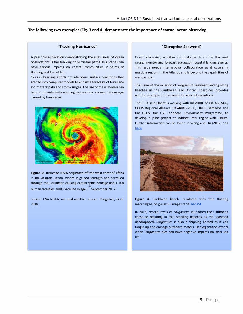
The following two examples (Fig. 3 and 4) demonstrate the importance of coastal ocean observing.
“Tracking Hurricanes”
A practical application demonstrating the usefulness of ocean
observations is the tracking of hurricane paths. Hurricanes can
have serious impacts on coastal communities in terms of
flooding and loss of life.
Ocean observing efforts provide ocean surface conditions that
are fed into computer models to enhance forecasts of hurricane
storm track path and storm surges. The use of these models can
help to provide early warning systems and reduce the damage
caused by hurricanes.
Figure 3: Hurricane IRMA originated off the west coast of Africa
in the Atlantic Ocean, where it gained strength and barrelled
through the Caribbean causing catastrophic damage and > 100
human fatalities. VIIRS Satellite Image 8th
September 2017.
Source: USA NOAA, national weather service. Cangialosi, et al.
2018.
“Disruptive Seaweed”
Ocean observing activities can help to determine the root
cause, monitor and forecast Sargassum coastal landing events.
This issue needs international collaboration as it occurs in
multiple regions in the Atlantic and is beyond the capabilities of
one country.
The issue of the invasion of Sargassum seaweed landing along
beaches in the Caribbean and African coastlines provides
another example for the need of coastal observations.
The GEO Blue Planet is working with IOCARIBE of IOC UNESCO,
GOOS Regional Alliance IOCARIBE-GOOS, UNDP Barbados and
the OECS, the UN Caribbean Environment Programme, to
develop a pilot project to address real region-wide issues.
Further information can be found in Wang and Hu (2017) and
here.
Figure 4: Caribbean beach inundated with free floating
macroalgae, Sargassum. Image credit: hat3M
In 2018, record levels of Sargassum inundated the Caribbean
coastline resulting in foul smelling beaches as the seaweed
decomposed. Sargassum is also a shipping hazard as it can
tangle up and damage outboard motors. Deoxygenation events
when Sargassum dies can have negative impacts on local sea
life.

AtlantOS D4.4 Sustained transatlantic coastal observations
10 | P a g e
6. Benefits of strengthened cooperation and inter-regional collaboration
There are many benefits to strengthening Atlantic coastal ocean observing alliances and coordinating
activities (Fig. 5). This includes the pooling of resources and knowledge to address key gaps in coastal ocean
observing.
Figure 5: An integrated Atlantic Ocean Observing System (source: AtlantOS)
The benefits of a strengthened inter-regional collaboration include:
- Collaborating to solve common socio-economic and global challenges
- Overcoming fragmentation
- Building trust
- Knowledge Transfer, e.g., sharing complementary skills and Best Practice
- Capacity Building, e.g., sharing of assets, ability to achieve critical mass in research
- Innovation development
- Joint funding, providing value for money as well as facilitating activities which are beyond the
capacity of any one country
- Developing joint strategies and increasing inter-regional visibility
A mature integrated coastal ocean observing system can leverage stakeholder efforts by creating,
developing and adopting inter-community “Best Practices” linking the network efforts in coastal,
continental shelf and deep ocean observing related to sampling, technology, data, as well as applications
facilitating knowledge sharing and training. Such community efforts encourage increased interaction with
the International Oceanographic Data and Information Exchange (IODE) programme whose “purpose is to
enhance marine research, exploitation and development, by facilitating the exchange of oceanographic data
and information between participating Member States, and by meeting the needs of users for data and
information products” that in turn inform society. Increased interaction within and between communities
leads to an increased awareness of data standards and to Findable, Accessible, Interoperable and Reusable
AtlantOS D4.4 Sustained transatlantic coastal observations
11 | P a g e
(FAIR) data policies and management. Constructive, dialogue and shared activities between communities
lead to an increase of data submissions to international data custodians such as those linked to the Joint
Commission for Oceanography and Marine Meteorology In Situ Observing Programmes Support Centre
(JCOMMOPS), the Copernicus Marine Environment Monitoring Service (CMEMS), the European Marine
Observation and Data Network (EMODnet) and SeaDataNet. This additional provision of high-quality
datasets will lead to an increased uptake and use of existing data for societal benefit.
The following examples show the value of pan-Atlantic collaboration between communities.
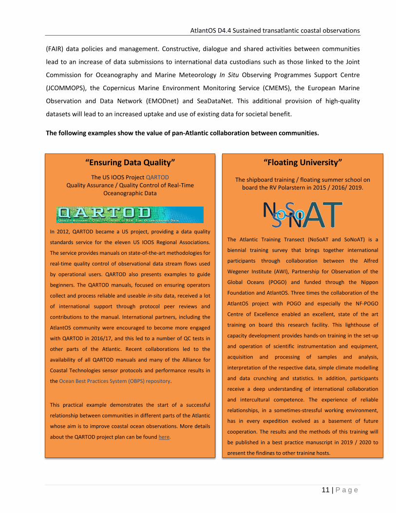
“Ensuring Data Quality”
The US IOOS Project QARTOD Quality Assurance / Quality Control of Real-Time
Oceanographic Data
In 2012, QARTOD became a US project, providing a data quality
standards service for the eleven US IOOS Regional Associations.
The service provides manuals on state-of-the-art methodologies for
real-time quality control of observational data stream flows used
by operational users. QARTOD also presents examples to guide
beginners. The QARTOD manuals, focused on ensuring operators
collect and process reliable and useable in-situ data, received a lot
of international support through protocol peer reviews and
contributions to the manual. International partners, including the
AtlantOS community were encouraged to become more engaged
with QARTOD in 2016/17, and this led to a number of QC tests in
other parts of the Atlantic. Recent collaborations led to the
availability of all QARTOD manuals and many of the Alliance for
Coastal Technologies sensor protocols and performance results in
the Ocean Best Practices System (OBPS) repository.
This practical example demonstrates the start of a successful
relationship between communities in different parts of the Atlantic
whose aim is to improve coastal ocean observations. More details
about the QARTOD project plan can be found here.
“Floating University”
The shipboard training / floating summer school on board the RV Polarstern in 2015 / 2016/ 2019.
The Atlantic Training Transect (NoSoAT and SoNoAT) is a
biennial training survey that brings together international
participants through collaboration between the Alfred
Wegener Institute (AWI), Partnership for Observation of the
Global Oceans (POGO) and funded through the Nippon
Foundation and AtlantOS. Three times the collaboration of the
AtlantOS project with POGO and especially the NF-POGO
Centre of Excellence enabled an excellent, state of the art
training on board this research facility. This lighthouse of
capacity development provides hands-on training in the set-up
and operation of scientific instrumentation and equipment,
acquisition and processing of samples and analysis,
interpretation of the respective data, simple climate modelling
and data crunching and statistics. In addition, participants
receive a deep understanding of international collaboration
and intercultural competence. The experience of reliable
relationships, in a sometimes-stressful working environment,
has in every expedition evolved as a basement of future
cooperation. The results and the methods of this training will
be published in a best practice manuscript in 2019 / 2020 to
present the findings to other training hosts.
AtlantOS D4.4 Sustained transatlantic coastal observations
12 | P a g e
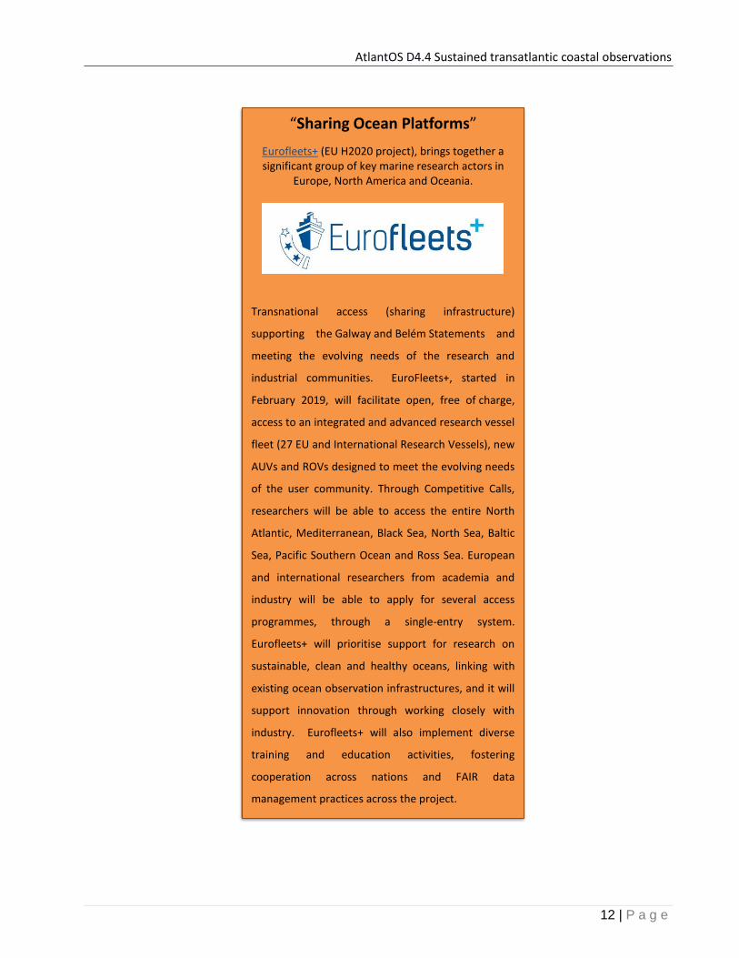
“Sharing Ocean Platforms”
Eurofleets+ (EU H2020 project), brings together a significant group of key marine research actors in
Europe, North America and Oceania.
Transnational access (sharing infrastructure)
supporting the Galway and Belém Statements and
meeting the evolving needs of the research and
industrial communities. EuroFleets+, started in
February 2019, will facilitate open, free of charge,
access to an integrated and advanced research vessel
fleet (27 EU and International Research Vessels), new
AUVs and ROVs designed to meet the evolving needs
of the user community. Through Competitive Calls,
researchers will be able to access the entire North
Atlantic, Mediterranean, Black Sea, North Sea, Baltic
Sea, Pacific Southern Ocean and Ross Sea. European
and international researchers from academia and
industry will be able to apply for several access
programmes, through a single-entry system.
Eurofleets+ will prioritise support for research on
sustainable, clean and healthy oceans, linking with
existing ocean observation infrastructures, and it will
support innovation through working closely with
industry. Eurofleets+ will also implement diverse
training and education activities, fostering
cooperation across nations and FAIR data
management practices across the project.

AtlantOS D4.4 Sustained transatlantic coastal observations
13 | P a g e
Other examples that show how collaboration between communities can achieve success, include, but are
not limited to ...
a) Transferring knowledge and services to the South Atlantic - harmonized sea level data flow
AtlantOS scientists, have been working with other groups, e.g., EuroGOOS tide gauge working
group, to provide a low cost service in coastal areas traditionally lacking capacity. AtlantOS has
compiled a sea level catalogue with valuable information on tide gauge stations in the South
Atlantic, Caribbean, Gulf of Mexico and a small section of Antarctica (Bradshaw 2017). Societal uses
of tide gauge data range from information on tsunamis, storm surges, port activities and tide tables
to global sea level change among other types of derived information. AtlantOS also developed a
South Atlantic tide gauge data management plan (Bradshaw and Rickard 2018). Collaboration was
essential to harmonise sea level data flows from tide gauges in the South Atlantic where there are
resource constraints.
Cross community collaboration has allowed the
- Development of an automatic QC and processing software to improve the flow of quality-
controlled sea level data in the South Atlantic;
- Production of a FAIR data policy management plan
There are future plans to continue collaborative activities with the EuroGOOS tide gauge team.
b) Building a critical mass in West Africa
The PROPAO coastal network (Sohou et al. 2014) is a Regional Program of Physical Oceanography in
West Africa / Programme Régional d’Océanographie Physique en Afrique de l’Ouest. The network is
supported and funded by the French Ministry of Foreign Affairs.
PROPAO has successfully
- Developed a regional network of coastal measurements and a regional coastal data bank for
oceanographic/climatic studies;
- Promoted the formation and capacity building in regional universities, and reinforced capacity
to carry on research in the partner laboratories;
- Initiated collaborations and partnership between a few laboratories dedicated to ocean
sciences in the Gulf of Guinea sub-region.

AtlantOS D4.4 Sustained transatlantic coastal observations
14 | P a g e
c) Simplifying sensor data processing
In late 2018, partners in the, EU INTERREG Atlantic Area funded, MyCoast project (focused on links
between coastal and open ocean observing systems) came together to work on a best practice, to
save time and effort required to process sensor data, that complies with SeaDataNet and
OceanSites data standards. The team aimed to improve interoperability, reduce the need for data
centres to re-process or convert data. Data from fixed platforms are difficult to standardise due to
their nature, e.g., multiple sensor-types and variables measured. Future plans of the MyCoast team
are to share processing scripts to facilitate easy dataset format conversion compatible with
international data integrators such as OceanSites, CMEMS in-situ TAC (e.g. netCDF file format). Best
practices will be extended to all sensors deployed and operational to ensure the same data quality
across the Atlantic Arc coastal observing systems.
d) Industry-Research partnerships
An example of a successful Public-Private partnership in Brazil is the Project AZUL. AZUL aims to
develop an ocean observation system in SE Brazil for the Santos Basin coastal region (dos Santos et
al. 2015). A key area to ensure success of project AZUL was the investment made in professional
and academic training in operational oceanography. Professional and academic capability in
operational ocean modelling and data assimilation was also developed through establishing
cooperative relationships with international universities and other scientific institutions. Project
AZUL proves the feasibility of a public-private partnership for systematic long-term oceanic
observation with tangible benefits to all parties involved. It is important to emphasize that Project
Azul was established as a good solution to improve oceanographic knowledge off the southeastern
coast of Brazil. Initiatives that follow the partnership model of AZUL are under development in
other Brazilian coastal regions and are considered a good solution to enhance the oceanographic
knowledge over the country ocean areas.
AtlantOS D4.4 Sustained transatlantic coastal observations
15 | P a g e
7. Existing Coordination of Atlantic coastal ocean observing system
GOOS and the Regional Alliances
The Global Ocean Observing System (GOOS) is responsible for the coordination of the continuous and long-
term system of ocean observations under three critical themes: climate, operational oceanographic services
and marine ecosystem health. The GOOS is guided by the Framework for Ocean Observations (FOO) to
deliver a fit-purpose ocean observing system driven by scientific requirements with a maximised user base
and societal impact.
The GOOS Regional Alliances (GRAs) are responsible for aligning the global goals of GOOS with the need for
services and products to meet regional and national priorities and requirements. There are thirteen GRAs
active globally. Those that are active in the AtlantOS region (Fig. 7) include:
● OCEATLAN (The Regional Alliance for Oceanography in the Upper Southwest and Tropical Atlantic)
● IOCARIBE (Intergovernmental Oceanographic Commission for the Caribbean and Adjacent Regions)
● US IOOS (US Integrated Ocean Observing System)
● C-IOOS (Canadian Integrated Ocean Observing System)
● EuroGOOS (European Global Ocean Observing System)
● MONGOOS (Mediterranean Operational Network for the Global Ocean Observing System)
● GOOS Africa (Global Ocean Observing System Africa)
“GRAs are coalitions of nations and/or institutions which share GOOS principles and goals, but are mostly
concerned with local priorities and organized around regional seas or coastal environments.”
GOOS is responsible for the international coordination of ocean observing activities and ensuring
cooperation and utilisation of the FOO among the GRAs. The strategic plans of the GRAs have a number of
key objectives in common that have been informed by the GOOS strategic goals. These are:
● Delivering sustained ocean observations that include the coastal zone
● Providing standardised data that is open access (follows the FAIR data principles)
● Supporting ocean modelling and forecasts
● Working with end users for the co-development of products, services and tools.
● Communicating and engaging regularly with relevant stakeholder groups in the scientific
community, industry, policy and the general public.

AtlantOS D4.4 Sustained transatlantic coastal observations
16 | P a g e
Figure 7: Leadership - Global Ocean Observing System (GOOS) Regional Alliances (GRAs) active in the Atlantic and recent coordination initiatives that will strengthen, support and facilitate Atlantic alliance interactions and cooperation. Where OCEATLAN = The Regional Alliance for Oceanography in the Upper Southwest and Tropical Atlantic; IOCARIBE = Intergovernmental Oceanographic Commission for the Caribbean and Adjacent Regions (GOOS); US IOOS = US Integrated Ocean Observing System; C-IOOS = The emerging Canadian Integrated Ocean Observing System; EuroGOOS = European Global Ocean Observing System; MONGOOS = Mediterranean Operational Network for the Global Ocean Observing System; GOOS Africa = Global Ocean Observing System Africa, EOOS = European Ocean Observing System. AORA = Atlantic Ocean Research Alliance supporting the Galway Statement, Belém = Belém Statement. AtlantOS = EU project seeking to improve international collaboration in the design, implementation and benefit sharing of ocean observing activities in the Atlantic. Note: GRA forum meets every two years and have a telecon every 3 months.

AtlantOS D4.4 Sustained transatlantic coastal observations
17 | P a g e
8. North Atlantic Coastal Technology Alliances
The Alliance for Coastal Technologies - USA
The Alliance for Coastal Technologies (ACT) is a partnership of research institutions, resource managers and
private sector companies dedicated to fostering the development and adoption of effective and reliable
sensors and platforms for use in coastal, freshwater and ocean environments. It also lists the provision of a
foundation for US IOOS as one of its priorities.
The Forum for Coastal Technologies - Europe
The Forum for Coastal Technologies (FCT) was established to facilitate interaction on scientific and technical
issues in relation to coastal observations between industry and the observing community (Coppola et al.
2014). One of its key aims is to provide a strong interface between SMEs, industry and, science and
technology stakeholders. A further aim was to develop a European Alliance for Coastal Technologies based
on the model used by the US ACT and to collaborate with the US effort. Unfortunately, the FCT is currently
inactive, although there are plans to revive efforts in future projects/initiatives.

AtlantOS D4.4 Sustained transatlantic coastal observations
18 | P a g e
9. Planning and Governance Initiatives to strengthen Atlantic alliances
The development of Atlantic partnerships has evolved significantly in recent years.
7.1 Established Initiatives
It is evident from the recent signing of the Galway and Belém statements that Atlantic countries want to
strengthen and support Atlantic coastal and open ocean observing. The purpose of the Galway and Belém
accords outlined below is to build on bilateral cooperations (e.g. scientific cooperations) and to work
together on Atlantic Ocean issues of concern to society. This will be achieved by sharing access to marine
research infrastructure, sharing data and knowledge, promoting training amongst others and also
coordinating the planning and programming of relevant activities in the Atlantic Ocean as a whole.
Supports for the implementation of the Galway and Belém Statements are the EC H2020 Atlantic Ocean
Research Alliance - Coordinated and Support Action (AORA-CSA) in the North and its sister flagship
Coordination and Support Action called the All AtlaNtic Cooperation for Ocean Research and innovation
(AANChOR). These support actions coordinate efforts to align research activities in the Atlantic. The
objective of the Supporting Actions is to provide scientific, technical and logistical supports to the European
Commission in developing and implementing pan-Atlantic Marine Research Cooperation with its Atlantic
partners working towards building an All Atlantic Ocean community.
Outputs and recommendations from these CSAs feed into policy maker decisions on research funding along
and across the Atlantic Ocean basin.
“Recognizing the importance of the Atlantic Ocean to our citizens, prosperity, human health and well-being,
adaptation to climate and other environmental change, and security, Cognizant of our reliance upon the best
available science and knowledge to inform decisions affecting the Atlantic Ocean, Realizing that our
countries face similar challenges in promoting a healthy and well understood Atlantic Ocean,
Acknowledging the critical interlink between the Atlantic Ocean and the portion of the Arctic region that
borders the Atlantic, Appreciating the value of our ongoing cooperation on ocean science and observation in
the Atlantic Ocean, and Valuing the essential role of international partnership to achieve our shared
objectives and the potential of greater cooperation to advance our knowledge of the Atlantic Ocean”
[Source: Galway Statement]

AtlantOS D4.4 Sustained transatlantic coastal observations
19 | P a g e
The Atlantic Ocean Research Alliance (AORA) involves the cooperation of Canada, the European Union and
the USA (Fig. 7) to enhance our understanding of the Atlantic Ocean and sustainably manage its resources.
AORA was established at the signing of the Galway Statement on Atlantic Ocean Cooperation in May 2013.
The AORA-CA H2020 project involves the coordination activity of building an Atlantic Ocean community that
focuses on five key areas, including ocean observations. A key activity by the Atlantic Ocean Observing
Community has been a coordinated effort to produce the All Atlantic Ocean Observing System Strategy (aka
Atlantic Blueprint) for an Integrated Atlantic Ocean Observing System.
“Oceans play a key role in developing national and regional economies, achieving the Sustainability Goals,
addressing climate change….Realising the mutual benefit that would accrue from linking research activities
in the South Atlantic and Southern Ocean with those in the North Atlantic, and exploring synergies with
other initiatives…Increasing operational efficiencies by optimising use and sharing of research infrastructures
and access to management of data and platforms: together with emerging methods of data science; and,
Further developing common understanding and deepening scientific knowledge of marine ecosystems and
the interrelations between the oceans and climate change, oceans and food, and oceans and energy
systems, as well as the dynamics of the Atlantic Ocean and its interconnected Circulation Systems from
Antarctica to the Arctic…” [Source: Belém Statement]
The Belém Statement is an agreement, signed in July 2017, between the EU, Brazil and South Africa (Fig. 7)
to upscale research and innovation cooperation within the Atlantic basin, from Antarctica to the Arctic. A
key aim of the agreement is to encourage new models of cooperation and coordination for a partnership-
based approach to tackle the scientific and societal challenges of the Atlantic Ocean. Cooperation between
the north and south Atlantic is strengthened by the recent cooperation agreements between the EC and
Cabo Verde, and between the EC and Argentina in 2018.

AtlantOS D4.4 Sustained transatlantic coastal observations
20 | P a g e
7.2 Emerging Implementation Initiatives
AtlantOS is an EU Horizon 2020 funded project that seeks to integrate ocean observing activities across all
disciplines in the Atlantic Ocean, by using the Framework for Ocean Observations (FOO) to obtain an
international, more sustainable and fit-for-purpose system. A key outcome of AtlantOS is improved
international collaboration in the design, implementation and benefit sharing of ocean observing activities
in the Atlantic.
The All Atlantic Ocean Observing System Strategy (aka Atlantic BluePrint; De Young et al. 2018) outlines an
ambitious vision and a new concept for a forward-looking framework and basin-scale partnership to
establish a comprehensive ocean observing system for the Atlantic Ocean as a whole that shall be
sustainable, multi-disciplinary, efficient, and fit-for-purpose. Europe is prepared to make a substantial
contribution to a successful implementation of AtlantOS and a European Strategy for Atlantic Ocean
Observing (Buch et al. 2019) formulated with clear goals and concrete actions to be achieved by 2025 and
2030 to meet requirements for products and services expressed by European user communities.

AtlantOS D4.4 Sustained transatlantic coastal observations
21 | P a g e
7.3 Regional Implementation Initiatives
EuroGOOS Coastal Working Group
The Coastal Working Group (WG) of EuroGOOS, kicked off in May 2018, and is one of four EuroGOOS WGs
with 16 participating European research and operational centers. The main objective of this group is to
provide recommendations for, and facilitate the creation of coastal data-products and services by groups
around Europe, using coastal data. The group also documents potential coastal data sources and users
requirements of coastal products. The EuroGOOS Coastal WG examines the entire coastal ocean value chain
from coastal observations (in-situ and satellite data), ocean forecasts and analysis, to science based
products and services (provision of products) for coastal users. The WG examines the sustainability and
fitness-for-use (upstream datasets) of the existing system and identifies the future steps needed to secure
and improve all elements of the coastal value chain. The EuroGOOS Coastal Working Group plans to build
upon initiatives already completed or underway with a focus on coastal observing. These include, but are
not limited to, the work of the JERICO and JERICO-NEXT EC projects, activities within EuroGOOS working
groups, task teams, and the five regional operational oceanographic systems (ROOS). A key early priority for
the Coastal Working Group is to document the existing and planned activities and provide a status of the
coastal observing system in Europe at the present time.
The European Ocean Observing System (EOOS) is a framework which aims to coordinate and connect open
ocean and coastal observations in Europe and EU ocean observing capabilities internationally. EOOS
development is driven by the ocean observing community with direction from EuroGOOS and the European
Marine Board. Links to the Global Ocean Observing System (GOOS) are ensured through the involvement of
EuroGOOS. It is also proposed that EOOS will connect with observing communities beyond GOOS, e.g., other
In-situ marine monitoring programmes, such as those related to WFD, MSFD, numerical modelling and
satellite earth observations.

AtlantOS D4.4 Sustained transatlantic coastal observations
22 | P a g e
The Joint European Research Infrastructures for Coastal Observations (JERICO) and JERICO NEXT projects
aimed to strengthen the coastal observing activities in Europe and to progress towards the establishment of
a permanent JERICO-Research Infrastructure. The Forum for Coastal Technologies (FCT) was established by
the first JERICO project, but not sustained in the JERICO-NEXT project. A new project proposal, called
JERICO3, will be submitted to request EC H2020 funding in 2019. If funded, there is planned cooperation
with US IOOS and the Alliance for Coastal Technologies to share best practices and innovative monitoring.
Cooperation initiated with non-European coastal Infrastructures shall include Northwest Association of
Networked Ocean Observing Systems (NANOOS; part of the US IOOS), Ocean Networks Canada (ONC) and
the planned extension of its network off the north Atlantic Canadian coast, and with the Australian
Integrated Marine Observing System (IMOS). The long term aim of JERICO is to build sustained
collaborations between the coastal observing community and the end users and to promote innovation in
the coastal marine sector, mainly in biological observations to answer societal questions linked to coastal
ocean health (Morin et al. 2015). Such collaborations bring added value to Atlantic cooperation on coastal
observatories. An important activity of the JERICO-NEXT project is the transnational access (TNA, now called
TA by the EC) to coastal infrastructure; provided free of charge to interested parties from industry and
academia. Plans to open the TA activities to international wide non-European users is proposed in JERICO3
and if successfully funded will focus on exchanges with other Atlantic infrastructures such as the COCA
(south Atlantic coastal network), US IOOS and C-IOOS. Innovation developments (e.g., biological and
chemical sampling - e-DNA extraction, flow cytometry or carbonate measurements near the coast) will be
tested through international cooperation.

AtlantOS D4.4 Sustained transatlantic coastal observations
23 | P a g e
10. Strategic enabling actions and expected outcomes Sustained coastal observations based on strengthened alliances
NFP3 & Dedicated Network to Strengthen
Alliances Sustained
Funding Structure Capacity
Retention & Development Implement
All Atlantic Ocean Observing System
Strategy
Strategic Enabling Actions (complete by 2030)
*Increase the number of, and empower the Atlantic Coastal Ocean Observing National Focal Points (NFPs; Ketelhake et al. 2019) to represent national ocean observing activities and interests. *The NFP acts as a broker between the national and international community (GOOS & GRAs) linking partners. *NFP coordinates updates on national infrastructure capacity, costs and regular national environmental scan (SWOT).
**Set-up a Funders forum as proposed in the European Strategy (Buch et al. 2019). **Forum responsible to calculate funds needed to support essential resources (personnel and infrastructure) to sustain a fit-for-purpose coastal ocean observing system.
*+**Advance and build on existing open access programmes in the Atlantic, e.g., TAs for researchers and industry, summer schools, floating universities. *+**Support and improve oceanographic academic (Master, PhD) programmes and training courses in ocean STEM. *+**+***Support data and information sharing based on the FAIR principles of digital assets. Support the harmonization of quality assurance and quality control procedures building on existing initiatives like the US QARTOD and in Europe, JERICO. The provision of guidelines will form the base for developing global data products. *+***Support the implementation of common best practices across the Atlantic basin through leveraging the AtlantOS supported Ocean Best Practices System (Perlman et al. submitted) to facilitate interoperability and capacity building.
*+**+***Implement the All Atlantic Ocean Observing System Strategy (aka the BluePrint) *+**+***Ensure implementation activities are carried out in close collaboration with the GOOS RAs.
Expected Outcome
Increased communication within and between countries successfully help nations to address and act on global issues, e.g., implementation of the 2030 UN SDGs Agenda The Coastal Ocean Observing Community is informed and well connected with strengthen Atlantic alliances.
Forum for funders is established with good options available to choose from to sustain observations and ensure the coastal ocean observing infrastructure is fit-for purpose.
Atlantic Wide Access to facilities is achieved. The maturity of coastal ocean observing technologies has advanced significantly. Capacity is built and retained in each Atlantic partner country.
An optimised, Enhanced, Integrated fit-for-purpose observing system is achieved. Strong and productive alliances between Atlantic coastal ocean observing communities are realised.
* Addresses Strategic Focus Priority 1 “Strengthen Atlantic Linkages with Coastal Communities” ** Addresses Strategic Focus Priority 2 “Sustained Observations”
*** Addresses Strategic Focus Priority 3 “Develop Best Practices”
3 National Focal Point (GOOS)
AtlantOS D4.4 Sustained transatlantic coastal observations
24 | P a g e
11. References
Anil, A., Guillaume, C., Cusack, C., Fernandez, V. and O'Conchubhair, D. (2018) Gap analysis of links between coastal and open ocean networks. AtlantOS Deliverable, D4.5 AtlantOS, 24 pp. DOI 10.13155/57443.
Barciela, R. and Tinker, J. (2018) Report on AtlantOS fitness to MSFD needs. ed. by Wood, R. AtlantOS Deliverable, D8.16 AtlantOS, 22 pp. DOI 10.3289/atlantos_d8.16
Benedetti-Cecchi, L.; Crowe, T.; Boehme, L.; Boero, F.; Christensen, A.; Grémare, A.; Hernandez, F.; Kromkamp, J.C.; Nogueira García, E.; Petihakis, G.; Robidart, J.; Sousa Pinto, I.; Zingone, A.; Larkin, K.; Muñiz Piniella, A.; Kellett, P.; Heymans, S.J.J. (2018) Strengthening Europe's capability in biological ocean observations. Marine Board Future Science Brief, 3. European Marine Board: Ostend. ISBN 9789492043559. 76 pp.
Bradshaw, E. (2017) Sea level observing site catalogue: Systematic documentation of South Atlantic tide gauge site data and benchmarks. AtlantOS Deliverable, D4.1 AtlantOS, 505 pp. DOI 10.3289/AtlantOS_D4.1.
Bradshaw, E. and Rickards, L. (2018) South Atlantic tide gauge data management plan. AtlantOS Deliverable, D4.2 AtlantOS, 16 pp. DOI 10.3289/AtlantOS_D4.2.
Buch, E., Palacz, A., Karstensen, J., Fernandez, V., Dickey-Collas, M. and Borges, D. (2017) Capacities and Gap analysis, AtlantOS Deliverable, D1.3 AtlantOS, 105 pp. DOI 10.3289/AtlantOS_D1.3.
Buch, E., Ketelhake, S., Larkin, K. and Ott, M. (2019) European Strategy for Atlantic Ocean Observing. AltantOS Deliverable, D9.5 . AtlantOS (submitted).
Cangialosi, J. P., Latto, A. S. and Berg R. (2018) National hurricane Center Tropical Cyclone Report Hurricane IRMA (AL112017) 111 pp., https://www.nhc.noaa.gov/data/tcr/AL112017_Irma.pdf.
Coppola, L., Puillat, I., Aoustin, Y., Monbet, Ph., Nolan, G., Diamond, E., Ntoumas, M. (2014) Assessment of FCT activities. Towards a Joint European Research Infrastructure network for Coastal Observatories D#1.8, JERICO (FP7), 24pp.
De Young, B. et al. (2018): BluePrint Vision for an Integrated Atlantic Ocean Observing System in 2030, to be considered for publication in Frontiers Marine Science, section Ocean Observation.
dos antos . . de Oliveira . . . . oares . . . arvalho . . o iago P. . antos . . ar o . . Pimentel .P. Boechat . . ariano . . Bergman . Rinaldi, F.L., Miranda, T.C., Cabral, M.M., da Cruz, L.M.M., Pellegrini, J.A.C., Assad, L.P.F., Landau, L., and Fragoso, M.R. (2015) Projeto Azul: operational oceanography in an active oil and gas area southeastern Brazil. Em: Liu Y, Kerkering H, Weisberg RH (eds) Coastal ocean observing systems, 1st ed. Elsevier, London, pp 99–116. doi: 10.1016/B978-0-12-802022-7.00020-1
eymans J.J. kogen . chrum . olidoro . (2018) Enhancing Europe’s capability in marine ecosystem modelling for societal benefit. Larkin, K.E., Coopman, J., Muñiz Piniella, A., Kellett, P., Simon, C., Rundt, C., Viegas, C., Heymans, J.J. [Eds.] Future Science Brief 4 of the European Marine Board, Ostend, Belgium. 32 pp. ISBN: 9789492043580 ISSN: 2593-5232
Ketelhake, S., Visbeck, M. et al. (2019) Report on the performance of AtlantOS observing system (submitted).

AtlantOS D4.4 Sustained transatlantic coastal observations
25 | P a g e
Larkin, K. and Heymans, S. J. J. (2018) Strategic foresight paper on AtlantOS in the European context: Towards strengthened coordination and governance of ocean observing systems. Open Access AtlantOS Deliverable, D10.11 AtlantOS, 48 pp. DOI 10.3289/atlantos_d10.11.
Martínez, M.L., Intralawan, A., Vazquez, G., Perez-Maqueo, O., Sutton, P. and Landgrave, R. (2007) The coasts of our world: Ecological, economic and social importance. Ecological Economics 63(2-3), p 254-272.
Morin, P., Krieger, M., Durand, D., Puillat, I. and Farcy, P. (2015) Achievements and Strategy for the Future. The joint European Research Infrastructure network for Coastal Observatories D#1.11, JERICO (FP7), 112pp.
OECD (2016) The Ocean Economy in 2030, OECD Publishing, Paris. http://dx.doi.org/10.1787/9789264251724-en Palmer, M., Williams, C. and Horsburgh, K. (2018) Synoptic multi-variable multi-glider study. AtlantOS Deliverable, D4.3 AtlantOS, 25 pp. DOI 10.3289/atlantos_d4.3.
Palmer, M., Williams, C. and Horsburgh, K. (2018) Synoptic multi-variable multi-glider study. AtlantOS Deliverable, D4.3 . AtlantOS, 25 pp. DOI 10.3289/atlantos_d4.3.
Pearlman, J., Bushnell, M., Buttigieg, PL., Coppola, L., Pearlman, F., Barbier, M., Simpson, P., Munoz, C., Karstensen, J., Muller-Karger, F., Pissiersens, P., Hermes, J., Heslop, E., Jenkyns, R., Achterberg, E., Bittig, H., Bourles, B., Buck, J., Cusack, C., Delory, E., Garello, R., Hartman, S., Heitsenrether, R., Lara Lopez, A., Leadbetter, A., Manzella, G., Maso, J., McCurdy, A., Moussat, E., Petihakis, G., Pinardi, N., Pouliquen, S., Przeslawski, R., Roden, N., Silke, J., Tamburri, M., Tanhua, T., Thomas, J., Waldmann, C., Whoriskey, F., Bensi M., Bozzano R., Blandin J., Cano D., Cardin V., Charcos Llorens M., Cianca A., Giovanetti G., Lanteri N., Ntoumas M., Pensieri S., Stasch C., Toma M., Tengberg A. (2019) Evolving and Sustaining Ocean Best Practices and Standards for the Next Decade ( ubmitted Ocean Obs’19 White paper to Frontiers Marine Science).
Pike, A., Morris, A., Cardwell C., Connelly, D. and Mowlem, M. (2016) Sensors and Instrumentation Roadmap AtlantOS Deliverable, D6.1 AtlantOS, 24 pp. DOI 10.3289/AtlantOS_D6.1
Sohou, Z. Bourles, B., Djiman, R., AMAN, A., Folorunsho, R., Armah, A. K., and Chuchla, R. Racape, V. (2014) PROPAO: a network of coastal temperature autonomous sensors in the north of the Gulf of Guinea, Proceeding of the Colloquium in Physical Oceanography and Applications, Cotonou, Republica of Benin, 7 November 2012, Ed. Hounkonnou, M.H. and duPenhoat, Y. ISBN 978-99919-1899-0.
UNESCO (2005) An implementation strategy for the coastal module of the Global Ocean Observing System (GOOS), GOOS Report No. 148, United Nations Educational, Scientific and Cultural Organisation, Paris. pp. 142.
Wang, M., and Hu, C. (2017) Predicting Sargassum blooms in the Caribbean Sea from MODIS observations. Geophys. Res. Lett., 44 (7), pp. 3265-3273
Wood, R., Tinker, J., Krijnen, J., Barciela, R. and Dye, S. (2017) Reanalysis for MSFD. AtlantOS Deliverable, D8.5 . AtlantOS, 8 pp. DOI 10.3289/AtlantOS_D8.5.

AtlantOS D4.4 Sustained transatlantic coastal observations
26 | P a g e
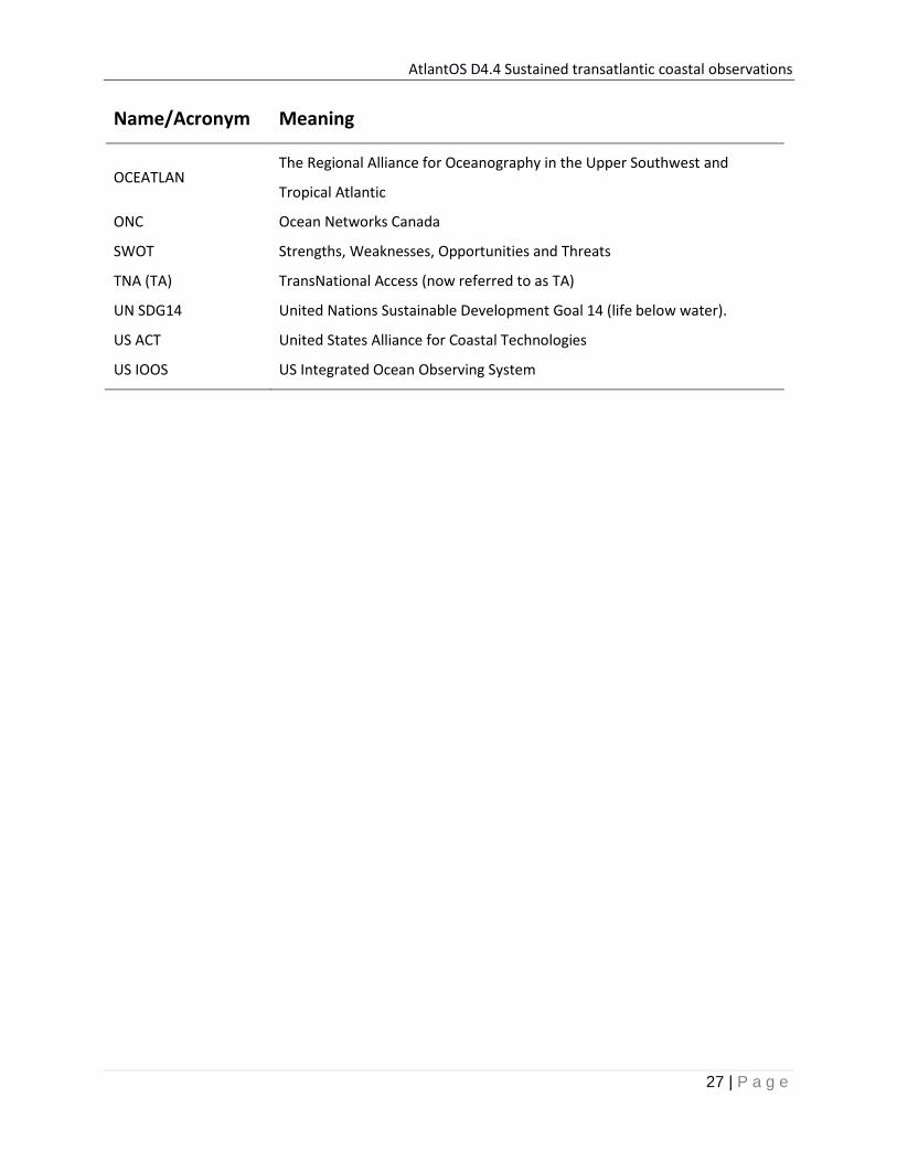
Annex 1: Glossary
Name/Acronym Meaning
Atlantic BluePrint AtlantOS All Atlantic Ocean Observing System Strategy
C-IOOS The emerging Canadian Integrated Ocean Observing System
CMEMS Copernicus Marine Environment Monitoring Service
CTD Conductivity, Temperature with Depth - a package of electronic sensors
that measure seawater properties.
EC European Commission
EU European Union
EuroGOOS European Global Ocean Observing System
FAIR Findable, Accessible, Interoperable and Reusable
FCT Forum for Coastal Technologies
FOO Framework for Ocean Observing
G7 Group of Seven (Canada, France, Germany, Italy, Japan, the United
Kingdom and the United States).
GOOS Global Ocean Observing System
GOOS Africa Global Ocean Observing System Africa
GRAs Global Ocean Observing System Regional Alliances
IOC Intergovernmental Oceanographic Commission of UNESCO
IOCARIBE Intergovernmental Oceanographic Commission for the Caribbean and
Adjacent Regions (GOOS)
IODE International Oceanographic Data and Information Exchange
JERICO Joint European Research Infrastructure for Coastal Observatories
MONGOOS Mediterranean Operational Network for the Global Ocean Observing
System
NANOOS Northwest Association of Networked Ocean Observing Systems
NFP National Focal Point (cf. GOOS)
AtlantOS D4.4 Sustained transatlantic coastal observations
27 | P a g e
Name/Acronym Meaning
OCEATLAN The Regional Alliance for Oceanography in the Upper Southwest and
Tropical Atlantic
ONC Ocean Networks Canada
SWOT Strengths, Weaknesses, Opportunities and Threats
TNA (TA) TransNational Access (now referred to as TA)
UN SDG14 United Nations Sustainable Development Goal 14 (life below water).
US ACT United States Alliance for Coastal Technologies
US IOOS US Integrated Ocean Observing System
AtlantOS D4.4 Sustained transatlantic coastal observations
28 | P a g e
Annex 2: Environmental scan of existing coastal ocean observations in the Atlantic
SWOT results from Atlantic regions in the South & North, East & West - Strengths, Weaknesses, Opportunities and Threats (SWOT) analysis
(South America, North America, Europe and Africa)
The top two priorities in each region is presented from a SWOT Analysis exercise carried out on the
existing Atlantic Ocean Coastal Observing System. This is followed by the SWOT results from the Atlantic
regions: South America, North America, Europe and Africa.
SWOT result source: The 2017 AtlantOS 3rd General Assembly SWOT workshop held in Plocan, Gran
Canaria. Representatives from the coastal and ocean observing communities in Brazil, Argentina, USA,
Canada and several European countries (UK, Ireland, Italy, France, Germany, Belgium, Portugal and
Spain) attended the workshop. Before the workshop information was provided for West Africa and the
Gulf of Guinea.

AtlantOS D4.4 Sustained transatlantic coastal observations
29 | P a g e
Top two for South America, North America, Europe & Africa

AtlantOS D4.4 Sustained transatlantic coastal observations
30 | P a g e

AtlantOS D4.4 Sustained transatlantic coastal observations
31 | P a g e

AtlantOS D4.4 Sustained transatlantic coastal observations
32 | P a g e

AtlantOS D4.4 Sustained transatlantic coastal observations
33 | P a g e
AtlantOS D4.4 Sustained transatlantic coastal observations
34 | P a g e
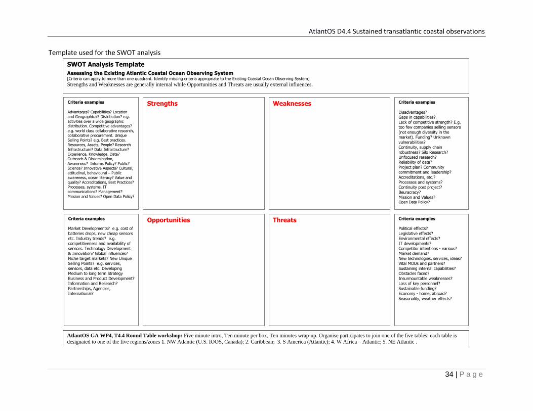
Template used for the SWOT analysis
Strengths Weaknesses
Opportunities Threats Criteria examples
Market Developments? e.g. cost of batteries drops, new cheap sensors etc. Industry trends? e.g. competitiveness and availability of sensors. Technology Development & Innovation? Global influences? Niche target markets? New Unique Selling Points? e.g. services, sensors, data etc. Developing Medium to long term Strategy Business and Product Development? Information and Research? Partnerships, Agencies, International?
Criteria examples
Disadvantages? Gaps in capabilities? Lack of competitive strength? E.g. too few companies selling sensors (not enough diversity in the market). Funding? Unknown vulnerabilities? Continuity, supply chain robustness? Silo Research? Unfocused research? Reliability of data? Project plan? Community commitment and leadership? Accreditations, etc.? Processes and systems? Continuity post project? Beuracracy? Mission and Values? Open Data Policy?
Criteria examples
Political effects?
Legislative effects?
Environmental effects?
IT developments?
Competitor intentions - various?
Market demand?
New technologies, services, ideas?
Vital MOUs and partners?
Sustaining internal capabilities?
Obstacles faced?
Insurmountable weaknesses?
Loss of key personnel?
Sustainable funding?
Economy - home, abroad?
Seasonality, weather effects?
Criteria examples Advantages? Capabilities? Location and Geographical? Distribution? e.g. activities over a wide geographic distribution. Competitive advantages? e.g. world class collaborative research, collaborative procurement. Unique Selling Points? e.g. Best practices. Resources, Assets, People? Research Infrastructure? Data Infrastructure? Experience, Knowledge, Data? Outreach & Dissemination, Awareness? Informs Policy? Public? Science? Innovative Aspects? Cultural, attitudinal, behavioural – Public awareness, ocean literacy? Value and quality? Accreditations, Best Practices? Processes, systems, IT communications? Management?
Mission and Values? Open Data Policy?
SWOT Analysis Template
Assessing the Existing Atlantic Coastal Ocean Observing System [Criteria can apply to more than one quadrant. Identify missing criteria appropriate to the Existing Coastal Ocean Observing System]
Strengths and Weaknesses are generally internal while Opportunities and Threats are usually external influences.
AtlantOS GA WP4, T4.4 Round Table workshop: Five minute intro, Ten minute per box, Ten minutes wrap-up. Organise participates to join one of the five tables; each table is
designated to one of the five regions/zones 1. NW Atlantic (U.S. IOOS, Canada); 2. Caribbean; 3. S America (Atlantic); 4. W Africa – Atlantic; 5. NE Atlantic .