ATLANTIC COAST PIPELINE, LLC ATLANTIC … Program...ATLANTIC COAST PIPELINE, LLC ATLANTIC COAST...
91
ATLANTIC COAST PIPELINE, LLC ATLANTIC COAST PIPELINE Docket Nos. CP15-554-000 & CP15-554-001 and DOMINION TRANSMISSION, INC. SUPPLY HEADER PROJECT Docket No. CP15-555-000 Restoration and Rehabilitation Plan Updated, Rev 3 Prepared by July 18, 2016
Transcript of ATLANTIC COAST PIPELINE, LLC ATLANTIC … Program...ATLANTIC COAST PIPELINE, LLC ATLANTIC COAST...
ATLANTIC COAST PIPELINE, LLC
ATLANTIC COAST PIPELINE
Docket Nos. CP15-554-000 &
CP15-554-001
and
DOMINION TRANSMISSION, INC.
SUPPLY HEADER PROJECT
Docket No. CP15-555-000
Restoration and Rehabilitation Plan
Updated, Rev 3
Prepared by
July 18, 2016
Restoration and Rehabilitation Plan
i
TABLE OF CONTENTS
1.0 INTRODUCTION..............................................................................................................1 2.0 PURPOSE ...........................................................................................................................1
3.0 TRAINING .........................................................................................................................2 4.0 VEGETATION TYPES IN PROJECT AREA ...............................................................2 5.0 BEST MANAGEMENT PRACTICES ............................................................................3
5.1 EROSION CONTROL ............................................................................................3 5.2 SOIL RESTORATION ............................................................................................4 5.3 SOIL COMPACTION .............................................................................................4
5.4 TOPSOIL SEGREGATION, REPLACEMENT, AND SOIL CONDITIONING ..5 5.5 RE-CONTOURING .................................................................................................6 5.6 STEEP SLOPE AREAS ..........................................................................................6
5.7 SITE PREPARATION AND SEEDING .................................................................7 5.7.1 Seedbed Preparation.....................................................................................7 5.7.2 Seeding .........................................................................................................8
5.7.3 Seeding Revegetation Units along the Pipeline Route ................................9 5.7.4 Summary of State and Federal Agencies and Subject Matter Experts
Consulted ...................................................................................................10 5.7.5 Seed Mix Recommendations .....................................................................10 5.7.6 Seeding Methods ........................................................................................22
5.8 SEEDBED AUGMENTATION ............................................................................22 5.8.1 Lime and Fertilizer Application .................................................................22
5.8.2 Mulching ....................................................................................................23 5.8.3 Supplemental Plantings ..............................................................................24
5.9 RIPARIAN RESTORATION ................................................................................24 5.9.1 Non-forested Riparian Areas .....................................................................25
5.9.2 Forested Riparian Areas .............................................................................25 5.10 WETLAND RESTORATION ...............................................................................25 5.11 AGRICULTURAL AREAS ..................................................................................26
5.12 EXPOSED BEDROCK .........................................................................................26 5.13 UPLAND FOREST ...............................................................................................26
6.0 FEDERAL LANDS ..........................................................................................................27 7.0 STATE LANDS ................................................................................................................27 8.0 RESTORATION MONITORING AND MAINTENANCE ........................................28
8.1 MONITORING ......................................................................................................28 8.2 GRAZING DEFERMENTS ..................................................................................28
8.3 PERMANENT RIGHT-OF-WAY MAINTENANCE ..........................................28
9.0 ROLES AND RESPONSIBILITIES ..............................................................................29 9.1 ENVIRONMENTAL INSPECTORS ....................................................................29 9.2 DOCUMENTATION ............................................................................................30
10.0 REFERENCES .................................................................................................................31
Restoration and Rehabilitation Plan
ii
LIST OF TABLES
Table 5.7.4-1 Summary of Federal and State/Commonwealth Agencies and Subject Matter
Expert Consultations ....................................................................................... 11 Table 5.7.5-1 Seed Mix P-MUDW01: Recommended Mountain Physiographic Region Seed
Mix and Application Rates for Excessively to Moderately Well Drained Sites
in West Virginia .............................................................................................. 14 Table 5.7.5-2 Seed Mix P-MUDW01: Recommended Mountain Physiographic Region Forb
Seed Mix and Application Rates for Excessively to Moderately Well Drained
Sites in West Virginia ..................................................................................... 14
Table 5.7.5-3 Seed Mix P-VABCHNP01: Recommended Mountain Physiographic Region
Grass Seed Mix and Application Rates for Excessively to Moderately Well
Drained Sites in Virginia ................................................................................ 15
Table 5.7.5-4 Seed Mix P-VABCHNP01: Recommended Mountain Physiographic Region
Forb Seed Mix and Application Rates for Excessively to Moderately Well
Drained Sites in Virginia ................................................................................ 15
Table 5.7.5-5 Seed Mix P-MUMP02: Recommended Mountain Physiographic Region Grass
Seed Mix and Application Rate for Somewhat Poorly to Very Poorly Drained
Sites in West Virginia ..................................................................................... 16 Table 5.7.5-6 Seed Mix P-MUMP02: Recommended Mountain Physiographic Region Forb
Seed Mix Application Rate for Somewhat Poorly to Very Poorly Drained
Sites in West Virginia ..................................................................................... 16 Table 5.7.5-7 Seed Mix P-VABCHNP02:Recommended Mountain Physiographic Region
Grass Seed Mix and Application Rates for Somewhat Poorly to Very Poorly
Drained Sites in Virginia ................................................................................ 17
Table 5.7.5-8 Seed Mix P-VABCHNP02: Recommended Mountain Physiographic Region
Forb Mix and Application Rates for Somewhat Poorly to Very Poorly Drained
Sites in Virginia .............................................................................................. 17 Table 5.7.5-9 Seed Mix P-VACSDGS01: Recommended Coastal Plain Physiographic
Region Grass Seed Mix and Application Rates for Excessively to Moderately
Well Drained Sites in Virginia ........................................................................ 19 Table 5.7.5-10 Seed Mix P-VACSDGS01: Recommended Coastal Plain Physiographic
Region Forb Seed Mix and Application Rates for Excessively to Moderately
Well Drained Sites in Virginia ........................................................................ 19
Table 5.7.5-11 Seed Mix P-CPDW01: Recommended Coastal Plain Physiographic Region
Grass Seed Mix and Application Rates for Excessively to Moderately Well
Drained Sites in North Carolina ...................................................................... 19
Table 5.7.5-12 Seed Mix P-CPDW01: Coastal Plain Physiographic Region Seed Mix for
Excessively to Moderately Well Drained Sites in North Carolina ................. 20 Table 5.7.5-13 Seed Mix P-VACSDGS02: Coastal Plain Physiographic Region Seed Mix for
Somewhat Poorly to Very Poorly Drained Sites in Virginia .......................... 20
Table 5.7.5-14 Seed Mix P-VACSDGS02: Coastal Plain Physiographic Region Seed Mix for
Somewhat Poorly to Very Poorly Drained Sites in Virginia .......................... 20 Table 5.7.5-15 Seed Mix P-CPDW02:Recommended Coastal Plain Physiographic Region
Grass Seed Mix and Application Rates for Somewhat Poorly to Very Poorly
Drained Sites in North Carolina ...................................................................... 21
Restoration and Rehabilitation Plan
iii
Table 5.7.5-16 Seed Mix P-CPDW02: Recommended Coastal Plain Physiographic Region
Forb Seed Mix and Application Rates for Somewhat Poorly to Very Poorly
Drained Sites in North Carolina ...................................................................... 21
LIST OF FIGURES
Figure 5.7.3-1 Revegetation Unit Areas Along the Pipeline Corridor ................................... 10
LIST OF APPENDICES
Appendix A Major Soil and Drainage Slope Classes Crossed by the Projects
Appendix B Recommended Seed Mix Prescriptions and Soil Amendments
Appendix C Recommended Seed Mixes by Milepost (to be provided prior to construction)

Restoration and Rehabilitation Plan
iv
LIST OF ACRONYMS AND ABBREVIATIONS
ACP Atlantic Coast Pipeline
Atlantic Atlantic Coast Pipeline, LLC
BFM bonded fiber matrix
BMP best management practice
DTI Dominion Transmission, Inc.
EI Environmental Inspector
FERC Federal Energy Regulatory Commission
lbs/acre/PLS pounds per acre of pure live seed
NRCS Natural Resources Conservation Service
Plan Upland Erosion Control, Revegetation, and Maintenance Plan
Procedures Wetland and Waterbody Construction and Mitigation Procedures
Projects Atlantic Coast Pipeline and Supply Header Projects
RU revegetation unit
SHP Supply Header Project
USFS U.S. Forest Service
WMA Wildlife Management Area
Restoration and Rehabilitation Plan
1
1.0 INTRODUCTION
Atlantic Coast Pipeline, LLC (Atlantic) – a company formed by four major energy
companies – Dominion Resources, Inc.; Duke Energy Corporation; Piedmont Natural Gas Co.,
Inc.; and AGL Resources, Inc. – proposes to construct and operate approximately 600 miles of
natural gas transmission pipelines and associated aboveground facilities in West Virginia,
Virginia, and North Carolina. This Project, referred to as the Atlantic Coast Pipeline (ACP), will
deliver up to 1.5 million dekatherms per day of natural gas from supply areas in the Appalachian
region to demand areas in Virginia and North Carolina. Atlantic has contracted with Dominion
Transmission, Inc. (DTI), a subsidiary of Dominion Resources, Inc., to construct and operate the
ACP on behalf of Atlantic.
In conjunction with the ACP, DTI proposes to construct and operate approximately
37.5 miles of pipeline loop and modify existing compression facilities in Pennsylvania and West
Virginia. This Project, referred to as the Supply Header Project (SHP), will enable DTI to
provide firm transportation service to various customers, including Atlantic.
2.0 PURPOSE
This Restoration and Rehabilitation Plan was prepared for the ACP and SHP
(collectively, the Projects) to address post-construction restoration and rehabilitation activities.
The plan will be implemented in conjunction with the 2013 versions of the Federal Energy
Regulatory Commission’s (FERC) Upland Erosion Control, Revegetation, and Maintenance
Plan (Plan) (FERC, 2013a) and Wetland and Waterbody Construction and Mitigation
Procedures (Procedures) (FERC, 2013b) as well as Atlantic’s and DTI’s other construction,
restoration, and mitigation plans (e.g., Spill Prevention, Control, and Countermeasures Plan,
Invasive Species Management Plan, and Winter Construction Plan). The measures described in
this plan reflect generally accepted best management practices (BMP) for restoration and
rehabilitation of pipeline projects.
Atlantic and DTI have consulted with the U.S. Department of Agriculture’s Natural
Resources Conservation Service (NRCS) and are still in the process of consulting with other
Federal, State/Commonwealth, and local agencies, including Federal and State/Commonwealth
land managing agencies, to identify appropriate seed mixes for use during restoration. Based on
discussions to date with the local NRCS offices, seed mixes have been developed and added to
this plan. Seed mixes and how they were developed are described below. A more detailed
description of seed mixes by region is presented in Appendix B.
On most pipeline projects, the seed mixes used for right-of-way restoration generally
consist of cool season grass species that grow well in the local area. Cool season grasses
typically become established quickly and form a dense mat of grass and roots that is effective in
controlling soil erosion in areas that have been disturbed by pipeline construction. These grasses
may also provide food and habitat for some wildlife.
In addition to cool season grasses, Atlantic is planning to incorporate regionally-specific
and endemic forb (flowering plant) seeds in its traditionally all-grass seed mix. The
incorporation and development of native flowering plants on the permanent pipeline right-of-
Restoration and Rehabilitation Plan
2
way will create, where conditions and land management practices are suitable (i.e., areas with
slope less than or equal to about 15 percent), substantial acreages of pollination habitat where
this type of habitat is either currently non-existent or was previously degraded.
Atlantic has consulted and continues to consult with various county offices of the NRCS,
Federal land management resource specialists at the U.S. Forest Service (USFS) and U.S. Fish
and Wildlife Service, county soil and water conservation districts, private groups, and
organizations that have specific knowledge of both perennial cover grasses as well as native
pollinator forb species seed mixes. Atlantic has obtained recommendations from the local
offices of each regarding species, seeding rates, mulching during planting, and maintenance
mowing. Atlantic has also met and consulted with various national, State/Commonwealth, and
local groups and experts on pollinators and pollination species endemic to the region that the
pipeline crosses to learn which native forb seed mixes will be complimentary to the various grass
seed mixes. These meetings and consultations provided information about the appropriate
seeding rates and percentages of each type of seed within a specific seed mix, as well as the
location each seed mix is to be used considering the various soil types, elevations, temperatures,
and other growing conditions along the right-of-way.
Through consultations with regional native seed experts, particularly those working with
the NRCS and the Xerces Society, Atlantic has determined that native flowering forbs grow best
and reproduce most successfully when planted with native warm season grasses. Warm season
grasses are slower to establish than cool season grasses, and are bunch grasses instead of mat
forming. Warm season grasses and forbs do not provide soil coverage that is as dense or as
effective at controlling erosion as cool season grasses. Therefore, Atlantic was advised and has
elected to use native warm season grass and forb mixtures only in areas with gradual or low
percent slopes. In general, in areas of the right-of-way that have slopes greater than 15 percent
Atlantic will use cool season grass mixes without flowering forbs to most effectively control the
potential for erosion. These areas are specified in Section 5.7.5 and in Appendix B.
Atlantic is committed to use only forb species that are native to the area or region where
they will be planted, to try to source seed from local growers, as available, and to avoid the
introduction of non-native and potentially invasive species to the extent practicable.
3.0 TRAINING
Prior to the start of construction, Atlantic and DTI will conduct environmental and safety
training for Company and Contractor personnel. The training program will focus on the FERC’s
Plan and Procedures; other construction, restoration, and mitigation plans, including this
Restoration and Rehabilitation Plan; and applicable permit conditions. In addition, Atlantic and
DTI will provide large-group training sessions before each work crew commences construction
with periodic follow-up training for groups of newly assigned personnel.
4.0 VEGETATION TYPES IN PROJECT AREA
Atlantic and DTI characterized vegetation types in the ACP Project area and SHP Project
area based on review of the U.S. Geological Survey’s National Gap Analysis Program Land
Cover Data and recent digital aerial photography augmented by field reconnaissance (2014 and
Restoration and Rehabilitation Plan
3
2015). Based on these data, the proposed ACP pipeline facilities cross the following cover
types: upland forest/woodland (258.2 miles), cultivated cropland (88.7 miles), wetlands
(79.2 miles), pasture (71.3 miles), tree plantation/harvested forest (60.0 miles), developed
(22.5 miles), open land (16.5 miles), and open water (3.3 miles). The proposed SHP pipeline
facilities cross upland forest/woodland (33.0 miles), pasture (2.2 miles), developed land
(1.3 miles), cultivated cropland (0.5 mile), wetlands (0.3 mile), open water (0.2 mile), open land
(less than 0.1 mile), and tree plantations/harvested forest (less than 0.1 mile). The types of
upland woodland/forest crossed by the Projects include coniferous forests, deciduous forests,
mixed forests, deciduous savanna and glades, and floodplain and riparian forests.
5.0 BEST MANAGEMENT PRACTICES
Based on FERC requirements identified in the Plan and Procedures and industry-accepted
practices, Atlantic and DTI have identified and developed BMPs for restoration and
rehabilitation of areas disturbed by construction. These BMPs have been used to establish
Atlantic’s and DTI’s standards for restoration and revegetation as described below.
5.1 Erosion Control
Atlantic and DTI anticipate that construction activities requiring the installation of
temporary erosion control devices will begin with access road preparation and timber clearing in
2017, and continue through the completion of construction in late 2018. Construction of the
pipelines will be followed by restoration of the rights-of-way, stabilization of the soil, and
seeding (where needed). Atlantic and DTI will complete final grading and installation of
permanent erosion control structures (e.g., trench breakers or permanent slope breakers)
generally within 20 days after backfilling the trench (10 days in residential areas), seasonal or
other weather conditions permitting. For construction activities occurring in Winter, conditions
such as frozen soils or snow cover could delay successful soil compaction mitigation or seeding
activities. In these conditions, Atlantic and DTI will resume clean-up and restoration efforts the
following Spring. Atlantic and DTI will monitor and maintain temporary erosion controls (e.g.,
temporary slope breakers, sediment barriers, or mulch) until conditions allow for completion of
cleanup and installation of permanent erosion control structures.
Temporary erosion control measures and permanent erosion control devices to be
employed during and after construction are described below. Atlantic and DTI will continue to
consult with the applicable land managing agencies to identify other site-specific measures
which may be required on Federal or State/Commonwealth lands.
Slope Breakers – Temporary and permanent slope breakers will be installed,
where required, to slow runoff velocity and direct water off the rights-of-way.
Temporary slope breakers, such as hay bales (weed free), silt fence, or earthen
berms, will be installed prior to the start of construction activities. Permanent
slope breakers will be installed during final grading.
Temporary Sediment Barriers – Temporary sediment barriers, such as silt fences,
staked hay or straw bales (weed free), or a combination of barriers, will be
installed at the base of slopes adjacent to road, wetland, and waterbody crossings,
Restoration and Rehabilitation Plan
4
and in other areas where required to prevent the transport of sediment off the
construction rights-of-way.
Permanent Trench Breakers – Sacks of subsoil or sand, polyurethane foam, or
bentonite clay bags installed around the pipe will remain in the trench to prevent
subsurface channeling of water along the trench.
Mulch – Straw (weed free), hay (weed free), erosion-control fabric, or other
equivalent material will be placed on the rights-of-way, where required, to protect
the soil surface from water and wind erosion and to optimize the soil moisture
regime necessary for successful revegetation, especially on dry, sandy sites.
During construction, the effectiveness of temporary erosion control devices will be
monitored by Atlantic’s and DTI’s Environmental Inspectors (EI). Where appropriate for local
resource priorities, the role of the EI may be filled by agricultural or horticultural monitors. The
effectiveness of revegetation and permanent erosion control devices will be monitored for the
life of the project by Atlantic and DTI operating personnel during the long-term operation and
maintenance of the pipeline systems.
5.2 Soil Restoration
Successful revegetation is dependent on appropriate soil conditions and can be influenced
by several factors, including soil texture, drainage class, salinity, and acidity. Soil characteristics
along the pipeline routes and access roads and at contractor yards and aboveground facility sites
are identified in Resource Report 7. Unless otherwise approved by a land managing agency or
landowner, soil restoration will include:
removal of excavated rock that is not returned to the trench and is considered
construction debris;
distribution of rock on the work area that is of similar size and density to adjacent
areas not disturbed by construction;
grading of the rights-of-way to restore preconstruction contours to the extent
practicable; and
preparation of the soil for revegetation.
5.3 Soil Compaction
Soil compaction resulting from construction activities may reduce the potential for
successful revegetation. Fine-textured soils with poor internal drainage that are moist or
saturated during construction are the most susceptible to compaction and rutting. Atlantic and
DTI will minimize impacts by implementing the mitigation measures for compaction and rutting
as described in the Plan and Procedures. Atlantic and DTI will test for soil compaction:
in residential and agricultural areas (e.g., active croplands, pastures, nurseries, and
orchards);
Restoration and Rehabilitation Plan
5
in other areas requested by the land managing agency or landowner;
in undisturbed areas adjacent to the construction workspace with the same soil
type under similar moisture conditions to approximate preconstruction conditions;
and
in areas identified by the EIs, who will be responsible for conducting subsoil and
topsoil compaction testing and determining the need for corrective measures.
Compaction impacts will be mitigated through the use of tillage equipment during
restoration activities such as a paraplow or similar implement. In areas where topsoil
segregation occurs, plowing with a paraplow or other deep tillage implement to alleviate subsoil
compaction will be conducted before replacement of the topsoil. In rocky or heavily rooted
soils, compaction may be impossible to measure and rectify without additional damage. If
compaction testing is impeded by rock or roots, Atlantic and DTI may conclude that there is a
suitable amount of large material in the soil to rectify potential compaction. Soil compaction
will be remediated prior to re-spreading of salvaged topsoil.
5.4 Topsoil Segregation, Replacement, and Soil Conditioning
The potential mixing of topsoil or surface soil with the subsoil from construction
activities could result in a loss of soil fertility. To prevent mixing of the soil horizons or
incorporation of additional rock into the topsoil, topsoil segregation will be:
performed in the trenchline within non-saturated wetlands, croplands, pastures,
hayfields, residential areas, and in other areas requested by the land managing
agency or landowner;
conducted as described in the Plan and Procedures;
stockpiled on the rights-of-way; and
excluded from materials used for padding the pipe.
Topsoil will be layered above subsoil where seeds stored in the soil will be encouraged to
grow. Topsoil segregation will generally not occur in forested areas. Most forested areas are not
conducive to topsoil segregation due to the amount of root materials present and the wider
construction rights-of-way that would be required to store segregated topsoil. Topsoil
segregation may be required on certain public lands as identified by land managing agencies;
these will be identified and addressed through ongoing consultations with the land managing
agencies (see Sections 5.0 and 6.0).
Restoration and Rehabilitation Plan
6
5.5 Re-Contouring
Grading will be conducted prior to construction where necessary to provide a reasonably
level work surface. Upon completion of construction, Atlantic and DTI will:
restore the ground surface as closely as practicable to original contours to restore
natural overland water flow patterns, aquifer recharge, and drainage patterns;
re-contour disturbed areas in a fashion designed to stabilize slopes, remove ruts
and scars, and support successful revegetation; and
restore, to original or better condition, drainage ditches and culverts that are
diverted or damaged during construction.
5.6 Steep Slope Areas
Areas with steep slopes along the pipeline routes may make the establishment of
vegetation more difficult due to the increased potential for stormwater runoff and erosion by
water. In areas with slopes greater than 15 percent, Atlantic and DTI are planning to use seed
mix prescriptions that utilize appropriate cool season grass species to quickly stabilize the
disturbed areas and minimize erosion and sedimentation. Table 5.6-1 in Appendix A quantifies
by county the major soil drainage and slope classes crossed by the Projects. Soil drainage
classes were used to determine some of the grass seed types utilized in specific mixes (see
Section 5.7.5).
The use of fast-growing cool season grasses will help to ensure faster soil stabilization in
steeper terrain because of the faster development of stable root systems, which hold the soil in
place. Additionally, in areas with slopes greater than 35 percent, the right-of-way will be
restored to natural contours to the extent practicable or in accordance with requests from land
managing agencies or landowners. These steep slope areas are mostly located along the route in
the Appalachian region of West Virginia and western Virginia but occasionally in other areas
along the entire right-of-way. Restoration of steep terrain may include:
grading to the natural conditions;
installation of permanent erosion control devices (i.e., slope breakers) designed to
reduce runoff velocity, divert water from the surface of the rights-of-way, and
encourage retention of soils; and
the use of additional structural materials (e.g., rock or woody debris) to provide an
anchor for revegetation and deposition of soil.
In addition to these general measures, Atlantic and DTI will develop and implement other
additional site-specific measures, where warranted, to address land movement, surface erosion,
backfill erosion, general soil stability when backfilling the trench, and restoring of the rights-of-
way in steep slope areas. Specifically, as discussed in Resource Report 6, Atlantic and DTI are
committed to employing best in class measures to protect the environment in steep slope areas.
Restoration and Rehabilitation Plan
7
Best in class is defined as the most efficient and/or protective design or configuration with the
least environmental impact providing reliable construction and operations.
Also as discussed in Resource Report 6, Atlantic and DTI will implement the Slip
Avoidance, Identification, Prevention, and Remediation – Policy and Procedure, and are
conducting geotechnical studies along the proposed pipeline routes in Pennsylvania, West
Virginia, and western Virginia in steep terrain areas to assess the potential for landslides and
landslips to occur during construction and operation of the Projects.
The following lists some of the special design and construction mitigation measures that
will be implemented during construction in steep slope areas:
targeted management and diversion of surface water around landslide sites,
including the use of ditches, berms, slope breakers, and/or grading;
mitigation of surface erosion by armoring or otherwise stabilizing surface soils
using riprap, coir cloth, hydroseeding, mulching, and/or tracking;
targeted management of water sources along the trench, including the use of
trench breakers and/or added drainage piping in the trench;
targeted mitigation of seeps, springs, or other subsurface water encountered along
the rights-of-way using subsurface drains or other special drainage measures;
engineering of the backfill around or within steep slope areas to dry the backfill,
add compaction, improve backfill soil strength, and reduce saturation;
installation of targeted structures to stabilize backfill using engineered fill,
retaining walls, sack-crete placements, key trenches, and/or shear trenches; and
reduction in surcharge on steep slope areas by reducing excess or saturated
backfill.
5.7 Site Preparation and Seeding
Atlantic and DTI will complete final grading and permanent erosion control measures
within 20 days after backfilling of the trench (10 days in residential areas), seasonal or other
weather conditions permitting. In the event that these timeframes cannot be met or construction
or restoration activities are interrupted for an extended period, mulch will be spread prior to
seeding. In these cases, all slopes within 100 feet of wetlands or waterbodies will be mulched at
a rate of 3 tons per acre.
5.7.1 Seedbed Preparation
Proper preparation of the soil surface and seedbed is essential for rapid and healthy
revegetation (Virginia Department of Environmental Quality, 1992). Successful germination of
seed is enhanced by a well-prepared seedbed, the suitability of which decreases rapidly after
rainfall.
Restoration and Rehabilitation Plan
8
Seedbed preparation starts immediately after soil has been replaced on the rights-of-way
and final grading, contouring, and de-compaction activities are complete. Seedbed preparation
will be conducted immediately prior to seeding to prepare a firm seedbed conducive to proper
seed placement. Seedbed preparation will also be performed to break up surface crusts and to
reduce weeds that develop between the initial ground clearing and final seeding.
Unless otherwise specified by land managing agencies or landowners, the seedbed will be
prepared in disturbed areas to a depth of 3 to 4 inches using appropriate equipment (e.g.,
cultipacker roller) to provide a seedbed that is firm, yet rough. Atlantic and DTI will imprint
exposed soils with a sheepsfoot, landfill compactor, tractor with studded tires, or land imprinter
equipment. Soil imprinting, or tracking, leaves divots on the ground surface that trap moisture
and seeds, creating catchments for native plant material to be spread across the seeded area
(West Virginia Department of Environmental Protection, 2012). In addition, a seedbed with a
rough surface is conducive to the capturing or lodging of seed when broadcasted or hydroseeded,
and can reduce runoff and erosion potential. The rough seedbed surface will also retain soil
moisture for seedling germination and promote faster establishment of vegetation.
In compacted areas, additional measures such as chisel plowing or disking may be
necessary to improve water infiltration and soil aeration necessary to prepare an adequate
seedbed. When hydroseeding, Atlantic and DTI will scarify the soil surface prior to seeding to
anchor the seed to the soil surface and encourage germination. Where residential lawns or
landscaped areas are disturbed, more intensive ground and seedbed preparations may be
required, including rock collection, grading, and soil preparation/amending.
5.7.2 Seeding
Seeding will not be conducted in actively cultivated croplands unless requested by the
landowner. In residential areas, lawns will be restored on a schedule established during
easement negotiations with the landowner. On all other lands, Atlantic and DTI will perform
seeding of permanent vegetation during the Fall of the year construction is completed, within the
recommended seeding dates, and within six working days of final grading, weather and soil
conditions permitting. Atlantic and DTI will prioritize seeding and other restoration work in
high-elevation areas, in an attempt to avoid restoration delays due to Winter-related weather and
field conditions. If seeding cannot be done within recommended Fall timeframes, appropriate
temporary erosion control measures will be installed and temporary grass cover will be seeded.
If temporary grass cover is used, seeding of permanent vegetation will occur at the beginning of
the next recommended seeding season.
In addition, as part of the restoration and rehabilitation plan to revegetate disturbed areas
along the pipeline routes, Atlantic and DTI will use cool season grasses to revegetate areas with
slopes greater than 15 percent. However, in areas with slopes between 0 and 15 percent, Atlantic
and DTI is incorporating regionally-specific warm season grasses and endemic forb (flowering
plant) seed mixes in its traditionally all-grass seed mixes. The incorporation and development of
native flowering plants on the operational rights-of-way of the pipelines will create substantial
acreages of pollination habitat, including areas where this type of habitat is either currently non-
existent or was previously degraded. These seed mixes are described in more detail below and in
Appendix B.
Restoration and Rehabilitation Plan
9
All seed will be certified weed free. The EIs will review all seed tags prior to use to
ensure that the seed is properly certified.
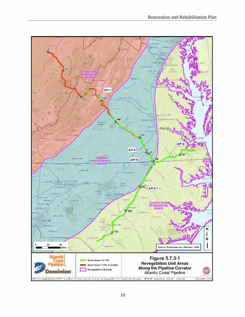
5.7.3 Seeding Revegetation Units along the Pipeline Route
After consultations with Federal, State/Commonwealth, local resource and land
managing agencies, and subject matter experts and in order to insure optimum seed germination
and growth, the areas crossed by the Projects were divided into four Revegetation Units (RU).
One of the RUs is dependent on and defined by the steepness of the slopes crossed by the
proposed pipelines. This RU can occur in site-specific locations anywhere along the pipeline
corridors. The three other RUs are based on physiographic regions, and cover areas that are
relatively homogenous with regards to factors such as soil type, vegetation, and climate that will
affect the revegetation potential of the area. Each RU has distinct seed mix prescriptions. The
four RUs include the following:
Steep to Very Steep Slope RU;
Mountain Physiographic Region RU;
Piedmont Physiographic Region RU; and
Coastal Plain Physiographic Region RU.
Figure 5.7.3-1 shows the distribution of the RUs, including the areas with slopes greater
than 15 percent, along the pipeline route. Seed mix descriptions specific for each RU are
provided in Appendix B.
5.7.3.1 Steep to Very Steep Slope
Although the Steep to Very Steep Slope RU includes areas with greater than 15 percent
slope located anywhere along the Projects, most of these areas are located within the
mountainous areas of the western Piedmont Physiographic RU and the Mountain Physiographic
RU (see Figure 5.7.3-1). To a much lesser extent, the Steep to Very Steep Slope RU may also be
found in smaller, site-specific areas along the pipeline rights-of-way where the steepness of the
local terrain increases the erosion potential. These areas in this RU require appropriate seed mix
prescriptions, erosion control measures, and BMPs that are able to quickly stabilize the disturbed
areas to minimize erosion and sedimentation.
5.7.3.2 Mountain Physiographic Region
The ACP Project area extends across the Mountain Physiographic Region RU in West
Virginia and western Virginia (see Figure 5.7.3-1). In West Virginia, the RU encompasses the
Western Allegheny Plateau, Central Appalachians, and Ridge and Valley ecoregions. The SHP
Project area also extends across the Western Allegheny Plateau in northeastern West Virginia
and southwestern Pennsylvania. In Virginia, this RU encompasses the Ridge and Valley, Blue
Ridge (mountains), and the Southeastern Plains ecoregions. The soils in the Mountain Region
RU generally consist of shallow soils with a loamy surface and subsoil texture. Steep slopes
with shallow, stony, droughty soils are common throughout the area, and many mountainous
soils have been severely eroded due to steepness. In less steep areas, the soils are deep and
stable (less erodible).
Restoration and Rehabilitation Plan
10
5.7.3.3 Piedmont Physiographic Region
The proposed ACP Project area extends across the Piedmont Physiographic Region RU
in Virginia and encompasses the Piedmont, Northern Piedmont, and Southeastern Plains
ecoregions. The Piedmont ecoregion is an area of rolling landscape, gentle hills and valleys with
a few isolated mountains (see Figure 5.7.3-1). The Piedmont is characterized by deep,
weathered, very old eroded rock surfaces. The ecoregion primarily consists of agricultural land
and managed woodlands. The temperate climate supports forests dominated by hardwood
species. In general, the Piedmont and Northern Piedmont ecoregions are similar, as they are
characterized by irregular plains, open valleys, and hills with stony soils that support both
forested and agricultural lands. The Southeastern Plains ecoregion consists of flat plains
interspersed with croplands, pastures, forests, and wetlands with primarily sandy soils. The
overall climate is warm with a much longer rainy season, which contributes to a longer growing
season compared to the Piedmont and Northern Piedmont ecoregions.
5.7.3.4 Coastal Plain Region
The proposed ACP Project area extends across the Coastal Plain Region RU in Virginia
and North Carolina (see Figure 5.7.3-1). This RU encompasses two ecoregions: the Southeastern
Plains and Mid-Atlantic Coastal Plain. As described above, the Southeastern Plains region
consists of flat plains interspersed with croplands, pastures, forests, and wetlands with primarily
sandy soils. The Mid-Atlantic Coastal Plain ecoregion borders the Piedmont ecoregion and the
Atlantic Ocean, and contains a mix of forests, agricultural lands, and wetlands. The soils crossed
by the Projects in these ecoregions are generally well drained soils with a loamy surface and
subsoil texture.
5.7.4 Summary of State and Federal Agencies and Subject Matter Experts Consulted
Table 5.7.4-1 provides a list of the Federal and State/Commonwealth agencies, and
subject matter experts consulted to determine the appropriate seed mix prescriptions and BMPs
to revegetate areas disturbed by the construction of the ACP and SHP facilities.
5.7.5 Seed Mix Recommendations
Appendix B compiles the recommended seeding mixes and amendments provided by
Federal, State/Commonwealth, local resource, and land managing agencies and subject matter
experts into seed mix prescriptions by County/City and by spread for the Projects. Atlantic and
DTI will work with the Federal and State/Commonwealth land managing agencies to determine
appropriate seed mixes and methods for revegetation and restoration of Federal and
State/Commonwealth lands crossed by the pipelines (see Sections 6 and 7). The Virginia
Department of Game and Inland Fisheries has requested that it be responsible for the reseeding
of Wildlife Management Area (WMA) lands crossed in Virginia and under the jurisdiction of
that agency.
Restoration and Rehabilitation Plan
11
The recommended seed mix prescriptions identified for each of the RUs will be identified
by milepost in Appendix C, which will be filed with the FERC prior to construction. The site-
specific seed mixes will also be included on the construction alignments sheets to identify the
seed mixes to be used by the construction contractors during restoration.
TABLE 5.7.4-1
Summary of Federal and State/Commonwealth Agencies and Subject Matter Expert Consultations
Contact Name
Agency/
Organization County Title/Role Phone Email
West Virginia
Greg Stone NRCS - State Office All Counties Acting State Resource Conservationist
304-284-7579 [email protected]
Jeff Griffith USDA NRCS Harrison; Lewis;
Doddridge
District
Conservationist
304-624-9232 x
110
Jack O'Connell USDA NRCS Pocahontas District Conservationist
304-799-4317 [email protected]
Barbara Sargent West Virginia Department of Natural Resources
Wetzel Wildlife Biologist 304-637-0245 [email protected]
Cliff Brown West Virginia Department of Natural Resources
Wetzel Wildlife Biologist 304-637-0245 [email protected]
Idun Guenther NRCS Pocahontas District Conservationist
304-255-9225 [email protected]
Susan Davis NRCS Pocahontas Soil Conservationist 304-799-4317 [email protected]
Rob Silvester West Virginia
Department of Natural Resources
Randolph District Wildlife
Biologist
304-924-6211 [email protected]
Steve Rauch West Virginia
Department of
Natural Resources
Randolph;
Wetzel
District Wildlife
Biologist
304-825-6787 [email protected]
Ben Collier NRCS Randolph;
Upshur
District
Conservationist
304-636-6703 x
305
Jeremy Bennett NRCS Randolph; Upshur
District Conservationist
304-457-4516 [email protected]
Dustin Adkins NRCS Tyler; Wetzel District Conservationist
304-758-2173 x 1
Katie Fitzsimmons NRCS Marshall District
Conservationist
304-242-0576 x
108
Virginia
Amy Ewing Virginia Department
of Game and Inland Fisheries
Wetzel Environmental
Services Biologist/Fish &
Wildlife Information
Manager
804-367-2211 [email protected]
Charles Ivins NRCS Augusta;
Highland
District
Conservationist
540-248-6218 x
122
Charles Simmons NRCS Bath District Conservationist
540-463-7124 x111
Justin Folk NRCS/Virginia Department of Game
and Inland Fisheries
Bath Private Lands Wildlife Biologist
540-248-6218 x 108
Davie Wade Harris NRCS Brunswick District Conservationist
434-848-2145 x 102
David Harris NRCS Buckingham; Cumberland
District Conservationist
434-983-4757 x 101
Restoration and Rehabilitation Plan
12
TABLE 5.7.4-1
Summary of Federal and State/Commonwealth Agencies and Subject Matter Expert Consultations
Contact Name
Agency/
Organization County Title/Role Phone Email
Bryan Poovey U.S. Fish and Wildlife Service
Chesapeake; Suffolk (City);
(Great Dismal
Swamp National Wildlife Refuge)
Forestry Scientist 757-986-3705 [email protected]
David Bryd U.S. Fish and Wildlife Service
Great Dismal Swamp NWR
Forestry Scientist 804-824-2412 [email protected]
Robert E. Williams NRCS Chesapeake District Conservationist
757-547-7172 x 102
Bob Glennon NRCS Eastern Virginia Counties
Private Lands Biologist
757-357-7004 x 126
Anthony Howell NRCS Dinwiddie District
Conservationist
804-469-7297 x
106
Harvey Baker NRCS Greensville District Conservationist
434-634-2115 x 109
Jay Jeffreys Virginia Department of Game and Inland
Fisheries
Highland; Nelson
Biologist 540-248-9360 [email protected]
Kory Kirkland NRCS Nelson District Conservationist
540-967-0233 x 111
Jeffray Jones NRCS All Counties State Biologist 804-287-1691 [email protected]
J.B. Daniel NRCS Prince Edward Agronomist Director 434-392-4171 [email protected]
Derek Hancock NRCS Nottoway; Prince Edward
District Conservationist
434-392-4127 x 101
Yamika Bennett NRCS Southampton District Conservationist
757-653-2532 x 122
Michael A. Faulk NRCS Suffolk (City) District
Conservationist
757-357-7004 x
114
Ryan McCormick National Park Service Specialist Coordinator 828-348-3441
North Carolina
Renessa Hardy-Brown
NRCS Cumberland District Conservationist
910-484-8479 [email protected]
Terry Best NRCS Halifax District
Conservationist
252-583-3481 [email protected]
Brian Loadholt NRCS Johnston District Conservationist
919-934-7156 [email protected]
Patrick Evens NRCS Nash District Conservationist
252-459-4116 x 124
Paul Boone NRCS Northampton District
Conservationist
252-534-2591 [email protected]
Jeremy Ruston NRCS Robeson District Conservationist
910-739-5478 [email protected]
Gavin Thompson NRCS Sampson District
Conservationist
910-592-7963 [email protected]
David Little NRCS Wilson District
Conservationist
252-237-2711 [email protected]
Pennsylvania
Chris Droste Westmoreland Conservation District
Westmoreland Erosion Control Specialist
724-837-5271 [email protected]
Subject Matter Experts
Mark Fiely Ernst Seeds All Counties Horticulturist 800-873-3321 [email protected]
Jeremy Hamlington Roundstone Native Seed
All Counties Horticulturist 270-531-3034 [email protected]
Bob Glennon NRCS / The Xerces All Counties Private Lands 757-357-7004 x [email protected]
Restoration and Rehabilitation Plan
13
TABLE 5.7.4-1
Summary of Federal and State/Commonwealth Agencies and Subject Matter Expert Consultations
Contact Name
Agency/
Organization County Title/Role Phone Email
Society Biologist 126
Nancy Lee Adamson
The Xerces Society for Invertebrate Conservation &
NRCS East National Technology Support
Center
All Counties Pollinator Conservation Specialist
336-370-3443 [email protected]
5.7.5.1 Steep to Very Steep Slope Seed Mixes
As described in Sections 5.7.3, the Steep to Very Steep Slope RU includes areas with
high erosion potential (e.g., slopes greater than 15 percent). These areas require appropriate seed
mixtures and erosion control measures that are able to quickly stabilize disturbed areas. The
recommended seed mixes include the use of cool season grasses, which are identified by County
in Appendix B.
5.7.5.2 Mountain Physiographic Region Seed Mixes
Excessively to Moderately Well Drained Sites
West Virginia
The proposed Mountain Physiographic Region Seed Mix P-MUDW01 (Tables 5.7.5-1
and 5.7.5-2) was designed to be compatible with the Mountain Physiographic Region RU in
areas with slopes of 15 percent or less. The mix is based on selected native grass and forb
species suitable for the restoration of excessively to moderately well-drained mountainous areas
in West Virginia.
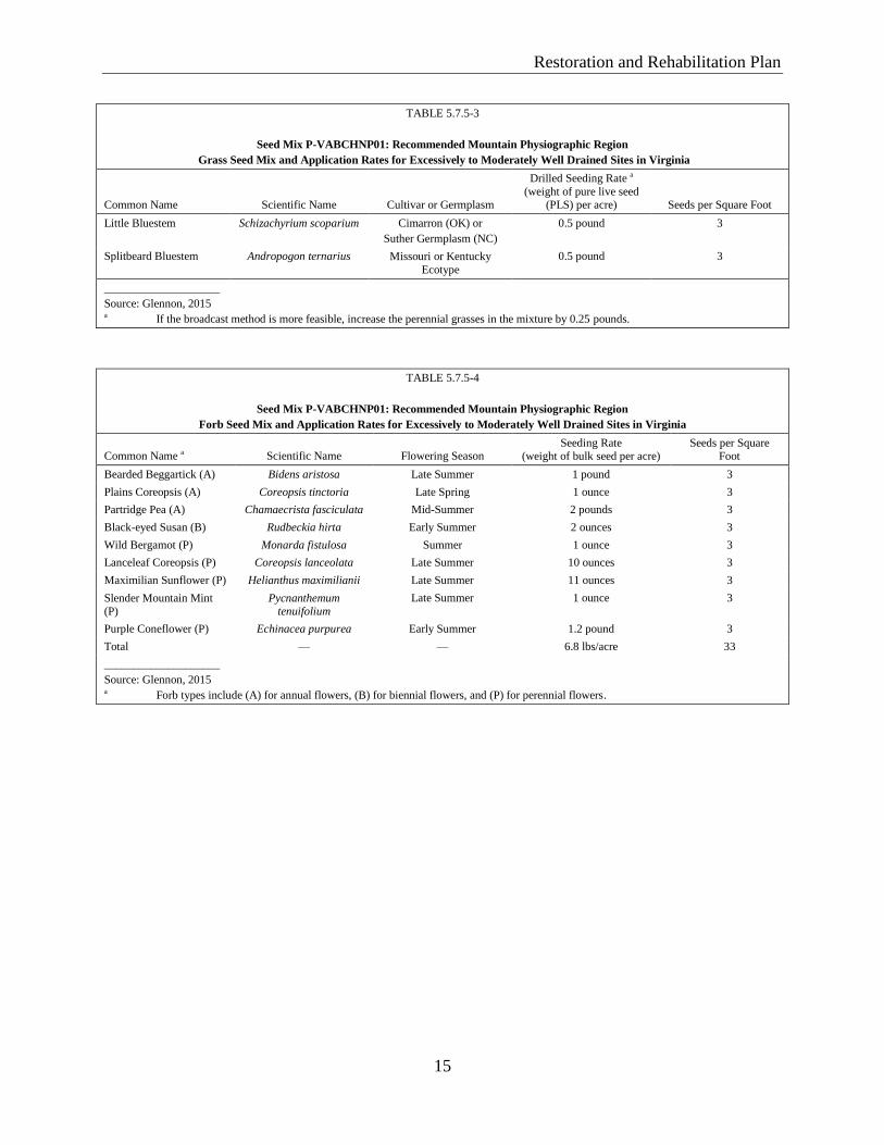
Virginia
The proposed Mountain Physiographic Region Seed Mix P-VABCHNP01
(Tables 5.7.5-3 and 5.7.5-4) was designed to be compatible with the Mountain Physiographic
Region RU in areas with slopes of 15 percent or less. The mix is based on selected native grass
and forb species suitable for restoration in excessively to moderately well-drained mountainous
areas in Virginia.
Somewhat Poorly to Very Poorly Drained Sites
West Virginia
The proposed Mountain Physiographic Region Seed Mix P-MUDW02 (Tables 5.7.5-5
and 5.7.5-6) was designed to be compatible with the Mountain Physiographic Region RU in
areas with slopes of 15 percent or less. The mix is based on selected native grasses and forb
species suitable for restoration in somewhat poorly to very poorly-drained mountainous areas in
West Virginia.
Restoration and Rehabilitation Plan
14
Virginia
The proposed Mountain and Upland Seed Mix P-VABCHNP02 (Tables 5.7.5-7 and
5.7.5-8) was designed to be compatible with the Mountain Physiographic Region RU in areas
with slopes of 15 percent or less. The mix is based on selected native grasses and forb species
suitable for restoration in somewhat poorly to very poorly-drained mountainous areas in
Virginia.
TABLE 5.7.5-1
Seed Mix P-MUDW01: Recommended Mountain Physiological Region
Grass Seed Mix and Application Rates for Excessively to Moderately Well Drained Sites in West Virginia a
Common Name Scientific Name Height (feet) Sun Exposure Seed Mix Rate (lbs/acre/PLS) b
Little Bluestem Schizachyrium scoparium 2 - 4 Full Sun 0.250
Virginia Wild Rye Elymus virginicus 2 - 4 Full Sun 0.250
Tall Dropseed Sporobolus compositus 2 - 3 Full Sun 0.050
Purple Top Tridens flavus 3 - 5 Part Shade 0.058
Indian Grass Sorghastrum nutans 3 - 6 Full Sun 0.167
Switchgrass Panicum virgatum 3 - 7 Full Sun 0.183
Fall Panicum Panicum anceps 2 - 4 Part Shade 0.042
Total — — — 1.0
____________________
Sources: Roundstone Native Seed, 2015; Glennon, 2015 a Recommended seeding application rate is 8 to 18 pounds per acre. b lbs/acre/PLS = pounds per acre of pure live seed
TABLE 5.7.5-2
Seed Mix P-MUDW01: Recommended Mountain Physiological Region
Forb Seed Mix and Application Rates for Excessively to Moderately Well Drained Sites in West Virginia
Common Name Scientific Name Color Bloom Period Seed Application Rate (lbs/acre/PLS) a
Lance Leaved Coreopsis Coreopsis lanceolata Yellow Spring,Summer 0.385
Smooth Beardtongue Penstemon digitalis White Spring 0.146
Common Milkweed Asclepias syriaca Pink Spring,
Summer
0.128
Goat's Rue Tephrosia virginiana White/Pink Spring, Summer
0.128
Partridge Pea Cassia fasciculata Yellow Summer 0.745
Slender Mountain Mint Pycnanthemum tenuifolium White Summer 0.069
Early Goldenrod Solidago juncea Yellow Summer 0.086
Bergamot Monarda fistulosa Lavender Summer 0.103
Spiked Blazing Star Liatris spicata Pink Summer 0.343
Sneezeweed Helenium autumnale Yellow Summer, Fall 0.128
Gray Goldenrod Solidago nemoralis Yellow Fall 0.086
Iron Weed Vernonia altissima Purple Summer, Fall 0.343
Tall Coreopsis Coreopsis tripteris Yellow Summer, Fall 0.051
Total 2.74
____________________
Sources: Roundstone Native Seed, 2015; Glennon, 2015 a lbs/acre/PLS = pounds per acre of pure live seed
Restoration and Rehabilitation Plan
15
TABLE 5.7.5-3
Seed Mix P-VABCHNP01: Recommended Mountain Physiographic Region
Grass Seed Mix and Application Rates for Excessively to Moderately Well Drained Sites in Virginia
Common Name Scientific Name Cultivar or Germplasm
Drilled Seeding Rate a
(weight of pure live seed (PLS) per acre) Seeds per Square Foot
Little Bluestem Schizachyrium scoparium Cimarron (OK) or
Suther Germplasm (NC)
0.5 pound 3
Splitbeard Bluestem Andropogon ternarius Missouri or Kentucky
Ecotype
0.5 pound 3
____________________
Source: Glennon, 2015 a If the broadcast method is more feasible, increase the perennial grasses in the mixture by 0.25 pounds.
TABLE 5.7.5-4
Seed Mix P-VABCHNP01: Recommended Mountain Physiographic Region
Forb Seed Mix and Application Rates for Excessively to Moderately Well Drained Sites in Virginia
Common Name a Scientific Name Flowering Season Seeding Rate
(weight of bulk seed per acre) Seeds per Square
Foot
Bearded Beggartick (A) Bidens aristosa Late Summer 1 pound 3
Plains Coreopsis (A) Coreopsis tinctoria Late Spring 1 ounce 3
Partridge Pea (A) Chamaecrista fasciculata Mid-Summer 2 pounds 3
Black-eyed Susan (B) Rudbeckia hirta Early Summer 2 ounces 3
Wild Bergamot (P) Monarda fistulosa Summer 1 ounce 3
Lanceleaf Coreopsis (P) Coreopsis lanceolata Late Summer 10 ounces 3
Maximilian Sunflower (P) Helianthus maximilianii Late Summer 11 ounces 3
Slender Mountain Mint
(P)
Pycnanthemum tenuifolium
Late Summer 1 ounce 3
Purple Coneflower (P) Echinacea purpurea Early Summer 1.2 pound 3
Total — — 6.8 lbs/acre 33
____________________
Source: Glennon, 2015 a Forb types include (A) for annual flowers, (B) for biennial flowers, and (P) for perennial flowers.
Restoration and Rehabilitation Plan
16
TABLE 5.7.5-5
Seed Mix P-MUMP02: Recommended Mountain Physiographic Region
Grass Seed Mix and Application Rate for Somewhat Poorly to Very Poorly Drained Sites in West Virginia a
Common Name Scientific Name Height (feet) Sun Exposure Seed Mix Rate (lbs/acre/PLS)b
Switchgrass Panicum virgatum 3 - 7 Full Sun 0.233
Red Top Panicum Panicum rigidulum 2 - 4 Full Sun 0.017
Fowl Manna Grass Glyceria striata 3 - 5 Part Shade 0.008
Virginia Wild Rye Elymus virginicus 2 - 4 Full Sun 0.217
Canada Wild Rye Elymus canadensis 2 - 5 Part Shade 0.167
Deer Tongue Grass Panicum clandestinum 2 - 4 Full Sun 0.058
Big Bluestem Andropogon gerardii 4 - 10 Full Sun 0.167
Frank's Sedge Carex frankii 1 - 2 Part Shade 0.042
Fox Sedge Carex vulpinoidea 2 - 3 Part Shade 0.025
Fall Panicum Panicum anceps 2 - 4 Part Shade 0.067
Total — – — 1.0
____________________
Sources: Roundstone Native Seed, 2015; Glennon, 2015
a Recommended seeding application rate is 8 to 18 pounds per acre. b lbs/acre/PLS = pounds per acre of pure live seed
TABLE 5.7.5-6
Seed Mix P-MUMP02: Recommended Mountain Physiographic Region
Forb Seed Mix Application Rate for Somewhat Poorly to Very Poorly Drained Sites in West Virginia
Common Name Scientific Name Color Bloom Period Seed Application Rate (lbs/acre/PLS)a
Ohio Spiderwort Tradescantia ohiensis Blue Spring, Summer 0.167
Smooth Beardtongue Penstemon digitalis White Spring 0.083
Butterfly Milkweed Asclepias tuberosa Orange Spring, Summer 0.083
Blackeyed Susan Rudbeckia hirta Yellow Spring, Summer 0.134
Wild Senna Senna marilandica Yellow Summer 0.668
Hoary Mountain Mint Pycnanthemum incanum White Summer 0.033
Lupine Lupinus perennis Blue Summer 0.501
Bergamot Monarda fistulosa Lavender Summer 0.083
Boneset Eupatorium perfoliatum White Summer 0.083
Joe-Pye Weed Eupatorium fistulosum Pink Summer, Fall 0.125
Showy Tickseed Bidens aristosa Yellow Summer, Fall 0.501
Sneezeweed Helenium autumnale Yellow Summer, Fall 0.125
Rough Goldenrod Solidago rugosa Yellow Fall 0.083
Total — — — 2.67
____________________
Sources: Roundstone Native Seed, 2015; Glennon, 2015 a lbs/acre/PLS = pounds per acre of pure live seed
Restoration and Rehabilitation Plan
17
TABLE 5.7.5-7
Seed Mix P-VABCHNP02: Recommended Mountain Physiographic Region
Grass Seed Mix and Application Rates for Somewhat Poorly to Very Poorly Drained Sites in Virginia a
Common Name Scientific Name Cultivar or Germplasm
Drilled Seeding Rate a
(weight of pure live seed (PLS) per acre) Seeds per Square Foot
Beaked Panicum Panicum anceps SC or MD Ecotype 0.25 pound 3
Redtop Panicum Panicum rigidulum NC Ecotype 0.20 pound 3
____________________
Source: Glennon, 2015 a If the broadcast method is more feasible, increase the perennial grasses in the mixture by 0.25 pounds.
TABLE 5.7.5-8
Seed Mix P-VABCHNP02: Recommended Mountain Physiographic Region
Forb Seed Mix and Application Rates for Somewhat Poorly to Very Poorly Drained Sites in Virginia
Common Name a Scientific Name Flowering Season Seeding Rate (weight of
bulk seed per acre) Seeds per Square Foot
Aster, Purple-stemmed (P) Symphyotrichum puniceum var. puniceum
Fall 3 ounces 3
Bergamot, Wild (P) Monarda fistulosa Summer 1 ounce 3
Coreopsis, Plains (A) Coreopsis tinctoria Late Spring 1 ounce 3
Goldenrod, Pine Barrens (P) Solidago fistulosa Late Summer 3 ounces 3
Joe Pye Weed, Spotted (P) Eupatoriadelphus fistulosus
Late Summer 2 ounces 3
Partridge Pea (A) Chamaecrista fasciculata Mid-Summer 2 pounds 3
Rattlesnake Master (P) Eryngium yuccifolium Summer 8 ounces 3
Rosemallow (P) Hibiscus moscheutos Summer 2 ounces 3
Narrowleaf Sunflower (P) Helianthus angustifolius Late Summer 4 ounces 3
Total — — 4.0 lbs/acre 33
____________________
Source: Glennon, 2015 a Forb types include (A) for annual flowers, (B) for biennial flowers, and (P) for perennial flowers
Pennsylvania
In Pennsylvania, the SHP pipeline (approximately 3.9 miles) will be collocated with
DTI’s existing LN-25 pipeline in Westmoreland County. In general, the SHP pipeline will be
constructed within and directly adjacent to the existing LN-25 pipeline right-of-way which is
seeded with cool season grasses. As presented in Appendix B, the recommended seed mixtures,
rates, and amendments for the SHP were based on existing site conditions and compatibility with
existing grasses, which includes the use of cool season grasses. No pollinator species specific to
the area were recommended.
Restoration and Rehabilitation Plan
18
5.7.5.3 Piedmont Physiographic Region Seed Mixes
Excessively to Moderately Well Drained Sites
Virginia
The proposed Mountain Physiographic Seed Mix P-VABCHNP01 that is described in
Section 5.7.5.2 was designed to also be compatible with the Piedmont Physiographic Region RU
in excessively to moderately well drained areas in Virginia.
Somewhat Poorly to Very Poorly Drained Sites
Virginia
The proposed Mountain Physiographic Seed Mix P-VABCHNP02 described in Section
5.7.5.2 was designed to also be compatible with the Piedmont Physiographic Region RU in
somewhat poorly to very poorly drained sites in Virginia.
5.7.5.4 Coastal Plain Physiographic Region Seed Mixes
Excessively to Moderately Well Drained Sites
Virginia
The proposed Coastal Plain Seed Mix P-VACSDGS01 (Tables 5.7.5-9 and 5.7.5-10) was
designed to be compatible with the Coastal Plain Physiographic Region RU in areas with slopes
of 15 percent or less. The mix is based on selected native grass and forb species suitable for
restoration in excessively to moderately well drained coastal areas in Virginia.
North Carolina
The proposed Coastal Plain Seed Mix P-CPDW01 (Tables 5.7.5-11 and 5.11.5-12) was
designed to be compatible with the Coastal Plain Physiographic Region RU in areas with slopes
of 15 percent or less and is based on selected native grass and forb species suitable for
restoration in excessively to moderately well drained coastal areas in North Carolina.
Somewhat Poorly to Very Poorly Drained Sites
Virginia
The proposed Coastal Plain Seed Mix P-VACSDGS02 (Tables 5.7.5-13 and 5.7.5-14)
was designed to be compatible with the Coastal Plain Physiographic Region RU in areas with
slopes of 15 percent or less. The mix is based on selected native grass and forb species suitable
for restoration in somewhat poorly to very poorly drained coastal areas in Virginia.
Restoration and Rehabilitation Plan
19
TABLE 5.7.5-9
Seed Mix P-VACSDGS01: Recommended Coastal Plain Physiographic Region
Grass Seed Mix and Application Rates for Excessively to Moderately Well Drained Sites in Virginia
Common Name Scientific Name Cultivar or Germplasm Drilled Seeding Rate a (weight of
pure live seed (PLS) per acre)
Seeds per
Square Foot
Little Bluestem Schizachyrium scoparium Cimarron (OK) or
Suther Germplasm (NC)
0.5 pound 3
Splitbeard Bluestem Andropogon ternarius Missouri or Kentucky Ecotype 0.5 pound 3
____________________
Source: Glennon, 2015 a If the broadcast method is more feasible, increase the perennial grasses in the mixture by 0.25 pounds.
TABLE 5.7.5-10
Seed Mix P-VACSDGS01: Recommended Coast Plain Physiographic Region
Forb Seed Mix and Application Rates for Excessively to Moderately Well Drained Sites in Virginia
Common Name a Scientific Name Flowering Season Drilled Seeding Rate (weight
of bulk seed per acre) Seeds per Square Foot
Narrowleaf Mountain
Mint (P)
Pycnanthemum
tenuifolium
Late Summer 1 ounce 3
Plains Coreopsis (A) Coreopsis tinctoria Late Spring 1 ounce 3
Partridge Pea (A) Chamaecrista fasciculata Mid-Summer 2 pounds 3
Black-eyed Susan (B) Rudbeckia hirta Early Summer 2 ounces 3
Bergamot, Spotted (P) Monarda fistulosa Summer 1 ounce 3
Lanceleaf Coreopsis (P) Coreopsis lanceolata Late Summer 10 ounces 3
Maximilian Sunflower (P)
Helianthus maximilianii Late Summer 11 ounces 3
Indian Blanket (A) Gaillardia pulchella Indeterminate 9 ounces 3
Purple Coneflower (P) Echinacea purpurea Early Summer 1.2 pound 3
Total — — 6.4 lbs/acre 33
____________________
Source: Glennon, 2015 a Forb types include (A) for annual flowers, (B) for biennial flowers, and (P) for perennial flowers.
TABLE 5.7.5-11
Seed Mix P-CPDW01: Recommended Coastal Plain Physiographic Region
Grass Seed Mix and Application Rates for Excessively to Moderately Well Drained Sites in North Carolina
Common Name Scientific Name Height (feet) Sun Exposure Seed Mix Rate (lbs/acre/PLS)b
Little Bluestem Schizachyrium scoparium
2- 4 Full Sun 0.250
Virginia Wild Rye Elymus virginicus 2 - 4 Full Sun 0.250
Tall Dropseed Sporobolus compositus 2 - 3 Full Sun 0.050
Purple Top Tridens flavus 3 - 5 Part Shade 0.058
Indian Grass Sorghastrum nutans 3 - 6 Full Sun 0.167
Switchgrass Panicum virgatum 3 - 7 Full Sun 0.183
Fall Panicum Panicum anceps 2 - 4 Part Shade 0.042
Total — — — 1.0
____________________
Sources: Roundstone Native Seed, 2015; Glennon, 2015 a Recommended seeding application rate is 8 to 18 pounds per acre. b lbs/acre/PLS = pounds per acre of pure live seed
Restoration and Rehabilitation Plan
20
TABLE 5.7.5-12
Seed Mix P-CPDW01: Recommended Coastal Plain Physiographic Region
Forb Seed Mix and Application Rates for Excessively to Moderately Well Drained Sites in North Carolina
Common Name Scientific Name Color Bloom Period Seed Application Rate (lbs/acre/PLS)a
Lance Leaved Coreopsis Coreopsis lanceolata Yellow Spring, Summer 0.266
Spotted Beebalm Monarda punctata Pink Spring, Summer 0.124
Common Milkweed Asclepias syriaca Pink Spring, Summer 0.107
Smooth Beardtongue Penstemon digitalis White Spring 0.107
Bergamot Monarda fistulosa Lavender Summer 0.124
Partridge Pea Cassia fasciculata Yellow Summer 0.621
Spiked Blazing Star Liatris spicata Pink Summer 0.222
Lupine Lupinus perennis Blue Summer 0.497
Early Goldenrod Solidago juncea Yellow Summer 0.160
Starry Silphium Silphium asteriscus Yellow Summer, Fall 0.178
Iron Weed Vernonia altissima Purple Summer, Fall 0.222
Sneezeweed Helenium autumnale Yellow Summer, Fall 0.124
Hairy Mountain Mint Pycnanthemum pilosum White Summer, Fall 0.089
Total — — — 2.84
____________________
Sources: Roundstone Native Seed, 2015; Glennon, 2015 a lbs/acre/PLS = pounds per acre of pure live seed
TABLE 5.7.5-13
Seed Mix P-VACSDGS02: Recommended Coastal Plant Physiographic Region
Grass Seed Mix and Application Rates for Somewhat Poorly to Very Poorly Drained Sites in Virginia
Common Name Scientific Name
Cultivar or
Germplasm
Drilled Seeding Rate a (weight
of pure live seed (PLS) per acre) Seeds per Square Foot
Beaked Panicum Panicum anceps SC or MD Ecotype 0.25 pound 3
Redtop Panicum Panicum rigidulum NC Ecotype 0.20 pound 3
____________________
Source: Glennon, 2015 a If the broadcast method is more feasible, increase the perennial grasses in the mixture by 0.25 pounds.
TABLE 5.7.5-14
Seed Mix P-VACSDGS02: Recommended Coastal Plant Physiographic Region
Forb Seed Mix and Application Rates for Somewhat Poorly to Very Poorly Drained Sites in Virginia
Common Name a Scientific Name Flowering
Season Drilled Seeding Rate (weight
of bulk seed per acre) Seeds per
Square Foot
Aster, Purple-stemmed (P) Symphyotrichum puniceum var. puniceum Fall 3 ounces 3
Sneezeweed, Common (P) Helenium autumnale Fall 2 ounces 3
Coreopsis, Plains (A) Coreopsis tinctoria Late Spring 1 ounce 3
Goldenrod, Wrinkleleaf (P) Solidago rugosa Late Summer 2 ounces 3
Joe Pye Weed, Spotted (P) Eupatoriadelphus fistulosus Late Summer 2 ounces 3
Partridge Pea (A) Chamaecrista fasciculata Mid-Summer 2 pounds 3
Rattlesnake Master (P) Eryngium yuccifolium Summer 8 ounces 3
Rosemallow (P) Hibiscus moscheutos Summer 2 ounces 3
Narrowleaf Sunflower (P) Helianthus angustifolius Late Summer 4 ounces 3
Total — — 4.0 lbs/acre 33
____________________
Source: Glennon, 2015 a Forb types include (A) for annual flowers, (B) for biennial flowers, and (P) for perennial flowers
Restoration and Rehabilitation Plan
21
North Carolina
The proposed Coastal Plain Seed Mix P-CPDW02 (Tables 5.7.5-15 and 5.7.5-16) was
designed to be compatible with the Coastal Plain Physiographic Region RU in areas with slopes
of 15 percent or less and is based on selected native grass and forb species suitable for
restoration in somewhat poorly to very poorly drained coastal areas in North Carolina.
TABLE 5.7.5-15
Seed Mix P-CPDW02: Recommended Coastal Plain Physiographic Region
Grass Seed Mix and Application Rates for Somewhat Poorly to Very Poorly Drained Sites in North Carolina a
Common Name Scientific Name Height (feet) Sun Exposure Seed Mix Rate (lbs/acre/PLS)b
Switchgrass Panicum virgatum 3 - 7 Full Sun 0.233
Red Top Panicum Panicum rigidulum 2 - 4 Full Sun 0.017
Fowl Manna Grass Glyceria striata 3 - 5 Part Shade 0.008
Virginia Wild Rye Elymus virginicus 2 - 4 Full Sun 0.217
Canada Wild Rye Elymus canadensis 2 - 5 Part Shade 0.167
Deer Tongue Grass Panicum clandestinum 2 - 4 Full Sun 0.058
Big Bluestem Andropogon gerardii 4 - 10 Full Sun 0.167
Frank's Sedge Carex frankii 1 - 2 Part Shade 0.042
Fox Sedge Carex vulpinoidea 2 - 3 Part Shade 0.025
Fall Panicum Panicum anceps 2 - 4 Part Shade 0.067
Total — — — 1.0
____________________
Sources: Roundstone Native Seed, 2015; Glennon, 2015 a Recommended seeding application rate is 8 to 18 pounds per acre. b lbs/acre/PLS = pounds per acre of pure live seed
TABLE 5.7.5-16
Seed Mix P-CPDW02: Recommended Coastal Plain Physiographic Region
Forb Seed Mix and Application Rates for Somewhat Poorly to Very Poorly Drained Sites in North Carolina
Common Name Scientific Name Color Bloom Period Seed Application Rate
(lbs/acre/PLS)a
Smooth Beardtongue Penstemon digitalis White Spring 0.169
Butterfly Milkweed Asclepias tuberosa Orange Spring, Summer 0.056
Ohio Spiderwort Tradescantia ohiensis Blue Spring, Summer 0.084
Blackeyed Susan Rudbeckia hirta Yellow Spring, Summer 0.180
Spiked Blazing Star Liatris spicata Pink Summer 0.264
Hoary Mountain Mint Pycnanthemum incanum White Summer 0.034
Early Goldenrod Solidago juncea Yellow Summer 0.113
Bergamot Monarda fistulosa Lavender Summer 0.169
Showy Tickseed Bidens aristosa Yellow Summer, Fall 0.366
Starry Silphium Silphium asteriscus Yellow Summer, Fall 0.113
Narrow-Leaved Sunflower Helianthus angustifolius Yellow Summer, Fall 0.113
Joe-Pye Weed Eupatorium fistulosum Pink Summer, Fall 0.141
Total — — — 2.84
____________________
Sources: Roundstone Native Seed, 2015; Glennon, 2015 a lbs/acre/PLS = pounds per acre of pure live seed
Restoration and Rehabilitation Plan
22
5.7.6 Seeding Methods
Seeding may be conducted with the use of a seed drill, a mechanical broadcast seeder, or
by hydroseeding. In the absence of requirements to the contrary, the standard application
method will be seeding with a seed drill equipped with a cultipacker. In rocky soils or where site
conditions may limit the effectiveness of this equipment, other alternatives may be appropriate
(e.g., use of a chain drag) to lightly cover seed after application, as approved by an EI.
Broadcast or hydroseeding at double the recommended seeding rates may be used in lieu of
drilling (see Appendix B for recommendations).
Broadcast seeding will be used for areas with minimal to moderate slopes and will be
performed by dry dispersal or wet broadcast seeding. Wet broadcast seeding is an effective
treatment for temporary erosion control and may be used when hydroseeding late in the season
or on certain site conditions where hydroseeding is not practical. To support successful seed
germination, seed will be broadcast once soil compaction has been rectified and soil composition
includes proper aeration and water percolation to support plant development. Where seed is
broadcast, the seedbed will be restructured with a cultipacker or imprinter after seeding. Once
seed is broadcast, Atlantic and DTI will rake the area lightly to encourage plant establishment
and minimize the seed that migrates from the site (North Carolina Department of Environment
and Natural Resources, 2009).
Hydroseeding involves the mixing of slurry (i.e., seed, water, fertilizer, tackifier, or
mulch) in a truck-mounted mixing tank and ground application via a pressurized pump.
Hydroseeding is the preferred method of seed dispersal on steep slopes greater than 60 percent,
where site conditions require seed adherence to the disturbed soil. Prior to hydroseeding,
Atlantic and DTI will scarify the seedbed to facilitate lodging and germination of seed.
Tackifiers will be applied where necessary so that seed adheres to soil. Polymer binders, if
selected, will be used in accordance with manufacturer’s specifications to ensure proper
compatibility with fertilizers and to avoid foaming that might otherwise result from excessive
agitation. All chemical components will be mixed and administered in accordance with
manufacturer and applicable agency guidelines. In addition, hydroseeding near wetlands or
waterbodies will only be conducted in accordance with the FERC Plan and Procedures and other
applicable agency regulations.
5.8 Seedbed Augmentation
5.8.1 Lime and Fertilizer Application
Lime and fertilizer recommendations provided by the various Federal,
State/Commonwealth, local and land management and subject matter experts consulted for each
County/City are provided in Appendix B. Each county crossed by the Projects may have
different fertilization and liming requirements based on the soil characteristics and the proposed
seed mix prescriptions. In general, and in accordance with the Plan and Procedures, upland areas
will have a fertilizer and pH supplement (i.e., lime) mixed in to the upper two inches of topsoil.
No lime or fertilizer will be used within 100 feet of wetlands or waterbodies or within 300 feet of
karst features. In upland areas without specific fertilization requirements, Atlantic and DTI will:
Restoration and Rehabilitation Plan
23
apply 150 pounds per acre of 10-20-20 (or similar) fertilizer;
apply phosphorus or potassium during the same installation, if required;
avoid fertilizer drift through restricted application times that exclude periods of
high winds or heavy rains; and
store and mix all fertilizers in upland areas and away from karst features, where
contamination of wetlands, waterbodies, or karst features will be avoided.
5.8.2 Mulching
Mulching recommendations provided by the various Federal, State/Commonwealth, local
and land management agencies, and subject matter experts consulted for each County/City are
provided in Appendix B. Each County/City crossed by the Projects may have different mulching
requirements based on the landscape characteristics, soil types, and the proposed seed mix
prescriptions. In general, and in accordance with the Plan, Atlantic and DTI will apply mulch to
slopes immediately after seeding to prevent erosion. In non-forested areas, mulch will be spread
uniformly over a minimum of 75 percent of the surface at a rate of 2 tons per acre, or 1 ton per
acre if wood chips are used, or per directions from land managing agencies or landowners. In
forested areas, if the amount of mulch will likely exceed these parameters due to the shredding of
non-merchandisable forest materials cleared from the rights-of-way, Atlantic and DTI will
request a variance from FERC prior to applying mulch greater than 1 ton/acre. Mulch materials
will be anchored to the soil with stakes or liquid mulch tackifiers. No tackifiers will be used
within 100 feet of wetlands and waterbodies or within 300 feet of karst features.
Possible mulch materials and application techniques are described below.
Salvaged wood materials, including slash and non-merchantable timber, will be
retained in forested areas and placed on the rights-of-way after final grading, re-
contouring, and seeding is complete. Woody debris is expected to support
revegetation while preventing erosion and providing micro-habitat for various
species.
Native wood chip materials will be used in forested systems and will be generated
from cleared materials that are chipped and stockpiled on the edge of the rights-
of-way. Native wood chips are expected to aid in the successful revegetation of
disturbed areas.
Wood fiber hydromulch may be used in shrubby areas to augment biomass
salvaged during clearing. Hydromulch is evenly distributed and absorbs water
quickly, which enhances seed survival rates and discourages erosion during
regeneration of shrubby species.
Bonded fiber matrix (BFM), a type of hydromulch designed to control erosion on
steep slopes, may also be used where appropriate. BFM slurry contains thermally
processed wood fibers (approximately 80 percent), water (approximately
Restoration and Rehabilitation Plan
24
10 percent), and tackifiers and polymer-based binding agents that are quick to dry
upon application. BFM is hydraulically applied, which allows for controlled
application on steep slopes where access may be difficult. BFM will only be
applied to stable slopes where final grading has been completed and water runoff
has been diverted from the slope face. Once BFM has had 24 to 48 hours to cure,
an erosion-resistant blanket is formed that is flexible, absorbent, and
biodegradable, and that will accelerate plant growth. BFM may be used in
conjunction with slope breakers and other erosion control devices on slopes
longer than 70 feet. BFM application rates will depend on manufacturers
specifications, based upon the slope of the disturbed areas.
Straw or hay that has been certified as weed-free will be used to preserve the soil
base in areas where native salvaged material is not available. In areas that are
seeded by drill, Atlantic and DTI will apply one bale of clean straw or hay per
1,000 square feet. Where broadcast seeding is used, Atlantic and DTI will apply
two bales of clean straw or hay per 1,000 square feet, or in accordance with
requirements specified by Federal or State/Commonwealth land managing
agencies.
5.8.3 Supplemental Plantings
Where required, Atlantic and DTI may supplement seeding with the planting of tree
seedlings or small shrubs. No supplemental plantings are anticipated for maintained areas within
the permanent easements for the pipelines. Public lands will be revegetated in accordance with
land management objectives and direction from land managing agencies (see Sections 5.0 and
6.0).
5.9 Riparian Restoration
Following initial stream bank stabilization, Atlantic and DTI will restore the banks of
waterbodies to preconstruction contours to the extent practicable. In steep-slope areas, re-
grading may be required to reestablish stable contours capable of supporting preconstruction
drainage patterns. Riparian areas will be revegetated with native species across the entire width
of the construction corridor. Restoration of riparian areas will be designed to:
restore stream bank integrity, including both shore crossings up to the ordinary
high water mark;
withstand periods of high flow without increasing erosion and downstream
sedimentation; and
include temporary erosion control fencing, which will remain in place until stream
bank and riparian restoration is complete.
Permanent bank stabilization and erosion control devices (e.g., natural structures, rock
riprap, and/or large woody debris) will be installed as necessary on steep banks in accordance
with permit requirements to permanently stabilize the banks and minimize sediment deposition
into waterbodies.
Restoration and Rehabilitation Plan
25
5.9.1 Non-forested Riparian Areas
All disturbed banks and riparian work areas will be seeded as soon as possible after final
grading, weather and soil conditions permitting and subject to the recommended seeding dates
for the area. Seeding is intended to stabilize the soil, improve the appearance of the area
disturbed by construction, and restore native flora. As discussed above, Atlantic and DTI will
determine appropriate seeding prescriptions based upon the vegetative community of the
disturbed area, and will continue to consult with land managing agencies regarding seeding
requirements for riparian areas.
5.9.2 Forested Riparian Areas
Restoration of forested riparian areas will include seeding as discussed above, and may
include supplemental plantings of tree seedlings and shrubs. Clearing of riparian trees in
forested areas will reduce shade near streams, and may allow for an increase in local water
temperature. Large woody debris, where available and appropriate habitat conditions exist, will
be placed adjacent to waterbody crossings to add shade and fish habitat. Forested riparian areas
will be restored and enhanced using plantings of native shrubs and trees, excluding the
permanent easement, which will be retained in an herbaceous state. On a site-specific basis and
in consultation with land managing agencies or landowners, Atlantic and DTI will design
riparian revegetation with the use of fast growing native trees and shrubs placed closest to the
bank top to provide canopy recovery as quickly as possible to shade and overhang the
waterbodies. Restoration of forested riparian areas on Federal and State/Commonwealth lands
will be determined based upon consultations with the appropriate land managing agencies.
5.10 Wetland Restoration
Atlantic and DTI will employ clearing and construction techniques designed to support
regeneration of existing wetland vegetation, including the following:
clearing vegetation at ground level in all non-forested wetland areas outside of the
trench line to leave existing root systems intact to help stabilize soils, preserve
existing ground elevations, and promote revegetation through sprouting and from
existing seed stocks;
using equipment mats to prevent soil compaction and allow intact root systems to
regrow;
replacing the topsoil segregated from the trenchline in unsaturated wetlands to
promote reestablishment of existing wetland species and preserving the vegetative
propagules (i.e., seeds, tubers, rhizomes, and bulbs) within the soil, which will
have the potential to germinate or sprout when the topsoil is replaced; and
limiting the removal of stumps to the trench area in forested wetlands, except
where safety considerations necessitate additional stump removal, as retained
stumps will facilitate reestablishment of woody species by enabling re-sprouting
from existing root structures.
Restoration and Rehabilitation Plan
26
In accordance with the Procedures, sediment barriers will be installed immediately
following clearing activities occurring within wetlands or adjacent upland areas along the
pipeline rights-of-way. Where necessary, sediment barriers will be installed across the
construction rights-of-way immediately upslope of the wetland boundary to prevent sediment
flow into wetlands. Sediment barriers will be properly maintained throughout construction,
reinstalled as necessary, and removed after restoration is complete and revegetation has
stabilized the disturbed areas.
Seeding of wetlands is not anticipated as wetlands are expected to naturally revegetate.
Unless specified by landowners or land managing agencies, revegetation will be monitored
annually until wetland revegetation is successful in accordance with the Procedures. Wetland
revegetation will be considered successful when vegetation community characteristics are similar
to the vegetation in adjacent wetland areas that were not disturbed by construction. As described
in the Procedures, restored wetland vegetation will include at least 80 percent of the species
targeted for restoration, and the density (i.e., percent cover) and distribution (e.g., microsites and
patches) of individual plants will be similar to areas not disturbed by construction. Revegetation
requirements appropriate for Federal and State/Commonwealth lands will be determined through
consultation with those agencies.
After revegetation, Atlantic and DTI anticipate no permanent impact on emergent
wetland vegetation within the rights-of-way. Scrub-shrub and forested wetlands will not be
allowed to fully reestablish within portions of the permanent rights-of-way centered over the
pipeline trench lines. Atlantic and DTI will periodically remove woody species from wetlands to
facilitate post-construction inspections of the permanently maintained rights-of-way. Where the
pipelines cross wetlands, Atlantic and DTI will maintain a 10-foot-wide corridor centered over
the pipelines in an herbaceous condition, and remove deep rooted trees within a 30-foot-wide
corridor centered over the pipelines.
5.11 Agricultural Areas
Atlantic and DTI will work with individual landowners to address restoration of active
agricultural areas. Generally, agricultural areas will be replanted by the landowner or tenant,
unless otherwise requested by the landowner. Anticipated impacts on and restoration of
irrigation systems, drain tiles, gates, and other structures are discussed in Resource Report 8.
5.12 Exposed Bedrock
In areas with exposed bedrock or bedrock, Atlantic and DTI will restore the area using
crushed rock rather than attempting to revegetate the area.
5.13 Upland Forest
Atlantic and DTI have prepared and will implement a Timber Removal Plan, which
describes construction and restoration activities in areas where timber is removed. The plan also
addresses compensation for loss of merchantable timber as well as elements of timber
removal/sale that are unique to public lands. Elements of the plan include:
Restoration and Rehabilitation Plan
27
completion of a timber cruise to appraise the value of merchantable timber;
installation of flagging/fencing of timber removal limits, riparian areas, and other
exclusion zones prior to timber removal operations;
identification of access and staging requirements for timber removal, including
log landing locations, temporary bridges at waterbody crossings, etc.; and
identification of timber removal methods (e.g., high line yarder logging,
mechanical harvesting, helicopter logging).
Following construction in forested areas, seed mixes and/or seedlings will be planted in
temporary workspace areas in accordance with recommendations from the NRCS, land
managing or other applicable agencies, and operators of commercial tree farms. In non-
cultivated uplands, including forested areas, the permanent easement for each pipeline will be
maintained in an herbaceous state.
6.0 FEDERAL LANDS
The AP-1 mainline will cross approximately 5.5 miles of Federal lands in the
Monongahela National Forest and approximately 14.5 miles of Federal lands in the George
Washington National Forest, which are administered by the USFS. As described in Atlantic’s
and DTI’s Resource Reports, Federal lands are managed in accordance with various management
directives, including standards and guidelines for restoration and revegetation activities.
Restoration activities on Federal lands will be accordance with these standards and guidelines.
Additional or site-specific requirements for restoration of Federal lands will be addressed in a
Construction, Operations, and Maintenance Plan to be developed in conjunction with USFS staff.
Consultation with USFS staff regarding seed mixes, soil amendments, and application
rates, including appropriate cultural practices recommended by USFS staff to be used in the
Monongahela National and George Washington National Forest is ongoing. This information
will be provided in Appendix B when consultation is complete.
In addition to USFS lands, the AP-1 mainline will also cross approximately 0.1 mile of
National Park Service lands along the Blue Ridge Parkway. Atlantic is proposing the use of the
horizontal directional drill construction method to install the proposed pipeline under the Blue
Ridge Parkway at this location. The horizontal directional drill method will avoid direct impacts
on the parkway, including impacts on adjacent vegetation.
7.0 STATE LANDS
In West Virginia, the AP-1 mainline crosses 3.8 miles of the Seneca State Forest in
Pocahontas County, West Virginia, and the SHP crosses approximately 3.6 miles of the Lewis
Wetzel WMA in Wetzel County, West Virginia. Seneca State Forest is managed by the WV
Division of Forestry and the Lewis Wetzel WMA is managed by the West Virginia Department
of Natural Resources. The AP-1 mainline crosses 1.2 miles of the James River WMA in Nelson
County, Virginia, which is managed by the Virginia Department of Game and Inland Fisheries.
Restoration and Rehabilitation Plan
28
The seed mixes, soils amendments, and application rates, including appropriate cultural
practices recommended by the State/Commonwealth staff, for the Lewis Wetzel WMA and
James River WMA are provided in Appendix B. In Virginia, the DGIF has indicated that it may
want to be responsible for replanting the right-of-way on its lands. Consultation with the WV
Division of Forestry regarding seed mixes, soil amendments, and application rates is ongoing.
This information will be provided in Appendix B when consultation is complete.
8.0 RESTORATION MONITORING AND MAINTENANCE
8.1 Monitoring
The general objectives of the monitoring program will be to determine the status and
effectiveness of restoration efforts and to determine locations where additional maintenance may
be required. Atlantic and DTI will inspect disturbed areas after the first and second growing
seasons to determine the success of revegetation. In agricultural areas, revegetation will be
considered successful when the area has been revegetated and is similar to adjacent undisturbed
areas of the same field. In all other non-forested areas, revegetation will be considered
successful when the density and cover of non-nuisance vegetation is similar to adjacent areas that
were not disturbed by construction activities. In Federal and State/Commonwealth forested
areas, monitoring activities will be performed until reforestation is determined successful based
on pre-defined success criteria, as determined through consultations with Federal and
State/Commonwealth land managing agencies.
Atlantic and DTI will continue revegetation efforts until they are successful. Restoration
will be considered successful when construction debris is removed, similar vegetative cover or
bedrock has been restored, the original surface elevations are restored as closely as practicable to
preconstruction contours, the surface condition is similar to adjacent non-disturbed areas, and
proper drainage is restored.
8.2 Grazing Deferments
Where warranted, Atlantic and DTI will work with landowners or lessees to implement
grazing deferment plans (e.g., by fencing off restoration sites) to minimize impacts on emergent
vegetation due to grazing.
8.3 Permanent Right-of-Way Maintenance
In order to maintain accessibility of the rights-of-way and to accommodate pipeline
integrity surveys, vegetation within the permanent easements will be periodically cleared over
the pipelines. In accordance with the Plan, in non-cultivated uplands, a 10-foot-wide herbaceous
corridor may be maintained annually, as needed. In addition, trees and brush will be cleared
over the entire width of the permanent rights-of-way on an as-needed basis not to exceed once
every 3 years. In wetlands and riparian areas, the Procedures allow a 10-foot-wide corridor
centered over pipelines to be permanently maintained in an herbaceous state. The Procedures
also allow for cutting and removing trees greater than 15 feet in height within 15 feet of pipelines
in wetlands.
Restoration and Rehabilitation Plan
29
Atlantic and DTI will use mechanical mowing or cutting along their rights-of-way for
normal vegetative maintenance. Atlantic and DTI will monitor the rights-of-way for infestations
of invasive species that may have been created or exacerbated by construction, restoration, or
maintenance activities, and will treat such infestations in consultation with landowners and
applicable agencies in accordance with its Invasive Species Management Plan.
9.0 ROLES AND RESPONSIBILITIES
9.1 Environmental Inspectors
EIs will have the authority to stop activities that violate environmental conditions of
Federal or State/Commonwealth environmental permits and landowner agreements and to order
appropriate corrective action. During revegetation and restoration, the EIs will be responsible
for:
ensuring compliance with the requirements of the Plan and Procedures; Atlantic’s
and DTI’s construction, restoration, and mitigation plans; conditions required by
permits and other approvals; this Restoration and Rehabilitation Plan; and
environmental requirements identified in landowner easement agreements;
identifying, documenting, and overseeing corrective actions, as necessary, to
bring an activity back into compliance;
verifying that the limits of authorized construction work areas and locations of
access roads are visibly marked before clearing;
verifying the location of restoration sites, and maintaining appropriate signage for
boundaries of sensitive resource areas, waterbodies, wetlands, farm improvements
(i.e., repair of fences, drain tiles, irrigation systems, or structures), or areas with
special restoration requirements;
monitoring erosion and sediment control devices and soil stabilization measures
in construction areas, and identifying additional needs for new controls or
maintenance of existing controls;
verifying that dewatering activities are properly monitored and do not result in the
deposition of sand, silt, and/or sediment into sensitive environmental resource
areas, including but not limited to wetlands, waterbodies, cultural resource sites,
and sensitive species habitats;
ensuring that subsoil and topsoil are tested in agricultural and residential areas to
measure compaction and determine the need for corrective action;
advising the Construction Inspector when environmental conditions (such as wet
or frozen soils) make it advisable to restrict or delay construction activities to
avoid topsoil mixing or excessive compaction;
ensuring restoration of contours and topsoil;
Restoration and Rehabilitation Plan
30
verifying that soils imported for agricultural or residential use have been certified
as free of invasive species and soil pests, unless otherwise approved by the
landowner;
determining the need for and ensuring that erosion controls are properly installed,
as necessary, to prevent sediment flow into wetlands, waterbodies, sensitive areas,
and onto roads;
inspecting and ensuring the maintenance of temporary erosion control measures at
least:
o on a daily basis in areas of active construction or equipment operation;
o on a weekly basis in areas with no construction or equipment operation;
and
o within 24 hours of each 0.5 inch of rainfall.
ensuring the repair of all ineffective temporary erosion control measures within
24 hours of identification;
keeping records of compliance or non-compliance with conditions of
environmental regulatory permits and approvals, including activities that could
result in decertification of organic farms; and
identifying areas that will require special attention to ensure stabilization and
restoration success.
Where appropriate for local resource priorities, the role of EIs may be filled by
agricultural or horticultural specialists.
9.2 Documentation
In accordance with the Plan, Atlantic and DTI will maintain post-construction records of
activities performed and will submit quarterly activity reports to the FERC. Reports will
document problems, including those identified by the landowner or land managing agency, and
corrective actions taken for at least two years following construction. Reports will identify by
milepost:
method of application, application rate, and type of fertilizer, pH modifier, seed,
and mulch used;
acreage treated;
dates of backfilling and seeding;
names of landowners requesting special seeding treatment and a description of the
follow-up actions;
the location of subsurface drainage repairs or improvements made during
restoration; and
problem areas and how they were addressed.
Restoration and Rehabilitation Plan
31
10.0 REFERENCES
Federal Energy Regulatory Commission. 2013a. Upland Erosion Control, Revegetation, and
Maintenance Plan. Available online at http://www.ferc.gov/industries/gas/enviro/
plan.pdf.
Federal Energy Regulatory Commission. 2013b. Wetland and Waterbody Construction and
Mitigation Procedures. Available online at http://www.ferc.gov/industries/gas/enviro/
procedures.pdf.
Glennon, Robert. 2015. Personal communication with Herbert Pirela of Environmental
Resources Management, Inc. Private Lands Biologist.
North Carolina Department of Environment and Natural Resources. 2009. North Carolina
Erosion and Sediment Control Planning and Design Manual. Available online at
http://portal.ncdenr.org/web/lr/576. Accessed June 2015.
Roundstone Native Seed. 2015. Jeremy Hamlington, personal communication with Herbert
Pirela of Environmental Resources Management, Inc. Horticulturist.
Virginia Department of Environmental Quality. 1992. Virginia Erosion and Sediment Control
Handbook. Available online at http://www.deq.virginia.gov/Programs/Water/
StormwaterManagement/Publications/ESCHandbook.aspx. Accessed June 2015
West Virginia Department of Environmental Protection, Office of Oil and Gas. 2012. West
Virginia Erosion and Sediment Control Field Manual. Available online at
http://www.dep.wv.gov/oil-and-gas/Documents/Erosion%20Manual%2004.pdf.
Accessed June 2015.
ATLANTIC COAST PIPELINE, LLC
ATLANTIC COAST PIPELINE
and
DOMINION TRANSMISSION, INC.
SUPPLY HEADER PROJECT
Restoration and Rehabilitation Plan
Appendix A
Major Soil Drainage and Slope Classes Crossed by the Projects
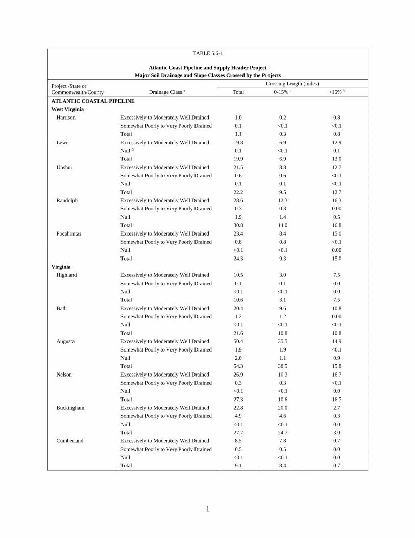
1
TABLE 5.6-1
Atlantic Coast Pipeline and Supply Header Project
Major Soil Drainage and Slope Classes Crossed by the Projects
Project /State or Commonwealth/County Drainage Class a
Crossing Length (miles)
Total 0-15% b >16% b
ATLANTIC COASTAL PIPELINE
West Virginia
Harrison Excessively to Moderately Well Drained 1.0 0.2 0.8
Somewhat Poorly to Very Poorly Drained 0.1 <0.1 <0.1
Total 1.1 0.3 0.8
Lewis Excessively to Moderately Well Drained 19.8 6.9 12.9
Null b/ 0.1 <0.1 0.1
Total 19.9 6.9 13.0
Upshur Excessively to Moderately Well Drained 21.5 8.8 12.7
Somewhat Poorly to Very Poorly Drained 0.6 0.6 <0.1
Null 0.1 0.1 <0.1
Total 22.2 9.5 12.7
Randolph Excessively to Moderately Well Drained 28.6 12.3 16.3
Somewhat Poorly to Very Poorly Drained 0.3 0.3 0.00
Null 1.9 1.4 0.5
Total 30.8 14.0 16.8
Pocahontas Excessively to Moderately Well Drained 23.4 8.4 15.0
Somewhat Poorly to Very Poorly Drained 0.8 0.8 <0.1
Null <0.1 <0.1 0.00
Total 24.3 9.3 15.0
Virginia
Highland Excessively to Moderately Well Drained 10.5 3.0 7.5
Somewhat Poorly to Very Poorly Drained 0.1 0.1 0.0
Null <0.1 <0.1 0.0
Total 10.6 3.1 7.5
Bath Excessively to Moderately Well Drained 20.4 9.6 10.8
Somewhat Poorly to Very Poorly Drained 1.2 1.2 0.00
Null <0.1 <0.1 <0.1
Total 21.6 10.8 10.8
Augusta Excessively to Moderately Well Drained 50.4 35.5 14.9
Somewhat Poorly to Very Poorly Drained 1.9 1.9 <0.1
Null 2.0 1.1 0.9
Total 54.3 38.5 15.8
Nelson Excessively to Moderately Well Drained 26.9 10.3 16.7
Somewhat Poorly to Very Poorly Drained 0.3 0.3 <0.1
Null <0.1 <0.1 0.0
Total 27.3 10.6 16.7
Buckingham Excessively to Moderately Well Drained 22.8 20.0 2.7
Somewhat Poorly to Very Poorly Drained 4.9 4.6 0.3
Null <0.1 <0.1 0.0
Total 27.7 24.7 3.0
Cumberland Excessively to Moderately Well Drained 8.5 7.8 0.7
Somewhat Poorly to Very Poorly Drained 0.5 0.5 0.0
Null <0.1 <0.1 0.0
Total 9.1 8.4 0.7
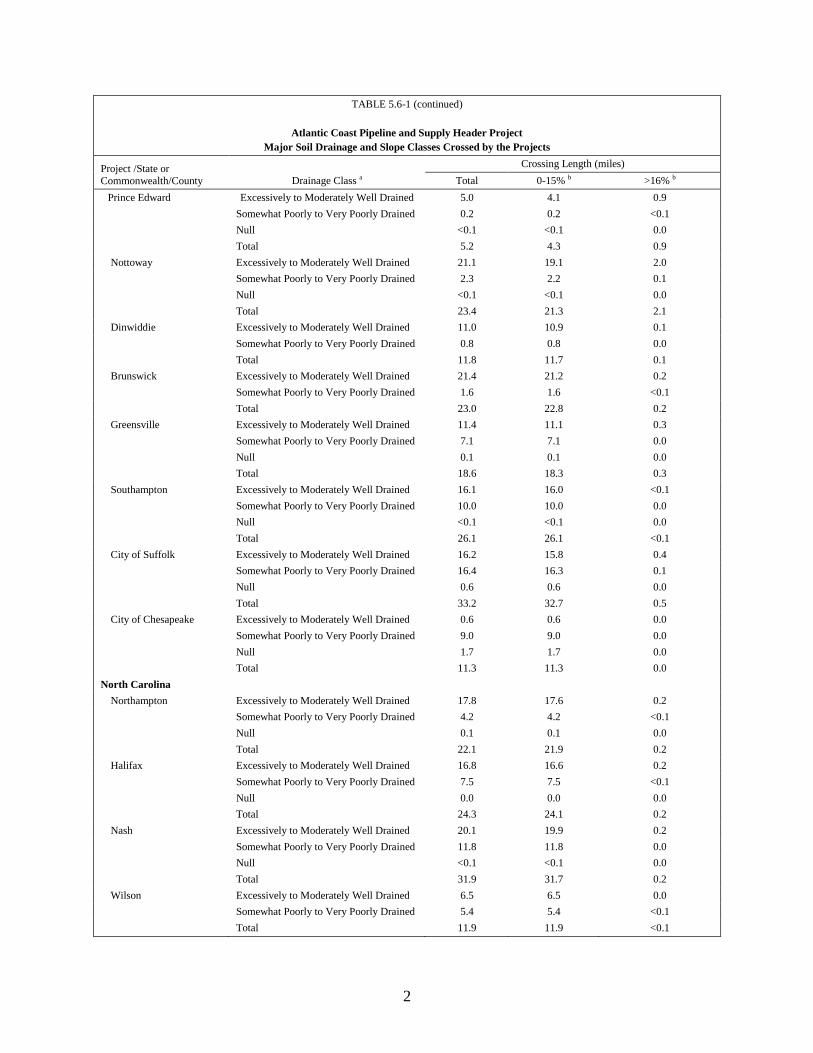
2
TABLE 5.6-1 (continued)
Atlantic Coast Pipeline and Supply Header Project
Major Soil Drainage and Slope Classes Crossed by the Projects
Project /State or Commonwealth/County Drainage Class a
Crossing Length (miles)
Total 0-15% b >16% b
Prince Edward Excessively to Moderately Well Drained 5.0 4.1 0.9
Somewhat Poorly to Very Poorly Drained 0.2 0.2 <0.1
Null <0.1 <0.1 0.0
Total 5.2 4.3 0.9
Nottoway Excessively to Moderately Well Drained 21.1 19.1 2.0
Somewhat Poorly to Very Poorly Drained 2.3 2.2 0.1
Null <0.1 <0.1 0.0
Total 23.4 21.3 2.1
Dinwiddie Excessively to Moderately Well Drained 11.0 10.9 0.1
Somewhat Poorly to Very Poorly Drained 0.8 0.8 0.0
Total 11.8 11.7 0.1
Brunswick Excessively to Moderately Well Drained 21.4 21.2 0.2
Somewhat Poorly to Very Poorly Drained 1.6 1.6 <0.1
Total 23.0 22.8 0.2
Greensville Excessively to Moderately Well Drained 11.4 11.1 0.3
Somewhat Poorly to Very Poorly Drained 7.1 7.1 0.0
Null 0.1 0.1 0.0
Total 18.6 18.3 0.3
Southampton Excessively to Moderately Well Drained 16.1 16.0 <0.1
Somewhat Poorly to Very Poorly Drained 10.0 10.0 0.0
Null <0.1 <0.1 0.0
Total 26.1 26.1 <0.1
City of Suffolk Excessively to Moderately Well Drained 16.2 15.8 0.4
Somewhat Poorly to Very Poorly Drained 16.4 16.3 0.1
Null 0.6 0.6 0.0
Total 33.2 32.7 0.5
City of Chesapeake Excessively to Moderately Well Drained 0.6 0.6 0.0
Somewhat Poorly to Very Poorly Drained 9.0 9.0 0.0
Null 1.7 1.7 0.0
Total 11.3 11.3 0.0
North Carolina
Northampton Excessively to Moderately Well Drained 17.8 17.6 0.2
Somewhat Poorly to Very Poorly Drained 4.2 4.2 <0.1
Null 0.1 0.1 0.0
Total 22.1 21.9 0.2
Halifax Excessively to Moderately Well Drained 16.8 16.6 0.2
Somewhat Poorly to Very Poorly Drained 7.5 7.5 <0.1
Null 0.0 0.0 0.0
Total 24.3 24.1 0.2
Nash Excessively to Moderately Well Drained 20.1 19.9 0.2
Somewhat Poorly to Very Poorly Drained 11.8 11.8 0.0
Null <0.1 <0.1 0.0
Total 31.9 31.7 0.2
Wilson Excessively to Moderately Well Drained 6.5 6.5 0.0
Somewhat Poorly to Very Poorly Drained 5.4 5.4 <0.1
Total 11.9 11.9 <0.1

3
TABLE 5.6-1 (continued)
Atlantic Coast Pipeline and Supply Header Project
Major Soil Drainage and Slope Classes Crossed by the Projects
Project /State or Commonwealth/County Drainage Class a
Crossing Length (miles)
Total 0-15% b >16% b
Johnston Excessively to Moderately Well Drained 19.0 19.0 <0.1
Somewhat Poorly to Very Poorly Drained 19.1 19.1 0.0
Null <0.1 <0.1 0.0
Total 38.1 38.1 <0.1
Sampson Excessively to Moderately Well Drained 4.7 4.7 0.0
Somewhat Poorly to Very Poorly Drained 3.1 3.1 0.0
Total 7.8 7.8 0.0
Cumberland Excessively to Moderately Well Drained 16.8 16.7 0.1
Somewhat Poorly to Very Poorly Drained 22.7 22.7 0.0
Null 0.1 0.1 0.0
Total 39.6 39.5 0.1
Robeson Excessively to Moderately Well Drained 9.4 9.4 0.0
Somewhat Poorly to Very Poorly Drained 13.1 13.1 0.0
Total 22.5 22.5 0.0
TOTAL 599.7 482.1 117.6
SUPPLY HEADER PROJECT
Pennsylvania
Westmoreland Excessively to Moderately Well Drained 3.8 2.2 1.6
Somewhat Poorly to Very Poorly Drained 0.1 0.1 0.0
Total 3.9 2.3 1.6
West Virginia
Harrison Excessively to Moderately Well Drained 0.3 0.2 0.1
Somewhat Poorly to Very Poorly Drained 0.3 0.1 0.2
Total 0.6 0.3 0.3
Doddridge Excessively to Moderately Well Drained 22.1 4.2 17.9
Null 0.1 0.1 <0.1
Total 22.2 4.3 17.9
Tyler Excessively to Moderately Well Drained 0.8 0.1 0.7
Total 0.8 0.1 0.7
Wetzel Excessively to Moderately Well Drained 10.0 1.2 8.8
Total 10.0 1.2 8.8
TOTAL 37.5 8.2 29.3
GRAND TOTAL
637.2 490.3 146.9
____________________ a Null = soil map units with no assigned drainage class. b Slope were determined using available digital elevation model raster data and running the slope analysis tool in ArcGIS: ArcMap.
The drainage classes were determined using the SSURGO database.
ATLANTIC COAST PIPELINE, LLC
ATLANTIC COAST PIPELINE
and
DOMINION TRANSMISSION, INC.
SUPPLY HEADER PROJECT
Restoration and Rehabilitation Plan
Appendix B
Recommended Seed Mix Prescriptions
and Soil Amendments
ATLANTIC COAST PIPELINE, LLC
ATLANTIC COAST PIPELINE
Docket Nos. CP15-554-000 &
CP15-554-001
and
DOMINION TRANSMISSION, INC.
SUPPLY HEADER PROJECT
Docket No. CP15-555-000
Recommended Seed Mixes by Milepost
Updated, Rev 3
Prepared by
July 15, 2016
Recommended Seed Mixes by Milepost
i
TABLE OF CONTENTS
1.0 INTRODUCTION..............................................................................................................1 2.0 ATLANTIC COAST PIPELINE ......................................................................................1
2.1 WEST VIRGINIA ...................................................................................................1
2.1.1 Harrison, Lewis, Randolph, and Upshur Counties ......................................1 2.1.2 Pocahontas County.......................................................................................2 2.1.3 Federal Lands ...............................................................................................4 2.1.4 State Lands ...................................................................................................5 2.1.5 Recommended Native Grasses and Pollinators Seed Mixtures, Application
Rates, and Non-Native Cover Crop by Physiographical Region .................5 2.2 VIRGINIA ...............................................................................................................8
2.2.1 Augusta, Brunswick, Buckingham, Cumberland, Highland, Bath, Nelson,
Nottoway, and Prince Edward Counties ......................................................8 2.2.2 Federal Lands .............................................................................................16 2.2.3 State Lands .................................................................................................16
2.2.4 Dinwiddie, Greensville, and Southampton Counties, and Chesapeake and
Suffolk Cities (Coastal Plain Region) ........................................................18
2.3 NORTH CAROLINA ............................................................................................21 2.3.1 Northampton County .................................................................................21 2.3.2 Halifax and Wilson Counties .....................................................................22
2.3.3 Nash and Johnston Counties ......................................................................23 2.3.4 Sampson County ........................................................................................24
2.3.5 Cumberland County ...................................................................................26 2.3.6 Robeson County .........................................................................................27
2.3.7 Recommended Native Grass and Pollinator Seed Mixtures, Application
Rates, and Non-Native Cover Crop by Physiographical Region (Coastal
Plain) ..........................................................................................................28
3.0 SUPPLY HEADER PROJECT ......................................................................................31 3.1 WEST VIRGINIA .................................................................................................31
3.1.1 Wetzel and Tyler Counties .........................................................................31 3.1.2 State Lands .................................................................................................32
3.1.3 Doddridge and Harrison Counties .............................................................33 3.1.4 Recommended Native Grasses and Pollinators Seed Mixtures, Application
Rates, and Non-Native Cover Crop by Physiographical Region ...............35 3.2 PENNSYLVANIA .................................................................................................35
3.2.1 Westmoreland County ...............................................................................35
4.0 REFERENCES .................................................................................................................37
Recommended Seed Mixes by Milepost
ii
LIST OF TABLES
Table 2.1.1-1 Seed Mix WVHLRU01 Recommended Cool Season Seed Mixture ................ 1 Table 2.1.1-2 Harrison, Lewis, Randolph, and Upshur Counties, West Virginia
Recommended Seeding Dates for Permanent Cover ........................................ 2
Table 2.1.1-3 Harrison, Lewis, Randolph, and Upshur Counties, West Virginia
Recommended Lime and Fertilizer Application ............................................... 2 Table 2.1.2-1 Seed Mix WVPO01: Cool or Warm Season Seed Mixture .............................. 3 Table 2.1.2-2 Recommended Lime and Fertilizer Application ............................................... 3 Table 2.1.2-3 Recommended Mulch Material Rates and Uses ............................................... 4
Table 2.1.5-1 Seed Mix P-MUDW01: Recommended Mountain Physiographic Region
Grass Seed Mix and Application Rates for Excessively to Moderately Well
Drained Sites in West Virginia ......................................................................... 5
Table 2.1.5-2 Seed Mix P-MUDW01:Recommended Mountain Physiographic Region Forb
Seed Mix and Application Rates for Excessively to Moderately Well Drained
Sites in West Virginia ....................................................................................... 6
Table 2.1.5-3 Seed Mix P-MUMP02: Recommended Mountain Physiographic Region Grass
Seed Mix and Application Rate for Somewhat Poorly to Very Poorly Drained
Sites in West Virginia ....................................................................................... 6 Table 2.1.5-4 Seed Mix P-MUMP02: Recommended Mountain Physiographic Region Forb
Seed Mix Application Rate for Somewhat Poorly to Very Poorly Drained
Sites in West Virginia ....................................................................................... 7 Table 2.1.5-5 Seed Mix P-NNTC: Recommended Mountain Physiographic Region Non-
Native Temporary Cover Crop Species for Steep Slope Areas in West
Virginia ............................................................................................................. 7
Table 2.1.5-6 Seed Mix P-NNGC: Recommended Mountain Physiographic Region Non-
Native Grass Cover Mix for Steep Slope Areas in West Virginia .................... 8
Table 2.2.1-1 Seed Mix VABCHNP01:Recommended Cool Season Erosion Prevention
Species and Seed Mixtures ............................................................................... 9 Table 2.2.1-2 Seed Mix VABCHNP02: Recommended Cool and Warm Season Forage
Species and Seed Mixtures ............................................................................. 10 Table 2.2.1-3 Recommended Soil Amendments ................................................................... 14
Table 2.2.1-4 Mulch Specifications ...................................................................................... 14 Table 2.2.1-5 Mulch Considerations ..................................................................................... 14
Table 2.2.1-6 Seed Mix P-VABCHNP01: Recommended Mountain Physiographic Region
Grass Seed Mix and Application Rates for Excessively to Moderately Well
Drained Sites in Virginia ................................................................................ 15
Table 2.2.1-7 Seed Mix P-VABCHNP01: Recommended Mountain Physiographic Region
Forb Seed Mix and Application Rates for Excessively to Moderately
Well/Well Drained Sites in Virginia ............................................................... 15 Table 2.2.1-8 Seed Mix P-VABCHNP02: Native Grasses and Forbs for Somewhat Poorly to
Very Poorly Drained Soils and have a High Pollinator Value ........................ 16 Table 2.2.1-9 Seed Mix VJRWMA01: Recommended Grass Seed Mix and Application
Rates for Excessively to Moderately Well Drained – Partially Shade Sites ... 17 Table 2.2.1-10 Seed Mix VJRWMA02: Recommended Grass Seed Mix and Application
Rates for Excessively to Moderately Well Drained – Wildlife Site ............... 17
Recommended Seed Mixes by Milepost
iii
Table 2.2.1-11 Seed Mix VJRWMA03: Recommended Grass Seed Mixes and Application
Rates for Steep Slopes Stabilization ............................................................... 18 Table 2.2.4-1 Seed Mix VACSDGS01: Recommended Cool and Warm Season Species,
Cultivars, Seeding Rates, Seeding Dates, and Temporary Cover ................... 19
Table 2.2.4-2 Seed Mix P-VACSDGS01: Perennial Grass and Forb Mixture for Excessively
to Moderately Well Drained Soils that Meets NRCS Pollinator Mix
Requirements – Higher Pollinator Value (7 of 9 High Value) DRILLED ..... 20 Table 2.2.4-3 Seed Mix P-VACSDGS02: Native Grasses and Forbs for Somewhat Poorly to
Very Poorly Drained Soils and have a High Pollinator Value - Higher
Pollinator Value (8 of 9 High Value) .............................................................. 21 Table 2.3.1-1 Seed Mix NCNO01: Recommended Cool Season Seed Mixture ................... 21 Table 2.3.1-2 Seed Mix NCNO02: Recommended Warm Season Seed Mixture ................. 22 Table 2.3.1-3 Recommended Soil Amendments ................................................................... 22
Table 2.3.2-1 Seed Mix NCHW01:Recommended Cool Season Seed Mixture ................... 23 Table 2.3.3-1 Seed Mix NCNJ01: Recommended Cool Season Grass Seed Mixture .......... 24
Table 2.3.3-2 Recommended Lime and Fertilizer Application ............................................. 24 Table 2.3.4-1 Seed Mix NCSA01: Recommended Cool Season Seed Mixture.................... 24
Table 2.3.4-2 Seed Mix NCSA02: Recommended Warm Season Seed Mixture ................. 25 Table 2.3.4-3 Recommended Lime and Fertilizer Application ............................................. 25 Table 2.3.5-1 Seed Mix NCCU01: Recommended Cool and Warm Season Seed Mixture . 26
Table 2.3.5-2 Recommended Lime and Fertilizer Application ............................................. 26 Table 2.3.5-3 Recommended Mulch Material Rates and Uses ............................................. 27
Table 2.3.6-1 Seed Mix NCRO01: Recommended Warm Season Seed Mixture ................. 27 Table 2.3.6-2 Seed Mix P-NCRO01:Recommended Pollinator Seed Mixture ..................... 28 Table 2.3.7-1 Seed Mix P-CPDW01:Recommended Coastal Plain Physiographic Region
Grass Seed Mix and Application Rates for Excessively to Moderately Well
Drained Sites in North Carolina ...................................................................... 28 Table 2.3.7-2 Seed Mix P-CPDW01:Recommended Coastal Plain Physiographic Region
Forb Seed Mix and Application Rates for Excessively to Moderately Well
Drained Sites in North Carolina ...................................................................... 29 Table 2.3.7-3 Seed Mix P-CPDW02: Recommended Coastal Plain Physiographic Region
Grass Seed Mix and Application Rates for Somewhat Poorly to Very Poorly
Drained Sites in North Carolina ...................................................................... 29
Table 2.3.7-4 Seed Mix P-CPDW02: Recommended Coastal Plain Physiographic Region
Forb Seed Mix and Application Rates for Somewhat Poorly to Very Poorly
Drained Sites in North Carolina ...................................................................... 30 Table 2.3.7-5 Seed Mix P-NNTC: Recommended Non-native Temporary Cover Crop
Species ............................................................................................................ 30 Table 2.3.7-6 Seed Mix P-NNGC: Recommended Non-native Grass Cover Mix............... 31 Table 3.1.1-1 Seed Mix WVWE01: Recommended Cool Season Seed Mixture ................. 31
Table 3.1.1-2 Recommended Seeding Dates for Permanent Cover ...................................... 32 Table 3.1.1-3 Recommended Lime and Fertilizer Application for Permanent Seeding ....... 32 Table 3.1.1-4 Recommended Lime and Fertilizer Application for Temporary Seeding
(Absent of a Soil Test) .................................................................................... 32 Table 3.1.2-1 Seed Mix WVLWWMA01: Recommended Grass Seed Mixes and
Application Rate ............................................................................................. 33

Recommended Seed Mixes by Milepost
iv
Table 3.1.2-2 Recommended Lime and Fertilizer Application ............................................. 33
Table 3.1.3-1 Seed Mix WVDH01: Recommended Cool Season Seed Mixtures ................ 34 Table 3.1.3-2 Recommended Seeding Dates for Permanent Cover ...................................... 34 Table 3.1.3-3 Recommended Lime and Fertilizer Application ............................................. 34
Table 3.2.1-1 Seed Mix PAWE01: Recommended Cool Season Seed Mixture ................... 35 Table 3.2.1-2 Soil Amendment Application Rate Equivalents ............................................. 36 Table 3.2.1-3 Recommended Mulch Type and Rates ........................................................... 36
Recommended Seed Mixes by Milepost
v
LIST OF ATTACHMENTS
Attachment A Summary of Seed Mixes by County for the Atlantic Coast Pipeline and
Supply Header Project
LIST OF ACRONYMS AND ABBREVIATIONS
ACP Atlantic Coast Pipeline
NRCS Natural Resources Conservation Service
SHP Supply Header Project
WMA Wildlife Management Area
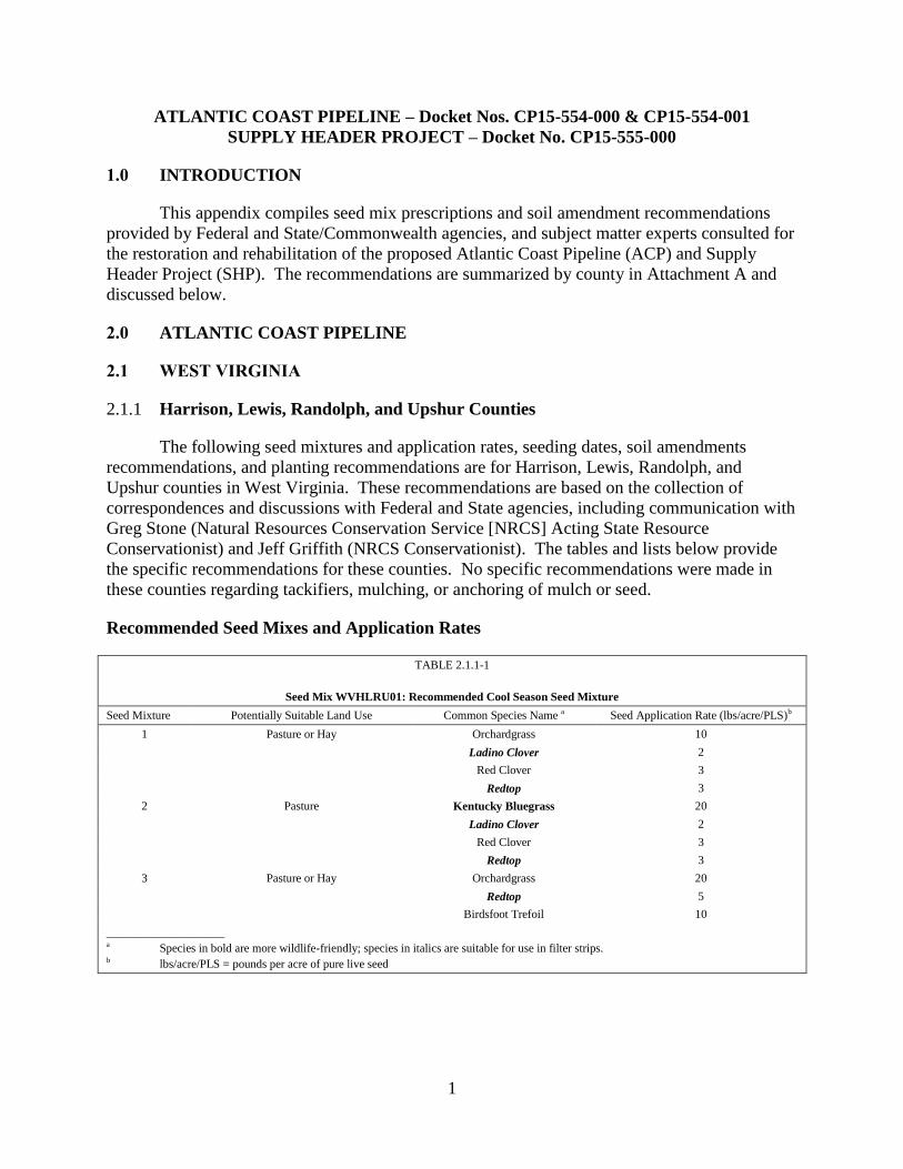
1
ATLANTIC COAST PIPELINE – Docket Nos. CP15-554-000 & CP15-554-001
SUPPLY HEADER PROJECT – Docket No. CP15-555-000
1.0 INTRODUCTION
This appendix compiles seed mix prescriptions and soil amendment recommendations
provided by Federal and State/Commonwealth agencies, and subject matter experts consulted for
the restoration and rehabilitation of the proposed Atlantic Coast Pipeline (ACP) and Supply
Header Project (SHP). The recommendations are summarized by county in Attachment A and
discussed below.
2.0 ATLANTIC COAST PIPELINE
2.1 WEST VIRGINIA
Harrison, Lewis, Randolph, and Upshur Counties 2.1.1
The following seed mixtures and application rates, seeding dates, soil amendments
recommendations, and planting recommendations are for Harrison, Lewis, Randolph, and
Upshur counties in West Virginia. These recommendations are based on the collection of
correspondences and discussions with Federal and State agencies, including communication with
Greg Stone (Natural Resources Conservation Service [NRCS] Acting State Resource
Conservationist) and Jeff Griffith (NRCS Conservationist). The tables and lists below provide
the specific recommendations for these counties. No specific recommendations were made in
these counties regarding tackifiers, mulching, or anchoring of mulch or seed.
Recommended Seed Mixes and Application Rates
TABLE 2.1.1-1
Seed Mix WVHLRU01: Recommended Cool Season Seed Mixture
Seed Mixture Potentially Suitable Land Use Common Species Name a Seed Application Rate (lbs/acre/PLS)b
1 Pasture or Hay Orchardgrass 10
Ladino Clover 2
Red Clover 3
Redtop 3
2 Pasture Kentucky Bluegrass 20
Ladino Clover 2
Red Clover 3
Redtop 3
3 Pasture or Hay Orchardgrass 20
Redtop 5
Birdsfoot Trefoil 10
____________________ a Species in bold are more wildlife-friendly; species in italics are suitable for use in filter strips. b lbs/acre/PLS = pounds per acre of pure live seed
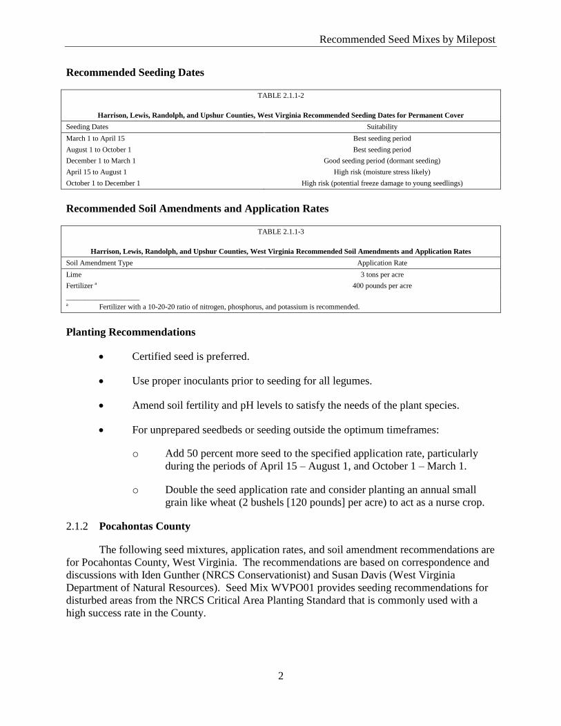
Recommended Seed Mixes by Milepost
2
Recommended Seeding Dates
TABLE 2.1.1-2
Harrison, Lewis, Randolph, and Upshur Counties, West Virginia Recommended Seeding Dates for Permanent Cover
Seeding Dates Suitability
March 1 to April 15 Best seeding period
August 1 to October 1 Best seeding period
December 1 to March 1 Good seeding period (dormant seeding)
April 15 to August 1 High risk (moisture stress likely)
October 1 to December 1 High risk (potential freeze damage to young seedlings)
Recommended Soil Amendments and Application Rates
TABLE 2.1.1-3
Harrison, Lewis, Randolph, and Upshur Counties, West Virginia Recommended Soil Amendments and Application Rates
Soil Amendment Type Application Rate
Lime 3 tons per acre
Fertilizer a 400 pounds per acre
____________________ a Fertilizer with a 10-20-20 ratio of nitrogen, phosphorus, and potassium is recommended.
Planting Recommendations
Certified seed is preferred.
Use proper inoculants prior to seeding for all legumes.
Amend soil fertility and pH levels to satisfy the needs of the plant species.
For unprepared seedbeds or seeding outside the optimum timeframes:
o Add 50 percent more seed to the specified application rate, particularly
during the periods of April 15 – August 1, and October 1 – March 1.
o Double the seed application rate and consider planting an annual small
grain like wheat (2 bushels [120 pounds] per acre) to act as a nurse crop.
Pocahontas County 2.1.2
The following seed mixtures, application rates, and soil amendment recommendations are
for Pocahontas County, West Virginia. The recommendations are based on correspondence and
discussions with Iden Gunther (NRCS Conservationist) and Susan Davis (West Virginia
Department of Natural Resources). Seed Mix WVPO01 provides seeding recommendations for
disturbed areas from the NRCS Critical Area Planting Standard that is commonly used with a
high success rate in the County.
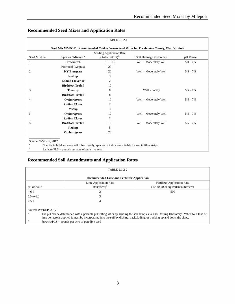
Recommended Seed Mixes by Milepost
3
Recommended Seed Mixes and Application Rates
TABLE 2.1.2-1
Seed Mix WVPO01: Recommended Cool or Warm Seed Mixes for Pocahontas County, West Virginia
Seed Mixture Species / Mixture a
Seeding Application Rate
(lbs/acre/PLS)b Soil Drainage Preference pH Range
1 Crownvetch 10 – 15 Well – Moderately Well 5.0 – 7.5
Perennial Ryegrass 20
2 KY Bluegrass 20 Well – Moderately Well 5.5 – 7.5
Redtop 3
Ladino Clover or 2
Birdsfoot Trefoil 10
3 Timothy 8 Well - Poorly 5.5 – 7.5
Birdsfoot Trefoil 8
4 Orchardgrass 10 Well – Moderately Well 5.5 – 7.5
Ladino Clover 2
Redtop 3
5 Orchardgrass 10 Well – Moderately Well 5.5 – 7.5
Ladino Clover 2
5 Birdsfoot Trefoil 10 Well – Moderately Well 5.5 – 7.5
Redtop 5
Orchardgrass 20
____________________
Source: WVDEP, 2012 a Species in bold are more wildlife-friendly; species in italics are suitable for use in filter strips. b lbs/acre/PLS = pounds per acre of pure live seed
Recommended Soil Amendments and Application Rates
TABLE 2.1.2-2
Recommended Lime and Fertilizer Application
pH of Soil a
Lime Application Rate
(tons/acre)b
Fertilizer Application Rate
(10-20-20 or equivalent) (lbs/acre)
> 6.0 2 500
5.0 to 6.0 3
< 5.0 4
____________________
Source: WVDEP, 2012 a The pH can be determined with a portable pH testing kit or by sending the soil samples to a soil testing laboratory. When four tons of
lime per acre is applied it must be incorporated into the soil by disking, backblading, or tracking up and down the slope. b lbs/acre/PLS = pounds per acre of pure live seed
Recommended Seed Mixes by Milepost
4
Recommended Mulch Material and Application Rates
TABLE 2.1.2-3
Recommended Mulch Material Rates and Uses
Material Minimum Rates Per Acre Coverage Remarks
Hay or Straw 2-3 Tons (100 – 150 Bales) 75% - 90% Subject to wind blowing or washing unless tied down
Wood Fiber, Pulp Fiber, Wood-
Cellulose, Recirculated Paper
1,000 – 1,500 lbs Cover all disturbed areas Hydroseeding
____________________
Source: WVDEP, 2012
Chemical Mulches, Soil Binders, and Tackifiers Recommendations
Determine mulch-type and its appropriate application rate;
A wide range of synthetic tackifiers (e.g., spray-on materials) are marketed to
stabilize and protect the seeds and soil surfaces. These tackifiers are mixed with
water and seed mixtures, and sprayed over the mulch and soils. They may be
used alone in some cases as temporary stabilizers, or in conjunction with fiber
mulch, straw or hay; and
Chemical tackifiers, when used alone, do not have the capability to insulate the
soil or retain soil moisture as effectively as organic mulches such wood fiber,
straw, or hay.
Mulch Anchoring
Depending on field conditions, mulch anchoring (e.g., mechanical methods or
netting) may become necessary due to environmental conditions, including heavy
winds or rapid water runoff (e.g., rain or snowmelt).
Mechanical Anchoring
o Apply mulch and pull a mulch anchoring tool over the mulch. When a
disk is used, set the disk straight and pull across the slope. Mulch material
should be tucked into the soil about three inches.
Mulch Netting
o Follow manufacturer’s recommendations when positioning and stapling
mulch netting into the soil.
Federal Lands 2.1.3
Monongahela National Forest – Pocahontas County
This section is pending additional consultation with the U.S. Forest Service.
Recommended Seed Mixes by Milepost
5
State Lands 2.1.4
Seneca State Forest – Pocahontas County
This section is pending additional consultation with the West Virginia Department of
Natural Resources.
Recommended Native Grasses and Pollinators Seed Mixtures, Application Rates, 2.1.5
and Non-Native Cover Crop by Physiographical Region
Recommended Seed Mixtures by Geographical Region (Mountain Physiographic Region)
and Drainage Class
The following seed mixtures are for the mountain and upland areas of West Virginia.
These recommendations are based on discussions with Roundstone Native Seed and Robert
Glennon, private lands biologist from the Conservation Management Institute, Virginia Tech and
NRCS, and the Xerces Society.
West Virginia Excessively to Moderately Well Drained Sites
TABLE 2.1.5-1
Seed Mix P-MUDW01: Recommended Mountain Physiological Region
Grass Seed Mix and Application Rates for Excessively to Moderately Well Drained Sites in West Virginia
Common Name Scientific Name Height (feet) Sun Exposure Seed Mix Rate (lbs/acre/PLS)b
Little Bluestem Schizachyrium scoparium 2 - 4 Full Sun 0.250
Virginia Wild Rye Elymus virginicus 2 - 4 Full Sun 0.250
Tall Dropseed Sporobolus compositus 2 - 3 Full Sun 0.050
Purple Top Tridens flavus 3 - 5 Part Shade 0.058
Indian Grass Sorghastrum nutans 3 - 6 Full Sun 0.167
Switchgrass Panicum virgatum 3 - 7 Full Sun 0.183
Fall Panicum Panicum anceps 2 - 4 Part Shade 0.042
Total — — — 1.0
____________________
Sources: Roundstone Native Seed, 2015; Glennon, 2015 a Recommended seeding application rate is 8 to 18 pounds per acre. b lbs/acre/PLS = pounds per acre of pure live seed
Recommended Seed Mixes by Milepost
6
TABLE 2.1.5-2
Seed Mix P-MUDW01: Recommended Mountain Physiological Region
Forb Seed Mix and Application Rates for Excessively to Moderately Well Drained Sites in West Virginia
Common Name Scientific Name Color Bloom Period Seed Application Rate (lbs/acre/PLS)a
Lance Leaved Coreopsis Coreopsis lanceolata Yellow Spring, Summer 0.385
Smooth Beardtongue Penstemon digitalis White Spring 0.146
Common Milkweed Asclepias syriaca Pink Spring, Summer 0.128
Goat's Rue Tephrosia virginiana White/Pink Spring, Summer 0.128
Partridge Pea Cassia fasciculata Yellow Summer 0.745
Slender Mountain Mint Pycnanthemum tenuifolium White Summer 0.069
Early Goldenrod Solidago juncea Yellow Summer 0.086
Bergamot Monarda fistulosa Lavender Summer 0.103
Spiked Blazing Star Liatris spicata Pink Summer 0.343
Sneezeweed Helenium autumnale Yellow Summer, Fall 0.128
Gray Goldenrod Solidago nemoralis Yellow Fall 0.086
Iron Weed Vernonia altissima Purple Summer, Fall 0.343
Tall Coreopsis Coreopsis tripteris Yellow Summer, Fall 0.051
Total — — — 2.74
____________________
Sources: Roundstone Native Seed, 2015; Glennon, 2015 b lbs/acre/PLS = pounds per acre of pure live seed
West Virginia Somewhat Poorly to Very Poorly Drained Sites
TABLE 2.1.5-3
Seed Mix P-MUMP02: Recommended Mountain Physiographic Region
Grass Seed Mix and Application Rate for Somewhat Poorly to Very Poorly Drained Sites in West Virginia
Common Name Scientific Name Height (feet) Sun Exposure Seed Mix Rate (lbs/acre/PLS)b
Switchgrass Panicum virgatum 3 - 7 Full Sun 0.233
Red Top Panicum Panicum rigidulum 2 - 4 Full Sun 0.017
Fowl Manna Grass Glyceria striata 3 - 5 Part Shade 0.008
Virginia Wild Rye Elymus virginicus 2 - 4 Full Sun 0.217
Canada Wild Rye Elymus canadensis 2 - 5 Part Shade 0.167
Deer Tongue Grass Panicum clandestinum 2 - 4 Full Sun 0.058
Big Bluestem Andropogon gerardii 4 - 10 Full Sun 0.167
Frank's Sedge Carex frankii 1 - 2 Part Shade 0.042
Fox Sedge Carex vulpinoidea 2 - 3 Part Shade 0.025
Fall Panicum Panicum anceps 2 - 4 Part Shade 0.067
Total — – — 1.0
____________________
Sources: Roundstone Native Seed, 2015; Glennon, 2015 a Recommended seeding application rate is 8 to 18 pounds per acre. b lbs/acre/PLS = pounds per acre of pure live seed
Recommended Seed Mixes by Milepost
7
TABLE 2.1.5-4
Seed Mix P-MUMP02: Recommended Mountain Physiographic Region
Forb Seed Mix Application Rate for Somewhat Poorly to Very Poorly Drained Sites in West Virginia
Common Name Scientific Name Color Bloom Period Seed Application Rate
(lbs/acre/PLS)a
Ohio Spiderwort Tradescantia ohiensis Blue Spring, Summer 0.167
Smooth Beardtongue Penstemon digitalis White Spring 0.083
Butterfly Milkweed Asclepias tuberosa Orange Spring, Summer 0.083
Blackeyed Susan Rudbeckia hirta Yellow Spring, Summer 0.134
Wild Senna Senna marilandica Yellow Summer 0.668
Hoary Mountain Mint Pycnanthemum incanum White Summer 0.033
Lupine Lupinus perennis Blue Summer 0.501
Bergamot Monarda fistulosa Lavender Summer 0.083
Boneset Eupatorium perfoliatum White Summer 0.083
Joe-Pye Weed Eupatorium fistulosum Pink Summer, Fall 0.125
Showy Tickseed Bidens aristosa Yellow Summer, Fall 0.501
Sneezeweed Helenium autumnale Yellow Summer, Fall 0.125
Rough Goldenrod Solidago rugosa Yellow Fall 0.083
Total — — — 2.67
____________________
Sources: Roundstone Native Seed, 2015; Glennon, 2015 a lbs/acre/PLS = pounds per acre of pure live seed
Recommended Non-Native Temporary Cover Crop Species and Non-Native Grass Cover
Mix for Inclusion with Pollinator Mixtures
In areas where the erosion potential is high (e.g., steep slope areas) and/or sites that require
stabilization within 30 days of disturbance, non-native temporary cover species in seed mixture P-
NNTC, as shown in Table 2.1.5-5, should be used. In areas where erosion is likely to occur on
steep slopes prior to the germination of native grasses and forbs, non-native grass mixture P-
NNGC should be used in combination with the forb mixtures that are prescribed for non-steep
slope areas within the Mountain Physiographic Region of West Virginia. Table 2.1.5-6 provides
the specific non-native grass species to be included with the native forb seed mix in these areas.
TABLE 2.1.5-5
Seed Mix P-NNTC: Recommended Mountain Physiographic Region
Non-Native Temporary Cover Crop Species for Steep Slope Areas in West Virginia
Common Name Scientific Name Height (Inches) Sun Exposure Seeding Application Rate (lbs/acre/PLS)a
Seed Mix Planting Season
Brown Top Millet Panicum ramosum 3 - 3.5 Full sun 5.0 Summer
Spring Oats Avena sativa 2 – 2.5 Full sun 30.0 Spring and Fall
Annual Rye Grass Lolium multiflorum 2 – 2.5 Part shade 6.0 Fall and Winter
____________________
Source: Roundstone Native Seed, 2015 a lbs/acre/PLS = pounds per acre of pure live seed
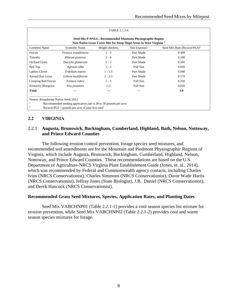
Recommended Seed Mixes by Milepost
8
TABLE 2.1.5-6
Seed Mix P-NNGC: Recommended Mountain Physiographic Region
Non-Native Grass Cover Mix for Steep Slope Areas in West Virginia a
Common Name Scientific Name Height (Inches) Sun Exposure Seed Mix Rate (lbs/acre/PLS)b
Fescue Festuca arundinacea 2 - 3 Part Shade 0.300
Timothy Phleum pratense 2 - 4 Part Shade 0.100
Orchard Grass Dactylis glomerata 2 - 3 Part Shade 0.100
Red Top Agrostis alba 2 - 3 Full Sun 0.020
Ladino Clover Trifolium repens 1 - 1.5 Part Shade 0.040
Annual Rye Grass Lolium multiflorum 2 - 2.5 Part Shade 0.170
Creeping Red Fescue Festuca rubra 1 - 2 Full Sun 0.250
Kentucky Bluegrass Poa pratensis 1-2 Full Sun 0.020
Total — — — 1.0
____________________
Source: Roundstone Native Seed, 2015 a Recommended seeding application rate is 30 to 50 pounds per acre. b lbs/acre/PLS = pounds per acre of pure live seed
2.2 VIRGINIA
Augusta, Brunswick, Buckingham, Cumberland, Highland, Bath, Nelson, Nottoway, 2.2.1
and Prince Edward Counties
The following erosion control prevention, forage species seed mixtures, and
recommended soil amendments are for the Mountain and Piedmont Physiographic Regions of
Virginia, which include Augusta, Brunswick, Buckingham, Cumberland, Highland, Nelson,
Nottoway, and Prince Edward Counties. These recommendations are based on the U.S.
Department of Agriculture-NRCS Virginia Plant Establishment Guide (Jones, et. al., 2014),
which was recommended by Federal and Commonwealth agency contacts, including Charles
Ivins (NRCS Conservationist), Charles Simmons (NRCS Conservationist), Davie Wade Harris
(NRCS Conservationist), Jeffray Jones (State Biologist), J.B. Daniel (NRCS Conservationist),
and Derek Hancock (NRCS Conservationist).
Recommended Grass Seed Mixtures, Species, Application Rates, and Planting Dates
Seed Mix VABCHNP01 (Table 2.2.1-1) provides a cool season species list mixture for
erosion prevention, while Seed Mix VABCHNP02 (Table 2.2.1-2) provides cool and warm
season species mixtures for forage.
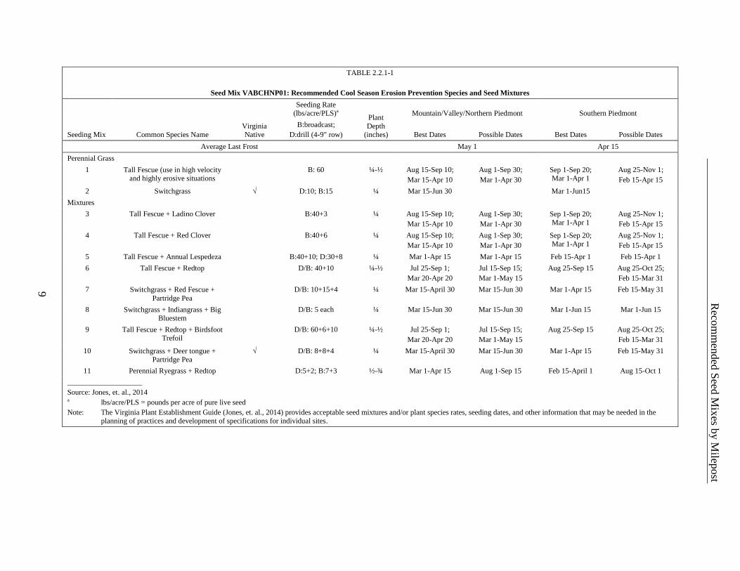
Reco
mm
ended
Seed
Mix
es by M
ilepost
9
TABLE 2.2.1-1
Seed Mix VABCHNP01: Recommended Cool Season Erosion Prevention Species and Seed Mixtures
Seeding Mix Common Species Name Virginia Native
Seeding Rate (lbs/acre/PLS)a
Plant
Depth (inches)
Mountain/Valley/Northern Piedmont Southern Piedmont
B:broadcast;
D:drill (4-9" row) Best Dates Possible Dates Best Dates Possible Dates
Average Last Frost May 1 Apr 15
Perennial Grass
1 Tall Fescue (use in high velocity and highly erosive situations
B: 60 ¼-½ Aug 15-Sep 10;
Mar 15-Apr 10
Aug 1-Sep 30;
Mar 1-Apr 30
Sep 1-Sep 20; Mar 1-Apr 1
Aug 25-Nov 1;
Feb 15-Apr 15
2 Switchgrass √ D:10; B:15 ¼ Mar 15-Jun 30 Mar 1-Jun15
Mixtures
3 Tall Fescue + Ladino Clover B:40+3 ¼ Aug 15-Sep 10;
Mar 15-Apr 10
Aug 1-Sep 30;
Mar 1-Apr 30
Sep 1-Sep 20; Mar 1-Apr 1
Aug 25-Nov 1;
Feb 15-Apr 15
4 Tall Fescue + Red Clover B:40+6 ¼ Aug 15-Sep 10;
Mar 15-Apr 10
Aug 1-Sep 30;
Mar 1-Apr 30
Sep 1-Sep 20; Mar 1-Apr 1
Aug 25-Nov 1;
Feb 15-Apr 15
5 Tall Fescue + Annual Lespedeza B:40+10; D:30+8 ¼ Mar 1-Apr 15 Mar 1-Apr 15 Feb 15-Apr 1 Feb 15-Apr 1
6 Tall Fescue + Redtop D/B: 40+10 ¼-½ Jul 25-Sep 1;
Mar 20-Apr 20
Jul 15-Sep 15;
Mar 1-May 15
Aug 25-Sep 15 Aug 25-Oct 25;
Feb 15-Mar 31
7 Switchgrass + Red Fescue +
Partridge Pea
D/B: 10+15+4 ¼ Mar 15-April 30 Mar 15-Jun 30 Mar 1-Apr 15 Feb 15-May 31
8 Switchgrass + Indiangrass + Big Bluestem
D/B: 5 each ¼ Mar 15-Jun 30 Mar 15-Jun 30 Mar 1-Jun 15 Mar 1-Jun 15
9 Tall Fescue + Redtop + Birdsfoot Trefoil
D/B: 60+6+10 ¼-½ Jul 25-Sep 1;
Mar 20-Apr 20
Jul 15-Sep 15;
Mar 1-May 15
Aug 25-Sep 15 Aug 25-Oct 25;
Feb 15-Mar 31
10 Switchgrass + Deer tongue + Partridge Pea
√ D/B: 8+8+4 ¼ Mar 15-April 30 Mar 15-Jun 30 Mar 1-Apr 15 Feb 15-May 31
11 Perennial Ryegrass + Redtop D:5+2; B:7+3 ½-¾ Mar 1-Apr 15 Aug 1-Sep 15 Feb 15-April 1 Aug 15-Oct 1
____________________
Source: Jones, et. al., 2014 a lbs/acre/PLS = pounds per acre of pure live seed
Note: The Virginia Plant Establishment Guide (Jones, et. al., 2014) provides acceptable seed mixtures and/or plant species rates, seeding dates, and other information that may be needed in the
planning of practices and development of specifications for individual sites.
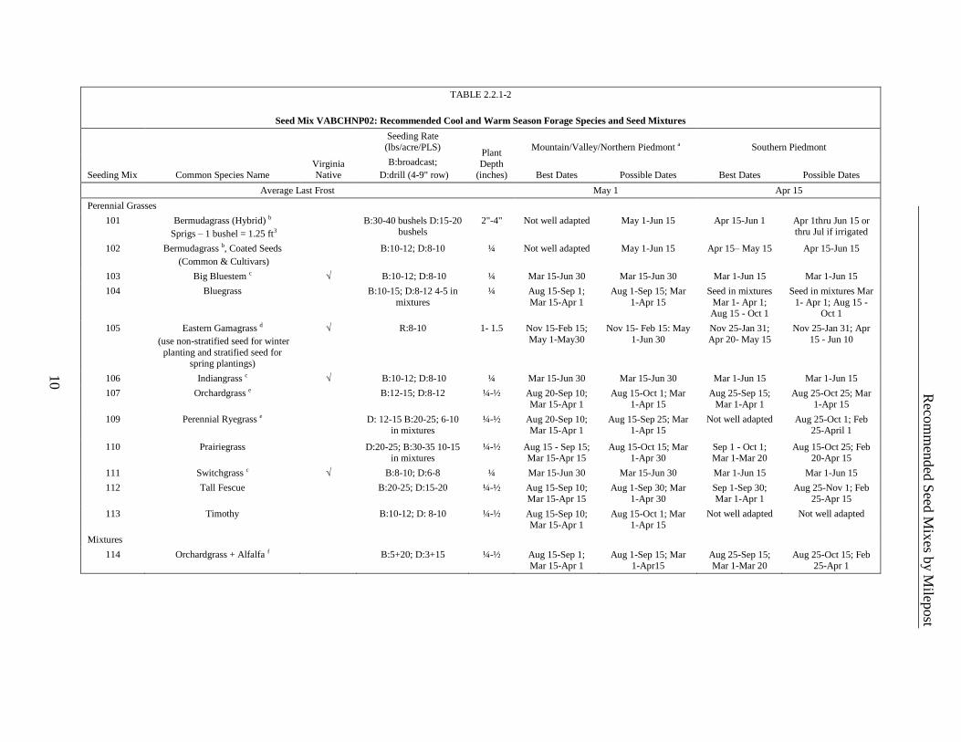
Reco
mm
ended
Seed
Mix
es by M
ilepost
10
TABLE 2.2.1-2
Seed Mix VABCHNP02: Recommended Cool and Warm Season Forage Species and Seed Mixtures
Seeding Mix Common Species Name Virginia Native
Seeding Rate (lbs/acre/PLS)
Plant
Depth (inches)
Mountain/Valley/Northern Piedmont a Southern Piedmont
B:broadcast;
D:drill (4-9" row) Best Dates Possible Dates Best Dates Possible Dates
Average Last Frost May 1 Apr 15
Perennial Grasses
101 Bermudagrass (Hybrid) b
Sprigs – 1 bushel = 1.25 ft3
B:30-40 bushels D:15-20 bushels
2"-4" Not well adapted May 1-Jun 15 Apr 15-Jun 1 Apr 1thru Jun 15 or thru Jul if irrigated
102 Bermudagrass b, Coated Seeds
(Common & Cultivars)
B:10-12; D:8-10 ¼ Not well adapted May 1-Jun 15 Apr 15– May 15 Apr 15-Jun 15
103 Big Bluestem c √ B:10-12; D:8-10 ¼ Mar 15-Jun 30 Mar 15-Jun 30 Mar 1-Jun 15 Mar 1-Jun 15
104 Bluegrass B:10-15; D:8-12 4-5 in
mixtures
¼ Aug 15-Sep 1;
Mar 15-Apr 1
Aug 1-Sep 15; Mar
1-Apr 15
Seed in mixtures
Mar 1- Apr 1; Aug 15 - Oct 1
Seed in mixtures Mar
1- Apr 1; Aug 15 - Oct 1
105 Eastern Gamagrass d
(use non-stratified seed for winter
planting and stratified seed for spring plantings)
√ R:8-10 1- 1.5 Nov 15-Feb 15;
May 1-May30
Nov 15- Feb 15: May
1-Jun 30
Nov 25-Jan 31;
Apr 20- May 15
Nov 25-Jan 31; Apr
15 - Jun 10
106 Indiangrass c √ B:10-12; D:8-10 ¼ Mar 15-Jun 30 Mar 15-Jun 30 Mar 1-Jun 15 Mar 1-Jun 15
107 Orchardgrass e B:12-15; D:8-12 ¼-½ Aug 20-Sep 10; Mar 15-Apr 1
Aug 15-Oct 1; Mar 1-Apr 15
Aug 25-Sep 15; Mar 1-Apr 1
Aug 25-Oct 25; Mar 1-Apr 15
109 Perennial Ryegrass e
D: 12-15 B:20-25; 6-10 in mixtures
¼-½ Aug 20-Sep 10; Mar 15-Apr 1
Aug 15-Sep 25; Mar 1-Apr 15
Not well adapted Aug 25-Oct 1; Feb 25-April 1
110 Prairiegrass D:20-25; B:30-35 10-15 in mixtures
¼-½ Aug 15 - Sep 15; Mar 15-Apr 15
Aug 15-Oct 15; Mar 1-Apr 30
Sep 1 - Oct 1; Mar 1-Mar 20
Aug 15-Oct 25; Feb 20-Apr 15
111 Switchgrass c √ B:8-10; D:6-8 ¼ Mar 15-Jun 30 Mar 15-Jun 30 Mar 1-Jun 15 Mar 1-Jun 15
112 Tall Fescue B:20-25; D:15-20 ¼-½ Aug 15-Sep 10; Mar 15-Apr 15
Aug 1-Sep 30; Mar 1-Apr 30
Sep 1-Sep 30; Mar 1-Apr 1
Aug 25-Nov 1; Feb 25-Apr 15
113 Timothy B:10-12; D: 8-10 ¼-½ Aug 15-Sep 10; Mar 15-Apr 1
Aug 15-Oct 1; Mar 1-Apr 15
Not well adapted Not well adapted
Mixtures
114 Orchardgrass + Alfalfa f B:5+20; D:3+15 ¼-½ Aug 15-Sep 1; Mar 15-Apr 1
Aug 1-Sep 15; Mar 1-Apr15
Aug 25-Sep 15; Mar 1-Mar 20
Aug 25-Oct 15; Feb 25-Apr 1
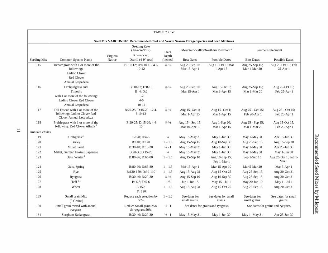
Reco
mm
ended
Seed
Mix
es by M
ilepost
11
TABLE 2.2.1-2
Seed Mix VABCHNP02: Recommended Cool and Warm Season Forage Species and Seed Mixtures
Seeding Mix Common Species Name Virginia Native
Seeding Rate (lbs/acre/PLS)
Plant
Depth (inches)
Mountain/Valley/Northern Piedmont a Southern Piedmont
B:broadcast;
D:drill (4-9" row) Best Dates Possible Dates Best Dates Possible Dates
115 Orchardgrass with 1 or more of the following:
Ladino Clover
Red Clover
Annual Lespedeza
B: 10-12; D:8-10 1-2 4-6 10-12
¼-½ Aug 20-Sep 10; Mar 15-Apr 1
Aug 15-Oct 1; Mar 1-Apr 15
Aug 25-Sep 15; Mar 1-Mar 20
Aug 25-Oct 15; Feb 25-Apr 1
116 Orchardgrass and
Timothy
with 1 or more of the following:
Ladino Clover Red Clover
Annual Lespedeza
B: 10-12; D:8-10
B: 4; D:2
1-2
4-6
10-12
¼-½ Aug 20-Sep 10;
Mar 15-Apr 1
Aug 15-Oct 1;
Mar 1-Apr 15
Aug 25-Sep 15;
Mar 1-Mar 20
Aug 25-Oct 15;
Feb 25-Apr 1
117 Tall Fescue with 1 or more of the following: Ladino Clover Red
Clover Annual Lespedeza
B:20-25; D:15-20 1-2 4-6 10-12
¼-½ Aug 15- Oct 1;
Mar 1-Apr 15
Aug 15- Oct 1;
Mar 1-Apr 15
Aug 25 - Oct 15;
Feb 20-Apr 1
Aug 25 - Oct 15;
Feb 20-Apr 1
118 Prairiegrass with 1 or more of the following: Red Clover Alfalfa f
B:20-25; D:15-20; 4-6 15
¼-½ Aug 15 - Sep 15;
Mar 10-Apr 10
Aug 1-Sep 20;
Mar 1-Apr 15
Aug 25 - Sep 15;
Mar 1-Mar 20
Aug 15-Oct 15;
Feb 25-Apr 1
Annual Grasses
119 Crabgrass g B:6-8; D:4-6 ¼ May 15-May 31 May 1-Jun 30 May 1-May 31 Apr 15-Jun 30
120 Barley B:140; D:120 1 – 1.5 Aug 15-Sep 15 Aug 10-Sep 30 Aug 25-Sep 15 Aug 15-Sep 30
121 Millet, Pearl B:30-40; D:15-20 ½ - 1 May 15-May 31 May 1-Jun 30 May 1-May 31 Apr 25-Jun 30
122 Millet, German Foxtail, Japanese B:20-30;D:15-20 ¼ May 15-May 31 May 1-Jun 30 May 1-May 31 May 1-Jun 30
123 Oats, Winter h B:80-96; D:65-80 1 – 1.5 Aug 15-Sep 10 Aug 10-Sep 15;
Feb 1-Mar 1
Sep 1-Sep 15 Aug 25-Oct 1; Feb 1-Mar 1
124 Oats, Spring B:80-96; D:65-80 1 – 1.5 Mar 15-Apr 1 Mar 15-Apr 10 Mar 5-Mar 20 Mar 5-Apr 1
125 Rye B:120-150; D:90-110 1 – 1.5 Aug 15-Aug 31 Aug 15-Oct 25 Aug 25-Sep 15 Aug 20-Oct 31
126 Ryegrass B:30-40; D:20-30 ¼-½ Aug 15-Sep 10 Aug 10-Sep 30 Aug 25-Sep 15 Aug 20-Oct 31
127 Teff g, i B: 6-8; D 5-6 1/8 Jun 1-Jun 15 May 15 - Jul 1 May 20-Jun 10 May 1 - Jul 1
128 Wheat B:150;
D: 120
1 – 1.5 Aug 15-Aug 31 Aug 15-Oct 25 Aug 25-Sep 15 Aug 20-Oct 31
129 Small grain Mix
(2 Grains)
Reduce each selection by 50%
1 – 1.5 See dates for small grains.
See dates for small grains.
See dates for small grains.
See dates for small grains.
130 Small grain mixed with annual ryegrass
Reduce Small grain 25% & ryegrass 50%
½ - 1 See dates for grains and ryegrass. See dates for grains and ryegrass.
131 Sorghum-Sudangrass B:30-40; D:20-30 ½ - 1 May 15-May 31 May 1-Jun 30 May 1- May 31 Apr 25-Jun 30
Reco
mm
ended
Seed
Mix
es by M
ilepost
12
TABLE 2.2.1-2
Seed Mix VABCHNP02: Recommended Cool and Warm Season Forage Species and Seed Mixtures
Seeding Mix Common Species Name Virginia Native
Seeding Rate (lbs/acre/PLS)
Plant
Depth (inches)
Mountain/Valley/Northern Piedmont a Southern Piedmont
B:broadcast;
D:drill (4-9" row) Best Dates Possible Dates Best Dates Possible Dates
132 Sorghum, Forage B: 15-20; R:5-10 1 – 1 ½ May 15-May 31 May 1 – Jun 30 May 1–May 31 Apr 25 – Jun 30
133 Sudangrass B:30-35; D:15-20 ½ - 1 May 15 -May 31 May 1 – Jun 30 May 1–May 31 Apr 25 – Jun 30
134 Triticale B:140-180; D: 120-140 1 – 1.5 Aug 15-Aug 31 Aug 15-Oct 25 Aug 25-Sep 15 Aug 20-Oct 31
Perennial Legumes
135 Alfalfa f B:20-25; D:15-20 ¼ Aug 25-Sep 15;
Mar 20–Apr 7
Aug 15-Sep 25;
Mar 15-Apr 15
Sep 1-Sep 15;
Mar 10-Mar 20
Aug 25-Oct 1;
Mar 5-Apr 5
136 Alfalfa
(no-till seeding into grass)
D:10-12 ¼ - ½ Mar 20–Apr 7
Mar 15-Apr 15 Mar 10-Mar 20 Mar 5-Apr 5
137 Birdsfoot Trefoil
(no-till into suppressed grass sod)
D:6-8 ¼ Aug 15-Sep 1 Aug1-Sep 15 Not adapted Not adapted
138 Birdsfoot Trefoil
(frost seed onto pasture)
B: 8-10 0 Feb 1-Mar 1 Jan 25-Mar 10 Not adapted Not adapted
139 Ladino or White Clover
(no-till into suppressed grass sod)
D:1-2 ¼ Aug 20-Sep 10;
Mar 15-Apr 1
Aug 15-Sep 25;
Mar 1-Apr 15
Aug 25-Sep 15;
Mar 1-Mar 20
Aug 25-Oct 15;
Feb 25-Apr 1
140 Ladino or White clover
(frost seed onto pasture)
B:1-2 0 Feb 1-Mar 1 Jan 25-Mar 10 Jan 25-Feb 15 Jan 20-Mar 1
141 Red Clover
(no-till into suppressed grass sod)
D:4-6 ¼ - ½ Aug 20-Sep 10;
Mar 15-Apr 1
Aug 15-Sep 25;
Mar 1-Apr 15
Aug 25-Sep 15;
Mar 1-Mar 20
Aug 25-Oct 15;
Feb 25-Apr 1
142 Red Clover
(frost seed onto pasture)
B:4-6 0 Feb 1-Mar 1 Jan 25-Mar 10 Jan 25-Feb 15 Jan 20-Mar 1
Annual Legumes
143 Crimson Clover w/Ryegrass or
small grain
B:20; D:15 & reduce
small grain by 1/3
¼ - ½ Aug 15-Sep 10 Aug 10-Sep 30 Aug 25-Sep 15 Aug 20-Oct 15
144 Lespedeza, Kobe
(Southeast VA)
(frost seeded onto pastures)
B:10-15 0 Not adapted Not adapted Not well adapted Not well adapted
145 Lespedeza, Korean
(frost seeded onto pastures)
B:10-15 0 Feb 1-Mar 1 Feb 1-Mar 15 Jan 25-Mar 1 Jan 25-Mar 10
146 Hairy Vetch w/ small grain B: 15; D 10 & reduce small grain by 50%
½ - 1 ½ Aug 15-Aug 31 Aug 15-Sep 15 Aug 25-Sep 15 Aug 20-Oct 1
Reco
mm
ended
Seed
Mix
es by M
ilepost
13
TABLE 2.2.1-2
Seed Mix VABCHNP02: Recommended Cool and Warm Season Forage Species and Seed Mixtures
Seeding Mix Common Species Name Virginia Native
Seeding Rate (lbs/acre/PLS)
Plant
Depth (inches)
Mountain/Valley/Northern Piedmont a Southern Piedmont
B:broadcast;
D:drill (4-9" row) Best Dates Possible Dates Best Dates Possible Dates
Other Species
147 Chicory
(in mixture w/grass & legume)
B: 3-4 D: 1-2 ¼ - ½ Apr 15-May5 Apr 1-May 15 Sep 1-Sep 15 Sep 1-Oct 10
148 Brassicas j
(sow 1-2 of the following in a 50% rate mix of summer or winter
annual grasses in late spring or late
summer respectively)
Rape
Kale
Turnip
Turnip X Rape
Radish
B: 2-3 D: 1-2
¼ - ½ May 1 - Jun 30 Aug 1 - Sep 1
May 1 - Jun 30 Aug 1 - Sep 1
Apr 20 - Jun 20 Aug 1 - Sep 10
Apr 20 - Jun 20 Aug 1 - Sep 10
____________________
Source: Jones, et. al., 2014 a The northern piedmont planting dates may be on the opposite end of the planting range compared to the mountains and valley in Southwest VA. b Sprigged and seeded Bermudagrass have been established in the mountain and valley region of the state but are not well adapted and have a higher chance of winter kill. c Native warm season grass planting date will vary within the planting window depending on dormancy of seed and expected annual grass/weed competition in the field. d Eastern Gama grass can be planted with a corn planter (30" row) or with a drill on approximately 15" row centers (by blocking every other seed tube). e This species tends to be a short lived perennial when planted and managed in monocultures in the piedmont and eastern regions of VA; it seems does better in the mountain and valley regions
of the state especially when managed with rotational stocking in a mixed stand with other grasses and legumes. f Fall planted alfalfa should not be no-tilled; alfalfa should be planted in spring 30 days prior to last killing frost and in fall 30-60 days before first killing fros.t g Planting too deep is a common cause of stand failure. h It is generally not recommended to plant oats in the fall west of the Blue Ridge because they will winter kill, however they are sometimes planted late summer and grazed in the fall and early
winter. i Not recommended for no-till planting, needs a clean firm seedbed to ensure establishment. j Brassicas are not recommended in a monoculture, they are low in fiber and have highly digestible protein and can cause problems with rumen function; they should be planted mixed with
summer or winter annuals to avoid problems (50 percent seeding rate of brassicas and 50 percent annuals).
Recommended Seed Mixes by Milepost
14
TABLE 2.2.1-3
Recommended Soil Amendments
Type Application Rate
Lime 2 tons/acre
Fertilizer 10-10-10 1,000 lbs/acre
Mulching
The NRCS Conservation Practice Standard - Mulching (Code 484) (NRCS, 2014)
provides a general recommendation for mulching in Virginia. Mulching materials should consist
of natural/artificial materials that can provide a certain depth/thickness and durability to achieve
adequate cover. Mulch should be applied evenly and, if necessary, anchored into the soil. As a
minimum, apply manufactured mulches in accordance with the manufacturer’s specifications.
The Mulch Specifications table provides some general guidelines when using certain mulches.
TABLE 2.2.1-4
Mulch Specifications
Mulch Type Suggested Cover
Cereal Grain/Grass Hay 70% Ground Cover
Wood Products (Wood Chips, Bark) ≤ 2-inch thickness
Gravel / Other Inorganic Materials 0.75 to 2-inch diameter / 2-inch thickness
Mulch should be applied to provide adequate protection from erosion, yet allow light and
moisture to penetrate into the seedbed. Typical mulching provides 70 percent cover
(approximately 2,000 pounds of straw per acre) with the appropriate erosion control measure to
hold the seed and straw in place during establishment, depending on slope (NRCS Code 342)
(NRCS, 2011). There are several types of mulches that can be used to conserve soil moisture,
promote plant growth, and reduce erosion; however, there are also mulches that can have the
reverse affect (see Mulch Considerations table). Consider potential benefit or detrimental effects
of mulching to the impacted and surrounding areas.
TABLE 2.2.1-5
Mulch Considerations
Type Warning Recommendation
Rice Hulls (finely textured) Limited oxygen penetration <2 inches thick
Thick/Tightly Packed Materials Soggy, anaerobic conditions during wet weather Avoid excessively thick/tightly packed mulches Interference with insect movements, increase of rate of
crop pests/diseases
Provides nesting habitat for ground-burrowing rodents that can chew extensively on tree trunks/roots
Sawdust (finely-divided plant residues)
Similar Carbon/Nitrogen ratio ties up soil nitrogen and necessitate supplemental nitrogen applications on crops
Use coarser materials, such as grain straw/chipped brush
Plastic (Low permeability) Increase concentrated flow and erosion on nearby sites Refrain from using low permeability mulches
Black Mulch Warm the soil by conduction Good for weed control
____________________
Source: NRCS, 2014
Recommended Seed Mixes by Milepost
15
Reco
mm
ended
Seed
Mix
es by M
ilepost
An operation and maintenance plan should clearly document:
Purpose of mulch and type;
Percent cover and/or thickness of mulch material;
Timing of application;
Site preparation; and
Method of anchoring (i.e., netting, tackifiers, etc.).
Recommended Perennial Grasses and Pollinator Seed mixtures, Species, and Rates for
Mountainous and Piedmont Regions
The following seed mixtures are for the Mountainous and Piedmont Regions of Virginia.
These recommendations are based on discussions and information provided by Robert Glennon,
private lands biologist from the Conservation Management Institute, Virginia Tech and NRCS,
and the Xerces Society.
TABLE 2.2.1-6
Seed Mix P-VABCHNP01: Recommended Mountain Physiographic Region
Grass Seed Mix and Application Rates for Excessively to Moderately Well Drained Sites in Virginia
Common Name Scientific Name Cultivar or Germplasm Drilled Seeding Rate a (weight
of pure live seed (PLS) per acre) Seeds per
Square Foot
Little Bluestem Schizachyrium scoparium Cimarron (OK) or
Suther Germplasm (NC)
0.5 pound 3
Splitbeard Bluestem Andropogon ternarius Missouri or Kentucky Ecotype 0.5 pound 3
____________________
Source: Glennon, 2015 a If the broadcast method is more feasible, increase the perennial grasses in the mixture by 0.25 pounds.
TABLE 2.2.1-7
Seed Mix P-VABCHNP01: Recommended Mountain Physiographic Region
Forb Seed Mix and Application Rates for Excessively to Moderately Well Drained Sites in Virginia
Common Name a Scientific Name Flowering Season Seeding Rate (weight of
bulk seed per acre) Seeds per Square Foot
Bearded Beggartick (A) Bidens aristosa Late Summer 1 pound 3
Plains Coreopsis (A) Coreopsis tinctoria Late Spring 1 ounce 3
Partridge Pea (A) Chamaecrista fasciculata Mid-Summer 2 pounds 3
Black-eyed Susan (B) Rudbeckia hirta Early Summer 2 ounces 3
Wild Bergamot (P) Monarda fistulosa Summer 1 ounce 3
Lanceleaf Coreopsis (P) Coreopsis lanceolata Late Summer 10 ounces 3
Maximilian Sunflower (P) Helianthus maximilianii Late Summer 11 ounces 3
Slender Mountain Mint (P) Pycnanthemum tenuifolium Late Summer 1 ounce 3
Purple Coneflower (P) Echinacea purpurea Early Summer 1.2 pound 3
Total — — 6.8 lbs/acre 33
____________________
Source: Glennon, 2015 a Forb types include (A) for annual flowers, (B) for biennial flowers, and (P) for perennial flowers.
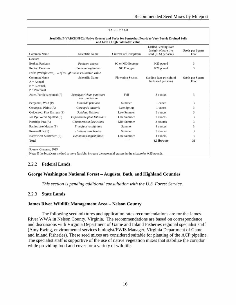
Recommended Seed Mixes by Milepost
16
Reco
mm
ended
Seed
Mix
es by M
ilepost
TABLE 2.2.1-8
Seed Mix P-VABCHNP02: Native Grasses and Forbs for Somewhat Poorly to Very Poorly Drained Soils
and have a High Pollinator Value
Common Name Scientific Name Cultivar or Germplasm
Drilled Seeding Rate (weight of pure live
seed (PLS) per acre) Seeds per Square
Foot
Grasses
Beaked Panicum Panicum anceps SC or MD Ecotype 0.25 pound 3
Redtop Panicum Panicum rigidulum NC Ecotype 0.20 pound 3
Forbs (Wildflowers) – 8 of 9 High Value Pollinator Value
Common Name
A = Annual
B = Biennial,
P = Perennial
Scientific Name Flowering Season Seeding Rate (weight of bulk seed per acre)
Seeds per Square Foot
Aster, Purple-stemmed (P) Symphyotrichum puniceum
var. puniceum
Fall 3 ounces 3
Bergamot, Wild (P) Monarda fistulosa Summer 1 ounce 3
Coreopsis, Plains (A) Coreopsis tinctoria Late Spring 1 ounce 3
Goldenrod, Pine Barrens (P) Solidago fistulosa Late Summer 3 ounces 3
Joe Pye Weed, Spotted (P) Eupatoriadelphus fistulosus Late Summer 2 ounces 3
Partridge Pea (A) Chamaecrista fasciculata Mid-Summer 2 pounds 3
Rattlesnake Master (P) Eryngium yuccifolium Summer 8 ounces 3
Rosemallow (P) Hibiscus moscheutos Summer 2 ounces 3
Narrowleaf Sunflower (P) Helianthus angustifolius Late Summer 4 ounces 3
Total — — 4.0 lbs/acre 33
____________________
Source: Glennon, 2015
Note: If the broadcast method is more feasible, increase the perennial grasses in the mixture by 0.25 pounds.
Federal Lands 2.2.2
George Washington National Forest – Augusta, Bath, and Highland Counties
This section is pending additional consultation with the U.S. Forest Service.
State Lands 2.2.3
James River Wildlife Management Area – Nelson County
The following seed mixtures and application rates recommendations are for the James
River WWA in Nelson County, Virginia. The recommendations are based on correspondence
and discussions with Virginia Department of Game and Inland Fisheries regional specialist staff
(Amy Ewing, environmental services biologist/FWIS Manager, Virginia Department of Game
and Inland Fisheries). These seed mixes are considered suitable for planting of the ACP pipeline.
The specialist staff is supportive of the use of native vegetation mixes that stabilize the corridor
while providing food and cover for a variety of wildlife.
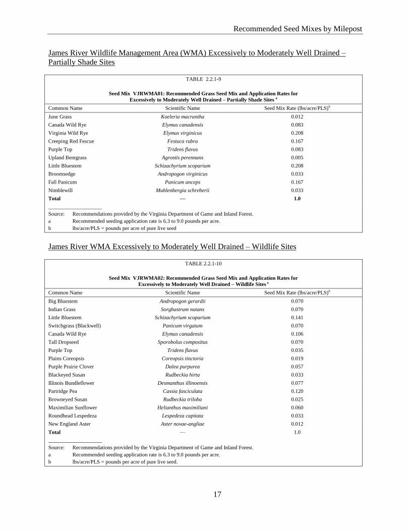
Recommended Seed Mixes by Milepost
17
Reco
mm
ended
Seed
Mix
es by M
ilepost
James River Wildlife Management Area (WMA) Excessively to Moderately Well Drained –
Partially Shade Sites
TABLE 2.2.1-9
Seed Mix VJRWMA01: Recommended Grass Seed Mix and Application Rates for
Excessively to Moderately Well Drained – Partially Shade Sites a
Common Name Scientific Name Seed Mix Rate (lbs/acre/PLS)b
June Grass Koeleria macrantha 0.012
Canada Wild Rye Elymus canadensis 0.083
Virginia Wild Rye Elymus virginicus 0.208
Creeping Red Fescue Festuca rubra 0.167
Purple Top Tridens flavus 0.083
Upland Bentgrass Agrostis perennans 0.005
Little Bluestem Schizachyrium scoparium 0.208
Broomsedge Andropogon virginicus 0.033
Fall Panicum Panicum anceps 0.167
Nimblewill Muhlenbergia schreberii 0.033
Total — 1.0
____________________
Source: Recommendations provided by the Virginia Department of Game and Inland Forest.
a Recommended seeding application rate is 6.3 to 9.0 pounds per acre.
b lbs/acre/PLS = pounds per acre of pure live seed
James River WMA Excessively to Moderately Well Drained – Wildlife Sites
TABLE 2.2.1-10
Seed Mix VJRWMA02: Recommended Grass Seed Mix and Application Rates for
Excessively to Moderately Well Drained – Wildlife Sites a
Common Name Scientific Name Seed Mix Rate (lbs/acre/PLS)b
Big Bluestem Andropogon gerardii 0.070
Indian Grass Sorghastrum nutans 0.070
Little Bluestem Schizachyrium scoparium 0.141
Switchgrass (Blackwell) Panicum virgatum 0.070
Canada Wild Rye Elymus canadensis 0.106
Tall Dropseed Sporobolus compositus 0.070
Purple Top Tridens flavus 0.035
Plains Coreopsis Coreopsis tinctoria 0.019
Purple Prairie Clover Dalea purpurea 0.057
Blackeyed Susan Rudbeckia hirta 0.033
Illinois Bundleflower Desmanthus illinoensis 0.077
Partridge Pea Cassia fasciculata 0.120
Browneyed Susan Rudbeckia triloba 0.025
Maximilian Sunflower Helianthus maximiliani 0.060
Roundhead Lespedeza Lespedeza capitata 0.033
New England Aster Aster novae-angliae 0.012
Total — 1.0
____________________
Source: Recommendations provided by the Virginia Department of Game and Inland Forest.
a Recommended seeding application rate is 6.3 to 9.0 pounds per acre.
b lbs/acre/PLS = pounds per acre of pure live seed.
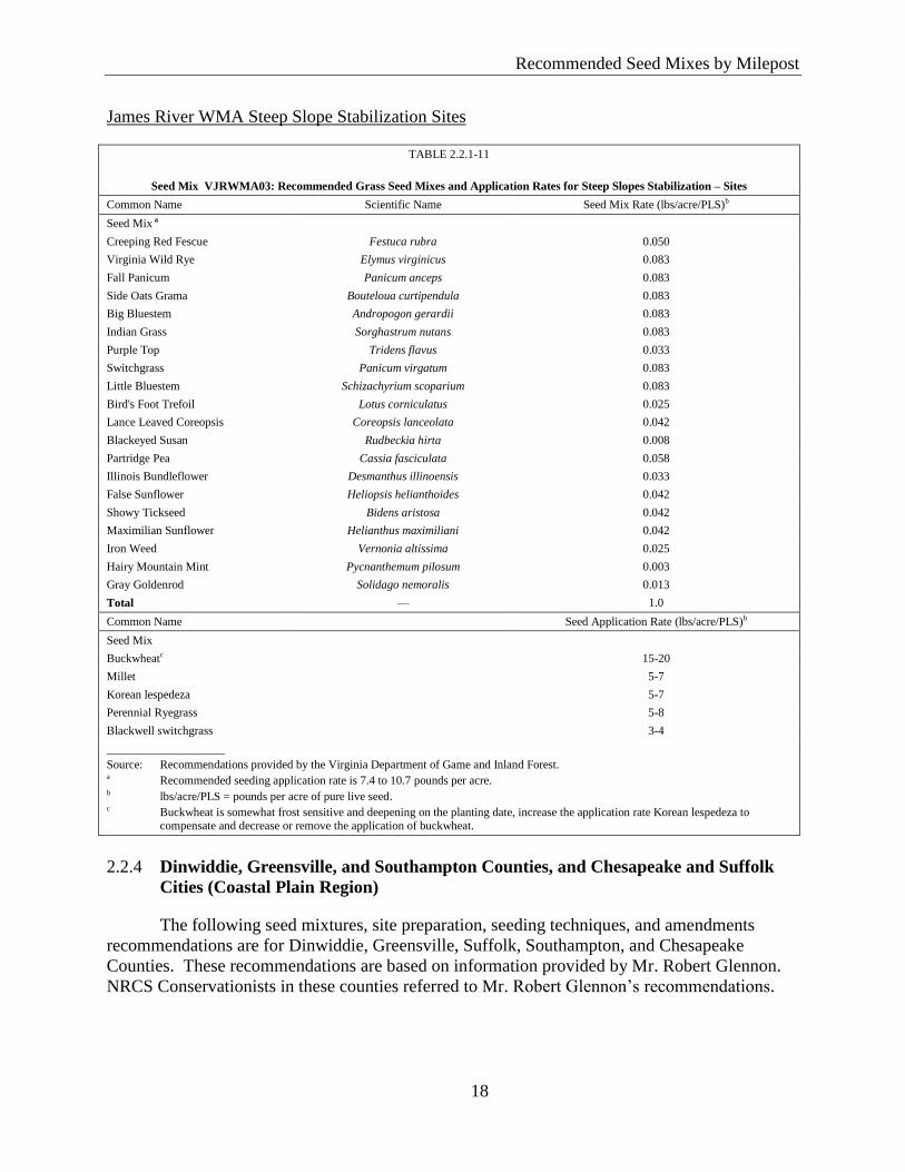
Recommended Seed Mixes by Milepost
18
Reco
mm
ended
Seed
Mix
es by M
ilepost
James River WMA Steep Slope Stabilization Sites
TABLE 2.2.1-11
Seed Mix VJRWMA03: Recommended Grass Seed Mixes and Application Rates for Steep Slopes Stabilization – Sites
Common Name Scientific Name Seed Mix Rate (lbs/acre/PLS)b
Seed Mix a
Creeping Red Fescue Festuca rubra 0.050
Virginia Wild Rye Elymus virginicus 0.083
Fall Panicum Panicum anceps 0.083
Side Oats Grama Bouteloua curtipendula 0.083
Big Bluestem Andropogon gerardii 0.083
Indian Grass Sorghastrum nutans 0.083
Purple Top Tridens flavus 0.033
Switchgrass Panicum virgatum 0.083
Little Bluestem Schizachyrium scoparium 0.083
Bird's Foot Trefoil Lotus corniculatus 0.025
Lance Leaved Coreopsis Coreopsis lanceolata 0.042
Blackeyed Susan Rudbeckia hirta 0.008
Partridge Pea Cassia fasciculata 0.058
Illinois Bundleflower Desmanthus illinoensis 0.033
False Sunflower Heliopsis helianthoides 0.042
Showy Tickseed Bidens aristosa 0.042
Maximilian Sunflower Helianthus maximiliani 0.042
Iron Weed Vernonia altissima 0.025
Hairy Mountain Mint Pycnanthemum pilosum 0.003
Gray Goldenrod Solidago nemoralis 0.013
Total — 1.0
Common Name Seed Application Rate (lbs/acre/PLS)b
Seed Mix
Buckwheatc 15-20
Millet 5-7
Korean lespedeza 5-7
Perennial Ryegrass 5-8
Blackwell switchgrass 3-4
____________________
Source: Recommendations provided by the Virginia Department of Game and Inland Forest. a Recommended seeding application rate is 7.4 to 10.7 pounds per acre. b lbs/acre/PLS = pounds per acre of pure live seed. c Buckwheat is somewhat frost sensitive and deepening on the planting date, increase the application rate Korean lespedeza to
compensate and decrease or remove the application of buckwheat.
Dinwiddie, Greensville, and Southampton Counties, and Chesapeake and Suffolk 2.2.4
Cities (Coastal Plain Region)
The following seed mixtures, site preparation, seeding techniques, and amendments
recommendations are for Dinwiddie, Greensville, Suffolk, Southampton, and Chesapeake
Counties. These recommendations are based on information provided by Mr. Robert Glennon.
NRCS Conservationists in these counties referred to Mr. Robert Glennon’s recommendations.
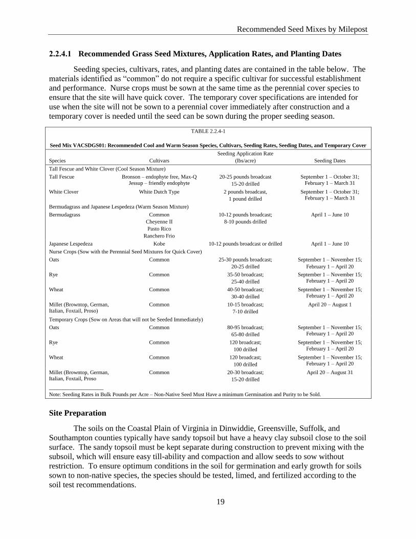
Recommended Seed Mixes by Milepost
19
Reco
mm
ended
Seed
Mix
es by M
ilepost
2.2.4.1 Recommended Grass Seed Mixtures, Application Rates, and Planting Dates
Seeding species, cultivars, rates, and planting dates are contained in the table below. The
materials identified as “common” do not require a specific cultivar for successful establishment
and performance. Nurse crops must be sown at the same time as the perennial cover species to
ensure that the site will have quick cover. The temporary cover specifications are intended for
use when the site will not be sown to a perennial cover immediately after construction and a
temporary cover is needed until the seed can be sown during the proper seeding season.
TABLE 2.2.4-1
Seed Mix VACSDGS01: Recommended Cool and Warm Season Species, Cultivars, Seeding Rates, Seeding Dates, and Temporary Cover
Species Cultivars
Seeding Application Rate
(lbs/acre) Seeding Dates
Tall Fescue and White Clover (Cool Season Mixture)
Tall Fescue Bronson – endophyte free, Max-Q
Jessup – friendly endophyte
20-25 pounds broadcast
15-20 drilled
September 1 – October 31;
February 1 – March 31
White Clover White Dutch Type 2 pounds broadcast,
1 pound drilled
September 1 – October 31; February 1 – March 31
Bermudagrass and Japanese Lespedeza (Warm Season Mixture)
Bermudagrass Common
Cheyenne II
Pasto Rico
Ranchero Frio
10-12 pounds broadcast;
8-10 pounds drilled
April 1 – June 10
Japanese Lespedeza Kobe 10-12 pounds broadcast or drilled April 1 – June 10
Nurse Crops (Sow with the Perennial Seed Mixtures for Quick Cover)
Oats Common 25-30 pounds broadcast;
20-25 drilled
September 1 – November 15;
February 1 – April 20
Rye Common 35-50 broadcast;
25-40 drilled
September 1 – November 15;
February 1 – April 20
Wheat Common 40-50 broadcast;
30-40 drilled
September 1 – November 15;
February 1 – April 20
Millet (Browntop, German, Italian, Foxtail, Proso)
Common 10-15 broadcast;
7-10 drilled
April 20 – August 1
Temporary Crops (Sow on Areas that will not be Seeded Immediately)
Oats Common 80-95 broadcast;
65-80 drilled
September 1 – November 15; February 1 – April 20
Rye Common 120 broadcast;
100 drilled
September 1 – November 15;
February 1 – April 20
Wheat Common 120 broadcast;
100 drilled
September 1 – November 15;
February 1 – April 20
Millet (Browntop, German, Italian, Foxtail, Proso
Common 20-30 broadcast;
15-20 drilled
April 20 – August 31
____________________
Note: Seeding Rates in Bulk Pounds per Acre – Non-Native Seed Must Have a minimum Germination and Purity to be Sold.
Site Preparation
The soils on the Coastal Plain of Virginia in Dinwiddie, Greensville, Suffolk, and
Southampton counties typically have sandy topsoil but have a heavy clay subsoil close to the soil
surface. The sandy topsoil must be kept separate during construction to prevent mixing with the
subsoil, which will ensure easy till-ability and compaction and allow seeds to sow without
restriction. To ensure optimum conditions in the soil for germination and early growth for soils
sown to non-native species, the species should be tested, limed, and fertilized according to the
soil test recommendations.
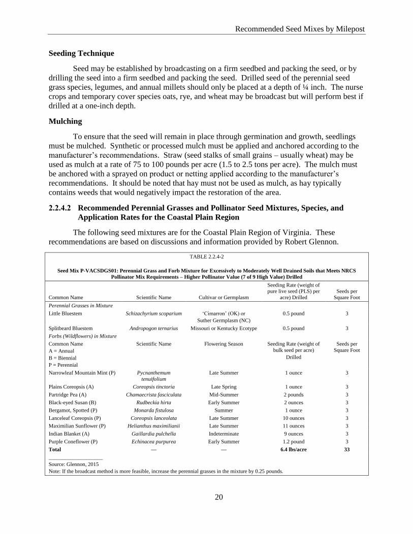
Recommended Seed Mixes by Milepost
20
Reco
mm
ended
Seed
Mix
es by M
ilepost
Seeding Technique
Seed may be established by broadcasting on a firm seedbed and packing the seed, or by
drilling the seed into a firm seedbed and packing the seed. Drilled seed of the perennial seed
grass species, legumes, and annual millets should only be placed at a depth of ¼ inch. The nurse
crops and temporary cover species oats, rye, and wheat may be broadcast but will perform best if
drilled at a one-inch depth.
Mulching
To ensure that the seed will remain in place through germination and growth, seedlings
must be mulched. Synthetic or processed mulch must be applied and anchored according to the
manufacturer’s recommendations. Straw (seed stalks of small grains – usually wheat) may be
used as mulch at a rate of 75 to 100 pounds per acre (1.5 to 2.5 tons per acre). The mulch must
be anchored with a sprayed on product or netting applied according to the manufacturer’s
recommendations. It should be noted that hay must not be used as mulch, as hay typically
contains weeds that would negatively impact the restoration of the area.
2.2.4.2 Recommended Perennial Grasses and Pollinator Seed Mixtures, Species, and
Application Rates for the Coastal Plain Region
The following seed mixtures are for the Coastal Plain Region of Virginia. These
recommendations are based on discussions and information provided by Robert Glennon.
TABLE 2.2.4-2
Seed Mix P-VACSDGS01: Perennial Grass and Forb Mixture for Excessively to Moderately Well Drained Soils that Meets NRCS
Pollinator Mix Requirements – Higher Pollinator Value (7 of 9 High Value) Drilled
Common Name Scientific Name Cultivar or Germplasm
Seeding Rate (weight of pure live seed (PLS) per
acre) Drilled
Seeds per
Square Foot
Perennial Grasses in Mixture
Little Bluestem Schizachyrium scoparium ‘Cimarron’ (OK) or
Suther Germplasm (NC)
0.5 pound 3
Splitbeard Bluestem Andropogon ternarius Missouri or Kentucky Ecotype 0.5 pound 3
Forbs (Wildflowers) in Mixture
Common Name
A = Annual
B = Biennial
P = Perennial
Scientific Name Flowering Season Seeding Rate (weight of
bulk seed per acre)
Drilled
Seeds per
Square Foot
Narrowleaf Mountain Mint (P) Pycnanthemum
tenuifolium
Late Summer 1 ounce 3
Plains Coreopsis (A) Coreopsis tinctoria Late Spring 1 ounce 3
Partridge Pea (A) Chamaecrista fasciculata Mid-Summer 2 pounds 3
Black-eyed Susan (B) Rudbeckia hirta Early Summer 2 ounces 3
Bergamot, Spotted (P) Monarda fistulosa Summer 1 ounce 3
Lanceleaf Coreopsis (P) Coreopsis lanceolata Late Summer 10 ounces 3
Maximilian Sunflower (P) Helianthus maximilianii Late Summer 11 ounces 3
Indian Blanket (A) Gaillardia pulchella Indeterminate 9 ounces 3
Purple Coneflower (P) Echinacea purpurea Early Summer 1.2 pound 3
Total — — 6.4 lbs/acre 33
____________________
Source: Glennon, 2015
Note: If the broadcast method is more feasible, increase the perennial grasses in the mixture by 0.25 pounds.
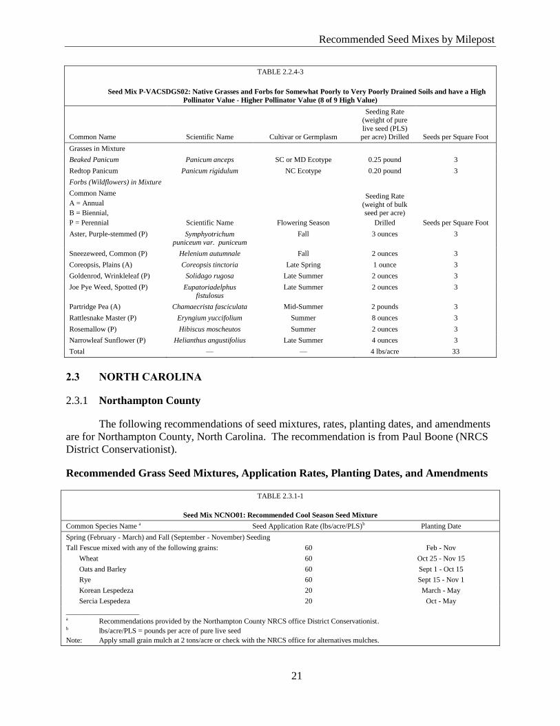
Recommended Seed Mixes by Milepost
21
Reco
mm
ended
Seed
Mix
es by M
ilepost
TABLE 2.2.4-3
Seed Mix P-VACSDGS02: Native Grasses and Forbs for Somewhat Poorly to Very Poorly Drained Soils and have a High
Pollinator Value - Higher Pollinator Value (8 of 9 High Value)
Common Name Scientific Name Cultivar or Germplasm
Seeding Rate (weight of pure
live seed (PLS) per acre) Drilled Seeds per Square Foot
Grasses in Mixture
Beaked Panicum Panicum anceps SC or MD Ecotype 0.25 pound 3
Redtop Panicum Panicum rigidulum NC Ecotype 0.20 pound 3
Forbs (Wildflowers) in Mixture
Common Name
A = Annual
B = Biennial,
P = Perennial Scientific Name Flowering Season
Seeding Rate
(weight of bulk seed per acre)
Drilled Seeds per Square Foot
Aster, Purple-stemmed (P) Symphyotrichum puniceum var. puniceum
Fall 3 ounces 3
Sneezeweed, Common (P) Helenium autumnale Fall 2 ounces 3
Coreopsis, Plains (A) Coreopsis tinctoria Late Spring 1 ounce 3
Goldenrod, Wrinkleleaf (P) Solidago rugosa Late Summer 2 ounces 3
Joe Pye Weed, Spotted (P) Eupatoriadelphus fistulosus
Late Summer 2 ounces 3
Partridge Pea (A) Chamaecrista fasciculata Mid-Summer 2 pounds 3
Rattlesnake Master (P) Eryngium yuccifolium Summer 8 ounces 3
Rosemallow (P) Hibiscus moscheutos Summer 2 ounces 3
Narrowleaf Sunflower (P) Helianthus angustifolius Late Summer 4 ounces 3
Total — — 4 lbs/acre 33
2.3 NORTH CAROLINA
Northampton County 2.3.1
The following recommendations of seed mixtures, rates, planting dates, and amendments
are for Northampton County, North Carolina. The recommendation is from Paul Boone (NRCS
District Conservationist).
Recommended Grass Seed Mixtures, Application Rates, Planting Dates, and Amendments
TABLE 2.3.1-1
Seed Mix NCNO01: Recommended Cool Season Seed Mixture
Common Species Name a Seed Application Rate (lbs/acre/PLS)b Planting Date
Spring (February - March) and Fall (September - November) Seeding
Tall Fescue mixed with any of the following grains: 60 Feb - Nov
Wheat 60 Oct 25 - Nov 15
Oats and Barley 60 Sept 1 - Oct 15
Rye 60 Sept 15 - Nov 1
Korean Lespedeza 20 March - May
Sercia Lespedeza 20 Oct - May
____________________ a Recommendations provided by the Northampton County NRCS office District Conservationist. b lbs/acre/PLS = pounds per acre of pure live seed
Note: Apply small grain mulch at 2 tons/acre or check with the NRCS office for alternatives mulches.
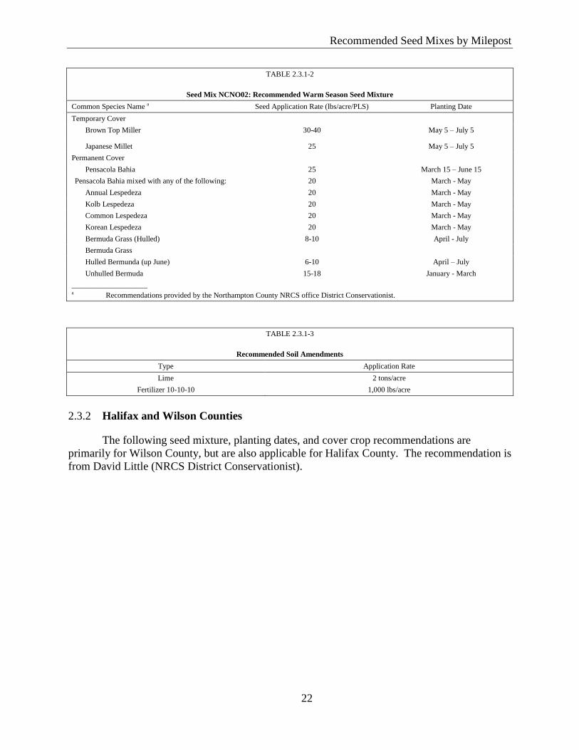
Recommended Seed Mixes by Milepost
22
Reco
mm
ended
Seed
Mix
es by M
ilepost
TABLE 2.3.1-2
Seed Mix NCNO02: Recommended Warm Season Seed Mixture
Common Species Name a Seed Application Rate (lbs/acre/PLS) Planting Date
Temporary Cover
Brown Top Miller 30-40 May 5 – July 5
Japanese Millet 25 May 5 – July 5
Permanent Cover
Pensacola Bahia 25 March 15 – June 15
Pensacola Bahia mixed with any of the following: 20 March - May
Annual Lespedeza 20 March - May
Kolb Lespedeza 20 March - May
Common Lespedeza 20 March - May
Korean Lespedeza 20 March - May
Bermuda Grass (Hulled) 8-10 April - July
Bermuda Grass
Hulled Bermunda (up June) 6-10 April – July
Unhulled Bermuda 15-18 January - March
____________________ a Recommendations provided by the Northampton County NRCS office District Conservationist.
TABLE 2.3.1-3
Recommended Soil Amendments
Type Application Rate
Lime 2 tons/acre
Fertilizer 10-10-10 1,000 lbs/acre
Halifax and Wilson Counties 2.3.2
The following seed mixture, planting dates, and cover crop recommendations are
primarily for Wilson County, but are also applicable for Halifax County. The recommendation is
from David Little (NRCS District Conservationist).
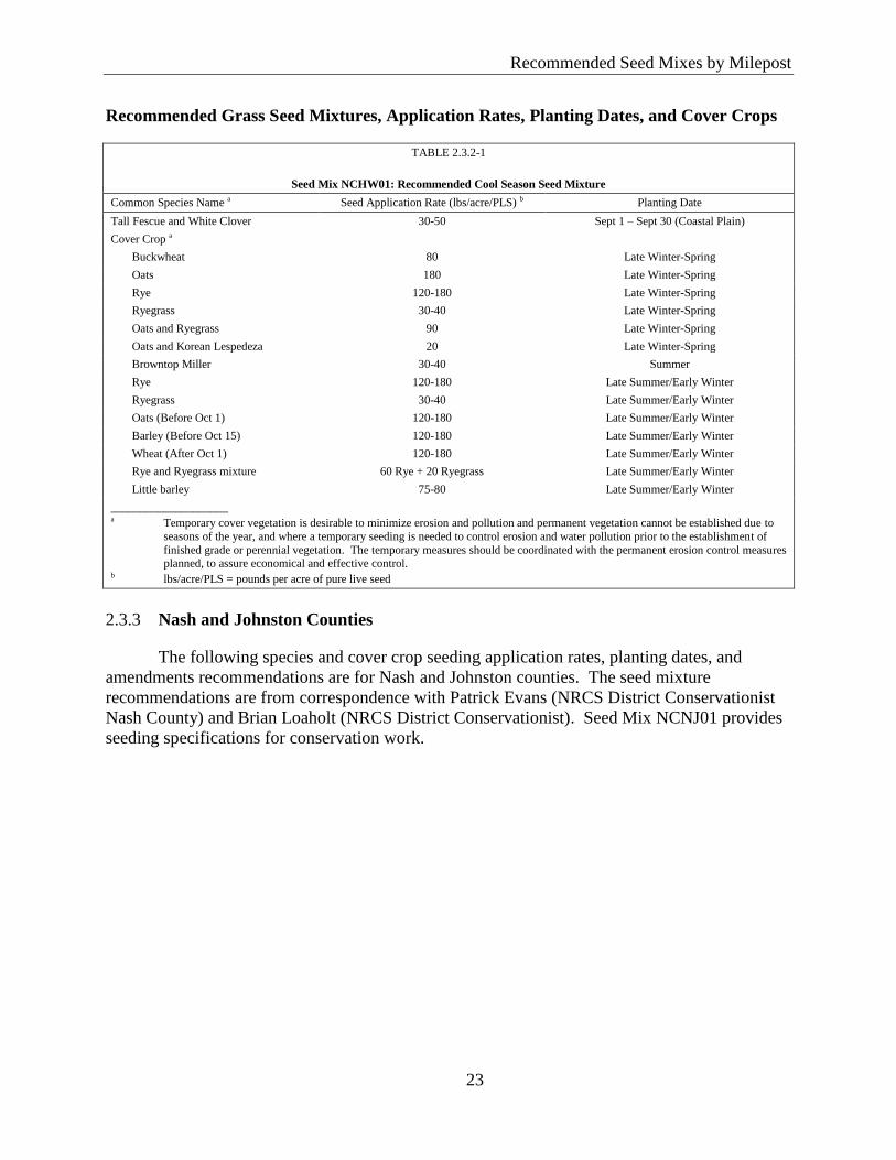
Recommended Seed Mixes by Milepost
23
Reco
mm
ended
Seed
Mix
es by M
ilepost
Recommended Grass Seed Mixtures, Application Rates, Planting Dates, and Cover Crops
TABLE 2.3.2-1
Seed Mix NCHW01: Recommended Cool Season Seed Mixture
Common Species Name a Seed Application Rate (lbs/acre/PLS) b Planting Date
Tall Fescue and White Clover 30-50 Sept 1 – Sept 30 (Coastal Plain)
Cover Crop a
Buckwheat 80 Late Winter-Spring
Oats 180 Late Winter-Spring
Rye 120-180 Late Winter-Spring
Ryegrass 30-40 Late Winter-Spring
Oats and Ryegrass 90 Late Winter-Spring
Oats and Korean Lespedeza 20 Late Winter-Spring
Browntop Miller 30-40 Summer
Rye 120-180 Late Summer/Early Winter
Ryegrass 30-40 Late Summer/Early Winter
Oats (Before Oct 1) 120-180 Late Summer/Early Winter
Barley (Before Oct 15) 120-180 Late Summer/Early Winter
Wheat (After Oct 1) 120-180 Late Summer/Early Winter
Rye and Ryegrass mixture 60 Rye + 20 Ryegrass Late Summer/Early Winter
Little barley 75-80 Late Summer/Early Winter
____________________ a Temporary cover vegetation is desirable to minimize erosion and pollution and permanent vegetation cannot be established due to
seasons of the year, and where a temporary seeding is needed to control erosion and water pollution prior to the establishment of
finished grade or perennial vegetation. The temporary measures should be coordinated with the permanent erosion control measures planned, to assure economical and effective control.
b lbs/acre/PLS = pounds per acre of pure live seed
Nash and Johnston Counties 2.3.3
The following species and cover crop seeding application rates, planting dates, and
amendments recommendations are for Nash and Johnston counties. The seed mixture
recommendations are from correspondence with Patrick Evans (NRCS District Conservationist
Nash County) and Brian Loaholt (NRCS District Conservationist). Seed Mix NCNJ01 provides
seeding specifications for conservation work.
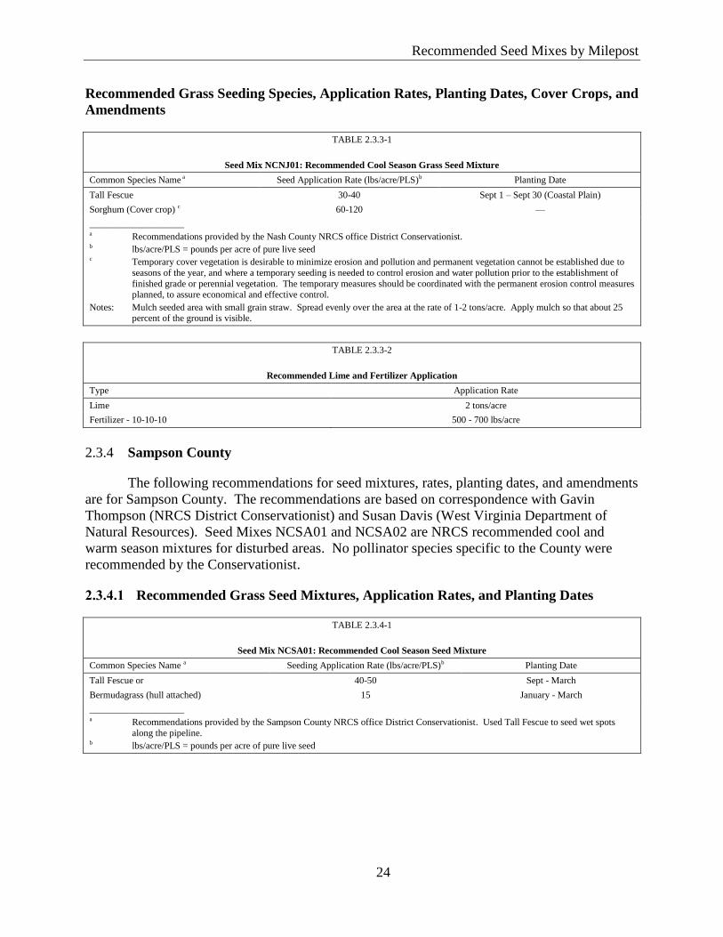
Recommended Seed Mixes by Milepost
24
Reco
mm
ended
Seed
Mix
es by M
ilepost
Recommended Grass Seeding Species, Application Rates, Planting Dates, Cover Crops, and
Amendments
TABLE 2.3.3-1
Seed Mix NCNJ01: Recommended Cool Season Grass Seed Mixture
Common Species Name a Seed Application Rate (lbs/acre/PLS)b Planting Date
Tall Fescue 30-40 Sept 1 – Sept 30 (Coastal Plain)
Sorghum (Cover crop) c 60-120 —
____________________ a Recommendations provided by the Nash County NRCS office District Conservationist. b lbs/acre/PLS = pounds per acre of pure live seed
c Temporary cover vegetation is desirable to minimize erosion and pollution and permanent vegetation cannot be established due to
seasons of the year, and where a temporary seeding is needed to control erosion and water pollution prior to the establishment of
finished grade or perennial vegetation. The temporary measures should be coordinated with the permanent erosion control measures
planned, to assure economical and effective control.
Notes: Mulch seeded area with small grain straw. Spread evenly over the area at the rate of 1-2 tons/acre. Apply mulch so that about 25 percent of the ground is visible.
TABLE 2.3.3-2
Recommended Lime and Fertilizer Application
Type Application Rate
Lime 2 tons/acre
Fertilizer - 10-10-10 500 - 700 lbs/acre
Sampson County 2.3.4
The following recommendations for seed mixtures, rates, planting dates, and amendments
are for Sampson County. The recommendations are based on correspondence with Gavin
Thompson (NRCS District Conservationist) and Susan Davis (West Virginia Department of
Natural Resources). Seed Mixes NCSA01 and NCSA02 are NRCS recommended cool and
warm season mixtures for disturbed areas. No pollinator species specific to the County were
recommended by the Conservationist.
2.3.4.1 Recommended Grass Seed Mixtures, Application Rates, and Planting Dates
TABLE 2.3.4-1
Seed Mix NCSA01: Recommended Cool Season Seed Mixture
Common Species Name a Seeding Application Rate (lbs/acre/PLS)b Planting Date
Tall Fescue or 40-50 Sept - March
Bermudagrass (hull attached) 15 January - March
____________________ a Recommendations provided by the Sampson County NRCS office District Conservationist. Used Tall Fescue to seed wet spots
along the pipeline. b lbs/acre/PLS = pounds per acre of pure live seed
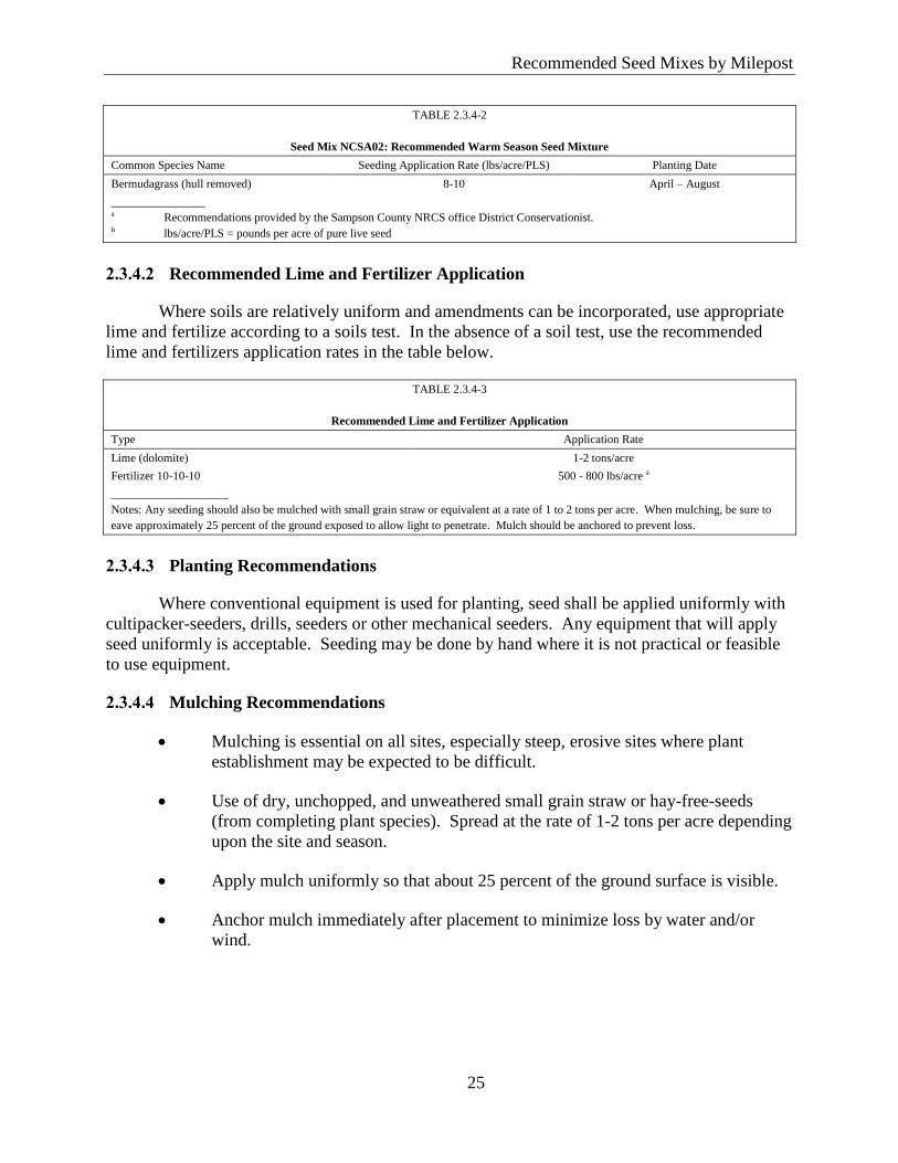
Recommended Seed Mixes by Milepost
25
Reco
mm
ended
Seed
Mix
es by M
ilepost
TABLE 2.3.4-2
Seed Mix NCSA02: Recommended Warm Season Seed Mixture
Common Species Name Seeding Application Rate (lbs/acre/PLS) Planting Date
Bermudagrass (hull removed) 8-10 April – August
________________ a Recommendations provided by the Sampson County NRCS office District Conservationist. b lbs/acre/PLS = pounds per acre of pure live seed
2.3.4.2 Recommended Lime and Fertilizer Application
Where soils are relatively uniform and amendments can be incorporated, use appropriate
lime and fertilize according to a soils test. In the absence of a soil test, use the recommended
lime and fertilizers application rates in the table below.
TABLE 2.3.4-3
Recommended Lime and Fertilizer Application
Type Application Rate
Lime (dolomite) 1-2 tons/acre
Fertilizer 10-10-10 500 - 800 lbs/acre a
____________________
Notes: Any seeding should also be mulched with small grain straw or equivalent at a rate of 1 to 2 tons per acre. When mulching, be sure to
eave approximately 25 percent of the ground exposed to allow light to penetrate. Mulch should be anchored to prevent loss.
2.3.4.3 Planting Recommendations
Where conventional equipment is used for planting, seed shall be applied uniformly with
cultipacker-seeders, drills, seeders or other mechanical seeders. Any equipment that will apply
seed uniformly is acceptable. Seeding may be done by hand where it is not practical or feasible
to use equipment.
2.3.4.4 Mulching Recommendations
Mulching is essential on all sites, especially steep, erosive sites where plant
establishment may be expected to be difficult.
Use of dry, unchopped, and unweathered small grain straw or hay-free-seeds
(from completing plant species). Spread at the rate of 1-2 tons per acre depending
upon the site and season.
Apply mulch uniformly so that about 25 percent of the ground surface is visible.
Anchor mulch immediately after placement to minimize loss by water and/or
wind.
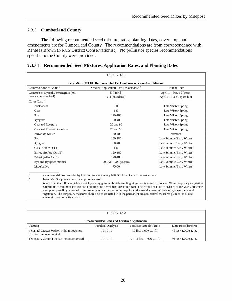
Recommended Seed Mixes by Milepost
26
Reco
mm
ended
Seed
Mix
es by M
ilepost
Cumberland County 2.3.5
The following recommended seed mixture, rates, planting dates, cover crop, and
amendments are for Cumberland County. The recommendations are from correspondence with
Renessa Brown (NRCS District Conservationist). No pollinator species recommendations
specific to the County were provided.
2.3.5.1 Recommended Seed Mixtures, Application Rates, and Planting Dates
TABLE 2.3.5-1
Seed Mix NCCU01: Recommended Cool and Warm Season Seed Mixture
Common Species Name a Seeding Application Rate (lbs/acre/PLS)b Planting Date
Common or Hybrid Bernudagrass (hull
removed or scarified)
5-7 (drill)
6-8 (broadcast)
April 1 – May 15 (best);
April 1 – June 7 (possible)
Cover Crop c
Buckwheat 80 Late Winter-Spring
Oats 180 Late Winter-Spring
Rye 120-180 Late Winter-Spring
Ryegrass 30-40 Late Winter-Spring
Oats and Ryegrass 20 and 90 Late Winter-Spring
Oats and Korean Lespedeza 20 and 90 Late Winter-Spring
Browntop Miller 30-40 Summer
Rye 120-180 Late Summer/Early Winter
Ryegrass 30-40 Late Summer/Early Winter
Oats (Before Oct 1) 180 Late Summer/Early Winter
Barley (Before Oct 15) 120-180 Late Summer/Early Winter
Wheat (After Oct 1) 120-180 Late Summer/Early Winter
Rye and Ryegrass mixture 60 Rye + 20 Ryegrass Late Summer/Early Winter
Little barley 75-80 Late Summer/Early Winter
____________________ a Recommendations provided by the Cumberland County NRCS office District Conservationist. b lbs/acre/PLS = pounds per acre of pure live seed c Select from the following table a quick growing grass with high seedling vigor that is suited to the area, When temporary vegetation
is desirable to minimize erosion and pollution and permanent vegetation cannot be established due to seasons of the year, and where
a temporary seeding is needed to control erosion and water pollution prior to the establishment of finished grade or perennial
vegetation. The temporary measures should be coordinated with the permanent erosion control measures planned, to assure economical and effective control.
TABLE 2.3.5-2
Recommended Lime and Fertilizer Application
Planting Fertilizer Analysis Fertilizer Rate (lbs/acre) Lime Rate (lbs/acre)
Perennial Grasses with or without Legumes, Fertilizer no incorporated
10-10-10 10 lbs / 1,000 sq. ft. 46 lbs / 1,000 sq. ft.
Temporary Cover, Fertilizer not incorporated 10-10-10 12 – 16 lbs / 1,000 sq. ft. 92 lbs / 1,000 sq. ft.
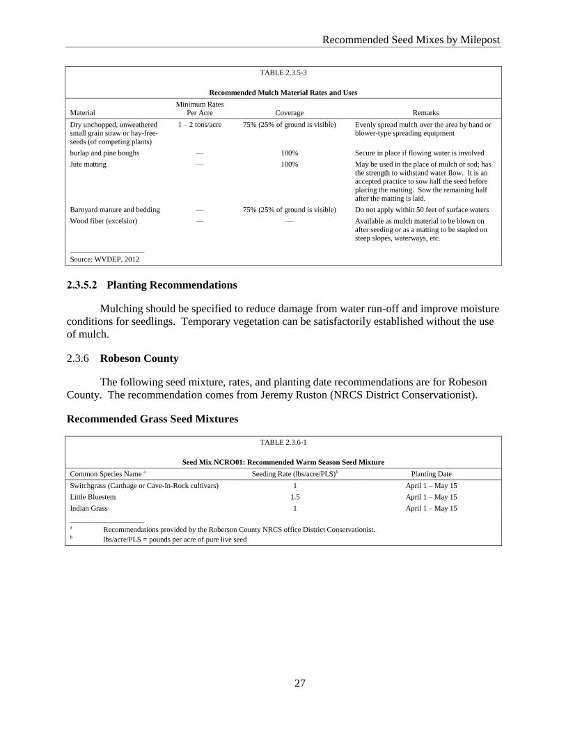
Recommended Seed Mixes by Milepost
27
Reco
mm
ended
Seed
Mix
es by M
ilepost
TABLE 2.3.5-3
Recommended Mulch Material Rates and Uses
Material Minimum Rates
Per Acre Coverage Remarks
Dry unchopped, unweathered small grain straw or hay-free-
seeds (of competing plants)
1 – 2 tons/acre 75% (25% of ground is visible) Evenly spread mulch over the area by hand or blower-type spreading equipment
burlap and pine boughs — 100% Secure in place if flowing water is involved
Jute matting — 100% May be used in the place of mulch or sod; has
the strength to withstand water flow. It is an accepted practice to sow half the seed before
placing the matting. Sow the remaining half
after the matting is laid.
Barnyard manure and bedding — 75% (25% of ground is visible) Do not apply within 50 feet of surface waters
Wood fiber (excelsior) — — Available as mulch material to be blown on
after seeding or as a matting to be stapled on
steep slopes, waterways, etc.
____________________
Source: WVDEP, 2012
2.3.5.2 Planting Recommendations
Mulching should be specified to reduce damage from water run-off and improve moisture
conditions for seedlings. Temporary vegetation can be satisfactorily established without the use
of mulch.
Robeson County 2.3.6
The following seed mixture, rates, and planting date recommendations are for Robeson
County. The recommendation comes from Jeremy Ruston (NRCS District Conservationist).
Recommended Grass Seed Mixtures
TABLE 2.3.6-1
Seed Mix NCRO01: Recommended Warm Season Seed Mixture
Common Species Name a Seeding Rate (lbs/acre/PLS)b Planting Date
Switchgrass (Carthage or Cave-In-Rock cultivars) 1 April 1 – May 15
Little Bluestem 1.5 April 1 – May 15
Indian Grass 1 April 1 – May 15
____________________ a Recommendations provided by the Roberson County NRCS office District Conservationist. b lbs/acre/PLS = pounds per acre of pure live seed
Recommended Seed Mixes by Milepost
28
Reco
mm
ended
Seed
Mix
es by M
ilepost
Recommended Pollinator Seed Mixtures
TABLE 2.3.6-2
Seed Mix P-NCRO01: Recommended Pollinator Seed Mixture
Common Name Scientific Name Bloom Period Sun Soil
Seeding Application Seed Rate
(lbs/acre/PLS)a
Lanceleaf coreopsis Coreopsis lanceolata April – June Full – Shade Dry – Moist 0.3
Wrinkleleaf goldenrod
Solidago rugosa Late Summer Full to Partial shade Moist
Purple coneflower Echinacea purpurea April – September Full to Partial shade Dry
____________________
Source: Recommendations provided by the Roberson County NRCS office District Conservationist. a lbs/acre/PLS = pounds per acre of pure live seed
Recommended Native Grass and Pollinator Seed Mixtures, Application Rates, and 2.3.7
Non-Native Cover Crop by Physiographical Region (Coastal Plain)
The following seed mixtures are for the Coastal Plan Region. These recommendations
are from discussions with Roundstone Native Seed and Robert Glennon.
Recommended Seed Mixtures by Geographical Region (Coastal Plain) and Drainage Class
TABLE 2.3.7-1
Seed Mix P-CPDW01: Recommended Coastal Plain Physiographic Region
Grass Seed Mix and Application Rates for Excessively to Moderately Well Drained Sites in North Carolina a
Common Name Scientific Name Height (Inches) Sun Exposure Seed Mix Rate
(lbs/acre/PLS)b
Little Bluestem Schizachyrium scoparium 2- 4 Full Sun 0.250
Virginia Wild Rye Elymus virginicus 2 - 4 Full Sun 0.250
Tall Dropseed Sporobolus compositus 2 - 3 Full Sun 0.050
Purple Top Tridens flavus 3 - 5 Part Shade 0.058
Indian Grass Sorghastrum nutans 3 - 6 Full Sun 0.167
Switchgrass Panicum virgatum 3 - 7 Full Sun 0.183
Fall Panicum Panicum anceps 2 - 4 Part Shade 0.042
Total — — — 1.0
____________________
Sources: Roundstone Native Seed, 2015; Glennon, 2015 a Recommended seeding application rate is 8 to 18 pounds per acre. b lbs/acre/PLS = pounds per acre of pure live seed
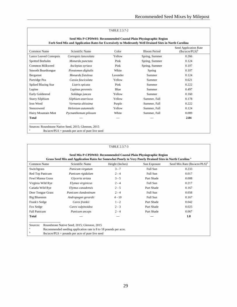
Recommended Seed Mixes by Milepost
29
Reco
mm
ended
Seed
Mix
es by M
ilepost
TABLE 2.3.7-2
Seed Mix P-CPDW01: Recommended Coastal Plain Physiographic Region
Forb Seed Mix and Application Rates for Excessively to Moderately Well Drained Sites in North Carolina
Common Name Scientific Name Color Bloom Period Seed Application Rate
(lbs/acre/PLS)b
Lance Leaved Coreopsis Coreopsis lanceolata Yellow Spring, Summer 0.266
Spotted Beebalm Monarda punctata Pink Spring, Summer 0.124
Common Milkweed Asclepias syriaca Pink Spring, Summer 0.107
Smooth Beardtongue Penstemon digitalis White Spring 0.107
Bergamot Monarda fistulosa Lavender Summer 0.124
Partridge Pea Cassia fasciculata Yellow Summer 0.621
Spiked Blazing Star Liatris spicata Pink Summer 0.222
Lupine Lupinus perennis Blue Summer 0.497
Early Goldenrod Solidago juncea Yellow Summer 0.160
Starry Silphium Silphium asteriscus Yellow Summer, Fall 0.178
Iron Weed Vernonia altissima Purple Summer, Fall 0.222
Sneezeweed Helenium autumnale Yellow Summer, Fall 0.124
Hairy Mountain Mint Pycnanthemum pilosum White Summer, Fall 0.089
Total — — — 2.84
____________________
Sources: Roundstone Native Seed, 2015; Glennon, 2015 a lbs/acre/PLS = pounds per acre of pure live seed
TABLE 2.3.7-3
Seed Mix P-CPDW02: Recommended Coastal Plain Physiographic Region
Grass Seed Mix and Application Rates for Somewhat Poorly to Very Poorly Drained Sites in North Carolina a
Common Name Scientific Name Height (Inches) Sun Exposure Seed Mix Rate (lbs/acre/PLS)b
Switchgrass Panicum virgatum 3 - 7 Full Sun 0.233
Red Top Panicum Panicum rigidulum 2 - 4 Full Sun 0.017
Fowl Manna Grass Glyceria striata 3 - 5 Part Shade 0.008
Virginia Wild Rye Elymus virginicus 2 - 4 Full Sun 0.217
Canada Wild Rye Elymus canadensis 2 - 5 Part Shade 0.167
Deer Tongue Grass Panicum clandestinum 2 - 4 Full Sun 0.058
Big Bluestem Andropogon gerardii 4 - 10 Full Sun 0.167
Frank's Sedge Carex frankii 1 - 2 Part Shade 0.042
Fox Sedge Carex vulpinoidea 2 - 3 Part Shade 0.025
Fall Panicum Panicum anceps 2 - 4 Part Shade 0.067
Total — — — 1.0
____________________
Sources: Roundstone Native Seed, 2015; Glennon, 2015 a Recommended seeding application rate is 8 to 18 pounds per acre. b lbs/acre/PLS = pounds per acre of pure live seed
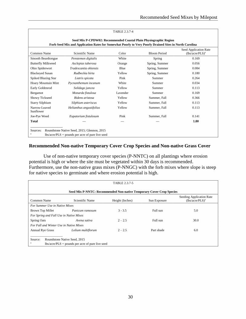
Recommended Seed Mixes by Milepost
30
Reco
mm
ended
Seed
Mix
es by M
ilepost
TABLE 2.3.7-4
Seed Mix P-CPDW02: Recommended Coastal Plain Physiographic Region
Forb Seed Mix and Application Rates for Somewhat Poorly to Very Poorly Drained Sites in North Carolina
Common Name Scientific Name Color Bloom Period Seed Application Rate
(lbs/acre/PLS)a
Smooth Beardtongue Penstemon digitalis White Spring 0.169
Butterfly Milkweed Asclepias tuberosa Orange Spring, Summer 0.056
Ohio Spiderwort Tradescantia ohiensis Blue Spring, Summer 0.084
Blackeyed Susan Rudbeckia hirta Yellow Spring, Summer 0.180
Spiked Blazing Star Liatris spicata Pink Summer 0.264
Hoary Mountain Mint Pycnanthemum incanum White Summer 0.034
Early Goldenrod Solidago juncea Yellow Summer 0.113
Bergamot Monarda fistulosa Lavender Summer 0.169
Showy Tickseed Bidens aristosa Yellow Summer, Fall 0.366
Starry Silphium Silphium asteriscus Yellow Summer, Fall 0.113
Narrow-Leaved Sunflower
Helianthus angustifolius Yellow Summer, Fall 0.113
Joe-Pye Weed Eupatorium fistulosum Pink Summer, Fall 0.141
Total — — — 1.80
____________________
Sources: Roundstone Native Seed, 2015; Glennon, 2015 a lbs/acre/PLS = pounds per acre of pure live seed
Recommended Non-native Temporary Cover Crop Species and Non-native Grass Cover
Use of non-native temporary cover species (P-NNTC) on all plantings where erosion
potential is high or where the site must be vegetated within 30 days is recommended.
Furthermore, use the non-native grass mixes (P-NNGC) with the forb mixes where slope is steep
for native species to germinate and where erosion potential is high.
TABLE 2.3.7-5
Seed Mix P-NNTC: Recommended Non-native Temporary Cover Crop Species
Common Name Scientific Name Height (Inches) Sun Exposure Seeding Application Rate
(lbs/acre/PLS)a
For Summer Use in Native Mixes
Brown Top Millet Panicum ramosum 3 - 3.5 Full sun 5.0
For Spring and Fall Use in Native Mixes
Spring Oats Avena sativa 2 – 2.5 Full sun 30.0
For Fall and Winter Use in Native Mixes
Annual Rye Grass Lolium multiflorum 2 – 2.5 Part shade 6.0
____________________
Source: Roundstone Native Seed, 2015 a lbs/acre/PLS = pounds per acre of pure live seed
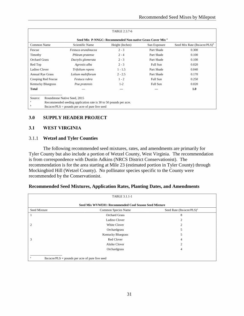
Recommended Seed Mixes by Milepost
31
Reco
mm
ended
Seed
Mix
es by M
ilepost
TABLE 2.3.7-6
Seed Mix P-NNGC: Recommended Non-native Grass Cover Mix a
Common Name Scientific Name Height (Inches) Sun Exposure Seed Mix Rate (lbs/acre/PLS)b
Fescue Festuca arundinacea 2 - 3 Part Shade 0.300
Timothy Phleum pratense 2 - 4 Part Shade 0.100
Orchard Grass Dactylis glomerata 2 - 3 Part Shade 0.100
Red Top Agrostis alba 2 - 3 Full Sun 0.020
Ladino Clover Trifolium repens 1 - 1.5 Part Shade 0.040
Annual Rye Grass Lolium multiflorum 2 - 2.5 Part Shade 0.170
Creeping Red Fescue Festuca rubra 1 - 2 Full Sun 0.250
Kentucky Bluegrass Poa pratensis 1-2 Full Sun 0.020
Total — — — 1.0
____________________
Source: Roundstone Native Seed, 2015 a Recommended seeding application rate is 30 to 50 pounds per acre. b lbs/acre/PLS = pounds per acre of pure live seed
3.0 SUPPLY HEADER PROJECT
3.1 WEST VIRGINIA
Wetzel and Tyler Counties 3.1.1
The following recommended seed mixtures, rates, and amendments are primarily for
Tyler County but also include a portion of Wetzel County, West Virginia. The recommendation
is from correspondence with Dustin Adkins (NRCS District Conservationist). The
recommendation is for the area starting at Mile 23 (estimated portion in Tyler County) through
Mockingbird Hill (Wetzel County). No pollinator species specific to the County were
recommended by the Conservationist.
Recommended Seed Mixtures, Application Rates, Planting Dates, and Amendments
TABLE 3.1.1-1
Seed Mix WVWE01: Recommended Cool Season Seed Mixture
Seed Mixture Common Species Name Seed Rate (lbs/acre/PLS)a
1 Orchard Grass 8
Ladino Clover 2
2 White Clover 2
Orchardgrass 5
Kentucky Bluegrass 5
3 Red Clover 4
Alsike Clover 2
Orchardgrass 4
____________________ a lbs/acre/PLS = pounds per acre of pure live seed
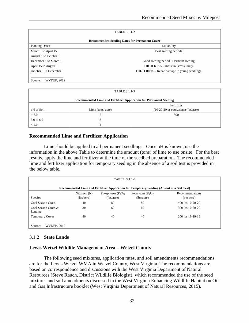
Recommended Seed Mixes by Milepost
32
Reco
mm
ended
Seed
Mix
es by M
ilepost
TABLE 3.1.1-2
Recommended Seeding Dates for Permanent Cover
Planting Dates Suitability
March 1 to April 15 Best seeding periods.
August 1 to October 1
December 1 to March 1 Good seeding period. Dormant seeding.
April 15 to August 1 HIGH RISK – moisture stress likely.
October 1 to December 1 HIGH RISK – freeze damage to young seedlings.
____________________
Source: WVDEP, 2012
TABLE 3.1.1-3
Recommended Lime and Fertilizer Application for Permanent Seeding
pH of Soil Lime (tons/ acre)
Fertilizer
(10-20-20 or equivalent) (lbs/acre)
> 6.0 2 500
5.0 to 6.0 3
< 5.0 4
Recommended Lime and Fertilizer Application
Lime should be applied to all permanent seedlings. Once pH is known, use the
information in the above Table to determine the amount (tons) of lime to use onsite. For the best
results, apply the lime and fertilizer at the time of the seedbed preparation. The recommended
lime and fertilizer application for temporary seeding in the absence of a soil test is provided in
the below table.
TABLE 3.1.1-4
Recommended Lime and Fertilizer Application for Temporary Seeding (Absent of a Soil Test)
Species
Nitrogen (N)
(lbs/acre)
Phosphorus (P2O5)
(lbs/acre)
Potassium (K2O)
(lbs/acre)
Recommendations
(per acre)
Cool Season Grass 40 80 80 400 lbs 10-20-20
Cool Season Grass & Legume
30 60 60 300 lbs 10-20-20
Temporary Cover 40 40 40 200 lbs 19-19-19
____________________
Source: WVDEP, 2012
State Lands 3.1.2
Lewis Wetzel Wildlife Management Area – Wetzel County
The following seed mixtures, application rates, and soil amendments recommendations
are for the Lewis Wetzel WMA in Wetzel County, West Virginia. The recommendations are
based on correspondence and discussions with the West Virginia Department of Natural
Resources (Steve Rauch, District Wildlife Biologist), which recommended the use of the seed
mixtures and soil amendments discussed in the West Virginia Enhancing Wildlife Habitat on Oil
and Gas Infrastructure booklet (West Virginia Department of Natural Resources, 2015).
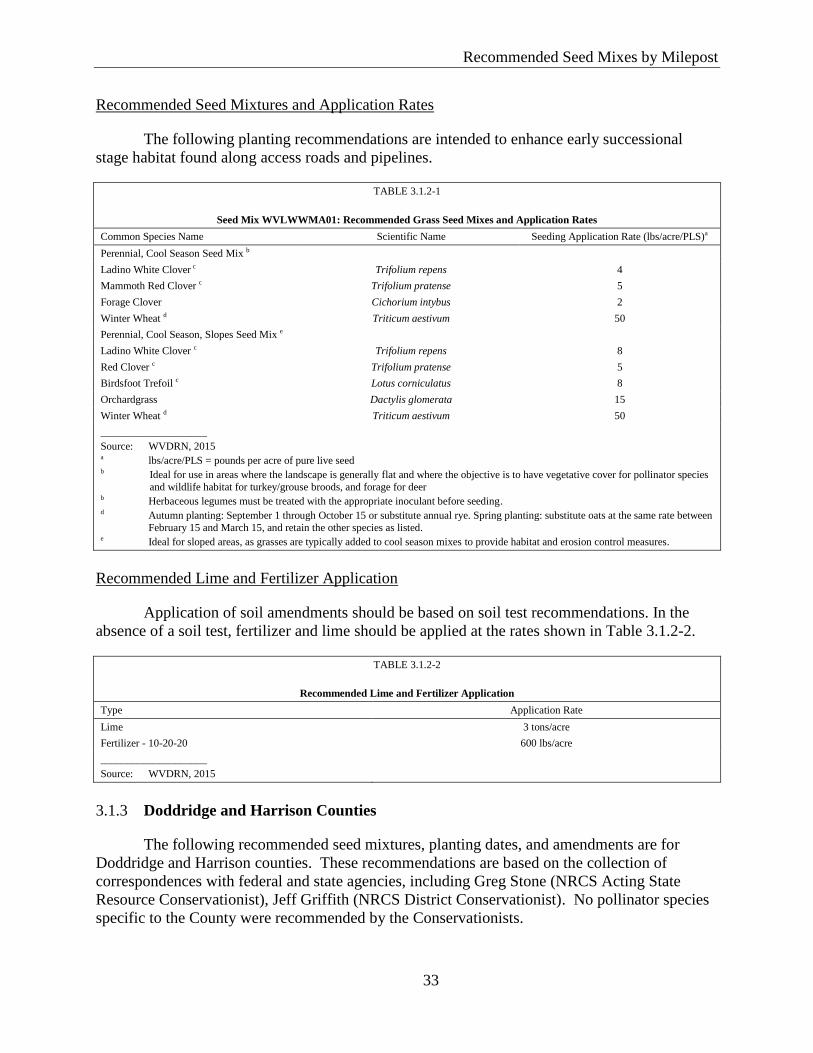
Recommended Seed Mixes by Milepost
33
Reco
mm
ended
Seed
Mix
es by M
ilepost
Recommended Seed Mixtures and Application Rates
The following planting recommendations are intended to enhance early successional
stage habitat found along access roads and pipelines.
TABLE 3.1.2-1
Seed Mix WVLWWMA01: Recommended Grass Seed Mixes and Application Rates
Common Species Name Scientific Name Seeding Application Rate (lbs/acre/PLS)a
Perennial, Cool Season Seed Mix b
Ladino White Clover c Trifolium repens 4
Mammoth Red Clover c Trifolium pratense 5
Forage Clover Cichorium intybus 2
Winter Wheat d Triticum aestivum 50
Perennial, Cool Season, Slopes Seed Mix e
Ladino White Clover c Trifolium repens 8
Red Clover c Trifolium pratense 5
Birdsfoot Trefoil c Lotus corniculatus 8
Orchardgrass Dactylis glomerata 15
Winter Wheat d Triticum aestivum 50
____________________
Source: WVDRN, 2015 a lbs/acre/PLS = pounds per acre of pure live seed b Ideal for use in areas where the landscape is generally flat and where the objective is to have vegetative cover for pollinator species
and wildlife habitat for turkey/grouse broods, and forage for deer b Herbaceous legumes must be treated with the appropriate inoculant before seeding. d Autumn planting: September 1 through October 15 or substitute annual rye. Spring planting: substitute oats at the same rate between
February 15 and March 15, and retain the other species as listed. e Ideal for sloped areas, as grasses are typically added to cool season mixes to provide habitat and erosion control measures.
Recommended Lime and Fertilizer Application
Application of soil amendments should be based on soil test recommendations. In the
absence of a soil test, fertilizer and lime should be applied at the rates shown in Table 3.1.2-2.
TABLE 3.1.2-2
Recommended Lime and Fertilizer Application
Type Application Rate
Lime 3 tons/acre
Fertilizer - 10-20-20 600 lbs/acre
____________________
Source: WVDRN, 2015
Doddridge and Harrison Counties 3.1.3
The following recommended seed mixtures, planting dates, and amendments are for
Doddridge and Harrison counties. These recommendations are based on the collection of
correspondences with federal and state agencies, including Greg Stone (NRCS Acting State
Resource Conservationist), Jeff Griffith (NRCS District Conservationist). No pollinator species
specific to the County were recommended by the Conservationists.
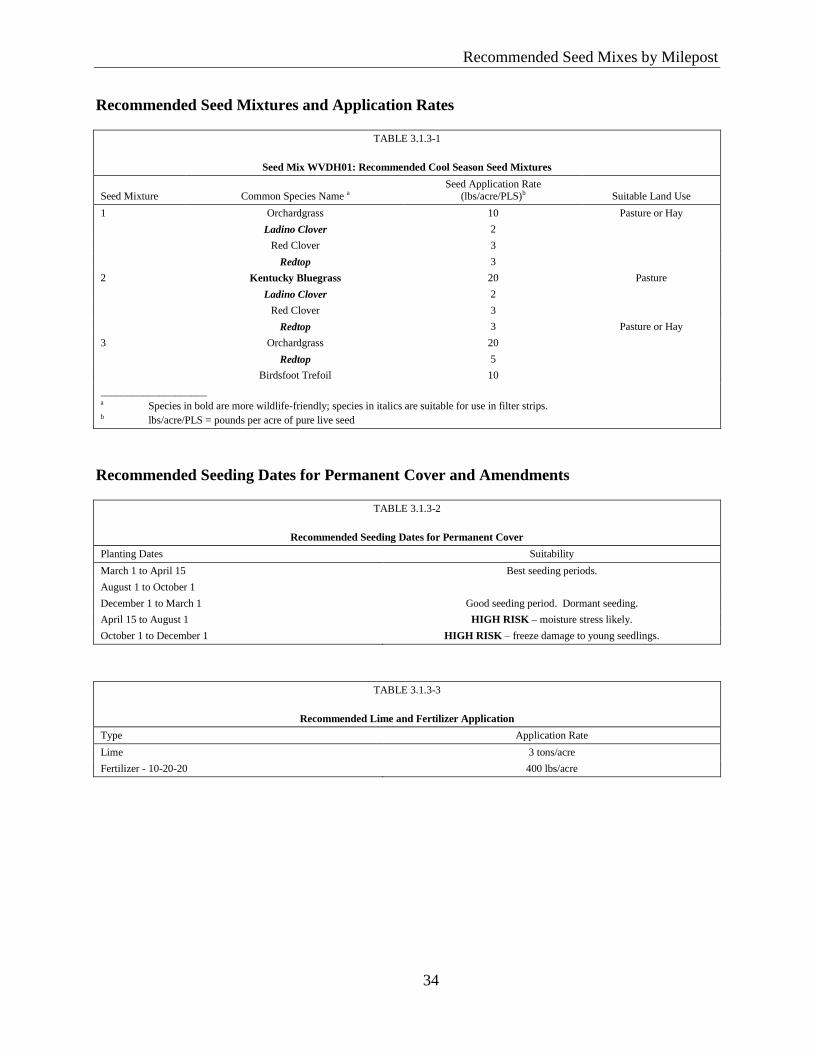
Recommended Seed Mixes by Milepost
34
Reco
mm
ended
Seed
Mix
es by M
ilepost
Recommended Seed Mixtures and Application Rates
TABLE 3.1.3-1
Seed Mix WVDH01: Recommended Cool Season Seed Mixtures
Seed Mixture Common Species Name a Seed Application Rate
(lbs/acre/PLS)b Suitable Land Use
1 Orchardgrass 10 Pasture or Hay
Ladino Clover 2
Red Clover 3
Redtop 3
2 Kentucky Bluegrass 20 Pasture
Ladino Clover 2
Red Clover 3
Redtop 3 Pasture or Hay
3 Orchardgrass 20
Redtop 5
Birdsfoot Trefoil 10
____________________ a Species in bold are more wildlife-friendly; species in italics are suitable for use in filter strips. b lbs/acre/PLS = pounds per acre of pure live seed
Recommended Seeding Dates for Permanent Cover and Amendments
TABLE 3.1.3-2
Recommended Seeding Dates for Permanent Cover
Planting Dates Suitability
March 1 to April 15 Best seeding periods.
August 1 to October 1
December 1 to March 1 Good seeding period. Dormant seeding.
April 15 to August 1 HIGH RISK – moisture stress likely.
October 1 to December 1 HIGH RISK – freeze damage to young seedlings.
TABLE 3.1.3-3
Recommended Lime and Fertilizer Application
Type Application Rate
Lime 3 tons/acre
Fertilizer - 10-20-20 400 lbs/acre
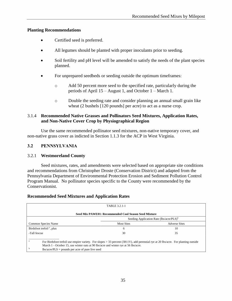
Recommended Seed Mixes by Milepost
35
Reco
mm
ended
Seed
Mix
es by M
ilepost
Planting Recommendations
Certified seed is preferred.
All legumes should be planted with proper inoculants prior to seeding.
Soil fertility and pH level will be amended to satisfy the needs of the plant species
planned.
For unprepared seedbeds or seeding outside the optimum timeframes:
o Add 50 percent more seed to the specified rate, particularly during the
periods of April 15 – August 1, and October 1 – March 1.
o Double the seeding rate and consider planning an annual small grain like
wheat (2 bushels [120 pounds] per acre) to act as a nurse crop.
Recommended Native Grasses and Pollinators Seed Mixtures, Application Rates, 3.1.4
and Non-Native Cover Crop by Physiographical Region
Use the same recommended pollinator seed mixtures, non-native temporary cover, and
non-native grass cover as indicted in Section 1.1.3 for the ACP in West Virginia.
3.2 PENNSYLVANIA
Westmoreland County 3.2.1
Seed mixtures, rates, and amendments were selected based on appropriate site conditions
and recommendations from Christopher Droste (Conservation District) and adapted from the
Pennsylvania Department of Environmental Protection Erosion and Sediment Pollution Control
Program Manual. No pollinator species specific to the County were recommended by the
Conservationist.
Recommended Seed Mixtures and Application Rates
TABLE 3.2.1-1
Seed Mix PAWE01: Recommended Cool Season Seed Mixture
Seeding Application Rate (lbs/acre/PLS)b
Common Species Name Most Sites Adverse Sites
Birdsfoot trefoil a, plus 6 10
-Tall fescue 30 35
____________________ a For Birdsfoot trefoil use empire variety. For slopes > 33 percent (3H:1V), add perennial rye at 20 lbs/acre. For planting outside
March 1 - October 15, use winter oats at 90 lbs/acre and winter rye at 56 lbs/acre. b lbs/acre/PLS = pounds per acre of pure live seed
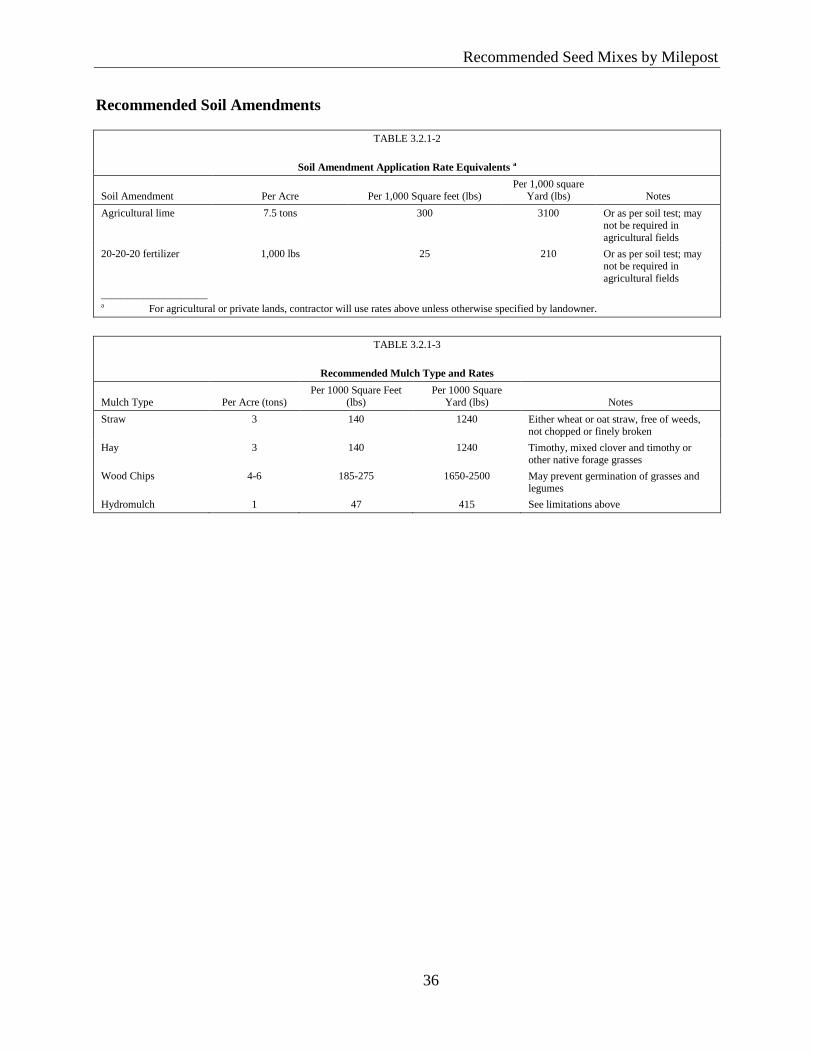
Recommended Seed Mixes by Milepost
36
Reco
mm
ended
Seed
Mix
es by M
ilepost
Recommended Soil Amendments
TABLE 3.2.1-2
Soil Amendment Application Rate Equivalents a
Soil Amendment Per Acre Per 1,000 Square feet (lbs) Per 1,000 square
Yard (lbs) Notes
Agricultural lime 7.5 tons 300 3100 Or as per soil test; may not be required in
agricultural fields
20-20-20 fertilizer 1,000 lbs 25 210 Or as per soil test; may not be required in
agricultural fields
____________________ a For agricultural or private lands, contractor will use rates above unless otherwise specified by landowner.
TABLE 3.2.1-3
Recommended Mulch Type and Rates
Mulch Type Per Acre (tons) Per 1000 Square Feet
(lbs) Per 1000 Square
Yard (lbs) Notes
Straw 3 140 1240 Either wheat or oat straw, free of weeds, not chopped or finely broken
Hay 3 140 1240 Timothy, mixed clover and timothy or other native forage grasses
Wood Chips 4-6 185-275 1650-2500 May prevent germination of grasses and legumes
Hydromulch 1 47 415 See limitations above
Recommended Seed Mixes by Milepost
37
Reco
mm
ended
Seed
Mix
es by M
ilepost
4.0 REFERENCES
Glennon, Robert. 2015. Personal communication with Herbert Pirela of Environmental
Resources Management, Inc. Private Lands Biologist.
Jones, J., Glennon, B., Lawrence, C., Faulkner, D., and C. Gordon. 2014. USDA-NRCS
Virginia Plant Establishment Guide. Revised 2014.
Natural Resource Conservation Service. 2011. National Conservation Practice Standard -
Critical Area Planting, Code 342.
Natural Resource Conservation Service. 2014. Conservation Practice Standard - Mulching,
Code 484. Technical Guide Section IV: 484-VA-1.
Roundstone Native Seed. 2015. Jeremy Hamlington, personal communication with Herbert
Pirela of Environmental Resources Management, Inc. Horticulturist.
West Virginia Department of Environmental Protection. 2012. West Virginia Erosion and
Sediment Control Field Manual. Available online at: http://www.dep.wv.gov/oil-and-
gas/Documents/Erosion%20Manual%2004.pdf. Accessed October 2015.
West Virginia Department of Natural Resources. 2015. Enhancing Wildlife Habitat on Oil and
Gas Infrastructure. Available online at: http://www.wvdnr.gov/Publications/OilGasAnd
Wildlife.pdf

Attachment A
Summary of Seed Mixes by County for the
Atlantic Coast Pipeline and Supply Header Project
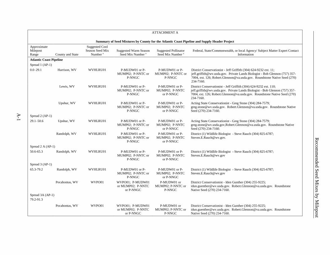
A-1
Reco
mm
ended
Seed
Mix
es by M
ilepost
ATTACHMENT A
Summary of Seed Mixtures by County for the Atlantic Coast Pipeline and Supply Header Project
Approximate Milepost
Range County and State
Suggested Cool Season Seed Mix
Number a Suggested Warm Season
Seed Mix Number a Suggested Pollinator Seed Mix Number a
Federal, State/Commonwealth, or local Agency/ Subject Matter Expert Contact Information
Atlantic Coast Pipeline
Spread 1 (AP-1)
0.0–29.1 Harrison, WV WVHLRU01 P-MUDW01 or P-MUMP02; P-NNTC or
P-NNGC
P-MUDW01 or P-MUMP02; P-NNTC or
P-NNGC
District Conservationist - Jeff Griffith (304) 624-9232 ext. 11; [email protected]. Private Lands Biologist - Bob Glennon (757) 357-
7004, ext. 126; [email protected]. Roundstone Native Seed (270)
234-7160.
Lewis, WV WVHLRU01 P-MUDW01 or P-
MUMP02; P-NNTC or P-NNGC
P-MUDW01 or P-
MUMP02; P-NNTC or P-NNGC
District Conservationist - Jeff Griffith (304) 624-9232 ext. 110;
[email protected]. Private Lands Biologist - Bob Glennon (757) 357-7004, ext. 126; [email protected]. Roundstone Native Seed (270)
234-7160.
Upshur, WV WVHLRU01 P-MUDW01 or P-MUMP02; P-NNTC or
P-NNGC
P-MUDW01 or P-MUMP02; P-NNTC
or P-NNGC
Acting State Conservationist - Greg Stone (304) 284-7579; [email protected]. [email protected]. Roundstone Native
Seed (270) 234-7160.
Spread 2 (AP-1)
29.1–50.6 Upshur, WV WVHLRU01 P-MUDW01 or P-MUMP02; P-NNTC or
P-NNGC
P-MUDW01 or P-MUMP02; P-NNTC
or P-NNGC
Acting State Conservationist - Greg Stone (304) 284-7579; [email protected],[email protected]. Roundstone Native
Seed (270) 234-7160.
Randolph, WV WVHLRU01 P-MUDW01 or P-
MUMP02; P-NNTC or
P-NNGC
P-MUDW01 or P-
MUMP02; P-NNTC
or P-NNGC
District (1) Wildlife Biologist - Steve Rauch (304) 825-6787;
Spread 2 A (AP-1)
50.6-65.3 Randolph, WV WVHLRU01 P-MUDW01 or P-MUMP02; P-NNTC or
P-NNGC
P-MUDW01 or P-MUMP02; P-NNTC
or P-NNGC
District (1) Wildlife Biologist - Steve Rauch (304) 825-6787; [email protected]
Spread 3 (AP-1)
65.3-79.2 Randolph, WV WVHLRU01 P-MUDW01 or P-MUMP02; P-NNTC or
P-NNGC
P-MUDW01 or P-MUMP02; P-NNTC
or P-NNGC
District (1) Wildlife Biologist - Steve Rauch (304) 825-6787; [email protected]
Pocahontas, WV WVPO01 WVPO01; P-MUDW01 or MUMP02; P-NNTC
or P-NNGC
P-MUDW01 or MUMP02; P-NNTC or
P-NNGC
District Conservationist - Iden Gunther (304) 255-9225; [email protected]. [email protected]. Roundstone
Native Seed (270) 234-7160.
Spread 3A (AP-1)
79.2-91.3
Pocahontas, WV WVPO01 WVPO01; P-MUDW01 or MUMP02; P-NNTC
or P-NNGC
P-MUDW01 or MUMP02; P-NNTC or
P-NNGC
District Conservationist - Iden Gunther (304) 255-9225; [email protected]. [email protected]. Roundstone Native Seed (270) 234-7160.
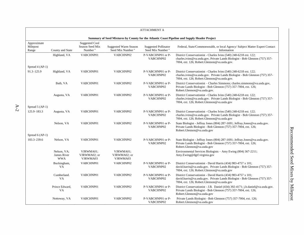
A-2
Reco
mm
ended
Seed
Mix
es by M
ilepost
ATTACHMENT A
Summary of Seed Mixtures by County for the Atlantic Coast Pipeline and Supply Header Project
Approximate Milepost
Range County and State
Suggested Cool Season Seed Mix
Number a Suggested Warm Season
Seed Mix Number a Suggested Pollinator Seed Mix Number a
Federal, State/Commonwealth, or local Agency/ Subject Matter Expert Contact Information
Highland, VA VABCHNP01 VABCHNP02 P-VABCHNP01 or P-
VABCHNP02
District Conservationist - Charles Ivins (540) 248-6218 ext. 122;
[email protected], Private Lands Biologist - Bob Glennon (757) 357-7004, ext. 126; [email protected].
Spread 4 (AP-1)
91.3–125.9 Highland, VA VABCHNP01 VABCHNP02 P-VABCHNP01 or P-
VABCHNP02
District Conservationist - Charles Ivins (540) 248-6218 ext. 122;
[email protected]. Private Lands Biologist - Bob Glennon (757) 357-
7004, ext. 126; [email protected].
Bath, VA VABCHNP01 VABCHNP02 P-VABCHNP01 or P-VABCHNP02
District Conservationist – Charles Simmons; [email protected], Private Lands Biologist - Bob Glennon (757) 357-7004, ext. 126;
Augusta, VA VABCHNP01 VABCHNP02 P-VABCHNP01 or P-VABCHNP02
District Conservationist - Charles Ivins (540) 248-6218 ext. 122; [email protected]. Private Lands Biologist - Bob Glennon (757) 357-
7004, ext. 126; [email protected]
Spread 5 (AP-1)
125.9–183.3 Augusta, VA VABCHNP01 VABCHNP02 P-VABCHNP01 or P-VABCHNP02
District Conservationist - Charles Ivins (540) 248-6218 ext. 122; [email protected]. Private Lands Biologist - Bob Glennon (757) 357-
7004, ext. 126; [email protected]
Nelson, VA VABCHNP01 VABCHNP02 P-VABCHNP01 or P-
VABCHNP02
State Biologist - Jeffray Jones (804) 287-1691; [email protected].
Private Lands Biologist - Bob Glennon (757) 357-7004, ext. 126;
Spread 6 (AP-1)
183.3–239.6 Nelson, VA VABCHNP01 VABCHNP02 P-VABCHNP01 or P-VABCHNP02
State Biologist - Jeffray Jones (804) 287-1691; [email protected]. Private Lands Biologist - Bob Glennon (757) 357-7004, ext. 126;
Nelson, VA; James River
WWA
VJRWMA01; VJRWMA02; or
VJRWMA03
VJRWMA01; VJRWMA02; or
VJRWMA03
Environmental Services Biologists – Amy Ewing (804) 367-2211; [email protected]
Buckingham, VA
VABCHNP01 VABCHNP02 P-VABCHNP01 or P-VABCHNP02
District Conservationist - David Harris (434) 983-4757 x 101; [email protected]. Private Lands Biologist - Bob Glennon (757) 357-
7004, ext. 126; [email protected]
Cumberland. VA
VABCHNP01 VABCHNP02 P-VABCHNP01 or P-VABCHNP02
District Conservationist - David Harris (434) 983-4757 x 101; [email protected]. Private Lands Biologist - Bob Glennon (757) 357-
7004, ext. 126; [email protected]
Prince Edward, VA
VABCHNP01 VABCHNP02 P-VABCHNP01 or P-VABCHNP02
District Conservationist - J.B. Daniel (434) 392-4171; [email protected]. Private Lands Biologist - Bob Glennon (757) 357-7004, ext. 126;
Nottoway, VA VABCHNP01 VABCHNP02 P-VABCHNP01 or P-VABCHNP02
Private Lands Biologist - Bob Glennon (757) 357-7004, ext. 126; [email protected]
A-3
Reco
mm
ended
Seed
Mix
es by M
ilepost
ATTACHMENT A
Summary of Seed Mixtures by County for the Atlantic Coast Pipeline and Supply Header Project
Approximate Milepost
Range County and State
Suggested Cool Season Seed Mix
Number a Suggested Warm Season
Seed Mix Number a Suggested Pollinator Seed Mix Number a
Federal, State/Commonwealth, or local Agency/ Subject Matter Expert Contact Information
Spread 7 (AP-1)
239.6–300.1 Nottoway, VA VABCHNP01 VABCHNP02 P-VABCHNP01 or P-VABCHNP02
Private Lands Biologist - Bob Glennon (757) 357-7004, ext. 126; [email protected]
Dinwiddie, VA VACSDGS01 VACSDGS01 P-VACSDGS01 or P-
VACSDGS02
Private Lands Biologist - Bob Glennon (757) 357-7004, ext. 126;
Brunswick, VA VABCHNP01 VABCHNP02 P-VABCHNP01 or P-VABCHNP02
Private Lands Biologist - Bob Glennon (757) 357-7004, ext. 126; [email protected]
Greensville, VA VACSDGS01 VACSDGS01 P-VACSDGS01 or P-VACSDGS02
Private Lands Biologist - Bob Glennon (757) 357-7004, ext. 126; [email protected]
Northampton,
NC
NCNO01 NCNO02 P-CPDW01 or P-
CPMP02; P-NNTC or P-NNGC
District Conservationist - Paul Boone (252) 534-2591; [email protected].
Private Lands Biologist - Bob Glennon (757) 357-7004, ext. 126; [email protected]. Roundstone Native Seed (270) 234-7160.
Spread 8 (AP-2)
0.0–61.6 Northampton, NC
NCNO01 NCNO02 P-CPDW01 or P-CPMP02; P-NNTC or
P-NNGC
District Conservationist - Paul Boone (252) 534-2591; [email protected]. Private Lands Biologist - Bob Glennon (757) 357-7004, ext. 126;
[email protected]. Roundstone Native Seed (270) 234-7160.
Halifax, NC NCHW01 P-CPDW01 or P-
CPMP02
P-CPDW01 or P-
CPMP02; P-NNTC or
P-NNGC
District Conservationist -David Little (252) 237-2711;
[email protected]. Private Lands Biologist - Bob Glennon (757) 357-
7004, ext. 126; [email protected]. Roundstone Native Seed (270)
234-7160.
Nash, NC NCNJ01 P-CDW01 or P-CPMP02 P-CPDW01 or P-CPMP02; P-NNTC or
P-NNGC
District Conservationist - Patrick Evans (252) 459-4116; [email protected]. Private Lands Biologist - Bob Glennon (757) 357-7004, ext. 126; [email protected]. Roundstone Native Seed (270)
234-7160.
Spread 9 (AP-2)
61.6–61.6 Nash, NC NCNJ01 P-CPDW01 or P-CPMP02
P-CPDW01 or P-CPMP02; P-NNTC or
P-NNGC
District Conservationist - Patrick Evans (252) 459-4116; [email protected]. Private Lands Biologist - Bob Glennon (757) 357-
7004, ext. 126; Roundstone Native Seed (270) 234-7160.
Wilson, NC NCHW01 P-CPDW01 or P-CPMP02
P-CPDW01 or P-CPMP02; P-NNTC or
P-NNGC
District Conservationist -David Little (252) 237-2711; [email protected]. Private Lands Biologist - Bob Glennon (757) 357-
7004, ext. 126; [email protected]. Roundstone Native Seed (270) 234-7160.
Johnston, NC NCNJ01 P-CDW01 or P-CPMP02 P-CPDW01 or P-CPMP02; P-NNTC or
P-NNGC
District Conservationist - Brian Loadholt (919) 934-7156; [email protected]. Private Lands Biologist - Bob Glennon (757) 357-7004, ext. 126; [email protected]. Roundstone Native Seed (270)
234-7160.
A-4
Reco
mm
ended
Seed
Mix
es by M
ilepost
ATTACHMENT A
Summary of Seed Mixtures by County for the Atlantic Coast Pipeline and Supply Header Project
Approximate Milepost
Range County and State
Suggested Cool Season Seed Mix
Number a Suggested Warm Season
Seed Mix Number a Suggested Pollinator Seed Mix Number a
Federal, State/Commonwealth, or local Agency/ Subject Matter Expert Contact Information
Sampson, NC NCSA01 NCSA02 P-CPDW01 or P-
CPMP02; P-NNTC or P-NNGC
District Conservationist - Gavin Thompson (910) 592-7963;
[email protected]. Private Lands Biologist - Bob Glennon (757) 357-7004, ext. 126; [email protected]. Roundstone Native Seed
(270) 234-7160.
Cumberland, NC NCCU01 NCCU01 P-CPDW01 or P-
CPMP02; P-NNTC or
P-NNGC
District Conservationist - Renessa Hardy-Brown (910) 484-8479;
[email protected]. Private Lands Biologist - Bob Glennon (757) 357-
7004, ext. 126; [email protected]. Roundstone Native Seed (270)
234-7160.
Spread 10 (AP-2)
61.5–183.0 Cumberland, NC NCCU01 NCCU01 P-CPDW01 or P-
CPMP02; P-NNTC or P-NNGC
District Conservationist - Renessa Hardy-Brown (910) 484-8479;
[email protected]. Private Lands Biologist - Bob Glennon (757) 357-7004, ext. 126; [email protected]. Roundstone Native Seed (270)
234-7160.
Robeson, NC P-CPDW01 or P-CPMP02
NCRO01 P-CPDW01, P-CPMP02, or P-
NCRO01; P-NNTC or
P-NNGC
District Conservationist - Jeremy Roston ( 910) 739-5478; [email protected]. Private Lands Biologist - Bob Glennon (757) 357-
7004, ext. 126; [email protected]. Roundstone Native Seed (270)
234-7160.
Spread 11 (AP-3)
0.0–83.0 Northampton,
NC
NCNO01 NCNO02 P-CPDW01 or P-
CPMP02; P-NNTC or P-NNGC
District Conservationist - Paul Boone (252) 534-2591; [email protected].
Private Lands Biologist - Bob Glennon (757) 357-7004, ext. 126; [email protected]. Roundstone Native Seed (270) 234-7160.
Greensville, VA VACSDGS01 VACSDGS01 P-VACSDGS01 or P-VACSDGS02
Private Lands Biologist - Bob Glennon (757) 357-7004, ext. 126; [email protected]
Southampton, VA
VACSDGS01 VACSDGS01 P-VACSDGS01 or P-VACSDGS02
Private Lands Biologist - Bob Glennon (757) 357-7004, ext. 126; [email protected]
Suffolk, VA VACSDGS01 VACSDGS01 P-VACSDGS01 or P-VACSDGS02
Private Lands Biologist - Bob Glennon (757) 357-7004, ext. 126; [email protected]
Spread 12 (AP-4; AP-5)
0.0–0.4; 0.0-1.1
Brunswick, VA VABCHNP01 VABCHNP02 P-VABCHNP01 or P-VABCHNP02
District Conservationist - Davie Wade Harris (434) 848-2145 ext. 102; [email protected]
Greensville, VA VACSDGS01 VACSDGS01 P-VACSDGS01 or P-VACSDGS02
Private Lands Biologist - Bob Glennon (757) 357-7004, ext. 126; [email protected]
A-5
Reco
mm
ended
Seed
Mix
es by M
ilepost
ATTACHMENT A
Summary of Seed Mixtures by County for the Atlantic Coast Pipeline and Supply Header Project
Approximate Milepost
Range County and State
Suggested Cool Season Seed Mix
Number a Suggested Warm Season
Seed Mix Number a Suggested Pollinator Seed Mix Number a
Federal, State/Commonwealth, or local Agency/ Subject Matter Expert Contact Information
Supply Header Project
Spread 13 (TL-635)
0.0–33.6 Wetzel, WV WVWE01 P-MUDW01 or P-MUMP02; P-NNTC or
P-NNGC
P-MUDW01 or P-MUMP02; P-NNTC or
P-NNGC
District Conservationist - Dustin Adkins (304) 758-2173; [email protected]. Private Lands Biologist - Bob Glennon (757) 357-
7004, ext. 126; [email protected]. Roundstone Native Seed (270)
234-7160.
Wetzel, WV;
Lewis Wetzel WMA
WVLWWMA01 District Wildlife Biologist - Steve Rauch (304)825-6787; [email protected]
Doddridge, WV WVDH01 P-MUDW01 or P-
MUMP02; P-NNTC or P-NNGC
P-MUDW01 or P-
MUMP02; P-NNTC or P-NNGC
Acting State Conservationist - Greg Stone (304) 284-7579;
[email protected]. Private Lands Biologist - Bob Glennon (757) 357-7004, ext. 126; [email protected]. Roundstone Native Seed (270)
234-7160.
Tyler, WV WVWE01 P-MUDW01 or P-MUMP02; P-NNTC or
P-NNGC
P-MUDW01 or P-MUMP02; P-NNTC or
P-NNGC
District Conservationist - Dustin Adkins (304) 758-2173; [email protected]. Private Lands Biologist - Bob Glennon (757) 357-
7004, ext. 126; [email protected]. Roundstone Native Seed (270)
234-7160.
Harrison, WV WVDH01 P-MUDW01 or P-
MUMP02; P-NNTC or
P-NNGC
P-MUDW01 or P-
MUMP02; P-NNTC or
P-NNGC
Acting State Conservationist - Greg Stone (304) 284-7579;
[email protected]. Private Lands Biologist - Bob Glennon (757) 357-
7004, ext. 126; [email protected]. Roundstone Native Seed (270) 234-7160.
Spread 14 (TL-636)
0.0–3.9 Westmoreland, PA
PAWE01 None Recommended None Recommended Westmoreland Conservation District, Christopher Droste, Senior Erosion Control Specialist (724) 837-5271; [email protected].
____________________ a Tables describing each seed mix are located within the text of Appendix A.
ATLANTIC COAST PIPELINE, LLC
ATLANTIC COAST PIPELINE
and
DOMINION TRANSMISSION, INC.
SUPPLY HEADER PROJECT
Restoration and Rehabilitation Plan
Appendix C
Recommended Seed Mixes by Milepost
(to be provided prior to construction)