At the Front Lines of Flood: How Prepared are Ontario ... · At the Front Line of Flood: How...
50
July 4, 2016 At the Front Lines of Flood: How Prepared are Ontario Communities? Zainab Moghal, PhD, Adaptation Planner Shawna Peddle, MSc, Director
Transcript of At the Front Lines of Flood: How Prepared are Ontario ... · At the Front Line of Flood: How...

July 4, 2016
At the Front Lines of Flood: How Prepared are Ontario Communities?
Zainab Moghal, PhD, Adaptation Planner Shawna Peddle, MSc, Director

At the Front Line of Flood: How Prepared are Ontario Communities? i
July 4, 2016
Acknowledgements The authors would like to thank the founding supporters of Partners for Action, the Co-operators Group and Farm Mutual Reinsurance Plan, for funding this study. We would like to thank members of the Partners for Action Stakeholder Group who had input into questionnaire design and reviewed iterations of this document: Dr. Jason Thistlethwaite, School of Environment, Enterprise and Development, University of Waterloo, Jo-Anne Rzadki, Conservation Ontario, and Tamsin Lyle, Ebbwater Consulting. Finally, we extend our appreciation to staff of the municipalities, First Nations, and Conservation Authorities who gave freely of their time and expertise in our interviews.

July 4, 2016
At the Front Line of Flood: How Prepared are Ontario Communities? ii
Executive Summary Our communities face significant exposure to flooding, with the potential for property damage, disruption to critical services, injury, and loss of life. Flood-related water damage has replaced fire as the number one cause of household insurance claims in Ontario and is also the largest cost for taxpayers of any natural hazard. Rainfall has increased across Canada over a 60-year period, and with a changing climate, Ontario could experience up to 240 mm more annual precipitation than historic levels by the end of this century. Researchers anticipate an increased frequency of high-intensity rainfall, leading to urban flooding, which threatens the province’s infrastructure, including stormwater and wastewater systems.
This study is the first to examine flood resiliency of small to medium-sized Ontario communities, through interviews with 18 municipalities, two First Nation communities, and 15 Conservation Authorities (CAs). The findings reveal that flooding represents a significant priority for Ontario, as the majority of communities have experienced a flood event in the last ten years, with some experiencing significant impacts from urban flooding. Areas of the local economy most at risk from flood include residences, businesses, commercial areas, transportation networks, agricultural areas, and traditional land use areas. Communities are motivated to reduce flood risk and believe they are at risk of future flooding, but most are not considering the costs of climate change impacts and the costs/benefits of adaptation or have limited knowledge of their liability in the event of a major flood event, making it difficult to effectively prioritize and defend adaptation measures.
Communities have planned for current flood risk through structural (i.e. stormwater infrastructure, berms and dykes) and non-structural (i.e. flood risk and vulnerability studies, development planning and emergency management) measures. Many of the surveyed CAs have also assessed their flood risks and vulnerabilities, but most struggle with flood maps that are 25 to 40 years old. Communities are addressing flood in their municipal Emergency Management Plans (EMPs), but only a few had successfully applied for existing funds for flood protection and adaptation improvements. Most communities offer incentive programs for personal flood risk reduction, though uptake of the voluntary (often subsidized) programs remains low.
Most surveyed communities inform their residents and businesses about flood risk and adaptation options and CAs have a broad outreach program to discuss flood with their communities. More work is needed in effectively communicating flood watches and warnings to individual residents, and adapting these procedures to fit with social media. Communities and CAs are planning for future flood risk and climate change impacts, by developing comprehensive stormwater management (SWM) plans, re-sizing infrastructure, increasing the intensity of design storm standards, and implementing and encouraging resilient design, such as low-impact development (LID). Communities and CAs are also looking at broader climate change impacts, developing adaptation plans, and carrying out climate change research.
July 4, 2016
At the Front Line of Flood: How Prepared are Ontario Communities? iii
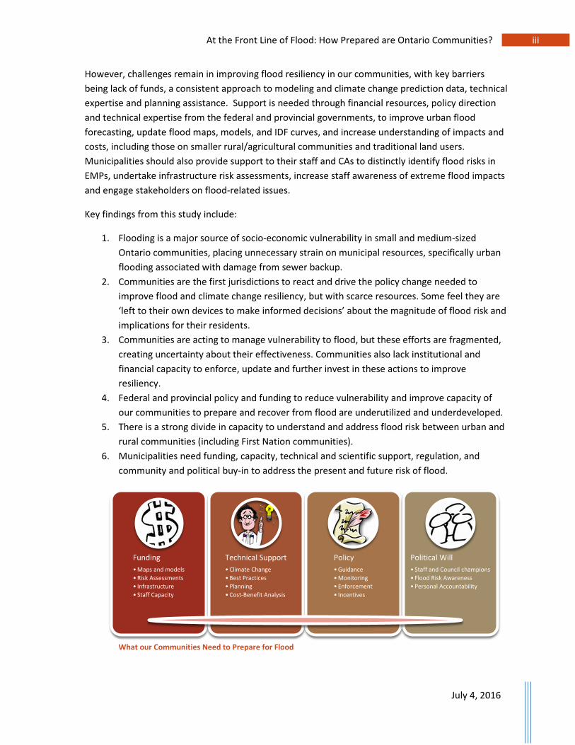
However, challenges remain in improving flood resiliency in our communities, with key barriers being lack of funds, a consistent approach to modeling and climate change prediction data, technical expertise and planning assistance. Support is needed through financial resources, policy direction and technical expertise from the federal and provincial governments, to improve urban flood forecasting, update flood maps, models, and IDF curves, and increase understanding of impacts and costs, including those on smaller rural/agricultural communities and traditional land users. Municipalities should also provide support to their staff and CAs to distinctly identify flood risks in EMPs, undertake infrastructure risk assessments, increase staff awareness of extreme flood impacts and engage stakeholders on flood-related issues.
Key findings from this study include:
1. Flooding is a major source of socio-economic vulnerability in small and medium-sized Ontario communities, placing unnecessary strain on municipal resources, specifically urban flooding associated with damage from sewer backup.
2. Communities are the first jurisdictions to react and drive the policy change needed to improve flood and climate change resiliency, but with scarce resources. Some feel they are ‘left to their own devices to make informed decisions’ about the magnitude of flood risk and implications for their residents.
3. Communities are acting to manage vulnerability to flood, but these efforts are fragmented, creating uncertainty about their effectiveness. Communities also lack institutional and financial capacity to enforce, update and further invest in these actions to improve resiliency.
4. Federal and provincial policy and funding to reduce vulnerability and improve capacity of our communities to prepare and recover from flood are underutilized and underdeveloped.
5. There is a strong divide in capacity to understand and address flood risk between urban and rural communities (including First Nation communities).
6. Municipalities need funding, capacity, technical and scientific support, regulation, and community and political buy-in to address the present and future risk of flood.
What our Communities Need to Prepare for Flood
Funding•Maps and models•Risk Assessments• Infrastructure• Staff Capacity
Technical Support•Climate Change•Best Practices• Planning•Cost-Benefit Analysis
Policy •Guidance•Monitoring• Enforcement• Incentives
Political Will• Staff and Council champions• Flood Risk Awareness• Personal Accountability

July 4, 2016
At the Front Line of Flood: How Prepared are Ontario Communities? iv
This study recommends that to improve resiliency in our communities, the following actions are required:
1. Public Safety Canada should establish and enforce national standards for flood risk management and mapping, and should also significantly expand and facilitate accessibility of funding through the National Disaster Mitigation Program.
2. The Ontario government should increase funding to Conservation Authorities for planning, flood management, and maintenance and operation of flood structures.
3. Provincial and federal governments should address the current leadership gap and prioritize community resiliency to flood by supporting communities in understanding and communicating risk and opportunities to reduce this risk.
4. All levels of government should further efforts to increase personal flood risk awareness, to encourage behavioural changes and increase the uptake of residential incentive programs.
5. All levels of government should work with the insurance industry to improve our understanding of flood risk in this country, and opportunities to reduce this risk.

July 4, 2016
At the Front Line of Flood: How Prepared are Ontario Communities? v
Contents 1 Introduction ................................................................................................................ 1
2 Background ................................................................................................................. 3
2.1 Flood Management in Ontario ................................................................................... 3
2.2 Increasing Flood Risk and the Need for Adaptation .................................................. 5
3 Methods ..................................................................................................................... 7
4 Results ...................................................................................................................... 11
4.1 Flooding Represents a Significant Priority for Ontario ............................................ 11
4.1.1 Current Flood Risk and Municipal Awareness .......................................................... 11
4.1.2 Economic Impacts of Flood Events ........................................................................... 11
4.2 Motivation to Reduce Flood Risk .............................................................................. 12
4.2.1 Future Flood Risk ...................................................................................................... 12
4.2.2 Cost Analysis of Climate Change Impacts and Adaptation Options ......................... 12
4.2.3 Liability Concerns ...................................................................................................... 12
1.3 Current Measures to Reduce Flood Risk .................................................................. 13
4.3.1 Assessing Flood Risks and Vulnerabilities ................................................................. 13
4.3.2 Emergency Management ......................................................................................... 14
4.3.3 Funding for Flood Protection and Adaptation Measures ......................................... 15
4.3.4 Incentive Programs ................................................................................................... 17
4.3.5 Communications ....................................................................................................... 18
4.3.6 Planning for Future Flood Risk and Climate Change Impacts ................................... 19
4.3.7 Consideration of Broader Climate Change Impacts and Adaptation Planning ........ 20
4.4 Barriers to Resiliency ............................................................................................... 21
4.4.1 General Barriers ........................................................................................................ 21
4.4.1 Consideration of Financial Benefits of Adaptation ................................................... 22
4.5 Measures to Improve Resiliency.............................................................................. 22
4.5.1 Additional Funds ....................................................................................................... 22
4.5.2 Policy Direction from Higher Levels of Government ................................................. 23
4.5.3 Technical Expertise ................................................................................................... 25
5 Discussion ................................................................................................................. 26
5.1 Encouraging Resiliency ............................................................................................. 26
5.2 Continuing Challenges/Barriers ................................................................................ 26

July 4, 2016
At the Front Line of Flood: How Prepared are Ontario Communities? vi
5.3 Support to Improve Resiliency ................................................................................. 27
5.3.1 Funding ..................................................................................................................... 27
5.3.2 Policies and Guidelines ............................................................................................. 27
6 Conclusion ................................................................................................................ 30
7 References ................................................................................................................ 32
List of Tables
Table 1. Municipalities Interviewed ............................................................................................... 8
Table 2. First Nations Communities Interviewed ........................................................................... 8
Table 3. Conservation Authorities Interviewed .............................................................................. 9
List of Figures
Figure 1. Flood Hazard Criteria Zones of Ontario and Conservation Authorities (MNRF, Figure B-1 (2002)) ............................................................................................................................................ 4
Figure 2. Map of Communities and Conservation Authorities Interviewed ................................ 10
Figure 3. Community Incentives/Programs for Personal Risk Reduction..................................... 18
Figure 4. Barriers to Considering Flood Risk and Adaptation ....................................................... 21
Appendices
Appendix A: Cmmunity Questionnaire
Appendix B: Conservation Authority Questionnaire
Appendix C: Current Practices and Interview Highlights

July 4, 2016
At the Front Line of Flood: How Prepared are Ontario Communities? 1
1 Introduction The Intergovernmental Panel on Climate Change (IPCC) has documented substantial evidence for human influence as the dominant cause of global climate change (Alexander et al., 2013). As some degree of further climate change is inevitable, natural and human systems are faced with a range of impacts which require adaptation (Field et al., 2014). This report examines flood-related adaptation initiatives of Ontario communities and Conservation Authorities (CAs) to anthropogenic climate change, where adaptation can be defined as a process of adjustment to actual or expected climate and its effects (IPCC, 2014). In human systems, adaptation aims to minimize harm or exploit beneficial opportunities, while in natural systems, human intervention can assist adjustment to expected climate and its effects (IPCC, 2014). Adaptation can be reactive or planned, with measures including structural/physical and non-structural (institutional and/or social) responses (Field et al., 2014). To adapt to present and future climate change impacts, communities can assess impacts, vulnerabilities1, risks2 and opportunities; plan for adaptation; implement adaptation measures; and monitor and evaluate adaptation initiatives3 (UNFCCC, 2013). Resilience is considered a characteristic of adaptive responses and current approaches consider the ability to absorb and persist through a disturbance, while also adapting, learning, innovating and self-organizing (Denton et al., 2014).
Ontario’s communities are at the front lines of climate change (NMAP, 2014b; Revi et al., 2014), with flooding having significant impacts on property and critical services, and leading to injury and loss of life. Flood damage can be caused by flash floods (overland or pluvial flooding), rising groundwater levels, or overflow of surface waterbodies (riverine flooding) (Floodsite, 2008). Flooding may also occur during high intensity rainfall, when the capacity of municipal sewage and stormwater systems and drainage canals to drain large amounts of rainfall is exceeded (urban flooding) (Floodsite, 2008). Rainfall has increased across Canada over a 60-year period (1950 to 2009) (Mekis & Vincent, 2011), with highest increases in the spring (McDermid, Fera, & Hogg, 2015). By late century (2080s), precipitation is predicted to be more variable in Ontario, with the province experiencing up to 240 mm more annual precipitation than historical levels, under a ‘business as usual’ greenhouse gas emissions scenario. An increased frequency of extreme weather events, in particular high-intensity rainfall and rapidly melting snowfall, could lead to flash flooding threatening the province’s infrastructure, including stormwater and wastewater systems (MOECC, 2011).
1 “The propensity or predisposition to be adversely affected. Vulnerability encompasses a variety of concepts including sensitivity or susceptibility to harm and lack of capacity to cope and adapt” (IPCC, 2014). 2 “The potential for consequences where something of human value is at stake and where the outcome is uncertain. Risk is often represented as probability of occurrence of hazardous events or trends multiplied by the consequences if these events occur” (IPCC, 2014). 3 Adaptation and vulnerability can be linked through the notion of risk, as the causal analysis of why a system is at risk (i.e. vulnerable) informs what can be done to reduce it (i.e. adapt) (Ribot, 2011).

July 4, 2016
At the Front Line of Flood: How Prepared are Ontario Communities? 2
This study is the first to examine flood resiliency (preparedness) of small to medium-sized communities and Conservation Authorities in Ontario, building upon the preparedness assessment of Canadian cities undertaken by Partners for Action (P4A) in 2015 (Feltmate & Moudrak, 2015). It commences by presenting the flood management regime in Ontario, the increasing risk of flood in our communities, and the need for adaptation. The methodology of the study is then detailed, followed by key results, including motivation to reduce flood risk, current measures to address risk, obstacles to adaptation, and measures to increase flood resiliency. This is followed by a discussion of measures to encourage flood resiliency to-date, continuing challenges, and support needed to further increase resiliency. The conclusion is then presented.

July 4, 2016
At the Front Line of Flood: How Prepared are Ontario Communities? 3
2 Background
2.1 Flood Management in Ontario Local governments, CAs, and the provincial and federal governments all play important roles in managing flood in Ontario communities. Municipalities have the principal responsibility for the wellbeing of their residents and protection of property, and the authority to respond to flooding and flood emergencies, primarily through non-structural measures (Government of Ontario, 1990). Municipalities use CA information when defining regulatory requirements for development in the floodplain when creating and updating official plans and by-laws, and reviewing development applications (ECO, 2011). Municipalities are also required to keep their emergency management plans current and regularly tested (Government of Ontario, 1990). Furthermore, upon receiving a flood watch or warning from the Conservation Authorities, municipalities are to notify their officials, departments and agencies, decide the suitable response, and if required, deploy municipal services. If necessary, municipalities could also declare a flood emergency and activate their Emergency Management Plan and appeal for provincial assistance. Throughout this process, municipalities are to maintain dialogue with their CA flood coordinators (Conservation Ontario, 2010; Government of Ontario, 1990).
Ontario has 36 Conservation Authorities, which conserve, restore and manage Ontario’s natural resources on a watershed basis and protect Ontarians and their properties from flooding and erosion hazards (Conservation Ontario, 2015). The first Ontario CAs were established in 1946, and were given a stronger role in flood management by the provincial government following the most severe flood event in Ontario, 1954’s Hurricane Hazel, which killed 81 people and caused damage of over $180 million (Conservation Ontario, 2009). Conservation Authorities were delegated flood management responsibilities at a watershed scale throughout most of southern Ontario and where they exist in northern Ontario through the Emergency Management and Civil Protection Act, RSO 1990. Conservation Authorities have four areas of responsibility pertaining to flood management, via non-structural and structural measures:
1. Support municipalities by providing technical advice pertaining to flood risk and engaging in mitigation projects to reduce risk prior to flood events (keeping people away from water) (Conservation Ontario, 2010). CAs regulate development in the floodplain by providing input into municipal planning processes (Conservation Ontario, 2015), such as Official Plan amendments, zoning and site-specific applications, subdivisions, site plans, variances and lot severances. CAs comment on natural hazards, erosion concerns, conservation and natural heritage, and encourage and implement stormwater management (SWM) and Low Impact Development (LID). CAs also undertake watershed planning and stewardship and floodplain mapping and modelling, including identifying flood-prone development (Conservation Ontario, 2013). Such activities allow CAs to detect and reduce flood risks to infrastructure, buildings and people and assess change over time (Conservation Ontario, 2013).

July 4, 2016
At the Front Line of Flood: How Prepared are Ontario Communities? 4
2. Maintain a local network, collect data, and monitor daily watershed and weather conditions to provide timely prediction of flood conditions.
3. Examine water-level data and Ministry of Natural Resources and Forestry (MNRF) weather forecasts. If a flood event is anticipated, CAs issue messages to municipalities and other agencies, including media and the public, to notify of potential flooding.
4. Operate dams and flood control structures to reduce the effects of flooding (keeping water away from people) (Conservation Ontario, 2010).
As shown in Figure 1, Ontario is divided into three regulatory flood zones4: 1) Zone 1 - southwestern and central Ontario, which uses the more severe of the Hurricane Hazel Regional Storm (1954) or the 1:100-year event, 2) Zone 2 - eastern Ontario, which uses the 1:100-year event and 3) Zone 3 -northern Ontario, which uses the more severe of the Timmins Regional Storm (1961) or the 1:100-year event (MNRF, 2002).
Figure 1. Flood Hazard Criteria Zones of Ontario and Conservation Authorities (MNRF, Figure B-1 (2002))
4 The more severe of the Regional Storm or the 1:100-year storm (TRCA, 2008). If a historical event of greater impact than those listed has occurred in an area, the MNRF can approve its use as the Regulatory Event.
July 4, 2016
At the Front Line of Flood: How Prepared are Ontario Communities? 5
Ontario CAs recognize that climate change, along with rapid urbanization, aging infrastructure and under-resourced flood management programs, will continue to challenge their communities (Conservation Ontario, 2013). Conservation Ontario’s ‘Business Case for Strategic Reinvestment’ advocates the urgent need to address gaps in floodplain management programs, flood operations and aging infrastructure, by adequately funding, staffing and arming CAs with the tools to meet their responsibilities (Conservation Ontario, 2013).
The Ontario government’s responsibility in flood management rests with the MNRF, which operates and maintains the provincial flood forecasting and warning system to alert their District Offices and CAs of meteorological events that could result in a flood hazard. The government can also provide assistance to local and regional municipalities when municipal resources are insufficient (Conservation Ontario, 2010). The federal government is involved in flood management by providing recovery resources (calculated based on declared emergency and population) under the Disaster Financial Assistance Arrangements (DFAA), once provincial resources are exceeded (Conservation Ontario, 2010).
2.2 Increasing Flood Risk and the Need for Adaptation Climate change will have significant impacts on community infrastructure (water and energy supply, sanitation and drainage, transport and telecommunication), health services, the built environment and ecosystem services (Revi et al., 2014). An examination of the state of adaptation planning in 468 cities found that increased stormwater runoff and stormwater management are the top impacts cities predict they will need to address in the immediate term (Carmin, Nadkarni, & Rhie, 2012). Cities also indicated their top three challenges when undertaking adaptation planning: securing funding; communicating the need for adaptation to elected officials and local departments; and, obtaining national government commitment to address local adaptation challenges (Carmin et al., 2012).
In 2012, the National Municipal Adaptation Project (NMAP) surveyed the state of adaptation in 481 Canadian municipalities, including 104 in Ontario, with 83 communities (80%) having a population of 100,000 or less (NMAP, 2014a; NMAP, 2014b). Notable findings in Ontario were that within the last ten years (2002-2012), 31% of respondents had experienced floods resulting in significant damage to public and/or private property, or requiring significant or uncommon protection measures (NMAP, 2014a). Forty percent of respondents also noted high rainfall to have caused damages. With respect to climate change, higher than average rain or snowfall (48%) and flooding (35%) were specific events that local governments expected to become problematic over the next 10 years (NMAP, 2014a).
The Insurance Bureau of Canada (IBC) has identified flooding as the costliest factor affecting catastrophic losses in the housing sector across Canada (IBC, 2015). In Ontario, flood-related water damage is now the number one cause of household insurance claims and since 1998, the provincial government has provided over $60 million for flood relief through the Ontario Disaster Relief

July 4, 2016
At the Front Line of Flood: How Prepared are Ontario Communities? 6
Assistance Program (ODRAP) (MOECC, 2011)5. Flooding caused the most expensive municipal natural disaster in Ontario’s history, the July 2013 rainstorm, which resulted in 125 mm of rain in a few hours over some parts of Ontario, leading to property damage estimated at $940 million in Toronto alone (MOECC, 2015). Increased flooding will present challenges for Ontario’s physical infrastructure, whose average age is 15.4 years, with much of it built before climate-related weather changes were apparent (MOECC, 2011; Statistics Canada, 2009). As a result, it is imperative that Ontario incorporates climate change impacts in the future design and maintenance of public infrastructure (MOECC, 2011). The Institute for Catastrophic Loss Reduction (ICLR) notes that damage to homes can be prevented if local governments invest in waste and stormwater management infrastructure, designed to cope with extreme rainfall events and the predicted increase of more extreme events in the future (Kovacs, Guilbault, & Sandink, 2014).
5 Recently changed to two programs: ‘Disaster Recovery Assistance for Ontarians’ and ‘Municipal Disaster Recovery Assistance’, to provide easier access and more defined criteria (OMMAH, 2016).
July 4, 2016
At the Front Line of Flood: How Prepared are Ontario Communities? 7
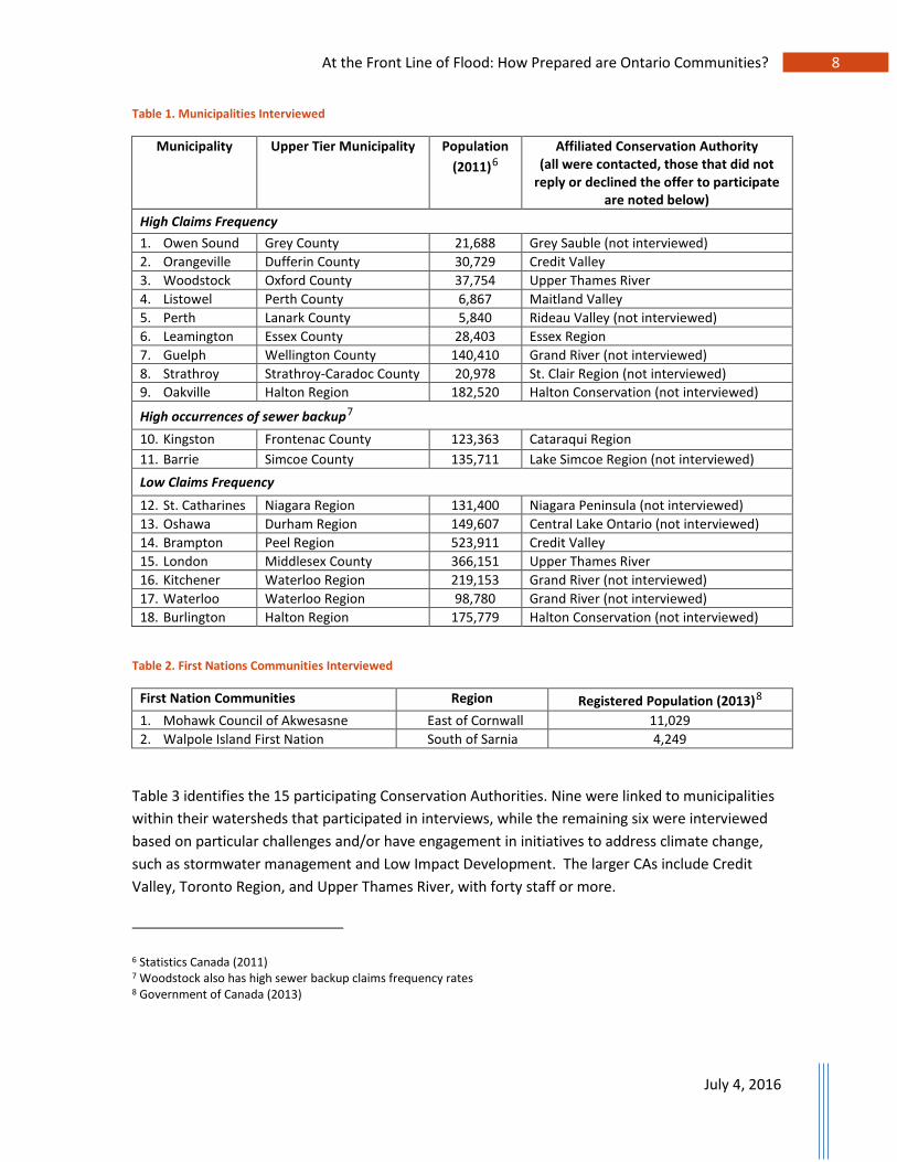
3 Methods Between January and March 2016, the study team approached 33 municipalities, six First Nation communities, and 19 Conservation Authorities to participate in telephone interviews regarding their level of resiliency to current and future flood events (see Appendices A and B for the community and CA questionnaires). Ontario municipalities can be single tier, solely responsible for planning and servicing (i.e., Barrie), or two-tier, as a municipality within either an upper-tier county (i.e., Dufferin County) or regional municipality (i.e., Waterloo Region). Upper-tier municipalities are created by two or more lower-tier municipalities, and responsibilities for planning and servicing are shared (AMO, 2013).
The Ontario Mutual Insurance Association (OMIA) assessed water damage claims from their member mutual insurers in Ontario between January, 2005 and March 2016. Municipalities were selected for the current study based on historic water damage claims, specifically frequency of sewer backup. Sampling both high and low claims municipalities allowed for the investigation of any potential management differences. CAs associated with ‘high-claims’ municipalities were then selected, but also those identified through discussions with Conservation Ontario as facing particular challenges and/or engaging in new flood-resiliency technologies (Jo-Anne Rzadki, personal communication, January 27, 2016). First Nation communities were invited to participate in interviews if their lands were within close proximity to municipalities and CAs that had also agreed to interviews.
Table 1 and 2 identify the participating communities (18 municipalities and 2 First Nations), including 10 communities from ‘high-claims areas’ with higher water damage claims activity, based on the mix between claims frequency and average claims severity. Two communities are also noted as having a high occurrence of sewer backup claims (Kingston and Barrie). Seven communities were also identified from ‘low-claims areas’. Community populations were distributed as follows:
• Nine (45%) under 50,000 residents (with four under 25,000); • Six between 50,000 and 150,000; • Three between 150,000 and 250,000; and, • Two with more than 250,000 residents.
Staff interviewed in each community represented engineering services (including operations, public works, environmental services and development services) (13), emergency management (5), chief administration (1) and flood coordination (1), with some communities having several staff participate in the interview. The study’s results are presented in a generalized manner. Appendix C attributes certain findings to some of the study participants, while others chose to remain anonymous.
July 4, 2016
At the Front Line of Flood: How Prepared are Ontario Communities? 8
Table 1. Municipalities Interviewed
Municipality Upper Tier Municipality Population (2011)6
Affiliated Conservation Authority (all were contacted, those that did not
reply or declined the offer to participate are noted below)
High Claims Frequency 1. Owen Sound Grey County 21,688 Grey Sauble (not interviewed) 2. Orangeville Dufferin County 30,729 Credit Valley 3. Woodstock Oxford County 37,754 Upper Thames River 4. Listowel Perth County 6,867 Maitland Valley 5. Perth Lanark County 5,840 Rideau Valley (not interviewed) 6. Leamington Essex County 28,403 Essex Region 7. Guelph Wellington County 140,410 Grand River (not interviewed) 8. Strathroy Strathroy-Caradoc County 20,978 St. Clair Region (not interviewed) 9. Oakville Halton Region 182,520 Halton Conservation (not interviewed)
High occurrences of sewer backup7 10. Kingston Frontenac County 123,363 Cataraqui Region 11. Barrie Simcoe County 135,711 Lake Simcoe Region (not interviewed) Low Claims Frequency 12. St. Catharines Niagara Region 131,400 Niagara Peninsula (not interviewed) 13. Oshawa Durham Region 149,607 Central Lake Ontario (not interviewed) 14. Brampton Peel Region 523,911 Credit Valley 15. London Middlesex County 366,151 Upper Thames River 16. Kitchener Waterloo Region 219,153 Grand River (not interviewed) 17. Waterloo Waterloo Region 98,780 Grand River (not interviewed) 18. Burlington Halton Region 175,779 Halton Conservation (not interviewed)
Table 2. First Nations Communities Interviewed
First Nation Communities Region Registered Population (2013)8 1. Mohawk Council of Akwesasne East of Cornwall 11,029 2. Walpole Island First Nation South of Sarnia 4,249
Table 3 identifies the 15 participating Conservation Authorities. Nine were linked to municipalities within their watersheds that participated in interviews, while the remaining six were interviewed based on particular challenges and/or have engagement in initiatives to address climate change, such as stormwater management and Low Impact Development. The larger CAs include Credit Valley, Toronto Region, and Upper Thames River, with forty staff or more.
6 Statistics Canada (2011) 7 Woodstock also has high sewer backup claims frequency rates 8 Government of Canada (2013)

July 4, 2016
At the Front Line of Flood: How Prepared are Ontario Communities? 9
Table 3. Conservation Authorities Interviewed
Conservation Authorities Links to Interviewed Municipalities9 (if no affiliation noted, CAs were identified by Conservation Ontario as being innovative or very active in flood management)
Linked to ‘High-claims Municipalities’ 1. Upper Thames River CA (UTRCA) Stratford, Woodstock, London (low claims) 2. Kawartha Region CA (KRCA) Lindsay, Peterborough 3. Ausable Bayfield CA (ABCA) Goderich 4. Credit Valley CA (CVC) Orangeville, Brampton 5. Lower Thames CA (LTCA) Chatham 6. Catfish Creek CA (CCCA) Aylmer 7. Cataraqui Region CA (CRCA) Kingston 8. Toronto Region CA (TRCA) 9. Maitland Valley CA (MVCA) Listowel Others 1. Ganaraska Region CA (GRCA) 2. North Bay Mattawa CA (NBMCA) 3. Sudbury (Nickel District) CA (SCA) 4. South Nation CA (SNCA) 5. Essex Region CA (ERCA) Leamington (low claims) 6. Mississippi Valley CA (Mississippi Valley CA)
9 The italicized communities were approached but were unable to participate in the study; however, their CAs did agree to participate.

At the Front Line of Flood: How Prepared are Ontario Communities? 10
Figure 2. Map of Communities and Conservation Authorities Interviewed
July 4, 2016
At the Front Line of Flood: How Prepared are Ontario Communities? 11
4 Results
4.1 Flooding Represents a Significant Priority for Ontario
4.1.1 Current Flood Risk and Municipal Awareness Flooding currently presents a major risk for Ontario communities, as most interviewed (65%) have experienced urban and riverine flood events in the last ten years (2005-2015), with six (30%) experiencing significant impacts from urban floods. The intensity of the storms varied, with some communities having more than one storm (i.e. four that exceeded the 1:50-year mark in a four-month period), to two feet of snow melting in two days, to receiving 96 mm of rain in two hours. In September, 2014, one community experienced a 1:150-year flood, followed two weeks later by a 1:100-year flood. Many surveyed communities (35%) experienced smaller events with localized impacts. In all cases, rains caused surface flooding, inundation of buildings, and storm sewer backup into residences. Many communities have older downtown cores with infrastructure that was not designed to handle increasing development pressures and changing precipitation conditions.
Fourteen of the communities interviewed (70%) think staff awareness of climate change impacts on flood risk has increased in recent years, particularly amongst senior management. This includes a recognition that they will experience the effects of extreme weather and climate-related events, though most are still not sure how these effects will manifest. Six surveyed communities (30%) believe their staff have a partial understanding, or do not fully understand how climate change will affect flood risk, and have not had any focused discussions. Most are devoting some staff time to climate change and flood-related adaptation, but some feel it is difficult to dedicate money and resources until there is guidance from upper levels of government as to reasonable levels of adaptation.
4.1.2 Economic Impacts of Flood Events Some aspects of local economies are more at risk from flooding. Eight communities (40%) noted their residential areas are most at risk, as they could become stigmatized through flood-related reductions in property value. Older neighbourhoods (pre-1960s) are more vulnerable, in particular where combined sewer systems still exist. Seven of those interviewed (35%) noted their older downtown areas to be at risk, including businesses, and one identified potential risks to their industrial area. Four communities (20%) noted that small commercial businesses (i.e. 5-10 employees) are most at risk, one identified potential risks to a large commercial business, and another indicated their sewage treatment plant could be at risk from flood. Four communities (20%) noted potential risks to transportation corridors, including road and rail systems (freight and GO train), where flooding could close arteries and affect transport of people and goods. Two communities noted their agricultural land could be impacted and one First Nation indicated that their traditional hunting and fishing areas could be impacted due to flooded marshland.

July 4, 2016
At the Front Line of Flood: How Prepared are Ontario Communities? 12
4.2 Motivation to Reduce Flood Risk
4.2.1 Future Flood Risk Fourteen communities (70%) believe they are at risk of a major flood event in the next thirty years, eleven (55%) believe the risk will be from urban flooding, and three (15%) from riverine flooding, as extreme rainfall events will continue. Even with increased infrastructure funding, better surface water management (i.e. permeable pavement/concrete and increased green space) and stormwater storage, there are concerns that spending will not enable municipalities to move forward quickly enough to avoid impacts. Four of the respondents (20%) do not think they are at risk due to their development restrictions, which will allow avoidance of major urban floods. Two communities are not sure whether they are at risk of future flood events.
4.2.2 Cost Analysis of Climate Change Impacts and Adaptation Options To further understand flood risk, three communities (15%) have considered the costs of climate change impacts and the costs and benefits of adaptation options. Five (25%) are currently examining or plan to examine costs, either as part of a climate change strategy or stormwater management plan. Twelve communities (60%) have not considered such costs. Many communities realize it is an important issue and would like to do so, but cannot due to a lack of resources and capacity, and thereby advocate for clearer guidance from the provincial and federal governments.
One Conservation Authority is currently quantifying the costs of data maintenance and adaptation options, including stormwater management ponds. Three CAs are initiating dialogue with their municipalities and assessing risks, though still need to establish assessment criteria. Eight CAs (53%) have not quantified costs and realize such an analysis could provide an economic rationale and overcome municipal barriers in encouraging adaptation. Other CAs feel that large Authorities should undertake such activities.
4.2.3 Liability Concerns Interviewees were not typically legal representatives and most deferred to their legal team for a full discussion of current and future liability. Ten of the surveyed communities (50%) had some understanding of their community’s legal and financial liability following a major flood event. There is no legal requirement to mitigate for flood risk (this was considered to be the responsibility of CAs), but there is a responsibility to ensure municipal infrastructure is designed using best practices and is functioning as intended. It is understood that if a municipality demonstrates they have done everything possible to prepare and inform their community that a flood event is taking place, their liability would be minor. Many communities are acting to reduce risk and potential by offering incentives to disconnect downspouts and weeping tiles from the municipal storm system, for example.
In terms of financial liability, municipalities act to ensure services are provided, maintained and restored during major flood events (i.e. cleaning out ditches, repaving roads), but not to restore private property following an event. Some communities expressed concern that changing design

July 4, 2016
At the Front Line of Flood: How Prepared are Ontario Communities? 13
storm standards and definitions for major events could subsequently change the definition of liability. This was the case as well when mapping has been updated, but municipal regulatory requirements for development have not yet been updated to reflect new information. Municipal staff therefore need to be clear on what they are protecting for, and educate homeowners that they need to do the same for their personal property. Municipalities hope the changing flood insurance market in Ontario will help to educate on personal risk and protective actions.
1.3 Current Measures to Reduce Flood Risk Several communities and CAs are working to reduce flood risk and improve resilience by considering climate change impacts and adaptation measures. A number of initiatives are presented below, focusing on structural and non-structural measures to address flood risk, or more broadly to adaptation to a range of climatic stressors. Many activities have been undertaken by municipalities experiencing both high water-damage claims and sewer back-up occurrences and low water-damage claims, and there is no discernible difference in the planning approach and initiatives for any of the communities and their associated CAs, regardless of past water claims history.
4.3.1 Assessing Flood Risks and Vulnerabilities To make informed decisions before spending tax dollars on flood adaptation, many communities and Conservation Authorities have assessed their flood risk and vulnerabilities. Thirteen communities (65%) have undertaken vulnerability and risk assessments, including identifying flooding as a top risk under the Hazard Identification Risk Assessment (HIRA) process, undertaking infrastructure assessments and Environmental Assessments (EAs) for flood-prone areas, predicting climate change impacts (including rainfall) to their community, and developing adaptation plans. Sixteen communities (80%) have undertaken drainage improvements by updating/developing infrastructure master plans, asset management plans, stormwater master plans, and flood mitigation studies. This includes undertaking EAs to assess minor/major drainage improvements, naturalizing SWM ponds, identifying 1:100-year events and smaller events in stormwater management plans, modelling the hydrology of sub-catchment areas, constructing new stormwater laterals during new road projects, and implementing Low Impact Development.
Most respondents (75%) have also undertaken infrastructure upgrades, flood characterization studies, and vulnerability assessments to prioritize upgrades. Eleven communities (55%) have undertaken land use planning/mapping by delineating their watershed and updating flood mapping with their CAs, and two are implementing erosion control measures along their rivers. Individuals across many municipal departments are involved in flood planning, including emergency management (70%) and public works/engineering (60%). Two communities have flood coordinators, and one First Nation has a heritage staff member involved in flood management. One municipality noted they have a staff member responsible for climate change adaptation planning.
Most municipalities cooperatively regulate development in the floodplain with their CA, with only two noting they are not involved in regulating floodplain development, as it is the responsibility of the upper-tier municipality. One community noted conflicts with their CA on development priorities

July 4, 2016
At the Front Line of Flood: How Prepared are Ontario Communities? 14
and struggle in development applications with wanting to encourage residents to interact with the river, while protecting public safety. Both First Nation communities do not have formal relationships with neighbouring Conservation Authorities, but one is trying to build a relationship by receiving information on CA programs and initiatives. These communities rely on local weather sources, such as Environment and Climate Change Canada and the Weather Network for rainfall information and have their own procedures to ensure new developments preserve and protect waters and lands.
Conservation Authorities, Conservation Ontario, and the MNRF recently completed a province-wide inventory of flood mapping in 2015, and found that the AVERAGE age of floodplain mapping in Ontario is 25 years. Ten of the surveyed CAs (67%) have floodplain maps dating from the mid-19802 to early-1990s (with 53% of imagery used to create these maps dating from the 1980s or earlier), with some back to the 1970s, and therefore not reflective of land use changes, climate change or advances in mapping methods. Six CAs (40%) have a ‘mixed’ state of older and newer mapping, with some using LIDAR to re-map urban areas and priority watercourses and participating in pilot projects using provincial large-scale imagery to map rural floodplains. The challenge is now to map low-risk areas, consider elevations of structures adjacent to the floodplain, and identify vulnerable properties within the floodplain. Many CAs are undertaking floodplain mapping funded partially or solely by the municipalities, with others setting aside their own capital budget funds to support updates.
To assess flood risks and vulnerabilities, eight CAs have undertaken flood mapping and modelling, including two-zone mapping (floodplain and fringe), hydrology/hydraulic modelling, field surveys and engineering assessments. These initiatives are then used to confirm that older models and maps are still appropriate, create new mapping, regulate new development, and develop flood-related mitigation. The maps focus on: a) high-development urban areas; b) secondary plan areas and smaller developments; c) known flood-prone areas outside of high growth urban areas; and, d) lakes. Five responding CAs are also undertaking risk assessments to examine the number of people living along watercourses, water levels from different storms (i.e. 1:2-year vs. 1:5-years), and resulting impacts on properties.
Public Safety Canada (PSC) is also developing mapping guidelines to identify hazards and flood risk, which will then be used by CAs and the provinces. Some CAs are creating flood maps or participating in a municipally-funded climate-risk program, which could contribute to examination of economic impacts. Two CAs have a list of flood prone areas, but have not comprehensively assessed flood risks and vulnerabilities in their watershed.
4.3.2 Emergency Management To manage flood emergencies, eight communities (40%) have a distinct flooding section in their Emergency Management Plans (EMP), including identifying flooding as a top HIRA risk, having a ‘flood plan’ annex and a plan to identify supporting bodies, maintain services and allocate resources. The Plans also map out flood-prone areas and evacuation routes, and detail flood emergency response and recovery exercises and responsibilities. Twelve communities (60%) look at flooding as

July 4, 2016
At the Front Line of Flood: How Prepared are Ontario Communities? 15
part of an ‘all hazards’ approach and do not have distinct flooding sections in their EMPs, although one First Nation community is looking to create one. All communities interviewed have prepared and/or shared their EMPs with local emergency responders.
Seven CAs (47%) noted their partner municipalities, often larger cities, have municipal EMPs with a distinct section on flooding, and have involved the CA in developing the EMP and/or Flood Contingency Plan. Communities within four CA watersheds (27%) integrate flooding with other hazards in their EMPs, using the HIRA approach to consider all potential risks, which can be challenging if CAs want to examine flood risk more closely. Ten of the surveyed CAs (67%) are involved in municipal EMP preparations and communicate with local emergency responders, with some participating in mock exercises on flood preparedness, when funding was available. Five CAs (33%) have not been involved in municipal EMP preparation, and some expressed concern regarding expertise that is nearing retirement, and the challenges of documenting that corporate knowledge in the short-term.
Eleven surveyed communities (55%) understand that their leadership is responsible for declaring an emergency and requesting financial assistance following a flood event, either as a First Nation Chief, or Mayor and Council requesting funds from provincial (i.e. ODRAP) and federal (i.e. Indigenous and Northern Affairs Canada (INAC)) departments. The other communities were not sure or had no comment. Six (30%) had applied for provincial emergency assistance funding, but only one to address flood impacts (the others were related to ice storms, blizzards and tornados). The community that applied for flood-related assistance was content with the process and successful in receiving ODRAP funding within three months after the flood. In addition, some communities have created an emergency contingency fund for unforeseen extreme events (which could also include hail, wind and snow).
Eleven communities (55%) document municipal response and recovery costs for extreme events via Emergency Management Ontario’s (EMO) Incident Management System, available to every municipality to delineate emergency costs. Five (25%) do not have a formal system, or have not had extreme events to track, and two noted they collected their costs through their CAs. Municipalities that have been through recovery noted the importance of having a system for tracking costs and staff time in place before an event, to properly capture information on spending, particularly when deploying resources in a short period, as trying to go back in time and recall spending allocations is extremely difficult. Accurate tracking also makes it easier to successfully apply for provincial assistance funding following a declared emergency.
4.3.3 Funding for Flood Protection and Adaptation Measures Half of the communities currently fund flood protection and adaptation initiatives through operating and capital budgets, but note challenges and the need for additional resources for assessment and implementation. Two municipalities use development charges/fees for flood and drainage work, while two have implemented stormwater utility rates to fund a separate utility that undertakes system improvements. INAC provides minor capital planning funds for drainage works in the First
July 4, 2016
At the Front Line of Flood: How Prepared are Ontario Communities? 16
Nation communities. Five responding communities (25%) do not specifically fund flood-related initiatives, as they do not face any significant flood impacts. One community noted they are barely meeting their current maintenance program needs, and have nothing remaining for flood-related adaptation.
To support additional flood-related adaptation initiatives, six surveyed communities (30%) had applied to the Ontario Community Infrastructure Fund (OCIF) and the Small Communities Fund (SCF), and three (15%) had applied to the New Build Canada Fund Provincial-Territorial Infrastructure Component Small Communities Fund (PTIC-SCF), both of which support infrastructure projects in small communities with populations under 100,000 (Government of Ontario, 2016; Infrastructure Canada, 2014). The proposed projects included road reconstruction (which can consider stormwater management and improved conveyance), expanding storm sewer systems to accommodate increased rainfall, permeable pavement, improving urban roads (including stormwater infrastructure), and separating stormwater and sewer systems. Only two of the six communities (33%) were successful with their applications, with some finding the process too lengthy and onerous. Of the 91 SCF projects approved to date in Ontario, only six (6.5%) “… are related to flood protection and/or disaster mitigation, and at least 15 address pollution-related concerns (waste-and stormwater…)”, including the Municipality of French River, part of the North Bay Mattawa CA, which recently received $250,000 in funding to “… construct a storm water management pond to reduce the risk of flooding” (Canadian Underwriter, 2016).
A number of CAs partnered with their municipalities to apply for funding of risk assessment studies under the new Public Safety Canada National Disaster Mitigation Program, provided to provincial and territorial governments for distribution to local governments for flood-related risk assessments, mapping upgrades and small non-structural mitigation projects (Public Safety Canada, 2015). Four of the interviewed CAs were successful in their applications, and intend to use the funds to update mapping and risk and vulnerability assessments, including one planning to develop a Flood Vulnerability Model. One community plans to use its upcoming Flood Mitigation Strategy to ask the province for a dedicated adaptation infrastructure funding stream, as it is beyond the ability of their municipality (and others) to fund larger solutions.
Eight communities (40%) had also applied for other funds to assist with adaptation. These included the MNRF Water and Erosion Control Infrastructure Program (WECI) to maintain/update dykes (CAs apply to federal funding to match provincial funding), Ministry of Environment and Climate Change (MOECC) grants to hire a stormwater management outreach coordinator and implement flood reduction in targeted neighbourhoods, ODRAP funding to assist residents in post-disaster clean-up and repair costs, First Nations-specific applications to the federal Joint Emergency Planning Program10, private industry funding on reserves, and INAC’s minor capital planning funds for drainage works. All communities had received funds from the Provincial and Federal Gas Tax Fund,
10 Discontinued in 2013.

July 4, 2016
At the Front Line of Flood: How Prepared are Ontario Communities? 17
and directed them towards stormwater pond retrofits, pipe capacity increases, asset management planning, and wastewater infrastructure. Five municipalities did not apply for any additional funding as they haven’t had any flooding issues or are undertaking risk assessments before applying for funds.
4.3.4 Incentive Programs Research suggests homes can be protected from flood damage by installing and maintaining backwater valves and sump pumps, landscaping (including rain gardens), and disconnecting downspouts and French drains or weeping tiles (a trench filled with gravel or a perforated pipe that directs water away from the foundation) from the municipal stormwater system (Kovacs et al., 2014). Twelve surveyed communities (60%) offer financial incentives or programs for property-level risk reduction, with two (10%) hoping to do so in the future. Ten (50%) offer incentives from 50% - 100% of costs for backwater valves or sump pumps, either through a first come, first serve program, or for all applicants through their annual budget. Many of the programs are voluntary, but many residents are hesitant to participate, even those who have experienced flooding, perhaps due to an inadequate understanding of personal property risk and the benefits of cost-effective, often subsidized, municipal programs.
Seven communities (35%) offer incentives for downspout or French drain/weeping tile disconnection from sanitary sewers, and eight communities (40%) provide incentives for rain barrels. Four (20%) provide home visits to discuss basement flooding, if requested, and one municipality offers stormwater credits of up to 45% of the stormwater utility fee for residential properties that manage their own stormwater. Six (30%) are considering providing stormwater credits or charges in the future, to pay for regular maintenance of stormwater infrastructure, but note that additional funding and staff resources would be required to implement such programs.
Figure 3 presents the types of municipal incentives/programs offered by the twelve communities for personal risk reduction, with some offering more than one.

July 4, 2016
At the Front Line of Flood: How Prepared are Ontario Communities? 18
Figure 3. Community Incentives/Programs for Personal Risk Reduction
4.3.5 Communications The majority of communities actively inform their residents and businesses about flood risks and adaptation options, with 15 respondents (75%) informing via social media, websites, community meetings/open houses, traditional media, mailings and personal dialogue, emergency management and flood prevention pamphlets and communicating about flood events as they happen. Five communities (25%) do not actively engage their residents and businesses about specific flood risks and adaptation, but will address issues with individual residents, as necessary.
Four surveyed communities (20%) engage residents and businesses on flood risk several times a year through open houses and home and garden shows. Six communities (30%) periodically inform their residents, when updating Master Plans, visiting vulnerable populations (i.e. seniors’ homes), providing training courses and information on risk for families, or via media during spring freshet and summer rainfalls. In addition, nineteen (95%) use the CA/MNRF flood monitoring and forecasting services, relaying messages related to potential flooding (depending on severity) to staff and residents through traditional and social media outlets. Riverine flood warnings are easier, as there is more time to assess and warn than during high intensity urban rainfalls. One of the First Nation communities does not use the CA/MNRF service, relying instead on Environment and Climate Change Canada data.
The majority of surveyed CAs (14) have broad outreach programs on spring watershed conditions and short and long-term flood risks, through social and traditional media and contacts to
10
8
7
6
4
1
0
2
4
6
8
10
12
backwatervalves/
sump pumps
rain barrels downspoutdisconnection
future SWcredits/charges
home visits SW credits
NU
MBE
R O
F CO
MM
UN
ITIE
S
INCENTIVE/PROGRAMS

July 4, 2016
At the Front Line of Flood: How Prepared are Ontario Communities? 19
municipalities, emergency responders, dam owners, community centers, media, school boards and any vulnerable people in the flood plain. Prevention, precautionary measures, and general flood awareness are also communicated through social media, websites, brochures/infographics, site visits, and presentations to residents, students, seniors’ homes and vulnerable populations. Smaller CAs note limited staff and resources to talk directly with the public in the event of a larger flood, so typically rely on primary communication with the municipality to distribute flood messages via traditional and social media.
Thirteen CAs (72%) have flood materials available to inform and educate communities, including websites detailing risks, preparation, forecasting, and warning. Some CAs annually host EMP planning sessions with watershed municipalities and police and fire departments to discuss flood emergencies and review respective roles and responsibilities. Most CAs also communicate changes in flood mapping through open houses and public meetings, but two have not held open houses recently, as they are not in a highly developing area and have not updated their floodplain maps in the past 20 years. Two CAs do not have a lot of educational materials and are working to develop these in the near future.
4.3.6 Planning for Future Flood Risk and Climate Change Impacts To consider future flood risk, 17 responding communities (85%) are developing comprehensive Stormwater Management Plans, updating infrastructure design guidelines to address climate change (including updating flood mapping and Intensity-Duration-Frequency (IDF) curves), examining stormwater management and Low Impact Development in newer areas (as most older areas are often less than 10% impervious surface), designing stormwater ponds to regional level storms, installing storm laterals on new road builds, and updating EAs and Master Plans to include improvements to creeks, pond retrofits, and slope stabilization. As the majority of flood mapping in Ontario is based on a 1:100-year event, some communities are now conservatively modelling for a 1:200-year event, while others are requiring developers to construct finished floors of basements a minimum of 1 m above the ‘obvert’ (top of the sewer pipe), in response to climate change projections and past flood events. Three municipalities noted they were unable to undertake flood risk initiatives due to lack of resources.
To plan for and fund future adaptation initiatives, 17 communities (85%) are examining risks and identifying priorities and adaptation opportunities, but most noted they are not forecasting from an adaptation perspective, but rather conducting business as usual. Municipalities are also prohibiting development in flood-prone areas, monitoring rainfall and analyzing storm events, and conducting post-mortem exercises following flood events. Three municipalities and both First Nation communities are not formally examining flood risks and adaptation opportunities, as flooding is not significant or they take an ‘all-hazards’ risk-approach.

July 4, 2016
At the Front Line of Flood: How Prepared are Ontario Communities? 20
CAs are also actively planning for future events, with five respondents (28%) updating their floodplain mapping, including examining the probability of flood-related events, and running sensitivity analyses with more water in the system. In addition, a number of CAs have partnered to purchase KISTERS Water Information Systems software, which provides flow and climate data information and live updates of water levels. To further their efforts, CAs interviewed as part of this study would like clarification from the provincial government on how to integrate climate change into floodplain mapping, as they have traditionally used historic precipitation data, rather than differing climate scenarios.
To improve flood resiliency, three CAs are updating their flood maps and models, and three others are undertaking flood mitigation on their creeks by examining how existing flood damage can be mitigated or by constructing catchment ponds. They are also developing greenspace/flood control measures in older urban areas that are being re-designated as growth areas. Three CAs are undertaking stewardship activities and flood-management best practices, working with communities to slow water on the landscape by restoring shorelines and recreating wetlands. Two CAs are performing risk assessments on creeks and examining the value of wetlands in mitigating flood. One CA is maintaining its existing capital projects through the MNRF Water and Erosion Control Infrastructure Program. Six surveyed CAs are not currently involved in any large-scale flood resiliency projects, but may if flood-prone areas are identified through flood mapping updates.
Many surveyed CAs are also implementing or encouraging design requirements that could reduce flood risk in their partner municipalities, with 12 implementing stormwater management and 11 encouraging low-impact development. Stormwater management through end of pipe control of quantity/quality has been actively used by municipalities for quite some time, though newer facilities focus more on conveyance controls, such as swales, and end of pipe controls, such as ponds. As part of the review of Planning Act applications, CA engineering staff comment on stormwater design, consider cumulative effects, and ensure flooding does not increase as a result of development. Many CAs have design guidelines to maintain the characteristics of the watershed even with development.
In addition, 11 responding CAs are encouraging, though not yet requiring, Low Impact Development through property-level facilities that mirror natural processes. There is some resistance from municipalities and developers in regards to maintenance and functionality, and some CAs are now working to develop standards and undertake pilot projects, while others are undertaking a cost/benefit analysis of implementation on a neighbourhood scale. Certain CAs have also had workshops to investigate implementing LID in road allowances.
4.3.7 Consideration of Broader Climate Change Impacts and Adaptation Planning Some of the interviewed communities and CAs are considering the broader impacts of climate change and developing adaptation plans and options. Four had examined specific climate change impacts and three are considering adaptation options. Municipalities within five of the CA watersheds are developing adaptation plans, and some are also using natural heritage to address

July 4, 2016
At the Front Line of Flood: How Prepared are Ontario Communities? 21
climate change in their municipal plans and programs. Seven CAs noted that smaller municipalities are starting to consider climate change, which can be made easier through implementation of measures such as Low Impact Development and stormwater management, which do not emphasize new infrastructure. Seven communities (35%) have not made any formal efforts to address climate change and flood-related adaptation. The issue is often not part of day-to-day planning, as communities do not have the resources to focus on issues beyond operations and maintenance of core infrastructure. In addition, five CAs (33%) carry out specific climate change research and support their own climate change strategy and/or adaptation initiatives.
4.4 Barriers to Resiliency
4.4.1 General Barriers Communities continue to face barriers to reducing flood risk and improving resilience, as documented in earlier studies (Carmin et al., 2012; Conservation Ontario, 2013; Feltmate & Moudrak, 2015). Barriers to considering flood risk and implementing adaptation were identified by 17 surveyed communities (85%), as presented in Figure 4, including time and the “sheer magnitude of what has to be done”. Key barriers included funding, consistent approaches to modeling, predictive climate data, and technological expertise and research. Other barriers included planning assistance/guidance, technology and design alternatives, staff capacity, climate change uncertainty (particularly the challenge of updating IDF curves without clear direction), and engaging the public toward increasing their awareness of personal responsibility to adapt. Three communities (15%) noted that they do not face any barriers, as they do not see flooding as an issue or rely on their CA for support.
Figure 4. Barriers to Considering Flood Risk and Adaptation
14
6
4 4
21 1
0
2
4
6
8
10
12
14
16
Funding ClimateProjections
TechnicalExpertise
PlanningAssistance
Capacity PublicAwareness
CCUncertainty
NU
MBE
R O
F CO
MM
UN
ITIE
S
BARRIERS TO ADAPTATION

July 4, 2016
At the Front Line of Flood: How Prepared are Ontario Communities? 22
4.4.1 Consideration of Financial Benefits of Adaptation Communities were also unaware of future costs that could be saved through adaptation, as half focused on reducing risk when upgrading/retrofitting in the urban environment where cost savings are not immediate. Seven surveyed communities (35%) noted they had reduced insurance claims for residents resulting from fewer sanitary backups and flood clean-ups, improved response time (reduced social costs) to flood events, reduced maintenance of infrastructure, and increased efficiency in monitoring and data collection. Three communities (15%) said they might notice cost savings in the future. Some surveyed communities are beginning formal cost-benefit analysis to determine cost savings due to current or future investment in flood mitigation.
4.5 Measures to Improve Resiliency Local governments are closest to the people and their problems, and make the decisions that count in their communities. They have the greatest ability to affect change, but need support and resources from provincial and federal governments to drive action. Several measures were suggested by communities and Conservation Authorities to increase flood resiliency, including additional funds, policy direction from senior levels of government, and technical support.
4.5.1 Additional Funds To improve resilience, and overcome the challenges noted throughout this report, five participating communities identified the need for additional resources from the provincial and federal governments, to harden infrastructure, update engineering and design storm standards, develop new IDF curves, and address the increased workload that will come with any municipal flood-related policy changes. Resources are limited in all communities, but particularly in smaller and rural communities. One First Nation noted they would like funds to develop their own flooding policies.
Close to half of the surveyed CAs noted there should be additional funds to support updated flood mapping and modelling, including in rural areas and northern Ontario. Mapping updates would help to further understand flood risks, and would help prioritize sediment dredging and flood mitigation infrastructure. Resources would also be beneficial for assessing the cumulative impact of existing and new developments, and developing additional tools and policies. In addition, to effectively assess hazards and risks, 11 CAs (73%) noted additional resources are needed to update maps with current climate data and state of the art technologies (i.e. LIDAR, surveys, digital elevation models, hydraulic/hydrologic modelling). Maps should also extend beyond the regulatory storm boundaries, consider new development, and consider risk probability in addition to hazards. While MNRF historically funded 50% of update costs and provided technical assistance, current provincial funds are primarily used for capital projects (i.e. dams and dyke structures), with resources for hazard mapping and modelling downloaded to municipalities. As a result, many rural CAs and communities do not have the population (and associated tax base) to support the updates. Some CAs are updating flood maps with local developers, though only focused on ‘hotspots’. CAs would also like additional funding for maintenance and operation of structural flood control infrastructure (dykes/dams), noting their capital repair funding from provincial and municipal governments must be phased over many years, slowing needed repairs. Provincial funding to CAs for flood
July 4, 2016
At the Front Line of Flood: How Prepared are Ontario Communities? 23
infrastructure should be increased (historically funded provincial/municipal/federal, now funded by province and municipalities to varying degrees) and reinstating federal funding would further enable more reasonable and timely upgrades to current safety standards.
Twelve surveyed CAs saw many opportunities for collaboration with government, including increased federal funding for the National Disaster Mitigation Program (NDMP). Current funds available under the NDMP are a good start, though not sufficient as they are currently split between evenly between federal and municipal governments, and funding applications must be coordinated with a provincial agency, meaning that some municipalities might not participate. There is also concern amongst the CAs that the $200 million currently available over 5 years under the NDMP will be allocated to areas where no mapping currently exists, rather than helping CAs in Ontario update their mapping. The former Federal Disaster Relief Program (FDRP) in the 1980s had a more amenable funding model of 50% federal, 40% provincial, and 10% municipal – returning to this type of model would facilitate participation by smaller municipalities with limited resources.
Conservation Ontario’s ‘Business Case for Strategic Re-investment’ advocates that investments in infrastructure and flood programs are required from all levels of government, building on current approaches, thereby mitigating or reducing impacts. Specific recommendations include investments in 1) floodplain mapping; 2) ongoing flood management; 3) existing flood and erosion control infrastructure; 4) ongoing program support for green infrastructure including LID, SWM and watershed stewardship best practices; and, 5) access to a rural and northern municipal infrastructure funding program (Conservation Ontario, 2013). Conservation Authorities interviewed in this study supported the points noted in the ‘Business Case’ and advocated for a re-instatement of previous provincial funding to CAs.
4.5.2 Policy Direction from Higher Levels of Government Those communities and Conservation Authorities that participated in this study all advocated for greater policy direction from the provincial and federal governments to increase flood resiliency. In particular, half of the communities advocated for leadership and flexibility on what to do after new guidelines and policies are introduced. It was noted that money is dedicated to climate change mitigation that will have an impact 30-50 years from now, but very little is being done to address adaptation and readiness to respond today. This imbalance could be addressed by providing clear direction on how to account for climate change when undertaking floodplain mapping and clarity on responsibilities for municipalities, CAs, homeowners, and the province towards adaptation. Federal and provincial governments should also assist in educating the public on why flood policies are necessary.
A need was expressed for policies that differentiate impacts and mitigation for riverine and urban flooding. Riverine flooding is addressed adequately by the CAs through flood control structures, land development policies and municipal Official Plans and EMPs. Urban flooding remains poorly understood and could be addressed through risk assessments and infrastructure funding, with the vision that any funding be sustainable over the long-term. Infrastructure spending could also be
July 4, 2016
At the Front Line of Flood: How Prepared are Ontario Communities? 24
prioritized by looking through an emergency management lens to safeguard communities. One municipality also identified the need for policies to address climate change impacts in rural settings, as there are significant differences in impacts, resources, and opportunities for adaptation between large urban and small rural municipalities. Another community advocated for a national standard for data, mapping and information, to bring Ontario in line with the rest of the country for equal access to response and recovery funding.
Three municipalities noted the importance of municipal political champions (i.e. staff or Councilor) to advocate the benefits of adaptation and the importance of building flood resiliency into day-to-day operations, particularly infrastructure development. Two municipalities talked about the difficulty in communicating needs based on uncertain future events, and the importance of encouraging participation and behavioural change of individuals not yet impacted by flooding. One First Nation noted collaboration and agreement is needed between the federal government (i.e. INAC) and the province, so the latter could assist the community with on-reserve emergency management training.
Seven CAs commented on the roles of municipal, provincial and federal governments in climate change adaptation. One noted that CAs should provide leadership on adaptation for municipalities, by examining climate change issues on a watershed basis. Municipalities should undertake infrastructure risk assessments to address urban flooding, especially in older areas. The majority of surveyed CAs noted that the provincial and federal governments should support municipalities to understand impacts and implement action. New provincial guidelines and case studies would help promote Low Impact Development in communities, including a new LID Guide and periodic updates to the 2003 MOECC Stormwater Management Planning and Design Manual. Six CAs noted that the province should provide clearer policy direction and regulatory tools on water resources adaptation and climate scenario modeling, especially for smaller CAs. The province should also focus on agricultural adaptation, especially for rural watersheds. Six CAs noted that the federal government should develop a national standard on floodplain mapping, and provide regional climate change models (i.e. expected rain events), so CAs could model what sort of climate to expect in 50-100 years into design standards.
Is important to distinguish between hazard mapping (i.e. establishing limits of a floodplain for a certain storm and regulating/limiting development in that area) and risk mapping (i.e. probability, duration and consequences of flooding). To effectively use flood maps to consider actual flood risk, one CA recommends horizontal setbacks from the flood-line and vertical freeboard11 in new developments as a factor of safety, which gives a sense that even if a flood-line of 2016 is not reflecting the reality of what would happen in a regulatory storm, there are factors of safety around it. The CAs also advocated that climate change should be incorporated into design standards, flood maps, risk models, and IDF curves, with stormwater management implemented in all municipalities.
11 A safeguard of separation in either length (linear - a specified distance) or height (vertical - a specified elevation) from the Regulatory Flood Plain or other specified flood level (TRCA, 2008).

July 4, 2016
At the Front Line of Flood: How Prepared are Ontario Communities? 25
It is also important to address other drivers of flood risk, including changing land-use pressures, and prepare a comprehensive plan to address urban and riverine flooding, including new tools and policies. Some surveyed CAs also recommended reinstating the 1980s program to acquire homes in floodplains. Finally, CAs would like alignment of standards and guidelines, and consistent interpretation and application of policies amongst their member municipalities and the province, to streamline the process and ensure watershed-wide flood understanding and management.
4.5.3 Technical Expertise The federal government should provide technical expertise and science to communities to understand the potential impacts of climate change. The provincial government should then develop guidelines and policies to update mapping and land-use policy to reflect climate projections. The province should also provide technical expertise and develop policies on stormwater management design, update IDF curves, monitor and standardize the insurance industry, revisit design standards for regulatory storms, and require Low Impact Development throughout the province.
Conservation Authorities advocated for newer technologies/tools for flood mapping, including updated IDF curves, GIS, orthophotos, LIDAR and confirmation of whether in-use regulatory storm standards still apply (i.e. element of freeboard and whether to consider more frequent 1:25-year floods under climate change, not just large storms). CAs also noted the need for improved flood forecasting and municipal emergency management to respond to the increasing impacts of urban floods. CAs also need high-confidence data and assurance from provincial and federal governments that the standard and design criteria are adequate, as this is a new shift to considering future scenarios rather than historical events.

July 4, 2016
At the Front Line of Flood: How Prepared are Ontario Communities? 26
5 Discussion
5.1 Encouraging Resiliency Communities and CAs are working to reduce flood risk and improve resilience by considering climate change impacts via structural and non-structural adaptation measures. The majority of measures presented in this study pertain to flood risks, with some more broadly applicable to a range of climatic stressors. The activities have been undertaken by municipalities experiencing both high water-damage claims/sewer back-up occurrences and low water-damage claims.
Communities are addressing their flood risk by developing policies, augmenting staff capacity and responsibility for adaptation planning, assessing vulnerabilities and potential opportunities, modelling, simulating more intense rain events (i.e. 1:200 year vs. 1:100 year events), improving infrastructure design standards, and considering the costs and benefits of climate change. Some communities are also developing a Climate Change Strategy, assessing climate change impacts and developing adaptation strategies.
CAs are updating urban and rural flood maps and engaging with local stakeholders, including working with municipalities to identify potential impacts and develop adaptation plans, and considering the costs and benefits of adaptation. CAs are monitoring rainfall to identify severe thunderstorm events and examining how climate change would impact sub-watersheds. They are also undertaking risk assessments, with some implementing and encouraging stormwater management and LID. In addition, CAs are hosting annual meetings with municipalities to discuss flood forecasting, warning and responsibilities. Some are also providing inquiry services to local stakeholders about regulations and susceptibility of particular properties to flooding, with some having flood officers available 24 hours/day. CAs are also undertaking structural measures to improve flood resiliency through mitigation and stewardship projects.
5.2 Continuing Challenges/Barriers Surveyed communities and CAs continue to face many challenges in improving resilience, as noted below:
• Lack of funds for a variety of initiatives: o Assessing flood risks; o Updating flood maps and models with current and appropriate tools; o Implementing infrastructure upgrades; and, o Developing climate change adaptation plans.
• Policies and guidelines with detailed climate projections to manage flood risk and account for
climate change.
• Technical expertise and research, particularly to predict urban flooding.

July 4, 2016
At the Front Line of Flood: How Prepared are Ontario Communities? 27
• Planning assistance, capacity/staff and senior leadership support: o Securing municipal champions and leadership to take action on climate change and flood-
related issues. o Improving familiarity with processes to request federal funds and declare an emergency.
• Public awareness and behavioural change:
o Leveraging political and developer will to implement new technologies, such as LID and SWM. o Fostering individual responsibility and greater understanding of personal property risk, as
demonstrated by the limited uptake of voluntary, often subsidized incentive programs.
5.3 Support to Improve Resiliency To improve flood resiliency in Ontario, study participants advocated for additional funds to move regulatory changes forward, in addition to policies and guidelines developed and implemented jointly by federal and provincial governments.
5.3.1 Funding Communities and CAs noted that the federal and provincial governments should provide funds for adaptation that is sustained over the long-term, noting capacity differences between larger and smaller communities and CAs. This includes consistent resourcing amongst all communities to address base funding for the increased workload that will come with any municipal flood-related policy changes. Approximately half of the communities had applied for existing provincial and federal funding, though not all were successful, causing frustration and reducing trust in the funding process.
Additional funds could be directed toward better tools to predict flood impacts on infrastructure and community needs, and develop adaptation plans. This could also involve increasing awareness and access to Public Safety Canada’s flood-related funding through the National Disaster Mitigation Program. New sources of funding, focusing specifically on climate change adaptation, were announced with the 2016 federal budget (Finance Canada, 2016), and additional funding was recently announced through the provincial government’s ‘Climate Change Strategy’, including initiatives to assess climate change impacts and develop adaptation plans in indigenous communities (Ministry of Aboriginal Affairs, 2016). Participating communities and CAs now need guidance, regulatory oversight, and common understanding on how to effectively access these new funding sources.
5.3.2 Policies and Guidelines Federal and provincial policies/guidelines are also needed to help manage flood risk, consider climate change when updating flood mapping and adaptation initiatives, and improve clarity on responsibilities between communities, CAs, landowners and the province. Higher levels of government should also assist in public education on the importance of flood policies and measures that can reduce personal risk. Governments should also develop policies and guidelines that address the difference in potential impacts between urban and rural communities, and differentiate

July 4, 2016
At the Front Line of Flood: How Prepared are Ontario Communities? 28
riverine and urban flood, with emphasis on urban flooding. Both levels of government should share scientific expertise, to understand the best techniques and tools for regional and local contexts.
As suggested by other authors, the Ontario government should create a ‘provincial urban flood damage reduction strategy’ and revise building codes (Kovacs & Sandink, 2013). The provincial government should also develop a strategy to replace combined sewer systems with independent sanitary and storm sewers and require local governments to share information about the state of their sanitary and stormwater systems. Lastly, the province should work with local governments and other stakeholders, including the insurance industry, to foster initiatives that reduce the risk of urban flooding in existing homes (Kovacs & Sandink, 2013).
Kovacs et al. (2014) advocate that municipal governments engage in a comprehensive flood-management strategy that comprises communication, improvements in design and management of sanitary wastewater and stormwater systems, and local actions and incentives by private property owners, including educating and encouraging homeowner participation. In addition to federal and provincial funding and policy support, communities in this study indicated that certain measures are required at the municipal level to improve flood resiliency and reduce impacts upon residences, businesses, commercial areas, transportation networks, agricultural areas and traditional land use. These include initiatives and support to encourage and implement behavioural change through increased awareness of personal property risk. Support is also needed to identify distinct flood risks in EMPs and improve emergency management for future events, particularly in communities that face significant flooding. Greater municipal staff awareness is also needed to address extreme events, including the process to apply for preparation, response, and recovery funds, tracking of municipal costs, and municipal legal and financial liabilities. Furthermore, most communities engage their stakeholders on flood issues, though many only do so periodically. Increasing the public recognition of flood risks, including engaging with external stakeholders (i.e. utilities), would contribute to improving flood resiliency.
CAs noted that municipalities should undertake infrastructure risk assessments to address urban flooding, especially in older areas. For First Nation communities, the provincial and federal governments should also finalize agreements to allow certain adaptation measures to be implemented, such as emergency training. In addition, there should also be greater understanding of flood impacts to First Nation communities, including those to traditional land use. Relationships with CAs and neighbouring First Nation communities should also be encouraged.
Specific policies and guidelines that need to be further developed and implemented include:
Improved Flood Information:
• Strengthen flood forecasting and Emergency Management Planning, including sections on urban flooding.
• Create uniform Intensity-Duration-Frequency curves to increase the ability to predict and understand increased rainfall leading to urban flooding.

July 4, 2016
At the Front Line of Flood: How Prepared are Ontario Communities? 29
• Update standards for regulatory storm boundaries to address more frequent and intense extreme events.
• Update flood maps and create new maps for previously undeveloped areas. Maps should also extend beyond regulatory storms, provide greater coverage, and consider risk probability in addition to hazards.
• Incorporate stormwater management into infrastructure and design and implement LID. • Monitor/standardize the insurance industry. • Increase regional science to understand the impacts of climate change, using consistent
information and programs across all the provinces, including a national standard on floodplain mapping.
• Increase public education on the importance of flood policies and measures to reduce personal risk.
Climate Change Adaptation Policies:
• Prove guidance on how to consider the costs of climate change impacts and costs/benefits of adaptation options.
Support Best Practices in Flood Risk Management:
• Discontinue dredging and invest in stormwater management. • Reinstate the 1980s policy to acquire homes located in floodplains. • Consider other drivers of flood risk, such as changing land use pressures and aging
infrastructure.
Support for Smaller, Rural and First Nation Communities:
• Increase support and awareness of flood-related climate change impacts for smaller and rural/agricultural communities.
• Foster greater understanding of flood-related impacts to First Nations communities, including those to traditional land use, and encourage relationships between First Nations and neighbouring CAs.
July 4, 2016
At the Front Line of Flood: How Prepared are Ontario Communities? 30
6 Conclusion This study has examined the state of flood resiliency in small and medium-sized Ontario communities and Conservation Authorities. Its findings indicate that only 30% of communities are experiencing significant impacts from urban flooding, but 70% believe they are at risk from future flood events (55% to urban floods). The majority of communities and CAs have good working relationships and are working to increase flood resiliency, through specific initiatives and broader adaptation measures. Many communities, including those with high and low historical water damage claims, and Conservation Authorities are preparing for flood through structural (i.e. updating stormwater plans, sizing infrastructure for increased rainfall) and non-structural (i.e. flood characterization studies, emergency management planning) measures. There is no discernible difference in planning approaches and initiatives for communities with high and low historical exposure to water damage claims.
Despite these efforts, challenges remain in improving resiliency, particularly to urban floods, with key barriers being a lack of funds, a consistent approach to modeling and predictive data, and technical expertise and planning assistance. These barriers could be eliminated through increased financial support by provincial and federal governments, in addition to policies and technical guidelines to understand climate change impacts on current and future flood events. Municipalities should also provide support to their staff and CAs to distinctly identify flood risks in EMPs, undertake infrastructure risk assessments, increase staff awareness of flood, and engage stakeholders on flood-related issues. This study also identifies the need to more thoroughly examine the institutional and financial needs of smaller and rural municipalities and CAs in addressing flood. Moreover, as low uptake remains a barrier for subsidized incentive programs, future research/programs should examine ways to increase uptake and encourage behavioural change at the residential level.
Key findings from this study include:
1. Flooding is a major source of socio-economic vulnerability in small and medium-sized Ontario communities, placing unnecessary strain on municipal resources, specifically urban flooding associated with damage from sewer backup.
2. Communities are the first jurisdictions to react and drive the policy change needed to improve flood and climate change resiliency, but with scarce resources. Some feel they are ‘left to their own devices to make informed decisions’ about the magnitude of flood risk and implications for their residents.
3. Communities are acting to manage vulnerability to flood, but these efforts are fragmented, creating uncertainty about their effectiveness. Communities also lack institutional and financial capacity to enforce, update and further invest in these actions to improve resiliency.
4. Federal and provincial policy and funding to reduce vulnerability and improve capacity of our communities to prepare and recover from flood are underutilized and underdeveloped.

July 4, 2016
At the Front Line of Flood: How Prepared are Ontario Communities? 31
5. There is a strong divide in capacity to understand and address flood risk between urban and rural communities (including First Nation communities).
6. Municipalities need funding, staff capacity, technical and scientific support, regulation, and elected and community and political buy-in to address the present and future risk of flood.
What our Communities Need to Prepare for Flood
This study recommends that to improve resiliency in our communities, the following actions are required:
1. Public Safety Canada should establish and enforce national standards for flood risk management and mapping, and should also significantly expand and facilitate accessibility of funding through the National Disaster Mitigation Program.
2. The Ontario government should increase funding to Conservation Authorities for planning, flood management, and maintenance and operation of flood structures.
3. Provincial and federal governments should address the current leadership gap and prioritize community resiliency to flood by supporting communities in understanding and communicating risk and opportunities to reduce this risk.
4. All levels of government should further efforts to increase personal flood risk awareness, to encourage behavioural changes and increase the uptake of residential incentive programs.
5. All levels of government should work with the insurance industry to improve our understanding of flood risk in this country, and opportunities to reduce this risk.
Funding•Maps and models•Risk Assessments• Infrastructure• Staff Capacity
Technical Support•Climate Change•Best Practices• Planning•Cost-Benefit Analysis
Policy •Guidance•Monitoring• Enforcement• Incentives
Political Will• Staff and Council champions• Flood Risk Awareness• Personal Accountability

July 4, 2016
At the Front Line of Flood: How Prepared are Ontario Communities? 32
7 References Alexander, L., Simon, A., Bindoff, N. L., Bréon, F. M., Church, J. A., Cubasch, U., Xie, S. P. (2013).
Climate Change 2013: The Physical Science Basis. Summary for Policymakers. The Fifth Assessment Report of the Intergovernmental Panel on Climate Change (IPCC). Cambridge, United Kingdom: Cambridge University Press.
AMO. (2013). Ontario Municipalities. Retrieved from https://www.amo.on.ca/AMO-Content/Municipal-101/Ontario-Municipalities.aspx.
Canadian Underwriter. (2016). Ottawa announces flood protection funding for small Ontario municipalities. Insurance Institute
Carmin, J., Nadkarni, N., & Rhie, C. (2012). Progress and Challenges in Urban Climate Adaptation Planning - Results of a Global Survey. Cambridge, MA: Massachusetts Institute of Technology (MIT) and International Council for Local Environmental Initiatives (ICLEI).
Conservation Ontario. (2009). Flood Management. Retrieved from http://www.conservation-ontario.on.ca/projects/floods_management.html.
Conservation Ontario. (2010). Flood Prevention and Protection: Roles and Responsibilities of Conservation Authorities. Conservation Ontario.
Conservation Ontario. (2013). Dodging the Perfect Storm: Conservation Ontario's Business Case for Strategic Reinvestment in Ontario’s Flood Management Programs, Services, and Structures. Conservation Ontario.
Conservation Ontario. (2015). Fact Sheet.
Denton, F., Wilbanks, T., Abeysinghe, A. C., Burton, I., Gao, Q., Lemos, M. C., Warner, K. (2014). Chapter 20: Climate-resilient pathways: adaptation, mitigation and sustainable development. In Climate Change 2014: Impacts, Adaptation, and Vulnerability. Contribution of Working Group II to the Fifth Assessment Report of the Intergovernmental Panel on Climate Change (IPCC). Cambridge, UK, New York, NY: Cambridge University Press.
ECO. (2011). Before the Flood: Conservation Authorities' Vital Role in Land Use Planning. Engaging Solutions, ECO Annual Report, 2010/11. Toronto: The Queen's Printer for Ontario. 73-75.: Environmental Commissioner of Ontario.
Feltmate, B., & Moudrak, M. (2015). Preparedness of Fifteen Canadian Cities to Limit Flood Damage. Faculty of Environment, University of Waterloo: Partners for Action.
Field, C., Barros, V., Mach, K. J., Mastrandrea, M. D., van Aalst, M. K., Adger, W. N., Yohe, G. (2014). Technical Summary. In Climate Change 2014: Impacts, Adaptation, and Vulnerability. Contribution of Working Group II to the Fifth Assessment Report of the Intergovernmental

July 4, 2016
At the Front Line of Flood: How Prepared are Ontario Communities? 33
Panel on Climate Change (IPCC). Cambridge, UK and New York, NY: Cambridge University Press.
Finance Canada. (2016). Growing the Middle Class - Federal Budget 2016. Government of Canada.
Floodsite. (2008). Flooding in Urban Areas (Urban Flooding). Retrieved from http://www.floodsite.net/juniorfloodsite/html/en/student/thingstoknow/hydrology/urbanfloods.html.
Government of Ontario. (1990). Emergency Management and Civil Protection Act (Ontario Regulation (380/04) Standards. Retrieved from https://www.ontario.ca/laws/regulation/040380
Government of Canada. (2013). Aboriginal Connectivity Profiles of Ontario - Current Residential Connectivity Availability. Retrieved from https://www.aadnc-aandc.gc.ca/eng/1352223782819/1353504825398?p=ON.
Government of Ontario. (2016). Infrastructure funding for small communities. Retrieved from https://www.ontario.ca/page/infrastructure-funding-small-communities.
IBC. (2015). The Financial Management of Flood Risk: An international review: Lessons learned from Flood Management Programs in G8 countries. Insurance Bureau of Canada (IBC).
Infrastructure Canada. (2014). New Building Canada Fund: Provincial-Territorial Infrastructure Component Small Communities Fund. Retrieved from http://www.infrastructure.gc.ca/plan/sc-cp-eng.html
IPCC. (2014). Glossary. In Climate Change 2014: Impacts, Adaptation, and Vulnerability. Contribution of Working Group II to the Fifth Assessment Report of the Intergovernmental Panel on Climate Change (IPCC). Cambridge, UK and New York, NY: Cambridge University Press.
Kovacs, P., Guilbault, S., & Sandink, D. (2014). Cities Adapt to Extreme Rainfall - Celebrating Local Leadership. Institute for Catastrophic Loss Reduction (ICLR).
Kovacs, P., & Sandink, D. (2013). Best Practices for Reducing the Risk of Future Damage to Homes from Riverine and Urban Flooding. A Report on Recovery and Rebuilding in Southern Alberta. Institute for Catastrophic Loss Reduction (ICLR).
McDermid, J., Fera, S., & Hogg, A. (2015). Climate Change Projections for Ontario: An Updated Synthesis for Policy-makers and Planners. (No. Climate Change Research Report (CCRR - 44)). Toronto, Canada: Ontario Ministry of Natural Resources and Forestry (OMNRF).
Mekis, É., & Vincent, L. A. (2011). An overview of the second generation adjusted daily precipitation dataset for trend analysis in Canada. Atmosphere-Ocean, 49, 163–177.
July 4, 2016
At the Front Line of Flood: How Prepared are Ontario Communities? 34
Ministry of Aboriginal Affairs. (2016). Ontario Partnering With First Nations to Address Climate Change. Retrieved from https://news.ontario.ca/maa/en/2016/03/ontario-partnering-with-first-nations-to-address-climate-change.html
MNRF. (2002). Technical Guide River & Stream Systems: Flooding Hazard Limit. Ontario Ministry of Natural Resources and Forestry.
MOECC. (2011). Climate Ready: Ontario’s Adaptation Strategy and Action Plan (2011-2014). Toronto, Canada: Ontario Ministry of Environment and Climate Change (MOECC).
MOECC. (2015). Ontario's Climate Change Strategy. Toronto, Canada: Ontario Ministry of Environment and Climate Change (MOECC).
NMAP. (2014a). Ontario Results from the National Municipal Adaptation Survey. Kelowna, BC: National Municipal Adaptation Project.
NMAP. (2014b). Results from the National Municipal Adaptation Survey. Kelowna, BC: National Municipal Adaptation Project (NMAP).
OMMAH. (2016). Disaster Recovery. Retrieved from http://www.mah.gov.on.ca/Page13722.aspx
Public Safety Canada. (2015). National Disaster Mitigation Program (NDMP). Retrieved from http://www.publicsafety.gc.ca/cnt/mrgnc-mngmnt/dsstr-prvntn-mtgtn/ndmp/index-eng.aspx
Revi, A., Satterthwaite, D., Aragón-Durand, F., Corfee-Morlot, J., Kiunsi, R. B. R., Pelling, M., Solecki, W. (2014). Chapter 8: Urban Area. In J. Balbus, & O. M. Cardona (Eds.), Climate Change 2014: Impacts, Adaptation, and Vulnerability. Contribution of Working Group II to the Fifth Assessment Report of the Intergovernmental Panel on Climate Change (IPCC). Cambridge, UK and New York, NY: Cambridge University Press.
Ribot, J. (2011). Vulnerability before adaptation: Toward transformative climate action. Global Environmental Change, 21(4), 1160-1162. doi:10.1016/j.gloenvcha.2011.07.008
Statistics Canada. (2009). Age of Public Infrastructure: A Provincial Perspective.
Statistics Canada. (2011). Census Profile 2011 - By City. Retrieved from http://www12.statcan.gc.ca/census-recensement/2011/dp-pd/prof/index.cfm?Lang=E
TRCA. (2008). The Living City Policies - Glossary. Toronto Region Conservation Authority.
UNFCCC. (2013). The State of Adaptation under the United Nations Framework Convention on Climate Change. Adaptation Committee, United Nations Framework Convention on Climate Change (UNFCCC).
1
Appendices
Appendix A: Community Questionnaire
Past Events
1. Has your community experienced a flood event in the last 10 years? 2. If yes, has your community done anything differently (planning, emergency preparedness,
infrastructure upgrades) as a direct result of that flood event? 3. What has your community done to assess your flood-related risks and vulnerabilities to
reduce flood risk? Examples could include vulnerability/risk assessments, drainage improvements, land use planning/mapping, erosion control, etc.
4. Have you recognized any cost savings due to these initiatives? 5. Have you attempted to access provincial or federal funding sources for adaptation
improvements, for example: • Ontario Community Infrastructure Fund Small Communities Fund (OCIF/OCIF SCF) • New Build Canada Fund Provincial-Territorial Infrastructure Component Small
Communities Fund (PTIC-SCF) • National Disaster Mitigation Program (NDMP) • Federal Gas Tax Fund
Present Situation
6. How has your community considered climate change and flood adaptation in infrastructure and development planning (structural - upgrades, new build, stormwater management) and in development of policies and procedures (non-structural - environmental impact assessments, disaster management, economic instruments, building codes/zoning, environmental management plans)?
7. What is your municipality’s role in regulating development in the floodplain? How do you work with the Conservation Authority and upper-tier municipality (if applicable) to manage development?
8. Can you comment on the roles of the municipal, provincial, and federal governments in adaptation to climate change? Do you see opportunities for collaboration?
9. Tell me about how flood protection and adaptation to flood risk are funded for your municipality.
10. Can you tell me about your municipality’s flood planning process? Are you looking at your risks, identifying priorities and adaptation opportunities, or incorporating adaptation into your existing policies and procedures? Other examples may include:
• Infrastructure planning • Land use/zoning • Building codes

2
• Risk management/assessment, vulnerability assessment • Emergency management planning • Transportation, social services, water/wastewater, emergency services, essential
services (financial, petroleum, electrical, food) • Incorporating adaptation into existing policies and procedures • Education/community engagement
11. Who is involved in municipal flood planning – emergency manager, planning, Conservation Authority, engineering, public works? Do you have a staff member with responsibility for adaptation planning?
12. What are the main barriers to considering flood risk and adaptation in your day-to-day activities? How might your municipality overcome these barriers? Some examples include:
• funding • technical expertise/research • flood mapping • climate projections/predictive data • planning assistance/guidance • case studies/best practices • outreach materials • examples of adaptation plans • technology and design alternatives
13. How do you inform residents and businesses about flood risks and flood adaptation options (examples could include community meetings/open houses, website, social media, mailings, traditional media)? How often do you engage residents and businesses on flood risk?
14. Does your municipality offer incentives or programs for personal risk reduction? If so, can you expand on what they are? Some examples from other communities include:
• incentives for backwater valves/sump pumps • downspout and/or weeping tile disconnection • rain barrels or rain gardens • home visits to identify vulnerabilities to basement flooding • on-line/mailout programs with information on preparing for emergencies and
reducing the risk for basement flooding • credits on stormwater charges for residents or businesses that install flood mitigation
measures (permeable pavement, rain barrels) on the property 15. What areas of the local economy are most at-risk from flooding? 16. Do you use Conservation Authority/Ministry of Natural Resources and Forestry flood
monitoring and forecasting services? How do you get these messages out to your community?
17. How does your municipal Emergency Management Plan address flood risks? Has it been prepared with/shared with local emergency responders?
18. What is your understanding of the process for a municipality to request local, provincial and federal assistance following a flood event?
3
19. If you have applied for assistance in the past, what is your assessment of the process? 20. What is your understanding of your municipality’s legal and financial liability in the event of a
major flood? 21. In the event of extreme weather, how are the costs for the municipalities or other sources of
information measured and collected?
Future Scenario
22. Do you think that your community is at risk for a major flood event in the next 30 years? 23. Do you think your staff understands how climate change will affect flood risk within your
municipality? 24. Have you considered the costs of climate change impacts and the costs/benefits of
adaptation options for your municipality? 25. What type of policy is required at the provincial and federal level to help municipalities
manage risk? Could you comment first on flood risk, then climate change risk? 26. What role should external stakeholders that provide essential services (such as utilities, gas,
and telecommunications) play in managing flood risk? Have you engaged with these stakeholders to plan for potential future flood events?

4
Appendix B: Conservation Authority Questionnaire
1. Can you comment on the current and potential tools or policies that CAs, or other levels of government, should adopt to reduce the risk of flood in your watershed?
2. We understand Conservation Authorities, Conservation Ontario, and the MNRF have recently completed a province-wide inventory of flood mapping. What is the state of floodplain mapping in your watershed? What would you need to effectively use these maps to consider flood risk in 2016 and going forward?
3. How do you get information from Conservation Authority/Ministry of Natural Resources and Forestry flood monitoring and forecasting out to your communities?
4. How do the municipal Emergency Management Plans within your watershed address flood risks? Were you involved in their preparation, and were they prepared with/shared with local emergency responders?
5. How have you assessed flood-related risks and vulnerabilities within your watershed? What are your short list of priority concerns related to flood in your watershed?
6. How does your staff consider climate change and the potential contribution to flood risk within your watershed? How is climate change factored into planning at your partner municipalities?
7. Have do you quantify the costs of climate change impacts and the costs/benefits of adaptation options for your watershed?
8. Can you comment on the roles of the municipal, provincial, and federal governments in adaptation to climate change? Do you see opportunities for collaboration (and what are they)?
9. We understand that it is your role under the CA Act (and associated regulations) to represent provincial interests in natural hazards, including planning and development and particularly related to flood and erosion. What is your CA’s level of involvement in day-to-day consideration of flood in municipal approval of development applications and planning?
10. What is your role, as a CA, in flood risk awareness and communication? Do you have information and materials readily available to inform and educate your communities on flooding? How do you communicate changes in flood plain mapping, for example?
11. Are you undertaking any CA-specific planning or projects to improve flood resiliency in your watershed?
12. Are you implementing design requirements (SWM or LID) that could contribute to reducing flood risk in your partner municipalities?

5
Appendix C: Current Practices and Interview Highlights
Some of the study’s results are attributed to specific participants, while others chose to remain anonymous. Comments below are numbered based on the relevant section in the report.
4 Results
4.1 Flooding Represents a Significant Priority for Ontario • One community had a major power outage due to urban flooding, with impacts to its water
and sewage plant. • Kingston gathered 1,800 reports from one urban flood event through their voluntary flood
reporting tool. • Akwesasne has experienced significant riverine flooding due to upstream water
management activities on the American portion of their reserve, which has lower shorelines. Nineteen homes in the community were evacuated for a week in 2015.
4.2 Motivation to Reduce Flood-Risk
4.2.1 Future Flood Risk • Orangeville feels well-positioned to tackle urban flooding, due to past development
restrictions and a better understanding of how their infrastructure handles large rain events. • Even with significant shoreline protected by dykes and pumping systems, Leamington is
concerned about flood risk along the Lake Erie shoreline, as lake levels are rising and the shoreline is susceptible to water level and lake fluctuations with changing wind conditions.
• Some municipalities do not think they are at risk from major urban floods, including: o Woodstock, due to its large reservoir and dam, which could handle water rising 1-2
inches. o Oshawa has improved infrastructure which, in combination with its location outside
the floodplain, would restrict flooding to a few older parts of the town, even with a precipitation increase of 20%.
4.2.2 Cost Analysis of Climate Change Impacts and Adaptation Options Some municipalities are considering the costs of climate change impacts and costs/benefits of adaptation, including:
• Kingston is applying a cost-benefit analysis on a catchment area basis. • Akwesasne is re-assessing their HIRA. • St. Catharines is investigating climate change impacts on their existing system and collecting
baseline information to consider the costs/ benefits of adaptation. • Listowel is working with their CA to develop adaptation options, including cost-benefit
analyses of each strategy, as it acknowledges the value of this approach for getting public support of any proposed strategy.

6
• South Nation CA is quantifying the costs of climate change impacts and the costs/benefits of adaptation options by assessing the costs of data maintenance and adaptation in different ways, including SWM ponds in one of their counties.
• Essex Region CA, Maitland Valley CA and Credit Valley Conservation are initiating discussions with their municipalities, though still need to establish their assessment criteria.
4.3 Current Measures to Reduce Flood Risk
4.3.1 Assessing Flood Risk • Some communities have historically planned, or currently undertaking infrastructure changes
to address flood issues, such as: o Listowel’s downtown was originally constructed on top of a river, with a conduit
installed to prevent flooding. Approximately 30 years ago, the community made major infrastructure upgrades in the underground tunnel, and has not experienced a major flood since.
o Brampton experienced a major flood in 1948, and undertook two initiatives to reduce future risk – a 1:1000-year flood diversion channel was built in 1952, and approximately 50 properties in the floodplain were purchased and converted to parkland that can now be closed during flood events. Both initiatives have greatly reduced flood risk and damage
• Oshawa undertakes rigorous scenario modelling for new developments. • St. Catharines and Guelph have flood coordinators. • Ganaraska CA has a pilot project with provincial large-scale imagery acquisition, using
Southwest Ontario and Southcentral Ontario Orthophotography (SWOOP and SCOOP) data-sets to map rural floodplains.
• South Nation CA has entered into an agreement with the City of Ottawa to update half of its floodplain mapping, including lower-populated areas.
• Cataraqui CA has a capital budget fund, where money is set aside every year for minor floodplain mapping updates.
• TRCA has very supportive municipal partners and up to date hydrology and flood mapping via new technologies such as LIDAR and 1 and 2 dimensional flood modelling. They are sharing their experiences with other CAs and participating in development of new floodplain management technical guidelines.
• Essex Region CA is updating its floodplain maps with local developers, though only focused on ‘hotspots’.
• Credit Valley CA has a municipally-funded climate-related municipal risk program to examine risks such as flooding, ice damage, and drought.
• Maitland Valley CA has identified and assessed the property value of structures at risk in their floodplain and along their shoreline and assessed the economic impact of flooding.
• Ganaraska CA is evaluating actual flood risk using a life-safety model that will allow them to develop a short list of priorities for flood management for one of their municipalities.
7
• Maitland Valley CA is monitoring rainfall more frequently, by tripling their rain gauges to identify severe thunderstorm events and increase warning time for municipalities to organize evacuation. Rain levels are monitored on an hourly basis, sending alerts to a 24-hour duty-officer and pulling data every 10 minutes via flood damage centers.
4.3.2 Emergency Management • Guelph undertakes mock emergency management exercises, considering how to build back
better following hypothetical flood events. • One community revised their Emergency Management Systems flooding manual to reflect
Emergency Management Ontario’s ‘Incident Management Structure’ and developed a process to involve service areas and tackle high-intensity rainfalls (pre and post event).
• TRCA hosts an annual ‘flood happens, are you ready?’ workshop, which feeds into municipal EMPs.
• Kawartha CA has a unique situation with a single watercourse that floods almost annually, which leads to a very efficient relationship with their partner municipalities in emergency management and post-mortem assessment of flood event response.
4.3.3 Funding for Flood Protection and Adaptation Measures • Burlington and Orangeville use development charges/fees for flood/drainage work. • Kitchener and Waterloo have implemented stormwater utility rates or credits to fund a
separate stormwater utility that undertakes system improvements. • St. Catharines funds the Flood Alleviation Assistance Program (FLAP) to increase flood-
awareness and mitigate risk by funding preventative measures in homes.
4.3.5 Incentive Programs • Waterloo offers stormwater credits of up to 45% of the stormwater utility fee for residential
properties that manage their stormwater.
4.3.6 Communications • One CA provides an inquiry service to landowners, real estate agents and lawyers about
regulations and susceptibility of a property to flooding. • TRCA has flood duty officers available 24 hours/day, 365 days/year. • South Nation CA attends public events to show individual homeowners their location in
relation to the floodplain, to educate on personal flood risk.
4.3.7 Planning for Future Flood-Risk and Climate Change Impacts • Kingston has developed a ‘preventive plumbing’ program to provide financial assistance to
homeowners to undertake work on their home to reduce risk of sewage backup, has active by-law enforcement, participates in rain barrel education, and educates homeowners on water conservation gardens and on-site infiltration.
• Leamington and St. Catharines are in the midst of separating storm and sewer pipes in older parts of the community.
• Some municipalities are working with their engineers and planners to develop LID standards.

8
• Woodstock has installed a dry basin in a neighbouring agricultural field, underground storage under their road system, and bypass routes to divert water to different storm systems during flood events, with the goal of restricting water to road areas away from private property.
• Maitland Valley CA is developing three major watershed resiliency projects, including restoring floodplain and river valley lands to improve streamflow and water quality.
• Catfish Creek CA is dredging in an area prone to ice-induced flooding. • Maitland Valley CA has developed flood progression mapping to help their municipalities
visualize where flood waters would go to effectively stage response efforts. • Ganaraska CA is undertaking a pilot flood risk assessment with their municipalities, by
working with Durham Region on developing their Climate Change Adaptation Plan. • Mississippi Valley CA is looking at 1:350-year flood projections as a surrogate for potential
climate change scenarios, even though it cannot regulate for anything larger than a 1:100-year event without approval from the MNRF.
• South Nation CA is updating their mapping and confirming sizing of flood mitigation structures in consideration of a 20% potential increase in water levels.
• Some municipalities within the Essex Region CA are reviewing/updating IDF curves, and putting in place additional SWM guidelines.
• Credit Valley CA has demonstration projects for LID. • Some CAs have had workshops to investigate implementing LID in road allowances (i.e.
Region of Peel). • TRCA is one of a number of CAs contributing to the development of new provincial LID and
SWM guidelines.
4.3.8 Consideration of Broader Climate Change Impacts and Adaptation Planning • Oshawa and St. Catharines are examining climate change impacts and Waterloo Region
(Kitchener and Waterloo) has examined projected climate change impacts for its region. • The City of Barrie and Waterloo Region (Kitchener and Waterloo) are developing adaptation
plans • Perth has a climate change committee. • Barrie has completed a Comprehensive SWM Master Plan. • TRCA, Ganaraska CA, Cataraqui CA, South Nation CA, Kawartha CA and North Bay Mattawa
CA have Climate Change Strategy/Mitigation and Adaptation Plans, a climate change group and/or specific climate change research.
• TRCA is working with the Ontario Climate Consortium, integrating freeboard and buffers into their mitigation projects to account for potential climate change, running a ‘green your grounds’ training program and building a porous demonstration garden with municipal staff.
• TRCA has developed flood management guidelines and flood and stormwater criteria. • South Nation CA has three climate change projects: 1) reviewing how municipalities have
been adapting to climate change in the watershed, 2) reviewing stormwater ponds and impacts of climate change and 3) examining impacts of climate change and tile drainage on culvert sizing.
9
• North Bay Mattawa CA is looking at dam operations, anticipated climate change impacts, and potential adaptation options, and has recently completed an integrated watershed management strategy to examine how climate change would impact sub-watersheds.
• Essex Region CA shares the details of Windsor’s Climate Change Adaptation Plan with all partner municipalities, increasing their familiarity with climate change issues and furthering discussion of adaption opportunities.
• Kawartha CA is developing a Climate Change Strategy, while the municipalities and regions of some CAs are developing an adaptation plan (City of Windsor [ERCA], Durham Region [Ganaraska CA], and Peel Region [CVC]).
• Credit Valley CA is working with Peel Region on a Climate Change Vulnerability Study, identifying climate-related risks and helping to improve EMPs. The CA is examining other factors contributing to an increased probability of downstream flood events in their partner municipalities.
4.4 Barriers to Flood Resiliency
4.4.2 Awareness of Cost Savings • Brampton noted that over the last 60-70 years, there were many situations similar to the
major flood event it experienced in the 1940s. It has seen substantial (though not quantified) cost savings through investment in properties and a diversion channel.
• Listowel expresses similar understanding of the cost savings achieved through retrofitting the conduit under their downtown core.
• Oshawa is currently completing a climate change study that could help with cost identification.
4.5 Measures to Increase Flood Resiliency
4.5.2 Policy Direction from Higher Levels of Government • TRCA and Ganaraska CA advocated for the development of a flood mitigation program,
including for high-risk urban streams. • Sudbury CA would like to examine vulnerable areas downstream of flood control structures,
particularly to address access issues to proposed new developments where the current single access road is annually at risk for flood.