Assessment of Groundwater Vulnerability to … › ... › Contribute ›...
12
Journal of Civil Engineering and Architecture 12 (2018) 798-809 doi: 10.17265/1934-7359/2018.11.003 Assessment of Groundwater Vulnerability to Pollution Using VLDA and COP Models in Halabja Saidsadiq Iraq Twana O. Abdullah 1, 2 , Salahalddin S. Ali 3, 4 , Nadhir A. Al-Ansari 2 and Sven Knutsson 2 1. Groundwater Directorate of Sulaimani, Kurdistan Region, NE 46001, Iraq 2. Department of Civil, Environmental and Natural Resources and Engineering, Division of Mining and Geotechnical Engineering, Lulea University of Technology, Lulea 971 87, Sweden 3. Department of Geology, University of Sulaimani, Kurdistan Region, NE 46001, Iraq 4. Komar University of Science and Technology, Sulaimani, Iraqi Kurdistan Region, 46001, Iraq Abstract: Groundwater aquifer in the HSB (Halabja and Saidsadiq Basin) is considered being one of the most important aquifers in terms of water supplying in Kurdistan Region, NE of Iraq. The growing of economics, irrigation and agricultural activities inside the basin makes it of the main essentials to the region. Therefore, pollution of groundwater is of specific worry as groundwater resources are the principal source of water for drinking, agriculture, irrigation and industrial activities. Thus, the best and practical arrangement is to keep the pollution of groundwater through. The current study aims at the evaluation of the vulnerability of groundwater aquifers of the study area. Two models were applied, to be specific VLDA and COP to develop maps of groundwater vulnerability for contamination. The VLDA model classified the area into four classes of vulnerability with each covered area: low (2%), moderate (44%), high (53%) and very high (1%). While four vulnerability classes were accomplished dependent on COP model including very low, low, moderate and high vulnerability classes with coverage areas of 1%, 37%, 2% and 60% respectively. To confirm the suitability of each map for assessment of groundwater vulnerability in the area, it required to be validated of the theoretical sympathetic of current hydrogeological conditions. In this study, groundwater age evaluated utilizing tritium isotopes investigation and applied it to validate the vulnerability results. Based on this validation, the outcome exhibits that the vulnerability classes acquired utilizing VLDA model are more predictable contrasted with the COP model. Key words: Vulnerability, VLDA, COP, HSB. 1. Introduction HSB (Halabja and Saidsadiq Basin) is considered to be one of the most important basins in Kurdistan Region, NE of Iraq, in terms of groundwater aquifers. The concentration of economic, agricultural and social activities within the basin makes it of prime significance to the region. Exhaustive agricultural activities are extensive and located close to groundwater wells, which pose imminent threats to these resources. Moreover, the authoritative structure of Halabja has been changed from a district to Corresponding author: Nadhir A. Al-Ansari, professor, research fields: water resources and environment. governorate in March 2014; this will improve the start of more economic improvement and progression. In perspective of these progressions, there is an expansion of the quantities of human making a beeline for live in this basin and its surrounding areas. This is forcing a developing interest in water which has set significant weights on water resources. Therefore, groundwater contamination is of particular concern as groundwater resources are the principal source of water for drinking, agriculture, irrigation and industrial activities. Groundwater vulnerability is evaluating the ability of pollutant to transport from the earth surface to reach a productive aquifer. The vulnerability studies D DAVID PUBLISHING
Transcript of Assessment of Groundwater Vulnerability to … › ... › Contribute ›...
Journal of Civil Engineering and Architecture 12 (2018) 798-809 doi: 10.17265/1934-7359/2018.11.003
Assessment of Groundwater Vulnerability to Pollution Using VLDA and COP Models in Halabja Saidsadiq Iraq
Twana O. Abdullah1, 2, Salahalddin S. Ali3, 4, Nadhir A. Al-Ansari2 and Sven Knutsson2
1. Groundwater Directorate of Sulaimani, Kurdistan Region, NE 46001, Iraq
2. Department of Civil, Environmental and Natural Resources and Engineering, Division of Mining and Geotechnical Engineering,
Lulea University of Technology, Lulea 971 87, Sweden
3. Department of Geology, University of Sulaimani, Kurdistan Region, NE 46001, Iraq
4. Komar University of Science and Technology, Sulaimani, Iraqi Kurdistan Region, 46001, Iraq
Abstract: Groundwater aquifer in the HSB (Halabja and Saidsadiq Basin) is considered being one of the most important aquifers in terms of water supplying in Kurdistan Region, NE of Iraq. The growing of economics, irrigation and agricultural activities inside the basin makes it of the main essentials to the region. Therefore, pollution of groundwater is of specific worry as groundwater resources are the principal source of water for drinking, agriculture, irrigation and industrial activities. Thus, the best and practical arrangement is to keep the pollution of groundwater through. The current study aims at the evaluation of the vulnerability of groundwater aquifers of the study area. Two models were applied, to be specific VLDA and COP to develop maps of groundwater vulnerability for contamination. The VLDA model classified the area into four classes of vulnerability with each covered area: low (2%), moderate (44%), high (53%) and very high (1%). While four vulnerability classes were accomplished dependent on COP model including very low, low, moderate and high vulnerability classes with coverage areas of 1%, 37%, 2% and 60% respectively. To confirm the suitability of each map for assessment of groundwater vulnerability in the area, it required to be validated of the theoretical sympathetic of current hydrogeological conditions. In this study, groundwater age evaluated utilizing tritium isotopes investigation and applied it to validate the vulnerability results. Based on this validation, the outcome exhibits that the vulnerability classes acquired utilizing VLDA model are more predictable contrasted with the COP model. Key words: Vulnerability, VLDA, COP, HSB.
1. Introduction
HSB (Halabja and Saidsadiq Basin) is considered to
be one of the most important basins in Kurdistan
Region, NE of Iraq, in terms of groundwater aquifers.
The concentration of economic, agricultural and social
activities within the basin makes it of prime
significance to the region. Exhaustive agricultural
activities are extensive and located close to
groundwater wells, which pose imminent threats to
these resources. Moreover, the authoritative structure
of Halabja has been changed from a district to
Corresponding author: Nadhir A. Al-Ansari, professor,
research fields: water resources and environment.
governorate in March 2014; this will improve the start
of more economic improvement and progression. In
perspective of these progressions, there is an
expansion of the quantities of human making a beeline
for live in this basin and its surrounding areas. This is
forcing a developing interest in water which has set
significant weights on water resources. Therefore,
groundwater contamination is of particular concern as
groundwater resources are the principal source of
water for drinking, agriculture, irrigation and
industrial activities.
Groundwater vulnerability is evaluating the ability
of pollutant to transport from the earth surface to
reach a productive aquifer. The vulnerability studies
D DAVID PUBLISHING

Ass
can supply
working on
environment
groundwater
the reservoi
such as DR
etc. These
form of nu
negotiation
hydrogeolog
Different
previously
important t
model is r
for the area.
Fig. 1 Locat
sessment of
precious in
n preventing
t [1]. To sim
r condition a
irs, several m
RASTIC, VLD
different me
umerical exc
of the diff
gical system [
vulnerabili
for the stud
to confirm
reflecting th
So the main
tion map of stu
Groundwater
nformation ab
further dete
mplify the iden
and to resist
methods wer
DA, COP, G
ethods are of
cerpt system
fferent factor
[2].
ity models
died area; w
the comput
e real vuln
objective of
udy basin.
r VulnerabilitSaidsa
bout stakeho
erioration of
ntification of
the pollutant
re recommen
GOD, SINTA
ffered under
ms based on
rs affecting
were app
while it is v
ted vulnerab
nerability sys
the current st
ty to Pollutionadiq Basin, Ir
older
f the
f the
ts in
nded
ACS,
r the
the
the
plied
very
bility
stem
tudy
is to
diff
sele
1.1
T
of
latit
45°
area
pop
is d
Hal
App
area
n Using VLDAraq
o compare the
ferent models
ect more sens
Study Area
The study ba
Iraq, geogra
tude 35°00′0
°36′00′′ and 4
a is about
pulation of ea
divided into
labja-Khurma
proximately
a due to its su
A and COP M
e achieved vu
s namely VLD
sible model to
sin is located
aphically it
0′′ and 35°36
46°12′00′′ E (
1,278 squa
arly 2015 of a
two sub-bas
al and Sa
57% of the
uitability for a
Models in Hala
ulnerability m
DA and COP
o be applied f
d in the north
is located
6′00′′ N and t
(Fig. 1). The
uare kilomet
about 190,72
sins by Ali [
aid Sadiq
studied area
agriculture [4
abja 799
map from two
P, in order to
for the area.
heastern part
between the
the longitude
e entire study
ers and its
7. This basin
[3] including
sub-basins.
is an arable
4].
9
o
o
t
e
e
y
s
n
g
.
e

Ass
800
1.2 Geology
Different
basin, these
limestone an
role in the v
Alluvial (qu
unit in th
characteristi
these depos
about nearly
Fig. 2 Geolo
sessment of
y and Hydroge
geological fo
formations c
nd conglome
vulnerability
uaternary) dep
he area in
ics and wate
its as observ
y 300 m.
ogical map of t
Groundwater
eological Set
ormations we
consist of lime
erate which h
system in th
posits are the
terms of
er supply. T
ved by Abdu
the HSB (modi
r VulnerabilitSaidsa
tting
re exposed to
estone, dolom
have an effec
he basin (Fig
e most impor
hydrogeolog
The thickness
ullah et al. [5
ified from Abd
ty to Pollutionadiq Basin, Ir
o the
mitic
ctive
g. 2).
rtant
gical
s of
5] is
H
exis
sho
whi
sou
gro
sou
rela
usu
nor
gen
dullah et al. [5]
n Using VLDAraq
Hydrogeologi
st in the are
own in Table
ich surround
utheast, are
undwater, w
utheastern pa
atively lower
ually from h
theast, south
nerally toward
]).
A and COP M
ically, differe
ea based on
e 1 and Fig.
d the basin
characterize
while toward
art, the gro
r depth. A gr
high elevate
h and southea
d the reservoi
Models in Hala
ent groundw
its geologic
3. The mou
n of the no
ed by high
rd the cent
oundwater l
roundwater m
ed areas at
ast towards
ir of Derband
abja
water aquifers
al origin, as
untain series,
ortheast and
h depth of
ter and the
level has a
movement is
t the north,
southwest or
dikhan Dam.
s
s
,
d
f
e
a
s
,
r
Ass
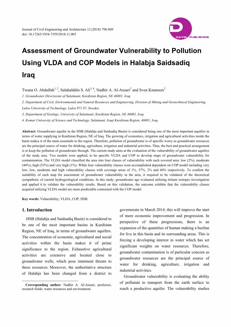
Table 1 Typ
Aquifer
Intergranular
Fissured aquif
Fissured-karst
Karstic-aquife
Non-aquifer (TAT)
Fig. 3 Hydro
sessment of
pe of aquifers i
aquifer (AIA)
fer (CFA)
tic aquifer (CK
er (TKA) and JK
aquiclude, aqui
ogeological ma
Groundwater
in the study ba
Form
QuatBalaKom
FA) AvroJura
KA AvroJura
itard and QulqShirTanj
ap of the HSB
r VulnerabilitSaidsa
asin.
mation
ternary depositambo metan oman ssic formationoman ssic qula anish jero
(modified from
ty to Pollutionadiq Basin, Ir
Thi
ts > 3
250
20080-20080-> 52252,00
m Abdullah et
n Using VLDAraq
ickness (m)
00
0
0 200
0 200 00
5 00
al. [5]).
A and COP M
R
A
A
Ja
Ja
B
Models in Hala
References
Abdullah et al. [
Ali [3]
assim and Goff
assim and Goff
Buday and Jassim
abja 801
6]
f [7]
f [7]
m [8]
1
Assessment of Groundwater Vulnerability to Pollution Using VLDA and COP Models in Halabja Saidsadiq Basin, Iraq
802
2. Methodology
Two different models have been applied with the
aid of GIS technique in order to map groundwater
vulnerability in the study area. The first applied model
is VLDA, predominantly it reflects lithology of
vadose zone (V), pattern of land use (L), groundwater
depth (D), and aquifer characteristics (A) [9]. In
addition, reliable weight can be assigned to each of the
four indexes depending on its impact on groundwater
vulnerability.
The vulnerability comprehensive assessment index
(DI) is the sum of the above-mentioned weighted four
indexes, as computed conferring to the following
formula:
DI= (WijRij)…………..(1) [9]
where, DI is the comprehensive assessment index, Wij
is the weight of the jth comprehensive assessment
index of the ith sub-system, Rij is the value of the jth
assessment index of the ith subsystem; 4 is the quantity
of indexes.
The lower the DI signifier to the lower vulnerability
of the groundwater system and the superior the
stability will be. To assess the groundwater
vulnerability, the new corresponding weights in HSB
were proposed using sensitivity analysis method [6].
Based on the result of sensitivity analysis, the proposed
weights used for VLDA model measured as 8.2, 4.8,
5.2 and 4.8, and after normalization, the weight is
0.357, 0.209, 0.226 and 0.209, respectively [10].
The second applied model is COP; its contraction
comes from the three initials of parameters namely
flow Concentration (C), Overly layers (O) and
Precipitation (P) [11]. The hypothetical basis of this
strategy, as indicated by the European Approach [12,
13], it is to evaluate the ordinary protection for
groundwater (O variable) controlled by the properties
of overly soils and the unsaturated zone, and also to
measure how this assurance can be adjusted by diffuse,
infiltration (C factor) and the climatic conditions (P
Factor – precipitation). The COP-index map was
computed from Eq. (2) [11]:
COP Index Map= C*O*P (2) [14]
3. Result and Conclusions
Subsequent to the weighted scores were achieved
for all parameters in each model, the GIS technique
was used to combine all layers. The vulnerability
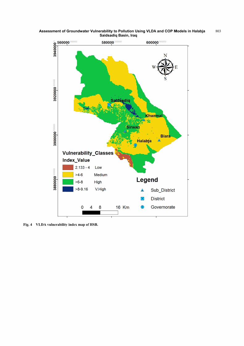
result based on VLDA model, illustrates that a total of
four ranges of vulnerability indexes had been
distinguished ranging from low on very high, with
vulnerability indexes (2.133-4, >4-6, >6-8 and > 8) as
shown in Fig. 4. The areas of low and very high
vulnerability zones occupy 2% and 1% of the whole
study area respectively. The high vulnerability classes
covered most of the mountains area that surrounding
the area of study and the central part of HSB. This
vulnerability zone covered an area of 53% of whole
area. Furthermore, medium vulnerability zones
covered an area of 44% of all studied area and
positioned southeast and northwest. Both high and
moderate classes that occupied most of the studied
basins refer to the exhaustive human activities, good
water yield property and lithological composition of
existed aquifers.
Four categories of vulnerability ranging from very
low to high are achieved according to the COP model
(Fig. 5). High vulnerability areas covering an area of
60% of the entire HSB, geologically include the
fissure zone and minor carbonate karstic rocks. While
the low vulnerability class comes in second place and
occupies 37% of the entire region, this region is
predominantly characterized by alluvial sediments.
The area with moderate and very low vulnerable
groups covers only 2% and 1% of the total area,
respectively.
Ass
Fig. 4 VLDA
sessment of
A vulnerability
Groundwater
y index map of
r VulnerabilitSaidsa
f HSB.
ty to Pollutionadiq Basin, Ir
n Using VLDAraq
A and COP MModels in Hala
abja 8033

Ass
804
Fig. 5 COP
4. Validati
The vulne
was evaluate
with the a
recharge ar
waters. Vari
from groun
estimate gro
tritium (un
radioactive
and two neu
sessment of
vulnerability i
ion of the R
erability of g
ed by compar
age of groun
re liable to
ious methods
ndwater age
oundwater m
nstable isotop
isotope of hy
utrons) with a
Groundwater
index map of H
Result
groundwater t
ring vulnerab
ndwater. Re
contaminatio
s endure for e
e. The meth
method in th
pes). Tritium
ydrogen (thr
half-life of (
r VulnerabilitSaidsa
HSB.
to contamina
bility index v
gions of re
on from sur
evaluation da
hod applied
his study is
m or 3H i
ough one pro
12.4) year [1
ty to Pollutionadiq Basin, Ir
ation
value
ecent
rface
ating
d to
the
is a
oton
5].
C
(trit
occ
(H)
ana
sam
out
valu
sam
aqu
aqu
n Using VLDAraq
Concentration
tium units)
currence of o
. In the pre
alyzed from o
mples from d
the groundw
ue of (4.8) T
mples were (4
uifers and (2.
uifers, respect
A and COP M
ns of tritium
where 1 T
ne tritium in
esent study,
one rain samp
different grou
water age. Ra
TU and a me
4.28) TU for
.28 and 3.03
tively (Table
Models in Hala
m are delibe
TU is descr
n 1018 atoms
tritium unst
ple and twent
undwater aqu
Rain sample h
ean value of
(CKFA, TK
3) TU for CF
5).
abja
erate in TU
ribed as the
of hydrogen
table isotope
ty water well
uifers to find
had a tritium
groundwater
A, and JKA)
FA and AIA
U
e
n
e
l
d
m
r
)
A
Assessment of Groundwater Vulnerability to Pollution Using VLDA and COP Models in Halabja Saidsadiq Basin, Iraq
805
There is no definite classification for age estimation
based on tritium results. While, Mckenzie et al. [16],
classified the age of groundwater samples by
classifying water as being modern and pre-bomb.
Tritium values of more than (0.3) TU are considered
as modern water (i.e. recharge after 1965) and values
smaller than or equal to (0.3) TU to considered to be
pre-bomb spikes to recharge (i.e. recharge before
1965). While [13] classified groundwater age as
follows:
<0.8 TU assigns sub-modern water (prior to
1950s);
0.8 to 5 TU assigns a mix of sub-modern and
modern water.
>5 to 15 TU assigns modern water (<5 to 10
years);
>15 to 30 TU assigns some bomb tritium;
>30 TU assigns recharge generate in the 1960s to
1970s.
Referring to both classifications, the tritium value,
Table 2 designates that the groundwater in the HSB is
modern or a mix of sub-modern and modern water. The
tritium data present approaching as to the mean
residence time of “old” versus “new” groundwater in
the HSB. The essential hypothesis for using
groundwater age to set up vulnerability is that
groundwater with a fairly rapid vertical transport rate
has a younger age. Since most contaminants exist near
the earth’s surface, younger groundwater is, therefore,
more vulnerable.
The results of tritium analysis exposed that
groundwater in the (CKFA, TKA and JKA) aquifers is
younger than in both (AIA and CFA), furthermore,
groundwater in the (AIA) aquifer is younger than (CFA)
as tritium value of AIA is higher than in CFA (Fig. 4).
Based on this classification, groundwater vulnerability
was assessed by comparing to the tritium (3H) value
and groundwater age. This approach scrutinizes the
comparison with a spatial pattern of variability of these
maps along with a common cross-section A-B (Fig. 6),
to observe the linear relationship between vulnerability
index value and groundwater tritium value. The results
show a better match between the patterns of the tritium
value of groundwater and vulnerability index value
Table 2 Results of tritium analysis of groundwater samples in the HSB.
Sample code Site 3H (TU) ± σ Average 3H Aquifer
ITB Banishar Mosques Well 4.7 ± 0.3
4.28 CKFA. TKA and JKA
ITB2 Basak Well 3.8 ± 0.3
ITJ Jalela Village Well 4 ± 0.3
ITS1 Saraw Swbhan Agha 4.5 ± 0.3
ITM Mzgawta 4 ± 0.3
ITSb SheraBara 4.3 ± 0.3
ITT2 Tawanawal 4.6 ± 0.3
ITD Darbarulla 4.3 ± 0.3
ITTh Halabaj Taymwr Hassan 3.3 ± 0.3
3.03
AIA
ITS Sirwan 2.3 ± 0.3
ITSs Shekhan Shanadactry Road Project 3.1 ± 0.3
ITSm Soila Mesh 3 ± 0.3
ITGs Gulajoy Saroo 3.2 ± 0.3
ITMh Mstakani Haji Ahmad 3 ± 0.3
ITT Taza De 3 ± 0.3
ITB3 Bezhawa 3.3 ± 0.3
ITX Kharpane Well 2.4 ± 0.3
2.28 ITBk Balkhay Khwaroo 2.3 ± 0.3
ITS2 Sargat 2.1 ± 0.3 CFA
ITBb Bani Bnok 2.3 ± 0.3
Ass
806
Fig. 6 Grou
sessment of
undwater age a
Groundwater
and tritium val
r VulnerabilitSaidsa
ue of aquifers
ty to Pollutionadiq Basin, Ir
at the HSB.
n Using VLDAraq
A and COP MModels in Hala
abja
Assessment of Groundwater Vulnerability to Pollution Using VLDA and COP Models in Halabja Saidsadiq Basin, Iraq
807
Fig. 7 Regression between COP model vs. tritium value for cross-section A-B.
Fig. 8 Regression between VLDA model vs. tritium value for cross-section A-B.
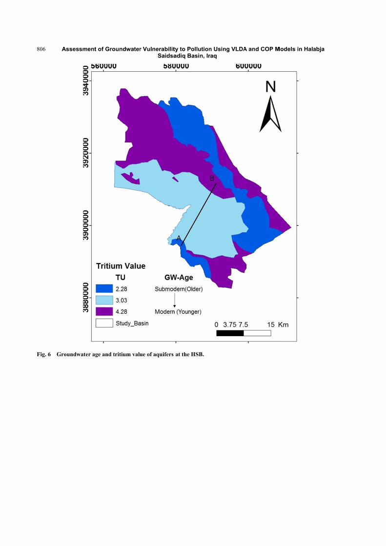
achieved from VLDA method compared to the COP
model (Figs. 7 and 8). Therefore based on this
verification, it can be concluded that the VLDA
vulnerability model reflects the real vulnerability
situation in the HSB.
5. Conclusion
Two different models specifically COP and VLDA
have been applied to assess the possible groundwater
vulnerability to pollution for the HSB. The value of
R² = 0.4596
0
0.5
1
1.5
2
2.5
3
3.5
4
4.5
0 0.5 1 1.5 2 2.5 3 3.5 4
Triti
um v
alue
(TU
)
Vulnerability Index value
R² = 0.7595
0
0.5
1
1.5
2
2.5
3
3.5
4
4.5
0 1 2 3 4 5 6 7 8 9
Triti
um v
alue
(TU
)
Vulnerability Index value
Assessment of Groundwater Vulnerability to Pollution Using VLDA and COP Models in Halabja Saidsadiq Basin, Iraq
808
the VLDA indexes ranged from 2.133-9.16, and the
value of the COP indexes ranged from 0.79-6.2. The
elevated index value of the VLDA models refers to
the higher class of vulnerability, whilst the value of
the lesser index value of the COP model refers to the
higher rate of vulnerability.
COP model comprises (very low to high), while
VLDA model embraces (low to very high)
vulnerability classes. The remarkable disparity has
been achieved from both applied models, therefore the
outcome desirable to be validated. A ground-water age
was applied to assess the vulnerability of groundwater
to contamination. Areas of recent recharge are
vulnerable to contamination from surface recharges.
Rain water sample had a tritium value of 4.8 TU and a
mean value of groundwater samples was 4.28 TU for
CKFA, TKA, and JKA aquifers and 2.28 and 3.03 TU
for CFA and AIA aquifers respectively. This approach
examines the relationship between the spatial
distribution of variability index value and
groundwater age. The results show a better match
between the patterns of the tritium value of
groundwater and the vulnerability index values
achieved from VLADA model rather than COP model,
because R2 value achieved from this relation by
applying VLDA model is about 0.75 while for COP
model is about 0.45, the closer of the value of
R-squared on the graph to 1.0, confirm the better the
fit of the regression line. This validation confirmed
that the VLDA vulnerability model reflects the real
vulnerability situation in the HSB compared to the
COP model.
References
[1] Mendoza, J. A., and Barmen, G. 2006. “Assessment of Groundwater Vulnerability in the Rio Artiguas Basin, Nicaragua.” Environmental Geology 50: 569-80.
[2] Attoui, B., Kherci, N., and Bousnoubra, H. 2012. “State of Vulnerability to Pollution of the Big Reservoirs of Groundwater in the Region of Annaba-Bouteldja (NE Algeria).” Geographia Technica 2: 1-13.
[3] Ali, S. S. 2007. “Geology and Hydrogeology of Sharazoor-Piramagroon Basin in Sulaimani Area,
Northeastern Iraq.” Unpublished Ph.D. thesis, Faculty of Mining and Geology, University of Belgrade, Serbia.
[4] Statistical Directorate in Sulaimaniyah. 2014. “Population of Halabja Saidsadiq Cities.” Archive Department.
[5] Abdullah, T. O., Ali, S. S., Al-Ansari, N. A., and Knutsson, S. 2015a. “Effect of Agricultural Activities on Groundwater Vulnerability: Case Study of Halabja Saidsadiq Basin, Iraq.” Journal of Environmental Hydrology 23 (10): 1-20.
[6] Abdullah, T. O., Ali, S. S., Al-Ansari, N. A., and Knutsson, S. 2015b. “Vulnerability of Groundwater to Pollution Using Three Different Models in Halabja Saidsadiq Basin, Iraq.” European Water 57: 353-9.
[7] Jassim, S. Z., and Guff, J. C. 2006. “Geology of Iraq.” In D. G. Geo Survey, edited by Jassim, S. Z. Min. Invest. Publication, 340.
[8] Buday, T., and Jassim, S. 1987. “The Regional Geology of Iraq: Tectonis, Magmatism, and Metamorphism.” In Stratigraphy, edited by Kassab, I. I., and Abbas, M. J. Baghdad: State Establishment of Geological Survey and Minieral Investigations, 445.
[9] Zhou, J., Lim Q., Guo, Y., Guo, X., Li, X., Zhoa, Y., and Jia, R. 2012. “VLDA Model and Its Application in Assessing Phreatic Groundwater Vulnerability: A Case Study of Phreatic Groundwater in the Plain Area of Yanji County, Xinjiang, China.” Environmental Earth Science Journal 67: 1789-99.
[10] Abdullah, T. O., Ali, S. S., Al-Ansari, N. A., and Knutsson, S. 2016a. “Assessing the Vulnerability of Groundwater to Pollution Using DRASTIC and VLDA Models in Halabja Saidsadiq Basin, NE—Iraq.” Journal of Civil Engineering and Architecture 10: 1144-59. doi: 10.17265/1934-7359/2016.10.006.
[11] Abdullah, T. O., Ali, S. S., Al-Ansari, N. A., and Knutsson, S. 2016b. “Groundwater Vulnerability Using DRASTIC and COP Models: Case Study of Halabja Saidsadiq Basin, Iraq.” Engineering 8: 741-60. http://www.scirp.org/journal/PaperInformation.aspx?PaperID=71681.
[12] Daly, D., Dassargues, A., Drew, D., Dunne, S., Goldscheider, N., Neale, S., Popescu, C., and Zwhalen, F. 2002. “Main Concepts of the ‘European Approach’ for (Karst) Groundwater Vulnerability Assessment and Mapping.” Hydrogeol J 10 (2): 340-5.
[13] Goldscheider, N., and Popescu, C. 2004. “The European Approach.” In Vulnerability and Risk Mapping for the Protection of Carbonate (Karst) Aquifers, edited by Zwahlen, F. Brussels: European Commission, 17-21.
[14] Vias, J. M., Andreo, B., Perles, M. J., Carrasco, I., Vadillo, P., and Jim’enez, P. 2006. “Proposed Method for Groundwater Vulnerability Mapping in Carbonate (Karstic) Aquifers: The COP Method. Application in

Assessment of Groundwater Vulnerability to Pollution Using VLDA and COP Models in Halabja Saidsadiq Basin, Iraq
809
Two Pilot Sites in Southern Spain.” Hydrogeology Journal 14: 912-25. doi: 10.1007/s10040-006-0023-6.
[15] Kumar, P. R., and Somashekar, R. K. 2011. “Environmental Tritium and Hydrochemical Investigations to Evaluate Groundwater in Varahi and Markandeya River Basins, Karnataka, India.” Journal of
Environmental Radioactivity 102: 153-62. [16] Mckenzie, J. M., Mark, B. G., Thompson, L. G.,
Schotterer, U., and Lin, P.-N. 2010. “A Hydrogeochemical Survey of Kilimanjaro (Tanzania): Implications for Water Sources and Ages.” Hydrogeology Journal 18: 985-95.


![Finale 2005a - [Untitled1]h).pdf · 2014-02-18 · 4 4 4 4 4 4 4 4 4 4 4 4 4 4 4 4 4 4 4 4 4 4 4 4 4 4 4 4 4 4 4 4 4 4 4 4 4 4 4 4 4 4 4 4 4 4 4 4 4 4 Picc. Flutes Oboe Bassoon Bb](https://static.fdocuments.us/doc/165x107/5b737b707f8b9a95348e2e6f/finale-2005a-untitled1-hpdf-2014-02-18-4-4-4-4-4-4-4-4-4-4-4-4-4-4.jpg)