Assessment of environmental water requirements for the ...€¦ · Web viewThe Water Act 2007...
42
Transcript of Assessment of environmental water requirements for the ...€¦ · Web viewThe Water Act 2007...

Published by Murray-Darling Basin Authority
Postal Address GPO Box 1801, Canberra ACT 2601
Office location Level 4, 51 Allara Street, Canberra City
Australian Capital Territory
For further information contact the Murray-Darling Basin Authority office
Telephone (02) 6279 0100 international + 61 2 6279 0100
Facsimile (02) 6248 8053 international + 61 2 6248 8053
E-Mail [email protected]
Internet http://www.mdba.gov.au
MDBA Publication No: 22/12
ISBN: 978-1-922068-30-9 (online)
© Murray–Darling Basin Authority for and on behalf of the Commonwealth of Australia, 2012.
With the exception of the Commonwealth Coat of Arms, the MDBA logo, all photographs, graphics and trademarks, this publication is provided under a Creative Commons Attribution 3.0 Australia Licence.
http://creativecommons.org/licenses/by/3.0/au
The MDBA’s preference is that you attribute this publication (and any material sourced from it) using the following wording:
Title: Assessment of environmental water requirements for the proposed Basin Plan: Gunbower-Koondrook-Perricoota Forest
Source: Licensed from the Murray–Darling Basin Authority, under a Creative Commons Attribution 3.0 Australia Licence.
The MDBA provides this information in good faith but to the extent permitted by law, the MDBA and the Commonwealth exclude all liability for adverse consequences arising directly or indirectly from using any information or material contained within this publication.
Australian Government Departments and Agencies are required by the Disability Discrimination Act 1992 (Cth) to ensure that information and services can be accessed by people with disabilities. If you encounter accessibility difficulties or the information you require is in a format that you cannot access, please contact us.

Murray Region
Assessment of Gunbower-Koondrook-Perricoota Forest environmental water requirements
1. Introduction
The Water Act 2007 (Cwlth) established the Murray Darling Basin Authority (MDBA) and tasked it with‐ the preparation of a Basin Plan to provide for the integrated management of the Basin’s water resources. One of the key requirements of the Basin Plan is to establish environmentally sustainable limits on the quantities of surface water that may be taken for consumptive use, termed Sustainable Diversion Limits (SDLs). SDLs are the maximum long term annual average volumes of water that can be‐ taken from the Basin and they must represent an Environmentally Sustainable Level of Take (ESLT).
The method used to determine the ESLT is described in detail within ‘The proposed “environmentally sustainable level of take” for surface water of the Murray-Darling Basin: Method and Outcomes,’ (MDBA 2011). A summary of the main steps undertaken to determine the ESLT is presented in Figure 1. The assessment of environmental water requirements including specification of site-specific flow indicators at a subset of hydrologic indicator sites (Step 3 of the overall ESLT method) is the focus of this document.
The work described herein is the MDBA’s current understanding of the environmental water requirements of Gunbower-Koondrook-Perricoota Forest. It is not expected that the environmental water requirements assessments will remain static, rather it is intended that they will evolve over time in response to new knowledge or implementation of environmental watering actions. Within this context, feedback is sought on the material presented within this document whether that be as part of the formal draft Basin Plan consultation phase or during the environmental watering implementation phase within the framework of the Environmental Watering Plan.
1.1. Method to determine site-specific flow indicators
Assessment of environmental water requirements for different elements of the flow regime using the hydrologic indicator site approach is one of the key lines of evidence that has informed the proposed SDLs. Effort focussed on regions and parts of the flow regime with greatest sensitivity to the scale of reduction in diversions necessary to achieve environmental objectives, an ESLT and a healthy working Basin.
Within the overall framework of the ESLT method (Figure 1) the MDBA used an iterative process to assess environmental water requirements and develop site-specific flow indicators.
The hydrologic indicator site approach uses detailed eco-hydrological assessment of environmental water requirements for a subset of the key environmental assets and key ecosystem functions across the Basin. Effort focused on high flow (freshes, bankfull flows and overbank flows) requirements reflecting the prioritisation of effort on parts of the flow regime that are most sensitive to the determination of the ESLT and SDLs. Gunbower-Koondrook-Perricoota Forest is one of the key environmental assets where a detailed assessment of environmental water requirements was undertaken.
1

Figure 1: Outline of method used to determine an Environmentally Sustainable Level of Take (Source: MDBA 2011).
Detailed environmental water requirement assessments lead to the specification of site-specific flow indicators to achieve site-specific ecological targets. Flow indicators were expressed at a hydrologic indicator site or sites. Environmental water requirements specified at hydrologic indicator sites are intended to represent the broader environmental flow needs of river valleys or reaches and thus the needs of a broader suite of ecological assets and functions.
2

This report provides a description of the detailed eco-hydrological assessment of environmental water requirements for the Gunbower-Koondrook-Perricoota Forest including information supporting the development of site-specific flow indicators for the site (with reference to flows gauged on the River Murray downstream of Torrumbarry Weir). More information on how the site-specific flow indicators for Gunbower-Koondrook-Perricoota Forest were used within the Basin-wide modelling process to inform the ESLT (i.e. Step 5 and 6 in Figure 1) can be found in the report ‘Hydrologic modelling to inform the proposed Basin Plan: Methods and results’ (MDBA 2012).
A description of the detailed eco-hydrological assessments of environmental water requirements for other indicator sites are described in other documents in the series ‘Assessment of environmental water requirements for the proposed Basin Plan’.
1.2. Scope and purpose for setting site-specific flow indicators
The MDBA’s assessment of environmental water requirements and associated site-specific flow indicators at hydrologic indicator sites has been used to inform the development of SDLs. This enables the MDBA to estimate the amount of water that will be required by the environment over the long-term to achieve a healthy working Basin through the use of hydrological models. Accordingly, site-specific flow indicators are not intended to stipulate future use of environmental water. MDBA expects that the body of work undertaken to establish these site-specific flow indicators will provide valuable input to environmental watering but this watering will be a flexible and adaptive process guided by the framework of the Environmental Watering Plan and natural eco-hydrological cues. It will be up to the managers of environmental water, such as the Commonwealth Environmental Water Holder, State Government agencies, and local communities to decide how best to use the available environmental water during any one year to achieve environmental outcomes.
2. Site location and extent
The Gunbower–Koondrook–Perricoota Forest covers approximately 51,000 ha of the River Murray floodplain downstream of Torrumbarry Weir, between Echuca and Barham (Figure 2). Gunbower Forest is on the Victorian side of the River Murray and Koondrook–Perricoota Forest is on the New South Wales side. For the purpose of determining environmental water requirements, the forests are treated as one asset because experience overbank flows under similar conditions.
The boundary of the Gunbower–Koondrook–Perricoota Forest hydrologic indicator site adopted by the MDBA is the same as the one delineated in the Ramsar wetlands of Australia dataset. Spatial data used in Figure 2 are listed in Appendix A.
3

Figure 2 Location and extent of Gunbower–Koondrook–Perricoota Forest key environmental asset. Flow indicators are specified at River Murray downstream of Torrumbarry Weir.
4

3. Ecological Values
Gunbower and Koondrook-Perricoota Forests are both listed as Ramsar wetlands of international importance. The forests are also an icon site under The Living Murray program.
Gunbower Forest and Koondrook–Perricoota Forest differ in structure. Gunbower Forest has more permanent and semi-permanent wetlands, partly as a result of a lower commence-to-flow threshold, and also because of its different geomorphology. Gunbower’s wetlands are interconnected by a series of flood runners, and surrounded by river red gum (Eucalyptus camaldulensis) forest, river red gum woodlands and black box (E. largiflorens) and grey box (E. moluccana) woodlands. Koondrook–Perricoota Forest is predominantly a river red gum forest, dissected by intermittent flood runners. Black and grey box woodlands fringe the river red gum forest on the higher, less frequently flooded areas. Areas of these habitat types in Gunbower and Koondrook–Perricoota forests are shown in Table 1.
Table 1 Habitat types and areas for Gunbower–Koondrook–Perricoota Forest (Source: compiled from unpublished data on The Living Murray icon site provided by the Victorian Department of Sustainability and Environment and NSW Department of Primary Industries (Forests NSW)).
Habitat types Gunbower
total area (ha)
Koondrook–Perricoota
total area (ha)
Permanent wetlands 381 0
Semi-permanent wetlands 992 1,700
River red gum (flood-dependent understorey) 8,423 19,000
River red gum (flood-tolerant understorey) 4,509 7,000
Black box woodland 3,126 4,000
Other 1,768 300
All types 19,200 32,000
Regulation of the River Murray has significantly reduced the frequency, duration and extent of medium to large floods, which are essential to maintain the health and biodiversity of the forests and floodplains (MDBC 2006). The condition of the Koondrook–Perricoota Forest has been reported to have declined significantly under the influence of the cumulative impacts of river regulation, coupled with drought (GHD 2009). Modelling of tree health shows the Gunbower Forest portion of the site has experienced a decline in condition of river red gum and black box communities (80% ‘stressed’ condition), although to a lesser degree than the Koondrook–Perricoota section (95% ‘stressed’ condition) (Cunningham et al. 2009).
5

In addition, the potential for Gunbower–Koondrook–Perricoota Forest to support colonial nesting waterbird breeding has decreased in response to declining flood frequencies and durations (MDBC 2006).
Irrespective of the observed decline in ecological condition, the Gunbower–Koondrook–Perricoota Forest still support important habitat and species that are listed in international agreements such as Ramsar, and include vulnerable and endangered species. Appendix B provides a summary of the conservationally significant species recorded at the site.
The ecological values of the Forest are reflected in MDBA’s assessment against the criteria used to identify key environmental assets within the Basin. The MDBA established five criteria to identify assets based on international agreements and broad alignment with the National Framework and Guidance for Describing the Ecological Character of Australian Ramsar Wetlands (Department of the Environment, Water, Heritage and the Arts 2008) and the draft criteria for identifying High Conservation Value Aquatic Ecosystems (SKM 2007).
Based on the ecological values identified at the Gunbower-Koondrook-Perricoota Forest, the site meets all five key environmental asset criteria (Table 2).
Table 2 Assessment of the Gunbower–Koondrook–Perricoota Forest against MDBA key environmental asset criteria.
Criterion Ecological values that support the criterion
1. The water-dependent ecosystem
is formally recognised in
international agreements or, with
environmental watering, is
capable of supporting species
listed in those agreements.
The Gunbower–Koondrook–Perricoota Forest is formally recognised in, or is capable of supporting species listed in, the Japan–Australia Migratory Bird Agreement, the China–Australia Migratory Bird Agreement or the Republic of Korea–Australia Migratory Bird Agreement. The entire hydrologic indicator site is listed, in two parts, as a Ramsar wetland of international importance:
Gunbower Forest on the Victorian side of the River Murray; and
Koondrook–Perricoota Forest on the New South Wales side of the River Murray (part of the broader New South Wales Central Murray State Forests Ramsar site).
Species listed in international agreements that have been recorded at Gunbower–Koondrook–Perricoota Forest are in Appendix B.
2. The water-dependent ecosystem
is natural or near-natural, rare or
unique
The NSW Central Murray State Forests Ramsar site, which comprises the New South Wales section of the Gunbower–Koondrook-Perricoota Forest, together with Barmah–Millewa and the Werai Forest, forms the largest complex of tree-dominated floodplain wetlands in southern Australia and is the world’s largest parcel of river red gum forest (GHD 2009).
3. The water-dependent ecosystem
provides vital habitat
Koondrook–Perricoota Forest provides refuge for mobile and sedentary fauna during environmentally stressful periods (e.g. drought) (GHD 2009). It also provides sources of migrants capable of dispersing into less productive areas during favourable conditions, as it is an area of comparatively high water availability and habitat productivity in a semi-arid rainfall zone (GHD 2009).
The lower elevations of the Gunbower Forest support permanent and semi-permanent wetlands where water can be retained for long periods, forming valuable habitat for fish, frogs and waterfowl (including breeding habitat for colonial nesting waterbirds). Permanent wetlands also provide important refuge in droughts (MDBC 2006).
4. Water-dependent ecosystems
that support Commonwealth,
Species and communities listed as threatened under both Commonwealth and state legislation that have been recorded at the site are in Appendix B.
6

Criterion Ecological values that support the criterion
State or Territory listed
threatened species or
communities
5. The water-dependent ecosystem
supports, or with environmental
watering is capable of
supporting, significant
biodiversity
More than 210 species of native flora and 143 species of native fauna have been recorded at Gunbower Forest (MDBC 2006).
Together with the adjacent Ramsar sites in Victoria (e.g. Barmah–Millewa), the NSW Central Murray State Forests regularly support more than 20,000 waterbirds (GHD 2009), including the only breeding colony of intermediate egret (Egretta intermedia) in Victoria (MDBC 2006). In addition, the Gunbower Forest Ramsar site provides important feeding, resting and breeding habitat for more than 22 waterbird species. The site maintains the ecological diversity of the bioregion by supporting vegetation communities representative of the Victorian Murray Fans Bioregion, a component of the Riverina Interim Biogeographic Regionalisation for Australia bioregion (Ecological Associates 2006a).
4. Hydrology
Flows in the River Murray through the Gunbower–Koondrook–Perricoota Forest are heavily influenced by Barmah Choke and flows from the Goulburn River. The natural topography and geomorphology of the landscape direct water that enters Koondrook–Perricoota Forest northward (Figure 2). Specifically, overbank flows from the Murray into Koondrook-Perricoota Forest travel via a network of watercourses into the Edward–Wakool River system and then back to the River Murray further downstream at the Wakool-River Murray junction, bypassing this stretch of the River Murray. In large floods a high proportion of water flows in this direction; while flows in the River Murray at Torrumbarry Weir, which is located at the upstream end of Gunbower-Koondrook-Perricoota Forest complex, do not exceed about 60,000 ML/d even in the biggest floods (e.g. approximately 50,000 ML/d peak flow during 2010 floods). Flood flows at Gunbower and Koondrook–Perricoota Forests therefore depend heavily on flows from the Goulburn River.
Flows begin to enter Gunbower Forest from the River Murray via a number of effluent streams, with the lowest flow threshold at Shillinglaws Regulator on Yarran Creek, which commences to flow at 13,700 ML/d. Flooding of the Gunbower wetlands is initiated at 15,200 ML/d (Ecological Associates 2006a; Ecological Associates 2006b). Water enters Koondrook Forest when flow in the River Murray exceeds 16,000 ML/d via the two inflow effluents to Swan Lagoon (GHD 2009). Other Gunbower Forest effluents begin to flow between 15,000 and 27,800 ML/d, filling wetlands within the lower and mid-forest. Bankfull flows in the River Murray occur at about 30,000 ML/d with corresponding widespread flooding of river red gum forests in both Gunbower Forest and Koondrook-Perricoota Forest occurring at flows of 30,000 ML/d and above (Ecological Associates 2006a; GHD 2009).
Since the advent of river regulation, the Gunbower–Koondrook–Perricoota Forest has received substantially less flooding in terms of timing, duration and frequency (Ecological Associates 2006a; GHD 2009). CSIRO (2008) found that as a result of water resource development, both the average and maximum period between beneficial spring-summer floods has more than doubled (average period between events increased from 1.7 to 3.8 years; maximum period between events increased from 4.8 to 11.8 years). Flood volumes have also been greatly reduced, such that the average annual flood
7

volume is now less than a fifth of the volume under without development conditions (from 680 to 118 GL). River regulation has been implicated in the steady decline of ecosystem health of the NSW Central Murray State Forests over the past 75 years (GHD 2009).
5. Determining the site-specific flow indicators for the Gunbower–Koondrook–Perricoota Forest
5.1. Setting site-specific ecological targets
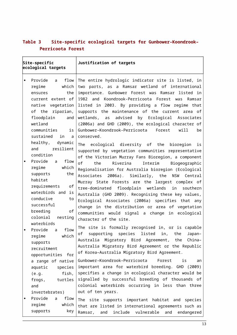
The objective setting framework used to determine the ESLT is outlined in the report ‘ The proposed “environmentally sustainable level of take” for surface water of the Murray-Darling Basin: Method and Outcomes’ (MDBA 2011). In summary, the MDBA developed a set of Basin-wide environmental objectives and ecological targets, which were then applied at a finer scale to develop site-specific objectives for individual key environmental assets. Using these site-specific objectives, ecological targets that relate specifically to the Gunbower-Koondrook-Perricoota Forest were developed (Table 3). Information underpinning site-specific ecological targets is shown in Table 3.
Site-specific ecological targets formed the basis of an assessment of environmental water requirements and the subsequent determination of site-specific flow indicators for the Gunbower-Koondrook-Perricoota Forest, as described below.
8
Table 3 Site-specific ecological targets for Gunbower–Koondrook–Perricoota Forest
Site-specific ecological targets Justification of targets
Provide a flow regime which ensures the current extent of native vegetation of the riparian, floodplain and wetland communities is sustained in a healthy, dynamic and resilient condition
Provide a flow regime which supports the habitat requirements of waterbirds and is conducive to successful breeding of colonial nesting waterbirds
Provide a flow regime which supports recruitment opportunities for a range of native aquatic species (e.g. fish, frogs, turtles and invertebrates)
Provide a flow regime which supports key ecosystem functions, particularly those related to connectivity between the river and the floodplain
The entire hydrologic indicator site is listed, in two parts, as a Ramsar wetland of international importance. Gunbower Forest was Ramsar listed in 1982 and Koondrook-Perricoota Forest was Ramsar listed in 2003. By providing a flow regime that supports the maintenance of the current area of wetlands, as advised by Ecological Associates (2006a) and GHD (2009), the ecological character of Gunbower–Koondrook–Perricoota Forest will be conserved.
The ecological diversity of the bioregion is supported by vegetation communities representative of the Victorian Murray Fans Bioregion, a component of the Riverina Interim Biogeographic Regionalisation for Australia bioregion (Ecological Associates 2006a). Similarly, the NSW Central Murray State Forests are the largest complex of tree-dominated floodplain wetlands in southern Australia (GHD 2009). Recognising these key values, Ecological Associates (2006a) specifies that any change in the distribution or area of vegetation communities would signal a change in ecological character of the site.
The site is formally recognised in, or is capable of supporting species listed in, the Japan–Australia Migratory Bird Agreement, the China–Australia Migratory Bird Agreement or the Republic of Korea–Australia Migratory Bird Agreement.
Gunbower–Koondrook–Perricoota Forest is an important area for waterbird breeding. GHD (2009) specifies a change in ecological character would be signalled by successful breeding of thousands of colonial waterbirds occurring in less than three out of ten years.
The site supports important habitat and species that are listed in international agreements such as Ramsar, and include vulnerable and endangered species such as Murray cod (Maccullochella peelii peelii) and Murray hardyhead (Craterocephalus fluviatilis). Achieving the targets for floodplain wetlands and waterbirds will ensure inundation of breeding and feeding habitats considered key for a range of fish, amphibian and water-dependent reptile and invertebrate species.
Key ecosystem functions support fish, birds and invertebrates through habitat maintenance, energy transfer and facilitating connections between rivers and floodplains. Overbank flows supply the floodplains with nutrients and sediments from the river, accelerate the breakdown of organic matter and supply water to disconnected wetlands, billabongs and oxbow lakes. As the floodwaters recede, the floodplains provide the main river channel with organic matter.
The hydrological connection between watercourses and their associated floodplain provides for the exchange of carbon and nutrients (Thoms 2003). The connections are considered essential for the functioning and integrity of floodplain-river ecosystems.
9

5.2. Information used to determine site-specific flow indicators
5.2.1. Vegetation
The flood regime (regularity, extent, duration and season of flooding) is a key determinant of the ecological character and vegetation associations of the Gunbower–Koondrook–Perricoota Forest (Ecological Associates 2006a; GHD 2009). The development of site-specific flow indicators to achieve the site specific ecological targets focused on assessment of the bankfull and overbank elements of the flow regime necessary to maintain flood dependent vegetation communities. These flood dependent vegetation communities are a critical component of the sites ecological character and have experienced decline as a result of water resource development alterations to the natural hydrology (GHD 2009).
A number of documents have been assessed to determine the flows required to achieve the site-specific ecological targets, as described below. However, it was found that no single existing plan or document sets out these requirements completely. The Gunbower–Koondrook–Perricoota Forest Icon Site Environmental Management Plan 2006-2007 (MDBC 2006) and the Gunbower Forest ecological character description (Ecological Associates 2006a) sets out water requirements in terms of flood frequencies and durations for selected vegetation communities. These are presented in Table 4 and Figure 3.
Table 4 Water requirements of selected vegetation communities for Gunbower–Koondrook–Perricoota Forest (Source: Ecological Associates 2006a; MDBC 2006).
Habitat type Flood frequency Inundation duration
Season
Permanent wetlands 10 years in 10 7–12 months Winter/spring persisting for 12 months in nearly all years
Semi-permanent wetlands 6–9 years in 10 5–8 months Winter/spring to early summer
River red gum forest with flood-dependent understorey
7–9 years in 10 4 months (range of 1 to 8 months)
Winter/spring
River red gum woodland with flood-tolerant understorey
3 years in 10 (range of 1–4 years)
2.5 months (range of 1 to 4 months
Spring
Black box woodland 1 year in 10 (range of 1 to 4 years)
1 month (range of 1 to 4 months)
Spring
10

Figure 3 Flooding requirements of selected vegetation communities for Gunbower–Koondrook–Perricoota Forest (Source: based on Ecological Associates 2006a).
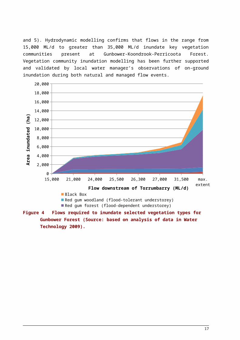
Data presented in hydrodynamic modelling reports (NSW Department of Environment and Climate Change 2008; Water Technology 2009) have been used as another key source of information to estimate flows needed to inundate the current extent of the riparian, floodplain and wetland communities and support key ecosystem functions associated with improved connectivity between the river and its floodplain (Figures 4 and 5). Hydrodynamic modelling confirms that flows in the range from 15,000 ML/d to greater than 35,000 ML/d inundate key vegetation communities present at Gunbower-Koondrook-Perricoota Forest. Vegetation community inundation modelling has been further supported and validated by local water manager’s observations of on-ground inundation during both natural and managed flow events.
11

15,000 21,000 24,000 25,500 26,300 27,000 31,500 max. extent0
2,000
4,000
6,000
8,000
10,000
12,000
14,000
16,000
18,000
20,000
Black Box Red gum woodland (flood-tolerant understorey)Red gum forest (flood-dependent understorey) Semi-permanent wetlandsPermanent wetlands
Flow downstream of Torrumbarry (ML/d)
Are
a in
unda
ted
(ha)
Figure 4 Flows required to inundate selected vegetation types for Gunbower Forest (Source: based
on analysis of data in Water Technology 2009).
10,000 15,000 20,000 25,000 30,000 35,000 40,0000%
20%
40%
60%
80%
100%
0
5,000
10,000
15,000
20,000
25,000
30,000
Flow at Torrumbarry (ML/d)
Prop
ortio
n si
te in
unda
ted
(%)
Are
a of
inun
datio
n (h
a)
Figure 5 Relationship between inundation and flow for Koondrook–Perricoota Forest (Source: based on analysis of data in NSW Department of Environment and Climate Change 2008).
12

5.2.2. Waterbirds
A variety of information sources have been used to inform development of site-specific flow indicators to achieve the ecological target of providing a flow regime which supports the habitat requirements of waterbirds and is conducive to successful breeding of colonial nesting waterbirds (Ecological Associates 2006a; MDBC 2006; GHD 2009; Overton et al. 2009).
Overton et al. (2009) suggests that for successful breeding, colonial nesting waterbirds require 4–5 months of flooding in total, taking into account provision of breeding cues and time needed to lay and incubate eggs and fledge young. Overton et al. (2009) has been used to inform the water requirements of colonial nesting waterbirds within Gunbower–Koondrook–Perricoota Forest in terms of duration.
Flows of 20,000 ML/d inundate large areas of permanent and semi-permanent wetlands (Water Technology 2009) that provide the shifting spatial and temporal mosaic of wetland inundation required for successful waterbird breeding (Overton et al. 2009). Ecological Associates (2006a) have suggested that to support large populations of waterbirds, flows exceeding 30,000 ML/d, which inundate all of the wetland habitat and extensive areas of forest, are needed. Similarly, MDBC (2006) identifies permanent and semi-permanent wetlands and river red gum forest with flood-dependent understorey as essential habitat for colonial nesting waterbirds. MDBA analysis of modelled without development flow data shows that flows of 20,000 ML/d for five months are regularly associated with shorter duration higher flow peaks that would inundate large areas of river red gum forest. These flows peaks are likely to provide healthy, productive foraging and nesting habitat, important for successful colonial nesting waterbird breeding.
Two key factors dictate that waterbirds do not need to breed every year on the same river system (Scott 1997). Firstly, Australian waterbirds are highly mobile and their mobility over large spatial scales is a defining characteristic (Scott 1997; Overton et al. 2009). Most of the 80 odd species of (non-vagrant) Murray-Darling Basin waterbirds that use inland wetlands have broad Australia-wide distributions and it is believed that individuals of most species are capable of dispersing at the scale of the continent (Overton et al. 2009). As such, prior to river regulation at least some individuals of the more mobile waterbird species have would have been able to seek suitable conditions for successfully breeding somewhere within the Basin in most years (Scott 1997).
Secondly, it is not essential for waterbirds to breed every year to maintain sustainable populations as they are generally long-lived (Scott 1997). Waterbirds become sexually mature at the age of one to two years and have a life expectancy ranging generally from 3-4 years for ducks, up to 8 years for larger birds such as ibis (Scott 1997).
These two key factors have informed the frequency of events for site-specific flow indicators intended to support the habitat requirements of waterbirds, including provision of conditions conducive to successful breeding of colonial nesting waterbirds. Specifically, it is desirable to provide multiple opportunities for successful waterbird breeding within the range of their life expectancy. The proposed successful breeding of colonial nesting waterbirds at Gunbower–Koondrook–Perricoota Forest in at least three years out of ten to maintain the ecological character of the site (MDBC 2006; GHD 2009) and adopted here is consistent with this rationale.
5.2.3. Other biota
There are numerous studies concerning the water dependent vegetation communities and needs of‐ colonial nesting waterbirds of the Gunbower–Koondrook–Perricoota Forest. The understanding of
13
flow ecology relationships of other faunal groups is generally less well understood as there are fewer‐ studies undertaken for these species. The MDBA is confident that the site specific flow indicators‐ determined to achieve the ecological targets relating to the current extent of native vegetation communities and the habitat requirements for waterbirds will also have valuable beneficial effects on the life cycle and habitat requirements of native fish, amphibians, and water dependent reptiles and‐ ‐ invertebrates.
There is still debate in the scientific literature as to the relative role of flooding to fish community dynamics, and an understanding of the nature of ‘fish ecology’ ‘river flow’ interactions is by no means‐ clear (Humphries et al. 1999, Mallen Cooper and Stuart 2003, Graham and Harris 2004; King et al.‐ 2009). For example, it has been suggested that some fish species, such as the conservationally significant Silver perch (Bidyanus bidyanus), which have been recorded at Gunbower–Koondrook–Perricoota Forest, require flow pulses or floods for spawning i.e. flood recruitment hypothesis (Humphries et al. 1999). Other factors such water temperature and day length, or the interaction of a range of environmental variables including flow, are suggested to also be important for native fish recruitment (King et al. 2009).
Despite the ongoing debate regarding the link between hydrology and fish ecology, available evidence supports that provision of flows that connect the river channel to the floodplain as well as in channel‐ flow variability are important to sustaining key ecological features such as native fish populations. Flow indicators described herein for the bankfull and overbank elements of the flow regime primarily based on the water requirements of flood dependent vegetation communities and waterbirds are expected to be sufficient to support life cycle and habitat requirements of native fish including provision of cues‐ for spawning and migration and access to food sources.
5.2.4. Environmental works
Environmental works at Gunbower-Koondrook-Perricoota Forest (built, under construction and/or proposed as part of the Living Murray Program) could assist with meeting environmental outcomes through the delivery of water through works instead of through the delivery of high flows. For example, works will be able to be used to extend the duration of flooding in parts of both the Gunbower and Koondrook-Perricoota Forests (i.e. those parts within the command of the works, which is a significant amount of this river reach).
The effect of using the works both at this site and for the broader River Murray environmental assets needs further assessment and consideration of the trade-offs: Gunbower-Koondrook-Perricoota Forest may be able to be managed with less water to meet many of the same outcomes but if flows associated with outcomes that can be delivered by works are removed this could be detrimental to achieving environmental outcomes at sites outside of the command of the works. As such, the MDBA has not currently reworked the flow indicators to take account of the works being built at Gunbower-Koondrook-Perricoota Forest. The implications of doing this, including tradeoffs with other parts of the river, needs further assessment and will input into a future Basin Plan review.
5.3.Proposed flow indicators
Based on the hydrology described in Section 4 and the environmental water requirements described in Sections 5.1 and 5.2, the MDBA has proposed five flow indicators for Gunbower-Koondrook-Perricoota Forest (Table 5). The site-specific flow indicators for Gunbower-Koondrook-Perricoota Forest represent an amalgam of information within existing literature and vegetation inundation hydrodynamic
14

modelling data, checked against analysis of modelled without development and baseline flow data. Site-specific flow indicators are expressed at River Murray downstream of Torrumbarry Weir, which generally represents the flow into the Gunbower-Koondrook-Perricoota Forest.
Flow indicators as specified for the bankfull and overbank elements of the flow regime attempt to strike a balance between desirable frequency (e.g. as described in Table 4) and desirable flow threshold, duration and timing using the without development hydrology of the site as a guide. Where a discrepancy exists between literature and inundation / hydrology modelling, an analysis of modelled without development flows has been used to guide the determination of site-specific flow indicators, particularly to ensure that the recommended flows are achievable and not greater than without development flows.
The site-specific flow indicators needed to achieve ecological targets for Gunbower–Koondrook–Perricoota Forest should be read in their entirety to understand the environmental water requirements as multiple flow indicators will contribute to achieving each ecological target. This approach has been used because it not possible to define a single flow threshold for each vegetation community. The flood dependent vegetation communities cover a wide range of flows (Figure 4) and a single indicator would be misleading.
Generally, the flow indicator metric with the greatest level of uncertainty across the Basin is the definition of the desirable frequency of inundation, expressed as the proportion of years an event is required. This uncertainty is due to a number of reasons. Firstly, it is likely that there are thresholds for many plants and animals beyond which their survival or ability to reproduce is lost, but the precise details of those thresholds are mostly unknown or where there is information (for instance river red gum communities) our knowledge is evolving. Secondly, vegetation communities are located across the floodplain and would have experienced significant variability in their inundation frequency under pre-development conditions, which subsequently makes specification of a single frequency metric deceptively certain. For many species and ecological communities the relationship between water provisions and environmental outcomes may not be threshold based, rather there could be a linear relationship between flow and the extent of environmental outcomes or the condition of a particular ecological species/community.
Recognising the degree of confidence in specifying a desirable frequency, ‘low uncertainty’ and ‘high‐ ‐uncertainty’ frequency of flow events have been specified (Table 5). For the low uncertainty‐ frequency, there is a high likelihood that the environmental objectives and targets will be achieved. The lower boundary of the desired range is referred to here as the high uncertainty frequency which is effectively the best estimate of the threshold, based on current scientific understanding, which, if not met, may lead to the loss of health or resilience of ecological communities, or the inability of species to reproduce frequently enough to sustain populations. The high uncertainty frequencies attempt to‐ define critical ecological thresholds. The high uncertainty frequency is considered to indicate a level beyond which the ecological targets may not be achieved.
For the Gunbower–Koondrook–Perricoota Forest a number of key sources of information were used to inform the high and low uncertainty frequencies. Site specific information, particularly the Gunbower–Koondrook–Perricoota Forest Icon Site Environmental Management Plan 2006-2007 (MDBC 2006) and the Gunbower Forest ecological character description (Ecological Associates 2006b) as presented in Table 4, was complemented by more generic literature on water requirements of flood dependent vegetation communities, particularly Roberts and Marston (2011). These documents express the desired frequency as a range and the high and low uncertainty frequency flow indicator metrics
15

attempt to encapsulate the broad water requirements represented by this range. Modelled flow data was used to verify if recommended frequencies were achievable and not greater than without development flows.
It is recognised that periods between inundation events are an important consideration when trying to determine ecosystem resilience or thresholds of irreversible change. When investigating the environmental water requirements for the various sites, consideration was given to specifying a maximum period between events or metrics related to maximum dry. However, the literature regarding the tolerance of various floodplain ecosystems to dry periods is limited. In addition where this information exists, recommended maximum dry intervals often conflicts with the maximum dry experienced under modelled without development conditions.
Considering these issues, MDBA has not proposed a maximum dry period with the exception of a small number of sites across the Basin, which does not include the Gunbower-Koondrook-Perricoota Forest. Even so, the importance of maximum dry periods and their role in maintaining ecosystem resilience is recognised. Maximum dry periods between successful events is reported for hydrological modelling associated with the Gunbower-Koondrook-Perricoota Forest hydrologic indicator site (see MDBA 2012) despite reducing the maximum period between events not being the primary objective of the modelling process.
16

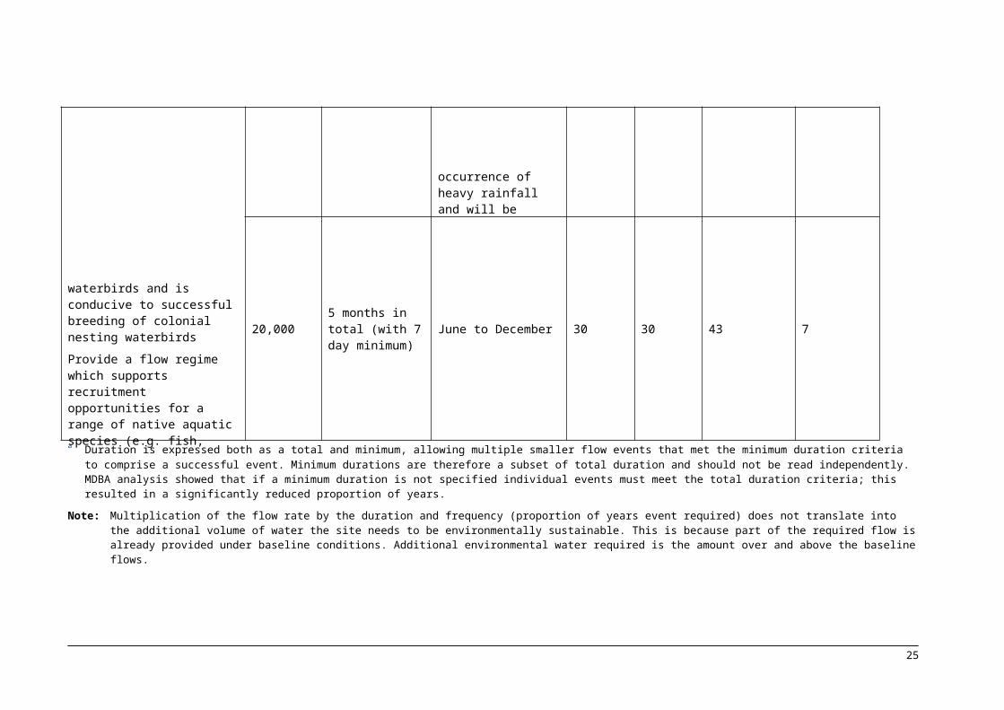
Table 5 Site-specific ecological targets and associated flow indicators for Gunbower–Koondrook–Perricoota Forest
Site-Specific Ecological Targets
Site-Specific Flow Indicators Without development and baseline event frequencies
Event Frequency - proportion of years event required
Proportion of years event occurred under modelled without development conditions (%)
Proportion of years event occurred under modelled baseline conditions (%)
Flow required (measured at Torrumbarry) ML/d
Durationa Timing
Low uncertainty (%)
High uncertainty (%)
Provide a flow regime which ensures the current extent of native vegetation of the riparian, floodplain and wetland communities is sustained in a healthy, dynamic and resilient condition
Provide a flow regime which supports the habitat requirements of waterbirds and is conducive to successful breeding of colonial nesting waterbirds
Provide a flow regime which supports recruitment opportunities for a range of native aquatic species (e.g. fish, frogs, turtles and invertebrates)
Provide a flow regime which supports key ecosystem functions, particularly those related to connectivity between the river and the floodplain
16,000 3 months in total (with 7 day minimum)
June to November
80 70 86 31
20,000 2 months in total (with 7 day minimum) 70 60 87 34
30,000 2 months in total (with 7 day minimum)
Preferably winter/spring but timing not constrained to reflect that high flows depend on occurrence of heavy rainfall and will be largely unregulated events
50 33 60 25
40,000 2 months in total (with 7 day minimum) 33 25 39 11
20,000 5 months in total (with 7 day minimum) June to December 30 30 43 7
a Duration is expressed both as a total and minimum, allowing multiple smaller flow events that met the minimum duration criteria to comprise a successful event. Minimum durations are therefore a subset of total duration and should not be read independently. MDBA analysis showed that if a minimum duration is not specified individual events must meet the total duration criteria; this resulted in a significantly reduced proportion of years.
Note: Multiplication of the flow rate by the duration and frequency (proportion of years event required) does not translate into the additional volume of water the site needs to be environmentally sustainable. This is because part of the required flow is already provided under baseline conditions. Additional environmental water required is the amount over and above the baseline flows.
17
6. Flow Delivery Constraints
Basin wide environmental objectives have been developed within the context of being deliverable in a working river system that contains public and private storages and developed floodplains . To understand and assess the implications of key constraints on the ability to achieve flow indicators specified for the Gunbower–Koondrook–Perricoota Forest, MDBA has drawn upon a combination of existing information (e.g. Water Sharing Plans, operating rules of water agencies, flood warning levels) and practical knowledge of river operators supported by testing using hydrological modelling.
Flows downstream of Hume Dam are typically limited to 25,000 ML/d under regulated flow conditions to minimise overbank flows and the associated inundation of agricultural land. This constraint prevents the release of flows, or adding water to augment natural flows, above 25,000 ML/d.
Constraints within tributaries of the Murray, particularly the Goulburn River, also influence the ability to achieve flow indicators specified for the Gunbower–Koondrook–Perricoota Forest. As highlighted in the description of the site hydrology, flood flows at Gunbower and Koondrook–Perricoota Forests depend heavily on flows from the Goulburn River. In addition, regulated releases from the Goulburn system may at times contribute to achievement of Gunbower-Koondrook-Perricoota Forest flow indicators. However, constraints on regulated releases from Eildon specified at Seymour (12,000 ML/d) and Trawool (18,000 ML/d) to avoid flooding (see MDBA 2011 for further detail) will act in combination with constraints in the Murray system to limit achievement of some flow indicators.
The MDBA has a vision of a healthy working Basin that has vibrant communities, productive and resilient industries, and healthy and diverse ecosystems. The delivery of environmental flows as a managed watering event within a healthy working Basin is highly dependent on existing system constraints, accordingly the site-specific flow indicators have been classified into three broad types (Table 6). Consistent with this rationale, within the hydrological modelling process used by the MDBA to assess the achievement of site-specific flow indicators orders for environmental flows have been limited to be within the constraints represented by the baseline model. This limits the delivery of regulated flows to the Gunbower–Koondrook–Perricoota Forest. Based on information above, it is generally considered possible to support the 30,000 ML/d flow indicator downstream of Torrumbarry Weir with the co-ordinated delivery of regulated releases from dams in both the Murray and Goulburn systems. However, in some years, constraints are likely to impede the ability to co-ordinate regulated releases to achieve this flow for the desired duration and frequency.
It is likely that the 40,000 ML/d threshold flow indicator downstream of Torrumbarry Weir will be difficult to support with only regulated releases from dams. Achieving these threshold flows will be reliant on supplementing tributary inflows with a regulated release from storage(s) and their duration will be limited to the duration of the tributary inflow.
18
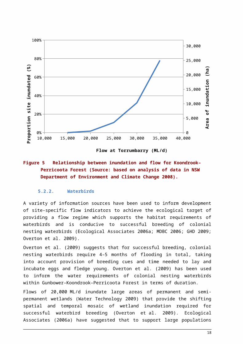
Table 6 Site-specific flow indicators for Gunbower–Koondrook–Perricoota Forest and the effect of system constraints
Site-specific ecological targets Site-specific flow indicators
Provide a flow regime which ensures the current extent of native vegetation of the riparian, floodplain and wetland communities is sustained in a healthy, dynamic and resilient condition
Provide a flow regime which supports the habitat requirements of waterbirds and is conducive to successful breeding of colonial nesting waterbirds
Provide a flow regime which supports recruitment opportunities for a range of native aquatic species (e.g. fish, frogs, turtles and invertebrates)
Provide a flow regime which supports key ecosystem functions, particularly those related to connectivity between the river and the floodplain
16,000 ML/d for a total duration of 90 days (with a minimum duration of 7 consecutive days) between June & November for 70% of years
20,000 ML/d for a total duration of 60 days (with a minimum duration of 7 consecutive days) between June & November for 60% of years
30,000 ML/d for a total duration of 60 days (with a minimum duration of 7 consecutive days) between June & May for 33% of years
40,000 ML/d for a total duration of 60 days (with a minimum duration of 7 consecutive days) between June & May for 25% of years
20,000 ML/d for a total duration of 150 days (with a minimum duration of 7 consecutive days) between June & December for 30% of years
Key
Achievable under current operating conditions
Flow indicators highlighted in blue are considered deliverable as mostly regulated flows under current operating conditions.
Achievable under some conditions (constraints limit delivery at some times)
Flow indicators highlighted in yellow are considered achievable when delivered in combination with tributary inflows and/or unregulated flow events. They may not be achievable in every year or in some circumstances, and the duration of flows may be limited to the duration of tributary inflows.
Difficult to influence achievement under most conditions (constraints limit delivery at most times)
Flow indicators highlighted in brown require large flows that cannot be regulated by dams and it is not expected that these flows can currently be influenced by river operators due to the river operating constraints outlined above.
19
7. Summary and conclusion
The Gunbower–Koondrook–Perricoota Forest is a key environmental asset within the Basin and is an important site for the determination of the environmental water requirements of the Basin. MDBA has undertaken a detailed eco-hydrological assessment of Gunbower–Koondrook–Perricoota Forest environmental water requirements. Specified flow indicators are indicative of a long-term flow regime that would achieve ecological targets at the Gunbower–Koondrook–Perricoota Forest and the broader river valley and reach. Along with other site-specific flow indicators developed across the Basin at other hydrologic indicator sites, these environmental flow requirements were integrated within hydrological models to inform the ESLT. This process including consideration of a range of constraints such as those outlined in Section 6 is described in further detail within the companion report on the modelling process ‘Hydrologic modelling to inform the proposed Basin Plan: Methods and results ’ (MDBA 2012).
The flow indicators in this report are used to assess potential Basin Plan scenarios. MDBA (2012) summarises how the proposed draft Basin Plan released in November 2011 performs against flow indicators for Gunbower–Koondrook–Perricoota Forest.
20

References
CSIRO 2008, Water availability in the Murray, a report to the Australian Government from the CSIRO Murray–Darling Basin Sustainable Yields Project, CSIRO, Australia.
Cunningham, SC, MacNally, R, Griffioen, P & White, M 2009, Mapping the condition of river red gum and black box stands in The Living Murray icon sites, a milestone report to the Murray–Darling Basin Authority as part of contract MD 1114, Murray–Darling Basin Authority, Canberra.
Department of the Environment, Water, Heritage and the Arts 2008, National framework and guidance for describing the ecological character of Australian Ramsar wetlands, module 2 of the national guidelines for Ramsar wetlands — implementing the Ramsar Convention in Australia, viewed 5 January 2010,www.environment.gov.au/water/publications/environmental/wetlands/module 2 framework.html‐ ‐Ecological Associates 2006a, Description of the ecological character of the Gunbower Forest icon site, Victorian Department of Sustainability and Environment, Melbourne.
Ecological Associates 2006b, Information sheet on Ramsar wetlands (RIS) for Gunbower Forest, Department of Sustainability, Environment, Water, Population and Communities website, viewed October 2010, <www.environment.gov.au/water/topics/wetlands/database/pubs/15-ris.pdf>.
GHD 2009, New South Wales Central Murray State Forests draft ecological character description, report prepared for New South Wales Forests, Sydney.
Graham, R & Harris, JH 2004, Floodplain inundation and fish dynamics in the Murray-Darling Basin. Current concepts and future research: a scoping study. CRC for Freshwater Ecology, Canberra.
Humphries, P, King, AJ and Koehn, JD 1999, ‘Fish, flows and floodplains: links between freshwater fishes and their environment in the Murray-Darling River system, Australia’. Environmental Biology of Fishes 56, 129-151.
King, AJ, Ramsey, D, Baumgartner, L, Humphries, P, Jones, M, Koehn, J, Lyon, J, Mallen-Cooper, M, Meredith, S, Vilizzi, L, Ye, Q & Zampatti, B 2009, Environmental requirements for managing successful fish recruitment in the Murray River Valley – Review of existing knowledge, Arthur Rylah Institute for Environmental Research Technical Report Series No. 197, Department of Sustainability and Environment, Heidelberg.
Mallen-Cooper, M & Stuart, IG 2003, ‘Age, growth and non-flood recruitment of two potamodromous fishes in a large semi-arid/temperate river system’. River research and applications 19: 697-719.
MDBA (Murray-Darling Basin Authority) 2011, The proposed “environmentally sustainable level of take” for surface water of the Murray-Darling Basin: Method and Outcomes. Murray-Darling Basin Authority, Canberra.
MDBA (Murray-Darling Basin Authority) 2012, Hydrologic modelling to inform the proposed Basin Plan: Methods and results. Murray-Darling Basin Authority, Canberra.
MDBC (Murray–Darling Basin Commission) 2006, Gunbower–Koondrook–Perricoota Forest icon site environmental management plan 2006–07, MDBC, Canberra.
21
NSW Department of Environment and Climate Change 2008, Koondrook–Perricoota Forest flood enhancement project hydraulic modelling, NSW Department of Environment and Climate Change, Sydney.
NSW Department of Environment, Climate Change and Water 2009, Atlas of NSW wildlife, viewed October 2009, <www.wildlifeatlas.nationalparks.nsw.gov.au/wildlifeatlas/watlas.jsp>.
NSW Department of Primary Industries 2007, ‘Endangered ecological communities in NSW Lower Murray River aquatic ecological community’, Primefacts, no. 172, NSW Department of Primary Industries, Orange, New South Wales.
Overton, IC, Colloff, MJ, Doody, TM, Henderson, B & Cuddy, SM (eds) 2009, Ecological outcomes of flow regimes in the Murray–Darling Basin, report prepared for the National Water Commission by CSIRO Water for a Healthy Country Flagship, CSIRO, Canberra.
Roberts, J & Marston, F 2011, Water regime for wetland and floodplain plants. A source book for the Murray–Darling Basin. National Water Commission, Canberra.
Scott, A 1997, Relationship between waterbird ecology and environmental flows in the Murray–Darling Basin, CSIRO Land and Water technical report 5–97, Canberra.
SKM (Sinclair Knight Merz) 2007, High Conservation Value Aquatic Ecosystems project identifying, ‐categorising and managing HCVAE, Final report, Department of the Environment and Water Resources, 16 March 2007. www.environment.gov.au/water/publications/environmental/ecosystems/hcvae.html
Thoms, M 2003 Floodplain-river ecosystems: lateral connections and the implications of human interference. Geomorphology 56: pp. 335–349.
Victorian Department of Natural Resources and Environment 2002, Forest management plan for the mid-Murray Forest Management Area, Victorian Department of Natural Resources and Environment, Melbourne.
Victorian Department of Sustainability and Environment 2003, Gunbower Forest Ramsar site strategic management plan, Victorian Department of Sustainability and Environment, Melbourne.
Victorian Department of Sustainability and Environment 2009a, Flora and/or fauna distribution data, Victorian Department of Sustainability and Environment, Melbourne.
Victorian Department of Sustainability and Environment 2009b, ‘Justification for key environmental assets’, unpublished report, Victorian Department Sustainability and Environment, Melbourne.
Water Technology 2009, Applying modelling tools to investigate water management in the Gunbower Forest — Part B scenario analysis report, report for North Central Catchment Management Authority, Huntly, Victoria.
22

Appendix A
Data used in producing hydrologic indicator site maps
Data Dataset name Sourcea
Basin Plan regions Draft Basin Plan Areas 25 May 2010 Murray–Darling Basin Authority (2010)
Dam walls/barrages GEODATA TOPO 250K Series 3 Topographic Data Geoscience Australia 2006
Gauges 100120 Master AWRC Gauges
Icon sites Living Murray Indicative Icon Site Boundaries Murray–Darling Basin Commission
(2007)
Irrigation areas Combined Irrigation Areas of Australia Dataset Bureau of Rural Sciences (2008)
Lakes GEODATA TOPO 250K Series 3 Topographic Data Geoscience Australia (2006)
Maximum wetland
extents
Wetlands GIS of the Murray–Darling Basin Series 2.0
(Kingsford)
Murray–Darling Basin Commission
(1993)
National parks/nature
reserves
Digital Cadastral Database New South Wales Department of Lands
(2007)
National parks/nature
reserves
Collaborative Australian Protected Areas Database —
CAPAD 2004
Department of the Environment, Water,
Heritage and the Arts (2004)
Nationally important
wetlands
Directory of Important Wetlands in Australia Spatial
Database
Department of the Environment, Water,
Heritage and the Arts (2001)
Ocean and landmass GEODATA TOPO 250K Series 3 Topographic Data Geoscience Australia (2006)
Ramsar sites Ramsar wetlands in Australia Department of the Environment, Water,
Heritage and the Arts (2009)
Rivers Surface Hydrology (AUSHYDRO version 1-6) Geoscience Australia (2010)
Roads GEODATA TOPO 250K Series 3 Topographic Data Geoscience Australia (2006)
State border GEODATA TOPO 250K Series 3 Topographic Data Geoscience Australia (2006)
State forests Digital Cadastral Database New South Wales Department of Lands
(2007)
Towns GEODATA TOPO 250K Series 3 Topographic Data Geoscience Australia (2006)
Weirs Murray–Darling Basin Weir Information System Murray–Darling Basin Commission
(2001)
Weirs 2 River Murray Water Main Structures Murray–Darling Basin Authority (2008)
a Agency listed is custodian of relevant dataset; year reflects currency of the data layer.
23
Appendix B
Species relevant to criteria 1 and 4: Gunbower–Koondrook–Perricoota Forest
Species Recognised in international agreement(s)1
Environment Protection and Biodiversity Conservation Act 1999 (Cwlth)
Fisheries Management Act 2004 (NSW)
Threatened Species Conservation Act 1995 (NSW)
Flora and Fauna Guarantee Act 1998 (Vic.)
Amphibians and reptiles
Broad-shelled turtle (Chelodina expansa)2 E
Carpet python (Morelia spilota metcalfei)5 E
Giant bullfrog (Limnodynastes interioris)5 CE
Southern bell or growling grass frog (Litoria raniformis)2, 4 V E
Crustaceans
Murray spiny cray (Euastacus armatus)2, 4 NT
Birds
Apostlebird (Struthidea cinerea)2, 4 L
Australasian bittern (Botaurus poiciloptilus)3, 4 V E
Baillon's crake (Porzana pusilla)5 V
Barking owl (Ninox connivens)2, 4 V E
Black-chinned honeyeater (eastern subspecies) (Melithreptus
gularis gularis)6
V
Blue-billed duck (Oxyura australis)2, 4 E
Brown treecreeper (Climacteris picumnus)6 V
Bush stone-curlew (Burhinus grallarius)2 E E
Cattle egret (Ardea ibis)2
Diamond firetail (Stagonopleura guttata)2 V V
Eastern great egret (Ardea modesta)2, 7 V
Gilbert's whistler (Pachycephala inornata)6 V
Grey goshawk (Accipiter novaehollandiae)5 V
Grey-crowned babbler (Pomatostomus temporalis)2, 4 V E
Ground cuckoo-shrike (Coracina maxima)2 V
24

Species Recognised in international agreement(s)1
Environment Protection and Biodiversity Conservation Act 1999 (Cwlth)
Fisheries Management Act 2004 (NSW)
Threatened Species Conservation Act 1995 (NSW)
Flora and Fauna Guarantee Act 1998 (Vic.)
Hooded robin (Melanodryas cucullata)2 V NT
Intermediate egret (Ardea intermedia)2, 7 CE
Latham’s snipe (Gallinago hardwickii)
Little bittern (Ixobrychus minutus)4 E
Little egret (Egretta garzetta)4 E
Masked owl (Tyto novaehollandiae)4 V E
Painted honeyeater (Grantiella picta)4 V V
Painted snipe (Rostratula australis)5 V CE
Powerful owl (Ninox strenua)4 V V
Red-chested button-quail (Turnix pyrrhothorax)4 V
Regent honeyeater (Xanthomyza phrygia)3 E E CE
Speckled warbler (Chthonicola sagittata)6 V
Square-tailed kite (Lophoictinia isura)5 V
Superb parrot (Polytelis swainsonii)4 V V E
Swift parrot (Lathamus discolor)4 E E E
Turquoise parrot (Neophema pulchella)4 V NT
White-bellied sea-eagle (Haliaeetus leucogaster)2 V
White-throated needletail (Hirundapus caudacutus)2
Fish
Macquarie perch (Macquaria australasica)2 E E E
Murray cod (Maccullochella peelii peelii)2 V E
Murray hardyhead (Craterocephalus fluviatilis)3 V CE
Murray–Darling rainbow fish (Melanotaenia fluviatilis)4 DD
Silver perch (Bidyanus bidyanus)2, 3 V CE
Trout cod (Maccullochella macquariensis)3, 4 E E CE
Unspecked hardyhead (Craterocephalus stercusmuscarum
fulvus)2
L
25
Species Recognised in international agreement(s)1
Environment Protection and Biodiversity Conservation Act 1999 (Cwlth)
Fisheries Management Act 2004 (NSW)
Threatened Species Conservation Act 1995 (NSW)
Flora and Fauna Guarantee Act 1998 (Vic.)
Mammals
Brush-tailed phascogale (Phascogale tapoatafa)4 V
Koala (Phascolarctos cinereus)6 V
Southern myotis (Myotis macropus)4 NT
Squirrel glider (Petaurus norfolcensis)2, 4 E
Yellow-bellied sheathtail bat (Saccolaimus flaviventris)6 V
Plants
River swamp wallaby grass (Amphibromus fluitans)3 V
Winged peppercress (Lepidium monoplocoides)2, 4, 5, 7 E E
Small scurf-pea (Cullen parvum syn. Psoralea parva)4 E
Buloke (Allocasuarina luehmannii)2 E
Boland yellow gum (Eucalyptus leucoxylon pruinosa)6 V
Chariot wheels (Maireana cheelii)6 V
Western water-starwort (Callitriche cyclocarpa)5 V V
Dwarf swainson-pea (Swainsona phacoides)5 E
Communities
River Murray endangered ecological community8 E
CE = critically endangered DD = data deficient E = endangered L= listed NT= near threatened V = vulnerable
1 Japan–Australia Migratory Bird Agreement, China–Australia Migratory Bird Agreement, or Republic of Korea – Australia Migratory Bird Agreement
2 Victorian Department of Sustainability and Environment (2003)
3 Murray–Darling Basin Commission (2006)
4 Victorian Department of Natural Resources and Environment (2002)
5 Victorian Department of Sustainability and Environment (2009a)
6 NSW Department of Environment, Climate Change and Water (2009)
7 Victorian Department Sustainability and Environment (2009b)
26
8 NSW Department of Primary Industries (2007)
27