Assessing the applicability of Ground Penetrating Radar ... final Ground... · type, vegetation...
14
Assessing the applicability of Ground Penetrating Radar (GPR) Techniques for estimating soil water content and irrigation requirements in the Eastern Province of Saudi Arabia: A project methodology. Omar K M Ouda 1 , Abdullatif A. Al-Shuhail 2 , Tawfiq Qubbaj 3 , Rana Samara 3 1 Assistant Professor; Department of Civil Engineering, Prince Mohamed Bin Fahd University, Al Khobar, KSA 2 Associate Professor of Geophysics, Earth Sciences Department, King Fahd University of Petroleum & Minerals, Dhahran, KSA. 3 Visiting Research Participant, Agriculture and Agri-Food Canada, Ontario. Canada. Abstract: The Kingdom of Saudi Arabia (KSA) has distinct and serious water deficit problem. KSA lies between between 16 o 22’ and 32 o 14’ North latitudes and 34 o 29’ and 55 o 40’ East longitudes in an arid to semi-arid climate. The country has low average annual precipitation ranges from 80 mm to 140 mm, with limited natural water resources. There are no lakes, rivers, or streams. The country is increasingly dependent on fossil groundwater resources which receive very limited natural recharge for intensive irrigation. Irrigation consumes about 85% of total water supply. This paper presents review of the application of GPR technology to estimate soil water content (SWC), underlines and discusses promising methodology of a two-year research project (submitted by Al-Shuhail & Ouda, 2012) for funding by the King Abdulaziz City for Science and Technology – Saudi Arabia. GPR technique will be used to measure agricultural field SWC as an accurate, precise and alternative method to conventional measurements methods in the Eastern Province of Saudi Arabia. A new irrigation scheduling methods based on tested and modified GPR technique will be introduced and applied to common agricultural crops in the target area. This technology transferred technique will play major role in improving the irrigation efficiency and minimizing the agricultural water consumption. Keywords: Saudi Arabia, Ground Penetrating Radar, Soil Water Content, Crop water requirements Irrigation
-
Upload
trinhhuong -
Category
Documents
-
view
220 -
download
0
Transcript of Assessing the applicability of Ground Penetrating Radar ... final Ground... · type, vegetation...

Assessing the applicability of Ground Penetrating Radar (GPR) Techniques for
estimating soil water content and irrigation requirements in the Eastern
Province of Saudi Arabia: A project methodology.
Omar K M Ouda1, Abdullatif A. Al-Shuhail2, Tawfiq Qubbaj3, Rana Samara3
1Assistant Professor; Department of Civil Engineering, Prince Mohamed Bin Fahd University, Al Khobar, KSA2Associate Professor of Geophysics, Earth Sciences Department, King Fahd University of Petroleum & Minerals,
Dhahran, KSA.3Visiting Research Participant, Agriculture and Agri-Food Canada, Ontario. Canada.
Abstract: The Kingdom of Saudi Arabia (KSA) has distinct and serious water deficit problem.
KSA lies between between 16o 22’ and 32o 14’ North latitudes and 34o 29’ and 55o 40’ East
longitudes in an arid to semi-arid climate. The country has low average annual precipitation
ranges from 80 mm to 140 mm, with limited natural water resources. There are no lakes, rivers,
or streams. The country is increasingly dependent on fossil groundwater resources which receive
very limited natural recharge for intensive irrigation. Irrigation consumes about 85% of total
water supply. This paper presents review of the application of GPR technology to estimate soil
water content (SWC), underlines and discusses promising methodology of a two-year research
project (submitted by Al-Shuhail & Ouda, 2012) for funding by the King Abdulaziz City for
Science and Technology – Saudi Arabia. GPR technique will be used to measure agricultural
field SWC as an accurate, precise and alternative method to conventional measurements methods
in the Eastern Province of Saudi Arabia. A new irrigation scheduling methods based on tested
and modified GPR technique will be introduced and applied to common agricultural crops in the
target area. This technology transferred technique will play major role in improving the irrigation
efficiency and minimizing the agricultural water consumption.
Keywords: Saudi Arabia, Ground Penetrating Radar, Soil Water Content, Crop water
requirements Irrigation
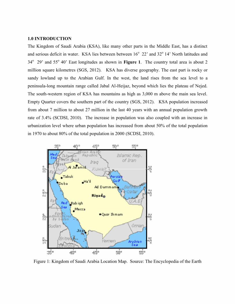
1.0 INTRODUCTIONThe Kingdom of Saudi Arabia (KSA), like many other parts in the Middle East, has a distinct
and serious deficit in water. KSA lies between between 16o 22’ and 32o 14’ North latitudes and
34o 29’ and 55o 40’ East longitudes as shown in Figure 1. The country total area is about 2
million square kilometres (SGS, 2012). KSA has diverse geography. The east part is rocky or
sandy lowland up to the Arabian Gulf. In the west, the land rises from the sea level to a
peninsula-long mountain range called Jabal Al-Heijaz, beyond which lies the plateau of Nejed.
The south-western region of KSA has mountains as high as 3,000 m above the main sea level.
Empty Quarter covers the southern part of the country (SGS, 2012). KSA population increased
from about 7 million to about 27 million in the last 40 years with an annual population growth
rate of 3.4% (SCDSI, 2010). The increase in population was also coupled with an increase in
urbanization level where urban population has increased from about 50% of the total population
in 1970 to about 80% of the total population in 2000 (SCDSI, 2010).
Figure 1: Kingdom of Saudi Arabia Location Map. Source: The Encyclopedia of the Earth
1.1 Water Resources
The Country characterized by an arid to semi-arid climate and low average annual precipitation
ranges from 80 mm to 140 mm, with limited natural water resources; there are no lakes, rivers, or
streams. Intermittent flash floods water is captured in 260 irrigation dams collecting an
estimated 0.6 Billion m3 per year (Ouda, 2013). Groundwater is the only reliable natural water
source on the country. KSA utilized sea water desalination as source for potable water supply.
The current desalination plant capacity is about 1 billion Cubic meters (SWCC, 2010), which
satisfied about 37% of municipal water demand. KSA government supports the reuse of treated
wastewater for agricultural and landscape irrigation. Saudi Municipalities have used treated
wastewater extensively for street landscape and municipal parks irrigation. In 2010, about 240
million m3/year of the treated wastewater have been used for landscape and crop irrigation across
the country (MWE, 2012). Water sustainable yields form both conventional and non-
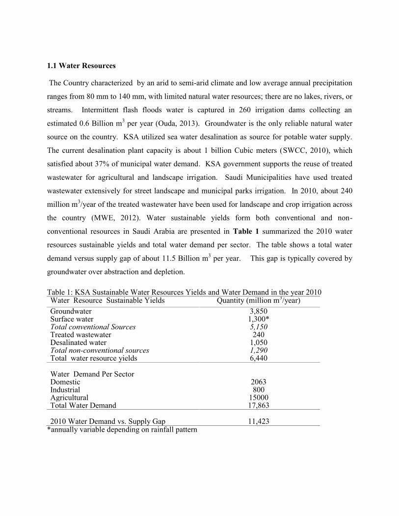
conventional resources in Saudi Arabia are presented in Table 1 summarized the 2010 water
resources sustainable yields and total water demand per sector. The table shows a total water
demand versus supply gap of about 11.5 Billion m3 per year. This gap is typically covered by
groundwater over abstraction and depletion.
Table 1: KSA Sustainable Water Resources Yields and Water Demand in the year 2010Water Resource Sustainable Yields Quantity (million m3/year)Groundwater 3,850Surface water 1,300*Total conventional Sources 5,150Treated wastewater 240Desalinated water 1,050Total non-conventional sources 1,290Total water resource yields 6,440
Water Demand Per SectorDomestic 2063Industrial 800Agricultural 15000Total Water Demand 17,863
2010 Water Demand vs. Supply Gap 11,423*annually variable depending on rainfall pattern

2.0 AGRICULTURE SECTOR IN SAUDI ARABIAAgriculture is considered a main sector in KSA, it contributes directly in food availability and
securing food resources, also it has a positive impact on job market and offering jobs for a wide
range of people (Alam et al. 2011). In addition, to its good contribution in the gross domestic
product (GDP), it offers self sufficiency ratio of different agricultural food products, reach up to
85 % - 60 % for vegetable and fruits, respectively as presented in Table 3 (MOA , 2011). The
productivity of various crops per unit area are presented in Figure 2. Agriculture sector is the
main water consumer; about 80% of all water used by mankind is withdrawn towards irrigation
uses, where 74 % is evaporated by crops (Sundquist B., 2007). Protected irrigated agriculture is
solely used for crop productions in KSA, where, agricultural water used (mainly irrigation) about
85% of the total water supplies from scarce groundwater resources as shown in Table 1. (Al
Zhrani et al., 2011; MEP 2005; World Bank, 2010).
Table 2 Self Sufficiency Ratio OF Different Agricultural Food Products For 2010Crops Local
ProductionNet
ImportsAvailable
forConsumption
SufficiencyRatio
Vegetables total 2521000 379633 2900633 86.90%Potatoes 399000 -104808 294192 135.60%Cucumber 221000 -5712 215288 102.70%Water Melons 339000 -59781 279219 121.40%Melons 267000 9215 276215 96.70%Tomato 492000 201869 693869 70.90%Eggplant 61000 -3772 57228 106.60%Okra 53000 0 53000 100.00%Fruits total 1549000 1127566 2676566 57.90%Grapes 139000 36782 175782 79.10%Dates 992000 -73360 918640 108%Citrus 105000 470807 575807 18.20%Other Fruits 313000 693337 1006337 31.10%
Source : (MOA , 2011)

0
5
10
15
20
25
30
2002 2003 2004 2005 2006 2007 2008 2009 2010
Vegetables
Date
All Fruits
Citrus
All Cereals
Prod
ucti
on R
ate
(MT/
Hec
ter)
Year
Figures 2: The productivity per unit area of different crops in Saudi Arabia
The agricultural sector has been intensively subsidized during the period from 1974 to 2006 by
Saudi government. The subsidized program aimed to improve the standard of livings in rural
communities. The program came with substantial increase of the cultivated area mainly for
intensive irrigated crops such as wheat. The irrigated area increased from less than 400
thousands hectare (ha) in 1971 to about 1.62 million ha in 1992 (World Bank, 2005). The
expanded irrigated agricultural has resulted in the depletion of groundwater resources. KSA
government have decided to re-structure the agricultural sector including phase out its support to
the cultivation of high water demanding crop such as wheat (Al-Zahrani, K. H. and E.A. Elhag,
2003; Khodran Hamadan Al-Zahrani, 2010; Al-Zahrani K. H.; Baig M. B., 2011). KSA has also
set up programs and policies heading towards maximizing efficiency of irrigation water supply
and arable land to produce high value crops such as fruits and vegetables. (MEP, 2005,
Alabdulkader et al. 2012). The newly massive policy and program have reduced cultivated area
from peak figure of about 1.63 million ha in 1992 to about 0.85 million ha in 2009 (FAO, 2009;
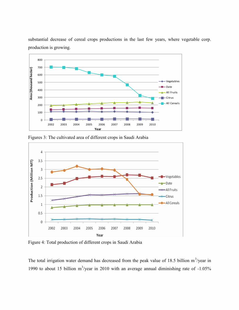
MWE, 2012). The reduction was mainly in cereal crops cultivated area as shown in Figure 3.
The total Saudi production of different crops is presented in Figure 4. The figure shows a
0
100
200
300
400
500
600
700
800
2002 2003 2004 2005 2006 2007 2008 2009 2010
Vegetables
Date
All Fruits
Citrus
All Cereals
Are
a (t
hous
and
hect
er)
Year
substantial decrease of cereal crops productions in the last few years, where vegetable corp.
production is growing.
Figures 3: The cultivated area of different crops in Saudi Arabia
Figure 4: Total production of different crops in Saudi Arabia
The total irrigation water demand has decreased from the peak value of 18.5 billion m3/year in
1990 to about 15 billion m3/year in 2010 with an average annual diminishing rate of -1.05%

(World Bank, 2005; MWE, 2012). KSA government is planning to reduce the agricultural water
demand on an annual diminishing rate of 3.7% during the period from 2010 to 2014 (MEP,
2010). The proposed project will help in achieving KSA government objectives through
presenting new approach to increase irrigation efficiency.
3.0 SOIL WATER CONTENTIrrigation is applied to compensate the shortage in soil water content. Monitoring soil water
content is crucial component for achieving higher irrigation efficiency, optimizing crop quality
as well as quantity, and minimizing soil salinity. Understanding vadose zone hydrological
processes such as evapotranspiration, surface runoff, and groundwater recharge rate is also very
important (Steelman et al. 2011). Several conventional methods to measure soil water content
are currently used; such as gravimetric sampling, neutron probe logging, time domain
reflectometry (TDR), frequency domain reflectometry (FDR), tensiometers, gamma ray
attenuation, capacitive sensors, gypsum block measurement, and pressure plate method. The soil
water content depends on many parameters that are spatially and temporally variable such as soil
type, vegetation cover, crop type, topography, and precipitation. Looking at all those variable
factors, collecting enough measurements for the account of the spatial variations of the vadose
zone soil water contents is neither financially nor technically practical. Remote sensing
technique can be used to estimate vadose zone water content over very large area but with a very
low resolution in the range of 100 meter and typically for the top 5cm of the vadose zone.
Additionally, dense crop coverage limits the applicability of the remote sensing for vadose zone
applications. On the other hand, Ground Penetrating Radar (GPR) is more promising technique
for estimating soil water content at the field scale. This technique has the potential to determine
soil water content with vertical resolution comparable to that of conventional pin point methods
and with an extended spatial resolution, leading to a better estimation over field size area.
Abundant research articles have documented the successful applications of GPR technique soil
water content measurement (Chanzy et al., 1996; van Overmeeren et al., 1997; Grote et al., 2003,
2010; Galagedara et al. 2005; Lambot et al.; 2006; Weihermuller, et al. 2007; Brandford 2008;
Giroux et al. 2010; Mint et al. 2011).
3.1 GROUND PENETRATING RADAR METHODGround Penetrating Radar technology is based on the transmission and reflection of radio waves
in the soil (Chanzy et al., 1996; Dobriyal et al., 2012). The GPR system sends radio waves
through the soil (Reynolds, 1997; Dobriyal et al., 2012). The GPR receiver detects the reflected
radio waves, where the variation in radio wave velocity shows the electromagnetic properties of
the subsurface soil (Du and Rummel, 1994). Radar antennas are manually or mechanically
moved over the soil surface simultaneously assessing the subsurface SWC (Reynolds, 1997). The
collected data do not need complicated calculations to generate three-dimensional views of the
SWC (Do, 2003; USACE, 1995). The GPR is a fast and non-destructive method. It is capable to
determine SWC with high vertical resolution comparable to that of conventional pin point
methods and with an extended spatial resolution, leading to a better estimation over large areas
(Huisman et al., 2001; Al-Shuhail, 2006; Adetunji et al., 2008; Dobriyal et al., 2012). The
successful application of GPR technique for the estimation of SWC in the field scale in humid to
semi-humid climate and for experimental purposes is well documented (Chanzy et al., 1996; van
Overmeeren et al., 1997; Grote et al., 2003 and 2010; Galagedara et al., 2005; Lambot et al.,
2006; Weihermuller et al., 2007; Brandford, 2008; Giroux et al., 2010; Mint et al., 2011).
The GPR technology has been successfully implemented to determine SWC in humid to semi
humid climate for clay to silty clay soil. Its applicability to arid to semiarid climate is not well
investigated. Additional studies with a large set of soil textures are needed (Grote et al., 2010)
especially for silty sand to sandy soil. The applicability of GPR technology for intensive
agriculture fields is not well investigated either. Studies are needed to develop optimum GPR
data acquisition and processing schemes for intensive agriculture fields. The potential for real-
time efficient irrigation scheduling based on GPR soil water content estimation is hardly
investigated in previous works.
This paper underlines and discusses the promising expected results of a two-year research project
(submitted by Dr. Abdullatif A. Al-Shuhail & Dr. Omar Ouda, 2012) for funding by the King
Abdulaziz City for Science and Technology – Saudi Arabia.

4. PROJECT METHODOLOGY
The project objectives are to assess the applicability and adaptability of the GPR technique to
measure SWC in agricultural fields in the Eastern Province of Saudi Arabia, to design and
implement various GPR data acquisition and processing schemes in order to identify the
optimum scheme for GPR application for SWC in target agricultural areas, and to develop
software codes to calculate SWC from processed GPR data and another for real-time efficient
irrigation scheduling based on the calculated SWC. To achieve the stated objectives the project
team willconduct a comprehensive literature review of recent applications of GPR technology
and other vadose zone water content measurement technologies, especially for the GPR
technology applicability to arid and semiarid climate will be conducted. A field visits to
different farms in the area will be conducted to select the target farms and crop types. The farms
will be selected based on a set of criteria including: location; crop type; soil type, topography,
and farm sizes. Based on the intensive literature review various GPR data acquisition schemes
(1-D, 2-D, or 3-D, monostatic or bistatic.) will be developed and implemented in the field. The
GPR data will be processed using various processing workflows. The efficiency and accuracy of
the implemented GPR data acquisition and processing schemes will be assessed and calibrated in
light of pin-point soil water contents testing results. Two TDR units will be used for
simultaneous pin point samplings. At least three soil samples will be collected and tested from
each farm for physical and chemical properties including: SWC (based on gravitational method),
soil texture, organic contents, salinity, phosphorus, and nitrogen contents. Finally the optimum
GPR data acquisition and processing scheme for SWC determination in the studied agricultural
fields and similar areas will be selected. A workflow for inverting SWC from processed GPR
data starting from available workflows will be developed as a base for software code for SWC
inversion from processed GPR measurements. The code will be tested on the GPR data acquired
and processed through the optimum schemes. A workflow for real-time irrigation scheduling
based on SWC values inverted from GPR measurements and software code for real-time
irrigation scheduling based on SWC values inverted from GPR measurements.

5.0 EXPECTED RESULTS AND DISCUSSIONThe results and outputs of this project expected to be of high value and benefit to Kingdom of
Saudi Arabia and in particular to water sector. The project will contribute to the promotion and
supporting the Kingdom economic, social, security, development through localizing and
applying an advanced technology in the water conservation area as the following:
It will be a pioneer project for studying innovative methods for measuring SWC not only
for the KSA but for the globe, since the GPR technology applicability to arid-to-semiarid
climate and for intensive agricultural field is not well investigated.
Agriculture is a major user of water resources, developing sustainable management of
water in agriculture specific to KSA endogenous dominant environmental conditions is
critical to increase agricultural production, ensure water can be shared with other users
and maintain the environmental and social benefits of water systems.
Determine the optimum irrigation strategy and develop an irrigation scheduling to
provide a positive impact to KSA agriculture industry. This includes, but not limited to,
the following: decrease in pest proliferation, decrease in water use, and decrease in
fertilizer use, decrease in energy cost, and decrease in pesticide use.
A new technology will be transferred and introduced to KSA and in particular to the
agricultural sector in Eastern Province aiming for optimizing and scheduling irrigation.
A great opportunity will be offered for human capacity building. Three graduate students
and a technician will be directly involved in various project activities, to learn and
improve their capabilities and research skills.
This project will serve as an end-user oriented project; all objects and activities will be
planned and modified to fulfill the demands and needs of target end users and
beneficiaries of this research project such as; water resources planning engineers,
agriculture engineers, geoscientists, farmers and agricultural companies working in KSA.

6.0 CONCLUSION
The Kingdom of Saudi Arabia faces a serious water shortage problem where the current water
demand is three folds the sustainable yields of both conventional and non-conventional water
resources. Agriculture sector demand is about 85% of total water demand in the Kingdom.
Apply massive measures to bridge the gap between water supply and demand is no more an
option in the Kingdom, it is a must. In this direction, KSA is planning to decrease the agriculture
water demand by 3.7% annually through increasing water irrigation efficiency and phasing out
uneconomical crops such as cereal. This paper presents a research project towards increasing
irrigation efficiency in Saudi Arabia. The project will review the applicability of GPR
technology to estimate fields SWC in the Eastern Province of Saudi Arabia. A new irrigation
scheduling methods based on tested and modified GPR technique will be introduced and applied
to common agricultural crops in the target area. This technology transferred technique will play
major role in improving the irrigation efficiency and minimizing the agricultural water
consumption in the Kingdom. The project has high scientific merits. The literature review
showed that the GPR technology applicability for intensive agriculture fields is not well
investigated especially under silty sand to sandy soil conditions. The applicability of GPR
technology to arid to semiarid climate has never been studied before. The potential for real-time
efficient irrigation scheduling based on GPR soil water content estimation is hardly investigated
in previous works. This reality shows the global scientific value of the proposed project.
This project will be implemented as an end-user oriented project; all objects and activities will
be planned and modified to fulfill the demands and needs of target end users and beneficiaries of
this research project such as; water resources planning engineers, agriculture engineers,
geoscientists, farmers and agricultural companies working in KSA.

REFERENCIESAdetunji, A. Q., Al-Shuhail, A. A., and Korvin, G. (2008). Mapping the internal structure of sand duneswith GPR: A case history from the Jafurah sand sea of eastern Saudi Arabia. The Leading Edge, 27:1446-1452.
Alabdulkader A. M. , Al-Amoud A. I.,. Awad F. S. (2012). Optimization of the cropping pattern in SaudiArabia using a mathematical programming sector model. Agric. Econ. – Czech, 58 (2): 56–60
Alam J. B., Hussein M. H., Magram S. F., Barua R., (2011). Impact of Climate Parameters onAgriculture in Saudi Arabia: Case Study of Selected Crops. International Journal of Climate Change:Impacts & Responses, 2 (4): 41-50.
Al-Ibrahim A. A. (1991). Excessive Use of Groundwater Resources in Saudi Arabia: Impacts and Policy.Ambio, 20 (1): 34-37.
Al-Shuhail A.A., (2006). Mapping the Surface of a Shallow Groundwater System using the GPR: ACase Study in Eastern Saudi Arabia. The Leading Edge, 25:738-740.
Al-Zahrani K. H.; Baig M. B.(2011). Water in the Kingdom of Saudi Arabia: Sustainable ManagementOptions. The Journal of Animal & Plant Sciences, 21(3), 601-604.
Al-Zahrani, K. H. and E.A. Elhag (2003). Agricultural Development during the era of King Fahd. 1st ed.Riyadh, KSA: King Saud University.
Brandford J.H. (2008). Measuring water content heterogeneity using multifold GPR with reflectionTomography. Vadose Zone Journal, 7(1).
Chanzy A.; Tarussov A.; Judge A.; Bonn F. (1996). Soil water content determination using a digitalground-penetrating radar. Soil Science Society of America Journal 60: 1318-1326.
Do, J. (2003). Ground Penetrating Radar. Geoenvironmental Engineering, Villanova University.Villanova.
Dobriyal, P., Qureshi, A., Badola, R., Hussain, S.A. (2012). A review of the methods available forestimating soil moisture and its implications for water resources management, Journal of Hydrology.
Du, S.; Rummel, P. (1995). Econnaissance studies of moisture in the subsurface with GPR. Proceedingsof the Fifth International Conference on Ground Penetrating Radar, Kitchener. 12-16 June 1994, 1241-1248.
FAO (2009). Irrigation in the Middle East regions in figures. Aquatat Survey -2008. FAO Land andWater Division Report 34, 325-337. edited by Karen Freken.
Galagedara L. W.; Parkin G.W.; Redman J.D.; von Bertoldi P.; Endres A.L. (2005). Field studies of theGPR ground wave method for estimating water content during irrigation and drainage. Journal ofHydrology 301: 182-197.
Giroux B.; Chouteau M. (2010). Quantitative analysis of water content estimation errors using groundpenetrating radar data and a low loss approximation. Geophysics. 75(4) :241-249

Grote K.; Anger C.; Kelly B.; Hubbard S.; Rubin Y. (2010). Characterization of soil water contentvariability and soil texture using GPR groundwave techniques. Journal of Environmental andEngineering Geophysics. 15(3): 93-110.
Grote K.; Hubbard S.; Rubin Y. (2003). Field-scale estimation of volumetric water content using ground-penetrating radar ground wave techniques. Water Resource Research 39 (11): 1321-1335.
Huisman, J.A.; Sperl. C.; Bouten, W.; Verstraten, J.M. (2001). Soil water content measurements atdifferent scales: accuracy of time domain refectometry and ground-penetrating radar. Journal ofHydrology. 245: 48-58.
Lambot S; Weihermuller L.; Huisaman J.A.; Vereecken H.; Vanclooster M.; Slob S.C. (2006). Analysisof air-lunched ground penetrating radar techniques to measure the soil surface water content. WaterResources Research. 42: W11403.
MEP (2005) The Eight Development Plan 2005-2008. Ministry of Economy and Planning Documents.Riyadh. KSA Government.
MEP (2010). The Nine Development Plan 2010-2014. Ministry of Economy and Planning Documents.Riyadh. KSA Government.
MOA (2011). Kingdom of Saudi Arabia, Ministry Of Agriculture, Statistical book 2011.
MWE (2012). Supporting Documents for King Hassan II Great Water Prize. available from:http://www.worldwatercouncil.org/fileadmin/wwc/Prizes/Hassan_II/Candidates_2011/16.Ministry_SA.pdf , [accessed 30 November 2012].
Omar K M Ouda (2013). Towards Assessment of Saudi Arabia Public Awareness of Water ShortageProblem. Resources and Environment, Vol.3, No.1.
Reynolds, J.M. (1997). An introduction to applied and environmental geophysics. Chichester, Wiley
SCDSI ( 2010). Population & Housing Census for 1431 A.H (2010 A.D) Findings. available from:http://www.cdsi.gov.sa/, [accessed 15 November 2012].
SGS ( 2012). Kingdom of Saudi Arabia Numbers and Facts”, 1st ed. Riyadh. KSA Government.
Steelman M. Colby; Endres L. Anthony (2011). Comparison of Petrophysical relationships for soilmoisture estimation using GPR ground waves. Vadose Zone J.10:270-285
Sundquist B.( 2007). Chapter 1- Irrigation overview. In: The earth's carrying capacity, some relatedreviews and analysis. http://home.windstream.net/bsundquist1/ir1.html
SWCC (2010). Annual Report for Operation & Maintenance. Saline Water Conservation Corporation.Riyadh. KSA.
Van Overmeeren R. A.; Sariowan S.V.; Gehrels J.C. (1997). Ground penetrating radar for determiningvolumetric soil water content; results of comparative measurements at two test sites. Journal ofHydrology 97: 316-338.

Weihermuller, L., Huisman, J.A., Lambot, S., Herbst, M., Vereecken, H., (2007). Mapping the spatialvariation of soil water content at the field scale with different ground penetrating radar techniques.Journal of Hydrology. 340: 202-216.
World Bank. (2010) Making the most scarcity: accountability for better water management result in theMiddle East and North Africa. Accessed at:http:/www.worldbank.org/website/external/topics/extwat/o,contentMDK.