Dorsal Fin Caudal Fin Anal Fin Pelvic Fin Pectoral Fin Operculum.

As Sawahira ash Sharqiya Town Profile
Prepared by
The Applied Research Institute – Jerusalem
Funded by
Spanish Cooperation
2012

Palestinian Localities Study Jerusalem Governorate
1
Acknowledgments
ARIJ hereby expresses its deep gratitude to the Spanish agency for International Cooperation for Development (AECID) for their funding of this project. ARIJ is grateful to the Palestinian officials in the ministries, municipalities, joint services councils, town committees and councils, and the Palestinian Central Bureau of Statistics (PCBS) for their assistance and cooperation with the project team members during the data collection process. ARIJ also thanks all the staff who worked throughout the past couple of years towards the accomplishment of this work.

Palestinian Localities Study Jerusalem Governorate
2
Background This report is part of a series of booklets, which contain compiled information about each city, village, and town in the Jerusalem Governorate. These booklets came as a result of a comprehensive study of all localities in Jerusalem Governorate, which aims at depicting the overall living conditions in the governorate and presenting developmental plans to assist in developing the livelihood of the population in the area. It was accomplished through the "Village Profiles and Needs Assessment;" the project funded by the Spanish Agency for International Cooperation for Development (AECID). The project's objectives are to survey, analyze, and document the available natural, human, socioeconomic and environmental resources, and the existing limitations and needs assessment for the development of the rural and marginalized areas in the Jerusalem Governorate. In addition, the project aims at preparing strategic developmental programs and activities to mitigate the impact of the current political, social, and economic instability with special emphasize on agriculture, environment and water. All locality profiles in Arabic and English are available online at http://vprofile.arij.org.

Palestinian Localities Study Jerusalem Governorate
3
Table of Content
Location and Physical Characteristics .............................................................................. 4
History ......................................................................................................................................... 5
Religious and Archaeological Sites .................................................................................... 6
Population .................................................................................................................................. 7
Education .................................................................................................................................... 8
Health Status ............................................................................................................................. 9
Economic Activities ............................................................................................................... 10
Agricultural Sector ................................................................................................................ 11
Institutions and Services ..................................................................................................... 14
Infrastructure and Natural Resources ............................................................................ 14
Impact of the Israeli Occupation ....................................................................................... 18
Development Plans and Projects ...................................................................................... 24
Locality Development Priorities and Needs ................................................................. 25
References ................................................................................................................................ 26
Palestinian Localities Study Jerusalem Governorate
4
As Sawahira ash Sharqiya Town Profile
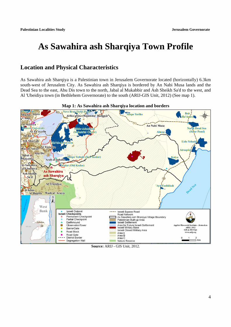
Location and Physical Characteristics As Sawahira ash Sharqiya is a Palestinian town in Jerusalem Governorate located (horizontally) 6.3km south-west of Jerusalem City. As Sawahira ash Sharqiya is bordered by An Nabi Musa lands and the Dead Sea to the east, Abu Dis town to the north, Jabal al Mukabbir and Ash Sheikh Sa'd to the west, and Al 'Ubeidiya town (in Bethlehem Governorate) to the south (ARIJ-GIS Unit, 2012) (See map 1).
Map 1: As Sawahira ash Sharqiya location and borders
Source: ARIJ - GIS Unit, 2012.

Palestinian Localities Study Jerusalem Governorate
5
As Sawahira ash Sharqiya is located at an altitude of 523m below sea level with a mean annual rainfall of 265.7mm. The average annual temperature is 18 oC and the average annual humidity is approximately 59% (ARIJ-GIS Unit, 2012). Since 1994, As Sawahira ash Sharqiya has been governed by a local council which is currently administrated by 11 members appointed by the Palestinian National Authority (PNA) in addition to 12 permanent employees. The Local Council owns a permanent headquarters and a vehicle for the collection of solid waste. It also owns a pick-up truck, a tractor, a metal detector, water maintenance devices, a mosquito spraying motor and asphalt scissors (As Sawahira ash Sharqiya Local Council, 2011). It is the responsibility of the Local Council to provide a number of services to the residents of As Sawahira ash Sharqiya, including (As Sawahira ash Sharqiya Local Council, 2011):
Establishing and maintaining the water network. Solid waste collection, road construction, pavement, and rehabilitation, and social development
services. Organizing the processes of construction and license issuing. Implementing projects and case studies for the town. Providing street lighting. Protecting schools.
History As Sawahira ash Sharqiya town is an extension of Beit Sahour al Wadd village, and was named in relation to Arab as Sawahira who inhabited it (Shkeirat, 2011). The establishment of the town dates back to more than 700 years ago; its residents are of Bedouin origin (As Sawahira ash Sharqiya Local Council, 2011) and are descended from Bani 'Aqabah, part of the southern Arabian Peninsula Lakhm tribe (Shkeirat, 2011) (See photo below for As Sawahira ash Sharqiya town).

Palestinian Localities Study Jerusalem Governorate
6
Photo 1: General Landscape of As Sawahira ash Sharqiya
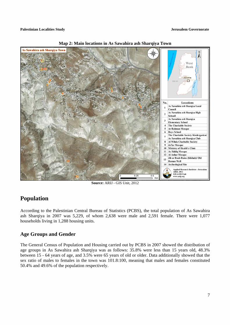
Religious and Archaeological Sites There are four mosques in the town, Ar Rahman, Ja'far ben Abi Talib, Al 'Abrar and Abu Bakr as Siddiq Mosques. There are several sites of archaeological interest: the ancient Roman road, ancient caves, Al Khishna, Umm Tabaq and Taqet an Nasrani areas, and the Khirbet Kurat ruins. However, none of these sites are qualified for tourism (As Sawahira ash Sharqiya Local Council, 2011) (See Map 2).
Palestinian Localities Study Jerusalem Governorate
7
Map 2: Main locations in As Sawahira ash Sharqiya Town
Source: ARIJ - GIS Unit, 2012
Population According to the Palestinian Central Bureau of Statistics (PCBS), the total population of As Sawahira ash Sharqiya in 2007 was 5,229, of whom 2,638 were male and 2,591 female. There were 1,077 households living in 1,288 housing units.
Age Groups and Gender The General Census of Population and Housing carried out by PCBS in 2007 showed the distribution of age groups in As Sawahira ash Sharqiya was as follows: 35.8% were less than 15 years old, 48.3% between 15 - 64 years of age, and 3.5% were 65 years of old or older. Data additionally showed that the sex ratio of males to females in the town was 101.8:100, meaning that males and females constituted 50.4% and 49.6% of the population respectively.
Palestinian Localities Study Jerusalem Governorate
8
Families As Sawahira ash Sharqiya residents are from several families, mainly Shkeirat, Ja'afrah, 'Ubeidat, Khalayla, 'Eweisat, Mashahra, Zahaiqa, Halasah, Za'atrah and Ja'abees in addition to other families (As Sawahira ash Sharqiya Local Council, 2011).
Immigration According to the field survey conducted by ARIJ team, approximately 350 persons have left the town since the Second Intifada in 2000 (As Sawahira ash Sharqiya Local Council, 2011).
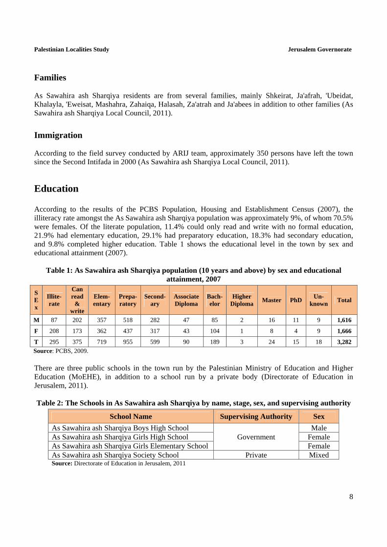
Education According to the results of the PCBS Population, Housing and Establishment Census (2007), the illiteracy rate amongst the As Sawahira ash Sharqiya population was approximately 9%, of whom 70.5% were females. Of the literate population, 11.4% could only read and write with no formal education, 21.9% had elementary education, 29.1% had preparatory education, 18.3% had secondary education, and 9.8% completed higher education. Table 1 shows the educational level in the town by sex and educational attainment (2007).
Table 1: As Sawahira ash Sharqiya population (10 years and above) by sex and educational attainment, 2007
S E x
Illite-rate
Can read
& write
Elem-entary
Prepa-ratory
Second-ary
Associate Diploma
Bach-elor
Higher Diploma
Master PhD Un-
known Total
M 87 202 357 518 282 47 85 2 16 11 9 1,616
F 208 173 362 437 317 43 104 1 8 4 9 1,666
T 295 375 719 955 599 90 189 3 24 15 18 3,282
Source: PCBS, 2009.
There are three public schools in the town run by the Palestinian Ministry of Education and Higher Education (MoEHE), in addition to a school run by a private body (Directorate of Education in Jerusalem, 2011). Table 2: The Schools in As Sawahira ash Sharqiya by name, stage, sex, and supervising authority
School Name Supervising Authority Sex
As Sawahira ash Sharqiya Boys High School Government
Male As Sawahira ash Sharqiya Girls High School Female As Sawahira ash Sharqiya Girls Elementary School Female As Sawahira ash Sharqiya Society School Private Mixed Source: Directorate of Education in Jerusalem, 2011

Palestinian Localities Study Jerusalem Governorate
9
In the town there are 844 students, 58 teachers, and 35 classes. The average number of students per teacher in the school is nearly 15, and the average number of students per class is approximately 24 (Directorate of Education in Jerusalem, 2011). There is one local kindergarten in the town, Zuhour as Sawahira ash Sharqiya kindergarten, which is run by a private body and was responsible for 32 children in 2011 (Directorate of Education in Jerusalem, 2011). Due to the lack of secondary scientific education in the town's schools for both genders, students attend neighboring villages' schools, including Abu Dis High School, Al 'Eizariya School, and the Arab Institute School, each of which is in Abu Dis around 3km from the town, or they go to Abu Dis UNRWA School, 5km away from the town. Some attend schools in Jabal al Mukabbir (As Sawahira ash Sharqiya Local Council, 2011). Some schools, mainly Jabal al Mukabbir schools, are facing difficulties caused by the existence of checkpoints on routes to and from the schools (As Sawahira ash Sharqiya Local Council, 2011). The educational sector in As Sawahira ash Sharqiya has some problems, primarily:
1. The lack of schools for males. 2. The lack of secondary education for both males and females, particularly scientific education. 3. The lack of qualified educational staff.
Health Status There are few health centers available in As Sawahira ash Sharqiya town. There is a governmental health center run by the Ministry of Health, a private pediatrician clinic and a private pharmacy. In emergencies or in the absence of any required health services, patients are sent to health centers in neighboring localities, including the Arabic Health Center and Jerusalem Governorate Health Center; each of which is located in Al 'Eizariya around 5km away, or to Al Maqasid Hospital in Abu Dis, 4km in distance from the town (As Sawahira ash Sharqiya Local Council, 2011).

Palestinian Localities Study Jerusalem Governorate
10
Economic Activities The economy in As Sawahira ash Sharqiya is dependent on several economic sectors, mainly the Israeli labor market, which absorbs approximately 80% of the town’s workforce (As Sawahira ash Sharqiya Local Council, 2011) (See Figure1). A field survey conducted by ARIJ in 2011 shows that the distribution of labor by economic activity in As Sawahira ash Sharqiya is as follows:
Israeli labor market (80%) Government or Private Employees Sector (10%) Trade Sector (4%) Services Sector (3%) Industry (2%) Agriculture Sector (1%)
Figure 1: Economic Activity in As Sawahira ash Sharqiya town
Source: As Sawahira ash Sharqiya Local Council, 2011
In terms of commercial, economic and industrial activities in As Sawahira ash Sharqiya town, there are the Hammudah Dairy Factory, As Sahuri Brick Factory and wheat mills. Additionally, there are 16 grocery stores in the town, 3 butcheries, 4 vegetable and fruit stores, 15 different professional workshops (carpentry, blacksmith, etc.) and 17 different services stores (As Sawahira ash Sharqiya Local Council, 2011). The unemployment rate in As Sawahira ash Sharqiya reached around 45% in 2011, and it was found that the social group most affected in the town as a result of Israeli restrictions and procedures is workers in industry (As Sawahira ash Sharqiya Local Council, 2011).

Palestinian Localities Study Jerusalem Governorate
11
Labor Force According to the PCBS Population, Housing and Establishment Census (2007), 33.2% of As Sawahira ash Sharqiya labor force were economically active, of whom 82% were employed, and 66% were not economically active, of whom 50.3% were students and 34.8% were housekeepers (See Table 3).
Table 3: As Sawahira ash Sharqiya population (10 years and above) by sex and employment status
S E X
Economically Active Not Economically Active
Un-known
Total Emp-loyed
Currently Unemp-
loyed
Unemp-loyed
(Never worked)
Total Stud-ents
House- keeping
Unable to work
Not working & Not looking
for work
Other Total
M 740 96 71 907 518 3 119 18 32 690 19 1,616
F 152 8 21 181 570 751 125 1 28 1,475 10 1,666
T 892 104 92 1,088 1,088 754 244 19 60 2,165 29 3,282 Source: PCBS, 2009.
Agricultural Sector As Sawahira ash Sharqiya has a total area of around 69,242 dunums, of which 53,735 dunums are considered 'arable' land and 920 are registered as ‘residential’ (See table 4 and map 3).
Table 4: Land use and land cover in As Sawahira ash Sharqiya town in 2010 (area in dunum)
Total Area
Built-
up Area
Agricultural area (53,735 dunums)
Inland water
Forests Open Space
Area of Industrial,
Commercial & Transport Unit
Area of Settlements,
Military Bases &
Wall Zone
Permanent Crops
Green-houses
Range-lands
Arable lands
69,242 920 1,014 0 51,894 827 0 0 11,493 68 3,026 Source: ARIJ – GIS Unit, 2012

Palestinian Localities Study Jerusalem Governorate
12
Map 3: Land use/land cover in As Sawahira ash Sharqiya town
Source: ARIJ - GIS Unit, 2012.
Table 5 shows the different types of fruit trees planted in the area. As Sawahira ash Sharqiya is known for the cultivation of olives; there are 512 dunums of land cultivated with olive trees.
Table 5: Total area of fruit and olive trees in As Sawahira ash Sharqiya town (dunum)
Fruit trees Rainfed Irrigated Olives 512 0 Citrus 0 0 Stone-fruits 6 0 Pome fruits 0 0 Nuts 4 0 Other fruits 0 0 Total Area 522 0 Source: Palestinian Ministry of Agriculture - Jerusalem, 2010
In terms of field crops and forage in As Sawahira ash Sharqiya, cereals, particularly wheat and barley, are the most cultivated covering an area of about 640 dunums, while dry legumes, such as chickpeas, are the second most cultivated crops (See table 6).

Palestinian Localities Study Jerusalem Governorate
13
Table 6: Total area of field crops in As Sawahira ash Sharqiya town (dunum)
Fruit trees Rainfed Irrigated Cereals 640 0 Bulbs 0 0 Dry legumes 10 0 Oil crops 0 0 Forage crops 30 0 Stimulating crops 0 0 Other crops 0 Total Area 680 0 Source: Palestinian Ministry of Agriculture - Jerusalem, 2010
The difference between the two sets of results obtained from the Ministry of Agriculture and by ARIJ’s GIS Unit in sizes of agricultural areas is explained by the fact that the Ministry of Agriculture and the Palestinian Central Bureau of Statistics (2010) conducted a survey which used a definition of agricultural areas based on land ownership. Therefore, the areas included in the survey were those of actual holdings of agricultural areas instead of seasonal ones. The survey did not consider fragmented and small seasonal cultivated areas in residential and agricultural areas. ARIJ’s survey, however, indicated the existence of a high proportion of small and fragmented holdings (home gardens) throughout the occupied Palestinian territories, thus accounting for the larger area of agricultural holdings calculated by ARIJ. The field survey conducted by ARIJ shows that 10% of the residents in As Sawahira ash Sharqiya rear and keep domestic animals such as goats, sheep, and broiler chickens (As Sawahira ash Sharqiya Local Council, 2011) (See Table 7).
Table 7: Livestock in As Sawahira ash Sharqiya town
Cows* Sheep Goats Camels Horses Donkeys Mules Broilers LayersBee
Hives 0 4,200 1,870 0 0 0 0 5,000 0 0
* Including cows, bull calves, heifer calves and bulls Source: Palestinian Ministry of Agriculture - Jerusalem, 2010
There are around 30 kilometers of agricultural roads in the town (As Sawahira ash Sharqiya Local Council, 2011), divided as follows:
Table 8: Agricultural roads in As Sawahira ash Sharqiya town and their lengths
Suitability of Agricultural Roads Length (km)
For vehicles - For tractors and agricultural machinery only 10 For animals only 20 Unsuitable - Source: As Sawahira ash Sharqiya Local Council, 2011
Palestinian Localities Study Jerusalem Governorate
14
As Sawahira ash Sharqiya residents face some obstacles concerning the agricultural sector, primarily:
Lack of interest from official bodies in agricultural development. Marginalization of the region. Lack of veterinary services. Military closures. Lack of rain. Lack of capital. Lack of economic feasibility.
Institutions and Services As Sawahira ash Sharqiya town has no governmental institutions. However, it has a number of local institutions and associations that provide services to various sectors of society. These include (As Sawahira ash Sharqiya Local Council, 2011):
As Sawahira ash Sharqiya Local Council: Founded in 1994 by the Ministry of Local Government with the goal of solving issues in the town and providing various services to its population.
As Sawahira Sports Club: Founded in 1976 by the Ministry of Youth, the Sports Club promotes sports, cultural, and educational activities.
Women Society: Founded in 2008 by the Ministry of Social Affairs. The Society is interested in women’s issues and affairs.
As Sawahira Charitable Society: Founded in 1970 by the Ministry of Social Affairs in order to provide young people with sports, social, and cultural services.
Al Wihda (Unity) Charitable Society: Founded in 1998 by the Ministry of Social Affairs, the society provides humanitarian aid.
Defense of Land Committee: Founded in 2007 by town residents to follow up on matters related to land confiscation.
Sheep Breeders Society: Founded in 1982 by town residents and dedicated to livestock.
Infrastructure and Natural Resources
Electricity and Telecommunication Services As Sawahira ash Sharqiya has been connected to a public electricity network since 1978. It is served by Jerusalem Electricity Company, which is the main source of electricity in the town. Approximately 95% of the housing units in the town are connected to this network. However, many town residents experience problems concerning electricity, primarily the high pressure, as the aerial pressure network passes through several residential neighborhoods (As Sawahira ash Sharqiya Local Council, 2011).
Palestinian Localities Study Jerusalem Governorate
15
As Sawahira ash Sharqiya is connected to a telecommunication network and approximately 100% of the housing units within the town boundaries are connected to phone lines (As Sawahira ash Sharqiya Local Council, 2011).
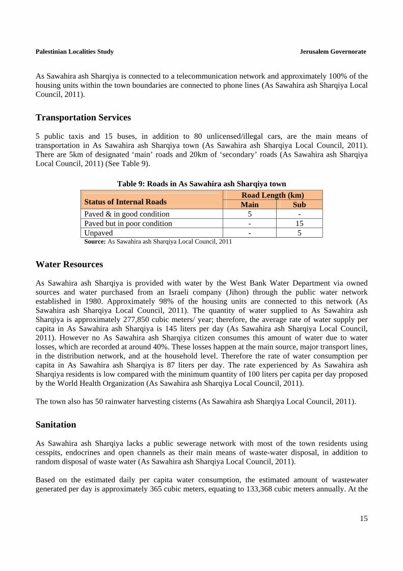
Transportation Services 5 public taxis and 15 buses, in addition to 80 unlicensed/illegal cars, are the main means of transportation in As Sawahira ash Sharqiya town (As Sawahira ash Sharqiya Local Council, 2011). There are 5km of designated ‘main’ roads and 20km of ‘secondary’ roads (As Sawahira ash Sharqiya Local Council, 2011) (See Table 9).
Table 9: Roads in As Sawahira ash Sharqiya town
Status of Internal Roads Road Length (km) Main Sub
Paved & in good condition 5 - Paved but in poor condition - 15 Unpaved - 5 Source: As Sawahira ash Sharqiya Local Council, 2011
Water Resources As Sawahira ash Sharqiya is provided with water by the West Bank Water Department via owned sources and water purchased from an Israeli company (Jihon) through the public water network established in 1980. Approximately 98% of the housing units are connected to this network (As Sawahira ash Sharqiya Local Council, 2011). The quantity of water supplied to As Sawahira ash Sharqiya is approximately 277,850 cubic meters/ year; therefore, the average rate of water supply per capita in As Sawahira ash Sharqiya is 145 liters per day (As Sawahira ash Sharqiya Local Council, 2011). However no As Sawahira ash Sharqiya citizen consumes this amount of water due to water losses, which are recorded at around 40%. These losses happen at the main source, major transport lines, in the distribution network, and at the household level. Therefore the rate of water consumption per capita in As Sawahira ash Sharqiya is 87 liters per day. The rate experienced by As Sawahira ash Sharqiya residents is low compared with the minimum quantity of 100 liters per capita per day proposed by the World Health Organization (As Sawahira ash Sharqiya Local Council, 2011). The town also has 50 rainwater harvesting cisterns (As Sawahira ash Sharqiya Local Council, 2011).
Sanitation As Sawahira ash Sharqiya lacks a public sewerage network with most of the town residents using cesspits, endocrines and open channels as their main means of waste-water disposal, in addition to random disposal of waste water (As Sawahira ash Sharqiya Local Council, 2011). Based on the estimated daily per capita water consumption, the estimated amount of wastewater generated per day is approximately 365 cubic meters, equating to 133,368 cubic meters annually. At the
Palestinian Localities Study Jerusalem Governorate
16
individual level, it is estimated that the per capita wastewater generation is 70 liters per day. The wastewater collected by cesspits is discharged by wastewater tankers directly to open areas or nearby valleys without concern for the environment. There is no wastewater treatment either at the source or at the disposal sites and this poses a serious threat to both environmental and public health (ARIJ-WERU, 2012).
Solid Waste Management As Sawahira ash Sharqiya Local Council is considered the official body responsible for managing the collection and disposal of solid waste generated by the citizens and establishments in the town. As the process of solid waste management is costly, a monthly fee (approx. 15 NIS/month) has been charged to the population served by domestic solid waste collection and transportation services. However, the collected fees are not considered sufficient for good management of solid waste, as only 25% of these fees are collected from citizens (As Sawahira ash Sharqiya Local Council, 2011). Most of the population in As Sawahira ash Sharqiya benefits from the solid waste services, whereby waste is collected from households, institutions, shops, and public squares in plastic bags and then transferred to 80 containers1 spread throughout the locality. As Sawahira ash Sharqiya Local Council collects the solid waste from the containers three times a week and transports it through a waste vehicle to El 'Eizariya dumping site, 3km from the town center, where it is buried or burnt (As Sawahira ash Sharqiya Local Council, 2011). The daily per capita rate of solid waste production in As Sawahira ash Sharqiya is 1.05kg. Thus the estimated amount of solid waste produced per day from As Sawahira ash Sharqiya residents is nearly 5.5 tons, or 2004 tons per year (ARIJ-WERU, 2012).
Environmental Conditions Like other towns and villages in the governorate, As Sawahira ash Sharqiya experiences several environmental problems which must be addressed and solved. These problems can be identified as follows: Water Crisis
Water is cut off by the West Bank Water Department for long periods of time during summer in several neighborhoods of the town.
High rate of water losses, because the water network is old and in need of rehabilitation and renovation.
Wastewater Management
The absence of a public sewage network means most town residents are forced to use unhygienic cesspits for the disposal of wastewater, and/or discharge wastewater in the streets. This is
1 each with a one cup capacity

Palestinian Localities Study Jerusalem Governorate
17
particularly common in winter, as citizens cannot afford the high cost of sewage tankers during this period. These methods facilitate environmental damage, health problems, and the spread of epidemics and diseases in the town. This wastewater also contaminates the groundwater because most cesspits are built without lining, allowing wastewater to enter into the ground and avoiding the need to use sewage tankers. Moreover, the untreated wastewater collected from cesspits by sewage tankers is disposed of in open areas without concern for the damage it causes to the environment and to residents' health.
The town and neighboring areas suffer from the wastewater flowing through the Wadi an Nar
(see Photo 2). The wastewater generated by the population is discharged in areas of Jerusalem (neighborhoods in eastern and western Jerusalem) and Bethlehem Governorate (Beit Sahour, El 'Eizariya, Abu Dis and east of Bethlehem) and flows towards the Dead Sea. Wadi an Nar water flows through the territories of Jabal al Mukabbir, Ash Sheikh Sa'd, As Sawahira ash Sharqiya, Al 'Ubeidiya and Tuqu', causing serious environmental, agricultural and health problems to residents of these areas.
Solid Waste Management
The lack of a central sanitary landfill to serve As Sawahira ash Sharqiya and other neighboring communities in the governorate is due mainly to the obstacles created by the Israeli authorities for local and national institutions in granting licenses to establish such a landfill, because the appropriate land is within Area C and under Israeli control. Additionally, the implementation of such projects depends on funding from donor countries. The lack of a sanitary landfill is a source of pollution to the groundwater and soil through the leachate produced from the solid waste, and produces bad odors and distortion of the landscape.
There is no system in the town and the governorate to separate hazardous waste from non-hazardous waste, so hazardous and industrial solid waste are collected with non-hazardous waste and transported to El Ezariyeh for disposal by burning or burial.
Photo 2: Wastewater flowing in Wadi an Nar stream

Palestinian Localities Study Jerusalem Governorate
18
Impact of the Israeli Occupation Geopolitical Status of As Sawahira ash Sharqiya Town According to the Oslo II Interim Agreement signed on 28th September 1995 by the Palestinian Liberation Organization (PLO) and Israel, As Sawahira ash Sharqiya town was divided into areas ‘A’, ‘B’ and ‘C’. Approximately 335 dunums (0.5% of the total town area) were assigned as area ‘A’, over which the Palestinian National Authority (PNA) has full security and administrative control, and 5,005 dunums (7.2% of the total town area) were assigned as area ‘B’, where the Palestinian National Authority has complete control over civil matters but Israel continues to have overriding responsibility for security. Area ‘B’ constitutes most of the inhabited Palestinian areas, including municipalities, towns, and some camps. Most of the town's population resides in area ‘B’ which constitutes a very small area in comparison to the total area of the town. Approximately 63,902 dunums (92.3% of the total town area) is classified as area ‘C’, where Israel retains full control over security and administration. In area ‘C’ Palestinian building and land management is prohibited unless through a permit given by the Israeli Civil Administration. Most of the lands lying within the area ‘C’ are pasturelands, agricultural lands, and open spaces (Table 10).
Table 10: The geopolitical divisions of As Sawahira ash Sharqiya town according to the Oslo II interim agreement in 1995
Percent of Total town area
Area in dunums Area
0.5 335 Area A 7.2 5,005 Area B
92.3 63,902 Area C 0 0 Nature Reserve
100 69,242 Total Source: ARIJ-GIS Unit, 2011
As Sawahira ash Sharqiya Town and the Israeli Occupation Practices As Sawahira ash Sharqiya town has experienced land confiscations for various Israeli purposes, including the construction of Israeli settlements on the town’s territories and its surroundings, the construction of Israeli bypass roads, and the establishment of Israeli military bases, outposts and military checkpoints. Israeli confiscations of As Sawahira ash Sharqiya’s territories are detailed below. During the Israeli occupation, the Israeli government has confiscated 1,000 dunums in As Sawahira ash Sharqiya to establish the Kedar settlement east of the town, which is inhabited by approximately 960 settlers, and the settlement of Kalya, which lies on town lands near the Dead Sea and is inhabited by around 300 Israeli settlers (Table 10).

Palestinian Localities Study Jerusalem Governorate
19
Table 11: Israeli Settlements constructed over As Sawahira ash Sharqiya lands
Settlement Name Year of
construction
Area confiscated from As Sawahira ash Sharqiya
(dunums)
Population of settlers (2009)
Kedar (Old Kedar) 1984 45 960 Kalya 1968 955 300 Total - 1,000 1,260 Source: ARIJ-GIS Unit, 2011
Israeli Occupation Authorities have also confiscated 1,986 dunums (3%) of town lands to establish an Israeli military base east of the town.
As Sawahira ash Sharqiya Town and the Segregation Wall The construction of the Israeli Segregation Wall has had a negative and destructive impact on As Sawahira ash Sharqiya town. According to the last amendment of the plan, published on the webpage of the Israeli Defense Ministry (30th of April 2007), the Wall extends 4km over As Sawahira ash Sharqiya town. The town is situated between part of the Wall constructed to the Western side, which isolates it from Jerusalem city, and a planned section of Wall to be constructed on the eastern side. A large area of As Sawahira ash Sharqiya lands within the area isolated behind the Wall will be confiscated. When the Wall is complete, 637 dunums of As Sawahira ash Sharqiya lands will be isolated. The isolated lands include part of the town's urban area, agricultural lands, pastures, open spaces, and settlements (Table 11).
Table 12: The land classification of the isolated lands to the west side of the Segregation Wall in As Sawahira ash Sharqiya Town - Jerusalem Governorate
No. Land classification Area (dunums)
1 Agricultural areas 38 2 Open spaces 508 3 Palestinian residential area 32 4 Israeli settlements 45 5 Wall zone 14
Total 637 Source: ARIJ-GIS Unit, 2011
The Segregation Wall and its Negative Impact on As Sawahira ash Sharqiya Residents When the Segregation Wall is completed, the urbanized area of As Sawahira ash Sharqiya will be isolated from neighboring Palestinian towns and villages and from Jerusalem city. The existing Wall is located west of the town and will push the town outside the Jerusalem city boundaries.

Palestinian Localities Study Jerusalem Governorate
20
If the Wall is completed as planned, As Sawahira ash Sharqiya, along with El 'Eizariya and Abu Dis, will be surrounded by the Segregation Wall from the eastern, northern and western sides, whilst the southern side will remain open for the town's residents to connect with the southern West Bank. Residents will therefore be able to access Bethlehem and Hebron Governorates, as the Wall will cut off As Sawahira ash Sharqiya from the north and it will become part of the southern West Bank. The eastern Wall in As Sawahira ash Sharqiya town will isolate the town's urban area from its territories extending to the east. The Israeli occupation authorities have constructed the Wall close to the urbanized areas in the town, increasing the total area of land confiscated and minimizing the area available for future urban development. The route of the Segregation Wall to the eastern side of the town annexes the Israeli settlement bloc of Ma'ale Adumim to Jerusalem City, as part of the ‘Greater Jerusalem’ plan. The Wall will completely separate Palestinians from As Sawahira ash Sharqiya who carry Palestinian IDs (the West Bank Green IDs) from Jerusalem City, cutting them off from educational, health, social, and economic services. Access to the city will be limited to those who have Jerusalem identity cards (the blue ID) through military checkpoints, where they must go through inspection and show their Jerusalem IDs to prove their right to travel, work, and reside in the City. This will generate considerable psychological and physical suffering and restrict their freedom of movement and communication. This step aims at to re-delineate Jerusalem City borders as part of Israeli plans to change the demographic status in the city to the benefit of Israel by excluding neighborhoods of high Palestinian population density from Jerusalem City.
The Israeli E1 Plan and As Sawahira ash Sharqiya's Lands The Israeli settlement bloc of Ma'ale Adumim is considered one of the most threatening settlement blocs in the West Bank, as it lies within the borders of the Jerusalem governorate and forms a geographical threat to links between the northern and southern areas of the West Bank. Additionally, it isolates East Jerusalem from other Palestinian governorates, complicating proposals for an independent Palestinian state with Jerusalem as its capital and threatening the territorial continuity of such a state. Ma'ale Adumim bloc has special consideration from the committee responsible for the Israeli project to segregate and fragment the West Bank due to its location near the eastern part of Jerusalem city. The Israeli administration therefore came up with the E1 plan which entails building a new settlement bloc in the West Bank to create a physical link between Ma'ale Adumim and central Jerusalem. The E1 plan affects Palestinian towns and villages in the area, including Abu Dis, El 'Eizariya, At Tour, 'Isawiya, As Sawahira ash Sharqiya, Az Za'ayyem and 'Anata; it restricts their right to urban development and creates an obstacle to territorial continuity between the northern and southern West Bank (map 4). The E1 Plan includes the construction of 3,900 housing units to the west and north of Ma'ale Adumim on an area of 13,213 dunums, which was included in the settlement's Master Plan created by the Israeli Civil Administration. It is expected that this plan will increase the population of the settlement dramatically. With the completion of the E1 Plan, the Israeli urban belt will be sealed around Jerusalem City. Consequently As Sawahira ash Sharqiya will be strangled from the east and north and will lose many dunums of its land.
Palestinian Localities Study Jerusalem Governorate
21
The ‘Fabric of Life’ Road Plan and As Sawahira ash Sharqiya On 9th October 2007, the IOF issued a military order (07/35/T) aiming to confiscate 387 dunums of As Sawahira ash Sharqiya, At Tour and El 'Eizariya lands to complete the ‘Fabric of Life Road’. This is a 17km road that was announced by military order 07/19/T on 4th October 2007. The road will connect the southern West Bank (Bethlehem and Hebron Governorates) with the Jordan Valley and with Jericho city in the eastern side of the West Bank (map 5). According to the Israeli military order 07/35/T, an extension to military order 07/19/T, the second part of the ‘Fabric of Life’ road will be 4.6 kilometers long. It will begin at the Container checkpoint east of As Sawahira ash Sharqiya, passing through As Sawahira ash Sharqiya and El 'Eizariya lands and the localities of At Tour and Az Za'ayyem. The road will connect through a tunnel in the area and will continue to 'Anata and Hizma localities, where it will be linked to a new road constructed by Israel near the Israeli military base east of 'Anata town. This road will confiscate more lands from As Sawahira ash Sharqiya and other neighboring towns. Its aim is to change Palestinians’ patterns of movement away from bypass road 1, which passes near Ma'ale Adumim east of Jerusalem city, as part of the process of settlement construction to the west of Ma’ale Adumim under the E1 plan. Wadi an Nar Israeli Military Checkpoint: The Container Since the outbreak of the Second Intifada in September 2000, the Israeli occupation forces have expanded and developed the Container checkpoint. The Container was once an ordinary Israeli military point, but it has now become a fully-equipped checkpoint for pedestrians and cars. An Israeli military base has been established along the checkpoint on As Sawahira ash Sharqiya lands. The Container separates the northern and the southern West Bank and is considered one of the most important Israeli military checkpoints in the West Bank due to its location near Jerusalem city. The Container forms a significant impediment to the movement of Palestinians between the northern and southern West Bank; Palestinians must cross it every day as part of daily movement between the north and south to work, study, or access health services and other Palestinian governorates. The Container checkpoint is seen as a symbol of the Palestinians’ routine and daily suffering; it has been the scene of many Israeli violations of Palestinian rights, including verbal insults, arrests and detainments, shootings, random closures, and severe traffic problems. For many years, Palestinian citizens have experienced great suffering due to the presence of Israeli checkpoints and obstacles throughout the West Bank. The number of obstacles to freedom of movement and travel for Palestinians in the West Bank has increased dramatically over the past decade; there are presently over 650 obstacles, including 79 checkpoints, 17 flying checkpoints, 71 military observation towers, 113 agricultural gates, 70 cement blocks, 234 earth mounds, and 85 iron gates. Following the outbreak of the Second Intifada in 2000, Wadi an Nar road (Wadi Kadron Road) became the main route for Palestinians as an alternative to Israeli bypass road 60, which links the cities of Bethlehem and Jerusalem. The distance via Wadi an Nar (Wadi Kadron) is nearly twice the distance of the bypass route; this increases the economic and social burden of travel. Additionally, the road is in poor condition and has been the scene of many crashes, breakdowns, and other traffic accidents.

Map 4: Israeli “E1” plan
Source: ARIJ – GIS Unit, 2012

Palestinian Localities Study Jerusalem Governorate
23
Map 5: “Fabric of Life” Road Plan
Source: ARIJ – GIS Unit, 2012

Israeli Military Orders Issued in As Sawahira ash Sharqiya The Israeli occupation authorities have issued a set of military orders to confiscate lands in As Sawahira ash Sharqiya town for different military purposes. These include:
Israeli military order 03/03/T: issued on 14th July 2004 (expansion and modification of boundaries) to confiscate 5 dunums of As Sawahira ash Sharqiya and Abu Dis towns for the Segregation Wall construction.
Israeli military order 19/07/T: issued on 24th September 2007 to confiscate 1129 dunums from As Sawahira ash Sharqiya, As Sawahira al Gharbiya and Abu Dis towns to build the ‘Fabric of Life’ Road.
Israeli military order 153/05/T: issued on 15th August 2005 to confiscate 212 dunums of As Sawahira ash Sharqiya town for construction of the Segregation Wall.
Development Plans and Projects Implemented Projects As Sawahira ash Sharqiya Local Council has not implemented any development projects in As Sawahira ash Sharqiya during the last five years.
Proposed Projects As Sawahira ash Sharqiya Local Council, in cooperation with the civil society organizations in the town and the town residents, hopes to implement several projects in the coming years. The project ideas were developed during the PRA workshop conducted by ARIJ staff in the town. The projects are as follows, in order of priority from the perspectives of the participants in the workshop:
1. Providing an executive authority. 2. Establishing a maternity hospital and an emergency center. 3. Establishing a public park. 4. Providing projects for the rehabilitation of the water network. 5. Establishing a sewage network. 6. Establishing a database for the old city and all archeological sites. 7. Establishing secondary schools. 8. Establishing Al Quds International Stadium. 9. Providing investment projects and creating job opportunities. 10. Providing awareness programs to create a cleaner environment in the town. 11. Reclaiming streets in the outskirts of the town.

Palestinian Localities Study Jerusalem Governorate
25
Locality Development Priorities and Needs As Sawahira ash Sharqiya suffers from a significant shortage of infrastructure and services. Table 13 shows the development priorities and needs in the town according to the local council’s feedback (As Sawahira ash Sharqiya Local Council, 2011).
Table 13: Development Priorities and Needs in As Sawahira ash Sharqiya
No. Sector Strongly Needed
Needed Not a
Priority Notes
Infrastructural Needs
1 Opening and Pavement of Roads * 24km
2 Rehabilitation of Old Water Networks * 5km
3 Extending the Water Network to Cover New Built up Areas
* 2km
4 Construction of New Water Networks *
5 Rehabilitation/ Construction of New Wells or Springs
*
6 Construction of Water Reservoirs * 1000 cubic meters
7 Construction of a Sewage Disposal Network * 18km
8 Construction of a New Electricity Network *
9 Providing Containers for Solid Waste Collection * 150 containers
10 Providing Vehicles for Collecting Solid Waste * 1 vehicle
11 Providing a Sanitary Landfill *
Health Needs 1 Building of New Clinics or Health Care Centres * 2 Rehabilitation of Old Clinics or Health Care
Centres * one health center
3 Purchasing of Medical Equipment and Tools *
Educational Needs 1
Building of New Schools * secondary scientific level &
elementary level 2 Rehabilitation of Old Schools * elementary level 3 Purchasing of New Equipment for Schools *
Agriculture Needs 1 Rehabilitation of Agricultural Lands * 30,000 dunums 2 Building Rainwater Harvesting Cisterns * 100 cisterns 3 Construction of Barracks for Livestock * 30 barracks 4 Veterinary Services * 5 Seeds and Hay for Animals * 400 tons per year 6 Construction of New Greenhouses * 40 greenhouses 7 Rehabilitation of Greenhouses * 8 Field Crops Seeds * 9 Plants and Agricultural Supplies * 8km are main roads, 10km are sub roads and 6km are agricultural roads. Source: As Sawahira ash Sharqiya Local Council, 2011.

Palestinian Localities Study Jerusalem Governorate
26
References As Sawahira ash Sharqiya Local Council, 2011. Applied Research Institute - Jerusalem (ARIJ), 2012. Geographic Information Systems and Remote
Sensing Unit; Land Use Analysis (2010) – Half Meter High Accuracy. Bethlehem - Palestine. Applied Research Institute - Jerusalem (ARIJ), 2012. Geographic Information Systems and Remote
Sensing unit Database. Bethlehem - Palestine. Applied Research Institute - Jerusalem (ARIJ). 2012. Water & Environment Research Unit Database
(WERU). Bethlehem - Palestine. Ministry of Education & Higher Education (MOHE) - Jerusalem, 2011. Directorate of Education; A
database of schools (2010/2011). Jerusalem – Palestine. Palestinian Central Bureau of Statistics. 2009. Jerusalem, Palestine: General Census of Population
and Housing Censuses, 2007. Palestinian Ministry of Agriculture (MOA), 2010. Directorate of Agriculture data (2009/2010).
Jerusalem - Palestine. Shkeirat, Muhammad. "As Sawahira at Jerusalem Eastern Gate." Al Quds News. October 15, 2011.
Print.