Arundel and Amberley - · PDF fileWe're heading to Arundel, ... drink plus plenty more...
5
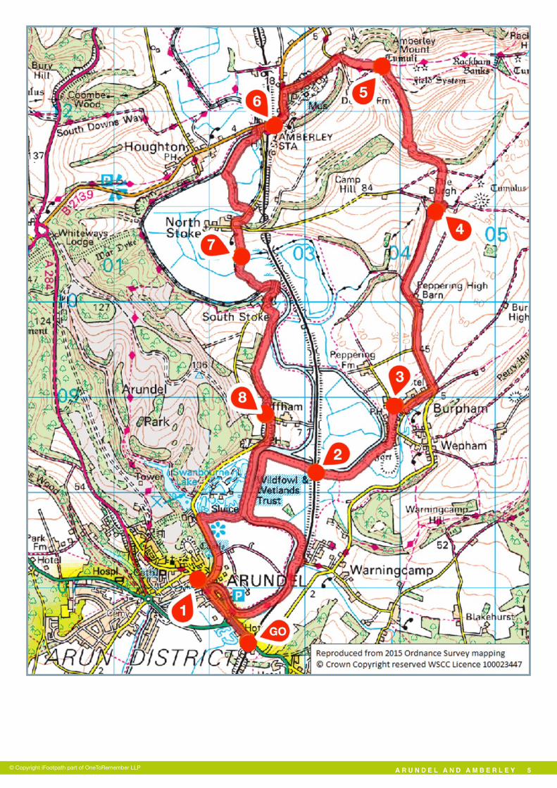
Hi, I'm Georgina and this is my West Sussex Weekends walk. We're heading to Arundel, my dad grew up there and it's the perfect place to get away from our hectic life in the city; a castle, the river and beautiful countryside, just a train ride from home, perfect. To read my full story visit www.west-sussex-weekends.com so I can tell you why I think you will love this walk and what highlights to expect. The West Sussex Weekends website is a great resource where you will also find ideas for places to stay, eat and drink plus plenty more inspirational stories to tempt you to explore more corners of West Sussex. Getting there The walk starts and finishes at Arundel Rail Station in West Sussex. You can catch the train direct from London Victoria. If you are coming by car, there is a pay and display car park at Arundel Station which costs £4.40 per day Mon-Sat or £2 on Sunday (correct Oct 2015). Approximate post code BN18 9PH. Walk Sections Start to Arundel Centre Leave Arundel Station along the access road and turn left alongside the A27. After just a short distance, use the pedestrian crossing to swap to the right-hand pavement and follow this passing a roundabout on your left. Soon you are forced to swap to the left-hand pavement and the road leads you over the river to a mini-roundabout. Go straight ahead into the High Street. Heading up the old High Street, you will have an impressive view of the castle, such an imposing building ARUNDEL AND AMBERLEY 1 1. The full walk is 12 miles but if that sounds too much for you, there's an option to shorten it to 7.5 miles. 2. The route has a few climbs and descents including a long climb over the South Downs ridge. 3. Almost all the paths can be muddy and in the wetter months the South Downs are often thick with chalky clay, so good boots are a must. 4. You will need to negotiate several sets of steps, kissing gates and 12 stiles (all of which have open fence surrounds suitable for dogs to pass through). 5. There are a couple of stretches along quiet roads and you will also need to cross the railway at an unsignalled crossing, so take particular care at these points. 6. You will be sharing several of the meadows and fields with both cattle and sheep. ARUNDEL AND AMBERLEY, WEST SUSSEX 12 miles Circular 6 hours Access Notes © Copyright iFootpath part of OneToRemember LLP Challenging Terrain 301015 Go 1 Get the iFootpath App for a smarter walking experience. Hundreds of walking guides in the palm of your hand with live maps that show your progress as you walk. Say goodbye to wrong turns! iFootpath.com
Transcript of Arundel and Amberley - · PDF fileWe're heading to Arundel, ... drink plus plenty more...

Hi, I'm Georgina and this is my West Sussex Weekends walk. We're heading to Arundel, my dad grew up there and it's the perfect place to get away from our hectic life in the city; a castle, the river and beautiful countryside, just a train ride from home, perfect. To read my full story visit www.west-sussex-weekends.com so I can tell you why I think you will love this walk and what highlights to expect. The West Sussex Weekends website is a great resource where you will also find ideas for places to stay, eat and drink plus plenty more inspirational stories to tempt you to explore more corners of West Sussex.
Getting there The walk starts and finishes at Arundel Rail Station in West Sussex. You can catch the train direct from London Victoria. If you are coming by car, there is a pay and display car park at Arundel Station which costs £4.40 per day Mon-Sat or £2 on Sunday (correct Oct 2015).
Approximate post code BN18 9PH.
Walk Sections Start to Arundel Centre
Leave Arundel Station along the access road and turn left alongside the A27. After just a short distance, use the pedestrian crossing to swap to the right-hand pavement and follow this passing a roundabout on your left. Soon you are forced to swap to the left-hand pavement and the road leads you over the river to a mini-roundabout. Go straight ahead into the High Street.
Heading up the old High Street, you will have an impressive view of the castle, such an imposing building
A R U N D E L A N D A M B E R L E Y �1
1. The full walk is 12 miles but if that sounds too much for you, there's an option to shorten it to 7.5 miles.
2. The route has a few climbs and descents including a long climb over the South Downs ridge.
3. Almost all the paths can be muddy and in the wetter months the South Downs are often thick with chalky clay, so good boots are a must.
4. You will need to negotiate several sets of steps, kissing gates and 12 stiles (all of which have open fence surrounds suitable for dogs to pass through).
5. There are a couple of stretches along quiet roads and you will also need to cross the railway at an unsignalled crossing, so take particular care at these points.
6. You will be sharing several of the meadows and fields with both cattle and sheep.
ARUNDEL AND AMBERLEY, WEST SUSSEX
12 miles Circular 6 hours
Access Notes
© Copyright iFootpath part of OneToRemember LLP
Challenging Terrain
301015
Go 1
Get the iFootpath App for a smarter walking experience. Hundreds of walking guides in the palm of your hand with live maps that show your progress as you walk. Say goodbye to wrong turns!
iFootpath.com

in such a quaint and pretty place. There’s tons to see so take time to explore if you wish.
Arundel Centre to Railway Crossing
When you are finished in Arundel, head back down to the mini-roundabout at the bottom of the High Street. Go straight ahead over the river bridge and, before the first house on the left, turn left into the alley signed as a public footpath. At the T-junction, fork left to join the narrow stone footpath which swings right to run directly alongside the River Arun.
Keep ahead on this riverside path which leads you to a stile. NOTE: You may come across cattle in the riverside pastures from this point. Cross the stile and continue ahead on the embankment path. Behind to your left, the views open up across the Arundel skyline, dominated by the castle and cathedral. Further along, a small river inlet forces you to swing right through a gate (alongside a white cottage and the rail line). Do NOT cross the rail line, instead swing left and left again through the next kissing gate to continue on the riverside path.
Simply stay on this riverside path for 1.3 miles, passing through a kissing gate and 2 stiles along the way. On the opposite bank you will see the Black Rabbit pub, the final pit stop for your return leg. Just before you come to a rail bridge over the river, fork right (leaving the embankment) to reach the pedestrian railway crossing. NOTE: The crossing is unsignalled so look and listen for trains carefully before you cross. Cross via the two stiles to reach the meadow on the far side.
Railway Crossing to Burpham Village
Keep ahead across the meadow to rejoin the embankment path. Cross a double stile and continue on the riverside path. After
crossing four more stiles you will come to a fingerpost marking a junction of paths. Go ahead, up the flight of steps (known as Jacob’s Ladder) into woodland. At the top, bear left, following the path with fenced fields on your right. Go through the gate ahead and you will come to the Burpham cricket ground.
Skirt to the left of the cricket pavilion and take the track down to the village road. If you're ready for lunch there’s a pub at hand, The George. The food is fab and the whole pub is owned by the community which is pretty great.
Burpham Village to Woodland Copse
Once fed and watered we are back on the move. Turn right along the village road heading downhill between the cute cottages. At the junction, follow the main road to the left. After passing Splash Farm Barn you will come to a crossroads. Turn left and follow the road (taking care of traffic) heading gradually uphill (the start of the long climb to the South Downs).
At the next junction, fork right onto the dead end lane signed to High Barn. Follow the lane as it swings left past the buildings of Peppering High Barn on your right. After the buildings, ignore the path to the right, simply keep ahead on the main stone bridleway. Over to the left, the views of Arundel are just stunning.
Stay on the main stone bridleway (ignoring a path to the left) and eventually you will come to a fork (just before a copse of trees). Take the right-hand branch, a grass track, and follow this with woodland on the left and hedgerows running on the right. Continue up to a fingerpost marking a staggered T-junction. Turn left into the woodland and just a few metres later you will come to another crossroads (marked with a fingerpost).
Woodland Copse to South Downs Way
Turn right and then join the field-edge path which runs along the left-hand side of the hedge in front of you. At the top of the field you will come to a crossroads. Go straight on and follow the track to a gate. NOTE: There will probably be sheep in this pasture. Pass through the gate and follow the wide track that hugs the left-hand edge of the steep valley side. As you walk down you will see two exits to this field; one ahead at the end of the field (you don’t want this one) and a smaller gate nearer to you on the right-hand boundary (this is the one you are after). As you reach the bottom of the valley, swing right and leave the field via the small gate.
After the gate, fork left to join the grass bridleway leading you
A R U N D E L A N D A M B E R L E Y �2© Copyright iFootpath part of OneToRemember LLP
1 2
2 3
3 4
4 5

uphill. The track swings right, swings left and then follow a fence on your left. Follow the path steadily uphill, passing through one gateway along the way. Stay with the fence line on the left and, after drawing level with the farm to the left, the track swings left to merge with the South Downs Way.
South Downs Way to Amberley Station
Go through the gateway (with the farm buildings ahead) and at the fork, take the right-hand branch, a narrower grass path between fenced fields (still part of the South Downs Way). From this high vantage point the views are quite something, they stretch for miles. You can see the castle in Amberley as well as the River Arun snaking through the valley bottom.
At the bottom of the slope the path leads you through a gate and out to Mill Lane. Turn right along the lane and, at the fork, keep left (still following the South Downs Way). As you continue downhill, try to find a place to catch a glance over the wall on the left. You will see old railways and engine sheds, part of Amberley Museum. If you’re after an interesting fact to share back in the office, the railway tunnel entrance at this museum was used as the film set for Zorin’s Main Strike silver mine in the Bond film, A View To A Kill. Wagons from the museum also starred in Captain America: The First Avenger.
Eventually you will reach a T-junction with New Barn Road. Cross over with care and turn left along the pavement, continuing downhill. The road leads you down past the museum entrance and on to reach Amberley Station on your left. If you’ve had your fill of walking (it’s been 7.5 miles so far), you can catch a train back to Arundel from this station. The trains normally run hourly but the journey is only 5 mins.
Amberley Station to Gurkha Bridge
If you’re still walking with us, follow the pavement under the railway bridge and you will come to Amberley Village which has lots of places to explore and the ideal spot for a second pit stop. We can’t help it, burning all those calories means one thing, it’s time to replenish them with scones and jam in the Amberley Village tea room, divine.
Continue along the road (taking care as there are no pavements) as it begins to cross the river. Half way across the bridge, turn left over a stile to join a signed public footpath. Take the small bridge over the creek, turn right over the stile and then walk ahead following the embankment path with the river running on the right. Further along, cross the next stile ahead and, soon afterwards (before passing a sluice gate), turn left by a disused stile to join a narrow path through trees.
At the end of the woodland path you will reach a tarmac lane. Turn right and follow the lane winding uphill into the hamlet of North Stoke. At the junction (with post box ahead), turn left then immediately right onto the signed footpath between hedgerows. Go through the pair of kissing gates and go straight on, heading downhill through the cattle pasture. At the bottom, take the kissing gate ahead and the path leads you to a perfectly formed (but miniature in scale) suspension bridge, known as the Gurkha Bridge.
Gurkha Bridge to Offham Village
Cross the bridge, continue along the tree-lined path, go through the kissing gate and then bear left to join the riverside path once again. Soon the path leads you through a kissing gate. Turn immediately right and follow the quiet lane over the river bridge. Ignore the stile on the left, simply follow the main lane winding through the village of South Stoke.
A R U N D E L A N D A M B E R L E Y �3© Copyright iFootpath part of OneToRemember LLP
5 6
6 7
7 8

Opposite the entrance for South Stoke Farm (on your right), turn left onto a grass track signed as a public bridleway. Follow this obvious grass track for 0.6 miles, eventually passing through a gate ahead to join a narrower path (which can be a bit overgrown at times). Pass the cottage on the left and follow the path climbing steeply up into woodland. You will emerge to a T-junction with the quiet road alongside Offham Village.
Offham Village to End
Turn left and then take the first road on the right (signed to Arundel). Follow the road downhill between tall steep banks and as you emerge out from the trees you will come to the Black Rabbit riverside pub on the left, the final pit stop on this walk and a perfect spot to kick back in the garden.
At the end of the pub car park, fork left to join the riverside path, with the river on the left. Soon the reassuring sight of the Arundel skyline appears ahead. Just before a kissing gate and sluice gate ahead, turn right onto the signed public footpath. Follow this surfaced path thorough a belt of trees with a water channel on your left. At the end of his section you will come to a junction of paths. Turn left over the footbridge and then keep straight ahead along the tree-lined tarmac footpath.
Follow this path all the way to its end where you will find the mini-roundabout alongside Arundel Bridge. From this point you will be re-tracing your steps back to the station. To do this, turn left over the bridge and follow Queen Street (swapping to the right-hand pavement and back again as you go) to its end. Go straight ahead past the roundabout on the right, cross over the pedestrian crossing and a few paces later you will come to Arundel Station where the walk began.
If you enjoyed this walk, remember to visit www.west-sussex-weekends.com where you will also find ideas for places to stay, eat and drink plus plenty more inspirational stories to tempt you to explore more corners of West Sussex.
A R U N D E L A N D A M B E R L E Y �4
DisclaimerThis walking route was walked and checked at the time of writing. We have taken care to make sure all our walks are safe for walkers of a reasonable level of experience and fitness. However, like all outdoor activities, walking carries a degree of risk and we accept no responsibility for any loss or damage to personal effects, personal accident, injury or public liability whilst following this walk. We cannot be held responsible for any inaccuracies that result from changes to the routes that occur over time. Please let us know of any changes to the routes so that we can correct the information.Walking SafetyFor your safety and comfort we recommend that you take the following with you on your walk: bottled water, snacks, a waterproof jacket, waterproof/sturdy boots, a woolly hat and fleece (in winter and cold weather), a fully-charged mobile phone, a whistle, a compass and an Ordnance Survey map of the area. Check the weather forecast before you leave, carry appropriate clothing and do not set out in fog or mist as these conditions can seriously affect your ability to navigate the route. Take particular care on cliff/mountain paths where steep drops can present a particular hazard. Some routes include sections along roads – take care to avoid any traffic at these points. Around farmland take care with children and dogs, particularly around machinery and livestock. If you are walking on the coast make sure you check the tide times before you set out.
© Copyright iFootpath part of OneToRemember LLP
8 9
A R U N D E L A N D A M B E R L E Y �5© Copyright iFootpath part of OneToRemember LLP