Article 10 Landmark Districtcommissions.sfplanning.org/hpcpackets/2011.0683Lv1.pdfArticle 10...
115
www.sfplanning.org Article 10 Landmark District Historic Preservation Commission Case Report Recommendation to the Board of Supervisors Hearing Date: December 19, 2012 Case No.: 2011.0683L Project: Duboce Park Landmark District Zoning: RH-2 & RTO Blocks: 0863, 0864, 0865, 0866 Staff Contact: Mary Brown – (415) 575-9074 [email protected] Reviewed By: Tim Frye – (415) 575-6822 [email protected] PROJECT DESCRIPTION The case before the Historic Preservation Commission (HPC) is the consideration to recommend approval of the landmark designation of the Duboce Park Landmark District pursuant to Section 1004.2 of the Planning Code. Further consideration by the Planning Commission and the Board of Supervisors will occur at future public hearings and will be noticed separately for a future date. ENVIRONMENTAL REVIEW STATUS The Planning Department (Department) has determined that actions by regulatory agencies for protection of the environment (specifically in this case, landmark designation) are exempt from environmental review, pursuant to CEQA Guidelines Section 15308 (Class Eight - Categorical). BACKGROUND / PREVIOUS ACTIONS The Historic Preservation Commission, at its regularly scheduled hearing on June 15, 2011, added the subject district to its Landmark Designation Work Program. On December 5, 2012, the HPC, by Resolution No. 696, formally initiated the Duboce Park Landmark District. APPLICABLE PRESERVATION STANDARDS ARTICLE 10 Section 1004 of the Planning Code authorizes the landmark designation of an individual structure or other feature or an integrated group of structures and features on a single lot or site, having special
Transcript of Article 10 Landmark Districtcommissions.sfplanning.org/hpcpackets/2011.0683Lv1.pdfArticle 10...

www.sfplanning.org
Article 10 Landmark District Historic Preservation Commission Case Report Recommendation to the Board of Supervisors
Hearing Date: December 19, 2012
Case No.: 2011.0683L
Project: Duboce Park Landmark District
Zoning: RH-2 & RTO
Blocks: 0863, 0864, 0865, 0866
Staff Contact: Mary Brown – (415) 575-9074
Reviewed By: Tim Frye – (415) 575-6822
PROJECT DESCRIPTION
The case before the Historic Preservation Commission (HPC) is the consideration to recommend approval
of the landmark designation of the Duboce Park Landmark District pursuant to Section 1004.2 of the
Planning Code. Further consideration by the Planning Commission and the Board of Supervisors will
occur at future public hearings and will be noticed separately for a future date.
ENVIRONMENTAL REVIEW STATUS
The Planning Department (Department) has determined that actions by regulatory agencies for
protection of the environment (specifically in this case, landmark designation) are exempt from
environmental review, pursuant to CEQA Guidelines Section 15308 (Class Eight - Categorical).
BACKGROUND / PREVIOUS ACTIONS
The Historic Preservation Commission, at its regularly scheduled hearing on June 15, 2011, added the
subject district to its Landmark Designation Work Program.
On December 5, 2012, the HPC, by Resolution No. 696, formally initiated the Duboce Park Landmark
District.
APPLICABLE PRESERVATION STANDARDS
ARTICLE 10
Section 1004 of the Planning Code authorizes the landmark designation of an individual structure or
other feature or an integrated group of structures and features on a single lot or site, having special

Landmark District Designation
December 19, 2012
2
Case Number 2011.0683L
Duboce Park Landmark District
character or special historical, architectural or aesthetic interest or value, as a landmark. Section 1004.1
also outlines that landmark designation may be initiated by the Board of Supervisors or the Historic
Preservation Commission and the initiation shall include findings in support. Section 1004.2 states that
once initiated, the proposed designation is referred to the Historic Preservation Commission for a report
and recommendation to the Board of Supervisors to approve, disapprove or modify the proposal.
Pursuant to Section 1004.3 of the Planning Code, if the Historic Preservation Commission approves the
designation, a copy of the resolution of approval is transmitted to the Board of Supervisors and without
referral to the Planning Commission. The Board of Supervisors shall hold a public hearing on the
designation and may approve, modify or disapprove the designation.
In the case of the initiation of a historic district, the Historic Preservation Commission shall refer its
recommendation to the Planning Commission pursuant to Section 1004.2(c). The Planning Commission
shall have 45 days to provide review and comment on the proposed designation and address the
consistency of the proposed designation with the General Plan, Section 101.1 Priority Policies, the City’s
Regional Housing Needs Allocation, and the Sustainable Communities Strategy for the Bay Area. These
comments shall be sent to the Board of Supervisors in the form of a resolution.
Section 1004(b) requires that the designating ordinance approved by the Board of Supervisors shall
include the location and boundaries of the landmark site … a description of the characteristics of the
landmark … which justify its designation, and a description of the particular features that should be
preserved.
Section 1004.4 states that if the Historic Preservation Commission disapproves the proposed designation,
such action shall be final, except upon the filing of a valid appeal to the Board of Supervisors within 30
days.
ARTICLE 10 LANDMARK CRITERIA
The Historic Preservation Commission on February 4, 2009, by Resolution No. 001, adopted the National
Register Criteria as its methodology for recommending landmark designation of historic resources.
Under the National Register Criteria, the quality of significance in American history, architecture,
archaeology, engineering, and culture is present in districts, sites, buildings, structures, and objects that
possess integrity of location, design, setting, feeling, materials, workmanship, and association, and that
are associated with events that have made a significant contribution to the broad patterns of our history;
or that are associated with the lives of persons significant in our past or that embody the distinctive
characteristics of a type, period, or method of construction, or that represent the work of a master, or that
possess high artistic values, or represent a significant and distinguishable entity whose components may
lack individual distinction; or that have yielded, or may likely yield, information important in prehistory
or history.
OUTREACH AND ENGAGEMENT The Department engaged in extensive community outreach, produced informational materials, and
hosted eight community events focused on the proposed designation, as outlined below. Representatives

Landmark District Designation
December 19, 2012
3
Case Number 2011.0683L
Duboce Park Landmark District
from Supervisor Scott Wiener’s office, the Recreation and Park Department, and the Duboce Triangle
Neighborhood Association (DTNA) attended most of these events. Events included a neighborhood
history walking tour, two Ask-A-Planner nights, and five community meetings and workshops. In
addition, the Department presented updates at DTNA meetings and provided updates for the
association’s newsletter. Details on the Department’s outreach activities are documented in the December
5, 2012 Case Report.
The following section provides an overview of the Department’s outreach activities focused on the
designation ordinance, specifically the tailoring of appropriate level of review for identified scopes of
work.
September 20, 2011 Community Workshop
This interactive workshop focused on community review of a draft designation ordinance. New policies
introduced by the Historic Preservation Commission, such as delegation of review to Department staff in
the form of Administrative Certificates of Appropriateness, allowed for greater flexibility and
engagement with the community in the tailoring of the designation and the required levels of review.
Topics at the workshop included prioritizing preservation needs and levels of permit review. The
Department produced large-scale posters outlining the initial proposed levels of review at the primary
façade and secondary facades. Working in small groups, workshop participants provided input on how
to best protect neighborhood character through appropriate review of identified scopes of work.
Participants prioritized scopes of work for three separate levels of review: Certificate of Appropriateness,
Administrative Certificate of Appropriateness, and No Certificate of Appropriateness. The goal of the
workshop was to gain a better understanding – at an open, public forum – of the types of alterations that
stakeholders prioritize for additional review. The feedback gathered at the workshop helped tailor a
designation ordinance that aligns more closely with community needs, provides a clear and predictable
review process for specific scopes of work, and protects the character of the neighborhood.
September 27, 2011 Ask-A-Planner Night
An “Ask-A-Planner” event focused on the review of future alterations was held at the Duboce Park Café
a week following the community workshop. Department planners and Commissioner Alan Martinez
engaged several property owners in detailed discussions regarding levels of review identified and
prioritized at the workshop. It served as an additional forum to receive feedback and hear of concerns
regarding the review of certain scopes of work.
December 7, 2011 Drop-In Event / Community Meeting
With Supervisor Scott Wiener and DTNA, the Department hosted a Drop-In Event / Community Meeting
to share revisions to the proposed levels of review. During the first half of this event, Department
planners were on hand to discuss the revised review framework and to discuss the differences between
the current California Environmental Quality Act (CEQA) review process and the proposed Article 10
review process. During the meeting’s second half, the group convened for a larger question and answer
session with Department staff, Supervisor Scott Wiener, and DTNA. In addition, Executive Director of
San Francisco Architectural Heritage, Mike Buhler, provided information at the meeting about the Facade
Easement program.

Landmark District Designation
December 19, 2012
4
Case Number 2011.0683L
Duboce Park Landmark District
Promotional materials for this event included a save-the-date postcard and a five-page mailing to
residents, owners, and stakeholders outlining the revised levels of review for future alterations to
properties within the proposed district. Large-scale posters outlined the revised levels of review at the
primary facade, visible rear façade, and non-visible rear facade. At the request of community members,
the Department created a comparison chart that documented the existing review process as compared to
the proposed review process.
At this meeting, many property owners expressed interest in the property tax savings offered by the Mills
Act program and concern that the existing application process presented a barrier to realizing those
savings. At the request of property owners, Supervisor Scott Wiener sponsored legislation to amend San
Francisco’s Mills Act Program to make the application process quicker, cheaper, and more predictable.
The Department coordinated with the San Francisco Assessor’s office to set established periods for the
submittal and review of Mills Act applications and reduced the application fee. The improved program
became effective in October 2012.
Online Questionnaire
At the request of property owners and Supervisor Scott Wiener, the Department created an online
questionnaire to solicit feedback regarding the proposed district. The online questionnaire was designed
specifically for residents and owners of buildings located within the proposed district. It was available
online from November 5, 2012 through November 26, 2012. Participation was limited to one
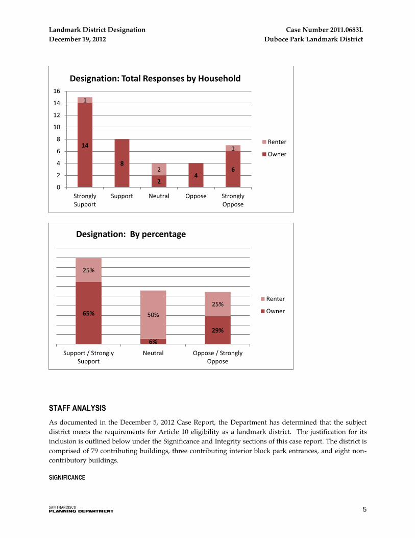
questionnaire per household. The online questionnaire produced a total of 38 valid household responses.
The vast majority of responses were provided by property owners. Just four renter households
participated. The following section summarizes responses to the online questionnaire. Details regarding
promotion of the online questionnaire, participation, and the full text of qualitative responses are
included in the December 5, 2012 Case Report.
Property owners supported the proposed landmark district designation by more than a two-to-one ratio.
Of the 34 owner participants, 65% support or strongly support the designation, compared to 29% who
oppose or are strongly opposed.
Landmark District Designation
December 19, 2012
5
Case Number 2011.0683L
Duboce Park Landmark District
STAFF ANALYSIS
As documented in the December 5, 2012 Case Report, the Department has determined that the subject
district meets the requirements for Article 10 eligibility as a landmark district. The justification for its
inclusion is outlined below under the Significance and Integrity sections of this case report. The district is
comprised of 79 contributing buildings, three contributing interior block park entrances, and eight non-
contributory buildings.
SIGNIFICANCE
14
8
2 4
6
1
2
1
0
2
4
6
8
10
12
14
16
StronglySupport
Support Neutral Oppose StronglyOppose
Designation: Total Responses by Household
Renter
Owner
65%
6%
29%
25%
50%
25%
Support / StronglySupport
Neutral Oppose / StronglyOppose
Designation: By percentage
Renter
Owner

Landmark District Designation
December 19, 2012
6
Case Number 2011.0683L
Duboce Park Landmark District
The Period of Significance for the district dates from 1899 to 1911, inclusive of the known period of
construction of all buildings within the district.
Association with significant events
The Duboce Park Landmark District is significant for the unusual development history of the contested
tract of land upon which it was built and the way in which the contested nature of the tract impacted the
District’s physical appearance and connection to the adjacent park. The tract (formerly known as the
Public Reservation, Hospital Lot, and Marion Tract) was subject to a decades-long series of court battles
over legal ownership, with the City of San Francisco losing half of its claim to the land to the German
Savings and Loan Association in the late 1890s. After acquiring title to half of the tract, the bank
subdivided the land, carved out interior block streets, and sold lots to builders who developed the
residential portion of the tract. The lots sold quickly and a handful of builders immediately began
developing the parcels. Due to the delay in development caused by the litigation, construction dates for
the vast majority of contributing resources within the district range from 1899 to approximately 1902.
This short period of development and limited number of builders resulted in a remarkably uniform
streetscape of Victorian- and Edwardian-era houses and flats of similar design and proportion.
The contested nature of the tract, its history as a debris dump, and neighborhood activism and
development of the adjacent civic park are key themes linked to the Duboce Park Landmark District. One
important visible manifestation of this interrelated history is found at the park’s northern border –
specifically the lack of separation between the park and residential buildings. The district represents the
best example of San Francisco’s handful of municipal parks that directly abut residential buildings,
without any separation of a street or sidewalk. In addition, the historic stone steps and rock retaining
walls at the three interior block park entrances – Carmelita, Pierce, and Potomac Streets – reflect the
transformation of the City-owned portion of the contested tract from a dumping ground for Serpentine
rock rubble to a picturesque, landscaped civic park. Serpentine rock rubble is also found in the
foundations of many district buildings.
Significant architecture:
The Duboce Park Landmark District is significant within the category of architecture, as a remarkably
intact district of Victorian- and Edwardian-era residential buildings. The district expresses the distinctive
characteristics of late Victorian- and Edwardian-era architectural styles, with the Queen Anne style
widely represented. Although the district displays a remarkable variety of ornament, unifying design
features include asymmetrical and articulated facades, steep roof pitches, the use of multiple textures and
wood cladding, and front yard setbacks.
Many of the Queen Anne cottages and flats were developed by Fernando Nelson, a master builder
known for his exuberant ornamentation and elaborately applied millwork. Nelson designed and built
approximately one half of the district properties, including nearly all of the residences on Carmelita and
Pierce Streets. The district represents one of the earliest developments in his 77-year career and is an
excellent representation of his effusive interpretation of the Queen Anne style. District features
characteristic of Nelson’s Victorian-era period include button boards, drips, and donuts; blocky geometric
cut-outs above the entry porch; two-sided bay windows; half-circle rows of dentils located in gable ends;
and a wavy, stylized quarter-sunburst detailed at the arched entry.

Landmark District Designation
December 19, 2012
7
Case Number 2011.0683L
Duboce Park Landmark District
The turn-of-the-century development of buildings within the district often resulted in a rare fusion of
Edwardian-era massing with exuberant Victorian-era detailing. It is common in the district for
Edwardian-era flats to feature unusually ornamented spandrel panels and decorative friezes and several
are capped with the gable roof form more commonly associated with Queen Anne style buildings.
The Department believes that the subject district is eligible as a landmark district due to its association
with significant events and significant architecture.
INTEGRITY
The Duboce Park Landmark District retains the physical components, aspects of design, spatial
organization, and historic associations that it acquired during the 1899-1911 Period of Significance.
Despite limited alterations to individual buildings, the district retains sufficient overall integrity to
convey its significance. The integrity analysis is found on pages 28-29 of the draft Landmark Designation
Report. The Department believes that the district retains sufficient overall integrity to convey its
significance.
CHARACTER-DEFINING FEATURES
Whenever a building, site, object, or landscape is under consideration for Article 10 Landmark
designation, the Historic Preservation Commission is required to identify character-defining features of
the property. This is done to enable owners and the public to understand which elements are considered
most important to preserve the historical and architectural character of the proposed landmark. The
character-defining features of the Duboce Park Landmark District are included in draft Landmark District
Designation Report and are copied below.
The character-defining interior features of buildings in the district are identified as: None.
The character-defining exterior features of buildings in the district are identified as: All exterior elevations
and rooflines as described below.
The character-defining landscape elements of the district are identified as: The rustic interior block park
entrances at Carmelita, Pierce, and Potomac Streets – which include the historic stone steps, Serpentine
rock retaining walls set in a random rubble pattern, and the public rights-of-way within a 10-foot buffer –
and the lack of physical separation between the park and adjacent buildings.
The following section describes in further detail the character-defining features of the district and of
individual buildings and landscape elements contained therein. Landmark district designation is
intended to protect and preserve these character-defining features.
1. Overall Form, Continuity, Scale and Proportion
Due to the brief period of construction – most buildings were constructed between 1899 and 1902 – and
combined involvement of two primary builders, buildings within the district exhibit a remarkable
consistency in term of massing, scale, style, detailing, front yard setback, and feeling.

Landmark District Designation
December 19, 2012
8
Case Number 2011.0683L
Duboce Park Landmark District
District buildings are overwhelmingly residential, being composed primarily of single family dwellings
and residential flats. A few multiple-family residences within the district (typically located on street
corners) also include a commercial use at the street level.
Buildings in the district range from 1 ½ story-over -basement to four stories in height, with two and three
stories predominating. The district’s largest single-family residences and flats were built on corner lots
directly adjacent to the Park. These buildings are typically two- to three- stories in height and feature
consistent detailing on the primary, Park-facing, and rear façades.
Generally speaking, the buildings fronting Carmelita, Pierce and Potomac Streets were originally
constructed as one- or two-family dwellings, while flats dominated the lots facing Waller and Steiner
Streets. Mid-block buildings are typically smaller than those constructed at the corners or on Waller and
Steiner streets and are more likely to draw from Victorian-era form and massing such as prominent
gabled roof forms and asymmetrical massing at the primary façade. Though consistent in massing,
single-family buildings on Potomac Street feature the greatest variety of roof forms, including gable,
hipped, cross-gable, and one building with a side gable roof form and small eyebrow dormers. Buildings
located along the interior blocks feature uniform front yard setbacks of approximately nine feet and are
often bounded by a low cast stone site wall. The flats buildings on Steiner Street do not feature front yard
setbacks, rather, they present a modulated massing of muscular bay windows and deeply recessed entry
porticos.
The Queen Anne style buildings present in the district may be subdivided into two basic arrangements: 1
½ story-over-raised-basement single family cottages, and 2 ½ story-over-raised-basement single family
dwellings or flats. The buildings tend to conform to a basic plan of a projecting bay on the first floor,
flanked by an open porch and entry to the side—with the porch entry often surmounted by spindle work
or decorative porch brackets. Roof forms are hipped or steeply pitched front-facing gables. Slightly
projecting second story overhangs are common.
Edwardian-era flats building are three stories-over-basement in height with wide projecting structural
window bays, featuring angled- or bent-sash windows. The roofline of Edwardian-era flats buildings
feature projecting cornices that follow the profiles of the primary facades. The buildings are typically
topped with flat roofs, though several feature gable roof forms. Massing is symmetrical, except at the
first story, where the two structural bays are occupied by a recessed entrance at one side and a projecting
bay window at the other.
Original roof projections include turrets topped with witch’s cap or conical roof forms and small-scale
cross-gables atop projecting bay windows. Turrets, found on both Queen Anne and Edwardian-era
buildings, are generally located at the corner, adjacent to or embedded within a forward-facing gable.
Additionally, several buildings exhibit what appear to be historic dormers. Located on sloped gables,
these dormers are small in scale, gabled, and match the ornamentation and fenestration of primary
facades.
Although the roof forms – particularly at the non-visible rear façade – of a substantial number of
buildings have been altered to incorporate skylights, small dormer windows, fire escapes, or solar panels,
Landmark District Designation
December 19, 2012
9
Case Number 2011.0683L
Duboce Park Landmark District
these alterations were constructed outside of the Period of Significance and have not gained significance
in their own right.
Similar roof forms, massing, and setbacks result in a cohesive streetscape of rooflines, entrances,
continuous primary facades, and modulated bays. With no visual separation between buildings in the
district, the block faces present an overall appearance of attached row-houses; however, with a few
exceptions, it is unlikely that buildings feature shared structural walls.
2. Fenestration
Fenestration is remarkably consistent throughout the district, consisting of vertically oriented double-
hung wood sash windows, with ogee lugs, set in wood surrounds. Windows are typically set in wide
angled bays with smaller windows set flush with the façade, often adjacent to the primary entry door.
Windows surrounds are typically topped with cornices, occasionally featuring pediments, with
ornamented details.
Smaller vertically oriented windows, set in a single, pair, or ganged configuration, are also often located
in the tympanum of the Queen Anne style buildings. Tympanums typically have a higher solid-to-void
ratio than the lower stories. Several buildings – typically Edwardian-era flats buildings – feature curved
wood sash windows set in curved structural bays. Angled or curved bays typically contain three
windows, though certain bays of corner buildings contain four windows. While rare, several buildings
display two-sided angled bay windows at the primary facade.
Large corner buildings with greater surface area have a higher solid-to-void ratio than mid-block
buildings. Window bays and window openings set flush with the façade are typically placed in the same
location, presenting a stacked appearance, at each story of the three story corner buildings.
The vast majority of buildings within the district retain some or all historic double-hung wood sash
windows with ogee lugs. Replacement windows made of aluminum or vinyl sash, casement windows, or
windows with divided lights that were added to buildings after the Period of Significance have not
gained significance in their own right.
3. Materials & Finishes
Buildings in the district are of wood frame construction and were historically clad in horizontal wood
siding. Exterior surfaces finishes are painted. Channel drop wood siding is typical at the secondary and
rear facades, while a combination of flush, lap, channel drop, and shingles are typically found at the
primary facades of Victorian-era buildings. Flush wood siding is most common on the primary facades of
Edwardian-era flats buildings. Most buildings retain their historic siding though a few were later clad in
stucco, asbestos, or composite shingle siding. These replacement sidings have not gained significance in
their own right.
Historically, the gabled roofs within the district were clad in unpainted wood shingles. These historic
roofing materials are no longer present. Existing gable roofs are typically finished with asphalt or
composite shingles that match the color and tone of the historic wood roofing materials. Though
generally compatible, this replacement roofing material has not gained significance in its own right.

Landmark District Designation
December 19, 2012
10
Case Number 2011.0683L
Duboce Park Landmark District
4. Architectural Details
Common traits found throughout the district are bay windows, gable roofs, decorative cornices,
ornamental shingles, and spindle work, as well as more classically influenced detailing such as dentils,
pediments, columns, and applied plaster ornament. Ornamental details are typically larger and more
robust in scale at the first story, with finer, more delicate features located at the upper floors.
Many of the district’s buildings retain their original primary entrance doors. These paneled wood doors,
often slightly wider than contemporary entrance doors, are commonly glazed at the upper portion and
feature corniced hoods and incised or applied ornament. Occasionally, a single fixed window is located
adjacent to the entry door of Queen Anne buildings and some doors, of both Queen Anne and
Edwardian-era buildings, are topped with transom windows.
Queen Anne Design Elements
Late Victorian- and Edwardian-era architectural styles predominate, with the Queen Anne style most
widely represented. Though Victorian-era architectural design displayed a remarkable variety of
ornament, unifying features include asymmetrical and articulated facades, steep roof pitches, and the use
of multiple textures, materials and colors.
Many of the Queen Anne style buildings on Potomac Street, designed by developer George Moore, stand
out for their muscular massing, restrained ornament, projecting second story overhangs, and hipped roof
forms. In contrast, the developer Fernando Nelson designed most of the Queen Anne buildings on
Pierce, Potomac, and Waller streets, to reflect his embrace of more exuberant and delicate architectural
features, including spindle screens, turrets, and cut-outs.
Architectural details commonly found on Queen Anne buildings throughout the district include raked
cornices, flared eaves, shingled tympanums, diamond and fish-scale shingling, turrets (particularly at
corner buildings), projecting bracketed cornices, steeply pitched gable roofs, double-gables, finials,
geometric applied ornament at spandrel panels, dentils, friezes decorated with plaster ornament, egg and
dart molding, cut-out screens, sunbursts, donut cut-outs, intermediate cornices, window and door hoods,
spindle screens, turned wood balustrades and newel posts, Tudor-inspired stick work, turned wood
porch supports, a variety of wood cladding and patterned wood shingles, arched porticos, and
Corinthian or Composite columns and pilasters. Anthropomorphic details are rare but present within the
district.
Historically, there were several types of stairs constructed in the district: longer flights of wood stairs that
typically project out from Queen Anne style buildings and shorter flights typically found within the
recessed entries of Edwardian-era flats buildings.
The Queen Anne buildings on interior block streets are typically accessed via a straight run flight of
wood stairs. Due to the slope, stairs on the west side of these blocks are significantly longer than those on
the east. Historically, wood stairs on these interior blocks were solid and uniform in appearance; featured
closed risers, solid cheek walls beneath the stairs, turned wood balustrades, and capped newel posts; and
had a painted finish. Some flights of stairs were later replaced with brick, concrete, tile, or terrazzo. These
replacement stairs have not gained significance in their own right.
Landmark District Designation
December 19, 2012
11
Case Number 2011.0683L
Duboce Park Landmark District
Edwardian-Era Design Elements
Edwardian-era buildings, referred to locally as Classical Revival, were constructed in San Francisco from
approximately 1901 to 1910. The term Edwardian is used architecturally to describe a more vernacular
interpretation of the Classical Revival style and is commonly applied to three-unit flats buildings – like
those found within the district – with wide angled or round bay windows, flat roofs, bulky projecting
cornices, and columned porch entries. Edwardian-era buildings within the district, particularly those on
Steiner Street, feature wood or terrazzo steps with solid cheek walls and landings. These stairs are
typically located largely within the building envelope and provide access to recessed entrance doors.
Entrances of Edwardian-era flats in the district are typically flanked by Classical columns or pilasters,
and decorated with applied plaster ornament, such as garlands and floral friezes.
Architectural ornament associated with the Edwardian-era is typically more restrained than those used
during the Victorian-era. The turn-of-the-century development of buildings within the district, however,
often resulted in a fusion of Edwardian-era massing with exuberant Victorian-era detailing. It is common
in the district for Edwardian-era flats to feature unusually ornamented spandrel panels and decorative
friezes and several are capped with the gable roof form more commonly associated with Queen Anne
style buildings.
5. Landscape Elements
Properties within the district typically feature uniform front yard setbacks on each block face. Setbacks
on the west side of interior blocks are generally much deeper – typically 13’ to 17’ – than the east side,
which, depending upon the block, range from approximately 5’ to 13’. Setbacks on the western portion of
Waller Street are uniform on each block face, ranging from approximately 8’ to 12’. Despite the variability
in front yard depth, each block face features similar setbacks and reads as uniform. Buildings located on
the eastern portion of Waller and Steiner streets, typically Edwardian-era flats, are built out to the
sidewalk, with no or minimal front yard setbacks.
Historically, front yards were bounded with low cast stone site walls and planted with vegetation. Site
walls on Carmelita Street – and possibly other blocks – were originally topped with decorative iron
fencing. Despite the west to east downward slope, the yards located within the front setback are level
rather than terraced or sloped.
Several sections of site walls on Carmelita Street retain all or a portion of their original decorative iron
fencing. Front yards setbacks and remnants of intact cast stone site walls are also located along Waller,
Pierce, and Potomac Streets.
The addition of garages has altered the front yards of many district properties. None of the historic
buildings within the district were originally constructed with an integrated or detached automobile
garage. On most blocks, portions of site walls were removed and front yards partially paved in order to
accommodate driveways for garages inserted in the basement of many buildings. Several properties
feature detached or semi-attached pop-out garages in the front yard. Garages structures, openings, and
driveways are not considered significant in their own right.

Landmark District Designation
December 19, 2012
12
Case Number 2011.0683L
Duboce Park Landmark District
6. Interior Block Park Entrances
The development history of residential properties within the Duboce Park Landmark District is closely
intertwined with the history of the adjacent Duboce Park. Certain identified elements on the periphery of
Duboce Park reflect this close association between residential and park development; notably, the lack of
a physical separation between residential buildings and the park and rustic entrances from cul-de-sac
streets into the park. These park entrances – located at the foot of Potomac Street, Pierce Street, and
Carmelita Street – feature rustic stone steps flanked by low retaining walls built of Serpentine rock set in
a random rubble pattern.
For the purpose of Article 10, the park entrances at Potomac Street, Pierce Street, and Carmelita Street are
defined as the steps, rock walls, and a surrounding 10-foot buffer. The buffer area includes the sidewalks,
street rights-of-way and area within the park directly adjacent to the steps and rock walls.
DESIGNATION ORDINANCE
As noted in the Outreach and Engagement section of this case report, the designation ordinance was
crafted with community feedback regarding levels of review for future alterations to buildings and the
three interior block park entrances within the district. Neighborhood feedback was used to guide
discussions and revisions to the designation ordinance, which was further tailored to align more closely
with expressed community needs while protecting the neighborhood’s character-defining features. The
Department significantly scaled back the level of review for scopes of work that meet certain conditions
and minimized the proposed review of alterations at the rear of properties. The Department also
clarified and simplified the definitions of specific terms and scopes of work. The revised designation
ordinance provides clarity and predictability in the review of future alterations as sought by the
community.
During the community input process, various scopes of work were assigned one of three levels of
review: Certificate of Appropriateness, Administrative Certificate of Appropriateness, and No
Certificate of Appropriateness. The following section describes these levels of review and the types of
alterations that would typically apply for properties located in the Duboce Park Landmark District.
Certificate of Appropriateness
Existing Landmark Districts: A Certificate of Appropriateness (C of A) is the entitlement required for
exterior alterations that require a building permit, demolition, and new construction within designated
landmark districts. This level of review applies to contributing and non‐contributing buildings. C’s of A
are heard at regularly scheduled and noticed hearings at the HPC and may occur concurrently with other
required Department neighborhood notifications. A C of A is not required for any interior alterations. A
sliding scale fee, based on construction cost, is charged for a C of A.
Proposed for the Duboce Park Landmark District: The C of A level of review for the proposed district
primarily applies to large, visible alterations, such as vertical additions or garage insertions. The draft
designation ordinance identifies many scopes of work that are specifically exempted from the HPC

Landmark District Designation
December 19, 2012
13
Case Number 2011.0683L
Duboce Park Landmark District
hearing and notification process. These exempted scopes of work may require review in the form of an
“Administrative Certificate of Appropriateness” or “No Certificate of Appropriateness.”
Administrative Certificate of Appropriateness
Existing Landmark Districts: In May 2011, the HPC delegated the ability to approve, disapprove, or modify
certain identified minor alterations to Department preservation staff. An Administrative Certificate of
Appropriateness (Admin C of A) is approved administratively by Department preservation planners. An
Admin C of A does not require neighborhood notification or a hearing at the HPC. A 20‐day wait period
is required for an Admin C of A. During this period, a member of the public may appeal approval of the
Admin C of A, at which point the item would be heard at an HPC hearing. A small fee, based on staff
time and materials, is charged for an Admin C of A.
The scopes of work that qualify for an Admin C of A in existing districts, as documented in Motion 181,
Exhibit A, include, but are not limited to, ordinary maintenance and repair, window replacement, new
signs and awnings, new rooftop equipment that is not visible from the adjacent public right-of-way, new
solar panels and supporting structure, new skylights, new or replacement rear yard decks and stairways
that are not visible from public rights-of-way, replacement and/or modification of non-historic
storefronts, and removal of non-historic features.1
Proposed for the Duboce Park Landmark District: The Admin C of A level of review for the proposed district
was crafted to accommodate more prominent alterations than are typically reviewed at this level in
existing landmark districts. For example, the proposed designation ordinance qualifies the following
scopes of work for Admin C of A review: vertical or horizontal additions (provided it is not visible from a
public right-of-way) and new window or door openings on visible rear facades.
Moreover, many scopes of work that require an Admin C of A in existing landmark districts are
exempted from the Admin C of A level of review in the proposed district if certain conditions are met.
Examples of exempted scopes of work include, but are not limited to, ordinary maintenance and repair;
in-kind window replacement; installation of non-visible rooftop equipment; the repair, replacement or
new construction of non-visible rear stairways and decks; and enlarging window or door openings at
non-visible rear facades.2
No Certificate of Appropriateness
Existing Landmark Districts: With the exception of seismic upgrades, exterior alterations that require a
building permit in existing landmark districts also require a C of A or an Admin C of A.
Proposed for the Duboce Park Landmark District: The designation ordinance for the proposed district
identifies many scopes of work that would not require a C of A or an Admin C of A if certain conditions
1 Note that in order to qualify for an Administrative Certificate of Appropriateness, the proposed alteration typically must meet
certain conditions. For example, replacement windows must match the historic windows in terms of material, configuration, and
exterior profiles and dimensions. 2 These scopes of work do not require an Admin C of A if certain conditions are met. See the draft designation ordinance to review
the required conditions.

Landmark District Designation
December 19, 2012
14
Case Number 2011.0683L
Duboce Park Landmark District
are met. Examples of exempted alterations at the primary façade include but are not limited to the
installation of solar panels and supporting structures; in-kind roof replacement; repair of historic
ornament; window repair and replacement; and garage door replacement. Most alterations at the non-
visible rear façade do not require a C of A or Admin C of A, including exploratory work, window or door
replacement, enlarged window or door openings, and new or replacement fences. Certain alterations at
visible rear facades also do not require a C of A, such as installation of security gates or grilles, window
replacement or the enlargement of window or door openings, the removal of non-historic ancillary
structures, or construction of new ancillary structures.3
Revised Levels of Review
In response to community discussions and staff analysis, the Department revised the Duboce Park
Landmark District Designation Ordinance several times in order to more closely align with levels of
review appropriate for this particular neighborhood and dominant building type. The review of certain
scopes of work, as originally presented, was perceived by some as overly burdensome to property
owners. Because the district’s buildings display remarkable cohesiveness in terms of massing,
materials, fenestration, and cladding, it was possible to exempt many of the contentious scopes of work
from C of A or Admin C of A level of review if certain conditions are met. Examples of revisions to the
review of scopes of work discussed during the community input process include:
Prioritized C’s of A for larger, visible alterations at the primary façade such as visible additions, garage
insertion, or other projects that might impact a building’s character-defining features.
Significantly scaled back the review of alterations at the non-visible rear façade, with most scopes of
work exempted from C of A or Admin C of A review.
Scaled back the review of alterations at the visible rear facades of the 17 properties closest to the park’s
northern boundary.
Expanded the types of alterations that would not require a C of A or Admin C of A when certain
conditions are met.
GENERAL PLAN POLICIES SAN FRANCISCO PLANNING CODE SECTION 101.1 – GENERAL PLAN CONSISTENCY AND IMPLEMENTATION
Planning Code Section 101.1 – Eight Priority Policies establish and require review of permits for
consistency with said policies.
1. That existing neighborhood‐serving retail uses be preserved and enhanced and future
opportunities for resident employment in and ownership of such businesses enhanced;
The proposed designation will not impact neighborhood‐serving retail uses or ownership/employment
opportunities in such businesses. Residential in character, the district contains just two mixed-use
properties, each of which feature retail or service-oriented businesses at the ground story storefront and
3 The designation ordinance details the conditions that need to be met in order for exterior alterations to be exempted from a C of A
and Admin C of A.

Landmark District Designation
December 19, 2012
15
Case Number 2011.0683L
Duboce Park Landmark District
dwelling units at the upper stories. Retention of historic fabric that contributes to this mixed-use character,
and related use of these buildings would be encouraged within the district.
2. That existing housing and neighborhood character be conserved and protected in order to
preserve the cultural and economic diversity of our neighborhoods;
The proposed designation will encourage conservation and protection of neighborhood character as
proposed alterations to exterior features of designated buildings shall be subject to review and approval by
the Historic Preservation Commission, or as delegated to Planning Department staff by the HPC in
accordance with Sections 1006 through 1010 of the Planning Code and Section 4.135 of the City Charter.
Designation will encourage retention of the district’s contributory buildings by providing access to an
important financial incentive, namely the Mills Act program.
3. That the City’s supply of affordable housing be preserved and enhanced;
The proposed designation will not negatively impact the City’s supply of affordable housing.
4. That commuter traffic not impede MUNI transit service or overburden our streets or
neighborhood parking;
The proposed designation will not impede transit service or overburden our streets or neighborhood
parking.
5. That a diverse economic base be maintained by protecting our industrial and service sectors
from displacement due to commercial office development, and that future opportunities for
resident employment and ownership in these sectors be enhanced;
The proposed designation would not impact the diversity of economic activity.
6. That the City achieves the greatest possible preparedness to protect against injury and loss of
life in an earthquake;
The proposed designation would not modify any physical parameters of the Planning Code or other Codes.
Seismic upgrades are not limited or subject to additional review as a result of this proposed designation.
7. That the landmarks and historic buildings be preserved;
Designation of buildings under Article 10 of the Planning Code will encourage the preservation of
character‐defining features of buildings within the district for the benefit of future generations.
Designation will require that the Planning Department and the Historic Preservation Commission review
any proposed work that may have an impact on character‐defining features of buildings within the district.
Both entities will utilize the Secretary of Interior’s Standards for the Treatment of Historic Properties in
their review to ensure that only appropriate, compatible alterations are made. In addition, the designation
will require that the Historic Preservation Commission review major alterations at the historic interior
block park entrances at Carmelita, Pierce, and Potomac Streets.
8. That our parks and open space and their access to sunlight and vistas be protected from
development;
The proposed designation would not impact or facilitate any development which could have any impact on
our parks and open space or their access to sunlight and vistas.

Landmark District Designation
December 19, 2012
16
Case Number 2011.0683L
Duboce Park Landmark District
URBAN DESIGN ELEMENT Objectives and Policies
OBJECTIVE 2: CONSERVATION OF RESOURCES WHICH PROVIDE A SENSE OF NATURE,
CONTINUITY WITH THE PAST, AND FREEDOM FROM OVERCROWDING.
POLICY 2.4. Preserve notable landmarks and areas of historic, architectural or aesthetic value,
and promote the preservation of other buildings and features that provide
continuity with past development.
POLICY 2.5: Use care in remodeling of older buildings, in order to enhance rather than
weaken the original character of such buildings.
POLICY 2.6: Respect the character of older developments nearby in the design of new
buildings.
POLICY 2.7: Recognize and protect outstanding and unique areas that contribute in an
extraordinary degree to San Francisco’s visual form and character.
The proposed designation would preserve notable landmarks and areas of historic, architectural or aesthetic value by
recognizing their cultural and historical value and providing mechanisms for review of proposed alterations as well
as incentives for property owners to maintain and preserve their buildings. Designation will require that the
Planning Department and/or the Historic Preservation Commission review proposed work that may have an impact
on character‐defining features.
The Market and Octavia Plan of the San Francisco General Plan contains the following relevant
objectives and policies:
OBJECTIVE 3.2: PROMOTE THE PRESERVATION OF NOTABLE HISTORIC LANDMARKS,
INDIVIDUAL HISTORIC BUILIDNGS, AND FEATURES THAT HELP TO
PROVIDE CONTINUITY WITH THE PAST.
POLICY 3.2.5 Preserve landmarks and other buildings of historic value as invaluable
neighborhood assets.
POLICY 3.2.6 Encourage rehabilitation and adaptive reuse of historic buildings and resources.
POLICY 3.2.8 Protect and preserve groupings of cultural resources that have integrity, convey
a period of significance, and are given recognition as groupings through the
creation of historic or conservation districts.
POLICY 3.2.9 Preserve resources in identified historic districts.
POLICY 3.2.10 Support future preservation efforts, including the designation of historic
landmarks and districts, should they exist, throughout the plan area.
Landmark District Designation
December 19, 2012
17
Case Number 2011.0683L
Duboce Park Landmark District
POLICY 3.2.11 Ensure that changes in the built environment respect the historic character and
cultural heritage of the area, and that resource sustainability is supported.
POLICY 3.2.12 Encourage new building design that respects the character of nearby older
development.
POLICY 3.2.15 Apply the Secretary of the Interior’s Standards for the Treatment of Historic
Properties for infill construction in Historic Districts and Conservation Districts
(designated at the local, state, or national level) to assure compatibility with the
character.
POLICY 3.2.16 Preserve the cultural and socio-economic diversity of the plan area through
preservation of historic resources.
Designation of the Duboce Park Landmark District under Article 10 of the Planning Code will fulfill this objective
by providing official designation and ensuring appropriate review of the character-defining features of this
significant group of historic buildings. The designation will ensure the preservation and protection of the district for
future generations. Designation will require that the Planning Department and/or the Historic Preservation
Commission review proposed alterations, demolitions, or new construction that may have an impact on character‐
defining features of buildings within the district and/or at the interior block park entrances. Both entities will utilize
the Secretary of Interior’s Standards for the Treatment of Historic Properties in their review to ensure that
appropriate, compatible alterations are made. Designation as an Article 10 landmark district will also qualify
owners of contributory buildings to apply for the voluntary Mills Act program. Approved Mills Act contracts
provide a property tax reduction to offset costs to rehabilitate, restore, or maintain historic properties.
BOUNDARIES OF THE LANDMARK SITE
The proposed landmark site encompasses all lots contained within Assessor’s Blocks 0863, 0864, 0865,
and 0866. The boundary commences 62’ east of the southeast corner of Scott Street and Waller Street. The
boundary then runs east along the south side of Waller Street, crossing Carmelita, Pierce, and Potomac
Streets, until reaching the southwest corner of Waller and Steiner Streets. From there, the boundary runs
south to the northeast corner of Duboce Park, where it turns west and travels along the property line
separating the residential properties and the adjacent park land. The boundary continues west, where it
jogs slightly south at the interior block park entrances at Carmelita, Pierce, and Potomac Streets to
accommodate a 10-foot buffer at each set of steps. The boundary continues west along the property line
until it reaches the park edge 28’ east of Scott Street. From here, the boundary continues north along the
residential property line until it reaches the point of beginning. See map.

Landmark District Designation
December 19, 2012
18
Case Number 2011.0683L
Duboce Park Landmark District
OTHER ACTIONS REQUIRED If the Historic Preservation Commission adopts a resolution to recommend approval of the landmark
district designation, its recommendation will be forwarded to the Planning Commission, which shall
have 45 days to review and comment on the proposed designation. Planning Commission comments will
then be sent by the Department to the Board of Supervisors together with the HPC's recommendation.
The nomination would then be considered at a future Board of Supervisors hearing for formal Article 10
landmark designation.
PLANNING DEPARTMENT RECOMMENDATION
The Department recommends approval of the proposed landmark district designation.
The Historic Preservation Commission may recommend approval, disapproval, or approval with
modifications of the recommendation of designation of the Duboce Park Landmark District as a San
Francisco landmark district under Article 10 of the Planning Code.
ATTACHMENTS
A. Draft Resolution of Recommendation
B. Draft Designation Ordinance
C. December 5, 2012 Case Report
D. Draft Landmark District Designation Report
I:\Preservation\Survey Team\Landmark Designation Work Program\Landmark District\Duboce Park
www.sfplanning.org
Historic Preservation Commission Resolution No. XXX HEARING DATE: DECEMBER 19, 2012
RESOLUTION TO RECOMMEND TO THE BOARD OF SUPERVISORS ARTICLE 10 LANDMARK DESIGNATION OF THE DUBOCE PARK LANDMARK DISTRICT, COMPRISED OF ALL LOTS IN ASSESSOR’S BLOCK 0863, 0864, 0865, AND 0866, PURSUANT TO 1004.2 OF THE PLANNING CODE.
1. WHEREAS, in June 2011, the Historic Preservation Commission added the Duboce Park
Landmark District to its Landmark Designation Work Program; and
2. WHEREAS, on December 5, 2012, by Resolution No. 696, the Historic Preservation Commission
reviewed Department staff’s analysis of the Duboce Park Landmark District’s historical
significance per Article 10 as part of the Landmark Designation Case Report dated December 5,
2012; and
3. WHEREAS, since July 2011, the Department has conducted a robust outreach effort, which
included a neighborhood history walking tour, two Ask-A-Planner nights, five community
meetings and workshops, and presentations to the Duboce Park Neighborhood Association; and
4. WHEREAS, the Historic Preservation Commission finds that the Duboce Park Landmark
District conveys its association with significant development patterns associated with the
contested Public Reservation tract and is significant for its Victorian- and Edwardian-era
architectural expression; and
5. WHEREAS, the Historic Preservation Commission finds that the Duboce Park Landmark
District appears to meet the eligibility requirements per Section 1004 of the Planning Code and
warrants consideration for Article 10 landmark designation; and
6. WHEREAS, the Historic Preservation Commission finds that the boundaries and the list of
character-defining features, as identified in the draft Landmark District Designation Report,
should be considered for preservation under the proposed landmark designation as they relate
to the district’s historical significance and retain historical integrity; and
7. WHEREAS, the levels of review for specific scopes of work identified in the draft designation
ordinance were tailored, with community input, to provide appropriate review for the unique
features of this district; and

Resolution No. XXX December 19, 2012
2
Duboce Park Landmark District Article 10 Landmark Designation
2011.0683L
8. WHEREAS, the proposed designation is consistent with the General Plan priority policies
pursuant to Planning Code section 101.1 and furthers Priority Policy No. 7, which states that
historic buildings be preserved, for reasons set forth in the December 19, 2012 Case Report; and
9. WHEREAS, the Department has determined that landmark designation is exempt from
environmental review, pursuant to CEQA Guidelines Section 15308 (Class Eight – Categorical);
and
THEREFORE BE IT RESOLVED, that the Historic Preservation Commission hereby recommends to the
Board of Supervisors approval of landmark designation of the Duboce Park Landmark District pursuant
to Article 10 of the Planning Code.
I hereby certify that the foregoing Resolution was adopted by the Historic Preservation Commission at its
meeting on December 19, 2012.
Jonas P. Ionin
Acting Commission Secretary
AYES:
NAYS:
ABSENT:
ADOPTED:

FILE NO. ORDINANCE NO.
Planning Department
BOARD OF SUPERVISORS Page 1
12/13/2012
originated at : c:\documents and settings\mbrown\local settings\temporary internet
files\content.outlook\yysc7o3n\00814133.doc
revised on: 12/13/2012 – c:\documents and settings\mbrown\local settings\temporary internet
files\content.outlook\yysc7o3n\00814133.doc
1
2
3
4
5
6
7
8
9
10
11
12
13
14
15
16
17
18
19
20
21
22
23
24
25
[Planning Code - Duboce Park Historic District.]
Ordinance amending the San Francisco Planning Code by adding a new Appendix N to
Article 10, “Preservation of Historical, Architectural and Aesthetic Landmarks,” to
create the Duboce Park Historic District; and making findings, including environmental
findings and findings of consistency with the General Plan and Planning Code section
101.1(b).
NOTE: Additions are single-underline italics Times New Roman; deletions are strike-through italics Times New Roman. Board amendment additions are double-underlined; Board amendment deletions are strikethrough normal.
Be it ordained by the People of the City and County of San Francisco:
Section 1. Findings. The Board of Supervisors of the City and County of San Francisco
hereby finds and determines that:
(a) Historic Preservation Commission Findings. On December 19, 2012, at a duly
noticed public hearing, the Historic Preservation Commission in Resolution No.
_____________ found that the proposed Planning Code amendments contained in this
ordinance were consistent with the City’s General Plan and with Planning Code Section
101.1(b) and recommended that the Board of Supervisors adopt the proposed amendments.
A copy of said Resolution is on file with the Clerk of the Board of Supervisors in File No.
_______________.
(b) On __________, 2012, at a duly noticed public hearing, the Planning
Commission in Resolution No. _____________ found that the proposed Planning Code
amendments contained in this ordinance were consistent with the City’s General Plan and

Planning Department
BOARD OF SUPERVISORS Page 2
12/13/2012
originated at : c:\documents and settings\mbrown\local settings\temporary internet
files\content.outlook\yysc7o3n\00814133.doc
revised on: 12/13/2012 – c:\documents and settings\mbrown\local settings\temporary internet
files\content.outlook\yysc7o3n\00814133.doc
1
2
3
4
5
6
7
8
9
10
11
12
13
14
15
16
17
18
19
20
21
22
23
24
25
with Planning Code Section 101.1(b). In addition, the Planning Commission recommended
that the Board of Supervisors adopt the proposed Planning Code amendments. A copy of said
Resolution is on file with the Clerk of the Board of Supervisors in File No. _______________
and is incorporated herein by reference.
(c) The Board finds that the proposed Planning Code amendments contained in this
ordinance are on balance consistent with the City’s General Plan and with Planning Code
Section 101.1(b) for the reasons set forth in both Historic Preservation Commission
Resolution No. ____________ and Planning Commission Resolution No. _____________,
which reasons are incorporated herein by reference as though fully set forth.
(d) Pursuant to Planning Code Section 302, the Board finds that the proposed
ordinance will serve the public necessity, convenience and welfare for the reasons set forth in
Historic Preservation Commission Resolution No. _____________ and Planning Commission
Resolution No. _____________, which reasons are incorporated herein by reference as
though fully set forth.
(e) Environmental Findings. The Planning Department has determined that the
actions contemplated in this Ordinance are exempt from the California Environmental Quality
Act (California Public Resources Code section 21000 et seq.) (CEQA). Said determination is
on file with the Clerk of the Board of Supervisors in File No. _______________ and is
incorporated herein by reference.
Section 2. The San Francisco Planning Code is hereby amended by amending Article
10 to add Appendix N, to read as follows:
APPENDIX N TO ARTICLE 10
DUBOCE PARK HISTORIC DISTRICT

Planning Department
BOARD OF SUPERVISORS Page 3
12/13/2012
originated at : c:\documents and settings\mbrown\local settings\temporary internet
files\content.outlook\yysc7o3n\00814133.doc
revised on: 12/13/2012 – c:\documents and settings\mbrown\local settings\temporary internet
files\content.outlook\yysc7o3n\00814133.doc
1
2
3
4
5
6
7
8
9
10
11
12
13
14
15
16
17
18
19
20
21
22
23
24
25
Sec. 1. Findings and Purposes.
Sec. 2. Designation.
Sec. 3. Location and Boundaries.
Sec. 4. Relation to Planning Code and the Provisions of the Charter of the City and County of
San Francisco.
Sec. 5. Statement of Significance.
Sec. 6. Features of the District and Existing Buildings.
Sec. 7. Definitions.
Sec. 8. Standards for Review of Applications
Sec. 9. Significance of Individual Buildings to the Historic District.
Sec. 10. Paint Color.
SEC. 1. FINDINGS AND PURPOSES.
The Board of Supervisors hereby finds that the area known and described in this ordinance as
the Duboce Park Historic District contains a number of structures having a special character and
special historical, architectural and aesthetic interest and value, and constitutes a distinct section of
the City. The Board of Supervisors further finds that designation of said area as an Historic District
will be in furtherance of and in conformance with the purposes of Article 10 of the Planning Code and
the standards set forth therein, and that preservation as a district rather than as individual structures
alone is in order.
This ordinance is intended to further the general purpose of historic preservation legislation as
set forth in Section 1001 of the Planning Code, to promote the health, safety and general welfare of the
public.

Planning Department
BOARD OF SUPERVISORS Page 4
12/13/2012
originated at : c:\documents and settings\mbrown\local settings\temporary internet
files\content.outlook\yysc7o3n\00814133.doc
revised on: 12/13/2012 – c:\documents and settings\mbrown\local settings\temporary internet
files\content.outlook\yysc7o3n\00814133.doc
1
2
3
4
5
6
7
8
9
10
11
12
13
14
15
16
17
18
19
20
21
22
23
24
25
SEC. 2. DESIGNATION.
Pursuant to Section 1004 of the Planning Code, the Duboce Park Historic District is hereby
designated as an Article 10 Historic District, this designation having been duly approved by Resolution
No. _______ of the Historic Preservation Commission and Resolution No. _______ of the Planning
Commission which Resolutions are on file with the Clerk of the Board of Supervisors under File No.
_______ and which Resolutions are incorporated herein and made part hereof as though fully set
forth.
SEC. 3. LOCATION AND BOUNDARIES.
The location and boundaries of the Duboce Park Historic District are: the west side of Steiner
Street, the south side of Waller Street, the rear property line of lots adjacent to Duboce Park, and the
three interior block park entrances at Carmelita, Pierce, and Potomac Streets (with a 10-foot buffer at
each set of steps and retaining walls). In addition to the interior block entrances, the historic district
encompasses all lots contained within Assessor’s Block 0863, 0864, 0865, and 0866 and shall be as
designated on the Duboce Park Historic District Map, the original of which is on file with the Clerk of
the Board of Supervisors under File No. _______, which Map is hereby incorporated herein as though
fully set forth.
SEC. 4. RELATION TO PLANNING CODE AND THE PROVISIONS OF THE CHARTER OF THE CITY AND COUNTY OF SAN FRANCISCO.
(a) Article 10 of the Planning Code is the basic law governing historic preservation in the City and
County of San Francisco. This ordinance, being a specific application of Article 10, is both subject to
and in addition to the provisions thereof.
(b) Except as may be specifically provided to the contrary in this ordinance, nothing in this
ordinance shall supersede, impair or modify any Planning Code provisions applicable to property in
the Duboce Park Historic District, including but not limited to existing and future regulations

Planning Department
BOARD OF SUPERVISORS Page 5
12/13/2012
originated at : c:\documents and settings\mbrown\local settings\temporary internet
files\content.outlook\yysc7o3n\00814133.doc
revised on: 12/13/2012 – c:\documents and settings\mbrown\local settings\temporary internet
files\content.outlook\yysc7o3n\00814133.doc
1
2
3
4
5
6
7
8
9
10
11
12
13
14
15
16
17
18
19
20
21
22
23
24
25
controlling uses, height, bulk, lot coverage, floor area ratio, required open space, off-street parking
and signs.
SEC. 5. STATEMENT OF SIGNIFICANCE.
The Duboce Park Historic District is a three-block residential enclave in the Duboce Triangle
neighborhood that is immediately adjacent to and shares a common development history with Duboce
Park, a small civic park. The district is comprised of 87 residential buildings and the stone steps and
Serpentine rock retaining walls at the three interior block park entrances: Carmelita, Pierce, and
Potomac Streets. The district is significant for its unusual development history and architectural
expression, as described below.
The Duboce Park Historic District is significant for the unusual development history of the
contested tract of land upon which it was built and the way in which the contested nature of the tract
impacted the district’s physical appearance and connection to the adjacent park. The tract (formerly
known as the Public Reservation, Hospital Lot, and Marion Tract) was subject to a decades-long series
of court battles over legal ownership, with the City of San Francisco losing half of its claim to the land
to the German Savings and Loan Association in the late 1890s. After acquiring title to half of the tract,
the bank subdivided the land, carved out interior block streets, and sold lots to builders who developed
the residential portion of the tract. The lots sold quickly and a handful of builders immediately began
developing the parcels. Due to the delay in development caused by the litigation, construction dates for
the vast majority of contributing resources within the district range from 1899 to approximately 1902.
This short period of development and limited number of builders resulted in a remarkably uniform
streetscape of Victorian- and Edwardian-era houses and flats of similar design and proportion.
The contested nature of the tract, its history as a debris dump, and neighborhood activism and
development of the adjacent civic park are key themes linked to the Duboce Park Historic District.
One important visible manifestation of this interrelated history is found at the park’s northern border –

Planning Department
BOARD OF SUPERVISORS Page 6
12/13/2012
originated at : c:\documents and settings\mbrown\local settings\temporary internet
files\content.outlook\yysc7o3n\00814133.doc
revised on: 12/13/2012 – c:\documents and settings\mbrown\local settings\temporary internet
files\content.outlook\yysc7o3n\00814133.doc
1
2
3
4
5
6
7
8
9
10
11
12
13
14
15
16
17
18
19
20
21
22
23
24
25
specifically the lack of separation between the park and residential buildings. The district represents
the best example of San Francisco’s handful of municipal parks that directly abut residential buildings,
without any separation of a street or sidewalk. In addition, the historic stone steps and rock retaining
walls at the three interior block park entrances – Carmelita, Pierce, and Potomac Streets – reflect the
transformation of the City-owned portion of the contested tract from a dumping ground for Serpentine
rock rubble to a picturesque, landscaped civic park. Serpentine rock rubble is also found in the
foundations of many district buildings.
The Duboce Park Historic District is also significant for its architectural expression as a
remarkably intact grouping of Victorian- and Edwardian-era residential buildings. The district
expresses the distinctive characteristics of late Victorian- and Edwardian-era architectural styles, with
the Queen Anne style widely represented. Although the district displays a remarkable variety of
ornament, unifying design features include asymmetrical and articulated facades, steep roof pitches,
the use of multiple textures and wood cladding, and front yard setbacks.
Many of the Queen Anne cottages and flats were developed by Fernando Nelson, a master
builder known for his exuberant ornamentation and elaborately applied millwork. Nelson designed and
built approximately one half of the district properties, including nearly all of the residences on
Carmelita and Pierce Streets. The district represents one of the earliest developments in his 77-year
career and is an excellent representation of his effusive interpretation of the Queen Anne style. District
features characteristic of Nelson’s Victorian-era period include button boards, drips, and donuts;
blocky geometric cut-outs above the entry porch; two-sided bay windows; half-circle rows of dentils
located in gable ends; and a wavy, stylized quarter-sunburst detailed at the arched entry.
The turn-of-the-century development of buildings within the district often resulted in a rare
fusion of Edwardian-era massing with exuberant Victorian-era detailing. It is common in the district
for Edwardian-era flats to feature unusually ornamented spandrel panels and decorative friezes and
Planning Department
BOARD OF SUPERVISORS Page 7
12/13/2012
originated at : c:\documents and settings\mbrown\local settings\temporary internet
files\content.outlook\yysc7o3n\00814133.doc
revised on: 12/13/2012 – c:\documents and settings\mbrown\local settings\temporary internet
files\content.outlook\yysc7o3n\00814133.doc
1
2
3
4
5
6
7
8
9
10
11
12
13
14
15
16
17
18
19
20
21
22
23
24
25
several are capped with the gable roof form more commonly associated with Queen Anne style
buildings.
The period of significance for the Duboce Park Historic District dates from 1899 to 1911,
inclusive of the known period of construction of all buildings within the district. Additional historic
information may be found in the Duboce Park Historic District Designation Report, which is hereby
incorporated herein as though fully set forth. This document is on file at the Planning Department
under Case No. 2011.0683L.
SEC. 6. FEATURES OF THE DISTRICT AND EXISTING BUILDINGS.
The character-defining interior features of buildings in the district are identified as: None.
The character-defining exterior features of buildings in the district are identified as: All exterior
elevations and rooflines as described below.
The character-defining landscape elements of the district are identified as: The rustic interior
block park entrances at Carmelita, Pierce, and Potomac Streets – which include the historic stone
steps, Serpentine rock retaining walls set in a random rubble pattern, and the public rights-of-way
within a 10-foot buffer – and the lack of physical separation between the park and adjacent buildings.
The following section describes in further detail the character-defining features of the district
and of individual buildings and landscape elements contained therein. Historic district designation is
intended to protect and preserve these character-defining features.
a) Overall Form, Continuity, Scale and Proportion.
Due to the brief period of construction – most buildings were constructed between 1899 and
1902 – and combined involvement of two primary builders, buildings within the district exhibit a
remarkable consistency in terms of massing, scale, style, detailing, front yard setback, and feeling.

Planning Department
BOARD OF SUPERVISORS Page 8
12/13/2012
originated at : c:\documents and settings\mbrown\local settings\temporary internet
files\content.outlook\yysc7o3n\00814133.doc
revised on: 12/13/2012 – c:\documents and settings\mbrown\local settings\temporary internet
files\content.outlook\yysc7o3n\00814133.doc
1
2
3
4
5
6
7
8
9
10
11
12
13
14
15
16
17
18
19
20
21
22
23
24
25
District buildings are overwhelmingly residential, being composed primarily of single-family
dwellings and residential flats. A few multiple-family residences within the district (typically located
on street corners) also include a commercial use at the street level.
Buildings in the district range from 1 ½ story-over-basement to four stories in height, with two
and three stories predominating. The district’s largest single-family residences and flats were built on
corner lots directly adjacent to the Park. These buildings are typically two- to three- stories in height
and feature consistent detailing on the primary, Park-facing, and rear façades.
Generally speaking, the buildings fronting Carmelita, Pierce and Potomac Streets were
originally constructed as one- or two-family dwellings, while flats dominated the lots facing Waller and
Steiner Streets. Mid-block buildings are typically smaller than those constructed at the corners or on
Waller and Steiner streets and are more likely to draw from Victorian-era form and massing such as
prominent gabled roof forms and asymmetrical massing at the primary façade. Though consistent in
massing, single-family buildings on Potomac Street feature the greatest variety of roof forms, including
gable, hipped, cross-gable, and one building with a side gable roof form and small eyebrow dormers.
Buildings located along the interior blocks feature uniform front yard setbacks of approximately
nine feet and are often bounded by a low cast stone site wall. The flats buildings on Steiner Street do
not feature front yard setbacks; rather, they present a modulated massing of muscular bay windows
and deeply recessed entry porticos.
The Queen Anne style buildings present in the district may be subdivided into two basic
arrangements: 1 ½ story-over-raised-basement single-family cottages, and 2 ½ story-over-raised-
basement single family dwellings or flats. The buildings tend to conform to a basic plan of a projecting
bay on the first floor, flanked by an open porch and entry to the side—with the porch entry often
surmounted by spindle work or decorative porch brackets. Roof forms are hipped or steeply pitched
front-facing gables. Slightly projecting second story overhangs are common.
Planning Department
BOARD OF SUPERVISORS Page 9
12/13/2012
originated at : c:\documents and settings\mbrown\local settings\temporary internet
files\content.outlook\yysc7o3n\00814133.doc
revised on: 12/13/2012 – c:\documents and settings\mbrown\local settings\temporary internet
files\content.outlook\yysc7o3n\00814133.doc
1
2
3
4
5
6
7
8
9
10
11
12
13
14
15
16
17
18
19
20
21
22
23
24
25
Edwardian-era flats building are three stories-over-basement in height with wide projecting
structural window bays, featuring angled- or bent-sash windows. The roofline of Edwardian-era flats
buildings feature projecting cornices that follow the profiles of the primary facades. The buildings are
typically topped with flat roofs, though several feature gable roof forms. Massing is symmetrical,
except at the first story, where the two structural bays are occupied by a recessed entrance at one side
and a projecting bay window at the other.
Original roof projections include turrets topped with witch’s cap or conical roof forms and
small-scale cross-gables atop projecting bay windows. Turrets, found on both Queen Anne and
Edwardian-era buildings, are generally located at the corner, adjacent to or embedded within a
forward-facing gable. Additionally, several buildings exhibit what appear to be historic dormers.
Located on sloped gables, these dormers are small in scale, gabled, and match the ornamentation and
fenestration of primary facades.
Although the roof forms – particularly at the non-visible rear façade – of a substantial number
of buildings have been altered to incorporate skylights, small dormer windows, fire escapes, or solar
panels, these alterations were constructed outside of the Period of Significance and have not gained
significance in their own right.
Similar roof forms, massing, and setbacks result in a cohesive streetscape of rooflines,
entrances, continuous primary facades, and modulated bays. With no visual separation between
buildings in the district, the block faces present an overall appearance of attached row-houses;
however, with a few exceptions, it is unlikely that buildings feature shared structural walls.
b) Fenestration.
Fenestration is remarkably consistent throughout the district, consisting of vertically oriented
double-hung wood sash windows, with ogee lugs, set in wood surrounds. Windows are typically set in
wide angled bays with smaller windows set flush with the façade, often adjacent to the primary entry

Planning Department
BOARD OF SUPERVISORS Page 10
12/13/2012
originated at : c:\documents and settings\mbrown\local settings\temporary internet
files\content.outlook\yysc7o3n\00814133.doc
revised on: 12/13/2012 – c:\documents and settings\mbrown\local settings\temporary internet
files\content.outlook\yysc7o3n\00814133.doc
1
2
3
4
5
6
7
8
9
10
11
12
13
14
15
16
17
18
19
20
21
22
23
24
25
door. Windows surround are typically topped with cornices, occasionally featuring pediments, with
ornamented details.
Smaller vertically oriented windows, set in a single, pair, or ganged configuration, are also
often located in the tympanum of the Queen Anne style buildings. Tympanums typically have a higher
solid-to-void ratio than the lower stories. Several buildings – typically Edwardian-era flats buildings –
feature curved wood sash windows set in curved structural bays. Angled or curved bays typically
contain three windows, though certain bays of corner buildings contain four windows. While rare,
several buildings display two-sided angled bay windows at the primary facade.
Large corner buildings with greater surface area have a higher solid-to-void ratio than mid-
block buildings. Window bays and window openings set flush with the façade are typically placed in the
same location, presenting a stacked appearance, at each story of the three story corner buildings.
The vast majority of buildings within the district retain some or all historic double-hung wood
sash windows with ogee lugs. Replacement windows made of aluminum or vinyl sash, casement
windows, or windows with divided lights that were added to buildings after the Period of Significance
have not gained significance in their own right.
c) Materials & Finishes.
Buildings in the district are of wood frame construction and were historically clad in horizontal
wood siding. Exterior surface finishes are painted. Channel drop wood siding is typical at the
secondary and rear facades, while a combination of flush, lap, channel drop, and shingles are typically
found at the primary facades of Victorian-era buildings. Flush wood siding is most common on the
primary facades of Edwardian-era flats buildings. Most buildings retain their historic siding though a
few were later clad in stucco, asbestos, or composite shingle siding. These replacement sidings have
not gained significance in their own right.

Planning Department
BOARD OF SUPERVISORS Page 11
12/13/2012
originated at : c:\documents and settings\mbrown\local settings\temporary internet
files\content.outlook\yysc7o3n\00814133.doc
revised on: 12/13/2012 – c:\documents and settings\mbrown\local settings\temporary internet
files\content.outlook\yysc7o3n\00814133.doc
1
2
3
4
5
6
7
8
9
10
11
12
13
14
15
16
17
18
19
20
21
22
23
24
25
Historically, the gabled roofs within the district were clad in unpainted wood shingles. These
historic roofing materials are no longer present. Existing gable roofs are typically finished with asphalt
or composite shingles that match the color and tone of the historic wood roofing materials. Though
generally compatible, this replacement roofing material has not gained significance in its own right.
d) Architectural Details.
Common traits found throughout the district are bay windows, gable roofs, decorative cornices,
ornamental shingles, and spindle work, as well as more classically influenced detailing such as dentils,
pediments, columns, and applied plaster ornament. Ornamental details are typically larger and more
robust in scale at the first story, with finer, more delicate features located at the upper floors.
Many of the district’s buildings retain their original primary entrance doors. These paneled
wood doors, often slightly wider than contemporary entrance doors, are commonly glazed at the upper
portion and feature corniced hoods and incised or applied ornament. Occasionally, a single fixed
window is located adjacent to the entry door of Queen Anne buildings and some doors, of both Queen
Anne and Edwardian-era buildings, are topped with transom windows.
Queen Anne Design Elements
Late Victorian- and Edwardian-era architectural styles predominate, with the Queen Anne style
most widely represented. Though Victorian-era architectural design displayed a remarkable variety of
ornament, unifying features include asymmetrical and articulated facades, steep roof pitches, and the
use of multiple textures, materials and colors.
Many of the Queen Anne style buildings on Potomac Street, designed by developer George
Moore, stand out for their muscular massing, restrained ornament, projecting second story overhangs,
and hipped roof forms. In contrast, the developer Fernando Nelson designed most of the Queen Anne
buildings on Pierce, Potomac, and Waller streets, to reflect his embrace of more exuberant and
delicate architectural features, including spindle screens, turrets, and cut-outs.

Planning Department
BOARD OF SUPERVISORS Page 12
12/13/2012
originated at : c:\documents and settings\mbrown\local settings\temporary internet
files\content.outlook\yysc7o3n\00814133.doc
revised on: 12/13/2012 – c:\documents and settings\mbrown\local settings\temporary internet
files\content.outlook\yysc7o3n\00814133.doc
1
2
3
4
5
6
7
8
9
10
11
12
13
14
15
16
17
18
19
20
21
22
23
24
25
Architectural details commonly found on Queen Anne buildings throughout the district include
raked cornices, flared eaves, shingled tympanums, diamond and fish-scale shingling, turrets
(particularly at corner buildings), projecting bracketed cornices, steeply pitched gable roofs, double-
gables, finials, geometric applied ornament at spandrel panels, dentils, friezes decorated with plaster
ornament, egg and dart molding, cut-out screens, sunbursts, donut cut-outs, intermediate cornices,
window and door hoods, spindle screens, turned wood balustrades and newel posts, Tudor-inspired
stick work, turned wood porch supports, a variety of wood cladding and patterned wood shingles,
arched porticos, and Corinthian or Composite columns and pilasters. Anthropomorphic details are
rare but present within the district.
Historically, there were several types of stairs constructed in the district: longer flights of wood
stairs that typically project out from Queen Anne style buildings and shorter flights typically found
within the recessed entries of Edwardian-era flats buildings.
The Queen Anne buildings on interior block streets are typically accessed via a straight run
flight of wood stairs. Due to the slope, stairs on the west side of these blocks are significantly longer
than those on the east. Historically, wood stairs on these interior blocks were solid and uniform in
appearance; featured closed risers, solid cheek walls beneath the stairs, turned wood balustrades, and
capped newel posts; and had a painted finish. Some flights of stairs were later replaced with brick,
concrete, tile, or terrazzo. These replacement stairs have not gained significance in their own right.
Edwardian-Era Design Elements
Edwardian-era buildings, referred to locally as Classical Revival, were constructed in San
Francisco from approximately 1901 to 1910. The term Edwardian is used architecturally to describe a
more vernacular interpretation of the Classical Revival style and is commonly applied to three-unit
flats buildings – like those found within the district – with wide angled or round bay windows, flat
roofs, bulky projecting cornices, and columned porch entries. Edwardian-era buildings within the
Planning Department
BOARD OF SUPERVISORS Page 13
12/13/2012
originated at : c:\documents and settings\mbrown\local settings\temporary internet
files\content.outlook\yysc7o3n\00814133.doc
revised on: 12/13/2012 – c:\documents and settings\mbrown\local settings\temporary internet
files\content.outlook\yysc7o3n\00814133.doc
1
2
3
4
5
6
7
8
9
10
11
12
13
14
15
16
17
18
19
20
21
22
23
24
25
district, particularly those on Steiner Street, feature wood or terrazzo steps with solid cheek walls and
landings. These stairs are typically located largely within the building envelope and provide access to
recessed entrance doors. Entrances of Edwardian-era flats in the district are typically flanked by
Classical columns or pilasters, and decorated with applied plaster ornament, such as garlands and
floral friezes.
Architectural ornament associated with the Edwardian-era is typically more restrained than
those used during the Victorian-era. The turn-of-the-century development of buildings within the
district, however, often resulted in a fusion of Edwardian-era massing with exuberant Victorian-era
detailing. It is common in the district for Edwardian-era flats to feature unusually ornamented
spandrel panels and decorative friezes and several are capped with the gable roof form more
commonly associated with Queen Anne style buildings.
e) Landscape Elements.
Properties within the district typically feature uniform front yard setbacks on each block face.
Setbacks on the west side of interior blocks are generally much deeper – typically 13’ to 17’ – than the
east side, which, depending upon the block, range from approximately 5’ to 13’. Setbacks on the
western portion of Waller Street are uniform on each block face, ranging from approximately 8’ to 12’.
Despite the variability in front yard depth, each block face features similar setbacks and reads as
uniform. Buildings located on the eastern portion of Waller and Steiner streets, typically Edwardian-
era flats, are built out to the sidewalk, with no or minimal front yard setbacks.
Historically, front yards were bounded with low cast stone site walls and planted with
vegetation. Site walls on Carmelita Street – and possibly other blocks – were originally topped with
decorative iron fencing. Despite the west to east downward slope, the yards located within the front
setback are level rather than terraced or sloped.

Planning Department
BOARD OF SUPERVISORS Page 14
12/13/2012
originated at : c:\documents and settings\mbrown\local settings\temporary internet
files\content.outlook\yysc7o3n\00814133.doc
revised on: 12/13/2012 – c:\documents and settings\mbrown\local settings\temporary internet
files\content.outlook\yysc7o3n\00814133.doc
1
2
3
4
5
6
7
8
9
10
11
12
13
14
15
16
17
18
19
20
21
22
23
24
25
Several sections of site walls on Carmelita Street retain all or a portion of their original
decorative iron fencing. Front yard setbacks and remnants of intact cast stone site walls are also
located along Waller, Pierce, and Potomac Streets.
The addition of garages has altered the front yards of many district properties. None of the
historic buildings within the district were originally constructed with an integrated or detached
automobile garage. On most blocks, portions of site walls were removed and front yards partially
paved in order to accommodate driveways for garages inserted in the basement of many buildings.
Several properties feature detached or semi-attached pop-out garages in the front yard. Garage
structures, openings, and driveways are not considered significant in their own right.
f) Interior Block Park Entrances.
The development history of residential properties within the Duboce Park Historic District is
closely intertwined with the history of the adjacent Duboce Park. Certain identified elements on the
periphery of Duboce Park reflect this close association between residential and park development;
notably, the lack of a physical separation between residential buildings and the park and rustic
entrances from cul-de-sac streets into the park. These park entrances – located at the foot of Potomac
Street, Pierce Street, and Carmelita Street – feature rustic stone steps flanked by low retaining walls
built of Serpentine rock set in a random rubble pattern.
For the purpose of Article 10, the park entrances at Potomac Street, Pierce Street, and
Carmelita Street are defined as the steps, rock walls, and a surrounding 10-foot buffer. The buffer area
includes the sidewalks, street rights-of-way and area within the park directly adjacent to the steps and
rock walls.
SEC. 7. DEFINITIONS
For the purpose of this Appendix N only, the following terms shall have the following meanings:

Planning Department
BOARD OF SUPERVISORS Page 15
12/13/2012
originated at : c:\documents and settings\mbrown\local settings\temporary internet
files\content.outlook\yysc7o3n\00814133.doc
revised on: 12/13/2012 – c:\documents and settings\mbrown\local settings\temporary internet
files\content.outlook\yysc7o3n\00814133.doc
1
2
3
4
5
6
7
8
9
10
11
12
13
14
15
16
17
18
19
20
21
22
23
24
25
Interior Block Park Entrance: The interior block park entrances at Potomac Street, Pierce
Street, and Carmelita Streets are defined as the steps, Serpentine rock retaining walls, and a
surrounding 10-foot buffer. The buffer area includes the sidewalks, street right-of-way and area within
the park directly adjacent to the steps and rock retaining walls.
Primary Façade: A primary façade is a building’s main street-facing façade. Corner buildings
have two primary façades; the second primary façade may front Duboce Park or the street.
Rear Façade: The rear façade is located at the rear of the building.
Public Right-of-Way: A public right-of-way is a street, sidewalk, interior block park entrance,
or park.
Visibility: A building, feature, or alteration is considered “visible” when it can be seen from a
public right-of-way within the District and/or is visible from Duboce Park. Visibility from Duboce
Park is limited to the highly visible façades of the first three buildings adjacent to the Park. Due to
their distance from the Park, the rear façades of buildings adjacent to the western portion of Duboce
Park (parallel to Scott Street) are excluded from this definition of visibility. See map.

Planning Department
BOARD OF SUPERVISORS Page 16
12/13/2012
originated at : c:\documents and settings\mbrown\local settings\temporary internet
files\content.outlook\yysc7o3n\00814133.doc
revised on: 12/13/2012 – c:\documents and settings\mbrown\local settings\temporary internet
files\content.outlook\yysc7o3n\00814133.doc
1
2
3
4
5
6
7
8
9
10
11
12
13
14
15
16
17
18
19
20
21
22
23
24
25
SEC. 8 STANDARDS FOR REVIEW OF APPLICATIONS
The standards for review of all applications for Certificates of Appropriateness are as set forth
in Section 1006.6 of Article 10. For the purposes of review under those standards, the "character of the
Historic District" shall mean the exterior architectural features of the Duboce Park Historic District
referred to and described in Section 7 of this Appendix.
Any exterior change within the Duboce Park Historic District shall require a Certificate of
Appropriateness, pursuant to the provisions of Article 10, when such work requires a City permit, with
the exception of specific scopes of work as outlined below. The procedures, requirements, controls and
standards of Article 10 of the Planning Code shall apply to all applications for Certificates of
Appropriateness and/or Administrative Certificates of Appropriateness in the Duboce Park Historic
District.
The following section outlines the levels of review as determined by proposed scopes of work
within the Duboce Park Historic District. The three levels of review are: “No Certificate of
Appropriateness” is required; an “Administrative Certificate of Appropriateness” is required, which is
approved administratively by Planning Department Preservation staff as delegated pursuant to Section
1006.2(b) of the Planning Code; and a “Certificate of Appropriateness” is required pursuant to
Section 1006 of the Planning Code at a regularly scheduled Historic Preservation Commission
hearing.
See Section 7 for definitions pertaining to primary and rear façades, interior block park
entrances, and visibility from public rights-of-way.
Ancillary Structures within the Rear Yard - Construction or Removal
A Certificate of Appropriateness shall not be required for the construction of any structure
within the rear yard that is no more than eight feet in height above grade and covers no more than 100

Planning Department
BOARD OF SUPERVISORS Page 17
12/13/2012
originated at : c:\documents and settings\mbrown\local settings\temporary internet
files\content.outlook\yysc7o3n\00814133.doc
revised on: 12/13/2012 – c:\documents and settings\mbrown\local settings\temporary internet
files\content.outlook\yysc7o3n\00814133.doc
1
2
3
4
5
6
7
8
9
10
11
12
13
14
15
16
17
18
19
20
21
22
23
24
25
square feet of land regardless of visibility from public rights-of-way. A Certificate of Appropriateness
shall not be required for the removal of any non-historic ancillary structure within the rear yard.
Decks, Stairs, & Railings
Front Stairways and Railings: An Administrative Certificate of Appropriateness shall be
required for the replacement of historic or non‐ historic stairways and/or railings with compatible
stairways and/or railings provided that the proposal is based on physical or documented evidence and
is found to be compatible in terms of location, configuration, materials, and details with the character-
defining features of the building and/or district. New railings, if needed, shall match the historic rail
system in design. This does not apply to the replacement of porticos, porches, or other architectural
components of the entry.
Rear Yard Decks, Stairs, and Railings: A Certificate of Appropriateness shall not be required
for the repair, replacement, or new construction of rear yard decks and stairways and associated
structural elements that are located in the rear yard and are not visible from the public rights-of-way.
An Administrative Certificate of Appropriateness shall be required for the replacement or new
construction of rear yard decks and stairways and associated structural elements that are visible from
public rights-of-way provided that the design is determined compatible in terms of location,
configuration, materials, and details with the character-defining features of the district.
Demolition
With the exception of ancillary buildings as defined in this Appendix, the demolition of a
contributory or non-contributory building within the district shall require a Certificate of
Appropriateness.

Planning Department
BOARD OF SUPERVISORS Page 18
12/13/2012
originated at : c:\documents and settings\mbrown\local settings\temporary internet
files\content.outlook\yysc7o3n\00814133.doc
revised on: 12/13/2012 – c:\documents and settings\mbrown\local settings\temporary internet
files\content.outlook\yysc7o3n\00814133.doc
1
2
3
4
5
6
7
8
9
10
11
12
13
14
15
16
17
18
19
20
21
22
23
24
25
Doors
Door Replacement – Primary Façade: An Administrative Certificate of Appropriateness shall
be required for door replacement on the primary façades provided that the proposed door matches the
historic door (extant or not) in terms of opening size, door type, glazing, material, and all exterior
profiles, dimensions and detailing.
Door Replacement – Secondary Façades: A Certificate of Appropriateness shall not be
required for door replacement on secondary façades regardless of material or visibility from the public
right-of-way.
Door Openings – Non-Visible Rear Façade: A Certificate of Appropriateness shall not be
required for the alteration of existing door openings, or the insertion of new door openings, at rear
façades that are not visible from public rights-of-way.
Door Openings – Visible Rear Façade: A Certificate of Appropriateness shall not be required
for the modification of existing openings provided that such openings are not enlarged more than 50%
of the existing opening’s size. An Administrative Certificate of Appropriateness shall be required for
the insertion of new door openings on rear façades visible from public rights-of-way.
Garage Doors: A Certificate of Appropriateness shall not be required for the replacement of an
existing garage door provided that the new garage door is compatible in terms of material, pattern,
and fenestration and minimizes its visual impacts on the character-defining features of the existing
building and front yard setting.
Dormers, Additions, Penthouses
An Administrative Certificate of Appropriateness shall be required for the construction or
enlargement of existing dormers, penthouses or horizontal or vertical additions provided that the new
construction is not visible from a public right-of-way.
Exploratory and Investigative Work

Planning Department
BOARD OF SUPERVISORS Page 19
12/13/2012
originated at : c:\documents and settings\mbrown\local settings\temporary internet
files\content.outlook\yysc7o3n\00814133.doc
revised on: 12/13/2012 – c:\documents and settings\mbrown\local settings\temporary internet
files\content.outlook\yysc7o3n\00814133.doc
1
2
3
4
5
6
7
8
9
10
11
12
13
14
15
16
17
18
19
20
21
22
23
24
25
An Administrative Certificate of Appropriateness shall be required for the removal of a limited
amount of non-historic material to conduct investigation about the historic structure and to determine
the existence of underlying historic material. This work will be limited to no more than 20% of the total
surface area on the primary façade (excluding window openings) and the area must be stabilized and
protected after the investigation is complete. A Certificate of Appropriateness shall not be required for
the equivalent removal at the rear or secondary façades of non-historic material for exploratory
purposes regardless of visibility.
Exterior Alterations or New Construction
Excluding the exceptions defined in this Appendix, any exterior change to a contributory or
non-contributory building or new construction within the Duboce Park Historic District shall require a
Certificate of Appropriateness, pursuant to the provisions of Article 10, when such work requires a City
permit. The following standards shall guide the approval of exterior alterations and new construction:
(a) Character of the district. New construction shall complement and support the historic
character of the district. Proposals for exterior alterations that result in greater conformity with the
character of the district and are based on physical or documented evidence are encouraged.
(b) Historic Materials. Exterior alterations or new construction shall not destroy historic
materials, features and spatial relationships that characterize the property. Repair and retention of
historic windows is encouraged.
(c) Compatibility. New construction shall be differentiated from the old and shall be compatible
with the historic materials, features, size, scale and proportion, and massing to protect the integrity of
the property and its environment, and shall conform to the following provisions:
1. Style. New construction shall be compatible with the character-defining features of the district,
yet is contemporary in design.
Planning Department
BOARD OF SUPERVISORS Page 20
12/13/2012
originated at : c:\documents and settings\mbrown\local settings\temporary internet
files\content.outlook\yysc7o3n\00814133.doc
revised on: 12/13/2012 – c:\documents and settings\mbrown\local settings\temporary internet
files\content.outlook\yysc7o3n\00814133.doc
1
2
3
4
5
6
7
8
9
10
11
12
13
14
15
16
17
18
19
20
21
22
23
24
25
2. Scale and Proportion. New construction shall be compatible with the massing, size, and scale
of the adjacent contributing buildings within the district.
3. Setbacks. New construction shall conform to existing setback patterns found in adjacent
buildings and within the district.
4. Roofline. Gabled, cross-gabled, or hipped roof forms or flat roofs with projecting cornices are
common within the district and new construction shall reference the massing and form of adjacent
buildings.
5. Dormers and Additions. The enlargement or construction of dormers, penthouses and
horizontal or vertical additions shall be designed in a manner that requires minimal change to the
character-defining features of the subject building and the district in terms of materials, fenestration,
cladding, massing and ornamentation.
6. Garages. The insertion of a garage shall minimize the physical and visual impacts on the
character-defining features of the existing building and front yard setting. The design of garages and
garage doors shall be unobtrusive and simple. Double-hinged doors with panels and multi-lights are in
keeping with the character of the district and are encouraged.
7. Driveways and Front Yard Setbacks. The addition of new driveways shall minimize the removal
of landscaping and include permeable paving materials in order to minimize disruption to front yard
setbacks and the character-defining features of the subject building and the district.
8. Details. Architectural details on new construction shall be contemporary, yet compatible with
the character-defining features found on the contributing buildings within the district.
Fences
A Certificate of Appropriateness shall not be required for the construction or replacement of
rear or side yard fences provided that the fence is not directly adjacent to a public right-of-way,

Planning Department
BOARD OF SUPERVISORS Page 21
12/13/2012
originated at : c:\documents and settings\mbrown\local settings\temporary internet
files\content.outlook\yysc7o3n\00814133.doc
revised on: 12/13/2012 – c:\documents and settings\mbrown\local settings\temporary internet
files\content.outlook\yysc7o3n\00814133.doc
1
2
3
4
5
6
7
8
9
10
11
12
13
14
15
16
17
18
19
20
21
22
23
24
25
including Duboce Park. An Administrative Certificate of Appropriateness shall be required for new or
replacement fences that are directly adjacent to Duboce Park or other public right-of-way.
Interior Block Park Entrances
The following scopes of work that may or may not require a building permit at the interior
block Duboce Park entrances at Potomac Street, Pierce Street, and Carmelita Street shall be subject to
the procedures, requirements, controls and standards of Article 10 of the Planning Code as outlined
below.
The following standards shall guide the review of work to the interior block Duboce Park
entrances:
(a) All work shall be compatible with the historic materials, features, size, scale and proportion to
protect the integrity of these historic park entrances.
(b) Retention of historic rustic steps and Serpentine rock retaining walls is encouraged.
(c) Unobstructed views from the interior block Park entrances to the larger expanse of the park are
encouraged.
(d) Alterations to return previously modified portions of the entrances to their historic rustic
character are encouraged.
Ordinary Maintenance and Repair: A Certificate of Appropriateness shall not be required for
ordinary maintenance and repair – defined as any work, the sole purpose and effect of which is to
correct or repair deterioration, decay, or damage – of the rustic steps, Serpentine rock retaining walls,
adjacent sidewalks, park pathways, or street rights-of-way.
Landscaping: A Certificate of Appropriateness shall not be required for new plantings, pruning,
or changes to vegetation within the Park’s interior block Park entrances’ buffer zones. Nothing in this
legislation shall be construed to regulate maintenance or changes to vegetation within Duboce Park.

Planning Department
BOARD OF SUPERVISORS Page 22
12/13/2012
originated at : c:\documents and settings\mbrown\local settings\temporary internet
files\content.outlook\yysc7o3n\00814133.doc
revised on: 12/13/2012 – c:\documents and settings\mbrown\local settings\temporary internet
files\content.outlook\yysc7o3n\00814133.doc
1
2
3
4
5
6
7
8
9
10
11
12
13
14
15
16
17
18
19
20
21
22
23
24
25
Emergency Repair: A Certificate of Appropriateness shall not be required for emergency
repair of unsafe or dangerous conditions of the rock wall and steps.
Minor Repair or In-Kind Replacement: A Certificate of Appropriateness shall not be required
for minor repair of the rustic steps or the in-kind replacement of Serpentine rock at the retaining walls.
All Other Alterations: A Certificate of Appropriateness shall be required for all other
alterations to the rustic steps, rock retaining walls, and area within the buffer zone.
Mills Act Contract
An Administrative Certificate of Appropriateness shall be required for work described in an
approved Mill’s Act Rehabilitation/Restoration/Maintenance Plan that has been reviewed and
endorsed by the Historic Preservation Commission, approved by the Board of Supervisors, and
determined to meet the Secretary of the Interior’s Standards.
Ordinary Maintenance and Repair
A Certificate of Appropriateness shall not be required if the proposed work consists of ordinary
maintenance and repair, as defined in Section 1005(e)(3) of the Planning Code.
Repair or Replacement of Architectural Details
A Certificate of Appropriateness shall not be required for the repair of existing historic
ornament (including, but not limited to porticos, porches, cornices, plaster work, tympanum, roofline,
and eaves) regardless of visibility from the public right-of-way. See “Ordinary Maintenance and
Repair.” An Administrative Certificate of Appropriateness shall be required for the in-kind
replacement at the primary façade of historic ornament (including, but not limited to porticos, porches,
cornices, plaster work, tympanum, roofline, and eaves) that has been previously removed, provided that
replacement ornament is determined to be compatible with documented designs and ornament found on
the subject building or within the district.

Planning Department
BOARD OF SUPERVISORS Page 23
12/13/2012
originated at : c:\documents and settings\mbrown\local settings\temporary internet
files\content.outlook\yysc7o3n\00814133.doc
revised on: 12/13/2012 – c:\documents and settings\mbrown\local settings\temporary internet
files\content.outlook\yysc7o3n\00814133.doc
1
2
3
4
5
6
7
8
9
10
11
12
13
14
15
16
17
18
19
20
21
22
23
24
25
Roof Replacement
A Certificate of Appropriateness shall not be required for roof replacement provided that the
proposed work does not change the roof character, form or structure.
Rooftop Equipment (excluding cellular installations)
A Certificate of Appropriateness shall not be required for the installation of rooftop equipment
provided that the rooftop equipment is not visible from a public right-of-way and that the rooftop
equipment is installed in a manner that may be easily removed in the future without disturbing any
historic fabric.
An Administrative Certificate of Appropriateness shall be required for the installation of
rooftop equipment (excluding solar panels and related structures) provided that:
(a) Proposed rooftop equipment shall be installed in a manner that avoids harming any historic
fabric of the building and that may be easily removed in the future without disturbing any historic
fabric; and,
(b) Proposed rooftop equipment is set back a minimum of 20 feet from the primary street-facing
façade; does not result in additional height of more than 5 feet as measured from the base of the
equipment; does not cover more than 10% of the total roof area; and is set in from the perimeter walls
of the building, and,
(c) Proposed skylights, if applicable, shall have a low, flat profile, are mounted flush with the slope
of the roof, and are setback from the perimeter walls of the building. Skylight frames shall have a
powder-coated or painted finish that matches the color of the roof material and the glazing shall be
non-reflective.
Security Measures
Planning Department
BOARD OF SUPERVISORS Page 24
12/13/2012
originated at : c:\documents and settings\mbrown\local settings\temporary internet
files\content.outlook\yysc7o3n\00814133.doc
revised on: 12/13/2012 – c:\documents and settings\mbrown\local settings\temporary internet
files\content.outlook\yysc7o3n\00814133.doc
1
2
3
4
5
6
7
8
9
10
11
12
13
14
15
16
17
18
19
20
21
22
23
24
25
Security Measures – Primary Façades: An Administrative Certificate of Appropriateness shall
be required for installation or replacement of metal security doors, window grilles, or security gates on
primary façades provided that the installation of these measures meet all other requirements of the
Planning Code and are installed in a reversible manner that avoids obscuring or damaging exterior
character-defining features of the building.
Security Measures – All Other Façades: A Certificate of Appropriateness shall not be required
for installation or replacement of metal security doors, window grilles, or security gates on rear
façades regardless of visibility from the public right-of-way.
Seismic Work
A Certificate of Appropriateness shall not be required for seismic work that complies with
Section 1006.2(a)(1) of the Planning Code. Seismic upgrades that minimize the alteration of
character-defining features of a structure are encouraged.
Siding
An Administrative Certificate of Appropriateness shall be required for the replacement of non-
historic siding with wood siding, provided that the replacement siding is determined to be compatible
with documented historic siding (extant or not) found on the subject building or within the district.
Signs & Awnings
An Administrative Certificate of Appropriateness shall be required for new tenant signs and
awnings that are compatible in terms of material, location, size, method of attachment, and method of
illumination with the property and/or district and meet the following requirements:
(a) Proposal does not obscure or cover any exterior character-defining features; and,
(b) Proposal includes the removal of any abandoned conduit, outlets, attachment structures, and
associated equipment.

Planning Department
BOARD OF SUPERVISORS Page 25
12/13/2012
originated at : c:\documents and settings\mbrown\local settings\temporary internet
files\content.outlook\yysc7o3n\00814133.doc
revised on: 12/13/2012 – c:\documents and settings\mbrown\local settings\temporary internet
files\content.outlook\yysc7o3n\00814133.doc
1
2
3
4
5
6
7
8
9
10
11
12
13
14
15
16
17
18
19
20
21
22
23
24
25
(c) Proposals for awnings and canopies shall use traditional shapes, forms and materials, and the
overall size, shape, and projection from the building shall be in proper proportion and scale to the
building and be contained within the window or door opening. In most instances, the only acceptable
material for awnings and canopies is canvas; exceptions will be considered if appropriate for historic
reasons. Signs or lettering shall be kept to a minimum size.
Solar Panels
A Certificate of Appropriateness shall not be required for the installation of solar panels.
A Certificate of Appropriateness shall not be required for the installation of structures that
support solar panels, regardless of visibility, provided that the installation would not require
alterations to the building greater than normally required to install a solar energy system, such as:
(a) Set with a low profile, and
(b) Mounted parallel with the slope of the roof (if roof is sloped greater than 1/12), and
(c) Not visible from adjacent street sightlines if on a flat roof, and
(d) Set in from the perimeter walls of the building, including the building’s primary facade
Windows
Window Repair: The repair and retention of historic windows is encouraged. A Certificate of
Appropriateness shall not be required for work to repair or correct deterioration, decay, or damage to
existing windows, at any façade, including window glazing, sash, muntins, jambs, pulleys, sills and
other historic window components. See “Ordinary Maintenance and Repair.”
Window Replacement – Primary Façade: A Certificate of Appropriateness shall not be required
for window replacement on primary façades provided that the proposed windows match the historic
(extant or not) windows in terms of opening size, configuration, material, and all exterior profiles and
dimensions.

Planning Department
BOARD OF SUPERVISORS Page 26
12/13/2012
originated at : c:\documents and settings\mbrown\local settings\temporary internet
files\content.outlook\yysc7o3n\00814133.doc
revised on: 12/13/2012 – c:\documents and settings\mbrown\local settings\temporary internet
files\content.outlook\yysc7o3n\00814133.doc
1
2
3
4
5
6
7
8
9
10
11
12
13
14
15
16
17
18
19
20
21
22
23
24
25
Window Replacement – Rear Façade: A Certificate of Appropriateness shall not be required for
window replacement on non-visible rear façades within the existing openings. A Certificate of
Appropriateness shall not be required for window replacement on visible rear façades provided that
the replacement windows are compatible in terms of material and configuration.
Window Openings – Non-Visible Rear Façade: A Certificate of Appropriateness shall not be
required for the alteration of existing window openings, or the insertion of new window openings, at
rear façades that are not visible from public rights-of-way.
Window Openings – Visible Rear Façade: A Certificate of Appropriateness shall not be
required for the modification of existing openings provided that such openings are not enlarged more
than 50% of the existing opening’s size. An Administrative Certificate of Appropriateness shall be
required for the insertion of new window openings at visible rear façades.
SEC. 9. SIGNIFICANCE OF INDIVIDUAL BUILDINGS TO THE HISTORIC DISTRICT.
Each building within the Duboce Park Historic District is assigned to either of the two
following categories.
Contributory. This category identifies buildings, which date from the Historic District's period
of significance and retain their historic integrity. These structures are of the highest importance in
maintaining the character of the Historic District. The maximum suspension period allowable under
Article 10 shall be imposed on applications for demolition of Contributory buildings.
The following buildings and interior block park entrances are deemed Contributory to the
Historic District:
APN From St. # To St. # Street Name Date Built
0863-009 49 49 Carmelita St. 1899
0864-011 50 52 Carmelita St. 1899

Planning Department
BOARD OF SUPERVISORS Page 27
12/13/2012
originated at : c:\documents and settings\mbrown\local settings\temporary internet
files\content.outlook\yysc7o3n\00814133.doc
revised on: 12/13/2012 – c:\documents and settings\mbrown\local settings\temporary internet
files\content.outlook\yysc7o3n\00814133.doc
1
2
3
4
5
6
7
8
9
10
11
12
13
14
15
16
17
18
19
20
21
22
23
24
25
APN From St. # To St. # Street Name Date Built
0863-008 53 53 Carmelita St. 1899
0863-007 57 57 Carmelita St. 1899
0864-013 58 58 Carmelita St. 1899
0864-014 60 62 Carmelita St. 1899
0863-006 61 61 Carmelita St. 1899
0863-005 65 65 Carmelita St. 1899
0864-015 66 66 Carmelita St. 1899
0863-004 69 69 Carmelita St. 1899
0864-016 70 70 Carmelita St. 1899
0863-003 73 73 Carmelita St. 1899
0863-002 77 77 Carmelita St. 1899
0864-018 78 78 Carmelita St. 1899
0865-011 46 48 Pierce St. 1899
0864-010 47 47 Pierce St. 1899
0864-009 49 51 Pierce St. 1899
0865-012 52 52 Pierce St. 1899
0864-008 55 55 Pierce St. 1899
0865-013 56 56 Pierce St. 1899
0864-007 59 59 Pierce St. 1899
0865-014 60 60 Pierce St. 1899

Planning Department
BOARD OF SUPERVISORS Page 28
12/13/2012
originated at : c:\documents and settings\mbrown\local settings\temporary internet
files\content.outlook\yysc7o3n\00814133.doc
revised on: 12/13/2012 – c:\documents and settings\mbrown\local settings\temporary internet
files\content.outlook\yysc7o3n\00814133.doc
1
2
3
4
5
6
7
8
9
10
11
12
13
14
15
16
17
18
19
20
21
22
23
24
25
APN From St. # To St. # Street Name Date Built
0864-006 63 65 Pierce St. 1899
0865-015 64 64 Pierce St. 1899
0864-005 67 67 Pierce St. 1899
0865-016 68 68 Pierce St. 1899
0864-004 71 71 Pierce St. 1899
0865-017 72 72 Pierce St. 1899
0864-003 75 75 Pierce St. 1899
0865-018 76 76 Pierce St. 1901
0864-002 79 79 Pierce St. c. 1901
0866-010 44 48 Potomac St. c.1900
0865-
026, 027,
028
47 51 Potomac St. 1901
0866-011 50 54 Potomac St. 1900
0865-009 53 57 Potomac St. 1901
0866-012 56 56 Potomac St. 1899
0865-008 59 59 Potomac St. 1900
0866-013 60 60 Potomac St. 1899
0865-006 63 63 Potomac St. 1899
0866-014 64 64 Potomac St. 1899

Planning Department
BOARD OF SUPERVISORS Page 29
12/13/2012
originated at : c:\documents and settings\mbrown\local settings\temporary internet
files\content.outlook\yysc7o3n\00814133.doc
revised on: 12/13/2012 – c:\documents and settings\mbrown\local settings\temporary internet
files\content.outlook\yysc7o3n\00814133.doc
1
2
3
4
5
6
7
8
9
10
11
12
13
14
15
16
17
18
19
20
21
22
23
24
25
APN From St. # To St. # Street Name Date Built
0865-005 65 65 Potomac St. 1899
0866-015 66 66 Potomac St. 1900
0865-004 67 67 Potomac St. 1899
0866-016 68 68 Potomac St. 1900
0865-003 69 69 Potomac St. c.1900
0866-017 70 70 Potomac St. 1901
0865-029 71 75 Potomac St. 1900
0866-018 72 76 Potomac St. c. 1905
(visual)
0866-019 82 86 Potomac St. 1911
0866-009 101 105 Steiner St. 1903
0866-008 107 111 Steiner St. 1907
0866-007 115 115 Steiner St. 1902
0866-006 121 125 Steiner St. 1902
0866-005 127 131 Steiner St. 1903
0866-002 133 135 Steiner St. c. 1899
0866-001 501 505 Waller St. 1901
0866-024 511 511 Waller St. 1902
0866-023 515 517 Waller St. 1902
0866-022 521 525 Waller St. c.1900

Planning Department
BOARD OF SUPERVISORS Page 30
12/13/2012
originated at : c:\documents and settings\mbrown\local settings\temporary internet
files\content.outlook\yysc7o3n\00814133.doc
revised on: 12/13/2012 – c:\documents and settings\mbrown\local settings\temporary internet
files\content.outlook\yysc7o3n\00814133.doc
1
2
3
4
5
6
7
8
9
10
11
12
13
14
15
16
17
18
19
20
21
22
23
24
25
APN From St. # To St. # Street Name Date Built
0866-021 527 531 Waller St. 1902
0866-
020A 533 537 Waller St. 1904
0866-020 539 539 Waller St. c.1905
0865-025 563 567 Waller St. 1900
0865-023 579 579 Waller St. 1900
0865-022 581 581 Waller St. 1900
0865-021 587 587 Waller St. 1900
0865-020 591 595 Waller St. 1902
0864-026 601 601 Waller St. 1900
0864-025 607 609 Waller St. 1900
0864-024 611 617 Waller St. 1899
0864-023 621 621 Waller St. 1900
0864-022 627 627 Waller St. 1899
0864-021 633 633 Waller St. 1899
0864-020 639 639 Waller St. 1900
0864-019 643 643 Waller St. 1900
0863-
013, 014,
015
661 663 Waller St. 1902

Planning Department
BOARD OF SUPERVISORS Page 31
12/13/2012
originated at : c:\documents and settings\mbrown\local settings\temporary internet
files\content.outlook\yysc7o3n\00814133.doc
revised on: 12/13/2012 – c:\documents and settings\mbrown\local settings\temporary internet
files\content.outlook\yysc7o3n\00814133.doc
1
2
3
4
5
6
7
8
9
10
11
12
13
14
15
16
17
18
19
20
21
22
23
24
25
APN From St. # To St. # Street Name Date Built
0863-012 667 667 Waller St. 1900
0863-011 673 675 Waller St. 1900
0863-016 679 681 Waller St. 1900
Carmelita Street interior block park entrance
Pierce Street interior block park entrance
Potomac Street interior block park entrance
For the purpose of Article 10, the park entrances at Potomac
Street, Pierce Street, and Carmelita Street are defined as the
steps, rock walls, and a surrounding 10-foot buffer. The buffer
area includes the sidewalks, street rights of way and area
within the park directly adjacent to the steps and rock walls.
Noncontributory. This category identifies buildings which postdate the Historic District's
period of significance and/or no longer retain sufficient integrity to convey significance. Demolition
permit applications for these buildings will be processed without reference to the suspension provisions
of Article 10. Alterations to Noncontributory buildings would require Certificate of Appropriateness
review in order to ensure that alterations and new construction would be compatible with the historic
character of the District in terms of scale, massing, fenestration, materials and detail.
The remaining buildings shall be deemed to be Noncontributory within the Historic District:
APN From St. # To St. # Street Name Year
Built
0864-012 54 54 Carmelita St. 1899

Planning Department
BOARD OF SUPERVISORS Page 32
12/13/2012
originated at : c:\documents and settings\mbrown\local settings\temporary internet
files\content.outlook\yysc7o3n\00814133.doc
revised on: 12/13/2012 – c:\documents and settings\mbrown\local settings\temporary internet
files\content.outlook\yysc7o3n\00814133.doc
1
2
3
4
5
6
7
8
9
10
11
12
13
14
15
16
17
18
19
20
21
22
23
24
25
0864-017 74 74 Carmelita St. c.1899
0865-019 80 80 Pierce St. c.1899
0865-007 61 61 Potomac St. 1900
0866-003 137 137 Steiner St. 1902
0866-004 139 141 Steiner St. 2009
0865-033 569 573 Waller St. 1900
0865-001 559 561 Waller St. c.1905
SEC. 10. PAINT COLOR.
Nothing in this legislation shall be construed to regulate paint colors within the District.
Section 3. Effective Date. This ordinance shall become effective 30 days from the
date of passage.
Section 4. This section is uncodified. In enacting this Ordinance, the Board intends to
amend only those words, phrases, paragraphs, subsections, sections, articles, numbers,
punctuation, charts, diagrams, or any other constituent part of the Planning Code that are
explicitly shown in this legislation as additions, deletions, Board amendment additions, and
Board amendment deletions in accordance with the "Note" that appears under the official title
of the legislation.
APPROVED AS TO FORM: DENNIS J. HERRERA, City Attorney By: ANDREA RUIZ-ESQUIDE Deputy City Attorney

FILE NO.
BOARD OF SUPERVISORS Page 1
12/13/2012
originated at : c:\documents and settings\mbrown\local settings\temporary internet
files\content.outlook\yysc7o3n\00814134.doc
revised on: 12/13/2012 – c:\documents and settings\mbrown\local settings\temporary internet
files\content.outlook\yysc7o3n\00814134.doc
LEGISLATIVE DIGEST
[Planning Code - Duboce Park Historic District.] Ordinance amending the San Francisco Planning Code by adding a new Appendix N to Article 10, “Preservation of Historical, Architectural and Aesthetic Landmarks,” to create the Duboce Park Historic District; and making findings, including environmental findings and findings of consistency with the General Plan and Planning Code section 101.1(b).
Existing Law Under Article 10, Section 1004 of the Planning Code, the Board of Supervisors may, by ordinance, designate individual structures or groups of structures that have special character or special historical, architectural or aesthetic interest or value as a City landmarks or historic districts. Once a structure or group of structures has been named a landmark or a district, any construction, alteration, removal or demolition for which a City permit is required and that may affect the character-defining features of the landmark or district necessitates a Certificate of Appropriateness from the Historic Preservation Commission ("HPC"). (Planning Code Section 1006; Charter of the City and County of San Francisco, Section 4.135.) Thus, landmark or historic district designation affords a high degree of protection to historic and architectural structures of merit in the City. There are currently 262 individual landmarks in the City and 11 historic districts under Article 10, in addition to other structures and districts in the downtown area that are protected under Article 11. (See Appendices to Article 10.)
Amendments to Current Law This Ordinance amends the Planning Code by adding a new historic district to Article 10: Appendix N, the Duboce Park Historic District. It sets forth the location of the district – in the Duboce Traingle Neighborhood in San Francisco – and its precise boundaries. The Ordinance also sets forth the historical significance of the district, specifically, its highly unusual development history and the resulting remarkably uniform streetscape of Victorian- and Edwardian-era houses and flats of similar design and proportion. As required by Section 1004, the ordinance lists in detail the particular features that shall be preserved, or replaced in-kind as determined necessary. It distinguishes which types of scopes of work or alterations would require no Certificate of Appropriateness at all, which would require an Administrative Certificate of Appropriateness from Planning Department staff, as authorized by Section 1006.2(b) of the Planning Code, and which would require a Certificate of Appropriateness from the Historic Presevation Commission (“HPC.”)
FILE NO.
BOARD OF SUPERVISORS Page 2
12/13/2012
originated at : c:\documents and settings\mbrown\local settings\temporary internet
files\content.outlook\yysc7o3n\00814134.doc
revised on: 12/13/2012 – c:\documents and settings\mbrown\local settings\temporary internet
files\content.outlook\yysc7o3n\00814134.doc
Background Information This historic district designation was initiated by the HPC pursuant to its authority under the Charter to recommend approval, disapproval, or modification of landmark and historic district designations under the Planning Code to the Board of Supervisors. The HPC held a hearing to initiate the designation of the Duboce Park Historic District on December 5, 2012. On December 19, 2012, after holding a public hearing on the proposed designation and having considered the specialized analyses prepared by Planning Department staff and the Landmark Designation Case Report also prepared by Planning Department Staff, the HPC voted to recommend approval of the designation of the Duboce Park Historic District to the Board of Supervisors.

www.sfplanning.org
Article 10 Landmark District Historic Preservation Commission Case Report
Nomination and Initiation
Hearing Date: December 5, 2012
Case No.: 2011.0683L
Project: Duboce Park Landmark District
Zoning: RH-2 & RTO
Blocks: 0863, 0864, 0865, 0866
Staff Contact: Mary Brown – (415) 575-9074
Reviewed By: Tim Frye – (415) 575-6822
PROJECT DESCRIPTION
The case before the Historic Preservation Commission is the consideration to initiate the Article 10
landmark designation process of the Duboce Park Landmark District pursuant to Section 1004.1 of the
Planning Code.
PROPERTY DESCRIPTION & SURROUNDING LAND USE AND DEVELOPMENT
The Duboce Park Landmark District (district) is a three-block residential enclave in the Duboce Triangle
neighborhood. The district is immediately adjacent to and shares a common development history with
Duboce Park, a small civic park composed of open grassy areas, wandering paths, a playground and
recreation center. The district is comprised of 87 residential buildings and the stone steps and rock
retaining walls at the three interior block park entrances: Carmelita, Pierce, and Potomac Streets.
Construction dates of contributing buildings within the district range from 1899 to 1911. Nearly two
thirds of the buildings were constructed in 1899 and 1900. The district’s buildings display similar
massing, materials, and uniform front yard setbacks that provide a cohesive streetscape of Victorian- and
Edwardian-era residences. Generally speaking, the buildings fronting Carmelita, Pierce and Potomac
Streets are single-family dwellings, while flats dominate the lots facing Waller and Steiner Streets. A few
mixed-use properties are found in the district, such as the three-story flats-over-store building on the
southwest corner of Waller and Steiner. Buildings in the district range from 1 ½ story-over-basement to
four stories in height, with two and three stories predominating. Mid-block buildings are typically
smaller than those constructed at the corners or on Waller and Steiner Streets. These buildings are more
likely to draw from Victorian-era form and massing such as prominent gabled roof forms and
asymmetrical massing at the primary façade. The district’s largest single-family residences and flats were
built on corner lots directly adjacent to the Park. These buildings are typically two- to three- stories in
height and feature consistent detailing on the primary, park-facing, and rear façades.

Landmark District Nomination & Initiation
December 5, 2012
2
Case Number 2011.0683L
Duboce Park Landmark District
Properties in the district are assigned one of two zoning districts. Buildings zoned RH-2 are found on the
interior block streets of Carmelita, Pierce, and Potomac Streets. Properties zoned RTO are located on
Waller and Steiner Streets. All buildings in the district are located within a 40-X height and bulk zoning
district. Buildings in the immediate vicinity of the district are zoned RH-3 (Scott Street, Waller Street, and
Duboce Avenue), RM-1 (Waller Street), and RTO (Steiner Street and Duboce Avenue). Surrounding
blocks likewise have a 40-X height and bulk limit with the exception of the California Pacific Medical
Center, Davies Campus, to the southwest of Duboce Park, which has a split 65-D and 130-E height and
bulk limit.
ENVIRONMENTAL REVIEW STATUS
The Planning Department has determined that actions by regulatory agencies for protection of the
environment (specifically in this case, landmark designation) are exempt from environmental review,
pursuant to CEQA Guidelines Section 15308 (Class Eight - Categorical).
BACKGROUND / PREVIOUS ACTIONS
The Historic Preservation Commission, at its regularly scheduled hearing on June 15, 2011, added the
subject district to its Landmark Designation Work Program.
APPLICABLE PRESERVATION STANDARDS
ARTICLE 10
Section 1004 of the Planning Code authorizes the landmark designation of an individual structure or
other feature or an integrated group of structures and features on a single lot or site, having special
character or special historical, architectural or aesthetic interest or value, as a landmark. Section 1004.1
also outlines that landmark designation may be initiated by the Board of Supervisors or the Historic
Preservation Commission and the initiation shall include findings in support. Section 1004.2 states that
once initiated, the proposed designation is referred to the Historic Preservation Commission for a report
and recommendation to the Board of Supervisors to approve, disapprove or modify the proposal.
Pursuant to Section 1004.3 of the Planning Code, if the Historic Preservation Commission approves the
designation, a copy of the resolution of approval is transmitted to the Board of Supervisors and without
referral to the Planning Commission. The Board of Supervisors shall hold a public hearing on the
designation and may approve, modify or disapprove the designation.
In the case of the initiation of a historic district, the Historic Preservation Commission shall refer its
recommendation to the Planning Commission pursuant to Section 1004.2(c). The Planning Commission
shall have 45 days to provide review and comment on the proposed designation and address the
consistency of the proposed designation with the General Plan, Section 101.1 priority policies, the City’s
Regional Housing Needs Allocation, and the Sustainable Communities Strategy for the Bay Area. These
comments shall be sent to the Board of Supervisors in the form of a resolution.

Landmark District Nomination & Initiation
December 5, 2012
3
Case Number 2011.0683L
Duboce Park Landmark District
Section 1004(b) requires that the designating ordinance approved by the Board of Supervisors shall
include the location and boundaries of the landmark site … a description of the characteristics of the
landmark … which justify its designation, and a description of the particular features that should be
preserved.
Section 1004.4 states that if the Historic Preservation Commission disapproves the proposed designation,
such action shall be final, except upon the filing of a valid appeal to the Board of Supervisors within 30
days.
ARTICLE 10 LANDMARK CRITERIA
The Historic Preservation Commission on February 4, 2009, by Resolution No. 001, adopted the National
Register Criteria as its methodology for recommending landmark designation of historic resources.
Under the National Register Criteria, the quality of significance in American history, architecture,
archaeology, engineering, and culture is present in districts, sites, buildings, structures, and objects that
possess integrity of location, design, setting, feeling, materials, workmanship, and association, and that
are associated with events that have made a significant contribution to the broad patterns of our history;
or that are associated with the lives of persons significant in our past or that embody the distinctive
characteristics of a type, period, or method of construction, or that represent the work of a master, or that
possess high artistic values, or represent a significant and distinguishable entity whose components may
lack individual distinction; or that have yielded, or may likely yield, information important in prehistory
or history.
OUTREACH AND ENGAGEMENT The following section provides an overview of the Department’s outreach activities focused on the
district. The Department engaged in extensive community outreach, produced informational materials,
and hosted eight community events, as detailed below. Representatives from Supervisor Scott Wiener’s
office, the Recreation and Park Department, and the Duboce Triangle Neighborhood Association
attended most of these events.
DTNA Meeting, April 2011
Department staff presented the Historic Preservation Commission’s Landmark Designation Work
Program (Work Program) at a regularly scheduled Duboce Triangle Neighborhood Association meeting.
See attached.
Historic Preservation Commission Hearing, June 15, 2011
In advance of the June 15, 2011 HPC hearing to add the subject district to the Work Program, the
Department produced promotional materials and conducted outreach to property owners, tenants,
government officials, and community stakeholders. A letter and packet of information, which included a
four-page FAQ related to the landmark designation process and potential benefits, an informational letter
for property owners, and a brochure of existing landmark districts was mailed to tenants and owners of
property located within the proposed landmark district. In addition, a hearing notification flyer was
posted in the neighborhood. All materials are attached. At the June 15, 2011 HPC hearing, with the stated

Landmark District Nomination & Initiation
December 5, 2012
4
Case Number 2011.0683L
Duboce Park Landmark District
support from property owners and the Duboce Triangle Neighborhood Association, the HPC
unanimously added the subject district to its Work Program. Following the inclusion of the subject
district to the Work Program, the Department developed a series of community events and outreach
materials as described below.
Department Event No. 1: July 16, 2011 Neighborhood History Walking Tour
Department planners Moses Corrette, Mary Brown, and Tim Frye led three separate large groups on a
neighborhood history walking tour of the subject district. Department planners shared the history of the
neighborhood and provided information regarding the landmark district designation process including
promotion of the Landmark Designation Kick-Off Meeting. Materials and outreach associated with this
event include an events flyer which was mailed to all residents, owners, and stakeholders (see attached).
In addition, the flyer was hand delivered to every building in the subject district and posted on poles and
businesses in the neighborhood.
Department Event No. 2: July 18, 2011 Landmark Designation Kick-Off Community Meeting
Two days after the Neighborhood History Walking Tour, the Department hosted a Kick-Off Community
Meeting at the Harvey Milk Recreation Center. This event was promoted in conjunction with the walking
tour. The Department presented an overview of what Article 10 designation entails, how Article 10
designation differs from the historic resource survey evaluation, the potential benefits and drawbacks of
designation, and the permit process for alterations to Article 10 landmark district buildings.
Department Event No. 3: August 16, 2011 Community Meeting
Preservation incentives and the process for review of future alterations were the focus of the second
Duboce Park Community Meeting. See attached presentation. A flyer for this event was mailed to all
residents, property owners, and stakeholders. The flyer was also posted in the neighborhood and hand
delivered to all properties within the subject district.
Department Event No. 4: August 30, 2011 Ask-A-Planner Night
The Department hosted its first “Ask-A-Planner” event at the Duboce Park Café across the street from the
subject district. This one-hour event was intended to supplement the larger community meeting process
and to provide for casual one-on-one discussions related to the proposed landmark designation. Several
stakeholders attended the event and engaged in discussion regarding potential future alterations to
properties within the district. This event was promoted in conjunction with the August 16th Community
Meeting.
Department Event No. 5: September 20, 2011 Community Workshop
This interactive workshop focused on community review of a draft designation ordinance for the subject
district. New policies introduced by the Historic Preservation Commission, such as delegation of review
to Department staff in the form of Administrative Certificates of Appropriateness, allowed for greater
flexibility and engagement with the community in the tailoring of the designation and required levels of
review.
Topics at the workshop included prioritizing preservation needs and levels of permit review. Working in
small groups, workshop participants provided input on how to best protect neighborhood character
through appropriate review of identified scopes of work. Participants prioritized scopes of work for three
Landmark District Nomination & Initiation
December 5, 2012
5
Case Number 2011.0683L
Duboce Park Landmark District
separate levels of review: Certificate of Appropriateness, Administrative Certificate of Appropriateness,
and No Certificate of Appropriateness. The goal of the workshop was to gain a better understanding – at
an open, public forum – of the types of alterations that stakeholders prioritize for additional review. The
feedback gathered at the workshop helped tailor a designation ordinance that aligns more closely with
community needs, provides a clear and predictable review process for specific scopes of work, and
protects the character of the neighborhood.
Department Event No. 6: September 27, 2011 Ask-A-Planner Night
A second “Ask-A-Planner” event was held at the Duboce Park Café a week following the community
workshop focused on review of alterations. Department planners and Commissioner Alan Martinez
engaged several property owners in detailed discussions regarding levels of review identified and
prioritized at the workshop. It served as an additional forum to receive feedback and hear of concerns
regarding the review of certain scopes of work. This event was promoted in conjunction with the August
events and with the September 20th Community Workshop.
Department Event No. 7: December 7, 2011 Drop-In Event / Community Meeting
With Supervisor Scott Wiener and the Duboce Triangle Neighborhood Association, the Department
hosted a Drop-In Event / Community Meeting to share revisions to the proposed levels of review. During
the first half of this event, Department planners were on hand to discuss the revised review framework
and to discuss the differences between the current California Environmental Quality Act (CEQA) review
process and the proposed Article 10 review process. During the meeting’s second half, the group
convened for a larger question and answer session with Department staff, Supervisor Scott Wiener, and
the Duboce Triangle Neighborhood Association. In addition, Executive Director of San Francisco
Architectural Heritage, Mike Buhler, provided information at the meeting about the Facade Easement
program.
Promotional materials for this event included a save-the-date postcard and a five-page mailing to
residents, owners, and stakeholders outlining the revised levels of review for alterations. Large-scale
posters included graphics outlining the proposed levels of review at the primary facade, visible rear
façade, and non-visible rear facades.
DTNA Meeting, August 13, 2012
On August 13, 2012, the Department provided an information update regarding the subject district and
amendments to the Mills Act program at the regularly scheduled Duboce Triangle Neighborhood
Association meeting.
Department Event No. 8: November 1, 2012 Final Community Meeting
On November 1, 2012, the Department hosted its final community event focused on the subject district.
At the meeting, participants visited three stations staffed by Department planners: Mills Act, Revised
Levels of Review, and Designation Process / Timeline. In addition, Supervisor Scott Wiener provided an
overview of the recently implemented amendments to the Mills Act program. Residents, stakeholders,
and property owners were notified of this meeting via a postcard mailing.
Mills Act Amendments
At the December 7, 2011 Community Meeting, many property owners expressed interest in the property
tax savings offered by the Mills Act and concern that the existing application process presented a barrier

Landmark District Nomination & Initiation
December 5, 2012
6
Case Number 2011.0683L
Duboce Park Landmark District
to realizing those savings. At the request of property owners, Supervisor Scott Wiener sponsored
legislation to amend San Francisco’s Mills Act Program to make the application process quicker, cheaper,
and more predictable. The Department coordinated with the San Francisco Assessor’s office to set
established periods for the submittal and review of Mills Act applications and reduced the application
fee. The improved program became effective in October 2012.
Online Questionnaire
At the request of property owners and Supervisor Scott Wiener, the Department created an online
questionnaire to solicit feedback regarding the proposed district. The online questionnaire was designed
specifically for residents and owners of buildings located within the proposed district. It was available
online from November 5, 2012 through November 26, 2012. Participation was limited to one
questionnaire per owner household and one questionnaire per tenant household. Tenants and owners
were provided the option to submit a paper questionnaire, though no household availed themselves of
this option. The questionnaire and responses are included in the attached appendix.
The questionnaire was designed to gauge support and opposition to the proposed district as well as the
underlying reasoning behind these opinions. In addition, the questionnaire examined the impact of
expanded access to the Mills Act program on support or opposition to the survey and the level of interest
of applying for the Mills Act.
Participation in the online questionnaire was encouraged through several channels. All residents and
property owners were mailed a postcard containing a link to the questionnaire on November 5, 2012. The
online questionnaire was promoted at the Department’s Community Meeting on November 1, 2012.
Mention of the online questionnaire was added to an update on the project website. The Department
emailed an announcement and web link for the questionnaire to the 65 people on its project mailing list
on November 7, 2012 and a follow-up reminder email on November 21, 2012. Supervisor Scott Wiener
emailed a web link for the questionnaire to the list of people who had previously contacted his office
regarding the proposed designation.
The online questionnaire produced a total of 38 valid household responses. Six of the 44 submitted
questionnaires were eliminated from the final analysis for the following reasons: participant did not live
or own property in the proposed district (1); more than one questionnaire was submitted for a single
owner household (1); participant did not indicate support or opposition to the district (2); and participant
did not provide a name and address, hence it was not possible to confirm residency or property
ownership in the proposed district (2). Given short turnaround time between the closing of the survey
and the submittal of this case report, the Department did not have sufficient time to analyze all questions
and variables presented in the survey, such as length of residency and number of events attended. This
extended analysis, including notable correlations will be provided at the second HPC hearing. The
following analysis focuses primarily on the support or opposition to the designation and the underlying
reasons for this support or opposition.
The vast majority of responses were provided by property owners. Just four renter households were
included in the analysis.

Landmark District Nomination & Initiation
December 5, 2012
7
Case Number 2011.0683L
Duboce Park Landmark District
Questionnaire Findings
Property owners supported the proposed landmark district designation by more than a two-to-one ratio.
Of the 34 owner participants, 65% support or strongly support the designation, compared to 29% who
oppose or are strongly opposed. Just four renters completed the questionnaire. One was in strong
support, one in strong opposition, and two were neutral on the proposed designation. See charts below.
Impact of Mills Act
Half of the respondents indicated that the Mills Act program, particularly the recent amendments
expanding access to the program, impacted their view of the proposed designation. Nearly 20
respondents indicated that they plan to apply for the Mills Act program if the district is formally
designated.
14
8
2 4
6
1
2
1
0
2
4
6
8
10
12
14
16
StronglySupport
Support Neutral Oppose StronglyOppose
Designation: Total Responses by Household
Renter
Owner
65%
6%
29%
25%
50%
25%
Support / StronglySupport
Neutral Oppose / StronglyOppose
Designation: By percentage
Renter
Owner

Landmark District Nomination & Initiation
December 5, 2012
8
Case Number 2011.0683L
Duboce Park Landmark District
Reasons for Support
Supporters of the district were asked to rank the reasons behind their support of the district. 96% of
respondents indicated that protecting the visual and architectural character of buildings in the district
was very important. Protecting the midblock park entrances was important or somewhat important to
87% of respondents. Providing “clear expectations and guidelines for myself and my neighbors in the
review of future exterior alterations to the district” was very important to 70% of respondents and
somewhat important to 30%. Bestowing neighborhood recognition was very important to 65%,
somewhat important to 26%, and not important to 9% of participants. Improving property values or
taking advantage of the Mills Act was very important to 39% and somewhat important to 52% of
participants.
Participants supportive or strongly supportive of the district designation also provided the following
additional qualitative responses for their support.
As new property owners this is somewhat confusing - however, a balanced approach to conservation
makes sense given the unique aspects of the area. I hope this is what will be achieved by this proposal.
Forty-odd years ago, The Western addition was razed in the name of urban renewal. The area now
being considered for landmark status was the next area scheduled for demolition. Hopefully, we have
learned something about the need to preserve and protect San Francisco's historical areas.
TO PREVENT THE URBANIZATION AND MODERNIZATION OF THE NEIGHBORHOOD
To protect the character of the street given the more intensive zoning established by the Market-
Octavia project.
Property owners supportive of designation additionally provided the following “final thoughts” on the
online questionnaire.
I find the negative views extremely short-sighted; residents need to think beyond their "tenure" in the
area and support preservation for future generations.
I have lived in this neighborhood for over 15 years -- first Walter Street, now Carmelita Street for the last
4+ years. We have a neighborhood worth protecting. As a former City Guide, I strongly support
preserving the character of San Francisco's neighborhoods. I am deeply grateful to the Duboce Triangle
Neighborhood Association for starting this process and to the Planning Department for carrying it
forward. Thank you.
I'd love to have confirmed my current understanding that a new garage entrance would require extra
review. If so, is it less likely to be able to do it?
Landmark District Nomination & Initiation
December 5, 2012
9
Case Number 2011.0683L
Duboce Park Landmark District
I am concerned that the main park entry, at Pierce, is not ADA/wheelchair accessible. I believe this can
be done sensitively, but am concerned that the landmark legislation not encumber that.
Reasons for Opposition
The top three ranked reasons for opposing the proposed designation were “opposition to any additional
fees or review time for myself or my neighbors in the review of future exterior alterations” (93% of
participants found this very important); “I have experienced or know of past negative experiences with
the Dept. of Building Inspections or with the Planning Department” (85% of participants found this very
important); and “I am opposed to government oversight of my property” (65% of participants found this
very important, while 21% indicated it was somewhat important).
Participants opposed or strongly opposed to the district designation also provided the following
qualitative responses for their opposition.
I believe we already have basic preservation laws on the books and that this process is redundant and
makes it appear we had to, or have to do something special to be designated historic. The fact is, the
houses themselves make it historic. What we homeowners have done to these homes is make them
livable and done as best we can to maintain their original character. Now, if present zoning laws would
allow someone to build a auto repair shop in an historic district THAT is something that needs to be
dealt with. Otherwise, I think the City should bestow historic neighborhood status to our neighborhood
because we already are historic and because the homeowners have kept it that way. Make it an award,
not just another obligation for homeowners to abide by.
I have just gone through 18 months of dealing with Planning and the preservation department and I
would not wish this process on anyone. In my opinion, this will only get worse if the Landmark District
is approved.
My house is under more scrutiny than houses not in view of the park. I feel this could negatively impact
the value of my property and add additional cost to remodeling due to a higher standard imposed by
the Historic District. Besides the Mills Act, which does not apply to me, there is NO financial help with
what could be additional costs for these improvements. I am retired and on a fixed income so these
kinds of issues worry me greatly. There seems to be a lack of appreciation on behalf of people imposing
this on us that we, the proposed Historic District Owners, have been responsible for improvement of
this area and the over sight of properties that do not adhere to a certain standard. I know I moved into
the area due to the love for my home and the desire to maintain its historic integrity. I know that the
majority of neighbors are of like minds. We didn't need the government, which is already over the top,
to do this. One of the most infuriating aspects of this plan is the fact we were not asked from the
inception of the idea, which was evidently 8 years ago. how we felt about it or if we were interested in
participating in this project. I know that a lot of time and MONEY has gone into this effort, something
that might have been minimized had we been consulted at the out set. The first I heard of this proposal
was about three years ago. The majority of the people who decided to move ahead with this proposal do
not live in the area nor are they impacted by these proposed rules. These are only a few reasons that I
oppose this plan. I will be going to the Mayor to tell him my point of view. I am certain that others in the
area will join me.

Landmark District Nomination & Initiation
December 5, 2012
10
Case Number 2011.0683L
Duboce Park Landmark District
Renovations to windows following historical designations can be costly. The cheapest way they can be
fulfilled is through plexiglass substitutes which are not suitable for a high-traffic area like Duboce Park.
I am not interested in living in a place like Alamo Square. We already have problems with people
leading bike tours that are extremely disruptive to the neighborhood.
The historic district designation introduces additional overhead to a process that already takes into
account, more than some would like, the character of the neighborhood. The new Mills Act process is
unproven. I would like to see some successful applications before our neighborhood is even considered.
The notion that home values would increase has never been shown with data from San Francisco
despite the fact that there are many historic districts with enough data to make comparisons. The only
assumption I can draw is that historic designation in a city like SF is irrelevant to property value, people
know and seek out great neighborhoods regardless of any designations. *Maybe* the use of the Mills
Act will change this in the future. It is sad that the only contribution to the neighborhood that the City
will make is a handful of historic landmark designation signs and upkeep of the park entrances. At the
very least the park entrances should be restored. Streets and sidewalks should be repaired. Historic
lighting should be put in place. All empty tree basins should be replanted. As it stands the proposal
could be titled the Duboce Park Landmark Facades Designation as that is what it is preserving and
celebrating. The central component of a Historic District but by no means the only component. It is not a
holistic designation for a District as evidenced by the lack of investment in the District. If we are going
to declare it a landmark, let's celebrate the entire area, not just the facades contained within. A survey
of this sort should have been one of the first orders of business. I believe there was an immense strategic
error in the presentation of this effort to make this a historic district. Rather than people in the
neighborhood rallying for this, it was perceived that outsiders were not merely suggesting it should
happen, but dictating that it would happen. I think this process would be more effective as a grass roots
effort from within the neighborhood rather than a top down effort coming mostly from outside the
neighborhood in question. As it is, despite some very genuine, positive, and supportive efforts from the
folks involved, especially the planning department, it leaves a bitter taste. It as absurd that the before
being approved any of these conditions would be put in place, even if just for 6 months. I can
understand if there are imminent tear downs that need to be protected but there is nothing imminent
and tear down protection appears to be in place already. In general I have seen the neighbors that can
afford to remodel their homes in ways that preserve the historic character independent of a mandate by
the city. I also know that these efforts were to some degree dictated by the planning department simply
based on the neighborhood character. The biggest issue for people is not the desire to make all of these
homes beautiful, it is the cost of getting high quality work done on these homes, whether to remodel or
simply upkeep. In that light this proposal is simply a burden to owners.
The planning and building departments are already a nightmare. Why would anyone want even more
regulation? A review process is already in place to prevent unsightly remodeling projects.
The property owners in the designated area have done an excellent job of maintaining the historic
character of their homes without the involvement of a preservation board. I don't think this is needed.
I've owned my house for 34 years. I and my neighbors have been careful to preserve the historic
character of our block. We have done this without historic district status. Conversely, I and my
neighbors feel the permitting process in San Francisco is excessive and costly. It already takes a

Landmark District Nomination & Initiation
December 5, 2012
11
Case Number 2011.0683L
Duboce Park Landmark District
minimum of one year to get permits for renovations, and for major renovations it's simply a nightmare.
We wish a more efficient process, not another layer in the permitting process.
There are protections already in place that limit the scope of what people are able to do to their homes. I
know this form recent first-hand experience. There is also the additional hurdle of neighborhood
notification that allows neighbors to weigh in on alterations. If this was ELIMINATED from the process,
in exchange for the higher scrutiny, I would be a strong supporter of this.
Too many processes / procedures already in place for construction permits.
Property owners opposed to designation additionally provided the following “final thoughts” comments
on the online questionnaire.
Don't make maintaining and / or renovating an old house any harder to then it already is (I just
completed a remodel so I know the process well after 1 1/2 years just to get our permits!).
I have owned and lived two separate properties within this proposed Landmark District and I don't
know of any fellow property owner's who asked for this. It really feels like it's being forced on us with
no clear benefit.
I live in a house that is 3 in from the park. Do not agree with restrictions for the rear or back area of the
first 3 properties closest from the park. It is not fair to these home owners.
I want to commend the planners working on this process as well as Supervisor Weiner for their efforts
and their responsiveness.
I will say, Supervisor Weiner and the Landmark Board has done a spectacular job in working with our
community. While I remain opposed to the designation it is solely because I do not like additional
government involvement in my homeownership. This City is VERY homeowner unfriendly and
especially Landlord unfriendly and homeowners are already smothered in rules and regulations. My
house is historic because it is over 100 years old and because I take care of it NOT because government
regulators have protected it. If it's been OK for over 100 years why do we need government
intervention now? I recognize that many want the historic designation so I will no longer openly
oppose it. A lot of work has been done to make this more palatable so I have resigned myself that this
will become the next historic neighborhood.
Not exactly clear on the benefits/ramifications
Please think of the neighbors who live here who would have to deal with the extra traffic that this
designation would bring. It's a negative effect on the quality of life for those who live here.

Landmark District Nomination & Initiation
December 5, 2012
12
Case Number 2011.0683L
Duboce Park Landmark District
The "cache" of living in a Landmark District is of no interest to me. What does interest me is less
interference. We are already forced by law to donate thousands of dollars every year in the form of
subsidized housing (rent controlled unit). This is not simply property we own. This is our home.
Coordination with City Officials and Agencies
At the June 15, 2011 HPC hearing regarding the Work Program, staff from the Recreation and Park
Department voiced their concerns over inclusion of Duboce Park in the subject district. As background,
the park was listed as a contributing element of the identified eligible National Register historic district
during the Market and Octavia Area Plan Historic Resource Survey. The survey was endorsed by the
Landmarks Preservation Advisory Board on December 19, 2007. For the purpose of CEQA the park is
considered a historic resource and a contributing element of the identified eligible district. The
Department recognizes that the park has undergone substantial renovation since its creation, including
the construction of a recreation center, basketball courts, streetcar tunnel portal, and playground. The
most significant character-defining features of the park, in relation to historic themes identified for the
subject district, are the lack of separation between the park and adjacent residential buildings and the
interior block park entrances. As a compromise, the Recreation and Park Department suggested that
rather than including the entire park in the subject district, the park-portion of the district be limited to
the historic stone steps and retaining walls at the three interior block park entrances. This boundary
largely alleviates the Recreation and Parks Department’s concerns regarding review of non-character-
defining elements of the park. On November 2, 2011, the Department presented this boundary option to
the Capital Committee of the Recreation and Park Commission.
The Recreation and Park Department prefers this option limiting inclusion of the park in the subject
district to the three interior block park entrances and surrounding 10’ buffer. Supervisor Scott Wiener is
likewise supportive.
Website
In June 2011, the Department created a project webpage – http://dubocepark.sfplanning.org – which it
updated frequently during the outreach and engagement process. This webpage includes the following
materials: a searchable Google Maps component which provides direct access to previously documented
building evaluations; a Duboce Park Fact Sheet; uploaded PDFs and calendar notification for meetings
and events; uploaded five-page PDF mailer of proposed framework for review of alterations; updates
related to preservation incentives and post-event progress reports; and recent studies focused on the
impact of historical designation on property values.
Media
The Department produced updates for the Duboce Triangle Neighborhood Association’s Fall 2011,
Winter 2011, and Fall 2012 newsletter editions. The Department was interviewed by reporters from the
New York Times and the San Francisco Examiner. The New York Times article, produced by the Bay Citizen,
contained inaccuracies and misrepresentations regarding the impact of the proposed designation.
Landmark District Nomination & Initiation
December 5, 2012
13
Case Number 2011.0683L
Duboce Park Landmark District
STAFF ANALYSIS
The case report and analysis under review was prepared by Department preservation staff based upon
the attached draft Landmark District Designation Report as well as staff site visits, research, and
photography. The draft Landmark District Designation Report was prepared by Mary Brown with
research assistance provided by Department interns Alexandra Kirby, Maura Martin, and Susan Parks.
The draft Landmark District Designation Report borrows heavily from the California Department of
Parks and Recreation (DPR) 523-District form produced as part of the Market-Octavia Historic Resource
Survey. Additional review was provided by Tim Frye, Department Preservation Coordinator.
Department preservation planning staff meet the Secretary of the Interior’s Professional Qualification
Standards for Historic Preservation.
The Department has determined that the subject district meets the requirements for Article 10 eligibility
as a landmark district. The justification for its inclusion is outlined below under the Significance and
Integrity sections of this case report.
SIGNIFICANCE
The Period of Significance for the district dates from 1899 to 1911, inclusive of the known period of
construction of all buildings within the district.
Association with significant events
The Duboce Park Landmark District is significant for the unusual development history of the contested
tract of land upon which it was built and the way in which the contested nature of the tract impacted the
District’s physical appearance and connection to the adjacent park. The tract (formerly known as the
Public Reservation, Hospital Lot, and Marion Tract) was subject to a decades-long series of court battles
over legal ownership, with the City of San Francisco losing half of its claim to the land to the German
Savings and Loan Association in the late 1890s. After acquiring title to half of the tract, the bank
subdivided the land, carved out interior block streets, and sold lots to builders who developed the
residential portion of the tract. The lots sold quickly and a handful of builders immediately began
developing the parcels. Due to the delay in development caused by the litigation, construction dates for
the vast majority of contributing resources within the district range from 1899 to approximately 1902.
This short period of development and limited number of builders resulted in a remarkably uniform
streetscape of Victorian- and Edwardian-era houses and flats of similar design and proportion.
The contested nature of the tract, its history as a debris dump, and neighborhood activism and
development of the adjacent civic park are key themes linked to the Duboce Park Landmark District. One
important visible manifestation of this interrelated history is found at the park’s northern border –
specifically the lack of separation between the park and residential buildings. The district represents the
best example of San Francisco’s handful of municipal parks that directly abut residential buildings,
without any separation of a street or sidewalk. In addition, the historic stone steps and rock retaining
walls at the three interior block park entrances – Carmelita, Pierce, and Potomac Streets – reflect the
transformation of the City-owned portion of the contested tract from a dumping ground for Serpentine
rock rubble to a picturesque, landscaped civic park. Serpentine rock rubble is also found in the
foundations of many district buildings.
Landmark District Nomination & Initiation
December 5, 2012
14
Case Number 2011.0683L
Duboce Park Landmark District
Significant architecture:
The Duboce Park Landmark District is significant within the category of architecture, as a remarkably
intact district of Victorian- and Edwardian-era residential buildings. The district expresses the distinctive
characteristics of late Victorian- and Edwardian-era architectural styles, with the Queen Anne style
widely represented. Although the district displays a remarkable variety of ornament, unifying design
features include asymmetrical and articulated facades, steep roof pitches, the use of multiple textures and
wood cladding, and front yard setbacks.
Many of the Queen Anne cottages and flats were developed by Fernando Nelson, a master builder
known for his exuberant ornamentation and elaborately applied millwork. Nelson designed and built
approximately one half of the district properties, including nearly all of the residences on Carmeltia and
Pierce Streets. The district represents one of the earliest developments in his 77-year career and is an
excellent representation of his effusive interpretation of the Queen Anne style. District features
characteristic of Nelson’s Victorian-era period include button boards, drips, and donuts; blocky geometric
cut-outs above the entry porch; two-sided bay windows; half-circle rows of dentils located in gable ends;
and a wavy, stylized quarter-sunburst detailed at the arched entry.
The turn-of-the-century development of buildings within the district often resulted in a rare fusion of
Edwardian-era massing with exuberant Victorian-era detailing. It is common in the district for
Edwardian-era flats to feature unusually ornamented spandrel panels and decorative friezes and several
are capped with the gable roof form more commonly associated with Queen Anne style buildings.
The Department believes that the subject district is eligible as a landmark district due to its association
with significant events and significant architecture.
INTEGRITY
The Duboce Park Landmark District retains the physical components, aspects of design, spatial
organization, and historic associations that it acquired during the 1899-1911 Period of Significance.
Despite limited alterations to individual buildings, the district retains sufficient overall integrity to
convey its significance.
The seven aspects of integrity are location, design, materials, workmanship, setting, feeling, and
association. Alterations introduced after 1911 generally detract from integrity. The impact of these
alterations is limited however, due to their low number, small-scale, and general conformity with the
historic design. The district was largely spared the remodeling, recladding, and stripping of ornament
that characterizes many Victorian-era neighborhoods. It clearly exhibits high physical integrity of
materials, design, and workmanship, with most buildings still retaining historic double-hung wood
windows, wood cladding, decorative shingles, millwork, and historic applied ornament. Likewise, the
district’s roof forms, front setbacks, massing, and entrances are largely intact. There are no significant
intrusions in the district and just one building was constructed after the identified 1899-1911 Period of
Significance.
Limited alterations are found within the district. Several buildings have been re-clad in stucco or asbestos
shingle siding and some windows replaced with aluminum sliders or vinyl sash. Most buildings were
remodeled to accommodate a garage opening, though for the most part such alterations do not diminish

Landmark District Nomination & Initiation
December 5, 2012
15
Case Number 2011.0683L
Duboce Park Landmark District
the overall integrity of the district. A few buildings feature pop-out garage structures that fully envelop
the front yard set-back. Nonetheless, despite the diminished integrity of certain individual buildings, the
district when evaluated as a whole retains sufficient integrity with which to convey its significance.
The interior block park entrances at Carmelita, Pierce, and Potomac Streets likewise retain sufficient
integrity with which to convey significance related to the contested nature of the Tract. Despite recent
alterations at the Carmelita Street entrance, the historic stone steps and Serpentine rock walls at the three
interior block entrances provide a direct and tangible connection to the intertwined development history
of the park and residences and the contested Tract’s historic use as a rubble debris dump.
Resources located within the Duboce Park Landmark District boundaries are identified as Contributory
or Non-Contributory. Contributory resources were constructed during the district’s period of significance
and retain a sufficient level of integrity. Non-Contributory resources may have been constructed during
the district’s period of significance but have lost integrity such that significance is no longer conveyed.
The district is comprised of 79 contributing buildings, three contributing interior block park entrances,
and eight non-contributory buildings.
The Department believes that the district retains sufficient overall integrity to convey its significance.
CHARACTER-DEFINING FEATURES
Whenever a building, site, object, or landscape is under consideration for Article 10 Landmark
designation, the Historic Preservation Commission is required to identify character-defining features of
the property. This is done to enable owners and the public to understand which elements are considered
most important to preserve the historical and architectural character of the proposed landmark. The
character-defining features of the Duboce Park Landmark District are included in draft Landmark District
Designation Report and are copied below.
The character-defining interior features of buildings in the district are identified as: None.
The character-defining exterior features of buildings in the district are identified as: All exterior elevations
and rooflines.
The character-defining landscape elements of the district are identified as: The rustic interior block park
entrances at Carmelita, Pierce, and Potomac Streets – which include the historic stone steps, Serpentine
rock retaining walls set in a random rubble pattern, and the public rights-of-way within a 10-foot buffer –
and the lack of physical separation between the park and adjacent buildings.
The following section describes in further detail the character-defining features of the district and of
individual buildings and landscape elements contained therein. Landmark district designation is
intended to protect and preserve these character-defining features.
1. Overall Form, Continuity, Scale and Proportion
Due to the brief period of construction – most buildings were constructed between 1899 and 1902 – and
combined involvement of two primary builders, buildings within the district exhibit a remarkable
consistency in term of massing, scale, style, detailing, front yard setback, and feeling.

Landmark District Nomination & Initiation
December 5, 2012
16
Case Number 2011.0683L
Duboce Park Landmark District
District buildings are overwhelmingly residential, being composed primarily of single family dwellings
and residential flats. A few multiple-family residences within the district (typically located on street
corners) also include a commercial use at the street level.
Buildings in the district range from 1 ½ story-over -basement to four stories in height, with two and three
stories predominating. The district’s largest single-family residences and flats were built on corner lots
directly adjacent to the Park. These buildings are typically two- to three- stories in height and feature
consistent detailing on the primary, Park-facing, and rear façades.
Generally speaking, the buildings fronting Carmelita, Pierce and Potomac Streets were originally
constructed as one- or two-family dwellings, while flats dominated the lots facing Waller and Steiner
Streets. Mid-block buildings are typically smaller than those constructed at the corners or on Waller and
Steiner streets and are more likely to draw from Victorian-era form and massing such as prominent
gabled roof forms and asymmetrical massing at the primary façade. Though consistent in massing,
single-family buildings on Potomac Street feature the greatest variety of roof forms, including gable,
hipped, cross-gable, and one building with a side gable roof form and small eyebrow dormers. Buildings
located along the interior blocks feature uniform front yard setbacks of approximately nine feet and are
often bounded by a low cast stone site wall. The flats buildings on Steiner Street do not feature front yard
setbacks, rather, they present a modulated massing of muscular bay windows and deeply recessed entry
porticos.
The Queen Anne style buildings present in the district may be subdivided into two basic arrangements: 1
½ story-over-raised-basement single family cottages, and 2 ½ story-over-raised-basement single family
dwellings or flats. The buildings tend to conform to a basic plan of a projecting bay on the first floor,
flanked by an open porch and entry to the side—with the porch entry often surmounted by spindle work
or decorative porch brackets. Roof forms are hipped or steeply pitched front-facing gables. Slightly
projecting second story overhangs are common.
Edwardian-era flats building are three stories-over-basement in height with wide projecting structural
window bays, featuring angled- or bent-sash windows. The roofline of Edwardian-era flats buildings
feature projecting cornices that follow the profiles of the primary facades. The buildings are typically
topped with flat roofs, though several feature gable roof forms. Massing is symmetrical, except at the
first story, where the two structural bays are occupied by a recessed entrance at one side and a projecting
bay window at the other.
Original roof projections include turrets topped with witch’s cap or conical roof forms and small-scale
cross-gables atop projecting bay windows. Turrets, found on both Queen Anne and Edwardian-era
buildings, are generally located at the corner, adjacent to or embedded within a forward-facing gable.
Additionally, several buildings exhibit what appear to be historic dormers. Located on sloped gables,
these dormers are small in scale, gabled, and match the ornamentation and fenestration of primary
facades.

Landmark District Nomination & Initiation
December 5, 2012
17
Case Number 2011.0683L
Duboce Park Landmark District
Although the roof forms – particularly at the non-visible rear façade – of a substantial number of
buildings have been altered to incorporate skylights, small dormer windows, fire escapes, or solar panels,
these alterations were constructed outside of the Period of Significance and have not gained significance
in their own right.
Similar roof forms, massing, and setbacks result in a cohesive streetscape of rooflines, entrances,
continuous primary facades, and modulated bays. With no visual separation between buildings in the
district, the block faces present an overall appearance of attached row-houses; however, with a few
exceptions, it is unlikely that buildings feature shared structural walls.
2. Fenestration
Fenestration is remarkably consistent throughout the district, consisting of vertically oriented double-
hung wood sash windows, with ogee lugs, set in wood surrounds. Windows are typically set in wide
angled bays with smaller windows set flush with the façade, often adjacent to the primary entry door.
Windows surrounds are typically topped with cornices, occasionally featuring pediments, with
ornamented details.
Smaller vertically oriented windows, set in a single, pair, or ganged configuration, are also often located
in the tympanum of the Queen Anne style buildings. Tympanums typically have a higher solid-to-void
ratio than the lower stories. Several buildings – typically Edwardian-era flats buildings – feature curved
wood sash windows set in curved structural bays. Angled or curved bays typically contain three
windows, though certain bays of corner buildings contain four windows. While rare, several buildings
display two-sided angled bay windows at the primary facade.
Large corner buildings with greater surface area have a higher solid-to-void ratio than mid-block
buildings. Window bays and window openings set flush with the façade are typically placed in the same
location, presenting a stacked appearance, at each story of the three story corner buildings.
The vast majority of buildings within the district retain some or all historic double-hung wood sash
windows with ogee lugs. Replacement windows made of aluminum or vinyl sash, casement windows, or
windows with divided lights that were added to buildings after the Period of Significance have not
gained significance in their own right.
3. Materials & Finishes
Buildings in the district are of wood frame construction and were historically clad in horizontal wood
siding. Exterior surfaces finishes are painted. Channel drop wood siding is typical at the secondary and
rear facades, while a combination of flush, lap, channel drop, and shingles are typically found at the
primary facades of Victorian-era buildings. Flush wood siding is most common on the primary facades of
Edwardian-era flats buildings. Most buildings retain their historic siding though a few were later clad in
stucco, asbestos, or composite shingle siding. These replacement sidings have not gained significance in
their own right.
Historically, the gabled roofs within the district were clad in unpainted wood shingles. These historic
roofing materials are no longer present. Existing gable roofs are typically finished with asphalt or

Landmark District Nomination & Initiation
December 5, 2012
18
Case Number 2011.0683L
Duboce Park Landmark District
composite shingles that match the color and tone of the historic wood roofing materials. Though
generally compatible, this replacement roofing material has not gained significance in its own right.
4. Architectural Details
Common traits found throughout the district are bay windows, gable roofs, decorative cornices,
ornamental shingles, and spindle work, as well as more classically influenced detailing such as dentils,
pediments, columns, and applied plaster ornament. Ornamental details are typically larger and more
robust in scale at the first story, with finer, more delicate features located at the upper floors.
Many of the district’s buildings retain their original primary entrance doors. These paneled wood doors,
often slightly wider than contemporary entrance doors, are commonly glazed at the upper portion and
feature corniced hoods and incised or applied ornament. Occasionally, a single fixed window is located
adjacent to the entry door of Queen Anne buildings and some doors, of both Queen Anne and
Edwardian-era buildings, are topped with transom windows.
Queen Anne Design Elements
Late Victorian- and Edwardian-era architectural styles predominate, with the Queen Anne style most
widely represented. Though Victorian-era architectural design displayed a remarkable variety of
ornament, unifying features include asymmetrical and articulated facades, steep roof pitches, and the use
of multiple textures, materials and colors.
Many of the Queen Anne style buildings on Potomac Street, designed by developer George Moore, stand
out for their muscular massing, restrained ornament, projecting second story overhangs, and hipped roof
forms. In contrast, the developer Fernando Nelson designed most of the Queen Anne buildings on
Pierce, Potomac, and Waller streets, to reflect his embrace of more exuberant and delicate architectural
features, including spindle screens, turrets, and cut-outs.
Architectural details commonly found on Queen Anne buildings throughout the district include raked
cornices, flared eaves, shingled tympanums, diamond and fish-scale shingling, turrets (particularly at
corner buildings), projecting bracketed cornices, steeply pitched gable roofs, double-gables, finials,
geometric applied ornament at spandrel panels, dentils, friezes decorated with plaster ornament, egg and
dart molding, cut-out screens, sunbursts, donut cut-outs, intermediate cornices, window and door hoods,
spindle screens, turned wood balustrades and newel posts, Tudor-inspired stick work, turned wood
porch supports, a variety of wood cladding and patterned wood shingles, arched porticos, and
Corinthian or Composite columns and pilasters. Anthropomorphic details are rare but present within the
district.
Historically, there were several types of stairs constructed in the district: longer flights of wood stairs that
typically project out from Queen Anne style buildings and shorter flights typically found within the
recessed entries of Edwardian-era flats buildings.
The Queen Anne buildings on interior block streets are typically accessed via a straight run flight of
wood stairs. Due to the slope, stairs on the west side of these blocks are significantly longer than those on
the east. Historically, wood stairs on these interior blocks were solid and uniform in appearance; featured

Landmark District Nomination & Initiation
December 5, 2012
19
Case Number 2011.0683L
Duboce Park Landmark District
closed risers, solid cheek walls beneath the stairs, turned wood balustrades, and capped newel posts; and
had a painted finish. Some flights of stairs were later replaced with brick, concrete, tile, or terrazzo. These
replacement stairs have not gained significance in their own right.
Edwardian-Era Design Elements
Edwardian-era buildings, referred to locally as Classical Revival, were constructed in San Francisco from
approximately 1901 to 1910. The term Edwardian is used architecturally to describe a more vernacular
interpretation of the Classical Revival style and is commonly applied to three-unit flats buildings – like
those found within the district – with wide angled or round bay windows, flat roofs, bulky projecting
cornices, and columned porch entries. Edwardian-era buildings within the district, particularly those on
Steiner Street, feature wood or terrazzo steps with solid cheek walls and landings. These stairs are
typically located largely within the building envelope and provide access to recessed entrance doors.
Entrances of Edwardian-era flats in the district are typically flanked by Classical columns or pilasters,
and decorated with applied plaster ornament, such as garlands and floral friezes.
Architectural ornament associated with the Edwardian-era is typically more restrained than those used
during the Victorian-era. The turn-of-the-century development of buildings within the district, however,
often resulted in a fusion of Edwardian-era massing with exuberant Victorian-era detailing. It is common
in the district for Edwardian-era flats to feature unusually ornamented spandrel panels and decorative
friezes and several are capped with the gable roof form more commonly associated with Queen Anne
style buildings.
5. Landscape Elements
Properties within the district typically feature uniform front yard setbacks on each block face. Setbacks
on the west side of interior blocks are generally much deeper – typically 13’ to 17’ – than the east side,
which, depending upon the block, range from approximately 5’ to 13’. Setbacks on the western portion of
Waller Street are uniform on each block face, ranging from approximately 8’ to 12’. Despite the variability
in front yard depth, each block face features similar setbacks and reads as uniform. Buildings located on
the eastern portion of Waller and Steiner streets, typically Edwardian-era flats, are built out to the
sidewalk, with no or minimal front yard setbacks.
Historically, front yards were bounded with low cast stone site walls and planted with vegetation. Site
walls on Carmelita Street – and possibly other blocks – were originally topped with decorative iron
fencing. Despite the west to east downward slope, the yards located within the front setback are level
rather than terraced or sloped.
Several sections of site walls on Carmelita Street retain all or a portion of their original decorative iron
fencing. Front yards setbacks and remnants of intact cast stone site walls are also located along Waller,
Pierce, and Potomac Streets.
The addition of garages has altered the front yards of many district properties. None of the historic
buildings within the district were originally constructed with an integrated or detached automobile
garage. On most blocks, portions of site walls were removed and front yards partially paved in order to
accommodate driveways for garages inserted in the basement of many buildings. Several properties

Landmark District Nomination & Initiation
December 5, 2012
20
Case Number 2011.0683L
Duboce Park Landmark District
feature detached or semi-attached pop-out garages in the front yard. Garages structures, openings, and
driveways are not considered significant in their own right.
6. Interior Block Park Entrances
The development history of residential properties within the Duboce Park Landmark District is closely
intertwined with the history of the adjacent Duboce Park. Certain identified elements on the periphery of
Duboce Park reflect this close association between residential and park development; notably, the lack of
a physical separation between residential buildings and the park and rustic entrances from cul-de-sac
streets into the park. These park entrances – located at the foot of Potomac Street, Pierce Street, and
Carmelita Street – feature rustic stone steps flanked by low retaining walls built of Serpentine rock set in
a random rubble pattern.
For the purpose of Article 10, the park entrances at Potomac Street, Pierce Street, and Carmelita Street are
defined as the steps, rock walls, and a surrounding 10-foot buffer. The buffer area includes the sidewalks,
street rights-of-way and area within the park directly adjacent to the steps and rock walls.
BOUNDARY ANALYSIS
At the request of owners of property located just outside the subject district, the Department analyzed the
feasibility of expanding the district boundary to include properties on Scott Street, Lloyd Street, Duboce
Avenue, and both sides of Waller Street. Some of these properties were also constructed by builder
Fernando Nelson and/or display similar design qualities; however, several large intrusions constructed
after the identified Period of Significance also characterize the surrounding blocks, including the
California Pacific Medical Center, Davies Campus and a 1980s-era residential development. After
reviewing water connection records, buildings permits, and historic maps of the surrounding blocks, the
Department confirmed the boundary as set forth in this case report. The identified boundary is focused
on the intertwined development history of the contested tract of land formerly known as the Public
Reservation, Hospital Lot, and Marion Tract. The limited dates of construction, shared development
history, high degree of physical integrity, and lack of intrusions justify the constrained boundary.
BOUNDARIES OF THE LANDMARK SITE
The proposed landmark site encompasses all lots contained within Assessor’s Block 0863, 0864, 0865, and
0866. The boundary commences 62’ east of the southeast corner of Scott Street and Waller Street. The
boundary then runs east along the south side of Waller Street, crossing Carmelita, Pierce, and Potomac
Streets, until reaching the southwest corner of Waller and Steiner Streets. From there, the boundary then
runs south to the northeast corner of Duboce Park, where it turns west and travels along the property line
separating the residential properties and the adjacent park land. The boundary continues west, where it
jogs slightly south at the interior block park entrances at Carmelita, Pierce, and Potomac Streets to
accommodate a 10-foot buffer at each set of steps. The boundary continues west along the property line
until it reaches the park edge 28’ east of Scott Street. From here, the boundary continues north along the
residential property line until it reaches the point of beginning. See map.

Landmark District Nomination & Initiation
December 5, 2012
21
Case Number 2011.0683L
Duboce Park Landmark District
OTHER ACTIONS REQUIRED If the Historic Preservation Commission adopts a resolution to confirm nomination and initiate
designation of the subject properties as an Article 10 landmark district, a second HPC hearing will be
scheduled for the Commission’s recommendation of approval of the designation. At that hearing, the
Department will present the designation ordinance, which outlines the proposed levels of review
required for certain identified scopes of work. The ordinance was developed and refined based on
feedback from the community and Department analysis.
If the HPC recommends approval of the landmark district designation ordinance, its recommendation
will be forwarded to the Planning Commission, which shall have 45 days to review and comment on the
proposed designation. Planning Commission comments will then be sent by the Department to the Board
of Supervisors together with the HPC's recommendation. The nomination would then be considered at a
future Board of Supervisors hearing for formal Article 10 landmark designation.
PLANNING DEPARTMENT RECOMMENDATION The case report and analysis under review was prepared by Department preservation staff based upon
the attached draft Landmark District Designation Report as well as staff site visits, research, and
photography. The Department has determined that the subject properties meet the requirements for
Article 10 eligibility as a landmark district. The designation report provides the justification for its
inclusion. The Department recommends that the HPC approve the proposed designation of the subject
district as a San Francisco landmark district.
The Historic Preservation Commission may recommend approval, disapproval, or approval with
modifications of the proposed initiation of the Duboce Park Landmark District as a San Francisco
landmark district under Article 10 of the Planning Code.
ATTACHMENTS
A. Draft Landmark District Designation Report
B. Draft Resolution Initiating Designation
C. Outreach Materials
D. Online Questionnaire and Results
I:\Preservation\Survey Team\Landmark Designation Work Program\Landmark District\Duboce Park

1
Prepared for the Historic Preservation Commission
December 5, 2012
DRAFT
DUBOCE PARK LANDMARK DISTRICT Designation Report

2
TABLE OF CONTENTS
page
OVERVIEW 3
DEVELOPMENT HISTORY 4
RESIDENTIAL DEVELOPMENT 17
BUILDERS 18
FERNANDO NELSON 18
OLINGER & MOORE 20
VICTORIAN-ERA STYLES 22
EDWARDIAN-ERA STYLES 23
POSTSCRIPT 25
ARTICLE 10 LANDMARK DISTRICT DESIGNATION 27
STATEMENT OF SIGNIFICANCE 27
PERIOD OF SIGNIFICANCE 28
INTEGRITY ANALYSIS 28
BOUNDARIES OF LANDMARK DISTRICT 29
CHARACTER-DEFINING FEATURES 33
SELECTED BIBLIOGRAPHY 38
ACKNOWLEDGEMENTS 40
The Historic Preservation Commission (HPC) is a seven-member body that makes recommendations to the Board of
Supervisors regarding the designation of landmark buildings and districts. The regulations governing landmarks and
landmark districts are found in Article 10 of the Planning Code. The HPC is staffed by the San Francisco Planning
Department.
This draft Landmark Designation Report is subject to possible revision and amendment during the initiation and designation
process. Only language contained within the Article 10 designation ordinance, adopted by the San Francisco Board of
Supervisors, should be regarded as final.
3
Duboce Park Landmark District 87 Buildings, 3 Interior Block Park Entrances
Built: c.1895-1907
Builders: Fernando Nelson, George Moore, Charles Olinger
Overview
The Duboce Park Landmark District (district) is a three-block residential enclave in the Duboce Triangle
neighborhood. The district is immediately adjacent to and shares a common development history with Duboce Park,
a small civic park composed of open grassy areas, meandering paths, a playground, and recreation center. The
district is significant for the unusual and contested history, and the litigation that resulted in the subdivision of
interior block streets and the adjacent civic park. The district is comprised of 87 residential buildings and the stone
steps and Serpentine rock retaining walls at the three interior block park entrances: Carmelita, Pierce, and Potomac
Streets. The district and adjacent park are sited on a contested plot of land formerly known as the Public Reservation,
Hospital Lot, and Marion Tract. Through a decades-long series of court battles, the tract was split nearly in half, with
the City retaining title to what is now Duboce Park and the German Savings and Loan Association acquiring title to
the adjacent land, which is what now encompasses the district. In the late 1890s, the German Savings and Loan
subdivided the land and sold lots to builders who developed the residential portion of the former Marion Tract. The
nearly 40-years of contested claims and litigation, the resultant delayed development of the residential buildings, and
creation of the civic park are inextricably intertwined. One visible manifestation of this interrelated history is found
in the lack of separation between the park and residential buildings – it is the best example in San Francisco of a civic
of park that immediately abuts residential buildings, without any separation of a street or sidewalk.
The district is also significant as an excellent example of mass-produced Victorian-era architecture designed for
middle-class turn-of-the-century San Franciscans. Construction dates of contributing buildings within the district
range from 1899 to 1911. Nearly two thirds of the buildings were constructed in 1899 and 1900. Most buildings in the

4
district were constructed by two key builders: the prolific Victorian-era master builder Fernando Nelson, known for
his lavishly applied ornamentation, and the smaller-scale partnership of George Moore and Charles Olinger. The
short period of construction combined with the limited number of builders resulted in a remarkably uniform
streetscape of houses and flats dominated by Victorian-era design influences, which include exuberant Queen Anne
decorative elements, a profusion of shingled cladding, angled bay windows, and gabled or hipped roof forms.
Likewise, the buildings’ similar massing, materials, and uniform front yard setbacks provide a cohesive streetscape of
one and a half- to four-story residential buildings.
Duboce Park Landmark District boundary.
Development History Buildings within the district were constructed on land originally set aside as a public park. Known variously as the
Public Reservation, Hospital Lot, and Marion Tract, the highly contested public land – bounded by the streets now
known as Duboce Avenue, Scott Street, Waller Street, and Steiner Streets – was subject to decades of litigation and
contested ownership. As noted in the San Francisco Chronicle in 1900, “The tract of land has long been a bone of
contention, and, cut down one-half of its original size through litigation.”1 Court rulings in the mid-1890s resulted in
the partial subdivision of the original Public Reservation into a civic park (to the south) and smaller, builder
developed parcels (to the north). The creation of Duboce Park and the adjacent residential development are
historically and physically intertwined, linked by the rubble that once covered the entire tract.
The following section details the historical development of this contested tract, from early Consolidation Acts,
prolonged litigation, the role of neighborhood improvement clubs, the creation of Duboce Park, and the connection
between the park and adjacent residential development.
Early History
Consolidation Acts
The first inclusion of the Duboce Park area within San Francisco’s city limits occurred in 1851, when one of three
Consolidation Acts passed by the San Francisco City Council extended the city limits south to Twenty-Second Street
and west to Castro Street. At the time, expansion of the street grid to the west and south had been hampered by the
existence of squatters on Pueblo Lands (territory of the City of San Francisco inherited from the Mexican
1 San Francisco Chronicle. Dedication of Duboce Park, September 10, 1900, 9.

5
government) and by the efforts of large private landholders such as the Noe, Bernal and De Haro families, to
maintain their properties intact.
These conflicting claims were largely resolved by the Van Ness Ordinance of 1855. Named for then-councilman (and
later mayor), James Van Ness, the Van Ness Ordinance clarified land titles in the outlying areas. The ordinance
settled land claims largely in favor of squatters by granting titles to those in actual possession of land on or before
January 1, 1855. The City’s claims to the Pueblo Lands were formally recognized by the U.S. Land Commission in the
1860s.
Shortly after the expansion of the city limits, street grids began to be plotted in the area, though in reality streets
remained ungraded, unpaved and lacked any infrastructure. A small subdivision, known as the Mission Dolores
tract (now portions of the Mission District, Eureka Valley and Duboce Triangle neighborhoods) was established by
the platting of those streets. It was bounded by Castro Street to the west, Duboce Avenue to the north, Valencia
Street to the east, and Eighteenth Street to the south. To the north lay the vast Western Addition neighborhood,
comprising most of the city limits west of Larkin Street and north of Market Street.
Development was slow, hampered by the lack of reliable transportation. The area presently known as Duboce
Triangle did not become readily accessible until Market Street was graded west of Dolores Street during the 1870s.
However, it was still considered difficult to reach due to its distance from downtown San Francisco. The
construction of the first cable car by Andrew Hallidie in 1873 revolutionized mass transit in San Francisco. The 1880s
witnessed a proliferation of cable car lines running to the Western Addition and Upper Market areas, such as the
Market and Haight (Red Line) which opened in 1883; the Market and Castro Line in 1887; and the Market and Hayes
(Green Line) opening in 1889.2 These transit lines made commuting to jobs downtown and in the South of Market
Area feasible, and residential construction began to proliferate in the Duboce Triangle area.
Public Reservation and Contested Ownership
Duboce Park had been designated as a “public reservation” as early as 1856 in the Van Ness Ordinance. It was one of
several block-square reservations set aside as public parkland in the Western Addition, such as Alamo Square,
2 Joe Thompson, Market Street Cable Railway, http://www.cable-car-guy.com/html/ccsfmsr.html.
Map of streetcar lines in San Francisco, circa 1895. Source: Anne Moudon, “Built for Change: Neighborhood Architecture in San Francisco” (Cambridge: MIT Press, 1986), 24.
6
Jefferson Square, and Lafayette Square. Although these reservations were relatively small in relation to the overall
area of the Western Addition, the fact that any land was set aside for the public good was at the time an
unprecedented event in San Francisco.
Unlike the other park reservations, which were typically square or rectangular, the Public Reservation in the Duboce
Park area had an odd wedge shape due to the awkward intersection between the Western Addition and Mission
Dolores surveys. In fact, its creation was likely the result of trying to rectify the intersection between the differing
street grids. In addition, the topography of the site was different from the other parks, which were usually centered
on hilltops and, other than Jefferson Square, not as steeply sloped.
For San Francisco’s early park reservations, though, mere designation as open space was usually not enough. City
authorities often had to confront squatters and other competing interests to preserve the open reservations. Duboce
Park is a notable example of this phenomenon. As early as 1861, a city map labeled the park as a “hospital site” for a
proposed city hospital. Why it was re-designated from parkland to a hospital site is unknown, but it remained as
such on city maps throughout the latter half of the nineteenth century. In the meantime, the open land was still the
subject of squatters’ claims related to the earlier land title disputes. In May 1869, a portion of the northern half of the
City reservation was awarded by the District Court of San Francisco to Mary Polack. Four years later, in January
1873, a group of court-appointed referees awarded another portion of the City reservation to Dan Rogers.3 The City,
however, continued to dispute their ownership.
In the 1880s, the Public Reservation (site of the district and Duboce Park) was leased to the San Francisco Female
Hospital at the rate of $1.00 per year, although the hospital was never built. In 1896, the City finally relinquished its
claims to the northern half of the Public Reservation, which by then was often referred to as the Hospital Lot. By that
time, the German Savings and Loan Association had assumed ownership of the land, and in July 1897, the bank
asked the City to accept deeds for the extension of Pierce Street south of Waller Street, as well as deeds for two new
dead-end streets called Primrose and Daisy Streets (now known as Carmelita and Potomac).4 The bank then sold the
remaining land to private developers who began constructing houses. It is these properties north of the existing park
that now make up the Duboce Park Landmark District.
The loss of formerly public land to private owners was long a sore spot for City leaders. A San Francisco Chronicle
article in 1902 laments: “The site of Duboce Park was a bone of contention for four decades, and the litigation which
lost to San Francisco a piece of land as large again as the present park shows what can happen to municipal holdings
when citizens are apathetic.”5
Hospital Lot Improvement Club
By 1896, the Hospital Lot / Marion Tract was occupied by Buckman’s Camp, a ramshackle collection of stables and
temporary boarding houses that served as a lodging place for laborers. The camp, named after its owner, the
contractor A.E. Buckman, raised the ire of nearby residents and property owners, who in August 1896 organized a
committee to rid the park of the squatters and demand a settlement of land ownership issues. The newly formed
“Hospital Lot Improvement Club” petitioned the Department of Health to close the camp as a public health
3 City of San Francisco. “Real estate owned by the City and County of San Francisco and Historical Data Relating to Same, with citations
from decisions of the Superior, Supreme and Federal Courts.” San Francisco: Board of Supervisors. 1910, 91.
4 Ibid., 9.
5 San Francisco Chronicle, The Story of Duboce Park, April 27, 1902, A10.

7
nuisance.6 Residents of the camp were reportedly infected with typhoid fever. Within weeks, several hundred
residents had joined the club which increased its demand for City action and decried Buckman’s refusal to close the
camp as “an infamous outrage on a long-suffering community that has borne this nuisance patiently for about two
years….7” By late August, Buckman had agreed to remove his camp from City property and the club set its sight on
improving the public land for neighborhood use.8
Although the Hospital Lot Improvement Club was successful in ridding the area of the laborers’ camp, the tract
remained a rubble-strewn mess and the “dumping of garbage could not be stopped.”9 It was still filled with rock
rubble from the 14th Street excavation project, often mounded in massive piles many feet high. This former staging
area was decried as “blight upon the neighborhood,”10 and the lot continued to be a bone of contention with nearby
residents, who stewed over the City’s continued inaction. The City, for its part, indicated a lack of urgency in
undertaking the monumental and expensive task of converting the debris-strewn area into a civic park, and the area
remained a dumping ground for many years following the settlement of land claims.
A 1902 article in the San Francisco Chronicle summarized the contested nature of the site and factors which caused it to
lay largely fallow for decades:
“More than forty years ago, this site, and as much more land adjoining, was set apart by the municipality for hospital
uses. No one knows just how, but complications concerning titles and taxes accumulated and the city fought out the
issue with the German Savings Bank and the Sharp estate, with the result that one-half of the property was awarded to
the bank. That settled, no one bothered about what should be done with it and in turn this property was a dumping
ground, a vegetable garden and finally was covered with stables and all the unsightly appurtenances of a contractor’s
camp. The era of the vegetable garden was picturesque at least and lasted until 1895, when a local firm secured the
construct to cut through Fourteenth Street. It supplemented this by getting from the German Bank permission to dump
rock on these blocks. This was done and the building of temporary boarding houses and stables made this section one
of the most undesirable in the city. The unsanitary conditions of this camp developed typhoid fever, and matters went
from bad to worse until the people who managed to remain in the vicinity decided to get what was their due.”11
6 San Francisco Chronicle, Buckman’s Camp Nuisance, August 9, 1896, 32.
7 San Francisco Chronicle, Organized to Protest, August 17, 1896, 10.
8 San Francisco Chronicle, Buckman’s Camp to Go, August 29, 1896, 7.
9 San Francisco Chronicle, The Story of Duboce Park, April 27, 1902, A10.
10 Ibid.
11 Ibid.

8
Buckman’s Camp (presumably), site of present day district and adjacent Duboce Park. No date. Source: San Francisco History Center, San Francisco Public Library
New Park Improvement Club
With construction of residential buildings on the privately owned portion of the Marion Tract, came renewed efforts
to clean up the abandoned lot. These new residents, who included builders George Moore and Charles Olinger, the
politically connected Supervisor James Gallagher, and developer E.W. Hinkle, revived and reconstituted the old
Hospital Lot Improvement Club into a new association – the New Park Improvement Club – to pressure the City
into cleaning up the abandoned lot and developing a park.
In June of 1900, the New Park Improvement Club was formed to promote the development of the vacant lot into a
civic park. As noted in the San Francisco Chronicle, “People living in the vicinity of the hospital lot [Marion Tract],
bounded by Steiner, Scott, Ridley [Duboce Avenue], and Waller streets, are showing much interest in the project of
converting the lot into a park, and are raising money to supplement the appropriation made for this purpose by the
Board of Supervisors.”12 The revived club lobbied the Board of Supervisors to set aside the land for its intended use –
a civic park – and quickly raised $1,000 to assist the Park Commission in the lot’s clean-up. The proactive role of the
New Park Improvement Club in lobbying and raising funds for creation of the long-planned civic park provided the
crucial momentum for the park’s creation. As noted in an April 1902 San Francisco Chronicle report on the park’s
development history:
“What these citizens of Duboce Park district have done for their locality any other improvement club can repeat. Some
civic pride, a little sacrifice, some time and a bit of money is the recipe the Duboce Club is glad to give to all who want
to know how they made their part of town one of the most homelike and inviting spots in the seven by seven miles of
this municipality. Too often citizens grumble and fuss and then ask for what is well nay impossible: they make plans
for stupendous improvements and get nothing. If each district, each neighborhood would work to improve itself, the
city would wake up some day and find itself beautiful.13
12 San Francisco Chronicle, New Park Improvement Club, Raising Money to Beautify Hospital Lot, June 26, 1900, 5.
13 San Francisco Chronicle, The Story of Duboce Park, April 27, 1902, A10.

9
Park Dedication and Development
The new park was dedicated around the same time that Colonel Victor Duboce, a returning hero of the Spanish-
American War, returned to San Francisco from his post in the Philippines. He was in poor health and in a vote of
sympathy for the ailing Colonel Duboce, the Board of Supervisors passed a resolution extolling his “high character,
loyalty, and amiable disposition” and renamed Ridley Street (also known as 13th Street for a time) to Duboce Avenue
in his honor. The Board also voted to convert the undeveloped portion of the old hospital lot into a park to be named
Duboce Park.
Duboce Park was dedicated on September 9, 1900. At that time, the park was neither cleared, graded, nor landscaped
– it was the vision of a future park that was celebrated, not the reality of the still vacant, rubble-strewn landscape. At
the dedication ceremony, Mayor James Phelan described the future park’s condition: “It looks as if it had been the
scene of a battle among the gods in which they threw huge rocks at one another.”14 A reported 1,500 people attended
the dedication ceremony, which was in part a celebration of the future park and a memorial to the recently passed
Colonel Duboce. At the dedication, a flag was raised on the new flagstaff, purchased by the New Park Improvement
Club, placed in the center of the park.
At the dedication ceremony, Mayor Phelan lamented the loss of City property through litigation: “For some reason
the city has lost one-half the piece of land that it originally had, but is fortunate in getting the other half. It is better as
a park than as a hospital, for which it was originally intended, for the one conduces to health of the community,
while the most the other can do is to restore it. The people have been wise enough at this time to set apart for a park
this piece of land.”15
Development of the new park’s paths, lawns, and rubble-mounded flower beds was underway in 1901, and within a
year, the park was cleared and landscaped. A 1902 Parks Commission report detailed the considerable work
undertaken to transform the rubble dump into a picturesque park. Several tons of dumped rock – mounded in some
places six or seven feet above grade – was redistributed on the land, some “to fill in hollows and others to build
rockeries.”16 The rock debris was then covered with soil, mulched with manure, plowed, raked, and sown with grass
and plantings.17 The land’s transformation was triumphantly described in the Parks Commission annual report,
“Three years ago a more uninviting spot for a square could hardly be imagined; to-day a green lawn, rockeries and
flowering shrubs form a pleasant, inviting picture to the eye.”18
Constructed during the long tenure of Park Superintendent John McLaren, Duboce Park was designed as a large
expanse of lawn, crossed by meandering walking paths, with groupings of trees, shrubs, and flowering beds. The
rockeries (rock gardens) were formed by mounding Serpentine rock rubble into large beds planted with a range of
flowering plants. Nearly 4,000 flowering plants and bulbs were planted, along with 14 species of flowering and
evergreen shrubs, hedges, and trees including Magnolia, Lemonwood, Spindle tree, Mexican orange shrub, Bottle
Brush, and a handful of Cordyline Palms.19 Constructed during the period when “pleasure gardens” were a popular
aspect in urban planning (c.1850-1900s), Duboce Park embraced the conventions of that school of park design. The
concept of the pleasure garden referenced pastoral landscapes with few man-made elements. They presented a
14 San Francisco Chronicle, The Dedication of Duboce Park, September 10, 1900, 9.
15 Ibid.
16 Annual Report of the Board of Parks Commissioners of San Francisco, 1902.
17 Ibid.
18 Ibid.
19 Ibid.

10
counterpoint to the city around them by providing a “wilderness” setting and circulation paths that broke the strict
grid of the city streets. They represent an effort to provide relief to city workers at a time when the urban
environment was reducing the availability of open land.
Street Platting and Connection to the Park
Historically, San Francisco parks were platted as floating blocks, separated from street-facing buildings by streets and
sidewalks. The construction of residential buildings adjacent to park land, with no physical separation such as a
street or sidewalk is highly unusual. In order to maximize the development potential for its half of the land, the
German Savings and Loan Association, however, opted to carve three interior block streets perpendicular to the park,
rather than parallel. This decision resulted in the unusual development pattern of buildings placed directly adjacent
to the park, with prominent side and rear facades. As noted in the following section, builders in Duboce Park
responded to this unusual site placement by extending the street-facing design along the buildings’ side and rear
profiles.
In addition to the open connection between Duboce Park and the nearby residences, elements on the periphery of the
park reflect this close and unusual association between residential and park development, most notably, the rustic
interior block park entrances. Located at the foot of Carmelita, Pierce, and Potomac Streets, these entrances feature
rustic stone steps flanked by low retaining walls built of Serpentine rock set in a random rubble pattern. The onsite
presence of Serpentine rock was a result of the 1890s dumping of rubble excavated during the extension of Duboce
Avenue near Market Street. Its later use in the rock retaining walls provides a direct, visible connection to the history
of park and residential development. Just as the dumped Serpentine rock was incorporated into rockeries and
interior block park entrance, the dumped rock was also used in the construction of the new residential buildings. The
Serpentine rock was incorporated into the foundations for many of the new houses in the adjacent district. Although
foundations are typically not visible from the street, a portion of Serpentine foundation is visible on at least one
building directly abutting the park.
View from 1904 of the Duboce Park rock gardens. In the background are district houses on Carmelita Street.
Source: San Francisco History Center, San Francisco Public Library

11
Left: View from Duboce Park looking east toward the highly ornamented park-facing façade at 50-52 Carmelita Street. Right: View from Duboce Park looking north toward the visible Serpentine rock foundation of 44 Potomac Street.
Left: Stone steps at the Potomac Street interior block park entrance. Right: Detail of rubble rock retaining wall at the Pierce Street interior block park entrance. Below: Pierce Street interior block park entrance (Source: Google Earth).
Duboce Park Refugee Camp
The 1906 Earthquake and Fire devastated much of San Francisco. Unlike eastern portions of the Western Addition,
the Duboce Park area was relatively undamaged aside from cracked foundations and toppled chimneys.
Immediately following the disaster, refugees from nearby areas streamed into Duboce Park to camp. By July 1906,
Duboce Park was officially organized as Relief Camp No. 19 with 300 residents living in tents. Although the San
Francisco Relief Corporation placed redwood “refugee shacks” in parks throughout the City, Camp No. 19 remained

12
a tent camp until it was disbanded on February 8, 1907.20 As San Francisco rebuilt itself, Duboce Park was restored to
its pre-quake appearance.
1906 Earthquake Refugee camp in Duboce Park. Source: California Historical Society.
20 San Francisco Relief Corporation, Department Reports of the San Francisco Relief and Red Cross Funds (San Francisco: annual report of
the San Francisco Relief Corporation, March 19, 1907), 18.

13
1894 Block Book. By 1894, the old Hospital Lot had been split nearly in half, though continued court battles prevented the subdivision and development of the German Savings and Loan Association’s holdings. Notably, the bank relinquished its claim to the northwest portion of the tract, an oddly shaped lot near the corner of Scott and Waller Streets, which the City later acquired (see following map). A single lot was carved from the bank’s tract, a 25’ x 100’ lot owned by Patrick Murphy, which had a depth greater than that of adjacent parcels when the land was subdivided. This oversized lot dimension persists to this day.

14
1899 Sanborn Fire Insurance Map. The red dotted line indicates the historic boundary of the Public Reservation / Hospital Lot / Marion Tract. By 1889, early development is shown along the interior block streets of Portola (Potomac Street), Pierce Street, and Primrose (Carmelita Street). The 1893 Sanborn Fire Insurance map (not shown due to poor reproduction quality), surveyed prior to the start of residential construction, showed the tract to be vacant with the exception of a large stable or shed structure located near Scott and Waller Streets. Source: Sanborn Fire Insurance Maps, 1899, Volume 3, Sheet 328.

15
1901 San Francisco Block Book. The red dotted line indicates the historic boundary of the Public Reservation /Hospital Lot / Marion Tract. By 1901, the German Savings and Loan Association had sold all but 16 of the subdivided lots. The northern portion of the park was noted as City Property controlled by the Fire Department, though the Department never built a station and the land has remained part of the city park.

16
1905 San Francisco Fire Insurance Map. The red dotted line indicates the historic boundary of the Public Reservation / Hospital Lot / Marion Tract. By 1905, all but two of the lots had been built out. Note the unusual depth of the undeveloped mid-block lot on Steiner Street, the former Patrick Murphy lot. Source: Sanborn Fire Insurance Maps, 1905, Volume 3, Sheet 328.

17
Residential Development Residential development of the northern half of the former Public Reservation / Hospital Lot / Marion Tract came
soon after the settlement of land claims in the late 1890s. By that time, the German Savings and Loan Association had
assumed ownership of the land, and in July 1897 the bank began to carve out interior block streets and subdivide the
large lot into smaller, 25’ x 90-95’ parcels.21 The bank then sold the remaining privately held land of the former Public
Reservation to developers who began constructing houses.
According to a review of water connection permits, the first house in the district – 78 Carmelita Street – was
connected to the water system on April 21, 1899.22 Master builder Fernando Nelson designed the 980-square-foot
turreted Queen Anne house as a small-scale replica of his personal residence at 709 Castro Street. The 1899 Sanborn
maps indicate that Carmelita, Pierce, and Potomac Streets had been platted into the northern portion of the Tract and
some buildings were already constructed. Residential construction was rapid, particularly on Carmelita and Pierce
Streets. These included clusters of single-family dwellings along the east sides of Carmelita and Pierce Streets, as
well as three single-family dwellings along the east side of Potomac. The lots facing Waller and Steiner Streets were
nearly completely vacant, save for two single family dwellings on Waller Street between Carmelita and Pierce. By
the end of 1899, 40 houses and flats – nearly half of the entire 87-property district – were constructed.
The frenzied pace of building activity continued into 1900, with the construction of an additional 19 houses and flats,
primarily on Waller and Potomac Streets. Steiner Street was the last block segment to develop, with a row of three-
story flats constructed in the early 1900s. Generally speaking, the buildings fronting Carmelita, Pierce, and Potomac
Streets were single-family dwellings, while flats dominated the lots facing Waller and Steiner Streets. A few mixed
use properties were built, such as the prominent three-story residential-over-commercial building on the southwest
corner of Waller and Steiner (501 – 505 Waller Street), which was John Nolan’s saloon for many years. On Steiner
Street, a butcher lived above his butcher shop.
Early district residents were solidly middle-class. As noted earlier, many of the new residents were active in the New
Park Improvement Club’s efforts to lobby for creation of the adjacent park. Residents of the first constructed block in
the district – the smaller one- to two-story Queen Anne cottages on Carmelita Street – included Angus Beaton, a
shipwright, and Rutherford Beaton, a clerk, who resided at 62 Carmelita Street; Miss Helen Bush, who resided across
the street at 61 Carmelita Street; James Dockery, an insurance agent, resided at 78 Carmelita; Albert T. Halck, a
foreman, at 58 Carmelita; Alexander Gardner, clerk, at 65 Carmelita Street; and tailor Tobias Roberts and Miss Rose
Siminoff, a cloak maker, at 54 Carmelita Street.23
21 Ibid., 9.
22 Due to the loss of building permits and Assessor’s sales records during the 1906 earthquake and fire, the exact construction dates for the district’s contributing resources are unknown. Dates of construction were extrapolated from water connection records, notices in the San
Francisco Chronicle, and documentation on Sanborn Fire Insurance Maps.
23 1900 San Francisco City Directory

18
Builders After settlement of land claims, the German Savings and Loan Bank moved to subdivide the land, deed the new
interior block streets to the City, and sell the lots to private developers. The lots sold quickly. In April 1899, the San
Francisco Chronicle reported that in a matter of weeks, over 60 of the vacant 85 lots had been sold to builders for prices
ranging from $1,250 to $3,750.25 Many were purchased by master builder Fernando Nelson. Builders, rather than
trained architects, are credited with the exuberant and richly detailed design of the district’s buildings.
Fernando Nelson
Fernando Nelson was a master San Francisco carpenter and builder who, during the course of his 77-year career,
constructed over 4,000 houses in emerging neighborhoods throughout San Francisco.26 An extraordinarily prolific
builder, Nelson is credited with building at least 43 of the district’s 87 buildings, in what was then one of his earliest
and largest developments.27
Born in New York in 1860, Nelson moved west to San Francisco in 1876. As a teenager, he was employed as a
carpenter by builders in the Mission District and Noe Valley. Young, ambitious and entrepreneurial, Nelson
completed his first solo commission, an $800 house in 1880. He built the house on the side, working on evenings and
Sundays after his regular work shift. The house at 407 30th Street in Noe Valley (extant) was designed in the flat front
Italianate style. A few years later, in 1883, Nelson expanded his role from employed carpenter to builder-developer,
constructing a group of 20 houses on the slopes of Bernal Heights.28 The modest houses were, according to Nelson,
25 San Francisco Chronicle, Real Estate News, April 29, 1899.
26 San Francisco Chronicle, 1952.
27 Based on analysis of Spring Valley Water Works, date of supply application records.
28 San Francisco Chronicle, S.F. Veteran Builder Here Half Century, April 19, 1930.
Left: 78 Carmelita Street, built 1899. Fernando Nelson’s first building in the district was modeled on his personal residence on Castro Street (pictured below).
Below: 709 Castro Street was later raised to accommodate garage openings and moved to a corner lot.
Source: 1976 Department of City Planning Architectural Survey

19
“like barns” compared to his more extravagant buildings in Mount Davidson later in his career.29 In 1889, he
partnered with his brother-in-law, William Hamerton, with whom he built two- and three-unit flats in the Haight-
Ashbury neighborhood. The partnership dissolved within a few years as the two had differing business objectives.
Hamerton preferred the rental income generated by building flats, while Nelson wanted to sell single-family, private
homes.30 In the late 1890s, Nelson purchased a tract of land at the southeast corner of 20th and Castro Streets in the
Eureka Valley neighborhood. He sited this, and future developments, close to newly expanded public transportation
cable car and streetcar lines. In an interview with historian Judith Waldhorn, Nelson’s son, George, recalled, “He
thought that people should pay for their houses according to how far they were from the nearest [train] line, he said
that after a certain distance; they should just give them the houses.”31
Nelson based his business model on direct sales of houses designed in a limited number of interior plan layouts. He
typically built a personal residence for himself or a family member at a corner lot, used an adjacent lot for his shop
and lumber storage, and sold the remainder of the lots to interested homeowners with a contract for construction.32
Buyers chose a design from Nelson’s calling card, which illustrated Plan A on one side and Plan B on the other, and
their ornamentation from his mill-supplied pattern books.33 However, most buyers left the decorative decisions to
Nelson. Nelson’s son described the design process, “Dad was always proud that you could tell a Nelson-built home,
and they did stand out. One reason, I guess was that in the early days he had two plans – one on one side of the card
and the other on the reverse side. To cut costs, he limited his buildings to those two basic plans.”34
Despite the similar plan layout, Nelson provided a range of ornamentation, resulting in similar, yet unified designs.
Typical house plans included long corridors running front-to-back with rooms distributed to either side; “public”
rooms (such as living rooms) were located at the fronts of houses and “private” rooms (such as bedrooms) were
positioned at the rear. These Victorian-era houses were, as one historian notes, “Usually set on a custom-made base
that responded to the irregularities of the topography. The Victorian house was basically a predesigned ‘box’ onto
which many additions and adornments could be grafted to suit individual needs and tastes.”36 This allowed for great
flexibility on the parts of home builders in determining final appearances. Nelson often decided on details after
houses were already built. According to his son, Nelson would “get an idea, scrawl it on an envelope or paper bag
and take it down to the Townley Brothers mill. The details would be produced in great quantities, and Nelson would
then have them hauled out to the construction site and nailed onto the houses.”37
Some of Nelson’s signature elements include applied panels with rounded ends called “button boards,” pendant-like
applied ornaments called “drips,” and bands of cut-out circles referred to as “donuts.”38 One of the district houses,
49 Carmelita Street, appears to include a line of Nelson “donuts” above the entry porch. Another distinctive Nelson
design element – a blocky geometric cut-out design located above the entry porch – is found on several buildings on
Carmelita and Waller Streets. Other Nelson design elements found in the district include an unusual two-sided bay
29 Ibid.
30 Judith Waldhorn, “Draft Notes, Interview with George Nelson,” October 8, 1974 (Notes on file at San Francisco Architectural Heritage,
Fernando Nelson file).
31 Ibid.
32 John Freeman, “Fernando Nelson: Master Builder,” San Francisco Architectural Heritage, Heritage News, September/October 2003, 6.
33 Waldhorn, “Draft Notes.”
34 San Francisco News, Fernando Nelson Came Here in ’76, January 3, 1952.
36 Moudon, Built for Change, 56.
37 Waldhorn & Woodbridge, Victoria’s Legacy, 137.
38 Ibid.
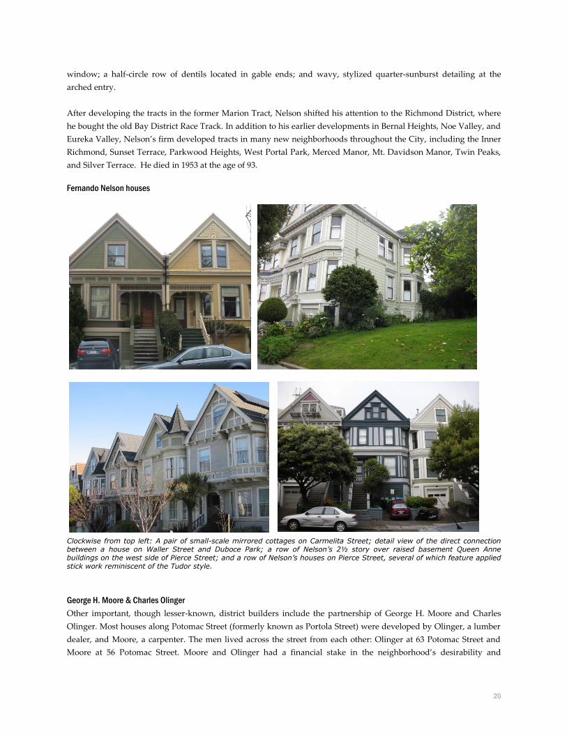
20
window; a half-circle row of dentils located in gable ends; and wavy, stylized quarter-sunburst detailing at the
arched entry.
After developing the tracts in the former Marion Tract, Nelson shifted his attention to the Richmond District, where
he bought the old Bay District Race Track. In addition to his earlier developments in Bernal Heights, Noe Valley, and
Eureka Valley, Nelson’s firm developed tracts in many new neighborhoods throughout the City, including the Inner
Richmond, Sunset Terrace, Parkwood Heights, West Portal Park, Merced Manor, Mt. Davidson Manor, Twin Peaks,
and Silver Terrace. He died in 1953 at the age of 93.
Fernando Nelson houses
Clockwise from top left: A pair of small-scale mirrored cottages on Carmelita Street; detail view of the direct connection between a house on Waller Street and Duboce Park; a row of Nelson’s 2½ story over raised basement Queen Anne buildings on the west side of Pierce Street; and a row of Nelson’s houses on Pierce Street, several of which feature applied stick work reminiscent of the Tudor style.
George H. Moore & Charles Olinger
Other important, though lesser-known, district builders include the partnership of George H. Moore and Charles
Olinger. Most houses along Potomac Street (formerly known as Portola Street) were developed by Olinger, a lumber
dealer, and Moore, a carpenter. The men lived across the street from each other: Olinger at 63 Potomac Street and
Moore at 56 Potomac Street. Moore and Olinger had a financial stake in the neighborhood’s desirability and
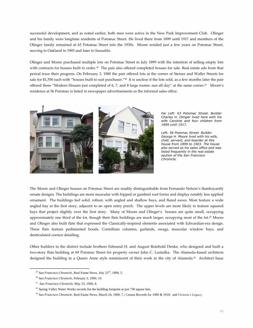
21
successful development, and as noted earlier, both men were active in the New Park Improvement Club. Olinger
and his family were longtime residents of Potomac Street. He lived there from 1899 until 1917 and members of the
Olinger family remained at 63 Potomac Street into the 1930s. Moore resided just a few years on Potomac Street,
moving to Oakland in 1903 and later to Sausalito.
Olinger and Moore purchased multiple lots on Potomac Street in July 1899 with the intention of selling empty lots
with contracts for houses built to order.39 The pair also offered completed houses for sale. Real estate ads from that
period trace their progress. On February 3, 1900 the pair offered lots at the corner of Steiner and Waller Streets for
sale for $1,550 each with “houses built to suit purchaser.”40 It is unclear if the lots sold, as a few months later the pair
offered three “Modern Houses just completed of 6, 7, and 8 large rooms: sun all day” at the same corner.41 Moore’s
residence at 56 Potomac is listed in newspaper advertisements as the informal sales office.
The Moore and Olinger houses on Potomac Street are readily distinguishable from Fernando Nelson’s flamboyantly
ornate designs. The buildings are more muscular with hipped or gambrel roof forms and display notably less applied
ornament. The buildings feel solid, robust, with angled and shallow bays, and flared eaves. Most feature a wide
angled bay at the first story, adjacent to an open entry porch. The upper levels are more likely to feature squared
bays that project slightly over the first story. Many of Moore and Olinger’s houses are quite small, occupying
approximately one third of the lot, though their flats buildings are much larger, occupying most of the lot.42 Moore
and Olinger also built flats that expressed the Classically-inspired elements associated with Edwardian-era design.
These flats feature pedimented hoods, Corinthian columns, garlands, swags, muscular window bays, and
denticulated cornice detailing.
Other builders in the district include brothers Edmund H. and August Reinhold Denke, who designed and built a
two-story flats building at 69 Potomac Street for property owner John C. Lustufka. The Alameda-based architects
designed the building in a Queen Anne style reminiscent of their work in the city of Alameda.43 Architect Isaac
39 San Francisco Chronicle, Real Estate News, July 22nd, 1899, 5.
40 San Francisco Chronicle, February 3, 1900, 10.
41 San Francisco Chronicle, May 25, 1900, 8.
42 Spring Valley Water Works records list the building footprint at just 730 square feet.
43 San Francisco Chronicle, Real Estate News, March 24, 1900, 7.; Census Records for 1900 & 1910; and Victoria’s Legacy.
Far Left: 63 Potomac Street. Builder Charles H. Olinger lived here with his wife Caroline and four children from 1899 until 1917.
Left: 56 Potomac Street. Builder George H. Moore lived with his wife, child, servant, and boarder at this house from 1899 to 1903. The house also served as his sales office and was listed frequently in the real estate section of the San Francisco Chronicle.

22
Anderson is credited with building two single-family houses (68 and 72 Pierce Street) in 1899 and two flats buildings
(115-119 and 121-125 Steiner Street) in 1902. Builder G.L. Sweeney constructed a handful of flats buildings from 1901
to 1907 including 501, 533-537, 661-663 Waller Street and 107-111 Steiner Street.
Victorian-Era
The 1890s marked the Victorian-era of construction at its most varied and exuberant. Building trade catalogs of the
era boasted an almost unlimited array of ornament and supplies, from milled geometric trim pieces to a galaxy of
different doors, windows, and porches.44 This ready supply of millwork is reflected in the buildings of the era, which
display an astonishing array of applied ornament, inventive shapes, and textured cladding. Notable design features
include the near ubiquitous use of broad, angled bay windows. Likewise, the use of brackets and raked eaves and
decorative shingles in the tympanum are extremely common. Large-scale builders, such as Fernando Nelson, often
left signature ornament on their buildings. Judith Waldhorn, author of Victoria’s Legacy, the seminal text on San
Francisco architecture of this period, describes the shift toward non-Classical ornament embraced by Victorian-era
design:
“The promise of redwood was fulfilled as local millwrights pushed the material to its limits, turning, sawing,
carving, pressing and incising…No longer was wood used to mimic stone details or to faithfully reproduce
Classical embellishment such as quoins or Corinthian columns. Breaking away from more traditional
residential adornments, architects, contractors, and owners could choose from a bewitching assortment of
such details as geometric strips, waffles, leaves, drips, holes and sunbursts.”45
By 1895, the Queen Anne style was approaching its zenith, most often in the form of multi-story flats or single-family
cottages. In both cases, buildings typically featured a front facing gable roof, often with decorative wood shingles and
applied ornament near the gable peak. Queen Anne residences also typically featured a bay window on one side of
the building, flanked by a covered porch on the other. Here, the upper portion of the porch was often decorated with
turned spindlework, while above, the upper floors were highlighted with molded or shingled best courses. The most
elaborate residences, flats and houses, might also feature rounded towers at the corner.46 Though Victorian-era
architectural design displayed a remarkable variety of ornament, unifying features in the district include
asymmetrical and articulated facades, steep roof pitches, and the use of multiple textures, materials and colors.
44 Based on a draft, unpublished architectural history produced for the San Francisco Planning Department, 2009.
45 Judith Lynch Waldhorn and Sally B. Woodbridge, Victoria’s Legacy: Tours of San Francisco Bay Area Architecture (San Francisco: 101
Productions, 1978), 14-19.
46 Ibid.
A row of Olinger/Moore houses on the east side of Potomac Street. Built 1899-1900.
Source: Bing.com
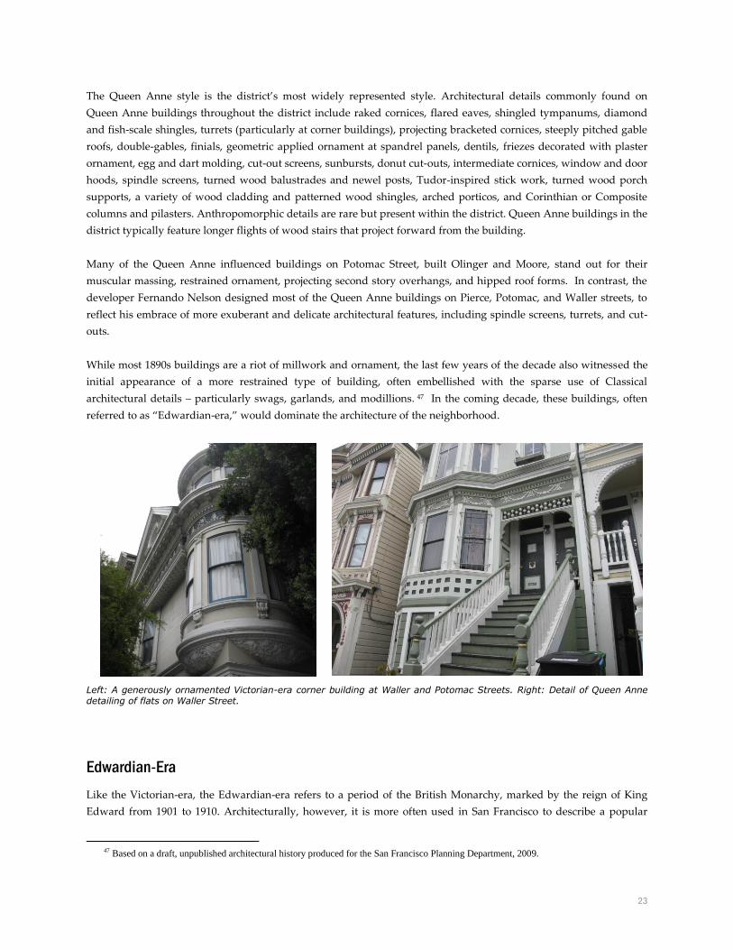
23
The Queen Anne style is the district’s most widely represented style. Architectural details commonly found on
Queen Anne buildings throughout the district include raked cornices, flared eaves, shingled tympanums, diamond
and fish-scale shingles, turrets (particularly at corner buildings), projecting bracketed cornices, steeply pitched gable
roofs, double-gables, finials, geometric applied ornament at spandrel panels, dentils, friezes decorated with plaster
ornament, egg and dart molding, cut-out screens, sunbursts, donut cut-outs, intermediate cornices, window and door
hoods, spindle screens, turned wood balustrades and newel posts, Tudor-inspired stick work, turned wood porch
supports, a variety of wood cladding and patterned wood shingles, arched porticos, and Corinthian or Composite
columns and pilasters. Anthropomorphic details are rare but present within the district. Queen Anne buildings in the
district typically feature longer flights of wood stairs that project forward from the building.
Many of the Queen Anne influenced buildings on Potomac Street, built Olinger and Moore, stand out for their
muscular massing, restrained ornament, projecting second story overhangs, and hipped roof forms. In contrast, the
developer Fernando Nelson designed most of the Queen Anne buildings on Pierce, Potomac, and Waller streets, to
reflect his embrace of more exuberant and delicate architectural features, including spindle screens, turrets, and cut-
outs.
While most 1890s buildings are a riot of millwork and ornament, the last few years of the decade also witnessed the
initial appearance of a more restrained type of building, often embellished with the sparse use of Classical
architectural details – particularly swags, garlands, and modillions. 47 In the coming decade, these buildings, often
referred to as “Edwardian-era,” would dominate the architecture of the neighborhood.
Left: A generously ornamented Victorian-era corner building at Waller and Potomac Streets. Right: Detail of Queen Anne detailing of flats on Waller Street.
Edwardian-Era
Like the Victorian-era, the Edwardian-era refers to a period of the British Monarchy, marked by the reign of King
Edward from 1901 to 1910. Architecturally, however, it is more often used in San Francisco to describe a popular
47 Based on a draft, unpublished architectural history produced for the San Francisco Planning Department, 2009.
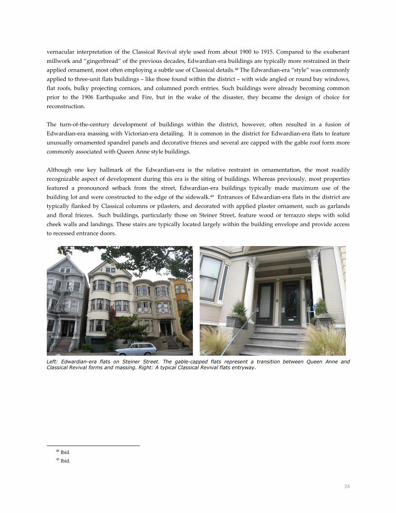
24
vernacular interpretation of the Classical Revival style used from about 1900 to 1915. Compared to the exuberant
millwork and “gingerbread” of the previous decades, Edwardian-era buildings are typically more restrained in their
applied ornament, most often employing a subtle use of Classical details.48 The Edwardian-era “style” was commonly
applied to three-unit flats buildings – like those found within the district – with wide angled or round bay windows,
flat roofs, bulky projecting cornices, and columned porch entries. Such buildings were already becoming common
prior to the 1906 Earthquake and Fire, but in the wake of the disaster, they became the design of choice for
reconstruction.
The turn-of-the-century development of buildings within the district, however, often resulted in a fusion of
Edwardian-era massing with Victorian-era detailing. It is common in the district for Edwardian-era flats to feature
unusually ornamented spandrel panels and decorative friezes and several are capped with the gable roof form more
commonly associated with Queen Anne style buildings.
Although one key hallmark of the Edwardian-era is the relative restraint in ornamentation, the most readily
recognizable aspect of development during this era is the siting of buildings. Whereas previously, most properties
featured a pronounced setback from the street, Edwardian-era buildings typically made maximum use of the
building lot and were constructed to the edge of the sidewalk.49 Entrances of Edwardian-era flats in the district are
typically flanked by Classical columns or pilasters, and decorated with applied plaster ornament, such as garlands
and floral friezes. Such buildings, particularly those on Steiner Street, feature wood or terrazzo steps with solid
cheek walls and landings. These stairs are typically located largely within the building envelope and provide access
to recessed entrance doors.
Left: Edwardian-era flats on Steiner Street. The gable-capped flats represent a transition between Queen Anne and Classical Revival forms and massing. Right: A typical Classical Revival flats entryway.
48 Ibid.
49 Ibid.

25
Postscript
The last district contributor was constructed in 1911, an in-fill project at 82 Potomac Street consisting of a three-story
flats building that replaced an earlier stable found at the rear of the corner lot at Waller and Potomac Streets. Since
that time there has been remarkably little change in the historic fabric of the district buildings, although the adjacent
park has seen substantial changes since 1902. The first major intrusion in the park was construction of the Municipal
Railway’s Sunset Tunnel portal in 1926. The Sunset Tunnel opened on October 11, 1928 as a primary route to the
Sunset district for the N-Judah streetcar line. The tracks cut into the southwestern portion of the park from Duboce
Avenue midway between Walter and Noe Streets, running nearly to the park’s western edge at Scott Street and
Duboce Avenue. A playground and basketball courts were added. In 1957, a recreation center was built toward the
western edge of the park and its footprint was expanded during a 2009 remodel. In the late 1970s, the rock gardens
were removed and the original park paths rerouted and paved. Recently, the neighborhood invested in a decorative
lighting system and created a labyrinth. Despite these changes, the park plays the same role for the community as it
initially did and boasts similar sprawling lawns with meandering paths and groupings of trees along the perimeter. It
likewise retains its connection to the adjacent district via the historic Serpentine rock interior block park entrances at
Carmelita, Pierce, and Potomac Streets.
View from 1937 showing the park’s circulation, vegetation, and connection to the interior blocks. Source: David Rumsey Historical Map Collection
The district has, however, experienced substantial social, economic, and ethnic shifts. During World War II, the influx
of defense workers from the South resulted in a large number of African Americans moving to the nearby Western
Addition neighborhood. In the 1960s, many African American families moved to the Duboce Triangle neighborhood,
as the San Francisco Redevelopment Agency projects forced thousands from their homes in the nearby Western
Addition neighborhood.
For a time, into the 1970s, the district was a predominately African American neighborhood. One of the early Black
Panther Party rallies was held in the mid-1960s on the steps of 75 Potomac Street, eventually spilling over into the

26
park.50 Hippies moved to the district as did several houses of prostitution.51 H. Arlo Nimmo, a Professor Emeritus of
Anthropology at California State University East Bay and longtime resident on Potomac Street, documented the
social and ethnic change of his block in Good and Bad Times in a San Francisco Neighborhood. He writes of the shift in
the mid-1980s population:
“Another elderly Black man, Mr. Crenshaw, also died. He and his wife lived in the top flat above the grocery
store at the corner of Potomac and Waller. They owned the building and for many years Mrs. Crenshaw and
her sister operated the small grocery store called “Two Sisters” on the ground floor. They sold delicious
barbecued chickens as well as cigarettes by the “stick.” I suppose they will be replaced by the ever increasing
mainstream Whites who are moving into the neighborhood.”52 (May 21, 1987)
By the late 1970s, white residents – many of them gay or lesbian – returned to the district. At that time, nearby Castro
Street was emerging as the center of the gay, primarily male, community. The new gay residents are credited with
sprucing up the exterior of the then unfashionable Victorian-era houses and painting the exteriors in a riot of colors.
As Alexander Bodi argued in his 1983 study of the neighborhood, “Gentrification always is accompanied by
displacement; in the Duboce Triangle as elsewhere, it was the people with lower incomes – including ethnic
minorities—who are squeezed out. As the poorer people were displaced, more gays moved in. Today, at least half of
the population of the Triangle – 3,012 by the 1980 census – is believed to be gay.”53
Today, the neighborhood composition continues to change as new residents are attracted to the area. Subcultures of
the district are evolving, as noted by Nimmo, and newer “subcultures will eventually be altered and perhaps
absorbed by the inevitable wave of change that arrives in the neighborhood.” 54
View from 2012. Source: Google Earth
50 H. Arlo Nimmo. Good and Bad Times in a San Francisco Neighborhood: A History of Potomac Street and Duboce Park, (San Francisco:
October Properties, 2007), 26.
51 Alexander S. Bodi, “Duboce Triangle of San Francisco: A study of Community,” Master’s Thesis, Anthropology, San Francisco State
University, May 1983.
52 Nimmo, Good Times and Bad, 74.
53 Bodi. “Duboce Triangle of San Francisco,” 84.
54 Nimmo, Good Times and Bad, 40.

27
Article 10 Landmark District Designation
CRITERIA FOR DESIGNATION
Criteria
Check all criteria applicable to the significance of the district that are documented in the report. The criteria checked
is (are) the basic justification for why the resource is important.
X Association with events that have made a significant contribution to the broad patterns of our history.
Association with the lives of persons significant in our past.
X Embody distinctive characteristics of a type, period, or method of construction, or that represent a
significant and distinguishable entity whose components may lack individual distinction.
Has yielded or may be likely to yield information in history or prehistory.
Statement of Significance
Characteristics of the Landmark that justify its designation:
Association with significant events
The Duboce Park Landmark District is significant for the unusual development history of the contested tract of land
upon which it was built and the way in which the contested nature of the tract impacted the district’s physical
appearance and connection to the adjacent park. The tract (formerly known as the Public Reservation, Hospital Lot,
and Marion Tract) was subject to a decades-long series of court battles over legal ownership, with the City of San
Francisco losing half of its claim to the land to the German Savings and Loan Association in the late 1890s. After
acquiring title to half of the tract, the bank subdivided the land, carved out interior block streets, and sold lots to
builders who developed the residential portion of the tract. The lots sold quickly and a handful of builders
immediately began developing the parcels. Due to the delay in development caused by the litigation, construction
dates for the vast majority of contributing resources within the district range from 1899 to approximately 1902. This
short period of development and limited number of builders resulted in a remarkably uniform streetscape of
Victorian- and Edwardian-era houses and flats of similar design and proportion.
The contested nature of the tract, its history as a debris dump, and neighborhood activism and development of the
adjacent civic park are key themes linked to the Duboce Park Landmark District. One important visible
manifestation of this interrelated history is found at the park’s northern border – specifically the lack of separation
between the park and residential buildings. The district represents the best example of San Francisco’s handful of
municipal parks that directly abut residential buildings, without any separation of a street or sidewalk. In addition,
the historic stone steps and rock retaining walls at the three interior block park entrances – Carmelita, Pierce, and
Potomac Streets – reflect the transformation of the City-owned portion of the contested tract from a dumping ground
for Serpentine rock rubble to a picturesque, landscaped civic park. Serpentine rock rubble is also found in the
foundations of many district buildings.

28
Significant architecture:
The Duboce Park Landmark District is significant within the category of architecture, as a remarkably intact district
of Victorian- and Edwardian-era residential buildings. The district expresses the distinctive characteristics of late
Victorian- and Edwardian-era architectural styles, with the Queen Anne style widely represented. Although the
district displays a remarkable variety of ornament, unifying design features include asymmetrical and articulated
facades, steep roof pitches, the use of multiple textures and wood cladding, and front yard setbacks.
Many of the Queen Anne cottages and flats were developed by Fernando Nelson, a master builder known for his
exuberant ornamentation and elaborately applied millwork. Nelson designed and built approximately one half of the
district properties, including nearly all of the residences on Carmelita and Pierce Streets. The district represents one
of the earliest developments in his 77-year career and is an excellent representation of his effusive interpretation of
the Queen Anne style. District features characteristic of Nelson’s Victorian-era period include button boards, drips,
and donuts; blocky geometric cut-outs above the entry porch; two-sided bay windows; half-circle rows of dentils
located in gable ends; and a wavy, stylized quarter-sunburst detailed at the arched entry.
The turn-of-the-century development of buildings within the district often resulted in a rare fusion of Edwardian-era
massing with exuberant Victorian-era detailing. It is common in the district for Edwardian-era flats to feature
unusually ornamented spandrel panels and decorative friezes and several are capped with the gable roof form more
commonly associated with Queen Anne style buildings.
Period of Significance
The period of significance for the district dates from 1899 to 1911, inclusive of the known period of construction of all
buildings within the district.
Integrity
The Duboce Park Landmark District retains the physical components, aspects of design, spatial organization, and
historic associations that it acquired during the 1899-1911 Period of Significance. Despite limited alterations to
individual buildings, the district retains sufficient overall integrity to convey its significance.
The seven aspects of integrity are location, design, materials, workmanship, setting, feeling, and association.
Alterations introduced after 1911 generally detract from integrity. The impact of these alterations is limited however,
due to their low number, small-scale, and general conformity with the historic design. The district was largely spared
the remodeling, recladding, and stripping of ornament that characterizes many Victorian-era neighborhoods. It
clearly exhibits high physical integrity of materials, design, and workmanship, with most buildings still retaining
historic double-hung wood windows, wood cladding, decorative shingles, millwork, and historic applied ornament.
Likewise, the district’s roof forms, front setbacks, massing, and entrances are largely intact. There are no significant
intrusions in the district and just one building was constructed after the identified 1899-1911 Period of Significance.
Limited alterations are found within the district. Several buildings have been re-clad in stucco or asbestos shingle
siding and some windows replaced with aluminum sliders or vinyl sash. Most buildings were remodeled to
accommodate a garage opening, though for the most part such alterations do not diminish the overall integrity of the
district. A few buildings feature pop-out garage structures that fully envelop the front yard set-back. Nonetheless,

29
despite the diminished integrity of certain individual buildings, the district when evaluated as a whole retains
sufficient integrity with which to convey its significance.
The interior block park entrances at Carmelita, Pierce, and Potomac Streets likewise retain sufficient integrity with
which to convey significance related to the contested nature of the Tract. Despite recent alterations at the Carmelita
Street entrance, the historic stone steps and Serpentine rock walls at the three interior block entrances provide a direct
and tangible connection to the intertwined development history of the park and residences and the contested Tract’s
historic use as a rubble debris dump.
Resources located within the Duboce Park Landmark District boundaries are identified as Contributory or Non-
Contributory. Contributory resources were constructed during the district’s period of significance and retain a
sufficient level of integrity. Non-Contributory resources may have been constructed during the district’s period of
significance but have lost integrity such that significance is no longer conveyed. The district is comprised of 79
contributing buildings, three contributing interior block park entrances, and eight non-contributory buildings.
Article 10 Requirements Section 1004 (b)
Boundaries of the Landmark District
The boundary of the Duboce Park Landmark District commences 62’ east of the southeast corner of Scott Street and
Waller Street. The boundary then runs east along the south side of Waller Street, crossing Carmelita, Pierce, and
Potomac Streets, until reaching the southwest corner of Waller and Steiner Streets. From there, the boundary then
runs south to the northeast corner of Duboce Park, where it turns west and travels along the property line separating
the residential properties and the adjacent park land. The boundary continues west, where it jogs slightly south at the
interior block park entrances at Carmelita, Pierce, and Potomac Streets to accommodate a 10-foot buffer at each set of
steps. The boundary continues west along the property line until it reaches the park edge 28’ east of Scott Street.
From here, the boundary continues north along the residential property line until it reaches the point of beginning.
The district encompasses all lots contained within Assessor’s Block 0863, 0865, 0865 and 0866. See map.

30
Contributing Properties The following properties are contributors to the Article 10 landmark district:
APN From St. # To St. # Street Name Date Built
0863-009 49 49 Carmelita St. 1899
0864-011 50 52 Carmelita St. 1899
0863-008 53 53 Carmelita St. 1899
0863-007 57 57 Carmelita St. 1899
0864-013 58 58 Carmelita St. 1899
0864-014 60 62 Carmelita St. 1899
0863-006 61 61 Carmelita St. 1899
0863-005 65 65 Carmelita St. 1899
0864-015 66 66 Carmelita St. 1899
0863-004 69 69 Carmelita St. 1899
0864-016 70 70 Carmelita St. 1899
0863-003 73 73 Carmelita St. 1899
0863-002 77 77 Carmelita St. 1899
0864-018 78 78 Carmelita St. 1899
0865-011 46 48 Pierce St. 1899
0864-010 47 47 Pierce St. 1899
0864-009 49 51 Pierce St. 1899
0865-012 52 52 Pierce St. 1899
0864-008 55 55 Pierce St. 1899
0865-013 56 56 Pierce St. 1899
0864-007 59 59 Pierce St. 1899
0865-014 60 60 Pierce St. 1899
0864-006 63 65 Pierce St. 1899
0865-015 64 64 Pierce St. 1899
0864-005 67 67 Pierce St. 1899
0865-016 68 68 Pierce St. 1899
0864-004 71 71 Pierce St. 1899
0865-017 72 72 Pierce St. 1899
0864-003 75 75 Pierce St. 1899
0865-018 76 76 Pierce St. 1901
0864-002 79 79 Pierce St. c. 1901
0866-010 44 48 Potomac St. c.1900
0865-026,
027, 028 47 51 Potomac St. 1901
0866-011 50 54 Potomac St. 1900
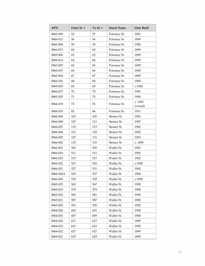
31
APN From St. # To St. # Street Name Date Built
0865-009 53 57 Potomac St. 1901
0866-012 56 56 Potomac St. 1899
0865-008 59 59 Potomac St. 1900
0866-013 60 60 Potomac St. 1899
0865-006 63 63 Potomac St. 1899
0866-014 64 64 Potomac St. 1899
0865-005 65 65 Potomac St. 1899
0866-015 66 66 Potomac St. 1900
0865-004 67 67 Potomac St. 1899
0866-016 68 68 Potomac St. 1900
0865-003 69 69 Potomac St. c.1900
0866-017 70 70 Potomac St. 1901
0865-029 71 75 Potomac St. 1900
0866-018 72 76 Potomac St. c. 1905
(visual)
0866-019 82 86 Potomac St. 1911
0866-009 101 105 Steiner St. 1903
0866-008 107 111 Steiner St. 1907
0866-007 115 115 Steiner St. 1902
0866-006 121 125 Steiner St. 1902
0866-005 127 131 Steiner St. 1903
0866-002 133 135 Steiner St. c. 1899
0866-001 501 505 Waller St. 1901
0866-024 511 511 Waller St. 1902
0866-023 515 517 Waller St. 1902
0866-022 521 525 Waller St. c.1900
0866-021 527 531 Waller St. 1902
0866-020A 533 537 Waller St. 1904
0866-020 539 539 Waller St. c.1905
0865-025 563 567 Waller St. 1900
0865-023 579 579 Waller St. 1900
0865-022 581 581 Waller St. 1900
0865-021 587 587 Waller St. 1900
0865-020 591 595 Waller St. 1902
0864-026 601 601 Waller St. 1900
0864-025 607 609 Waller St. 1900
0864-024 611 617 Waller St. 1899
0864-023 621 621 Waller St. 1900
0864-022 627 627 Waller St. 1899
0864-021 633 633 Waller St. 1899

32
APN From St. # To St. # Street Name Date Built
0864-020 639 639 Waller St. 1900
0864-019 643 643 Waller St. 1900
0863-013,
014, 015 661 663 Waller St. 1902
0863-012 667 667 Waller St. 1900
0863-011 673 675 Waller St. 1900
0863-016 679 681 Waller St. 1900
Carmelita Street interior block park entrance
Pierce Street interior block park entrance
Potomac Street interior block park entrance
For the purpose of Article 10, the park entrances at Potomac Street, Pierce
Street, and Carmelita Street are defined as the steps, rock walls, and a
surrounding 10-foot buffer. The buffer area includes the sidewalks, street
rights of way and area within the park directly adjacent to the steps and rock
walls.
Non-Contributing Properties The following properties are located within the district boundaries, but are considered non-contributing elements.
The majority were constructed within the period of significance, but do not contribute due to subsequent alterations
that have significantly altered their integrity such that they can no longer readily convey their significance.
APN From St. # To St. # Street Name Year Built
0864-012 54 54 Carmelita St. 1899
0864-017 74 74 Carmelita St. c.1899
0865-019 80 80 Pierce St. c.1899
0865-007 61 61 Potomac St. 1900
0866-003 137 137 Steiner St. 1902
0866-004 139 141 Steiner St. 2009
0865-033 569 573 Waller St. 1900
0865-001 559 561 Waller St. c.1905

33
Character-Defining Features
Whenever a building, site, object, or landscape is under consideration for Article 10 Landmark designation, the
Historic Preservation Commission is required to identify character-defining features of the property. This is done to
enable owners and the public to understand which elements are considered most important to preserve the historical
and architectural character of the proposed landmark.
The character-defining interior features of buildings in the district are identified as: None.
The character-defining exterior features of buildings in the district are identified as: All exterior elevations and
rooflines.
The character-defining landscape elements of the district are identified as: The rustic interior block park entrances at
Carmelita, Pierce, and Potomac Streets – which include the historic stone steps, Serpentine rock retaining walls set in
a random rubble pattern, and the public rights-of-way within a 10-foot buffer – and the lack of physical separation
between the park and adjacent buildings.
The following section describes in further detail the character-defining features of the district and of individual
buildings and landscape elements contained therein. Landmark district designation is intended to protect and
preserve these character-defining features.
1. Overall Form, Continuity, Scale and Proportion
Due to the brief period of construction – most buildings were constructed between 1899 and 1902 – and combined
involvement of two primary builders, buildings within the district exhibit a remarkable consistency in terms of
massing, scale, style, detailing, front yard setback, and feeling.
District buildings are overwhelmingly residential, being composed primarily of single-family dwellings and
residential flats. A few multiple-family residences within the district (typically located on street corners) also include
a commercial use at the street level.
Buildings in the district range from 1 ½ story-over-basement to four stories in height, with two and three stories
predominating. The district’s largest single-family residences and flats were built on corner lots directly adjacent to
the Park. These buildings are typically two- to three- stories in height and feature consistent detailing on the primary,
Park-facing, and rear façades.
Generally speaking, the buildings fronting Carmelita, Pierce and Potomac Streets were originally constructed as one-
or two-family dwellings, while flats dominated the lots facing Waller and Steiner Streets. Mid-block buildings are
typically smaller than those constructed at the corners or on Waller and Steiner streets and are more likely to draw
from Victorian-era form and massing such as prominent gabled roof forms and asymmetrical massing at the primary
façade. Though consistent in massing, single-family buildings on Potomac Street feature the greatest variety of roof
forms, including gable, hipped, cross-gable, and one building with a side gable roof form and small eyebrow
dormers. Buildings located along the interior blocks feature uniform front yard setbacks of approximately nine feet
and are often bounded by a low cast stone site wall. The flats buildings on Steiner Street do not feature front yard
setbacks; rather, they present a modulated massing of muscular bay windows and deeply recessed entry porticos.

34
The Queen Anne style buildings present in the district may be subdivided into two basic arrangements: 1 ½ story-
over-raised-basement single-family cottages, and 2 ½ story-over-raised-basement single family dwellings or flats.
The buildings tend to conform to a basic plan of a projecting bay on the first floor, flanked by an open porch and
entry to the side—with the porch entry often surmounted by spindle work or decorative porch brackets. Roof forms
are hipped or steeply pitched front-facing gables. Slightly projecting second story overhangs are common.
Edwardian-era flats building are three stories-over-basement in height with wide projecting structural window bays,
featuring angled- or bent-sash windows. The roofline of Edwardian-era flats buildings feature projecting cornices
that follow the profiles of the primary facades. The buildings are typically topped with flat roofs, though several
feature gable roof forms. Massing is symmetrical, except at the first story, where the two structural bays are occupied
by a recessed entrance at one side and a projecting bay window at the other.
Original roof projections include turrets topped with witch’s cap or conical roof forms and small-scale cross-gables
atop projecting bay windows. Turrets, found on both Queen Anne and Edwardian-era buildings, are generally
located at the corner, adjacent to or embedded within a forward-facing gable. Additionally, several buildings exhibit
what appear to be historic dormers. Located on sloped gables, these dormers are small in scale, gabled, and match
the ornamentation and fenestration of primary facades.
Although the roof forms – particularly at the non-visible rear façade – of a substantial number of buildings have been
altered to incorporate skylights, small dormer windows, fire escapes, or solar panels, these alterations were
constructed outside of the Period of Significance and have not gained significance in their own right.
Similar roof forms, massing, and setbacks result in a cohesive streetscape of rooflines, entrances, continuous primary
facades, and modulated bays. With no visual separation between buildings in the district, the block faces present an
overall appearance of attached row-houses; however, with a few exceptions, it is unlikely that buildings feature
shared structural walls.
2. Fenestration
Fenestration is remarkably consistent throughout the district, consisting of vertically oriented double-hung wood
sash windows, with ogee lugs, set in wood surrounds. Windows are typically set in wide angled bays with smaller
windows set flush with the façade, often adjacent to the primary entry door. Windows surround are typically topped
with cornices, occasionally featuring pediments, with ornamented details.
Smaller vertically oriented windows, set in a single, pair, or ganged configuration, are also often located in the
tympanum of the Queen Anne style buildings. Tympanums typically have a higher solid-to-void ratio than the lower
stories. Several buildings – typically Edwardian-era flats buildings – feature curved wood sash windows set in
curved structural bays. Angled or curved bays typically contain three windows, though certain bays of corner
buildings contain four windows. While rare, several buildings display two-sided angled bay windows at the primary
facade.
Large corner buildings with greater surface area have a higher solid-to-void ratio than mid-block buildings. Window
bays and window openings set flush with the façade are typically placed in the same location, presenting a stacked
appearance, at each story of the three story corner buildings.

35
The vast majority of buildings within the district retain some or all historic double-hung wood sash windows with
ogee lugs. Replacement windows made of aluminum or vinyl sash, casement windows, or windows with divided
lights that were added to buildings after the Period of Significance have not gained significance in their own right.
3. Materials & Finishes
Buildings in the district are of wood frame construction and were historically clad in horizontal wood siding. Exterior
surface finishes are painted. Channel drop wood siding is typical at the secondary and rear facades, while a
combination of flush, lap, channel drop, and shingles are typically found at the primary facades of Victorian-era
buildings. Flush wood siding is most common on the primary facades of Edwardian-era flats buildings. Most
buildings retain their historic siding though a few were later clad in stucco, asbestos, or composite shingle siding.
These replacement sidings have not gained significance in their own right.
Historically, the gabled roofs within the district were clad in unpainted wood shingles. These historic roofing
materials are no longer present. Existing gable roofs are typically finished with asphalt or composite shingles that
match the color and tone of the historic wood roofing materials. Though generally compatible, this replacement
roofing material has not gained significance in its own right.
4. Architectural Details
Common traits found throughout the district are bay windows, gable roofs, decorative cornices, ornamental shingles,
and spindle work, as well as more classically influenced detailing such as dentils, pediments, columns, and applied
plaster ornament. Ornamental details are typically larger and more robust in scale at the first story, with finer, more
delicate features located at the upper floors.
Many of the district’s buildings retain their original primary entrance doors. These paneled wood doors, often
slightly wider than contemporary entrance doors, are commonly glazed at the upper portion and feature corniced
hoods and incised or applied ornament. Occasionally, a single fixed window is located adjacent to the entry door of
Queen Anne buildings and some doors, of both Queen Anne and Edwardian-era buildings, are topped with transom
windows.
Queen Anne Design Elements
Late Victorian- and Edwardian-era architectural styles predominate, with the Queen Anne style most widely
represented. Though Victorian-era architectural design displayed a remarkable variety of ornament, unifying
features include asymmetrical and articulated facades, steep roof pitches, and the use of multiple textures, materials
and colors.
Many of the Queen Anne style buildings on Potomac Street, designed by developer George Moore, stand out for their
muscular massing, restrained ornament, projecting second story overhangs, and hipped roof forms. In contrast, the
developer Fernando Nelson designed most of the Queen Anne buildings on Pierce, Potomac, and Waller streets, to
reflect his embrace of more exuberant and delicate architectural features, including spindle screens, turrets, and cut-
outs.
Architectural details commonly found on Queen Anne buildings throughout the district include raked cornices,
flared eaves, shingled tympanums, diamond and fish-scale shingling, turrets (particularly at corner buildings),
projecting bracketed cornices, steeply pitched gable roofs, double-gables, finials, geometric applied ornament at
spandrel panels, dentils, friezes decorated with plaster ornament, egg and dart molding, cut-out screens, sunbursts,
donut cut-outs, intermediate cornices, window and door hoods, spindle screens, turned wood balustrades and newel
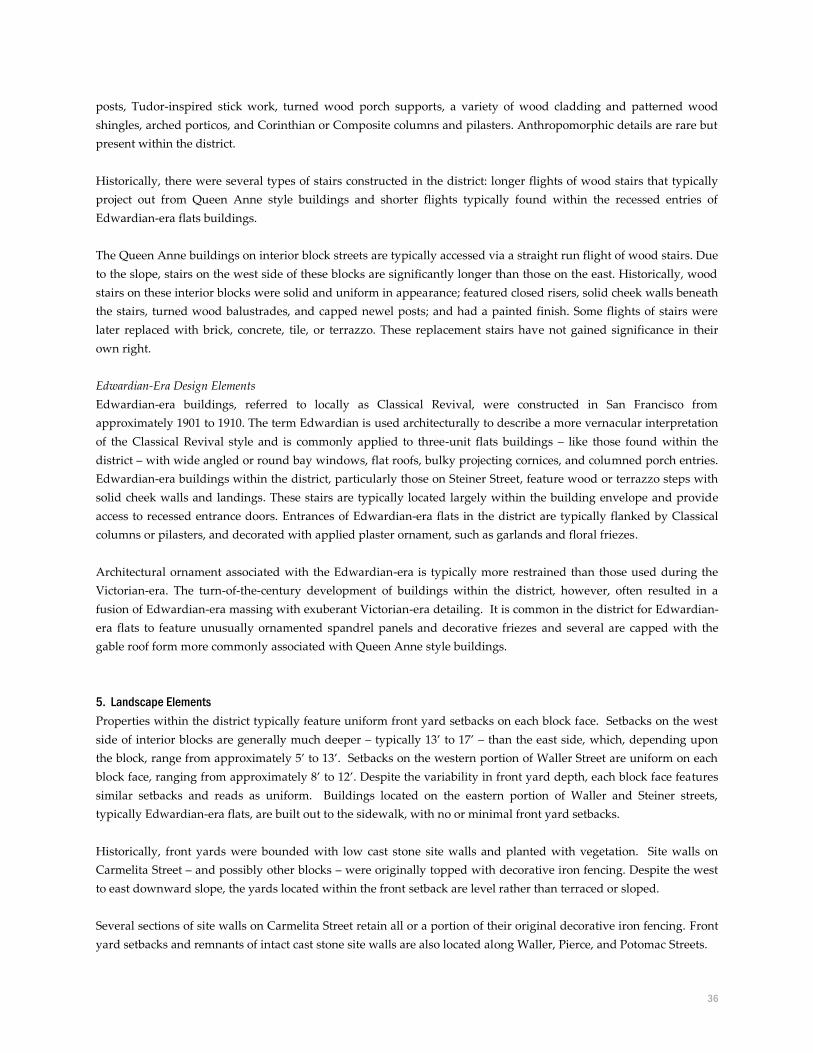
36
posts, Tudor-inspired stick work, turned wood porch supports, a variety of wood cladding and patterned wood
shingles, arched porticos, and Corinthian or Composite columns and pilasters. Anthropomorphic details are rare but
present within the district.
Historically, there were several types of stairs constructed in the district: longer flights of wood stairs that typically
project out from Queen Anne style buildings and shorter flights typically found within the recessed entries of
Edwardian-era flats buildings.
The Queen Anne buildings on interior block streets are typically accessed via a straight run flight of wood stairs. Due
to the slope, stairs on the west side of these blocks are significantly longer than those on the east. Historically, wood
stairs on these interior blocks were solid and uniform in appearance; featured closed risers, solid cheek walls beneath
the stairs, turned wood balustrades, and capped newel posts; and had a painted finish. Some flights of stairs were
later replaced with brick, concrete, tile, or terrazzo. These replacement stairs have not gained significance in their
own right.
Edwardian-Era Design Elements
Edwardian-era buildings, referred to locally as Classical Revival, were constructed in San Francisco from
approximately 1901 to 1910. The term Edwardian is used architecturally to describe a more vernacular interpretation
of the Classical Revival style and is commonly applied to three-unit flats buildings – like those found within the
district – with wide angled or round bay windows, flat roofs, bulky projecting cornices, and columned porch entries.
Edwardian-era buildings within the district, particularly those on Steiner Street, feature wood or terrazzo steps with
solid cheek walls and landings. These stairs are typically located largely within the building envelope and provide
access to recessed entrance doors. Entrances of Edwardian-era flats in the district are typically flanked by Classical
columns or pilasters, and decorated with applied plaster ornament, such as garlands and floral friezes.
Architectural ornament associated with the Edwardian-era is typically more restrained than those used during the
Victorian-era. The turn-of-the-century development of buildings within the district, however, often resulted in a
fusion of Edwardian-era massing with exuberant Victorian-era detailing. It is common in the district for Edwardian-
era flats to feature unusually ornamented spandrel panels and decorative friezes and several are capped with the
gable roof form more commonly associated with Queen Anne style buildings.
5. Landscape Elements
Properties within the district typically feature uniform front yard setbacks on each block face. Setbacks on the west
side of interior blocks are generally much deeper – typically 13’ to 17’ – than the east side, which, depending upon
the block, range from approximately 5’ to 13’. Setbacks on the western portion of Waller Street are uniform on each
block face, ranging from approximately 8’ to 12’. Despite the variability in front yard depth, each block face features
similar setbacks and reads as uniform. Buildings located on the eastern portion of Waller and Steiner streets,
typically Edwardian-era flats, are built out to the sidewalk, with no or minimal front yard setbacks.
Historically, front yards were bounded with low cast stone site walls and planted with vegetation. Site walls on
Carmelita Street – and possibly other blocks – were originally topped with decorative iron fencing. Despite the west
to east downward slope, the yards located within the front setback are level rather than terraced or sloped.
Several sections of site walls on Carmelita Street retain all or a portion of their original decorative iron fencing. Front
yard setbacks and remnants of intact cast stone site walls are also located along Waller, Pierce, and Potomac Streets.

37
The addition of garages has altered the front yards of many district properties. None of the historic buildings within
the district were originally constructed with an integrated or detached automobile garage. On most blocks, portions
of site walls were removed and front yards partially paved in order to accommodate driveways for garages inserted
in the basement of many buildings. Several properties feature detached or semi-attached pop-out garages in the front
yard. Garage structures, openings, and driveways are not considered significant in their own right.
6. Interior Block Park Entrances
The development history of residential properties within the Duboce Park Landmark District is closely intertwined
with the history of the adjacent Duboce Park. Certain identified elements on the periphery of Duboce Park reflect this
close association between residential and park development; notably, the lack of a physical separation between
residential buildings and the park and rustic entrances from cul-de-sac streets into the park. These park entrances –
located at the foot of Potomac Street, Pierce Street, and Carmelita Street – feature rustic stone steps flanked by low
retaining walls built of Serpentine rock set in a random rubble pattern.
For the purpose of Article 10, the park entrances at Potomac Street, Pierce Street, and Carmelita Street are defined as
the steps, rock walls, and a surrounding 10-foot buffer. The buffer area includes the sidewalks, street rights-of-way
and area within the park directly adjacent to the steps and rock walls.
Zoning Properties in the Duboce Park Landmark District are zoned Residential (RH-2) and Residential Transit Oriented
(RTO) as indicated on the map below. All buildings in the district are located within a 40-X height and bulk zoning
district.
The red outline indicates the Duboce Park Landmark District boundary.

38
Selected Bibliography
Beutner, Bill. Personal communication with Jonathan Lammers regarding builder Fernando Nelson. January 7, 2008.
Board of Parks Commissioners of San Francisco. Annual Report of the Board of Parks Commissioners of San Francisco. San
Francisco: 1902.
Bodi, Alexander S. The Duboce Triangle of San Francisco: A Study of a Community. Master’s Thesis, San Francisco State
University, 1983.
City of San Francisco Block Book Map. 1894.
City of San Francisco Block Book Map. 1901.
City of San Francisco. Real Estate Owned by the City and County of San Francisco and Historical Data Relating to Same, with
citations from decisions of the Superior, Supreme and Federal Courts. San Francisco Board of Supervisors. 1910.
Cranz, Galen. Changing Roles of Urban Parks: From Pleasure Gardens to Open Space. Accessed Nov. 21, 2006.
http://www.spur.org/documents/000601_article_01.shtm.
David Rumsey Historical Map Collection. 1937-1938 Aerial Views, San Francisco.
Delehanty, Randolph Stephen. San Francisco Parks and Playgrounds, 1839 to 1990: The History of a Public Good in One
North American City, Vol. 1 and II. Unpublished PhD dissertation, Harvard University, 1992.
Department of City Planning, 1976 Architectural Survey, Field Survey Forms, San Francisco: 1976.
Duscherer, Paul and Douglas Keister. Victorian Glory in San Francisco and the Bay Area. New York: Penguin Group,
2001.
Freeman, John. “Fernando Nelson: Master Builder,” San Francisco Architectural Heritage, Heritage News, September-
October 2003.
Moudon, Anne. Built for Change: Neighborhood Architecture in San Francisco. Cambridge: MIT Press, 1986.
Neighborhood Parks Council. Duboce Park and Harvey Milk Playground.
http://www.sfneighborhoodparks.org/parkhistories/dubocepark.html.
Nimmo, H. Arlo. Good and Bad Times in a San Francisco Neighborhood: A History of Potomac Street and Duboce Park. San
Francisco: October Properties, 2007.
Page & Turnbull. Draft Historic Context Statement, Market & Octavia Neighborhood Plan Area. San Francisco: 2007.
Page & Turnbull, California Department of Parks and Recreation (DPR), 523-D (District) form, Duboce Park Historic
District, evaluated by Jonathan Lammers, January 2008.
Sanborn Fire Insurance Map. San Francisco, Volume 3, Sheet 328, 1899.
Sanborn Fire Insurance Map. San Francisco, Volume 3, Sheet 328, 1905.
San Francisco Chronicle, “Buckman’s Camp Nuisance.” August 9, 1896.
San Francisco Chronicle. “Organized to Protest.” August 17, 1896.
San Francisco Chronicle. “Buckman’s Camp to Go.” August 29, 1896.
San Francisco Chronicle, “Real Estate News.” April 29, 1899.
San Francisco Chronicle, “Real Estate News.” July 22, 1899.
San Francisco Chronicle, “Real Estate News.” March 24, 1899.
San Francisco Chronicle. “New Park Improvement Club, Raising Money to Beautify Hospital Lot.” June 26, 1900.
San Francisco Chronicle. “The Dedication of Duboce Park.” September 10, 1900.

39
San Francisco Chronicle. “The Story of Duboce Park.” April 27, 1902.
San Francisco Chronicle, “S.F. Veteran Here Half Century.” April 19, 1930.
San Francisco Chronicle. Untitled. February 3, 1900.
San Francisco Chronicle. Untitled. May 25, 1900.
San Francisco City Directory, 1900.
San Francisco News, “Fernando Nelson Came Here in ’76.” January 3, 1952.
San Francisco Planning Department. Inner Mission North 1853-1943 Historic Context Statement. San Francisco: 2005.
San Francisco Relief Corporation. Department Reports of the San Francisco Relief and Red Cross Funds: Annual Report of
the San Francisco Relief Corporation. San Francisco: March 19, 1907.
Spring Valley Water Works, “Date of Supply, Application and Agreement.” (Water connection records, various
years) .
Thompson, Joe. Market Street Cable Railway. http://www.cable-car-guy.com/html/ccsfmsr.html.
The Victorian Alliance. Duboce Park House Tour. Unpublished brochure on file at San Francisco Architectural
Heritage, October 15, 1995.
United States Federal Census of Population and Housing, 1900 & 1910: Summary Population and Housing
Characteristics: California.
Waldhorn, Judith. “Draft Notes, Interview with George Nelson,” October 8, 1974. (Notes on file at San Francisco
Architectural Heritage, Fernando Nelson file).
Waldhorn, Judith and Sally Woodbridge. “Victoria’s Legacy: Tours of San Francisco Bay Area Architecture.” San
Francisco: 101 Productions, 1978.
Young, Terrance. Building San Francisco’s Parks, 1850 - 1930. Baltimore: Johns Hopkins Press, 2004.

40
ACKNOWLEDGEMENTS
San Francisco City and County
Edwin M. Lee, Mayor
Scott Wiener, District 5 Supervisor
Historic Preservation Commissioners
Charles Chase, President
Courtney Damkroger, Vice President
Karl Hasz
Alan Martinez
Diane Matsuda
Richard Johns
Andrew Wolfram
Planning Department
John Rahaim, Director
Tim Frye, Preservation Coordinator
Project Staff
Mary Brown, Department Preservation Planner, research, writing, and photography
Maura Martin, Department intern, research and photography
Alexandra Kirby, Department intern, research and documentation
Susan Parks, Department intern, research
Additional Support
This report is based upon a Department of Parks and Recreation (DPR) 523-D form produced by Jonathan Lammers
of the consulting firm Page & Turnbull. It was produced for the San Francisco Planning Department’s Market-
Octavia Area Plan historic resource survey. The Duboce Park Historic District DPR523-D form was endorsed by the
Landmarks Advisory Board on December 19, 2007.
This material is based upon work assisted by a grant from the Department of the Interior, National Park Service. Any opinions, findings, and
conclusions or recommendations expressed in this material are those of the author(s) and do not necessarily reflect the view of the Department
of the Interior.