ARNALDO CARNEIRO FILHO KARINE COSTA The expansion of ... · Paula Moura Cover photo ©Adriano...
30
The expansion of soybean production in the Cerrado Paths to sustainable territorial occupation, land use and production ARNALDO CARNEIRO FILHO KARINE COSTA
Transcript of ARNALDO CARNEIRO FILHO KARINE COSTA The expansion of ... · Paula Moura Cover photo ©Adriano...

The expansion of soybean production
in the CerradoPaths to sustainable territorial occupation,
land use and production
ARNALDO CARNEIRO FILHOKARINE COSTA

São Paulo, October 2016.
The expansion of soybean production in the CerradoPaths to sustainable territorial occupation, land use and production
ARNALDO CARNEIRO FILHOKARINE COSTA
© THE EXPANSION OF SOYBEAN PRODUCTION IN THE CERRADO Paths to sustainable territorial occupation, land use and production
Agroicone, INPUT/2016
General coordinationArnaldo Carneiro FilhoKarine Costa
Editing and editorial coordinationCamila Rossi
Maps and technical revisionKarine Costa
Text and interviewJaime Gesisky
Revision Camila RossiMoema Ungarelli Gonzaga
Translation Paula Moura
Cover photo©Adriano Gambarini
Photographs©Adriano Gambarini ©Eduardo Aigner ©Mauricio Mercadante
Graphic design and layout Ana Cristina Silveira/Anacê Design
ABOUT THE INPUT PROJECT
As the world responds to food security and climate change, Brazil holds a unique position of strength. Thanks to technological advances in agricultural practices and the recent success in curbing deforestation, land use is shifting towards more sustainable practices. Increasing its agricultural production needs while promoting environmental regularization and the conservation of its natural resources is a challenging agenda that brings huge opportunities to the country and to the productive sectors.
The Land Use Initiative (INPUT - Iniciativa para o Uso da Terra) brings together Agroicone with Climate Policy Initiative (CPI) in Brazil. It counts on a dedicated team of leading economists, lawyers, mathematicians, geographers and agronomists who work at the forefront of how to increase environmental protection and food production.
INPUT engages stakeholders in Brazil’s public and private sectors and maps the challenges for a better management of its natural resources. Also, it mobilizes agents of the productive chains in order to promote compliance with the new Forest Code. In addition, the project aims at analyzing and influencing the creation of a next generation of low-carbon economy policies in Brazil.
In this project, besides from generating information about the alternatives for restoration of native forests and compensation of Legal Reserve areas, Agroicone is responsible for engaging the private sector in the challenges for compliance and creating sectoral solutions that enable large-scale implementation.
To learn more: www.inputbrasil.org
ABOUT AGROICONE
Agroicone was founded in 2013 by a group of specialists from ICONE - Institute for International Trade Negotiations. It resulted from 10 years of work by a cohesive team, which was responsible for the production of applied papers and studies, as well as qualified and skilled debates in global agricultural issues both locally and internationally.
The scope of Agroicone’s work includes international trade negotiations, food security, public policies, land use change, market intelligence, sustainability, climate change, certifications, remote and satellite sensing technology and also the assembly of content and communication strategies for various value chains, especially: sugarcane, beef and dairy, grain commodities, perennial crops (planted forests and palm oil), bio-energy and those from smallholders.
C E R R A D O

C E R R A D O
INTRODUCTION 4
1. TERRITORIAL OCCUPATION OF THE CERRADO 7Current agriculture in the Cerrado 10Agricultural expansion – 2000 to 2014 12
2. OPPORTUNITIES FOR AGRICULTURAL EXPANSION IN THE BIOME 15Pastures, the agricultural opportunity of the Cerrado 18The path to occupation of the Cerrado 20Agricultural suitability 22Soybean production 23Agricultural expansion 23
3. INTERVIEW 25Bernardo Rudorff and Joel Risso, authors of the paper “Geospatial Analyses of the Annual Crops Dynamics in the Brazilian Cerrado Biome – 2000 to 2014”
Executive Summary

4
C E R R A D O
Because of its geographical position and ecological characteristics, the Brazilian Cerrado is of major importance for Brazilian society and
agriculture. The biome is a unique environment in the context of South America due to its “water tank” effect as maintainer of water resources, as well as its biodiversity and socio-diversity. Considering its aptitude for modern agriculture and capacity to feed the world, the Cerrado will likely face great challenges in the next decades.
The relationship between production and conservation has long ceased to be ideological and become central in the contemporary economic debate. This because the Brazilian economy and the future of its main pillars, which are agriculture and natural capital, are what is at stake.
The best way to face the challenge of reconciling the growing pressure for the increase in food production and environmental conservation of the Cerrado is to gather the best available scientific knowledge and bring it to the debate.
Considering this scenario of challenges and opportunities, Agroicone seeks to contribute to further advance the discussion about land use optimization in the Cerrado biome through the Land Use Initiative (INPUT) project. By engaging
Introductionkey stakeholders in agriculture, INPUT develops scenarios that lead to the best solutions in natural resource management and mobilizes agents in the production chains to promote environmental compliance of agricultural properties. Additionally, the project aims to analyze and influence the creation of a next generation of low-carbon economy policies in Brazil.
It is this context that Agroicone promotes the study “Geospatial Analyses of the Annual Crops Dynamics in the Brazilian Cerrado Biome – 2000 to 2014”, carried out by the researchers Bernardo Rudorff and Joel Risso, from Agrosatélite, whose main conclusions are summarized in this document.
The basis for the analysis was the collection of georeferenced data on the biome, enabling a better comprehension of the agricultural occupation and land use dynamics between 2000 and 2014, which was a period of great advances in the agricultural production of the region, especially of soybeans. The researchers present an unprecedented view of the region, which is strategic for national agricultural expansion, as well as for meeting conservation challenges. Currently, the Cerrado concentrates the largest stock of land suitable for agriculture.
5
C E R R A D O
Enjoy the read!
This study seeks to be as complete as possible, including solutions to guide agriculture to suitable areas that are still available, comparing the best opportunities in terms of soil and climate, especially for soybean production. With less focus and detail, the study also maps areas for expansion of corn and cotton crops.
One of the main indications of the study is the opportunity for agribusiness to expand soybean production to areas previously occupied by pastures without the necessity of further deforestation.
In the last 10 years, the dynamic of agricultural expansion in the Cerrado was essentially over already anthropized areas (74%), that is, transformation occurred by human action. Within the entire biome, at least 33.4 million hectares of anthropized areas would be suitable for conversion into grain production. Sustainable cattle ranching intensification initiatives in the Cerrado are extremely relevant and strategic to accommodate the new territorial challenges without losses to the remaining vegetation. The consolidated agricultural frontiers have demonstrated that this process is already underway and has great potential to promote the transition between cattle-soybeans over pasture areas.
In the last decade, more than half of the agricultural expansion in the Cerrado occurred over pasture areas, with the exception of the Matopiba region (confluence of the states of Maranhao, Tocantins, Piaui and Bahia), which lacks anthropized areas suitable for agriculture, thus have had the greatest expansion over native vegetation areas.
For this publication, based on crossing data, Agroicone identified agricultural suitability in pastures in order to signal the path to the occupation of the Cerrado. The analysis indicates areas in the Cerrado with native vegetation that are not suitable for agriculture, but that can very well be used for forest compensation or conservation in private areas for compliance with the new Forest Code.
The work carried out by Agrosatelite, which is a type of production zoning, can also serve as an excellent tool for planning conservation without raising conflicts with the territorial interests of agriculture in the Cerrado.
Agroicone’s contribution to this publication consists of raising the visibility of the Cerrado biome, disseminating and translating qualified information as a way of enrichening the strategies that will define the outline for sustainable agriculture in Brazil and in the Cerrado.


Territorial occupation of the Cerrado
1
9
C E R R A D O
In the last decades, soybeans became one of the most important crops, playing a key role in global food security. Soybeans produce more
protein per hectare than any other large-scale crop. In the last 50 years, soybean production increased from 27 to 269 million tons. The conversion of vast areas of forest, pasture and savannah for agricultural use helped to feed the world population and resulted in economic benefits for the countries that produce and commercialize the crop.
According to the Food and Agriculture Organization of the United Nations (FAO), by 2025 Brazil will become the largest producer of soybeans in the world, surpassing the United States. Brazilian production will increase from 89 million tons, on average, to 136 million tons.
The challenge for agribusiness, therefore, is evident: how can it ensure the expansion of soybean production while, at the same time, incorporating the conservation agenda, securing the availability of natural capital and climate security in order to safeguard the future of agricultural production?
Soybeans represent 90% (15.6 million hectares) of all agriculture in the Cerrado biome. In the 2013/2014 harvest, more than half (52%) of the soybeans produced in Brazil were concentrated in the Cerrado.
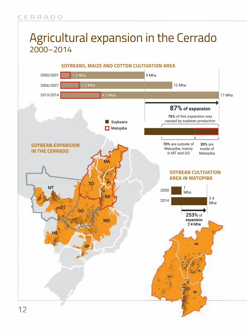
From 2000 to 2014, the agricultural area of the Cerrado expanded by 87%. Around 70% of the land use changes occurred in pastures or areas with other agricultural crops. The main factor for this change was soybean production, which increased 108% in this period – representing in absolute values 8.13 million hectares in Mato Grosso and Goias. However, it was not only there.
In Matopiba, confluence of the states of Maranhao, Tocantins, Piaui and Bahia, soybean
production increased from 1 million to 3.4 million hectares, which represents a growth of 253% in the period. Most of the agricultural expansion in Matopiba occurred over native vegetation: 68% (0.78 million hectares) between 2000 and 2007 and 62% (1.3 million hectares) in the following period, between 2007 and 2014, especially in Maranhao and Piaui, indicating the current agricultural frontier of the Cerrado.
The states that are outside of Matopiba followed the general trend: 80% (between 2000 and 2007) and 89% (between 2007 and 2014) of the changes occurred in pastures or other agricultural crops. The exception is Mato Grosso, where agricultural expansion occurred predominantly over native vegetation: 88% (between 2000 and 2007) and 68% (between 2007 and 2014).
The data based on the analysis of more than 2,500 satellite images collected during the 2000, 2007 and 2014 harvests are in the report Geospatial Analyses of the Annual Crops Dynamics in the Brazilian Cerrado Biome, coordinated by the researchers Bernando Rudorff and Joel Risso, from Agrosatelite.
The study evaluated around 204 million hectares of the biome, enabling an understanding of the dynamics underlying the expansion of areas planted with annual crops in the region and how this dynamic relates to the land use changes in the region between 2000 and 2014, which was a period marked by major expansion of agricultural production, especially soybeans.
The stocks of areas suitable for agriculture were mapped within already converted areas, priority areas for agricultural expansion without further deforestation, as well as in native vegetation areas and areas that are not suitable for crops, but that can be used for forest compensation or for conservation in private areas in order to comply with the new Forest Code.
10
C E R R A D O
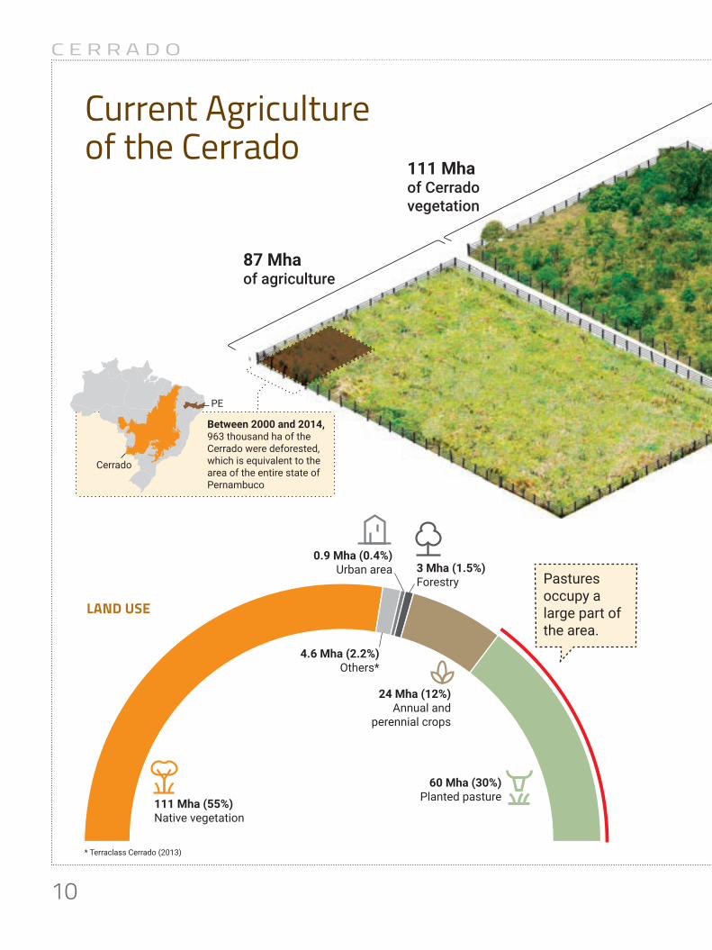
111 Mhaof Cerradovegetation
87 Mhaof agriculture
76%is in private properties
24% is in public lands, protected by UCs and indigenous territories
Cerrado
PE
Between 2000 and 2014, 963 thousand ha of the Cerrado were deforested, which is equivalent to the area of the entire state of Pernambuco
24 Mha (12%)Annual and
perennial crops
60 Mha (30%)Planted pasture
3 Mha (1.5%)Forestry
111 Mha (55%)Native vegetation
0.9 Mha (0.4%)Urban area
4.6 Mha (2.2%)Others*
* Terraclass Cerrado (2013)
Current Agriculture of the Cerrado
LAND USE
Pastures occupy a large part of the area.

11
C E R R A D O
52% in the Cerrado
48% in other Brazilian regions
PROTECTED AREAS IN CONSERVATION UNITS (UCS)AND INDIGENOUS TERRITORIES
13%Cerrado
51%Amazon
10%cotton, maize and other crops
90% soybeans
THE CULTIVATION OF SOYBEANS IN THE BRAZILIAN TERRITORYAGRICULTURE IN THE CERRADO
111 Mhaof Cerradovegetation
87 Mhaof agriculture
76%is in private properties
24% is in public lands, protected by UCs and indigenous territories
Cerrado
PE
Between 2000 and 2014, 963 thousand ha of the Cerrado were deforested, which is equivalent to the area of the entire state of Pernambuco
ANNUAL DEFORESTATION RATE IN HA/YEAR
2003 2014
Amazon
0
500,000
1,000,000
1,500,000
2,000,000
Cerrado
12
C E R R A D O
Agricultural expansion in the Cerrado2000–2014
12
2000/2001
2006/2007
2013/2014
12 Mha
9 Mha1.2 Mha
2.2 Mha
4.1 Mha 17 Mha
87% of expansion
30% are inside of Matopiba
70% are outside of Matopiba, mainly
in MT and GO
76% of this expansion was caused by soybean productionSoybeans
Matopiba
2000
2014
1Mha
253% of expansion2.4 Mha
3.4Mha
SOYBEAN CULTIVATION AREA IN MATOPIBA
SOYBEANS, MAIZE AND COTTON CULTIVATION AREA
SOYBEAN EXPANSION IN THE CERRADO
expansion2.4 Mha

13
C E R R A D O
OVER PASTURESAND OTHER CROPS
OVER NATIVE VEGETATION OF THE CERRADO
CERRADO 69% 74% 31% 26%
2000-2007 2007-2014 2000-2007 2007-2014
MATOPIBA32% 38% 68% 63%
OUTSIDE OF MATOPIBA
81% 94%
Most of the expansion occurred over native vegetation.
Most of the expansion occurred over pastures and other crops.
19% 6%
68%158 Thousand ha
88%576 Thousand ha
Agricultural expansion in the state of Mato Grosso occurred mainly over native vegetation.


Pastures, the agricultural opportunity of the CerradoPATHS TO OPTIMIZING LAND USE
2
17
C E R R A D O
SUITABILITY IN CONVERTED AREAS
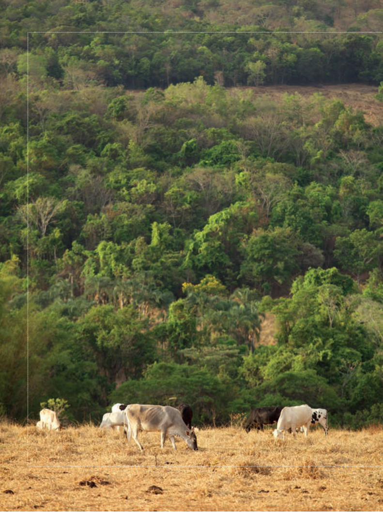
Data on rainfall, temperature relief and altitude made it possible to identify that there is a high concentration of areas in the Cerrado that
are ideal for the production of soybeans, maize and cotton. The Agrosatelite study shows that there are at least 25.4 million hectares –territory equivalent to the size of the state of Parana – of already converted lands that are suitable for agriculture. Most of this territory, which is already occupied by anthropic uses and highly suitable and unrestricted for soybeans, is outside of Matopiba, totaling 22.5 million hectares to be used for crops. In Matopiba, only 2.8 million hectares have the same conditions.
It is worth highlighting that pastures (15.5 million hectares)1 occupy most of these highly suitable areas. This fact, associated to the cattle ranching intensification trend, where increased productivity in a specific area frees less productive areas, poses a strategic opportunity for agribusiness that can expand soybean production in previously occupied pasture areas, without the necessity of further deforestation. Added to that are all the logistic advantages in these areas, normally located in regions with some transportation and warehousing infrastructure. These areas are mainly outside of Matopiba (13.9 million hectares)1, with emphasis to the states of Goias and Mato Grosso do Sul (4.8 million hectares and 3.3 million hectares, respectively).
Besides from the converted areas with high agricultural suitability identified by the study, there are still large areas that have also been modified and have medium suitability and no slope or altitude restrictions (5 million hectares, out of which 771 thousand hectares are in Matopiba and 4.2 million hectares outside of Matopiba), but are available for agricultural expansion. From this total, 3 million hectares are pastures1, out of which 300 thousand hectares are in Matopiba and 2.7 million hectares outside of Matopiba1. These may
also be preferred areas for agribusiness expansion before the occupation of other areas with high suitability covered by native vegetation. Meanwhile, there are 53 million hectares of already modified areas that have restrictions or are not suitable for agriculture, out of which pastures occupy 30.6 million hectares1. Part of these areas may be used for restoration projects and compliance with the legal requirements of the Forest Code.
SUITABILITY IN NATIVE VEGETATION
The identification of areas with high agricultural suitability covered with native vegetation was another valuable exercise carried out by the researchers. In Matopiba, these areas total 4.2 million hectares and outside they total 8.3 million hectares, distributed among the other states of the biome.1
Furthermore, the study identified the equivalent to 50.7 million hectares1 of native vegetation with some restriction for agriculture and another 22.5 million hectares1 of Cerrado with native forests that are unsuitable for agriculture. However, unsuitable areas can also be opportunities for the sector. Areas with this profile can be used for Legal Reserve compensation and other forms of compliance to the forest legislation in force. They can also be used for compliance with international commitments signed by Brazil to reduce greenhouse gas emissions, in REDD+ and in the establishment of private or public protection areas.
One of the conclusions of the researchers from Agrosatélite is that the next agricultural frontier in Brazil will be in pasture areas that are suitable for soybean production and not necessarily degraded in the states of Goias, Mato Grosso and Mato Grosso do Sul.
1. Values discounting areas within Conservation Units (except Environmental Protection Areas – APAs), indigenous lands, rural settlements and quilombola community areas.

18
C E R R A D O
26,7 MhaHigh suitability2 22,5 MhaMedium suitability2 4,2 Mha
3,6 MhaHigh suitability2 2,8 MhaMedium suitability2 771 thousand ha
6,1 MhaHigh suitability2 4,3 Mha3
Medium suitability2 1,8 Mha3
9,7 MhaHigh suitability2 8,3 Mha3
Medium suitability2 1,4 Mha3 INSIDE OF MATOPIBA
OUTSIDE OF MATOPIBAOUTSIDE OF
INSIDE OF
Agricultural suitability in the Cerrado
Areas with remaining Cerrado vegetation can be used for Legal Reserve Compensation.
2. No slope or altitude restrictions.
HIGH AND MEDIUM AGRICULTURAL SUITABILITY WITHOUT RESTRICTIONS2 IN CERRADO NATIVE VEGETATION AREASHIGH AND MEDIUM
AGRICULTURAL SUITABILITY WITHOUT RESTRICTIONS2 IN CONVERTED AREAS (PASTURES + OTHER USES)

19
C E R R A D O
Pastures, the agricultural opportunity of the Cerrado
Other usesHigh agricultural suitability9 Mha3 Medium agricultural suitability1,8 Mha3
Pastures4
High agricultural suitability 15,5 Mha3
Medium agricultural suitability 3 Mha3
Expansion of agriculture over pasture areas already occurs in the Cerrado. However, in Matopiba, expansion still occurs over native vegetation.
The opportunity for agricultural expansion in the Cerrado is on pastures with high agricultural suitability.
2000-2007 2007-2014 2000-2007 2007-2014MATOPIBA
32% 38%
FORA DO MATOPIBA
81% 94%2000-2007 2007-2014 2000-2007 2007-2014
MATOPIBA
32% 38%
OUTSIDE OF MATOPIBA
81% 94%
HIGH AND MEDIUM AGRICULTURAL SUITABILITY2 IN CONVERTED CERRADO AREAS
OVER PASTURES AND OTHER CROPS
3. Values discounting areas within Conservation Units (except Environmental Protection Areas – APAs), indigenous lands, rural settlements and quilombola community areas.4. Agricultural suitability (Agrosatelite/MOORE, 2016) and Terraclass Cerrado 2013 (MMA, 2015).

20
C E R R A D O
MA
PA
TO
PI
SP
PR
BA
GO
DF
MG
MT
MS
PASTURES WITH HIGH AND MEDIUM AGRICULTURAL SUITABILITY AND WITHOUT RESTRICTIONS5 CAN SUPPORT THE DEMAND FOR AGRICULTURAL EXPANSION AREAS
High suitabilityMedium suitability Matopiba
Cerrado
Matopiba1.5 Mha
Outside ofMatopiba13.9 Mha
Matopiba300
thousand ha
Outside ofMatopiba2.7 Mha
15.5 Mhaof pastures with high agricultural
suitability
3 Mhaof pastures with
medium suitability
The path to occupation of the Cerrado
5. Restrictions apply to slopes >12% and altitude.

21
C E R R A D O
MA
PA
TO
PI
SP
PR
BA
GO
DF
MG
MT
MS
PASTURES WITH LOW AGRICULTURAL SUITABILITY, WITHRESTRICTIONS6 OR UNSUITABLE FOR SOYBEANS CAN BE USED FOR RESTORATION OR CATTLE INTENSIFICATION
Low suitability Matopiba Cerrado
1000 200 400 km
N
Matopiba6.4 Mha
Outside ofMatopiba24.2 Mha
30.6 Mhaof pastures with low
agricultural suitability, with restrictions6 or
unsuitable for agricultures
6. Restrictions apply to slopes >12% and altitude.OBS. The pasture area for which the agricultural suitability was classified is equivalent to 49 Mha. The difference between this value and the pasture area mapped by Terraclass Cerrado 2013 is due to the different methodology used in the mappings.

22
C E R R A D O
Agricultural suitability
MS MT
SP
GO
MG17%
26%
PR 0.06%
DF 0.26%
4.3%
13%28%
Matopiba 10%
PI 0.3%
TO6%
MA 2.5%
BA
0.9%
1.1%
TO
9.4%
MA
4.8%
BA
5.6%
MSMT
SP
GO
MG21.9%
23.1%
PR 0.11%
DF 0.16%
3%
12%18.9%
Matopiba 21%
PI
18.5 Mha 1.8 Mha
30.5 Mha 6.4 Mha
MS MT
SP
GO
MG17%
26%
PR 0.06%
DF 0.26%
4.3%
13%28%
Matopiba 10%
PI 0.3%
TO6%
MA 2.5%
BA
0.9%
1.1%
TO
9.4%
MA
4.8%
BA
5.6%
MSMT
SP
GO
MG21.9%
23.1%
PR 0.11%
DF 0.16%
3%
12%18.9%
Matopiba 21%
PI
18.5 Mha 1.8 Mha
30.5 Mha 6.4 Mha
PASTURES WITH HIGH AND MEDIUM AGRICULTURAL SUITABILITY WITHOUT RESTRICTIONS7 FOR AGRICULTURE
PASTURES WITH LOW AGRICULTURAL SUITABILITY, WITH RESTRICTIONS7 OR UNSUITABLE FOR AGRICULTURE
Mato Grosso has12% of these areas.
Matopiba concentrates 10% of these areas.
7. Slope restrictions and altitude restrictions.

23
C E R R A D O
Soybean production
Agricultural expansion
MS
MT
GO
MG8.1%
22.3%
PR 0.5%
SP 2.6%
DF 0.5%
8.8%
35.4%
Matopiba 21.8%
4.4%
TO
9.2%
MA
4.4%BA
4%PI
15.7 Mha 3.4 Mha
DISTRIBUTION OF SOYBEANS IN THE CERRADO (2013-2014)
Mato Grosso is the state with the largest soybean area in the Cerrado.
In the 2013/14 harvest, Matopiba already concentrated a large part (21.8%) of soybean area in the Cerrado. A signifi cant increase of this area occurred in Piaui.
0
600
1200
1800
2400
3000
0
600
1200
1800
2400
3000
Agric
ultu
ral e
xpan
sion
(ha)
Ag
ricul
tura
l exp
ansi
on (h
a)
MS Matopiba MA TO PI BADFPRSPMTMGGOOutside of Matopiba
MS Matopiba MA TO PI BAPRDFMTSPMGGOOutside of Matopiba
OVER PASTURE OR OTHER CROPS
OVER NATIVE VEGETATION
BETWEEN 2000 AND 2007
BETWEEN 2007 AND 2014

InterviewBERNARDO RUDORFF AND JOEL RISSO
3
26
C E R R A D O
Although Brazil did not commit to specific targets for reduction of deforestation during the Climate Conference in Paris, the Cerrado Biome is too important to carry on without long term planning, do you agree?
BERNARDO RUDORFF: Brazil has access to updated satellite images that are capable of showing land use occupation dynamics and if there has been deforestation or not, at the property level. There is no reason for not having an effective system to control the Cerrado. Civil society is concerned with the future of the region for essential reasons, such as the Cerrado’s biodiversity and ability to capture and retain water, including for the Amazon. As previously defined, it is Brazil’s water tank. Furthermore, the biome plays a central role in greenhouse gas emissions. Add to that the fact that the Cerrado concentrates the greatest amount of land with high agricultural suitability in the Country and that agribusiness will carry on. Thus, it is of general interest to think about the future of the biome. There is no way to look at the future of the Cerrado without considering all of the science and technology available.
“There is a lot of space for soybean expansion in the Cerrado without needing to clear new areas”, stated one of the researchers.
During an interview, the researchers BERNARDO RUDORFF and JOEL RISSO explained that the study is only the first step, although substantial, in thinking about the strategic plan for agriculture in the Cerrado and looking at the future of the region. Other studies
and analyses need to be done in order to build up on this effort. Read the full interview!
And in what way can this analysis about the dynamics of agricultural crops help in this planning?
JOEL RISSO: TWe have to consider that it is the first study that contemplates the biome as a whole, from the point of view of its land use dynamics with agriculture for a long period of 14 years. We are talking about an area of 204 million hectares, which is far from negligible. Around 94.3 million hectares have unfavorable slopes and altitude for soybean production. Another 36.8 million hectares are unsuitable for agricultural production due to climate and soil conditions. There are areas with high suitability, but covered with native vegetation, where the recommendation is certainly conservation. However, there are a remainder of 30.4 million hectares of anthropized areas with high and medium suitability for soybeans, which is where the government should rationally guide future grain expansion to in the Cerrado Biome.
These areas have appropriate soil, climate, slope and altitude. It is just a matter of choice. If we subtract the sugarcane areas, which
27
C E R R A D O
occupy around 5 million hectares, out of these 33.4 million hectares, we would still have a stock of land large enough to expand in up to 1.5 times the area destined to grains in this biome, occupying only areas of high and medium agricultural suitability and without further deforestation. Furthermore, most of this stock is in areas outside of the Matopiba. I would risk to say that the next agricultural frontier in Brazil will be in pasture areas suitable for soybean production and not necessarily degraded in Goias, Mato Grosso and Mato Grosso do Sul.
But Matopiba is currently the major agricultal frontier. It is at the forefront of deforestation in the Cerrado.
BERNARDO RUDORFF: This has been the trend in the last decade, but we believe that it will not be for long. The stocks of land with highest agricultural suitability and, consequently, lowest climatic risks are limited and increasingly scarce. Take the case of western Bahia, for example, where the advance of grains east of BR-020 have maybe exceeded the limit of areas with lowest climatic risk. This region suffers with a series of three or four consecutive years of harvest losses caused by periods of drought and, generally, the most affected areas are in these recent expansion areas east of BR-020. Precipitation there has been lower than expected and much thought should be put into opening a new business there. The soil did not change, but the climate shows many signs of change. The yellow light was turned on.
And in the study, where are the most indicated areas for future agricultural production located?
BERNARDO RUDORFF: There is a very rich database available in the project’s website, where it is possible to carry out several consultations, whether at the level of the
biome, micro-region, municipality or within the municipality, and check where the best areas for expansion are. It is obvious that further analysis and improvements can be made to the data considering specific and important aspects for different agents. We want to be challenged in order to take further steps in this study, but the baseline is ready. We understand that the creation of a public policy to address this with the necessary seriousness is indispensable. And this is the government’s role. The instruments for decision-making are in the study and in further studies that should complement it throughout the years. We are creating the basis for rational, strategic planning. Beyond that, we can aggregate studies on viability of processing and logistics infrastructure, among many others. It is also a great argument for civil society to use in debates about agribusiness and sustainability from now on.
However, doesn’t the production sector also need to be aligned in this perspective?
JOEL RISSO: The new businesses that are emerging are already more sustainable, which is a consequence of new factors. Among them, the Forest Code, which requires commitment to Legal Reserves and Permanent Preservation Areas, with penalties in access to credit for those who do not comply. Currently, no serious entrepreneur will start a business in soybean production without establishing a Legal Reserve, as he knows that he will be questioned on whether there was deforestation in the soybean’s production chain. Compliance to the law is something that both society and the market already require. Moreover, the market has even been stricter than the Forest Code, pointing to zero deforestation requirements, as seen in the New York Declaration – in which companies, governments and society committed to zero deforestation in the next decades – and in international forums, where large agricultural

28
C E R R A D O
commodity buyers, specially of soybeans, want to get rid of the deforestation trail.
But the Forest Code allows legal deforestation.
BERNARDO RUDORFF: The thing is that satellite images now show if the soybeans came from a deforested area and that soybean may be rejected. The market tends to be stricter than the Forest Code. However, using the satellite images in a more efficient way is necessary in order to effectively monitor and demonstrate to the international market that Brazilian soybeans are being produced in a sustainable manner and the advances toward reducing and even eliminating deforestation from the soybean production chain. The study helps to better guide production with gains for agribusiness, society and government. Therefore, saying that it is impossible to do things right is no longer conceivable. We need
The complete study Geospatial Analyses of the Annual Crops Dynamics in the Brazilian Cerrado Biome 2000-2014 is available at https://goo.gl/WU88WS
political will. What we are showing is that there is a lot of space for soybean expansion in the Cerrado without clearing new areas.
Something like what happened with soybeans in the Amazon after the moratorium?
JOEL RISSO: Exactly. Soybean production in the Amazon grew since the beginning of the Moratorium, which banned the advance of the crop over the forest. And deforestation fell drastically in the last years. This was only possible due to the expansion over previously deforested areas that were occupied by pastures. And it was not at the expense of clearing new areas, but largely thanks to improvements in the quality of pastures, which have freed thousands of hectares for agriculture with no losses to meat production. If everything is working out in the Amazon, the same logic can be applied to the Cerrado.