ARIZONA - Census Arizona E-1 U.S. Census Bureau, 2010 Census ARIZONA MEXICO APACHE COCHISE COCONINO...
16
Maps Arizona E-1 U.S. Census Bureau, 2010 Census ARIZONA MEXICO APACHE COCHISE COCONINO GILA GRAHAM GREENLEE LA PAZ MARICOPA MOHAVE NAVAJO PIMA PINAL SANTA CRUZ YAVAPAI YUMA NEVADA UTAH CALIFORNIA COLORADO NEW MEXICO 109° 109° 110° 110° 111° 111° 112° 112° 113° 113° 114° 114° 115° 115° 37° 37° 36° 36° 35° 35° 34° 34° 33° 33° 32° 32° 31° 31° Counties 0 10 20 30 Kilometers 0 10 20 30 Miles LEGEND MEXICO International UTAH State GILA County Note: All boundaries and names are as of January 1, 2010.
-
Upload
nguyenthuy -
Category
Documents
-
view
219 -
download
2
Transcript of ARIZONA - Census Arizona E-1 U.S. Census Bureau, 2010 Census ARIZONA MEXICO APACHE COCHISE COCONINO...

Maps Arizona E-1U.S. Census Bureau, 2010 Census
ARIZONA
MEXICO
APACHE
COCHISE
COCONINO
GILA
GRAHAM
GREENLEE
LA PAZ
MARICOPA
MOHAVENAVAJO
PIMA
PINAL
SANTA CRUZ
YAVAPAI
YUMA
NEVADA
UTAH
CALIFORNIA
COLORADO
NEWMEXICO
109°
109°
110°
110°
111°
111°
112°
112°
113°
113°
114°
114°
115°
115°
37° 37°
36° 36°
35° 35°
34° 34°
33° 33°
32° 32°
31° 31°
Counties
0 10 20 30 Kilometers
0 10 20 30 Miles
LEGENDMEXICO International
UTAH State
GILA CountyNote: All boundaries and names are as of January 1, 2010.
E-2 Arizona MapsU.S. Census Bureau, 2010 Census
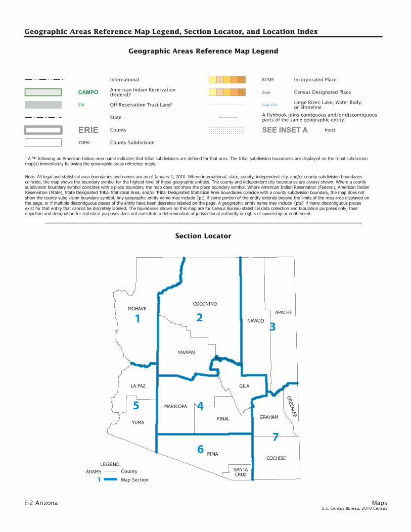
Geographic Areas Reference Map Legend, Section Locator, and Location Index
PIMA
COCONINOMOHAVE
APACHE
NAVAJO
GILA
YAVAPAI
YUMAPINAL
MARICOPA
COCHISE
LA PAZ
GRAHAM
GREEN
LEE
SANTACRUZ
23
4
1
76
5
Geographic Areas Reference Map Legend
Census Designated Place
Large River, Lake, Water Body,or Shoreline
Zena
Lake Erie
American Indian Reservation(Federal)1CAMPO
Off-Reservation Trust Land1ZIA
Inset
A fishhook joins contiguous and/or discontiguousparts of the same geographic entity.
SEE INSET A
LEGENDADAMS County
1 Map Section
State
Incorporated PlaceROME
YORK County Subdivision
CountyERIE
International
Note: All legal and statistical area boundaries and names are as of January 1, 2010. Where international, state, county, independent city, and/or county subdivision boundariescoincide, the map shows the boundary symbol for the highest level of these geographic entities. The county and independent city boundaries are always shown. Where a countysubdivision boundary symbol coincides with a place boundary, the map does not show the place boundary symbol. Where American Indian Reservation (Federal), American IndianReservation (State), State Designated Tribal Statistical Area, and/or Tribal Designated Statistical Area boundaries coincide with a county subdivision boundary, the map does notshow the county subdivision boundary symbol. Any geographic entity name may include ’(pt)’ if some portion of the entity extends beyond the limits of the map area displayed onthe page, or if multiple discontiguous pieces of the entity have been discretely labeled on the page. A geographic entity name may include ’(pts)’ if many discontiguous piecesexist for that entity that cannot be discretely labeled. The boundaries shown on this map are for Census Bureau statistical data collection and tabulation purposes only; theirdepiction and designation for statistical purposes does not constitute a determination of jurisdictional authority or rights of ownership or entitlement.
1 A ’ ’ following an American Indian area name indicates that tribal subdivisions are defined for that area. The tribal subdivision boundaries are displayed on the tribal subdivisionmap(s) immediately following the geographic areas reference maps.
**
Section Locator

Maps Arizona E-3U.S. Census Bureau, 2010 Census
COUNTY MAPSEC
Apache 3Cochise 7Coconino 2Gila 4Graham 7Greenlee 7La Paz 5Maricopa 4Mohave 1Navajo 3Pima 6Pinal 4Santa Cruz 6Yavapai 2Yuma 5
Map section numbers refer to the geographic areas reference maps only.This list presents the map section numbers for each county in the state.
County Location Index
Geographic Areas Reference Map Legend, Section Locator, and Location Index

E-4 Arizona MapsU.S. Census Bureau, 2010 Census
MOHAVE
KEY
1 Mohave Valley2 Arizona Village345
FORT MOJAVE (pt)Golden ShoresTopock
MOHAVE
KINGMAN
LAKE HAVASU CITY
BULLHEAD CITY
COLORADO CITY
Antares
2
Cane BedsCentennial Park
Beaver Dam
Chloride
Clacks Canyon
Crozier
CrystalBeach
Desert Hills
DolanSprings
McConnico
Meadview
Mesquite Creek
FortMohave
4
GoldenValley
Grand Canyon West
Hackberry
Kaibab
Katherine
Lazy Y U
LittlefieldMoccasin
1
Mojave Ranch Estates
PeachSprings
New Kingman-Butler
OatmanPine Lake
Pinion Pines
Scenic
So-Hi
Walnut Creek
5
Truxton
ValentineValleVista
White Hills
Wikieup
Willow ValleyYucca
HUALAPAI (pt)
HUALAPAI (pt)
HUALAPAI (pt)3
KAIBAB(pt)
HUALAPAI (pts)
BULLHEADCITY
KINGMAN
LAKE HAVASU CITY
NORTH MOHAVE
SEESECTION 2
SEESECTION 5
Lake Mead
112°
112°
113°
113°
114°
114°
115°
115°
37°
37°
36°
36°
35°
35°
34°
34°
American Indian Areas, Counties, County Subdivisions, and Places - Section 1
0 10 20 30 Kilometers
0 10 20 30 Miles

Maps Arizona E-5U.S. Census Bureau, 2010 Census
COCONINO
YAVAPAI6
KEY
1 YAVAPAI-APACHE NATION (pt)2 CLARKDALE3456789
COTTONWOODVerde VillageCornvilleVillage of Oak Creek (Big Park)YAVAPAI-APACHE NATION (pt)PRESCOTT VALLEYYAVAPAI-PRESCOTT
YAVAPAI
FLAGSTAFF
FREDONIA
SEDONA
JEROME
PAGE
PEORIA (pt)
PRESCOTT8
CAMPVERDE
CHINOVALLEY
23
DEWEY-HUMBOLDT
WICKENBURG (pt)
WILLIAMS
Cameron
Ash Fork
Bagdad
Bitter Springs
Black Canyon City
CongressCordes Lakes
5
Doney Park
Mayer
Fort Valley
Grand CanyonVillage
Kachina Village
Kaibito
LakeMontezuma
LeChee
Leupp
Moenkopi
Mountainaire
Munds Park
Parks
Paulden
Peeples ValleySpring Valley
Supai
Seligman
Tolani Lake
Tonalea
Tuba City
Tusayan
Valle
4
Wilhoit
William
son
Winslow West (pt)
Yarnell
9
NAVAJO NATION* (pt)
HOPI*(pt)
HOPI* (pt)
HUALAPAI (pt)
KAIBAB (pt)
HAVASUPAI
1
7
HOPI (pt)
NAVAJONATION (pt)
FLAGSTAFF
HAVASUPAI
HOPI
HUALAPAI
KAIBAB PLATEAU
TUBA CITY
WILLIAMS
ASH FORK
CAMP VERDE-SEDONA
CONGRESS
CORDES LAKES-MAYER
MINGUSMOUNTAIN
PRESCOTT
SEESECTION 1
SEESECTION 3
SEESECTION 4
SEESECTION 5
Lake Powell
American Indian Areas, Counties, County Subdivisions, and Places - Section 2
0 10 20 30 Kilometers
0 10 20 30 Miles

E-6 Arizona MapsU.S. Census Bureau, 2010 Census
APACHE
NAVAJO
23
McNaryHondah
KEY
1 White Mountain Lake2 Wagon Wheel3456789
Lake of the WoodsPINETOP-LAKESIDEPinetop Country ClubRainbow CityWhiteriverTurkey CreekEast Fork
10 Seven Mile11 Fort Apache
NAVAJOHOLBROOK
SHOWLOW
SNOWFLAKE
SPRINGERVILLE
TAYLOR
4
ST. JOHNS
EAGAR
WINSLOW
Burnside
Alpine9
First Mesa
Chilchinbito
Chinle
Cibecue
Clay Springs
Concho
Cornfields
Cottonwood
Del Muerto
Dennehotso
DilkonLupton
Many Farms
11
Fort Defiance
Ganado
Greasewood
Greer
Hard Rock
Heber-Overgaard
Hotevilla-Bacavi
Houck
Indian Wells
Jeddito
Joseph City
Kayenta
KeamsCanyon
Klagetoh
Kykotsmovi Village
Linden
Low Mountain
Lukachukai
Nazlini
NorthFork
Nutrioso
Oak Springs
Oljato-Monument Valley
Steamboat
Sun Valley
Pinedale
5
Pinon
6
Red Mesa
Red Rock
Rock Point
Rough Rock
Round Rock
St. Michaels
Sanders
Sawmill
Seba Dalkai
Second Mesa
Sehili
10
Shongopovi
Shonto
Teec Nos Pos
Tees Toh
Toyei
Tsaile
8
Vernon
Whitecone
1
7
Wide Ruins
Window Rock
WinslowWest (pt)
Woodruff
ZUNI (pts)
NAVAJO NATION* (pt)
NAVAJO NATION* (pt)
HOPI*(pt)
FORT APACHE (pt)
HOPI (pt) NAVAJONATION (pts)
CHINLE
DENNEHOTSO
EAGAR-SPRINGERVILLE
FORT APACHE
FORT DEFIANCE
PUERCO
ST. JOHNS
SWEETWATER
FORT APACHE
HOPI
INDIAN WELLS
KAYENTA
PINON
SNOWFLAKE
WINSLOW-HOLBROOK
SEESECTION 2
SEESECTION 4
SEESECTION 7
109°
109°
110°
110°
111°
111°
112°
112°
37° 37
°
36° 36
°
35° 35
°
34° 34
°
American Indian Areas, Counties, County Subdivisions, and Places - Section 3
0 10 20 30 Kilometers
0 10 20 30 Miles

Map
s A
rizona E-7
U.S. C
ensu
s Bureau
, 20
10
Cen
sus
APA
CH
E
NAVA
JO
23
McN
aryH
ondah
KEY
1W
hite Mountain Lake
2W
agon Wheel
3456789
Lake of the Woods
PINETO
P-LAK
ESIDE
Pinetop Country C
lubR
ainbow C
ityW
hiteriverTurkey C
reekEast Fork
10Seven M
ile11
Fort Apache
NAVA
JOH
OLB
RO
OK
SHO
WLO
W
SNO
WFLA
KE
SPRIN
GERV
ILLE
TAYLO
R
4
ST. JOH
NS
EAG
AR
WIN
SLOW
Burnside
Alpine
9
First Mesa
Chilchinbito
Chinle
Cibecue
Clay Springs
Concho
Cornfields
Cottonw
ood
Del M
uerto
Dennehotso
Dilkon
Lupton
Many Farm
s
11
Fort Defiance
Ganado
Greasew
ood
Greer
Hard R
ock
Heber-O
vergaard
Hotevilla-B
acavi
Houck
Indian Wells
Jeddito
Joseph City
Kayenta
Keam
sC
anyon
Klagetoh
Kykotsm
ovi Village
Linden
Low M
ountain
Lukachukai
Nazlini
North
ForkN
utrioso
Oak Springs
Oljato-M
onument Valley
Steamboat
Sun Valley
Pinedale
5
Pinon
6
Red M
esa
Red R
ock
Rock Point
Rough R
ock
Round R
ockSt. Michaels
Sanders
Sawm
ill
Seba Dalkai
Second Mesa
Sehili
10
Shongopovi
Shonto
Teec Nos Pos
Tees Toh
Toyei
Tsaile
8
Vernon
Whitecone
1
7
Wide R
uins
Window
Rock
Winslow
West (pt)
Woodruff
ZUN
I (pts)
NAVA
JO N
ATION
* (pt)
NAVA
JO N
ATION
* (pt)
HO
PI*(pt)
FOR
T APA
CH
E (pt)
HO
PI (pt)
NAVA
JON
ATION
(pts)
CH
INLE
DE
NN
EH
OTS
O
EA
GA
R-
SP
RIN
GE
RV
ILLE
FOR
T APA
CH
E
FOR
T DE
FIAN
CE
PU
ER
CO
ST. JO
HN
S
SW
EE
TWATE
R
FOR
T APA
CH
E
HO
PI
IND
IAN
WE
LLS
KAY
EN
TA
PIN
ON
SN
OW
FLAK
E
WIN
SLO
W-H
OLB
RO
OK
SEESEC
TION
2
SEESEC
TION
4
SEESEC
TION
7
109°
109°
110°
110°
111°
111°
112°
112°
37°
37°
36°
36°
35°
35°
34°
34°
Am
eric
an
Ind
ian
Are
as, C
ou
ntie
s, C
ou
nty
Su
bd
ivis
ion
s, a
nd
Pla
ces - S
ectio
n 3
010
2030
Kilom
eters
010
2030
Miles
GILA
MARICOPA PINAL
23 4
678 10 12 14
17
SCOTTSDALE (pt)
27
2
KEY
1 Strawberry2 Pine3456789
Geronimo EstatesWashington ParkWhispering PinesBeaver ValleyFreedom AcresFlowing SpringsEast Verde Estates
10 Mesa del Caballo1112131415
1617181920
STAR VALLEYMead RanchTonto VillageKohls RanchBear Flat
Hunter CreekChristopher CreekHaigler CreekMIAMIClaypool
PINAL
21 Central Heights-Midland City22 GLOBE2324252627
CutterEast GlobeSix Shooter CanyonIcehouse CanyonPinal
12
QUEEN CREEK (pt)COOLIDGE (pt)
GILA MARICOPA1 Sun City West
SEEINSET
A
ELOY (pt)
FLORENCE
GILA BEND
22
GOODYEAR (pt)HAYDEN
11
SUPERIOR
SURPRISE (pt)
KEARNY
MAMMOTH
19
PAYSON
PEORIA(pt)
1
APACHE JUNCTION
AVON-DALE
(pt)
BUCKEYE (pt)
WICKENBURG (pt)
WINKELMANCactus Forest
Campo Bonito
Canyon Day
Carrizo Cedar Creek
21
Arlington
15
Aguila
DrippingSprings
Dudleyville
24
9
El Capitan
20Copper Hill
23
Deer CreekGisela
Gold Canyon
18
16
26
Jakes Corner
Kaka
Morristown
Oxbow Estates
Peridot (pt)
Picacho (pt)Oracle
1
1
Queen Valley
Red Rock (pt)
Rio Verde (pt)Rock House
Roosevelt
RoundValley
Rye
Saddlebrooke
San Carlos
SanManuel
San TanValley
25
Theba
Tonopah
Tonto Basin
13
Top-of-the-World
Wheatfields
5
Wintersburg
Wittmann
Young
TOHONO O’ODHAMNATION* (pt)
TOHONO O’ODHAMNATION* (pts)
TOHONO O’ODHAM NATION* (pt)
FORTAPACHE (pt)
SAN CARLOS (pt)
TONTO APACHE
FORT APACHE
GLOBE-MIAMI
PAYSON
SAN CARLOS
TONTO BASIN
WINKELM
AN
BUCKEYE
GILA BEND
TONTONATIONALFOREST
WICKENBURG
FLORENCE
NORTHPINAL
SAN MANUEL
SEESECTION 2
SEESECTION 3
SEESECTION 5
SEESECTION 6
SEESECTION 7
San CarlosReservoir
Theodore RooseveltLake
Am
eric
an
Ind
ian
Are
as, C
ou
ntie
s, C
ou
nty
Su
bd
ivis
ion
s, a
nd
Pla
ces - S
ectio
n 4
110°
110°
111°
111°
112°
112°
113°
113°
34°
34°
33°
33°
32°
32°
0 10 20 30 Kilometers
0 10 20 30 Miles

E-8 Arizona MapsU.S. Census Bureau, 2010 Census
LA PAZ
YUMA
1 4
5 6
YUMA
789
10
11 12
KEY
1 Drysdale2 Wall Lane3456789
Donovan EstatesPadre RanchitosEl Prado EstatesBuckshotGadsdenSOMERTONCOCOPAH (pt)
10 Orange Grove Mobile Manor1112
Rancho Mesa VerdeSOMERTON
YUMA
SANLUIS
PARKER (pt)
PARKER (pt)
QUARTZSITE
WELLTON
YUMA
3
Aztec
Bluewater
Bouse
Brenda
AlamoLake
Ehrenberg
2
Cibola
Cienega Springs
Dateland
Martinez Lake
FortunaFoothills
La Paz Valley
Avenue B and C
Parker Strip
Sunwest
Poston
Salome
Wellton Hills
Wenden
Tacna
Utting
Vicksburg
COCOPAH (pt)
COLO
RADO
RIV
ER (p
t)
FORT YUMA (pt)
PARKER
WELLTON
SEESECTION 1
SEESECTION 2
SEESECTION 4
SEESECTION 6
113°
113°
114°
114°
115°
115°
34°
34°
33°
33°
32°
32°
American Indian Areas, Counties, County Subdivisions, and Places - Section 5
0 10 20 30 Kilometers
0 10 20 30 Miles

Map
s A
rizona E-9
U.S. C
ensu
s Bureau
, 20
10
Cen
sus
LA PAZ
YUM
A
14
56
YUMA
789
10
1112
KEY
1D
rysdale2
Wall Lane
3456789
Donovan Estates
Padre Ranchitos
El Prado EstatesB
uckshotG
adsdenSO
MERTO
NC
OC
OPA
H (pt)
10O
range Grove M
obile Manor
1112R
ancho Mesa Verde
SOMERTON
YUM
A
SAN
LUIS
PAR
KER
(pt)
PAR
KER
(pt)
QU
ARTZSITE
WELLTO
N
YU
MA
3
Aztec
Bluew
ater
Bouse
Brenda
Alam
oLake
Ehrenberg
2
Cibola
Cienega Springs
Dateland
Martinez Lake
FortunaFoothills
La Paz Valley
Avenue B and C
Parker Strip
Sunwest
Poston
Salome
Wellton H
ills
Wenden
Tacna
UttingV
icksburg
CO
CO
PAH
(pt)
COLORADO RIVER (pt)
FOR
T YUM
A (pt)
PARKER
WELLTO
N
SEESEC
TION
1
SEESEC
TION
2
SEESEC
TION
4
SEESEC
TION
6
113° 113°
114°
114°
115°
115°
34°
34°
33°
33°
32°
32°
Am
eric
an
Ind
ian
Are
as, C
ou
ntie
s, C
ou
nty
Su
bd
ivis
ion
s, a
nd
Pla
ces - S
ectio
n 5
010
2030
Kilom
eters
010
2030
Miles
PIMA
SANTACRUZ
1 2
34
567 8
KEY
1 Nelson2 Rillito3456789
Casas AdobesFlowing WellsSOUTH TUCSONTucson EstatesValencia WestDrexel HeightsLittletown
10 Summit11 PASCUA PUEBLO YAQUI
1 Tumacacori-Carmen2 Kino Springs
PIMA SANTA CRUZ
MARANA
NOGALES
ORO VALLEY
PATAGONIA
SAHUARITA
TUCSON
Anegam
Arivaca
Arivaca Junction
Catalina
CatalinaFoothills
Avra Valley
Beyerville
Ajo
Ak Chin
Ali ChukAli Chukson Ali Molina
Amado
Elephant Head
Elgin
Charco
Chiawuli TakComobabi
Corona de Tucson
Cowlic
Maish Vaya
Green Valley
Gu Oidak
HaivanaNakya
2
Ko Vaya 9
PictureRocks
PimacoTwo
Nolic
SonoitaSouth Komelik
Summerhaven
10Pisinemo
Rincon Valley
Rio Rico
San Miguel
Santa Rosa
Sells
Wahak Hotrontk
Tanque Verde
Three Points
Topawa
Tubac1
Vail
Ventana
Why
Willow Canyon
TOHONO O’ODHAM NATION* (pt)
TOHONOO’ODHAM
NATION* (pt)
11
AJO
ARIVACA
MARANA
TOHONO O’ODNAMNATION
TUCSON
NOGALESPATAGONIA
SEESECTION 4
SEESECTION 5
SEESECTION 7
Am
eric
an
Ind
ian
Are
as, C
ou
ntie
s, C
ou
nty
Su
bd
ivis
ion
s, a
nd
Pla
ces - S
ectio
n 6
110°
110°
111°
111°
112°
112°
113°
113°114°
33°
33°
32°
32°
31°
31°
0 10 20 30 Kilometers
0 10 20 30 Miles

E-10 Arizona MapsU.S. Census Bureau, 2010 Census
COCHISE
GRAHAM
GREENLEE
HUACHUCACITY
MiracleValley
Palominas
SIERRAVISTA
THATCHERPIMASAFFORD
BENSON
BISBEE
CLIFTON
DOUGLAS (pt)
DOUGLAS (pt)
DUNCAN
TOMBSTONE (pt)
TOMBSTONE (pt)
WILLCOX
Central
Bowie
Bryce
Bylas
Cactus Flats
Dragoon
Elfrida
McNeal
Mescal
Fort Thomas
Franklin
Morenci
Peridot (pt)
Naco
Sunizona
Pirtleville
St. David
San Jose
SanSimon
Sierra VistaSoutheast
Solomon
Swift Trail Junction
Whetstone
York
SAN CARLOS (pt)
BENSON
BISBEE
BOWIE
DOUGLAS
ELFRIDA
SIERRA VISTA
WILLCOX
BONITA-KLONDYKE
PIMA
SAFFORD
SAN CARLOS
CLIFTON
DUNCAN
SEESECTION 3
SEESECTION 4
SEESECTION 6
San CarlosReservoir
108°
109°
109°
110°
110°
111°
111°
34°
34°
33°
33°
32°
32°
31°
31°
American Indian Areas, Counties, County Subdivisions, and Places - Section 7
0 10 20 30 Kilometers
0 10 20 30 Miles
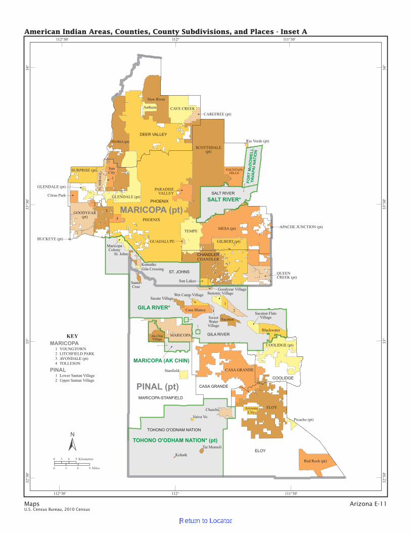
Maps Arizona E-11U.S. Census Bureau, 2010 Census
MARICOPA (pt)
PINAL (pt)
GLENDALE (pt)
23
1
2
ELOY
KEY
1 YOUNGTOWN2 LITCHFIELD PARK34
AVONDALE (pt)TOLLESON
PINAL12
Lower Santan VillageUpper Santan Village
MARICOPA
EL M
IRA
GE
ELOY
FOUNTAINHILLS
GILBERT (pt)
GLENDALE (pt)
GOODYEAR(pt)
GUADALUPE
SCOTTSDALE(pt)
SURPRISE (pt)
TEMPE
MARICOPA
MESA (pt)
PARADISEVALLEY
PEORIA (pt)
PHOENIX
QUEENCREEK (pt)
APACHE JUNCTION (pt)
BUCKEYE (pt)
CAREFREE (pt)
CASA GRANDE
CAVE CREEK
CHANDLER
COOLIDGE (pt)
4
1
Anthem
ArizonaCity
Casa Blanca
BlackwaterAk-ChinVillage
Chuichu
Citrus Park
MaricopaColony
Gila Crossing
Goodyear Village
Kohatk
Komatke
Picacho (pt)
New River
Stanfield
Stotonic Village
SunCity
Sun Lakes
Red Rock (pt)
Rio Verde (pt)
Sacate Village
SacatonSacaton Flats
Village
St. Johns
SantaCruz
SweetWater
Village
Tat Momoli
Vaiva Vo
Wet Camp Village
GILA RIVER*
SALT RIVER*
TOHONO O’ODHAM NATION* (pt)
FOR
T M
cDO
WEL
LYA
VAPA
I NAT
ION
MARICOPA (AK CHIN)
CHANDLER
DEER VALLEY
PHOENIX
ST. JOHNS
SALT RIVER
CASA GRANDE
COOLIDGE
GILA RIVER
MARICOPA-STANFIELD
TOHONO O’ODNAM NATION
111°30’
111°30’
112°
112°
112°30’
112°30’
34°
34°
33°3
0’
33°3
0’
33°
33°
32°3
0’
32°3
0’
American Indian Areas, Counties, County Subdivisions, and Places - Inset A
0 3 6 9 Kilometers
0 3 6 9 Miles

E-12
Arizo
na
Map
sU
.S. Cen
sus Bu
reau, 2
01
0 C
ensu
s
District 6
District 4
District 5
District 3
District 7
District 1
District2
Am
eric
an
Ind
ian
Reserv
atio
n, T
ribal S
ub
div
isio
ns - G
ila R
iver
0 2 4 6 Kilometers
0 2 4 6 Miles
Area Locator Map
Map Legend
Tribal Subdivision
American Indian Reservation
Note: All legal boundaries and names are as of January 1, 2010. Wherethe boundaries coincide, the map shows the boundary symbol for theAmerican Indian reservation and/or off-reservation trust land. Anygeographic entity name may include ’(pt)’ if some portion of the entityextends beyond the limits of the map area displayed on the page, or ifmultiple discontiguous pieces of the entity have been discretely labeledon the page. A geographic entity name may include ’(pts)’ if many discontiguous pieces exists for that entity that cannot be discretely labeled.The boundaries shown on this map are for Census Bureau statistical datacollection and tabulation purposes only; their depiction and designation forstatistical purposes does not constitute a determination of jurisdictionalauthority or rights of ownership or entitlement.

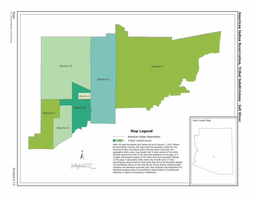
Maps Arizona E-13U.S. Census Bureau, 2010 Census
RU255
RU551
RU263
RU253
RU257
Hardrock
RU252
RU256Moenkopi
Five Houses
RU555
RU552
RU553
Shonto
RU259
RU262
Talahogan
RU251
RU554
RU254
Upper Polacca
RU351
North Oraibi
RU559
RU261
Toreva
RU260
RU562
Tovar Mesa
RU565
RU563
RU258
RU556
PolaccaWash
BurroSprings
Shongopovi
EastDinnebito
SouthOraibi
BluePoint
RU451
RU
558
RU570
RU572
RU566
RU557
RU573
RU
568
Wes
tDin
nebi
to
RU571
RU567
RU560
RU569
RU564
RU561
MoenkopiAdministrative
Area
Hopi-Winslow
American Indian Reservation and Off-Reservation Trust Land, Tribal Subdivisions - Hopi
0 3 6 9 Kilometers
0 3 6 9 Miles
Area Locator Map
Map Legend
Tribal Subdivision
American Indian Reservation/Off-Reservation Trust Land
Note: All legal boundaries and names are as of January 1, 2010. Wherethe boundaries coincide, the map shows the boundary symbol for theAmerican Indian reservation and/or off-reservation trust land. Anygeographic entity name may include ’(pt)’ if some portion of the entityextends beyond the limits of the map area displayed on the page, or ifmultiple discontiguous pieces of the entity have been discretely labeledon the page. A geographic entity name may include ’(pts)’ if many discontiguous pieces exists for that entity that cannot be discretely labeled.The boundaries shown on this map are for Census Bureau statistical datacollection and tabulation purposes only; their depiction and designation forstatistical purposes does not constitute a determination of jurisdictionalauthority or rights of ownership or entitlement.

E-14
Arizo
na
Map
sU
.S. Cen
sus Bu
reau, 2
01
0 C
ensu
s
Coalmine Mesa(pts)
Dilcon (pts)
Bodaway
ShontoKayenta
Leupp
Chinle
Dilcon(pt)
LeChee
Kaibeto
Nazlini
Oljato(pt)
Coalmine Mesa(pt)Cameron
Dennehotso(pt)
Nahatadziil (pt)
Coppermine
Wide Ruins
Tonalea
Tuba City
Kinlichee
Tselani
Tolani Lake
Piñon
Klagetoh
Bird Springs
Black Mesa
Sweetwater
Indian Wells
Tachee
Teesto
ChilchinbetoRound Rock
Houck
Cove
Lukachukai
Many Farms
Grease-wood
RockPoint
Insc
riptio
n
House
(pt)
GanadoSteam-boat
ForestLake
Lupto
n
RedValley
(pt)
Tsaile-Wheatfields
(pt)
Sawmill
Cornfields
White Cone
Teec Nos Pos(pt)
OakSprings
RoughRock
Hard Rock
Mexica
n Wate
r
(pt)
NavajoMountain
(pt)
St. M
icha
els
(pt)
Nahatadziil
(pt)
Low
Mounta
in
Crystal
(pt)
Jeddito(pt)
Jedd
ito(p
t)
FortDefiance
(pt)
Whippoorwill
Sanostee(pt)
Red
Lak
e(p
t)
Red Mesa (pt)
Beclabito(pt)
San Juan SouthernPaiute Southern
Am
eric
an
Ind
ian
Reserv
atio
n a
nd
Off-R
eserv
atio
n T
rust L
an
d, T
ribal S
ub
div
isio
ns -
Navajo
Natio
n (p
t)
0 8 16 24 Kilometers
0 8 16 24 Miles
Map Legend
Tribal Subdivision
American Indian Reservation/Off-Reservation Trust Land
Note: All legal boundaries and names are as of January 1, 2010. Wherethe boundaries coincide, the map shows the boundary symbol for theAmerican Indian reservation and/or off-reservation trust land. Anygeographic entity name may include ’(pt)’ if some portion of the entityextends beyond the limits of the map area displayed on the page, or ifmultiple discontiguous pieces of the entity have been discretely labeledon the page. A geographic entity name may include ’(pts)’ if many discontiguous pieces exists for that entity that cannot be discretely labeled.The boundaries shown on this map are for Census Bureau statistical datacollection and tabulation purposes only; their depiction and designation forstatistical purposes does not constitute a determination of jurisdictionalauthority or rights of ownership or entitlement.
Area Locator Map
Map
s A
rizona E-1
5U
.S. Cen
sus Bu
reau, 2
01
0 C
ensu
s
District FDistrict D
District G
District C
District B
District A
District E
Am
eric
an
Ind
ian
Reserv
atio
n, T
ribal S
ub
div
isio
ns - S
alt R
iver
0 0.5 1 1.5 Kilometers
0 0.5 1 1.5 Miles
Area Locator Map
Map Legend
Tribal Subdivision
American Indian Reservation
Note: All legal boundaries and names are as of January 1, 2010. Wherethe boundaries coincide, the map shows the boundary symbol for theAmerican Indian reservation and/or off-reservation trust land. Anygeographic entity name may include ’(pt)’ if some portion of the entityextends beyond the limits of the map area displayed on the page, or ifmultiple discontiguous pieces of the entity have been discretely labeledon the page. A geographic entity name may include ’(pts)’ if many discontiguous pieces exists for that entity that cannot be discretely labeled.The boundaries shown on this map are for Census Bureau statistical datacollection and tabulation purposes only; their depiction and designation forstatistical purposes does not constitute a determination of jurisdictionalauthority or rights of ownership or entitlement.

E-16
Arizo
na
Map
sU
.S. Cen
sus Bu
reau, 2
01
0 C
ensu
s
Gu Achi(pt)
Sells
Sif Oidak
Hickiwan
Schuk Toak
Gu Vo
Gu Achi(pt)
Pisinemo
Chukut Kuk
Baboquivari
San Xavier
Gila Bend(pts)
Am
eric
an
Ind
ian
Reserv
atio
n a
nd
Off-R
eserv
atio
n T
rust L
an
d, T
ribal S
ub
div
isio
ns -
Toh
on
o O
’od
ham
Natio
n
0 5 10 15 Kilometers
0 5 10 15 Miles
Area Locator Map
Map Legend
Note: All legal boundaries and names are as of January 1, 2010. Wherethe boundaries coincide, the map shows the boundary symbol for theAmerican Indian reservation and/or off-reservation trust land. Anygeographic entity name may include ’(pt)’ if some portion of the entityextends beyond the limits of the map area displayed on the page, or ifmultiple discontiguous pieces of the entity have been discretely labeledon the page. A geographic entity name may include ’(pts)’ if many discontiguous pieces exists for that entity that cannot be discretely labeled.The boundaries shown on this map are for Census Bureau statistical datacollection and tabulation purposes only; their depiction and designation forstatistical purposes does not constitute a determination of jurisdictionalauthority or rights of ownership or entitlement.
Tribal Subdivision
American Indian Reservation/Off-Reservation Trust Land