ARCHITECTURAL AND HISTORIC SITES SURVEY AND INVENTORY
21
ARCHITECTURAL AND HISTORIC SITES SURVEY AND INVENTORY IDAHO HISTORIC SITES INVENTORY (IHSI) REQUIREMENTS AND STANDARDS FOR DOCUMENTATION Compiled By Belinda Davis Historic Sites Registrar Idaho State Historic Preservation Office Boise Idaho February 2011 (Revised January 2012) ARCHITECTURAL AND HISTORIC SITES SURVEY AND INVENTORY PRESERVING THE PAST, ENRICHING THE FUTURE
Transcript of ARCHITECTURAL AND HISTORIC SITES SURVEY AND INVENTORY

ARCHITECTURAL AND HISTORIC SITES
SURVEY AND INVENTORY
IDAHO HISTORIC SITES INVENTORY (IHSI)
REQUIREMENTS AND STANDARDS FOR DOCUMENTATION
Compiled By
Belinda Davis
Historic Sites Registrar
Idaho State Historic Preservation Office
Boise Idaho
February 2011 (Revised January 2012)
ARCH
ITECTU
RAL A
ND
HIS
TO
RIC
SIT
ES S
URVEY A
ND
IN
VEN
TO
RY
PRESERVING THE PAST, ENRICHING THE FUTURE

ARCHITECTURAL AND HISTORIC SITES
SURVEY AND INVENTORY
IDAHO HISTORIC SITES INVENTORY (IHSI)
Idaho’s system of Architectural and Historic Sites Survey and
Inventory provides an ongoing effort to identify and record historic
properties throughout the State. The product of this systematic identification
of historic properties is officially referred to as the Idaho Historic Sites
Inventory (IHSI). The IHSI houses the statewide inventory of architectural
and historic properties and serves as a permanent record of known historic
buildings, structures, objects, sites, and districts. The Inventory consists of
individual historic property records supplemented by property-specific
documentation such as photographs, maps, sketches, architectural or
engineering drawings, historical documents, news clippings, and other
miscellaneous materials. Each property record provides descriptive data
elements about a property for purposes of research, preservation planning,
local and city planning endeavors, compliance with federal regulations, and
National Register of Historic Places eligibility. The Idaho Historic Sites
Inventory automated database form and guidelines are the standard for
recording all architectural and aboveground historic resources as well as
linear resources such as agricultural irrigation systems, railroad systems, and
vehicular travel systems.
ARCH
ITECTU
RAL A
ND
HIS
TO
RIC
SIT
ES S
URVEY A
ND
IN
VEN
TO
RY
PRESERVING THE PAST, ENRICHING THE FUTURE i

IDAHO HISTORIC SITES INVENTORY (IHSI)
Table of Contents
Introduction 1
Minimum Survey Product Requirements 2
Recording Requirements 3
Linear Historic Resources Guidelines for Documentation 6
Agricultural Irrigation Resources Requirements for Documentation 8
Appendix A: Photographic Standards 9
Appendix B: Sample Sheets 15
Appendix C: Online Map Sources 16
Appendix D: IHSI Automated Database Instructions-Abridged 17
ARCH
ITECTU
RAL A
ND
HIS
TO
RIC
SIT
ES S
URVEY A
ND
IN
VEN
TO
RY
PRESERVING THE PAST, ENRICHING THE FUTURE ii

IDAHO HISTORIC SITES INVENTORY (IHSI)
Introduction
This guide is designed to assist historic preservation commissions,
government agencies, cultural resource consultants, local preservation
organizations, and others in the systematic documentation of architectural
and historic properties. Descriptive data elements as well as supporting
documentation such as photographic and cartographic (map) materials must
meet established standards of quality in order to afford an appropriate
framework for the identification, evaluation, registration, and protection of
Idaho’s historic resources. The standards and guidelines presented here will
ensure that site documentation is acceptable for inclusion in and meets the
recording standards of the Idaho Historic Sites Inventory.
Individual architectural and historic sites records are required to be
submitted to the Idaho State Historic Preservation Office (ISHPO) utilizing
the Idaho Historic Sites Inventory automated database recording system.
The ISHPO will provide a copy of the Idaho Historic Sites Inventory
Automated Database: Manual of Instruction for Data Entry and the IHSI
database template on compact disk. As this method of recordation and
submittal of property data requires specific computer hardware and software,
the agency or its contractor(s) must contact the ISHPO for specifications and
requirements. In addition, all photographic materials must be submitted in
accordance with the established procedures and guidelines outlined in the
Idaho State Historic Preservation Office Photographic Standards for
Archaeological and Historic Sites Inventory Forms and National Register
Nominations (2007) [see Appendix A]. Finally, all cartographic (map)
materials submitted must meet the required standards outlined in the Idaho
Historic Sites Inventory Recording Requirements [p. 3].
ARCH
ITECTU
RAL A
ND
HIS
TO
RIC
SIT
ES S
URVEY A
ND
IN
VEN
TO
RY
PRESERVING THE PAST, ENRICHING THE FUTURE 1
IDAHO HISTORIC SITES INVENTORY (IHSI)
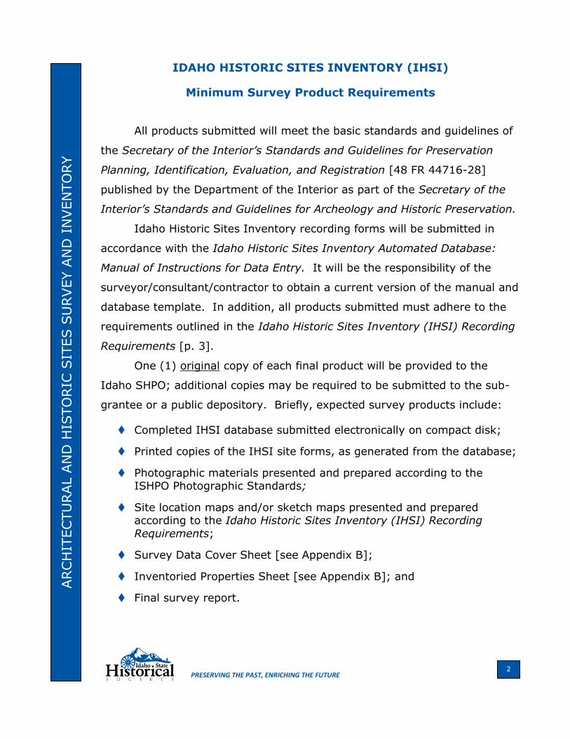
Minimum Survey Product Requirements
All products submitted will meet the basic standards and guidelines of
the Secretary of the Interior’s Standards and Guidelines for Preservation
Planning, Identification, Evaluation, and Registration [48 FR 44716-28]
published by the Department of the Interior as part of the Secretary of the
Interior’s Standards and Guidelines for Archeology and Historic Preservation.
Idaho Historic Sites Inventory recording forms will be submitted in
accordance with the Idaho Historic Sites Inventory Automated Database:
Manual of Instructions for Data Entry. It will be the responsibility of the
surveyor/consultant/contractor to obtain a current version of the manual and
database template. In addition, all products submitted must adhere to the
requirements outlined in the Idaho Historic Sites Inventory (IHSI) Recording
Requirements [p. 3].
One (1) original copy of each final product will be provided to the
Idaho SHPO; additional copies may be required to be submitted to the sub-
grantee or a public depository. Briefly, expected survey products include:
Completed IHSI database submitted electronically on compact disk;
Printed copies of the IHSI site forms, as generated from the database;
Photographic materials presented and prepared according to the ISHPO Photographic Standards;
Site location maps and/or sketch maps presented and prepared according to the Idaho Historic Sites Inventory (IHSI) Recording
Requirements;
Survey Data Cover Sheet [see Appendix B];
Inventoried Properties Sheet [see Appendix B]; and
Final survey report.
ARCH
ITECTU
RAL A
ND
HIS
TO
RIC
SIT
ES S
URVEY A
ND
IN
VEN
TO
RY
PRESERVING THE PAST, ENRICHING THE FUTURE 2 2
IDAHO HISTORIC SITES INVENTORY (IHSI)
Recording Requirements
With regard to completing the IHSI site form, all IHSI Main Form data
fields that are identified with a red check mark () in “Section Seven – Data Entry Instructions” of the Idaho Historic Sites Inventory Automated
Database manual1 [see Appendix D] are required fields and must be completed for reconnaissance-level survey. These fields supply the
minimum level of information necessary to re-locate a property and to evaluate its potential for National Register of Historic Places (NRHP)
eligibility.
While the reconnaissance level of documentation is designed to provide the minimum amount of information to record a potentially eligible
property, an intensive-level survey is meant to be more comprehensive. When recording properties at an intensive level, complete ALL DATA
FIELDS contained in the IHSI database excepting those designated as “FOR ISHPO USE ONLY.” Recording properties on an intensive level
requires an expanded architectural description and historical narrative than that provided for reconnaissance-level documentation; use the IHSI
Supplemental Form and the IHSI Attachment Form in addition to the IHSI Main Form. Keep in mind that one of the goals of intensive-level
documentation is to provide sufficient information to make a well-informed determination regarding the property’s NRHP eligibility. In
addition, the information collected should be in a format readily transferrable to a National Register nomination form, and so should meet
NRHP documentation requirements.
When recording a complex of buildings and/or structures, the IHSI site
form must include references to and brief descriptions of all existing buildings, structures, and features on the property. (This data must be added in the “COMMENTS” data field. See the Manual of Instructions for
Data Entry, p. 10 of 18.)
Every property documented on an IHSI site form must be illustrated with
at least one clear photograph. For sites containing two or more resources, photographs of associated structures/features are required.2
Traditional photographs must be labeled only in pencil and only on the backs of the prints. (Consult the ISHPO Photographic Standards for
appropriate labeling methods.) Extremely soft pencils such as the Schwan All-Stabilo #8046, available at art or drafting supply stores, are
most effective for labeling the backs of photographs. Digital photographs
3
ARCH
ITECTU
RAL A
ND
HIS
TO
RIC
SIT
ES S
URVEY A
ND
IN
VEN
TO
RY
PRESERVING THE PAST, ENRICHING THE FUTURE

must be labeled “digitally” on the front of and below the photograph. No photograph should ever be labeled with adhesive labels or other applied
materials. Never affix photographs to paper, cardboard, etc.3
All photographs – both traditional and digital – must be contained and
submitted in clear archival photographic sleeves meeting the requirements outlined in the ISHPO Photographic Standards.4
Each site record (including photo sleeves) must be stapled together as one unit.
Rural properties located outside of city limits must be pinpointed on United States Geological Survey (USGS) topographic maps (1:24,000);
urban properties must be pinpointed on Sanborn Fire Insurance Company maps, subdivision/addition plats, or other appropriately detailed maps.
At a minimum, a photocopy of the topographic map – or portion of map – exhibiting the property location must be submitted with each site form.
Additional maps may be required for urban properties. PLEASE NOTE, telephone book maps and maps generated from online map sources, such
as MapQuest, Yahoo!, Rand McNally, Expedia, etc., typically lack sufficient detail for mapping and do not allow for accurate UTM calculations or precise legal descriptions. Therefore, these forms of maps will not be
accepted. [see Appendix C for acceptable online map sources]
Sketch maps or detailed maps must be submitted for districts or for
properties containing more than two (2) resources/features. Plat books, insurance maps, bird’s-eye views, district highway maps, and hand-drawn
maps may be utilized. Sketch maps must include a north arrow (true or magnetic), but do not need to be to scale.
All IHSI site forms submitted must include Universal Transverse Mercator (UTM) coordinates based on the North American Datum (NAD) of 1983
(noted as NAD83). Site records that use NAD27 will not be accepted. Forms should specifically note the UTM as NAD83 in the “ADD’L NOTES”
data field. Contact the Historic Sites Registrar for assistance with UTM coordinate determinations. [see Appendix C for a list of online map
resources offering mapping services]
1 Idaho Historic Sites Inventory Automated Database, Section Seven–Data Entry Instructions, pp.
1-14 of 18. 2
Idaho State Historic Preservation Office Photographic Standards for Archaeological and Historic
Sites Inventory Forms and National Register Nominations (2007), p. 1. 3 Photographic Standards, p. 2. 4
Photographic Standards, p. 3.
4
ARCH
ITECTU
RAL A
ND
HIS
TO
RIC
SIT
ES S
URVEY A
ND
IN
VEN
TO
RY
PRESERVING THE PAST, ENRICHING THE FUTURE

Linear sites (½ mile or more in length) such as main (named) agricultural canals and primary laterals, named/numbered roads and highways, and
railroads and railroad grades must be recorded on IHSI forms. Further details about recording linear resources are outlined in Linear Historic
Resources Guidelines for Documentation [p. 5].
ARCH
ITECTU
RAL A
ND
HIS
TO
RIC
SIT
ES S
URVEY A
ND
IN
VEN
TO
RY
PRESERVING THE PAST, ENRICHING THE FUTURE 5 5

IDAHO HISTORIC SITES INVENTORY (IHSI)
Linear Historic Resources Guidelines for Documentation
As part of the development of the Geographic Information System
(GIS) at ISHPO, engineering and historic linear properties have been divided
into four (4) types or categories: roads, railroads, irrigation resources, and
others. (Note that trails, wagon roads, mining features, livestock trails and
timber harvesting features are not to be included in the definition of those
properties that are recorded on the IHSI form; rather, these resources must
be recorded on and comply with the format of the Archaeological Survey of
Idaho (ASI) site forms.) To further clarify, examples of the four categories
of linear resources that are to be recorded on the IHSI form are:
Roads: Roads are those that appear on any modern map from city
streets to interstate highways. It also includes roads, numbered or not, identified on U.S. Forest Service maps.
Railroads: Railroads include all common-carrier railroads and railroad grades or those that generally transport passengers or goods/cargo.
Irrigation Resources: Irrigation resources are those that are associated
with the development of water conveyance for agricultural purposes. These consist of major named canals, laterals and ditches.
Others: Other linear resources can include such aboveground
structures as transmission lines, levees/embankments, and aerial tramways (excluding mining features), to name a few.
If questions remain as to whether a property should be classified as a
linear resource for IHSI recording purposes, contact the Historic Sites
Registrar.
The Idaho SHPO assigns a separate IHSI accession number for each
county a linear resource crosses. Although surveyors/consultants/
contractors are strongly advised to record a linear property from county
ARCH
ITECTU
RAL A
ND
HIS
TO
RIC
SIT
ES S
URVEY A
ND
IN
VEN
TO
RY
PRESERVING THE PAST, ENRICHING THE FUTURE 6

boundary to county boundary, comprehensive field examination for the full
extent of the resource is not an ISHPO requirement. Therefore, portions of
the route of the resource may be based on historic documents, general
knowledge, system maps, or even assumption. At the very least, a complete
legal description of all crossed sections and maps showing the full extent of
the property within the county is expected. A map scale of less than
1:24,000 may be used, but it must be reasonably translatable to the
standard 1:24,000 USGS quadrangle map.
Generally, the following requirements for documenting agricultural
irrigation resources can be applied to any of the linear resources categories
previously identified.
ARCH
ITECTU
RAL A
ND
HIS
TO
RIC
SIT
ES S
URVEY A
ND
IN
VEN
TO
RY
PRESERVING THE PAST, ENRICHING THE FUTURE 7

IDAHO HISTORIC SITES INVENTORY (IHSI)
Agricultural Irrigation Resources
Requirements for Documentation
The following requirements are intended to collect sufficient
documentation of agricultural irrigation resources in order to appropriately
evaluate their historic significance. They also are intended to supplement
the instructions set forth in the Idaho Historic Sites Inventory Automated
Database: Manual of Instructions for Data Entry.
Documentation of agricultural irrigation resources must include:
A general, physical description of the canal/lateral/ditch itself; include the approximate length of the resource in its entirety.
A brief history of the resource. When possible, include such information as significant dates, significant persons, associated major
laterals, etc.
A USGS map or maps outlining the entire route of the canal/lateral –
from point of diversion to its terminus. Include a list of USGS map names utilized for mapping.
References to all townships, ranges and section numbers (omitting quarter sections) through which the resource passes within the county
of project activity whether field checked or not.
Photographs depicting overviews of the canal/lateral/ditch from various locations within the project area.
Individual site forms for each of the major features along the resource within the project area, such as bridge crossings, diversion structures,
head gates, drop structures, weirs, etc.
At least one (1) photograph of each feature recorded within the project
area.
A USGS map or maps indicating the location of each major feature
recorded within the project area.
UTM coordinates (NAD 83) for each major feature recorded within the
project area. (Note that UTM coordinates are not required at various locations along the route of the resource itself.)
ARCH
ITECTU
RAL A
ND
HIS
TO
RIC
SIT
ES S
URVEY A
ND
IN
VEN
TO
RY
PRESERVING THE PAST, ENRICHING THE FUTURE 8
APPENDIX A
Idaho State Historic Preservation Office
Photographic Standards for Archaeological and Historic Sites Inventory Forms and National Register Nominations
2007
Archaeological and Historic Sites Inventory Forms
All photographs submitted to the Idaho State Historic Preservation
Office as documentation for archaeological and historic properties must be sufficient to allow for concurrence with determinations of eligibility and
project effect. If the following requirements are not met, the submitter will be notified, and any associated Section 106 Review will be delayed until
photographs meeting the requirements are submitted. Additional requirements may be necessary in cases of Section 106 mitigation.
At least two (2) clear photographs per property must be submitted for all recordings (see exception under IHSI forms
below). Different requirements apply whether the photographs are part of the recordation contributing to the Idaho Historic Sites
Inventory (IHSI) or Archaeological Survey of Idaho (ASI).
IHSI forms: While Section 106 and other surveys require at least
two (2) photographs per property, non-archaeological Certified Local Government (CLG)-generated surveys can be limited to one (1)
photograph per property. All surveys should consider that for properties containing two or more resources, photographs of associated structures/features are required. When photographing
historic buildings, photograph the primary (front) exterior wall of each property recorded; oblique images, where possible, are recommended.
Depending upon the complexity of a property, it may be appropriate to take several photographs from various angles as well as of major
additions and/or alterations.
Acceptable forms of photographic documentation for IHSI forms
include:
o Black and white archival-quality prints for 35mm
photographs. o Black and white or color archival-quality digital photographic
prints. o Photographs in JPEG or TIFF format on CD in addition to
hard-copy prints.
ARCH
ITECTU
RAL A
ND
HIS
TO
RIC
SIT
ES S
URVEY A
ND
IN
VEN
TO
RY
PRESERVING THE PAST, ENRICHING THE FUTURE 9
o Negatives accompanied by a photographic log in addition to hard-copy prints.
ASI forms: One of the two photographs should be an overview that includes geographic features that would help relocate the site.
Additional photographs of significant features or artifacts may be submitted. Acceptable forms of photographic documentation for ASI
forms include:
o Black and white archival-quality prints for 35mm
photographs. o Black and white or color archival-quality digital photographic
prints.
Photographs must be at least 3 ½ x 5 inches, but 4 x 6 inches and
larger is preferred.
Only archival-quality photographic prints meeting a 75-year-
permanence standard will be accepted. The following requirements must be met depending upon the technology
applied.
Traditional 35mm Black and White Prints:
o 35mm prints must be produced using black and white film
developed with black and white processing chemicals and printed on black and white photographic paper.
o Resin-coated photographic paper is acceptable, but fiber-based photographic paper is preferred.
o Photographs processed with chromogenic processing (C-41), or printed on chromogenic papers, are not acceptable.
Digital Photographic Prints:
o Inks and paper used for digital prints must be archivally
stable. The type of inks and paper used must be declared within the inventory form. Types used may also be stated
additionally in the survey report. A non-comprehensive list of acceptable ink and paper combinations for digital images that
meet a 75-year-permanence standard is maintained by the National Park Service at: http://www.nps.gov/history/nr/publications/guidance/Photo_
Policy_final.pdf o Camera and printer resolution settings should be sufficient to
produce prints with sharp detail. Appropriate resolution and contrast are of utmost importance.
ARCH
ITECTU
RAL A
ND
HIS
TO
RIC
SIT
ES S
URVEY A
ND
IN
VEN
TO
RY
PRESERVING THE PAST, ENRICHING THE FUTURE 10

Each photograph must be labeled with the required information
using the methods described below:
Labeling Information:
o Smithsonian or IHSI number (property field or temporary number, if a new recording);
o subject of the photograph; o the direction the camera is facing;
o date (month/year); o name of the project.
Labeling Methods:
Traditional 35mm black and white photographs must be labeled
on the back of the print (never on the front) with a water-soluble pencil intended for writing on transparent or glazed
surfaces. We feel the only acceptable labeling instrument is the #8046 pencil produced by Schwan All-Stabilo which can be
purchased at art supply stores or on-line. Do not use any type of pen for labeling, including those identified as “archival.” Never use adhesive labels or other applied materials. Never
affix photographs to paper, cardboard, or other material. Digital photos must be labeled as just described or digitally on the front
and below the photograph.
All photographs – both traditional 35mm and digital – must be
contained and submitted in clear archival photographic sleeves meeting the following requirements:
Sleeves must be at least 8½ x 11 inches over all and must not
exceed 9½ x 11½ inches. Pockets in the sleeves must match the photograph dimensions. For 35mm black and white
photographs, do not sleeve back to back. Digital prints may be sleeved back to back provided all labeling is digitally printed on
the front and below the photograph. Sleeve digital photographs in full-sheet sleeves rather than cutting them to fit pocketed sleeves. Use no adhesives on sleeves and do not label sleeves.
Photographic sleeves for each property must be clipped or carefully stapled (taking care not to staple the print) to the
appropriate inventory form. Photographs from different properties cannot be contained in the same sleeve.
For additional information regarding archival-quality photography, please visit the following websites:
ARCH
ITECTU
RAL A
ND
HIS
TO
RIC
SIT
ES S
URVEY A
ND
IN
VEN
TO
RY
PRESERVING THE PAST, ENRICHING THE FUTURE 11

www.cr.nps.gov/nr/publications/bulletins/photobul/ www.shutterbug.net/features/1103sb_thearchival/
National Register Nominations
National Register of Historic Places nominations require the submission of black and white prints with each document. Two separate sets of prints
must be submitted: one for the National Park Service (NPS) and one for the SHPO. NPS prints should be at least 5 x 7 inches or 8 x 10 inches in size.
SHPO will accept prints as small as 3½ x 5 inches, but strongly prefers at least 4 x 6 inch sized prints. Photos should be submitted, unmounted, in an
envelope or other protective sleeve.
Each photo must be labeled directly on the back of the photo (do not
use adhesive labels) using a #8046 Schwan All-Stabilo pencil (or equivalent) with the following information:
1. Name of property (if a district, the name of the district, plus the address and inventory # of the property in the photo)
2. County and state 3. Name of photographer
4. Date of photograph 5. Location of negatives or CD-ROM
6. Description of view, indicating direction that the camera is facing (e.g. Front façade, looking NE)
7. Number of photograph, including total # of photographs (e.g. Photo #
4 of 8)
An alternative labeling method allows for the above information to be
included on a Continuation Sheet, with only items #1, #2, & #7 written on the back of the photos. Information common to all photographs, #1 - #5,
may be listed once in a statement at the top of the continuation sheet. See pages 63-64 of the National Register Bulletin How to Complete the National
Register Registration Form for more information.
Traditional 35mm Black and White Prints:
o 35mm prints must be produced using black and white film developed with black and white processing chemicals and printed
on black and white photographic paper. o Resin-coated photographic paper is acceptable, but fiber-based
photographic paper is preferred. o Photographs processed with chromogenic processing (C-41), or
printed on chromogenic papers, are not acceptable.
ARCH
ITECTU
RAL A
ND
HIS
TO
RIC
SIT
ES S
URVEY A
ND
IN
VEN
TO
RY
PRESERVING THE PAST, ENRICHING THE FUTURE 12

Digital Photographic Prints:
The National Park Service now allows the submission of digitally based
photographs with National Register of Historic Places nominations provided they meet archival requirements. In addition to the paper
and ink requirements (which can be found on their website at: http://www.nps.gov/history/nr/publications/guidance/Photo_Policy_fin
al.pdf) the NPS and the Idaho SHPO have defined specifications for digital-format photos. The SHPO has found that its needs differ
somewhat from the NPS requirements. Please submit NPS and SHPO copies of digital photos for nominations in the following manner:
For NPS photos:
o Photos should be saved in a .TIF format.
o The size of each image must be 1600 x 1200 pixels at 300 ppi (pixels per inch) or larger.
o Digital images should be saved in 8-bit (or larger) color format, which provides maximum detail even when printed in black and
white. o Each photograph on the CD-ROM should be individually saved and
named. For example, for the Jones House in Ada County, individual
photos should be named:
ID_AdaCounty_Jones1.tif
ID_AdaCounty_Jones2.tif, etc.
o The CD on which photos are saved should be labeled in the
following manner: Full Name of Property; Name of MPD (if applicable); County and State.
o While the photos on the CD are color, the prints submitted with the nomination should be black and white, and labeled in the
traditional manner (see above). o Submit the CD in a jewel case.
o Include only those photos on the CD-ROM that are printed and submitted with the NRHP packet.
For SHPO Photos:
o Put photos and supplemental information (scans of historic photos, maps, newspaper articles) on a separate CD from the NRHP
nomination document. This means that in all, 3 CDs would be submitted: one for the NPS with photos only; one for the SHPO
with photos and supplemental information; and one with the NRHP nomination form.
ARCH
ITECTU
RAL A
ND
HIS
TO
RIC
SIT
ES S
URVEY A
ND
IN
VEN
TO
RY
PRESERVING THE PAST, ENRICHING THE FUTURE 12 13

o Photos should be saved in a .JPG format (note the difference from NPS requirements).
o The size of each image must be 1600 x 1200 pixels at 300 ppi (pixels per inch) or larger.
o You may (and are encouraged to) include more digital photos than the printed copies.
o The digital photos that are printed for the nomination should be saved in a separate folder from any supplemental photos. The
folders should be named as follows:
Jones House, Ada County, NRHP Photos (these photos
should be individually named in the same manner as those for the NPS).
Jones House, Ada County, Supplemental Photos (these photos do not need to be individually named).
o The CD should be labeled in the same manner as the NPS copy and submitted in a jewel case.
ARCH
ITECTU
RAL A
ND
HIS
TO
RIC
SIT
ES S
URVEY A
ND
IN
VEN
TO
RY
PRESERVING THE PAST, ENRICHING THE FUTURE 14

APPENDIX B
IDAHO HISTORIC SITES INVENTORY (IHSI)
Sample Sheets
ARCH
ITECTU
RAL A
ND
HIS
TO
RIC
SIT
ES S
URVEY A
ND
IN
VEN
TO
RY
PRESERVING THE PAST, ENRICHING THE FUTURE 15
SURVEY DATA COVER SHEET
Survey Title: ________________________________________________
Prepared By: ________________________________________________
Prepared For: _______________________________________________
Date: ______________________________________________________
Total number of properties surveyed:
______ RECONNAISSANCE ______ INTENSIVE
Number of acres surveyed:
______ RECONNAISSANCE ______ INTENSIVE
INVENTORIED PROPERTIES SHEET
Field # Name Location NR Recommendation
13-367 Bennett Block 927 1st Ave. Eligible
13-368 Smith’s Grocery 1001 1st Ave. Not eligible

APPENDIX C
IDAHO HISTORIC SITES INVENTORY (IHSI)
Online Mapping Resources
Online Maps:
ESRI ArcGIS Explorer (free) –
http://www.esri.com/software/arcexplorer/index.html
National Geographic MapMachines (free) –
http://maps.nationalgeographic.com/map-machine#s=r&c=43.74999999999998,%20-99.71000000000001&z=4
Bing Maps (free) – http://maps.live.com/
Online Maps with Lat/Long Coordinates:
MicroSoft Research Maps (free) – http://msrmaps.com
The USGS Store (free) – http://www.store.usgs.gov/ (click on “Map
Locator”)
TerraServer (fee/subscription) – http://www.terraserver.com/
USGS EarthExplorer (free) –
http://edcsns17.cr.usgs.gov/NewEarthExplorer/
Online Maps with UTM Coordinates:
Google Earth (free) – http://earth.google.com/
Topoquest (free) – http://www.topoquest.com/
MyTopo (free) – http://maptech.mytopo.com/onlinemaps/index.cfm
Trails.Com (fee/subscription) – http://www.trails.com
Online Coordinate Conversion Tools:
NADCON (free) – http://www.ngs.noaa.gov/cgi-bin/nadcon.prl
ARCH
ITECTU
RAL A
ND
HIS
TO
RIC
SIT
ES S
URVEY A
ND
IN
VEN
TO
RY
PRESERVING THE PAST, ENRICHING THE FUTURE 16
APPENDIX D
IDAHO HISTORIC SITES INVENTORY (IHSI)
Automated Database: Manual of Instructions for Data Entry (Abridged)
The Idaho Historic Sites Inventory Automated Database: Manual of
Instructions for Data Entry is written for data collectors and users as
guidelines for how each data field is defined and what data-entry
conventions must be used. This is important in order to provide a clear
meaning of the data entered and to ensure the consistency of data for
manipulation and retrieval.
The IHSI database should be considered a supplement to the paper
record; it is not intended to be a replacement of the paper files. Therefore,
data collectors are encouraged to include additional pertinent documentation
beyond that required in the automated database. It is critical that complete
documentation for each recorded property be submitted as all data and
materials are the foundation for future research activities and decision-
making processes.
Finally, technical support for use of the database template and for
problem-solving issues is available from the Idaho State Historic
Preservation Office, Historic Sites Registrar, by phone at 208-334-3861
Extension 103 or by email at [email protected].
ARCH
ITECTU
RAL A
ND
HIS
TO
RIC
SIT
ES S
URVEY A
ND
IN
VEN
TO
RY
PRESERVING THE PAST, ENRICHING THE FUTURE 17

ARCH
ITECTU
RAL A
ND
HIS
TO
RIC
SIT
ES S
URVEY A
ND
IN
VEN
TO
RY
PRESERVING THE PAST, ENRICHING THE FUTURE