Archaeological Investigations of
163
Transcript of Archaeological Investigations of

Funded by the Mississippi Department of Archives and History with a grant from the US Department of Housing and Urban Development
and Mississippi Development Authority
Archaeological Report 37Mississippi Department of Archives and History
Jackson, Mississippi
2015
Archaeological Investigations of Coastal Shell Middens in the
Grand Bay Estuary, Mississippi
Edited by H. Edwin Jackson
with contributions by Samuel Butz, Barbara Thedy Hester, Samuel Huey,
H. Edwin Jackson, and Susan L. Scott

Archaeological Report No. 37
Mississippi Department of Archives and History
Katie BlountDirector
Pamela Edwards LiebSeries Editor
Chris GoodwinManaging Editor
Gregory A. Waselkov and Bonnie L. Gums
Technical Editors
Sarah B. MatticsDesign and Layout
Cover Illustration: North wall profile, N505E506, Grand Bay Estuary.
ISBN-13: 978-0-938896-03-6
Copyright © 2015 Mississippi Department of Archives and History
P.O. Box 571, Jackson, MS [email protected]

Table of ContentsList of Figures ...................................................................................................................................................................................... iiiList of Tables ........................................................................................................................................................................................viiAcknowledgments ............................................................................................................................................................................... 1Chapter 1. The Grand Bay Estuary Project, by H. Edwin Jackson ................................................................................................... 3 The Grand Bay Setting .............................................................................................................................................................. 3 Previous Archaeological Investigations .................................................................................................................................. 5 The Mississippi Gulf Coast ................................................................................................................................................. 5 Alabama ................................................................................................................................................................................ 8 Previous Archaeological Investigations in the Grand Bay Area .......................................................................................... 9 The Grand Bay Site Universe ................................................................................................................................................... 9Chapter 2. The Archaeological Framework of Grand Bay Prehistory, by H. Edwin Jackson ........................................................ 11 Cultural Chronology ................................................................................................................................................................. 11 Claiborne Phase (1200-800 BC) ........................................................................................................................................ 11 Apple Street Phase (800-100 BC) ...................................................................................................................................... 11 Greenwood Island Phase (100 BC-AD 200) ..................................................................................................................... 12 Godsey Phase (AD 200-400) .............................................................................................................................................. 13 Graveline Phase (AD 400-700) .......................................................................................................................................... 13 Tates Hammock Phase (AD 700-1200) ............................................................................................................................. 13 Pinola Phase (AD 1200-1350) ............................................................................................................................................ 14 Singing River Phase (AD 1350-1550) ................................................................................................................................ 15 Bear Point Phase (AD 1550-1700) ..................................................................................................................................... 15 La Pointe Phase (AD 1700-1775) ....................................................................................................................................... 15 The European Colonial Period ........................................................................................................................................... 16 Research Issues ........................................................................................................................................................................... 16 Culture History .................................................................................................................................................................... 16 Environmental Change ....................................................................................................................................................... 16 Adaptation and the Grand Bay Estuary ............................................................................................................................ 18 Summary ..................................................................................................................................................................................... 18Chapter 3. Field Investigations, by H. Edwin Jackson ...................................................................................................................... 19 Spring Reconnaissance ............................................................................................................................................................. 19 Summer Investigations ............................................................................................................................................................. 20 22JA564 ....................................................................................................................................................................................... 20 Previous Investigations ........................................................................................................................................................ 20 Present Investigations .......................................................................................................................................................... 23 22JA575 ....................................................................................................................................................................................... 26 Previous Investigations ........................................................................................................................................................ 26 Present Investigations .......................................................................................................................................................... 27 22JA633 ....................................................................................................................................................................................... 29 Previous Investigations ........................................................................................................................................................ 30 Present Investigations .......................................................................................................................................................... 31 Radiocarbon Dates .................................................................................................................................................................... 35Chapter 4. Native American Artifacts, by Samuel Huey and H. Edwin Jackson ............................................................................ 39 Ceramic Artifacts ....................................................................................................................................................................... 39 Classification of Grand Bay Ceramics ................................................................................................................................ 39 Temper and Ware .................................................................................................................................................................. 40 Undecorated Ceramics ......................................................................................................................................................... 41 Decorated Ceramic Type-Varieties ..................................................................................................................................... 41 Unclassified Decorated Sherds ............................................................................................................................................. 58 Site Ceramic Assemblages .................................................................................................................................................... 60 Ceramics Discussion ............................................................................................................................................................. 66 Lithic Artifacts ............................................................................................................................................................................ 66 Worked Stone, 22JA564 ........................................................................................................................................................ 66 Worked Stone, 22JA633 ........................................................................................................................................................ 66 Worked Stone, 22JA575 ........................................................................................................................................................ 67 Surface Collections from Other Sites ....................................................................................................................................... 69Chapter 5. Historic Artifacts, by Barbara Thedy Hester .................................................................................................................. 71 22JA564 ....................................................................................................................................................................................... 72

ii Shell Middens in the Grand Bay Estuary
22JA575 ...................................................................................................................................................................................... 72 22JA563 ...................................................................................................................................................................................... 75 Conclusions ............................................................................................................................................................................... 75Chapter 6. Invertebrate Fauna, by H. Edwin Jackson ..................................................................................................................... 77 Taxa Other Than Oyster ........................................................................................................................................................... 77 Oysters ....................................................................................................................................................................................... 78 Fragmentation ........................................................................................................................................................................... 79 Trends in Oyster Size ............................................................................................................................................................... 83 Intersite Comparison ............................................................................................................................................................... 86Chapter 7. Vertebrate Faunal Remains, by Susan L. Scott .............................................................................................................. 89 Methods ..................................................................................................................................................................................... 89 Results ........................................................................................................................................................................................ 90 22JA564 Lower Levels (6, 7, and 8): Middle Woodland (AD 100-400) ....................................................................... 90 22JA564 Upper Levels (1-5): Late Woodland (AD 400-900) ......................................................................................... 93 22JA633: Late Woodland/Terminal Late Woodland/Mississippian (AD 700-1500) .................................................. 93 22JA633: Late Woodland (AD 700-1200) ........................................................................................................................ 94 22JA633: Mississippian (AD 1200-1500) ......................................................................................................................... 95 22JA575: Late Woodland/Terminal Mississippian (AD 1000-1500) ............................................................................ 97 Discussion .................................................................................................................................................................................. 97Chapter 8. Analysis of Fish Otoliths, by Samuel H. Butz and H. Edwin Jackson .......................................................................... 99 Otolith Structure and Function .............................................................................................................................................. 99 Otoliths in Zooarchaeology ..................................................................................................................................................... 99 Faunal Assemblages from 22JA564, 22JA575 and 22JA633 ................................................................................................ 100 Biological Information of Species Present ...................................................................................................................... 100 Methods ............................................................................................................................................................................... 101 Results .................................................................................................................................................................................. 101 Species Distribution ........................................................................................................................................................... 102 Total Species Percentages .................................................................................................................................................. 103 Conclusions ................................................................................................................................................................................ 105 Chapter 9. Culture and Adaptation on Grand Bay, by H Edwin Jackson ....................................................................................... 111 Results of the 2010 Investigations ........................................................................................................................................... 111 Research Questions .................................................................................................................................................................. 111 Chronology of Site Use ....................................................................................................................................................... 111 Stylistic Boundaries ............................................................................................................................................................ 112 Site Function, Subsistence Patterns, and Changes through Time ................................................................................ 113 Conclusions ................................................................................................................................................................................. 115Appendix A. Artifact Inventory, 22JA564 ....................................................................................................................................... 117Appendix B. Artifact Inventory, 22JA575 ........................................................................................................................................ 121Appendix C. Artifact Inventory, 22JA633 ........................................................................................................................................ 125Appendix D. Ceramic Inventory, 22JA564 ....................................................................................................................................... 129Appendix E. Ceramic Inventory, 22JA575 ....................................................................................................................................... 141Appendix F. Ceramic Inventory, 22JA633 ....................................................................................................................................... 147 References .......................................................................................................................................................................................... 149

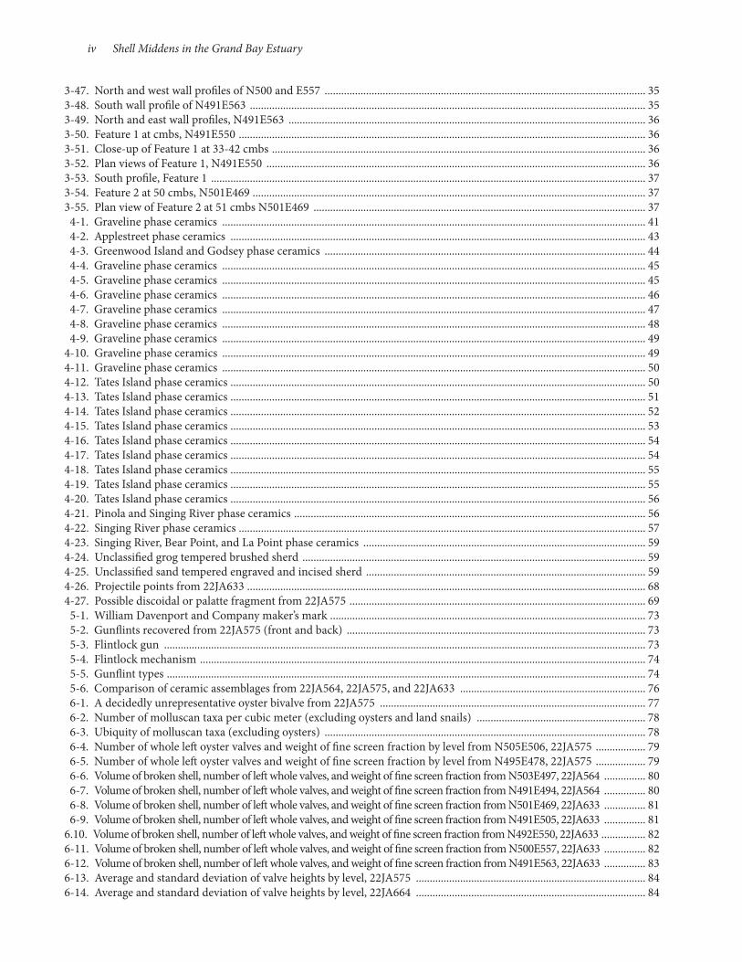
1-1. Satelite imagery of the Grand Bay estuary .............................................................................................................................. 3 1-2. Grand Bay estuary ...................................................................................................................................................................... 6 1-3. Storm-ravaged shell midden near the Mississippi Sound ..................................................................................................... 6 1-4. Sites in Mississippi mentioned in the text ............................................................................................................................... 7 1-5. Recorded sites in the Grand Bay estuary ................................................................................................................................. 5 2-1. Late Holocene sea level fluctuations ......................................................................................................................................17 3-1. March 2010 reconnaissance at 22JA576 on North Rigolets Island ....................................................................................19 3-2. March 2010 reconnaissance at 22JA711 on Bayou Heron ...................................................................................................20 3-3. Reworked contracting stem projectile/knife on surface at 22JA632 ..................................................................................20 3-4. Grog-tempered rim sherds on bank at 22JA711 ...................................................................................................................20 3-5. Topographic map fo 22JA632, Bangs Island .........................................................................................................................21 3-6. The Ford site, 22JA564 .............................................................................................................................................................22 3-7. Contour map with locations of STPs and excavation units ................................................................................................22 3-8. Ford site excavation ..................................................................................................................................................................22 3-9. Shovel testing, Ford site, 22JA564 ...........................................................................................................................................223-10. West wall profile of N491E494 ................................................................................................................................................223-11. East and north profiles, N491E494 ........................................................................................................................................233-12. South wall profile, N503E497 .................................................................................................................................................243-13. South and west wall profiles, N503E497 ................................................................................................................................243-14. South wall, N519E494 ..............................................................................................................................................................243-15. West and north profiles, N519E494 .......................................................................................................................................253-16. East wall profile, Unit 1 ............................................................................................................................................................253-17. North and east wall profiles, Unit 1 ........................................................................................................................................253-18. Feature 1 at 20 cmbs, exposed in northwest corner of N491E494 .....................................................................................263-19. Plan view drawing of Feature 1, N491E494 and N492E494 ...............................................................................................263-20. Feature 2, N503E497 ................................................................................................................................................................263-21. 22JA575, Crooked Bayou I site ...............................................................................................................................................273-22. Large mainly whole shell on surface near water’s edge ........................................................................................................273-23. Fragmentary shell upslope from area in Figure 3-22 ...........................................................................................................273-24. Topographic map of 22JA575, Crooked Bayou I ..................................................................................................................283-25. Shovel testing, Crooked Bayou I site ......................................................................................................................................283-26. “Water screening” 0.23-cm (⅛-inch) fraction, 22JA575 .....................................................................................................283-27. North wall, N505E506 .............................................................................................................................................................283-28. North and east profiles, N505E506 ........................................................................................................................................293-29. East wall profile, N495E478 ....................................................................................................................................................293-30. Close-up of crushed shell “hash” redeposited on intact shell stratum, N495E478 ..........................................................303-31. Profiles on N495E478 ...............................................................................................................................................................303-32. Augering through sub-water table shell ................................................................................................................................313-33. 22JA633, Kenny’s Island ...........................................................................................................................................................313-34. Shovel testing on 22JA633 .......................................................................................................................................................313-35. Topographic map fo 22JA633 .................................................................................................................................................323-36. Location of excavation units, 22JA633 ..................................................................................................................................323-37. North wall profile, N501E469 .................................................................................................................................................333-38. South and west wall profiles, N501E469 ................................................................................................................................333-39. South wall profile, N501E469 .................................................................................................................................................333-40. South and west wall profiles, N499E480 ................................................................................................................................333-41. East wall profile of N491E550 .................................................................................................................................................343-42. South wall profile, N491E550, with Feature 1 exposed in profile ......................................................................................343-43. East wall profile, N491E550 and N492E550 .........................................................................................................................343-44. North wall profile, N492E550 .................................................................................................................................................343-45. South wall profile, N491E550 ..................................................................................................................................................343-46. East wall profile, N500E557 .....................................................................................................................................................35
List Of Figures
iv Shell Middens in the Grand Bay Estuary
3-47. North and west wall profiles of N500 and E557 .................................................................................................................... 353-48. South wall profile of N491E563 ............................................................................................................................................... 353-49. North and east wall profiles, N491E563 ................................................................................................................................. 363-50. Feature 1 at cmbs, N491E550 ................................................................................................................................................... 363-51. Close-up of Feature 1 at 33-42 cmbs ....................................................................................................................................... 363-52. Plan views of Feature 1, N491E550 ......................................................................................................................................... 363-53. South profile, Feature 1 ............................................................................................................................................................. 373-54. Feature 2 at 50 cmbs, N501E469 .............................................................................................................................................. 373-55. Plan view of Feature 2 at 51 cmbs N501E469 ........................................................................................................................ 37 4-1. Graveline phase ceramics ......................................................................................................................................................... 41 4-2. Applestreet phase ceramics ...................................................................................................................................................... 43 4-3. Greenwood Island and Godsey phase ceramics .................................................................................................................... 44 4-4. Graveline phase ceramics ......................................................................................................................................................... 45 4-5. Graveline phase ceramics ......................................................................................................................................................... 45 4-6. Graveline phase ceramics ......................................................................................................................................................... 46 4-7. Graveline phase ceramics ......................................................................................................................................................... 47 4-8. Graveline phase ceramics ......................................................................................................................................................... 48 4-9. Graveline phase ceramics ......................................................................................................................................................... 494-10. Graveline phase ceramics ......................................................................................................................................................... 494-11. Graveline phase ceramics ......................................................................................................................................................... 504-12. Tates Island phase ceramics ...................................................................................................................................................... 504-13. Tates Island phase ceramics ...................................................................................................................................................... 514-14. Tates Island phase ceramics ...................................................................................................................................................... 524-15. Tates Island phase ceramics ...................................................................................................................................................... 534-16. Tates Island phase ceramics ...................................................................................................................................................... 544-17. Tates Island phase ceramics ...................................................................................................................................................... 544-18. Tates Island phase ceramics ...................................................................................................................................................... 554-19. Tates Island phase ceramics ...................................................................................................................................................... 554-20. Tates Island phase ceramics ...................................................................................................................................................... 564-21. Pinola and Singing River phase ceramics ............................................................................................................................... 564-22. Singing River phase ceramics ................................................................................................................................................... 574-23. Singing River, Bear Point, and La Point phase ceramics ...................................................................................................... 594-24. Unclassified grog tempered brushed sherd ............................................................................................................................ 594-25. Unclassified sand tempered engraved and incised sherd ..................................................................................................... 594-26. Projectile points from 22JA633 ................................................................................................................................................ 684-27. Possible discoidal or palatte fragment from 22JA575 ........................................................................................................... 69 5-1. William Davenport and Company maker’s mark .................................................................................................................. 73 5-2. Gunflints recovered from 22JA575 (front and back) ............................................................................................................ 73 5-3. Flintlock gun .............................................................................................................................................................................. 73 5-4. Flintlock mechanism ................................................................................................................................................................. 74 5-5. Gunflint types ............................................................................................................................................................................. 74 5-6. Comparison of ceramic assemblages from 22JA564, 22JA575, and 22JA633 ................................................................... 76 6-1. A decidedly unrepresentative oyster bivalve from 22JA575 ................................................................................................ 77 6-2. Number of molluscan taxa per cubic meter (excluding oysters and land snails) ............................................................. 78 6-3. Ubiquity of molluscan taxa (excluding oysters) .................................................................................................................... 78 6-4. Number of whole left oyster valves and weight of fine screen fraction by level from N505E506, 22JA575 .................. 79 6-5. Number of whole left oyster valves and weight of fine screen fraction by level from N495E478, 22JA575 .................. 79 6-6. Volume of broken shell, number of left whole valves, and weight of fine screen fraction from N503E497, 22JA564 ............... 80 6-7. Volume of broken shell, number of left whole valves, and weight of fine screen fraction from N491E494, 22JA564 ............... 80 6-8. Volume of broken shell, number of left whole valves, and weight of fine screen fraction from N501E469, 22JA633 ............... 81 6-9. Volume of broken shell, number of left whole valves, and weight of fine screen fraction from N491E505, 22JA633 ............... 816.10. Volume of broken shell, number of left whole valves, and weight of fine screen fraction from N492E550, 22JA633 ................ 826-11. Volume of broken shell, number of left whole valves, and weight of fine screen fraction from N500E557, 22JA633 ............... 826-12. Volume of broken shell, number of left whole valves, and weight of fine screen fraction from N491E563, 22JA633 ............... 836-13. Average and standard deviation of valve heights by level, 22JA575 ................................................................................... 846-14. Average and standard deviation of valve heights by level, 22JA664 ................................................................................... 84

Archaeological Report No. 37 v
6-15. Average and standard deviation of valve heights by level, 22JA633 ...................................................................................846-16. Distribution of height means by level for all three sites .......................................................................................................856-17. Height to length ratio (HLR) for all levels of each unit, 22JA564 .......................................................................................856-18. Height to length ratio (HLR) for all levels of each unit, 22JA575 .......................................................................................866-19. Height to length ratio (HLR) for all levels of each unit, 22JA633 .......................................................................................86 7-1. 22JA564: Middle Woodland fish composition by MNI and estimated length ..................................................................89 7-2. Bone artifacts ..............................................................................................................................................................................90 7-3. 22JA564: Middle Woodland fish composition by MNI and estimated length ..................................................................93 7-4. 22JA633: Late Woodland fish composition by MNI and estimated length .......................................................................94 7-5. 22JA575: Terminal Woodland/Mississippian fish composition by MNI and estimated length ......................................94 7-6. Change in contribution of faunal taxa through time based on percent weight ................................................................97 7-7. Change in contribution of taxonomic classes excluding alligator through time based on percent bone weight .........97 7-8. Change in fish size through time based on vertebra diameter ............................................................................................98 8-1. Species distribution of 22JA564 otoliths .............................................................................................................................. 102 8-2. Species distribution for 22JA575 .......................................................................................................................................... 102 8-3. Species distribution for 22JA633 .......................................................................................................................................... 102 8-4. Otolith distribution by age cohort, 22JA564 ....................................................................................................................... 103 8-5. Otolith distribution by age cohort, 22JA575 ....................................................................................................................... 103 8-6. Otolith distribution by age cohort, 22JA633 ....................................................................................................................... 104 8-7. Distribution of otoliths among represented species, all sites combined ......................................................................... 104 8-8. Speckled trout otoliths, all sites combined .......................................................................................................................... 104 8-9. American croaker otoliths, all sites combiined .................................................................................................................. 104 8-10. Red drum otoliths, all sites combined ................................................................................................................................. 105 8-11. Hardhead catfish otoliths, all sites combined ..................................................................................................................... 105 8-12. Gafftopsail catfish otoliths, all sites combined .................................................................................................................... 105 8-13. Black drum otoliths, all sites combined ............................................................................................................................... 105

vi Shell Middens in the Grand Bay Estuary
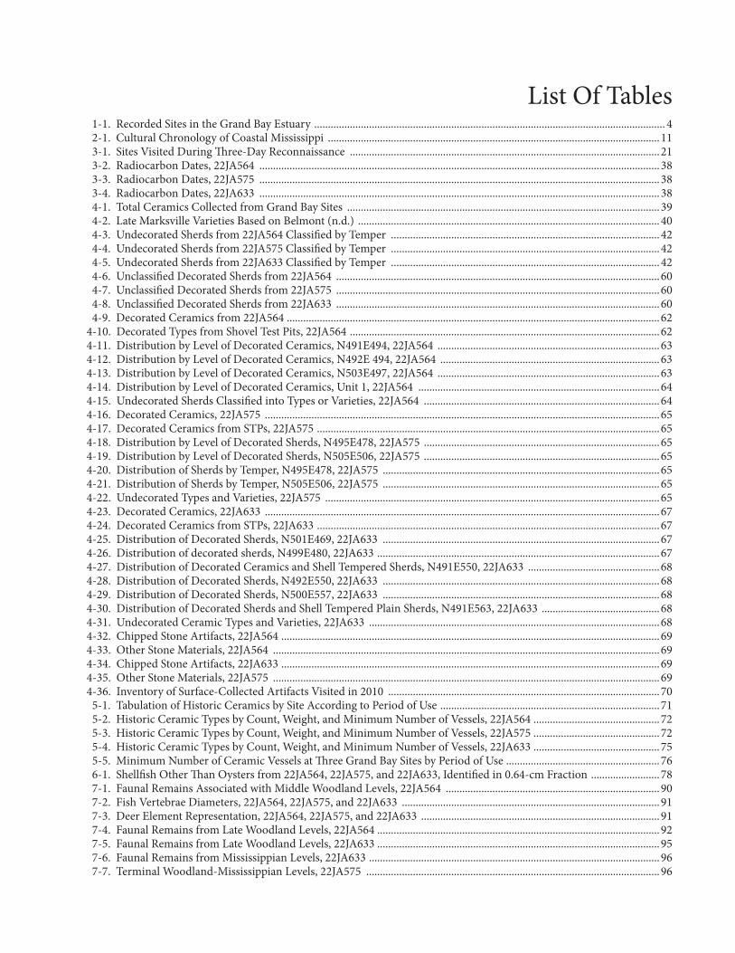
1-1. Recorded Sites in the Grand Bay Estuary ................................................................................................................................ 4 2-1. Cultural Chronology of Coastal Mississippi .........................................................................................................................11 3-1. Sites Visited During Three-Day Reconnaissance .................................................................................................................21 3-2. Radiocarbon Dates, 22JA564 ..................................................................................................................................................38 3-3. Radiocarbon Dates, 22JA575 ..................................................................................................................................................38 3-4. Radiocarbon Dates, 22JA633 ..................................................................................................................................................38 4-1. Total Ceramics Collected from Grand Bay Sites ..................................................................................................................39 4-2. Late Marksville Varieties Based on Belmont (n.d.) ..............................................................................................................40 4-3. Undecorated Sherds from 22JA564 Classified by Temper ..................................................................................................42 4-4. Undecorated Sherds from 22JA575 Classified by Temper ..................................................................................................42 4-5. Undecorated Sherds from 22JA633 Classified by Temper ..................................................................................................42 4-6. Unclassified Decorated Sherds from 22JA564 ......................................................................................................................60 4-7. Unclassified Decorated Sherds from 22JA575 ......................................................................................................................60 4-8. Unclassified Decorated Sherds from 22JA633 ......................................................................................................................60 4-9. Decorated Ceramics from 22JA564 ........................................................................................................................................624-10. Decorated Types from Shovel Test Pits, 22JA564 .................................................................................................................624-11. Distribution by Level of Decorated Ceramics, N491E494, 22JA564 .................................................................................634-12. Distribution by Level of Decorated Ceramics, N492E 494, 22JA564 ................................................................................634-13. Distribution by Level of Decorated Ceramics, N503E497, 22JA564 .................................................................................634-14. Distribution by Level of Decorated Ceramics, Unit 1, 22JA564 ........................................................................................644-15. Undecorated Sherds Classified into Types or Varieties, 22JA564 ......................................................................................644-16. Decorated Ceramics, 22JA575 ................................................................................................................................................654-17. Decorated Ceramics from STPs, 22JA575 .............................................................................................................................654-18. Distribution by Level of Decorated Sherds, N495E478, 22JA575 ......................................................................................654-19. Distribution by Level of Decorated Sherds, N505E506, 22JA575 ......................................................................................654-20. Distribution of Sherds by Temper, N495E478, 22JA575 .....................................................................................................654-21. Distribution of Sherds by Temper, N505E506, 22JA575 .....................................................................................................654-22. Undecorated Types and Varieties, 22JA575 ..........................................................................................................................654-23. Decorated Ceramics, 22JA633 ................................................................................................................................................674-24. Decorated Ceramics from STPs, 22JA633 .............................................................................................................................674-25. Distribution of Decorated Sherds, N501E469, 22JA633 .....................................................................................................674-26. Distribution of decorated sherds, N499E480, 22JA633 .......................................................................................................674-27. Distribution of Decorated Ceramics and Shell Tempered Sherds, N491E550, 22JA633 ................................................684-28. Distribution of Decorated Sherds, N492E550, 22JA633 .....................................................................................................684-29. Distribution of Decorated Sherds, N500E557, 22JA633 .....................................................................................................684-30. Distribution of Decorated Sherds and Shell Tempered Plain Sherds, N491E563, 22JA633 ...........................................684-31. Undecorated Ceramic Types and Varieties, 22JA633 ..........................................................................................................684-32. Chipped Stone Artifacts, 22JA564 ..........................................................................................................................................694-33. Other Stone Materials, 22JA564 .............................................................................................................................................694-34. Chipped Stone Artifacts, 22JA633 ..........................................................................................................................................694-35. Other Stone Materials, 22JA575 .............................................................................................................................................694-36. Inventory of Surface-Collected Artifacts Visited in 2010 ...................................................................................................70 5-1. Tabulation of Historic Ceramics by Site According to Period of Use ................................................................................71 5-2. Historic Ceramic Types by Count, Weight, and Minimum Number of Vessels, 22JA564 ..............................................72 5-3. Historic Ceramic Types by Count, Weight, and Minimum Number of Vessels, 22JA575 ..............................................72 5-4. Historic Ceramic Types by Count, Weight, and Minimum Number of Vessels, 22JA633 ..............................................75 5-5. Minimum Number of Ceramic Vessels at Three Grand Bay Sites by Period of Use ........................................................76 6-1. Shellfish Other Than Oysters from 22JA564, 22JA575, and 22JA633, Identified in 0.64-cm Fraction .........................78 7-1. Faunal Remains Associated with Middle Woodland Levels, 22JA564 ..............................................................................90 7-2. Fish Vertebrae Diameters, 22JA564, 22JA575, and 22JA633 ..............................................................................................91 7-3. Deer Element Representation, 22JA564, 22JA575, and 22JA633 .......................................................................................91 7-4. Faunal Remains from Late Woodland Levels, 22JA564 .......................................................................................................92 7-5. Faunal Remains from Late Woodland Levels, 22JA633 .......................................................................................................95 7-6. Faunal Remains from Mississippian Levels, 22JA633 ..........................................................................................................96 7-7. Terminal Woodland-Mississippian Levels, 22JA575 ...........................................................................................................96
List Of Tables

viii
8-1. Margin Codes ............................................................................................................................................................................102 8-2. Otoliths Examined for this Study ...........................................................................................................................................102 8-3. Otolith Raw Data .......................................................................................................................................................................107A-1. Artifact Inventory, 22JA564 .....................................................................................................................................................117 B-1. Artifact Inventory, 22JA575 .....................................................................................................................................................121 C-1. Artifact Inventory, 22JA633 .....................................................................................................................................................125 D-1. Ceramic Inventory, 22JA564 ....................................................................................................................................................129 E-1. Ceramic Inventory, 22JA575 ....................................................................................................................................................141 F-1. Ceramic Inventory, 22JA633 ....................................................................................................................................................147
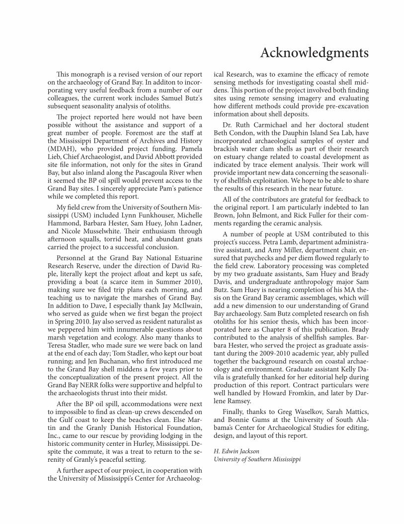
This monograph is a revised version of our report on the archaeology of Grand Bay. In additon to incor-porating very useful feedback from a number of our colleagues, the current work includes Samuel Butz's subsequent seasonality analysis of otoliths.
The project reported here would not have been possible without the assistance and support of a great number of people. Foremost are the staff at the Mississippi Department of Archives and History (MDAH), who provided project funding. Pamela Lieb, Chief Archaeologist, and David Abbott provided site file information, not only for the sites in Grand Bay, but also inland along the Pascagoula River when it seemed the BP oil spill would prevent access to the Grand Bay sites. I sincerely appreciate Pam's patience while we completed this report.
My field crew from the University of Southern Mis-sissippi (USM) included Lynn Funkhouser, Michelle Hammond, Barbara Hester, Sam Huey, John Ladner, and Nicole Musselwhite. Their enthusiasm through afternoon squalls, torrid heat, and abundant gnats carried the project to a successful conclusion.
Personnel at the Grand Bay National Estuarine Research Reserve, under the direction of David Ru-ple, literally kept the project afloat and kept us safe, providing a boat (a scarce item in Summer 2010), making sure we filed trip plans each morning, and teaching us to navigate the marshes of Grand Bay. In addition to Dave, I especially thank Jay McIlwain, who served as guide when we first began the project in Spring 2010. Jay also served as resident naturalist as we peppered him with innumerable questions about marsh vegetation and ecology. Also many thanks to Teresa Stadler, who made sure we were back on land at the end of each day; Tom Stadler, who kept our boat running; and Jen Buchanan, who first introduced me to the Grand Bay shell middens a few years prior to the conceptualization of the present project. All the Grand Bay NERR folks were supportive and helpful to the archaeologists thrust into their midst.
After the BP oil spill, accommodations were next to impossible to find as clean- up crews descended on the Gulf coast to keep the beaches clean. Else Mar-tin and the Granly Danish Historical Foundation, Inc., came to our rescue by providing lodging in the historic community center in Hurley, Mississippi. De-spite the commute, it was a treat to return to the se-renity of Granly’s peaceful setting.
A further aspect of our project, in cooperation with the University of Mississippi’s Center for Archaeolog-
ical Research, was to examine the efficacy of remote sensing methods for investigating coastal shell mid-dens. This portion of the project involved both finding sites using remote sensing imagery and evaluating how different methods could provide pre- excavation information about shell deposits.
Dr. Ruth Carmichael and her doctoral student Beth Condon, with the Dauphin Island Sea Lab, have incorporated archaeological samples of oyster and brackish water clam shells as part of their research on estuary change related to coastal development as indicated by trace element analysis. Their work will provide important new data concerning the seasonali-ty of shellfish exploitation. We hope to be able to share the results of this research in the near future.
All of the contributors are grateful for feedback to the original report. I am particularly indebted to Ian Brown, John Belmont, and Rick Fuller for their com-ments regarding the ceramic analysis.
A number of people at USM contributed to this project’s success. Petra Lamb, department administra-tive assistant, and Amy Miller, department chair, en-sured that paychecks and per diem flowed regularly to the field crew. Laboratory processing was completed by my two graduate assistants, Sam Huey and Brady Davis, and undergraduate anthropology major Sam Butz. Sam Huey is nearing completion of his MA the-sis on the Grand Bay ceramic assemblages, which will add a new dimension to our understanding of Grand Bay archaeology. Sam Butz completed research on fish otoliths for his senior thesis, which has been incor-porated here as Chapter 8 of this publication. Brady contributed to the analysis of shellfish samples. Bar-bara Hester, who served the project as graduate assis-tant during the 2009-2010 academic year, ably pulled together the background research on coastal archae-ology and environment. Graduate assistant Kelly Da-vila is gratefully thanked for her editorial help during production of this report. Contract particulars were well handled by Howard Fromkin, and later by Dar-lene Ramsey.
Finally, thanks to Greg Waselkov, Sarah Mattics, and Bonnie Gums at the University of South Ala-bama’s Center for Archaeological Studies for editing, design, and layout of this report. H. Edwin Jackson University of Southern Mississippi
Acknowledgments
10 Shell Middens in the Grand Bay Estuary
This work is dedicated to
Barbara Thedy Hester
for her significant contributions to theGrand Bay Project
and for her Passion for the
History and Archaeology of the Mississippi Gulf Coast

Sporadic archaeological investigaions have been conducted on the Mississippi Gulf coast for more than a century. Recent archaeological activity relates primarily to federally-mandated compliance work, with some notable exceptions (e.g., Blitz and Mann 2000). Expectably, much of this work has been concen-trated in areas of the coast experiencing development, leaving sites in the preserved wetlands and marshes adjacent to Grand Bay largely uninvestigated. The overarching goal of the present investigation has been to gather data from Grand Bay shell middens that can be used to integrate the archaeological record of this area with better-known portions of the Gulf coast.
A number of specific questions directed the re-search. First, what is the time range during which the Grand Bay estuary was used by prehistoric and historic inhabitants of the coast? Second, how was the estuary used? Specifically, did sites result from resi-dential activities (camps or longer term settlements) or from specific procurement tasks, or both? Related
to these questions are sea level fluctuations during the Holocene that may have punctuated prehistoric uses of the area. Third, what were the cultural associations of Grand Bay occupants and how did these change over time? Prior investigations have noted cultur-al influences, reflected by distinctive ceramic types, coming from both east and west of the project area, as well as from inland cultures. In addition to these geographically framed research questions are those pertaining to the nature of coastal adaptations. Was human predation under pre- contact conditions suf-ficiently intensive or persistent to have impacted the ecosystem or the biological populations that were part of that ecosystem (e.g., Manino and Thomas 2002)?
The Grand Bay Setting The study area defined for the project includes
coastal wetlands adjacent to Grand Bay and Point aux Chenes Bay and within the state borders (Figure 1- 1).
Chapter 1 The Grand Bay Estuary Project
by H. Edwin Jackson
Figure 1-1. Satellite imagery of the Grand Bay estuary.
4 Shell Middens in the Grand Bay Estuary
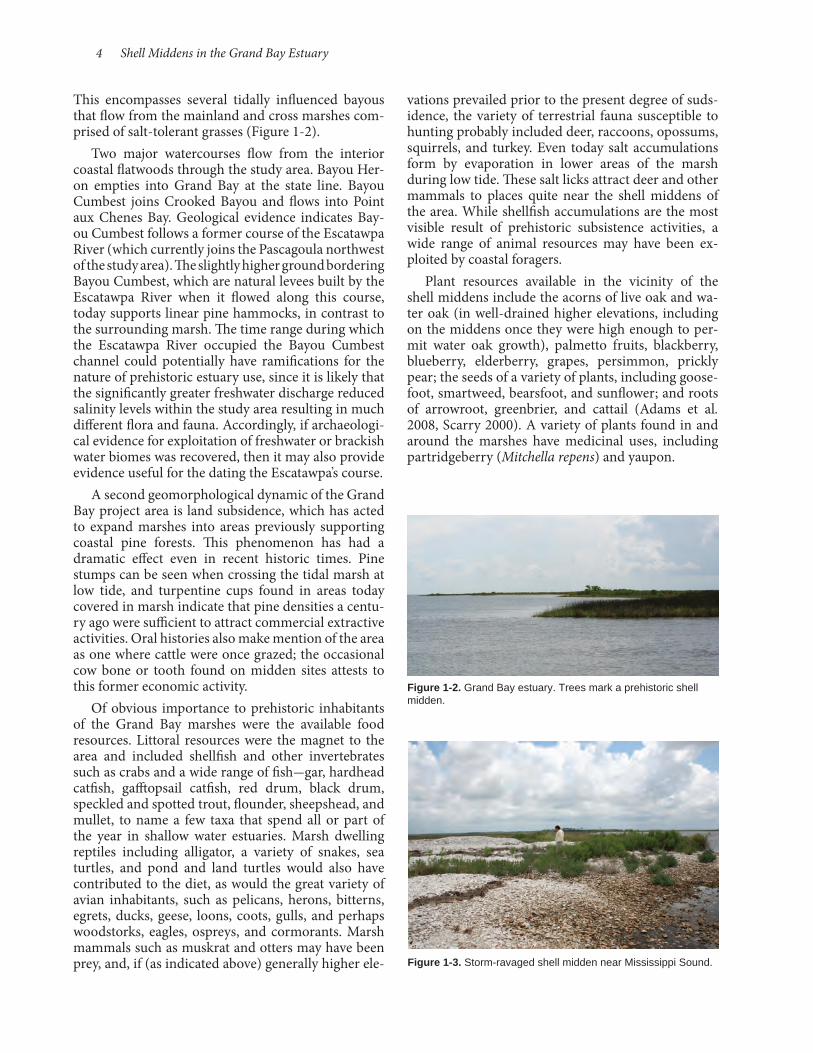
This encompasses several tidally influenced bayous that flow from the mainland and cross marshes com-prised of salt- tolerant grasses (Figure 1- 2).
Two major watercourses flow from the interior coastal flatwoods through the study area. Bayou Her-on empties into Grand Bay at the state line. Bayou Cumbest joins Crooked Bayou and flows into Point aux Chenes Bay. Geological evidence indicates Bay-ou Cumbest follows a former course of the Escatawpa River (which currently joins the Pascagoula northwest of the study area). The slightly higher ground bordering Bayou Cumbest, which are natural levees built by the Escatawpa River when it flowed along this course, today supports linear pine hammocks, in contrast to the surrounding marsh. The time range during which the Escatawpa River occupied the Bayou Cumbest channel could potentially have ramifications for the nature of prehistoric estuary use, since it is likely that the significantly greater freshwater discharge reduced salinity levels within the study area resulting in much different flora and fauna. Accordingly, if archaeologi-cal evidence for exploitation of freshwater or brackish water biomes was recovered, then it may also provide evidence useful for the dating the Escatawpa’s course.
A second geomorphological dynamic of the Grand Bay project area is land subsidence, which has acted to expand marshes into areas previously supporting coastal pine forests. This phenomenon has had a dramatic effect even in recent historic times. Pine stumps can be seen when crossing the tidal marsh at low tide, and turpentine cups found in areas today covered in marsh indicate that pine densities a centu-ry ago were sufficient to attract commercial extractive activities. Oral histories also make mention of the area as one where cattle were once grazed; the occasional cow bone or tooth found on midden sites attests to this former economic activity.
Of obvious importance to prehistoric inhabitants of the Grand Bay marshes were the available food resources. Littoral resources were the magnet to the area and included shellfish and other invertebrates such as crabs and a wide range of fish-gar, hardhead catfish, gafftopsail catfish, red drum, black drum, speckled and spotted trout, flounder, sheepshead, and mullet, to name a few taxa that spend all or part of the year in shallow water estuaries. Marsh dwelling reptiles including alligator, a variety of snakes, sea turtles, and pond and land turtles would also have contributed to the diet, as would the great variety of avian inhabitants, such as pelicans, herons, bitterns, egrets, ducks, geese, loons, coots, gulls, and perhaps woodstorks, eagles, ospreys, and cormorants. Marsh mammals such as muskrat and otters may have been prey, and, if (as indicated above) generally higher ele-
vations prevailed prior to the present degree of suds-idence, the variety of terrestrial fauna susceptible to hunting probably included deer, raccoons, opossums, squirrels, and turkey. Even today salt accumulations form by evaporation in lower areas of the marsh during low tide. These salt licks attract deer and other mammals to places quite near the shell middens of the area. While shellfish accumulations are the most visible result of prehistoric subsistence activities, a wide range of animal resources may have been ex-ploited by coastal foragers.
Plant resources available in the vicinity of the shell middens include the acorns of live oak and wa-ter oak (in well-drained higher elevations, including on the middens once they were high enough to per-mit water oak growth), palmetto fruits, blackberry, blueberry, elderberry, grapes, persimmon, prickly pear; the seeds of a variety of plants, including goose-foot, smartweed, bearsfoot, and sunflower; and roots of arrowroot, greenbrier, and cattail (Adams et al. 2008, Scarry 2000). A variety of plants found in and around the marshes have medicinal uses, including partridgeberry (Mitchella repens) and yaupon.
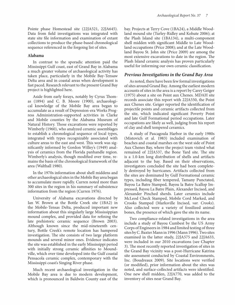
Figure 1-3. Storm-ravaged shell midden near Mississippi Sound.
Figure 1-2. Grand Bay estuary. Trees mark a prehistoric shell midden.

Archaeological Report No. 37 5
An important archaeological site in the vicinity of Pascagoula is Greenwood Island (22JA516), a multicomponent site with significant occupation during the Middle Gulf Formational Claiborne phase (1200- 800 BC) and early Middle Woodland Green-wood Island phase (100 BC- AD 200). Non- local ex-change goods recovered there include copper beads, galena, and a Hopewellian copper earspool (Blitz and Mann 2000). Unfortunately, harbor development and artifact collecting have had a devastating effect on the site. Greenwood Island was afforded professional attention during cultural resource surveys by the Uni-versity of Alabama Office of Archaeologial Research (Solis and Walling 1982), which included limited testing, and by OSM Archaeological Consultants (Mistovich et al. 1983) related to Pascagoula Harbor development. Those investigators concluded that intact deposits possibly remained of this important site. Artifacts collected from those investigations ranged in age from the Poverty Point to Mississippi periods, with strong representation of the Middle and Late Gulf Formational periods. Some years later, a party from MDAH recovered a bundle burial thought to be associated with fiber tempered ceramics during limited testing at the site (Lehmann et al. 1991). Efforts to afford Greenwood Island some level of protection have been largely unsuccessful.
R. Barry Lewis performed reconnaissance in the Bay St. Louis area. He examined the distribution of recorded sites to model settlement pattern and adap-tation trends along the Mississippi Gulf coast (Lewis 1988), later using those data to examine the effects of sea level rise and subsidence on the distribution of known sites and model the probabilities of site identification on the basis of site age.
Among the sites recorded by Lewis is the Dia-mondhead site (22HA550), near the mouth of the Jourdan River that flows into St. Louis Bay. The site is a Rangia shell midden, the main portion of which is L- shaped and approximately 35 by 20 m in extent. Cultural deposits and sporadic shell accumulations extend both east and west. The highest point of the midden is 2 m above the surrounding ground surface. Lewis’s limited testing there recovered a small number of Mississippi Plain sherds associated with charcoal samples that yielded dates of 300±70 BP (AD 1653) and 570±70 BP (AD 1380). The site was the subject of investigation by a University of Southern Mississippi (USM) field school in 1988 (Jackson 1991; Jackson et al. 1993). Six 2.0- by- 2.0- m units and one 1.0- by- 1.0- m unit were excavated, sampling the shell pile as well as the surrounding area. Analysis of recovered ceramics (Sims 1997) provided evidence of a much longer peri-od of use than suggested by Lewis’s initial testing, ex-
Previous Archaeological Investigations
The Mississippi Gulf Coast Along the Mississippi Gulf coast are numerous
shell accumulations, including some that appear to have served primarily as harvesting and process-ing locations and others associated with substantial amounts of cultural material that suggest at least periodic if not permanent residential occupations. They also vary in terms of the primary shellfish species present, with those near Mississippi Sound comprised mainly of oyster shells (Crassostrea vir-ginica) and those located further inland dominated by marsh clams (Rangia cuneata). One of the best known, though unfortunately not well documented, shell middens occupies the west end of Deer Island (22HR500). As reported by Calvin Brown (1926) early in the twentieth century, the Deer Island site midden stood up to 15 feet high with ample ceramic sherds, human remains, and what he described as the re-mains of dwellings (Figure 1- 4). Reports indicate the possibility of a mound on Deer Island (Kraus 1966), apparently eradicated by Camille in 1969. The site has been a target of much surface collecting and occasional digging by artifact seekers, and much of what is known about the site is restricted to unprovenienced surface collections, mainly from the south side of the island where tidal erosion constantly exposed new material. Greenwell (1984) reported on excavations that yielded burials, from remnants of the mound, associated with shell tempered (Mississippian) pottery. The site was also briefly examined by MDAH staff in the 1980s (Lauro 1986), who assigned ceramics to the Pensac-ola complex. More recent work with surface collected material by Blitz and Mann (2000) and Craig (2010) indicate a strong Singing River phase (AD 1200- 1500) component, as well as a Bear Point (AD 1500- 1700) phase occupation, along with a small number of ear-lier Woodland sherds. Other materials suggest Indi-an occupation of the site into the historic era. With respect to fauna, the midden is primarily composed of oyster shells and vertebrate taxa are dominated by fish expected from Mississippi Sound, along with birds, small mammals, deer, and bear.
In the 1970s the Gulf Coast Chapter of the Mississippi Archaeological Association conducted excavations at the Jackson Landing site (22HA515) at the mouth of the Pearl River. Jackson Landing includes a single mound and arc- shaped earthwork, as well as a multi- component shell midden on the bank of Mulatto Bayou. That excavation was supervised by Mark Williams, then in the Air Force and stationed at Keesler Air Force Base in Biloxi, who later reported on the excavations (Williams 1987).

6 Shell Middens in the Grand Bay Estuary
Allgood suggests that the nearly equal contributions of mammals, fish, and reptiles from Late Woodland de-posits indicate a broadening of resource use, perhaps to compensate for diminishing returns from shellfish collecting. Upon return to the site by Mississippian occupants, subsistence efforts focused on sea turtle capture. This shift, along with indications of decreased variety in the Mississippian ceramic assemblage (Sims 1997) may indicate a transition in site use from earlier seasonal encampments to a more focused collection locus during the Mississippi period.
The single most significant contribution to our un-derstanding of coastal Mississippi’s prehistory is the synthesis of fieldwork, collections analysis, and site file information presented by Blitz and Mann (2000). Their work produced a chronological framework for the last 3,000 years of coastal occupation, based on a limited number of radiocarbon dates and site ceram-ic assemblage seriation to define phases beginning in the Gulf Formational period and extending to historic contact between Native Americans and French colo-nists in the eighteenth century. Blitz and Mann’s field efforts included limited excavations at a number of key sites distributed mainly along the eastern half of the Mississippi Gulf coast, but not as far east as Grand Bay. Excavated sites included Apple Street (22JA530), the type site for the Apple Street phase; the Apple Street phase East Bayou LaMotte site (22JA555); Godsey phase Godsey site (22HR591); Graveline phase Harvey site (22HR534) and Graveline Mound (22JA503); Pinola and Singing River phase Singing River site (22JA508, 22JA520, 22JA578); and the La
tending from possibly as early as the late Gulf Forma-tional Tchula period (800- 100 BC) or more definitely from the early Middle Woodland (100 BC- AD 500) through Mississippi periods (AD1200-1550). Ceram-ics generally point to the site’s association with the Louisiana Delta to the west, except during the Late Woodland, when not only lower Mississippi Valley/Louisiana Delta types but also several Weeden Island types were deposited at the site. An apparent lull in site use occurred at the end of the Woodland era, followed by a return to the site during the Singing River phase (post- AD 1350).
With respect to evidence of subsistence activities at the site, Montana’s (1996) analysis of shellfish remains indicates primarily summer to early fall exploitation. Examination of trends in shellfish size over time indi-cated a measurable decrease in mean shell size during the Late Woodland, which may help explain why the site was not used in the subsequent early Mississippi period. When collectors returned to the site, shell size was greater. The data suggest that persistent col-lecting in the Late Woodland put pressure on the exploited shellfish bed, leading to declining harvests and a change in collecting location that allowed the bed to rebound. Vertebrate faunal remains analyzed by Allgood (2001) document changes in subsistence patterns over time. During the Middle and Late Woodland, mammal and fish furnished major con-tributions to the samples, with reptiles (primarily sea turtle) increasing from 10 percent to just less than 25 percent over time. In the Mississippian sample, rep-tiles comprise nearly 70 percent of the subassemblage.
Figure 1-4. Sites in Mississippi mentioned in the text: 1, Jackson Landing (22HA515); 2, Claiborne (22HA501); 3, Cedarland (22HA504); 4, Diamondhead (22HA550); 5, Harvey (22HR534); 6, Godsey (22HR591); 7, Deer Island (22HR500); 8, Apple Street (22JA530); 9, East Bayou LaMotte (22JA551); 10, Graveline (22JA503); 11, Homestead (22JA645); 12, Singing River (22JA508, 22JA520, 22JA778); 13, La Pointe-Krebs House (22JA526); 14, Greenwood Island (22JA516); 15, Pointe aux Chenes (22JA520) and Bone Yard (22JA537).
Archaeological Report No. 37 7
Pointe phase Homestead site (22JA521, 22JA645). Data from field investigations was integrated with state site file information and examination of extant collections to produce the phase- based chronological sequence referenced in the forgoing list of sites.
AlabamaIn contrast to the sporadic attention paid the
Mississippi Gulf coast, east of Grand Bay in Alabama a much greater volume of archaeological activity has taken place, particularly in the Mobile Bay- Tensaw Delta area and in coastal areas when development is fast paced. Research relevant to the present Grand Bay project is highlighted here.
Aside from early forays, notably by Cyrus Thom-as (1894) and C. B. Moore (1900), archaeologi-cal knowledge of the Mobile Bay area began to accumulate as a result of Depression-era Works Prog-ress Administration-supported activities in Clarke and Mobile counties by the Alabama Museum of Natural History. Those excavations were reported by Wimberly (1960), who analyzed ceramic assemblages to establish a chronological sequence of local types, integrated with types recognizably associated with culture areas to the east and west. This work was sig-nificantly informed by Gordon Willey’s (1949) anal-ysis of ceramics from the Florida panhandle region.Wimberly’s analysis, though modified over time, re-mains the basis of the chronological framework of the area (Walthall 1980).
In the 1970s information about shell middens and other archaeological sites in the Mobile Bay area began to accumulate more rapidly. Curren noted more than 300 sites in the region in his summary of subsistence information from the region (Curren 1976).
University of Alabama excavations directed by Ian W. Brown at the Bottle Creek site (1BA2) in the Mobile-Tensas Delta, produced important new information about this singularly large Mississippian mound complex, and provided data for refining the late prehistoric ceramic sequence (Brown 2003). Although known since the mid- nineteenth cen-tury, Bottle Creek’s remote location has hampered investigation. The site consists of two large platform mounds and several minor ones. Evidence indicates the site was established in the early Mississippi period with initially strong ceramic affinities to Mound-ville, which over time developed into the Gulf coastal Pensacola ceramic complex, contemporary with the Mississippi coast’s Singing River phase.
Much recent archaeological investigation in the Mobile Bay area is due to modern development, which is pronounced in Baldwin County east of the
bay. Projects at Terry Cove (1BA24), a Middle Wood-land mound site (Turley- Ridley and Kohute 2006); at the Plash Island site (1BA134), a multi- component shell midden with significant Middle to Late Wood-land occupations (Price 2008); and at the Late Wood-land Bayou St. John site (Price 2009) are among the most extensive excavations to date in the region. The Plash Island ceramic analysis has proven particularly useful for informing our own ceramic classification.
Previous Investigations in the Grand Bay Area As noted, there have been few formal investigations
of sites around Grand Bay. Among the earliest modern accounts of sites in the area is a report by Carey Geiger (1975) about a site on Point aux Chenes. MDAH site records associate this report with 22JA550, the Point aux Chenes site. Geiger reported the identification of projectile points and ceramic artifacts collected from the site, which indicated significant Poverty Point and late Gulf Formational period occupations. Later occupations are likely as well, judging from his report of clay and shell tempered ceramics.
A study of Pascagoula Harbor in the early 1980s (Mistovich et al. 1983) included examination of beaches and coastal marshes on the west side of Point Aux Chenes Bay, where the project team visited what remained of 22JA537, the Bone Yard site. The site is a 1.0-km long distribution of shells and artifacts adjacent to the bay. Based on their observations, investigators concluded the site had been complete-ly destroyed by hurricanes. Artifacts collected from the sites are dominated by Gulf Formational ceramic types, including fiber tempered, Tamany Punctated, Bayou La Batre Stamped, Bayou la Batre Scallop Im-pressed, Bayou La Batre Plain, Alexander Incised, and Alexander Pinched sherds. Later ceramics include McLeod Check Stamped, Mobile Cord Marked, and Crooks Stamped (Marksville Incised, var. Crooks). Also collected were a variety of fossilized animal bones, the presence of which gave the site its name.
Two compliance- related investigations in the area include a study of Bayou Cumbest by the US Army Corps of Engineers in 1984 and limited testing of three sites by C. Baxter Mann in 1996 (Mann 1996). Two sites examined in the latter study, 22JA575 and 22JA633, were included in our 2010 excavations (see Chapter 3). The most recently reported investigation of sites in the Grand Bay vicinity was a post- Hurricane Katrina site assessment conducted by Coastal Environments, Inc. (Boudreaux 2009). Site locations were verified (or modified), prior information about the sites was noted, and surface- collected artifacts were identified. One new shell midden, 22JA770, was added to the inventory of sites near Grand Bay.
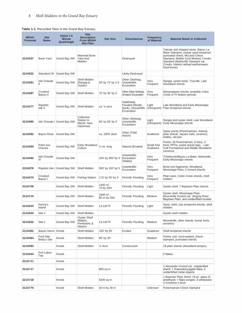
8 Shell Middens in the Grand Bay Estuary
Table 1-1. Recorded Sites in the Grand Bay Estuary.
MDAH Trinomial
Site Name
USGS 7.5 Minute
Quadrangle
Site Description From MDAH
Site FilesSite Size Disturbances Frequency
of Material Material Noted or Col lected
22JA537 Bone Yard Grand Bay SWMammal Bone Yard And Midden
Destroyed
Tabular and chipped stone, Bayou La Batre Stamped, coarse sand tempered punctated sherd, McLeod Check Stamped, Mobile Cord Marked, Crooks Stamped (Marksville Stamped var. Crooks, historic refined earthenware, fossil bones
22JA522 Standard Oil Grand Bay SW Likely Destroyed
22JA581 Isle Chaude II Grand Bay SW
Shell Midden (Rangia & Oyster)
50' by 75' by 2.5’Other (Sinking), Unscientific Excavation
Very Frequent
Rangia, oyster bank, Troyville, Late Woodland sherds
22JA587 Crooked Bayou II Grand Bay SW Shell Midden 70’ by 30’ by 2’ Other (Slow Sinking),
Amateur ExcavationVery Frequent
Mississippian sherds, probably Coles Creek or Ft Walton periods
22JA577 Rigolets Isle II Grand Bay SW Shell Midden ca. ¼ acre
Indefinitely Flooded (Mostly Sunk), Unscientific Excavation
Light (Infrequent)
Late Woodland and Early Mississippi Plain tempered sherds
22JA580 Isle Chaude I Grand Bay SW
Collection Station In Marsh, Now Hammock
50’ by 50’ by 2’Other (Sinking), Unscientific Excavation
Light (Infrequent)
Rangia and oyster shell, Late Woodland-Early Mississippi sherds
22JA592 Bayou Rosa Grand Bay SW ca. 1000’ diam Other (Tidal Action) Scattered
Spear points (Pontchartrain, Adena), plain sherds, square nails, ceramics, bottles, old pier
22JA550 Point Aux Chenes Grand Bay SW Early Woodland
Culture ½ mi. long Natural (Eroded) Small And Scattered
Points: 26 Pontchartrain, 6 Gary, 2 Kent, PPOs, podal vessel legs, Late Gulf Formational and Middle Woodland ceramics
22JA582 Isle Chaude III Grand Bay SW 100' by 300' by 4’
Unscientific Excavation (Stable)
Very Frequent
Tchefuncte/Bayou La Batre, Marksville , Early Mississippi sherds
22JA576 Rigolets Isle I Grand Bay SW Shell Midden 500' by 100' by 5 Unscientific Excavation
Very Frequent
Bone tool fragments, Woodland, Mississippi Plain, 2 Incised sherds
22JA575 Crooked Bayou I Grand Bay SW Fishing Station 175' by 50' by 3’ Periodic Flooding Very
FrequentPlain ware, Coles Creek sherds, shell midden
22JA709 Grand Bay SW Shell Midden 1400 m2, 70 by 20m Periodic Flooding Light Oyster shell, 7 Baytown Plain sherds
22JA710 Grand Bay SW Shell Midden 1600 m2, 80 m by 20m Periodic Flooding Medium
Oyster shell, Mississippi Plain, Moundville Incised var. Singing River, Baytown Plain, and unidentified incised
22JA633 Kenny’s Island Grand Bay SW Shell Midden 13,125 ft2 Periodic Flooding Light Sand, shell, clay tempered sherds, shell
midden
22JA634 Site 2 Grand Bay SW Shell Midden Oyster shell midden
22JA632 Site 1 Grand Bay SW
Oyster Shell Midden, Prehistoric & Historic
13,125 ft2 Periodic Flooding Medium Moundville, other sherds, burial, brick, ceramics
22JA562 Bayou Heron Kreole Shell Midden 150’ by 50’ Eroded Scattered Shell tempered sherds
22JA564 Ford Site; Betty’s Site Kreole Shell Midden 90’ by 30’ Medium Points; celt; cord-marked, check-
stamped, punctated sherds
22JA583 Kreole Shell Midden ¼ Acre Construction 18 plain sherds (Woodland temper).
22JA644 Fort Lakes Tap Kreole 2 flakes
22JA711 Kreole
22JA717 Kreole 800 sq m1 Alexander Incised var. unspecified. sherd; 1 chalcedony/agate flake; 2 unidentified metal objects
22JA718 Kreole 5200 sq m1 Baytown Plain sherd; 19 pc. glass (3 amethyst); 1 flake scraper; 3 whiteware; 2 ironstone;1.brick
22JA770 Kreole Shell Midden 30 m by 30 m Unknown Pontchartrain Check Stamped
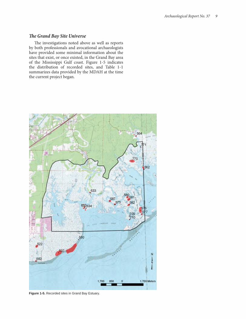
Archaeological Report No. 37 9
The Grand Bay Site UniverseThe investigations noted above as well as reports
by both professionals and avocational archaeologists have provided some minimal information about the sites that exist, or once existed, in the Grand Bay area of the Mississippi Gulf coast. Figure 1- 5 indicates the distribution of recorded sites, and Table 1- 1 summarizes data provided by the MDAH at the time the current project began.
Figure 1-5. Recorded sites in Grand Bay Estuary.
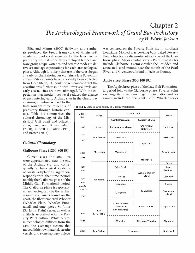
Blitz and Mann’s (2000) fieldwork and synthe-sis produced the broad framework of Mississippi’s coastal chronological sequence for the later part of prehistory. In that work they employed temper and ware groups, type-varieties, and ceramic modes to de-rive assemblage expectations for each archaeological phase. Although it is likely that use of the coast began as early as the Paleoindian era (since late Paleoindi-an San Patrice points have reportedly been collected from Deer Island), it should be remembered that the coastline was further south with lower sea levels and early coastal sites are now submerged. With the ex-pectation that modern sea level reduces the chance of encountering early Archaic sites in the Grand Bay environs, attention is paid to the final roughly three millennia of prehistory through historic con-tact. Table 2-1 summarizes the cultural chronology of the Mis-sissippi Gulf coast and adjacent areas, based on Blitz and Mann (2000), as well as Fuller (1998) and Brown (2003).
Cultural Chronology
Claiborne Phase (1200-800 BC)Current coast line conditions
were approximated near the end of the Archaic era, and conse-quently archaeological evidence of coastal adaptations largely cor-responds with that time period, notably the Claiborne phase of the Middle Gulf Formational period. The Claiborne phase is represent-ed archaeologically by the earliest ceramic containers found on the coast, the fiber tempered Wheeler (Wheeler Plain, Wheeler Punc-tated) and untempered St. Johns (St. Johns Plain) series, as well as artifacts associated with the Pov-erty Point culture. While ceram-ic technologies diffused from the east, the exchange system that moved lithic raw material, steatite vessels, and stone lapidary objects
was centered on the Poverty Point site in northeast Louisiana. Molded clay cooking balls called Poverty Point objects are a diagnostic artifact class of the Clai-borne phase. Major coastal Poverty Point-related sites include Claiborne, a semi-circular shell midden and associated sand mound near the mouth of the Pearl River, and Greenwood Island in Jackson County.
Apple Street Phase (800-100 BC)The Apple Street phase of the Late Gulf Formation-
al period follows the Claiborne phase. Poverty Point exchange items were no longer in circulation and ce-ramics include the persistent use of Wheeler series
Chapter 2 The Archaeological Framework of Grand Bay Prehistory
by H. Edwin Jackson
Table 2-1. Cultural Chronology of Coastal Mississippi.
12 Shell Middens in the Grand Bay Estuary
copper, and mica and other minerals, there is broad similarity in ceramic decorative ideas that spans the eastern part of the continent. Many of these design ideas may have been spawned by the indigenous Gulf Tradition (e.g., Shenkel 1984). In the lower Mississip-pi River valley, the local cultural variant is known as Marksville culture, named after the Marksville site in central Louisiana. In the Mobile Bay area early Middle Woodland is marked by the appearance of the Santa Rosa series associated with the local Blakeley phase. Marksville and Santa Rosa ceramics share decorative techniques derived from earlier Tchefuncte and Bay-ou La Batre ideas, as well as similar arrangements, the most prevalent being curvilinear incision using a broad U-shaped implement to create geometric or zoomorphic designs set off by fields of simple den-tate or shell edge stamping applied as single stamps or by rocker stamping. Clear early Middle Wood-land markers in the lower Mississippi Valley include zoned simple stamped designs (Mabin Stamped), raptorial bird motifs, and crosshatched rims (Toth 1988), which also have chronological utility on the Mississippi Gulf coast (Blitz and Mann 2000:27). Also part of the Marksville-derived ceramic assemblage are Marksville Incised, Marksville Stamped, Indian Bay Stamped, and Catahoula Zoned Red. Santa Rosa types occurring on the Mississippi Gulf coast include Greenwood Stamped, Santa Rosa Stamped, and Santa Rosa Punctated. Santa Rosa ceramics are sand tem-pered, while Marksville ceramics document the in-troduction of grog (ground-up potsherds) as temper. In addition to broad line incised and zone stamped decorations on grog or sand tempered vessels, a more easterly influence (Florida panhandle or possibly southern Georgia) is manifest in the appearance of simple paddle stamped and check stamped (Deptford Simple Stamped, Deptford Linear Check Stamped, and Deptford Bold Check Stamped) and possibly Swift Creek Complicated Stamped types (Blitz and Mann 2000:27).
There is abundant evidence of Hopewell-related (Marksville) mortuary practices in the lower Missis-sippi Valley (Toth 1988). In the Mobile-Tensaw Delta, excavation of the McQuorqudale Mound (Wimberly and Tourtelot 1941) produced several Hopewellian ar-tifacts, including copper beads and earspools, galena, greenstone celts, and a stone cup. Inland, in the Pine Hills, there is evidence of Middle Woodland mound-building, though the purpose of mounds, mortuary or otherwise, has not been established, (Freeman 2008). Somewhat further to the north, the McRae mound in Clarke County also produced Hopewellian artifacts, including a copper and silver clad panpipe, lamellar blades of possibly Midwestern chert, and a quartz crystal point (Blitz 1986).
vessels, to which are added sand tempered Alexander series (Baldwin Plain, Alexander Incised, Alexander Pinched, Alexander Punctated Chinchuba Brushed), coarse sand or grit tempered Bayou La Batre series (Bayou La Batre Stamped, Bayou La Batre Scallop Impressed, Bayou La Batre Cord Wrapped Dowel Im-pressed), and untempered or clay tempered Tchefunc-te ceramics (Tchefuncte Incised, Tchefuncte Stamped, Tammany Punctated, Lake Borgne Incised).
Alexander series pots were decorated by incision, fingernail impressions and pinching, and stamping, often covering vessels in complex patterns. Vessels often had podal supports (feet). Tchefuncte vessel decorations include incision, punctation, and simple stamping on vessels with podal supports. The Bayou la Batre series includes footed vessels, as well as those having ring bases that were decorated with incision, simple stamping, and scallop shell stamping. The geo-graphic centers of these three new ceramic series vary, with Alexander series found from the Tennessee Riv-er valley southward to the Gulf coast, Bayou La Batre rather limited to the Mobile Bay area and surround-ing region, and Tchefuncte occurring in the Louisi-ana Delta and up the Mississippi River as far north as the Louisiana-Arkansas border. On the Mississippi Gulf coast sites of this phase have variable represen-tations of the three series, with increasing dominance of one type or the other, depending on proximity to the assumed centers of distribution. Temporal pri-ority is unclear, but contemporaneity of the series is certain, as they have been found together in closed feature contexts (e.g., Marshall 1982). There is a cer-tain degree of technological overlap as well, with Al-exander designs occurring on coarse sand tempered ware more similar to Bayou La Batre ceramics in the interior of southeastern Mississippi (Hodge 2006). Major sites with components dating the Apple Street phase include Apple Street in Jackson County, as well as East Bayou LaMotte and possibly Diamondhead. In the Grand Bay area, Point Aux Chenes site (22JA550) reportedly produced vessel podal supports.
Greenwood Island Phase (100 BC-AD 200)The Greenwood Island phase represents the early
portion of the Middle Woodland period, a time during which there was an increased attention to burial cer-emonialism that included interments in mounds, as well as an uptick in interregional trade of items that were often deposited in mortuary contexts as grave goods. Across eastern North America this time in-terval is associated with what is termed the Hopewell Interaction Sphere, after the elaborate Hopewell cul-ture ceremonial and mortuary earthworks of the Ohio River valley. In addition to mortuary items of shell,

Archaeological Report No. 37 13
includes check-stamped pottery which does not ap-pear (at least based on present knowledge) until the subsequent Mississippi coast’s Tates Hammock phase (Fuller 1998).
Tates Hammock Phase (AD 700-1200)As conceived by Blitz and Mann (2000:44), the
Tates Hammock phase, encompasses a half-century beginning ca. AD 700 and reflects the incorporation of check-stamped ceramics, grog tempered Pontchar-train Check Stamped, and sand tempered Wakulla Check Stamped, a continuation of Weeden Island ceramics types that appeared in the Graveline phase, to which is added Weeden Island Punctated and the appearance of cord marked pottery (sand tempered Furrs Cord Marked and grog tempered Mulberry Creek Cord Marked), considered to reflect a north-erly influence. The Tates Hammock phase nomencla-ture is taken from a brief consideration of coastal shell middens near Mobile Bay by Walthall (1980:171-172) who based the phase primarily on WPA excavations. Walthall’s determination of chronology was limited, and he essentially tied the phase to the span of time during which Weeden Island ceramics were wide- spread on the northern Gulf coast, ca. AD 400-1000. Fuller (1998) later refined the temporal span of the phase to the early half of Walthall’s estimate, ca. AD 400-750, marked by assemblages that include Weeden Island types, and sand tempered and grog tempered check-stamped pottery (Wakulla and Pontchartrain, respectively) along with smaller amounts of sand tempered Furrs Cord Marked and (presumably) ear-ly grog tempered Coles Creek varieties of types, in-cluding Coles Creek Incised, Mazique Incised, and Evansville Punctated. Fuller suggests that over time sand tempering increased at the expense of grog tempering, Troyville (lower Mississippi Valley) types decrease, and check stamping increases. In Fuller’s scheme, Tates Hammock is succeeded by the Coden phase, ca. AD 750-1100, during which check stamp-ing was the dominant surface treatment, paralleling the same development along the Florida panhandle. Partially overlapping the Coden phase are two other phases, the Tensaw Lake Phase (AD 850-1100/1200) and the McLeod phase (ca. AD 400-1100/1200). Sand and sometime coarse grit tempered check-stamped (Hubbard Check Stamped, McLeod Check Stamped, with less Wakulla Check Stamped) and cord-marked (Furrs Cord Marked, Mobile Cord Marked) types dominate Tensaw Lake assemblages, while Wakulla Check Stamped, in association with Weeden Island types, is more typical of McLeod phase assemblages. Distinctions among the various check-stamped types are based primarily on rim form, and are often dif-ficult to confidently sort in practice (Fuller 1998:21).
Godsey Phase (AD 200-400)The Godsey phase is the local expression of the late
Middle Woodland Marksville period. Throughout what was previously the Hopewell Interaction Sphere evidence for interregional contact waned. Greater iso-lation is indicated by the persistence of local ceramic traditions, but fewer non-local wares, yielding gen-erally lower ceramic diversity (Blitz and Mann 2000: 38). In the lower Mississippi Valley southward to the Louisiana Delta and eastward across Mississippi’s Gulf coast, a relatively uniform set of grog tempered types (actually later varieties of the Marksville series) set out what has come to be known as the Issaquena complex, named for what was originally a late Marksville phase in the lower Yazoo Basin (Greengo 1965; Phillips 1970; see Jeter et al. 1989 for the rationale for extending the Issaquena construct). The Godsey phase represents the local manifestation of the Issaquena complex, and ceramics are later varieties of Marksville Incised and Marksville Stamped, with the introduction of Churu-pa Punctated, a punctation-filled zoned decoration. There continues to be minority representation of San-ta Rosa types, which during this time interval are sand tempered cognates of Issaquena varieties. The Godsey site is the type site for the phase.
Graveline Phase (AD 400-700)The Graveline phase marks the beginning of the
Late Woodland period on the Mississippi Gulf coast. There is strong continuity with the preceding Godsey phase (Blitz and Mann 2000:41) reflected by late va-rieties of Marksville Incised and Marksville Stamped. New ceramic types also appear, including varieties of the grog tempered type French Fork Incised, as well as a painted ware Landon Red on Buff, types associ-ated with ceramic assemblages in the lower Missis-sippi Valley representing Troyville culture. There are also a number of fine sand tempered types, including Carrabelle Punctated, Carrabelle Incised, Indian Pass Incised, and Weeden Island Incised (the central dis-tribution of which is in the Florida panhandle), that define the Weeden Island culture. Others have com-mented on the stylistic similarities of Weeden Island types and those of Troyville culture. The Mississippi Gulf coast appears to have been on the boundaries of these two culture’s ranges, and the mixed assem-blages suggest not only the exchange of ideas regard-ing pottery decoration, but also possibly exchange as well. The Harvey site in Harrison County and Grave-line Mound in Jackson County date to the Graveline phase.
On the Alabama coast and Mobile Bay the Grave-line phase coincides with the Tates Hammock phase, which also contains Weeden Island ceramics, but
14 Shell Middens in the Grand Bay Estuary
Pinola Phase (AD 1200-1350)Around AD 1200, shell began to be used as a tem-
pering agent, either alone or in combination with grog. This technological change in ceramic production heralds the initial effects of the Middle Mississippian tradition and the emergence of chiefdoms, such as Moundville in the interior Southeast. The onset of the Pinola phase roughly coincides with establishment of the Bottle Creek site in the Mobile-Tensaw delta, the largest mound center on the northern Gulf coast (with 18 mounds at its apex) and principle political center of the region for the next three centuries. Early in its history, during the Bottle Creek I phase, Bottle Creek ceramics reveal a close relationship with Moundville, but over time the northern Gulf coast Mississippi-an ceramic tradition evolved into what is called the Pensacola culture (Brown 2003), fully present in the succeeding Bottle Creek II phase. In the Mobile Bay region prior to the Bottle Creek I phase is the present-ly poorly understood Andrews Place phase from ap-proximately AD 1100-1250, represented mainly at the namesake site and considered by some to represent an intrusion of Mississippian (specifically Moundvillian) peoples into the coastal area. Contemporaneous sites appear to retain their Woodland roots.
The Pinola phase on the Mississippi Gulf coast appears to represent a variety of influences com-ing from the Moundville area (probably via Bottle Creek), the lower Mississippi Valley, and beyond. New ceramic types associated with the Pinola phase include Moundville Incised, var. Moundville, D’Olive Incised, Medora Incised, Barton Incised, Carter En-graved, var. Shell Bluff, Kimmswick Fabric Impressed, Winterville Incised, and Parkin Punctated-all shell tempered varieties except Medora Incised and Carter Engraved, which are grog tempered types associated with Plaquemine culture in the lower Mississippi Val-ley south of Greenville, Mississippi. Types that persist after the Tates Hammock phase include Coles Creek Incised, Mulberry Creek Cord Marked, Alligator In-cised, Mazique Incised, and Evansville Punctated (Blitz and Mann 2000:57). Mixed grog and shell tem-pering occured during the Pinola phase as well.
Widespread use of maize formed the agricultural subsistence base of southeastern Native Americans during the Mississippi period. Corn cupules were identified in Pinola phase samples from the Singing River site (Scarry 2000:172-173). A second cultigen, sunflower, may also be present. There is no evidence to suggest cultivation of the several small seed taxa in use in the interior Southeast. Indeed, wild plant foods appear to have had continued importance, including hickory nuts, acorns, hackberry, persimmon, sumac, and palmetto, reflecting fall collection.
The different conceptualizations of the Tates Ham-mock phase present something of a conundrum. Full-er’s Tates Hammock phase is roughly coeval with the Graveline phase, but formally the two are quite differ-ent. Formal characteristics with respect to the pres-ence of certain ceramic types link Blitz and Mann’s definition to Walthall’s, although in their chronology it appears as its namesake in the Mobile Bay area is on the way out. Moreover Blitz and Mann add some two hundred years to the phase, ending it ca. AD 1200. The Mississippi Tates Hammock phase then is contemporaneous with the Coden phase in Alabama, and larger sample sizes may well provide the basis for demonstrating quantitatively the similarities between the two. Regardless, it seems that the Tates Hammock phases’ broad time range needs subdivision or revi-sion as new data become available. Moreover, Fuller’s Tates Hammock conceptualization may not be with-out flaws, since it seems placed too early to expect Mazique Incised or Coles Creek Incised, except to-ward the end of the phase (Coles Creek, var. Chase), since these occur in Troyville period assemblages in the Louisiana Delta. At present, the dual nature of the Tates Hammock phase is awkward at best, and Grand Bay assemblages from this time interval may clarify things given their intermediate geographic position along the Gulf coast. Two possibilities of how such a modification might be accomplished seem to be pres-ent. First, there is growing recognition in the lower reaches of the lower Mississippi Valley that post-Is-saquena varieties of Marksville Incised and Marks-ville Stamped last well into the Troyville Period there. These may become useful for delineating the early end of the Tates Hammock phase. Furthermore, Blitz and Mann restrict some lower Mississippi Valley types to the succeeding Pinola phase, for which there are ear-lier varieties. For example, they include Alligator In-cised, var. Oxford (sic, Oxbow) in the Pinola phase, but the earlier var. Alligator is a useful marker for the early half of the Tates Hammock phase. Second, Weeden Is-land types declined and disappeared after about AD 900, so it is predicted that later Tates Hammock phase components would include check-stamped pottery, cord-marked pottery, and possibly late Coles Creek varieties, but not Weeden Island types.
Sometime after AD 700, another technological change, the shift from atlatl and darts to bow and arrow occurred. In south Mississippi this is marked by the appearance of small stemmed Collins points and, probably, somewhat later small triangular Mad-ison points. The spread of bow and arrow technology seems to have had a north to south trajectory coin-ciding with the spread of cord marking as a ceramic surface treatment, another northern influence (Blitz and Mann 2000:99).

Archaeological Report No. 37 15
of D’Olive Incised and Pensacola Incised. Decoration continues to include motifs of the preceding Singing River phase, including SECC imagery, but executed in a more abstract, stylized fashion. Bear Point phase ceramics are present in the upper levels of the Singing River site (Blitz and Mann 2000:61), as well as in sur-face collections from Deer Island (Craig 2010).
La Pointe Phase (AD 1700-1775)French efforts to colonize the Gulf coast and to
control the mouth of the Mississippi River ushered in the Historic contact period, but earlier exploration ef-forts had introduced Native populations to European diseases, such as small pox, measles, and dysentery, that led to widespread pandemics that tore apart the social fabric of Mississippian societies. The old Mis-sissippian lifeway was, by and large, a thing of the past—mound centers were abandoned and remnant populations fell victim to a variety of new pressures. Among these were commercial slave raids by Native Americans on other Native Americans, spurred by English slave markets on the Atlantic coast. Previ-ously independent populations coalesced into social groups such as the Choctaw and Creek (e.g., Galloway 1998). The effects of these rapid changes are reflected archaeologically in the replacement of the Pensacola culture and derivative Bear Point ceramics with what Fuller has termed the Gulf Historic pottery tradition. Early Historic period finewares, the roots of which are found in the Mississippian fine ceramic series on Bell and Addis pastes (Fuller 1998: 33), display a signifi-cant reduction in decorative variability, now dominat-ed by curvilinear designs (meanders, scrolls) applied with a single pointed instrument or with a comb to produce a tightly-spaced multiple-line decoration, or incised triangular fields filled by punctations. There is a reduction in the use of coarse shell tempered vessels, likely because they were largely replaced by European metal pots. According to Blitz and Mann (2000:71), a single ceramic series represents the La Pointe phase, which they term Choctawan, that includes Port Dau-phin Incised, Chickachae Incised, Fatherland Incised, var. Fatherland, Owens Punctated, var. Muir, Chick-achae Combed, La Pointe Combed, and Kemper Combed, distinguished by temper.
How archaeological sites of the La Pointe phase relate to Native American tribes that lived along the Mississippi Gulf coast has not yet been determined. Blitz and Mann attempted to correlate settlements that appear on a French map of the lower Pasca-goula River, drafted between 1722 and 1726 by Du-mont de Montigny, to recorded archaeological sites. Mapped settlement locations correspond to Martin’s Bluff (22JA505), La Pointe-Krebs House (22JA526), and the Homestead site (22JA645). The last of these
Singing River Phase (AD 1350-1550)The Singing River phase encompasses the ma-
ture Pensacola culture, as defined for the Mississippi Gulf coast. Ceramic diagnostics that include late va-rieties of the Moundville series, Moundville Incised, vars. Carrollton, Snows Bend, and Bottle Creek, and Moundville Engraved occur with significantly great-er amounts of the local varieties of D’Olive Incised, Mound Place Incised, Pensacola Incised, Salt Creek Cane Impressed, and Moundville Incised, var. Singing River. Pottery decoration often incorporated a range of Southeastern Ceremonial Complex (SECC) motifs, such as skulls, bones, and the hand and eye.
As with the Pinola phase component at the Sing-ing River site, maize is present in Singing River phase botanical samples (Scarry 2000:174). A possible cu-curbit rind fragment was also recovered. The suite of wild foods identified in samples is similar to that of the preceding Pinola phase, although hickory is less well represented as there is greater representation (though still not great) of seedy annuals, including bearsfoot, chenopods, and purslane. Although the plant assemblages from both phases are small, Scar-ry suggests that, in comparison to interior sites where evidence for maize is “ubiquitous and relatively abun-dant,” the data from Singing River point to farming on a smaller scale than elsewhere in the Southeast (Scar-ry 2000:174-175). Further there may have been a re-duced reliance on domesticates over time, with maize replaced by greater acorn collection. The importance of agriculture in the economies of coastal peoples of the region continues to be an important research question (e.g., Knight 1984).
Bear Point Phase (AD 1550-1700)The time span represented by the Bear Point phase
represents the interval between first contacts be-tween Native Americans and Spanish explorers and the onset of French colonialism on the Gulf coast. The phase was first defined for the Mobile Bay area, where several sites of the time have been investigated, including Pine Log Creek (Stowe 1982) and the latest occupation of Bottle Creek (Brown 2003). Ceramics from Pine Log Creek have been assigned to what Full-er calls the Ginhouse Island Complex, consisting of a cluster of small burial mounds near the confluences of the Alabama, Tombigbee, and Mobile rivers. The construction of burial mounds here contrasts with the practice nearer the coast of intruding burials into ear-lier Mississippian mounds. A paucity of data from the Mississippi coast precludes evaluation of how close-ly the local Protohistoric expression corresponds to Bear Point phase assemblages. Accordingly ceramic diagnostics are limited and confined to late varieties
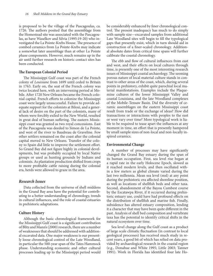
16 Shell Middens in the Grand Bay Estuary
be considerably enhanced by finer chronological con-trol. The present inadequacy has much to do simply with sample size—excavated samples from additional Late Woodland sites will begin to fill the typological gaps that presently exist, which in turn should aid in construction of a finer-scaled chronology. Addition-al absolute dates from critical time spans will further calibrate the coastal chronology.
The ebb and flow of cultural influences from east and west, and their effects on local cultures through time, is presently one of the most interesting research issues of Mississippi coastal archaeology. The seeming porous nature of local material culture stands in con-trast to other areas of the coast, which, during several points in prehistory, exhibit quite parochial local ma-terial manifestations. Examples include the Plaque-mine cultures of the lower Mississippi Valley and coastal Louisiana, and the late Woodland complexes of the Mobile-Tensaw Basin. Did the diversity of ce-ramic assemblages on the eastern Mississippi coast result from trade or the exchange of ideas? How did transactions or interactions with peoples to the east or west vary over time? More typological work is lia-ble to be required to tease apart the influences at any moment in time, an effort that is presently hampered by small sample sizes of non-local and non-locally in-spired ceramics.
Environmental ChangeA number of processes may have significantly
changed the Grand Bay estuary during the span of its human occupation. First, sea level rise began at a rapid rate in the early Holocene Epoch, slowed as it reached modern levels, and then oscillated with-in a few meters as global climate varied during the last two millennia. Mean sea level (msl) at any point during the prehistoric era affected shoreline position, as well as locations of shellfish beds and other taxa. Second, abandonment of the Bayou Cumbest course by the Escatawpa River, if it occurred during prehis-toric estuary use, could have had profound effects on the distribution of shellfish and marine fish. Finally, subsidence has altered estuary composition, lending it a character that may have been quite different in the past. Analysis of shell bed composition and vertebrate taxa has the potential to identify critical shifts in the natural ecosystem over time.
Sea level change along the Gulf coast as a product of large scale climatic fluctuation (in contrast to local geological processes) has received much study in re-cent years, a good bit of which has relied on data pro-vided by archaeological research in the coastal region (e.g., Donahue and White 1995; Little 2003; Tanner 1991). Work in Florida has identified four late Ho-
is proposed to be the village of the Pascagoulas, ca. 1726. The authors posited that the assemblage from the Homestead site was associated with the Pascagou-las, as have Waselkov and Silvia (1995:19-20) who in-vestigated the La Pointe-Krebs House. The presence of combed ceramics from La Pointe-Krebs may indicate a somewhat later assemblage than at other La Pointe phase components. However, much remains up in the air until further research on historic contact sites has been conducted.
The European Colonial PeriodThe Mississippi Gulf coast was part of the French
colony of Louisiane from 1699 until ceded to Britain in 1763. Early on, the seat of the French colony was twice located here, with an intervening period at Mo-bile. After 1720 New Orleans became the French colo-nial capital. French efforts to colonize the Mississippi coast were largely unsuccessful. Failure to provide ad-equate support for the colonists at Biloxi, and a gener-al lack of desire on the part of the colonists, many of whom were forcibly exiled to the New World, resulted in great deal of human suffering. The eastern Missis-sippi coast was granted as two royal concessions. East of the Pascagoula was deeded to Simon de La Pointe, and west of the river to Baudreau de Graveline. Few other settlers remained on the coast after the colonial capital moved to New Orleans. Transfer of the colo-ny to Spain did little to improve the settlement effort. So Grand Bay did not figure highly in colonial devel-opments, but was probably occupied by local Native groups or used as hunting grounds by Indians and colonists. As plantation production shifted from crops to more profitable cattle raising during the colonial era, herds were allowed to graze in the area.
Research IssuesData collected from the universe of shell middens
in the Grand Bay area have the potential for contrib-uting to a better understanding of chronology, trends in cultural influences, and the role of coastal estuaries in prehistoric adaptations.
Culture HistoryAlthough the basic chronological framework for
the Mississippi Gulf coast is a significant contribution of Blitz and Mann’s (2000) research, there are a number of weaknesses that should be addressed with addition-al excavated data. One major weakness is our present-ly loose chronological control of the Late Woodland, in particular the 500-year span of the Tates Hammock phase. Understanding economic and other cultural processes leading up to the Mississippi period would
Archaeological Report No. 37 17
would have been rivers and streams with entrenched valleys, only taking on the configuration of mean-dering streams as rising seas approximated modern levels. Bayou Cumbest may still have been the lower reaches of the Escatawpa River, which was building natural levees, following a well-defined meandering channel, and presumably building a river delta (which may in part be represented by the North and South Rigolets Islands, although there are presently no geo-logical data to evaluate this possibility). As long as this was the active meander belt of the Escatawpa, sedi-ment deposition would have been the primary alluvial process. Once the Escatawpa’s flow was captured by the Pascagoula—Eleuterius (n.d.) suggests this was a mid-Holocene event—sediments of the prior mean-der belt would have begun to subside. Simultaneously rising sea levels would have encroached on prior sta-ble ground. This process continues to the present as marshes take over land that even in historic times sup-ported pine forests. Kennish (2001) estimates that the Grand Bay segment of the Gulf coast is losing 1.29 m/ year of land, due to natural and human agents. Given the dynamic interplay between local geomorphic pro-cesses and global fluctuations of sea level, the domi-nance of one over the other may best be evaluated by the archaeological evidence for occupation of Grand Bay sites. If sites were occupied during sea level trans-gressions on present-day elevations that would imply inundation, then at the time of occupation ground was indeed higher and subsidence had not yet preclud-ed occupation. Further, during low stands, when the shoreline would have had to be to the south of present day sites, tidal fluctuation and salinity may not have affected local streams to the extent they do today, and these may have hosted biological communities adapt-ed to low salinity levels.
locene sea level stands that deviate from modern sea levels (Figure 2-1). Sanibel I is a low stand occurring between 3000 and 2000 years BP at 30-60 cm below present-day msl. The Wulfert transgression marks a rise in level from 40-60 cm below msl to 70-137 cm above msl between 1850 and 1350 years BP. During the Buck Key regression from 1350-1100 years BP, sea level again dropped below present msl. The La Costa transgression raised seas again to near modern msl. A possible earlier transgression at 4200-3000 BP is suggested by sites of the Elliott Point complex in the panhandle of Florida that include shell middens that are as much as 800 m from the present shoreline and above 1.5 m in elevation (Little 2003). Assuming that shellfish processing occurred near the location of their harvest, Little concludes that a 1.5 m rise in sea level would account for their inland location.
These eustatic sea level fluctuations significantly impacted the character of Grand Bay, in particular in the distribution of dry land and marsh. During regressions present-day marshes would have been above tidal fluctuations and likely supported forests. Given the shallow depths of Mississippi Sound, shore line would have advanced seaward and subsurface features such as the Grand Batture Islands would have been above-the-tide landforms. Marshes would follow this pattern of advance. Sea level rise on the order of the Wulfert transgression would have inundated the present-day marsh system and moved the shoreline north, perhaps as far north as the Ford site (22JA564).
Projections regarding the effects of eustatic sea lev-el change are confounded by local geomorphological dynamics. The early Holocene shoreline would have been significantly further south, in what is now the sound. Present-day bayous that traverse the marsh
Figure 2-1. Late Holocene sea level fluctuations.

18 Shell Middens in the Grand Bay Estuary
One potentially significant alteration of prehistor-ic economies was the introduction of and increased commitment to crop cultivation. Blitz and Mann’s investigations of the Singing River site (Scarry 2000) produced evidence of maize in Pinola and Singing River phase deposits. So did the Mississippian D’Ol-ive Creek and Bottle Creek sites in Alabama (Knight 1984; Scarry 2000). On the other hand, a widespread assumption that Mississippi period coastal popula-tions relied more on foraging and less on agriculture than did their inland counterparts is based primarily on ethnohistoric accounts, not archaeology (Knight 1984; cf. Curren 1976). Knight’s review of ethnohis-toric information on the Mobile-Tomeh points to a mixed subsistence system that incorporated horticul-ture, hunting, fishing, and gathering-an adaptation perhaps more appropriate to the deltas of the Mobile River and other large systems, where annual flooding replenished soil fertility. Where agricultural plots be-came depleted of soil nutrients, shifting farmsteads may have precluded population nucleation as well as limited dependence on agriculture (Knight 1984:214). The immediate area of Grand Bay best fits the latter characterization, although the estuaries of Grand Bay may well have been used by populations who at other times occupied the lower reaches of the Pascagoula and Escatawpa rivers, where horticulture may have been more successful.
SummaryThe shell middens of Grand Bay offer a unique op-
portunity to examine prehistoric and early historic ad-aptations along the Mississippi Sound, by document-ing how site functions may have changed over time. In addition to shellfish gathering and processing, what other subsistence tasks were performed at these sites? Were these specialized procurement locations, or is there evidence of their temporary or long-term resi-dential use? What evidence is there for environmental change over the course of the Grand Bay occupation, either as a consequence of global climatic variation or as a product of local geomorphological processes that may have affected adaptive strategies? In addition to addressing these questions of adaptation, our project offers the opportunity to gauge the cultural influences affecting prehistoric populations living in a bound-ary area between two strong cultural traditions, that of the lower Mississippi Valley and coastal Louisiana to the west and the Mobile Bay to Florida panhandle to the east. How did these influences wax and wane over time? Finally, how were the shellfish collectors who used Grand Bay affected by broader cultural evo-lutionary processes, such as the spread of agriculture and the rise of Mississippian chiefdoms?
Sea level changes correlate to broad patterns of climate change. The Sanibel 1 regression occurred during a period of cooler temperature that corre-sponds to worldwide glacial advances. Onset of the Wulfert transgression is correlated with the Roman optimum, which began about 300 BC and lasted un-til about AD 300 (Gunn 1994). The Roman optimum was followed by the Vandal minimum, a time of cool-er worldwide temperatures that lasted until roughly AD 750 and was responsible for the Buck Key regres-sion. The La Costa transgression corresponds to the Medieval optimum, which lasted until AD 1200, and was followed by the Little Ice Age, a time of cooler and drier conditions. How these worldwide climatic shifts were manifested in local environmental conditions of the central Gulf coast is not well understood. Howev-er, while temperature declines of a just a few degrees may have resulted in significant glacial advance and more extensive polar ice, they would likely not have had wholesale impacts on local plant and animal com-munities.
Adaptation and the Grand Bay EstuaryA major research goal of the present project is to ex-
amine the roles these sites played as parts of a regional settlement system and how that system evolved over time. There is debate among coastal archaeologists re-garding the importance of shellfish as a resource rel-ative to other quarry. Shellfishing is the most visible aspect of the coastal prehistoric archaeological record, but what other estuarine resources played roles in prehistoric subsistence systems? As noted in Chapter 1, a wide range of aquatic, semi-aquatic, and terres-trial fauna were available in the Grand Bay environs. Issues for greater focus include the mix of available re-sources, the scheduling of procurement activities, and shifts in subsistence patterns over time. Site function is another area of research. How were shellfish collect-ing locations used, as short term camps, as seasonal camps by residential groups, or for focused procure-ment and processing locations used sporadically by special task groups whose residences were somewhere else? How might those patterns have changed over time? Knight (1984) characterized the shell middens of the Mobile Bay as “seasonal estuarine fishing en-campments,” although data from the Diamondhead midden to the west suggests that, at least for the Mis-sissippi period, the site served a much more focused extractive function, specializing in sea turtle as well as shellfish harvesting. Even the limited testing of these investigations can produce archaeological evidence of site structure, residential activities, length of occu-pation, and seasonality, which will help address how the shell middens of Grand Bay articulated with other sites of prehistoric settlement systems.

Grand Bay fieldwork in 2010 included a three-day reconnaissance in March and an eight-week mapping and testing program in June and July. This chapter describes fieldwork and details results of the summer fieldwork, as well as summarizing data collected in the spring reconnaissance.
Spring ReconnaissanceIn preparation for summer fieldwork, the Grand
Bay sites were visited on March 16-18, 2010, by a field party that included Jackson and Barbara Hester from USM and Jay Johnson, Eddie Henry, and John Cappleman from the University of Mississippi (UM) (Figures 3-1 and 3-2). Jay McIlwain of Grand Bay Na-tional Estuarine Research Reserve (NERR) served as our guide. We visited 14 previously recorded sites and two unrecorded sites, and collected GPS coordinates for each. Artifacts were observed on the ground sur-
face, but none were collected (Figures 3-3 and 3-4). In addition to gathering information about the general condition of the sites, at 22JA632, a site we planned on testing during the summer, Hester and I established an arbitrary datum designated N100E100, elevation 5 m (arbitrary), and gathered elevation data from the site. The resulting topographic map (Figure 3-5) indi-cates the considerable amount of reworking the site has experienced. The entire northern limits of the site appeared to consist of shell that had been redeposit-ed over the marsh. The UM team tested their remote sensing equipment there and at 22JA633.
Observations about the sites visited during this portion of the investigation are summarized in Table 3-1. With respect to site condition, nearly all of the sites have been compromised to some extent by tidal action and boat wake erosion. There was large-scale damage, presumably from large-scale storm surges, the latest being associated with Hurricane Katrina.
Chapter 3 Field Investigations
by H. Edwin Jackson
Figure 3-1. March 2010 reconnaissance at 22JA576 on North Rigolets Island. Note reworked shell.
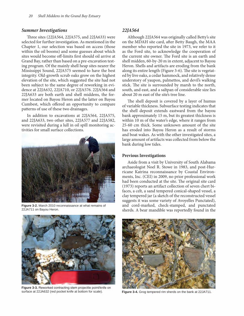
20 Shell Middens in the Grand Bay Estuary
22JA564Although 22JA564 was originally called Betty’s site
on the MDAH site card, after Betty Baugh, the MAA member who reported the site in 1973, we refer to it as the Ford site, to acknowledge the cooperation of the current site owner. The Ford site is an earth and shell midden, 60-by-20 m in extent, adjacent to Bayou Heron. Shells and artifacts are eroding from the bank along its entire length (Figure 3-6). The site is vegetat-ed by live oaks, a cedar hammock, and relatively dense understory of yaupon, palmettos, and devil’s walking stick. The site is surrounded by marsh to the north, south, and east, and a saltpan of considerable size lies about 20 m east of the site’s tree line.
The shell deposit is covered by a layer of humus of variable thickness. Subsurface testing indicates that the shell deposit extends eastward from the bayou bank approximately 15 m, but its greatest thickness is within 10 m of the water’s edge, where it ranges from 25-60 cm thick. Some unknown amount of the site has eroded into Bayou Heron as a result of storms and boat wakes. As with the other investigated sites, a large amount of artifacts was collected from below the bank during low tides.
Previous InvestigationsAside from a visit by University of South Alabama
archaeologist Noel R. Stowe in 1983, and post-Hur-ricane Katrina reconnaissance by Coastal Environ-ments, Inc. (CEI) in 2009, no prior professional work had been conducted at the site. The original site card (1973) reports an artifact collection of seven chert bi-faces, a celt, a sand tempered conical-shaped vessel, a clay tempered jar (a sketch of the reconstructed vessel suggests it was some variety of Avoyelles Punctated), and cord-marked, check-stamped, and punctated sherds. A bear mandible was reportedly found in the
Summer InvestigationsThree sites (22JA564, 22JA575, and 22JA633) were
selected for further investigation. As mentioned in the Chapter 1, our selection was based on access (those within the oil booms) and some guesses about which sites would become off-limits first should oil arrive at Grand Bay, rather than based on a pre-excavation test-ing program. Of the mainly shell heap sites nearer the Mississippi Sound, 22JA575 seemed to have the best integrity. Old-growth scrub oaks grow on the highest elevation of the site, which suggested the site had not been subject to the same degree of reworking in evi-dence at 22JA632, 22JA710, or 22JA576. 22JA564 and 22JA633 are both earth and shell middens, the for-mer located on Bayou Heron and the latter on Bayou Cumbest, which offered an opportunity to compare patterns of use of these two drainages.
In addition to excavations at 22JA564, 22JA575, and 22JA633, two other sites, 22JA577 and 22JA582, were revisited during a lull in oil spill monitoring ac-tivities for small surface collections.
Figure 3-3. Reworked contracting stem projectile point/knife on surface at 22JA632 (red pocket knife at bottom for scale).
Figure 3-2. March 2010 reconnaissance at what remains of 22JA711 on Bayou Heron.
Figure 3-4. Grog tempered rim sherds on the bank at 22JA711.

Archaeological Report No. 37 21
Table 3-1. Sites Visited during Three-Day Reconnaissance.
Site Name Condition Artifacts Noted
22JA562 Largely gone; a few scattered shells in the marsh grass
22JA564 Betty’s Site; Ford Intact; vegetated by hardwoods and herbaceous taxaMarksville Stamped, Mulberry Creek Cord Marked, fine shell/sand sherd with fine incised lines, undeco-rated shell tempered sherds
22JA575 Crooked Bayou I Reworked shell; sparse vegetation along landward side of midden and sparse shrubs elsewhere on midden
Undecorated shell tempered sherds, historic ceram-ics and glass
22JA576 Rigolets 1 Reworked and storm-sorted shell Undecorated grog tempered sherd, sandstone bowl fragment
22JA580 Isle Chaude I Undecorated grog tempered sherd
22JA581 Isle Chaude II Marksville Stamped, Pontchartrain Check Stamped
22JA582 Isle Chaude IIII Undecorated shell tempered sherds
22JA587 Crooked Bayou II Wakulla Check Stamped sherd
22JA632 Bangs Island Badly damaged by storm and erosion; no vegetationMarksville Incised, Mound Place Incised, Baytown Plain sherds, undecorated shell tempered sherds, Gary Point
22JA633 Kenny’s Island Intact; heavily wooded with hardwoods, cedar, under-story and herbaceous taxa
Mound Place Incised, undecorated shell tempered sherds, deer astragalus
22JA634 Destroyed; scattered shell at marsh level Undecorated grog tempered sherds
22JA710 Significant reworking of shell Undecorated sand tempered sherds, undecorated shell tempered sherds, two deer astragali
22JA711 Sparse scatter of shell at marsh level Undecorated shell tempered, grog tempered sherds
22JA770 Mulberry Creek Cord Marked sherd
31710-1 Undecorated grog tempered sherd
AL-1 Port Dauphin Incised, undecorated grog tempered sherd, contracting stem projectile point
Figure 3-5. Topographic map of 22JA632, Bangs Island.
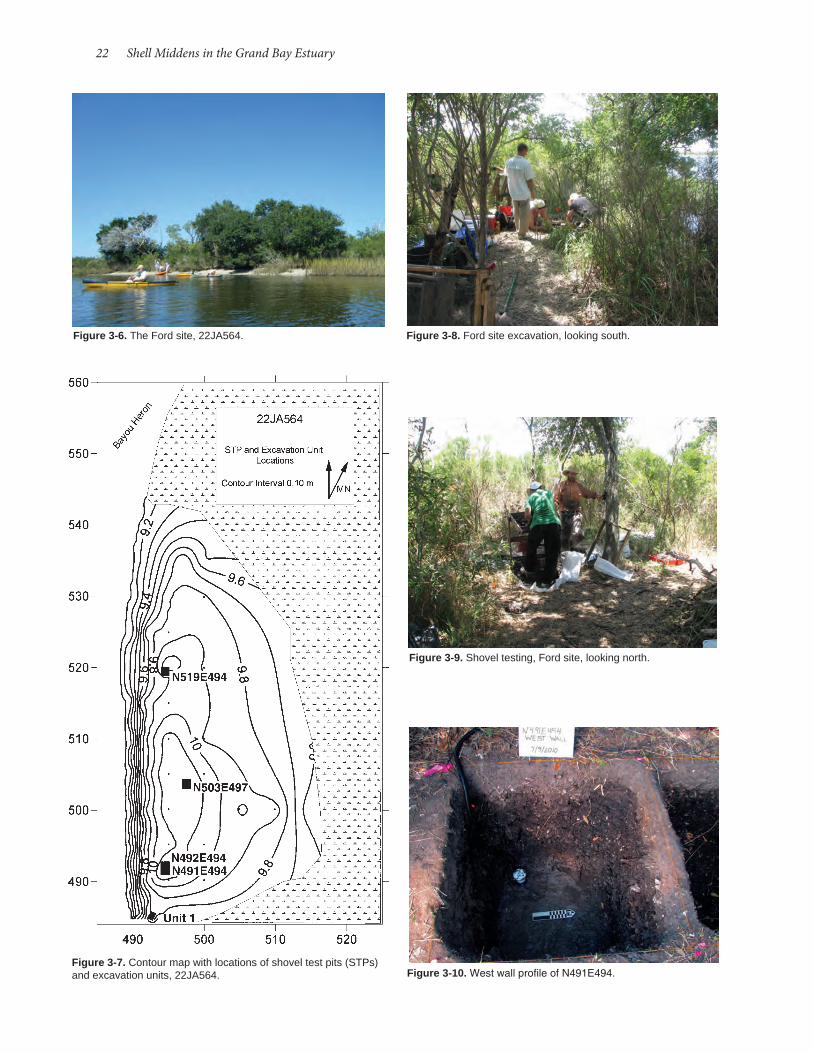
22 Shell Middens in the Grand Bay Estuary
Figure 3-7. Contour map with locations of shovel test pits (STPs) and excavation units, 22JA564.
Figure 3-6. The Ford site, 22JA564.
Figure 3-10. West wall profile of N491E494.
Figure 3-9. Shovel testing, Ford site, looking north.
Figure 3-8. Ford site excavation, looking south.

Archaeological Report No. 37 23
These corners provided mapping points. The western edge of the unit was the waterline.
N491E494, N492E494These units began with excavation of N492E494. In
Levels 2 and 3, a relatively dense deposit of faunal ma-terial was encountered associated with ceramics that strongly suggested a Late Woodland Tates Hammock phase occupation surface. N491E394 was excavated to increase our sample of this deposit, but in doing so we encountered an intrusive Mississippian feature (Fea-ture 1). N492E494 was excavated to a depth of 60 cm, while N491E494 was excavated to a depth of 75 cm, at which point the water table prevented further excava-tion. Stratigraphy consisted here of a top layer, from ground surface to 10-15 cm below surface (cmbs) of organic humus (10YR4/1); from 10-15 cmbs to 40-55 cmbs a lens of compact shell deposit in an organic ma-trix (10YR2/1); and from 40-55 cmbs to the base of excavation an organic stratum lacking shell (10YR5/1) (Figures 3-10 and 3-11).
N503E497N503E497 was excavated to 66 cmbs, the point at
which the water table prevented further excavation. Stratigraphy exposed by the unit consisted of a humic topsoil (10YR3/2) from the ground surface to 10-20 cmbs; a shell deposit in an organic matrix from 10-20 cmbs to 50-60 cmbs; and an underlying relatively shell free silt (10YR4/1-10YR4/2) to the base of excava-tion (Figures 3-12 and 3-13). The shell deposit in this area of the site is variable in shell density with lenses of lighter density of a sediment matrix interspersed through more compact shell. Shell density was nota-bly lighter in Level 4 near the base of the shell deposit.
vicinity of a burial that was apparently washing out of the bank. Stowe updated the MDAH records in 1983, reporting additional ceramic types, including French Fork Incised, Ponchartrain Incised (?), Carrabelle Incised, Weeden Island Plain, Baytown Plain, Bell Plain, and Mississippi Plain. The collections appear to represent Late Woodland and Mississippian occu-pations. University of South Alabama was contacted to examine the Stowe collection, but the collection is not housed there. Only Baytown Plain is identified as having been retrieved during the CEI site visit (Bou-dreaux 2009: Appendix 1).
Present InvestigationsA grid was established from an arbitrarily placed
N500E500 datum with an arbitrary elevation of 10 m, and the north-south baseline aligned 30° west of magnetic north. The site was mapped and shov-el test pits (STPs) were excavated at 5-m intervals along the north-south baseline between N490E500 and N530E500, and on a second transect on the east 495 line from N490E495 and N525E495 (Figure 3-7). Two additional STPs were excavated at N500E505 and N500E510, beyond the margins of cultural deposits and adjacent to the marsh.
Based on the STPs, three 1.0-by-1.0-m units were set in, with southwest corner grid locations at N491E494, N519E494, and N503E497 (Figures 3-8 and 3-9). N491E494 was extended 50 cm northward (N492E550) to delineate a feature. In addition, an off-grid unit, Unit 1, was placed on the bank edge to pro-vide control for removing what remained of a bundle burial exposed by wave action. The grid location for the northeast corner of this unit was N485.40E492.54 and that for the southeast corner was N484.53E492.06.
Figure 3-11. East and north profiles, N491E494.
22JA564 N491E494 East Profile
22JA564 N491E494 North Profile
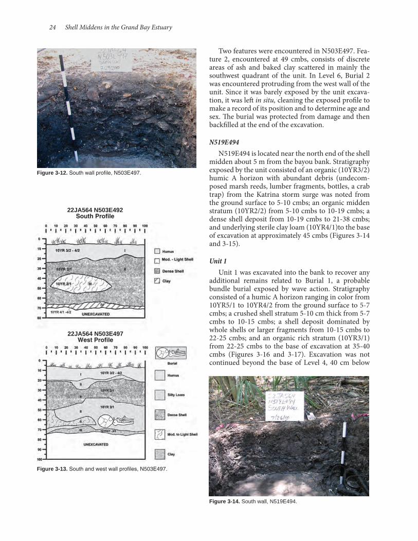
24 Shell Middens in the Grand Bay Estuary
Two features were encountered in N503E497. Fea-ture 2, encountered at 49 cmbs, consists of discrete areas of ash and baked clay scattered in mainly the southwest quadrant of the unit. In Level 6, Burial 2 was encountered protruding from the west wall of the unit. Since it was barely exposed by the unit excava-tion, it was left in situ, cleaning the exposed profile to make a record of its position and to determine age and sex. The burial was protected from damage and then backfilled at the end of the excavation.
N519E494N519E494 is located near the north end of the shell
midden about 5 m from the bayou bank. Stratigraphy exposed by the unit consisted of an organic (10YR3/2) humic A horizon with abundant debris (undecom-posed marsh reeds, lumber fragments, bottles, a crab trap) from the Katrina storm surge was noted from the ground surface to 5-10 cmbs; an organic midden stratum (10YR2/2) from 5-10 cmbs to 10-19 cmbs; a dense shell deposit from 10-19 cmbs to 21-38 cmbs; and underlying sterile clay loam (10YR4/1)to the base of excavation at approximately 45 cmbs (Figures 3-14 and 3-15).
Unit 1Unit 1 was excavated into the bank to recover any
additional remains related to Burial 1, a probable bundle burial exposed by wave action. Stratigraphy consisted of a humic A horizon ranging in color from 10YR5/1 to 10YR4/2 from the ground surface to 5-7 cmbs; a crushed shell stratum 5-10 cm thick from 5-7 cmbs to 10-15 cmbs; a shell deposit dominated by whole shells or larger fragments from 10-15 cmbs to 22-25 cmbs; and an organic rich stratum (10YR3/1) from 22-25 cmbs to the base of excavation at 35-40 cmbs (Figures 3-16 and 3-17). Excavation was not continued beyond the base of Level 4, 40 cm below
Figure 3-12. South wall profile, N503E497.
Figure 3-13. South and west wall profiles, N503E497.
Figure 3-14. South wall, N519E494.
22JA564 N503E492 South Profile
22JA564 N503E497 West Profile
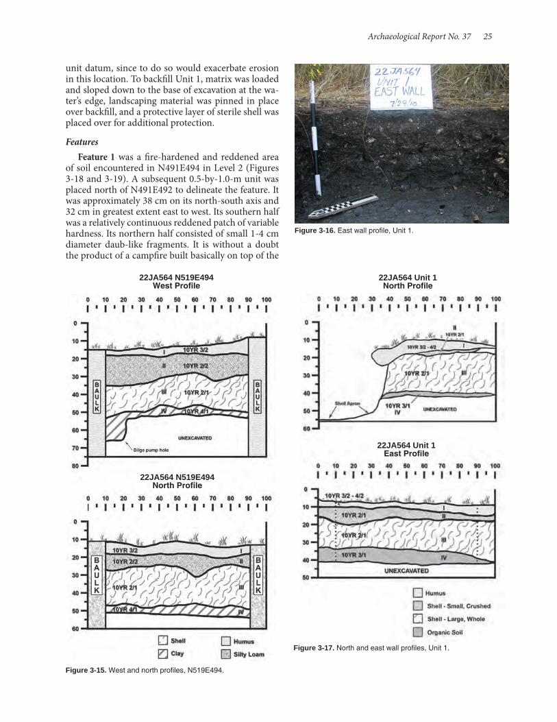
Archaeological Report No. 37 25
Figure 3-15. West and north profiles, N519E494.
unit datum, since to do so would exacerbate erosion in this location. To backfill Unit 1, matrix was loaded and sloped down to the base of excavation at the wa-ter’s edge, landscaping material was pinned in place over backfill, and a protective layer of sterile shell was placed over for additional protection.
FeaturesFeature 1 was a fire-hardened and reddened area
of soil encountered in N491E494 in Level 2 (Figures 3-18 and 3-19). A subsequent 0.5-by-1.0-m unit was placed north of N491E492 to delineate the feature. It was approximately 38 cm on its north-south axis and 32 cm in greatest extent east to west. Its southern half was a relatively continuous reddened patch of variable hardness. Its northern half consisted of small 1-4 cm diameter daub-like fragments. It is without a doubt the product of a campfire built basically on top of the
Figure 3-16. East wall profile, Unit 1.
Figure 3-17. North and east wall profiles, Unit 1.
22JA564 Unit 1 North Profile
22JA564 Unit 1 East Profile
22JA564 N519E494 West Profile
22JA564 N519E494 North Profile

26 Shell Middens in the Grand Bay Estuary
shell deposit, heat from which baked underlying soil. A whiteware sherd recovered from near its base sug-gests that it was a historic feature and probably a result of the commonly occurring recreational camping that occurs on the Grand Bay shell middens.
Feature 2 consisted of a patchy concentration of ash and fire hardened soil encountered at 49 cmbs in N503E497. Although comprised of several areas of ash and baked clay, it was mainly located in the south-west quadrant of the unit. It covered an area approxi- mately 70 cm north-south by 65 cm east-west and was approximately 4 cm thick. Dominant Munsell colors are 10YR4/3 (matrix and ash) and 2.5YR4/6 (baked soil). It is interpreted as a hearth (Figure 3-20).
Burial 1 consisted of exposed bones in the bank side of the site. Excavation into the in situ shell de-posit was conducted to ensure all remaining human remains were collected. Some elements were collected from below the waterline, indicating the likelihood that a significant portion of the burial had already been winnowed from its original burial location.
Burial 2 was an extended supine burial, with hands placed under the head. The head was to the south and face to the west. Osteological markers observed in the field indicate the skeleton is a young adult with grac-ile features, possibly a female. No trauma or negative health or nutritional markers were observed.
22JA57522JA575 is a shell heap comprised primarily of
oyster, approximately 300 m long and 40 m wide at its broadest point near the center, that forms a cres-cent-shaped deposit along the bank of Crooked Bay-ou where it and the North Rigolets meet and flow south toward the Sound through Jose Bay (Figure 3-21). The site has undergone some disturbance due to erosion from boat traffic, but most notably the tidal surge associated with Hurricane Katrina and perhaps earlier hurricanes (Figures 3-22 and 3-23). However, the persistence of several scrub trees on the midden suggested that some portions might remain intact, and clearly the site was less completely damaged com-pared with more seaward sites, such as Bangs Island (22JA632). On higher elevations of the site, size-sort-ed shell appeared to blanket underlying deposits, pos-sibly protecting the latter. In the context of the BP oil spill in 2010, 22JA575 was the most seaward of the shell middens available for examination, and since its integrity was in question (see below) it was deemed appropriate to evaluate its condition with minimal testing.
Previous InvestigationsThe site had been examined in a site evaluation
conducted by C. Baxter Mann for the US Fish and Wildlife Service (Mann 1996). Mann created a topo-graphic map of the site and excavated auger borings at 10-m intervals to determine shell deposit depth.
Figure 3-18. Feature 1 at 20 cmbs, exposed in northwest corner of N491E494.
Figure 3-19. Plan view of Feature 1, N491E494 and N492E494. Figure 3-20. Feature 2, N503E497 (light ashy areas left of scale).
22JA564 Plan View N491E494 and N492E494

Archaeological Report No. 37 27
Based on what appeared to be wave-sorted shells on the surface of the site and the recovery of eroded sherds from the auger holes, Mann concluded that the site likely had been redeposited northward into the marsh. However, he implied that auger testing may have been insufficient to make this determination, stating, “if this [redeposition] is in fact the case, site 22JA575 would not be eligible for the National Reg-ister of Historic Places.” Artifacts collected indicate site use during the Late Woodland (Tates Hammock phase), Middle Mississippi (Singing River phase), and Protohistoric (Bear Point phase) periods. Diagnostic ceramics included Baytown Plain, Mulberry Creek Cord Marked, Cracker Road Incised, Pensacola In-cised, vars. Gasque and Perdido Bay, and Weeden Is-land Plain.
More recently archaeologists from Coastal Envi-ronments, Inc., visited the site as part of a post-Hur-ricane Katrina site evaluation when fieldwork was conducted across the coast in 2006 and 2007. Little to no subsurface investigations were conducted; rather, general site condition was evaluated and grab samples of exposed artifacts collected (Boudreaux 2009). Ce-ramics retrieved during the visit included Alligator In-cised, Baytown Plain, Mulberry Creek Cord Marked, Pontchartrain Check Stamped, Mississippi Plain, and Pensacola Incised, corroborating Mann’s assessment of chronological associations of the site.
Present InvestigationsSite investigations were conducted from June 9
though June 23, with additional trips to the site, notably on July 19 to complete lower levels of excavations. A datum (N500E500, arbitrary elevation 10 m) was set near the center of the length of the midden and a baseline was set out. A topographic map was made of the site, using the total station (Figure 3-24). Nine STPs were excavated, including a line that served to provide a transect across the width of the midden and along the top of the midden (Figure 3-25). The latter were judgmentally placed along the crest of the midden, and then plotted with the total station; hence their irregular grid locations. STPs ranged in depth from 85 to 120 cm, with excavation stopped at the point at which the water table prevented further excavation, most often because the sides of the STPs began collapsing into the excavated hole. Matrix from STPs was screened through ¼-inch mesh hardware cloth. Oyster shell and shell fragments were discarded and the remaining material was retained.
Based on the STPs it was determined that two areas had the greatest potential for excavating apparently intact deposits and two 1.0-by-1.0-m units were excavated, one in each of these areas (Figure 3-26).
Figure 3-21. 22JA575, Crooked Bayou I site, looking north.
Figure 3-22. Large, mainly whole shell on surface near water's edge.
Figure 3-23. Fragmentary shell upslope from area in Figure 3-22.
N505E506N505E506 was excavated to 80 cm, at which point
the water level even at lowest tide and using two small bilge pumps, precluded further excavation. Therefore, the lowest level of the shell deposit was not reached. A bucket auger was used to estimate the depth of the deposit below the excavation floor; the shell extends another 31 cm in this location.

28 Shell Middens in the Grand Bay Estuary
Figure 3-24. Topographic map of 22JA575, Crooked Bayou I.
Figure 3-25. Shovel testing, Crooked Bayou I site.
Figure 3-26. "Water-screening" 0.23 cm (⅛ in.) fraction, 22JA575. Figure 3-27. North wall profile, N505E506.
The stratigraphy exposed in the unit is relatively simple (Figures 3-27 and 3-28). Stratum I from the ground surface to 11-18 cm was dense crushed shell that appears to be size-sorted. Below this to approxi-mately 60 cm, Stratum II is primarily whole shells in an earth and crushed shell matrix. From 60 cm to the base of excavation is densely packed, primarily whole shell that lacks encasing matrix due to the winnowing effects of tidal rise and fall.
N495E478N495E478 was excavated to a depth of 100 cm, at
which point the water table prevented further excava-tion. A bucket auger was used to estimate the depth of the shell deposit. In this unit, incoming water caused the unit sides to slide onto the excavation floor, mak-
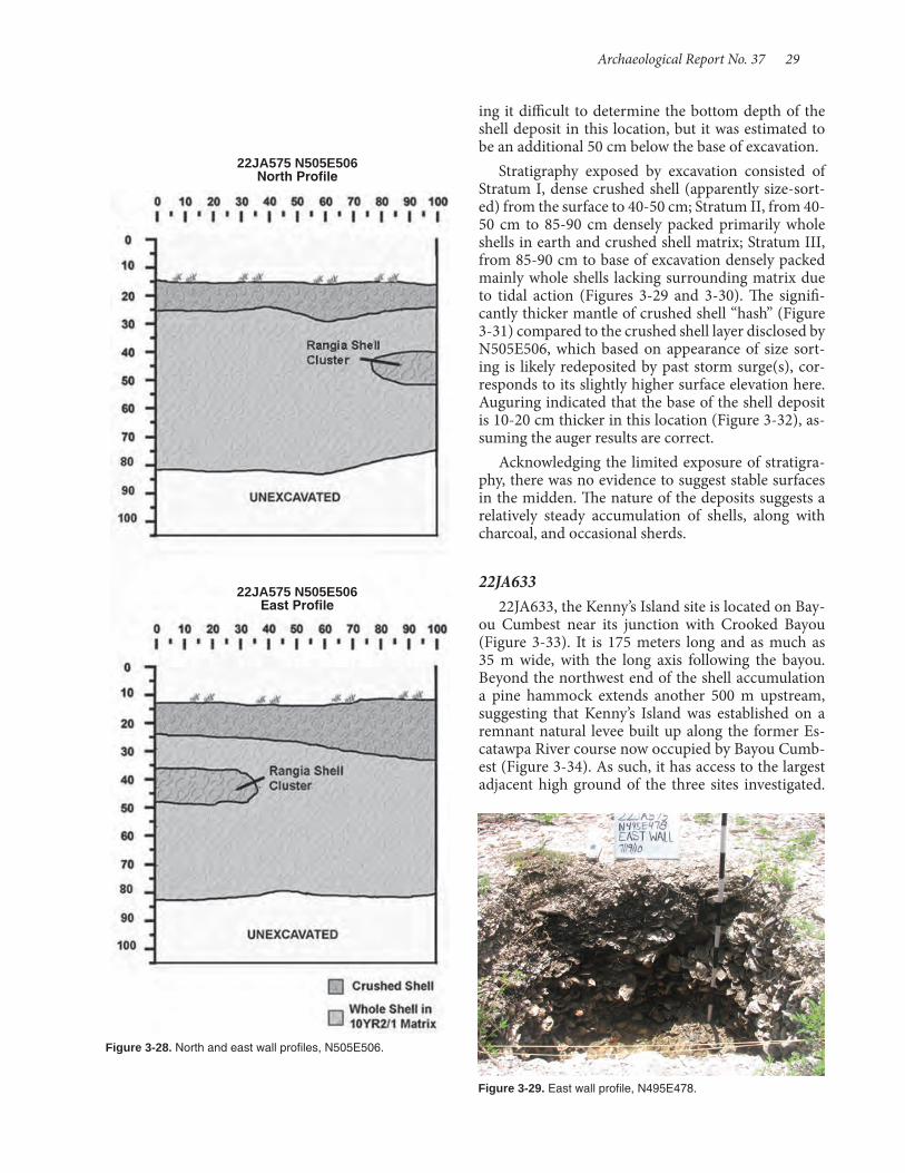
Archaeological Report No. 37 29
ing it difficult to determine the bottom depth of the shell deposit in this location, but it was estimated to be an additional 50 cm below the base of excavation.
Stratigraphy exposed by excavation consisted of Stratum I, dense crushed shell (apparently size-sort-ed) from the surface to 40-50 cm; Stratum II, from 40-50 cm to 85-90 cm densely packed primarily whole shells in earth and crushed shell matrix; Stratum III, from 85-90 cm to base of excavation densely packed mainly whole shells lacking surrounding matrix due to tidal action (Figures 3-29 and 3-30). The signifi-cantly thicker mantle of crushed shell “hash” (Figure 3-31) compared to the crushed shell layer disclosed by N505E506, which based on appearance of size sort-ing is likely redeposited by past storm surge(s), cor-responds to its slightly higher surface elevation here. Auguring indicated that the base of the shell deposit is 10-20 cm thicker in this location (Figure 3-32), as-suming the auger results are correct.
Acknowledging the limited exposure of stratigra-phy, there was no evidence to suggest stable surfaces in the midden. The nature of the deposits suggests a relatively steady accumulation of shells, along with charcoal, and occasional sherds.
22JA63322JA633, the Kenny’s Island site is located on Bay-
ou Cumbest near its junction with Crooked Bayou (Figure 3-33). It is 175 meters long and as much as 35 m wide, with the long axis following the bayou. Beyond the northwest end of the shell accumulation a pine hammock extends another 500 m upstream, suggesting that Kenny’s Island was established on a remnant natural levee built up along the former Es-catawpa River course now occupied by Bayou Cumb-est (Figure 3-34). As such, it has access to the largest adjacent high ground of the three sites investigated.
Figure 3-28. North and east wall profiles, N505E506.
Figure 3-29. East wall profile, N495E478.
22JA575 N505E506 North Profile
22JA575 N505E506 East Profile
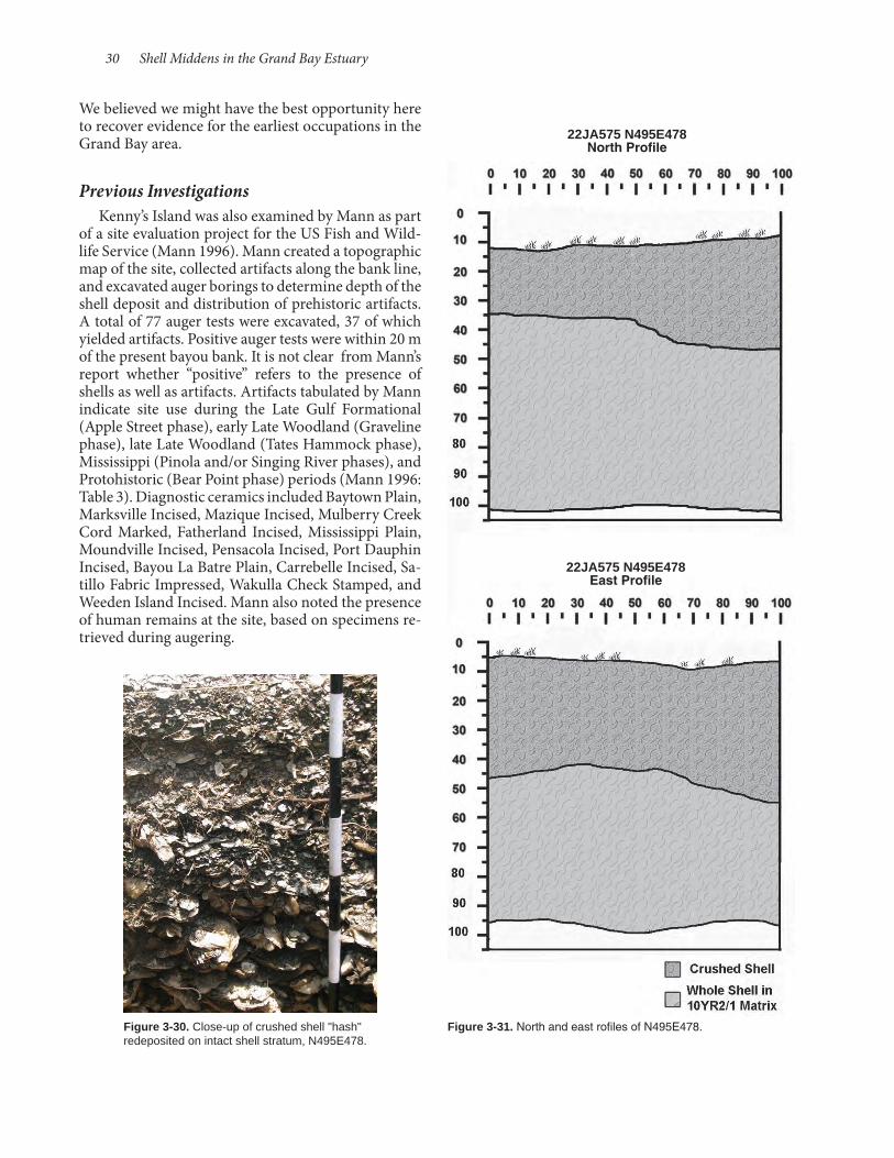
30 Shell Middens in the Grand Bay Estuary
We believed we might have the best opportunity here to recover evidence for the earliest occupations in the Grand Bay area.
Previous InvestigationsKenny’s Island was also examined by Mann as part
of a site evaluation project for the US Fish and Wild-life Service (Mann 1996). Mann created a topographic map of the site, collected artifacts along the bank line, and excavated auger borings to determine depth of the shell deposit and distribution of prehistoric artifacts. A total of 77 auger tests were excavated, 37 of which yielded artifacts. Positive auger tests were within 20 m of the present bayou bank. It is not clear from Mann’s report whether “positive” refers to the presence of shells as well as artifacts. Artifacts tabulated by Mann indicate site use during the Late Gulf Formational (Apple Street phase), early Late Woodland (Graveline phase), late Late Woodland (Tates Hammock phase), Mississippi (Pinola and/or Singing River phases), and Protohistoric (Bear Point phase) periods (Mann 1996: Table 3). Diagnostic ceramics included Baytown Plain, Marksville Incised, Mazique Incised, Mulberry Creek Cord Marked, Fatherland Incised, Mississippi Plain, Moundville Incised, Pensacola Incised, Port Dauphin Incised, Bayou La Batre Plain, Carrebelle Incised, Sa-tillo Fabric Impressed, Wakulla Check Stamped, and Weeden Island Incised. Mann also noted the presence of human remains at the site, based on specimens re-trieved during augering.
Figure 3-30. Close-up of crushed shell "hash" redeposited on intact shell stratum, N495E478.
Figure 3-31. North and east rofiles of N495E478.
22JA575 N495E478 North Profile
22JA575 N495E478 East Profile
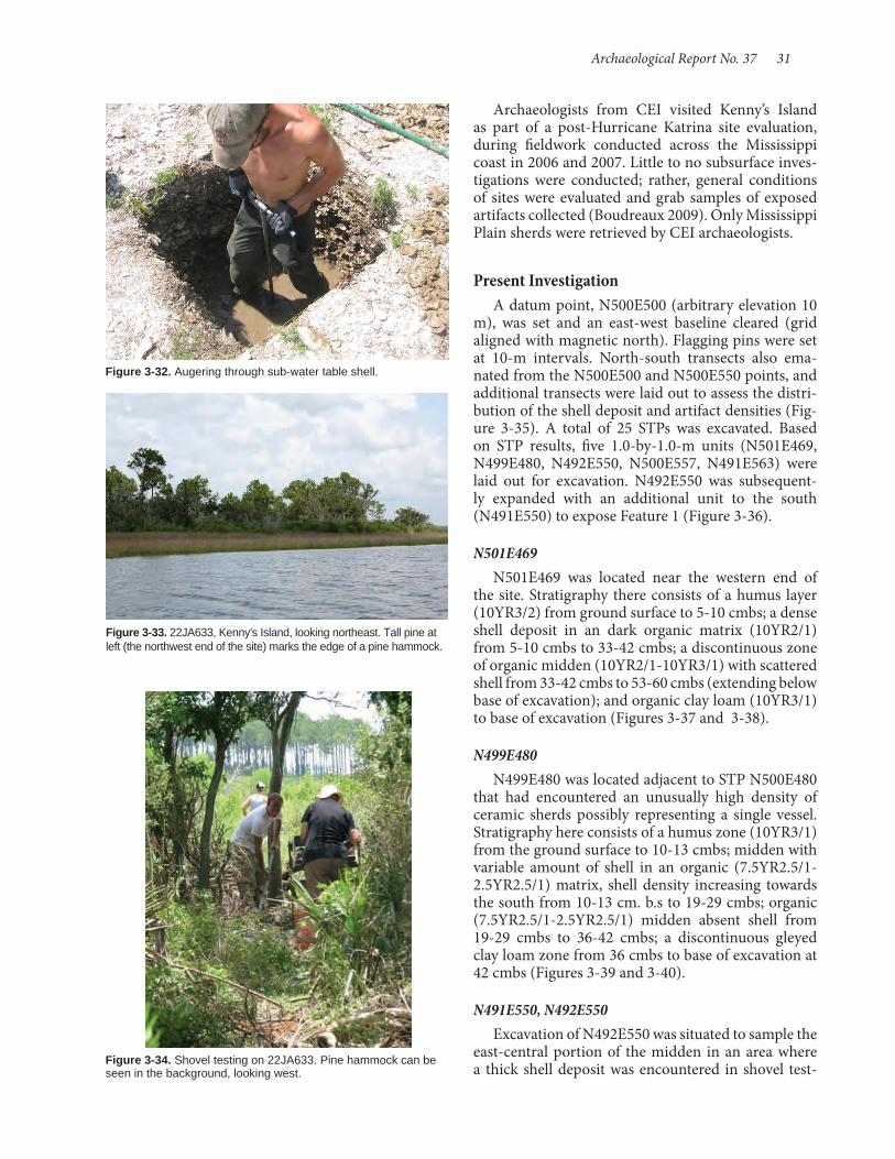
Archaeological Report No. 37 31
Archaeologists from CEI visited Kenny’s Island as part of a post-Hurricane Katrina site evaluation, during fieldwork conducted across the Mississippi coast in 2006 and 2007. Little to no subsurface inves-tigations were conducted; rather, general conditions of sites were evaluated and grab samples of exposed artifacts collected (Boudreaux 2009). Only Mississippi Plain sherds were retrieved by CEI archaeologists.
Present InvestigationA datum point, N500E500 (arbitrary elevation 10
m), was set and an east-west baseline cleared (grid aligned with magnetic north). Flagging pins were set at 10-m intervals. North-south transects also ema-nated from the N500E500 and N500E550 points, and additional transects were laid out to assess the distri-bution of the shell deposit and artifact densities (Fig-ure 3-35). A total of 25 STPs was excavated. Based on STP results, five 1.0-by-1.0-m units (N501E469, N499E480, N492E550, N500E557, N491E563) were laid out for excavation. N492E550 was subsequent-ly expanded with an additional unit to the south (N491E550) to expose Feature 1 (Figure 3-36).
N501E469N501E469 was located near the western end of
the site. Stratigraphy there consists of a humus layer (10YR3/2) from ground surface to 5-10 cmbs; a dense shell deposit in an dark organic matrix (10YR2/1) from 5-10 cmbs to 33-42 cmbs; a discontinuous zone of organic midden (10YR2/1-10YR3/1) with scattered shell from 33-42 cmbs to 53-60 cmbs (extending below base of excavation); and organic clay loam (10YR3/1) to base of excavation (Figures 3-37 and 3-38).
N499E480N499E480 was located adjacent to STP N500E480
that had encountered an unusually high density of ceramic sherds possibly representing a single vessel. Stratigraphy here consists of a humus zone (10YR3/1) from the ground surface to 10-13 cmbs; midden with variable amount of shell in an organic (7.5YR2.5/1-2.5YR2.5/1) matrix, shell density increasing towards the south from 10-13 cm. b.s to 19-29 cmbs; organic (7.5YR2.5/1-2.5YR2.5/1) midden absent shell from 19-29 cmbs to 36-42 cmbs; a discontinuous gleyed clay loam zone from 36 cmbs to base of excavation at 42 cmbs (Figures 3-39 and 3-40).
N491E550, N492E550Excavation of N492E550 was situated to sample the
east-central portion of the midden in an area where a thick shell deposit was encountered in shovel test-
Figure 3-32. Augering through sub-water table shell.
Figure 3-33. 22JA633, Kenny's Island, looking northeast. Tall pine at left (the northwest end of the site) marks the edge of a pine hammock.
Figure 3-34. Shovel testing on 22JA633. Pine hammock can be seen in the background, looking west.
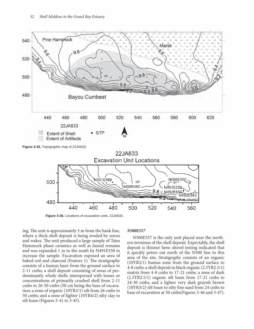
32 Shell Middens in the Grand Bay Estuary
Figure 3-35. Topographic map of 22JA633.
Figure 3-36. Locations of excavation units, 22JA633.
ing. The unit is approximately 5 m from the bank line, where a thick shell deposit is being eroded by waves and wakes. The unit produced a large sample of Tates Hammock phase ceramics as well as faunal remains and was expanded 1 m to the south by N491E550 to increase the sample. Excavation exposed an area of baked soil and charcoal (Feature 1). The stratigraphy consists of a humus layer from the ground surface to 2-11 cmbs; a shell deposit consisting of areas of pre-dominantly whole shells interspersed with lenses or concentrations of primarily crushed shell from 2-11 cmbs to 26-50 cmbs (50 cm being the base of excava-tion; a zone of organic (10YR3/1) silt from 26 cmbs to 50 cmbs; and a zone of lighter (10YR4/2) silty clay to silt loam (Figures 3-41 to 3-45).
N500E557N500E557 is the only unit placed near the north-
ern terminus of the shell deposit. Expectably, the shell deposit is thinner here; shovel testing indicated that it quickly peters out north of the N500 line in this area of the site. Stratigraphy consists of an organic (10YR2/1) humus zone from the ground surface to 4-8 cmbs; a shell deposit in black organic (2.5YR2.5/1) matrix from 4-8 cmbs to 17-21 cmbs; a zone of dark (2.5YR2.5/1) organic silt loam from 17-21 cmbs to 24-30 cmbs; and a lighter very dark grayish brown (10YR3/2) silt loam to silty fine sand from 24 cmbs to base of excavation at 30 cmbs(Figures 3-46 and 3-47).
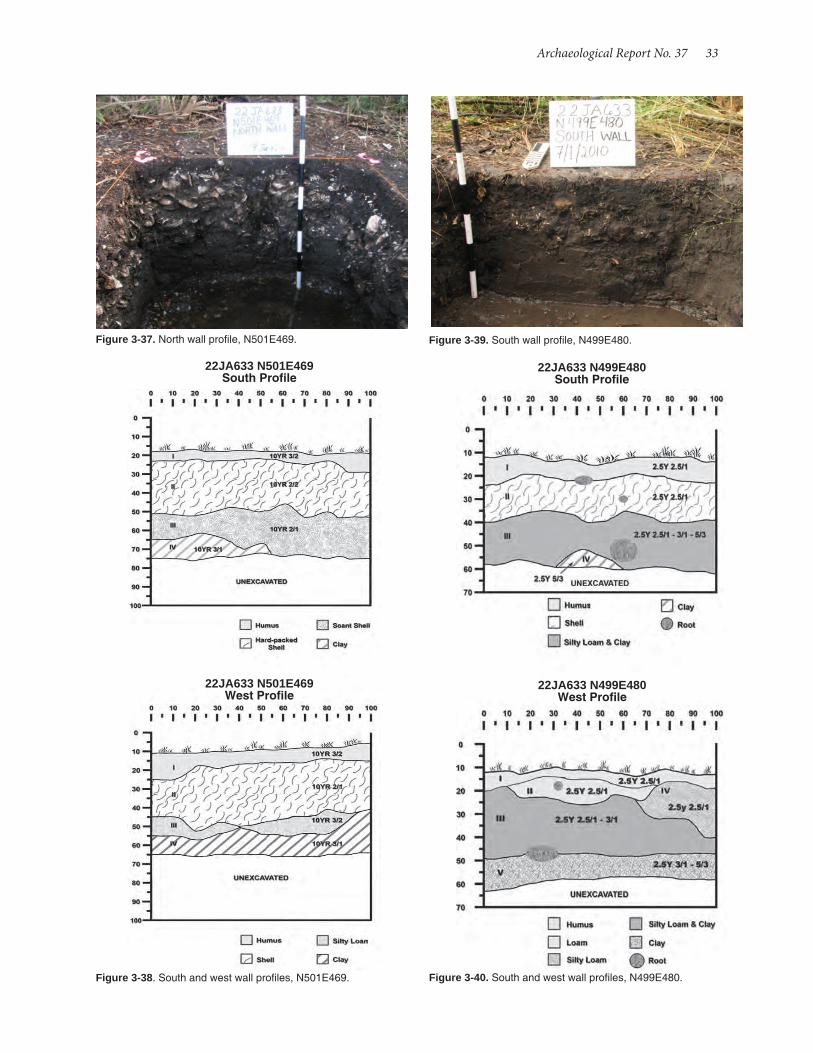
Archaeological Report No. 37 33
Figure 3-37. North wall profile, N501E469.
Figure 3-38. South and west wall profiles, N501E469.
Figure 3-39. South wall profile, N499E480.
Figure 3-40. South and west wall profiles, N499E480.
22JA633 N501E469 South Profile
22JA633 N501E469 West Profile
22JA633 N499E480 South Profile
22JA633 N499E480 West Profile

34 Shell Middens in the Grand Bay Estuary
N491E563N491E563 tested one of the deepest shell deposits
on the site, based on our STP results. Shell appears just below a thin surface humus and extends to 45 cmbs Stratigraphy consists of an organic very dark grayish brown (10YR3/2) humus zone from the surface to 2-3 cmbs; a dense shell layer with a very dark grayish brown (10YR3/2) silty matrix from 2-3 cmbs to 8-15 cmbs; dense shell in a organic black (10YR2/1) silty matrix from 8-15 cmbs to 40-43 cmbs, a silty clay dark grayish brown (10YR3/3) stratum lacking significant shell from 40-43 cmbs to 55-58 cmbs; and a grayish brown (10YR6/4) clay stratum from 55-58 cmbs to base of excavation (Figures 3-48 and 3-49).
FeaturesFeature 1 appeared as an area of heat-reddened
baked soil and associated charcoal at 27-30 cmbs in N491E550 (Figure 3-50). To determine the extent of the midden a bucket auger was used to core at 50-cm intervals east and west on the grid line N491.50 and
Figure 3-41. East wall profile of N491E550 and N492E550.
Figure 3-42. South wall profile, N491E550, with Feature 1 ex-posed in profile.
Figure 3-43. East wall profile, N491E550 and N492E550.
Figure 3-44. North wall profile, N492E550.
Figure 3-45. South wall profile, N491E550.
22JA633 N491E550 and N492E550 East Profile
22JA633 N492E550 North Profile
22JA633 N491E550 South Profile

Archaeological Report No. 37 35
south on the grid line at E550.50. Coring was able to discern the heat reddened surface, and determined that Feature 1 is approximately 2 m in diameter. The feature is interpreted as a roasting facility associated with shellfish processing. Associated ceramics and a radiocarbon date indicate that it is Mississippian in age, intruding into an underlying late Woodland de-posit (Figures 3-51 to 3-53).
Feature 2 was encountered at 50 cmbs in the east half of N501E469 (Figure 3-54). It consisted of an area of baked clay and associated charcoal that measured 30 by 40+ cm and extended eastward beyond the lim-its of the excavation unit (Figure 3-55). It was inter-preted as a hearth.
Feature 3, an historic complex encountered while shovel testing at the eastern end of the site, at grid lo-cation N493E580, was not excavated. But shovel test data and surface material offer some information. The feature includes a surface concentration of bricks, perhaps a structure pier or chimney fall, adjacent to a low area that bisects the shell midden. Shovel tests west of the brick concentration encountered a zone of baked earth and ash with associated brick fragments and glass, overlying and overlain by layers of oyster shells. Although the feature appears to be historic, no diagnostic artifacts were collected.
Radiocarbon DatesCharcoal samples from each site were submitted to
Beta Analytic, Inc., for radiocarbon dating. All assay were accomplished by accelerator mass spectrometry (AMS), which can provide a date from a small amount of organic material, even single relatively small spec-imens. Because of the dearth of closed contexts (i.e., features), the majority of samples were drawn from material recovered from 0.64-cm screening or piec-es collected and catalogued in the field. The samples
Figure 3-46. East wall profile, N500E557.
22JA633 N500E557 North Profile
22JA633 N500E557 East Profile
Figure 3-47. North and east wall profiles, N500E557. Figure 3-48. South wall profile, N491E563.
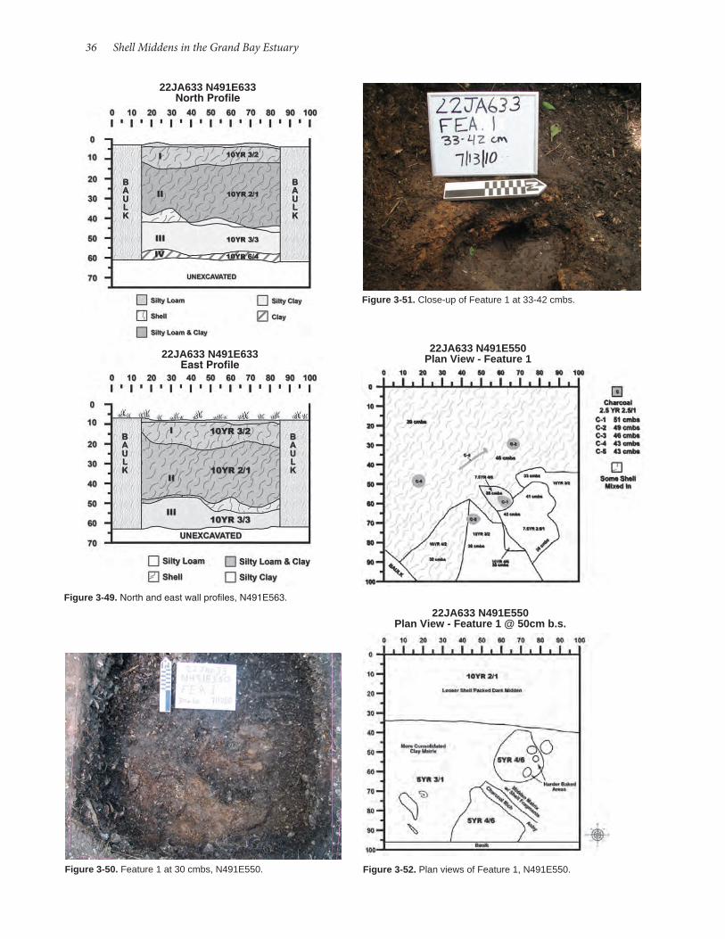
36 Shell Middens in the Grand Bay Estuary
22JA633 N491E633 North Profile
22JA633 N491E633 East Profile
Figure 3-49. North and east wall profiles, N491E563.
Figure 3-50. Feature 1 at 30 cmbs, N491E550.
Figure 3-51. Close-up of Feature 1 at 33-42 cmbs.
22JA633 N491E550 Plan View - Feature 1
22JA633 N491E550 Plan View - Feature 1 @ 50cm b.s.
Figure 3-52. Plan views of Feature 1, N491E550.
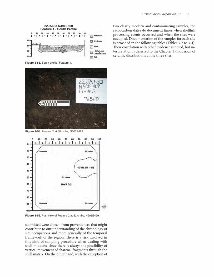
Archaeological Report No. 37 37
22JA633 N491E550 Feature 1 - South Profile
Figure 3-53. South profile, Feature 1.
Figure 3-54. Feature 2 at 50 cmbs, N501E469.
Figure 3-55. Plan view of Feature 2 at 51 cmbs, N501E469.
submitted were chosen from proveniences that might contribute to our understanding of the chronology of site occupations and more generally of the temporal framework of the region. There is a risk involved in this kind of sampling procedure when dealing with shell middens, since there is always the possibility of vertical movement of charcoal fragments through the shell matrix. On the other hand, with the exception of
two clearly modern and contaminating samples, the radiocarbon dates do document times when shellfish processing events occurred and when the sites were occupied. Documentation of the samples for each site is provided in the following tables (Tables 3-2 to 3-4). Their correlation with other evidence is noted, but in-terpretation is deferred to the Chapter 4 discussion of ceramic distributions at the three sites.
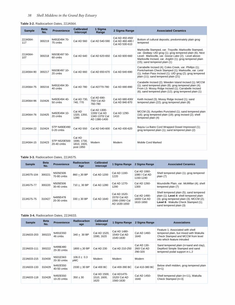
38 Shell Middens in the Grand Bay Estuary
Table 3-2. Radiocarbon Dates, 22JA564.
Sample Beta No. Provenience Calibrated
Intercept1 Sigma Range 2 Sigma Range Associated Ceramics
22JA564-117 300219 N491E494 70-
75 cmbs Cal AD 560 Cal AD 540-590Cal AD 450-450/Cal AD 460-480 /Cal AD 530-610
Bottom of cultural deposits; predominately plain grog tempered
22JA564-107 300218 N503E497 50-
60 cmbs Cal AD 640 Cal AD 620-650 Cal AD 600-660
Marksville Stamped, var. Troyville; Marksville Stamped, var. Godsey; UID grog (1); grog tempered plain (6); Next Level: Marksville, var. Goose Lake (2); Level above: Marksville Incised, var. Anglim (1); grog tempered plain (15); sand tempered plain (1)
22JA564-90 300217 N503E497 10-20 cmbs Cal AD 660 Cal AD 650-670 Cal AD 640-690
Carrabelle Incised (4); Coles Creek, var. Phillips (1); Pontchartrain Check Stamped (1); Marksville, var. Leist (1); Indian Pass Incised (1); UID grog (2); grog tempered plain (11); sand tempered plain (21)
22JA564-75 300216 N491E494 30-40 cmbs Cal AD 780 Cal AD770-780 Cal AD 690-890
Carabelle Incised (2); Weeden Island Incised (1); MCCM (1); sand tempered plain (8); grog tempered plain (4); From L5: Mossy Ridge Incised (1); Carrabelle Incised (6); sand tempered plain (12); grog tempered plain (1)
22JA564-96 310426 N492E494 40-50 cmbs
Cal AD 730, 740, 770
Cal AD 690-750/ Cal AD 760-780
Cal AD 680-830/ Cal AD 840-870
Keith Incised (3); Mossy Ridge Incised (1); sand tempered plain (22); grog tempered plain (8)
22JA564-76 310425 N492E494 10-20 cmbs
Cal AD 1320, 1350, 1390
Cal AD 1300-1330/ Cal AD 1340-1370/ Cal AD 1380-1400
Cal AD 1290-1410
MCCM (3); Avoyelles Punctated (1); sand tempered plain (16); grog tempered plain (19); grog incised (2); shell tempered plain (4)
22JA564-22 310424 STP N490E490 0-20 cmbs Cal AD 550 Cal AD 540-600 Cal AD 430-620 Bayou La Batre Cord Wrapped Dowel Impressed (1);
grog tempered plain (1); sand tempered plain (2)
22JA564-15 310423 STP N520E500 20-40 cmbs
Cal AD 1690, 1730, 1810, 1920, post 1950
Modern Modern Mobile Cord Marked
Table 3-3. Radiocarbon Dates, 22JA575.
Sample Beta No. Provenience Radiocarbon
AgeCalibrated Intercept 1 Sigma Range 2 Sigma Range Associated Ceramics
22JA575-104 300221 N505E506 70-80 cmbs 860 + 30 BP Cal AD 1200 Cal AD 1160-
1220
Cal AD 1060-1080 / Cal AD 1150-1240
Shell tempered plain (1); grog tempered plain (7)
22JA575-77 300220 N505E506 30-40 cmbs 710 + 30 BP Cal AD 1280 Cal AD 1270-
1290Cal AD 1260-1300
Moundville Plain, var. McMillan (4); shell tempered plain (7)
22JA575-75 310427 N495E478 20-30 cmbs 330 + 30 BP Cal AD 1640
Cal AD 1520-1570/ Cal AD 1590-1590/ Cal AD 1630-1650
Cal AD 1490-1600/ Cal AD 1610-1650
Shell tempered plain (5); sand tempered plain (1); Level 4: shell tempered plain (3); grog tempered plain (3); MCCM (2); Level 8: Wakulla Check Stamped (1); sand tempered plain (3)
Table 3-4. Radiocarbon Dates, 22JA633.
Sample Beta No. Provenience Radiocarbon
ageCalibrated Intercept 1 Sigma Range 2 Sigma Range Associations
22JA633-203 300223 N491E550 46 cmbs 340 + 30 BP Cal AD 1520,
1590, 1620
Cal AD 1480-1540/ Cal AD 1540-1630
Cal AD 1460-1640
Feature 1. Associated with shell tempered plain, but mixed with Wakulla Check Stamped and MCCM from level into which feature intruded
22JA633-111 300222 N499E480 20-30 cmbs 1800 + 30 BP Cal AD 230 Cal AD 210-250
Cal AD 130-260/ Cal AD 290-320
Sand tempered plain (n=sand and clay), Deptford Simple Stamped and sand tempered podal support in L.2
22JA633-215 310430 N501E563 20-30 cmbs
106.0 + 0.3 pMC Modern Modern Modern
22JA633-133 310429 N492E550 40-50 cmbs 2330 + 30 BP Cal 400 BC Cal 400-390 BC Cal 410-380 BC Below shell midden, grog tempered plain
(n=1)
22JA633-118 310428 N492E550 10-20 cmbs 350 + 30
Cal AD 1500, 1510, 1600, 1620
Cal AD1470-1520/ Cal AD 1560-1630
Cal AD 1450-1640
Shell tempered plain (n=11), Wakulla Check Stamped (n=3)

Archaeological investigations at Grand Bay pro-duced many artifacts, mainly ceramic but also to a lesser extent lithic and bone artifacts, that represent Native American use and occupation of the area, be-ginning sometime prior to 100 BC during the Late Gulf Formational period and continuing into the post-contact period La Pointe phase. In this chapter the ceramic assemblages from 22JA564, 22JA575, and 22JA633 receive most attention because they offer the best evidence on the chronology of prehistoric and historic use of the area, as well as the ebb and flow of cultural contacts or connections over time in what is clearly an interface between two cultures-one with roots in the lower Mississippi Valley and Louisiana Delta and the other with connections to the east in the Mobile Bay region and Florida panhandle. Shell mid-dens are likely not the best archaeological contexts for refining archaeological chronologies, in combination with radiocarbon dates. Still, the present work chal-lenges the existing cultural chronology offered by the pioneering work of Blitz and Mann (2000) and at least points in the direction of a clearer framework for re-search in the future. Consideration of the ample his-toric artifact inventories from the sites are found in Chapter 5, but readers should note that some portion of those Euroamerican materials may relate to the his-toric aboriginal occupation of the Grand Bay marshes.
Ceramic ArtifactsOver 4,000 ceramic sherds were recovered from
excavations and surface collections during investiga-tions of Grand Bay, the vast majority produced by ex-cavations at 22JA564, 22JA575, and 22JA633. Sherds were sorted by size and only those larger than 1.25 cm (0.5 in) were subjected to analytical scrutiny beyond noting temper. The analyzed sample from tested sites totals 2,515 sherds, and an additional 131 sherds were collected during visits to other Grand Bay sites (Table 4-1).
Classification of Grand Bay CeramicsThe ceramic classification system used in the pres-
ent analysis drew freely upon typological schemes de-veloped for ceramic complexes to the west and east. For the Mississippi Sound, investigations by Blitz and Mann (2000) provide a basic framework to interpret coastal ceramic assemblages. To the extent possible
their work was the point of departure in this analysis. Their analysis leaned westward and relied to a great extent on the type-variety system developed by Har-vard University’s Lower Mississippi Survey (LMS; an outgrowth of the pioneering work of Phillips, Ford and Griffin [1951]), which was first systematically ap-plied in Phillips’ (1970) work in the lower Yazoo Basin of Mississippi.
The type-variety system has been modified and ex-panded considerably, sometimes in conflicting ways, since Phillips published his Yazoo Basin monograph. Later work by the LMS in northeast Louisiana and more contemporary research by Louisiana archaeol-ogists (e.g., Brown 1984; Fuller and Fuller 1987; Mc-Gimsey 2004) inform our understanding of ceramic classification and change over time, while Blitz and Mann have added local refinement to the classification scheme. However, our recognition that these assem-blages also reflect an assortment of influences from cultures to the east and north of Mississippi Sound has necessitated comparison with other regions. Work in the adjacent Mobile Bay area, which significantly in-formed the analysis of Blitz and Mann, provided a sec-ond local anchor for ceramic identifications. Here, ap-plication of type-variety classification has been most strongly developed for the later end of the prehistoric continuum, particularly the Mississippi period, by the work of Fuller and colleagues (e.g., Fuller 1985, 2003; Fuller and Brown 1993; Fuller and Stowe 1982). Modern cultural resource management research has informed Mobile Bay classifications of Woodland ce-ramics (e.g., Price 2008). For some periods, however, little more has been done with pottery typology since Steve Wimberly’s pioneering work (1960). We have also looked further east, employing classifications developed for ceramics from the Florida panhandle,
Chapter 4 Native American Artifacts
by Samuel Huey and H. Edwin Jackson
Table 4-1. Ceramics Collected from Grand Bay Sites (n=4,015).
Site Analyzed Sherds
Sherds <1.25 cm
22JA564 1,094 368
22JA575 431 304
22JA633 990 707
22JA582 (Surface) 7 -
22JA577 (Surface) 46 -
22JA577-A (Surface) 6 -
22JA632 (Surface) 72 -

40 Shell Middens in the Grand Bay Estuary
turally significance. In the southern portion of the lower Mississippi Valley the final time range of this tradition is encapsulated in the Troyville culture. Ce-ramic elements of Weeden Island begin to infiltrate the local ceramic tradition; on the Mississippi Gulf coast we see clearly the merging of eastern Weeden Island types with later varieties of the Marksville tra-dition. Influences likely moved in both directions. Application of this scheme potentially impacts Blitz and Mann’s Godsey variety of Marksville Stamped, defined by the use of a crenulated shell edge as a stamping tool, without regard to line character. One such sherd of Marksville Stamped, var. Godsey, from 22JA564 differs notably from those illustrated by Blitz and Mann (2000: Figure A7), specifically in the ap-plication of incision and rocker stamping on an ex-tremely wet paste with sloppy execution, seemingly a counterpart of this variety to other late Issaquena va-rieties. It is possible that var. Godsey will require fur-ther subdivision, although we are loath to do so with just one example each from two sites.
Temper and WareTemper provides a first level of subdivision of ce-
ramic categories, although we have found in our anal-ysis a considerable overlap within ceramic decorative varieties and in tempering constituents. In particular there is considerable variability in grain size within the sand tempered category and that, like Mississip-pi coast ceramics reported elsewhere, sand is a likely constituent regardless of the primary (and presum-ably intentional) tempering agent. We have simplified our analysis by not distinguishing between wares that, for instance, are grog tempered from those that are grog tempered with sand inclusions, assuming that to some significant extent the sand may be a naturally occurring constituent of the clays used in making pots (see Hester 2012 for a discussion of temper category possibilities). We distinguished among the following temper groups:
particularly those associated with the Weeden Island culture of the Late Woodland period (e.g., Millanich et al. 1997; Willey 1949), where ceramic classification remains at the level of identified types.
One area of apparent lack of fit is in ceramic deco-rative styles that evolved from Middle Woodland grog tempered Marksville Incised and Marksville Stamped and their sand tempered cognates, Basin Bayou In-cised and Alligator Bayou Stamped. The present system of classification differs from that employed by Blitz and Mann in this continuum of Marksville ceramic types and varieties spanning the Middle to early Late Woodland. While Phillips’ (1970) work suggested that Marksville varieties diminished after Middle Woodland, more recent work in the lower Mississippi Valley and Mobile Bay area indicates their persistence well into the Late Woodland. Particularly important is the largely unpublished typological work by John Belmont, as well as the chronological eval-uation of Marksville varieties by McGimsey (2004). Although Belmont’s efforts were not published, they exist as a corpus of notes, tables, and figures compiled and presented by McGimsey as part of his report on the Troyville period site Goldmine Plantation (Mc-Gimsey 2004). Partial implementations of Belmont’s scheme are presented by Weinstein et al. (1995) in their analysis of the late Marksville component of the Rock Levee site in the northern Mississippi Delta, and by Bitgood (1982) in the Tensas Basin of north Louisi-ana. Chief among Belmont’s innovations was the rec-ognition that the character of line incision changed over time, which provides a way to delineate the pro-gression of varieties of Marksville Incised, Marksville Stamped, Troyville Stamped, and Churupa Punctated. The scheme that Belmont developed is presented in Table 4-2 (McGimsey 2004: 312). This aspect of our analysis owes a debt to Rich Weinstein, who informed us of Belmont’s typological efforts.
Persistence on the Gulf coast of what Bitgood (1989:133) has termed the Marksville tradition is cul-
Table 4-2. Late Marksville Varieties Based on Belmont (n.d.).
Early Issaquena Late Issaquena Early Troyville Late Troyville
Line Characteristics Deeply U-shaped, smooth, crisp
Classic, broad, deep in wet clay, messy Medium, broad, shallow Narrow, shallow
Type, Design
Marksville Incised with Marksville motifs Eagle Lake Yokena Anglim Vick
Marksville Incised with Steel Bayou design Hays Landing Steele Bayou Scott Dunbar
"Indian Pass" design Liddieville Liddieville
Churupa Punctated Clotard Churupa Thornton Watson
Marksville Stamped Newsome Manny Cummins
Troyville Stamped Poindexter Troyville Elm Ridge Bayou Rouge

Archaeological Report No. 37 41
sissippi Plain for the Mobile Bay region, they rely at least in part on products of firing that may or may not be intentional (soft, chalky ware versus hard) and are difficult to apply in the present context.
Fine Lamellar Shell Temper. Finely ground shell particles, generally 1 mm or less in size, characterize this category, which conforms to the type Bell Plain. As with Mississippi Plain, Fuller (1996, 2003; also Dumas 2008a) has defined multiple varieties. Variety Boatyard includes fine shell tempered soft brownish paste ceramics. Variety Fort Condé has fine shell and fine sand, often with neatly folded rims. Variety Hale is black filmed and highly burnished. Variety Stockton includes brown-filmed, fine shell tempered ware.
Coarse Angular Shell Temper. Tempering with coarse angular shell defines the ware Guillory Plain, which includes two varieties, Briar Lake and Guillo-ry on the basis of hard or soft surfaces, respectively. Fuller attributes a chronological difference between the two, with Guillory associated with the later Bear Point phase.
Fine Angular Shell Temper. Fine angular shell tem-per characterizes Graveline Plain. Distinctions at the variety level are based on the presence of burnishing (var. Aiken) or the presence of bowls with the “Port Dauphin” rim mode (var. Graveline). Fine angular shell tempering is often mixed with fine sand.
Mixed Shell and Grog Temper. Grog and shell tem-pered ware marks the transition to the Mississippi period and is characteristic of the Pinola phase (Blitz and Mann 2000:57).
Undecorated CeramicsUndecorated ceramics were sorted accord-
ing to tempering. Some sherds were assigned to types and varieties. Basic temper differenc-es by site are presented in Tables 4-3 through 4-6.
Decorated Ceramic Type-VarietiesDecorated ceramics identified at the three
tested sites are described below, organized by the phase during which they first appeared and the ceramic series to which they belong.
Apple Street Phase, 800-100 BC Bayou La Batre Series Bayou La Batre Cord Wrapped Dowell Impressed (Blitz and Mann 2000; Wimberly 1960) (Figure 4-2a-b)
Fine-Medium Sand Temper. This group includes sand tempered sherds with sand grain size generally less than 1 mm. Plainware types include Weeden Is-land Plain, Baldwin Plain, Franklin Plain, and Lake Jackson Plain, with distinctions made when possible based on vessel shape and rim mode (Figure 4-1).
Course Sand Temper. Sherds with sand larger than 1 mm in size are included in this ware group. Bayou La Batre Plain is coarse sand tempered pottery.
Coarse Sand and Grit Temper. A few sherds were tempered with pieces of crushed rock, generally larger than 1 mm in size.
Grog Temper. Grog tempering refers to the use of ground potsherds as the tempering agent. We lumped into this category the possibility of hardened clay (possibly a result of incomplete clay matrix mixing), which in the particular collections we are working with are difficult to distinguish from grog. Plainwares that are grog tempered are categorized as Baytown Plain, but, except in specific cases, these are not fur-ther subdivided into varieties, as local variants have not yet been defined.
Coarse Lamellar Shell Temper. As pointed out by Fuller (1996, 2003; Fuller and Brown 1993; Fuller and Stowe 1982), there exists on the Gulf coast shell tempered pottery using shell that generally exfoliates into platy fragments and also shell that when crushed produces angular pieces, and these can each be fur-ther subdivided into coarse and fine shell. Coarse shell tempered wares conform to the type Mississippi Plain. Although Fuller has defined varieties of Mis-
Figure 4-1. Graveline phase ceramics: (a-c) Weeden Island Plain rims (catalog numbers 564-55, 564-92, and 564-96) (actual size).

42 Shell Middens in the Grand Bay Estuary
Santa Rosa Punctated consists of widely spaced U-shaped incisions forming zones of punctation on sand tempered ceramics. It may first occur in the Apple Street phase (Blitz and Mann 2000:111), but is more common in the succeeding Greenwood Island phase and may persist into the Godsey phase. Its grog tempered cognate is Churupa Punctated.
Santa Rosa Stamped (Willey 1949; Wimberly 1960; Dumas 2008a; Blitz and Mann 2000) (Figure 4-2d) Kenny’s Island site (22JA633), N=1
Santa Rosa Stamped is coarse sand tempered ware decorated with unzoned rocker stamping. It first ap-pears during the Apple Street phase and may contin-ue into the Greenwood Island phase (Blitz and Mann 2000:111).
Alexander Series Chinchuba Brushed, var. Chinchuba (Ford and Quimby 1945; Phillips 1970; Blitz and Mann 2000) (Figure 4-2e-f) Ford site (22JA564), N=6
Chinchuba Brushed, var. Chinchuba has carefully brushed (to the point of approaching combed) deco-ration with a fine-toothed implement on sand tem-pered ware. The type was defined on the basis of re-search on the Tchefuncte culture in coastal Louisiana.
Mandeville Stamped, var. Mandeville (Ford and Quimby 1945; Phillips 1970; Blitz and Mann 2000) (Figure 4-2g) Kenny’s Island site (22JA633), N=1
Mandeville Stamped includes sand tempered pot-tery with vertical rows of dentate stamping around vessel rim and upper portion. Like Chinchuba Brushed, it was defined based on coastal Louisiana Tchefuncte sites.
Greenwood Island Phase, 100 BC-AD 200Santa Rosa Stamped and Santa Rosa Punctated
from the previous phase are also present in this phase.
Santa Rosa (Swift Creek) Series Basin Bayou Incised, var. unspecified (Willey 1949; Wimberly 1960; Blitz and Mann 2000; Dumas 2008a; Dumas 2009) (Figure 4-3f)
Table 4-3. Undecorated Sherds from 22JA564 by Temper.
Temper Groups Base Body Rim Total
Fine-Medium Sand Temper 1 364 35 400
Coarse Sand Temper - 11 1 12
Grog Temper 1 573 54 628
Coarse Lamellar Shell Temper - 3 - 3
Fine Lamellar Shell Temper - 6 1 7
Coarse Angular Shell - 14 - 14
Fine Angular Shell - 28 - 28
Mixed Shell and Grog - 9 - 9
Totals 2 1001 91 1094
Table 4-4. Undecorated Sherds from 22JA575 by Temper.
Temper Groups Body Rim Total
Fine-Medium Sand Temper 72 6 78
Coarse Sand Temper 12 - 12
Grog Temper 83 8 90
Coarse Lamellar Shell Temper 17 1 18
Fine Lamellar Shell Temper 65 - 65
Coarse Angular Shell 55 3 58
Fine Angular Shell 95 11 106
Mixed Shell and Grog 4 - 4
Totals 403 28 431
Table 4-5. Undecorated Sherds from 22JA633 by Temper.
Temper Groups Base Body Rim Total
Fine-Medium Sand Temper 1 147 16 164
Coarse Sand Temper - 21 5 26
Grog Temper 2 546 27 575
Coarse Lamellar Shell Temper - 17 11 28
Fine Lamellar Shell Temper - 49 - 49
Coarse Angular Shell - 69 12 81
Fine Angular Shell - 55 5 60
Mixed Shell and Grog - 4 3 7
Totals 3 908 79 990
Ford site (22JA564), N=3Bayou La Bate Cord Wrapped Dowell Impressed is
coarse sand tempered ware decorated with generally parallel impressions made with a cord-wrapped stick. It was identified in the Mobile Bay Region (Wimber-ly 1960) and recovered from Bryant’s Landing Phase contexts at the Plash Island site (Dumas 2008a).
Bayou La Batre/Santa Rosa Series Santa Rosa Punctated (Willey 1949; Wimberly 1960; Thomas et al. 1996; Ridley 2006; Blitz and Mann 2000; Dumas 2008a) (Figure 4-2c) Kenny’s Island site (22JA633), N=1
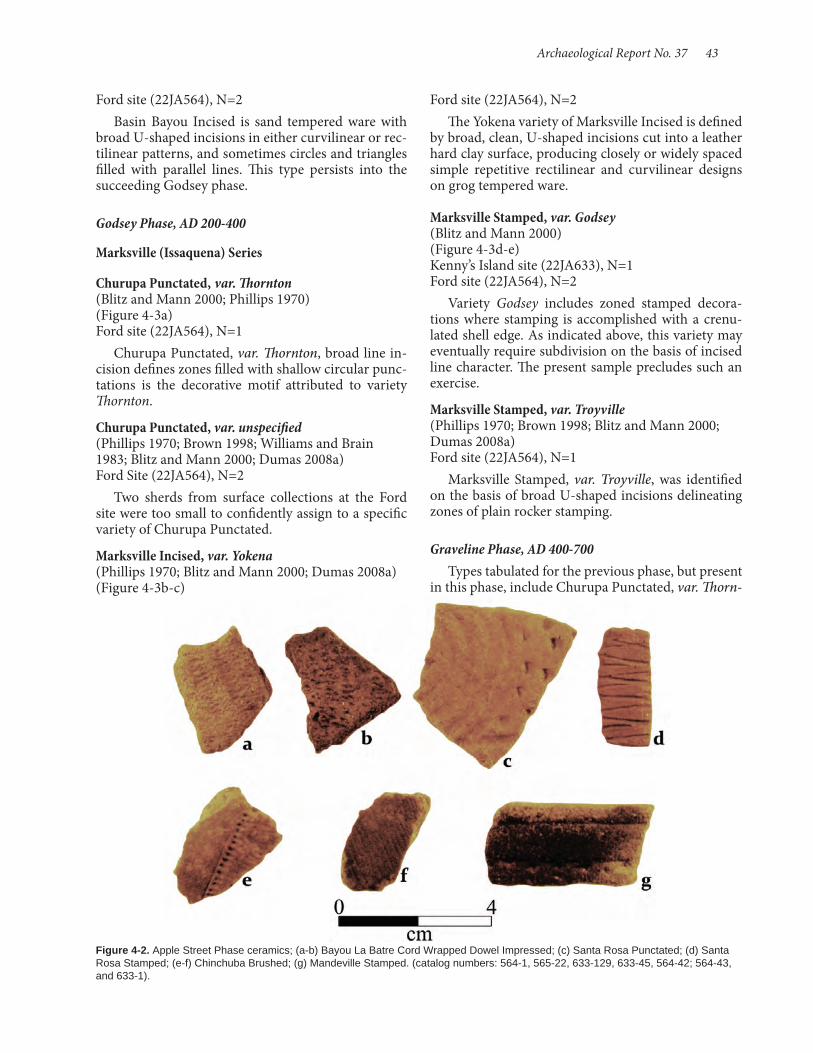
Archaeological Report No. 37 43
Ford site (22JA564), N=2Basin Bayou Incised is sand tempered ware with
broad U-shaped incisions in either curvilinear or rec-tilinear patterns, and sometimes circles and triangles filled with parallel lines. This type persists into the succeeding Godsey phase.
Godsey Phase, AD 200-400 Marksville (Issaquena) Series Churupa Punctated, var. Thornton (Blitz and Mann 2000; Phillips 1970) (Figure 4-3a) Ford site (22JA564), N=1
Churupa Punctated, var. Thornton, broad line in-cision defines zones filled with shallow circular punc-tations is the decorative motif attributed to variety Thornton.
Churupa Punctated, var. unspecified (Phillips 1970; Brown 1998; Williams and Brain 1983; Blitz and Mann 2000; Dumas 2008a) Ford Site (22JA564), N=2
Two sherds from surface collections at the Ford site were too small to confidently assign to a specific variety of Churupa Punctated.
Marksville Incised, var. Yokena (Phillips 1970; Blitz and Mann 2000; Dumas 2008a) (Figure 4-3b-c)
Ford site (22JA564), N=2The Yokena variety of Marksville Incised is defined
by broad, clean, U-shaped incisions cut into a leather hard clay surface, producing closely or widely spaced simple repetitive rectilinear and curvilinear designs on grog tempered ware.
Marksville Stamped, var. Godsey (Blitz and Mann 2000) (Figure 4-3d-e) Kenny’s Island site (22JA633), N=1 Ford site (22JA564), N=2
Variety Godsey includes zoned stamped decora-tions where stamping is accomplished with a crenu-lated shell edge. As indicated above, this variety may eventually require subdivision on the basis of incised line character. The present sample precludes such an exercise.
Marksville Stamped, var. Troyville (Phillips 1970; Brown 1998; Blitz and Mann 2000; Dumas 2008a) Ford site (22JA564), N=1
Marksville Stamped, var. Troyville, was identified on the basis of broad U-shaped incisions delineating zones of plain rocker stamping.
Graveline Phase, AD 400-700Types tabulated for the previous phase, but present
in this phase, include Churupa Punctated, var. Thorn-
Figure 4-2. Apple Street Phase ceramics; (a-b) Bayou La Batre Cord Wrapped Dowel Impressed; (c) Santa Rosa Punctated; (d) Santa Rosa Stamped; (e-f) Chinchuba Brushed; (g) Mandeville Stamped. (catalog numbers: 564-1, 565-22, 633-129, 633-45, 564-42; 564-43, and 633-1).

44 Shell Middens in the Grand Bay Estuary
(Belmont n.d.; Bitgood 1989; McGimsey 2004) (Figure 4-7b) Ford site (22JA564), N=1
Marksville Stamped, var. Dunbar, includes “Steele Bayou” designs executed in wet paste with a pointed instrument.
Marksville Incised, var. Goose Lake (Phillips 1970; Blitz and Mann 2000) (Figure 4-5e) Ford site (22JA564), N=2
Marksville Incised, var. Goose Lake is grog tem-pered ware with deep, broad incisions organized into line-filled triangles. This variety is considered repre-sentative of Troyville (Blitz and Mann 2000:42), but may be somewhat earlier than the narrow lined vari-
ton; Churupa Punctated, var. unspecified; Larto Red, Marksville Incised, var. Yokena, Marksville Stamped, var. Godsey, Marksville Stamped, var. Troyville. St. Andrews Complicated Stamped var. unspecified and Basin Bayou Incised var. Ford.
Marksville (Late Issaquena/Troyville) Series Churupa Punctated, var. Watson (Belmont n.d.; Bitgood 1989; McGimsey 2004) (Figure 4-4a-b) Ford site (22JA564), N=1 Kenny’s Island site (22JA633), N=1
Churupa Punctated includes grog tempered wares with punctated zones delineated by curvilinear U-shaped incisions. Vari-ety Watson is distinguished by narrow, shallow lines compared to “classic” ex-amples of the type (see Table 4-2). In the lower Mississippi Valley it is considered to date to the late Troyville time range, near the end of the Graveline phase and early in the Tates Hammock phase.
Larto Red, var. unspecified (Blitz and Mann 2000; Belmont and Williams 1981; Phillips 1970) Ford site (22JA564), N=2 Kenny’s Island site (22JA633), N=1
Larto Red includes red “filmed,” generally coarse grog tempered pot-tery. The red film is an attribute of Larto pottery that qualifies as a mode. This painted type is representative of an in-teraction sphere linking Louisiana and Florida (Blitz and Mann 2000:43) origi-nally identified as the Quafalorma hori-zon by Belmont and Williams (1981), in operation throughout the Graveline phase.
Marksville Incised, var. Anglim (Belmont n.d.; Bitgood 1989; McGimsey 2004) (Figure 4-4d-h) Ford site (22JA564), N=7 Kenny’s Island site (22JA633), N=1
Marksville Incised, var. Anglim, in-cludes curvilinear Marksville designs executed with medium broad, but shal-low, U-shaped lines (see Table 4-2). It is considered diagnostic of early Troyville in the lower Mississippi Valley.
Marksville Incised, var. Dunbar
Figure 4-3. Greenwood Island and Godsey phase ceramics; (a) Churupa Punctat-ed, var. Thornton; (b-c) Marksville Incised, var. Yokena; (d-e) Marksville Stamped, var. Godsey; (f) Basin Bayou Incised, var. unspecified. (catalog numbers: 564-102, 564-1, 564-115, 564-107, 564-1, and 564-1) (actual size).

Archaeological Report No. 37 45
Figure 4-4. Graveline phase ceramics; (a-b) Churupa Punctated, var. Watson; (c) Marksville Stamped, var. Cummins; (d-h) Marksville Incised, var. Anglim (catalog numbers: 633-128, 564-131, 564-107, 633-164, 564-102, 564-1, and 564-1) (actual size).
Figure 4-5. Graveline phase ceramics; (a-c) Marksville Incised, var. Spanish Fort; (d-f) Marksville Incised, var. Vick (catalog numbers: 633-128, 633-128, 564-115, 564-1, 564-102, 564-90, and 564-35) (actual size).

46 Shell Middens in the Grand Bay Estuary
is distinguished by incisions executed with a narrow shallow line, and is indicative of a late Troyville time frame, thus likely straddling the late Graveline and early Tates Hammock phases. It should be noted that it appears that Belmont (n.d.) re-elevated Troyville stamped to the level of type, but we have hesitated to do so.
Marksville Stamped, var. Cummins (Belmont n.d.; Bitgood 1989; McGimsey 2004) (Figure 4-6d-e; also Figure 4-4c) Ford site (22JA564 ), N=4
Marksville Stamped, var. Cummins, is identified by areas of stamping zoned by medium broad, shallow incisions on grog tempered pottery. It is diagnostic of the early Troyville period in the lower Mississip-pi Valley and is theoretically somewhat later that var. Manny.
Marksville Stamped, var. Manny (Phillips 1970; Blitz and Mann 2000) (Figure 4-7a) Ford site (22JA564), N=1
Marksville Stamped, var. Manny, was developed by Phillips out of the need to distinguish temporal differ-ences within the stylistic adaptation of the Marksville Stamped type. Variety Manny initially received type designation and then was reduced to variety status. The basis of the argument to establish more than one variety distinguished by zoned dentate rocker stamp-ing was material recovered in Louisiana from the early occupation at the Baptiste site, which was con-temporaneous with the time interval between Marks-ville and Troyville periods. Phillips created Marksville Stamped, var. Newsome to account for earlier, finer
eties such as Anglim. Whether this chronological dis-tinction holds for the Gulf coast needs further study.
Marksville Incised, var. Spanish Fort (Phillips 1970) (Figure 4-5a-c) Ford site (22JA564), N=2 Kenny’s Island site (22JA633), N=3
Marksville Incised, var. Spanish Fort, includes de-signs executed with broad lines in the wet paste of grog tempered pottery.
Marksville Incised, var. Liddieville (Belmont n.d.; Bitgood 1989; McGimsey 2004) Ford site (22JA564), N=1
This variety is defined by the “Indian Pass” design with narrow lines applied to wet paste.
Marksville Incised, var. Vick (Belmont n.d.; Bitgood 1989; McGimsey 2004) (Figure 4-6a-b; also Figure 4-5d-f) Kenny’s Island site (22JA633), N=1 Ford site (22JA564), N=4
Marksville Incised, var. Vick, is a late Troyville va-riety of the type identified on the basis of incisions that are narrow and shallow, producing “Marksville motifs” on grog tempered pottery.
Marksville Stamped, var. Bayou Rouge (Belmont n.d.; Bitgood 1989; McGimsey 2004) (Figure 4-6c) Kenny’s Island site (22JA633), N=1
Marksville Stamped, var. Bayou Rouge, is similar to var. Troyville in that the stamping is accomplished by a flat stamping implement (plain rocker stamped), but
Figure 4-6. Graveline phase ceramics; (a-b) Marksville Incised, var. Vick; (c) Marksville Stamped, var. Bayou Rouge; (d-e) Marksville Stamped, var. Cummins (catalog numbers: 564-92, 633-115, 633-1, 564-91, and 564-67) (actual size).
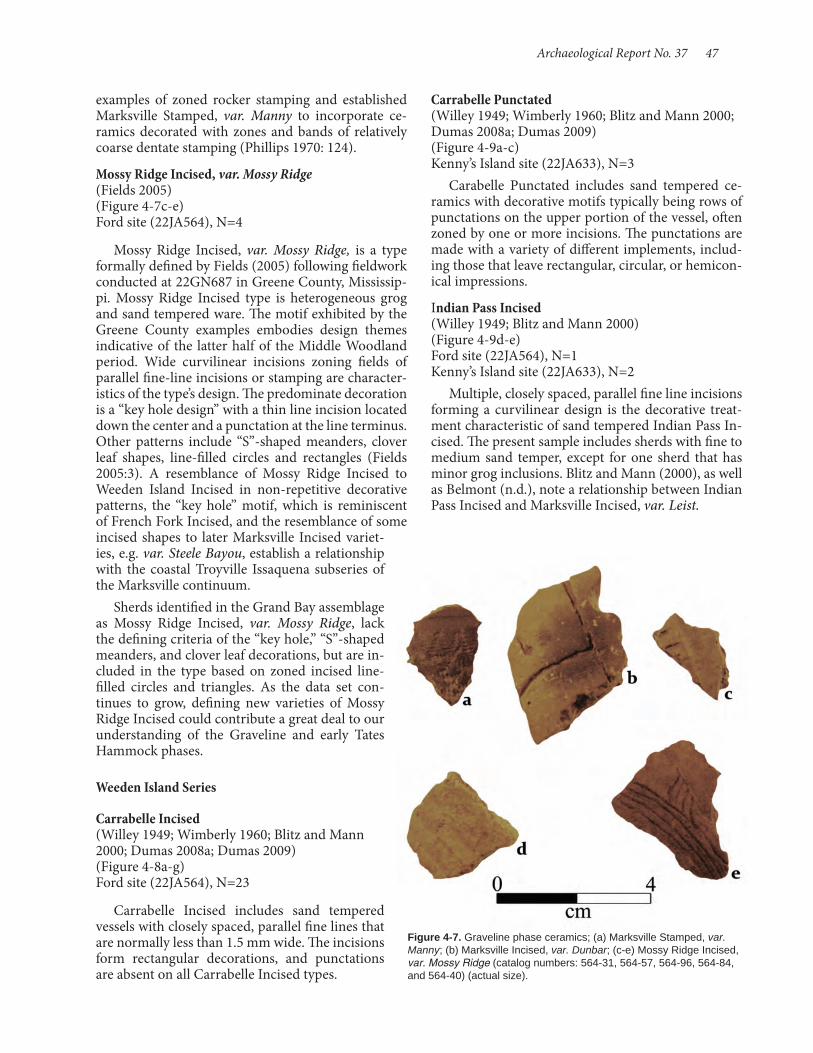
Archaeological Report No. 37 47
Carrabelle Punctated (Willey 1949; Wimberly 1960; Blitz and Mann 2000; Dumas 2008a; Dumas 2009) (Figure 4-9a-c) Kenny’s Island site (22JA633), N=3
Carabelle Punctated includes sand tempered ce-ramics with decorative motifs typically being rows of punctations on the upper portion of the vessel, often zoned by one or more incisions. The punctations are made with a variety of different implements, includ-ing those that leave rectangular, circular, or hemicon-ical impressions.
Indian Pass Incised (Willey 1949; Blitz and Mann 2000) (Figure 4-9d-e) Ford site (22JA564), N=1 Kenny’s Island site (22JA633), N=2
Multiple, closely spaced, parallel fine line incisions forming a curvilinear design is the decorative treat-ment characteristic of sand tempered Indian Pass In-cised. The present sample includes sherds with fine to medium sand temper, except for one sherd that has minor grog inclusions. Blitz and Mann (2000), as well as Belmont (n.d.), note a relationship between Indian Pass Incised and Marksville Incised, var. Leist.
examples of zoned rocker stamping and established Marksville Stamped, var. Manny to incorporate ce-ramics decorated with zones and bands of relatively coarse dentate stamping (Phillips 1970: 124).
Mossy Ridge Incised, var. Mossy Ridge (Fields 2005) (Figure 4-7c-e) Ford site (22JA564), N=4
Mossy Ridge Incised, var. Mossy Ridge, is a type formally defined by Fields (2005) following fieldwork conducted at 22GN687 in Greene County, Mississip-pi. Mossy Ridge Incised type is heterogeneous grog and sand tempered ware. The motif exhibited by the Greene County examples embodies design themes indicative of the latter half of the Middle Woodland period. Wide curvilinear incisions zoning fields of parallel fine-line incisions or stamping are character-istics of the type’s design. The predominate decoration is a “key hole design” with a thin line incision located down the center and a punctation at the line terminus. Other patterns include “S”-shaped meanders, clover leaf shapes, line-filled circles and rectangles (Fields 2005:3). A resemblance of Mossy Ridge Incised to Weeden Island Incised in non-repetitive decorative patterns, the “key hole” motif, which is reminiscent of French Fork Incised, and the resemblance of some incised shapes to later Marksville Incised variet-ies, e.g. var. Steele Bayou, establish a relationship with the coastal Troyville Issaquena subseries of the Marksville continuum.
Sherds identified in the Grand Bay assemblage as Mossy Ridge Incised, var. Mossy Ridge, lack the defining criteria of the “key hole,” “S”-shaped meanders, and clover leaf decorations, but are in-cluded in the type based on zoned incised line-filled circles and triangles. As the data set con-tinues to grow, defining new varieties of Mossy Ridge Incised could contribute a great deal to our understanding of the Graveline and early Tates Hammock phases.
Weeden Island Series
Carrabelle Incised (Willey 1949; Wimberly 1960; Blitz and Mann 2000; Dumas 2008a; Dumas 2009) (Figure 4-8a-g) Ford site (22JA564), N=23
Carrabelle Incised includes sand tempered vessels with closely spaced, parallel fine lines that are normally less than 1.5 mm wide. The incisions form rectangular decorations, and punctations are absent on all Carrabelle Incised types.
Figure 4-7. Graveline phase ceramics; (a) Marksville Stamped, var. Manny; (b) Marksville Incised, var. Dunbar; (c-e) Mossy Ridge Incised, var. Mossy Ridge (catalog numbers: 564-31, 564-57, 564-96, 564-84, and 564-40) (actual size).

48 Shell Middens in the Grand Bay Estuary
the decoration is executed by a much thinner, but still U-shaped line, and thus seems to follow the temporal trend defined for late varieties of its grog tempered cognate, Marksville Incised (McGimsey 2004). Basin Bayou Incised, var. Ford, is a Mississippi Sound ex-pression of Porter phase culture during the contem-poraneous late Godsey and Graveline phases. Basin Bayou Incised, var. Ford, Alligator Bayou Stamped, and St. Andrews Complicated Stamped are terminal expressions of the Santa Rosa series types present in the study area (Blitz and Mann 2000:39). Over time Basin Bayou Incised designs begin to resemble later Weeden Island types (Dumas 2008a:155). The new-ly defined Ford variety design includes incisions and excludes punctations. This type may also be distin-guished from Basin Bayou Incised, var. Porter, by rim mode. Porter rims rarely are wedge-shaped and are not flattened, unless finished with a notched lip (Du-mas 2008a:156). In contrast to Basin Bayou Incised, var. Porter, one recovered Ford rim sherd has a flat-tened Marksville (Issaquena) type rim.
Tates Hammock Phase, AD 700-1200Types tabulated for the previous phase, but present
in this phase, include French Fork Incised, var. Lar-kin; French Fork Incised, var. unspecified; Marksville Incised, var. Vick; Marksville Stamped, var. Bayou Rouge; Mossy Ridge Incised, var. Mossy Ridge; Weed-en Island Incised, and Carrabelle Incised.
Weeden Island Incised (Willey 1949; Wimberly 1960; Blitz and Mann 2000; Dumas 2008a; Dumas 2009) (Figure 4-10a-h) Ford site (22JA564), N=6 Kenny’s Island site (22JA633), N=13
Decoration characteristic of Weeden Island In-cised includes fine line rectilinear designs with back-grounds of punctations, and ends of lines are com-monly accented or excised. Weeden Island Incised ceramics recovered from Grand Bay lack lines termi-nating with punctations. The temper of these sherds is fine to medium sand. Weeden Island rim modes are folded either to the exterior and finished with a U-shape incision or folded to the interior on restrict-ed bowls, with interior folds sometimes exhibiting decoration (Dumas 2008a:156). Unlike their grog tempered cognates, Weeden Island rims are thickened and folded, but seldom flattened.
Santa Rosa Series Basin Bayou Incised, var. Ford (new variety) (Figure 4-11a-c) Kenny’s Island site (22JA633), N=1 Ford site (22JA564), N=2
Basin Bayou Incised, var. Ford, is defined here on the basis of a small sample of sherds from Kenny’s Is-land and the Ford site. It is analogous to the previ-ously defined Basin Bayou Incised, but differs in that
Figure 4-8. Graveline phase ceramics; (a-c) Carabelle Incised with folded rims; (d-g) Carrabelle Incised (catalog numbers: 564-90, 564-92, 564-43, 564-90, 564-84, 564-90, and 564-90).
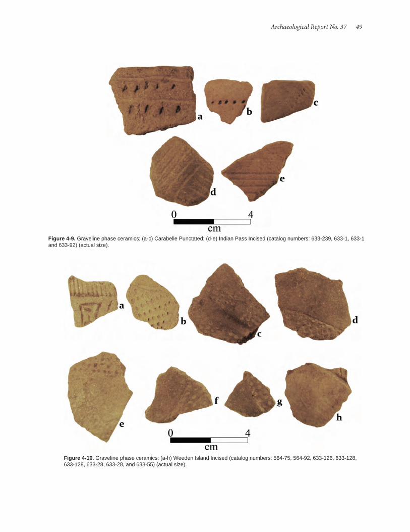
Archaeological Report No. 37 49
Figure 4-10. Graveline phase ceramics; (a-h) Weeden Island Incised (catalog numbers: 564-75, 564-92, 633-126, 633-128, 633-128, 633-28, 633-28, and 633-55) (actual size).
Figure 4-9. Graveline phase ceramics; (a-c) Carabelle Punctated; (d-e) Indian Pass Incised (catalog numbers: 633-239, 633-1, 633-1 and 633-92) (actual size).

50 Shell Middens in the Grand Bay Estuary
Figure 4-11. Graveline phase ceramics: (a-c) Basin Bayou Incised, var. Ford (catalog numbers: 564-67, 564-109, and 633-208) (actual size).
Figure 4-12. Tates Hammock phase ceramics: (a-b) Alligator Incised, var. Alligator; (c) Beldeau Incised, var. unspec-ified; (d-f) Coles Creek Incised, var. Pecan; (g) Avoyelles Punctated, var. Dupree (catalog numbers: 633-215, 564-1, 564-131, 564-91, 564-90, 564-1, and 564-76) (actual size).
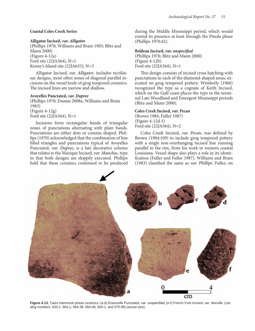
Archaeological Report No. 37 51
Coastal Coles Creek Series Alligator Incised, var. Alligator (Phillips 1970; Williams and Brain 1983; Blitz and Mann 2000) (Figure 4-12a) Ford site (22JA564), N=1 Kenny’s Island site (22JA633), N=3
Alligator Incised, var. Alligator, includes rectilin-ear designs, most often zones of diagonal parallel in-cisions on the vessel body of grog tempered ceramics. The incised lines are narrow and shallow.
Avoyelles Punctated, var. Dupree (Phillips 1970; Dumas 2008a; Williams and Brain 1983) (Figure 4-12g) Ford site (22JA564), N=1
Incisions form rectangular bands of triangular zones of punctations alternating with plain bands. Punctations are either dots or comma shaped. Phil-lips (1970) acknowledged that the combination of line filled triangles and punctations typical of Avoyelles Punctated, var. Dupree, is a late decorative scheme that relates to the Mazique Incised, var. Manchac, type in that both designs are sloppily executed. Phillips held that these ceramics continued to be produced
during the Middle Mississippi period, which would extend its presence at least through the Pinola phase (Phillips 1970:42).
Beldeau Incised, var. unspecified (Phillips 1970; Blitz and Mann 2000) (Figure 4-12b) Ford site (22JA564), N=1
This design consists of incised cross hatching with punctations in each of the diamond-shaped areas, ex-ecuted on grog tempered pottery. Wimberly (1960) recognized the type as a cognate of Keith Incised, which on the Gulf coast places the type in the termi-nal Late Woodland and Emergent Mississippi periods (Blitz and Mann 2000).
Coles Creek Incised, var. Pecan (Brown 1984; Fuller 1987) (Figure 4-12d-f) Ford site (22JA564), N=2
Coles Creek Incised, var. Pecan, was defined by Brown (1984:109) to include grog tempered pottery with a single non-overhanging incised line running parallel to the rim, from his work in western coastal Louisiana. Vessel shape also plays a role in its identi-fication (Fuller and Fuller 1987). Williams and Brain (1983) classified the same as var. Phillips. Fuller, on
Figure 4-13. Tates Hammock phase ceramics: (a-d) Evansville Punctated, var. unspecified; (e-f) French Fork Incised, var. Iberville. (cat-alog numbers: 633-1, 564-1, 564-38, 564-49, 564-1, and 575-99) (actual size).
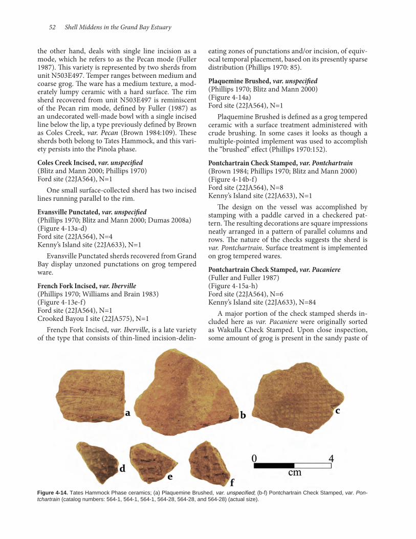
52 Shell Middens in the Grand Bay Estuary
the other hand, deals with single line incision as a mode, which he refers to as the Pecan mode (Fuller 1987). This variety is represented by two sherds from unit N503E497. Temper ranges between medium and coarse grog. The ware has a medium texture, a mod-erately lumpy ceramic with a hard surface. The rim sherd recovered from unit N503E497 is reminiscent of the Pecan rim mode, defined by Fuller (1987) as an undecorated well-made bowl with a single incised line below the lip, a type previously defined by Brown as Coles Creek, var. Pecan (Brown 1984:109). These sherds both belong to Tates Hammock, and this vari-ety persists into the Pinola phase.
Coles Creek Incised, var. unspecified (Blitz and Mann 2000; Phillips 1970) Ford site (22JA564), N=1
One small surface-collected sherd has two incised lines running parallel to the rim.
Evansville Punctated, var. unspecified (Phillips 1970; Blitz and Mann 2000; Dumas 2008a) (Figure 4-13a-d) Ford site (22JA564), N=4 Kenny’s Island site (22JA633), N=1
Evansville Punctated sherds recovered from Grand Bay display unzoned punctations on grog tempered ware.
French Fork Incised, var. Iberville (Phillips 1970; Williams and Brain 1983) (Figure 4-13e-f) Ford site (22JA564), N=1 Crooked Bayou I site (22JA575), N=1
French Fork Incised, var. Iberville, is a late variety of the type that consists of thin-lined incision-delin-
eating zones of punctations and/or incision, of equiv-ocal temporal placement, based on its presently sparse distribution (Phillips 1970: 85).
Plaquemine Brushed, var. unspecified (Phillips 1970; Blitz and Mann 2000) (Figure 4-14a) Ford site (22JA564), N=1
Plaquemine Brushed is defined as a grog tempered ceramic with a surface treatment administered with crude brushing. In some cases it looks as though a multiple-pointed implement was used to accomplish the “brushed” effect (Phillips 1970:152).
Pontchartrain Check Stamped, var. Pontchartrain (Brown 1984; Phillips 1970; Blitz and Mann 2000) (Figure 4-14b-f) Ford site (22JA564), N=8 Kenny’s Island site (22JA633), N=1
The design on the vessel was accomplished by stamping with a paddle carved in a checkered pat-tern. The resulting decorations are square impressions neatly arranged in a pattern of parallel columns and rows. The nature of the checks suggests the sherd is var. Pontchartrain. Surface treatment is implemented on grog tempered wares.
Pontchartrain Check Stamped, var. Pacaniere (Fuller and Fuller 1987) (Figure 4-15a-h) Ford site (22JA564), N=6 Kenny’s Island site (22JA633), N=84
A major portion of the check stamped sherds in-cluded here as var. Pacaniere were originally sorted as Wakulla Check Stamped. Upon close inspection, some amount of grog is present in the sandy paste of
Figure 4-14. Tates Hammock Phase ceramics; (a) Plaquemine Brushed, var. unspecified; (b-f) Pontchartrain Check Stamped, var. Pon-tchartrain (catalog numbers: 564-1, 564-1, 564-1, 564-28, 564-28, and 564-28) (actual size).

Archaeological Report No. 37 53
the sherds. Moreover, none of the rims fit the typical Wakulla folded rim style, often with incised decora-tive motifs, but are closely akin to what Fuller and Fuller (1987) defined as the Salt Mine Valley rim mode, which they found to be associated with var. Pacaniere. The variety, though established for western coastal Louisiana, is clearly found this far to the east, and demonstrates how nearly seamlessly decoration and paste recipe combinations trend across the north-ern Gulf coast.
Miller Series Mobile Cord Marked (Fuller 1998; Dumas 2008a) (Figure 4-16a-f) Ford site (22JA564), N=1 Kenny’s Island site (22JA633), N=6
Mobile Cord Marked sherds are sand tempered and decorated with cordage impressions applied by repeated stamping with a cord wrapped implement. Recovered sherds are tempered with coarse sand accompanied with small amounts of clay and grog. Sherds reflect proximity to the Mobile Basin, where the type is associated with the Tensaw Lake or Coden phases of the Alabama coast cultural historical frame-
work outlined by Fuller (1998). The time period spans AD 750 to 1100-1200, comfortably within the Tates Hammock phase for coastal Mississippi (Blitz and Mann 2000).
Mulberry Creek Cord Marked (Phillips 1970; Blitz and Mann 2000; Dumas 2008a) (Figure 4-17a-i) Crooked Bayou I site (22JA575), N=4 Ford site (22JA564), N=24 Kenny’s Island site (22JA633), N=42
Mulberry Creek Cord Marked is a broadly distrib-uted Late Woodland type that diffused southward into the Gulf Coastal Plain. It encompasses grog tempered sherds with impressions made by cord wrapped im-plements. The sherds collected from Grand Bay are generally sandy paste ceramics tempered with grog. This type persists into the Pinola phase.
Weeden Island Series Keith Incised (Willey 1949; Wimberly 1960; Dumas 2008a; Dumas 2009) (Figure 4-18a-e) Ford site (22JA564), N=5
Figure 4-15. Tates Hammock phase ceramics: (a) Pontchartrain Check Stamped, var. Pacaniere, Salt Mine Valley rim; (b-h) Pontchartrain Check Stamped, var. Pacaniere (catalog numbers: 633-234, 633-130, 564-1, 564-1, 564-1, 633-115, 633-115, and 633-115) (actual size).
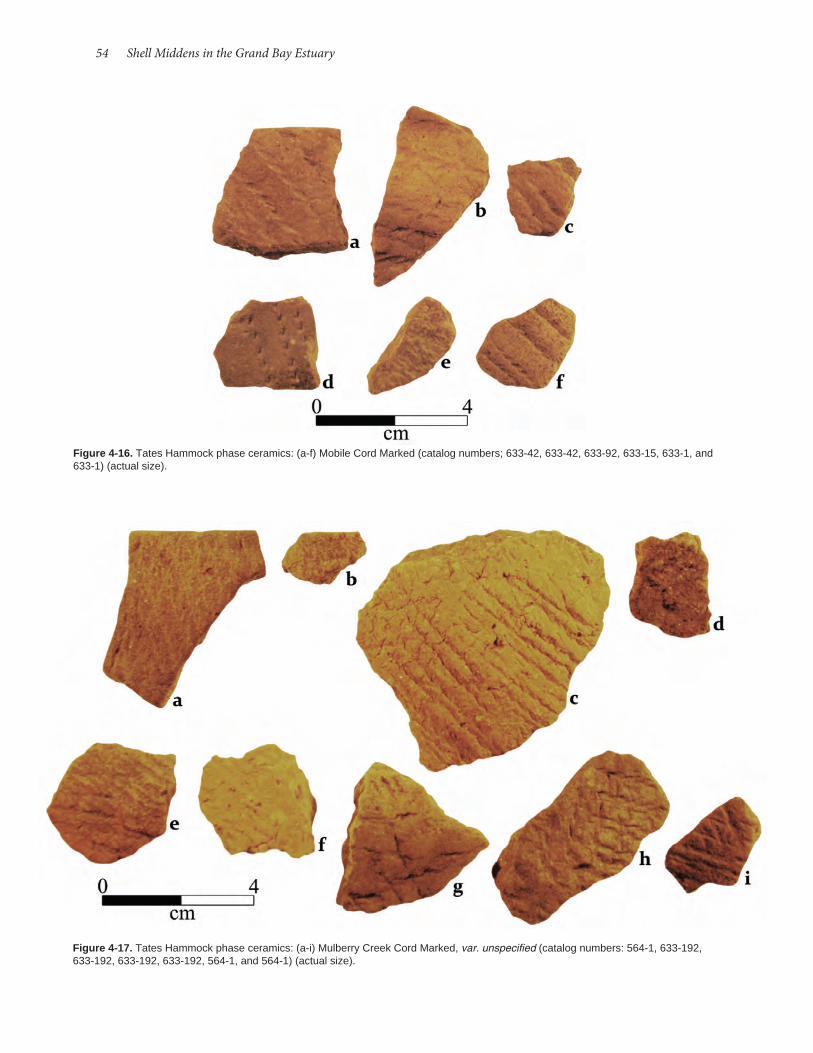
54 Shell Middens in the Grand Bay Estuary
Figure 4-16. Tates Hammock phase ceramics: (a-f) Mobile Cord Marked (catalog numbers; 633-42, 633-42, 633-92, 633-15, 633-1, and 633-1) (actual size).
Figure 4-17. Tates Hammock phase ceramics: (a-i) Mulberry Creek Cord Marked, var. unspecified (catalog numbers: 564-1, 633-192, 633-192, 633-192, 633-192, 564-1, and 564-1) (actual size).

Archaeological Report No. 37 55
Keith Incised is fine to very fine sand tempered ware with narrow, neat, and shallow incisions forming a diamond pattern, occasionally with a single punctu-ation set in the center of the diamond.
Tucker Ridge Pinched (Willey 1949; Wimberly 1960; Dumas 2009) (Figure 4-18f) Ford site (22JA564), N=1
Tucker Ridge Pinched includes sand tempered pottery with decoration consisting of parallel rows of small ridges produced by pinching moist clay be-tween thumbnail and index finger. Pinching the clay between finger and thumb results in triangular ridges or in a “V” shape decorative pattern. The single exam-ple from Grand Bay is tempered with sand and grit with pieces of fractured quartz.
Wakulla Check Stamped (Willey 1949; Blitz and Mann 2000; Dumas 2008a; Dumas 2009) (Figure 4-19a-f) Ford site (22JA564), N=4 Kenny’s Island site (22JA633), N=2 Crooked Bayou I site (22JA575), N=2
The exterior portion of the Wakulla Check Stamped type is covered in a neat, square check pattern ac-complished by repeated stamping of the vessel with a paddle carved in a symmetrical check pattern. Sherds classified as Wakulla were tempered solely with sand. However, as noted above, a majority of sandy paste check stamped sherds were classified as Pontchartrain Check Stamped, var. Pacaniere, based on the presence
Figure 4-18. Tates Hammock phase ceramics: (a-e) Keith Incised; (f) Tucker Ridge Pinched (catalog numbers: 564-96, 564-96, 564-96, 564-131, 564-71, and 564-1) (actual size).
Figure 4-19. Tates Hammock phase ceramics: (a-f) Wakulla Checked Stamped (catalog numbers: 564-1, 564-5-633-1, 633-103, 564-131, and 564-1) (actual size).
of grog in the paste and rims that closely resemble what Brown identified as the Salt Mine Valley rim mode, rather than the more characteristic folded rims associated with Wakulla.
Weeden Island Punctated (Willey 1949; Wimberly 1960; Blitz and Mann 2000; Dumas 2008a; Dumas 2009) (Figure 4-20a-b) Ford site (22JA564), N=1 Kenny’s Island site (22JA633), N=1
Small punctations organized as closely spaced lines on medium to fine sand tempered ware, the Weeden Island Punctated type is devoid of incised lines.

56 Shell Middens in the Grand Bay Estuary
Plaquemine Series Anna Incised (Phillips 1970; Williams and Brain 1983; Fuller 2003) (Figure 4-21a) Crooked Bayou I site (22JA575), N=1
The Anna Incised type is grog tempered ware with decorations incised on the interior surface of bowls. The sherd recovered from Crooked Bayou I displays a single thin line incision on the interior surface of a grog tempered body.
Carter Engraved, var. Carter (Williams and Brain 1983; Blitz and Mann 2000) (Figure 4-21c) Kenny’s Island site (22JA633), N=1
A single sherd from the surface collection was clas-sified as var. Carter. Its design consists of dry-paste incised, intersecting sets of parallel lines.
Carter Engraved, var. Sara (Williams and Brain 1983; Blitz and Mann 2000) (Figure 4-21b) Kenny’s Island site (22JA633), N=1Figure 4-20. Tates Hammock phase ceramics: (a-b) Weeden Island
Punctated (catalog numbers: 564-1 and 633-39) (actual size).
Figure 4-21. Pinola and Singing River phase ceramics: (a) Anna Incised; (b) Carter Engraved, var. Sara; (c) Carter Engraved, var. Carter; (d) Barton Incised, var. unspecified; (e) Moundville Incised, var. Singing River; (f-g) Mound Place Incised, var. McMillan rims; (h-j) Mound Place Incised, var. McMillan (catalog numbers: 575-76, 633-1, 633-1, 575-33, 575-1, 575-99, 575-99, 575-18, 575-18, and 575-18) (actual size).
Pinola Phase, AD 1200-1350Types tabulated for the previous phase, but pres-
ent in this phase, include Coles Creek Incised, var. Phillips; Coles Creek Incised, var. unspecified; Evans-ville Punctuated, var. unspecified; Mazique Incised, var. unspecified; Mobile Cord Marked, and Mulberry Creek Cord Marked.

Archaeological Report No. 37 57
The single example of Carter Engraved, var. Sara, is a fine grog temper ware, with fine lines incised on dry paste or engraved into fired paste. Decoration on the sherd is cross hatched fine line engraving that ex-tends onto the body from a neatly executed exterior folded rim on medium/fine textured pottery.
Pensacola Series Barton Incised, var. unspecified (Phillips 1970; Williams and Brain 1983; Blitz and Mann 2000; Dumas 2008a) (Figure 4-21d) Crooked Bayou I site (22JA575), N=1
One shell tempered sherd classified as Barton In-cised has eight closely-spaced parallel incisions that appear to be zoned by an oblique incision. The sherd broke along the diagonal zone incision. Decoration applied to the surface is consistent with incised motifs on necks of Barton vessels. The type belongs to the Middle Mississippian pottery tradition, and on the Gulf coast is a marker of the Pinola phase (Blitz and Mann 2000:114, Price 2008:144, Phillips 1970:43-44).
Singing River Phase, AD 1350-1550 Moundville Series Moundville Incised, var. Singing River (Blitz and Mann 2000) (Figure 4-21e) Crooked Bayou I site (22JA575), N=1
Decoration consists of a motif constructed of me-dium width, curvilinear incisions that form arches placed end-to-end that encircle the upper portion of the vessel. Moundville Incised, var. Singing River is distinguished by three or more rows of punctations or short, eyelash-like incisions above the arches. Puncta-tions are zoned by a single line incised below the rim, creating a zoned field of punctations above the arches.
Pensacola Series Mound Place Incised, var. McMillan (Blitz and Mann 2000; Dumas 2008a) Figure 4-21f-j) Crooked Bayou I site (22JA575), N=13
The decorative treatment for Mound Place Incised consists of two or more parallel lines incised horizon-tally on the exterior upper portion of a shell tempered vessel below the lip. Mound Place Incised, var. McMil-lan, has six or more closely-spaced parallel fine line incisions typically on a burnished well-made vessel.
Mound Place Incised, var. Walton’s Camp (Blitz and Mann 2000; Dumas 2008a) (Figure 4-22a-c) Crooked Bayou I site (22JA575,)N=3 Kenny’s Island site (22JA633), N=1
Mound Place Incised, var. Walton’s Camp, has a surface treatment consisting of two to five widely spaced incisions parallel to the rim of a shell tempered
Figure 4-22. Singing River phase ceramics: (a-c) Mound Place Incised, var. Walton's Camp (catalog numbers 575-1, 575-1, and 575-1) (actual size).
58 Shell Middens in the Grand Bay Estuary
Chickachae Combed (Blitz and Mann 2000; Dumas 2008a) (Figure 4-23g) Ford site (22JA564), N=1
Chickachae Combed is a sand tempered fine ware devoid of shell and grog decorated with bands of par-allel fine lines applied with a toothed implement.
Unclassified Decorated SherdsUnclassified decorated sherds are generally simply
too small or too weathered to classify with confidence; they are summarized by site in Tables 4-6 through 4-8. Three sherds that could not be fit into existing types bear mention.
Unclassified BrushedOne sherd (Figure 4-24) from 22JA564 surface
context is identical in execution to the sand tempered sherds classified as Chinchuba Brushed, but clearly tempered with grog. Grog tempered brushed sherds are usually some variation of Plaquemine Brushed, a Pinola phase diagnostic, but similarity to this late Gulf Formational type causes us to leave it unclassi-fied until more examples are found. It could easily be a grog or clay cognate associated with the Tchefuncte ceramic complex.
A second brushed sherd from 22JA633 surface context is sand tempered and exhibits what is best de-scribed as zoned brushing.
Unclassified Sand Tempered Engraved and IncisedOne sand tempered sherd (Figure 4-25) from the
22JA564 surface has vertical zone cross hatching ex-ecuted by engraving that runs from lip to base of the rim. Below is a vertical zone of incised hatching on the body. The character of the design, which if it were on grog tempered pottery might be classified as Carter Engraved, suggests a late prehistoric temporal range.
ModesIn addition to types and varieties are rim and oth-
er modes that cross cut decorated types and, when present, aid in identification of plain ceramics beyond temper characteristics. Blitz and Mann (2000) include, in their diagnostic attributes for each phase, modes present during the time intervals. Here they are sum-marized by phase (also drawn from Price 2008, 2009).
Apple Street phase modes include wedge or coni-cal podal supports, rim-top impressions or notches, rim bosses, initial appearance of zoned stamping, and coarse to medium sand temper.
vessel. The incised decoration may also include fes-toons or horizontal P-shaped loops.
Pensacola Incised, var. unspecified (Blitz and Mann 2000; Dumas 2008a) (Figure 23a-c) Kenny’s Island site (22JA633), N=3
Pensacola Incised includes shell tempered vessels with curvilinear incised designs, as well as motifs related to the Southeastern Ceremonial Complex, typically on burnished ware. In the Grand Bay sam-ple, two sherds are tempered with angular shell and the third is tempered with lamellar shell. This type is thought to represent the initial ceramic marker of Mississippian culture along the Alabama and eastern Mississippi coast.
Owens Punctated, var. unspecified (Phillips 1970; Fuller 1996; Dumas 2008a) (Figure 4-23d) Ford site (22JA564), N=1
The Owens Punctated sherd collected from the Ford site has angular shell temper, with a decorative treatment of linear bands of punctations bordered by straight narrow to medium incisions.
Bear Point Phase, AD 1550-1699A type tabulated for previous phase, but present in
this phase is Pensacola Incised, var. unspecified.
Moundville Series Moundville Incised, var. Douglas (Fuller 1996; Fuller 2003; Dumas 2008a) (Figure 4-23e) Crooked Bayou I site (22JA575), N=1
Moundville Incised, var. Douglas, is defined by decoration typified by one to three curvilinear inci-sions made in wet paste forming arches around the upper portion of the vessel, with one to three rows of conical-shaped punctations above the arches.
La Pointe Phase, AD 1699-1775 Choctawan Series Chickachae Incised (Blitz and Mann 2000) (Figure 4-23f) Ford site (22JA564), N=1
Chickachae Incised, a sand tempered fine ware, has fine incised lines applied in bands of parallel lines. This Gulf Historic fine ware is a sand tempered cog-nate of Port Dauphin Incised and Fatherland Incised.

Archaeological Report No. 37 59
Figure 4-23. Singing River, Bear Point, and La Pointe phase ceramics; (a-c) Pensacola Incised, var. unspecified; (d) Owens Punctated, var. unspecified; (e) Moundville Incised, var. Douglas; (f) Chickachae Incised; (g) Chickachae Combed (catalog numbers: 633-1, 633-1, 633-1, 564-1, 575-1, 564-1 and 564-1) (actual size).
Figure 4-24. Unclassified grog tempered brushed sherd (catalog number 564-1) (twice actual size).
Figure 4-25. Unclassified sand tempered engraved and incised sherd (catalog number 564-1) (twice actual size).

60 Shell Middens in the Grand Bay Estuary
ment, scalloped rims, handles, lip nicks/notches, and rim folds or straps.
Singing River phase modes include fine shell temper (Bell Plain), coarse shell temper (Mississippi Plain), handles, lip nicks/notches, and effigy rim treatments.
Bear Point phase modes include fine shell temper (Bell Plain), coarse shell temper (Mississippi Plain), handles, lip nicks/notches, and effigy rim treatments.
Site Ceramic AssemblagesDiagnostic ceramics provide an indication of the
time spans of site occupation. Of greatest interest are the assemblages from in situ contexts. However, ceramic collections from each site include a large number of specimens collected from the surface, which in the case of these middens primarily means sherds found along the eroded banklines of the sites during low tide. These provide additional information about the time periods represented and say something about site loss due natural and cultural factors that promote erosion.
Ceramic Assemblage from 22JA564The decorated ceramic roster from 22JA564 is pre-
sented in Table 4-9. Ceramics point to use from the Apple Street phase until historic times, with possible time gaps between 100 BC and AD 200 (Greenwood Island phase) and in the early Mississippian Pinola phase (AD 1200-1350). This, of course, does not mean the site was occupied continually outside of these in-tervals, but occupations did occur during each of the phases for which diagnostic ceramics are present.
Certain ceramic types were found only in STPs (Table 4-10). For instance, the only indications of a Gulf Formational occupation, ceramically represent-ed by Chinchuba Brushed and Bayou La Batre Cord Wrapped Dowell Impressed, came from two STPs 25 m apart and a single sherd from N492E494.
A tighter sense of time frame as well as ceramic relationships can be had by examining the distribu-tion of ceramics by levels in excavation units. Tables 4-11 through 4-14 provide these data for N491E494, N492E494, and N503E497, along with available ra-diocarbon determinations. Acknowledging the possi-bility of artifact migration through the shell matrix, the N491E494 deposit consists of Graveline phase markers in the lower levels of the shell midden, with the base of cultural deposits dating to approximate-ly AD 560. This fits well with dates for Mossy Ridge Incised, a type first defined for the Mississippi Pine Hills, which (at 22GN687 in Greene County) was as-sociated with three dates, two with a two-sigma range
Greenwood Island phase modes include wedge or conical podal supports, rim-top impressions or notches, red pigment (rare), coarse to medium sand temper, and grog temper. Note that the use of coarse sand temper ends during this period (Price 2008:253).
Godsey phase modes include rim-top impressions or notches, red pigment, small conical podal supports, rounded, thickened rims, ceramics with a sandy paste, with both sand and grog tempered ceramics present.
Graveline phase modes include rounded, thickened rims; pigmentation (red, buff, black); and grog and sand temper.
Tates Hammock phase modes include check stamp-ing as a dominant surface treatment, rim strap or fold, pigmentation, and heterogeneous temper.
Pinola phase modes include grog temper, sand tem-per, fine shell temper (Bell Plain), coarse shell temper (Mississippi Plain), shell-grog mixed temper, red pig-
Table 4-6. Unclassified Decorated Sherds from 22JA564.
Temper
Grog Sand Lamellar Shell
Decoration Body Rim Body Rim Body Rim
Incised 24 4 18 1
Punctated 1 - 1
Incised and Punctated 1 - 1
Stamped 1 - -
Cord Marked - - 1
Brushed - - -
Table 4-7. Unclassified Decorated Sherds from 22JA575.
Temper
Grog Sand Angular Shell Lamellar Shell
Decoration Body Rim Body Rim Body Rim Body Rim
Incised 3 - - - 5 1 - -
Punctated - - - - 1 - 1 -
Incised and Punctated - - - - 1 - - -
Indeterminate - - - 1 - - - -
Table 4-8. Unclassified Decorated Sherds from 22JA633.
Temper
Grog Sand Angular Shell Lamellar Shell
Decoration Body Rim Body Rim Body Rim Body Rim
Incised 9 1 2 2 6 2 1 -
Punctated 5 - 2 - 1 - - -
Incised and Punctated 1 - - - 1 - - -
Cord Marked 3 - - - - - - -
Stamped 3 - 3 - - - -
Brushed - - - - - - - -
Eroded Indeterminate - - 1 - - - - -

Archaeological Report No. 37 61
of AD 550-670 and a third somewhat later date of AD 650-780 (Fields 2005). If the radiocarbon dates for Level 4 are accepted, then Graveline markers persist after the defined AD 700 end of the phase and overlap with Tates Hammock phase diagnostics. This distri-bution of ceramics suggests the possibility that, with additional data, the overly long Tates Hammock phase might be further divided into early and late segments, with the former based on association of persistent types of the Graveline phase and the early appearance of Tates Hammock phase markers.
Adjacent unit N492E494 (1.0-by-0.5 m) offers little clarification, since it appears to have undergone some disturbance, with a Bayou La Batre Cord Wrapped Dowell Impressed sherd in the level above an eighth century date (see Table 4-12). Ignoring that sherd, the remaining ceramics could be later than the radio-carbon date, reinforcing the possibility that certain Graveline phase markers persist into the Tates Ham-mock phase. At the recent end of the spectrum, the fourteenth century date is unexpectably late, but the decorated and shell tempered plain sherds from Level 2 indicate a likely palimpsest of late occupations.
Decorated sherd distribution in N503E497 is pre-sented in Table 4-13. The unit’s two radiocarbon dates have intercepts at AD 640 for a sample from Level 6 and AD 680 for a sample from Level 2. At face value, this deposit accumulated during a relatively short pe-riod of time and is sandwiched between the dates for the samples from N491E494. This is awkward, as the ceramics from N503E497 include far fewer Weeden Island types relative to examples of later Marksville varieties, leading us to believe that the increase in Weeden Island ceramics occured late in the Graveline phase. As for the later Marksville varieties, all are, in Belmont’s scheme, associated with the early Troyville subperiod. Godsey phase ceramics are found below the shell midden in the lowest two levels and were likely deposited earlier than the AD 640 date. As with N491E494, Weeden Island ceramics occur in the same levels as Tates Hammock phase diagnostics, supporting the conclusion that in the early part of this phase Weeden Island types persisted, a fact that may be useful in subdividing the phase into shorter time segments. A broader question remains: why do these apparently contemporaneous units have such differ-ent representations of eastern and western types?
Unit 1 (Table 4-14), the bankside unit excavated to salvage eroding Burial 1, has two early Troyville sub-period varieties, Cummins and Anglim, near the base of the deposit, along with one of two examples from Unit 1 of Basin Bayou, var. Ford. Its association with the aforementioned varieties supports the case that Basin Bayou, var. Ford is a sand tempered cognate of
later thinner-lined versions of Marksville decoration. The second example comes from a mixed context pro-duced by a wall collapse that also includes a second example of var. Cummins. In the first level of excava-tion is an example of the somewhat later Marksville Incised, var. Dunbar, which is likely associated with the two Tates Hammock phase sherds also collected from this mixed context.
Plainwares from 22JA564In addition to sorting by temper characteristics,
some number of plain sherds were sorted into existing varieties, which relied not only on temper but specific rim modes or other attributes (Table 4-15). As noted earlier, there are several sand tempered types that can-not be reliably sorted except rims exhibiting specific modes, so a great many sherds are simply classified by temper type. Grog tempered plain sherds are classified as Baytown Plain, without attempting to distinguish different varieties. Shell tempered ceramics were as-signed to one of several varieties determined by size and shape of shell particles as well as surface charac-teristics.
Ceramic Assemblage from 22JA575Decorated ceramics are summarized in Table 4-16.
Tates Hammock, Pinola, Singing River, and Bear Point phase diagnostics are represented in the collection. However, as noted in Chapter 3, we could not sample sub-water table shell deposits, where there could be evidence of earlier occupations.
Decorated ceramics from STPs are presented in Table 4-17, and decorated sherds from the two test units are presented in Tables 4-18 and 4-19. Few dec-orated examples were produced by excavation and generally, in comparison to 22JA564 and 22JA633, pottery was scarce here. Decorated sherds indicate the upper levels of the midden are Mississippian in age, and somewhere between 40 cm in N495E478 and 80 cm in N505E506 earlier Late Woodland depos-its were encountered. The meager decorated sample from the two excavation units is only partially reme-died by the distribution of temper categories (Tables 4-20 and 4-21). Dates from 22JA575 include one from N495E478, Level 3 with a calibrated intercept of AD 1640, one from N505E506, Level 4, with a calibrat-ed intercept of AD 1280, and a second from Level 8 with a calibrated intercept of AD 1200. The first date is clearly too late and must be charcoal that filtered down from higher in the deposit, but it suggests that the upper levels are quite late accumulations. Deposits below Level 4 must date to the Tates Hammock phase. The two dates from N505E506 indicate an early Mis-sissippian Pinola phase accumulation.
62 Shell Middens in the Grand Bay Estuary
Table 4-9. Decorated Ceramics from 22JA564.
Apple Street Phase, 800-100 BC
Chinchuba Brushed var. Chinchuba 2 Bayou La Batre Cord Wrapped Dowel Impressed
Godsey Phase, AD 200-400
Basin Bayou Incised Churupa Punctated, var. Thornton Churupa Punctated, var. unspecified
Marksville Incised, var. Yokena Marksville Stamped, var. Godsey
Graveline Phase, AD 400-700
Churupa Punctated, var. WatsonFrench Fork Incised, var. unspecified 2
Larto Red, var. unspecifiedMarksville Incised, var. Anglim Marksville Incised, var. LiddievilleMarksville Incised, var. DunbarMarksville Incised, var. Spanish FortMarksville Incised, var. Vick
Marksville Stamped, var. CumminsMarksville Stamped, var. Manny 2
Mossy Ridge Incised, var. Mossy RidgeBasin Bayou Incised, var. FordCarrabelle Incised Weeden Island IncisedIndian Pass Incised
Tates Hammock Phase, AD 700-1200
Alligator Incised, var. unspecifiedAvoyelles Punctated, var. Dupree Beldeau Incised, var. unspecified Coles Creek Incised, var. PecanColes Creek Incised, var. unspecified1
Evansville Punctated, var. unspecified 1, 2
French Fork Incised, var. Iberville1Pontchartrain Check Stamped, var. PontchartrainPontchartrain Check Stampled, var. Pacaniere
Plaquemine Brushed 1
Mobile Cord Marked 2
Mulberry Creek Cord MarkedWakulla Check StampedWeeden Island Punctated 1
Tucker Ridge Pinched 1 Keith Incised
Singing River Phase, AD 1350-1500
Owens Punctated, var. unspecified 1
La Pointe Phase, AD 1699-1775
Chickachae Incised 1 Chickachae Combed
1 Surface Collection Only 2 Shovel Test Pit Only
Table 4-10. Decorated Cerqmic Types from Shovel Test Pits, 22JA564.
N495E495 N495E500 N500E495 N505E495
Bayou La Batre Cord Wrapped Dowel Impressed - 1 - - -
Marksville Stamped, var Manny - - 1 - -
Marksville Incised, var. Vick - - - 2 -
Marksville Incised, var. Anglim 1 - - - -
Pontchartrain Check Stamped 2 - - - -
N510E495 N515E495 N520E495 N520E500 N525E495
Chinchuba Brushed, var. Chinchuba - - 6 - -
Marksville Incised, var. Anglim - 1 - - -
Mossy Ridge Incised, var. Mossy Ridge - 1 - - -
Carrabelle Incised, var. unspecified - - 1 - -
Mulberry Creek Cord Marked 1 - - 1 -
Mobile Cord Marked - - - 1 -
Evansville Punctated, var. unspecified 1 - 1 - 1
French Fork Incised, var. unspecified - - - - -
Pontchartrain Check Stamped, var. Pontchartrain - 1 - - -
Wakulla Check Stamped - - - 1 1
Archaeological Report No. 37 63
Table 4-11. Distribution by Level of Decorated Ceramics, N491E494, 22JA564.
Phase Decorated Ceramics Level 2 Level 3 Level 4 Level 5 Levels 6-7
Graveline Churupa Punctated, var. Watson - 1 - 1 -
Mossy Ridge Incised, var. Mossy Ridge - 1 - 1 -
Carrabelle Incised 1 3 2 6 -
Weeden Island Incised - 2 1 - -
Tates Hammock Wakulla Check Stamped 2 - - - -
Mulberry Creek Cord Stamped 1 - 1 - -
Pontchartrain Check Stamped, var. Ponchartrain - 2 - - -
Beldeau Incised 1 - - - -
Keith Incised 1 - - - -
Radiocarbon Dates (Cal Intercepts) - - - AD 780 - AD 560
Table 4-12. Distribution by Level of Decorated Ceramics, N492E494, 22JA564.
Phase Decorated Ceramics Level 2 Level 3 Level 4 Level 5
Apple Street Bayou La Batre Cord Wrapped Dowel Impressed - - 1 -
Graveline Larto Red 1 - - -
Marksville Incised, var. Vick - - 1 -
Mossy Ridge Incised, var. Mossy Ridge - - - 1
Weeden Island Incised 1 1 - -
Carrabelle Incised - - 2 -
Tates Hammock Mulberry Creek Cord Marked 3 - - -
Keith Incised - - - 3
Pinola Avoyelles Punctated, var. Dupree 1 - - -
Table 4-13. Distribution by Level of Decorated Ceramics, N503E497, 22JA564.
Phase Decorated Ceramics Level 2 Level 3 Level 4 Level 5 Levels 6 Level 7
Godsey Marksville Stamped, var. Godsey - - - - 1 -
Marksville Incised, var. Yokena - - - - - 2
Graveline Marksville Incised, var. Vick 1 - 1 - - -
Marksville Stamped, var. Cummins - 1 - - 1 -
Marksville Incised, var. Anglim - - 1 1 - -
Marksville Incised, var. Liddieville - 1 - - - -
Churupa Punctated, var. Thornton - - 1 - - -
Indian Pass Incised 1 - - - - -
Carrabelle Incised 6 - 1 - - -
Tates Hammock Pontchartrain Check Stamped, var. Ponchartrain 1 - - - - -
Coles Creek Incised, var. Pecan 1 1 - - - -
Radiocarbon Dates (Cal Intercepts) AD 680 - - - AD 640 -
64 Shell Middens in the Grand Bay Estuary
sand tempered podal support indicative of the Apple Street, or possibly early Greenwood Island, phase was recovered from Level 2. A date on charcoal from Lev-el 3 below the shell deposit has a calibrated intercept of AD 230. One rim sherd from Level 1 classified as unidentified stamped is from a sand tempered vessel and exhibits a row of vertically-oriented rim stamp-ings, possibly using a cord-wrapped stick.
Stratification in the vicinity of N491E550 has been complicated by the intrusion of a Mississippian pe-riod roasting feature into the Tates Hammock-aged shell deposit, resulting in mixing of ceramics from the two phases throughout the level. The amorphous na-ture of the feature prevented clear distinction between it and the surrounding shell. Table 4-27 presents the level-by-level distribution of decorated sherds, along with the distribution of Mississippian plainware sherds. There is an absence of any decorated materi-al from the later time period. A radiocarbon sample from Feature 1 returned a date with calibrated in-tercepts at AD 1520, 1590, and 1620; clearly this is a Mississippian feature straddling the late Singing River and Bear Point phases.
The adjacent unit, N492E550 (Table 4-28), pro-vides a clearer association of the deposits in this area with the Tates Hammock phase. The lone outlier is a Marksville Incised, var. Vick sherd, likely redeposited during the original creation of Feature 1.
N500E557 is further from the bayou bank than any other unit, and the shell deposit here is thin, occur-ring in just Levels 2 and 3. A single Santa Rosa Punc-tated sherd suggests an early occupation in this part of the site (Table 4-29). The only other ceramics rep-resenting the Greenwood Island phase occupation are a sherd of Santa Rosa Stamped from STP N500E480 and a Mandeville Stamped, var. Mandeville sherd collected from the surface. The overlap in Level 3 of Graveline and Tates Hammock phase ceramics may reflect contemporaneity, and thus indicate midden ac-cumulation in the early Tates Hammock phase. More likely, though, the thin midden developed slowly here during both the Graveline and Tates Hammock phases, but were not distinguished by excavators and therefore removed as a single level.
Plainwares from 22JA575Undecorated sherds from 22JA575 are dominated
by varieties of shell tempered ware (Table 4-22). Ex-amples of Bell Plain are identified on the basis of shell particle size; few if any appear to have been burnished.
Ceramic Assemblage from 22JA633 22JA633 is quite similar to 22JA564 with respect
to occupational history. Site occupation began some time before 100 BC during the Apple Street phase, with reoccupation during each subsequent phase un-til at least the late Mississippian Singing River phase (Table 4-23). There is strong evidence for occupations during the Graveline and Tates Hammock phases.
STPs at 22JA633 were unproductive with respect to decorated sherds, with only six of them produc-ing any examples (Table 4-24). However, those yield-ed the only examples of Santa Rosa Stamped, Indian Pass Incised, Weeden Island Punctated, Mobile Cord Marked, and Mound Place Incised, var. Walton’s Camp, from excavated contexts. The Walton’s Camp example came from an STP very near the location of the Mississippian-aged Feature 1 roasting pit.
The westernmost unit, N501E469, produced sherds indicative of a Graveline phase occupation of this part of the site (Table 4-25). Associated plainwares include sand tempered and grog tempered examples.
In addition to the Graveline and Tates Hammock decorated sherds from N499E480 (Table 4-26), a
Table 4-14. Distribution by Level of Decorated Ceramics, Unit 1, 22JA564.
Phase Decorated Ceramics Level 1 Level 2 Level 3 Level 4 Profile Collapse Level 2-3
Graveline Basin Bayou, var. Ford - - - 1 1
Marksville Stamped, var. Cummins - - - 1 1
Marksville Incised, var. Anglim - - 2 - -
Marksville Incised, var. Dunbar 1 - - - -
Tates Hammock Mulberry Creek Cord Marked - - - - 1
Alligator Incised, var. unspecified - - - - 1
Table 4-15. Undecorated Sherds Classified into Types or Varieties, 22JA564.
Undecorated Ceramic Types Body Rim Total
Weeden Island Plain 10 13 23
Baytown Plain 474 36 510
Graveline Plain, var. Aiken 4 - 4
Graveline Plain, var. Graveline 4 - 4
Graveline Plain, var. unspecified 20 - 20
Guillory Plain, var. Briar Lake 1 - 1
Guillory Plain, var. unspecified - 9 9
Mississippi Plain 3 - 3

Archaeological Report No. 37 65
Table 4-16. Decorated Ceramics from 22JA575
Tates Hammock Phase, AD 700-1200
Carabelle Incised 1
Mulberry Creek Cord Marked Wakulla Check Stamped
Pinola Phase, AD 1200-1350
Anna Incised French Fork Incised, var. Iberville 1 Barton Incised, var. unspecified 2
Singing River Phase, AD 1350-1500
Moundville Incised, var. Singing River 1
Mound Place Incised, var. McMillan Mound Place Incised, var. Walton's Camp 1. 2.
Bear Point Phase, AD 1550-1699
Moundville Incised, var. Douglas 1
1 Surface Collection Only 2 Shovel Test Pit Only
Table 4-17. Decorated Ceramics from STPs, 22JA575.
N496.2E498.3 N499E487.11 N506.1E507.2 N494.7E470.7
Wakulla Check Stamped - - - 1
Barton Incised, var. unspecified - - 1 -
Mound Place Incised, var. McMillan - 5 - -
Mound Place Incised, var. Walton's Camp 1 - - -
Table 4-18. Distribution by Level of Decorated Sherds, N495E478, 22JA575.
Phase Decorated Ceramics Level 4
Level 8
Tates Hammock Wakulla Check Stamped - 1
Mulberry Creek Cord Marked 2 -
Pinola Anna Incised 1 -
Table 4-19. Distribution by Level of Decorated Sherds, N505E506, 22JA575.
Phase Decorated Ceramics Level 2
Level 4
Singing River Mound Place Incised, var. McMillan 2 4
Table 4-20. Distribution by Level of Decorated Sherds, N495E478, 22JA575.
Level Shell Sand Grog
1 4 - -
2 2 - -
3 4 1 -
4 3 1 4
5 - - -
6 - - -
7 - 1 1
8 - 4 -
9 - - 4
Table 4-21. Distribution by Level of Decorated Sherds, N505E506, 22JA575.
Level Shell Shell-Grog Sand Grog
1 2 - - -
2 17 2 - -
3 - - - -
4 10 - - -
5 - - - -
6 - - - -
7 - - - -
8 1 - - 6
Table 4-22. Undecorated Ceramic Types and Varieties, 22JA575.
Undecorated Ceramic Type Body Rim Total
Baytown Plain, var. Addis 6 - 6
Baytown Plain, var. unspecified 87 7 94
Bell Plain, var. Boatyard 2 - 2
Bell Plain, var. Conde 4 - 4
Bell Plain, var. Hale 4 - 4
Bell Plain, var. Stockton 19 - 19
Bell Plain, var. unspecified 35 - 35
Graveline Plain, var. Aiken 16 2 18
Graveline Plain, var. Graveline 7 - 7
Graveline Plain, var. unspecified 7 - 7
Guillory Plain, var. Guillory 3 - 3
Guillory Plain, var. unspecified 50 1 51
Mississippi Plain 13 - 13

66 Shell Middens in the Grand Bay Estuary
Graveline and Tates Hammock phase markers, as well as Mississippi period shell tempered sherds, were recovered from N491E563 (Table 4-30). Some degree of shell infiltration into lower levels here is indicated by the two sherds of Guillory Plain.
Plainwares from 22JA633 Although not well represented by decorated
sherds, when plainwares are considered the Mis-sissippi period is well represented (Table 4-31). The preponderance of undecorated vessels represented in the assemblage suggests a more attenuated range of activities at the site during the final centuries of pre-history and mirrors the pattern found at 22JA575 for the same time interval. In terms of earlier plainwares, the small number of sand tempered types is primari-ly a function of identification only by the presence of particular rim forms.
Ceramics DiscussionThere is sufficient evidence from the investigations
of Grand Bay sites to consider the possibility of sub-dividing the overly long Tates Hammock phase. If we take at face value the collective associations of variet-ies considered diagnostic of Graveline phase (in par-ticular, Weeden Island types), and those considered to be diagnostic of Tates Hammock phase, along with the addition of post-Issaquena varieties of Marksville Incised, Marksville Stamped, and Churupa Punctat-ed, then apparently during the early half of the Tates Hammock phase we should expect a growing rep-resentation of check-stamping and cord-marking associated with Weeden Island types and terminal varieties of the Marksville series. Only at 22JA633, in units N491E550 and N501E469, did excavation re-cover Tates Hammock types without accompanying Graveline varieties. In adjacent unit N492E550, Mul-berry Creek Cord Marked and Wakulla Stamped were found with one example of Marksville Incised, var. Vick, although this could be the result of disturbance caused by the excavation that created Feature 1.
At a broader level, 22JA564 and 22JA633 are quite similar in terms of pattern of occupation. The earli-est ceramic markers indicate initial occupations in the late Gulf Formational period, and an apparent increase in frequency or duration of occupation be-ginning in the Graveline phase and extending into the Tates Hammock phase (that is, if ceramic sample size and diversity is a gauge of cultural patterns). 22JA633 had a more significant late Tates Hammock phase use, and both sites have occupations during the Mississip-pi period, but we did not encounter significant de-posits associated with this latest phase of occupation. That may well be a function of taphonomic processes
at play for these sites, as our best samples of Missis-sippian ceramics come from the shoreline of the sites where they have been winnowed out by tidal action, storm surges, and modern boat wakes. Our view of site occupations may well be skewed by the latest site deposits having been truncated by these forces.
22JA575 is clearly different in a number of ways.With respect to ceramics, what stands out are a small sample size and a paucity of decorated sherds. If the assemblages from 22JA564 and 22JA633 are residen-tial in origin, then that from 22AJ575 is perhaps bet-ter characterized as the result of intensive collection and processing of oysters and other shellfish.
Lithic Artifacts
Worked Stone, 22JA564 Chipped Stone
In contrast to the ceramics gathered during the present investigations, stone artifacts are sparse, not just at 22JA564, but at all sites. From 22JA564 came nine pieces of debitage, one utilized flake, two con-joining fragments from a burned crude or unfinished Woodland-style projectile point, and one bifacially worked fragment. The sum total of chipped stone ar-tifact recovery is summarized in Table 4-32.
Other StoneMany of the other pieces of stone are naturally oc-
curring pebbles. However, there are other specimens that were likely transported to the site. Fourteen sand-stone pieces total 66.3 g. Most are irregular in shape, but one specimen may be a small fragment of an ax or hoe. Sandstone occurs naturally in the Pine Hills north of Grand Bay. There are also two specimens of a very fine grained siltstone (3.6 g) that could be fragments from ground and polished artifacts. Finally, there is a single piece of slate, which is not locally found, that was collected from the bankside and is considerably water worn, making it difficult to determine whether it was once part of an artifact. As trade items, slate artifacts were widely distributed during the Poverty Point (ca. 1400-800 BC) and early Middle Woodland (100 BC-AD 200) periods. Other stone artifacts are summarized in Table 4-33.
Worked Stone, 22JA633 Chipped Stone
The chipped stone artifact inventory from 22JA633 consists of two projectile points, one blocky fragment, and six flakes, summarized in Table 4-34. The two

Archaeological Report No. 37 67
Table 4-23. Decorated Ceramics from 22JA633.
Apple Street Phase, 800-100 BC
Santa Rosa Punctated Santa Rosa Stamped 2
Chinchuba Brushed 1
Mandeville Stamped, var. Mandeville 1
Godsey Phase, AD 200-400
Larto Red, var. unspecified Marksville Stamped, var. Godsey
Graveline Phase, AD 400-700
Churupa Punctated, var. WatsonMarksville Incised, var. Anglim Marksville Incised, var. Spanish FortMarksville Incised, var. VickMarksville Stamped, var. Bayou Rouge 1
Alligator Incised, var. AlligatorCarrabelle PunctatedIndian Pass Incised 1,2
Weeden Island IncisedBasin Bayou Incised, var. Ford
Tates Hammock Phase, AD 700-1200
Evansville Punctated, var. unspecified 1
Pontchartrain Check Stamped, var. Pontchartrain 1
Pontchartrain Check Stamped, var. Pacaniere
Mobile Cord Marked 1,2
Mulberry Creek Cord MarkedWakulla Check StampedWeeden Island Punctated 1,2
Pinola Phase, AD 1200-1350
Carter Engraved, var. Carter 1 Carter Engraved, var. Sara 1
Singing River Phase, AD1350-1550
Mound Place Incised, var. Walton’s Camp 2 Pensacola Incised, var. unspecified 1
1 Surface Collection Only 2 Shovel Test Pit Only
Table 4-24. Decorated Ceramics from STPs, 22JA633.
N500E480 N500E490 N500E560
Santa Rosa Stamped 1 - -
Indian Pass Incised - - 1
Mobile Cord Marked - - 4
Weeden Island Punctated - 1 -
N490E550 N490.5E550 N495E550
Pontchartrain Check Stamped, var. Pacaniere - 1 -
Mulberry Creek Cord Marked - 2 1
Mound Place Incised, var. Walton's Camp 1 - -
Table 4-25. Distribution by Level of Decorated Sherds, N501E469, 22JA633.
Phase Decorated Ceramics Level 2
Level 3
Level 5
Graveline Basin Bayou Incised, var. Ford 2 - -
Carrabelle Punctated - - 1
Alligator Incised, var. Alligator - 1 -
Table 4-26. Distribution by Level of Decorated Sherds, N499E480, 22JA633.
Phase Decorated Ceramics Level 1
Level 2
Graveline Weeden Island Incised 2 -Tates
Hammock Wakulla Check Stamped - 1
Mulberry Creek Cord Marked 3 2
projectile points were both collected from Level 5 of N501E469. One is a Maybon point made from local gravel chert, and the other is an unidentified point (the base is missing) made from Tallahatta Sandstone (Figure 4-26). It is broken mid-blade along an appar-ent flaw in the material. Its finely serrated blade is sim-ilar to Flint Creek points.
Other StoneIn addition to a number of small, presumably natu-
rally occurring pebbles, excavation recovered 23 frag-ments of sandstone, assumed to have been carried to the site by its occupants. Several small nodules of he-matite were also collected, which may or may not be naturally occurring.
Worked Stone, 22JA575 Chipped Stone
Three local chert flakes were collected from the surface of 22JA575.
Other StoneFour sandstone fragments were collected (Table
4-35). The largest piece (88.9 g), a surface find, is a fragment of what appears to have been roughly shaped circular tablet that is 2 cm thick and has an unusually flat smooth surface that may have been intentionally ground (Figure 4-27).
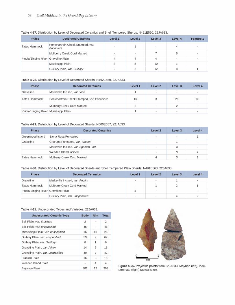
68 Shell Middens in the Grand Bay Estuary
Table 4-27. Distribution by Level of Decorated Ceramics and Shell Tempered Sherds, N491E550, 22JA633.
Phase Decorated Ceramics Level 1 Level 2 Level 3 Level 4 Feature 1
Tates Hammock Pontchartrain Check Stamped, var. Pacaniere - 1 - 4 -
Mullberry Creek Cord Marked - - 7 5 -
Pinola/Singing River Graveline Plain 4 4 4 - -
Mississippi Plain 3 5 10 1 -
Guillory Plain, var. Guillory - 2 12 8 1
Table 4-28. Distribution by Level of Decorated Sherds, N492E550, 22JA633.
Phase Decorated Ceramics Level 1 Level 2 Level 3 Level 4
Graveline Marksville Incised, var. Vick 1 - - -
Tates Hammock Pontchartrain Check Stamped, var. Pacaniere 16 3 28 30
Mulberry Creek Cord Marked 2 - 2 -
Pinola/Singing River Mississippi Plain 1 - - -
Table 4-29. Distribution by Level of Decorated Sherds, N500E557, 22JA633.
Phase Decorated Ceramics Level 2 Level 3 Level 4
Greenwood Island Santa Rosa Punctated - - 1
Graveline Churupa Punctated, var. Watson - 1 -
Marksville Incised, var. Spanish Fort - 3 -
Weeden Island Incised - 9 2
Tates Hammock Mulberry Creek Cord Marked 4 3 1
Table 4-30. Distribution by Level of Decorated Sherds and Shell Tempered Plain Sherds, N491E563, 22JA633.
Phase Decorated Ceramics Level 1 Level 2 Level 3 Level 4
Graveline Marksville Incised, var. Anglim - - 1 -
Tates Hammock Mulberry Creek Cord Marked - 1 2 1
Pinola/Singing River Graveline Plain 3 - - -
Guillory Plain, var. unspecified - - 4 2
Table 4-31. Undecorated Types and Varieties, 22JA633.
Undecorated Ceramic Type Body Rim Total
Bell Plain, var. Stockton 2 - 2
Bell Plain, var. unspecified 46 - 46
Mississippi Plain, var. unspecified 16 10 26
Guillory Plain, var. unspecified 53 9 62
Guillory Plain, var. Guillory 8 1 9
Graveline Plain, var. Aiken 14 2 16
Graveline Plain, var. unspecified 40 2 42
Franklin Plain 16 2 18
Weeden Island Plain - 4 4
Baytown Plain 381 12 393Figure 4-26. Projectile points from 22JA633: Maybon (left), inde-terminate (right) (actual size).

Archaeological Report No. 37 69
Table 4-32. Chipped Stone Artifacts, 22JA564.Catalog Number Provenience Quantity Category Material
90 N503E497, L. 2 1
Bifacially Worked Core Frag-ment
Local Chert
119 N491E494, Profile trim 2
Biface Fragments (same tool)
Local Chert, heated/burned
1 Surface 1Re-tourched Fake
Local Chert
102 N503E497, L. 4 2 Flake Tallahatta Sandstone
27 STP N495E495 (0-20) 1 Flake Coastal
Plain Chert
62 N519E494, L. 2 1 Flake Local Chert
90 N 503E497, L. 2 1 Flake Local Chert
48 STP N525E494 (0-20) 1 Flake Local Chert
89 N492E494, L. 3 2 Flake Local Chert
89 N492E494, L. 3 1 Flake Local Chert, heat treated
Table 4-33. Other Stone Materials from 22JA564.Catalog Number Provenience Quantity Material
1 Surface 1 Siltstone
1 Surface 1 Slate
1 Surface 3 Sandstone
24 STP N490E495 (20-40) 1 Siltstone
29 STP N495E495 (40-70) 2 Sandstone
34 STP N505E495 (20-40) 1 Sandstone
55 N491E494, L. 3 4 Sandstone
62 N519E494, L. 2 2 Sandstone
119 N494E491 Wall Profile 1 Sandstone
131 N494E494, L. 2 1 Sandstone
Table 4-34. Chipped Stone Artifacts, 22JA633.Catalog Number Provenience Quantity Category Material
239 N501E469, L. 5 1 Projectile Point
Local Gravel
239 N501E469, L. 5 1 Projectile Point
Tallahatta Sandstone
241 N501E469, L. 6 1 Blocky Fragment
Tallahatta Sandstone
1 Surface 2 Flakes Local Gravel
43 STP N500E450 (40-60) 2 Flakes Local Gravel
110 STP N495E550 (40-60) 1 Flake Local Gravel
111 N499E480, L. 3 1 Flake Milky Quartz
Figure 4-27. Possible tablet fragment from 22JA575 (actual size). Table 4-35. Other Stone Materials from 22JA575.Catalog Number Provenience Quantity Material
99 Surface 2 Sandstone (one modified)
4 STP N505E500 1 Sandstone
41 STP N506.1E507.2 1 Sandstone
99 Surface2 (from same rock)
Limonite (?)
99 Surface 1 Hematite
104 N505E506, L. 8 7 Hematite
The other specimens show no evidence of wear or modification. Two fragments of the same limonite (?) pebble were also collected from the surface. Finally, several small pieces of hematite (red ochre) were col-lected.
Surface Collections from Other Sites
Small samples of artifacts were collected from four shell middens during brief visits in 2010. These are summarized Table 4-36. Woodland and Mississip-pian components are represented by artifacts from 22JA576 and 22JA632.
Decorated ceramics were collected only from 22JA576, which indicate Apple Street, Tates Ham-mock, and Singing River phase occupations. A sin-gle grog and shell tempered sherd points to a Pino-la phase occupation as well. 22JA576 also produced the only diagnostic lithic artifact during our visit, a stemmed point similar to the Mud Creek type, a Late Gulf Formational to Middle Woodland style. Its blade has been resharpened. Historic artifacts were collect-ed only from 22JA632, which likely reflect a nine-teenth to twentieth-century historic use of the site.
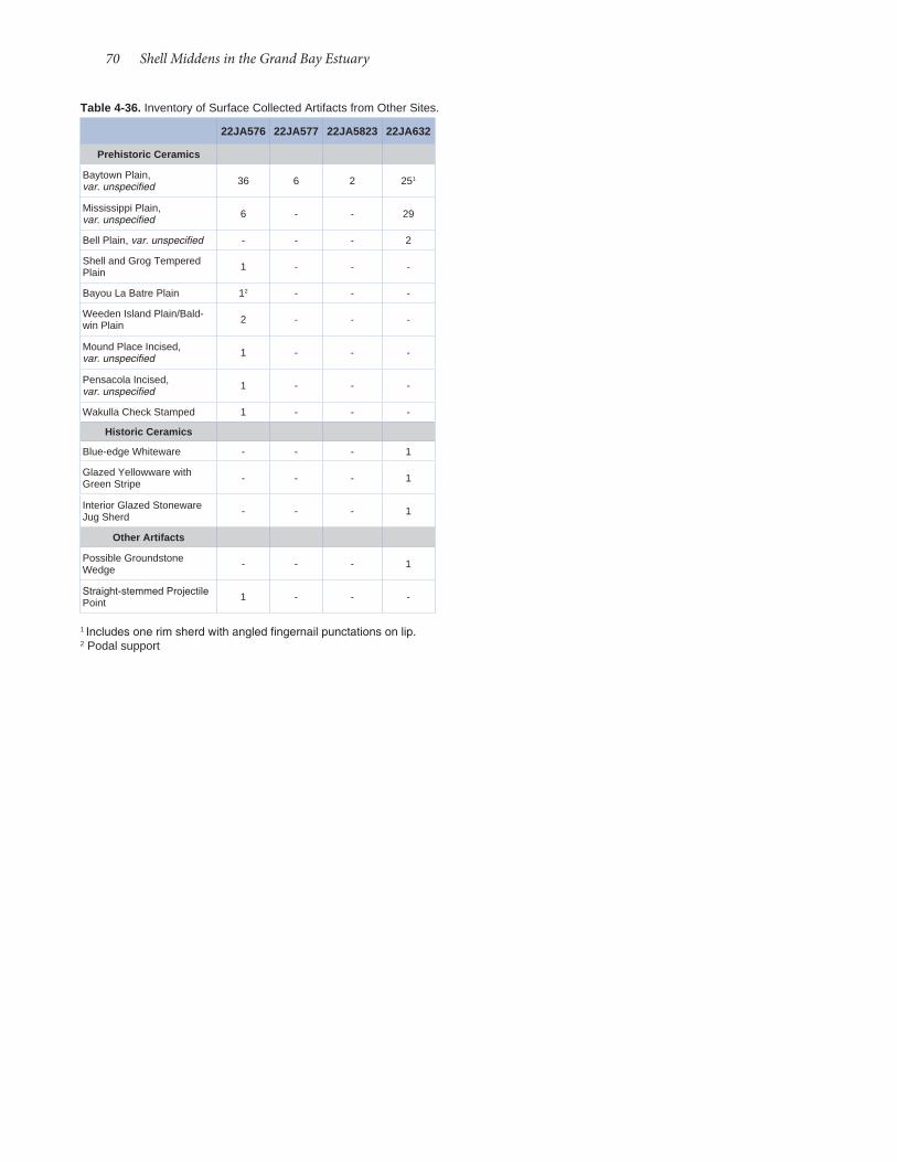
70 Shell Middens in the Grand Bay Estuary
Table 4-36. Inventory of Surface Collected Artifacts from Other Sites.
22JA576 22JA577 22JA5823 22JA632
Prehistoric Ceramics
Baytown Plain, var. unspecified 36 6 2 251
Mississippi Plain, var. unspecified 6 - - 29
Bell Plain, var. unspecified - - - 2
Shell and Grog Tempered Plain 1 - - -
Bayou La Batre Plain 12 - - -
Weeden Island Plain/Bald-win Plain 2 - - -
Mound Place Incised, var. unspecified 1 - - -
Pensacola Incised, var. unspecified 1 - - -
Wakulla Check Stamped 1 - - -
Historic Ceramics
Blue-edge Whiteware - - - 1
Glazed Yellowware with Green Stripe - - - 1
Interior Glazed Stoneware Jug Sherd - - - 1
Other Artifacts
Possible Groundstone Wedge - - - 1
Straight-stemmed Projectile Point 1 - - -
1 Includes one rim sherd with angled fingernail punctations on lip. 2 Podal support

Historic artifacts are plentiful on the Grand Bay shell middens. Ground surfaces are littered with the flotsam and jetsam of Hurricane Katrina, rang-ing from plastic bottles to portions of docks. Recent camping episodes and their associated aluminum cans also contributed to the historic material on the sites. Surface collecting along the shoreline produced numerous fragments of asbestos siding interspersed among prehistoric shells and sherds. For this reason, we were relatively selective in our collection of historic artifacts from the surfaces of sites. We did retain historic material-glass, metal, ceramics, and miscellaneous items-from excavation units, if for no other reason than to gauge the degree of mod-ern disturbance to prehistoric deposits. Data on recovered historic material are included in the artifact inventories of each site. In this chapter, we focus on the chronologically sensitive subsample of historic ar-tifacts, primarily ceramics, to evaluate the possibility of early historic occupation or use of the marshes.
At the three Grand Bay sites investigated by surface surveys, auger and shovel tests, and unit ex-cavations in the summer of 2010-namely, 22JA564, 22JA575, and 22JA633-both surface collections and excavations yielded a total of 91 historic ceramic sherds, weighing a total of 479.70 g and comprising a minimum of 70 vessels (Table 5-1). All told, the three Grand Bay sites yielded a total of 33 eighteenth- century sherds (36% of total sherds excavated at the sites), weighing 189.45 g (39% of total), and compris-ing a minimum of 25 vessels (36% of total). Some of the sherds tabulated as eighteenth- century in date may have been manufactured and used in the nineteenth century, such as creamware and pearlware. However, they were tabulated as eighteenth- century sherds since whiteware quickly gained popularity ear-ly in the nineteenth century and rapidly replaced the older refined earthenwares. As for nineteenth- century ceramics, the three sites yielded 54 sherds (59% of to-tal), weighing 274.36 g (57% of total), and comprised a minimum of 42 vessels (60% of total). Likewise, while some of the ceramics recovered from the three sites may have been manufactured and/or used in the twentieth century, such as the whiteware, mocha-ware, and stoneware, since the preponderance of their period of use occurred in the nineteenth century, they were tabulated as such. Only one site, 22JA633, yielded ceramic sherds that were both manufactured and used only in the twentieth century: one sherd of
Chapter 5 Historic Artifacts
by Barbara Thedy Hester
Table 5-1. Tabulation of Historic Ceramics by Site According to Period of Use.
EIGHTEENTH-CENTURY CERAMICS
22JA564
Type Date Ct. Wt. (g) MNV
Stoneware (Albany-Slipped) 1775-1900 1 1.73 1
Pearlware (Decorated) 1780-1820 1 4.26 1
TOTAL 2 5.99 2
22JA575
Stoneware (pale red and gray) 1750-1850 10 93.96 7
Greyware 1750-1850 1 4.35 1
Creamware 1760-1820 3 5.83 1
Pearlware (Plain) 1780-1820 3 26.38 2
Pearlware (Decorated) 1780-1820 3 7.63 3
Annular Ware 1785-1840 2 8.23 2
TOTAL 22 146.38 16
22JA633
Stoneware 1775-1900 9 37.08 7
TOTAL 9 37.08 7
NINETEENTH-CENTURY CERAMICS
22JA564
Ironstone 1840-1930 2 10.91 2
Whiteware (Plain) 1820-20th c. 5 14.77 5
Whiteware (Decorated) 1920-20th c. 2 7.47 2
TOTAL 9 33.15 9
22JA575
Whiteware (Plain) 1820-20th c. 19 103.17 9
Whiteware (Decorated) 1820-20th c. 10 51.11 10
Spatterware (red) 1820-1860 1 5.38 1
Yellowware 1840-20th c. 5 10.26 4
Mochaware 1799-1939 3 8.07 2
Ironstone 1840-1930 1 14.84 1
TOTAL 39 192.83 27
22JA633
Soft-Paste Porcelain 1800-20th c. 2 0.24 2
Stoneware (with Brown and Bristol Slip)
1835-1920 1 16.57 1
Whiteware (Plain) 1820-20th c. 1 3.72 1
Whiteware (Decorated) 1820-20th c. 1 5.73 1
Stoneware Flowerpot 1830-20th c. 1 22.12 1
TOTAL 6 48.38 6
TWENTIETH-CENTURY CERAMICS
22JA633
Stoneware (Bristol-Slipped) 1920+ 3 14.76 2
Fiestaware 1930-20th c. 1 1.13 1
TOTAL 4 15.89 3
72 Shell Middens in the Grand Bay Estuary
22JA564 appear to span a period of manufacture and use from the late eighteenth century to the end of the nineteenth century.
22JA575 Ceramics
A total of 61 sherds weighing 339.21 g were re-covered from 22JA575, comprising a minimum of 43 vessels (Table 5- 3). The greatest number and di-versity of ceramic artifacts were recovered from this site, which may be attributed to the fact that it is the southernmost of the three sites and the one most ex-posed to the open seas. At the time of our excavation, the depth of the shell midden at 22JA575 always ex-ceeded the lowest tidal level; therefore, the base of the midden was always submerged. Gulf waters per-colated through the shell with the rise and fall of the tide and filtered downward as waves lapped upon and overwashed the shore, which may account for the re-covery of 25 subsurface ceramic sherds from amidst the prehistoric shell. This premise that artifacts have migrated within the shell midden matrix is support-ed by the nature of subsurface finds, which were overwhelmingly smaller than the surface finds. One small sherd of yellowware was found as deep as Level 7 (60- 70 cmbs). Ceramic artifacts recovered from the site span approximately the mid- eighteenth century to present.
One sherd tentatively identified as greyware may have an Iberian source, and ceramics of this type are recovered from eighteenth- century Caribbean ar-chaeological sites (Deagan 1987:39). The earliest date of manufacture and use of greywares was 1750, and its use life extended to 1850. During the eighteenth century, trade between Spaniards and French ensued, despite being prohibited by law (Clune et al. 2003: 64- 66). “Spanish governors made frequent exceptions and allowances to the law confining Louisiana commerce to Spanish ships and ports, and in 1776, Spain officially opened the colony’s trade with France and the French West Indies” (Usner 1992:118-119). This sherd may be evidence of a visit to the site during either the pre- 1783 period of intercolonial trade or the post- 1783 Spanish occupation of West Florida. Perhaps the use- life and deposition of the vessel this sherd was once a part at 22JA575 stretched into the period of Mississippi statehood.
Another noteworthy ceramic recovered from 22JA575 is a plain whiteware sherd with a maker's mark (Figure 5-1). John Davenport began manufacturing earthenware in 1785, first as a workman and later as a partner with Thomas Wolfe of Stoke (Godden 1964:189-191). He acquired his own pottery at Long-
fiestaware weighing 1.13 g and three sherds of Bristol- slipped stoneware, both interior and exterior of the vessel, weighing a total of 14.76 g and comprising a minimum of two vessels.
No archaeological evidence of historic structures was found, at any of the three sites, in terms of postholes, wall trenches, window glass, or nails suggestive of a permanent residence. The only possible exception was Feature 3 at 22JA633, a surface concentration of brick and a possible shell tabby floor. For the most part, ceramics recovered from the three sites likely repre-sent the refuse of transient visitors, who, considering the marshy estuarine environment, perhaps included marsh hunters and fisherfolk.
22JA564Site 22JA564 yielded a total of 11 ceramic sherds
weighing 39.14 g, comprising a minimum of 11 vessels (Table 5- 2). Aside from one sherd of Albany- slipped salt- glazed stoneware (1775- 1900) and one sherd of blue decorated pearlware (1780- 1820) found in Lev-el 2 of N491E494, the nine remaining sherds recov-ered from the site are whiteware and ironstone. One ironstone and five whiteware sherds are surface finds; one of each type was found in Unit 1 with the burial eroding from the bank’s edge. Ceramic artifacts from
Table 5-2. Historic Ceramics by Count, Weight, and Minimum Number of Vessels (MNV) for 22JA564.
Type Ct. Wt. (g) MNV
Stoneware 1 1.73 1
Pearlware (Decorated) 1 4.26 1
Whiteware (Plain) 5 14.77 5
Whiteware (Decorated) 2 7.47 2
Ironstone 2 10.91 2
TOTAL 11 39.14 11
Table 5-3. Historic Ceramic Types for 22JA575.
Type Ct. Wt. (g) MNV
Creamware 3 5.83 1
Stoneware 10 93.96 7
Pearlware (Plain) 3 26.38 2
Pearlware (Decorated) 3 7.63 3
Whiteware (Plain) 19 103.17 9
Whiteware (Decorated) 10 51.11 10
Ironstone 1 14.84 1
Yellowware 5 10.26 4
Spatterware 1 5.38 1
Annular Ware 5 16.3 4
Greyware 1 4.35 1
TOTAL 61 339.21 43

Archaeological Report No. 37 73
the period of manufacture of this piece falls between 1824 and 1884 (Godden 1964:189-191). Upon their defeat in 1763 in the Seven Years War, the French ced-ed the area of the Grand Bay site to the British, who held the territory until their defeat in the American Revolution in 1780. During the Revolutionary period, Anglo- Americans migrated to the Gulf coast and the eastern bank of the Mississippi River in increasing numbers. “By the end of 1775, West Florida became an officially designated asylum for loyalist refugees” (Usner 1992:112). While manufacture of the vessel from which this sherd came would have postdated this period, descendants of these Anglo- American loyalists may have maintained a preference for ceramic wares produced in England.
Gunflints Also falling within the colonial-period use of the
site suggested by some of the ceramics described above are two honey- colored gunflints (Figure 5- 2) of French manufacture, recovered during a surface survey of 22JA575. These artifacts are particularly worthy of attention since the French established their colony of Louisiane in this region of the northern coast of the Gulf of Mexico in 1699. After various relocations along the coast, the French ultimately transferred the capital of their colony to New Orle-ans in 1722, where it remained until 1763 when New Orleans and the territory west of the Mississippi River was ceded to Spain and the area east of the Mississippi was ceded to the English. During the entirety of the French colonial period and beyond, flintlock guns were used by both Indians and Europeans for hunting and warring.
The period of use of flintlock guns (Figures 5-3 and 5- 4) extends from 1650, when true flintlocks were first manufactured (Kenmotsu 2000:341, citing Chapel 1962:40- 45; Rosebush 1962:5- 7), until replaced by other firing mechanisms in the mid-nineteenth century (Kenmotsu 2000:341). The flintlock was only slightly modified over the course of the intervening 230 years. The part of the mechanism that sparked the firing process was the gunflint itself, made of flint or chert, a cryptocrystalline siliceous rock (Kenmotsu 2000:341; Crabtree 1972:51). Procurement sources for
port, Staffordshire, England in 1794 and retired in 1830, leaving the business to his sons William and Henry. Henry died in 1835, and the firm became Wil-liam Davenport and Company. In 1869 William died and left the business to his two sons. The pottery re-mained in the family until 1887. Maker’s marks are generally good dating tools, and they usually point to place of manufacture. The numbers impressed on either side of the anchor on the Davenport sherd represent the year of manufacture. Unfortunately, only the second number, the number “4” to the right of the anchor, is legible on the sherd.
Since this sherd of a whiteware plate recovered from 22JA575 displaying a maker’s mark could have been first produced no earlier than 1820, and since the pottery remained in the Davenport family until 1887,
Figure 5-2. Gunflints from 22JA575; (a) obverse (left) and reverse (right) ; (b) obverse (left) and reverse (right) (actual size).
Figure 5-1. Example of William Davenport and Company maker's mark (Godden 1964:189).
Figure 5-3. Flintlock musket (Diderot's Encyclopedia, Plate 61).
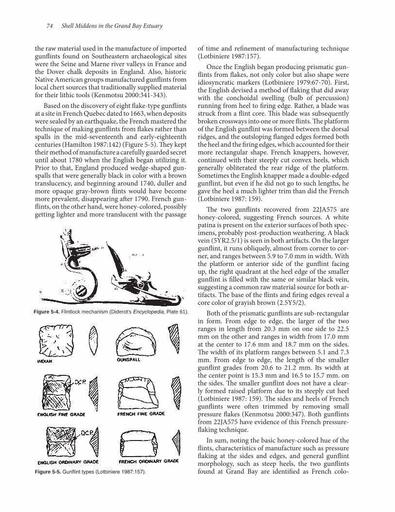
74 Shell Middens in the Grand Bay Estuary
of time and refinement of manufacturing technique (Lotbiniere 1987:157).
Once the English began producing prismatic gun-flints from flakes, not only color but also shape were idiosyncratic markers (Lotbiniere 1979:67- 70). First, the English devised a method of flaking that did away with the conchoidal swelling (bulb of percussion) running from heel to firing edge. Rather, a blade was struck from a flint core. This blade was subsequently broken crossways into one or more flints. The platform of the English gunflint was formed between the dorsal ridges, and the outsloping flanged edges formed both the heel and the firing edges, which accounted for their more rectangular shape. French knappers, however, continued with their steeply cut convex heels, which generally obliterated the rear ridge of the platform. Sometimes the English knapper made a double- edged gunflint, but even if he did not go to such lengths, he gave the heel a much lighter trim than did the French (Lotbiniere 1987: 159).
The two gunflints recovered from 22JA575 are honey- colored, suggesting French sources. A white patina is present on the exterior surfaces of both spec-imens, probably post-production weathering. A black vein (5YR2.5/1) is seen in both artifacts. On the larger gunflint, it runs obliquely, almost from corner to cor-ner, and ranges between 5.9 to 7.0 mm in width. With the platform or anterior side of the gunflint facing up, the right quadrant at the heel edge of the smaller gunflint is filled with the same or similar black vein, suggesting a common raw material source for both ar-tifacts. The base of the flints and firing edges reveal a core color of grayish brown (2.5Y5/2).
Both of the prismatic gunflints are sub-rectangular in form. From edge to edge, the larger of the two ranges in length from 20.3 mm on one side to 22.5 mm on the other and ranges in width from 17.0 mm at the center to 17.6 mm and 18.7 mm on the sides. The width of its platform ranges between 5.1 and 7.3 mm. From edge to edge, the length of the smaller gunflint grades from 20.6 to 21.2 mm. Its width at the center point is 15.3 mm and 16.5 to 15.7 mm. on the sides. The smaller gunflint does not have a clear-ly formed raised platform due to its steeply cut heel (Lotbiniere 1987: 159). The sides and heels of French gunflints were often trimmed by removing small pressure flakes (Kenmotsu 2000:347). Both gunflints from 22JA575 have evidence of this French pressure- flaking technique.
In sum, noting the basic honey- colored hue of the flints, characteristics of manufacture such as pressure flaking at the sides and edges, and general gunflint morphology, such as steep heels, the two gunflints found at Grand Bay are identified as French colo-
the raw material used in the manufacture of imported gunflints found on Southeastern archaeological sites were the Seine and Marne river valleys in France and the Dover chalk deposits in England. Also, historic Native American groups manufactured gunflints from local chert sources that traditionally supplied material for their lithic tools (Kenmotsu 2000:341- 343).
Based on the discovery of eight flake- type gunflints at a site in French Quebec dated to 1663, when deposits were sealed by an earthquake, the French mastered the technique of making gunflints from flakes rather than spalls in the mid- seventeenth and early- eighteenth centuries (Hamilton 1987:142) (Figure 5- 5). They kept their method of manufacture a carefully guarded secret until about 1780 when the English began utilizing it. Prior to that, England produced wedge- shaped gun-spalls that were generally black in color with a brown translucency, and beginning around 1740, duller and more opaque gray- brown flints would have become more prevalent, disappearing after 1790. French gun-flints, on the other hand, were honey- colored, possibly getting lighter and more translucent with the passage
Figure 5-4. Flintlock mechanism (Diderot's Encyclopedia, Plate 61).
Figure 5-5. Gunflint types (Lotbiniere 1987:157).

Archaeological Report No. 37 75
nial-era gunflints. Both are fine grade, according to Hamilton’s typology. The small sizes suggest they were used in French hunting fusils rather than in military muskets (Gregory Waselkov 2011, personal communication).
22JA633 A total of 19 ceramic sherds weighing 101.35 g
from 22JA633, represent a minimum of 16 vessels (Ta-ble 5- 4). In this small ceramic assemblage brownwares predominate. Albany- slipped stonewares are most abundant, with a total of seven sherds comprising a minimum of five vessels. Their total weight is 47.64 g. Three small brown lead- glazed stoneware sherds, hav-ing a weight of 6.01 g, represent a minimum of three vessels. Only three small sherds were recovered by excavation, and all were found in Level 1: one brown lead- glazed stoneware sherd weighing 1.40 g and two tiny porcelain (possible milk glass) sherds weighing 0.24 g. Two whiteware sherds-one transfer-printed in a gray- and- black floral design, weighing 5.73 g, and one plain sherd weighing 3.72 g-were recovered from the surface of the site. Three additional surface finds include a red Fiestaware sherd weighing 1.13 g, one Bristol- slipped stoneware sherd weighing 14.76 g, and one stoneware flowerpot sherd weighing 22.12 g.
While produced in Burlington, New Jersey in 1684 and in New York City about 1735, American-made stonewares were not common until after the Revolution (Ramsay 1947:139). Albany slip came into wide use in the United States as a glaze for utilitarian stonewares in the beginning of the nineteenth cen-tury, and plain stonewares with salt- glazed exteriors and Albany- slip interiors became ubiquitous after 1850 (Greer 1981:194, 197, 265). This method of seal-ing both interior and exterior surfaces of the vessel-one with salt glaze and one with slip-was developed because the salt vapors would not descend inside the vessel while firing; therefore, the inside of the vessel had to be covered with a separate glaze or left unglazed (Majewski and O’Brien, 1987:110). Unglazed interiors were less desirable since liquids inside would seep into and through the vessel walls (Greer 1981:197). Prior to 1920, Bristol glaze was used on the exteriors of pots in combination with Albany slips; after 1920, it was almost always used alone (Greer 1981:210- 13).
Ceramic pots were produced by local cottage manufacturers on the northern Gulf coast since as early as the 1720s (Gums 2001:4). Such local manu-facture gave rise to pottery traditions with distinctive regional characteristics based on variations in geography, ethnicity, cultural influences, and raw material availability (Gums 2001:1). During the nine-teenth and early twentieth centuries, salt- glazed,
Albany- slipped, and lead- glazed ceramics of the types found at 22JA633 were produced in local potteries in the Mobile Bay region (Gums 2001:5- 10). Missis-sippi also had its own coteries of potters. While not known for stoneware manufacture, the famous Bi-loxi potter George Ohr (1857- 1918), self-proclaimed “Mad Potter of Biloxi,” mined local clays and created distinctive pots in south Mississippi, as did his mentor Joseph Fortune Meyer (1848- 1931) and Joseph’s father François A. Meyer, who created their pots in the Back Bay area of Biloxi. Stonewares may also have been produced in Mississippi. Whether produced locally or outsourced, stonewares were hardy vessels that could withstand the rigors of hunting camp use.
Conclusions The three Grand Bay sites yielded 33 eighteenth-
century ceramic sherds (36% of all sherds excavated at the sites), weighing 189.45 g (39% of total) and comprising a minimum of 25 vessels (36% of total); 54 sherds (59% of total) of nineteenth- century ce-ramics, weighing 274.36 g (57% of total) and com-prising a minimum of 42 vessels (60% of total); and four twentieth- century sherds weighing 15.89 g and comprising a minimum of three vessels (Table 5- 5). When comparing the three Grand Bay sites-22JA564, 22JA575, and 22JA633-the site farthest to the south, 22JA575, yielded the largest number of vessels (Fig-ure 5- 6), 16 dating to the eighteenth century and 27 dating to the nineteenth century.
Cumulatively, at all three sites stoneware and whiteware sherds are most abundant: a minimum of 19 stoneware vessels, 15 plain whiteware vessels, and 13 decorated whiteware vessels. This not particularly surprising, since stoneware and whiteware are two of the most ubiquitous utilitarian and serving wares of the nineteenth and twentieth centuries. The period of use for pale red and gray salt- glazed stoneware vessels found at 22JA575 begins as early as the mid-eighteenth century (Ramsey 1947:139), and the Albany- slipped salt- glazed stoneware recovered from 22JA564 and 22JA633 dates to as early as the late eighteenth century and extended into the 1900s (Ramsey 1947:139- 40). Plain whiteware became popular around the second
Table 5-4. Historic Ceramic Types from 22JA633.
Type Ct. Wt. (g) MNV
Stoneware 14 90.53 11
Whiteware (Plain) 1 3.72 1
Whiteware (Decorated) 1 5.73 1
Porcelain 2 0.24 2
Fiestaware 1 1.13 1
TOTAL 19 101.35 16
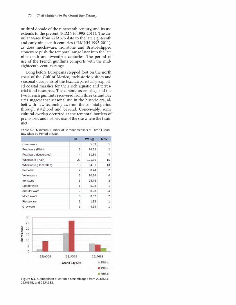
76 Shell Middens in the Grand Bay Estuary
or third decade of the nineteenth century, and its use extends to the present (FLMNH 1995- 2011). The an-nular wares from 22JA575 date to the late eighteenth and early nineteenth centuries (FLMNH 1995- 2011), as does mochaware. Ironstone and Bristol- slipped stoneware push the temporal range later into the late nineteenth and twentieth centuries. The period of use of the French gunflints comports with the mid- eighteenth-century range.
Long before Europeans stepped foot on the north coast of the Gulf of Mexico, prehistoric visitors and seasonal occupants of the Escatawpa estuary exploit-ed coastal marshes for their rich aquatic and terres-trial food resources. The ceramic assemblage and the two French gunflints recovered from three Grand Bay sites suggest that seasonal use in the historic era, al-beit with new technologies, from the colonial period through statehood and beyond. Conceivably, some cultural overlap occurred at the temporal borders of prehistoric and historic use of the site where the twain met.
Figure 5-6. Comparison of ceramic assemblages from 22JA564, 22JA575, and 22JA633.
Table 5-5. Minimum Number of Ceramic Vessels at Three Grand Bay Sites by Period of Use.
Ct. Wt. (g) MNV
Creamware 3 5.83 1
Pearlware (Plain) 3 26.38 2
Pearlware (Decorated) 4 11.89 4
Whiteware (Plain) 25 121.66 15
Whiteware (Decorated) 13 64.31 13
Porcelain 2 0.24 2
Yellowware 5 10.26 4
Ironstone 3 25.75 3
Spatterware 1 5.38 1
Annular ware 2 8.23 24
Mochaware 3 8.07 2
Fiestaware 1 1.13 1
Greyware 1 4.35 1
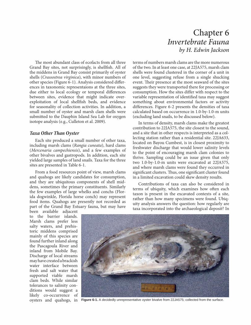
The most abundant class of ecofacts from all three Grand Bay sites, not surprisingly, is shellfish. All of the middens in Grand Bay consist primarily of oyster shells (Crassostrea virginica), with minor numbers of other species (Figure 6- 1). Analysis considered differ-ences in taxonomic representaions at the three sites, due either to local ecology or temporal differences between sites, evidence that might indicate over- exploitation of local shellfish beds, and evidence for seasonality of collection activities. In addition, a small number of oyster and marsh clam shells were submitted to the Dauphin Island Sea Lab for oxygen isotope analysis (e.g., Culleton et al. 2009).
Taxa Other Than Oyster Each site produced a small number of other taxa,
including marsh clams (Rangia cuneata), hard clams (Mercenaria campechiensis), and a few examples of other bivalves and gastropods. In addition, each site yielded large samples of land snails. Taxa for the three sites are presented in Table 6- 1.
From a food resources point of view, marsh clams and quahogs are likely candidates for consumption, and they are ubiquitous components of shell mid-dens, sometimes the primary constituents. Similarly the few examples of large whelks and conchs (Flor-ida dogwinkle, Florida horse conch) may represent food items. Quahogs are presently not recorded as part of the Grand Bay Estuary fauna, but may have been available adjacent to the barrier islands. Marsh clams prefer less salty waters, and prehis-toric middens comprised mainly of this species are found further inland along the Pascagoula River and inland from Mobile Bay. Discharge of local streams may have created a brackish water interface between fresh and salt water that supported viable marsh clam beds. While similar tolerances to salinity con-ditions would suggest a likely co- occurrence of oysters and quahogs, in
terms of numbers marsh clams are the more numerous of the two. In at least one case, at 22JA575, marsh clam shells were found clustered in the corner of a unit in one level, suggesting refuse from a single shucking event. Their presence at the most seaward of the sites suggests they were transported there for processing or consumption. How the sites differ with respect to the variable representation of identified taxa may suggest something about environmental factors or activity differences. Figure 6- 2 presents the densities of taxa calculated based on occurrence in 1.0-by- 1.0-m units (excluding land snails, to be discussed below).
In terms of density, marsh clams make the greatest contribution to 22JA575, the site closest to the sound, and a site that in other respects is interpreted as a col-lecting station rather than a residential site. 22JA633, located on Bayou Cumbest, is in closest proximity to freshwater discharge that would lower salinity levels to the point of encouraging marsh clam colonies to thrive. Sampling could be an issue given that only two 1.0-by-1.0-m units were excavated at 22JA575, and where marsh clams were found they occurred in significant clusters. Thus, one significant cluster found in a limited excavation could skew density results.
Contributions of taxa can also be considered in terms of ubiquity, which examines how often each taxon is present in the excavated contexts of a site, rather than how many specimens were found. Ubiq-uity analysis answers the question: how regularly are taxa incorporated into the archaeological deposit? In
Chapter 6 Invertebrate Fauna
by H. Edwin Jackson
Figure 6-1. A decidedly unrepresentative oyster bivalve from 22JA575; collected from the surface.
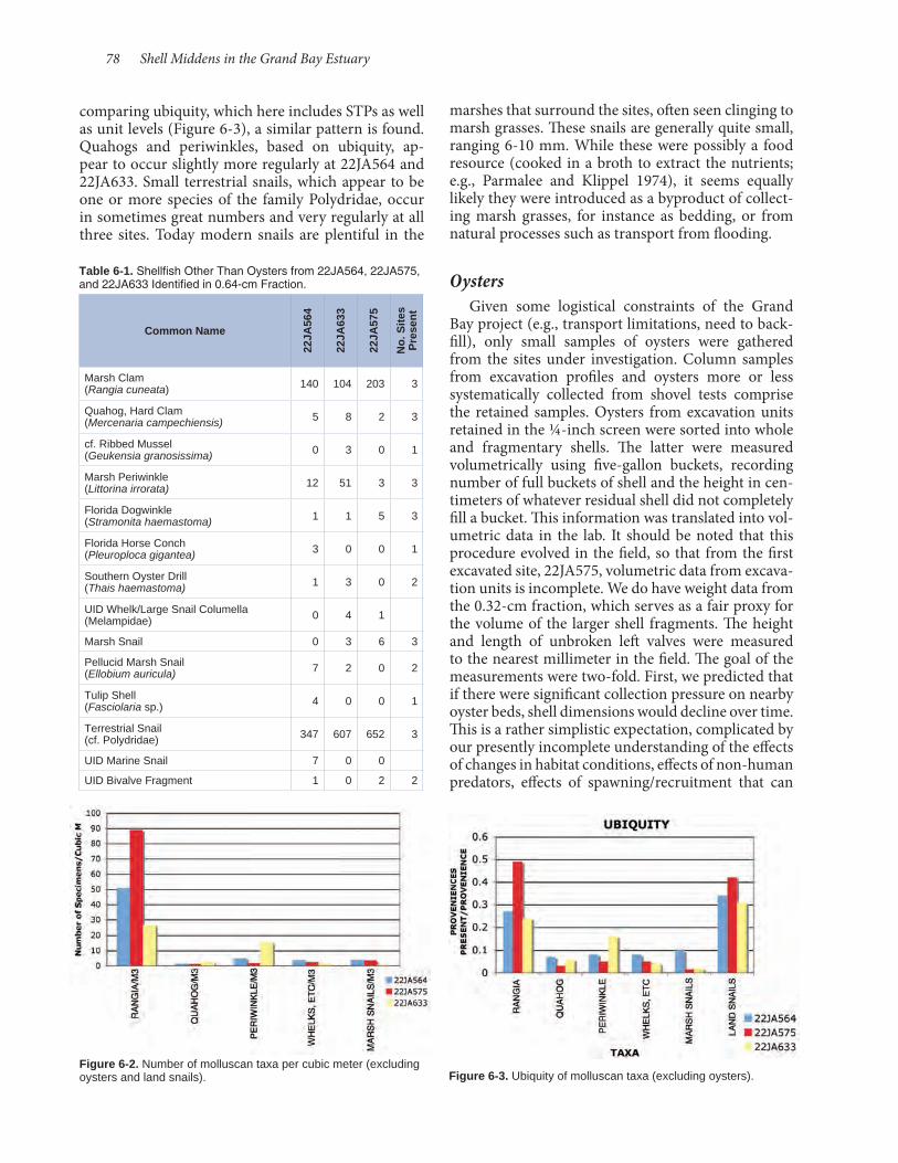
78 Shell Middens in the Grand Bay Estuary
marshes that surround the sites, often seen clinging to marsh grasses. These snails are generally quite small, ranging 6-10 mm. While these were possibly a food resource (cooked in a broth to extract the nutrients; e.g., Parmalee and Klippel 1974), it seems equally likely they were introduced as a byproduct of collect-ing marsh grasses, for instance as bedding, or from natural processes such as transport from flooding.
Oysters Given some logistical constraints of the Grand
Bay project (e.g., transport limitations, need to back-fill), only small samples of oysters were gathered from the sites under investigation. Column samples from excavation profiles and oysters more or less systematically collected from shovel tests comprise the retained samples. Oysters from excavation units retained in the ¼-inch screen were sorted into whole and fragmentary shells. The latter were measured volumetrically using five- gallon buckets, recording number of full buckets of shell and the height in cen-timeters of whatever residual shell did not completely fill a bucket. This information was translated into vol-umetric data in the lab. It should be noted that this procedure evolved in the field, so that from the first excavated site, 22JA575, volumetric data from excava-tion units is incomplete. We do have weight data from the 0.32-cm fraction, which serves as a fair proxy for the volume of the larger shell fragments. The height and length of unbroken left valves were measured to the nearest millimeter in the field. The goal of the measurements were two- fold. First, we predicted that if there were significant collection pressure on nearby oyster beds, shell dimensions would decline over time. This is a rather simplistic expectation, complicated by our presently incomplete understanding of the effects of changes in habitat conditions, effects of non- human predators, effects of spawning/recruitment that can
comparing ubiquity, which here includes STPs as well as unit levels (Figure 6- 3), a similar pattern is found. Quahogs and periwinkles, based on ubiquity, ap-pear to occur slightly more regularly at 22JA564 and 22JA633. Small terrestrial snails, which appear to be one or more species of the family Polydridae, occur in sometimes great numbers and very regularly at all three sites. Today modern snails are plentiful in the
Table 6-1. Shellfish Other Than Oysters from 22JA564, 22JA575, and 22JA633 Identified in 0.64-cm Fraction.
Common Name
22JA
564
22JA
633
22JA
575
No.
Site
s P
rese
nt
Marsh Clam (Rangia cuneata) 140 104 203 3
Quahog, Hard Clam (Mercenaria campechiensis) 5 8 2 3
cf. Ribbed Mussel (Geukensia granosissima) 0 3 0 1
Marsh Periwinkle (Littorina irrorata) 12 51 3 3
Florida Dogwinkle (Stramonita haemastoma) 1 1 5 3
Florida Horse Conch (Pleuroploca gigantea) 3 0 0 1
Southern Oyster Drill(Thais haemastoma) 1 3 0 2
UID Whelk/Large Snail Columella (Melampidae) 0 4 1
Marsh Snail 0 3 6 3
Pellucid Marsh Snail (Ellobium auricula) 7 2 0 2
Tulip Shell (Fasciolaria sp.) 4 0 0 1
Terrestrial Snail (cf. Polydridae) 347 607 652 3
UID Marine Snail 7 0 0
UID Bivalve Fragment 1 0 2 2
Figure 6-2. Number of molluscan taxa per cubic meter (excluding oysters and land snails). Figure 6-3. Ubiquity of molluscan taxa (excluding oysters).
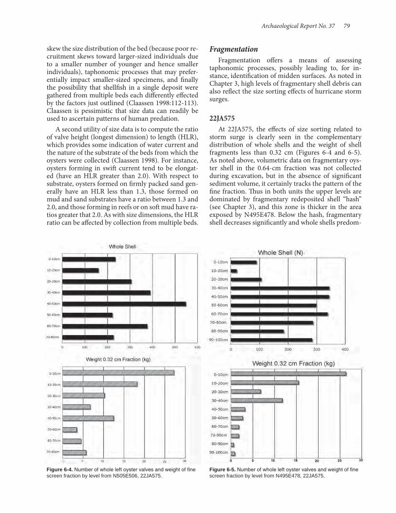
Archaeological Report No. 37 79
Fragmentation Fragmentation offers a means of assessing
taphonomic processes, possibly leading to, for in-stance, identification of midden surfaces. As noted in Chapter 3, high levels of fragmentary shell debris can also reflect the size sorting effects of hurricane storm surges.
22JA575At 22JA575, the effects of size sorting related to
storm surge is clearly seen in the complementary distribution of whole shells and the weight of shell fragments less than 0.32 cm (Figures 6- 4 and 6- 5). As noted above, volumetric data on fragmentary oys-ter shell in the 0.64-cm fraction was not collected during excavation, but in the absence of significant sediment volume, it certainly tracks the pattern of the fine fraction. Thus in both units the upper levels are dominated by fragmentary redeposited shell “hash” (see Chapter 3), and this zone is thicker in the area exposed by N495E478. Below the hash, fragmentary shell decreases significantly and whole shells predom-
skew the size distribution of the bed (because poor re-cruitment skews toward larger-sized individuals due to a smaller number of younger and hence smaller individuals), taphonomic processes that may prefer-entially impact smaller- sized specimens, and finally the possibility that shellfish in a single deposit were gathered from multiple beds each differently effected by the factors just outlined (Claassen 1998:112- 113). Claassen is pessimistic that size data can readily be used to ascertain patterns of human predation.
A second utility of size data is to compute the ratio of valve height (longest dimension) to length (HLR), which provides some indication of water current and the nature of the substrate of the beds from which the oysters were collected (Claassen 1998). For instance, oysters forming in swift current tend to be elongat-ed (have an HLR greater than 2.0). With respect to substrate, oysters formed on firmly packed sand gen-erally have an HLR less than 1.3, those formed on mud and sand substrates have a ratio between 1.3 and 2.0, and those forming in reefs or on soft mud have ra-tios greater that 2.0. As with size dimensions, the HLR ratio can be affected by collection from multiple beds.
Figure 6-4. Number of whole left oyster valves and weight of fine screen fraction by level from N505E506, 22JA575.
Figure 6-5. Number of whole left oyster valves and weight of fine screen fraction by level from N495E478, 22JA575.
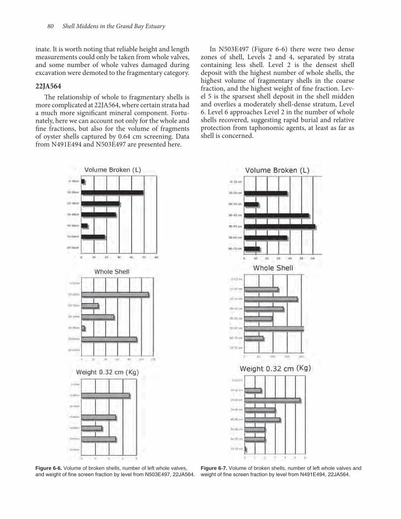
80 Shell Middens in the Grand Bay Estuary
In N503E497 (Figure 6- 6) there were two dense zones of shell, Levels 2 and 4, separated by strata containing less shell. Level 2 is the densest shell deposit with the highest number of whole shells, the highest volume of fragmentary shells in the coarse fraction, and the highest weight of fine fraction. Lev-el 5 is the sparsest shell deposit in the shell midden and overlies a moderately shell-dense stratum, Level 6. Level 6 approaches Level 2 in the number of whole shells recovered, suggesting rapid burial and relative protection from taphonomic agents, at least as far as shell is concerned.
inate. It is worth noting that reliable height and length measurements could only be taken from whole valves, and some number of whole valves damaged during excavation were demoted to the fragmentary category. 22JA564
The relationship of whole to fragmentary shells is more complicated at 22JA564, where certain strata had a much more significant mineral component. Fortu-nately, here we can account not only for the whole and fine fractions, but also for the volume of fragments of oyster shells captured by 0.64 cm screening. Data from N491E494 and N503E497 are presented here.
Figure 6-6. Volume of broken shells, number of left whole valves, and weight of fine screen fraction by level from N503E497, 22JA564.
Figure 6-7. Volume of broken shells, number of left whole valves and weight of fine screen fraction by level from N491E494, 22JA564.

Archaeological Report No. 37 81
N491E494 exposed a shell deposit with greater overall density of oyster remains, as well as signifi-cantly greater numbers of whole valves (Figure 6- 7). In contrast to N503E497, where only one level (Level 2) produced in excess of 100 measurable valves, in N491E494 only one level (Level 7, at the base of the shell deposit) failed to meet or exceed 100 measurable valves, with Level 6 producing 220. The general ratios of broken shell volume to number of whole valves per level are not out of line with those from N503E497. However, suggesting that, on the whole, shell destructive processes were probably compara-ble leads us to conclude that there was originally a higher concentration of shells comprising deposits in
the vicinity of N491E494, which is attributable to its closer proximity to the bayou and to sampling from the part of the site more likely to have been used for shellfish processing.
22JA633 Five units produced sufficient oyster shell samples
to examine deposit composition. Only N499E480 was excavated in a spot relatively devoid of shell deposit. Earth middens in that location had only scattered shells and debris.
Data from N501E469, near the western end of the site, is presented in Figure 6- 8. Here volume
Figure 6-8. Volume of broken shell, number of left whole valves, and weight of fine screen fraction by level from N501E469, 22JA633.
Figure 6-9. Volume of broken shells, number of left whole valves, and weight of fine screen fraction by levels from N491E550, 22JA633.

82 Shell Middens in the Grand Bay Estuary
of crushed shell, numbers of whole valves, and the weights of the fine fraction appear to share the same pattern, indicating little variation from top to bottom of the shell deposit.
Oyster shell composition in N491E550 (Fig-ure 6- 9) shows a similar pattern, except for an in-creased amount of fine screen shell debris in Level 1 attributable to surface taphonomic processes, and dominance of fragmentary debris in the lower levels unaccompanied by spikes in the fine screen sample weight. Adjacent unit N492E550 (Figure 6- 10), fur-ther from the shoreline, actually differs quite a bit, with smaller volumes, counts, and weights overall. In particular, fine fraction weight is significantly less
than elsewhere on the site, possibly due to a more protective sediment matrix comprising a greater part of level volumes.
N500E557 (Figure 6- 11) was placed near the northern edge of the shell distribution. Its shell de-posit was both thinner and the shell density is low compared to other tested locations. The data by level are somewhat misleading, as most of the shells, predominantly fragmentary in Level 1, were from near the base of the level. Only Level 2 is similar to other deposits, but in fact differs due to the large number of whole valves in this relatively protected margin of the site.
Figure 6-10. Volume of broken shells, number of left whole valves, and weight of fine screen fraction by levels from N492E550, 22JA633.
Figure 6-11. Volume of broken shells, number of left whole valves, and weight of fine screen fraction by levels from N500E557, 22JA633.

Archaeological Report No. 37 83
Finally, N491E563 (Figure 6- 12) is notable in for the number of measurable left valves recovered, and broken shell volume is relatively low. This may reflect rapid midden accumulation in the area, or lack of hu-man activities that would tend to break shells down once deposited. The unit is in similar proximity to the bank edge as N491E550, so differences are difficult to interpret.
The foregoing analysis of midden composition in-dicates variability across the sites and from site to site in shell density, shell preservation, and the degree to which fragmentation has broken whole valves into larger and then into smaller pieces. One clear distinc-tion can be drawn between 22JA575 and the other two
sites: at neither of the latter did excavations encounter homogenous deposits of small fragments that would indicate redeposition of midden by storm surge. In-stead, despite variation from location to location, it appears that the middens at 22JA564 and 22JA633 are largely intact, save for in situ depositional processes.
Trends in Oyster Size Despite the cautions voiced by Claassen cited
above, it is useful to examine size data for any trends and intrasite or intersite differences that may reflect changes either in the environment or in patterns of exploitation.
22JA575 Figure 6- 13 presents oyster valve average height
and standard deviation by level for N495E478 and N505E506. There is no reason to believe that the same levels are contemporaneous, but ceramics from both units, as well as radiocarbon dates, indicate that both encountered terminal Woodland/Early Mississippian deposits in the lower levels and middle Mississippian deposits near the top. Two trends are of interest. In both units there is fluctuation in the lower half of the deposits between levels with larger average size and those with smaller average size, rather than a unilinear change in size. Upper deposits are more similar in average size, though below the maximum average size from a level in each unit. The pattern may indicate a change in collection strategy, from one where early collection persisted until size was depressed, and then the shellfish bed was abandoned until size rebounded. In the later levels, roughly associated with the mature Mississippian time range, a more sustained but lower impact collection strategy ensued that neither allowed oyster sizes to increase significantly nor appreciably depressed average oyster sizes. Standard deviations around the mean are relatively stable, with the excep-tion of Level 6 in N495E478, where a jump in standard deviation occurs with an overall decrease in average height, perhaps reflecting multiple sources of oysters that included the depressed bed and individuals col-lected elsewhere.
22JA564 Figure 6- 14 presents comparable data for exca-
vation units at 22JA564. The utility of this exercise is supported by the very similar pattern exhibited by N491E494 and the adjacent 1.0-by-0.5-m unit N492E494. N503E497 documents an initial decline, then a rebound, then gradual decline in oyster valve height. This pattern is similar to the one seen in N491E494, although in this unit there is a two-level
Figure 6-12. Volume of broken shells, number of left whole valves, and weight of fine screen fraction by level from N491E563, 22JA633.
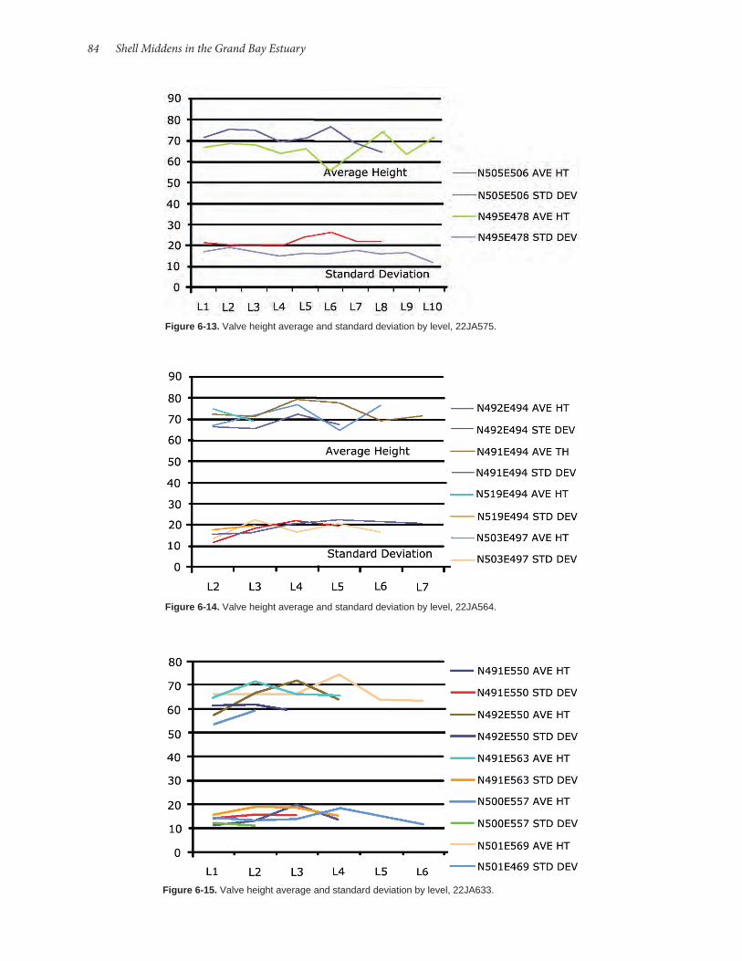
84 Shell Middens in the Grand Bay Estuary
Figure 6-14. Valve height average and standard deviation by level, 22JA564.
Figure 6-13. Valve height average and standard deviation by level, 22JA575.
Figure 6-15. Valve height average and standard deviation by level, 22JA633.

Archaeological Report No. 37 85
peak in average size. In the final two levels of the shell deposit sample there is a slight decline in average size that may indicate increased collecting pressure. This smaller size range seems persistent, since the ceramic data suggest the upper levels of N503E497 are somewhat earlier (Graveline phase) that those in N491E494 (late Graveline or early Tates Hammock phase). Standard deviations hold relatively constant until the upper levels, indicating greater uniformity of smaller sizes in the latest deposits.
22JA633 Finally, oyster valve data from 22JA633 are pre-
sented in Figure 6-15. Our deepest sequence comes from N501E469. Unfortunately a dearth of ceramics collected from this unit hinders chronological inter-pretation. Ceramics from the upper three levels sug-gest a time in the (early?) Graveline phase, so the lower levels are at least this early, if not earlier. Interestingly, the highest and lowest average sizes per level are repre-sented in these lower levels, suggesting intensive col-lecting, then abandonment for some period of time. Level 6 may be misleading in that only thirteen valves were measured and these came from the upper part of the level, so they probably belong to the same depo-sitional context as Level 5. In the two adjoining units, N491E550 and N492E550, patterns are not clearly aligned. While N492E550 shows a steady decline in average size (and an associated decline in standard deviation), N491E550 shows a slight increase from Level 3 to Level 2, then holds steady (with standard deviation decreasing as well). One characteristic is shared by these units. For levels with peak average size for a particular unit, there is a corresponding peak in
Figure 6-16. Distribution of height means by level for all sites.Figure 6-17. Height to length ratio (HLR) for all levels of each unit, 22JA564.
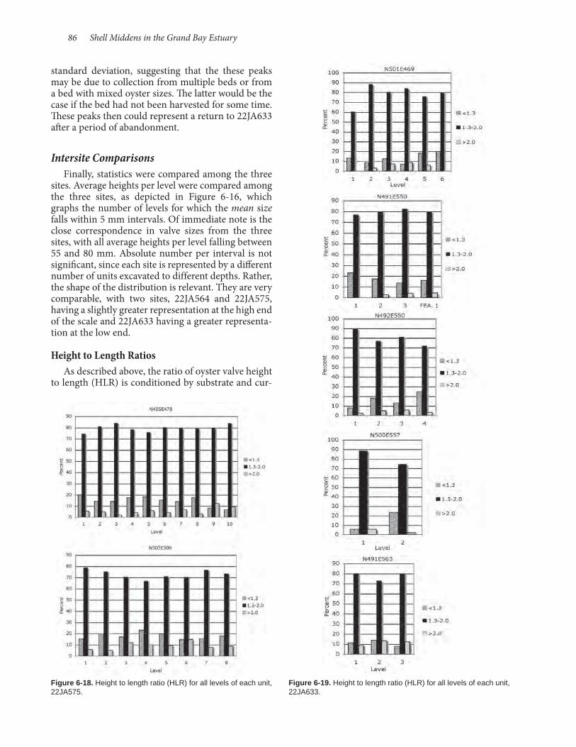
86 Shell Middens in the Grand Bay Estuary
standard deviation, suggesting that the these peaks may be due to collection from multiple beds or from a bed with mixed oyster sizes. The latter would be the case if the bed had not been harvested for some time. These peaks then could represent a return to 22JA633 after a period of abandonment.
Intersite Comparisons Finally, statistics were compared among the three
sites. Average heights per level were compared among the three sites, as depicted in Figure 6- 16, which graphs the number of levels for which the mean size falls within 5 mm intervals. Of immediate note is the close correspondence in valve sizes from the three sites, with all average heights per level falling between 55 and 80 mm. Absolute number per interval is not significant, since each site is represented by a different number of units excavated to different depths. Rather, the shape of the distribution is relevant. They are very comparable, with two sites, 22JA564 and 22JA575, having a slightly greater representation at the high end of the scale and 22JA633 having a greater representa-tion at the low end.
Height to Length RatiosAs described above, the ratio of oyster valve height
to length (HLR) is conditioned by substrate and cur-
Figure 6-19. Height to length ratio (HLR) for all levels of each unit, 22JA633.
Figure 6-18. Height to length ratio (HLR) for all levels of each unit, 22JA575.

Archaeological Report No. 37 87
rent. HLR was calculated for all measured valves from excavation units to determine whether there were differences over time reflected in all site assemblag-es or whether there were differences between sites that reflected geographic differences in the exploited shellfish beds. The ratios are collapsed into three cat-egories: less than 1.3, between 1.3 and 2.0 (inclusive), and greater than 2.0. Distributions are illustrated in Figures 6- 17 through 6- 19. Regardless of site or level, the ratio distributions are very consistent, with the vast majority of HLR values from 1.3 to 2.0, which points to substrate conditions of mud or soft sand, a condition that occurs today throughout the estuary.
Seasonality of Shellfish Collection A number of approaches have been used to
determine the seasonality of shellfish collecting. An-nual growth ring analysis using quahogs has been successful in a number of studies (e.g., Quitmyer et al. 1985; Quitmyer et al. 1992). Such an approach is difficult for analyzing archaeological oysters due to their tendency to exfoliate over time. However, Her-bert and Steponaitis (1998) offer a possible method that involves examining the hinge. Analysis of marsh clam growth rings also have been problematic due to a lack of correspondence between rings and annual growth. On the other hand, with sufficient samples, size composition of marsh clam samples seems to have utility in determining likely season of harvest (Montana 1996; Ricklis and Whelan 2002). Increas-ingly, attention has turned to measurement of oxygen isotope data, which has recently proven successful for marsh clams and quahogs. Results using oysters have-been less successful, since not only temperature (as indicator of season), but also salinity has an impact on absorption of different isotopic variations of oxygen.
A sample of oyster, quahog, and marsh clam valves has been submitted to Dr. Ruth Carmichael, a biochemist with the Dauphin Island Sea Lab for isotope analysis. While her research is focused on prehistoric water quality for comparison with mod-ern conditions and their impact on oysters, data col-lected from archaeological shells may shed light on seasonality issues as well. Results of this research will be disseminated when they become available.

88 Shell Middens in the Grand Bay Estuary

Faunal remains were abundant in the shell middens at the three Grand Bay coastal sites excavated by the USM in 2010. All of the sites are located on islands in the estuary, between the mouth of the Pascagoula River and the Alabama state line. Due to recent ero-sion and subsidence of the coastal environment in the area, each of the three sites probably was located on somewhat larger areas of land when occupied, and one, 22JA633, may actually have been connected to the mainland. All of the sites have Woodland com-ponents, the earliest being the lower levels (6 to 8) of 22JA564, which-based on radiocarbon dates and as-sociated ceramics-are believed to date to the Middle Woodland period. 22JA575 had the latest occupation, dating to the terminal Late Woodland/Mississippian periods.
In the field, all excavated matrix was processed through 0.64-cm (¼-inch) or 0.32-cm (⅛-inch) screen mesh, and numerous flotation samples were collected. Because the volume of animal bones far exceeded the analysis budget, only a portion of the 0.64-cm sample was considered for this report. To maximize data quality, analyzed samples include those from levels of excavation units that were as-signable to phases based on analyzed ceramics and aided by radiocarbon dates. Fish remains are abun-
dant in the unanalyzed fine screen fractions, although most are unidentifiable vertebral elements. The oyster shell matrix of the various middens contributed to bone preservation by raising soil pH, but also created some mechanical erosion that pulverized all but the most robust elements. For instance, Herring (Clupei-dae), which have very delicate bones, were abundant in the sandy Woodland age deposits at Graveline Mound (Scott 2011), but are here represented by a single atlas in the Middle Woodland deposit at 22JA564. One other taphonomic process was noted during analysis. Small mammals, when present, were frequently represented by more than one element, suggesting rapid deposition, presumably because the remains were quickly buried under shell from penecontemporaneous oyster consumption.
Methods All of the faunal remains were identified by the au-
thor using comparative collections from the Depart-ment of Anthropology and Geography at Louisiana State University, the Louisiana Museum of Natural History, or collections at USM. Bones were identified to the most specific level possible, given the surviving morphology of the fragment. Element, side, degree of
fragmentation, portion, age, and sex were record-ed for birds and mammals when possible. For fish and alligator remains, length was estimated by comparing a fragment to a range of specimens of known size. Lengths are reported as standard length (SL), which is the length from the tip of the snout to the anterior edge of the fin. Vertebral diameter was recorded for fish vertebrae. Also noted were carnivore and rodent gnawing, char-ring, butchering marks, erosion, and leaching.
Chapter 7 Vertebrate Faunal Remains
by Susan L. Scott
Figure 7-1. Middle Woodland fish composition by MNI and estimated length, 22JA564.
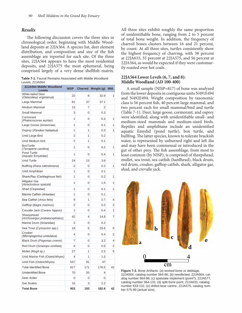
90 Shell Middens in the Grand Bay Estuary
All three sites exhibit roughly the same proportion of unidentifiable bone, ranging from 2 to 5 percent of total bone weight. In addition, the frequency of charred bones clusters between 16 and 21 percent, by count. At all three sites, turtles consistently show the highest frequency of charring, with 38 percent at 22JA633, 55 percent at 22JA575, and 56 percent at 22JA564, as would be expected if they were customar-ily roasted over hot coals.
22JA564 Lower Levels (6, 7, and 8): Middle Woodland (AD 100-400)
A small sample (NISP=817) of bone was analyzed from the lower deposits in contiguous units N491E494 and N492E494. Weight composition by taxonomic class is 56 percent fish, 40 percent large mammal, and two percent each for small mammal/bird and turtle (Table 7- 1). Deer, large goose, cormorant, and osprey were identified, along with unidentifiable small- and medium-sized mammals and medium-sized birds. Reptiles and amphibians include an unidentified aquatic Emydid (pond turtle), box turtle, and bullfrog. The latter species, known to tolerate brackish water, is represented by unburned right and left ilia and may have been commensal or introduced in the gut of other prey. The fish assemblage, from most to least common (by NISP), is comprised of sheepshead, mullet, sea trout, sea catfish (hardhead), black drum, red drum, croaker, gafftop catfish, shark, alligator gar, shad, and crevalle jack.
ResultsThe following discussion covers the three sites in
chronological order, beginning with Middle Wood-land deposits at 22JA564. A species list, deer element distribution, and composition and size of the fish assemblage are reported for each site. Of the three sites, 22JA564 appears to have the most residential deposits, and 22JA575 the most ephemeral, being comprised largely of a very dense shellfish matrix.
Table 7-1. Faunal Remains Associated with Middle Woodland Levels, 22JA564.
22JA564 Middle Woodland Levels NISP Charred Weight (g) MNI
White-tailed Deer (Odocoileus virginianus) 22 8 32.9 1
Large Mammal 81 37 37.1
Medium Mammal 13 7 2
Small Mammal 3 0 0.3
Cormorant (Phalocrocorax auritas) 1 0 0.3 1
Large Goose (Anserinae) 1 0 0.1 1
Osprey (Pandion haliaetus) 1 1 0.3 1
Unid Large Bird 2 1 0.2
Unid Medium bird 2 1 0.1
BoxTurtle (Terrapene carolina) 1 0 0.2 1
Pond Turtle (Aquatic Emydidae) 1 0 0.4 1
Unid Turtle 24 13 3.6
Bullfrog (Rana catesbeiana) 2 0 0.2 1
Unid Amphibian 1 0 0.1
Shark/Ray (Cartilaginous fish) 1 0 0.2 1
Alligator Gar (Atractosteus spatula) 1 0 1.5 1
Shad (Clupeidae) 1 0 0.1 1
Marine Catfish (Ariiadae) 1 0 0.1
Sea Catfish (Arius felis) 9 1 0.7 4
Gafftop (Bagre marinus) 2 0 0.2 2
Crevalle Jack (Caranx hippos) 1 0 0.4 1
Sheepshead (Archosargus probatocephalus) 42 4 14.8 7
Marine Drum (Scianidae) 2 0 0.2
Sea Trout (Cynoscion spp.) 19 5 25.6 5
Croaker (Micropogonius undulatus) 4 0 0.4 2
Black Drum (Pogonias cromis) 7 0 3.2 4
Red Drum (Scianops ocellata) 4 0 0.5 2
Mullet (Mugil sp.) 27 1 2.5 5
Unid Marine Fish (Osteichthyes) 4 1 1.5
Unid Fish (Osteichthyes) 537 91 47
Total Identified Bone 817 171 176.5 42
Unidentified Bone 70 20 4
Deer Antler 0 0 0
Gar Scales 16 3 2.2
Total Bone 903 193 182.6 42
Figure 7-2. Bone Artifacts: (a) worked bone or debitage, 22JA564, catalog number 564-86; (b) needle/awl, 22JA564, cat-alog number 564-86; (c) spatulate implement (point?), 22JA577, catalog number 564-131; (d) split bone point, 22JA633, catalog number 633-131; (e) drilled bear canine, 22JA575, catalog num-ber 575-99 (actual size).

Archaeological Report No. 37 91
Table 7-2. Fish Vertebrae Diameters from 22JA564, 22JA575, and 22JA633.
2 mm
3 mm
4 mm
5 mm
6 mm
7 mm
8 mm
9 mm
10 mm
11 mm
12 mm
13 mm
14 mm
15-16 mm
17-18 mm
19-20 mm Total
Middle Woodland (22JA564) 1 9 42 53 67 46 25 2 3 0 1 0 0 0 1 0 250
Late Woodland (22JA564) 2 27 106 98 133 78 37 6 5 3 3 0 0 0 0 0 498
Late Woodland (22JA633) 0 0 3 25 14 9 8 8 0 2 0 1 0 1 0 0 71
Late Woodland (22JA575) 0 0 1 4 6 5 1 0 0 0 0 0 0 0 0 0 17
Mississippian (22JA575) 0 3 26 44 41 20 5 7 3 6 1 1 1 0 1 0 159
Mississippian (22JA633) 0 0 0 0 5 8 4 2 3 3 2 0 0 0 0 1 28
TOTAL 3 39 178 224 266 166 80 25 14 14 7 2 1 1 2 1 1023
Table 7-3. Deer Element Representation from 22JA564, 22JA575, and 22JA633.
22JA
564
Mid
dle
Woo
dlan
d
22JA
564
Mid
dle
Woo
dlan
d
22JA
564
Mid
dle
Woo
dlan
d
22JA
564
Late
Woo
dlan
d
22JA
564
Late
Woo
dlan
d
22JA
564
Late
Woo
dlan
d
22JA
633
Late
Woo
dlan
d
22JA
633
Late
Woo
dlan
d
22JA
633
Late
Woo
dlan
d
22JA
633
Mis
siss
ippi
an
22JA
633
Mis
siss
ippi
an
22JA
633
Mis
siss
ippi
an
22JA
575
Mis
siss
ippi
an
22JA
575
Mis
siss
ippi
an
22JA
575
Mis
siss
ippi
an
Element NISP MAU MNI NISP MAU MNI NISP MAU MNI NISP MAU MNI NISP MAU MNI
Skull 8 3 3 2 1 1
Thoracic Vertebra 2 1 1
Lumbar Vertebra 1 1 1
Scapula 1 1 1
Humerus 2 1 1 1 1 1
Radius 2 1 1 4 4 3
Ulna 2 1 1 1 1 1 1 1 1
Metacarpal 3 1 1 1 1 1 5 2 1
Innominate 2 1 1 1 1 1
Tibia 2 1 1 2 2 2 4 2 1
Astragalus 1 1 1
Calcaneum 1 1 1
Tarsal 2 1 1
Metatarsal 5 1 2 1 1 1
Phalanx 1 5 2 1 3 1 1 1 1 1
Phalanx 2 1 1 1
Phalanx 3 1 1 1
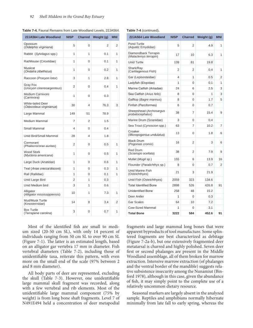
92 Shell Middens in the Grand Bay Estuary
fragments and large mammal long bones that were apparent byproducts of tool manufacture. Some splin-tered fragments are best characterized as debitage (Figure 7- 2a-b), but one extensively fragmented deer metatarsal is charred and highly polished. Seven deer first or second phalanges are present in the Middle Woodland assemblage, all of them broken for marrow extraction. Intensive marrow extraction (of phalanges and the ventral border of the mandible) suggests rela-tive subsistence insecurity among the Nunamiut (Bin-ford 1978), although in this case, given the abundance of fish, it may simply point to the complete use of a relatively uncommon dietary resource.
Seasonal markers are largely absent in the analyzed sample. Reptiles and amphibians normally hibernate minimally from late fall to early spring, whereas the
Most of the identified fish are small to medi-um sized (20- 50 cm SL), with only 14 percent of individuals ranging from 50 cm SL to over 90 cm SL (Figure 7- 1). The latter is an estimated length, based on an alligator gar vertebra 17 mm in diameter. Fish vertebral diameters (Table 7- 2), including those of unidentifiable taxa, reiterate this pattern, with even more on the small end of the scale (97% between 2 and 8 mm diameter).
All body parts of deer are represented, excluding the skull (Table 7- 3). However, one unidentifiable large mammal skull fragment was recorded, along with a few vertebral and rib elements. Most of the unidentifiable large mammal component (75% by weight) is from long bone shaft fragments. Level 7 of N491E494 held a concentration of deer metapodial
Table 7-4. Faunal Remains from Late Woodland Levels, 22JA564.
22JA564 Late Woodland NISP Charred Weight (g) MNI
Opossum (Didelphis virginiana) 5 0 2 2
Rabbit (Sylvilagus spp.) 1 1 0.1 1
Rat/Mouse (Cricetidae) 1 0 0.1 1
Muskrat (Ondatra zibethicus) 1 0 0.2 1
Raccoon (Procyon lotor) 3 1 2.8 1
Gray Fox (Urocyon cinereoargenteus) 2 0 0.4 1
Medium Carnivore (Carnivora) 1 0 0.3
White-tailed Deer (Odocoileus virginianus) 30 4 76.3 3
Large Mammal 149 51 78.9
Medium Mammal 7 2 1.5
Small Mammal 4 0 0.4
Unid Bird/Small Mammal 28 4 1.8
Cormorant (Phalocrocorax auritas) 2 0 0.5 1
Wood Stork (Mycteria americana) 1 0 0.5 1
Large Duck (Anatidae) 1 0 0.6 1
Teal (Anas crecca/discors) 1 0 0.3 1
Rail (Rallidae) 1 0 0.1 1
Unid Large Bird 2 1 0.3
Unid Medium bird 3 1 0.6
Alligator (Alligator mississippiensis) 10 1 7.3 1
Mud/Musk Turtle (Kinosternidae) 14 8 3.4 2
Box Turtle (Terrapene carolina) 3 0 0.7 1
Table 7-4 (continued).
22JA564 Late Woodland NISP Charred Weight (g) MNI
Pond Turtle (Aquatic Emydidae) 5 2 4.9 1
Diamondback Terrapin (Malaclemys terrapin) 17 10 6.3 1
Unid Turtle 139 81 19.8
Shark/Ray (Cartilagenous Fish) 2 2 0.4 1
Gar (Lepisosteidae) 4 1 0.5 2
Ladyfish (Elopidae) 1 0 0.1 1
Marine Catfish (Ariiadae) 24 6 2.5 3
Sea Catfish (Arius felis) 8 0 1 3
Gafftop (Bagre marinus) 8 0 1.7 5
Finfish (Perciformes) 6 0 0.7
Sheepshead (Archosargus probatocephalus) 38 7 15.4 9
Marine Drum (Scianidae) 3 0 0.4
Sea Trout (Cynoscion spp.) 63 7 10.2 7
Croaker (Micropogonius undulatus) 13 0 1.8 6
Black Drum (Pogonias cromis) 16 2 3 6
Red Drum (Scianops ocellata) 38 2 7.9 9
Mullet (Mugil sp.) 155 6 13.9 16
Flounder (Paralichthys sp.) 8 0 0.7 2
Unid Marine Fish (Osteichthyes) 21 3 21.9
Unid Fish (Osteichthyes) 2059 323 134.6
Total Identified Bone 2898 526 426.8 91
Unidentified Bone 258 48 15.2
Deer Antler 1 0 0.3
Gar Scales 64 10 7.2
Cow-Sized Mammal 1 0 3.1
Total Bone 3222 584 452.6 91
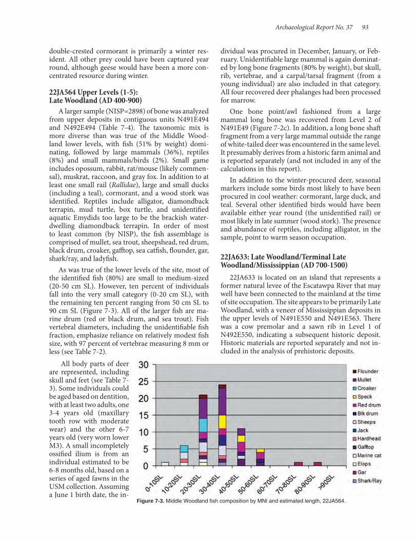
Archaeological Report No. 37 93
double- crested cormorant is primarily a winter res-ident. All other prey could have been captured year round, although geese would have been a more con-centrated resource during winter.
22JA564 Upper Levels (1- 5): Late Woodland (AD 400- 900)
A larger sample (NISP=2898) of bone was analyzed from upper deposits in contiguous units N491E494 and N492E494 (Table 7- 4). The taxonomic mix is more diverse than was true of the Middle Wood-land lower levels, with fish (51% by weight) domi-nating, followed by large mammals (36%), reptiles (8%) and small mammals/birds (2%). Small game includes opossum, rabbit, rat/mouse (likely commen-sal), muskrat, raccoon, and gray fox. In addition to at least one small rail (Rallidae), large and small ducks (including a teal), cormorant, and a wood stork was identified. Reptiles include alligator, diamondback terrapin, mud turtle, box turtle, and unidentified aquatic Emydids too large to be the brackish water-dwelling diamondback terrapin. In order of most to least common (by NISP), the fish assemblage is comprised of mullet, sea trout, sheepshead, red drum, black drum, croaker, gafftop, sea catfish, flounder, gar, shark/ray, and ladyfish.
As was true of the lower levels of the site, most of the identified fish (80%) are small to medium-sized (20- 50 cm SL). However, ten percent of individuals fall into the very small category (0- 20 cm SL), with the remaining ten percent ranging from 50 cm SL to 90 cm SL (Figure 7- 3). All of the larger fish are ma-rine drum (red or black drum, and sea trout). Fish vertebral diameters, including the unidentifiable fish fraction, emphasize reliance on relatively modest fish size, with 97 percent of vertebrae measuring 8 mm or less (see Table 7- 2).
All body parts of deer are represented, including skull and feet (see Table 7- 3). Some individuals could be aged based on dentition, with at least two adults, one 3- 4 years old (maxillary tooth row with moderate wear) and the other 6-7 years old (very worn lower M3). A small incompletely ossified ilium is from an individual estimated to be 6- 8 months old, based on a series of aged fawns in the USM collection. Assuming a June 1 birth date, the in-
dividual was procured in December, January, or Feb-ruary. Unidentifiable large mammal is again dominat-ed by long bone fragments (80% by weight), but skull, rib, vertebrae, and a carpal/tarsal fragment (from a young individual) are also included in that category. All four recovered deer phalanges had been processed for marrow.
One bone point/awl fashioned from a large mammal long bone was recovered from Level 2 of N491E49 (Figure 7- 2c). In addition, a long bone shaft fragment from a very large mammal outside the range of white-tailed deer was encountered in the same level. It presumably derives from a historic farm animal and is reported separately (and not included in any of the calculations in this report).
In addition to the winter-procured deer, seasonal markers include some birds most likely to have been procured in cool weather: cormorant, large duck, and teal. Several other identified birds would have been available either year round (the unidentified rail) or most likely in late summer (wood stork). The presence and abundance of reptiles, including alligator, in the sample, point to warm season occupation.
22JA633: Late Woodland/Terminal Late Woodland/Mississippian (AD 700-1500)
22JA633 is located on an island that represents a former natural levee of the Escatawpa River that may well have been connected to the mainland at the time of site occupation. The site appears to be primarily Late Woodland, with a veneer of Mississippian deposits in the upper levels of N491E550 and N491E563. There was a cow premolar and a sawn rib in Level 1 of N492E550, indicating a subsequent historic deposit. Historic materials are reported separately and not in-cluded in the analysis of prehistoric deposits.
Figure 7-3. Middle Woodland fish composition by MNI and estimated length, 22JA564.

94 Shell Middens in the Grand Bay Estuary
Originally, this site was going to be analyzed as a single component, but the composition was so clearly different from 22JA564, with more alligator and larger fish, that chronological differences were sought to split the sample. With the split, Late Woodland age com-ponents comprise most of the sample (NISP=1,892) with the Mississippian component yielding a sample roughly ten percent as large (NISP=210).
22JA633 Late Woodland (AD 700- 1200) A large and diverse faunal sample from the Late
Woodland component of 22JA633 produced 1,892 identified bones representing a minimum of 29 taxa (Table 7- 5). In addition to deer, there is a quantity of small, mostly terrestrial game: opossum, swamp rabbit, cotton rat, unidentified mouse, raccoon, large dog/wolf, bobcat, teal, osprey, and wild turkey. The assortment of reptiles also exhibits diversity, with alligator (several quite large), mud, box, and pond turtles, diamondback terrapin, viper, and colubrid snakes. Eleven species of fish were identified that include, based on relative abundance (by NISP), sheepshead, mullet, black drum, red drum, sea trout, gafftop catfish, gar, sea catfish, shark/ray, flounder, and croaker.
The taxonomic mix for the sample (by percent weight) is 52 percent fish, 31 percent large mammal, 8 percent turtle, 5 percent small mammal/bird, 4 percent alligator, and less than 1 percent snake. Because there is so much alligator in the Mississippian deposit, the provenience of all identified alligator was checked to determine if the inclusion could have been the result of displacement via bioturbation. This appears not to be the case, as alligator was identified in both upper and lower levels of N491E550 and in two widely separated levels of N501E469.
Like the other Woodland deposits, most of the identified fish are small to medium sized (20- 50 cm SL), with the peak size being 30- 40 cm SL (Figure 7- 4). Overall fish size is larger than was true of Woodland deposits
at 22JA564, with almost 20 percent of individuals exceeding 50 cm SL. Small fish (less than 20 cm SL) comprise only 4 percent of MNI. Most of the larger fish are marine drum, but large gar and gafftop catfish are also present. Fish vertebral diameter, including remains of unidentifiable fish, reiterates this pattern, although very small fish (vertebral diameter less than 5 mm) comprise less than 10 percent of the sample, with relatively large fish making up 14 percent (see Table 7- 2).
Excluding axial elements (ribs and vertebrae), all anatomical parts of white-tailed deer are repre-sented, and there are axial skeleton elements in the unidentifiable large mammal fraction (Table 7- 3). The single first phalanx in the sample had not been fractured for marrow. An unfused and incompletely
Figure 7-4. Late Woodland fish composition by MNI and estimated length, 22JA633.
Figure 7-5. Terminal Woodland/Mississippian fish composition by MNI and estimated length, 22JA575.
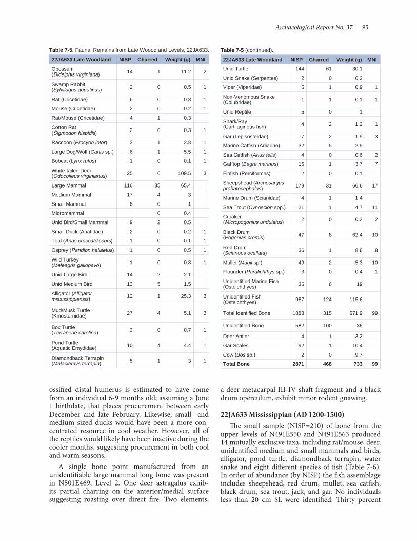
Archaeological Report No. 37 95
Table 7-5. Faunal Remains from Late Wooodland Levels, 22JA633.
22JA633 Late Woodland NISP Charred Weight (g) MNI
Opossum (Didelphis virginiana) 14 1 11.2 2
Swamp Rabbit (Sylvilagus aquaticus) 2 0 0.5 1
Rat (Cricetidae) 6 0 0.8 1
Mouse (Cricetidae) 2 0 0.2 1
Rat/Mouse (Cricetidae) 4 1 0.3
Cotton Rat (Sigmodon hispidis) 2 0 0.3 1
Raccoon (Procyon lotor) 3 1 2.8 1
Large Dog/Wolf (Canis sp.) 6 1 5.5 1
Bobcat (Lynx rufus) 1 0 0.1 1
White-tailed Deer (Odocoileus virginianus) 25 6 109.5 3
Large Mammal 116 35 65.4
Medium Mammal 17 4 3
Small Mammal 8 0 1
Micromammal 0 0.4
Unid Bird/Small Mammal 9 2 0.5
Small Duck (Anatidae) 2 0 0.2 1
Teal (Anas crecca/discors) 1 0 0.1 1
Osprey (Pandion haliaetus) 1 0 0.5 1
Wild Turkey (Meleagris gallopavo) 1 0 0.8 1
Unid Large Bird 14 2 2.1
Unid Medium Bird 13 5 1.5
Alligator (Alligator mississippiensis) 12 1 25.3 3
Mud/Musk Turtle (Kinosternidae) 27 4 5.1 3
Box Turtle (Terrapene carolina) 2 0 0.7 1
Pond Turtle (Aquatic Emydidae) 10 4 4.4 1
Diamondback Terrapin (Malaclemys terrapin) 5 1 3 1
Table 7-5 (continued).
22JA633 Late Woodland NISP Charred Weight (g) MNI
Unid Turtle 144 61 30.1
Unid Snake (Serpentes) 2 0 0.2
Viper (Viperidae) 5 1 0.9 1
Non-Venomous Snake (Colubridae) 1 1 0.1 1
Unid Reptile 5 0 1
Shark/Ray (Cartilaginous fish) 4 2 1.2 1
Gar (Lepisosteidae) 7 2 1.9 3
Marine Catfish (Ariiadae) 32 5 2.5
Sea Catfish (Arius felis) 4 0 0.6 2
Gafftop (Bagre marinus) 16 1 3.7 7
Finfish (Perciformes) 2 0 0.1
Sheepshead (Archosargus probatocephalus) 179 31 66.6 17
Marine Drum (Scianidae) 4 1 1.4
Sea Trout (Cynoscion spp.) 21 1 4.7 11
Croaker (Micropogonius undulatus) 2 0 0.2 2
Black Drum (Pogonias cromis) 47 8 62.4 10
Red Drum (Scianops ocellata) 36 1 8.8 8
Mullet (Mugil sp.) 49 2 5.3 10
Flounder (Paralichthys sp.) 3 0 0.4 1
Unidentified Marine Fish (Osteichthyes) 35 6 19
Unidentified Fish (Osteichthyes) 987 124 115.6
Total Identified Bone 1888 315 571.9 99
Unidentified Bone 582 100 36
Deer Antler 4 1 3.2
Gar Scales 92 1 10.4
Cow (Bos sp.) 2 0 9.7
Total Bone 2871 468 733 99
ossified distal humerus is estimated to have come from an individual 6- 9 months old; assuming a June 1 birthdate, that places procurement between early December and late February. Likewise, small- and medium-sized ducks would have been a more con-centrated resource in cool weather. However, all of the reptiles would likely have been inactive during the cooler months, suggesting procurement in both cool and warm seasons.
A single bone point manufactured from an unidentifiable large mammal long bone was present in N501E469, Level 2. One deer astragalus exhib-its partial charring on the anterior/medial surface suggesting roasting over direct fire. Two elements,
a deer metacarpal III- IV shaft fragment and a black drum operculum, exhibit minor rodent gnawing.
22JA633 Mississippian (AD 1200- 1500) The small sample (NISP=210) of bone from the
upper levels of N491E550 and N491E563 produced 14 mutually exclusive taxa, including rat/mouse, deer, unidentified medium and small mammals and birds, alligator, pond turtle, diamondback terrapin, water snake and eight different species of fish (Table 7- 6). In order of abundance (by NISP) the fish assemblage includes sheepshead, red drum, mullet, sea catfish, black drum, sea trout, jack, and gar. No individuals less than 20 cm SL were identified. Thirty percent

96 Shell Middens in the Grand Bay Estuary
Table 7-6. Faunal remains from Mississippian Levels, 22JA633.
22JA633 Mississippian NISP Charred Weight (g) MNI
Rat/Mouse (Cricetidae) 1 0 0.1 1
White-tailed Deer (Odocoileus virginianus) 1 0 6.9 1
Large Mammal 19 2 4.9
Medium Mammal 1 0 0.1 1
Small Mammal 1 0 0.2 1
Unid Large Bird 2 0 0.6 1
Alligator (Alligator mississippiensis) 17 2 38.2 2
Unid Large Reptile 5 2 3.9
Pond Turtle (Aquatic Emydidae) 1 1 1.7 1
Diamondback Terrapin (Malaclemys terrapin) 2 1 0.7 1
Unid Turtle 11 6 2.4
Water Snake (Nerodia sp.) 1 0 0.1 1
Gar (Lepisosteidae) 1 0 0.8 1
Unid Catfish (Siluriformes) 1 0 0.1
Marine Catfish (Ariiadae) 2 0 0.2
Sea Catfish (Arius felis) 2 1 0.3 1
Jack (Carangidae) 1 0 0.3 1
Sheepshead (Archosargus probatocephalus) 11 1 5.5 6
Sea Trout (Cynoscion spp.) 1 0 0.3 1
Black Drum (Pogonias cromis) 2 0 0.5 2
Red Drum (Scianops ocellata) 11 0 3.7 4
Mullet (Mugil sp.) 4 1 0.6 1
Unid Marine Fish (Osteichthyes) 5 0 1.5
Unid Fish (Osteichthyes) 107 16 14.3
Total Identified Bone 210 33 87.9 27
Unidentified Bone 39 16 3.3
Deer Antler
Gar Scales 50 2 10.6
Cow (Bos sp.)
Total Bone 299 51 101.8 27
of the individuals are estimated to have exceeded 50 cm SL (Figure 7- 5). Most strikingly, however, is the quantity of relatively large fish based on vertebral diameter (see Table 7- 2), which, because it includes unidentifiable fish, probably offers a more accurate depiction of the population taken. The sample has no very small fish (vertebral diameter 4 mm or less), while 39 percent consists of fish with vertebrae exceeding 8 mm in diameter. The only identified deer element is a scapula fragment, although skull and axial elements are present in the unidentifiable large mammal frac-tion (see Table 7- 3).
Table 7-7. Faunal remains from Terminal Woodland-Mississippian Levels, 22JA575.
22JA575 Terminal Woodland/Mississippian NISP Charred Weight
(g) MNI
Swamp Rabbit (Sylvilagus aquaticus) 1 0 0.1 1
Raccoon (Procyon lotor) 1 0 0.1 1
White-tailed Deer (Odocoileus virginianus) 1 0 5.7 1
Large Mammal 15 2 4.8
Medium Mammal 2 0 0.3
Small Mammal 3 0 0.2
Unid Bird/Small Mammal 11 2 0.8
Large Goose (Anserinae) 1 0 0.1 1
Unid Large Bird 1 0 0.2
Unid Medium Bird 10 0 0.8
Mud/Musk Turtle (Kinosternidae) 1 0 0.2 1
Pond Turtle (Aquatic Emydidae) 2 0 1.4 1
Diamondback Terrapin (Malaclemys terrapin) 9 7 1.9 1
Unid Turtle 26 14 4.1
Shark/Ray (Cartilaginous Fish) 2 1 0.5 1
Gar (Lepisosteidae) 7 0 2.6 3
Marine Catfish (Ariiadae) 3 1 0.3
Sea Catfish (Arius felis) 5 1 0.6 3
Gafftop (Bagre marinus) 8 0 1.2 4
Sheepshead (Archosargus probatocephalus) 21 2 5.5 5
Sea Trout (Cynoscion spp.) 5 0 0.6 2
Croaker (Micropogonius undulatus) 4 0 0.4 4
Black Drum (Pogonias cromis) 11 0 2.8 5
Red Drum (Scianops ocellata) 12 0 5.5 6
Mullet (Mugil sp.) 28 4 3.1 7
Flounder (Paralichthys sp.) 1 0 0.1 1
Unid Marine Fish (Osteichthyes) 6 5 3.2
Unid Fish (Osteichthyes) 475 73 32
Total Identified Bone 672 112 79.1 48
Unidentified Bone 128 27 3.1
Deer Antler 0 0 0
Gar Scales 97 25 10.4
Total Bone 897 164 92.6
What is most striking about the Mississippian component in relation to all of the Woodland assem-blages analyzed and reported here is the taxonomic mix by weight. Alligator comprises 48 percent, fish 32 percent, large mammals 13 percent, turtles 6 percent, small mammal/birds 1 percent, and snakes less than 0.1 percent. With the potential stochastic effect of the abundant alligator remains removed, the fish/large mammal weight comparison is 61 percent/26 percent,
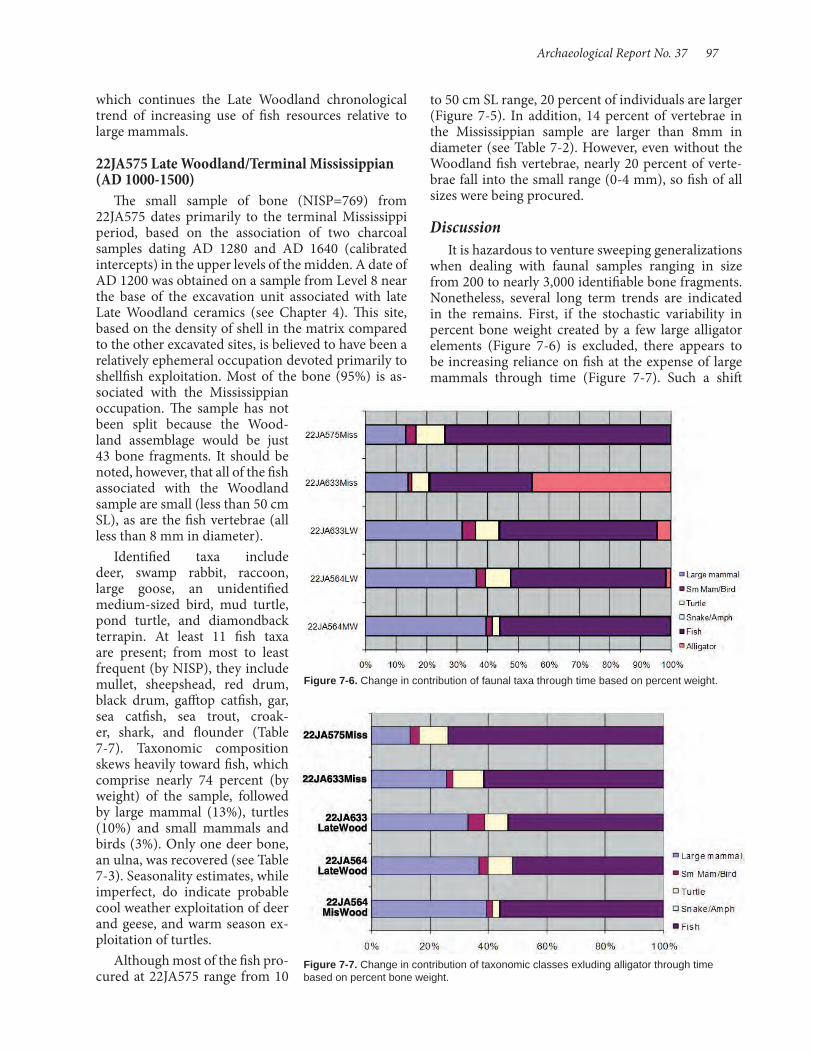
Archaeological Report No. 37 97
which continues the Late Woodland chronological trend of increasing use of fish resources relative to large mammals.
22JA575 Late Woodland/Terminal Mississippian (AD 1000- 1500)
The small sample of bone (NISP=769) from 22JA575 dates primarily to the terminal Mississippi period, based on the association of two charcoal samples dating AD 1280 and AD 1640 (calibrated intercepts) in the upper levels of the midden. A date of AD 1200 was obtained on a sample from Level 8 near the base of the excavation unit associated with late Late Woodland ceramics (see Chapter 4). This site, based on the density of shell in the matrix compared to the other excavated sites, is believed to have been a relatively ephemeral occupation devoted primarily to shellfish exploitation. Most of the bone (95%) is as-sociated with the Mississippian occupation. The sample has not been split because the Wood-land assemblage would be just 43 bone fragments. It should be noted, however, that all of the fish associated with the Woodland sample are small (less than 50 cm SL), as are the fish vertebrae (all less than 8 mm in diameter).
Identified taxa include deer, swamp rabbit, raccoon, large goose, an unidentified medium-sized bird, mud turtle, pond turtle, and diamondback terrapin. At least 11 fish taxa are present; from most to least frequent (by NISP), they include mullet, sheepshead, red drum, black drum, gafftop catfish, gar, sea catfish, sea trout, croak-er, shark, and flounder (Table 7- 7). Taxonomic composition skews heavily toward fish, which comprise nearly 74 percent (by weight) of the sample, followed by large mammal (13%), turtles (10%) and small mammals and birds (3%). Only one deer bone, an ulna, was recovered (see Table 7- 3). Seasonality estimates, while imperfect, do indicate probable cool weather exploitation of deer and geese, and warm season ex-ploitation of turtles.
Although most of the fish pro-cured at 22JA575 range from 10
to 50 cm SL range, 20 percent of individuals are larger (Figure 7- 5). In addition, 14 percent of vertebrae in the Mississippian sample are larger than 8mm in diameter (see Table 7- 2). However, even without the Woodland fish vertebrae, nearly 20 percent of verte-brae fall into the small range (0-4 mm), so fish of all sizes were being procured.
Discussion It is hazardous to venture sweeping generalizations
when dealing with faunal samples ranging in size from 200 to nearly 3,000 identifiable bone fragments. Nonetheless, several long term trends are indicated in the remains. First, if the stochastic variability in percent bone weight created by a few large alligator elements (Figure 7- 6) is excluded, there appears to be increasing reliance on fish at the expense of large mammals through time (Figure 7- 7). Such a shift
Figure 7-6. Change in contribution of faunal taxa through time based on percent weight.
Figure 7-7. Change in contribution of taxonomic classes exluding alligator through time based on percent bone weight.

98 Shell Middens in the Grand Bay Estuary
could occur if fishing pursuits were gradually intensified to facilitate greater sedentism by alleviating subsistence pressure on terrestrial game. Alternatively, the changes observed may reflect increas-ing use of these coastal sites as ephemeral occupations for rel-atively specialized procurement of coastal resources. Although the Mississippian- age samples are small (which is itself an indication of decreased seden-tism), specialization in coastal procurement is suggested both by a relative increase in fish remains, and an increase in the size of the fish procured (Figure 7- 8). Increasing quantities of fish (and alligator) in the Mississippian-aged deposits, coupled with an apparent effort to procure larger fish, suggests that the economic use of coastal resourc-es may have changed fundamentally with the arrival of subsistence security afforded by large-scale corn agriculture. Although all of the samples analyzed here include species that indicate the possibility of year-round residence, there may have been a shift toward more extensive occupation during the warmer months.
Figure 7-8. Change in fish size through time based on vertebra diameter.
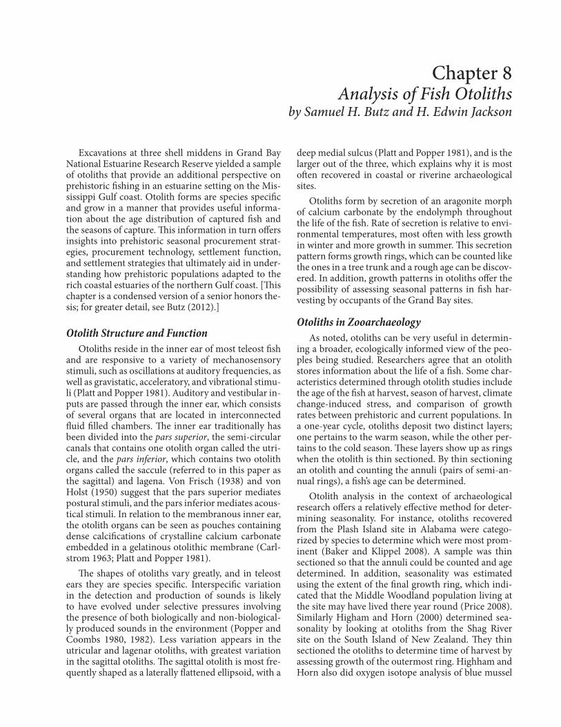
Excavations at three shell middens in Grand Bay National Estuarine Research Reserve yielded a sample of otoliths that provide an additional perspective on prehistoric fishing in an estuarine setting on the Mis-sissippi Gulf coast. Otolith forms are species specific and grow in a manner that provides useful informa-tion about the age distribution of captured fish and the seasons of capture. This information in turn offers insights into prehistoric seasonal procurement strat-egies, procurement technology, settlement function, and settlement strategies that ultimately aid in under-standing how prehistoric populations adapted to the rich coastal estuaries of the northern Gulf coast. [This chapter is a condensed version of a senior honors the-sis; for greater detail, see Butz (2012).]
Otolith Structure and FunctionOtoliths reside in the inner ear of most teleost fish
and are responsive to a variety of mechanosensory stimuli, such as oscillations at auditory frequencies, as well as gravistatic, acceleratory, and vibrational stimu-li (Platt and Popper 1981). Auditory and vestibular in-puts are passed through the inner ear, which consists of several organs that are located in interconnected fluid filled chambers. The inner ear traditionally has been divided into the pars superior, the semi-circular canals that contains one otolith organ called the utri-cle, and the pars inferior, which contains two otolith organs called the saccule (referred to in this paper as the sagittal) and lagena. Von Frisch (1938) and von Holst (1950) suggest that the pars superior mediates postural stimuli, and the pars inferior mediates acous-tical stimuli. In relation to the membranous inner ear, the otolith organs can be seen as pouches containing dense calcifications of crystalline calcium carbonate embedded in a gelatinous otolithic membrane (Carl-strom 1963; Platt and Popper 1981).
The shapes of otoliths vary greatly, and in teleost ears they are species specific. Interspecific variation in the detection and production of sounds is likely to have evolved under selective pressures involving the presence of both biologically and non-biological-ly produced sounds in the environment (Popper and Coombs 1980, 1982). Less variation appears in the utricular and lagenar otoliths, with greatest variation in the sagittal otoliths. The sagittal otolith is most fre-quently shaped as a laterally flattened ellipsoid, with a
deep medial sulcus (Platt and Popper 1981), and is the larger out of the three, which explains why it is most often recovered in coastal or riverine archaeological sites.
Otoliths form by secretion of an aragonite morph of calcium carbonate by the endolymph throughout the life of the fish. Rate of secretion is relative to envi-ronmental temperatures, most often with less growth in winter and more growth in summer. This secretion pattern forms growth rings, which can be counted like the ones in a tree trunk and a rough age can be discov-ered. In addition, growth patterns in otoliths offer the possibility of assessing seasonal patterns in fish har-vesting by occupants of the Grand Bay sites.
Otoliths in ZooarchaeologyAs noted, otoliths can be very useful in determin-
ing a broader, ecologically informed view of the peo-ples being studied. Researchers agree that an otolith stores information about the life of a fish. Some char-acteristics determined through otolith studies include the age of the fish at harvest, season of harvest, climate change-induced stress, and comparison of growth rates between prehistoric and current populations. In a one-year cycle, otoliths deposit two distinct layers; one pertains to the warm season, while the other per-tains to the cold season. These layers show up as rings when the otolith is thin sectioned. By thin sectioning an otolith and counting the annuli (pairs of semi-an-nual rings), a fish’s age can be determined.
Otolith analysis in the context of archaeological research offers a relatively effective method for deter-mining seasonality. For instance, otoliths recovered from the Plash Island site in Alabama were catego-rized by species to determine which were most prom-inent (Baker and Klippel 2008). A sample was thin sectioned so that the annuli could be counted and age determined. In addition, seasonality was estimated using the extent of the final growth ring, which indi-cated that the Middle Woodland population living at the site may have lived there year round (Price 2008). Similarly Higham and Horn (2000) determined sea-sonality by looking at otoliths from the Shag River site on the South Island of New Zealand. They thin sectioned the otoliths to determine time of harvest by assessing growth of the outermost ring. Highham and Horn also did oxygen isotope analysis of blue mussel
Chapter 8 Analysis of Fish Otoliths
by Samuel H. Butz and H. Edwin Jackson

100 Shell Middens in the Grand Bay Estuary
catfish, spotted sea trout, Atlantic croaker, red drum, and black drum. These species all have relatively large otoliths that are likely to be recognizable. It is possible or perhaps likely that smaller otoliths remain hidden in the shell “hash” recovered by 3.2-mm screening (although samples from this fraction were sorted in a fruitless attempt to add additional specimens for this analysis).
Biological Information of Species PresentEstuary systems and shallow subtidal zones, such
as are present in Grand Bay, are essential for provid-ing nursery habitat for the species represented by the recovered otoliths. The most common species—ma-rine drums (Atlantic croaker, black drum, red drum), sea trout, and sea catfish—are the dominant species present at all three sites. These species are commonly found near shore and can be exploited all year.
Cynoscion nebulosus (known as speckled trout or spotted sea trout) average 19 inches for males and 25 inches for females, with both weighing 2 to 3 pounds. They reach sexual maturity at one to two years and usually spawn in coastal bays, estuaries, and lagoons. Their peak spawning season is from March to Octo-ber. They prefer shallow grassy areas where their eggs have cover from predators. As water temperatures decline during the fall season, they move into deeper bay waters and the Gulf of Mexico. As water tempera-tures warm in the spring, these fish move back into the shallows of the primary and secondary bays (Her-ald 1972).
Micropogonias undulatus (known as Atlantic croaker, hardhead, king billy, or grumbler) on average measure 12 inches and weigh 1.5 to 2 pounds. They reach sexual maturity at one year old and live during spring and summer in shallow estuaries and bays. In the months of September through April, they travel to deeper water to spawn (Zim and Shoemaker 1955).
Sciaenops ocellatus (red drum; also known as red-fish, rat red, and bull red) is a fast growing fish, which reach 11 inches and 1 pound in its first year, 22 inch-es and 3.5 pounds in two years, and 24 inches and 7 pounds in three years. They reach sexual maturity be-tween their third and fourth year of life. Their peak spawning time is from August through December. Eggs are deposited and hatch in small tidal bays and shallow waters with muddy or grassy bottoms. Red drums travel between coastal bays and the Gulf of Mexico throughout their lifetime. There is little evi-dence of seasonal migrations (Herald 1972).
Pogonias cromis (known as black drum, drum fish, or tambor) can grow to 6 inches in their first year, 12 inches in their second, 16 inches in their third, and
(Mytilus edulis aoteanus) shells from the same layer to acquire an independent data set for comparison. Their study concluded the fish were harvested in the warm months and the site was occupied during the summer.
Age determinations from thin sectioned otoliths also produce a demographic profile of caught fish (Campana 2013; Secor et al. 1991), which may re-veal evidence of fishing pressure on fish populations or alternatively the methods used to harvest fish. In addition, research comparing thin sections of prehis-toric otoliths and those of modern fish has shown that prehistoric fish grew significantly slower than their modern-day counterparts (for an example, see Hales and Reitz 1992). Another approach in otolith studies determines the age of a fish from the otolith by sim-ply measuring it. However, according to Francis et al. (2004), this technique is especially susceptible to bias. Those authors suggest a new approach: a hybrid be-tween the measuring and thin sectioning. This new approach alleviates bias and provides a more accurate age estimate for the otolith.
Faunal Assemblages from 22JA564, 22JA575, and 22JA633
Analysis of the Grand Bay shell middens (Jackson, Chapter 9) suggests that occupation of the area began in the Gulf Formational period, ca. 800 BC, and con-tinued through the Historic era. However, the Mid-dle and Late Woodland phases are represented most strongly at these excavated sites. Jackson suggests that these Woodland occupations served as seasonal camps, rather than specialized procurement locations. Being a shell midden site, the most visible evidence of procurement activities is that of shellfish gathering and processing. However, sizable samples of vertebrate faunal remains were recovered, including, of course, fish, but also some terrestrial fauna (Scott, Chapter 7). Scott’s faunal analysis suggests that the high species diversity associated with Woodland phases supports interpretation of site use as residential. In comparison, the Mississippian-era occupation seems to have had a stronger focus on fishing and shellfish processing, showing a change in the settlement system and socie-tal organization.
Pull factors for prehistoric use of the area include the littoral resources, such as shellfish and many oth-er invertebrates, and the vast array of fish, as demon-strated by the remains recovered. The fish assemblage of recovered bones includes (in descending order of frequency based on NISP) sheepshead, mullet, spot-ted sea trout, hardhead catfish, black drum, red drum, croaker, gafftopsail catfish, shark, alligator gar, shad, and crevalle jack (Scott, Chapter 7). Species repre-sented by otoliths include hardhead catfish, gafftopsail
Archaeological Report No. 37 101
to the far right allowed enough space for a saw clamp to hold the epoxy block in place when cutting, while maintaining a necessary distance between saw blade and clamp. Some cubes were allowed to cure at room temperature, but better results were obtained by plac-ing the mold in an oven at 70° C for one hour. Thin sections were produced using a Buehler Isomet Low Speed Wafer Cutting Saw. With some experimenta-tion with modern specimens, a thickness of 35 to 40µ allowed for translucency without being too fragile to handle. Completed thin sections were mounted on glass slides using ordinary “super glue.” Slides were examined using a binocular microscope at 30x mag-nification using transmitted light.
When using transmitted light, such as light from below, the wide warm-water growth rings appear light and the narrow cold-water growth rings appear dark-er. Age enumeration is not as easy as counting rings. It is important to remember that for a fish to be at least one year old, it has to show two complete translucent rings, meaning that if it was born in mid-summer, the second translucent ring must be at least half as wide as the previous to show that it made it to the following year’s mid-summer. Thus the otolith of a one-year-old must display three rings. This can cause inconsisten-cies when determining age, so to solve this problem, instead of assigning a specific age, age cohorts were used. Cohorts ascend in one-year increments, such as age 0-1, age 1-2, etc.
The principal goal of this Grand Bay otolith analy-sis was not to determine age of fish, but rather the sea-son of fish death. The last ring deposited on the otolith is used to determine the time of death. As stated ear-lier translucent rings refer to warm water and opaque rings refer to cold water. When this observation is combined with the otolith species’ spawning and mi-gration habits during the year, along with the amount of growth of the outermost ring, a fairly precise time of capture and death can be estimated.
This study used a coding system (Table 8-1) bor-rowed from VanderKooy (2009) to record the growth of the margin (outermost) ring. Growth of the margin ring was determined by comparison to the full growth of the previous like ring.
ResultsA total of 310 otoliths comprise the sample (Tables
8-2 and 8-3). This number was reduced because sev-eral had been exposed to fire, which obliterated the ring pattern, and several others were broken (or broke during preparation). 22JA564 produced by far the largest sample (n=266), while far fewer were collected at 22JA633 (n=34) and 22JA575 (N=3).
2 inches per year after that. Black drum can live in sandy or muddy waters so shallow that their backs are constantly exposed to the open air, or in waters up to 100 feet deep. Spawning usually occurs during the months of February and March. In the fall they travel into the deep waters of the Gulf of Mexico (Zim and Shoemaker 1955).
Ariopsis felis (commonly known as the hardhead catfish, catfish, or tourist trout) has an average size of 10 inches and 0.5 pound. They spawn from May through August and carry eggs in their mouth until they hatch and are able to care for themselves. Hard-head catfish live in both bay and Gulf waters, and move to deeper water during the fall (Zim and Shoe-maker 1955).
Bagre marinus (also known as the gafftopsail cat-fish or sea cat) has an average size of 2.5 pounds and 11 inches. Like the hardhead catfish, spawning occurs from May through August, and eggs are carried in the mouth of the male until they hatch and the fry can feed on their own. Gafftopsails tend to feed near the bottom of bays or in the Gulf of Mexico (Zim and Shoemaker 1955).
MethodsOtolith thin sectioning entails six broad steps:
cleaning and preparing, cataloging, embedding, saw-ing, mounting, and microscopic analysis. The method followed here is adapted from Secor et al. (1991) and VanderKooy (2009). In addition, some practical ad-vice was garnered at the University of Southern Mis-sissippi’s Gulf Coast Research Laboratory. Detailed procedural steps are provided in Butz (2012).
Proper cleaning is essential, but remains a topic of some debate. For instance, Secor et al. (1991) recom-mend that the otolith be soaked in a 10 percent bleach (sodium hypochlorite)/water mixture, rinsed with distilled water to prevent bleach crystals from form-ing, and finally soaked in 95 percent ethanol to draw all of the water out of the otolith. In contrast, Vander-Kooy, (2009) warns against the use of bleach, which can dissolve the aragonite matrix and alter an otolith’s chemical composition. Here only water was used to remove surface dirt and staining. Each otolith was as-signed a site-specific specimen number to maintain control of archaeological provenience.
Specimens were embedded in epoxy (Hillquist, Inc.) using a silicone ice cube tray with 0.5-by-0.5-inch compartments, which did not require a releasing agent, as is the case for some molds. Molds were filled halfway and allowed to harden; otoliths were placed in the mold, making sure the sacculus protrusion was situated as far to one side as possible; and the molds were filled to the top with epoxy. Placing the sacculus

102 Shell Middens in the Grand Bay Estuary
Species DistributionThe largest sample of otoliths was collected at
22JA564, and without surprise it has the greatest num-ber of species represented (Figure 8-1). Speckled trout (n=107) and Atlantic croaker (n=103) comprise the vast majority of otoliths examined from 22JA564, with far fewer red drum (n=23), hardhead catfish (n=10), gafftopsail catfish (n=5), and black drum (n=3). The greatest deviation in order of otolith abundance is in the representation of Atlantic croaker, a species that falls after hardhead catfish, black drum, and red drum, based on the faunal analysis. Site 22JA575 yielded the fewest otoliths (n=8), including hardhead catfish (n=3), Atlantic croaker (n=3), and speckled trout (n=2) (Figure 8-2). As at 22JA564, croaker is significantly better represented in the otolith samples, as is speckled trout, which in the analyzed bone sam-ple rank ninth and tenth in abundance, respectively. Drums and catfish, species with large and distinctive otoliths, all rank higher in the bone sample. While not-ing the relatively small faunal sample from 22JA575, this difference in the two lines of evidence might point to a processing and discard procedure that re-moved the skulls of these fish from the midden. The sample from 22JA633 of 33 otoliths includes speckled trout (n=15), hardhead catfish (n=6), gafftopsail cat-fish (n=6), and croaker (n=2) (Figure 8-3). Here the otolith representation of speckled trout exceeds both drum species, which in the analyzed bone samples rank higher than trout.
22JA564Figure 8-4 summarizes site-level otolith data for
22JA564, including age cohort distribution, number of opaque versus translucent terminal growth rings, and the otolith distribution across the four stages of ring growth (Margin Codes 1 through 4), as de-
Table 8-1. Margin Codes (VanderKooy 2009).
Code Explanations
Code 1 Opaque zone present on edge
Code 2 Translucent zone forming to one-third complete on edge
Code 3 Translucent zone one-third to two-thirds complete on edge
Code 4 Translucent zone two-thirds to fully complete on edge
Table 8-2. Otoliths Examined for this Study.
Site Total Sample
Number Thermally
Altered
Number-Broken
Number Examined
22JA564 266 4 11 251
22JA633 35 1 1 33
22JA575 9 1 8
Figure 8-2. Species distribution for 22JA575 otoliths.
Figure 8-3. Species distribution for 22JA633 otoliths.
Figure 8-1. Species distribution of 22JA564 otoliths.
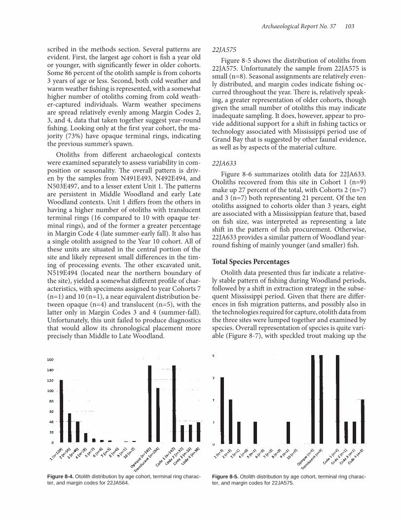
Archaeological Report No. 37 103
22JA575Figure 8-5 shows the distribution of otoliths from
22JA575. Unfortunately the sample from 22JA575 is small (n=8). Seasonal assignments are relatively even-ly distributed, and margin codes indicate fishing oc-curred throughout the year. There is, relatively speak-ing, a greater representation of older cohorts, though given the small number of otoliths this may indicate inadequate sampling. It does, however, appear to pro-vide additional support for a shift in fishing tactics or technology associated with Mississippi period use of Grand Bay that is suggested by other faunal evidence, as well as by aspects of the material culture.
22JA633Figure 8-6 summarizes otolith data for 22JA633.
Otoliths recovered from this site in Cohort 1 (n=9) make up 27 percent of the total, with Cohorts 2 (n=7) and 3 (n=7) both representing 21 percent. Of the ten otoliths assigned to cohorts older than 3 years, eight are associated with a Mississippian feature that, based on fish size, was interpreted as representing a late shift in the pattern of fish procurement. Otherwise, 22JA633 provides a similar pattern of Woodland year-round fishing of mainly younger (and smaller) fish.
Total Species PercentagesOtolith data presented thus far indicate a relative-
ly stable pattern of fishing during Woodland periods, followed by a shift in extraction strategy in the subse-quent Mississippi period. Given that there are differ-ences in fish migration patterns, and possibly also in the technologies required for capture, otolith data from the three sites were lumped together and examined by species. Overall representation of species is quite vari-able (Figure 8-7), with speckled trout making up the
scribed in the methods section. Several patterns are evident. First, the largest age cohort is fish a year old or younger, with significantly fewer in older cohorts. Some 86 percent of the otolith sample is from cohorts 3 years of age or less. Second, both cold weather and warm weather fishing is represented, with a somewhat higher number of otoliths coming from cold weath-er-captured individuals. Warm weather specimens are spread relatively evenly among Margin Codes 2, 3, and 4, data that taken together suggest year-round fishing. Looking only at the first year cohort, the ma-jority (73%) have opaque terminal rings, indicating the previous summer’s spawn.
Otoliths from different archaeological contexts were examined separately to assess variability in com-position or seasonality. The overall pattern is driv-en by the samples from N491E493, N492E494, and N503E497, and to a lesser extent Unit 1. The patterns are persistent in Middle Woodland and early Late Woodland contexts. Unit 1 differs from the others in having a higher number of otoliths with translucent terminal rings (16 compared to 10 with opaque ter-minal rings), and of the former a greater percentage in Margin Code 4 (late summer-early fall). It also has a single otolith assigned to the Year 10 cohort. All of these units are situated in the central portion of the site and likely represent small differences in the tim-ing of processing events. The other excavated unit, N519E494 (located near the northern boundary of the site), yielded a somewhat different profile of char-acteristics, with specimens assigned to year Cohorts 7 (n=1) and 10 (n=1), a near equivalent distribution be-tween opaque (n=4) and translucent (n=5), with the latter only in Margin Codes 3 and 4 (summer-fall). Unfortunately, this unit failed to produce diagnostics that would allow its chronological placement more precisely than Middle to Late Woodland.
Figure 8-4. Otolith distribution by age cohort, terminal ring charac-ter, and margin codes for 22JA564.
Figure 8-5. Otolith distribution by age cohort, terminal ring charac-ter, and margin codes for 22JA575.

104 Shell Middens in the Grand Bay Estuary
majority (42%), followed by Atlantic croaker (37%), red drum (9%), hardhead catfish (7%), gafftopsail cat-fish (4%), and black drum (1%). As noted earlier, this does not exactly correspond with relative frequencies determined from the bone assemblages, in particular by leaving out the clearly significant contributions of mullet and sheepshead.
Speckled TroutSpeckled trout was clearly an important species of
fish being procured at the Grand Bay sites. Cohorts 1 (n=39), 2 (n=37), and 3 (n=27) comprise of 83 per-cent of the total (Figure 8-8).
Atlantic CroakerAtlantic croaker, the second most ubiquitous fish
represented by otoliths, comprises 37 percent of the total. In terms of overall age distribution (Figure 8-9), Cohort 1 is 62 percent of the total, while Co-
hort 2 (n=22) only makes up 20 percent and Cohort 3 (n=15) just 13 percent. The distribution of Atlantic croaker by opaque and translucent terminal ring data points to greater exploitation during colder months (65%) than was the case for speckled trout. The pat-tern is indicative of fishing the last summer’s spawned croakers residing in the shallows of the bay.
Red DrumRed drum makes up only 9 percent of the total oto-
liths recovered; 77 percent of these otoliths fall into Cohort 1 (n=21; Figure 8-10), followed by Cohort 2 (n=4) with 14 percent. Along with the season of cap-ture data, which indicate cold weather exploitation, red drum is more closely aligned with the pattern of Atlantic croaker. However, as with both croaker and speckled trout, red drum was fished throughout the warmer periods of the year as well.
Figure 8-6. Otolith distribution by age cohort, terminal ring charac-ter, and margin codes for 22JA633.
Figure 8-7. Distribution of otoliths among represented species, all sites combined.
Figure 8-8. Speckled trout otoliths, all sites combined.
Figure 8-9. Atlantic croaker otoliths, all sites combined.
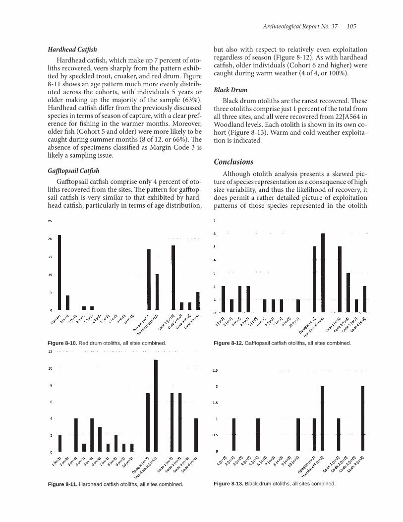
Archaeological Report No. 37 105
Hardhead CatfishHardhead catfish, which make up 7 percent of oto-
liths recovered, veers sharply from the pattern exhib-ited by speckled trout, croaker, and red drum. Figure 8-11 shows an age pattern much more evenly distrib-uted across the cohorts, with individuals 5 years or older making up the majority of the sample (63%). Hardhead catfish differ from the previously discussed species in terms of season of capture, with a clear pref-erence for fishing in the warmer months. Moreover, older fish (Cohort 5 and older) were more likely to be caught during summer months (8 of 12, or 66%). The absence of specimens classified as Margin Code 3 is likely a sampling issue.
Gafftopsail CatfishGafftopsail catfish comprise only 4 percent of oto-
liths recovered from the sites. The pattern for gafftop-sail catfish is very similar to that exhibited by hard-head catfish, particularly in terms of age distribution,
Figure 8-10. Red drum otoliths, all sites combined.
Figure 8-11. Hardhead catfish otoliths, all sites combined.
but also with respect to relatively even exploitation regardless of season (Figure 8-12). As with hardhead catfish, older individuals (Cohort 6 and higher) were caught during warm weather (4 of 4, or 100%).
Black DrumBlack drum otoliths are the rarest recovered. These
three otoliths comprise just 1 percent of the total from all three sites, and all were recovered from 22JA564 in Woodland levels. Each otolith is shown in its own co-hort (Figure 8-13). Warm and cold weather exploita-tion is indicated.
ConclusionsAlthough otolith analysis presents a skewed pic-
ture of species representation as a consequence of high size variability, and thus the likelihood of recovery, it does permit a rather detailed picture of exploitation patterns of those species represented in the otolith
Figure 8-12. Gafftopsail catfish otoliths, all sites combined.
Figure 8-13. Black drum otoliths, all sites combined.

106 Shell Middens in the Grand Bay Estuary
sample. One fundamental goal of this research was to determine if the Grand Bay shell middens were occu-pied during a particular time of year or year round. Regardless of species and site, Woodland components appear to have been fishing locations (or more specif-ically, fish processing locations) throughout the year. Confidence in this conclusion is variable for the three sites, as sample sizes were significantly different, with 22JA564 producing the largest number of otoliths and only a small number obtained at 22JA575. Scott (Chapter 7) notes a shift in fishing with the onset of the Mississippi period, and the otolith data, though limited, seem to corroborate the pattern. The small number of otoliths recovered from 22JA575, which is mainly a terminal Woodland to Mississippian depos-it, may be part of a more focused oyster gathering and processing location, less often used for fishing.
A second pattern that has emerged from the otolith sample is a dichotomous pattern of seasonal and co-hort exploitation between catfish species (gafftopsail, hardhead) and marine drums (red drum, black drum, croaker, and sea trout). The former exhibit a wide age cohort range and greater emphasis on warm weather fishing. Catfish tend to abandon estuaries during cold weather for deeper waters offshore (Jewell 1997:55). Drums, on the other hand, are vastly better represent-ed in the younger age cohorts (1-3) and, while cap-tured year round, are more likely to be captured in colder months than catfish. Drums spawn offshore during the winter, but their life cycle is intimately tied to coastal estuaries, and larval forms move into the shallows to feed in that nutrient rich environment, where they grow rapidly (attaining a length of 10-25 cm by the end of the first year) (Jewell 1997:58). The Grand Bay fisherfolk likely took advantage during the winter of the return of juveniles from deeper summer locations.
Although sites 22JA575, 22JA633, and 22JA564 are located in different areas of the Grand Bay estuary, all are well situated to take advantage of near shore spawning species, as well as those seeking protection during winter months. Procurement of small fish like-ly involved tidal traps, nets, and seines, rather than hook and line or spear fishing, although the latter could have been used to take older catfish.
Year-round harvesting of fish resources posited for the Grand Bay shell middens finds support in the otolith analysis conducted with samples from Plash Island in Alabama. That analysis found otoliths with almost equal amounts of opaque and translucent last rings. Data from thin sectioned otoliths show “evi-dence which indicates that Middle Woodland people may have occupied the Plash Island site year round” (Baker and Klippel 2008:284). Similarly, it is not hard
to conceive of the inhabitants of shell middens scat-tered about Grand Bay occupying them throughout the year. The mild climate and abundance of littoral resources, combined with locally available terrestrial species, would have provided substantial amounts of sustenance.
Key to Table 8-3
Specimen Number is the unique ID given to each otolith. Species refers to the species of fish. 1 = Speck-led Trout, 2 = Atlantic Croaker, 3 = Red Drum, 4 = Black Drum, 5 = Hardhead Catfish, and 6 = Gafftop-sail Catfish. Rings are the amount of rings visible in an otolith. Cohort is the age range of the otolith. Translu-cent refers to the number of translucent rings visible. Opaque refers to the number of opaque rings visible. Last Ring refers to the presence of either an opaque (0) last ring or a translucent (1) last ring. Margin is the margin code (see Table 8-2 for explanation). Site is the site number. All sites are in Jackson County, Mississippi (22JA). Unit is the unit's identifying grid coordinate, indicated by northing and easting. Level refers to stratigraphic level. Unless otherwise noted, all levels are 10 cm.
Specimens indicated as Burnt are completely burned. Cause was not addressed in this study. Due to carbonization, the rings are not visible, and only species could be determined. Specimens indicated as Null were broken during or after the cutting process could not to be analyzed, and are not included in the analysis.

Archaeological Report No. 37 107
Spe
cim
en
Num
ber
Spe
cies
Rin
gs
Coh
ort
Tran
sluc
ent
Opa
que
Last
Rin
g
Mar
gin
Site
Uni
t
Leve
l
1 5 16 9 8 8 0 1 564 505 495 32 2 2 1 1 1 0 1 564 503 492 33 3 2 1 1 1 0 1 564 503 492 24 2 2 1 1 1 0 1 564 503 498 45 1 4 2 2 2 0 1 564 503 498 46 1 9 4 5 4 1 4 564 495 500 37 1 7 4 4 3 1 4 564 495 500 38 1 4 2 2 2 0 1 564 495 500 39 3 7 4 4 3 1 2 564 495 500 310 2 8 4 4 4 0 1 564 495 500 311 1 5 3 3 2 1 3 564 525 495 2 30-5012 5 5 3 3 2 1 2 564 490 495 3 40-6013 5 10 5 5 5 0 1 575 505 506 514 1 3 1 2 1 1 4 575 505 506 5
15/B 5 575 505 506 716 1 4 2 2 2 0 1 575 505 506 8
17 5 3 1 2 1 1 2 575 505 506 Auger 78-108
18 2 2 1 1 1 0 1 575 505 506 819 1 8 4 4 4 0 1 564 Unit 1 220 1 3 1 2 1 1 4 564 Unit 1 421 1 1 1 1 0 1 4 564 Unit 1 422 2 4 2 2 2 0 1 564 Unit 1 423 1 4 2 2 2 0 1 564 Unit 1 324 2 3 1 2 1 1 4 564 Unit 1 325 1 7 3 4 3 1 4 564 Unit 1 426 1 3 1 2 1 1 3 564 Unit 1 427 1 2 1 1 1 0 1 564 Unit 1 428 1 3 2 2 1 1 3 564 Unit 1 429 2 3 1 2 1 1 3 564 Unit 1 430 4 21 10 11 10 1 4 564 Unit 1 Burial31 1 7 3 4 3 1 4 564 Unit 1 Burial32 1 2 1 1 1 0 1 564 Unit 1 Burial33 2 3 1 2 1 1 4 564 Unit 1 Burial34 1 3 1 2 1 1 2 564 Unit 1 335 1 3 1 2 1 1 4 564 Unit 1 336 1 2 1 1 1 0 1 564 Unit 1 337 1 2 1 1 1 0 1 564 Unit 1 338 1 2 1 1 1 0 1 564 Unit 1 339 1 3 2 2 1 1 4 564 Unit 1 340 1 4 2 2 2 0 1 564 Unit 1 341 2 3 1 2 1 1 3 564 Unit 1 342 2 3 1 2 1 1 3 564 Unit 1 343 2 3 1 2 1 1 3 564 Unit 1 344 3 3 2 2 1 1 1 564 Unit 1 345 1 4 3 2 2 0 1 564 519 494 246 6 11 10 6 5 1 4 564 519 494 247 1 6 3 3 3 0 1 564 519 494 348 1 5 2 3 2 1 3 564 519 494 349 1 3 1 2 1 1 3 564 519 494 350 1 1 1 1 0 1 4 564 519 494 351 2 2 1 1 1 0 1 564 519 494 352 2 2 1 1 1 0 1 564 519 494 353 2 13 7 7 6 1 4 564 519 494 454 1 5 3 3 3 1 2 564 492 494 1
Spe
cim
en
Num
ber
Spe
cies
Rin
gs
Coh
ort
Tran
sluc
ent
Opa
que
Last
Rin
g
Mar
gin
Site
Uni
t
Leve
l
55 1 5 3 3 2 1 3 564 492 494 256 2 4 2 2 2 0 1 564 492 494 357 2 2 1 1 1 0 1 564 492 494 358 1 9 5 5 4 1 2 564 492 494 359 1 7 4 4 3 1 2 564 492 494 360 1 4 2 2 2 0 1 564 492 494 361 1 6 3 3 3 0 1 564 492 494 362 1 2 1 1 1 0 1 564 492 494 363 5 13 7 7 6 1 4 564 492 494 364 5 9 5 5 4 1 2 564 492 494 365 1 13 7 7 6 1 3 564 492 494 466 1 4 2 2 2 0 1 564 492 494 467 1 4 2 2 2 0 1 564 492 494 4
68/N 1 564 492 494 469 1 5 3 3 2 1 2 564 492 494 470 1 4 2 2 2 0 1 564 492 494 471 2 6 3 3 3 0 1 564 492 494 472 2 6 3 3 3 0 1 564 492 494 473 2 3 2 2 1 1 2 564 492 494 474 2 2 1 1 1 0 1 564 492 494 4
75/N 5 564 492 494 476 5 6 3 3 3 0 1 564 492 494 477 1 3 1 2 1 1 2 564 492 494 578 1 4 2 2 2 0 1 564 492 494 579 1 2 1 1 1 0 1 564 492 494 580 3 2 1 1 1 0 1 564 492 494 581 3 2 1 1 1 0 1 564 492 494 582 2 1 1 1 0 1 3 564 492 494 583 2 3 2 2 1 1 2 564 492 494 584 5 5 3 3 2 1 2 564 492 494 585 6 2 1 1 1 0 1 564 492 494 586 1 2 1 1 1 0 1 564 492 494 487 1 5 3 3 2 1 3 564 503 497 288 1 2 1 1 1 0 1 564 503 497 289 2 2 1 1 1 0 1 564 503 497 290 2 2 1 1 1 0 1 564 503 497 291 2 2 1 1 1 0 1 564 503 497 292 6 5 3 3 2 1 2 564 503 497 293 2 4 3 2 2 0 1 564 503 497 7
94/B 2 564 503 497 795 2 2 1 1 1 0 1 564 503 497 7
96/B 5 564 503 497 797 1 8 4 4 4 0 1 564 503 497 498 1 7 4 4 3 1 3 564 503 497 499 1 4 2 2 2 0 1 564 503 497 4100 1 5 3 3 2 1 2 564 503 497 4101 1 4 2 2 2 0 1 564 503 497 4102 1 4 3 2 2 0 1 564 503 497 4103 1 4 2 2 2 0 1 564 503 497 4104 1 3 2 2 1 1 3 564 503 497 4105 1 5 3 3 2 1 3 564 503 497 4106 1 2 2 1 1 0 1 564 503 497 4107 1 2 1 1 1 0 1 564 503 497 4108 1 4 3 2 2 0 1 564 503 497 4109 1 2 1 1 1 0 1 564 503 497 4
Table 8-3. Otolith Raw Data. Table 8-3. (continued).
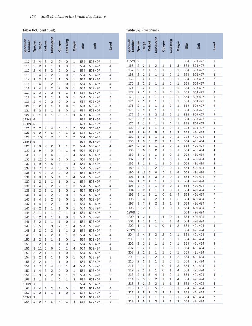
108 Shell Middens in the Grand Bay Estuary
110 2 4 3 2 2 0 1 564 503 497 4111 2 2 1 1 1 0 1 564 503 497 4112 2 4 3 2 2 0 1 564 503 497 4113 2 4 2 2 2 0 1 564 503 497 4114 2 2 1 1 1 0 1 564 503 497 4115 2 4 3 2 2 0 1 564 503 497 4116 2 4 3 2 2 0 1 564 503 497 4117 2 3 2 2 1 1 4 564 503 497 4118 2 2 1 1 1 0 1 564 503 497 4119 2 4 2 2 2 0 1 564 503 497 4120 2 2 1 1 1 0 1 564 503 497 4121 3 2 1 1 1 0 1 564 503 497 4122 3 1 1 1 0 1 4 564 503 497 4
123/N 6 564 503 497 4124/N 5 564 503 497 4125 5 7 4 4 3 1 2 564 503 497 4126 6 9 4 5 4 1 2 564 503 497 4127 5 13 6 7 6 1 2 564 503 497 4
128/N 5 564 503 497 4129 1 3 2 2 1 1 2 564 503 497 4130 1 9 4 5 4 1 4 564 503 497 4131 1 7 4 4 3 1 4 564 503 497 4132 1 12 6 6 6 0 1 564 503 497 4133 1 9 5 5 4 1 4 564 503 497 4134 1 7 4 4 3 0 1 564 503 497 4135 1 4 2 2 2 0 1 564 503 497 4136 1 9 4 5 4 1 4 564 503 497 4137 1 2 1 1 1 0 1 564 503 497 4138 1 4 3 2 2 1 3 564 503 497 4139 1 2 1 1 1 0 1 564 503 497 4140 1 4 2 2 2 0 1 564 503 497 4141 1 4 2 2 2 0 1 564 503 497 4142 1 4 2 2 2 0 1 564 503 497 4143 3 2 1 1 1 0 1 564 503 497 4144 3 1 1 1 0 1 4 564 503 497 4145 3 2 1 1 1 0 1 564 503 497 4146 3 2 1 1 1 0 1 564 503 497 4147 2 5 3 3 2 1 4 564 503 497 4148 2 3 2 2 1 1 2 564 503 497 4149 2 3 2 2 1 1 3 564 503 497 4150 2 2 1 1 1 0 1 564 503 497 4151 2 2 1 1 1 0 1 564 503 497 4152 3 11 5 6 5 1 4 564 503 497 3153 3 2 1 1 1 0 1 564 503 497 3154 3 2 1 1 1 0 1 564 503 497 3155 3 2 1 1 1 0 1 564 503 497 3156 1 7 4 4 3 1 4 564 503 497 3157 1 4 3 2 2 0 1 564 503 497 3158 2 3 2 2 1 1 3 564 503 497 3159 2 1 1 1 0 1 3 564 503 497 3
160/N 1 564 503 497 6161 1 4 2 2 2 0 1 564 503 497 6162 3 2 1 1 1 0 1 564 503 497 6
163/N 2 564 503 497 6164 2 9 4 5 4 1 4 564 503 497 6
165/N 2 564 503 497 6166 2 3 1 2 1 1 3 564 503 497 6167 2 2 1 1 1 0 1 564 503 497 6168 2 2 1 1 1 0 1 564 503 497 6169 2 2 1 1 1 0 1 564 503 497 2170 2 2 1 1 1 0 1 564 503 497 2171 2 2 1 1 1 0 1 564 503 497 6172 2 2 1 1 1 0 1 564 503 497 6173 2 2 1 1 1 0 1 564 503 497 6174 2 2 1 1 1 0 1 564 503 497 6175 2 2 1 1 1 0 1 564 503 497 5176 2 2 1 1 1 0 1 564 503 497 5177 2 4 3 2 2 0 1 564 503 497 5178 2 2 1 1 1 0 1 564 503 497 5179 5 2 1 1 1 0 1 564 503 497 5180 6 2 1 1 1 0 1 564 503 497 5181 1 9 4 5 4 1 3 564 491 494 4182 1 2 1 1 1 0 1 564 491 494 4183 1 3 2 2 1 1 2 564 491 494 4184 2 2 1 1 1 0 1 564 491 494 4185 2 3 2 2 1 0 1 564 491 494 4186 2 2 1 1 1 0 1 564 491 494 4187 2 2 1 1 1 0 1 564 491 494 4188 2 2 1 1 1 0 1 564 491 494 4189 4 4 2 2 2 0 1 564 491 494 4190 1 11 5 6 5 1 4 564 491 494 2191 1 6 3 3 3 0 1 564 491 494 2192 1 2 1 1 1 0 1 564 491 494 2193 2 4 2 1 2 0 1 564 491 494 1194 2 2 1 1 1 0 1 564 491 494 7195 2 1 1 1 0 1 4 564 491 494 7196 2 3 2 2 1 1 3 564 491 494 7197 3 3 2 2 1 1 3 564 491 494 7198 3 2 1 1 1 0 1 564 491 494 7
199/B 5 564 491 494 7200 1 2 1 1 1 0 1 564 491 494 5201 1 1 1 1 0 1 4 564 491 494 5202 1 1 1 1 0 1 2 564 491 494 5
203/N 2 564 491 494 5204 2 4 3 2 2 0 1 564 491 494 5205 2 2 1 1 1 0 1 564 491 494 5206 2 2 1 1 1 0 1 564 491 494 5207 2 2 1 1 1 0 1 564 491 494 5208 2 2 1 1 1 0 1 564 491 494 5209 2 3 2 2 1 1 2 564 491 494 5210 2 2 1 1 1 0 1 564 491 494 5211 2 1 1 1 0 1 3 564 491 494 5212 2 1 1 1 0 1 4 564 491 494 5213 2 8 5 4 4 0 1 564 491 494 5214 2 3 2 2 1 1 4 564 491 494 5215 3 3 2 2 1 1 3 564 491 494 5216 1 10 6 5 5 0 1 564 491 494 7217 1 5 3 3 2 1 2 564 491 494 7218 1 2 1 1 1 0 1 564 491 494 7219 1 5 3 3 2 1 2 564 491 494 7
Spe
cim
en
Num
ber
Spe
cies
Rin
gs
Coh
ort
Tran
sluc
ent
Opa
que
Last
Rin
g
Mar
gin
Site
Uni
t
Leve
l
Spe
cim
en
Num
ber
Spe
cies
Rin
gs
Coh
ort
Tran
sluc
ent
Opa
que
Last
Rin
g
Mar
gin
Site
Uni
t
Leve
l
Table 8-3. (continued). Table 8-3. (continued).
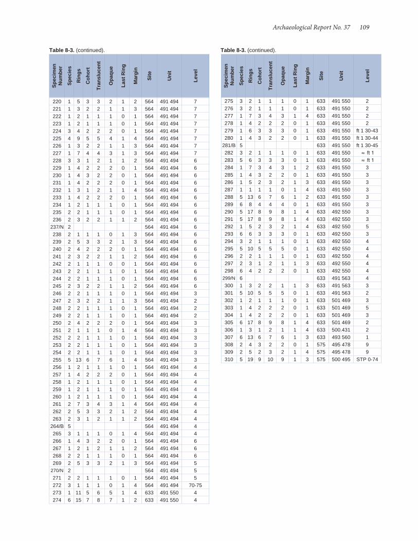
Archaeological Report No. 37 109
275 3 2 1 1 1 0 1 633 491 550 2276 3 2 1 1 1 0 1 633 491 550 2277 1 7 3 4 3 1 4 633 491 550 2278 1 4 2 2 2 0 1 633 491 550 2279 1 6 3 3 3 0 1 633 491 550 ft 1 30-43280 1 4 3 2 2 0 1 633 491 550 ft 1 30-44
281/B 5 633 491 550 ft 1 30-45282 3 2 1 1 1 0 1 633 491 550 ≈ ft 1283 5 6 3 3 3 0 1 633 491 550 ≈ ft 1284 1 7 3 4 3 1 2 633 491 550 3285 1 4 3 2 2 0 1 633 491 550 3286 1 5 2 3 2 1 3 633 491 550 3287 1 1 1 1 0 1 4 633 491 550 3288 5 13 6 7 6 1 2 633 491 550 3289 6 8 4 4 4 0 1 633 491 550 3290 5 17 8 9 8 1 4 633 492 550 3291 5 17 8 9 8 1 4 633 492 550 3292 1 5 2 3 2 1 4 633 492 550 5293 6 6 3 3 3 0 1 633 492 550 3294 3 2 1 1 1 0 1 633 492 550 4295 5 10 5 5 5 0 1 633 492 550 4296 2 2 1 1 1 0 1 633 492 550 4297 2 3 1 2 1 1 3 633 492 550 4298 6 4 2 2 2 0 1 633 492 550 4
299/N 6 633 491 563 4300 1 3 2 2 1 1 3 633 491 563 3301 5 10 5 5 5 0 1 633 491 563 2302 1 2 1 1 1 0 1 633 501 469 3303 1 4 2 2 2 0 1 633 501 469 5304 1 4 2 2 2 0 1 633 501 469 3305 6 17 8 9 8 1 4 633 501 469 2306 1 3 1 2 1 1 4 633 500.431 2307 6 13 6 7 6 1 3 633 493 560 1308 2 4 3 2 2 0 1 575 495 478 9309 2 5 2 3 2 1 4 575 495 478 9310 5 19 9 10 9 1 3 575 500 495 STP 0-74
220 1 5 3 3 2 1 2 564 491 494 7221 1 3 2 2 1 1 3 564 491 494 7222 1 2 1 1 1 0 1 564 491 494 7223 1 2 1 1 1 0 1 564 491 494 7224 3 4 2 2 2 0 1 564 491 494 7225 4 9 5 5 4 1 4 564 491 494 7226 1 3 2 2 1 1 3 564 491 494 7227 1 7 4 4 3 1 3 564 491 494 7228 3 3 1 2 1 1 2 564 491 494 6229 1 4 2 2 2 0 1 564 491 494 6230 1 4 3 2 2 0 1 564 491 494 6231 1 4 2 2 2 0 1 564 491 494 6232 1 3 1 2 1 1 4 564 491 494 6233 1 4 2 2 2 0 1 564 491 494 6234 1 2 1 1 1 0 1 564 491 494 6235 2 2 1 1 1 0 1 564 491 494 6236 2 3 2 2 1 1 2 564 491 494 6
237/N 2 564 491 494 6238 2 1 1 1 0 1 3 564 491 494 6239 2 5 3 3 2 1 3 564 491 494 6240 2 4 2 2 2 0 1 564 491 494 6241 2 3 2 2 1 1 2 564 491 494 6242 2 1 1 1 0 0 1 564 491 494 6243 2 2 1 1 1 0 1 564 491 494 6244 2 2 1 1 1 0 1 564 491 494 6245 2 3 2 2 1 1 2 564 491 494 6246 2 2 1 1 1 0 1 564 491 494 3247 2 3 2 2 1 1 3 564 491 494 2248 2 2 1 1 1 0 1 564 491 494 2249 2 2 1 1 1 0 1 564 491 494 2250 2 4 2 2 2 0 1 564 491 494 3251 2 1 1 1 0 1 4 564 491 494 3252 2 2 1 1 1 0 1 564 491 494 3253 2 2 1 1 1 0 1 564 491 494 3254 2 2 1 1 1 0 1 564 491 494 3255 5 13 6 7 6 1 4 564 491 494 3256 1 2 1 1 1 0 1 564 491 494 4257 1 4 2 2 2 0 1 564 491 494 4258 1 2 1 1 1 0 1 564 491 494 4259 1 2 1 1 1 0 1 564 491 494 4260 1 2 1 1 1 0 1 564 491 494 4261 2 7 3 4 3 1 4 564 491 494 4262 2 5 3 3 2 1 2 564 491 494 4263 2 3 1 2 1 1 2 564 491 494 4
264/B 5 564 491 494 4265 3 1 1 1 0 1 4 564 491 494 4266 1 4 3 2 2 0 1 564 491 494 6267 1 2 1 2 1 1 2 564 491 494 6268 2 2 1 1 1 0 1 564 491 494 6269 2 5 3 3 2 1 3 564 491 494 5
270/N 2 564 491 494 5271 2 2 1 1 1 0 1 564 491 494 5272 3 1 1 1 0 1 4 564 491 494 70-75273 1 11 5 6 5 1 4 633 491 550 4274 6 15 7 8 7 1 2 633 491 550 4
Spe
cim
en
Num
ber
Spe
cies
Rin
gs
Coh
ort
Tran
sluc
ent
Opa
que
Last
Rin
g
Mar
gin
Site
Uni
t
Leve
l
Spe
cim
en
Num
ber
Spe
cies
Rin
gs
Coh
ort
Tran
sluc
ent
Opa
que
Last
Rin
g
Mar
gin
Site
Uni
t
Leve
l
Table 8-3. (continued). Table 8-3. (continued).

110 Shell Middens in the Grand Bay Estuary
Results of the 2010 Investigations At the outset of this project we identified sever-
al research issues that could be addressed based on the state of knowledge of Grand Bay archaeology. We knew, according to the MDAH site files, there were as many as 20 prehistoric sites in the vicinity of Grand Bay. These had been reported by both professionals and nonprofessionals. Some sites were well known from extensive collecting, such as 22JA550, Point aux Chenes (e.g., Geiger 2012), but others were scantily documented in the site records. Professional investi-gations were limited to an archaeological reconnais-sance of portions of the Grand Bay National Wildlife Refuge and follow-up testing by Mann at 22JA575, 22JA578, and 22JA633 (Mann 1996). Records indicat-ed components at these sites ranged from the Middle Gulf Formational Claiborne phase to the Mississippi period, and perhaps beyond (Blitz and Mann 2000; Boudreaux 2009). Most were simply known to be lo-cations where shellfish had been gathered and pro-cessed, based on the most obvious ecofact class. And most sites had produced aboriginal ceramics, but also bone and chipped stone tools that might be indicative of a broader range of activities. Vertebrate faunal re-mains indicated fishing and sometimes hunting from these locations as well. However, other than what had been gleaned from brief visits and surface collections from some sites, little was known about settlement or subsistence activities in the Grand Bay area, or how these sites might relate to regional settlement systems (Geiger 1985). Finally, it was impossible to assess how site function may have changed over time. Strati-graphically controlled artifact and ecofact samples sufficient for quantitative evaluation were needed to move beyond these limited perceptions based on site file data.
One research goal was to evaluate human adapta-tion in the context of dynamic environmental fluctua-tions related to global patterns of climate and sea level change, more local hydrological changes in freshwater discharge that impacted salinity levels (and therefore faunal composition), and geomorphologic changes in river courses and subsidence. While today the Grand Bay is occupied by vast stretches of tidal marsh, this may not always have been the case. Therefore, could we use archaeological data, in particular subsistence remains, to gauge human responses to environmental change?
It was clear from site visits after Hurricane Katrina that the Grand Bay sites are an endangered resource. Several sites were severely damaged by tidal surge. Others in more sheltered locations sustained less ob-vious damage from the hurricane, but are being erod-ed by tidal action and boat traffic. Gathering basic archaeological data from these dwindling resources seemed a paramount concern.
Research Questions Chronology of Site Use
Our investigations at 22JA564, 22JA575, and 22JA633 produced no artifacts to indicate site use ear-lier than the Apple Street phase (800- 100 BC). In fact, our evidence for shellfish collecting at 22JA575 sug-gests its initial use occurred during the Late Wood-land Tates Hammock phase (and possibly only during the later half of that phase). This is a tentative state-ment, however, since excavations could not sample midden below the low tide mark.
The earliest intact deposits at 22JA564 and 22JA633 date to the Apple Street phase, based on examples of Chinchuba Brushed and Bayou La Batre Cord Wrapped Dowel Impressed from excavation units or shovel tests at 22JA564, and examples of Santa Rosa Stamped and Santa Rosa Punctated from 22JA633. Additional examples were collected from shoreline surface contexts, indicating that possibly significant portions of the earlier archaeological records of these sites have succumbed to wave erosion. Earlier Clai-borne phase (1200- 800 BC) artifacts previously col-lected from 22JA550, now destroyed (Geiger 2012), indicate an earlier use of the Grand Bay area, and even earlier archaeological remains may be underwater.
Greenwood Island phase is only represented by di-agnostic ceramics at 22JA564, and there only scant-ily by two decorated sherds. The succeeding Godsey phase is also only faintly represented, but in this case at both 22JA564 and 22JA633. A radiocarbon date with a two- sigma range of AD 130- 260 from 22JA633 lends support for a Godsey phase presence on the site.
The Graveline and Tate's Hammock phases seem to be the most intensive periods of site use at 22JA564 and 22JA633, judging from the number of decorat-ed ceramic markers associated with this time span, as well as the diversity of types represented. The for-
Chapter 9 Culture and Adaptation on Grand Bay
by H. Edwin Jackson

112 Shell Middens in the Grand Bay Estuary
Historic use of these shell middens continued from the contact period until the present day. Mid to late eighteenth-century European ceramics were collect-ed from each of the three sites, along with later nine-teenth- and twentieth-century wares. There is little to suggest permanent habitations on the sites. There are stubs of modern piers at 22JA575, possibly the remains of a duck blind. At 22JA633 shovel testing encountered a concentration of old bricks and what might be the remains of a prepared floor. Otherwise, historic use of the sites seems to have been ephemeral, for hunting or recreational camps and, more recently, as picnic spots. Finally, strewn over all the sites is mod-ern debris deposited by Hurricane Katrina, ranging from portions of piers to crab traps. At 22JA633 the number of asbestos siding shards along the shoreline seems to outnumber prehistoric sherds. Interpreting the earlier historic artifacts as evidence of occupation or use of the middens is something of a leap of faith, given the possibility that grandmother's dinnerware might only recently have been swept onto a site.
Stylistic Boundaries
Located as it is on the extreme eastern end of the Mississippi coast, Grand Bay residents enjoyed sty-listic stimulation from both east and west through-out much of the prehistoric era represented by the excavated sites. Sand tempering, which appeared during the middle Gulf Formational period, persist-ed through the Tates Hammock phase, joined by grog tempered ceramics in the Middle Woodland period. Sand tempered pots do appear more likely to bear designs attributable to peoples to the east, and grog tempered pots designs are more readily attributable to western origins. But this is not always the case. During the Middle Woodland period, east and west share relatively uniform decorative treatments that are distinguished by vessel temper. During the Late Woodland period, Weeden Island designs on sand tempered pottery could be vessels obtained through exchange or transported to the Grand Bay by people originating somewhere on the Florida panhandle. Al-though a stylistic connection has been made between Weeden Island types and the Lower Mississippi Val-ley's French Fork Incised, the only evidence of the lat-ter in the present collections is provided by two var. Iberville sherds, which seem to be a devolved and pre-sumably late Early Mississippi period variant of the classic type (Phillips 1970: 85).
mer is somewhat misleading since during this inter-val whole vessel decorative treatments (including Mulberry Creek Cord Marked, Ponchartrain Check Stamped and Wakulla Check Stamped) became pop-ular. Nonetheless, 81 percent of recovered decorat-ed ceramics from 22JA564 and nearly 96 percent of those from 22JA633 are associated with the Graveline and Tates Hammock phases. For both sites, the later phase is represented by the larger number of diagnos-tic sherds. Several radiocarbon determinations from these sites corroborate the intensity of occupation, and faunal samples associated with this time span are also the largest. One reason for the wide variety of decorated types associated with these two phases is the clear overlap here of the Lower Mississippi Valley- Louisiana Delta and Weeden Island stylistic zones and associated differences in ceramic ware recipes. The lowest levels of 22JA575 date to the latter half of the Tates Hammock phase (AD 1060- 1080 and 1150- 1240, at the two-sigma calibrated range).
Mississippian, protohistoric, and early historic use of the shell middens is only represented by a few decorated sherds from each phase, a probable conse-quence of changing site functions. Site use intensity varied considerably, with all shell tempered paste rec-ipe variations comprising 58 percent of all ceramics from 22JA575, 24 percent of those from 22JA633, but only 5 percent from 22JA564 (see Tables 4- 3 through 4- 5). Early Mississippi period Pinola phase is repre-sented at 22JA575 and 22JA633, but not at 22JA564. Only a small number of sherds can be clearly attribut-ed to that phase (Carter Engraved from 22JA633, and Anna Incised and Barton Incised from 22JA575), but some Tate's Hammock markers may persist into Pino-la phase.
Singing River phase diagnostics were retrieved from all three sites. A fully shell tempered pottery technology was in place by this time. At 22JA633 a concentration of shell tempered ceramics was associ-ated with a large baked earth feature that produced a radiocarbon date of AD 1450- 1640 (two-sigma range).
Only one decorated sherd from 22JA575, Mound-ville Incised, var. Douglas, is indicative of a Bear Point phase occupation. The only La Pointe phase diag-nostics were recovered from 22JA564, although two French gunflints found at 22JA575 could have been associated with historic Native American use of the site. Further evidence of colonial period hunting in the marshes was collected subsequent to our field investigations in the form of a musket part (possibly English), probably at 22JA710, by a Grand Bay NWR biologist (Jay McIlwain, personal communication, 2012).

Archaeological Report No. 37 113
est?) then carried to 22JA575 for processing. Another shellfish resource appearing in small numbers at each site is quahog, which is not known from the Grand Bay area today, but likely could have been collected adjacent to the barrier islands where an appropriate substrate to support quahog colonies probably existed (David Ruple, personal communication 2011).
Montana's (1996) analysis of shellfish from the Di-amondhead site made the case for population stress as a consequence of overexploitation, resulting in aban-donment of the site, or, more precisely, shifting the location of shellfish collecting to somewhere else in the vicinity. A similar pattern revealed by a decrease in shell size over time was hypothesized for the Grand Bay middens. However, systematic measurement of valve height and length failed to reveal a similar trend at any of these sites. Rather, variation around a mean was a near universal pattern. This suggests that resi-dential groups had access to multiple collecting loca-tions and moved among them sufficiently frequently to avoid overpredation. This is true even for 22JA575, where more than a meter of shell deposits accumulat-ed in just a few centuries, during a period of hypothe-sized intensive food gathering. Despite the number of sites, the marsh likely supported a fairly low human population. Certainly more excavation arerequired to determine whether this conclusion applies generally to the entire estuary.
Fish, not surprisingly, were an important compo-nent of the diet in each of the chronologically con-trolled samples. At least fourteen species are represent-ed, all marine with the exception of alligator gar, which although a freshwater species is tolerant of saltwater environments and commonly found in the bay and river mouths of the Mississippi Gulf coast. The marine species present are generally indicative of shallow ma-rine environments and could be captured year round. Present in all chronologically distinguished samples are sheepshead, mullet, sea catfish, red drum, croaker, shark/ray, and gar, the most plentiful fish species over-all being sheepshead, mullet, and black drum. Species represented in only a single sample include ladyfish, shad, and crevalle jack. Drum and mullet, along with sea catfish, were the most common fish in the Godsey and Singing River assemblages (Jewell 2000). The fish assemblage from the Diamondhead site diverges from those from Grand Bay and those analyzed by Jewell in including a significant amount of freshwater fish, although the relative contributions of these fluctuate over time. The greater important of freshwater taxa is a function of its location on the Jourdan River, a major freshwater source emptying into St. Louis Bay, placing it in a strategic location for exploiting both saltwater and freshwater environments. The site's location at the interface between the two ecozones is indicated by the
Site Function, Subsistence Patterns, and Changes through Time
To what extent sites at Grand Bay served as residen-tial, as opposed to collecting and fishing, locations is a fundamental question related to the nature of coastal settlement patterns and how these may have changed through time. Data from 22JA564 and 22JA633, in-cluding the presence of features, human burials, ce-ramic diversity, and more varied faunal assemblages, point to residential functions during the Woodland era. In addition, both sites have archaeological depos-its beyond the limits of the shell middens. Residential camps, rather than specialized harvesting locations, are indicated by the diversity of decorated ceramics at these sites, incorporating styles imitating, or perhaps obtained from, peoples both to the west and east.
In contrast, 22JA575 has significantly denser and thicker shell deposits, with significantly lower artifact density than the aforementioned sites, this despite a more abbreviated period of use than either 22JA564 or 22JA633. Decorated sherds comprise a significantly smaller proportion of the ceramic assemblage. Marine resources are more dominant in the vertebrate faunal assemblage than is the case with other site samples, a point to which I will return below. Nonetheless, even at 22JA575 terrestrial fauna is present, pointing to multiple subsistence targets rather than simply fishing and shellfish collecting. Surface inspections of sites south of 22JA575 seem to have similar characteristics, although at 22JA632 (Bangs Island) it should be noted that a projectile point and deer long bone fragments were observed, suggesting some variety of on- site ac-tivities, as well as subsistence tasks.
At all three sites, shellfish collecting focused almost exclusively on oysters, readily available in the adjacent waters. Although we hypothesized that changing hy-drological conditions, specifically changes in salinity, could have resulted in local species changes, this part of the Grand Bay procurement continuum remained surprisingly stable. The general estuarine environ-ment, at least that necessary for supporting oyster col-onies, was well established by 500 BC throughout the study area. Changing sea level or rainfall patterns had no perceptible impact on the environment, as least with respect to oysters. A small number of other taxa are present, but of these only marsh clams occur in numbers to indicate any significant contribution. All three sites produced some marsh clams, but the most surprising occurrence was at 22JA575, where several clear concentrations of clam shells were noted among the oyster shells. Presumably, this site would have been situated farthest from the appropriate habitat for this brackish water species. So we infer that these clams were collected elsewhere (upstream on Bayou Cumb-

114 Shell Middens in the Grand Bay Estuary
fish procurement, a change that does not seem to sig-nal a change in subsistence strategy, but rather the ef-fects of a gradually changing landscape as subsidence reduced terrestrial habitats surrounding the sites and therefore necessitated longer hunting forays. This shift is quantitative rather than qualitative, at least during the Woodland time span.
While landscape changes may be the primary fac-tor in the Grand Bay pattern, a similar pattern was noted by Jewell (2000) in his analysis of fauna from the Godsey and Singing River sites, which he attri-butes to possible territorial constriction. In addition, he noted an increase in the contribution of reptiles to the Mississippian samples, a change also seen in the Diamondhead assemblage (Allgood 2001). In both cases, the shift in assemblage composition is related to increased sea turtle and alligator hunting. There is a coincident change in artifact assemblage, interpreted to signal a shift from residential site to extractive camp (Sims 1997). For Grand Bay, there is no evidence of sea turtle in any of the samples, but alligator does appear in quantity at 22JA633 in the Mississippian sample. The presence of alligator may not reflect a systematic shift in procurement in this case, however, since be-cause of the small sample size associated with the Mis-sissippian occupation, a small number of specimens from a large individual can overpower the remainder of the sample. Notably there is no alligator associated with the Mississippian sample for 22JA575. More im-portantly, and to the general point of possibly signifi-cant change in the organization of Mississippian pro-curement, there does appear to be a somewhat abrupt change in fishing strategy coincident with the onset of the Mississippi period. At 22JA633 the small sample from the Mississippian component provides evidence of significantly larger fish sizes, a pattern that it shares with the Mississippian sample from 22JA575. This is interpreted to be a shift similar to that seen at the Dia-mondhead site, specifically a targeted extractive effort reflecting changes in technology employed or selec-tion for larger individuals, perhaps during a narrower window of time when smaller individuals would be unlikely to be captured.
Whether this altered pattern reflects economic re-organization as a consequence of greater reliance on agricultural production, or whether it reflects social and political changes with the emergence of small chiefly polities such as Singing River and Deer Is-land, cannot be answered at present. The Mississip-pian pattern could simply be a change in scheduling coinciding with the demands of spring planting and fall harvesting, either inland as posited by some (e.g., Lewis 1988), or even in small gardens on the shore as mentioned in early historic records (Blitz and Mann 2000:104). Alternatively, it could reflect periodic in-
fact that the shellfish there are nearly entirely brackish water or marsh clams. During the Mississippi period a narrower range of species was taken during a more limited seasonal timeframe for their capture (Allgood 2001). For the Grand Bay assemblages, there seem to be no shifts in time when species were caught, with the possible exception of sea trout, which declines rel-ative to other taxa after the Late Woodland period.
While fish are the mainstay of the prehistoric diet throughout the sequence, the diversity of other taxa, particularly those associated with the Woodland oc-cupations, lends credence to an interpretation that these sites served residential functions. Small and me-dium-sized mammals include opossum, rabbit, musk-rat, raccoon, gray fox, bobcat, and wolf or large dog. Identified birds include goose, teal, large and medium ducks, cormorant, osprey, rail, turkey, and wood stork. Reptiles include diamondback terrapin, pond turtles, box turtle, mud turtle alligator, water snake, viper, and unidentified colubrid snakes. There is a sharp decline in faunal diversity in the Mississippian sample from 22JA575, coincident with a significant increase in the overall contribution of fish.
Seasonality of coastal site use is also indicative of residential encampments during the Woodland era. Winter deer hunting is in evidence in the late Wood-land samples from both 22JA564 and 22JA633, and cormorants and ducks might have been more likely targets during the colder months as well. However, the abundance and variety of reptiles in each of the assemblages is indicative of summer procurement. According to Jewell (2000:163), sea catfish as well as drums, while inshore year round, tend to move to deeper water in winter, reducing their availability. Other fish, such as sheepshead and flounder, move into the open Gulf to spawn, between fall and early spring (Jewell 2000: 165). For these species warmer weather fishing near shore is more likely. This implies greater emphasis on fishing in spring through fall. Looking at fish size estimates, compared with fisher-ies data (Jewell 2000: Table C.7), indicate a potential-ly broader window for fishing to have occurred, with the size ranges of one-year-old specimens pointing to fall to winter fishing. These data fit well with Blitz and Mann's (2000:104) characterization of seasonality and settlement flexibility. A clearer understanding of the seasonality of shellfish collecting and fishing will require more analysis in the form of trace element analysis of the former, and otolith thin- sectioning for the latter. In the meantime, the data support a multi- season settlement.
Faunal assemblages from the sites indicate long term trends in procurement practices, ones that were likely not perceived by the Grand Bay foragers. There is a slow but steady transition toward greater marine
Archaeological Report No. 37 115
tensive procurement to supply particular events either in local communities or at mound centers.
One economic activity that is not at all in evidence is saltmaking, at least so far as we did not identify any sherds from large salt pans. Although saltmaking was common upriver from Mobile Bay (Dumas 2008b), and there are some salt pan sherds from Deer Island (Blitz and Mann 2000:130; Craig 2010), this does not (at this point) seem to have been an activity in Grand Bay.
Conclusions Despite the logistical problems of trying to conduct
coastal archaeology in the summer of 2010, the data we collected from 22JA564, 22JA575, and 22JA633 provide a much clearer picture of the Native Ameri-can occupation of the Grand Bay area, and their ad-aptation to the estuarine environment adjacent to Mississippi Sound, than we previously had. Artifactu-al evidence indicates that, by at least the middle Gulf Formational period, Native Americans were fishing, collecting shellfish, and hunting terrestrial fauna from sites located in the estuary. Unfortunately, much of the evidence we collected of these earliest document-ed occupations came from surface collections along the shorelines of sites, indicating that the archaeolog-ical record of this period of occupation has already succumbed at least in part to erosion and storm dam-age. While we did not gather evidence of even earlier components, that does not necessarily mean they are not present, perhaps at unexamined sites. If, indeed, there were occupations during periods of lower sea level, these would likely be at sites nearer the Sound, at least if shellfish were the target of subsistence re-source. Moreover, if subsidence has played a role in the configuration of the estuary, and even relatively late historic evidence, namely the encroachment of marshes on previously forested patches, suggests this is so, then evidence for the earliest use of the Grand Bay area may be well below present sea level. It is notable that at 22JA564 and 22JA633, the two sites closest to dry land, the earliest cultural deposits are roughly at the level of tidal fluctuation. At these sites, lower levels could only be excavated at low tide, but once removed it was pretty clear that we had reached culturally sterile soil. At 22JA575, closer to Mississippi Sound, we reached the level of tidal fluctuation well before we ran out of midden. Augering indicates an-other half meter or more of shell midden below what we sampled. (We failed to get any deeper using the auger because the shell matrix below water level col-lapsed before we could return the auger to its hole.) As the lowest reachable levels date later than the earli-est deposits at either 22JA633 or 22JA575, subsidence
must be the cause of sub-low tide cultural deposits. Earlier deposits associated with lower sea levels re-mains a possibility, one that has greater probability at sites closer to the Sound. Unfortunately, these are also the sites that display the greater degree of damage from tidal surges. Since we could not excavate at these sites, we must leave open the question as to whether there are intact archaeological deposits below a veneer (in some cases probably a thick veneer) of wave-rede-posited shell, as is the case at 22JA575. The question as to whether there are even earlier deposits will only be answered by technologically sophisticated excavations that can reach below sea level. There is still much po-tential for future research in the Grand Bay area.

116 Shell Middens in the Grand Bay Estuary
Appendix A Artifact Inventory, 22JA564
Cat
alog
Num
ber
Nor
th
Eas
t
Leve
l
Feat
ure
Uni
t Typ
e
Dec
orat
ed C
eram
ics
Und
ecor
ated
C
eram
ics
Deb
itage
Sto
ne T
ool
Sto
ne
Bon
e
Biv
alve
s
Sna
ils
His
tori
c G
lass
His
tori
c C
eram
ics
His
tori
c M
etal
Cha
rcoa
l
Bak
ed C
lay
Oth
er: N
otes
1 Surface Collection
Surface Collection 191 34 2 85 7 5 3 2 8
1 Surface Collection
Surface Collection 16 211 1 4 305 6 3 3 3 12 4
1 g of red ochre; 3 recorded in the stone column is representative of the sandstone
1 Surface Collection
Surface Collection 9 31 25 1
2 510 500 1 STP 3 4 0.2
4 510 500 2 STP 1 7 5 0.4 2.5
6 510 500 3 STP 1 66 6 2.2 2.4 40-50 cm
8 530 500 2 STP 2 2.6 2.6 g of burned wood/charcoal
9 530 500 3 STP 7 5.4
11 520 500 1 STP 1 3 1 17 1.8
12 490 500 1 STP 1 11 3 1 18.2 159 g of brick
13 520 495 2 STP 5 11 87 7 2.1
13 490 500 2 STP 2 20 9 5 3 0.9 10 30-50 cm depth
15 520 500 2 STP 1 8 15 4 4.8
16 520 500 3 STP 18 1.8
17 500 510 2 STP 5
18 500 510 3 STP 2 10 1 0.3
19 500 505 2 STP 1 9 1 1 1 g red ochre
20 495 500 1 STP 1 3 4 4 1 4.9 g of brick; .4 g of plastic; 1.7 g of historic metal
21 495 500 2 STP 9 27 2 6 2 25-45 cm
22 495 500 3 STP 1 5 59 19 1 4.1 0.6 40-58 cm
23 490 495 1 STP 19 7 1
24 490 495 2 STP 2 1 6 9 1 0.3
25 490 495 3 STP 3 23 12 6 3.1 4
26 490 495 4 STP 1 21 1 27.7 60-75 cm
27 495 495 1 STP 1 2 4
28 495 495 2 STP 3 13 1 22 4 2 2.5
29 495 495 3 STP 1 12 35 1 0.5 7.4 21.5 g of brick; 40-70 cm of depth
30 500 495 1 STP 1 2 5
31 500 495 2 STP 1 2 7 19 16
32 500 495 3 STP 2 24 35 5 6 5
33 505 495 1 STP 4 4 1 3
34 505 495 2 STP 12 2 3 1 4 1 sandstone
35 505 495 3 STP 2 3 20 2 6 9
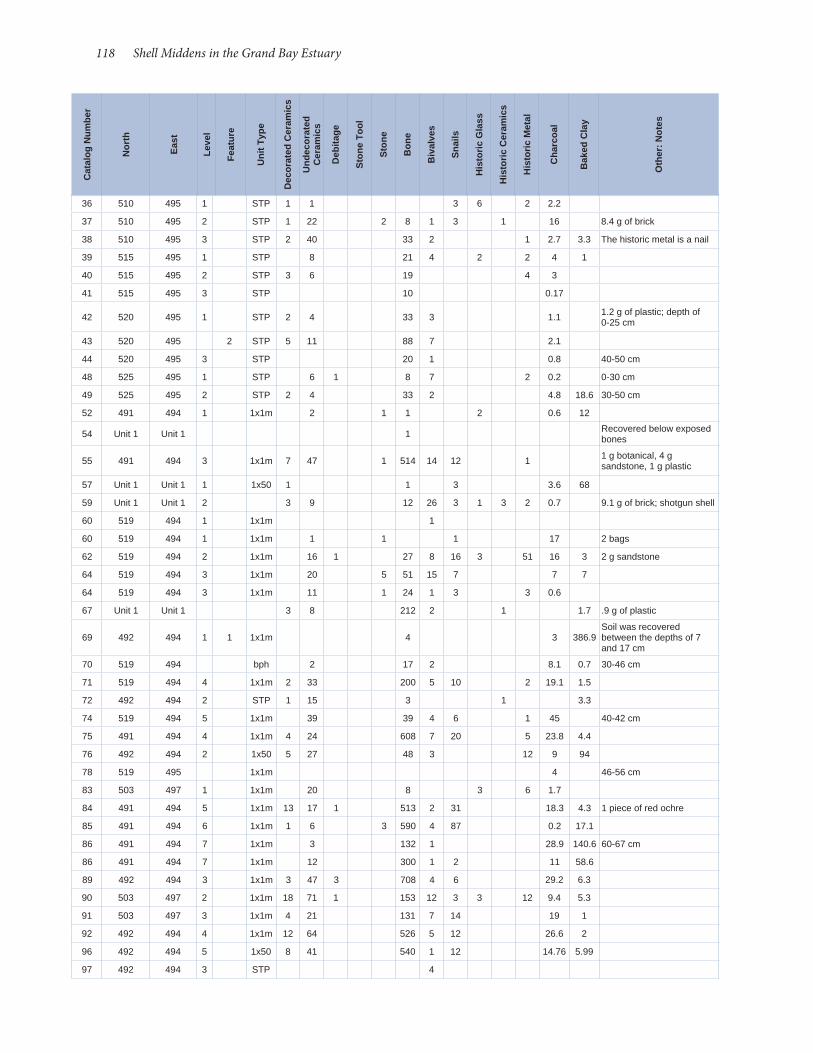
118 Shell Middens in the Grand Bay Estuary
36 510 495 1 STP 1 1 3 6 2 2.2
37 510 495 2 STP 1 22 2 8 1 3 1 16 8.4 g of brick
38 510 495 3 STP 2 40 33 2 1 2.7 3.3 The historic metal is a nail
39 515 495 1 STP 8 21 4 2 2 4 1
40 515 495 2 STP 3 6 19 4 3
41 515 495 3 STP 10 0.17
42 520 495 1 STP 2 4 33 3 1.1 1.2 g of plastic; depth of 0-25 cm
43 520 495 2 STP 5 11 88 7 2.1
44 520 495 3 STP 20 1 0.8 40-50 cm
48 525 495 1 STP 6 1 8 7 2 0.2 0-30 cm
49 525 495 2 STP 2 4 33 2 4.8 18.6 30-50 cm
52 491 494 1 1x1m 2 1 1 2 0.6 12
54 Unit 1 Unit 1 1 Recovered below exposed bones
55 491 494 3 1x1m 7 47 1 514 14 12 1 1 g botanical, 4 g sandstone, 1 g plastic
57 Unit 1 Unit 1 1 1x50 1 1 3 3.6 68
59 Unit 1 Unit 1 2 3 9 12 26 3 1 3 2 0.7 9.1 g of brick; shotgun shell
60 519 494 1 1x1m 1
60 519 494 1 1x1m 1 1 1 17 2 bags
62 519 494 2 1x1m 16 1 27 8 16 3 51 16 3 2 g sandstone
64 519 494 3 1x1m 20 5 51 15 7 7 7
64 519 494 3 1x1m 11 1 24 1 3 3 0.6
67 Unit 1 Unit 1 3 8 212 2 1 1.7 .9 g of plastic
69 492 494 1 1 1x1m 4 3 386.9Soil was recovered between the depths of 7 and 17 cm
70 519 494 bph 2 17 2 8.1 0.7 30-46 cm
71 519 494 4 1x1m 2 33 200 5 10 2 19.1 1.5
72 492 494 2 STP 1 15 3 1 3.3
74 519 494 5 1x1m 39 39 4 6 1 45 40-42 cm
75 491 494 4 1x1m 4 24 608 7 20 5 23.8 4.4
76 492 494 2 1x50 5 27 48 3 12 9 94
78 519 495 1x1m 4 46-56 cm
83 503 497 1 1x1m 20 8 3 6 1.7
84 491 494 5 1x1m 13 17 1 513 2 31 18.3 4.3 1 piece of red ochre
85 491 494 6 1x1m 1 6 3 590 4 87 0.2 17.1
86 491 494 7 1x1m 3 132 1 28.9 140.6 60-67 cm
86 491 494 7 1x1m 12 300 1 2 11 58.6
89 492 494 3 1x1m 3 47 3 708 4 6 29.2 6.3
90 503 497 2 1x1m 18 71 1 153 12 3 3 12 9.4 5.3
91 503 497 3 1x1m 4 21 131 7 14 19 1
92 492 494 4 1x1m 12 64 526 5 12 26.6 2
96 492 494 5 1x50 8 41 540 1 12 14.76 5.99
97 492 494 3 STP 4
Cat
alog
Num
ber
Nor
th
Eas
t
Leve
l
Feat
ure
Uni
t Typ
e
Dec
orat
ed C
eram
ics
Und
ecor
ated
C
eram
ics
Deb
itage
Sto
ne T
ool
Sto
ne
Bon
e
Biv
alve
s
Sna
ils
His
tori
c G
lass
His
tori
c C
eram
ics
His
tori
c M
etal
Cha
rcoa
l
Bak
ed C
lay
Oth
er: N
otes

Archaeological Report No. 37 119
98 Surface Collection
Surface Collection 1
Related to Burial 1, recovered near surface of Unit 1
100 Unit 1 Unit 1 3 5
101 Unit 1 Unit 1 3 1x50 4 18 1 140 37 31 1 15 6 35 8 g of brick
102 503 497 4 1x1m 3 2 2 300 22 32 17.2 22.7
104 503 497 5 1 23 183 1 5 21.2
107 503 497 6 1x1m 5 6 417 7 9 24.8 52.4
109 Unit 1 Unit 1 4 1x1m 2 25 145 2 5 8 7.6 90.4 Deer antler
115 503 497 7 1x1m 2 15 2 21.82 32
117 491 494 8 1x1m 1 14 2 16.2 19.9 70-75 cm
119 491 494 Profile Wall 1x1m 1 2 1 67 1 8.7 24.1 The recovered stone is
sandstone
129 500 557 4 1x1m 7 40 7.8 61.2 14 g of pulverized shell
130 492 494 1 1x50 3 1 1 3 1 0.1 2.6 g of plastic
131 491 494 2 1x1m 12 80 2 193 8 11 1 2 15 22.6 g of brick
Cat
alog
Num
ber
Nor
th
Eas
t
Leve
l
Feat
ure
Uni
t Typ
e
Dec
orat
ed C
eram
ics
Und
ecor
ated
C
eram
ics
Deb
itage
Sto
ne T
ool
Sto
ne
Bon
e
Biv
alve
s
Sna
ils
His
tori
c G
lass
His
tori
c C
eram
ics
His
tori
c M
etal
Cha
rcoa
l
Bak
ed C
lay
Oth
er: N
otes

120 Shell Middens in the Grand Bay Estuary
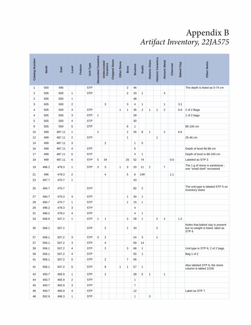
1 500 495 STP 2 46 The depth is listed as 0-74 cm
2 505 500 1 STP 2 20 1 3
2 505 500 1 48
3 505 500 2 3 3 4 1 1 3.1
4 505 500 3 STP 1 1 35 2 1 1 2 6.6 2 of 2 Bags
4 505 500 3 STP 1 39 1 of 2 bags
5 505 500 4 STP 30
9 505 500 5 STP 6 1 85-100 cm
10 499 487.11 1 2 2 26 8 1 2 6.6
12 499 487.11 2 STP 1 1 25-46 cm
14 499 487.11 3 2 1 5
16 499 487.11 4 STP 5 Depth of level 66-86 cm
17 499 487.11 5 STP 4 1 Depth of level is 86-100 cm
18 499 487.11 6 STP 5 34 25 52 74 0.6 Labeled as STP 3
19 496.2 478.3 1 STP 3 3 1 3 20 11 2 7 The 1 g of stone is sandstone ; one “small shell” recovered
21 496 478.3 2 4 5 6 149 1.1
23 497.7 470.7 1 43
25 494.7 470.7 STP 82 2 The unit type is labeled STP 5 on inventory sheet
27 494.7 470.3 3 STP 1 30 1
28 494.7 470.7 1 STP 1 15 1
29 496.2 478.3 3 STP 4
31 496.2 478.2 4 STP 4 1
33 506.9 507.2 1 STP 1 1 3 28 1 2 2 1.2
35 506.1 507.2 STP 2 1 33 2Notes that baked clay is present but no weight is listed, label as STP 6
37 506.1 507.2 3 STP 3 2 24 3 1
37 506.1 507.2 3 STP 4 59 14
39 506.1 507.2 4 STP 2 3 68 1 Unit type is STP 6; 2 of 2 bags
39 506.1 507.2 4 STP 55 1 Bag 1 of 2
41 506.1 507.2 5 STP 2 7 56
41 506.1 507.2 5 STP 6 1 1 57 1 Also labeled STP 6; the stone column is labled 1/240
42 493.7 465.9 1 STP 2 28 5 1 1
44 493.7 465.9 2 STP 1
45 493.7 465.9 3 STP 7
46 493.7 465.9 4 STP 12 Label as STP 7
48 502.9 496.3 1 STP 1 3
Appendix B Artifact Inventory, 22JA575
Cat
alog
Num
ber
Nor
th
Eas
t
Leve
l
Feat
ure
Uni
t Typ
e
Dec
orat
ed C
eram
ics
Und
ecor
ated
C
eram
ics
Chi
pped
Sto
ne
Oth
er S
tone
Bon
e
Biv
alve
s
Sna
ils
His
tori
c G
lass
His
tori
c C
eram
ics
His
tori
c M
etal
Cha
rcoa
l
Bak
ed C
lay
Oth
er N
otes

122 Shell Middens in the Grand Bay Estuary
48 502.9 496.3 1 STP 1
50 502.9 496.3 2 STP 22
52 510.2 513.8 1 STP 3 14 11 Unit type STP 8
54 510.2 513.8 2 STP 3 1 1 7 0.1 Baked clay is listed, but no weight is recorded
56 510.2 513.8 STP 45 Unit type label as STP 8
56 510.2 513.8 3 STP 59 2 3.6
58 510.2 513.8 4 STP 1 6
59 502.9 496.3 3 STP 4
60 502.9 496.3 4 STP 7 65-80 cm
61 502.9 496.3 5 STP 40
63 505 506 1 1x1m 1 4 18 38 5 2 7 5 6.1
65 505 506 2 3 8 8 4 9 0.8
65 505 506 2 3 8 2 5 1 1 “other 3 g (tabby)”
67 505 506 3 9 12 40 33 0.5
69 505 506 3 1x1m 0.9
73 495 478 1 1x1m 1 7 2 12 21 1 20 0.1
74 495 478 2 1x1m 1 8 6 9 16 1 27 30.7
75 495 478 3 1x1m 9 17 22 24 6 1.1 14.6
76 495 478 4 1x1m 2 2 2 3 1
76 495 478 4 2 3 8 5
76 495 478 4 5 10 5 2 0.1 2.9
77 505 506 4 2 14 136 46 176 1 16.5 g other
79 505 506 4 1x1m 4 6 2 2.9
80 495 478 5+6 1x1m 1 15 1 11 1 2 Levels 5 and 6 are combined, 40-60 cm
83 505 506 5 1x1m 60 7 14 1 7.5 0.9
83 505 506 5 1x1m 23 4 20 2.9 1.6
85 495 478 7 5 2 6 1 1 1 1
86 505 506 6 24 11 3.5
89 505 506 7 1x1m 143 12 45 6.9
91 495 478 8 1x1m 1
91 495 478 8 1x1m 3 2 13 2 1 0.1 0.5
93 495 478 9 6 19 1 1 0.1
99 SurfaceCollection
SurfaceCollection 3 9 1 1 2 The weight of the historic metal
36 g
99 SurfaceCollection
SurfaceCollection 2 68 1 10 3 49 The weight of the historic metal
39.3 g
99 SurfaceCollection
SurfaceCollection 1 5 1 9 44 39.7 Stone and historic metal are
weighed in grams
99 SurfaceCollection
SurfaceCollection 12 1 1 31.6
99 SurfaceCollection
SurfaceCollection 1 29 5 1 1
99 SurfaceCollection
SurfaceCollection 5 2 2 6 Sandstone
99 SurfaceCollection
SurfaceCollection 4 32 2 1 3 1
Cat
alog
Num
ber
Nor
th
Eas
t
Leve
l
Feat
ure
Uni
t Typ
e
Dec
orat
ed C
eram
ics
Und
ecor
ated
C
eram
ics
Chi
pped
Sto
ne
Oth
er S
tone
Bon
e
Biv
alve
s
Sna
ils
His
tori
c G
lass
His
tori
c C
eram
ics
His
tori
c M
etal
Cha
rcoa
l
Bak
ed C
lay
Oth
er N
otes

Archaeological Report No. 37 123
99 SurfaceCollection
SurfaceCollection 2 8 1 1 5
99 SurfaceCollection
SurfaceCollection 5 57 1 2 3 6 16.6 The historic metal appears to be
a 6 count and weighs 28.9 g
99 SurfaceCollection
SurfaceCollection 5 257 3 94 7 13 29 The historic metal weighs 72 g; 3
pieces of debitage recovered
100 505 506 23 1.1
103 494.7 470.7 5 stp 1 1 Depth is 80-90 cm
104 505 506 8 10 243 2 13 35 g
111 499 480 3 1x1m 4
129 500 557 4 1x1m 6 40 7.8 61.1 7 14.7 g of botanical
Cat
alog
Num
ber
Nor
th
Eas
t
Leve
l
Feat
ure
Uni
t Typ
e
Dec
orat
ed C
eram
ics
Und
ecor
ated
C
eram
ics
Chi
pped
Sto
ne
Oth
er S
tone
Bon
e
Biv
alve
s
Sna
ils
His
tori
c G
lass
His
tori
c C
eram
ics
His
tori
c M
etal
Cha
rcoa
l
Bak
ed C
lay
Oth
er N
otes

124 Shell Middens in the Grand Bay Estuary
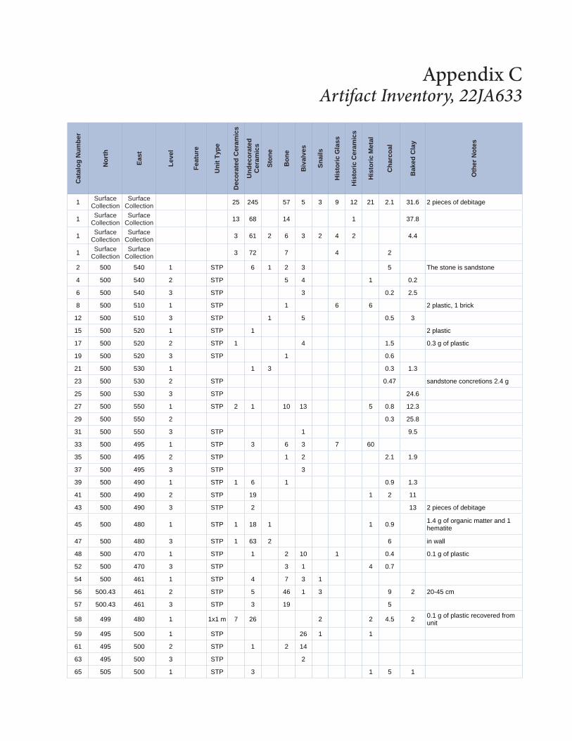
1 Surface Collection
Surface Collection 25 245 57 5 3 9 12 21 2.1 31.6 2 pieces of debitage
1 Surface Collection
Surface Collection 13 68 14 1 37.8
1 Surface Collection
Surface Collection 3 61 2 6 3 2 4 2 4.4
1 Surface Collection
Surface Collection 3 72 7 4 2
2 500 540 1 STP 6 1 2 3 5 The stone is sandstone
4 500 540 2 STP 5 4 1 0.2
6 500 540 3 STP 3 0.2 2.5
8 500 510 1 STP 1 6 6 2 plastic, 1 brick
12 500 510 3 STP 1 5 0.5 3
15 500 520 1 STP 1 2 plastic
17 500 520 2 STP 1 4 1.5 0.3 g of plastic
19 500 520 3 STP 1 0.6
21 500 530 1 1 3 0.3 1.3
23 500 530 2 STP 0.47 sandstone concretions 2.4 g
25 500 530 3 STP 24.6
27 500 550 1 STP 2 1 10 13 5 0.8 12.3
29 500 550 2 0.3 25.8
31 500 550 3 STP 1 9.5
33 500 495 1 STP 3 6 3 7 60
35 500 495 2 STP 1 2 2.1 1.9
37 500 495 3 STP 3
39 500 490 1 STP 1 6 1 0.9 1.3
41 500 490 2 STP 19 1 2 11
43 500 490 3 STP 2 13 2 pieces of debitage
45 500 480 1 STP 1 18 1 1 0.9 1.4 g of organic matter and 1 hematite
47 500 480 3 STP 1 63 2 6 in wall
48 500 470 1 STP 1 2 10 1 0.4 0.1 g of plastic
52 500 470 3 STP 3 1 4 0.7
54 500 461 1 STP 4 7 3 1
56 500.43 461 2 STP 5 46 1 3 9 2 20-45 cm
57 500.43 461 3 STP 3 19 5
58 499 480 1 1x1 m 7 26 2 2 4.5 2 0.1 g of plastic recovered from unit
59 495 500 1 STP 26 1 1
61 495 500 2 STP 1 2 14
63 495 500 3 STP 2
65 505 500 1 STP 3 1 5 1
Appendix C Artifact Inventory, 22JA633
Cat
alog
Num
ber
Nor
th
Eas
t
Leve
l
Feat
ure
Uni
t Typ
e
Dec
orat
ed C
eram
ics
Und
ecor
ated
C
eram
ics
Sto
ne
Bon
e
Biv
alve
s
Sna
ils
His
tori
c G
lass
His
tori
c C
eram
ics
His
tori
c M
etal
Cha
rcoa
l
Bak
ed C
lay
Oth
er N
otes

126 Shell Middens in the Grand Bay Estuary
67 505 500 2 STP 5 1 concretion
69 505 500 3 STP 1
71 510 500 1 STP 1
73 510 500 2 STP 8 g of concretions
75 510 500 3 STP 1 13 g of concretions
78 520 550 2 STP 7 4 g of concertions
80 520 550 3 STP 2
82 528 500 1 STP 5 14
84 528 500 2 STP 7 1
86 528 500 3 STP 2 19
88 528 500 4 Auger Test 5 Went to auger at 40 cm
90 500 550 1 STP 1 1 1 3 1 stone tool, 2 brick,
92 500 560 2 STP 5 6 1 1 1 1 1 piece of brick
94 500 560 3 STP 2
96 490 550 1 STP 1 11
98 490 550 2 STP 13 5 4 2 2 1 3 3
100 510 550 1 STP 2 1 g of botanical, 3 g plastic
102 510 550 2 STP 4 g of concretions
106 495 550 1 STP 1 2 4 1 plastic button
108 495 550 2 STP 1 3 4 4
110 495 550 3 STP 23 13 5 2 3 2 1 piece of debitage
110 510 550 3 STP 3 g of concretions
111 499 480 3 1x1m 5 2 72 4 1.5 52 1 piece of debitage, 1 seed, C14 sample, the bivalves are oyster
115 492 550 1 1x1m 33 24 1 22 9 19 1 17 g of brick, 1 g of mortar, 11.14 g of silica
115 492 550 1 1x1m 23 48 175 7 5 14.28 15.4 1 g of hematite, 1 brick
118 492 550 2 1x1m 3 28 22 1 3.22 7 g of brick
121 492 550 3 1x1m 25 15 3 129 12.5 2.2 4 teeth were recovered from unit, C14 sample
124 499 480 STP 18 From wall
125 500 557 1 1x1m 7 6 43 1 2.02 1.98 5 g of botanical, 10 g of silica
126 500 557 2 1x1m 3 20 52 4 5 3 4.9 10
128 500 557 3 1x1m 17 43 659 3 2 9 23.32 44.1 3 g of pebbles, 3 g of botanical, 1 g of red ochre, 2 g of hematite
130 492 550 4 1x1m 31 107 1 384 14 14 20.85 39.95 1 g of red ochre, 2 g of silica, 3 g of “possible” hematite
132 492 550 6 1x1m 3 1 22 15 4 40-60 cm of depth
133 492 550 5 1 26
Cat
alog
Num
ber
Nor
th
Eas
t
Leve
l
Feat
ure
Uni
t Typ
e
Dec
orat
ed C
eram
ics
Und
ecor
ated
C
eram
ics
Sto
ne
Bon
e
Biv
alve
s
Sna
ils
His
tori
c G
lass
His
tori
c C
eram
ics
His
tori
c M
etal
Cha
rcoa
l
Bak
ed C
lay
Oth
er N
otes

Archaeological Report No. 37 127
136 492 550 wall collapse
wall col-
lapse1x1m 39 0.54 17
137 493 610 1 STP 8 0.1
139 493 610 2 STP 1 3 3 0.7
140 493 610 3 STP 0.14 4.9
141 493 600 1 STP 1 11 2 1 5 0.2 10
143 493 600 2 STP 1 18 1 1 8
144 493 600 3 STP 2 6 1 3 1
145 493 570 1 STP 3 4 3 9 7 12 g brick
147 493 570 2 STP 1 9 1 10 4
148 493 570 3 STP 1 8
149 493 580 1 STP 4 1 200.66
150 493 580 2 STP 1 78.2 g of brick
151 493 580 3 STP 3 45 7 0.6 6.3 2.5 g of concretions
154 493 580 1 STP 29 2 3 2 4.4 179.8 g of brick; Level 1 0-60
155 493 560 1 STP 2 2 2 12 4 6 brick
156 493 560 2 STP 7 35 1 3 1 14 9
157 493 560 3 STP 12 3
158 493 577 Auger Test 8 4 2 2 20
159 491 563 1 1x1m 1 6 6 51 14 3 2.5 9.6
160 491 563 2 1x1m 1 3 72 1 162 30 2.2 Barnacles, 1 g of red ocher
163 491 550 1 1x1m 13 1 42 6 21 8 7 6 5 brick, 23 sandstone
164 491 563 3 1x1m 7 101 1 38 1.9 5.3
164 491 563 3 1x1m 4 20 264 7 64 101.1 1.3 5.8 g of hornet nest
165 491 563 4Bilge Pump Hole
1 3 25 3 165 4.2
174 491 563 5 Bilge Pump 1x1m 10 8 1 8.7 4
175 491 563 4 1x1m 1 8 58 7 50 35.7 27.9
175 491 563 4 1x1m 10 1 35.7
176 491 563 5 1x1m 15 15 2 3 3.23 9 2 red ochre
177 491 563 6 1x1m 6 1 1.7 51-59 cm
184 491 550 2 1x1m 4 29 2 230 5 57 1 13 8.1
185 491 563 6 1x1m 13 1 24 1 3.7 1.5
186 491 563 Profile 1x1m 4 2 2 2
187 491 563Bilge Pump Hole
3 1 0.12 60-70 cm
192 491 550 3 1x1m 7 76 1 305 14 44 22 132.05
193 491 550 2 1x1m 1 C14 charcoal sample
197 491 550 1 Sherd found in profile wall
198 491 550 5 1 1x1m 14 16.8 9 42 cm of depth
205 491 550 Surface 2 Found on the surface near the unit
Cat
alog
Num
ber
Nor
th
Eas
t
Leve
l
Feat
ure
Uni
t Typ
e
Dec
orat
ed C
eram
ics
Und
ecor
ated
C
eram
ics
Sto
ne
Bon
e
Biv
alve
s
Sna
ils
His
tori
c G
lass
His
tori
c C
eram
ics
His
tori
c M
etal
Cha
rcoa
l
Bak
ed C
lay
Oth
er N
otes

128 Shell Middens in the Grand Bay Estuary
206 501 469 1 1x1m 13 17 2 5 13 28 g of plastic, 3 g of concre-tions, 4 g of botanical
208 501 469 2 1x1m 5 18 62 6 12 25 9
211 491 550 4 11 18 32 6 7 20.4 191.8
211 491 550
Area Around Feature
1
1 1x1m 5 1 37 6 1 3.42 55.73 Area around feature
214 491 550 3 1 1x1m 4 38 6 16 2.76 355.86 Level is between 30-43 cm
215 501 469 3 1x1m 1 6 182 1 23 12.6 3.2
217 501 469 4 1x1m 106 3 5 20.3 9.52
219 491 550 5 1x1m 2 8 3 1 6 2 1 g of red ochre, 1 g of hematite
221 491 550 5 1x1m 3 1 2 5
223 491 549 Auger Test 11 3 0-40 cm
224 491 549.75 Auger Test 1 15 2 1 4 5 0-30 cm
225 491 549.5 Auger Test 2 11 g of botanical, 0-40 cm
231 491 551.5 STP 3 1 17 0-40 cm depth
232 490.5 550 STP 3 11 9 0-40 cm depth
234 491 550 5 1x1m 1 43 cm
235 490 550 Auger Test 5 5 1 0-40 cm
236 489.5 550 Auger Test 3 1 18 0-46 cm
237 489.5 551 Auger Test 15 4 2 8 1 I piece of debitage, 0-46 cm
238 489 550 Auger Test 2 0-50 cm, 1 brick, 1 g botanical
239 501 469 5 1x1m 1 4 64 5 7 26.2 76.78 2 stone tools recovered
241 501 469 6 1x1m 9 30 1 5 10.04 24 1 piece of debitage
244 501 469 4 Root Hole 1 3 18 1 5 138.1 1
247 493 579 Auger Test 1 16 1 3 454.6 91.3 g of brick; 11.3 g of white
baked clay
202 491 550 5 1 1x1m 1 2 0.1
202 is the residue from an 1/8-in screen, the recorded depth on the bag is 46 cm, bag labeled C#3
114 499 480 5 1x1m 1 9 1.8 3.4
200 491 550 6 1 1x1m 2 0.2 the depth is 51cm, the bag is labeled C#2 1/8in screen
Cat
alog
Num
ber
Nor
th
Eas
t
Leve
l
Feat
ure
Uni
t Typ
e
Dec
orat
ed C
eram
ics
Und
ecor
ated
C
eram
ics
Sto
ne
Bon
e
Biv
alve
s
Sna
ils
His
tori
c G
lass
His
tori
c C
eram
ics
His
tori
c M
etal
Cha
rcoa
l
Bak
ed C
lay
Oth
er N
otes
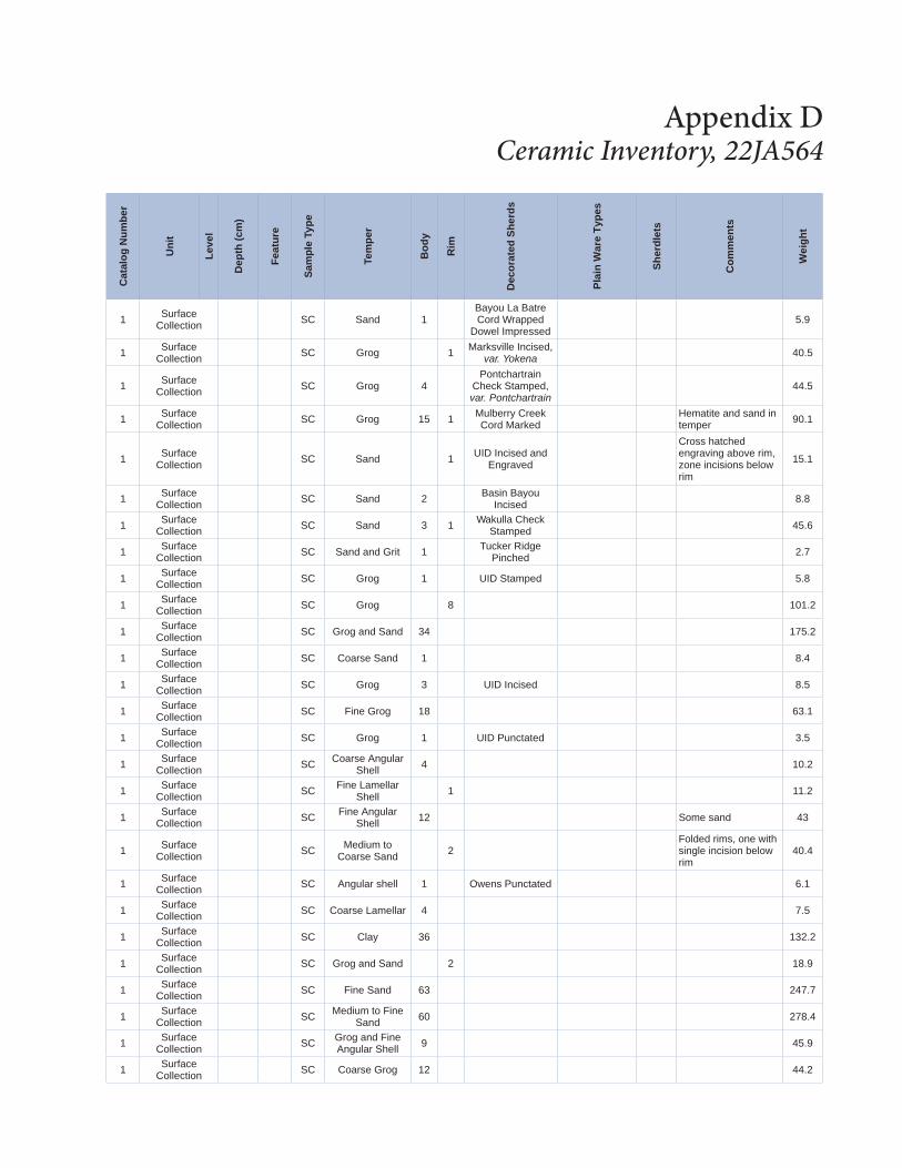
Appendix D Ceramic Inventory, 22JA564
Cat
alog
Num
ber
Uni
t
Leve
l
Dep
th (c
m)
Feat
ure
Sam
ple
Type
Tem
per
Bod
y
Rim
Dec
orat
ed S
herd
s
Pla
in W
are
Type
s
She
rdle
ts
Com
men
ts
Wei
ght
1 Surface Collection SC Sand 1
Bayou La Batre Cord Wrapped
Dowel Impressed5.9
1 Surface Collection SC Grog 1 Marksville Incised,
var. Yokena 40.5
1 Surface Collection SC Grog 4
Pontchartrain Check Stamped, var. Pontchartrain
44.5
1 Surface Collection SC Grog 15 1 Mulberry Creek
Cord MarkedHematite and sand in temper 90.1
1 Surface Collection SC Sand 1 UID Incised and
Engraved
Cross hatched engraving above rim, zone incisions below rim
15.1
1 Surface Collection SC Sand 2 Basin Bayou
Incised 8.8
1 Surface Collection SC Sand 3 1 Wakulla Check
Stamped 45.6
1 Surface Collection SC Sand and Grit 1 Tucker Ridge
Pinched 2.7
1 Surface Collection SC Grog 1 UID Stamped 5.8
1 Surface Collection SC Grog 8 101.2
1 Surface Collection SC Grog and Sand 34 175.2
1 Surface Collection SC Coarse Sand 1 8.4
1 Surface Collection SC Grog 3 UID Incised 8.5
1 Surface Collection SC Fine Grog 18 63.1
1 Surface Collection SC Grog 1 UID Punctated 3.5
1 Surface Collection SC Coarse Angular
Shell 4 10.2
1 Surface Collection SC Fine Lamellar
Shell 1 11.2
1 Surface Collection SC Fine Angular
Shell 12 Some sand 43
1 Surface Collection SC Medium to
Coarse Sand 2Folded rims, one with single incision below rim
40.4
1 Surface Collection SC Angular shell 1 Owens Punctated 6.1
1 Surface Collection SC Coarse Lamellar 4 7.5
1 Surface Collection SC Clay 36 132.2
1 Surface Collection SC Grog and Sand 2 18.9
1 Surface Collection SC Fine Sand 63 247.7
1 Surface Collection SC Medium to Fine
Sand 60 278.4
1 Surface Collection SC Grog and Fine
Angular Shell 9 45.9
1 Surface Collection SC Coarse Grog 12 44.2
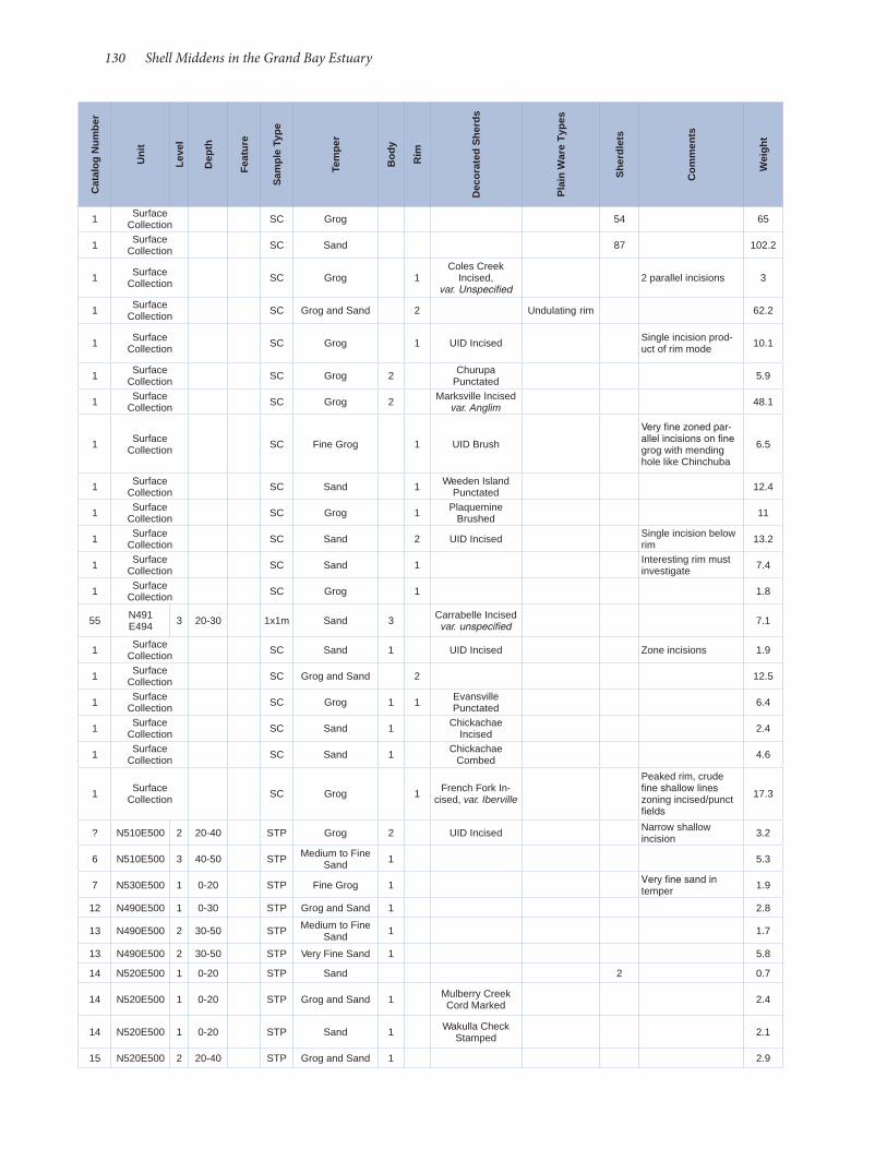
130 Shell Middens in the Grand Bay Estuary
1 Surface Collection SC Grog 54 65
1 Surface Collection SC Sand 87 102.2
1 Surface Collection SC Grog 1
Coles Creek Incised,
var. Unspecified2 parallel incisions 3
1 Surface Collection SC Grog and Sand 2 Undulating rim 62.2
1 Surface Collection SC Grog 1 UID Incised Single incision prod-
uct of rim mode 10.1
1 Surface Collection SC Grog 2 Churupa
Punctated 5.9
1 Surface Collection SC Grog 2 Marksville Incised
var. Anglim 48.1
1 Surface Collection SC Fine Grog 1 UID Brush
Very fine zoned par-allel incisions on fine grog with mending hole like Chinchuba
6.5
1 Surface Collection SC Sand 1 Weeden Island
Punctated 12.4
1 Surface Collection SC Grog 1 Plaquemine
Brushed 11
1 Surface Collection SC Sand 2 UID Incised Single incision below
rim 13.2
1 Surface Collection SC Sand 1 Interesting rim must
investigate 7.4
1 Surface Collection SC Grog 1 1.8
55 N491 E494 3 20-30 1x1m Sand 3 Carrabelle Incised
var. unspecified 7.1
1 Surface Collection SC Sand 1 UID Incised Zone incisions 1.9
1 Surface Collection SC Grog and Sand 2 12.5
1 Surface Collection SC Grog 1 1 Evansville
Punctated 6.4
1 Surface Collection SC Sand 1 Chickachae
Incised 2.4
1 Surface Collection SC Sand 1 Chickachae
Combed 4.6
1 Surface Collection SC Grog 1 French Fork In-
cised, var. Iberville
Peaked rim, crude fine shallow lines zoning incised/punct fields
17.3
? N510E500 2 20-40 STP Grog 2 UID Incised Narrow shallow incision 3.2
6 N510E500 3 40-50 STP Medium to Fine Sand 1 5.3
7 N530E500 1 0-20 STP Fine Grog 1 Very fine sand in temper 1.9
12 N490E500 1 0-30 STP Grog and Sand 1 2.8
13 N490E500 2 30-50 STP Medium to Fine Sand 1 1.7
13 N490E500 2 30-50 STP Very Fine Sand 1 5.8
14 N520E500 1 0-20 STP Sand 2 0.7
14 N520E500 1 0-20 STP Grog and Sand 1 Mulberry Creek Cord Marked 2.4
14 N520E500 1 0-20 STP Sand 1 Wakulla Check Stamped 2.1
15 N520E500 2 20-40 STP Grog and Sand 1 2.9
Cat
alog
Num
ber
Uni
t
Leve
l
Dep
th
Feat
ure
Sam
ple
Type
Tem
per
Bod
y
Rim
Dec
orat
ed S
herd
s
Pla
in W
are
Type
s
She
rdle
ts
Com
men
ts
Wei
ght
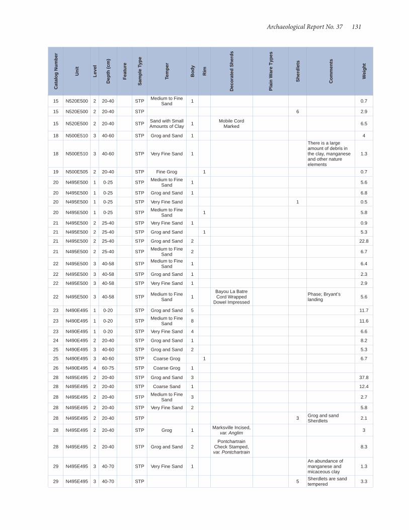
Archaeological Report No. 37 131
15 N520E500 2 20-40 STP Medium to Fine Sand 1 0.7
15 N520E500 2 20-40 STP 6 2.9
15 N520E500 2 20-40 STP Sand with Small Amounts of Clay 1 Mobile Cord
Marked 6.5
18 N500E510 3 40-60 STP Grog and Sand 1 4
18 N500E510 3 40-60 STP Very Fine Sand 1
There is a large amount of debris in the clay, manganese and other nature elements
1.3
19 N500E505 2 20-40 STP Fine Grog 1 0.7
20 N495E500 1 0-25 STP Medium to Fine Sand 1 5.6
20 N495E500 1 0-25 STP Grog and Sand 1 6.8
20 N495E500 1 0-25 STP Very Fine Sand 1 0.5
20 N495E500 1 0-25 STP Medium to Fine Sand 1 5.8
21 N495E500 2 25-40 STP Very Fine Sand 1 0.9
21 N495E500 2 25-40 STP Grog and Sand 1 5.3
21 N495E500 2 25-40 STP Grog and Sand 2 22.8
21 N495E500 2 25-40 STP Medium to Fine Sand 2 6.7
22 N495E500 3 40-58 STP Medium to Fine Sand 1 6.4
22 N495E500 3 40-58 STP Grog and Sand 1 2.3
22 N495E500 3 40-58 STP Very Fine Sand 1 2.9
22 N495E500 3 40-58 STP Medium to Fine Sand 1
Bayou La Batre Cord Wrapped
Dowel Impressed
Phase; Bryant’s landing 5.6
23 N490E495 1 0-20 STP Grog and Sand 5 11.7
23 N490E495 1 0-20 STP Medium to Fine Sand 8 11.6
23 N490E495 1 0-20 STP Very Fine Sand 4 6.6
24 N490E495 2 20-40 STP Grog and Sand 1 8.2
25 N490E495 3 40-60 STP Grog and Sand 2 5.3
25 N490E495 3 40-60 STP Coarse Grog 1 6.7
26 N490E495 4 60-75 STP Coarse Grog 1
28 N495E495 2 20-40 STP Grog and Sand 3 37.8
28 N495E495 2 20-40 STP Coarse Sand 1 12.4
28 N495E495 2 20-40 STP Medium to Fine Sand 3 2.7
28 N495E495 2 20-40 STP Very Fine Sand 2 5.8
28 N495E495 2 20-40 STP 3 Grog and sand Sherdlets 2.1
28 N495E495 2 20-40 STP Grog 1 Marksville Incised, var. Anglim 3
28 N495E495 2 20-40 STP Grog and Sand 2Pontchartrain
Check Stamped, var. Pontchartrain
8.3
29 N495E495 3 40-70 STP Very Fine Sand 1An abundance of manganese and micaceous clay
1.3
29 N495E495 3 40-70 STP 5 Sherdlets are sand tempered 3.3
Cat
alog
Num
ber
Uni
t
Leve
l
Dep
th (c
m)
Feat
ure
Sam
ple
Type
Tem
per
Bod
y
Rim
Dec
orat
ed S
herd
s
Pla
in W
are
Type
s
She
rdle
ts
Com
men
ts
Wei
ght

132 Shell Middens in the Grand Bay Estuary
29 N495E495 3 40-70 STP Medium to Fine Sand 4 27.6
29 N495E495 3 40-70 STP Grog and Sand 1 3.6
29 N495E495 3 40-70 STP Grog 1 Manganese in temper 5.9
30 N500E495 1 0-20 STP Very Fine Sand 1 1.2
31 N500E495 2 20-40 STP Very Fine Sand 1 2.1
31 N500E495 2 20-40 STP Coarse Grog 1Marksville Stamped,
var. Manny3.2
32 N500E495 3 40-60 STP Grog and Sand 2 15.2
33 N505E495 1 0-20 STP 4 2.6
35 N505E495 3 40-60 STP Medium to Fine Sand 1 Manganese in temper 7.4
35 N505E495 3 40-60 STP 2 1.3
35 N505E495 3 40-60 STP Grog and Sand 2 Marksville Incised var. Vick 28.3
36 N510E495 1 0-20 STP Grog and Sand 1 UID incised 2.3
36 N510E495 1 0-20 STP Very Fine Sand 1 UID incised 1.4
37 N510E495 2 20-40 STP Coarse Grog 1 2.2
37 N510E495 2 20-40 STP Grog and Sand 10 23.6
37 N510E495 2 20-40 STP Fine Lamellar Shell 2 5.9
37 N510E495 2 20-40 STP Coarse Sand 2 10.1
37 N510E495 2 20-40 STP Very Fine Sand 1 1.7
37 N510E495 2 20-40 STP Grog and Sand 1 Mulberry Creek-Cord Marked 3
38 N510E495 3 40-60 STP Coarse Grog 1 Folded rim 10.9
38 N510E495 3 40-60 STP Fine Grog 1 3.4
38 N510E495 3 40-60 STP Grog and Sand 14 36.5
38 N510E495 3 40-60 STP Medium to Fine Sand 20 Few sherds have
small grog inclusions 47.4
38 N510E495 3 40-60 STP Grog and Sand 1Evansville Punctat-ed, var. Evansville/
Rhinehart
Appears to be stamped or drag and stamp method
3.3
39 N515E495 1 0-20 STP Grog and Sand 3 8.8
39 N515E495 1 0-20 STP 5 3.9
40 N515E495 2 20-40 STP Medium to Fine Sand 2 5.5
40 N515E495 2 20-40 STP Sand 4 3.5
40 N515E495 2 20-40 STP Grog 1Pontchartrain
Check Stamped, var. Pontchartrain
2.9
40 N515E495 2 20-40 STP Grog 1Mossy Ridge
Incised, var. Mossy Ridge
2
40 N515E495 2 20-40 STP Grog 1 Marksville Incised var. Anglim 4.8
42 N520E495 1 0-20 STP Grog and Sand 2 Actual depth is 0-25 cm 9.9
42 N520E495 1 0-20 STP Medium to Fine Sand 1 Actual depth is 0-25
cm 5.1
42 N520E495 1 0-20 STP Grog and Sand 2Chinchuba Brushed,
var. Chinchuba
0-25 cm, possible Mossy Ridge Incised 9.4
Cat
alog
Num
ber
Uni
t
Leve
l
Dep
th (c
m)
Feat
ure
Sam
ple
Type
Tem
per
Bod
y
Rim
Dec
orat
ed S
herd
s
Pla
in W
are
Type
s
She
rdle
ts
Com
men
ts
Wei
ght
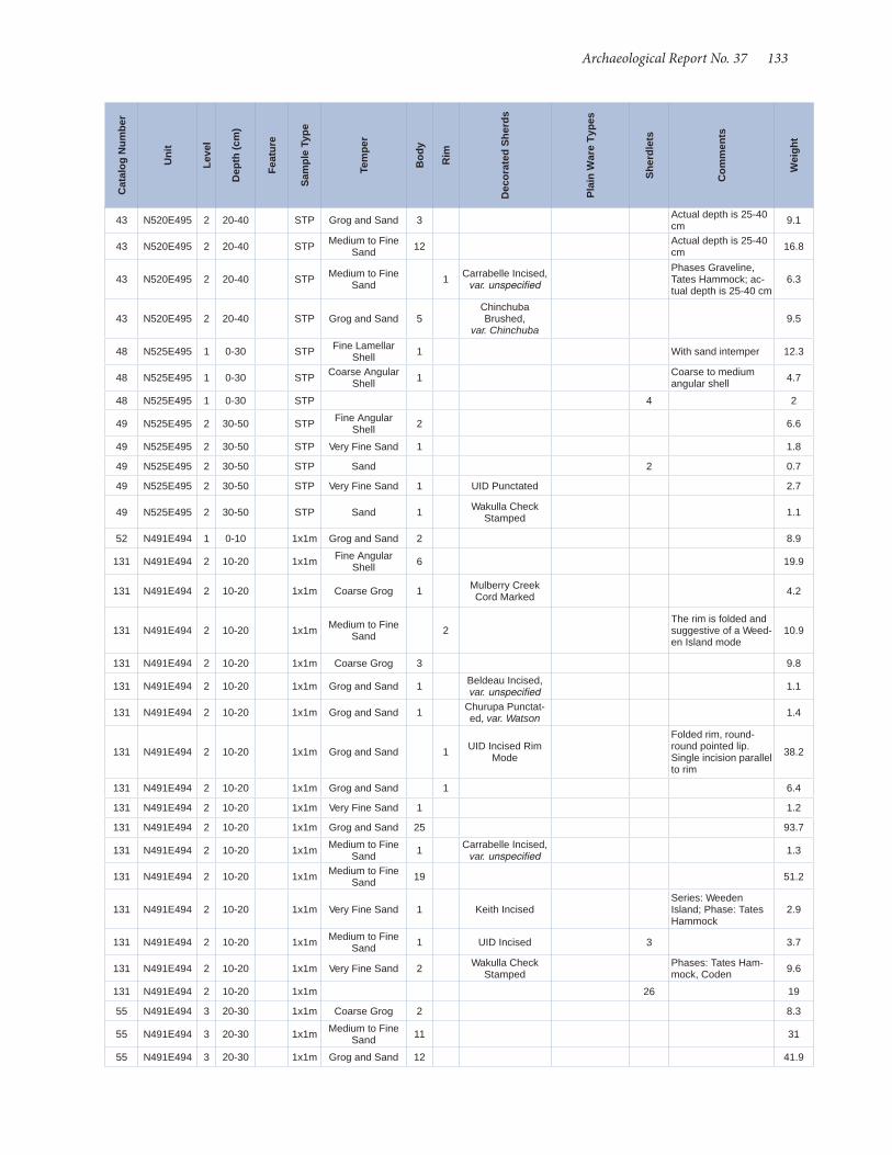
Archaeological Report No. 37 133
43 N520E495 2 20-40 STP Grog and Sand 3 Actual depth is 25-40 cm 9.1
43 N520E495 2 20-40 STP Medium to Fine Sand 12 Actual depth is 25-40
cm 16.8
43 N520E495 2 20-40 STP Medium to Fine Sand 1 Carrabelle Incised,
var. unspecified
Phases Graveline, Tates Hammock; ac-tual depth is 25-40 cm
6.3
43 N520E495 2 20-40 STP Grog and Sand 5Chinchuba Brushed,
var. Chinchuba9.5
48 N525E495 1 0-30 STP Fine Lamellar Shell 1 With sand intemper 12.3
48 N525E495 1 0-30 STP Coarse Angular Shell 1 Coarse to medium
angular shell 4.7
48 N525E495 1 0-30 STP 4 2
49 N525E495 2 30-50 STP Fine Angular Shell 2 6.6
49 N525E495 2 30-50 STP Very Fine Sand 1 1.8
49 N525E495 2 30-50 STP Sand 2 0.7
49 N525E495 2 30-50 STP Very Fine Sand 1 UID Punctated 2.7
49 N525E495 2 30-50 STP Sand 1 Wakulla Check Stamped 1.1
52 N491E494 1 0-10 1x1m Grog and Sand 2 8.9
131 N491E494 2 10-20 1x1m Fine Angular Shell 6 19.9
131 N491E494 2 10-20 1x1m Coarse Grog 1 Mulberry Creek Cord Marked 4.2
131 N491E494 2 10-20 1x1m Medium to Fine Sand 2
The rim is folded and suggestive of a Weed-en Island mode
10.9
131 N491E494 2 10-20 1x1m Coarse Grog 3 9.8
131 N491E494 2 10-20 1x1m Grog and Sand 1 Beldeau Incised, var. unspecified 1.1
131 N491E494 2 10-20 1x1m Grog and Sand 1 Churupa Punctat-ed, var. Watson 1.4
131 N491E494 2 10-20 1x1m Grog and Sand 1 UID Incised Rim Mode
Folded rim, round-round pointed lip. Single incision parallel to rim
38.2
131 N491E494 2 10-20 1x1m Grog and Sand 1 6.4
131 N491E494 2 10-20 1x1m Very Fine Sand 1 1.2
131 N491E494 2 10-20 1x1m Grog and Sand 25 93.7
131 N491E494 2 10-20 1x1m Medium to Fine Sand 1 Carrabelle Incised,
var. unspecified 1.3
131 N491E494 2 10-20 1x1m Medium to Fine Sand 19 51.2
131 N491E494 2 10-20 1x1m Very Fine Sand 1 Keith IncisedSeries: Weeden Island; Phase: Tates Hammock
2.9
131 N491E494 2 10-20 1x1m Medium to Fine Sand 1 UID Incised 3 3.7
131 N491E494 2 10-20 1x1m Very Fine Sand 2 Wakulla Check Stamped
Phases: Tates Ham-mock, Coden 9.6
131 N491E494 2 10-20 1x1m 26 19
55 N491E494 3 20-30 1x1m Coarse Grog 2 8.3
55 N491E494 3 20-30 1x1m Medium to Fine Sand 11 31
55 N491E494 3 20-30 1x1m Grog and Sand 12 41.9
Cat
alog
Num
ber
Uni
t
Leve
l
Dep
th (c
m)
Feat
ure
Sam
ple
Type
Tem
per
Bod
y
Rim
Dec
orat
ed S
herd
s
Pla
in W
are
Type
s
She
rdle
ts
Com
men
ts
Wei
ght
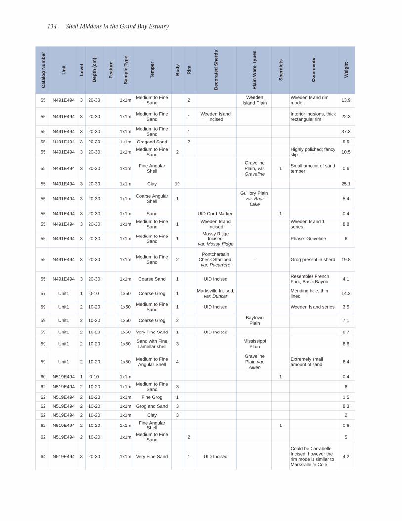
134 Shell Middens in the Grand Bay Estuary
55 N491E494 3 20-30 1x1m Medium to Fine Sand 2 Weeden
Island PlainWeeden Island rim mode 13.9
55 N491E494 3 20-30 1x1m Medium to Fine Sand 1 Weeden Island
IncisedInterior incisions, thick rectangular rim 22.3
55 N491E494 3 20-30 1x1m Medium to Fine Sand 1 37.3
55 N491E494 3 20-30 1x1m Grogand Sand 2 5.5
55 N491E494 3 20-30 1x1m Medium to Fine Sand 2 Highly polished; fancy
slip 10.5
55 N491E494 3 20-30 1x1m Fine Angular Shell
Graveline Plain, var. Graveline
1 Small amount of sand temper 0.6
55 N491E494 3 20-30 1x1m Clay 10 25.1
55 N491E494 3 20-30 1x1m Coarse Angular Shell 1
Guillory Plain, var. Briar
Lake5.4
55 N491E494 3 20-30 1x1m Sand UID Cord Marked 1 0.4
55 N491E494 3 20-30 1x1m Medium to Fine Sand 1 Weeden Island
IncisedWeeden Island 1 series 8.8
55 N491E494 3 20-30 1x1m Medium to Fine Sand 1
Mossy Ridge Incised,
var. Mossy RidgePhase: Graveline 6
55 N491E494 3 20-30 1x1m Medium to Fine Sand 2
Pontchartrain Check Stamped, var. Pacaniere
- Grog present in sherd 19.8
55 N491E494 3 20-30 1x1m Coarse Sand 1 UID Incised Resembles French Fork; Basin Bayou 4.1
57 Unit1 1 0-10 1x50 Coarse Grog 1 Marksville Incised, var. Dunbar
Mending hole, thin lined 14.2
59 Unit1 2 10-20 1x50 Medium to Fine Sand 1 UID Incised Weeden Island series 3.5
59 Unit1 2 10-20 1x50 Coarse Grog 2 Baytown Plain 7.1
59 Unit1 2 10-20 1x50 Very Fine Sand 1 UID Incised 0.7
59 Unit1 2 10-20 1x50 Sand with Fine Lamellar shell 3 Mississippi
Plain 8.6
59 Unit1 2 10-20 1x50 Medium to Fine Angular Shell 4
Graveline Plain var.
Aiken
Extremely small amount of sand 6.4
60 N519E494 1 0-10 1x1m 1 0.4
62 N519E494 2 10-20 1x1m Medium to Fine Sand 3 6
62 N519E494 2 10-20 1x1m Fine Grog 1 1.5
62 N519E494 2 10-20 1x1m Grog and Sand 3 8.3
62 N519E494 2 10-20 1x1m Clay 3 2
62 N519E494 2 10-20 1x1m Fine Angular Shell 1 0.6
62 N519E494 2 10-20 1x1m Medium to Fine Sand 2 5
64 N519E494 3 20-30 1x1m Very Fine Sand 1 UID Incised
Could be Carrabelle Incised, however the rim mode is similar to Marksville or Cole
4.2
Cat
alog
Num
ber
Uni
t
Leve
l
Dep
th (c
m)
Feat
ure
Sam
ple
Type
Tem
per
Bod
y
Rim
Dec
orat
ed S
herd
s
Pla
in W
are
Type
s
She
rdle
ts
Com
men
ts
Wei
ght

Archaeological Report No. 37 135
64 N519E494 3 20-30 1x1m Grog 2 Baytown Plain var. Addis
Folded rim, round lip, single incision beneath rim
30
64 N519E494 3 20-30 1x1m Grog and Sand 1 2.9
64 N519E494 3 20-30 1x1m Fine Grog 3Have some kind of slip or were polished at some point
6.6
64 N519E494 3 20-30 1x1m Medium to Fine Sand 8 13.3
64 N519E494 3 20-30 1x1m Angular Shell And Grog 7 6 angular shell and
1 grog 3
67 Unit 1 1x50 Coarse Grog 2 Baytown Plain 15.2
67 Unit 1 1x50 Coarse Grog 1 Baytown Plain Pecan rim mode 13.9
67 Unit 1 1x50 Medium to Fine Sand 1 Mulberry Creek-
Cord Marked 8.5
67 Unit 1 1x50 Medium to Fine Sand 1
Basin Bayou Incised, var. Ford (Late thin-lined
variety)
16
67 Unit 1 1x50 Grog and SandMarksville Stamped,
var. Cummins1 2.5
67 Unit 1 1x50 Grog and Sand 1 Alligator Incised, var. Alligator 2
67 Unit 1 1x50 Fine Grog 1 6.4
67 Unit 1 1x50 3 2.5
70 N519E494 30-46Bilge pump hole
1x1m Fine Grog 1 Baytown Plain var. Addis 1.4
70 N519E494 30-46Bilge pump hole
1x1m Lamellar Shell 1 0.3
71 N519E494 4 30-40 1x1m Sand 1 Keith Incised 1.9
71 N519E494 4 30-40 1x1m Medium to Fine Sand 4 9
71 N519E494 4 30-40 1x1m Grog and Sand 7 Sand is mostly in the paste 38.4
71 N519E494 4 30-40 1x1m Fine Grog 1 8.8
71 N519E494 4 30-40 1x1m Grog and Sand 2 Sand is mostly in the paste 18.3
71 N519E494 4 30-40 1x1m Coarse Grog 1 Baytown Plain var. Reed 13.6
71 N519E494 4 30-40 1x1m 13 Sherdlets 7.7
71 N519E494 4 30-40 1x1m Fine Grog 3 28.6
71 N519E494 4 30-40 1x1m Clay 2 17.3
74 N519E494 5 40-42 1x1m Fine Grog 1 UID Incised 1.3
74 N519E494 5 40-42 1x1m Grog 4
Baytown Plain var. Satarti, Deasonville
Phase
31.9
74 N519E494 5 40-42 1x1m Fine Grog 7 Baytown Plain var. Addis 18.4
74 N519E494 5 40-42 1x1m Medium to Fine Sand 15 19.9
Cat
alog
Num
ber
Uni
t
Leve
l
Dep
th (c
m)
Feat
ure
Sam
ple
Type
Tem
per
Bod
y
Rim
Dec
orat
ed S
herd
s
Pla
in W
are
Type
s
She
rdle
ts
Com
men
ts
Wei
ght
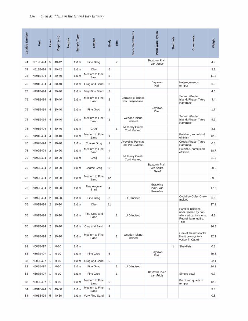
136 Shell Middens in the Grand Bay Estuary
74 N519E494 5 40-42 1x1m Fine Grog 2 Baytown Plain var. Addis 4.9
74 N519E494 5 40-42 1x1m Clay 6 3.2
75 N491E494 4 30-40 1x1m Medium to Fine Sand 5 11.8
75 N491E494 4 30-40 1x1m Grog and Sand 3 Baytown Plain
Heterogeneous temper 6.9
75 N491E494 4 30-40 1x1m Very Fine Sand 2 4.5
75 N491E494 4 30-40 1x1m Medium to Fine Sand 2 Carrabelle Incised
var. unspecified
Series: Weeden Island; Phase: Tates Hammock
3.4
75 N491E494 4 30-40 1x1m Fine Grog 1 Baytown Plain 1.7
75 N491E494 4 30-40 1x1m Medium to Fine Sand 1 Weeden Island
Incised
Series: Weeden Island; Phase: Tates Hammock
5.3
75 N491E494 4 30-40 1x1m Grog 1 Mulberry Creek Cord Marked 8.1
75 N491E494 4 30-40 1x1m Medium to Fine Sand 1 Polished, some kind
of finish 12.3
76 N492E494 2 10-20 1x1m Coarse Grog 1 Avoyelles Punctat-ed, var. Dupree
Creek; Phase: Tates Hammock 6.3
76 N492E494 2 10-20 1x1m Medium to Fine Sand 4 Polished, some kind
of finish 18.7
76 N492E494 2 10-20 1x1m Grog 3 Mulberry Creek Cord Marked 31.5
76 N492E494 2 10-20 1x1m Coarse Grog 6Baytown Plain
var. Addis, Reed
30.9
76 N492E494 2 10-20 1x1m Medium to Fine Sand 12 39.8
76 N492E494 2 10-20 1x1m Fine Angular Shell 4
Graveline Plain, var. Graveline
17.6
76 N492E494 2 10-20 1x1m Fine Grog 2 UID Incised Could be Coles Creek Incised 6.6
76 N492E494 2 10-20 1x1m Clay 11 37.1
76 N492E494 2 10-20 1x1m Fine Grog and Sand 1 UID Incised
Parallel incisions underscored by par-allel vertical incisions, Round-flattened lip. Thin
4.3
76 N492E494 2 10-20 1x1m Clay and Sand 4 14.9
76 N492E494 2 10-20 1x1m Medium to Fine Sand 2 Weeden Island
Incised
One of the rims looks like it belongs to a vessel in Cat 96
12.1
83 N503E497 1 0-10 1x1m 1 Sherdlets 0.3
83 N503E497 1 0-10 1x1m Fine Grog 6 Baytown Plain 39.6
83 N503E497 1 0-10 1x1m Grog and Sand 5 22.1
83 N503E497 1 0-10 1x1m Fine Grog 1 UID Incised 24.1
83 N503E497 1 0-10 1x1m Fine Grog 1 Baytown Plain var. Addis Simple bowl 9.7
83 N503E497 1 0-10 1x1m Medium to Fine Sand 6 Fractured quartz in
temper 12.5
84 N491E494 5 40-50 1x1m Medium to Fine Sand 2 3.4
84 N491E494 5 40-50 1x1m Very Fine Sand 1 0.8
Cat
alog
Num
ber
Uni
t
Leve
l
Dep
th (c
m)
Feat
ure
Sam
ple
Type
Tem
per
Bod
y
Rim
Dec
orat
ed S
herd
s
Pla
in W
are
Type
s
She
rdle
ts
Com
men
ts
Wei
ght

Archaeological Report No. 37 137
84 N491E494 5 40-50 1x1m Medium to Fine Sand 6 Carrabelle Incised
var. unspecified
Broad incisions for Carrabelle Incised maybe Basin Bayou Incised
22
84 N491E494 5 40-50 1x1m Medium to Fine Sand 1 9.1
84 N491E494 5 40-50 1x1m Clay 1 2.8
84 N491E494 5 40-50 1x1m Medium to Fine Sand 8 18.1
84 N491E494 5 40-50 1x1m Coarse Grog 1Mossy Ridge
Incised, var. Mossy Ridge
4.6
85 N491E494 6 50-60 1x1m Medium to Fine Sand 1 2.7
85 N491E494 6 50-60 1x1m Clay 1 2.8
85 N491E494 6 50-60 1x1m Coarse Grog 2 Baytown Plain 15.2
86 N491E494 7 60-70 1x1m Clay 5 23.6
86 N491E494 7 60-70 1x1m Medium to Fine Sand 2
Cat number 119 is from Unit N491E494, 119 is from wall cave-in July 27 and 28
4.6
86 N491E494 7 60-70 1x1m Coarse Grog 1
With slip, some kind of finish applied to ceramic, July 27 and 28
5.6
86 N491E494 7 60-70 1x1m Fine Grog 1 UID Incised 9.9
86 N491E494 7 60-70 1x1m Fine Grog 1 1.3
89 N492E494 3 20-30 1x1m Clay 9 102.3
89 N492E494 3 20-30 1x1m Grog 2 UID Incised 3.7
89 N492E494 3 20-30 1x1m Sand UID Incised 1 0.7
89 N492E494 3 20-30 1x1m 18 Sherdlets 12.7
89 N492E494 3 20-30 1x1m Fine Grog Baytown Plain 2 One of the sherds
appears painted 2
89 N492E494 3 20-30 1x1m Medium to Fine Sand 5 12.8
89 N492E494 3 20-30 1x1m Coarse Grog 6 21.4
90 N503E497 2 10-20 1x1m Medium Sand 3 1 Carrabelle Incised var. unspecified
Quartz in temper, restricted bowl Willey page 422-424
94.4
90 N503E497 2 10-20 1x1m Very Fine Sand 2 Carrabelle Incised var. unspecified
Phases: Tates Ham-mock, Graveline 3.6
90 N503E497 2 10-20 1x1m 26 Sherdlets 20.2
90 N503E497 2 10-20 1x1m Coarse Grog 1 Coles Creek In-cised, var. Pecan Pecan rim mode 27.5
90 N503E497 2 10-20 1x1m Fine Grog 5 Baytown Plain var. Addis 12.6
90 N503E497 2 10-20 1x1m Fine Grog 1 UID Incised Maybe Coles Creek Incised 1.3
90 N503E497 2 10-20 1x1m Coarse Sand 3 Baytown Plain 8.7
90 N503E497 2 10-20 1x1m Fine Grog 1 UID Incised 4.7
90 N503E497 2 10-20 1x1m Very Fine Sand 10 46.7
90 N503E497 2 10-20 1x1m Medium to Fine Sand 8
Largest sherd has black residue on the interior wall
48.6
Cat
alog
Num
ber
Uni
t
Leve
l
Dep
th (c
m)
Feat
ure
Sam
ple
Type
Tem
per
Bod
y
Rim
Dec
orat
ed S
herd
s
Pla
in W
are
Type
s
She
rdle
ts
Com
men
ts
Wei
ght

138 Shell Middens in the Grand Bay Estuary
90 N503E497 2 10-20 1x1m Fine Grog 1Pontchartrain
Check Stamped, var. Pontchartrain
1.4
90 N503E497 2 10-20 1x1m Coarse Grog 3 Baytown Plain 12.7
90 N503E497 2 10-20 1x1m Coarse Grog 1 Marksville Incised var. Leist/Vick
(3 combine to 1, 4th to Pass
Incised)13.9
90 N503E497 2 10-20 1x1m Sand 1 Indian Pass Incised
90 N503E497 2 10-20 1x1m Grog and Sand 2 7.1
90 N503E497 2 10-20 1x1m Clay 1 4
91 N503E497 3 20-30 1x1m Very Fine Sand 1 UID Incised 0.6
91 N503E497 3 20-30 1x1m Grog and Sand 4 8.6
91 N503E497 3 20-30 1x1m 4 Sherdlets 2.3
91 N503E497 3 20-30 1x1m Grog 1 Coles Creek In-cised, var. Pecan Pecan rim mode 11.6
91 N503E497 3 20-30 1x1m Coarse Grog 4 Baytown Plain 8.7
91 N503E497 3 20-30 1x1m Fine Grog 1Marksville Stamped,
var. Cummins5.6
91 N503E497 3 20-30 1x1m Fine Grog 1 Marksville Incised var. Liddievillle 3
91 N503E497 3 20-30 1x1m Medium to Fine Sand 9 27
92 N492E494 4 30-40 1x1m Medium to Fine Sand 2 Weeden
Island PlainBelongs to vessel recovered in lv2cat92 10.5
92 N492E494 4 30-40 1x1m Medium to Fine Sand 1 Weeden
Island Plain
Thick slightly incurved rim, lip is round, ves-sel is a globular bowl, incision in interior
34
92 N492E494 4 30-40 1x1m Medium to Coarse Sand 2 Carrabelle Incised
var. unspecified 28.1
92 N492E494 4 30-40 1x1m Very Fine Sand 1 8.4
92 N492E494 4 30-40 1x1m 41 Sherdlets 21.4
92 N492E494 4 30-40 1x1m Grog UID Incised 1 1.2
92 N492E494 4 30-40 1x1m Coarse Grog 1 3.7
92 N492E494 4 30-40 1x1m Coarse Grog 4 10
92 N492E494 4 30-40 1x1m Fine Grog 7 Baytown Plain 40.1
92 N492E494 4 30-40 1x1m Fine Sand UID Incised and Punctated 1
Cross hatched inci-sions with punctation satline intersections
1.4
92 N492E494 4 30-40 1x1m Clay 2There was a shell inclusion in one of the sherds
10.9
92 N492E494 4 30-40 1x1m Sand 1 Weeden Island Incised
This sherd is a part of the Weeden island series, unsure of actual type
4.3
92 N492E494 4 30-40 1x1m Medium to Fine Sand 10 32.7
92 N492E494 4 30-40 1x1m Sand 1Bayou La Batre Cord Wrapped
Dowel Impressed2.5
Cat
alog
Num
ber
Uni
t
Leve
l
Dep
th (c
m)
Feat
ure
Sam
ple
Type
Tem
per
Bod
y
Rim
Dec
orat
ed S
herd
s
Pla
in W
are
Type
s
She
rdle
ts
Com
men
ts
Wei
ght
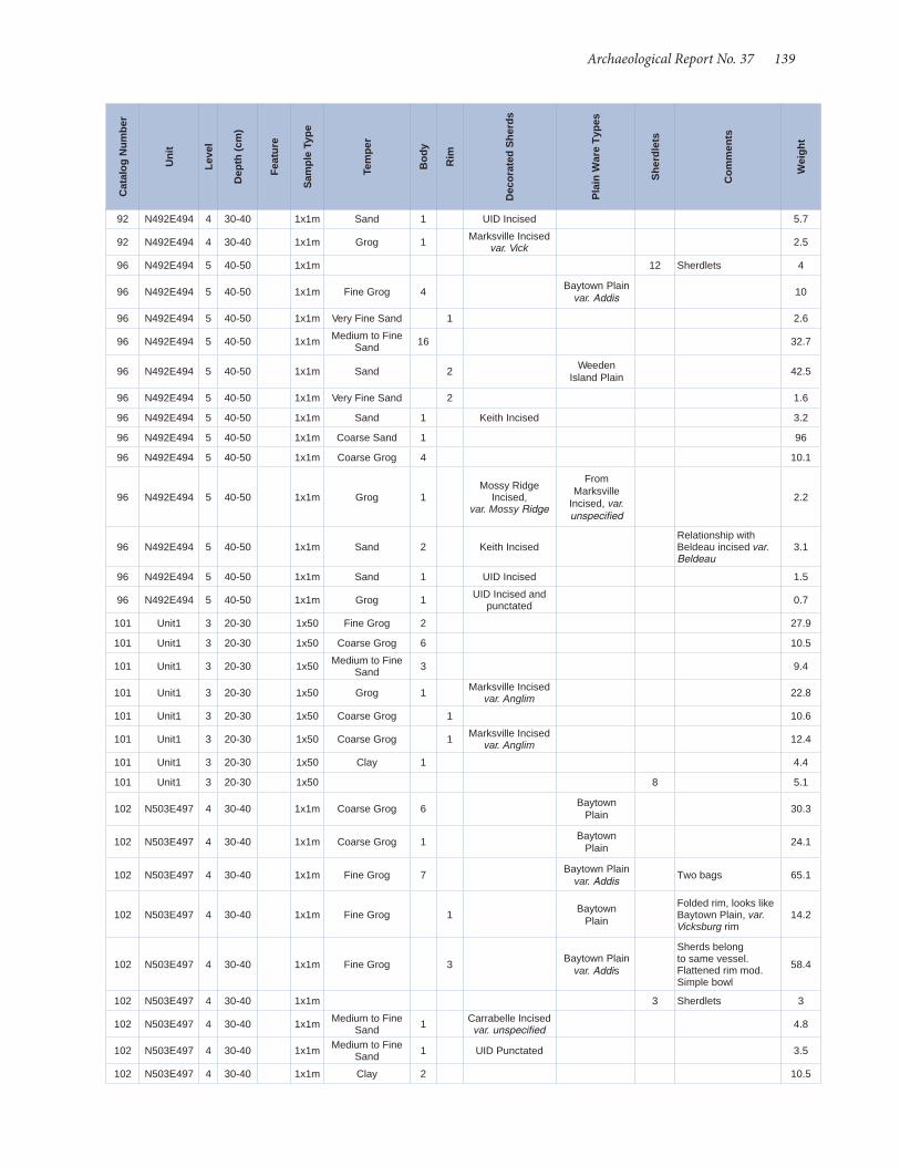
Archaeological Report No. 37 139
92 N492E494 4 30-40 1x1m Sand 1 UID Incised 5.7
92 N492E494 4 30-40 1x1m Grog 1 Marksville Incised var. Vick 2.5
96 N492E494 5 40-50 1x1m 12 Sherdlets 4
96 N492E494 5 40-50 1x1m Fine Grog 4 Baytown Plain var. Addis 10
96 N492E494 5 40-50 1x1m Very Fine Sand 1 2.6
96 N492E494 5 40-50 1x1m Medium to Fine Sand 16 32.7
96 N492E494 5 40-50 1x1m Sand 2 Weeden Island Plain 42.5
96 N492E494 5 40-50 1x1m Very Fine Sand 2 1.6
96 N492E494 5 40-50 1x1m Sand 1 Keith Incised 3.2
96 N492E494 5 40-50 1x1m Coarse Sand 1 96
96 N492E494 5 40-50 1x1m Coarse Grog 4 10.1
96 N492E494 5 40-50 1x1m Grog 1Mossy Ridge
Incised, var. Mossy Ridge
From Marksville
Incised, var. unspecified
2.2
96 N492E494 5 40-50 1x1m Sand 2 Keith IncisedRelationship with Beldeau incised var. Beldeau
3.1
96 N492E494 5 40-50 1x1m Sand 1 UID Incised 1.5
96 N492E494 5 40-50 1x1m Grog 1 UID Incised and punctated 0.7
101 Unit1 3 20-30 1x50 Fine Grog 2 27.9
101 Unit1 3 20-30 1x50 Coarse Grog 6 10.5
101 Unit1 3 20-30 1x50 Medium to Fine Sand 3 9.4
101 Unit1 3 20-30 1x50 Grog 1 Marksville Incised var. Anglim 22.8
101 Unit1 3 20-30 1x50 Coarse Grog 1 10.6
101 Unit1 3 20-30 1x50 Coarse Grog 1 Marksville Incised var. Anglim 12.4
101 Unit1 3 20-30 1x50 Clay 1 4.4
101 Unit1 3 20-30 1x50 8 5.1
102 N503E497 4 30-40 1x1m Coarse Grog 6 Baytown Plain 30.3
102 N503E497 4 30-40 1x1m Coarse Grog 1 Baytown Plain 24.1
102 N503E497 4 30-40 1x1m Fine Grog 7 Baytown Plain var. Addis Two bags 65.1
102 N503E497 4 30-40 1x1m Fine Grog 1 Baytown Plain
Folded rim, looks like Baytown Plain, var. Vicksburg rim
14.2
102 N503E497 4 30-40 1x1m Fine Grog 3 Baytown Plain var. Addis
Sherds belong to same vessel. Flattened rim mod. Simple bowl
58.4
102 N503E497 4 30-40 1x1m 3 Sherdlets 3
102 N503E497 4 30-40 1x1m Medium to Fine Sand 1 Carrabelle Incised
var. unspecified 4.8
102 N503E497 4 30-40 1x1m Medium to Fine Sand 1 UID Punctated 3.5
102 N503E497 4 30-40 1x1m Clay 2 10.5
Cat
alog
Num
ber
Uni
t
Leve
l
Dep
th (c
m)
Feat
ure
Sam
ple
Type
Tem
per
Bod
y
Rim
Dec
orat
ed S
herd
s
Pla
in W
are
Type
s
She
rdle
ts
Com
men
ts
Wei
ght

140 Shell Middens in the Grand Bay Estuary
102 N503E497 4 30-40 1x1m Coarse Grog 2 Marksville Incised var. Anglim 13.4
102 N503E497 4 30-40 1x1m Fine Grog 1 Churupa Punctated var. Thornton 4.3
102 N503E497 4 30-40 1x1m Very Fine Sand 7 17.1
104 N503E497 5 40-50 1x1m Coarse Grog 1 UID Incised Baytown Plain Round flattened lip 5
104 N503E497 5 40-50 1x1m Coarse Grog 1 Marksville Incised var. Anglim 1.2
104 N503E497 5 40-50 1x1m Grog and Sand 1 2.7
104 N503E497 5 40-50 1x1m Coarse Grog 12 25.2
104 N503E497 5 40-50 1x1m Clay 1 1.2
104 N503E497 5 40-50 1x1m Medium to Fine Sand 1 UID Incised 0.9
104 N503E497 5 40-50 1x1m 7 Sherdlets 2.3
107 N503E497 6 50-60 1x1m 2 Sherdlets 0.8
107 N503E497 6 50-60 1x1m Coarse Grog 2 Baytown Plain 4.7
107 N503E497 6 50-60 1x1m Fine Grog 4 Baytown Plain var. Addis.
There is sand present but not enough to qualify the sherd as sand and grog tempered.
15.6
107 N503E497 6 50-60 1x1m Coarse Grog 1Marksville Stamped,
var.Cummins3.5
107 N503E497 6 50-60 1x1m Coarse Grog 1Marksville Stamped,
var. Godsey
Rocker stamping. var. Godsey. Phases: Godsey, Graveline.
8.1
107 N503E497 6 50-60 1x1m Coarse Grog 1 UID Incised 2
109 Unit1 4 30-40 1x50 Grog and Sand 1Marksville Stamped,
var.Cummins4.9
109 Unit1 4 30-40 1x50 Medium to Fine Sand 1
Basin Bayou Incised,
var. Ford (Late thin-lined variety)
23.9
109 Unit1 4 30-40 1x50 Fine Grog 4 Baytown Plain var. Addis 22.2
109 Unit1 4 30-40 1x50 Coarse Grog 8 Baytown Plain 45
109 Unit1 4 30-40 1x50 2 1
109 Unit1 4 30-40 1x50 Medium to Fine Sand 1 0.4
109 Unit1 4 30-40 1x50 Medium to Fine Sand 3 55.1
109 Unit1 4 30-40 1x50 Coarse Grog 2 10.1
109 Unit1 4 30-40 1x50 Grog and Sand 2 4
109 Unit1 4 30-40 1x50 Clay 1 2.5
115 N503E497 7 60-66 1x1m Grog 2 Marksville Incised var. Spanish Fort 12.6
117 N491E494 8 70-75 1x1m Clay 1 Sherdlet 0.9
1 Surface Collection SC Sand and grog 3
Pontchartrain Check Stamped, var. Pacaniere
22.5
1 Surface Collection SC Grog 1 Marksville Incised
var. Spanish Fort 3493.4
Cat
alog
Num
ber
Uni
t
Leve
l
Dep
th (c
m)
Feat
ure
Sam
ple
Type
Tem
per
Bod
y
Rim
Dec
orat
ed S
herd
s
Pla
in W
are
Type
s
She
rdle
ts
Com
men
ts
Wei
ght

Appendix E Ceramic Inventory, 22JA575
Cat
alog
Num
ber
Uni
t
Leve
l
Dep
th
Feat
ure
Sam
ple
Type
Bas
e
Bod
y
Rim
Dec
orat
ed S
herd
s
Pla
in W
are
Type
s
She
rdle
ts
Com
men
ts
Wei
ght
1 Surface Collection
Surface Collection 200 244
1 Surface Collection
Surface Collection
Fine-to-Medium Sand 27 118.9
1 Surface Collection
Surface Collection
Fine-to-Medium Grog 9 Baytown Plain 46.9
1 Surface Collection
Surface Collection
Fine-to-Medium Sand 37 256.9
1 Surface Collection
Surface Collection
Fine-to-Medium Sand 2 15.2
1 Surface Collection
Surface Collection
Fine-to-Medium Sand 1 7.2
1 Surface Collection
Surface Collection
Fine-to-Medium Grog 4 Baytown Plain 28
1 Surface Collection
Surface Collection
Fine-to-Medium Grog 27 Baytown Plain 193
1 Surface Collection
Surface Collection
Fine Angular Shell 5 UID Incised 26.1
1 Surface Collection
Surface Collection
Fine-to-Medium Grog 3 UID Incised 5.7
1 Surface Collection
Surface Collection Coarse Sand 7 52.9
1 Surface Collection
Surface Collection
Fine-to-Medium Grog 1 Baytown Plain 4.8
1 Surface Collection
Surface Collection
Coarse Angular Shell 1
Moundville Incised,
var. Singing River
33.5
1 Surface Collection
Surface Collection
Fine-to-Medium Grog 1 Baytown Plain 13.2
1 Surface Collection
Surface Collection
Fine Angular Shell 1 Graveline Plain,
var. unspecified 10.5
1 Surface Collection
Surface Collection
Fine Angular Shell 2 Graveline Plain,
var. unspecified 45.4
1 Surface Collection
Surface Collection
Fine Angular Shell 21 Graveline Plain,
var. unspecified 100.2
1 Surface Collection
Surface Collection
Fine-to-Medium Grog 28 Baytown Plain 151.2
1 Surface Collection
Surface Collection
Mixed Shell and Grog 2 13.8
1 Surface Collection
Surface Collection
Fine Lamellar Shell 4 16.9
1 Surface Collection
Surface Collection
Coarse Angular Shell 20 Guillory Plain,
var. Guillory 96.6
1 Surface Collection
Surface Collection
Coarse Angular Shell 1 UID Incised 5
1 Surface Collection
Surface Collection
Fine-to-Medium Grog 1 Baytown Plain 2
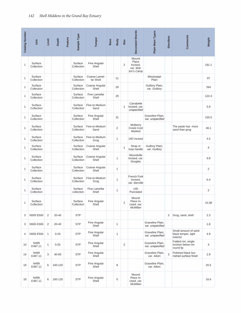
142 Shell Middens in the Grand Bay Estuary
1 Surface Collection
Surface Collection
Fine Angular Shell 2
Mound Place
Incised, var. Wal-
ton’s Camp
181.1
1 Surface Collection
Surface Collection
Coarse Lamel-lar Shell 11 Mississippi
Plain 97
1 Surface Collection
Surface Collection
Coarse Angular Shell 29 Guillory Plain,
var. Guillory 264
1 Surface Collection
Surface Collection
Fine Lamellar Shell 25 122.4
1 Surface Collection
Surface Collection
Fine-to-Medium Sand 1
Carrabelle Incised, var. unspecified
5.9
1 Surface Collection
Surface Collection
Fine Angular Shell 31 Graveline Plain,
var. unspecified 155.5
1 Surface Collection
Surface Collection
Fine-to-Medium Sand 2
Mulberry Creek Cord
Marked
The paste has more sand than grog 46.1
1 Surface Collection
Surface Collection
Fine-to-Medium Grog 1 UID Incised 4.5
1 Surface Collection
Surface Collection
Coarse Angular Shell 1 Strap or
loop handleGuillory Plain, var. Guillory 4
1 Surface Collection
Surface Collection
Coarse Angular Shell 1
Moundville Incised, var.
Douglas9.8
1 Surface Collection
Surface Collection
Coarse Angular Shell 1 2
1 Surface Collection
Surface Collection
Fine-to-Medium Grog 1
French Fork Incised,
var. Iberville 6.4
1 Surface Collection
Surface collection
Fine Lamellar Shell 1 UID
Punctated 2
1 Surface Collection
Surface Collection
Fine Angular Shell 2
Mound Place In-
cised, var. McMillan
10.38
3 N505 E500 2 20-40 STP 3 Grog, sand, shell 2.3
3 N505 E500 2 20-40 STP Fine Angular Shell 1 Graveline Plain,
var. unspecified 1.8
4 N505 E500 1 0-20 STP Fine Angular Shell 1 Graveline Plain,
var. unspecified
Small amount of sand black temper, light exterior
4.9
10 N499 E487.11 1 0-25 STP Fine Angular
Shell 2 Graveline Plain, var. unspecified
Folded rim, single incision below rim round lip
4
14 N499 E487.11 3 40-60 STP Fine Angular
Shell Graveline Plain,
var. Aiken 3 Polished black bur-nished surface finish 2.9
18 N499 E487.11 6 100-120 STP Fine Angular
Shell 8 Graveline Plain, var. Aiken 20.5
18 N499 E487.11 6 100-120 STP Fine Angular
Shell 5
Mound Place In-
cised, var. McMillan
16.6
Cat
alog
Num
ber
Uni
t
Leve
l
Dep
th
Feat
ure
Sam
ple
Type
Tem
per
Bas
e
Bod
y
Rim
Dec
orat
ed S
herd
s
Pla
in W
are
Type
s
She
rdle
ts
Com
men
ts
Wei
ght
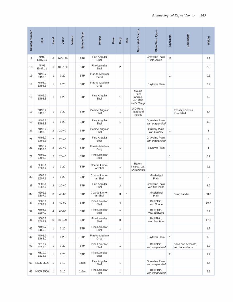
Archaeological Report No. 37 143
18 N499 E487.11 6 100-120 STP Fine Angular
Shell Graveline Plain,
var. Aiken 25 9.8
18 N499 E487.11 6 100-120 STP Fine Lamellar
Shell 2 2.3
19 N496.2 E498.3 1 0-20 STP Fine-to-Medium
Sand 1 0.5
19 N496.2 E498.3 1 0-20 STP Fine-to-Medium
Grog Baytown Plain 0.9
19 N496.2 E498.3 1 0-20 STP Fine Angular
Shell 1
Mound Place
Incised, var. Wal-
ton’s Camp
3.9
19 N496.2 E498.3 1 0-20 STP Coarse Angular
Shell 1UID Punc-tated and Incised
Possibly Owens Punctated 3.4
19 N496.2 E498.3 1 0-20 STP Fine Angular
Shell 1 Graveline Plain, var. unspecified 1.5
21 N496.2 E498.3 2 20-40 STP Coarse Angular
Shell Guillory Plain var. Guillory 1 1
21 N496.2 E498.3 2 20-40 STP Fine Angular
Shell 1 Graveline Plain, var. unspecified 2
21 N496.2 E498.3 2 20-40 STP Fine-to-Medium
Grog 1 Baytown Plain 1
21 N496.2 E498.3 2 20-40 STP Fine Lamellar
Shell 1 0.9
33 N506.1 E507.2 1 0-20 STP Coarse Lamel-
lar Shell 1Barton
Incised, var. unspecified
9.1
33 N506.1 E507.2 1 0-20 STP Coarse Lamel-
lar Shell 1 Mississippi Plain 8
35 N506.1 E507.2 2 20-40 STP Fine Angular
Shell 2 Graveline Plain, var. Graveline 3.9
37 N506.1 E507.2 3 40-60 STP Coarse Lamel-
lar Shell 3 1 Mississippi Plain Strap handle 68.8
37 N506.1 E507.2 3 40-60 STP Fine Lamellar
Shell 4 Bell Plain, var. Conde 10.7
39 N506.1 E507.2 4 60-80 STP Fine Lamellar
Shell 2 Bell Plain, var. boatyard 6.1
41 N506.1 E507.2 5 80-100 STP Fine Lamellar
Shell 8 Bell Plain, var. Stockton 17.2
42 N493.7 E465.9 1 0-20 STP Fine Lamellar
Shell 1 1.7
42 N493.7 E465.9 1 0-20 STP Fine-to-Medium
Grog Baytown Plain 1 0.3
52 N510.2 E513.8 1 0-20 STP Fine Lamellar
Shell 1 Bell Plain, var. unspecified
Sand and hematite, iron concretions 1.9
52 N510.2 E513.8 1 0-20 STP Fine Lamellar
Shell 2 1.4
63 N505 E506 1 0-10 1x1m Fine Angular Shell 1 Graveline Plain,
var. unspecified 3.5
63 N505 E506 1 0-10 1x1m Fine Lamellar Shell 1 Bell Plain,
var. unspecified 5.8
Cat
alog
Num
ber
Uni
t
Leve
l
Dep
th
Feat
ure
Sam
ple
Type
Tem
per
Bas
e
Bod
y
Rim
Dec
orat
ed S
herd
s
Pla
in W
are
Type
s
She
rdle
ts
Com
men
ts
Wei
ght

144 Shell Middens in the Grand Bay Estuary
63 N505 E506 1 0-10 1x1m Fine Angular Shell
UID Punc-tated 1 0.8
63 N505 E506 1 0-10 1x1m Coarse Angular Shell 2 Shell and sand 2.6
65 N505 E506 2 10-20 1x1m Fine Lamellar Shell 2 Bell Plain,
var. Hale 5.5
65 N505 E506 2 10-20 1x1m Shell 3 2.2
65 N505 E506 2 10-20 1x1m Mixed Shell and Grog 2
Mound Place In-
cised, var. McMillan
2.6
65 N505 E506 2 10-20 1x1m Fine Angular Shell 3 Graveline Plain,
var. Graveline 20.8
65 N505 E506 2 10-20 1x1m Fine Lamellar Shell 11 Bell Plain,
var. Stockton 32.3
65 N505 E506 2 10-20 1x1m Fine Lamellar Shell 1 Bell Plain,
var. unspecified 3.2
67 N505 E506 3 20-30 1x1m Fine Angular Shell
Graveline Plain, var. Graveline 9 2.2
73 N495 E478 1 0-10 1x1m Coarse Angular Shell 4 Shell and sand 3.1
73 N495 E478 1 0-10 1x1m Coarse Angular Shell 2 Guillory Plain,
var. Guillory 9.3
73 N495 E478 1 0-10 1x1m Fine-to-Medium Grog 2 Baytown Plain 9.9
74 N495 E478 2 10-20 1x1m Coarse Angular Shell 1 Guillory Plain,
var. Guillory 4.1
74 N495 E478 2 10-20 1x1m Fine Angular Shell 1 Graveline Plain,
var. Aiken 3.1
74 N495 E478 2 10-20 1x1m Coarse Angular Shell 7 6.3
75 N495 E478 3 20-30 1x1m Coarse Sand 1UID
Surface Treatment
15
75 N495 E478 3 20-30 1x1m Fine Angular Shell 1 Graveline Plain,
var. Aiken 2.4
75 N495 E478 3 20-30 1x1m Shell 17 10.3
75 N495 E478 3 20-30 1x1m Fine Angular Shell 1 1 Graveline Plain,
var. Aiken 5.2
75 N495 E478 3 20-30 1x1m Coarse Lamel-lar Shell 1 Mississippi
Plain 3.8
76 N495 E478 4 30-40 1x1m Fine-to-Medium Grog 1 Anna
Incised 2
76 N495 E478 4 30-40 1x1m Fine Angular Shell 2 Graveline Plain,
var. Graveline 3.2
76 N495 E478 4 30-40 1x1m Fine Angular Shell 7 4
76 N495 E478 4 30-40 1x1m Fine-to-Medium Grog 1 Baytown Plain,
var. Addis 1.9
76 N495 E478 4 30-40 1x1m Fine Angular Shell 1 Graveline Plain,
var. Aiken 1.5
Cat
alog
Num
ber
Uni
t
Leve
l
Dep
th
Feat
ure
Sam
ple
Type
Tem
per
Bas
e
Bod
y
Rim
Dec
orat
ed S
herd
s
Pla
in W
are
Type
s
She
rdle
ts
Com
men
ts
Wei
ght

Archaeological Report No. 37 145
76 N495 E478 4 30-40 1x1m Fine-to-Medium Grog 1
Mulberry Creek Cord
MarkedBaytown Plain 6.2
76 N495 E478 4 30-40 1x1m Fine-to-Medium Grog 1
Mulberry Creek Cord
Marked4
77 N505 E506 4 30-40 1x1m Shell 9 4
77 N505 E506 4 30-40 1x1m Fine Lamellar Shell 2 Bell Plain,
var. Hale 4.8
77 N505 E506 4 30-40 1x1m Fine Angular Shell 1 Graveline Plain,
var. Aiken 1.2
77 N505 E506 4 30-40 1x1m Fine Angular Shell 3 Graveline Plain,
var. Aiken 5.6
77 N505 E506 4 30-40 1x1m Fine Angular Shell 4
Mound Place In-
cised, var. McMillan
3.6
80 N495 E478 5+6 40-60 1x1m Fine-to-Medium Grog
Baytown Plain, var. Addis 1 1.5
85 N495 E478 7 60-70 1x1m Fine Angular Shell
Graveline Plain, var. unspecified 1 1.3
85 N495 E478 7 60-70 1x1m Fine-to-Medium Sand 2 Polished finish 6.1
85 N495 E478 7 60-70 1x1m Fine-to-Medium Grog 1 Baytown Plain,
var. Addis Surface treatment 2.2
91 N495 E478 8 70-80 1x1m Fine-to-Medium Sand 1
Wakulla Check
Stamped5.8
91 N495 E478 8 70-80 1x1m Fine-to-Medium Sand 2 1 1 Burnished black, fine
ware 14.4
93 N495 E478 9 80-90 1x1m Fine Angular Shell Graveline Plain,
var. unspecified 2 2.8
93 N495 E478 9 80-90 1x1m Coarse Sand 3 15
93 N495 E478 9 80-90 1x1m Coarse Sand 1 5.5
103 N494.7 E470.7 5 80-100 stp Fine-to-Medium
Sand 1Wakulla Check
Stamped14
104 N505 E506 8 70-80 1x1m Fine Angular Shell 1 Graveline Plain,
var. Aiken 1 2.9
104 N505 E506 8 70-80 1x1m Fine-to-Medium Grog 1 Baytown Plain 1 4.9
104 N505 E506 8 70-80 1x1m Fine-to-Medium Grog 4 Baytown Plain 8.6
104 N505 E506 8 70-80 1x1m Fine-to-Medium Grog 1 Baytown Plain 46.1
Cat
alog
Num
ber
Uni
t
Leve
l
Dep
th
Feat
ure
Sam
ple
Type
Tem
per
Bas
e
Bod
y
Rim
Dec
orat
ed S
herd
s
Pla
in W
are
Type
s
She
rdle
ts
Com
men
ts
Wei
ght

146 Shell Middens in the Grand Bay Estuary
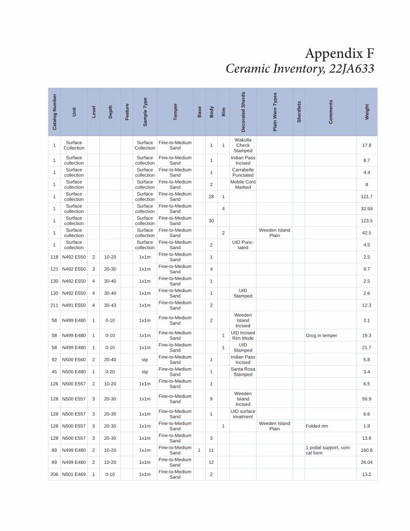
Appendix F Ceramic Inventory, 22JA633
Cat
alog
Num
ber
Uni
t
Leve
l
Dep
th
Feat
ure
Sam
ple
Type
Tem
per
Bas
e
Bod
y
Rim
Dec
orat
ed S
herd
s
Pla
in W
are
Type
s
She
rdle
ts
Com
men
ts
Wei
ght
1 Surface Collection
Surface Collection
Fine-to-Medium Sand 1 1
Wakulla Check
Stamped17.8
1 Surface collection
Surface collection
Fine-to-Medium Sand 1 Indian Pass
Incised 8.7
1 Surface collection
Surface collection
Fine-to-Medium Sand 1 Carrabelle
Punctated 4.4
1 Surface collection
Surface collection
Fine-to-Medium Sand 2 Mobile Cord
Marked 8
1 Surface collection
Surface collection
Fine-to-Medium Sand 28 1 121.7
1 Surface collection
Surface collection
Fine-to-Medium Sand 4 32.59
1 Surface collection
Surface collection
Fine-to-Medium Sand 30 123.5
1 Surface collection
Surface collection
Fine-to-Medium Sand 2 Weeden Island
Plain 42.5
1 Surface collection
Surface collection
Fine-to-Medium Sand 2 UID Punc-
tated 4.5
118 N492 E550 2 10-20 1x1m Fine-to-Medium Sand 1 2.5
121 N492 E550 3 20-30 1x1m Fine-to-Medium Sand 4 9.7
130 N492 E550 4 30-40 1x1m Fine-to-Medium Sand 1 2.5
130 N492 E550 4 30-40 1x1m Fine-to-Medium Sand 1 UID
Stamped 2.6
211 N491 E550 4 30-43 1x1m Fine-to-Medium Sand 2 12.3
58 N499 E480 1 0-10 1x1m Fine-to-Medium Sand 2
Weeden Island Incised
3.1
58 N499 E480 1 0-10 1x1m Fine-to-Medium Sand 1 UID Incised
Rim Mode Grog in temper 19.3
58 N499 E480 1 0-10 1x1m Fine-to-Medium Sand 1 UID
Stamped 21.7
92 N500 E560 2 20-40 stp Fine-to-Medium Sand 1 Indian Pass
Incised 5.8
45 N500 E480 1 0-20 stp Fine-to-Medium Sand 1 Santa Rosa
Stamped 3.4
126 N500 E557 2 10-20 1x1m Fine-to-Medium Sand 1 6.5
128 N500 E557 3 20-30 1x1m Fine-to-Medium Sand 9
Weeden Island Incised
50.9
128 N500 E557 3 20-30 1x1m Fine-to-Medium Sand 1 UID surface
treatment 6.6
128 N500 E557 3 20-30 1x1m Fine-to-Medium Sand 1 Weeden Island
Plain Folded rim 1.9
128 N500 E557 3 20-30 1x1m Fine-to-Medium Sand 3 13.9
89 N499 E480 2 10-20 1x1m Fine-to-Medium Sand 1 11 1 podal support, coni-
cal form 160.8
89 N499 E480 2 10-20 1x1m Fine-to-Medium Sand 12 26.04
206 N501 E469 1 0-10 1x1m Fine-to-Medium Sand 2 13.2
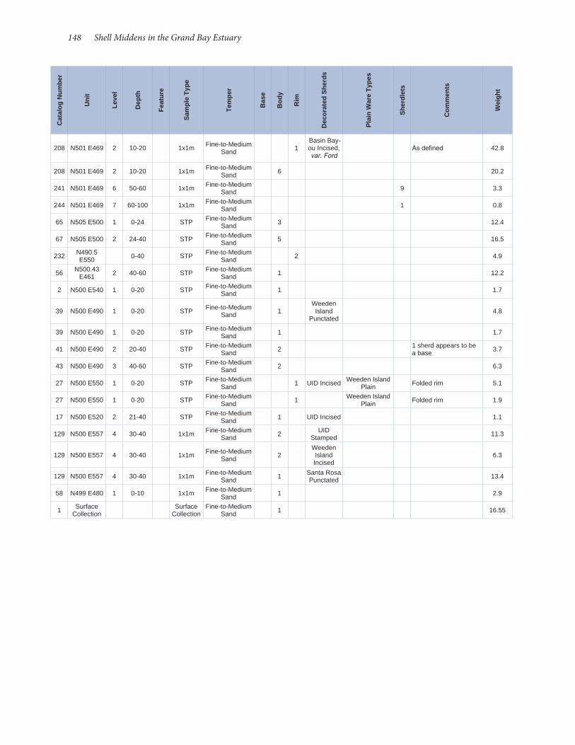
148 Shell Middens in the Grand Bay Estuary
208 N501 E469 2 10-20 1x1m Fine-to-Medium Sand 1
Basin Bay-ou Incised, var. Ford
As defined 42.8
208 N501 E469 2 10-20 1x1m Fine-to-Medium Sand 6 20.2
241 N501 E469 6 50-60 1x1m Fine-to-Medium Sand 9 3.3
244 N501 E469 7 60-100 1x1m Fine-to-Medium Sand 1 0.8
65 N505 E500 1 0-24 STP Fine-to-Medium Sand 3 12.4
67 N505 E500 2 24-40 STP Fine-to-Medium Sand 5 16.5
232 N490.5 E550 0-40 STP Fine-to-Medium
Sand 2 4.9
56 N500.43 E461 2 40-60 STP Fine-to-Medium
Sand 1 12.2
2 N500 E540 1 0-20 STP Fine-to-Medium Sand 1 1.7
39 N500 E490 1 0-20 STP Fine-to-Medium Sand 1
Weeden Island
Punctated4.8
39 N500 E490 1 0-20 STP Fine-to-Medium Sand 1 1.7
41 N500 E490 2 20-40 STP Fine-to-Medium Sand 2 1 sherd appears to be
a base 3.7
43 N500 E490 3 40-60 STP Fine-to-Medium Sand 2 6.3
27 N500 E550 1 0-20 STP Fine-to-Medium Sand 1 UID Incised Weeden Island
Plain Folded rim 5.1
27 N500 E550 1 0-20 STP Fine-to-Medium Sand 1 Weeden Island
Plain Folded rim 1.9
17 N500 E520 2 21-40 STP Fine-to-Medium Sand 1 UID Incised 1.1
129 N500 E557 4 30-40 1x1m Fine-to-Medium Sand 2 UID
Stamped 11.3
129 N500 E557 4 30-40 1x1m Fine-to-Medium Sand 2
Weeden Island Incised
6.3
129 N500 E557 4 30-40 1x1m Fine-to-Medium Sand 1 Santa Rosa
Punctated 13.4
58 N499 E480 1 0-10 1x1m Fine-to-Medium Sand 1 2.9
1 Surface Collection
Surface Collection
Fine-to-Medium Sand 1 16.55
Cat
alog
Num
ber
Uni
t
Leve
l
Dep
th
Feat
ure
Sam
ple
Type
Tem
per
Bas
e
Bod
y
Rim
Dec
orat
ed S
herd
s
Pla
in W
are
Type
s
She
rdle
ts
Com
men
ts
Wei
ght
Adams, William Hampton, editor 1980 "Waverly Plantation: Ethnoarchaeology of a Tenant Farming
Community." Submitted to Heritage Conservation and Recre-ation Service, Contract No. C- 55026(79), US Army Corps of Engineers, Mobile District, Mobile, AL.
Allgood, Jessica2001 The Diamondhead Site (22HA550): Subsistence and Human
Adaptation on the Mississippi Gulf Coast. MA thesis, De-partment of Anthropology and Sociology, The University of Southern Mississippi, Hattiesburg.
Baker, Jonathan D., and Walter E. Klippel2008 Vertebrate Faunal Analysis. In Phase III Archaeology at Plash
Island, Archaeological Site 1BA134, in Baldwin County, Ala-bama, edited by Sarah Price, pp. 243-286. University of South Alabama, Center for Archaeological Studies, Mobile.
Belmont, Johnn.d. Notes on Ceramic Typology. Papers on file at Coastal Envi-
ronments, Inc., Baton Rouge and the Louisiana Regional Ar-chaeological Program.
Belmont, John, and Stephen Williams1981 Painted Pottery Horizons in the Lower Mississippi Valley.
Geoscience and Man 12:19- 21.
Binford, Lewis R. 1978 Nunamiut Archaeology. Academic Press, New York.
Bitgood, Mark J. 1982 The Baytown Period in the Upper Tensas Basin Basin. Lower
Mississippi Survey Bulletin 12. Peabody Museum, Harvard University, Cambridge, MA.
Blitz, John H. 1986 The McRae Mound: A Middle Woodland Site in Southeastern
Mississippi. Mississippi Archaeology 21:11- 39.
Blitz, John H., and C. Baxter Mann 2000 Fisherfolk, Farmers, and Frenchmen: Archaeological Explora-
tions on the Mississippi Gulf Coast. Archaeological Report No. 30. Mississippi Department of Achives and History, Jackson.
Boudreaux, Edmond A. 2009 A Post- Katrina Archaeological Site- Assessment Survey Along
the Mississippi Gulf Coast. Report prepared for Mississippi Department of Archives and History. Coastal Environments, Inc., Baton Rouge, LA.
Brown, Calvin 1926 Archaeology of Mississippi. University, Mississippi.
Brown, Ian W. 1984 Late Prehistory in Coastal Mississippi: The Coles Creek Peri-
od. In Perspectives on Gulf Coast Prehistory, edited by Dave D. Davis, pp. 94- 124. University Press of Florida, Gainesville.
1998 Decorated Pottery of the Lower Mississippi Valley: A Sorting Manual. Mississippi Archaeological Association and the Mis-sissippi Department of Archives and History, Jackson.
Brown, Ian, editor 2003 Bottle Creek: A Pensacola Culture Site in South Alabama. Uni-
versity of Alabama Press, Tuscaloosa.
Bruseth, James E. 1980 Intrasite Structure at the Claiborne Site. Louisiana Archaeolo-
gy 6:283- 318. 1991 Poverty Point Development as Seen at the Cedarland and
Claiborne Sites, Southern Mississippi. In The Poverty Point
Culture: Local Manifestations, Subsistence Practices, and Trade Networks, edited by Kathleen M. Byrd, pp. 7- 26. Geoscience and Man, Volume 29. Louisiana State University, Baton Rouge.
Butz, Samuel H.2012 Zooarchaeological Investigations of the Grand Bay Sites,
22JA564, 22JA575, and 22JA633: Determining Seasonality through Otolith Analysis. Senior Thesis, Department of An-thropology and Sociology, University of Southern Mississippi, Hattiesburg.
Campana, Steven2013 Otolith Research Laboratory, Bedford Institute of Oceanogra-
phy. http://www.marinebiodiversity.ca/otolith/english/home.htm. Accessed 9/18/2013
Carlstrom, Diego1963 A Crystallographic Study of Vertebrate Otoliths. Biological
Bulletin 125:441-463.
Chapel, Charles Edward 1962 U.S. Martial and Semi- Martial Single Shot Pistols. Coward and
McCann, New York.
Claassen, Cheryl 1998 Shells. Cambridge University Press, Cambridge, UK.
Clune, John James, R. Wayne Childers, William S. Coker, and Brenda N. Swann 2003 Settlement, Settlers and Survival: Documentary Evidence. In
Presidio Santa María de Galve: A Struggle for Survival in Colo-nial Spanish Pensacola, Judith A. Bense, ed., pp. 25- 82. Univer-sity Press of Florida, Gainesville.
Craig, Donald L. 2010 The Deer Island Site (22HR500) Prehistoric Ceramics and Their
Meaning on the Mississippi Gulf Coast. MA thesis, Department of Anthropology and Sociology, The University of Southern Mississippi, Hattiesburg.
Culleton, Brendan J., Douglas J. Kennett, and Terry L. Jones 2009 Oxygen Isotope Seasonality in a Temperate Estuarine Shell
Midden: A Case Study from CA- ALA- 17 on the San Francis-co Bay, California. Journal of Archaeological Science 36:1354- 1363.
Curren, Cailup B. 1976 Prehistoric and Early Historic Occupation of the Mobile Bay
and Mobile Delta Area of Alabama with an Emphasis on Sub-sistence. Journal of Alabama Archaeology 22:61- 84.
Deagan, Kathleen 1987 Artifacts of the Spanish Colonies of Florida and the Caribbean,
1500- 1800, vol. 1. Smithsonian Institution, Washington, DC.
Donahue, Joseph F., and Nancy Marie White 1995 Late Holocene Sea- Level Change and Delta Migration, Apala-
chicola River Region, Northwest Florida, U.S.A. Journal of Coastal Research 11:651- 663.
Dumas, Ashley 2008a Pottery Analysis. In Phase III Archaeology at Plash Island, Ar-
chaeological 1BA134, In Baldwin County, Alabama, edited by Sarah Price, pp. 129- 195. Center for Archaeological Studies, University of South Alabama, Mobile.
2008b The Role of Salt in the Late Woodland to Early Mississippian Transition in Southwest Alabama. PhD Dissertation, Depart-ment of Anthropology, University of Alabama, Tuscaloosa.
2009 Archaeology at Orange Beach: Phase III Data Recovery at 1BA21, the Bayou St. John Site, Orange Beach, Baldwin County,
References Cited
150 Shell Middens in the Grand Bay Estuary
Clarence H. Webb, pp. 47- 72. Southeastern Archaeological Conference Bulletin 12. Morgantown, WV.
Galloway, Patricia 1995 Choctaw Genesis 1500- 1700. University of Nebraska Press,
Lincoln.
Geiger, Carey 1985 (1974) A Closer Look at Point aux Chenes. In Anthology of
Mississippi Archaeology, 1966- 1979: A Selection from the Pub-lications of the Mississippi Archaeological Association, edited by Patricia Galloway, pp. 30- 31. Mississippi Archaeological Association/Mississippi Department of Archives and History, Jackson.
Gillespie, Charles C., editor 1987 A Diderot Pictorial Encyclopedia of Trades and Industry: 485
Plates Selected from 'Encyclopédie of Denis Diderot [1763], Vol. 1. Dover Publications, New York.
Greengo, Robert E. 1964 Issaquena: An Archaeological Phase in the Yazoo Basin of the
Lower Mississippi Valley. Memoir 18, Society of American Ar-chaeology, Menasha, WI.
Greenwell, Dale 1984 The Mississippi Gulf Coast. In Perspectives on Gulf Coast Pre-
history, edited by Dave D. Davis, pp. 72- 93. University Press of Florida, Gainesville.
Greer, Georgeanna H. 1981 American Stonewares: The Art & Craft of Utilitarian Potters.
Schiffer Publishing, Atglen, PA.
Gums, Bonnie L. 2001 Made of Alabama Clay: Historic Potteries on Mobile Bay. Cen-
ter for Archaeological Studies, University of South Alabama, Mobile.
Gunn, Joel L. 1994 Global Climate-Human Life: Physical Contexts of Historic
Landscapes. Human Ecology 22(1).
Hales, L. Stanton, Jr., and Elizabeth J. Reitz1992 Historical Changes in Age and Growth of Atlantic Croaker,
Micropogonias undulatus (Perciformes: Sciaenidae). Journal of Archaeological Science 19(1):73-99.
Hamilton, T.M. 1987 Colonial Frontier Guns. The Fur Press, Chadron, NE.
Herald, Earl S.1972 Fishes of North America. Doubleday and Company, New York.
Herbert, Joseph M., and Laurie Cameron Steponaitis 1998 Estimating the Season of Harvest of Eastern Oysters (Cras-
sostrea virginica) with Shells from the Chesapeake Bay. South-eastern Archaeology 17:53- 71.
Hester, Barbara T. 2012 Cross- Cultural Contact on Ship Island Mississippi: An Analysis
of the French Warehouse Site Ceramic Assemblage from an Ab-original and Engendered Perspective. MA thesis, Department of Anthropology and Sociology, University of Southern Mis-sissippi.
Higham, T. F. G., and P.L. Horn 2000 Seasonal Dating Using Fish Otoliths: Results from the Shag
River Mouth Site, New Zealand. Journal of Archaeological Sci-ence 27: 439-448.
Hodge, Phillip R. 2006 Gulf Formational Ceramic Classification, Cultural Historical
Alabama, edited by Sarah Price, pp. 93- 117. Center for Ar-chaeological Studies, University of South Alabama, Mobile.
Eleuterius, Charles K. n.d. Mississippi Superport Study: Environmental Assessment. Re-
port prepared for the Office of Science and Technology, Office of the Governor, Jackson, MS.
Fields, Rita D. 2005 Contributions to Ceramic Chronology Building in Southeast
Mississippi: Prehistoric Ceramics Recovered from 22GN680, 22GN685 and 22GN687, Green County, MS. Mississippi Ar-chaeology 40(2):101- 140.
Ford, James A., and George L. Quimby 1945 The Tchefuncte Culture, and Early Occupation of the Lower
Mississippi Valley. Memoir 10, Society for American Archae-ology, Menasha, WI.
Francis, Chris, Steven Campana, Tom Highham, Peter Horn and Erich von Holst 2004 Inferring age from Otolith Measurements: A Review and a
New Approach. Canadian Journal of Fisheries and Aquatic Sci-ences 61:1269-1284.
Freeman, Matthew R. 2008 Cultural Complexity at Deathly Silent (22FO826): A Middle
Woodland Mound in the Pine Hills. MA thesis, Department of Anthropology and Sociology, University of Southern Missis-sippi, Hattiesburg.
Fuller, Richard S. 1985 The Persistence of Woodland Culture in Southwest Alabama
During the Early Mississippi Period. Presented at the Sixth An-nual Mid- South Archaeological Conference, Starkville, MS.
1996 Mississippi through Early Historic Period Shell Tempered Pot-tery in the Pensacola Culture Area. Unpublished manuscript on file, Gulf Coast Survey, Alabama Museum of Natural His-tory, University of Alabama, Tuscaloosa.
1998 Indian Pottery and Cultural Chronology of the Mobile- Tensaw Basin and Alabama Coast. Journal of Alabama Archaeology 44:1- 51.
2003 Out of the Moundville Shadow: The Origin and Evolution of Pensacola Culture. In Bottle Creek: A Pensacola Culture Site in South Alabama, edited by Ian W. Brown, pp. 27-62. University of Alabama Press, Tuscaloosa.
Fuller Richard S., and Ian W. Brown 1993 Analysis of Bottle Creek Pottery at the Alabama Museum of
Natural History. In Bottle Creek Research: Working Papers on the Bottle Creek Site (1BA2), Baldwin County, Alabama. Jour-nal of Alabama Archaeology 39:36- 114.
Fuller, Richard S., and Diane Silvia Fuller 1987 Excavations at Morgan: A Coles Creek Mound Complex In
Coastal Louisiana. Peabody Museum, Harvard University, Cambridge, MA.
Fuller, Richard S., and Noel R. Stowe 1982 A Proposed Typology for Late Shell Tempered Ceramics in the
Mobile Bay/Mobile- Tensaw Delta Region. In Archaeology in Southwest Alabama: A Collection of Papers, edited by Cailup B. Curren, pp. 45- 93. Alabama Tombigbee Regional Commis-sion, Camden, AL.
Gagliano, Sherwood M. 1963 A Survey of Preceramic Occupations in Portions of South Loui-
siana and South Mississippi. Louisiana State University Coastal Studies Institute Technical Report 16, Baton Rouge.
Gagliano, Sherwood M., and Clarence H. Webb. 1970 Archaic- Poverty Point Transition at the Pearl River Mouth.
In The Poverty Point Culture, edited by Bettye J. Broyles and

Archaeological Report No. 37 151
Lotbiniere, Seymour de 1979 A Suggested Explanation of the "Demicones" on French Gun-
flints. Minnesota Archaeologist 38(2):67- 71. 1987 History of English Gunflints. In Colonial Frontier Guns, edited
by T. M. Hamilton, pp. 154- 160. Pioneer Press, Union City, TN.
Majewsi, Teresita, and Michael J. O'Brien1987 The Use and Misuse of Nineteenth-Century English and
American Ceramics in Archaeological Analysis. Advances in Archaeological Method and Theory 11:987-209.
Mannino, M.A., and K. D. Thomas 2002 Depletion of a Resource? The Impact of Prehistoric Human
Foraging on Intertidal Communities and Its Significance for Human Settlement, Mobility and Dispersal. World Archaeolo-gy 33:452- 474.
Mann, Cyril B. 1996 Archaeological Investigations at Three Previously Identified
Archaeological Sites Lo cated within the Boundaries of the Mississippi Sandhill Crane and Grand Bay Refugees, Jackson County, Mississippi. Report submitted to U.S. Department of the Interior, Fish and Wildlife Service, Mississippi Sandhill Crane Refuge, Gautier, MS.
Marshall, Richard A. 1982 A Report on Archaeological Test Excavations at Goode Lake,
Jackson County, Mississippi. Archaeological Report No. 10, Mississippi Department of Archives and History, Jackson
McGimsey, Charles R. 2004 The Gold Mine Site (16RI13): An AD 825 Ossuary in Northeast
Louisiana. Regional Archaeology Program Management Unit 3 2003- 2004 Annual Report. Louisiana Department of Cul-ture, Recreation, and Tourism, Baton Rouge, LA.
Milanich, Jerald T., Ann S. Cordell, Vernon J. Knight, Timothy Kohler, and Brenda J. Sigler- Lavelle 1984 McKeithen Weeden Island: The Culture of Northern Florida,
A.D. 200- 900. Academic Press, Orlando, FL. 1997 Archaeology of Northern Florida A.D. 200- 900. University
Press of Florida, Gainesville.
Mistovich, Tim S., Vernon J. Knight, and Carlos Solis 1983 Cultural Resources Reconnaissance of Pascagoula Harbor, Mis-
sissippi. OSM Archaeological Consultants, Inc. Report Sub-mitted to the Mobile District, US Army Corps of Engineers.
Montana, Angele 1996 An Analysis and Interpretation of Shellfish Remains from the
Diamondhead Site (22HA550), Hancock County, Mississippi. MA thesis, Department of Anthropology and Sociology, The University of Southern Mississippi, Hattiesburg.
Moore, Clarence B. 1905 Certain Aboriginal Remains on Mobile Bay and on Mississip-
pi Sound. Journal of the Academy of Natural Sciences of Phila-delphia, Second Series, 13(2):279- 297.
Otvos, Ervin G. Holocene Gulf Levels: Recognition Issues and an Updated
Sea- Level Curve. Journal of Coastal Research 20:680- 699.
Parmalee, Paul W., and Walter E. Klippel 1974 Freshwater Mussels as a Prehistoric Food Resource. American
Antiquity 39: 421- 434.
Phillips, Philip 1970 Archaeological Survey of the Lower Yazoo Basin, Mississippi,
1949- 1955. Papers of the Peabody Museum of Archaeology and Ethnology, Vol. 60. Harvard Universtiy, Cambridge, MA.
Integration, and Cultural Process in Southeastern Mississippi, Mississippi Archaeology 40 (1).
Jackson, H. Edwin 1989 Preliminary Report of Test Excavations at 22HA501, The Clai-
borne Site, Hancock County, Mississippi. Report prepared for the Mississippi Department of Archives and History, Jackson, and the Hancock County Port and Harbor Commission.
1991 Shellfish Harvesting on the Mississippi Gulf Coast: Excava-tions at the Diamondhead Site (22HA550). Paper presented at the Annual Meeting of the Southeastern Archaeological Con-ference, Jackson, MS.
2007 An Archaeological Survey of a Proposed Industrial Site at Port Bienville, Hancock County, Mississippi. Manuscript on file, Department of Anthropology and Sociology, University of Southern Mississisppi, Hattiesburg.
Jackson, H. Edwin, Douglas R. Sims, and Angele Montana 1993 Long- term Trends in Culture and Adaptation on the Northern
Gulf Coast: The Diamondhead Shell Midden, Hancock Coun-ty, MS. Paper presented at the Annual Meeting of the Society for American Archaeology, St. Louis, MO.
Jeter, Marvin D., Martha A. Rolingson, John H. House, Henry McKel-way, and Michael J. Kaczor1989 Archeology and Bioarcheology of the Lower Mississippi Valley
and Trans- Mississippi South in Arkansas and Louisiana.Re-search Series 37. Arkansas Archeological Survey, Fayetteville.
Jewell, Joseph David,1997 Prehistoric Faunal Adaptation on the Mississippi Gulf Coast:
Faunal Exploitation at the Godsey Site (22HR591), Harrison County, and at the Singing River site (22JA520), Jackson Coun-ty, Mississippi. MA Thesis, Department of Anthropology and Sociology, University of Southern Mississippi, Hattiesburg.
Kenmotsu, Nancy 2000 Gunflints: A Study. In Approaches to Material Culture Research
for Historical Archaeologists, edited by Ronald L. Michael. The Society of Historical Archaeology.
Kennish, Michael J. 2001 Coastal Salt Marsh Systems in the U.S.: A Review of Anthro-
pogenic Impacts. Journal of Coastal Research 17:731- 748.
Knight, Vernon J. 1984 Late Prehistoric Adaptation in the Mobile Bay Region. Per-
spectives on Gulf Coast Prehistory, edited by Dave D. Davis, pp. 198- 215. University Press of Florida, Gainesville.
Kraus, Guy 1966 Notes on the Deer Island Site, Harrison County (22HR500).
Mississippi Archaeology 1 (12):2.
Lauro, James 1986 The Deer Island Site and Coastal Archaeology. Mississippi Ar-
chaeology 21:50- 61.
Lehmann, Geoffrey R., M. Cassandra Hill, and Carey L. Geiger 1991 The Gulf Formational Stage on the Mississippi Gulf Coast:
Evidence from the Greenwood Island Site (22JA516). Paper presented at the 12th Annual Mid- South Archaeological Con-ference, Starkville, MS.
Lewis, R. Barry 1988 Fires on the Bayou: Cultural Adaptations in the Mississippi
Sound Region. Southeastern Archaeology 7:109- 123.2000 Sea- Level Rise and Subsidence Effects on Gulf Coast Archae-
ological Site Distributions. American Antiquity 65:525- 541.
Little, Keith J. 2003 Late Holocene Climate Fluctuations and Culture Change in
Southeastern North America. Southeastern Archaeology 22:9- 32.
152 Shell Middens in the Grand Bay Estuary
Secor , D. H., J. M. Dean, E. H. Laban1991 Otolith Removal and Preparation for Microstructural Exam-
ination: A Users Manual. University of Maryland, Center for Environmental Science.
Shenkel, J. Richard 1984 Early Marksville Burial Component in Southeastern Louisi-
ana. Midcontinental Journal of Archaeology 9:105- 143.
Sims, Douglas R. 1997 An Analysis of the Diamondhead (22HA550) Ceramic Collec-
tion, Hancock County, Mississippi. MA thesis, Department of Anthropology and Sociology, The University of Southern Mississippi, Hattiesburg.
Solis, Carlos and Richard Walling 1982 Archaeological Survey and Testing of Greenwood Island and
Bayou Cosotte Proposed Port Facilities, Jackson County, Mis-sissippi. Office of Archaeological Research, Moundville, Ala-bama. Report Submitted to the Jackson County Port Authori-ty, Pascagoula, MS.
Stowe, Noel R. 1982 A Preliminary Report on the Pine Log Creek Site (1BA462).
Unpublished report, Archaeological Research Laboratory, The University of South Alabama, Mobile.
Tanner, William F. 1991 The "Gulf Of Mexico" Late Holocene Sea Level Curve and Riv-
er Delta History. Transactions of the Gulf Coast Association of Geological Societies 41:583- 589.
Thomas, Cyrus 1894 Report on the Mound Explorations of the Bureau of Ethnology.
Twelfth Annual Report, 1890- 91, Annual Report of the Bu-reau of American Ethnology to the Secretary of the Smithso-nian Institution, Washington, DC.
Thomas, Prentice M., Maria L. Schleidt Penavla, L. Janice Campbell, and Matilda Cox 1996 Completing the Compliance Process at Eglin Air Force Base,
Okaloosa, Santa Rosa, and Walton Counties: Volumes XXVI- XX: Controlled Excavation at 8WL58, The Old Homestead Site. Report of Investigations No. 284.Prentice Thomas and Asso-ciates, Inc., Fort Walton, FL.
Toth, Alan 1988 Early Marksville Phases in the Lower Mississippi Valley: A
Study of Culture Contact Dynamics. Archaeological Report 21. Mississippi Department of Archives and History, Jackson.
Usner, Daniel H., Jr. 1992 Indian, Settlers, & Slaves in a Frontier Exchange Economy: The
Lower Mississippi Valley Before 1783. University of North Car-olina Press, Chapel Hill.
VanderKooy, Steve, editor2009 A Practical Handbook for Determining the Ages of Gulf of Mex-
ico Fishes, 2nd Edition. Gulf States Marine Fisheries Commis-sion, Publication No. 167. Ocean Springs, MS.
Von Frisch, K. 1938 Zur Psychologie des Fish-Schwarmes. Die Naturwissen-
schaften 26: 601-606.
Von Holst, E.1950 Quantitative Measurement of Mood in the Behavior of Fish.
Symposia of the Society for Experimental Biology 4:143-172.
Walthall, John A. 1980 Prehistoric Indians of the Southeast: Archaeology of Alabama
and the Middle South. University of Alabama Press, Tuscaloo-sa.
Phillips, Philip, James A. Ford, and James B. Griffin 1951 Archaeological Survey of the Lower Mississippi Valley, 1940-
1947. Papers of the Peabody Museum of Archaeology and Ethnology, Vol. 25. Harvard University, Cambridge, MA.
Platt, C., and A. N. Popper. 1981. Fine Structure and Function of the Ear. In Hearing and Sound
Sommunication in Fishes, edited by W. N. Tavaloga, A.N. Pop-per, and R.R. Fay, pp 1-36. Springer-Verlag, New York.
Popper, Arthur N., and Sheryl Coombs1980 Auditory Mechanisms in Teleost Fishes. American Scientist 68:
429-440.1982 The Morphology and Evolution of the Ear in Actinopterygian
Fishes. Oxford Journals 22:311-328.
Price, Sarah 2008 Phase III Archaeology at Plash Island, Archaeological 1BA134,
In Baldwin County, Alabama. Volume 1: Submitted by the Center for Archaeological Studies, University of South Ala-bama, Mobile.
2009 Archaeology at Orange Beach: Phase III Data Recovery at 1BA21, the Bayou St. John Site, Orange Beach, Baldwin County, Alabama Volume I: Report. Submitted by the Center for Ar-chaeological Studies, University of South Alabama, Mobile.
Quitmyer, Irvy R., H. Stephen Hale, and Douglas S. Jones 1985 Paleoseasonality Determination Based on Incremental Shell
Growth in the Hard Clam, Mercenaria mercenaria, and its Im-plications for the Analysis of Three Southeast Georgia Coastal Shell Middens. Southeastern Archaeology 4:27- 40.
1992 Calendars of the Past: Seasonal Growth Increment Patterns in Shells of Modern and Archaeological southern Quahogs, Mercenaria campechiensis, from Charlotte Harbor, Florida. In Culture and Environment in the Domain of the Calusa, edited by William H. Marquardt. Institute of Archaeology and Pa-leoenvironmental Studies Monograph 1. University of Florida, Gainesville.
Ramsey, John 1947 American Potters and Pottery. Tudor Publishing, New York.
Ricklis, Robert A., and James P. Whelan 2002 Seasonality, Population, and Habitat Analyses of Oyster and
Rangia Samples. In Archaeological Investigations at the Gua-dalupe Bay Site (41CL2): Late Archaic through Historic Occu-pation along the Channel to Victoria, Calhoun County, Texas. Report prepared for the U.S. Army Corps of Engineers, Gal-veston District. Coastal Environments, Inc, Baton Rouge.
Ridley, Rebecca Turley 2006 The Terry Cove Site, 1BA468: A Santa Rosa- Swift Creek Mound
Site Located In Baldwin County, Alabama. Preliminary Find-ings Of The 2005 JUS- ARL Salvage Investigation AHC 2003- 0873/COE Permit AL03- 01576- G. Jacksonville State Universi-ty Archaeological Laboratory.
Rosebush, Waldo E. 1962 Amerian Firearms and the Changing Frontier. Eastern Wash-
ington State Historical Society, Spokane, WA.
Scarry, C. Margaret 2000 Foraging and Gardening on the Mississippi Coast: Plant Food
Remains. In Fisherfolk, Farmers, and Frenchmen: Archaeologi-cal Explorations on the Mississippi Gulf Coast edited by John H. Blitz and C. Baxter Mann, pp. 168- 175. Archaeological Report No. 30. Mississippi Department of Achieves and History, Jack-son.
Scott, Susan L. 2011 Analysis of Faunal Remains from the Graveline Mound. Re-
port submitted to John Blitz for incorporation into report on the 2010 excavation of Graveline Mound (22JA503) to Missis-sippi Department of Archives and History, Jackson.

Archaeological Report No. 37 153
Waselkov, Gregory A., and Diane E. Silvia 1995 Archaeology at the Krebs House (Old Spanish Fort), Pascagou-
la, Mississippi. Center for Archaeological Studies, University of South Alabama, Mobile.
Webb, Clarence H. 1982 The Poverty Point Culture. Geoscience and Man 17, 2nd edi-
tion. Louisiana State University, Baton Rouge.
Weinstein, Richard A., Richard S. Fuller, Susan L. Scott, C. Margaret Scarry, and Silvia T. Duay 1995 The Rock Levee Site: Late Marksville through Late Mississippi
Period Settlement, Bolivar County, Mississippi. Report submit-ted to the Vicksburg Districti, US Army Corps of Engineers. Coastal Environments, Inc, Baton Rouge, LA.
Willey, Gordon R. 1949 Archaeology of the Gulf Coast. Smithsonian Miscellaneous
Collections Volume 113, Smithsonian Institution, Washing-ton, DC.
Williams, Mark 1987 Archaeological Excavations at the Jackson Landing/Mulatto
Bayou Earthwork. Archaeological Report 19, Mississippi De-partment of Archives and History, Jackson.
Williams, Steven, and Jeffrey P. Brain 1983 Excavations at the Lake George Site: Yazoo County, Mississippi,
1958- 1960. Peabody Museum of Archaeology and Ethnology Harvard University, Cambridge, MA.
Wimberly, Steve 1960 Indian Pottery from Clark County and Mobile County, South-
ern Alabama. Alabama Museum of Natural History, Museum Paper Number 36, Tuscaloosa.
1941 McQuorquordale Mound: A Manifestation of the Hopewellian Phase in South Alabama. Museum Paper 19, Geological Sur-vey of Alabama, Tuscaloosa.
Zim, Herbert, and Hurst Shoemaker1955 Fishes: A Guide to Familiar American Species. Western Pub-
lishing Company, New York.