Archaeological Evaluation Report, Toors O'Ythan, Newburgh, AB41 6AA
22
Archaeological Evaluation Report, Toors O'Ythan, Newburgh, AB41 6AA Alison Cameron Cameron Archaeology 11 April 2013
Transcript of Archaeological Evaluation Report, Toors O'Ythan, Newburgh, AB41 6AA

Archaeological Evaluation Report, Toors O'Ythan, Newburgh, AB41 6AA
Alison Cameron Cameron Archaeology 11 April 2013

Toors O'Ythan, Newburgh, Aberdeenshire, AB41 6AA (CA0123-2013) Cameron Archaeology
CONTENTS
1 INTRODUCTION ................................................................................................... 3
2 ARCHAEOLOGICAL BACKGROUND .................................................................... 4
3 THE ARCHAEOLOGICAL EVALUATION ............................................................... 6
4 CONCLUSIONS AND RECOMMENDATIONS ........................................................ 9
5 REFERENCES .................................................................................................... 11
6 ACKNOWLEDGEMENTS .................................................................................... 11
APPENDIX 1 PHOTOGRAPHS .................................................................................. 12
APPENDIX 2 FEATURES .......................................................................................... 14
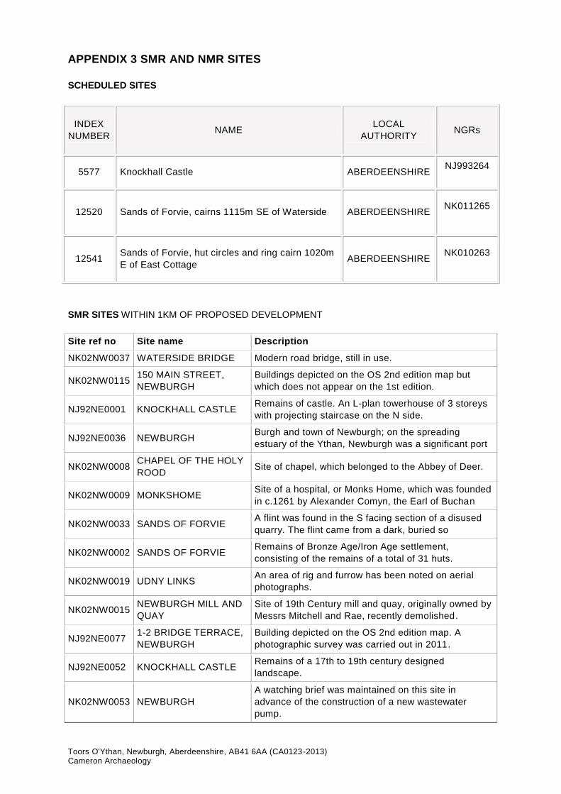
APPENDIX 3 SMR AND NMR SITES ......................................................................... 15
APPENDIX 4 MAPS ................................................................................................... 17
ILLUSTRATIONS (top) panoramic of site from SE; (centre) shallow scoop F4 facing west; (bottom) scraper SF1 Illus 1 Location plan ..................................................................................................... 3
Illus 2 Plan of trenches with main features and contours ............................................... 6
Illus 3 Trench 1 sand dune deposits 5, facing NW ......................................................... 7
Illus 4 Scoop F4 prior to excavation facing west ............................................................ 8
Illus 5 Scoop F4 half excavated facing west .................................................................. 8
Illus 6 Section through scoop F4 .................................................................................. 9
Illus 7 SF1 scraper from shallow scoop F4 .................................................................... 9
Illus 8 Plan showing trenches and main features ......................................................... 10
Illus 9 Robert Gordon, A map of Eastern Scotland. ..................................................... 17
Illus 10 Blaeu 1654 .................................................................................................... 18
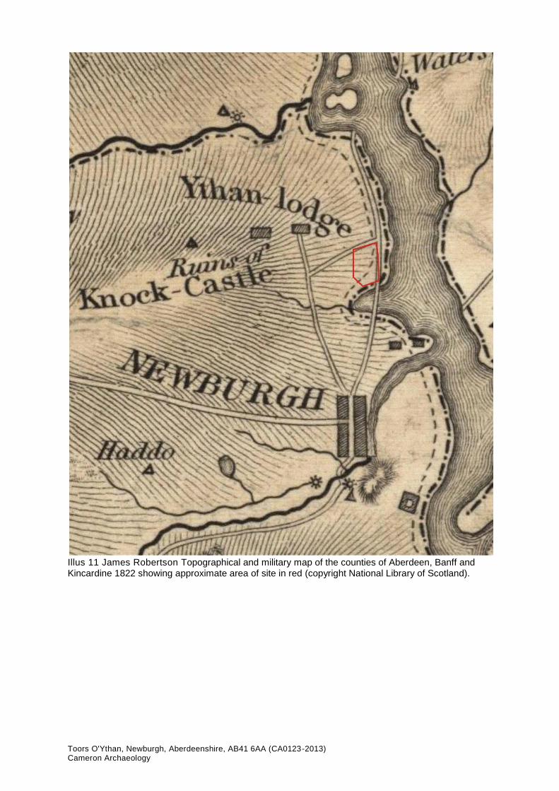
Illus 11 James Robertson ........................................................................................... 19
Illus 12 Alexander Gibb. ............................................................................................. 20
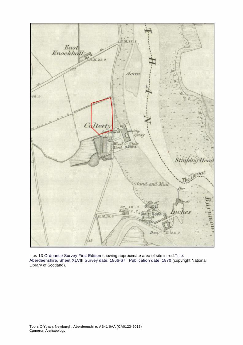
Illus 13 Ordnance Survey First Edition ........................................................................ 21
Illus 14 Ordnance Survey Second Edition. .................................................................. 22
SUMMARY A 7% archaeological evaluation was carried out on 4 April 2013. The south of the site had been sand dunes and the east had been within the area of the Ythan. On the higher ground at the north-west of the site a shallow scoop containing a flint scraper was the remains of a small working area. A watching brief will be required during soil stripping on the west side of the site.

Toors O'Ythan, Newburgh, Aberdeenshire, AB41 6AA (CA0123-2013) Cameron Archaeology
1 INTRODUCTION
1.1 The site is located north of Newburgh on the west side of the B975 north of The Quay
and Culterty House at NK 00069 26162, at 4-10m OD and in Foveran parish. It is a
cultivated field 1 hectare in size.
1.2 The work was commissioned by Nicholas Schellenberg in response to a planning
application APP/2012/3344 has been lodged with Aberdeenshire Council but is at
the moment pending.
1.3 All the archaeological work was carried out in the context of Scottish Planning
Policy (SPP) Planning Advice Note (PAN 2/2011) and Scottish Historic
Environment Policy (SHEP), which state that archaeological remains should be
regarded as part of the environment to be protected and managed.
Illus 1 Location plan (Contains Ordnance Survey data © Crown copyright and database right 2013)

Toors O'Ythan, Newburgh, Aberdeenshire, AB41 6AA (CA0123-2013) Cameron Archaeology
2 ARCHAEOLOGICAL BACKGROUND 2.1 There are three Scheduled Ancient Monuments within 1km of the proposed
development site; Knockhill Castle (NJ993264), Sands of Forvie cairns (NK011265) and Sands of Forvie hut circles and ring cairn (NK010263).
2.2 Knockhill Castle (NJ92NE2) is the remains of an L-plan towerhouse of 3 storeys
with projecting staircase on the N side. Above the doorway in the re-entrant angle is a stone dated 1565. Basic fabric is 16th century, the re-construction is late 17th century, being confined to windows, internal details and probably the square projecting tower at the N side. It was accidently burnt in 1734 when it fell into ruins. There is a vaulted ground floor, E vault intact, the W kitchen vault has fallen. A courtyard lay to the S, in the SE corner of which stood a circular tower with vaulted basement and shot-holes. The upper storey was a dovecot. Now only a stump remains. The castle also has Remains of a 17th to 19th century designed landscape (NJ92NE2; Shepherd 1994, 212).
2.3 Sands of Forvie contains the remains of a Bronze Age/Iron Age settlement
(NK02NW2), consisting of the remains of a total of 31 huts. The floors were sunk into the sand underlying a heath surface, and covered with red clay or paving stones. The walls were formed by banking up the excavated sand and stabilising it with clay and turf to carry a stone kerb. Inside posts supported the roof timbers. The entrances were invariably on the E side. The small finds were discovered both within and outside the huts, indicating LBA/EIA date. Outside the huts amid a scatter of fire-cracked stones, traces of working places were discovered with small finds scattered around. The huts varied from 6-12m in diameter. Artefacts from the area include jet beads, bracelets, querns and pottery. Area is now generally obscured by drifting sand (Cowie and Shepherd 2003, 161).
2.4 Also at Sands of Forvie are the remains of ring-cairn, with outer kerb diameter
c.6.40m; only its W half survives (NK02NW3). Stones vary in size, but generally the larger stones are found in the SW part of the circle. The inner kerb has a diameter of c.3.65m and is complete save for an arc of 1.21m in the NE. The inner kerb is sunk lower than the outer one by 0.15m, although their tops are on the same level. The area between the two kerbs is filled with rubble down to the level of the base of the outer kerbstones, with large stones at the bottom, resting on sand. In the centre area enclosed by the kerbs are four upright stones, forming a “four-poster”, set in a layer of stained sand with carbon streaks; above was black earth with charcoal and a number of white quartz fragments at the base of the layer. Large quantities of burnt bone came from within the central square. Sherds of Late Bronze Age “flat-rimmed” ware were also found (Burl 2000, 420).
2.5 There have been several finds recovered from the Newburgh area including a lithic
working site at Foveran Links (NK02SW 1) which was identified by a surface collection of flints. Several sites including shell middens and flint working sites are known from the area around the Ythan more than 1km from the current site. A flint was found in the S facing section of a disused quarry (NK02NW28). The flint came from a dark, buried soil horizon. The section is highly unstable and under-mined by rabbits. There appears to be a beach deposit on top of the buried soil. Three other finds from the Newburgh area include an axe hammer (NJ92NE 9) a wedge-shaped axe-hammer of diorite and donated to the National Museum of Antiquities of Scotland (PSAS 1893), three worked flints found in the 1920s (NJ92NE 11) which were in the Mrs Irvine collection at Barra Castle and a leaf-shaped arrowhead (NJ92NE 123) from Newburgh in Marischal Museum, Aberdeen (ABDUA: 17033).

Toors O'Ythan, Newburgh, Aberdeenshire, AB41 6AA (CA0123-2013) Cameron Archaeology
2.6 Near the Ythan a collection of mostly unworked flints were found in an old bed of the river (NK02NW 5) in 1905, a flint core and blades (NK02NW 21) were recovered from below estuarine mud in 1958 (Kirk 1958, 30) and a flint flake (NK02NW 24) is in Cambridge University Museum of Archaeology and Ethnology (Z.32791).
2.7 Two midden mounds, mainly consisting of mussel shells, sit on a main post glacial
raised beach. Found during a detailed topographical survey (NK02NW47) (Noble, Milek and Philip, G, K and E 2010, 28-29; Warren, G 1999, 10-11).
2.8 Chapel of the Holy Rood (NK02NW8) is the site of chapel, which belonged to the
Abbey of Deer. In c.1890 a man was commissioned to level out the cemetery and the remains of the chapel were removed. The burial ground of the former chapel also contains the 18th Century Udny family burial vault. The vault is a small rectangular building with low walls and tall roof, straight skews with skewputt, entrance raised and swept in roof and a tall blind gablet at the back. A few 18th Century stones are in the churchyard which is still in use (Shepherd 2006, 213).
2.9 Monksholme (NK02NW9) is the site of a hospital, or Monks Home, which was
founded in c.1261 by Alexander Comyn, the Earl of Buchan, at Newburgh for six poor men and a chaplain. Monks from the Cistercian Abbey of Deer lived at the Monkshome. The site of the home was later occupied by an inn, where it is said that the Old Pretender lodged on his journey south from Peterhead in 1715. The inn was known as 'Monkshome' and was believed to be on the site of the hospital (Cowan and Easson 1976, 151).
2.10 Udny Links (NK02NW30), Newburgh Golf Course (NK02NW30) and Sands of
Forvie (NK02NW31) both have areas of rig and furrow has been noted on aerial photographs.
2.11 Newburgh Mill (NK02NW18) is the site of a (now destroyed) 19th Century mill and
quay, originally owned by Messrs Mitchell and Rae, recently demolished to make way for a residential development. The mill was a 3-storey brick building with segmentally arched windows and a flat kiln with vent. The granary building was a 3-storey, 19-window structure built with a pine frame with a centre row of cast-iron columns, clad in corrugated iron. It had a queen-post roof with an early automatic belt conveyor system within the posts. It had a concrete gable, and an interesting system of firebreaks between the kiln, mill and granary. The quay was part concrete faced, with some 1 and 2-storey rubble warehouses on it. It was set on a tidal islet with a causeway connection to the mainland. Newburgh's utility as a harbour has been prejudiced by unstable littoral sands and shallow and obstructed water (Graham 1979, 344).
2.12 A watching brief was maintained on this site in advance of the construction of a
new wastewater pumping station in 2004 by Murray Archaeological Services. Two abraded sherds of medieval pottery were recovered during the top-soil strip, one of which was of Scarborough Ware dating to the 13th century; no other archaeological features or artefacts were encountered (NK02NW104; Murray 2004, 16).
2.13 A six-sided pill-box stands on the southwest side of the Ythan estuary near the
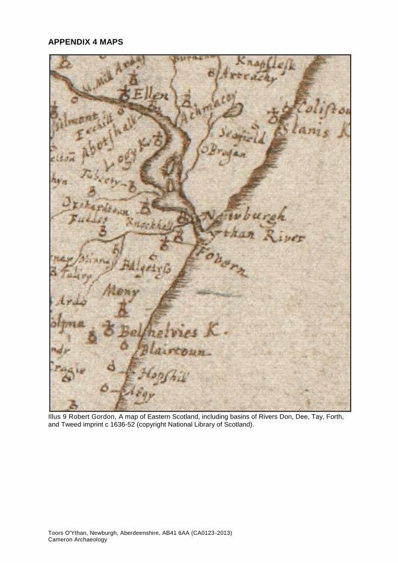
road bridge. There is a blast wall at the west side (NK02NW93). 2.14 Map evidence includes 'Forvy K[irk]' on Pont (surveyed c 1583-1614) and Gordon
(1636-52) shows 'Knockhall' and 'Fovern' (Appendix 4) and 'Fovern' and 'Knokhall'
on Blaeu 1654. James Robertson's Topographical and military map of the counties
of Aberdeen, Banff and Kincardine 1822 and Alexander Gibb's Map of the north

Toors O'Ythan, Newburgh, Aberdeenshire, AB41 6AA (CA0123-2013) Cameron Archaeology
eastern districts of Aberdeenshire, 1858 both show the proximity of the site to the
shore on the mid 19th century before the construction of the B975 (Appendix 4).
3 THE ARCHAEOLOGICAL EVALUATION
Four trenches totaling 7% of the proposed development were evaluated on 4 April 2013 (Illus 2). A soil bund and site entrance at the south end of the site reduced the area available for the evaluation. All trenches were excavated with a tracked slew with a 1.7m ditching bucket.
Illus 2 Plan of trenches with main features and contours

Toors O'Ythan, Newburgh, Aberdeenshire, AB41 6AA (CA0123-2013) Cameron Archaeology
Trench 1 Trench 1 was 90m long. At the north end was ploughsoil on compact rusty brown gravel natural subsoil. At the east end a series of sand and organic lenses (Illus 3) up to 1m deep are the remains of sand dunes (5). Both the maps of Robertson 1822 (lllus 11) and Gibb 1858 (Illus 12) show that there was an inlet of the Ythan to the south of this development site and these dunes are probably associated with this inlet.
Illus 3 Trench 1 sand dune deposits 5, facing NW
Trench 2 Trench 2 was 95m long and at the south end of the trench were the remains of sand dunes (5). In the centre of the trench an area of buried topsoil (3) survived and immediately to the north was a shallow scoop, F4, 70 x 80cm in size (Illus 4). It was half sectioned (Illus 5, 6), contained two clay fills and was a maximum of 15cm deep. The upper fill may have been the remains of historic plough damage; the topsoil is 50cm deep above this feature so this is probably not a result of modern ploughing. In the top of the feature was a flint scraper (SF 1: Illus 7). The north end of the trench was as Trench 1, a compact gravel natural. Trench 3 Trench 3 was 100m long and contained no archaeological features. The natural at the north was gravel and the south sandy clay. Undulations in the sand at the south end are natural dune features. Trench 4 Trench 4 was 100m long and of a similar nature to Trench 3. At the south end there was also a soil-filled trench (F6) which contained 19th and 20th century china fragments. This was probably created by dumping soil at the SE end of the field to raise it in height, possibly during the formation of the B975 road.

Toors O'Ythan, Newburgh, Aberdeenshire, AB41 6AA (CA0123-2013) Cameron Archaeology
Illus 4 Scoop F4 prior to excavation facing west
Illus 5 Scoop F4 half excavated facing west

Toors O'Ythan, Newburgh, Aberdeenshire, AB41 6AA (CA0123-2013) Cameron Archaeology
Illus 6 Section through scoop F4
Illus 7 SF1 scraper from shallow scoop F4 (scale mm)
4 CONCLUSIONS AND RECOMMENDATIONS
The east half of the site had been within the area of the Ythan and therefore no archaeological features were recorded in Trenches 3 and 4. The south end of Trenches 1 and 2 had been sand dunes and one shallow scoop, F4, was found on the slightly higher ground north of these dunes. The feature contained a scraper and this had probably been a small working area for preparation of fish or animal products. No other finds were recovered from the trenches or spoil heaps suggesting that this was not an intensively used area.
It is therefore recommended that a watching brief be carried out during soil strip of the west half of the site to record any features or finds not included in this evaluation (Illus 8). There

Toors O'Ythan, Newburgh, Aberdeenshire, AB41 6AA (CA0123-2013) Cameron Archaeology
are several areas in the centre of the site which will be not be disturbed down to natural level.
Illus 8 Plan showing trenches and main features superimposed on plan of proposed development (copyright Crichton Wood Architects)

Toors O'Ythan, Newburgh, Aberdeenshire, AB41 6AA (CA0123-2013) Cameron Archaeology
5 REFERENCES
Burl, HAW 2000 The stone circles of Britain, Ireland and Brittany. New Haven and London. Cowan and Easson, I B and D E 1976 Medieval religious houses in Scotland: with an appendix on the houses in the Isle of Man. London.
Cowie and Shepherd, T G and I A G 2003 'The Bronze Age', in Edwards, KJ and Ralston, IBM Scotland after the Ice Age: environment, archaeology and history 8000BC - AD 1000, 161. Edinburgh.
Graham, A 1979 'Old harbours and landing places on the east coast of Scotland', Proc Soc Antiq Scot, vol.108, 333-5.
Murray, J C 2004 'Inch Road, Newburgh (Foveran parish), watching brief Discovery Excav Scot, vol.5, 16. Noble, Milek and Philip, G, K and E 2010 'Sands of Forvie, Aberdeenshire (Slains parish), excavation', Discovery Excav Scot, New, vol.11, 28-9. Shepherd, IAG 1994 'Gordon: an illustrated architectural guide'. Edinburgh. Shepherd, IAG and McKean, C 2006 'Aberdeenshire, Donside and Strathbogie: an illustrated architectural guide'. Edinburgh.
Warren, G 1999 'Sands of Forvie (Slains parish), mesolithic lithic scatters and middens', Discovery Excav Scot, 10-11.
6 ACKNOWLEDGEMENTS
Thanks to Nicholas Schellenberg and to Claire Herbert, Aberdeenshire Archaeology
Service.
Cameron Archaeology 45 View Terrace Aberdeen AB25 2RS 01224 643020 07581 181057 [email protected] www.cameronarchaeology.com Company registration no 372223 (Scotland) VAT registration no 990 4373 00

Toors O'Ythan, Newburgh, Aberdeenshire, AB41 6AA (CA0123-2013) Cameron Archaeology
APPENDIX 1 PHOTOGRAPHS
Photo no Description Trench Facing
DSC_5087-5100 Site from bridge over Ythan north of site S/SSE
DSC_5101-5109 Site from B975 NW/W
DSC_5110 Site WNW
DSC_5111 Site NW/W
DSC_5112 Site NNW
DSC_5113-5123 Trench 4 showing undulations in sand natural 4 N
DSC_5124-5128 Trench 4 showing undulations in sand natural 4 W
DSC_5129-5138 F6 upfill above natural subsoil 4 N
DSC_5139-5143 Trench 4 showing undulations in sand natural 4 NNW
DSC_5144-5149 Trench 4 showing undulations in sand natural 4 N
DSC_5150-5155 Trench 4 undulation in sand natural part excavated revealing sand under topsoil
4 W
DSC_5156-5160 Trench 4 4 S
DSC_5161-5163 Trench 4 4 SW
DSC_5164-5168 Trench 3 3 S
DSC_5169-5173 Trench 3 showing undulations in sand natural 3 N
DSC_5174-5178 Trench 3 3 N
DSC_5179-5184 Trench 3 3 N
DSC_5185-5194 Trench 2 sand dune deposits 5 2 N
DSC_5195-5199 Trench 2 sand dune deposits 5 2 N
DSC_5200-5204 Trench 2 sand dune deposits 5 2 E
DSC_5205-5209 Trench 2 buried topsoil 3 2 NNE
DSC_5210-5215 Trench 2 buried topsoil 3 2 N
DSC_5216-5220 Trench 2 F4 prior to cleaning and excavation with buried topsoil 3 (top)
2 S
DSC_5221-5230 Trench 2 buried topsoil 3 section 2 W
DSC_5231-5241 Trench 2 F4 2 W
DSC_5242-5246 Trench 2 F4 with SF1 in situ 2 W
DSC_5247-5271 Trench 2 F4 half excavated and section 2 W
DSC_5272-5281 Trench 2 F4 half excavated and section 2 S
DSC_5282-5286 Trench 2 showing compact gravel and north end 2 S
DSC_5287-5291 Trench 1 north end 1 S
DSC_5292-5297 Site from north end Trench 1 E/SE/SSE
DSC_5298-5302 Trench 1 north end showing compact gravel 1 N
DSC_5303-5312 Trench 1 showing south end sand dune deposits 5 1 S
DSC_5313-5317 Trench 1 showing south end sand dune deposits 5 1 SSW
DSC_5318-5322 Trench 1 showing south end sand dune deposits 5 1 NW
DSC_5323-5327 Trench 1 showing south end sand dune deposits 5 in section
1 W
DSC_5328-5337 Trench 1 from south end 1 N
DSC_5338-5341 Site from south end Trench 1 E/NE/NNE
DSCF2027 Craig Reid machine used in evaluation
DSCF2029-35 Panoramas of site

Toors O'Ythan, Newburgh, Aberdeenshire, AB41 6AA (CA0123-2013) Cameron Archaeology

Toors O'Ythan, Newburgh, Aberdeenshire, AB41 6AA (CA0123-2013) Cameron Archaeology
APPENDIX 2 FEATURES Context no Trench Description Feature
1 2 Dark grey clay, sand and stone flecks - plough mark into top of F4? F4
2 2 Medium grey sandy clay - primary fill of F4 F4
3 2 Black compact sandy loam - buried soil
F4 1 Shallow scoop 70x80cm and max 15cm deep. Contains SF1 flint scraper
5 1 and 2 Alternate layers sand and organic loam layers - sand dune
6 4
Infill at SE end of site to level up field; contains 19th/20th century china. May be associated with construction of road B975.
7 1, 2, 3, 4 Light sandy topsoil
Toors O'Ythan, Newburgh, Aberdeenshire, AB41 6AA (CA0123-2013) Cameron Archaeology
APPENDIX 3 SMR AND NMR SITES
SCHEDULED SITES
INDEX
NUMBER NAME
LOCAL
AUTHORITY NGRs
5577 Knockhall Castle ABERDEENSHIRE NJ993264
12520 Sands of Forvie, cairns 1115m SE of Waterside ABERDEENSHIRE NK011265
12541
Sands of Forvie, hut circles and ring cairn 1020m
E of East Cottage ABERDEENSHIRE
NK010263
SMR SITES WITHIN 1KM OF PROPOSED DEVELOPMENT
Site ref no Site name Description
NK02NW0037 WATERSIDE BRIDGE Modern road bridge, still in use.
NK02NW0115
150 MAIN STREET,
NEWBURGH
Buildings depicted on the OS 2nd edition map but
which does not appear on the 1st edition.
NJ92NE0001 KNOCKHALL CASTLE Remains of castle. An L-plan towerhouse of 3 storeys
with projecting staircase on the N side.
NJ92NE0036 NEWBURGH Burgh and town of Newburgh; on the spreading
estuary of the Ythan, Newburgh was a significant port
NK02NW0008
CHAPEL OF THE HOLY
ROOD Site of chapel, which belonged to the Abbey of Deer.
NK02NW0009 MONKSHOME Site of a hospital, or Monks Home, which was founded
in c.1261 by Alexander Comyn, the Earl of Buchan
NK02NW0033 SANDS OF FORVIE A flint was found in the S facing section of a disused
quarry. The flint came from a dark, buried so
NK02NW0002 SANDS OF FORVIE Remains of Bronze Age/Iron Age settlement,
consisting of the remains of a total of 31 huts.
NK02NW0019 UDNY LINKS An area of rig and furrow has been noted on aerial
photographs.
NK02NW0015
NEWBURGH MILL AND
QUAY
Site of 19th Century mill and quay, originally owned by
Messrs Mitchell and Rae, recently demolished.
NJ92NE0077
1-2 BRIDGE TERRACE,
NEWBURGH
Building depicted on the OS 2nd edition map. A
photographic survey was carried out in 2011.
NJ92NE0052 KNOCKHALL CASTLE Remains of a 17th to 19th century designed
landscape.
NK02NW0053 NEWBURGH
A watching brief was maintained on this site in
advance of the construction of a new wastewater
pump.

Toors O'Ythan, Newburgh, Aberdeenshire, AB41 6AA (CA0123-2013) Cameron Archaeology
NK02NW0039 INCHES The remains of a 19th Century warehouse and small
quay lie at the end of the small promontory.
NJ92NE0025
CROSS OF
NEWBURGH
Market Cross; broken by a cart but site was well
known.
NK02NW0020 SANDS OF FORVIE An area of rig and furrow has been noted on aerial
photographs.
NK02NW0016
NEWBURGH
WAREHOUSE
A warehouse, probably 18th Century in date, stands
near the landward end of a causeway.
NK02NW0003 SANDS OF FORVIE Remains of ring-cairn, with outer kerb diameter
c.6.40m; only its W half survives.
NK02NW0046 SANDS OF FORVIE Two midden mounds, mainly consisting of mussel
shells, sit on a main post glacial raised beach.
NK02NW0049 NEWBURGH A six-sided pill-box stands on the southwest side of
the Ythan estuary near the road bridge.
NK02NW0035
NEWBURGH GOLF
COURSE
Remains of an area of denuded rig and furrow, visible
in low light
Toors O'Ythan, Newburgh, Aberdeenshire, AB41 6AA (CA0123-2013) Cameron Archaeology
APPENDIX 4 MAPS
Illus 9 Robert Gordon, A map of Eastern Scotland, including basins of Rivers Don, Dee, Tay, Forth, and Tweed imprint c 1636-52 (copyright National Library of Scotland).

Toors O'Ythan, Newburgh, Aberdeenshire, AB41 6AA (CA0123-2013) Cameron Archaeology
Illus 10 Blaeu 1654 Duo Vicecomitatus Aberdonia & Banfia, una cum Regionibus & terrarum tractibus sub iis comprehensis / Auctore Roberto Gordonio à Straloch. Description of the two Shyres Aberdene and Banf (copyright National Library of Scotland).
Toors O'Ythan, Newburgh, Aberdeenshire, AB41 6AA (CA0123-2013) Cameron Archaeology
Illus 11 James Robertson Topographical and military map of the counties of Aberdeen, Banff and Kincardine 1822 showing approximate area of site in red (copyright National Library of Scotland).

Toors O'Ythan, Newburgh, Aberdeenshire, AB41 6AA (CA0123-2013) Cameron Archaeology
Illus 12 Alexander Gibb, Map of the north eastern districts of Aberdeenshire, 1858 showing approximate area of site in red (copyright National Library of Scotland).
Toors O'Ythan, Newburgh, Aberdeenshire, AB41 6AA (CA0123-2013) Cameron Archaeology
Illus 13 Ordnance Survey First Edition showing approximate area of site in red.Title: Aberdeenshire, Sheet XLVIII Survey date: 1866-67 Publication date: 1870 (copyright National Library of Scotland).

Toors O'Ythan, Newburgh, Aberdeenshire, AB41 6AA (CA0123-2013) Cameron Archaeology
Illus 14 Ordnance Survey Second Edition showing approximate area of site in red. Title: Aberdeenshire Sheet XLVIII.SW Publication date: 1902 Date revised: 1899 (copyright National Library of Scotland).