ArcGIS Pro: An Introduction · 2020. 5. 4. · ArcGIS Pro Roadmap • Offset Printing (2.5) •...
36
Thomas Oaks ArcGIS Pro: An Introduction
Transcript of ArcGIS Pro: An Introduction · 2020. 5. 4. · ArcGIS Pro Roadmap • Offset Printing (2.5) •...

Thomas Oaks
ArcGIS Pro: An Introduction

ArcGIS Desktop
Desktop Web Device
Server Online Content
and Services
Portal
ArcMap
ArcCatalog
ArcScene
ArcGlobe
ArcGIS Pro

Modern ArcGIS Platform Overview
ArcGIS Pro
ArcGIS Online
ArcGIS Enterprise
ArcGIS Apps

ArcGIS Pro
• 64-bit multi-threaded application
• Contextual user interface
• Closer integration with the
platform
• Combined 2D/3D experience
• Multiple maps and layouts
• All the analysis tools
• Simple search and query
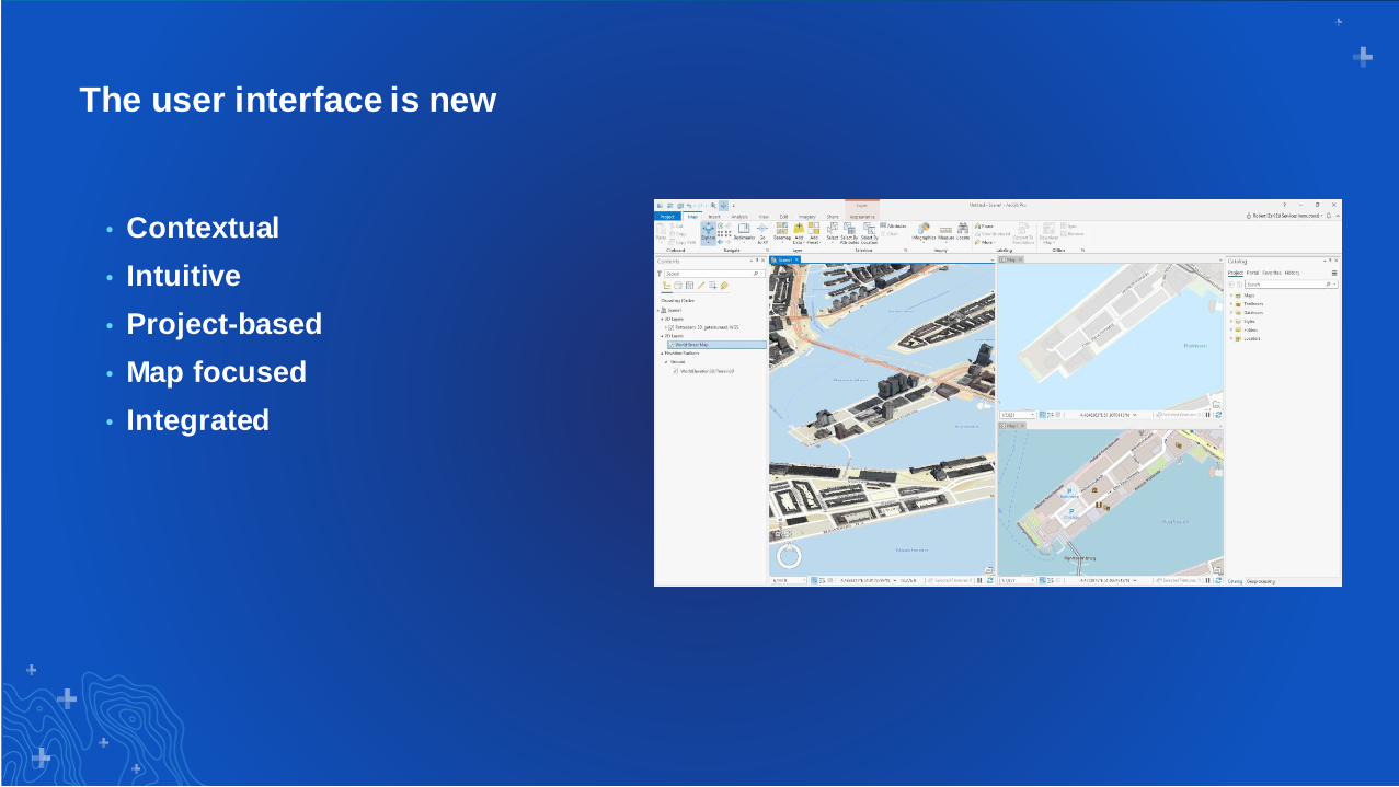
The user interface is new
• Contextual
• Intuitive
• Project-based
• Map focused
• Integrated

Fusion of Applications
ArcMap / ArcCatalog
ArcGlobe / ArcScene
CityEngine
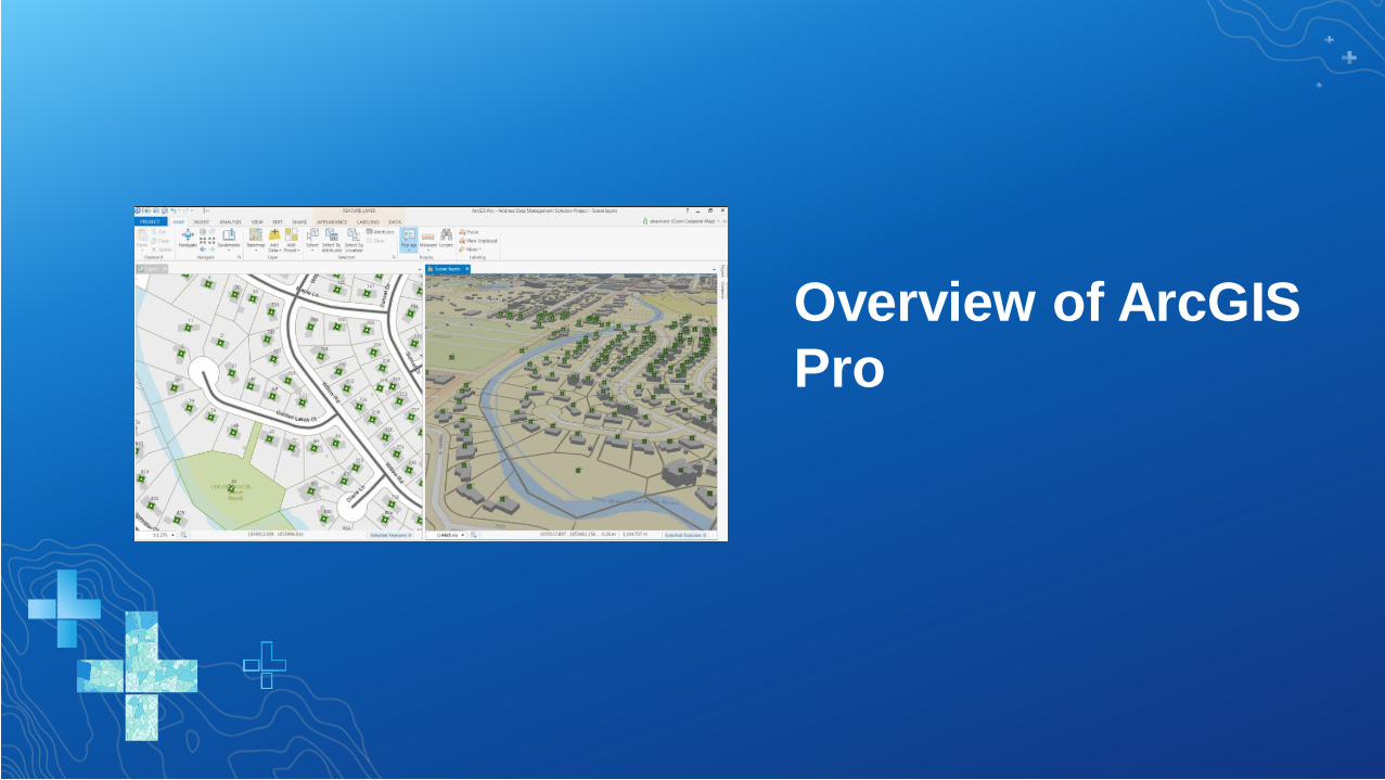
Overview of ArcGIS
Pro

What can I do with ArcGIS Pro?

Editing
• 2D and 3D editing
• Simplified edit sessions
• Edit shapefiles
• Edit file & enterprise GDBs
• Group templates
• GDB & Map topology
• CAD like editing experience
Create
Features
Update Attributes Modify
Features

Editing in ArcGIS
Pro

Analysis
• Analysis ribbon
• All analysis tools from ArcMap
• Interactive analysis tools
• Geoprocessing pane
• ModelBuilder
• Python window
• Network Analysis
• Geostatistical Wizard
• Image and Raster Analysis

Analysis in ArcGIS
Pro

Mapping & Visualization
• Improved drawing performance and quality
• Multiple layouts
• Unified symbol model
• Transparency
• 3D cartography
• Map series
• Reports
• Animation

Visualization in
ArcGIS Pro

Sharing
• Web maps and 3D web scenes
• Map and layer packages
• Project packages
• Map & layout files
• Task files
• Print & export
• Symbology (*.stylx)
ArcGIS
portal

Common Questions

Is ArcGIS Pro a replacement
for ArcMap?

• Yes. We plan on releasing ArcMap 10.8 with ArcGIS 10.8 in
2020. While we will continue to release ArcMap, our
development and innovation focus is on ArcGIS Pro. After 10.8,
our support for ArcMap will be limited to providing patches,
updates, and new environment certifications based on the
established ArcGIS Desktop Product Life Cycle. There will be
little new functionality in each release, and we encourage our
users to move to ArcGIS Pro as soon as they are able to
complete their workflows.

How do I get started with
ArcGIS Pro?

Import existing maps, scenes, and globes
• What will import?
- .mxd, .sxd, .3dd files
- Maps, layouts, symbology,
scenes, and models
- Map packages (.mpk, .mpkx)
• Results will look
the same
ArcMap ArcGIS Pro

How is ArcGIS Pro licensed?

Any way you want
Named user
Single use
Concurrent use

Licensing Options
• Concurrent Use at 2.4
- Install ArcGIS License Manager 2019.0
or later
- Update license file
• Single Use
- Locked to a single machine

Can ArcGIS Pro be virtualized?

On-Premises Virtualization
• Citrix
- Virtual Apps & Desktops
• Microsoft
- Hyper-V VDI
• Nutanix
- AHV
• VMWare
- Horizon

Cloud Virtualization
Amazon Web Services (AWS)
- Workspaces
- AppStream 2.0
- EC2 with Elastic Graphics
• Microsoft Azure
- NV Series VM
- NC Series VM
• Google Drive Platform

Can I customize ArcGIS Pro?

Customizable
• Use
• Configure
• Automate
• Extend
Customize the Ribbon
Tasks
.NET API
Python
What’s New at ArcGIS Pro
2.5?

ArcGIS Pro 2.4 Highlights (to start with)…
Parcel Editing ToolsRaster Pixel Editor
ModelBuilder to Python script
Dynamic Feature Binning
Realistic VisualizationMultipatch Editing
GeoAnalytics Desktop
Parallel Processing
Profile Viewing

ArcGIS Pro 2.5 Highlights
Map AuthoringNotebooks
More Modelbuilder Functions
Replica Workflows
Chart ImprovementsMore Multipatch
Editing
Core Tools for BIM

ArcGIS Pro Roadmap
• Offset Printing (2.5)
• Replication Workflows
• Parcel Adjustment
• Voxel Layers
• Tie Point Manager
• Geoprocessing Leveraging Spatial
Databases
• Python Notebooks (2.5)
• Geoprocessing Scheduler (2.5)
• Scripting Metadata
• Hydro Networks
• Create Network Dataset (2.5)
• Multidimensional Raster
Improvements
• Interactive Suitability Modeling
• Projects in the Enterprise
• Animated Symbols
• Material Textures
• Multipatch Editing in Stereo
• Layer Blend Modes
• Presentations
• GPS Support
• Dynamic Feature Clustering
• Voxel Layer Sharing
• Map Graphics
• New Extensions
• Terrain Editing
• 3D Mesh as ground
• High Fidelity rendering
Mid-TermNear Term Long Term

Questions?
Print Your Certificate of Attendance
Print Stations Located in 150 Concourse Lobby
Tuesday12:30 pm – 6:30 pm
Expo
Hall B
5:15 pm – 6:30 pm
Expo Social
Hall B
Wednesday10:45 am – 5:15 pm
Expo
Hall B
6:30 pm – 9:30 pm
Networking Reception
Smithsonian National Museum
of Natural History

Download the Esri
Events app and find your event
Select the session
you attended
Scroll down to
“Survey”
Log in to access the
survey
Complete the survey
and select “Submit”
Please Share Your Feedback in the App

Show this after your presentation has ended.