ArcGIS Geodatabase Topology Rules
2
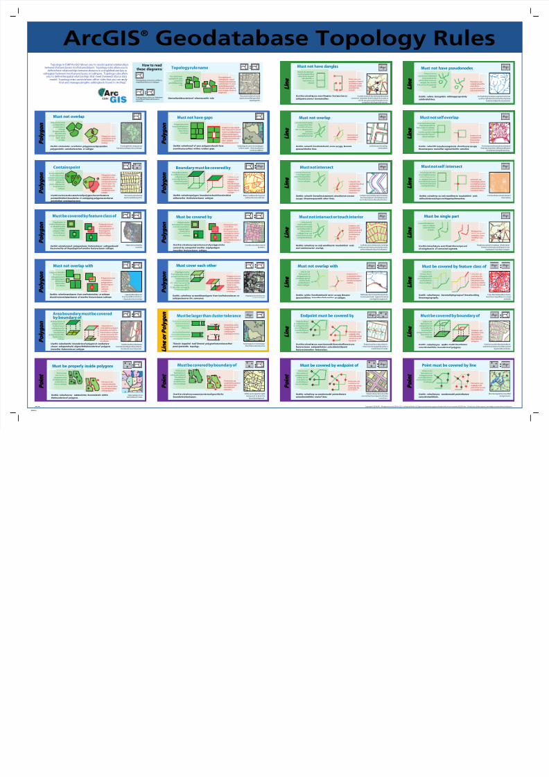
Topology in ESRI® ArcGIS®allows you to model spatial relationships between featureclasses in a featuredataset. Topology rules allow you to definethose relationships between f eatures in a singlefeatureclass or subtypeor between two featureclasses or subtypes. Topology rules allow you to definethespatial relationships that meet theneeds ofyour data model. Topology err ors areviolations ofthe rules that you can e asily find and manageusingthe editingtools found in ArcMap . How to read these diagrams: Thetopology ruleoccurs within a singlefeatureclass or subtype. Thetopology ruleoccurs between two different featureclasses or subtypes. : Descriptionofareal-world applicationofthespecified topology rule. Generalized descriptionof whentousethis rule. Topology rule name Description and exampleofa valid caseofthe specified topology rule. Description and exampleofa caseof thespecifiedtopology rulewhereerrors exist and will bereturned. For each example,the error shapeis shown in bright red. : L i n e P o i n t P o i n t P o i n t P o l y g o n P o l y g o n L i n e L i n e L i n e P o i n t P o i n t P o i n t P o l y g o n P o l y g o n P o l y g o n P o l y g o n P o l y g o n P o l y g o n P o l y g o n P o l y g o n P o l y g o n P o l y g o n P o l y g o n P o l y g o n P o l y g o n P o l y g o n P o l y g o n P o l y g o n P o i n t P o i n t P o i n t Counties must becovered by states. Usethisrulewhenyou wantonesetof polyg onstobe covered by somepartof another singlepolygon inanother featureclassor subtype. Must be covered by Polygonsinone featureclass or subtype must becovered by a singlepolygon from another featureclass or subtype. Polygonerrorsare created from polygonsfromthe first featureclass or subtypethat arenot covered by a single polygon from the second featureclass or subtype. : Usethis rulewheny ou wantthepolygons from twofeatureclasses or subtypestocover the samearea. Must cover each other Polygonerrorsare created whereany part ofa polygon is not covered by oneor more polygonsinthe other featureclass orsubtype. All polygons in the first featureclass and all polygons in thesecond featureclass must covereachother. -FC1 Must becovered b y featureclass ofFC2. -FC2Must be covered by featureclass ofFC1. Vegetationandsoilsmust covereachother. : Major road lines form part of outlinesforcensusblocks. Usethis rulewhenpolygon boundariesshould becoincident withanother linefeatureclassor subtype. Boundary must be covered by Lineerrors are createdwhere polygon boundaries are not covered by a lineofanother featureclass or subtype. Polygon boundaries in onefeatureclass or subtypemust be covered by thelines ofanotherfeature class or subtype. : Thisrule isapplied toall lineand polygonfeatureclassesthat participateinthe topology. Must be larger than cluster tolerance Anypolygonorline featurethat would collapsewhen validatingthe topology is an error. Cluster toleranceis the minimumdistance between vertices offeatures. Vertices that fall within thecluster toleranceare definedascoincidentand aresnapped together. Soilpolygonscannotincludegaps or form voids—they must form a continuous fabric. Usethis rulewhenall of your polygonsshould form acontinuoussurface withno voidsor gaps. Must not have gaps Polygonsmustnot havea void between them within a featureclass orsubtype. Lineerrors arecreated from theoutlines ofvoid areas in a singlepolygon or between polygons. Polygon boundaries that arenot coincident with other polygon boundariesareerrors. Utility servicepoints might berequired to beon the boundaryofaparcel. Usethisrulewhenyou wantpoin tstoalignwiththe boundariesof polygons. Must be covered by boundary of Points in one featureclass or subtypemust touch boundaries of polygons from another feature class or subtype. Point errors are createdwherepoints do not touch the boundaries of polygons. : Lakesandlandparcels fromtwodifferentfeature classes must not overlap. Usethis rulewhenpolygons from onefeatureclass or subtype should notoverlappolygons of another featureclassor subtype. Must not overlap with Polygonerrorsare createdwhere polygons from thetwo feature classes or subtypes overlap. Polygons ofthefirst featureclass or subtypemust not overlappolygons ofthesecond featureclass orsubtype. : Subdivision boundaries are coincident with parcel boundaries, but do not cover all parcels. Usethis rulewhenthe boundariesof polygonsin onefeature classor subtypeshould alignwiththeboundariesof polygons inanother featureclassor subtype. Theboundaries of polygonsinone featureclass or subtypemust be covered by the boundaries of polygons in another featureclass or subtype. Lineerrors are created wherepolygon boundaries in thefirst featureclass or subtype arenot covered by the boundaries ofpolygons in another featureclass orsubtype. Area boundary must be covered by boundary of : States arecovered by counties. Must be covered by feature class of Usethis rulewheneach polygoninone featureclassor subtypeshould becovered by all thepolygonsof another featureclassor subtype. Polygonerrorsare created from the uncoveredareasof thepolygons in thefirst feature class or subtype. Thepolygons in thefirst featureclass or subtypemust be covered by the polygons ofthe second feature class or subtype. : Parcels must contain at least oneaddress point. Usethisruletomakesu rethatall polyg onshaveatleas tone pointwithintheir boundaries. O verlapping polygonscansharea pointinthat overlapping area. Containspoint Each polygon ofthe first featureclass or subtypemustcontain within its boundaries at least one point ofthesecond featureclass or subtype. Polygonerrorsare created from the polygonsthatdonot contain at least one point.A point on theboundary ofa polygonisnot containedinthat polygon. : A votingdistrict mapcannot haveany overlaps in its coverage. Usethis ruletomake surethatno polygonoverlapsanother polygoninthe samefeatureclass or subtype. Must not overlap Polygonsmustnot overlapwithina featureclass or subtype. Polygonscanbe disconnected or touch at a point or touch along an edge. Polygon errors are created from areas wherepolygons overlap. Copyright ©2004ESRI. All rights reserved.ESRI,ArcGIS,A rcMap,and theArcGIS logo aretrademarks,registered trademarks,or servicemarks ofESRI in the United States,theEuropean Commun ity,or certain other jurisdictions. 94238 03/04 rh Monitoringstationsmustfall alongstreams. Usethis rulewhenyou wanttomodel pointsthatare coincidentwithlines. Points in one featureclass or subtypemust be covered by lines in anotherfeatureclass orsubtype. Point errors are created on the points that arenot coveredbylines. Point must be covered by line : Lines that makeupbus routes must beon topoflines in a road network. Usethis rulewhenyou havemultiplegroupsof linesdescribing thesamegeography. Lines in one featureclass or subtypemust be covered by lines in another feature class or subtype. Lineerrors are created on the lines in thefirst featureclass that arenot covered by lines in thesecond featureclass. Must be covered by feature class of : Fortransportationanalysis,streetand highway segments ofthesamefeature should not overlapthemselves. Usethis rulewithli neswhosesegments should never occupy thesamespace asanother segmentonthe sameline. Lines must not overlap themselveswithina featureclass or subtype. Linescantouch, intersect,andoverlap linesinanotherfeature class or subtype. Lineerrors are createdwhere lines overlap themselves. Must not self overlap Contourlinescannotintersect themselves. Usethis rulewheny ou only wantlinesto touchattheir ends withoutintersecting or overlapping themselves. Lines must not cross oroverlapthemselves within a featureclass or subtype.Lines can touchthemselvesand touch,intersect,and overlapotherlines. Lineerrors are created wherelines overlapthemselves, and point errors are created wherelines crossthemselves. Must not self intersect For hydrologic analysis,segments ofa river system might beconstrained to only have nodes at endpoints or junctions. Usethis ruletoc leanupdata withinappropriately subdivided lines. Theend ofa line cannot touch theend of only oneother line within a featureclass or subtype.The end ofa linecan touch any part of itself. Point errors are created wherethe end ofa line touches theend of only oneother line. Must not have pseudonodes A highway system is madeup ofindividual features whereany onefeatureis not madeupof morethan onepart. Usethisrulewhe nyou wantline stobecomposed of asingleseries of connected segment s. Must be single part 25 40 Lineswithinafeature class or subtype must only have onepart. Multipart line errors arecreated wherelines have morethan one part. 9 10 8 9 9 8 Polylinesusedfordisplayingblock and lot boundaries must becovered byparcelboundaries. Usethis rulewhenyou wan tto model linesthatare coincidentwiththe boundariesof polygons. Lines in one featureclass or subtypemust be covered by the boundaries of polygons in another featureclass or subtype. Lineerrors are created on lines that arenot covered by the boundaries of polygons. Must be covered by boundary of : Street intersections must be covered by theendpoints ofstreet centerlines. Usethis rulewheny ou wanttomodel pointsthatare coincidentwiththe endsof lines. Points in one featureclass or subtypemust be covered by the ends oflines in another feature class or subtype. Must be covered by endpoint of Point errors are created on the points that arenot covered by the ends oflines. : Highways can cross and comeclose to rivers,but road segments cannot overlapriversegments. Usethis rulefor linesthatshould never occupy t hesame spacewithlines inanother featureclass or subtype. Lines in one featureclass or subtypemust not overlapany part of another linein another feature class or subtype. Lineerrors are createdwherelines fromtwofeature classes or subtypes overlap. Must not overlap with : Lotlinescannotoverlap oneanother. Usethis rulewith linesthatshould never occupy t hesame spacewithother lines. Must not overlap Lines must not overlap any part ofanother linewithin a feature class or subtype.Lines cantouch, intersect,and overlapthemselves. Lineerrors are created where lines overlap. Lot lines cannot intersect or overlap, but theendpoint ofonefeaturecan touch theinterior ofanother feature. Usethis rulewith lineswhosesegments should never crossor occupy thesamespacewith other lines. Must not intersect Lines must not cross or overlapany part ofanother linewithin thesamefeature class or subtype. Lineerrors are created wherelines overlap,and point errors are createdwhere lines cross. A street network has linesegments that connect.If segments end for dead-end roads or cul-de-sacs,you could chooseto set as exceptions duringan edit session. Usethisrulewhe nyou wantline sina featu reclassor subtypetoconnect tooneanother. Must not have dangles 25 40 Theend ofa linemust touch any part ofone other lineor any part ofitselfwithin a featureclass or subtype. Point errors are created at theend ofa linethat does not touch at least oneother line or itself. Endpoints ofsecondary electric lines must becapped by either a transformer or meter. Usethisrulewhe nyou wanttomode l theendsof linesinone featureclassor subtypethatare coincidentwithpoint featuresinanother featureclass. Theends oflines in onefeatureclass or subtypemust be coveredbypoints inanotherfeature class or subtype. Endpoint must be covered by Point errors are created at the ends oflines that arenot covered by a point. : Lot lines cannot intersect or overlap and must connect to oneanother only at theendpoint ofeach linefeature. Usethis rulewheny ou only wantlinesto touchattheir ends and notintersector Linescanonly touch at their ends and must not overlap each other within a featureclass or subtype.Lines can touch,intersect,and overlapthemselves. Lineerrors are createdwhere linesoverlap,and point errors are createdwhere lines cross or touch. Must not intersect or touch interior overlap. ArcGIS ® Geodatabase Topology Rules L i n e L i n e L i n e L i n e P o i n t P o i n t L i n e L i n e L i n e L i n e L i n e L i n e L i n e L i n e L i n e L i n e L i n e L i n e L i n e L i n e L i n e L i n e L i n e L i n e L i n e L i n e L i n e L i n e P o i n t Cluster Tolerance Cluster Tolerance Usethis rulewhenyou wa ntpointsto becompletely within theboundariesof polygons. Must be properly inside polygons Point errors are created wherethe points areoutsideor touchtheboundary ofthepolygons. Points in one featureclass or subtypemust be insidepolygons of another feature class or subtype. Statecapitals must beinsideeach state. : Soil polygons must belarger than thecluster tolerance. L i n e o r P o l y g o n L i n e o r P o l y g o n
-
Upload
raluca-kogalniceanu -
Category
Documents
-
view
242 -
download
0
Transcript of ArcGIS Geodatabase Topology Rules
7/22/2019 ArcGIS Geodatabase Topology Rules
http://slidepdf.com/reader/full/arcgis-geodatabase-topology-rules 1/1