

ArcGIS API for JavaScript: What's New for 4 /devsummit... · 2015. 11. 20. · one convention...
52
ArcGIS API for Javascript What's new for 4.0 Yann Cabon
Transcript of ArcGIS API for JavaScript: What's New for 4 /devsummit... · 2015. 11. 20. · one convention...

4.0OverviewArchitecture: Map and ViewsArchitecture: core componentsFeaturesFuture work

4.0 Overview

In a nutshellSimplified APIWebMap and WebScene, first class citizensBrings 3D capabilitiesAPIs and Widgets redesignLot of common patterns shared with Quartz Runtime SDKs

In a nutshellNew architectureAMD only
IE9+ for 2D, IE11+ for 3D
Classes properly cased: esri/Map, esri/Graphic, esri/layers/Layer
New folder structure.

ReleasesAlready in production in the WebScene Viewerbeta1, released in mid-julybeta2, November 19thPlanned: beta3 in decemberPlanned: final in 2016 - devsummit

ArchitectureMap and Views

Why a new architecture?One of the starting point of 4.0: bring 3Dcurrently in :
Map, many DOM nodesEach Layer, 1 DOM Node
rendering 3D with WebGL which is completely different
3.x

New architectureSeparate the business logic from the drawing logic.

var map = new Map({ basemap: 'topo', layers: [ new ArcGISDynamicLayer(...) ] });
var mapView = new MapView({ map: map, container: 'mapDiv' });
var sceneView = new SceneView({ map: map, container: 'sceneDiv' });
side by side views

2D/3DFor the rest, one APIDEMO

2Dnew "engine" in the work.faster, more future proof
abstraction to draw tiles and dynamic images to ease custom layers/layerviewsabstraction to draw in DOM or Canvas, possibly WebGL
display graphics while zooming.rotationcontinous zoom
, vector map tiles basemaps
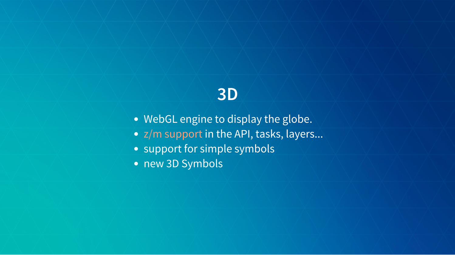
3DWebGL engine to display the globe.
in the API, tasks, layers...support for simple symbolsnew 3D Symbols
z/m support

Architecturenew core components
esri/core/Accessoresri/core/Promiseesri/core/Loadableesri/core/Collection

esri/core/AccessorMixin similar to dojo/StatefulConsistent pattern:
getting and setting properties valuewatching properties change
Single object constructorComputed propertiesAutocast

Properties watchingDirect benefits:
remove inconsistancies between constructor, getter, setter functions, eventsone convention everywhere. "just need to know what properties for a class"Single object constructor, no more 3+ constructorsLeaner SDK: we doc only the properties, the rest is convention
Changes:
no more property-change events, use watch()in 3.x, listen for event.in 4.0 extent watchers will be call very oftennew events and properties for animation.
extent-change

Accessor - Properties watchingvar map = new Map(...);var view = new MapView({ map: map });
// watch for viewpoint updatesview.watch('viewpoint', function(newValue, oldValue, property, target) { console.log(newValue, oldValue, property, target);})
// chain watchingmap.watch('basemap.title', function(value) { console.log(value);});map.basemap = 'topo';

Accessor - Properties watchingFrameworks integration
properties are framework agnosticbetter/easier integration
Examples
dbindReactcamera recorder

Accessor - unified single object constructorConstructors of any subclass of Accessor accepts a single object.forget the order of argumentswe do support old signatures for convenience like new Point(x, y, z)/!\ This can look like JSON, but it isn't. Old JSON constructor signatures areremoved instead MyClass.fromJSON()

Accessor - unified single object constructorrequire([ 'esri/Map', 'esri/Basemap', 'esri/core/Collection', 'esri/layers/ArcGISTiledLayer'],function( Map, Basemap, Collection, ArcGISTiledLayer) { var map = new Map({ basemap: new Basemap({ baseLayers: new Collection([ new ArcGISTiledLayer(url) ]) }) });});

Accessor - autocastAutomatically create an instance of the expected type.What you assign to the property is passed to the constructor of the class.For example, MapView.center is of type Point so you can do
view.center = [0, 0];view.center = [0, 0, 0];view.center = { longitude: 0, latitude: 0 };view.center = { x: 0, y: 0, spatialReference: 102100 };...
All properties might not support this at the moment.

Accessor - autocastrequire([ 'esri/Map', 'esri/layers/ArcGISTiledLayer'],function( Map, ArcGISTiledLayer) { var map = new Map({ basemap: { baseLayers: [ new ArcGISTiledLayer(url) ] },
initialExtent: { xmin: -180, xmax: 180, ymin: -80, ymax: -80, spatialReference: { wkid: 4326 } } });});

Accessor - autocast // 3.x new SimpleMarkerSymbol(SimpleMarkerSymbol.STYLE_SQUARE, 10, new SimpleLineSymbol(SimpleLineSymbol.STYLE_SOLID, new Color([255,0,0]), 4), new Color([255,255,255,0.25]));
// 4.0 new SimpleMarkerSymbol({ style: 'square', color: 'red', size: 10,
outline: { color: 'rgba(255, 255, 255, 0.5)' width: 4 } });

Accessor - autocastclass example:
var Map = Accessor.createSubclass({ // or declare([Accessor], { ... })
classMetadata: { properties: { basemap: { type: Basemap }, initialExtent: { type: Extent }, layers: { type: Collection } } }
});

Accessor - computed propertiesvar Person = Accessor.createSubclass({ classMetadata: { properties: { fullName: { readOnly: true, dependsOn: ['lastName', 'firstName'] } } },
_fullNameGetter: function() { return this.firstName + ' ' + this.lastName; }
});
var john = new Person({ firstName: 'John', lastName: 'Doe'});john.fullName; // 'John Doe'

Promises4.0 is a promises-based architecture!
all async fonctions and methods are returning to Promise. no more Getting Started with Dojo
events
someAsyncFunction() .then( function(resolvedVal){ //This is called when the promise resolves console.log(resolvedVal); //logs the value the promise resolves to } ) .otherwise( function(error){ //This function is called when the promise is rejected console.error(error); //logs the error message } );

PromisesClasses may be Promise
because they might have to load resourcesbecause they might be asychronously initialized
Map, Layer, View
var map = new Map({...})
view = new SceneView({ map: map, //...});
view.then(function() { // the view is ready to go});

Loadable - 4.0beta2brings better control, and scheduling of loading resources.extension of esri/core/Promisein 3.x, instanciating a layer loads it. in 4.0, it's an explicit callthe views automatically loads the map and its layersuse cases:WebMap / WebScene / Basemap need to load:
the portal itemthe layer modulesthe layer portal items
MapView / SceneView need to load:the mapthe layers
BasemapGallery need to loadbasemaps from the portal, not the layers

In a single page application, get a feature from a FeatureLayer from a WebMapwithout displaying it, ASAP!
var webmap = new WebMap({ portalItem: { id: 'affa021c51944b5694132b2d61fe1057' } });
webmap.load() .then(function() { return webmap.getLayer('myFeatureLayerId').load(); }) .then(function(featureLayer) { return featureLayer.queryFeatures({ where: 'OBJECTID = 1' }); }) .then(function(result) { dsiplayDetails(result.features[0]); }) .otherwise(function(error) { console.error(error); });

CollectionMore or less like an Arrayadd / remove / forEach / map / find / findIndex...emit 'change' events when something is added/removed/movedused for layers, used for layers in Basemap, used for graphics...

Features

SDKNew SDK built from scratch
Simpler, focused samplesUser experience
Find the relevant informationMore code snippets
beta1beta2

Layersmap.layers, a collection of the operational layers
mix of image AND graphicsShorter names: ArcGISTiledLayer, ArcGISDynamicLayernew ones:ArcGISElevationLayerSceneLayerGroupLayer

GroupLayerNew layer: GroupLayergroup layers togetherstructure your data visualizationvisibility mode: exclusive, independent, inheritlistMode: hide-children, hiddenDEMO

GroupLayermap = new Map({ basemap: 'dark-gray', layers: [ new GroupLayer({ title: 'USA Tiled Services', visibilityMode: 'exclusive', //listMode: 'hide-children', layers: [ new ArcGISTiledLayer({ url: '//server.arcgisonline.com/ArcGIS/rest/services/Demographics/USA_Median_Household_Income/MapServer' title: 'Median Household Income', visible: false }), new ArcGISTiledLayer({ "url": '//services.arcgisonline.com/ArcGIS/rest/services/Demographics/USA_Tapestry/MapServer' "title": "Tapestry Segmentation", visible: true }) ] }) ]});

VectorTileLayervector data stored in tiles
binary formatstyling is down clientsideconsumes new VectorTile servicenew client-side layer
new VectorTileLayer({ url: ...});
vector basemaps available through known namesDEMO

Basemapfull fledge class esri/Basemapbasemap's layers are not part of the map.layers, but from map.basemapcontains 3 Collections: baseLayers, referenceLayers, elevationLayerscan be set with
or custom in 2D and
string for esri's basemapBasemap instance
3D

Basemapbasemap as a string, creation of the appropriated Basemap instance
var map = new Map({ basemap: 'topo'});
map.basemap = 'streets';
basemap as an instance of Basemap
var map = new Map({/*...*/});
var toner = new Basemap({ baseLayers: [ new WebTiledLayer({ urlTemplate: '...' }) ]})
map.basemap = toner;

Paddingeasier fullscreen view application.defines inner margin to make space for UI.2D2D3D

Animationgeneric function animateTo(target, options):Promise
querytask.execute(query).then(function(result) { view.animateTo(result.features, { duration: 3000 });});
customize DIY using esri/core/Viewpoint: common way to share between 2D/3D
easing, duration, chainingother libs

UI/UX - ResizingDOM isn't our friendautomatically measure and position the view
better integration with responsive design pagesand
resize by center, or not
frameworks

UI/UX - CSSall existing CSSs are revisited for the views and widget.decreased class complexity
easily customize the tinyest aspects of each component.consistent kebab case of CSS class names.all classes are prefixed by esri- to avoid conflicts with CSS frameworks.

UI/UX - ViewUIView exposes an API to manipulate the UI elements on top of the layers. Still WIP
view = new MapView({ ui: { components: ["zoom", "compass", "attribution"] }});
// adding UI elements on specific positionsvar ui = view.ui;ui.add(search, "top-right");ui.add(home, { position: "top-left", index: 0});
DEMO

UI/UX - Widgetswidgets designed as MVVM
one ViewModel, many Viewsseparates the logic from the UI/UX implementationeasier to create new views using other frameworks
ported to 4.0beta: Search, Zoom, Attribution, Popupnew ones: Compass

UI/UX - PopupThe Popup in 4 went through a complete redesign.
The UX was improved in the following areas:
It can be docked, through a user action or as an propertyIt is and works well in small spacesAllows for easy navigation of multiple features.in beta3, includes new large scale view of images and charts to bettercommunicate key information.
On the developer side:
Easily style the popup to match your app can be configured to expose extra capabilities
responsive
Custom actions

Portal, WebMap, WebSceneare central classes of the API.replace the 3.x esri/arcgis/utilseasy to access, modify, and persist back to portal.

var portal = new Portal({ authMode: 'immediate', // anonymous | auto | immediate canSearchPublic: true, url: '//jsapi.maps.arcgis.com'});
portal.load() .then(function() { return portal.queryItems({ query: 'Brest' }); }) .then(function() { displayResults(...) });

WebMap and WebSceneMap holds
basemapoperational layersinitial state
WebMap, WebScene hold
portal itempresentationsenvironment options
Scene can be global or local

var scene = new WebScene({ portalItem: new PortalItem({ id: 'affa021c51944b5694132b2d61fe1057' })});
var view = new SceneView({ map: scene, container: 'viewDiv'});
loading a webscenescene localscene slides

ConclusionOne API3D, and better 2DNew concepts
to observe properties with Accessorto handle asynchronous operations with Promise
Simplified and consistent API