ArcGIS 9 – Experiences from a global enterprise rollout · • Increased Windows 2000 compliancy...
31
ArcGIS 9 – Experiences from a global enterprise rollout [email protected] [email protected] ESRI PUG Meeting Houston, 7 March 2005 Shell Exploration & Production
Transcript of ArcGIS 9 – Experiences from a global enterprise rollout · • Increased Windows 2000 compliancy...

ArcGIS 9 – Experiences from a global enterprise [email protected]@Shell.com
ESRI PUG MeetingHouston, 7 March 2005
Shell Exploration & Production

ArcNews, Winter 2004/5

User environment, architecture & support
Enterprise rollout: successes, issues, lessons
Trends, work in progress
Road ahead, future opportunities
Contents

Global GIS user baseStatus 01-01-2005: GIS staff & users on the ground in 20 countries
Americas:Americas:Canada, USA,Venezuela
Europe:Europe:Netherlands, Norway,UK, Italy
Africa:Africa:Gabon, Nigeria
AsiaAsia--Pacific:Pacific:Australia, Brunei, China, Malaysia, Philippines,New Zealand
Middle East & Russia:Middle East & Russia:Egypt, Oman, Saudi Arabia, Syria, Russia (Sakhalin)

GIS applicationsAlmost 100 custom-developed ArcGIS extensionsGIS is the Swiss Army Knife of the energy business!
GISGIS

Global Shell IT infrastructureBased on 3 main hubs (mega centres)
Netherlands: 10 GbitsEurope/US 1-2 GbitsRest of World: < 1 Gbit
Software application rationalisation ongoing (from >7000 in 2003 to <2000 in 2007)
AmsterdamAmsterdam
HoustonHouston
KL / BorneoKL / Borneo

Shell CorporateOracle Environment
The Business
External GIS data
(Various formats)
The GIS Users
ArcIMSWeb
Trend:Data integration at application level
(less database level)
Live ProjectGIS Data
(Personal Geodatabases)
ArcGISDesktop
GIS Publicationdatabase
ArcSDE Gateway
GIS Master Database
ESRI SDE_BINARYOracle SDO_GEOMETRY
Load
Archive
SpatialEnabling
Business databases(Science, Engineering, Documents, SAP,etc)
Standard GIS architecture

3-Tier SupportShell ! ESRI Regional Distributor ! ESRI Redlands
Americas EMEA Asia-Pacific

Internal support model (Tier 1)New geoscience helpdesk model being applied to GIS
Geo-Information Management
Global IT Helpdesk (7x24)
Functional Expertise
Network, Governance & Consultants
GIS Assist Desk
Self-help: online knowledge base & discussion forum
Technical Application Support &
Maintenance
GIS Vendor(s)
Link to Tier 2Support
IT Services
• Desktop• Citrix• File Server• Infrastructure• Oracle DBA• ArcSDE
Administration
Informal network of GIS power users
LE
VE
L 3
LE
VE
L 2
LE
VE
L 1
Service Delivery Management
Legend:
VendorsDomain staffIT services
Web Services
Data ContentServices & Advice
Back-End Database & Metadata Services
GIS Users

User environment, architecture & support
Enterprise rollout: successes, issues, lessons
Trends, work in progress
Road ahead, future opportunities
Contents

ArcGIS 9.0 much improved for push deployment
• Increased Windows 2000 compliancy brought down scripting costs
– Cost savings of an order of magnitude• Worldwide rollout to 100+ software deployment servers
– No issues as long as enough bandwidth to push 1GB ArcGIS footprint thru• Easier installation on desktop
– No reboot
– Single script– Minimal user intervention
– Install process takes 10-15 minutes• Great & much appreciated functionality
– Model builder, Cartography, Geoprocessing, 3D, etc
and…
(Charles Fried this morning)
“Do one brave thing today – then run like hell”
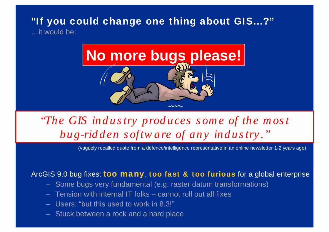
“If you could change one thing about GIS...?”…it would be:
ArcGIS 9.0 bug fixes: too many, too fast & too furious for a global enterprise– Some bugs very fundamental (e.g. raster datum transformations)– Tension with internal IT folks – cannot roll out all fixes– Users: “but this used to work in 8.3!”– Stuck between a rock and a hard place
No more bugs please!
“The GIS industry produces some of the mostbug-ridden software of any industry.”
(vaguely recalled quote from a defence/intelligence representative in an online newsletter 1-2 years ago)

If you want your GIS to fly……everything must work all the time
Not piece-meal delivery!

Lessons
Leading edge not bleeding edge
– Our office with the least technical issues is in Damaskus, Syria: US Export controls prevent the bleeding edge from entering!
Welcome: The ESRI strategy on future software development– Less new stuff but improved existing software
Global enterprise deployment is a powerful weapon – handle with care
– Faster benefits but also faster screw-ups!
Users: Educate, Educate, Educate– An MXD with 100 layers from 50 servers is not a good idea!
– Each ArcGIS release needs proper training plan

Some of our issues
• Keeping up with application versioning & people’s technical skills in the global enterprise – the total ESRI suite is very rich & still expanding
• Global corporate standards vs local needs: Control vs freedom (IT vs GIS)
• Increasing no. of dependencies to track with each new GIS product release
• Spending too much time still on tools and IT issues, not enough on GIS itself
• Increasing no. of petroleum vendors provide their own GIS interfaceswith their products integrate, duplicate, interoperate or kill?
• End users should set the pace of change but too often still it’s IT setting it
• GIS performance in a global IT network: a bit like Blind Men and the Elephant

User environment, architecture & support
Enterprise rollout: successes, issues, lessons
Trends, work in progress
Road ahead, future opportunities

GIS delivery improvementsGlobal standard workflow & replication architecture
Master Regional project data
Master Globalcorporate data= Master Regional
project data
Copy Global (R/O)corporate data=
Thin clients(Citrix, Web)
Thick clients(ArcGIS Desktop)
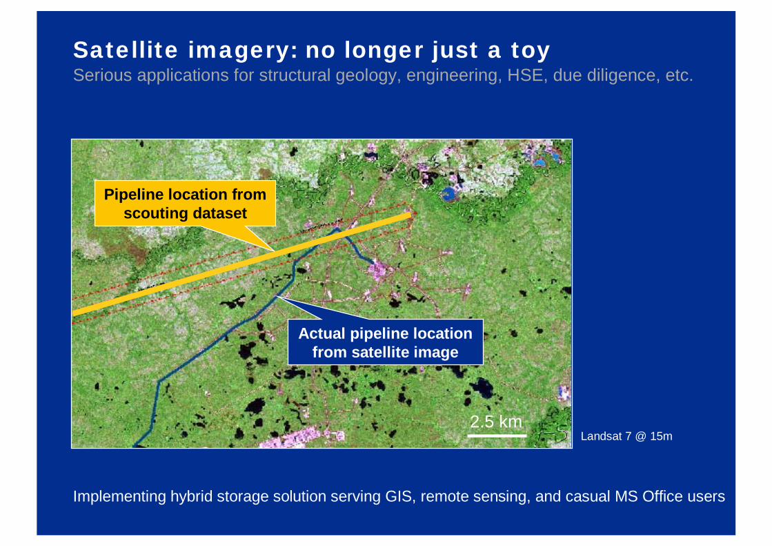
Satellite imagery: no longer just a toySerious applications for structural geology, engineering, HSE, due diligence, etc.
Implementing hybrid storage solution serving GIS, remote sensing, and casual MS Office users
Actual pipeline locationfrom satellite image
Pipeline location from scouting dataset
Landsat 7 @ 15m2.5 km

More integration required with other systemsWeb portals, geoscience applications
Turns web-enabled GIS intoa spatial search engine
Integration between desktop apps- OpenSpirit?- ArcGIS Interop Extension?
e.g. Petrel reservoir modelling ArcGIS Desktop
?

More interoperability also poses more risks…Geodetic coordinate integrity!
To prevent e.g.
• drilling in wrong place due to wrong map datum…
• dropping rig anchor in wrong place onto a pipeline or telecoms cable…• misinterpreting legal licence boundary…
• etc.
causing $100s millions of damage!!
Pan-applicationcoordinate
integrity

ArcGIS: custom datum validation toolDeveloped by Woodside/Shell
For each layer checks PRJ information against list of pre-defined (EPSG) CRS systems

Standards still an issueNot-invented-here syndrome slowly making way to industry standards, e.g. APDM

Portals & all that high-tech are great…But basic ArcGIS cartography is still hardcore business
Nothing beats a beautifully crafted paper map- Bespoke craftmanship by professionals

User environment, architecture & support
Enterprise rollout: successes, issues, lessons
Trends, work in progress
Road ahead, future opportunities

High level integrated business architectureMetadata & catalogs make retrieval predictable, reliable, relevant
Find &Retrieve
UserApplicationinterfaces
CorporateMemory
Documents(Livelink EDMS)
Library Records(incl. hardcopies)
A B
C
Federated DBs(joint-up business net)
Federated GIS DBs(joined-up GIS net)
Imagery(Satellite, Grids)
Business Catalog(Central Asset Register)
GIS Catalog(Metadata per layer)
Search (spatial, text, natural language)
Geoparsing&Geocoding
Browse (folders, categories)
Specialist Apps(Business/GeoScience)
Corportal Portal(User-customisable)
GIS(ArcGIS Desktop)
Internet (search, trade journals,
hosted services)
www
‘Light’ users Power Users

Corporate portalUser DIY – choose from 300 pre-configured windows in SAP Portal:
Pass GIS query attributes to intranet
& internet search
My page
World clock
World news
Domain discussionforum
Internalannouncements
Corporate A-Z
GIS legend

Seamless web text search for GIS featuresSimplicity is speed & power
East African eco-regionsCompetitive
intelligence hotspot
Click on any GIS feature & attribute
Dig deeper instantly, internally & externally

Conclusion: Energy is foremost a spatial business
Proximity to infrastructure & markets
Location of retail sites
Geo-marketing
Distribution ofgeology / wind
Geographic restrictions (legal, environmental, physical)
GISGIS

are we keeping up?
Technology & expectations are moving fast…

Potential for E&P industry collaborationE.g. some of our top issues:
• GIS Integration with Petrel– Various options from OpenSpirit to ArcGIS Interoperability Extension
• GIS integration with SAP– Looking for real business cases, so far only 1 small pilot done
• Coordinate integrity across the subsurface application workflow
– EPSG based consistency, e.g. via generic engine or Safe FME extensions?
• Gridding with geological faults (3D/Spatial Analyst enhancements?)
– Crucial for increased GIS market share in petroleum

Thank you
Questions & feedback appreciated!