Aquastat - getting to grips with water information for ...€¦ · sensing, geographical...
12
IWG-Env, International Work Session on Water Statistics, Vienna, June 20-22 2005 AQUASTAT - GETTING TO GRIPS WITH WATER INFORMATION FOR AGRICULTURE 1 By Åse Eliasson, Jean-Marc Faurès, Karen Frenken, Jippe Hoogeveen 2 ABSTRACT: Initiated in 1993, AQUASTAT, which is FAO’s global information system on water and agriculture, consists mainly of a) systematic descriptions of the state of agricultural water management by country and region with focus on developing countries and countries in transition; b) up-to-date online data by country; c) digital geographical data on water resources and irrigation; d) specific studies such as the review of world water resources by country, the irrigation potential in Africa, projections of future agricultural water use and irrigation development, and contribution to the World Water Development Report. The current data and information on the AQUASTAT website have been acquired through extensive country surveys by continent. Country information is updated regularly. The surveys follow a standard methodology, which strongly involves national expertise. The surveys comprise a) country based reviews of existing literature; b) data and information collection by national resource person’s trough a detailed questionnaire; c) critical analysis, data processing, and standardization of information; d) preparation of country profiles and tables, which are submitted to national authorities for feedback and approval before being disseminated. Tools such as remote sensing, geographical information systems (GIS), and hydrological models are applied to estimate data for those variables for which very limited information is available and to provide spatial data. Further, a country water resource calculation framework has been developed and applied globally for consistent water resource assessments. The experience indicates the importance of systematic data and information collection and evaluation, harmonized definitions and classifications, associated metadata, support for evaluation in the database management system, website properties to guarantee quick and good access for all users, and collaboration with other institutes. Printed information still remains the major information source accessed for most of the developing countries. INTRODUCTION The need for comprehensive, reliable, and systematic information on the state of water resources and people’s access to and use of it has been recognized by international and national institutions as a tool for improving food security and access to water and sanitation. The targeted commitments and actions have been agreed upon at the Earth summit in Johannesburg 2002 and outlined in the Millennium Development Goals. Agriculture is the largest water user and as population grows the need for water in food production is increasing. Currently, one billion people in the world lack access to water for meeting basic needs for health, hygiene, and food, and thus they are short of capacity for development. It is in FAO’s mandate, as stated in Article 1 of its constitution, that “the Organization shall collect, analyze, interpret and disseminate information related to nutrition, food and agriculture”. Internet has become an important media for information dissemination and management, but other information media are just as important for FAO as internet is not accessible for many of the FAO targeted users (FAO, 2000a). As the information-rich countries are getting more and more information through the expansion of digital information the gap between the information-rich and the information-poor countries, i.e. the digital divide, is getting wider and wider. 1 This paper was originally prepared for the Sixth Water Information Summit, Delft, The Netherlands, 9-12 September 2003 2 Land and Water Development Division of the Food and Agriculture Organization of the United Nations (FAO), Rome, Italy 1
Transcript of Aquastat - getting to grips with water information for ...€¦ · sensing, geographical...
IWG-Env, International Work Session on Water Statistics, Vienna, June 20-22 2005
AQUASTAT - GETTING TO GRIPS WITH WATER INFORMATION FOR AGRICULTURE1
By Åse Eliasson, Jean-Marc Faurès, Karen Frenken, Jippe Hoogeveen2
ABSTRACT: Initiated in 1993, AQUASTAT, which is FAO’s global information system on water and agriculture, consists mainly of a) systematic descriptions of the state of agricultural water management by country and region with focus on developing countries and countries in transition; b) up-to-date online data by country; c) digital geographical data on water resources and irrigation; d) specific studies such as the review of world water resources by country, the irrigation potential in Africa, projections of future agricultural water use and irrigation development, and contribution to the World Water Development Report. The current data and information on the AQUASTAT website have been acquired through extensive country surveys by continent. Country information is updated regularly. The surveys follow a standard methodology, which strongly involves national expertise. The surveys comprise a) country based reviews of existing literature; b) data and information collection by national resource person’s trough a detailed questionnaire; c) critical analysis, data processing, and standardization of information; d) preparation of country profiles and tables, which are submitted to national authorities for feedback and approval before being disseminated. Tools such as remote sensing, geographical information systems (GIS), and hydrological models are applied to estimate data for those variables for which very limited information is available and to provide spatial data. Further, a country water resource calculation framework has been developed and applied globally for consistent water resource assessments. The experience indicates the importance of systematic data and information collection and evaluation, harmonized definitions and classifications, associated metadata, support for evaluation in the database management system, website properties to guarantee quick and good access for all users, and collaboration with other institutes. Printed information still remains the major information source accessed for most of the developing countries. INTRODUCTION The need for comprehensive, reliable, and systematic information on the state of water resources and people’s access to and use of it has been recognized by international and national institutions as a tool for improving food security and access to water and sanitation. The targeted commitments and actions have been agreed upon at the Earth summit in Johannesburg 2002 and outlined in the Millennium Development Goals. Agriculture is the largest water user and as population grows the need for water in food production is increasing. Currently, one billion people in the world lack access to water for meeting basic needs for health, hygiene, and food, and thus they are short of capacity for development. It is in FAO’s mandate, as stated in Article 1 of its constitution, that “the Organization shall collect, analyze, interpret and disseminate information related to nutrition, food and agriculture”. Internet has become an important media for information dissemination and management, but other information media are just as important for FAO as internet is not accessible for many of the FAO targeted users (FAO, 2000a). As the information-rich countries are getting more and more information through the expansion of digital information the gap between the information-rich and the information-poor countries, i.e. the digital divide, is getting wider and wider.
1 This paper was originally prepared for the Sixth Water Information Summit, Delft, The Netherlands, 9-12 September 2003 2 Land and Water Development Division of the Food and Agriculture Organization of the United Nations (FAO), Rome, Italy
1

AQUASTAT collects, analyzes, and disseminates data and information by country on water recourses and agricultural water use, targeted to users in international institutions, national governments and development agencies. Other examples of water information systems and portals in support of improved water resource management for poverty reduction, food security and human health on global level are the Development Gateway, a joint initiative by several organizations; the Knowledgebase, of the Dialogue on Water, Food and the Environment initiated by the Consultative Group on International Agricultural Research; the Integrated Water Resource Management Toolbox initiated by the Global Water Partnership; InterWATER coordinated by the IRC International Water and Sanitation Centre; the Sanitation-connection; UNEP freshwater portal; the UNESCO Water portal; and the World Water site, managed by the Pacific Institute (see internet addresses at the end of the article). A joint United Nations initiative with the aim to strive water crises is the World Water Assessment Programme, were FAO is one of the partners. One of its components is the World Water Development Report “Water for People, Water for Life”, which was presented at World Water Forum in March 2003 in Kyoto (WWAP, 2003). The report provides extensive analysis and facts of the world’s freshwater resources and its stewardship targeted for those involved in formulation and implementation of water-related policies and investments. However, the relation between water information, knowledge and decision-making for development is not that straight forward (Dean, 2000 and World Bank’s World Development Report, 1998/1999, 1999/2000). Parker (2000) also discussed this issue and illustrates the complexity by stating that “information is like water because:
it comes from many different sources it may be easy to obtain, or difficult before it can be used, it has to be collected, processed, stored and distributed it may be used for many different purposes it may be polluted through distortion or inaccuracy it may be lost through leakages it flows – but, unlike water, not of its own accord; the flow of information has to be
managed if it is to reach those who need it, when they need it” The aim of this article is to describe the FAO information systems relevant to water, and in particular AQUASTAT, and experience and lessons learned concerning information management. The paper addresses the following questions: Section 1, Water and food security: What is the role of agriculture in the global water resource scarcity picture? Section 2, FAO information systems: Which are the FAO information resources relevant to water? Section 3, AQUASTAT: How is information gathered in AQUASTAT and what are the products? Section 4, Experience and lessons learned: What are the experience and lessons learned on information management, and Section 5: Conclusions: Which are the conclusions and recommendations drawn? WATER AND FOOD SECURITY To reduce the water and food scarcity problem that especially many developing countries are facing, there is a need to produce more crop per drop, to ensure equitable access to water, and to conserve water quality. Irrigated agriculture is responsible for approximately 70 percent of all the freshwater withdrawn in the world, wile industry and domestic withdrawal represent approximately 20 and 10 percent, respectively. The daily drinking water needs, 2 to 4 litres,
2
IWG-Env, International Work Session on Water Statistics, Vienna, June 20-22 2005
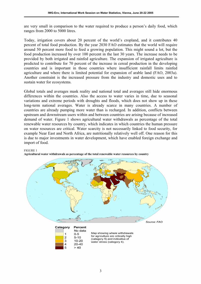
are very small in comparison to the water required to produce a person’s daily food, which ranges from 2000 to 5000 litres. Today, irrigation covers about 20 percent of the world’s cropland, and it contributes 40 percent of total food production. By the year 2030 FAO estimates that the world will require around 50 percent more food to feed a growing population. This might sound a lot, but the food production increased by over 100 percent in the last 30 years. The increase needs to be provided by both irrigated and rainfed agriculture. The expansion of irrigated agriculture is predicted to contribute for 70 percent of the increase in cereal production in the developing countries and is important in those countries where insufficient rainfall limits rainfed agriculture and where there is limited potential for expansion of arable land (FAO, 2003a). Another constraint is the increased pressure from the industry and domestic uses and to sustain water for ecosystems. Global totals and averages mask reality and national total and averages still hide enormous differences within the countries. Also the access to water varies in time, due to seasonal variations and extreme periods with droughts and floods, which does not show up in these long-term national averages. Water is already scarce in many countries. A number of countries are already pumping more water than is recharged. In addition, conflicts between upstream and downstream users within and between countries are arising because of increased demand of water. Figure 1 shows agricultural water withdrawals as percentage of the total renewable water resources by country, which indicates in which countries the human pressure on water resources are critical. Water scarcity is not necessarily linked to food security, for example Near East and North Africa, are nutritionally relatively well off. One reason for this is due to major investments in water development, which have enabled foreign exchange and import of food. FIGURE 1 Agricultural water withdrawals as percentage of the total renewable water resources by country
3

FAO INFORMATION SYSTEMS FAO is disseminating a range of products, such as publications, statistics and geographical data, through the internet, as printed publications and other information media. Table 1 describes a few selected information systems that are relevant for water management issues on global level. AQUASTAT To meet the demand for reliable and consistent global data and information on water and agriculture from international institutions, national governments, and development agencies the AQUASTAT programme is operated by the Water Resources, Development and Management Service of FAO. It was initiated in 1993 and was later shown to be one of the main accessed resources by users from various institution, and universities. In 2001, a critical review of outputs, tools, users, and user needs were carried out. Information needs and lacks were identified after which the methodology, dissemination, and management tools were improved. TABLE 1 Selected information systems at FAO relevant for water management on a regional and global scale (Internet addresses are provided at the end of the article)
Information system Description AQUASTAT Global information system of water and agriculture developed by the Land and Water Development
division. FAOSTAT On-line multilingual database currently containing over 1 million time-series records from over 210
countries and territories covering statistics on agriculture, nutrition, fisheries, forestry, food aid, land use and population. Data are also published on CD-rom and in FAO yearbooks. The data are collected on a yearly basis through the ministries in the respective countries. The database is arranged in 19 domains, such as agricultural production, trade, food aid, land use, and population.
FIGIS The Fisheries Global Information System is a global information system on fisheries aimed at providing policy makers with timely, reliable strategic information on fishery status and trends on a global scale.
FIVIMS The Food Insecurity and Vulnerability Information and Mapping Systems project contains a network of systems that assemble, analyze and disseminate information on the problem of food insecurity and vulnerability.
GEONETWORK The FAO portal to spatial data and information GIEWS The Global Information and Early Warning System on Food and Agriculture provides regular bulletins on
food outlook, food crops and shortages, food supply situation and crop prospects, weather and alerts on a regional or country-by-country basis.
GTOS The Global Terrestrial Observing System houses an international directory of sites and networks that carry out long-term terrestrial monitoring and research activities.
Waicent Infofinder The World Agricultural Information Centre portal improves access to agricultural information: essential documents, statistics, maps and multimedia resources
Water and food security country profiles
Information retrieval portal which groups the organization's vast archive of information on its global activities in agriculture and development in a single area and catalogues it exclusively by country.
Purpose The goal of AQUASTAT is to support agricultural and rural development by sustainable use of water and land by providing:
Systematic descriptions on the state of agricultural water management by country; Up-to-date and reliable data by country; Predictions of future agricultural water use and irrigation developments; In-depth analysis for diverse thematic studies, e.g. World Water Development Report,
Agriculture towards 2015/2030, and Global review of water resources by country; Methodologies and definitions for the water resource and irrigation sector; Answers to requests from governments, research institutes, non-governmental
organizations and individuals.
4

IWG-Env, International Work Session on Water Statistics, Vienna, June 20-22 2005
Methodology The information provided by AQUASTAT relies to a great extent on national capacities and expertise. The goal is to provide the most accurate information presented in a consistent and standard way. The core information has been acquired through extensive surveys covering Africa (1995 and 2003), the Near East (1996), the Countries of the former Soviet Union (1997), Asia (1998), and Latin America and the Caribbean (1999). Country profiles are to be updated regularly and currently the African countries are surveyed. The AQUASTAT information management process is illustrated in Figure 2 and comprises:
1) Review of literature and information on the country and the sub-country level; 2) Country surveys consisting of data collection and country description by means of a
detailed questionnaire were the source reference and comments are associated with each value, through national resource persons;
3) Critical analysis of information and data processing by the AQUASTAT team at FAO headquarters. Preference is given to national sources and expert knowledge. The data validation and processing is supported by the AQUASTAT database management system;
4) Modelling of data by means of GIS and water balance models for estimating unavailable data and for providing spatial data. GIS data and remote sense data are important input data together with the data acquired trough the country surveys, which are also used for calibration;
5) Standardization of information and data tables; 6) Feed back and approval from national authorities/institutions; 7) Dissemination on the web, as publications and/or as CD-rom; 8) Finally, voluntary feedback is acquired from users and through co-operation with other
institutions. FIGURE 2 The process through how information is gathered, analyzed, and provided in AQUASTAT
5
Country surveys
Dissemination - web, publications, CD-rom
← Water resource, irrigation master plans← National yearbooks, statistics, and reports← Expert information
→ Country profiles→ Data→ Spatial data→ Thematic studies
Literature review
Critical analysis and data processing – database management system
Standardisation
Feedback and approval from national authorities/institutions
Modelled data – GIS and remote sense data
Use
r fe
edba
ck

Water and agricultural information sources All the AQUASTAT products are available through the internet and as published reports or on CD-rom. For further information on the products and description of the methodologies the reader is referred to the AQUASTAT web site (http://www.fao.rg/ag/aquastat). Data Around 150 variables on water and agriculture by country can be accessed through the internet on the new AQUASTAT database query system (http://www.fao.org/ag/agl/aglw/aquastat/dbase/index.stm), which will also be made available on a CD-rom in the future. Data can be queried online or downloaded as a coma separated value file (CSV). The query allows for multiple selection options, were the user can a) select a country, a number of countries, or a continent, for b) one variable, a group of variables, or selected variables, for c) one time period or several time periods. Due to the problems of acquiring time-series data, one value for each five year period is aimed at for the moment. Data can be queried for every five year period back to 1965, but the time-series are far from complete. A complete time-serie of yearly values from 1961 exists only for the variable on irrigated land, which is made available through the FAOSTAT database, on the basis of the AQUASTAT data. To allow for further analysis the user can include the variable and country codes and define their own display of the data table in the AQUASTAT database. The variables are classified in the following main categories:
Land use and population Climate and water resources Water use, by sector and by source Irrigation and drainage development Environment and health
In addition, there are four separate databases on:
Addresses and links to around 300 institutions presented by country in the field of agricultural water resource management
(http://www.fao.org/ag/agl/aglw/aquastat/institutions/index.htm); Definitions for around 250 terms in the field of water resources and agricultural water
management terminology, including terminology, origin, comments, and typology in English, French, and Spanish (http://www.fao.org/ag/agl/aglw/aquastat/glossary/index.jsp);
Detailed calculations of renewable water resources for around 200 countries, including an inventory of reference sources (http://www.fao.org/ag/agl/aglw/aquastat/water_res/index.stm);
A geo-referenced database of large African dams holding information on, the year of completion, size, capacity, rate of sedimentation, and purpose of use of the dam (http://www.fao.org/ag/agl/aglw/aquastat/damsafrica/index.stm).
State of agricultural water management The country profiles and the regional overviews describe the state of agricultural water management for 150 developing countries and countries in transition and five regions in English, French or Spanish (FAO, 1995, 1997a and 1997b, 1999, 2000). The aims of the
6

IWG-Env, International Work Session on Water Statistics, Vienna, June 20-22 2005
country profiles are to describe the particularities in each country, problems encountered in rural water management and irrigation, and to summarize the perspectives in agricultural water management. Depending on the importance of irrigation in the country, size, and the amount of information available in the country the descriptions varies from three to ten pages. The country profiles have been standardized and cover the following areas: Geography, climate and population; economy, agriculture and food security, water resources and use; irrigation and drainage development; water management, policies and legislation related to water use in agriculture; environment and health; perspectives for agricultural water management. In addition, standardized tables holding key data are included in all the country profiles. Added value information on the key data is provided in the text profile, which allows for further description of the origin and particularities of the value. The regional overviews provide analysis by a grouping of countries which are similar in terms of geographic and socio-economic conditions, including tables and maps. Spatial data Several spatial datasets in ArcInfo or ASCII format, which can easily be imported to a GIS, are available and downloadable from the web (http://www.fao.org/ag/agl/aglw/aquastat/gis/index.stm). The digital spatial resources are mainly the global map of irrigated areas (http://www.fao.org/ag/agl/aglw/aquastat/irrigationmap/index.stm) and the atlas of water resources and irrigation for Africa (http://www.fao.org/ag/agl/aglw/aquastat/watresafrica/index.stm). The Global digital map of irrigated areas (Siebert et al, 2002) is an ASCII grid map with a resolution of 0.5 degree (about 50 km at the equator) showing the percentage of areas equipped for irrigation. The first global digital map of irrigated areas on the basis of cartographic information and FAO statistics was developed in 1999 by the Center for Environmental Systems Research of the University of Kassel (Döll and Siebert, 1999 and 2001). At present it is being further developed by the Hydrology Group of the Department of Physical Geography of the Johann Wolfgang Goethe University at Frankfurt, in cooperation with AQUASTAT, and several improvements in the last version 3.0 have been carried out. The methodology includes a variety of steps depending on the type of data available for the respective country and includes tools to allow for inclusion of new information and quick updates of the global map. First, the location of areas equipped for irrigation within each country is determined by digitizing irrigation maps and by mapping non spatial data sources such as databases and reports holding information on location and size of irrigation projects. Additional information such as interpreted satellite images and land cover datasets are used for identifying possible location of irrigated land. Then, the irrigation density is interpolated over a cell size of 0.01 degree (about 1 kilometre on the equator) making sure that sum of the total area equipped for irrigation corresponds to the total within a spatial unit, e.g. a country. Finally, the information is aggregated to a 0.5 degree raster. Initially the map was generated on a lower resolution and due to the methodology there is no uniform quality. The digital atlas of water resources and irrigation published on the internet and on a CD-rom (FAO, 2000) contains mainly a set of spatial data in ArcView format and tables on annual averages on water resources and water use by major river basins and sub-basins in Africa. Natural and actual water resources and runoff, actual evapotranspiration, and soil water
7

storage has been modeled for a 10 km spatial grid cell on monthly time steps by GIS in conjunction with a lumped, steady state, water balance model. The spatial input data includes, digital elevation model (USGS, 2000), precipitation (Leemans and Cramer, 1991), reference evapotranspiration, rivers, dams and waterbodies, soil moisture storage properties (FAO, 1998), and irrigation cropping pattern zones, which are all available for display and download on the web site. The model results was calibrated against (a) natural and actual annual water resources by country from the AQUASTAT data and (b) river runoff from major rivers by river basin from the global discharge database (UNESCO, 1995). The geographical modeling tool was initially developed with the technical assistance of the Center for Research in Water Resources of the University of Texas at Austin under the joint FAO/UNESCO project and the avenue script to be used in conjunction with ArcView, spatial analysts is available for users who which to modify the model for there own purposes. Thematic studies In depth studies based on the AQUASTAT information resources described above have been carried out for (a) irrigation potential in Africa, (b) global water resources by country, (c) Agriculture towards 2015/30, and (d) World Water Development Report, which are available as published reports and in html format. The study on “Irrigation potential in Africa, a basin approach” (FAO, 1997b) assesses the land and water that are available for irrigation development, by river basin. The approach is based on the physical constrains of land and water, including variations between wet and dry years, and highlights the environmental issues in relation to irrigation developments. The study is particularly useful for researchers and planners at national and regional levels working with sustainable water resources development in Africa. A “Review of the world water resources by country” (FAO, 2003) has been undertaken to improve the quality of the knowledge of the state of the world’s water resources. The study comprise (a) detailed data on internal and external generated surface and groundwater water resources in the country and its components, e.g. flow reserved by treaties, (b) the countries dependency on water from other countries, (c) calculation spreadsheet with rules and guidelines for accounting the water resources, and (d) regional overviews of the water resource situation. The methodology for assessing renewable water by country was first described by FAO/BRMG (1996) and is based on a water accounting approach. In the framework of the study “World Agriculture: towards 2015/2030” (FAO, 2002) AQUASTAT has assessed the present and future agricultural water use and irrigation efficiency. This publication is the latest FAO assessment on possible long-term developments in world food, nutrition, and agriculture, including forestry and fisheries. To provide a comparable coverage, were the data has been calculated in a uniform way, the current and future water use for agriculture has been estimated for 93 developing countries. The estimations are based on a spatial water balance calculation approach applying GIS in conjunction with a model for a 10 km spatial grid cell on monthly time steps (Faures et al, 2002). The main outputs of the study are an irrigation cropping calendar and irrigation water use per country for the year 2000. As part of the World Water Development Report, AQUASTAT has prepared the chapter on Agriculture, water, and food (FAO, 2003). The chapter addresses questions like: What is the
8

IWG-Env, International Work Session on Water Statistics, Vienna, June 20-22 2005
status of food production in the world? How can it be more efficient without compromising the environment? What is the connection between food security and poverty? EXPERIENCE AND LESSONS LEARNED The experience and lessons learned in global water information management shows the importance of national capacities, systematic data and information collection, harmonized definitions, metadata, support for data handling in the database management system, website properties, and lastly and not least, a good team. For acquiring reliable data and information the importance of cooperating with national resources persons working in the field of water and agriculture, with good networking capabilities, and sense of responsibility has shown to be vital. To be able to have access to and to collect information from various sources, and to discuss the contents with the people in the respective fields AQUASTAT is relying to a major extent on persons in the country and the collaboration with FAO country representatives and institutions. However, the previous country surveys in AQUASTAT has shown the difficulties in acquiring data on national and sub-national level for several variables, such as private irrigation, the use of groundwater, water use efficiency, cost of irrigation developments, area salinized by irrigation and water related diseases. Attempts have been made to collect data by river basin which has shown to be almost inexistent. Experience also shows that water-scarce countries have more reports describing the state of water use and water resources, but, often these analyses are based on a limited number of basic data and the computing methods behind vary from one country to another. In countries were water is abundant very limited information on irrigation and water resources is existing. Moreover, difficulties in acquiring data on natural river flows, i.e. without major water withdrawals for agriculture, has shown to be very difficult for the regions were water withdrawals for irrigation are significant since long times. To be able to provide comparable datasets and descriptions of agricultural water management by country it is important to critical analyze them and to standardize them. Variables on arable land, water resources, irrigation, and water withdrawal have different meanings from country to country and therefore imply major uncertainties when used for global analysis. In addition, when calculating transboundary water resources it is very important to apply the same rules based on physical approaches to ensure consistency between the countries and regions and to avoid double counting of water resources. Therefore it is important to have clear definitions, typologies, and calculation rules, which can be applied for different countries. The importance of associated metadata, i.e. bibliographical reference and comments associated with each value, has shown to be necessary when processing data. Each value in the AQUASTAT database is stored with a bibliographic reference, the actual source year of the value, and a comment. This is a way to keep track of the data and to select the most reliable information. This comment field provides added-value information, such as methodology used, uncertainty range, or expert opinion. The functions and support of the internal database management system has shown to be very import for secure handling and validation of data. The data collected are going trough a
9

critical review by the national resource person hired and the AQUASTAT Team, which is further supported by the database management system through a set of functions. Before data are uploaded to the query database they have to pass a set of actions, involving evaluation and calculation rules and relationships between the different variables to avoid non logical values. All the changes in the database are kept full record of in a journal history. The use of GIS, remote sensing, and models have proven to be a valuable tool for providing spatial data and making projections on key indicators. The availability of global quality spatial datasets on land cover and base data has made it possible to make predictive modelling studies for indicators such as river runoff, agricultural water withdrawal, and irrigated areas for those areas were data exist for calibration and evaluation. As water resources are not divided by administrative boundaries the use of GIS and models for processing data by river basin and or smaller spatial units are applied for water balance calculations, as described in the above chapter. The use of these tools and spatial data also provides a powerful instrument showing the degree of water stress by river basin, which illustrates were conflicts may arise due to the claim of water from different countries or areas. For information dissemination Internet has shown to be a quick and dynamic way of publication. To be able to guarantee quick access for as many internet users as possible the AQUASTAT website follows the World Wide Web consortium standards and the layout is made as simple as possible to enable quick loading times and printer friendly formats. The website is available in English, French, and Spanish and uses style sheets to allow for simple editing and coherent layout changes. Methodologies and descriptions of the information provided are all easily accessible in html format. The website has also shown to be an important media for feedback from users. However, information dissemination through the web is not the only media as the web site is difficult or even non accessible for many of the FAO targeted users. The digital divide between information-rich and information-poor countries is very much illustrated through the monitoring of the AQUASTAT users. For example the AQUASTAT website had in June 2003 around 850 hits per day, 70 visitors per day, were the number of users from Africa are less than one percent. CONCLUSION Agriculture will continue to be the main user of water and to ensure people’s access to water for food, health, and hygiene, investments are necessary. FAO is devoting considerable efforts in providing its users with access to information on the state of world agriculture, fisheries, forestry, nutrition and the environment to for agricultural and rural development, apart from the work on development assistance, advice to governments, and providing a neutral forum. Although, the access to information will not solve the goal of equitable and sustainable development, reliable and standardized information on key indicators is necessary to raise awareness and to support investments and cooperation for integrated water resource management. In doing so the importance of quality check, metadata, standardized information, and sharing of information has shown to be one of the requisites for the work of the AQUASTAT Team. In addition the dissemination and sharing of data and tools provides decision-makers, media, researches, non-governmental organizations etc. with information resources for improved water resource management. Finally, as the internet is not yet
10

IWG-Env, International Work Session on Water Statistics, Vienna, June 20-22 2005
accessible to all other information media such as printed information remains important along with strengthening of information and knowledge management capacities. REFERENCES Dean, J. 2000. The role of knowledge in development cooperation. Information Development 16 (4): 239-240. Döll. P. and Siebert, S. 2001. A digital global map of irrigated areas. - An update for Latin America and Europe.
Kassel World Water Series. Report Number 4. Center for Environmental Systems Research, University of Kassel, Germany.
FAO. 1995. Irrigation in Africa region in Figures. FAO Water Report 7. Rome. FAO. 1997a. Irrigation in the Near East region in Figures. FAO Water Report 9. Rome. FAO. 1997b. Irrigation in the countries of the Former Soviet Union in Figures. FAO Water Report 15. Rome. FAO. 1997c. Irrigation potential in Africa - a basin approach. FAO Land and Water Bulletin 4. Rome. FAO. 1998. Digital soil of the world and derived soil properties. FAO Land and Water Digital Media Series 1.
Rome. FAO. 1999. Irrigation in Asia in Figures. FAO Water Report 18. Rome. FAO. 2000a. 1st consultation on agricultural information management, working document, Rome 5-7th June
2000, Improving access to Agricultural information. FAO. 2000b. Irrigation in Latin America and the Caribbean in Figures, FAO Water Report 20. Rome. FAO. 2000c. Atlas of water resources and irrigation. Land and Water Digital Media Series 13. FAO. Rome. FAO. 2002. The state of food insecurity in the world. FAO. Rome. FAO. 2003a. World agriculture: towards 2015/2030, an FAO perspective. Editor: Bruinsma, J. Earthscan
Publications Ltd. FAO. 2003b. Review of world water resources by country. FAO Water Report 23. Rome. FAO. 2003c. Agriculture, food and water. Rome. FAO/BRMG, 1996. Les ressources en eau, manuels et méthodes. FAO. Rome. Faurès, J., Hoogeveen, J. and Bruinsma, J. 2000. The FAO irrigated area forecast for 2030. FAO. Rome. Leemans, R. and Cramer, W. 1991. The IIASA database for mean monthly values of temperature, precipitation
and cloudiness on a global terrestrial grid. Research Report RR-91-18. November 1991. International Institute of Applied Systems Analysis, Laxenburg, Austria.
Parker, S., 2000. Knowledge is like light - Information is like water. Information Development 16(4): 233-238. Siebert, S. and P. Döll. 1999. A digital global map of irrigated areas, Kassel World Water Series. Report Number
1, Center for Environmental Systems Research, University of Kassel, Germany. Stefan, S., Döll, P., and Hoogeveen, J., 2002. Global map of irrigated areas version 2.1. Center for
Environmental Systems Research, University of Kassel, Germany/Food and Agriculture Organization of the United Nations, Rome, Italy.
UNESCO, 1995. Discharge of selected rivers of Africa. Studies and Reports in Hydrology 52. UNESCO Publishing, Paris.
USGS, 2000. HYDRO1k geographic database, developed by the US Geological Survey's EROS Data Center in cooperation with UNEP/GRID Sioux Falls.
World Bank. World Development Report 1999/2000: entering the 21st Century: the changing development landscape.
World Bank. World Development Report 1998/1999: knowledge for development. Published for the World Bank by Oxford University Press, 1998.
WWAP, 2003. World Water Development Report, Water for people, water for life. UNESCO Publishing and Bergham books.
11

12
INTERNET ADDRESSES AQUASTAT: http://www.fao.org/ag/aquastat Development Gateway: http://www.developmentgateway.org/ FAOSTAT: http://apps.fao.org/default.htm FIGIS: http://www.fao.org/fi/figis/ FIVIMS: http://www.fivims.net GEONETWORK: http://www.fao.org/geonetwork GIEWS: http://www.fao.org/giews/ GTOS: http://www.fao.org/gtos/ Knowledgebase: http://www.iwmi.cgiar.org/dialogue/ Integrated Water Resource Management Toolbox: http://www.gwpforum.org InterWATER: http://www.irc.nl/interwater/ Sanitation-connection: http://www.sanicon.net/ UNEP Freshwater Portal: http://freshwater.unep.net UNESCO Water Portal: http://www.unesco.org/water/ Water and Food Security Country Profiles: http://www.fao.org/countryprofiles/water/ Waicent InfoFinder: http://www.fao.org/waicent/search/ World Water Site: http://www.worldwater.org