REDD+ Benefit-Sharing Mechanisms: Comparison of Three National Policy Approaches
Approaches for Data Sharing:Science in the Great Lakes (SiGL) Mapper
Lake Superior Environmental Monitoring Collaborative
March 19-20, 2015
Houghton, Michigan

GLRI Data Delivery Overarching Goal
To create a publicly accessible data network that:
• Seamlessly provides efficient discovery of and accessto multi-disciplinary monitoring data sets to advance Great Lake science
• Enables policy makers to plan and evaluate restoration activities
• Provides flexible products that can accommodate the community’s changing needs and integrate with other Great Lakes data applications

Purpose of the SiGL Mapper
• Supports strategic Great Lakes data collection and analysis
– Increases access and visibility of existing efforts
– Identifies areas and topics that need more study
– Allows future projects to build on existing data
• Captures and displays spatial data component
– Those without GIS capabilities can display monitoring locations
• Built for both large and small datasets
– Connects with large, enterprise data repositories
– Captures smaller datasets that aren’t documented using current metadata standards or may not have access to online data hosting

Data vs. Metadata
Your science produces data: measurements, values, statistics, results, analysis, etc.
SiGL collects metadata: information about your data
• Project information
– Who, what, where, when, why?
– Contact/PI details
– Publications
• Data information
– Sources (what data exists and where it’s stored)
– Site information (what, where, when, and how data was collected)

Science in the Great Lakes (SiGL) mapper
wim.usgs.gov/SiGL

Searchable data
Search SITES Search PROJECTS

SiGL pop-up: Project information
Information available in SiGL
Displays vital information about the project, including the organizations involved and custom descriptions
Shows if data and publications are available and where to get them
Lists who to contact for more information
Links out to project websites
Links out data sources, online applications, and publications
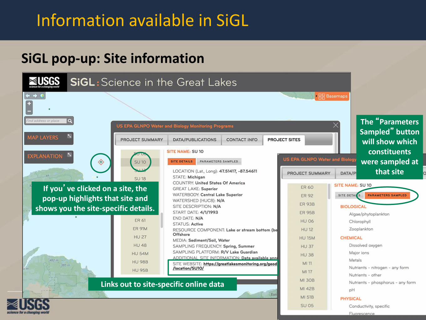
SiGL pop-up: Site information
Information available in SiGL
If you’ve clicked on a site, the pop-up highlights that site and
shows you the site-specific details.
The “Parameters Sampled” button will show which
constituents were sampled at
that site
Links out to site-specific online data

How to submit data to SiGL
OPTION 1 – SiGL Data Management System (DMS)
•New online tool
•Add, edit, and update your projects
•You maintain control of your own data
Your account is pre-populated with your projects
Add project information, data sources, contacts,
publications, and sites at any time

How to submit data to SiGL
OPTION 2 – submit site information via excel spreadsheet
•Best for large numbers of sites
•Links to existing project in SiGL DMS
•Optionally can be used to add sites to existing project information entered through SiGL DMS

Future development plans
SiGL functionality:
•Search results will display in list form, allowing projects without sites to be searchable
•Improve selection ability for overlaying sites
•Expand database to allow line and polygon spatial features
•Download a project’s information and export your search results
•Improved integration with other Great Lakes data products, especially greatlakesmonitoring.org
•Enhance and expand additional data layers
Form SiGL user group:
•Representatives from a variety of organizations and disciplines
•Will help guide SiGL development, identify priorities, and keep system content relevant and consistent
•Once assembled, the user group will undertake a rigorous review of SiGL fields and parameters (ex. PCBs)

Contact SiGL
John Walker, USGS Wisconsin Water Science CenterCenter [email protected]
Jen Bruce, USGS Wisconsin Water Science CenterSiGL mapper project [email protected]

[SiGL Mapper demo]

greatlakesmonitoring.org team
• EPA-GLNPO – Paul Horvatin, MIRB Branch Chief– Program leads – Eric Osantowski and Glenn Warren,
Limnology; Beth Murphy Fish Monitoring; Todd Nettesheim, IADN
• NCSA – Developers: Luigi Marini, Barbara Minsker, Nick
Tenczar, Rob Kooper, Brock Angelo, Eugene Roeder– Designer – Lisa Gatzke
• IL – IN Sea Grant – Brian Miller, Kristin Tepas


glm demo

Future steps
• Increase flexibility of data views
• Identify data sets for ingestion:
– USGS stream gauges
– NOAA buoy data
– STORET
• Additional data views:
– GLNPO Biology program

August crustacean zooplankton biomassStation SU 10, 1997-2011153 um mesh, 100 m tows
Year
1998 2000 2002 2004 2006 2008 2010
Biom
ass
(mg/
m3 )
0
5
10
15
20Non-daphnid cladoceransDaphniaPredatory cladoceransCyclopoid copepoditesCyclopoid adultsCalanoid copepoditesCalanoid adults

Future steps
• Identify data sets for ingestion:
– USGS stream gauges
– NOAA buoy data
– STORET
• Additional data views:
– GLNPO Biology program
– Triaxus and D.O. program

Night Transects
Temperature
Oxygen Saturation (%)
Fluoroprobe (Total Pigment)
OPC Biomass
Transect 2 (West)Transect 3 (Central)Transect 5 (East)


gltg demo

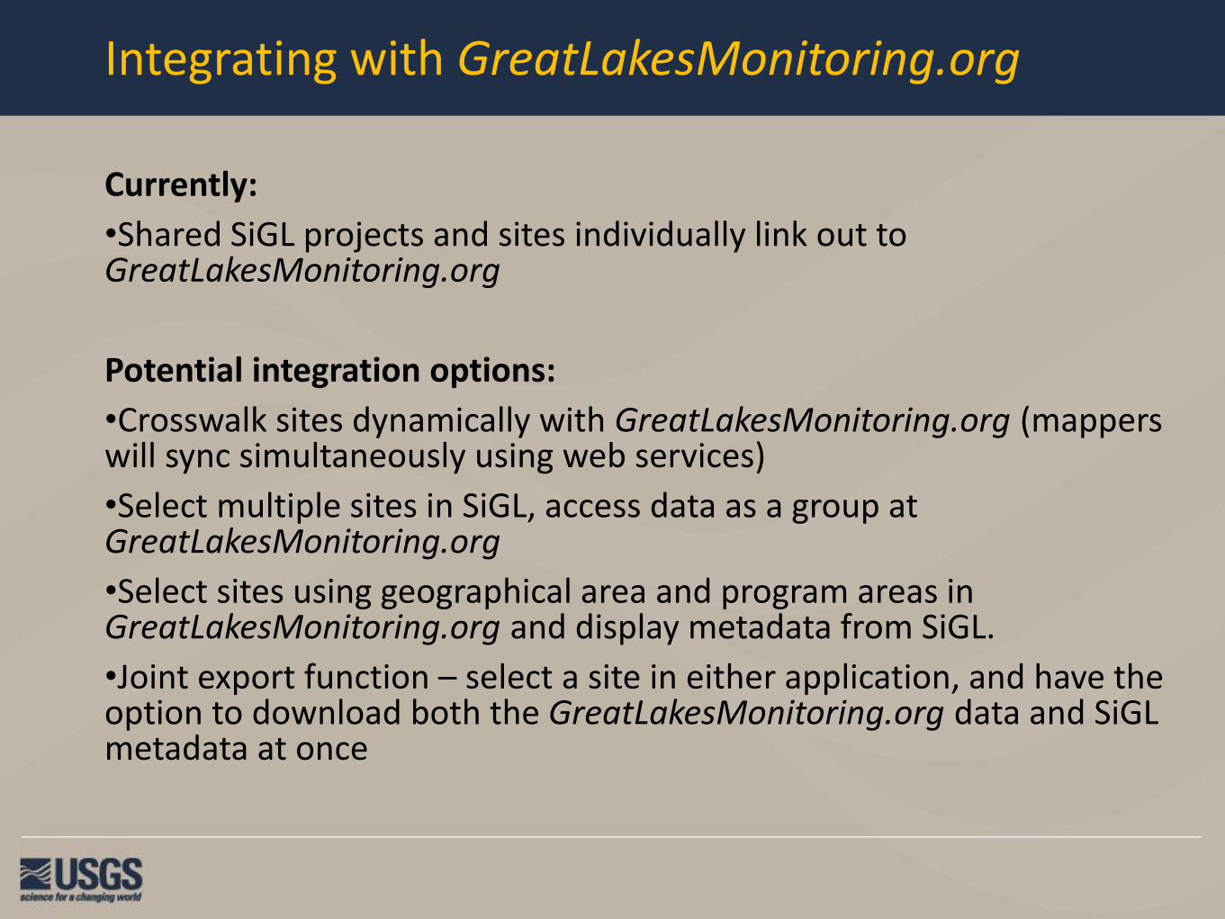
Integrating with GreatLakesMonitoring.org
Currently:
•Shared SiGL projects and sites individually link out to GreatLakesMonitoring.org
Potential integration options:
•Crosswalk sites dynamically with GreatLakesMonitoring.org (mappers will sync simultaneously using web services)
•Select multiple sites in SiGL, access data as a group at GreatLakesMonitoring.org
•Select sites using geographical area and program areas in GreatLakesMonitoring.org and display metadata from SiGL.
•Joint export function – select a site in either application, and have the option to download both the GreatLakesMonitoring.org data and SiGL metadata at once

[SiGL DMS demo]