Applications of GPS in Meteorology OUTLINE Overview - GPS.gov
12
Applications of GPS in Meteorology by Professor Steven Businger University of Hawaii [email protected] CGSIC Regional Meeting Honolulu, Hawaii, June 23 – 24, 2009 GPS Satellite 1 OUTLINE • Brief Review of GPS Meteorology • Space-Based GPS Meteorology (COSMIC) – Atmospheric profiles • Earth-Based GPS Meteorology – Integrated Precipitable Water Vapor (IPV) 2 One Person’s Noise is Another’s Signal • GPS signals are slowed and refracted as they pass through the Earth’s atmosphere. • Measurement of the bending angle produced by atmospheric refraction provides the observable that is the basis of space-based GPS meteorology. • Resolving the delay of GPS signals by the atmosphere using the most accurate geodetic receivers provides the observable that is the basis for ground-based GPS meteorology. • Water vapor’s permanent dipole moment provides a unique delay in the GPS signal that can be isolated. 3 GPS Meteorology Space-Based Occultation Measures bending angle from Low Earth Orbit (LEO) satellites with near-global coverage Provides profiles of integrated refractive index (~ 1km x 300km) Integrated Precipitable Water Vapor Gives total precipitable water vapor directly above site Slant-Path Signal Delay Gives line-of-sight signal delay to each satellite in view Measures signal delay from fixed point on ground. Ground Based Overview of GPS Meteorology One Person’s Noise is Another’s Signal 4
Transcript of Applications of GPS in Meteorology OUTLINE Overview - GPS.gov

Applications of GPS in Meteorologyby
Professor Steven BusingerUniversity of Hawaii
CGSIC Regional MeetingHonolulu, Hawaii, June 23 – 24, 2009
GPS Satellite
1
OUTLINE
• Brief Review of GPS
Meteorology
• Space-Based GPS
Meteorology (COSMIC)
– Atmospheric profiles
• Earth-Based GPS
Meteorology
– Integrated
Precipitable Water
Vapor (IPV)
2
One Person’s Noise is Another’s Signal
• GPS signals are slowed and refracted as they pass
through the Earth’s atmosphere.
• Measurement of the bending angle produced by
atmospheric refraction provides the observable that is
the basis of space-based GPS meteorology.
• Resolving the delay of GPS signals by the atmosphere
using the most accurate geodetic receivers provides
the observable that is the basis for ground-based GPS
meteorology.
• Water vapor’s permanent dipole moment provides a
unique delay in the GPS signal that can be isolated.
3
GPS
Meteorology
Space-Based
Occultation
Measures bending angle
from Low Earth Orbit
(LEO) satellites with
near-global coverage
Provides profiles of
integrated refractive
index (~ 1km x 300km)
Integrated
Precipitable
Water Vapor
Gives total
precipitable water
vapor directly above
site
Slant-Path
Signal Delay
Gives line-of-sight
signal delay to each
satellite in view
Ground
Based
Measures signal
delay from fixed
point on ground.
Ground
Based
Overview of GPS Meteorology
One Person’s Noise is Another’s Signal
4
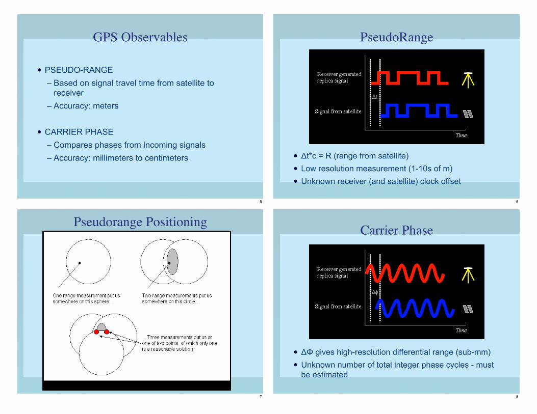
GPS Observables
• PSEUDO-RANGE
– Based on signal travel time from satellite to receiver
– Accuracy: meters
• CARRIER PHASE
– Compares phases from incoming signals
– Accuracy: millimeters to centimeters
5
PseudoRange
• !t*c = R (range from satellite)
• Low resolution measurement (1-10s of m)
• Unknown receiver (and satellite) clock offset
6
Pseudorange Positioning
7
Carrier Phase
• !" gives high-resolution differential range (sub-mm)
• Unknown number of total integer phase cycles - must
be estimated
8

GPS Positioning Environmental Error Sources
• Ionospheric Delay
– Mitigated by dual-frequencies
• Multipath
– Mitigated by choke-ring antenna
• Solar activity
– Mitigated by higher power signal/signal-tracking
• Troposphere
– Basis for GPS meteorology
9
LEO
The COSMIC SystemConstellation Observing System for Meteorology Ionosphere and Climate
Six Low-Earth Orbit (LEO) micro satellites were
launched on one rocket on 15 April 2006.
10
COSMIC System
• Three instruments: GPS receiver, TIP (tiny ionospheric
photometer), Tri-band beacon
• Global observations of
– Refractivity
– Pressure, Temperature, Humidity
– Ionospheric Electron Density
– Ionospheric Scintillation
• Operational GPS limb sounding with global coverage in near-real time
• Climate Monitoring
11
Color represents lowest height
of vertical sounding profiles
FORMOSAT-3/COSMIC Daily Soundings
12

One-Day of COSMIC Soundings
January 29, 2007
13
2006-08-27-12Z (102h forecast)GPS all No GPS
Sat. IR
Impact of COSMIC on Forecast
of Hurricane Ernesto (2006)
14
Tem
per
atu
re
Time in Years
Mission 1 Mission 2
Past Satellite Climate Missions
Offsets between missions and Temperature Drift
Mission 3
15
Radio Occultation 1 Radio Occultation 2 Radio Occultation 3
Tem
per
atu
re
Time in Years
GPS Satellite Climate Missions
No offset between missions and Temperature Drift
16

COSMIC Summary and Conclusions
• First constellation of microsatellites to observe Earth
atmosphere and ionosphere
• New cost effective paradigm for making observations of
Earth atmosphere from space
• First demonstration of radio occultation soundings of
pressure, temperature, and water vapor, with global
coverage in near real time — for testing in weather models
• Unprecedented capability to measure atmospheric structure
from 25 miles to surface in all weather (sees through
clouds)
17
• World’s most accurate, precise and stable thermometer for
climate monitoring
• First satellite system to observe Earth’s boundary layer
(lowest mile of atmosphere above ground; important for
weather forecasting and climate research)
• First global observations of ionospheric electron density in
near real time – for monitoring space weather
• International cooperation; free and open sharing of data for
benefit of all the world’s people
COSMIC Summary and Conclusions
18
Earth-Based GPS Met
19
Earth-based GPS Meteorolgy
• Special Role of Water Vapor
• National GPS IPW Network
• Some GPS-IPW applications
20

Role of Water Vapor in Weather
• The distribution of water vapor is highly variable
and is not dynamically linked with temperature and
pressure.
• Very large latent heat is released with condensation
and deposition with immediate dynamic impact.
• Water vapor is under observed in time and space,
especially during active weather when the information
is needed most.
21
Role of Water Vapor in Climate
• It is the most plentiful greenhouse gas. !
• Effects the formation of clouds, aerosols, atmospheric
electricity, and the chemistry of the lower atmosphere.
• In turn, clouds absorb and reflect energy from the sun.
• Multi-year climate changes are linked to large
changes in SST and water vapor in the tropical
Pacific associated with the El Niño-Southern
Oscillation.
22
Structure of the GPS signal delay
TOTALATMOSPHERICDELAY
IONOSPHERICDELAY
NEUTRALDELAY
WETDELAY
HYDROSTATICDELAY
PW = ! • ZWD
where ! = f (physical constants, Tm)
Estimate from dual frequency observations
and known dispersion relations
Estimate during
geodetic inversion
Estimate from surfacepressure measurement
Wet = neutral - hydrostatic
Wet delay is nearly proportional to PW
23
24

IMPACT OF
HYDROSTATIC
DELAY
25
GPS IPW APPLICATIONS
USING TIME-SERIES DATA
• Numerical Weather Prediction
• Predict Lightning
• Predict Flash Flooding
• Predict Fog Formation
• Calibrate Satellite IPW Algorithms
26
GPS IPWV TIME SERIES
Integrated precipitable water vapor at Purcell,
Oklahoma from 16 to 30 May 1993.
27
GPS IPWV TIME SERIES
Hurricane Georges, September 1998
28
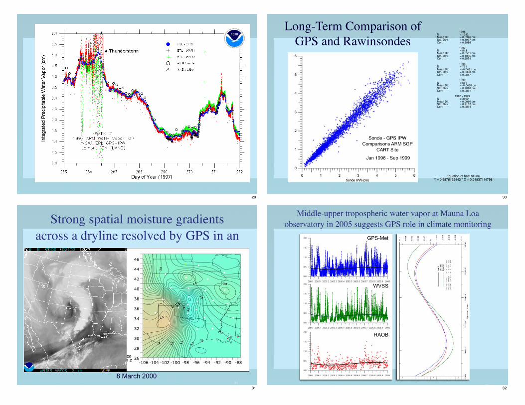
29
1996N! = 1382Mean Dif.! = 0.0346 cmStd. Dev.! = 0.1977 cmCorr.! = 0.9886
1997N! = 813Mean Dif.! = 0.0501 cmStd. Dev.! = 0.1965 cmCorr.! = 0.9874
1998N! = 771Mean Dif.! = -0.0431 cmStd. Dev.! = 0.2308 cmCorr.! = 0.9817
1999N! = 551Mean Dif.! = -0.0460 cmStd. Dev.! = 0.2070 cmCorr.! = 0.9851
1996 - 1999N! = 3600Mean Dif.! = 0.0080 cmStd. Dev. ! = 0.2102 cmCorr. ! = 0.9854
Equation of best fit lineY = 0.9876125443 * X + 0.01837114798
Sonde - GPS IPW
Comparisons ARM SGP
CART Site
Jan 1996 - Sep 1999
Long-Term Comparison of
GPS and Rawinsondes
30
31
8 March 2000
Strong spatial moisture gradients
across a dryline resolved by GPS in an
31
32
GPS-Met
WVSS
RAOB
Middle-upper tropospheric water vapor at Mauna Loa
observatory in 2005 suggests GPS role in climate monitoring
32
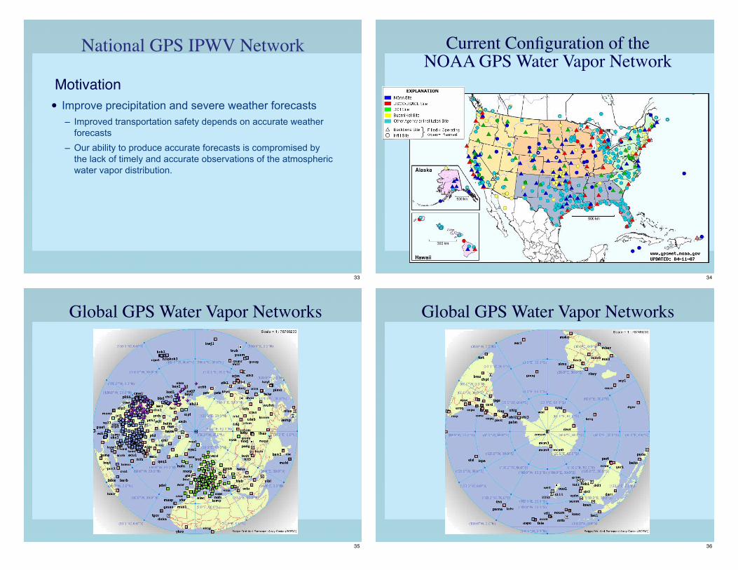
National GPS IPWV Network
• Improve precipitation and severe weather forecasts
– Improved transportation safety depends on accurate weather
forecasts
– Our ability to produce accurate forecasts is compromised by
the lack of timely and accurate observations of the atmospheric
water vapor distribution.
Motivation
33
Current Configuration of the NOAA GPS Water Vapor Network
34
Global GPS Water Vapor Networks
35
Global GPS Water Vapor Networks
36

GSOS Surface Met Sensors
Whitney, NEWinnfield, LA
37
NOAA Wind Profiler
Sites, Platteville, CO
(PLTC)
Other NOAA Sites
Blacksburg, VA WFO
(BLKV)
USCG and FHWA
NDGPS Sites
Clark, SD (CLK1)
Typical GPS Water Vapor Network Sites
38
39
Operational RUC
Research RUC
Transition to operations at NCEP in 2005
• Hourly assimilation of GPS into RUC, especially at asynoptic times, reduces model moisture bias; error by ~ 50%.
• 10% improvement in 3h RH forecasts below 500 hPa in Midwest (lower left); 6% over entire CONUS (lower right).
• Significant improvements in 3h CAPE forecast and skill scores (ETS) for heavy precipitation events are also observed.
39
Northeast Pacific Winter Storm 18-20 December 2002
Long-Range Lightning Detection
Made possible by GPS
40

Applications – Hurricanes
Hurricane Humberto – September 2007
41
Improving Weather Models
170°W 160° 150° 140°
30°N
20°
10°
1
2
3
4
27 km151 x 151
9 km82 x 100
3 km76 x 76
1 km55 x 55
A
B
1 2 3 4
Progressive grid density(shown here enlarged 10 times from fig A)
1. Collect Observations
2. Divide data onto a map.
3. Apply laws of air motion.
4. Visualize model
predictions on forecast
maps.
42
Improving Weather Models
1. Collect Observations
2. Divide data onto a map.
3. Apply laws of air motion.
4. Visualize model
predictions on forecast
maps.
43
Computer Model of Hawai’i’s Atmosphere
A high resolution model of
the atmosphere can
simulate the impact of the
Big Island on the wind field.
GPS Met data improves
these forecasts.
Custom forecasts available
for Hawaii at:http://weather.hawaii.edu
44

SUMMARY/CONCLUSIONS
• Ground-based GPS improves forecast accuracy,
especially under conditions of active weather when it is
most needed.
• The use of GPS for weather forecasting enhances the
value of federal (DoT, DoD, and NOAA) programs at little
or no additional cost. By leveraging the federal
investment in GPS, an IPW observing system can expand
quickly, at low cost and risk.
• As observation density increases, assimilation of slant
path data may provide 3-D distribution of water vapor.
• Many research opportunities exist for use of time series
IPW data to develop tools for forecast guidance.
45