APPLICATION OF GIS IN THE WASTEWATER MANAGEMENT
6
M. Jurišić, L. Tadić, T. Dadić Primjena GIS-a u gospodarenju otpadnim vodama ISSN 1330-3651(Print), ISSN 1848-6339 (Online) UDC/UDK 528.88:628.38 APPLICATION OF GIS IN THE WASTEWATER MANAGEMENT Tamara Dadić, Mladen Jurišić, Lidija Tadić Subject review This paper briefly describes the application of GIS in waste waters. It describes the major characteristics of GIS, as well as wastewater collection system and the reasons for the application of GIS in the analysis, modelling and display characteristics of drainage systems. There are described two programs based on GIS technology to analyse and monitor wastewater collection system. Also shown is the principle of selecting the location of device for purifying waste water, which is the ultimate element of the drainage system, using a GIS. In this way, it facilitated the process of selecting locations taking into account the various regulations, standards, as well as characteristics of the terrain and vegetation. GIS is used to monitor water quality even after treatment, which creates good conditions for its re-use. This was exemplified by the use of such treated water in irrigation and selection of suitable locations. Keywords: GIS, irrigation, site selection, sewage system, wastewater purifying device Primjena GIS-a u gospodarenju otpadnim vodama Pregledni članak U radu je ukratko opisana primjena GIS-a u gospodarenju otpadnim vodama. Navedene su glavne karakteristike GIS-a, kao i sustava odvodnje otpadnih voda te razlozi primjene GIS-a pri analizi, modeliranju i prikazu karakteristika sustava odvodnje. Detaljnije su opisana dva programa bazirana na GIS tehnologiji za analizu i monitoring sustava odvodnje otpadnih voda. Prikazan je i princip odabira lokacije uređaja za pročišćavanje otpadne vode, koji je krajnji element sustava odvodnje, pomoću GIS-a. Na taj je način olakšan sam postupak odabira lokacije uzimajući u obzir različite propise, standarde, kao i karakteristike okolnog terena i vegetacije. GIS omogućuje i praćenje kvalitete vode i nakon pročišćavanja čime se stvaraju dobri uvjeti za njeno ponovno korištenje. Naveden je primjer korištenja takve tretirane vode u navodnjavanju i odabiru prikladnih lokacija. Ključne riječi: GIS, navodnjavanje, odabir lokacija, sustav odvodnje otpadnih voda, uređaj za pročišćavanje otpadnih voda 1 Introduction GIS (geographical information system) represents a set of related objects and activities that serve with their mutual relations the general purpose which is decision making of spatial activities. It enables storage, processing, analysis, modelling and display of spatial data [1]. Precisely because of its wide range of features, this technology has great use in many areas. Due to strong spatial component, hydrotehnical systems are ideal for analysing using GIS. All the structures and systems, whether it is a water supply or wastewater drainage system or an irrigation one, are spatially located and have their own numerous characteristics. Their display and a systematic analysis greatly facilitate the application of GIS. Major role in such systems have hydrological data. The spatial distribution of such data, especially rainfall, is extremely important, so monitoring of such data by GIS is very practical. In the continuation, more detail application of GIS in the wastewater systems will be described. 2 Wastewater sewage system Wastewater is water with changed original composition by entering pollutants whose presence causes a change in the physical, chemical, biological or bacteriological characteristics of water [2]. Wastewaters are classified according to their origin to [3]: sanitary (sewage), industrial, drainage and wastewaters. This paper refers to sanitary wastewater and reuse of that water after treatment process. Sanitary wastewaters are drained by wastewater sewage system, and it is defined as a system of facilities and measures for the prompt removal of wastewater from settlements and their treatment before letting in receiver [3]. Wastewater sewage system (Fig. 1) consists of: − sewage network (primary and secondary), − structures of sewage network (pumping stations, input and switching shafts, overflow facilities), − wastewater treatment plant, − outlet. Figure 1 Wastewater sewage system [6] There are several types of sewage systems, but most common are mixed and separated systems. Mixed systems receive and drain rainfall and sanitary waters with one network, and the separated ones with separate networks drain rainfall and sanitary waters towards wastewater treatment plant and outlet. Whichever type of sewage system is concerned, these are extremely complex systems whose elements are interrelated and require regular maintenance. Functionality of sewage system depends entirely on the degree of interaction between system elements. In order to achieve optimal effects of the Tehnički vjesnik 21, 5(2014), 1159-1163 1159
Transcript of APPLICATION OF GIS IN THE WASTEWATER MANAGEMENT

M. Jurišić, L. Tadić, T. Dadić Primjena GIS-a u gospodarenju otpadnim vodama
ISSN 1330-3651(Print), ISSN 1848-6339 (Online) UDC/UDK 528.88:628.38
APPLICATION OF GIS IN THE WASTEWATER MANAGEMENT Tamara Dadić, Mladen Jurišić, Lidija Tadić
Subject review This paper briefly describes the application of GIS in waste waters. It describes the major characteristics of GIS, as well as wastewater collection system and the reasons for the application of GIS in the analysis, modelling and display characteristics of drainage systems. There are described two programs based on GIS technology to analyse and monitor wastewater collection system. Also shown is the principle of selecting the location of device for purifying waste water, which is the ultimate element of the drainage system, using a GIS. In this way, it facilitated the process of selecting locations taking into account the various regulations, standards, as well as characteristics of the terrain and vegetation. GIS is used to monitor water quality even after treatment, which creates good conditions for its re-use. This was exemplified by the use of such treated water in irrigation and selection of suitable locations. Keywords: GIS, irrigation, site selection, sewage system, wastewater purifying device Primjena GIS-a u gospodarenju otpadnim vodama
Pregledni članak U radu je ukratko opisana primjena GIS-a u gospodarenju otpadnim vodama. Navedene su glavne karakteristike GIS-a, kao i sustava odvodnje otpadnih voda te razlozi primjene GIS-a pri analizi, modeliranju i prikazu karakteristika sustava odvodnje. Detaljnije su opisana dva programa bazirana na GIS tehnologiji za analizu i monitoring sustava odvodnje otpadnih voda. Prikazan je i princip odabira lokacije uređaja za pročišćavanje otpadne vode, koji je krajnji element sustava odvodnje, pomoću GIS-a. Na taj je način olakšan sam postupak odabira lokacije uzimajući u obzir različite propise, standarde, kao i karakteristike okolnog terena i vegetacije. GIS omogućuje i praćenje kvalitete vode i nakon pročišćavanja čime se stvaraju dobri uvjeti za njeno ponovno korištenje. Naveden je primjer korištenja takve tretirane vode u navodnjavanju i odabiru prikladnih lokacija. Ključne riječi: GIS, navodnjavanje, odabir lokacija, sustav odvodnje otpadnih voda, uređaj za pročišćavanje otpadnih voda 1 Introduction
GIS (geographical information system) represents a set of related objects and activities that serve with their mutual relations the general purpose which is decision making of spatial activities. It enables storage, processing, analysis, modelling and display of spatial data [1]. Precisely because of its wide range of features, this technology has great use in many areas.
Due to strong spatial component, hydrotehnical systems are ideal for analysing using GIS. All the structures and systems, whether it is a water supply or wastewater drainage system or an irrigation one, are spatially located and have their own numerous characteristics. Their display and a systematic analysis greatly facilitate the application of GIS. Major role in such systems have hydrological data. The spatial distribution of such data, especially rainfall, is extremely important, so monitoring of such data by GIS is very practical. In the continuation, more detail application of GIS in the wastewater systems will be described.
2 Wastewater sewage system
Wastewater is water with changed original composition by entering pollutants whose presence causes a change in the physical, chemical, biological or bacteriological characteristics of water [2].
Wastewaters are classified according to their origin to [3]: sanitary (sewage), industrial, drainage and wastewaters.
This paper refers to sanitary wastewater and reuse of that water after treatment process. Sanitary wastewaters are drained by wastewater sewage system, and it is defined as a system of facilities and measures for the prompt removal of wastewater from settlements and their
treatment before letting in receiver [3]. Wastewater sewage system (Fig. 1) consists of: − sewage network (primary and secondary), − structures of sewage network (pumping stations,
input and switching shafts, overflow facilities), − wastewater treatment plant, − outlet.
Figure 1 Wastewater sewage system [6]
There are several types of sewage systems, but most
common are mixed and separated systems. Mixed systems receive and drain rainfall and sanitary waters with one network, and the separated ones with separate networks drain rainfall and sanitary waters towards wastewater treatment plant and outlet. Whichever type of sewage system is concerned, these are extremely complex systems whose elements are interrelated and require regular maintenance. Functionality of sewage system depends entirely on the degree of interaction between system elements. In order to achieve optimal effects of the
Tehnički vjesnik 21, 5(2014), 1159-1163 1159

Application of GIS in the wastewater management M. Jurišić, L. Tadić, T. Dadić
system, from a technical and economic point of view, it is necessary to define in detail all elements of the system and their roles. Newer sewage systems are extremely complex, and their operation and maintenance are more complex and more expensive [4]. 3 Application of GIS in wastewater sewage system
Data of the sewage network, which refer to the
location of pipelines and structures on the pipelines (manholes, hydrants, valves, gate valves ...) were stored at maps of different scales. Reading data from such maps required a lot of time, and sometimes it was not even possible to do so.
With increasing construction of sewage networks, a need appeared [5] for input and processing of quality data, which were gathered by field measurement or by geodetic surveys of a performed state.
Because of its complexity, increased development and highlithed spatial component, the GIS technology with its own characteristics (data visualization and connectivity of geographic and attribute features) fits very well into the monitoring and maintenance of the wastewater sewage system.
In order to build a GIS sewage system, the actual system information must be entered, that is, there must be a digital model of the system. All the elements of a system are spatially located and connected with attribute data that describe each element and its relationship with other elements of the system. All elements of the sewage system can be divided into spatial features: points, lines and areas. Pressurized pipelines, open and closed channels, etc. are represented with lines. They all have their own set of characteristics that are more or less independent. Audit shafts, drains, pumping stations, outlets belonging to nodal features and catchment areas, over which the quantity and distribution of rainfall enters the system, are areal features [6].
Connection between objects is achieved on the graphical and topological level. All system objects are associated with its graphics performance and connectivity to the topological level is achieved and stored as an attribute of each object. GIS model of sewage systems must have the following properties [6]: − graphical and geometrical presentation of data in 3D, − adding and modifying object properties, − connection of object in a topological level, − management and controlling system during operation.
The constant maintenance is an extremely important
component in order to help avoiding and correcting mistakes. Major role in this segment has the database and its ability to control and manage data. Some of these GIS based software for wastewater sewage systems are Bentley WasteWater and ProGIS. 3.1 Bentley WasteWater
Bentley Wastewater is the application for management of wastewater sewage systems. Functions such as mapping, design, maintenance and record keeping, are integrated in a spatial environment. This application enables creation of detailed models, either
separated or mixed sewage system, with an emphasis on connectivity of the entire network. This application combines functions of CAD platform and GIS capabilities which stress the spatial component of the system (Fig. 2). CAD background is reflected in the drawing of longitudinal and cross sections of pipes and manholes [7]. GIS environment allows the execution of different spatial and attribute queries, overlay data and various spatial analysis [6]. The main functions are: − creation of a physical data model, − data connection on the geometric and topological
level, − construction of topological network system, − changing the geometric and attribute properties, − basic hydraulic system analysis, − creation schemes and diagrams, − thematic representation of data, − storing videos, − exchange data with other platforms.
Figure 2 Bentley WasteWater application [7]
Access is provided to a wide range of aerial
photographs, satellite images, scanned maps and drawings allowing advanced visual information for the design and system analysis.
This type of management enables records of the actual condition of the properties of the system and provides data for hydraulic analysis and remediation, reconstruction and expansion of the system [6].
3.2 ProGIS
ProGIS is a system based on GIS technology, and is used for management and monitoring of wastewater sewage systems. It consists of three modules [8]: − longitude profiles, − optical inspection, − geodetical module.
Module longitudinal profile is for plotting, analysis
and exporting longitudinal profile of utility lines. The selected alignment in plan is automatically rendered as a longitudinal profile with all the accompanying data: altitude, drop, depth and height difference.
1160 Technical Gazette 21, 5(2014), 1159-1163
M. Jurišić, L. Tadić, T. Dadić Primjena GIS-a u gospodarenju otpadnim vodama
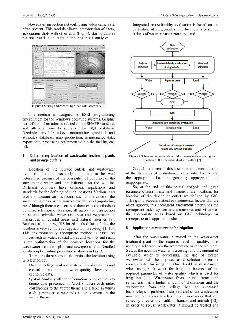
Nowadays, inspection network using video cameras is often present. This module allows interpretation of shots, association shots with other data (Fig. 3), storing data in real space and an unlimited number of spatial analyses.
Figure 3 Storing and connecting video with other data [8]
This module is designed in ESRI programming
environment for the Windows operating systems. Graphic part of the information is related to the SHAPE standard, and attributes one to some of the SQL database. Geodetical module allows maintaining graphical and attributes database, map production, maintenance data, export data, processing equipment within the facility, etc. [8]. 4 Determining location of wastewater treatment plants
and sewage outfalls Location of the sewage outfall and wastewater
treatment plant is extremely important to be well determined because of the possibility of pollution of the surrounding water and the influence on the wildlife. Different countries have different regulations and standards for the defining of such locations. Various laws take into account various factors such as the value of the surrounding areas, water sources and the local population, etc. Although there are a series of theories and methods to optimize selection of location, all ignore the distribution of aquatic animals, water resources and vegetation of mangroves in coastal areas and natural reserves [9]. Because of this, new, GIS based method for defining the location is very suitable for application in ecology [1, 10]. This environmentally appropriate method is based on indices such as water, coastal zones and soil. Its end result is the optimization of the possible locations for the wastewater treatment plant and sewage outfalls. Detailed location optimization procedure is shown in Fig. 3.
There are three steps to determine the location using GIS technology: − Data collecting: land use, distribution of wetlands and
coastal aquatic animals, water quality, flows, socio-economic data,
− Spatial Analysis: all the information is converted into theme data processed in ArcGIS where each index corresponds to the vector theme and a table in which each parameter corresponds to an element in the vector theme.
− Integrated eco-suitability evaluation is based on the evaluation of single-index; the location is based on indices of water, riparian zone and land.
Figure 4 Schematic representation of the process of determining the
location of the treatment plant and outfall [9] Crucial parameter of this assessment is determination
of the standards of evaluation, divided into three levels: the appropriate location, generally appropriate and inappropriate.
So, at the end of this spatial analysis and given parameters, appropriate and inappropriate locations for location of the device or outlet are defined by GIS. Taking into account critical environmental factors that are often ignored, this ecological assessment determines the appropriate index system and determines and visualizes the appropriate areas based on GIS technology as appropriate or inappropriate sites.
5 Application of wastewater for irrigation
After the wastewater is treated in the wastewater
treatment plant to the required level of quality, it is usually discharged into the watercourse or other recipient. But, as the need for water is increasing, and the amount of available water is decreasing, the use of treated wastewater will be imposed as a solution to ensure enough water for irrigation. One should be very careful when using such water for irrigation because of the required parameter of water quality which is used for irrigation [11]. Wastewater from animal farms and settlements has a higher amount of phosphorus and the wastewater from the village has an expressed bacteriological problem. Industrial and urban wastewater may contain higher levels of toxic substances that can seriously threaten the health of humans and animals [12]. In order to re-use wastewater, it should be treated and
Tehnički vjesnik 21, 5(2014), 1159-1163 1161

Application of GIS in the wastewater management M. Jurišić, L. Tadić, T. Dadić
thoroughly analyzed. For this purpose, GIS is, like satetelite images, very useful for monitoring and analysis of water quality parameters [13].
These water quality parameters are changing in the space, depending on human activities. GIS enables their mapping and, as it is an information system based on spatial data processing, provides the basis for the rapid and reliable decisions. For this purpose, GIS serves as a tool for planning and management of the treated wastewater for irrigation. This can be achieved by classifying wastewater into several categories based on statistics and approach that is based on cluster that provides accurate information about the degree of pollution and water quality in each location. Information visualization using GIS can create thematic maps of the whole area [14].
To create GIS layers so that they represent the spatial statistical meetings, the following actions are required [14]: − map digitalization, − application of GPS, tracking, locating and referencing
the location in the observed system − system classification based on water quality, − connecting locations with segments which they
represent. In addition to monitoring and defining the quality of
wastewater, GIS is extremely useful for the selection of the location where such water can be used. Combining GIS and multi-criteria analysis, optimum location for the application of treated wastewater including the technical, economic, social and spatial characteristics, can be chosen [15].
GIS is often used as a tool for defining various suitable locations. It is very often used to determine the appropriate location of landfills [16 ÷ 22]. Its other applications: the determination of the most suitable location for the cultivation of shellfish [23 ÷ 25], determining the location for the wind farm [26], defining the optimal location for the construction of the shopping center [27], the selection of the most suitable location for ecotourism [28 ], site selection for artificial percolation [29], etc. For site selection for irrigation, except GIS technology, multicriteria analysis can be used. By combining these two methods, an innovative approach for the selection of suitable locations for irrigation with treated wastewater is obtained. Combinations of the two approaches are mentioned in [30, 31, 19, 18, 25], etc. This approach allows to take into account some other criteria, not just proximity of the potential sites. The methodology of this approach consists of the following steps [15]: − selection criteria, sub-criteria and constraints, − development of hierarchical structures for the
identification of priority (weight coefficients) using pairwise comparison matrices,
− extraction of geographic layers that correspond to each sub-criteria and limit using GIS,
− standardizing each sub-criteria in order to be able to combine and count the combined value of the decision,
− extraction of the most appropriate locations and their surfaces,
− application of sensitivity analysis to check the impact of weight coefficients to the results.
For this method of selecting the optimal locations,
data are required which can be obtained in municipalities and satellite images. Therefore it is suitable for use anywhere in the world, and with the upgrade can be used for the other use of treated wastewater [15].
6 Conclusion
GIS technology has tremendous applications in
wastewater management precisely because of the spatial component of the system. In this way, monitoring, analysis and display of all system components and water is enabled. There are already software packages based on GIS and CAD technology and they are designed for management of wastewater systems. Detailed analysis, entering a large database and its management, display by transverse and longitudinal profiles, monitoring, etc. is enabled by those software packages. Because of its characteristics, GIS can be used for location selection for wastewater treatment plant, as well as a location selection for the irrigation with the treated water, which emphasizes its use in combination with multicriteria analysis. Selection of such sites is largely based on environmental standards and the characteristics of the area, which then through GIS technologies are taken into account. These examples show the great contribution and shift which this technology and method for analysing and presenting data provide to the wastewater management. 7 References [1] Jurišić, M.; Plaščak, I. Geoinformacijski sustavi-GIS u
poljoprivredi i zaštiti okoliša. Poljoprivredni fakultet, Osijek, 2009.
[2] Komunalno društvo VODOVOD I KANALIZACIJA d.o.o. za vodoopskrbu i odvodnju Rijeka, URL: http://www.kdvik-rijeka.hr/default.asp?ru=114 (9.07.2012).
[3] Vuković, Ž. Osnove hidrotehnike, prvi dio, druga knjiga. Akvamarine d.o.o., Zagreb, 1994.
[4] Milićević, D.; Milenković, S.; Milićević, S. Water Distribution and Sewer System Modeling like Prereasons of Succesfull Reconstruction/Rehabilitation, BALWOIS, Ohrid, 2010.
[5] Sisački vodovod d.o.o. URL:http://www.sisackivodovod.hr/ index.php?option=com_content&view=article&id=68&Itemid=83 (10.07.2012.)
[6] Kolarek, M. Primjena GIS-a u sustavima odvodnje otpadnih voda. // Ekscentar. 12, (2010), pp. 78-81.
[7] Bentley, URL: http://www.bentley.com/en-US/Products/ Bentley+Wastewater/Product-Overview.htm, (9.07.2012.).
[8] Protok, URL:http://www.protok.com (20.07.2012.). [9] Zhao, Y. W.; Qin, Y.; Chen B.; Zhao X.; Li, Y.; Yin, X. A.;
Chen, G. Q. GIS-based optimization for the locations of sewage treatment plants and sewage outfalls - A case study of Nansha District in Guangzhou City, China. // Commnunications in Nonlinear Science and Numerical Simulations. 14, (2009), pp. 1746-1757.
[10] Kereković, D., Ur. GIS u Hrvatskoj // Ina-industrija nafte d.d.Sektor informatike, Zagreb, 1997.
[11] Ayers, R. S.; Westcot, D. W. Waterquality for agriculture // FAO irrigation and drainage paper. 29, (1989), Rev.1.
1162 Technical Gazette 21, 5(2014), 1159-1163

M. Jurišić, L. Tadić, T. Dadić Primjena GIS-a u gospodarenju otpadnim vodama
[12] ...: Načela dobre poljoprivredne prakse, Ministarstvo poljoprivrede, šumarstva i vodnog gospodarstva RH, Zagreb, 2009.
[13] Matĕjiček, L.; Benešová, L.; Tonika, J. Ecological modelling of nitrate pollution in small river basins by spreadsheets and GIS. // Ecological Modelling. 170, (2003), pp. 245-263.
[14] Shaban, M.; Urban, B.; Fasial, M. Detection and mapping of water pollution variation in the Nile delta using multivariate clustering and GIS techniques. // Journal of Environmental Management. 91, (2010), pp. 1785-1793.
[15] Anane, M.; Bouziri, L.; Limam, A.; Jellali, S. Ranking suitable sites for irrigation with reclaimed water in the Nabeul-Hammemet ragion (Tunisia) using GIS and AHP-multicriteria decision analysis. // Resources, Conservation and Recycling. 65, (2012), pp. 36-46.
[16] Sumathi, V. R.; Natesan, U.; Sarkar, C. GIS-based approach for optimized siting of municipial solid waste landfill. // Waste management. 28, (2008), pp. 2146-2160.
[17] Corner, R. A.; Brooker, A. J.; Telfer, T. C.; Ross, L. G. A fully integrated GIS-based model of particulate waste distribution from marine fish-cage sites. // Aquaculture. 258, (2006), pp. 299-311.
[18] Gbanie, S. P.; Tengbe, P. B.; Momoh, J. S.; Medo, J. Modelling landfill location using Geographic Information Systems (GIS) and Multi-Criteria Decision Analysis (MCDA): Case study Bo, Southern Sierra Leone. // Applied Geography. (2012).
[19] Chang, N. B.; Parvathinathan, G.; Breeden, J. B. Combining GIS with fuzzy multicriteria decision-making for landfill siting in a fast-growing urban region // Journal of Environmental Management. 87, (2008), pp. 139-153.
[20] Zamorano, M.; Molero, E.; Hurtado, A. Evaluation of a municipial landfill site in Southern Spain with GIS-aided methodology. // Journal of Hazardous Materials. 160, (2008), pp. 473-481.
[21] Muttiah, R. S.; Engel B. A.; Jones, D. D. Waste disposal site selectionusing GIS-based simulated annealing // Computers & Geosciences. 22, (1996), pp. 1013-1017.
[22] Şener, S.; Şener, E.; Nas, B.; Karagüzel, R. Combining AHP with GIS for landfill site selection: A case study int he Lake Beyşehir catchment area (Konya, Turkey). // Waste Management. 30, (2010), pp. 2037-2046.
[23] Silva, C.; Ferreira, J. G.; Bricker, S. B.; Delvalls, T. A.; Martín-Díaz, M. L.; Yáñez, E. Site selection for shellfish aquaculture by means of GIS and farm-scale models, with an emphasis on data-poor environments. // Aquaculture. 318, (2011), pp. 444-457.
[24] Cho, Y.; Lee, W. C.; Hong, S.; Kim, H. C.; Kim, J. B. GIS-based suitable site selection using habitat suitability indeks for oyster farms in Geoje-Hansan Bay, Korea. // Ocean & Coastal Management. 56, (2012), pp. 10-16.
[25] Radiatra, I. N.; Saitoh, S. I.; Miyazono, A. GIS-based multi-criteria evaluation models for identifying suitable sites for Japanese scallop (Mizuhopecten yessoensis) aquaculture in Funka Bay, southwestern Hokkaido, Japan. // Aquaculture. 284, (2008), pp. 127-135.
[26] Van Haaren, R.; Fthenakis, V. GIS-basedwindfarmselection using spatial multi-criteria analysis (SMCA): Evaluating case for New York State. // Renewable and Suistanable Energy Reviews. 15, (2011), pp. 3332-3340.
[27] Cheng, E. W. L.; Li, H.; Yu, L. A GIS approach to shopping mall location selection. // Building and Environment. 42, (2007), pp. 884-892.
[28] Bunruamkaew, K.; Murayama, Y. Site Suitability Evaluation for Ecotourism Using GIS & AHP: A Case Study of Surat Thani Province, Thailand. // Procedia Social and Behavioral Science. 21, (2011), pp. 269-278.
[29] Ghayoumian, J.; Saravi, M. M.; Feiznia, S.; Nouri, B.; Malekian, A. Application of GIS techniques to determine
areas most suitable for artificial groundwater recharge in a coastal aquifer in southern Iran. // Journal of Asian Earth Sciences. 30, (2007), pp. 364-374.
[30] Hossain, M. S.; Chowdhury, S. R.; Das, N. G.; Sharifuzzaman, S. M.; Sultana, A. Integration of GIS and multicriteria decision analysis for urban aquaculture development in Bangladesh. // Landscape and Urban Planning. 90, (2009), pp. 119-133.
[31] Pedrero, F.; Albuquerque, A.; Marecos Do Monte, H.; Cavaleiro, V. Application of GIS based multi-criteria analysis for site selection of aquifer recharge with reclaimed water. // Resources, Conservation and Recycling. 56, (2011), pp. 105-116.
Authors’ addresses Tamara Dadić, mag. ing. aedif. J. J. Strossmayer University of Osijek Faculty of Civil Engineering Osijek
Crkvena 21, 31000 Osijek, Croatia E-mail: [email protected]
Mladen Jurišić, PhD full professor J. J. Strossmayer University of Osijek Faculty of Agriculture in Osijek Kralja Petra Svačića 1D, 31000 Osijek, Croatia E-mail: [email protected] Lidija Tadić, PhD associate professor J. J. Strossmayer University of Osijek Faculty of Civil Engineering Osijek Crkvena 21, 31000 Osijek, Croatia E-mail: [email protected]
Tehnički vjesnik 21, 5(2014), 1159-1163 1163

1164