APPLICATION OF GIS IN THE ENVIRONMENTAL … OF GIS IN THE ENVIRONMENTAL IMPACT ASSESSMENT OF SABALAN...
36
GEOTHERMAL TRAINING PROGRAMME Reports 2004 Orkustofnun, Grensásvegur 9, Number 19 IS-108 Reykjavík, Iceland 439 APPLICATION OF GIS IN THE ENVIRONMENTAL IMPACT ASSESSMENT OF SABALAN GEOTHERMAL FIELD, NW-IRAN Hossein Yousefi Sahzabi Ministry of Energy Iran Energy Efficiency Organization (SABA) P.O. Box 14665-618 Tehran IRAN [email protected] ABSTRACT In a world that is showing an increasing concern for the environment, there is a greater emphasis on the utilization of clean and sustainable energy sources such as geothermal energy. In this report, Environmental Impact Assessment (EIA) is presented for a geothermal project on the western plains of Mt. Sabalan, approximately 16 km southeast of Meshkinshahr City, in the province of Ardabil in Northwest Iran. The study area is a catchment of Khiav River and its area is about 132 km 2 . Various researchers have investigated the possible development of geothermal resources for the past few years in order to install a power station, possibly the first of a number of such stations. A preliminary review was carried out of the possible environmental effects of this proposed project as a precursor to an EIA. An attempt was made to identify the likely key impacts of geothermal exploration, drilling, and operation, and to suggest potential mitigating measures. The results indicate that detailed studies are necessary on the water supply for drilling, how to properly dispose of effluent water, the effects of gas emissions to the atmosphere during drilling and operation, and methods of reducing soil erosion. It is also recommended that a detailed assessment survey on the biology of the area be carried out as well as a study of the socio-economic effects of this project on Meshkinshahr and the nearby villages’ residents. Present information on the region’s environment, including the physical, biological and social environment, was collected during 2000-2003, before the start of geothermal operations. In this report, assessment of positive and negative environmental effects of the construction of a geothermal power plant is carried out based on information collected on the environmental effects of geothermal plants around the world and data collected from the region of study. The Sabalan geothermal power plant is planned to start production in 2006 in cooperation with the Iranian Ministry of Energy and the Renewable Energy Organization of Iran (SUNA). The EIA was carried out using a check list and the ARC/Map 9 software.
Transcript of APPLICATION OF GIS IN THE ENVIRONMENTAL … OF GIS IN THE ENVIRONMENTAL IMPACT ASSESSMENT OF SABALAN...
GEOTHERMAL TRAINING PROGRAMME Reports 2004 Orkustofnun, Grensásvegur 9, Number 19 IS-108 Reykjavík, Iceland
439
APPLICATION OF GIS IN THE ENVIRONMENTAL IMPACT ASSESSMENT OF
SABALAN GEOTHERMAL FIELD, NW-IRAN
Hossein Yousefi Sahzabi Ministry of Energy
Iran Energy Efficiency Organization (SABA) P.O. Box 14665-618
Tehran IRAN
ABSTRACT
In a world that is showing an increasing concern for the environment, there is a greater emphasis on the utilization of clean and sustainable energy sources such as geothermal energy. In this report, Environmental Impact Assessment (EIA) is presented for a geothermal project on the western plains of Mt. Sabalan, approximately 16 km southeast of Meshkinshahr City, in the province of Ardabil in Northwest Iran. The study area is a catchment of Khiav River and its area is about 132 km2. Various researchers have investigated the possible development of geothermal resources for the past few years in order to install a power station, possibly the first of a number of such stations. A preliminary review was carried out of the possible environmental effects of this proposed project as a precursor to an EIA. An attempt was made to identify the likely key impacts of geothermal exploration, drilling, and operation, and to suggest potential mitigating measures. The results indicate that detailed studies are necessary on the water supply for drilling, how to properly dispose of effluent water, the effects of gas emissions to the atmosphere during drilling and operation, and methods of reducing soil erosion. It is also recommended that a detailed assessment survey on the biology of the area be carried out as well as a study of the socio-economic effects of this project on Meshkinshahr and the nearby villages’ residents. Present information on the region’s environment, including the physical, biological and social environment, was collected during 2000-2003, before the start of geothermal operations. In this report, assessment of positive and negative environmental effects of the construction of a geothermal power plant is carried out based on information collected on the environmental effects of geothermal plants around the world and data collected from the region of study. The Sabalan geothermal power plant is planned to start production in 2006 in cooperation with the Iranian Ministry of Energy and the Renewable Energy Organization of Iran (SUNA). The EIA was carried out using a check list and the ARC/Map 9 software.
Yousefi Sahzabi Report 19
440
1. INTRODUCTION In recent years, attention has been focussed on the utilization of geothermal energy as an alternative to hydropower, and fossil fuel power plants. The environmental aspects of geothermal development are receiving increasing attention with the shift in attitudes towards the world’s natural resources. Not only is there increased awareness of the effect of geothermal development on the surrounding ecosystems and landscape, but great effort is also being made to use the resources in a sustainable manner. Geothermal power generation is often considered a ‘clean’ alternative to fossil fuel or nuclear power plants but it is still necessary to survey its effects on the environment. Geothermal power generation results in the release of non-condensable gases, and fine solid particles to the atmosphere. The geothermal operation in Iran was started by the Ministry of Energy in 1975. The results of the surveys indicate that Iran has substantial geothermal potential, especially in the Sabalan, Sahand (Khoy-Maku) and Damavand regions, and that they are reasonable prospects for electric power generation and direct use. The Electric Power Research Centre (EPRC) and the Renewable Energy Organization of Iran (SUNA) were to establish priorities for the above mentioned regions (Fotouhi and Noorollahi, 2000). As a result of the investigations the Meshkinshahr and Sarein fields in the Sabalan region were proposed for electricity generation and direct use, respectively. In 1998 Kingston Morrison Ltd. (KML) on behalf of SUNA completed a resistivity survey consisting of D.C., TEM, and MT measurements in Meshkinshahr and locations of three exploration wells were proposed in 1998. The Ardabil province in NW-Iran has nearly 1,200,000 inhabitants, including the 165,000 inhabitants of Meshkinshahr City. The Meshkinshahr field is located near the city in a former farmland. The Ministry of Energy and the Renewable Energy Organisation of Iran (SUNA) have attempted to develop the Meshkinshahr geothermal field for constructing the first geothermal power plant in Iran. Before such projects are initiated an EIA is necessary to predict the environmental effects of a geothermal project. In this report an attempt is made to describe the probable effects of exploration, the drilling of three deep geothermal wells and utilization in the Meshkinshahr field (132 km2), and to give some recommendations of mitigating measures against project effects in the geothermal field and the surrounding areas. An EIA was started in 1999 by Iran Energy Efficiency Organization (SABA). EIA is becoming more and more extensively used in the world. EIA is an aid system to decision-making and to the minimization or elimination of environmental impacts at an early planning stage. The EIA process is potentially a basis for negotiations between the developer, public interest groups and the planning regulator. There are many techniques used in EIA, such as matrices, checklists, overlay maps, and networks. The EIA process in this field has been based on the check list techniques. This study has been undertaken to determine which information is needed to establish baseline environmental conditions including surveys of geology and land, weather, noise conditions, ecology and socio-economic conditions. 2. ENVIRONMENTAL IMPACT ASSESSMENT (EIA) 2.1 What is EIA? EIA is a relatively new planning and decision-making tool first established in the United States in the National Environmental Policy Act of 1969. It is a formal study process used to predict the environmental consequences of any development project and its environmental management. The EIA tool is used worldwide as an instrument for developmental planning and control. It is an effort to anticipate and quantify the socio-economic and biophysical changes that may result from a proposed project. It assists decision-makers in considering the proposed projects’ environmental costs and benefits. When benefits sufficiently exceed the costs, a project can be viewed as environmentally justified. Some future measures may be required to reduce anticipated environmental degradation.

Report 19 Yousefi Sahzabi
441
Before starting a major project, it is essential to assess the present environment without the project, and the likely impact of the project on that environment, when completed. Therefore, an Environment Impact Assessment has to be started before project initiation. For analysis of environmental impacts, many professions and disciplines have to be involved. EIA is a management tool for officials and managers who make important decisions about major development projects. 2.2 Definition of EIA EIA can be defined as a process for identifying, predicting, evaluating and mitigating the biophysical biological, hydrological, ecological, meteorological, noise, economical, social, and other relevant effects prior to development, then using the conclusions as a tool in planning and decision-making. In other words, impact assessment, simply defined, is the process of identifying the future consequences of a current or proposed action. 2.3 Purpose of EIA Environmental assessment enables us to carry out an environmental cost-benefit analysis of projects at an initial stage. It is a precursor to detailed analysis of environmental impacts, which are taken up only if a need for the same is established. It gives a view of the actors involved in the development-environment linkages. This is required in view of the fact that the community at large is always at a loss in terms of deterioration of living environment that accompanies industrial development. Based on Environmental Impact Assessment, regulatory measures can be identified and the roles of agencies concerned defined for achieving more efficient environmental management. EIA is a process with several important purposes. Its general purposes are (IAIA,1999):
• To ensure that environmental considerations are explicitly addressed and incorporated into the development decision-making process;
• To anticipate and avoid, minimize or offset adverse significant biophysical, social and other relevant effects of developmental proposals;
• To protect the productivity and capacity of natural systems and the ecological processes which maintain their functions; and
• To promote development that is sustainable and optimizes resource use and management opportunities.
2.4 EIA framework Several countries have over 20 years experience in applying EIA (e.g. USA, Australia, Canada and New Zealand). Recently, the number of countries with an active EIA process has increased rapidly, possibly to more than 100 countries. The environmental assessment process has been defined differently in different countries. In fact, it appears that no two countries have defined it in exactly the same way. General blanket statements are often made that developing countries all lag behind the industrial countries in terms of environmental issues (Goff and Goff, 1997). The United States was the first country to legislate for EIA. It is interesting to note that the Philippines have required EIAs for certain projects since 1977. In addition to the different approaches to the process, there are wide varieties of formats for EIAs available. Generally, studies of physical, chemical, biological and socio-economic impacts are carried out for an EIA. These parameters are differently defined in different countries, using different EIA evaluation criteria. Matrices, checklists and flow charts are the most commonly used techniques for impact identification. The Geographical Information System (GIS) and overlay maps can give a good evaluation of environmental impact. In addition, monitoring is important for checking the results of an EIA, but is very difficult to develop for economical and technical reasons. A general EIA process is shown in Figure 1.

Yousefi Sahzabi Report 19
442
2.5 Environmental impact of geothermal projects Environmental impacts of geothermal development vary during the various phases of development. Geothermal development can be described as a three-part process: Preliminary exploration, drilling, production and utilization. This section describes typical operations for each phase of development and the nature of the effects that can be expected during each phase. Preliminary exploration is usually the least expensive exploration stage with the least environmental effects. There are usually no environmental effects of geologic mapping as it only involves walking or aerial reconnaissance across the exploration area. Sampling procedures carried out during this phase are also benign. In geothermal projects most land effects occur during drilling. Each drill site usually requires 200-2500 m2 in the field. The soil in these fields is compacted and changed, and close to the drill site there is also deposition of waste soil and drill mud. To transport the drill rig and other
FIGURE 1: The international process of EIA (modified from UNEP, 1990)

Report 19 Yousefi Sahzabi
443
instruments road construction may be needed and this affects the land. Construction of roads, well pads, and power plant sites results in cut and fill slopes that reshape the topography of the fields, but the effect on the field’s topography is not significant. During installation there is some effect on the land from soil movement for construction of pipelines, power plant and other buildings. During plant operation subsidence and induced seismicity are the main possible effects on the land and surrounding zones. Preliminary exploration (geology, geochemistry, and geophysical exploration) during geothermal projects does not affect atmospheric air. During drilling, air pollution can result from non-condensable gas emissions, exhaust smoke from generators, compressors and vehicles. Combustion of diesel fuel in the drilling rig produces NOx, CO, SO2 and hydrocarbons, but the amount of these gases is not significant and does not have an important effect on the atmosphere. During well testing, steam and spray can have an adverse effect on the local vegetation, scalding trees and grass. Fugitive dust is generated by several activities scheduled during construction, operation and decommissioning. The principal source is dust generated by travel on unpaved roads, dust generated by earthmoving activities during construction and reclamation on the power plant site and well pads, and dust carried by wind blowing across exposed surfaces. 3. GEOGRAPHIC INFORMATION SYSTEM (GIS) GIS is a set of computerized tools (including both hardware and software) for collecting, storing, retrieving, transforming, and displaying spatial data. GIS is essentially a marriage between computerized mapping and data base management systems. Anything that can appear on a map can be encoded into a computer and then compared to anything on any other map, using longitude-latitude coordinates. GIS is a computer system capable of assembling, storing, manipulating, and displaying geographically referenced information to their locations. GIS technology can be used for scientific investigations, resource management, and community education. Maps have been used for thousands of years, but it is only within the last few decades that the technology has existed to combine maps with computer graphics and databases to create GIS. In other words, GIS can be regarded as the high-tech equivalent of a map. An individual map contains a lot of information, which is used in different ways by different individuals and organizations. It represents a means of locating ourselves in relation to the world around us. Maps are used in diverse applications; from locating telephone wires and gas mains under our streets, to displaying the extent of de-forestation in the Brazilian Amazon and the thawing of a glacier in Iceland. Maps are static and 0, is used to display and analyze spatial data which are tied to databases. This connection is what gives GIS its power: maps can be drawn from the database and data can be referenced from the maps. When a database is updated, the associated map can be updated as well. GIS databases include a wide variety of information including geographic, social, political, environmental, and demographic. GIS uses layers, called "themes," to overlay different types of information, much as some static maps use Mylar overlays to add tiers of information to a geographic background, etc. Each theme represents a category of information, such as roads, vegetation, settlements, forest cover, etc. (example is given in Figure 2). GIS provides the facility to extract different sets of information from a map and use these as required. This provides great flexibility, allowing a paper map, which exactly meets the needs of the user, to be quickly produced. However, GIS goes further, because the data are stored on a computer and analysis and modelling become possible. For example, one might point at two buildings, ask the computer to describe each from an attached database (much more information than could be displayed on a paper map) and then to calculate the best route between these. So when making decisions about site selection for new facilities, creating or developing a new geothermal site or power plant, protecting

Yousefi Sahzabi Report 19
444
wetlands, directing emergency response vehicles, designating historic neighbourhoods, carrying out EIA projects or redrawing legislative districts, GIS plays a significant role. GIS combines previously unrelated information into easily understood maps and can perform complicated analytical functions and then present the results visually as maps, tables or graphs, allowing decision-makers to virtually see the issues before them and then select the best course of action.
4. APPLICATION OF GIS IN EIA Geographical information systems can be applied at all EIA stages. EIA is a decision process, which aims to both identify and anticipate impacts on the natural environment. The interface between these two components produces several effects, which will generate specific impacts. GIS can also be explored within the EIA process to improve different features, mainly related to data storage and access, to the analytical capabilities and to the communicability of the results. The development of such a system will allow a more realistic approach to the environmental descriptors and a better understanding of their interrelationships. GIS will bring to the EIA process a new way of analyzing and manipulating spatial objects and an improved way of communicating the results of the analysis, which can be of great importance to the public participation process. The use of GIS in the EIA process, where public participation is of great importance, requires the development of applications allowing a better understanding of spatial phenomena. During the EIA process many different variables and phenomena presenting complex interrelationships, which vary in space and time are considered. These procedures involve technical analysis that includes changing assumptions and priorities and descriptions of significant visual and audible impacts. In summary, the capabilities of GIS in EIA are:
• It is possible to store large amounts of different kinds of data. The access to these rich databases allows the performance of dynamic queries based on real world representations.
• Concerning the analytical capabilities, some potential functionality can be added such as the use of interactive video and digital sound associated with zoning maps, to help planners and decision-makers to visualize and better evaluate the impact of a new infrastructure. Other capabilities are related to the integration of spatial simulations associated with real images and to stereoscopic aerial photographs in order to get an improved visualization of the phenomena and their evaluation in real time.
• The results of EIA correspond to compressed information to synthesize in a small number of descriptors the complex and diversified universe that has been analysed. In a GIS, the improvements in the communicability of the results are associated with the use of images, which represent information in a compact way, of easier comprehension.
The development of GIS for EIA requires the analysis of this process in order to identify the tasks that will be beneficial. To better understand the study area it may be necessary to view it from several different perspectives: aerial views, static and dynamic ground views. The aerial view corresponds to a combined flight through aerial photographs or satellite digital photographs, giving a perspective of the study area. This representation can be associated with the corresponding route of the flight over a map, allowing the interrelationship between the two spatial representations to be established.
FIGURE 2: Overlapping of several layers of GIS

Report 19 Yousefi Sahzabi
445
GIS offers a group of operations for the manipulation of data to reveal complex inter-relationships that otherwise would not be detected. This information can be relevant to the identification and evaluation of environmental effects. When presenting the results, most of the visualization and manipulation operations can be used, while making sure the results can be understood by a non-technical public. Special emphasis should also be given to the navigation tools. 5. LEGAL AND ADMINISTRATIVE FRAMEWORK FOR EIA IN IRAN The Iranian Department of Environment (DoE) is responsible for the protection of the environment, ensuring legitimate and sustainable utilization of natural resources to guarantee sustainable development, controlling pollution, prevention of the destruction of the environment, and the preservation of Iran’s biodiversity. Any industrial and construction activity in the country needs permission from the DoE according to size and type. An EIA particularly needs to be carried out for power plants planned to be 100 MW or larger. Iran is facing serious environmental problems such as air and water pollution, soil erosion and loss of biodiversity. The root of these problems lies in population growth, rapid urbanization, expanded industrialization, and unwise use of agricultural land, rangelands and forests. Appropriate land use and management practices are the key factors in this context. The Islamic Republic of Iran is one of the few countries that have the principle of Environmental Protection built into its Constitution. Article 50 of its Constitution states:
‘Environmental conservation in the Islamic Republic of Iran is a public duty. Therefore; any economic or other activities which cause environmental pollution or other irreversible damage to the environment are forbidden’.
Geothermal energy, the natural heat within the earth, arises almost totally from the decay of radioactive elements that occur naturally in the whole earth. For thousands of years, people have benefited from hot springs and steam vents, using them for bathing, cooking, and heating. During the last hundred years, technological advances have made it possible and economic to locate and drill into hydrothermal reservoirs, pipe the steam or the hot water to the surface, and use the heat directly (for space heating, aquaculture, and industrial processes) or to convert the heat into electricity. It is impossible to cover the complete legal framework in this report. The aim is to give an idea of the Iranian regulatory system regarding permits and environmental aspects. 5.1 Legal provisions EIA in Iran is enabled by Note 82 of the Law for the Second State Economical, Social and Cultural Development Plan of 1994, amended by Note 105 of the Third Development Plan. It is implemented through Decree 138 dated 12/04/1994, of the Environmental Protection High Council (EPHC). Detailed requirements under the law are defined in the Code of Practice dated 23/12/1997, issued by the Environmental Protection High Council. The enabling law requires that large manufacturing and service projects be subject to EIA prior to implementation at the feasibility and implementation stages, and gives the EPHC power to determine both the interpretation of what is a large project and the pattern of the assessment. The EPHC has defined seventeen project types as subject to EIA, seven in Decree 138, with a further 10 added in 2000 including; power plant, refinery, dam, bridge, airport, freeway, railroad, industrial city, irrigation project and forestry project. EPHC may also require an EIA for any other large project. Screening thresholds for the first seven classified types are defined in the 1997 Code of Practice, together with the requirements for the pattern of assessment. The competent body for approving EIA reports is defined in Note 2 of Decree 138 as the Department of the Environment.
Yousefi Sahzabi Report 19
446
The DoE passes the approved report, together with any recommendations it may make, to the government directorate responsible for the project. This enables execution of the project to begin. Article 9 of the Code of Practice states that if project execution is found to be inconsistent with the assessment, the DoE shall notify the relevant ministry, and that any controversy shall be resolved by a decision by the President. Neither the enabling law nor the Code of Practice includes provision for environmental management plans or implementation monitoring, nor for public participation. Article 9 of the decree requires the establishment of a scientific committee to coordinate affairs related to EIA, under the chairmanship of the head of the DoE. This includes scientific experts selected by the DoE as well as representatives of other environment-related government departments. There is no specific requirement for this committee to contribute to reviews of EIA reports or project decision-making, but its constitution enables it to do so, through the inclusion of a representative of the ministry or organization related to the assessed project (Yousefi et al., 2002). 5.2 Administrative framework The DoE has established an EIA Bureau under a Director General. The Bureau has approximately 15 staff members in the national office in Tehran, of whom approximately half are professionally qualified. The DoE also has offices in each province, usually with one member of professional staff but up to three in major cities, who contribute to EIAs at the screening stage. Applications for developmental approval are submitted to the local DoE offices, which screen them to decide whether an EIA is required. If the project falls within one of the seventeen categories subject to EIA, and is above any threshold for that category specified by EPHC, the developer is required to submit a preliminary or primary EIA report, as defined in the DoE guidelines. The completed primary report is submitted to the local DoE office and passed to the national office in Tehran for review. This may be accepted without further assessment, or the DoE may, within one month, require further consideration of sensitive issues. The DoE then has 3 months from receipt to submit its comments on the final report. The report may be accepted, rejected, or approved with recommended conditions. Article 6 of the Code of Practice requires that EIA reports be prepared by individuals or organizations whose qualifications are approved by the related authorities, and provides for the DoE to publish a preliminary list until such time when qualified practitioners are well established. A general qualification system for consultants is operated by Managing, Organization, and Planning, but with no specific requirements for EIA. Currently, DoE places no constraint on the selection of practitioners, but requires the EIA report to give details of the experts who prepared it. There is no barrier to the EIA study being conducted by the developer, and both public and private sector developers and design engineering consultancies have used their own environmental staff to prepare EIA reports (Yousefi et al., 2002). Figure 3 shows the EIA framework in Iran. 5.3 Guidelines and procedures The DoE has issued “Guidance and proposals for preparing the preliminary assessment report.” The distinction between preliminary and final assessment is discussed below. While this document does not appear to have legal force beyond what is specified in the Code of Practice, it is used by the DoE on what may be a discretionary basis, to evaluate the acceptability of EIA reports that are submitted. The English translation of this guidance also refers to a “primary environmental assessment report preparation guide”, and requires that the arrangement of the EIA report’s chapters and parts shall be in accordance with the items in this guide. This additional guide is included in a table annexed to the official Farsi version of the guidance document, which specifies the chapter headings required, together with the information to be presented on the title page, in the abstract and in each chapter, with a maximum number of pages for each. The DoE has drawn these various documents together into a booklet issued to developers and consultants, which also includes copies of all relevant environmental

Report 19 Yousefi Sahzabi
447
legislation and standards. This provides useful information to support the role of EIA as a check that all legal requirements for environmental protection have been complied with. Further guidelines have been drafted in a recently completed project carried out by the UNDP. These give technical details of the methods to be used in the assessment of 13 of the 17 project types subject to EIA, plus guidance on public participation, environment-tally sensitive areas, and the general implementation of EIA. These have yet to be accepted by the DoE (Yousefi et al., 2002). The following is a list of factors that primarily need attention during geothermal project development in Iran (Noorollahi and Yousefi, 2003): - Exploration for under-
ground resources: Accor-ding to this act the developer must apply for an exploration permit before starting further studies and drilling exploration wells. The developer must apply for a utilization permit before starting the construction of a power plant. Developers earn priority to utilization permits by obtaining exploration permits in geothermal fields from the DoE.
- Energy act: Developers planning to utilize geothermal resources for producing more than 1 MW electric power must apply for operation permits.
- EIA project: Projects that may have significant effects on the environment are subject to EIA. Developers are responsible for the EIA and bear the cost. The DoE delivers a ruling on the EIA and decides whether a project can be accepted or rejected.
- Planning and building: Substantial developmental projects shall be carried out in accordance with development plans and decisions on EIA.
- Environment conservation: Certain types of landscape and habitats enjoy special protection according to this act. Amongst these are hot springs and other thermal sources, surface geothermal deposits, volcanic craters and lava fields – all of which are frequent features in geothermal fields.
FIGURE 3: EIA frameworks in Iran

Yousefi Sahzabi Report 19
448
The laws requiring EIA have been in force in Iran since 1994 but were updated in 1997. The DoE is the principal authority in the field covered by this act, and is responsible for the supervision of the implementation of the act and for providing guidelines. It is stipulated that all projects, which may have significant effects on the environment, on the ground, within territorial waters, within territorial air space or in the pollution territory of Iran, should be made subject to EIAs. For power plant development, EIA is needed for >10 MWe in Iran. But geothermal projects may or may not be subjected to an assessment, depending on their potential, impacts and specifications of a study area. The process relating to it is shown in Figure 3, which shows how decisions are made as to whether projects need an EIA or not. 6. SABALAN GEOTHERMAL FIELD 6.1 Overview The city of Meshkinshahr is located in northwest Iran, in the centre of the Ardabil province, 839 kilometres from Tehran. It is near high Sabalan mountain and enjoys a moderate mountainous climate. Formerly, it was known as "Khiav" because of the Khiav river to the south of the city. The Sabalan summit can be seen south of the city with eye-catching scenery. The Sabalan geothermal area is located in the northern part of Iran, south of Meshkinshahr city at a 120 km distance from the major city Ardabil. The field chosen for study is 132 km2 and is part of the watershed of the major river Khiav. The field is located between 38° 11' 55'' and 38° 22' 00'' North and 47° 38' 30'' and 47° 48' 20'' East and includes the villages Moeil, Valezir, and Dizo. These villages are located approximately on the 16 km main road that connects Meshkinshahr city to Moeil, the biggest village in the field. The study area is located in the Sabalan mountain, the second highest mountain in Iran. Mt. Sabalan is a Quaternary volcanic complex that rises to 4811 m, some 3800 m above the Ahar Chai valley to the north. The town of Meshkinshahr lies at an elevation of 1400 m, while the study area is at an elevation of 2200 m at Moeil in the north, to 3700 m in the south, close to the peak of Mt. Kasra. Within the western section of the field, a wide valley in which several rivers and streams are situated, runs north from Mt. Kasra, between the two villages of Moeil (to the east) and Dizo (to the west), to Meshkinshahr. The largest and most deeply channelled river is Khiav River, located on the western side of the valley. The eastern part of the field is dominated by the lower slopes of Mt. Sabalan. An asphalt road provides access to the field from Meshkinshahr to the village of Moeil, then by paved road to the valley south of the village. The location of the study area is shown in Figure 4. Sabalan is one of the most beautiful mountains in the world. It is one of two mountains in Iran that has a lake on its summit. Sabalan is the 29th highest mountain in the world with lovely views. The lake at its top is very picturesque and one of the most beautiful lakes in Iran. Its distance from Meshkinshahr is 25 km.
FIGURE 4: General map of the study area

Report 19 Yousefi Sahzabi
449
6.2 Sabalan geothermal project The Iranian Ministry of Energy started exploration for geothermal energy in 1973 with the co-operation of the Italian Company ENEL and the Iranian Tehran Berkley Co. The aim of the study was to investigate the geothermal prospects in an area of about 260,000 km2 in the northwest part of the country. The result of the study published in 1982 indicated four prospect areas in the northwest part of Iran. Further studies by the Renewable Energy Organization of Iran (SUNA) have defined 10 more prospect areas in other parts of country (Noorollahi and Yousefi, 2003). In 1995, studies and development of the Sabalan area (one of these 14 areas) started, which had been designated as the first priority area according to the recommendations of several studies. The aim of the project is the installation of the first Iranian geothermal power plant (100 MWe). The Meshkinshahr geothermal prospect lies in the Moeil valley on the western slopes of Mt. Sabalan approximately 16 km southeast of Meshkinshahr City, in the province of Ardabil in Northwest Iran. Mt. Sabalan was previously explored for geothermal resources in 1974, with geological, geochemical and geophysical surveys being undertaken (Fotouhi, 1995). Renewed interest in the area resulted in further geophysical, geochemical and geological surveys being carried out in 1998, resulting in a number of prospects associated with Mt. Sabalan being identified (Fotouhi and Noorollahi, 2000). The Ministry of Energy and the Renewable Energy Organization of Iran (SUNA) are attempting to develop Meshkinshahr geothermal field for Iran’s first geothermal power plant. 6.3 Existing environment 6.3.1 Geology The Sabalan is a large strato-volcano, consisting of an extensive central edifice built on a probable tectonic horst of underlying intrusive and effusive volcanic rocks. A geological map of the Meshkinshahr field is shown in Figure 5 (Noorollahi and Yousefi, 2003). Enormous amounts of magma discharge were involved in the formation of a collapse caldera about 12 km in diameter and a depression of about 400 m. The lava flows in the Sabalan are mostly trachy-andesite and dacites with alternating explosive phases. Four major units have been identified within the Meshkinshahr prospect:
- Valhazir formation. This
formation consists of Pliocene pre-caldera trachyandesitic lava flows, tuffs and pyroclastic
FIGURE 5: Simplified geological map of the Meshkinshahr field (modified from Noorollahi and Yousefi, 2003)
Yousefi Sahzabi Report 19
450
breccias with a stratigraphic thickness of at least 2000 m. They are the oldest volcanic rocks mapped in this field, and form the lowermost slopes and ridges of the volcanic complex. They are interpreted to predate the development of the caldera. The lavas occupy the highest stratigraphic and topographic positions and occur as short, thick flows, intercalated with the enclosing tuffs and breccias. They are more fractured and are more affected by faulting than the younger units. The lavas contain phenocrysts of plagioclase, sanidine, hornblende, biotite and augite in a groundmass rich in plagioclase laths, fine mafics, opaques (magnetite) and glass (where unaltered or not devitrified). Accessory titanite and zircon grains are rare, whereas apatite grains are widespread. The pyroclastics are fine grained tuffs, rich in feldspar and subordinate mafic crystal fragments. All are at least moderately altered, which means that primary textures and minerals are difficult to recognise, but in general, these rocks contain the same minerals in the same proportions as the coeruptive lavas (Bogie et al., 2000).
- Toas formation. These are Pleistocene syn-caldera trachydacitic volcanics associated with the
displaced caldera rim comprised of a series of trachydacite and minor trachyandesite and rhyolite flows, domes and lahars. The steep-sided domes have an arcuate distribution interpreted to represent the margin of the inner caldera, and the viscous flows and minor lahars that emanate from them are directed downslope, overlying the precaldera volcanics. The northernmost of the Toas Formation volcanics comprise a small dome and an associated extensive and distinctive ropey, trachyandesite flow. The other larger domes, and significantly smaller flows to the southwest are rhyolite and trachydacites. A small, isolated dome of trachydacite is found near Moeil. This dome, which is surrounded on three sides by terrace deposits of the Dizu Formation, is underlain by altered, pre-caldera tuffs. It is petrographically similar to the other trachydacite domes east of the Toas plateau, and on this basis is included in the Toas Formation although it is 0.4 Ma younger. It appears to have been erupted up the undisplaced caldera rim. The northernmost Toas Formation dome and flow is a trachyandesite containing abundant plagioclase and subordinate biotite and hornblende phenocrysts with little or no augite and with minor titanite. In contrast, the southwestern syn-caldera flows and domes are trachydacites and rhyolite containing phenocrysts of embayed quartz. All syn-caldera lavas have glassy, vesicular, strongly flow aligned groundmasses that in some cases have devitrified to spherules of radiating needles of fine cristobalite and K-feldspar (Bogie et al., 2000).
- Kasra formation. This formation consists of Pleistocene post-caldera trachyandesitic volcanics
largely located outside the mapped area. They form the main peaks of Sabalan, Sabalan Sultan and Kasra to the south and east. These peaks have been formed by a series of trachyandesitic domes and lava flows, together with associated lahars, and they are present (particularly the lava flows and lahars) at the southeast end of the Meshkinshahr prospect. They are the products of resurgent volcanism located along the central axis (N-S) of the caldera. The largest trachyandesite lava flows are from Kuh-e-Kasra and one of these is of relatively low viscosity, having flowed downslope in a sinuous path between older trachydacite domes over a distance of 2.5 km. Southeast of this flow, the mountainside rises steeply to the trachyandesite dome that forms Kuh-e-Kasra. The lahar and lava flows of the Kasra Formation have flowed across the precaldera volcanics, but they only partially overlie the topographically higher syn-caldera domes and flows. The lava flows and domes are all trachyandesites that contain abundant plagioclase and subordinate K-feldspar, biotite, hornblende and augite phenocrysts in a glassy groundmass (Bogie et al., 2000).
- Dizu formation. This includes Quaternary alluvium, fans and terrace deposits and thin airfall ash
interlayered with thick lahar and debris flows. In part these have subsequently been reworked by fluvial processes to create crudely stratified, terraced deposits up to 150 m thick. In other areas, these terraced deposits form only a thin veneer (less than 10 m) over the volcanics. The clasts (ash, crystal and lithic fragments, and blocks of lava) within the terrace deposits are derived from all three (post-, syn- and pre-) volcanic units. Fan deposits, large enough to be mapped as discrete rock types, occur in the area, one at the head of the Moeil valley and the other in a smaller valley south of Dizu. These thin deposits are debris/mass flows and comprise volcanic boulders, located
Report 19 Yousefi Sahzabi
451
on steep slopes close to their angle of repose. The fan deposit south of Dizu appears to be a little older than the one at the head of the main valley, as it is less steep and more vegetated. A number of areas is covered by thin (up to 10-20 m), elongated, flat-lying lacustrine deposits of sand and pebble sized volcanogenic clasts, which occur in topographic depressions developed by faulting and/or volcanism. These appear to have been created where streams and rivers have built up alluvial deposits and then been choked off, resulting in the formation of a shallow lake. The largest examples are the extensive flats on the Toas plateau and the large plain at Hoshang Meidani in the north (Bogie et al., 2000).
Geophysical surveys of the Meshkinshahr field. During the summer of 1998, a resistivity survey of the Mt Sabalan geothermal field, in northwest Iran, was undertaken for SUNA (Renewable Energy Organisation of Iran). The primary objective of this survey was to carry out geothermal exploration of the Sabalan area to delineate any resistivity anomalies that may be associated with high-temperature geothermal resources. The subsurface resistivity structure was modelled to assess the size of the geothermal resource, to facilitate the choice of initial exploration well sites, and to prepare conceptual models for the hydrology of the geothermal fluid reservoirs. Planning of the resistivity survey called for a flexible approach to both method and site selection. The types of structures that the survey was designed to target included: lateral resistivity boundaries - to assess resource extent; vertical resistivity layers - to assist hydrological modelling and drillhole planning; and two-dimensional (or three-dimensional) structures - to assist in locating fault zones, caldera and graben structures or intrusives The scope of the geophysical project involved a total of 212 resistivity stations in an area of about 860 km2 on the slopes of Mt Sabalan, near Meshkinshahr and Sarein (Ardabil). Three complementary resistivity methods were chosen to achieve the desired accuracy and penetration depth range for practical drilling target purposes, DC Schlumberger array for resistivity at shallow depths (10-20 m), TEM method for 20-200 m depth and MT for deeper resistivity, up to 2000 m depth. The results showed large areas of relatively low resistivity (< 5 ohmm), the most significant ones from a geothermal perspective located near the Gheynarjeh/Moeil hot springs and at Sarein, and outlining possible production fields and targets for the first deep exploration wells (Bromley et al., 2000). 6.3.2 Climate Measurements of meteorological parameters in this geothermal field started with the installation of the Moeil meteorological station in April 2000. In this meteorological station data including temperature, humidity, wind speed, wind direction, solar radiation and air effluent such as SOx, and NOx are continually collected and automatically recorded every half hour. Most of the rains come in the months of October, November, March, and April while snowing takes place from December to March. - Air quality. Meshkinshahr geothermal field is an unexploited natural area without any industrial
or other air polluting activities. Only gases from geothermal manifestations escape to the atmosphere. The concentrations of SO2 are higher than those of other gases in geothermal manifestations, and it seems necessary to monitor this in the field. SO2 concentrations have been monitored over about 132 km2, where most of the geothermal manifestations are located. The concentration of gases in the northwest part of the field is greater than in the other parts, because there most of the gas is released to the atmosphere (Yousefi et al., 2002). Figure 6 shows a dispersion model of SO2 distribution in the study area.
- Temperature. The temperature fluctuations in the study area are large from -35°C in January to
+30°C in June and July. This temperature variation forces the sheep grazers to move during the winter to a warmer area near the Caspian Sea and the Aras River by the Azerbaijan border. The average monthly temperature in the study area from 2000 to 2003 is shown in Figure 7 (Yousefi et al., 2002).

Yousefi Sahzabi Report 19
452
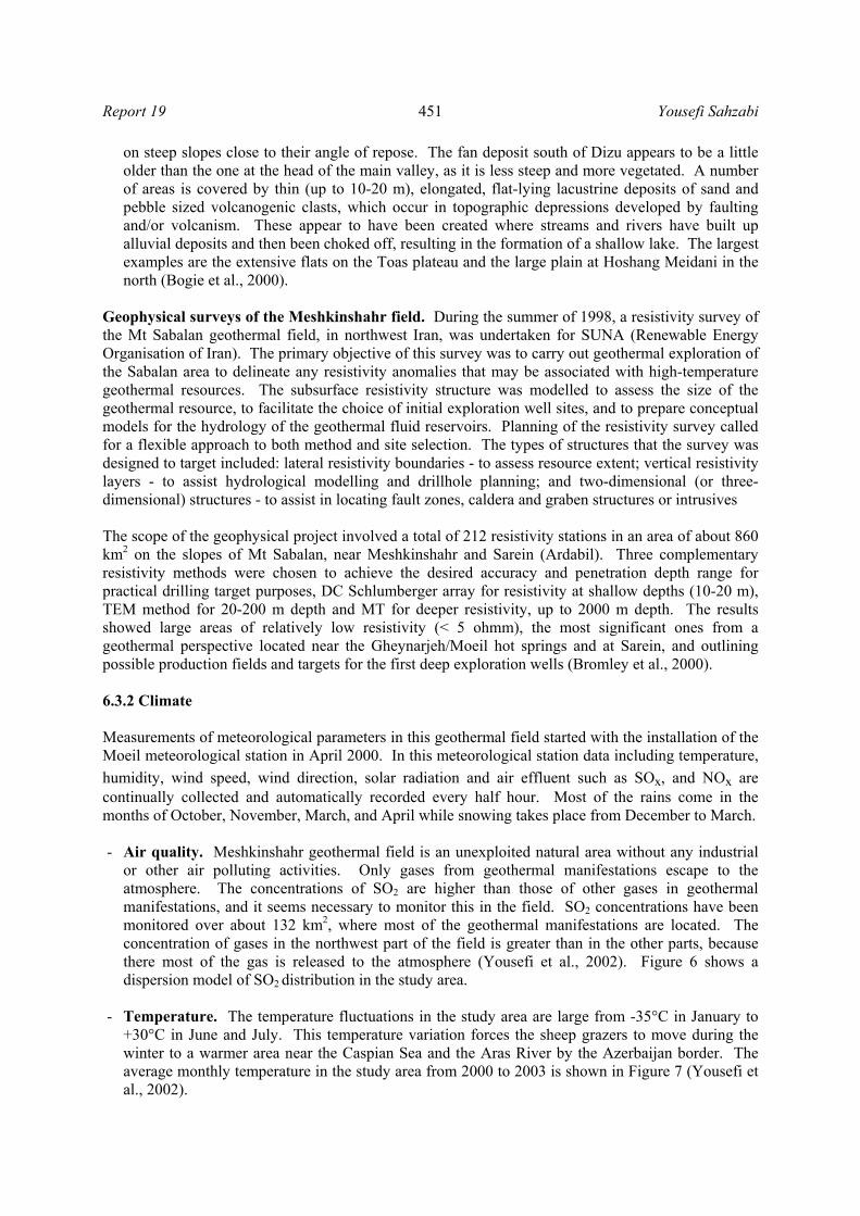
- Humidity. The humidity in the area is not very high because of high elevation and cold climate. The annual mean humidity in the study area is 59.5% according to data from the geothermal project meteorological station in the area. The monthly average humidity in the study area from 2000 to 2003 is shown in Figure 8. It shows that the maximum humidity is observed in May, 85%, and the minimum in June and July, 13%.
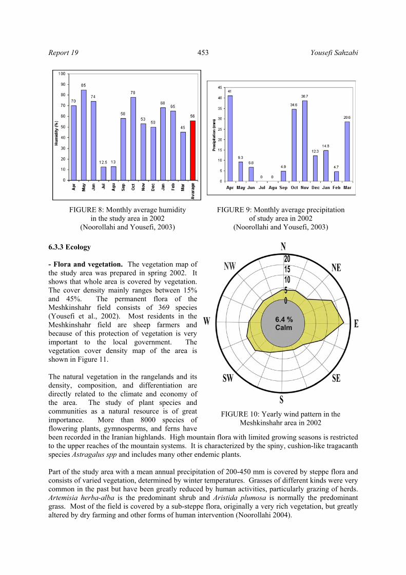
- Precipitation. Precipitation in
this area is rain in fall and spring, snow in winter and hardly any precipitation in summer. The monthly averages for measured precipitation in the geothermal project meteoro-logical station from April 2000 to March 2003 are shown in Figure 9 (Noorollahi and Yousefi., 2003). According to recorded data annual precipitation was 196 mm/year in 2000 and 300 mm/year in 2003, with maximum precipitation in December of about 39 mm and down to zero in June and July.
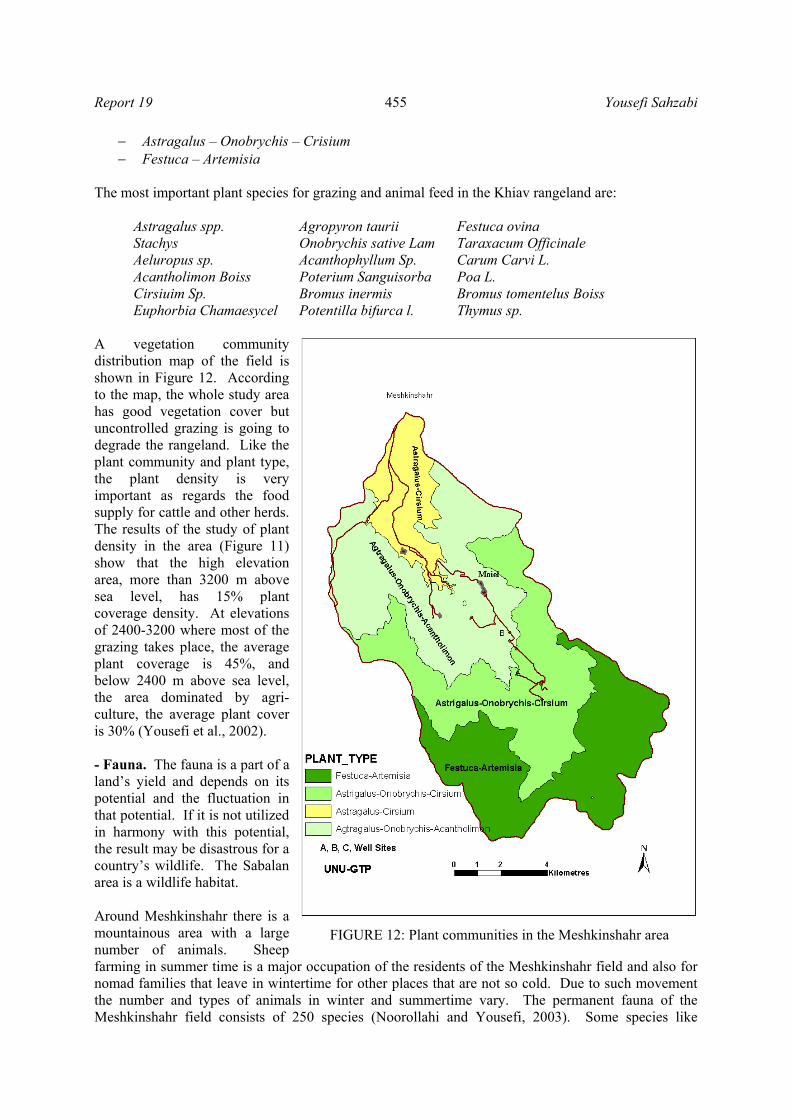
- Wind patterns. Wind patterns
observed in the geothermal meteorological station for the year 2002 have been plotted in Figure 10. The most common wind directions are west and southwest. Maximum erosion is seen on the west face slopes. Unfortunately, most slopes in this area face west winds. Water erosion occurs in the same slopes (Noorollahi and Yousefi, 2003). Wind erosion and its destructive effects on natural resources and the environment have been a serious problem in Iran for years although there have been efforts to control it. Basically, wind erosion control involves land salvage and revegetation in areas that are not subjected to it because of denudation. Wind pattern data in any study related to vegetation and rangeland is necessary.
FIGURE 6: Dispersion of SO2 in 2002
FIGURE 7: Temperature variation in the study area
Report 19 Yousefi Sahzabi
453
6.3.3 Ecology - Flora and vegetation. The vegetation map of the study area was prepared in spring 2002. It shows that whole area is covered by vegetation. The cover density mainly ranges between 15% and 45%. The permanent flora of the Meshkinshahr field consists of 369 species (Yousefi et al., 2002). Most residents in the Meshkinshahr field are sheep farmers and because of this protection of vegetation is very important to the local government. The vegetation cover density map of the area is shown in Figure 11. The natural vegetation in the rangelands and its density, composition, and differentiation are directly related to the climate and economy of the area. The study of plant species and communities as a natural resource is of great importance. More than 8000 species of flowering plants, gymnosperms, and ferns have been recorded in the Iranian highlands. High mountain flora with limited growing seasons is restricted to the upper reaches of the mountain systems. It is characterized by the spiny, cushion-like tragacanth species Astragalus spp and includes many other endemic plants. Part of the study area with a mean annual precipitation of 200-450 mm is covered by steppe flora and consists of varied vegetation, determined by winter temperatures. Grasses of different kinds were very common in the past but have been greatly reduced by human activities, particularly grazing of herds. Artemisia herba-alba is the predominant shrub and Aristida plumosa is normally the predominant grass. Most of the field is covered by a sub-steppe flora, originally a very rich vegetation, but greatly altered by dry farming and other forms of human intervention (Noorollahi 2004).
FIGURE 8: Monthly average humidity in the study area in 2002
(Noorollahi and Yousefi, 2003)
FIGURE 9: Monthly average precipitation of study area in 2002
(Noorollahi and Yousefi, 2003)
FIGURE 10: Yearly wind pattern in the Meshkinshahr area in 2002

Yousefi Sahzabi Report 19
454
The results of the vegetation study in the proposed area show that there are 369 plant species present with 25 endemic species. Totally, about 110 plant species are used for animal food, 12 species for human food, 15 species have chemical and industrial value and 19 species have medicinal value. According to the biodiversity protection law, there are three different classes of protected plant species in the area (Noorollahi and Yousefi 2003) i.e.: - Conservation class one. In
Ardabil province there are 239 species of plants in conservation class one. These species should be protected by the Iranian Department of Environment and the areas in which these species are located to have priority for sustainable land use. There are 99 plant species in the area in conservation class 1, and it makes careful monitoring of the area important for sustainable grazing. Among species in class one that are located in this area are Adonis flammea, Astragalus odoratus, Bellis perennis and Chenopodium album (Noorollahi and Yousefi, 2003).
- Conservation class two. Plants located in this class are endangered and according to the
biodiversity conservation law in Iran, use and collection of mass and seed of these plants are forbidden even for medical or industrial applications. There are 76 such plant species in Ardabil province, 12 of them in the study area. Among species in class two located in the study area are Astragalus mozatfananii, Acantholimon senganense, Bromus tectorum, and Cotoneaster nummularioides.
- Conservation class three. The species of this class are critically endangered and need special
care. There are two such species (Hordeum glaucum and Hordeum violaceu) in the study area. There are four main plant communities that support the resources for grazing and agriculture in the study area. These plant communities are:
− Astragalus – Crisium − Astragalus – Onobrychis – Acantholimon
FIGURE 11: Vegetation cover density in the Meshkinshahr area
Report 19 Yousefi Sahzabi
455
− Astragalus – Onobrychis – Crisium − Festuca – Artemisia
The most important plant species for grazing and animal feed in the Khiav rangeland are:
Astragalus spp. Agropyron taurii Festuca ovina Stachys Onobrychis sative Lam Taraxacum Officinale Aeluropus sp. Acanthophyllum Sp. Carum Carvi L. Acantholimon Boiss Poterium Sanguisorba Poa L. Cirsiuim Sp. Bromus inermis Bromus tomentelus Boiss Euphorbia Chamaesycel Potentilla bifurca l. Thymus sp.
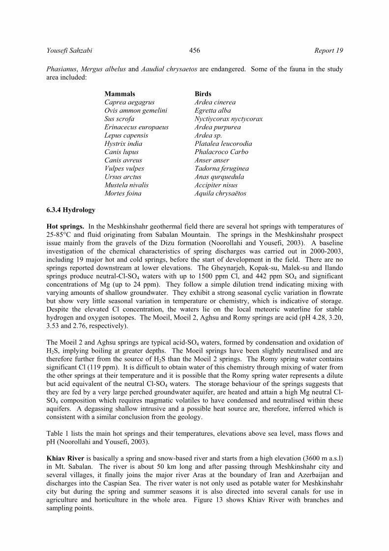
A vegetation community distribution map of the field is shown in Figure 12. According to the map, the whole study area has good vegetation cover but uncontrolled grazing is going to degrade the rangeland. Like the plant community and plant type, the plant density is very important as regards the food supply for cattle and other herds. The results of the study of plant density in the area (Figure 11) show that the high elevation area, more than 3200 m above sea level, has 15% plant coverage density. At elevations of 2400-3200 where most of the grazing takes place, the average plant coverage is 45%, and below 2400 m above sea level, the area dominated by agri-culture, the average plant cover is 30% (Yousefi et al., 2002). - Fauna. The fauna is a part of a land’s yield and depends on its potential and the fluctuation in that potential. If it is not utilized in harmony with this potential, the result may be disastrous for a country’s wildlife. The Sabalan area is a wildlife habitat. Around Meshkinshahr there is a mountainous area with a large number of animals. Sheep farming in summer time is a major occupation of the residents of the Meshkinshahr field and also for nomad families that leave in wintertime for other places that are not so cold. Due to such movement the number and types of animals in winter and summertime vary. The permanent fauna of the Meshkinshahr field consists of 250 species (Noorollahi and Yousefi, 2003). Some species like
FIGURE 12: Plant communities in the Meshkinshahr area
Yousefi Sahzabi Report 19
456
Phasianus, Mergus albelus and Aaudial chrysaetos are endangered. Some of the fauna in the study area included:
Mammals Birds Caprea aegagrus Ardea cinerea Ovis ammon gemelini Egretta alba Sus scrofa Nyctiycorax nyctycorax Erinacecus europaeus Ardea purpurea Lepus capensis Ardea sp. Hystrix india Platalea leucorodia Canis lupus Phalacroco Carbo Canis avreus Anser anser Vulpes vulpes Tadorna feruginea Ursus arctus Anas qurquedula Mustela nivalis Accipiter nisus Mortes foina Aquila chrysaëtos
6.3.4 Hydrology Hot springs. In the Meshkinshahr geothermal field there are several hot springs with temperatures of 25-85°C and fluid originating from Sabalan Mountain. The springs in the Meshkinshahr prospect issue mainly from the gravels of the Dizu formation (Noorollahi and Yousefi, 2003). A baseline investigation of the chemical characteristics of spring discharges was carried out in 2000-2003, including 19 major hot and cold springs, before the start of development in the field. There are no springs reported downstream at lower elevations. The Gheynarjeh, Kopak-su, Malek-su and Ilando springs produce neutral-Cl-SO4 waters with up to 1500 ppm Cl, and 442 ppm SO4 and significant concentrations of Mg (up to 24 ppm). They follow a simple dilution trend indicating mixing with varying amounts of shallow groundwater. They exhibit a strong seasonal cyclic variation in flowrate but show very little seasonal variation in temperature or chemistry, which is indicative of storage. Despite the elevated Cl concentration, the waters lie on the local meteoric waterline for stable hydrogen and oxygen isotopes. The Moeil, Moeil 2, Aghsu and Romy springs are acid (pH 4.28, 3.20, 3.53 and 2.76, respectively). The Moeil 2 and Aghsu springs are typical acid-SO4 waters, formed by condensation and oxidation of H2S, implying boiling at greater depths. The Moeil springs have been slightly neutralised and are therefore further from the source of H2S than the Moeil 2 springs. The Romy spring water contains significant Cl (119 ppm). It is difficult to obtain water of this chemistry through mixing of water from the other springs at their temperature and it is possible that the Romy spring water represents a dilute but acid equivalent of the neutral Cl-SO4 waters. The storage behaviour of the springs suggests that they are fed by a very large perched groundwater aquifer, are heated and attain a high Mg neutral Cl-SO4 composition which requires magmatic volatiles to have condensed and neutralised within these aquifers. A degassing shallow intrusive and a possible heat source are, therefore, inferred which is consistent with a similar conclusion from the geology. Table 1 lists the main hot springs and their temperatures, elevations above sea level, mass flows and pH (Noorollahi and Yousefi, 2003). Khiav River is basically a spring and snow-based river and starts from a high elevation (3600 m a.s.l) in Mt. Sabalan. The river is about 50 km long and after passing through Meshkinshahr city and several villages, it finally joins the major river Aras at the boundary of Iran and Azerbaijan and discharges into the Caspian Sea. The river water is not only used as potable water for Meshkinshahr city but during the spring and summer seasons it is also directed into several canals for use in agriculture and horticulture in the whole area. Figure 13 shows Khiav River with branches and sampling points.

Report 19 Yousefi Sahzabi
457
TABLE 1: Characteristics of hot springs in the Meshkinshahr geothermal field
Location Temperature(°C)
Elevation(m)
Mass flow(l/s) pH
Moeil 45 2200 1.5 5 Gheynarjeh 83 2120 7 7 Ilando 34 2010 4 6 Ghatour-su 29 2200 10 3 Aghsu 32 2500 0.3 3 Malek-su 45 2250 2 6 Kopak-su 64 2140 0.2 6 Yel-su 41 1980 4 5 Do-do 51 1990 1 5
The Sabalan geothermal project is close to the source part of the river at a higher elevation than the
river basin and between its main branches. The area is harsh mountainous land and the average elevation difference between the three well sites in the Moeil plain and the river base in the Geynarjeh valley is about 300 m. A baseline study of the chemical characteristics of the river water was carried out from 2000 to 2003 for 22 points in the river where the river branches are joined together, in different seasons (high and low flow rate) before the start of development in area. The results of measurements and analysis are shown in Table 2. Groundwater. A geo-thermal system consists of a body of hot aqueous fluid within the top few kilometres of the Earth’s crust and is characterized by a particular rock-hydrology situation. Most often they develop by a deep circulation of groundwater which usually consists of ancient to modern precipitation or seawater (Ármannsson, 2004). FIGURE 13: The Khiav river basin in the study area and sampling points

Yousefi Sahzabi Report 19
458
Report 19 Yousefi Sahzabi
459
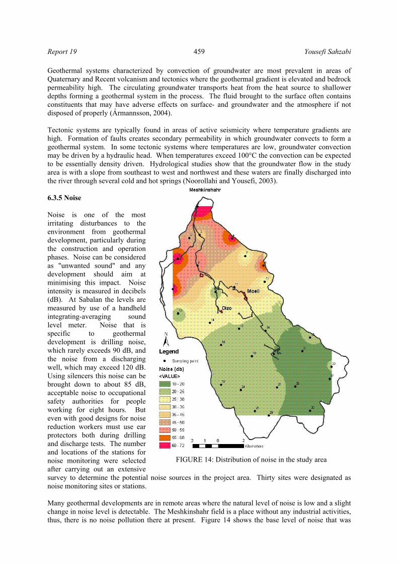
Geothermal systems characterized by convection of groundwater are most prevalent in areas of Quaternary and Recent volcanism and tectonics where the geothermal gradient is elevated and bedrock permeability high. The circulating groundwater transports heat from the heat source to shallower depths forming a geothermal system in the process. The fluid brought to the surface often contains constituents that may have adverse effects on surface- and groundwater and the atmosphere if not disposed of properly (Ármannsson, 2004). Tectonic systems are typically found in areas of active seismicity where temperature gradients are high. Formation of faults creates secondary permeability in which groundwater convects to form a geothermal system. In some tectonic systems where temperatures are low, groundwater convection may be driven by a hydraulic head. When temperatures exceed 100°C the convection can be expected to be essentially density driven. Hydrological studies show that the groundwater flow in the study area is with a slope from southeast to west and northwest and these waters are finally discharged into the river through several cold and hot springs (Noorollahi and Yousefi, 2003). 6.3.5 Noise Noise is one of the most irritating disturbances to the environment from geothermal development, particularly during the construction and operation phases. Noise can be considered as "unwanted sound" and any development should aim at minimising this impact. Noise intensity is measured in decibels (dB). At Sabalan the levels are measured by use of a handheld integrating-averaging sound level meter. Noise that is specific to geothermal development is drilling noise, which rarely exceeds 90 dB, and the noise from a discharging well, which may exceed 120 dB. Using silencers this noise can be brought down to about 85 dB, acceptable noise to occupational safety authorities for people working for eight hours. But even with good designs for noise reduction workers must use ear protectors both during drilling and discharge tests. The number and locations of the stations for noise monitoring were selected after carrying out an extensive survey to determine the potential noise sources in the project area. Thirty sites were designated as noise monitoring sites or stations. Many geothermal developments are in remote areas where the natural level of noise is low and a slight change in noise level is detectable. The Meshkinshahr field is a place without any industrial activities, thus, there is no noise pollution there at present. Figure 14 shows the base level of noise that was
FIGURE 14: Distribution of noise in the study area

Yousefi Sahzabi Report 19
460
measured in April 2002. It shows that the noise levels in the whole area are well below safety levels (Noorollahi and Yousefi, 2003).
6.3.6 Social and economic aspects Village residents. The study area is inhabited by farming communities in 3 villages but also by agronomads who only stay for the summer in part of the area but move away to warmer places in winter. The village community consists of a group, possibly linked by blood, using land, sometimes held communally, for purposes of cultivation and pasturage. The village community has been established by a transformation of tribal life of nomadic hunting to stable agriculture. Although innumerable variations in patterns of village life have existed, the typical village is small, consisting of perhaps 5 to 300 families. Homes are densely situated for sociability and defence, and the land surrounding the living quarters is farmed. This farmland might extend for as much as several kilometres and is generally parcelled out in varying proportions to each family. There are also woods and meadows used for pasturage, firewood, and hunting, a communal activity. There are three villages in the study area located in the southern, northern and eastern parts, respectively. The Valezir village is located in the northern part and comprises about 50 families and is the village closest to Meshkinshahr city. Plant cultivation is the dominant occupation of its inhabitants. The second village is Dizo in the northwest part of the area comprising about 30 families where the main occupation is sheep keeping with some cultivation, and the third and largest village is Moeil that is located in the southeast part of the area with more than 400 families whose dominant occupation is sheep keeping and some cultivation. The economy of this community is mostly related to sheep keeping and agriculture, but also to some direct use of geothermal energy (swimming pools), tourist and mountaineer guiding and hunting. Nomadic families. Pastoral communities have always played an important role in Iran and the greater ethno-ecological region of which it is a part by developing creative and sustainable systems for the use of scarce natural resources. Migration is a common cornerstone of their strategy, and their mobility ensures that natural resources are not used to the point of exhaustion and eventual extermination. In addition, their herds browse the vegetation, stomp the soil, transport seeds of wild species, and fertilise the land, all of which benefit the rangeland and the maintenance of its biological diversity. Nomadic pastoralists have learned to conserve rangelands through sophisticated techniques embedded in complex social and cultural institutions. There are about 200 nomad families in the area. They come in May and leave at the end of September every year. Each of them has a certain settlement located in the study area and common property rights along with village communities for grazing in certain areas. Their economy mostly depends on sheep keeping for use and trade for different products. Land use. The whole of Iran is by law divided into 28 provinces, each province including some major cities, each city being divided into several districts, and finally each district comprising many villages, with all villages having predefined borders with the surrounding villages. In all villages in Iran, there are two different types of land ownership:
− Land used for cultivation and farming transferred by the government to the people and
documented about 40 years ago; after that, the ownership of this land has been private (Noorollahi, 2004).
− Land whose natural resources are not to be utilized, (forests, rangelands, deserts, pastures and mountain area) but are a national area belonging to the government. People rent it or have free property rights for a certain period of time or infinitely depending on natural resources and land type (Noorollahi, 2004).
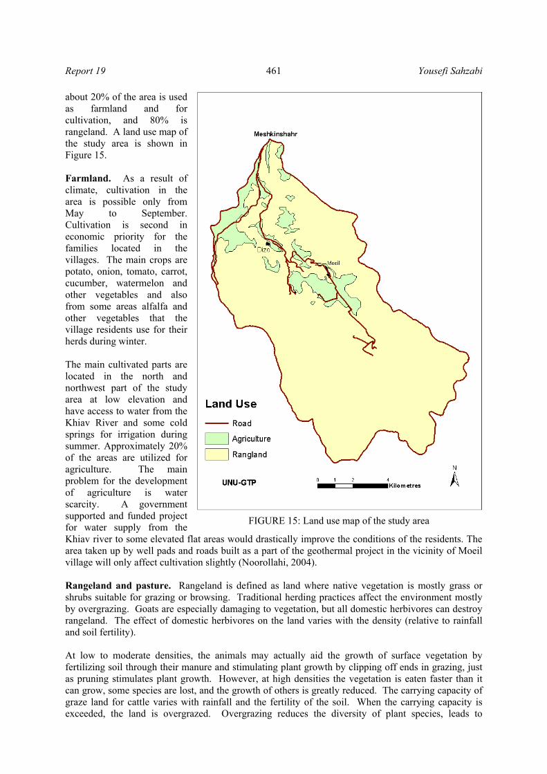
The study area comprises 132 km2 of the watershed of the Khiav river and includes the three villages described above. The country regulation and law about land ownerships is followed. Land in the study area is divided into two major types according to use: Farmlands and rangelands. Currently,
Report 19 Yousefi Sahzabi
461
about 20% of the area is used as farmland and for cultivation, and 80% is rangeland. A land use map of the study area is shown in Figure 15. Farmland. As a result of climate, cultivation in the area is possible only from May to September. Cultivation is second in economic priority for the families located in the villages. The main crops are potato, onion, tomato, carrot, cucumber, watermelon and other vegetables and also from some areas alfalfa and other vegetables that the village residents use for their herds during winter. The main cultivated parts are located in the north and northwest part of the study area at low elevation and have access to water from the Khiav River and some cold springs for irrigation during summer. Approximately 20% of the areas are utilized for agriculture. The main problem for the development of agriculture is water scarcity. A government supported and funded project for water supply from the Khiav river to some elevated flat areas would drastically improve the conditions of the residents. The area taken up by well pads and roads built as a part of the geothermal project in the vicinity of Moeil village will only affect cultivation slightly (Noorollahi, 2004). Rangeland and pasture. Rangeland is defined as land where native vegetation is mostly grass or shrubs suitable for grazing or browsing. Traditional herding practices affect the environment mostly by overgrazing. Goats are especially damaging to vegetation, but all domestic herbivores can destroy rangeland. The effect of domestic herbivores on the land varies with the density (relative to rainfall and soil fertility). At low to moderate densities, the animals may actually aid the growth of surface vegetation by fertilizing soil through their manure and stimulating plant growth by clipping off ends in grazing, just as pruning stimulates plant growth. However, at high densities the vegetation is eaten faster than it can grow, some species are lost, and the growth of others is greatly reduced. The carrying capacity of graze land for cattle varies with rainfall and the fertility of the soil. When the carrying capacity is exceeded, the land is overgrazed. Overgrazing reduces the diversity of plant species, leads to
FIGURE 15: Land use map of the study area

Yousefi Sahzabi Report 19
462
reduction in the growth of vegetation and dominance of plant species that are relatively undesirable to the cattle, increases the loss of soil by erosion as the plant cover is reduced, and results in damage from cattle trampling on the land. Rangeland has a significant role in the social and economic life of the rural areas and is also effectively involved in water and soil conservation, agricultural and non- agricultural life span, as well as production of feed stuff and many other different products. The study area is mainly rangeland except for parts that are used for agriculture. Generally, grazing capacity is considered to be the average number of animals that a particular range or ranch will sustain over time. It is based on stocking rate. Stocking rate is defined by the Society for Range Management as the amount of land allocated to each animal unit for the grazable period of the year. Determination of stocking rate and grazing capacity involves the same procedures, except that grazing capacity estimates require an adjustment of forage production to the hypothetical average year. This hypothetical average year is defined as the average forage production over the previous 10 year period. Ideally, at least 3 years of forage production data should be collected to establish grazing capacity. The grazing capacity of Ardabil province of which the study area is a part is 1.8 ha rangeland per sheep for 100 days grazing. The statistical information for herds based in the study area in the year 2002 is shown in Table 3.
TABLE 3: Number in herds in study area
Community Type of herd Number Village residents Sheep, goat and cow 4600 Nomad families Sheep and goat 5300
The total carrying capacity of the study area’s 13000 ha. is 7200 sheep equivalent for only 100 days, according to the basic standard assigned by Forest, Range & Watershed Management Organization of Iran. Currently, there are 9900 sheep in the area of which 5300 belong to nomads and are located and grazing in the area for about 150 days per year (Noorollahi, 2004). There are also 4600 sheep belonging to the village residents and they are settled in the area for the whole year and graze about 200 days per year. It shows that currently each sheep is using only 1.3 ha for an average of 170 days. Compared with standards it is very low and it has affected the total production and also caused degradation of rangeland (Noorollahi, 2004). The people rely on common property rights for rangeland in this area, and problems related to common property rights are rife. Every family has tried to increase its number of sheep to obtain greater benefits, and despite government inspection, they have been allowed to increase their number of sheep without limitation. When they have obtained their property rights, they have found it advantageous to keep and graze a large number of sheep in the area. The rangeland in the study area is already under severe pressure and the development of a geothermal power project with the total use of 160 hectares of land owned by the Power Company in the first phase has been of great concern to other stakeholders. The Iranian Department of Environment and Forest, Range & Watershed Management Organization stated that the project will increase the pressure on rangeland, affect rangeland quality and the biodiversity of area. Both organizations will design a programme obliging the power company to carry out mitigating measures to stop rangeland degradation (Noorollahi, 2004). Tourism. The Sabalan volcano with a height of 4,811 m is one of the most interesting mountains in Iran. The summit is located 41 km from Ardabil and can easily be observed while travelling by road to Sarein and Ardabil. The lake on top is a major tourist attraction. In a general report on tourism in Iran published by the Ministry of Society and Culture it is recommended that geothermal fields be given high priority in the development of tourism especially in the Ardabil province and also the Meshkinshahr field because of a large number of hot springs at different temperatures and a very nice landscape in all seasons.
Report 19 Yousefi Sahzabi
463
There are two groups of tourists that visit the area. One of them comes to use the natural hot springs for swimming and recreation. Because of the location of the hot springs in the southern part of the area, this group is not directly exposed to geothermal project activities but there is concern that flowrates of hot springs will be reduced. They are opposed to project development and have several times contacted the local governments and asked them to force the project developer to give them an assurance that they will be compensated for their loss if the hot water flowrate decreases or disappears (Noorollahi, 2004). The second group of tourists who visit the area, comes for climbing and sometimes they have permits from DoE for wildlife hunting. At an altitude of 3600 meters and higher, around the Sabalan crater, there have formed gigantic sculptures, as a result of volcanic rock erosion, which resemble various creatures including animals, birds, insects, etc. The most beautiful one is an eagle sculpture, appearing to maintain control over the Sabalan slope and valley from the top. The mountain offers specific attractions in various seasons of the year making the mountain climber feel as if he has entered a land of dreams and wonders. There are also many trails and a few small villages in the area, as well as many nomadic people with their round “Yurt” tents. Visiting and seeing these indigenous people is one of the best reasons for climbing the mountain (Yousefi et al.,2003). Population. The Meshkinshahr region in NW-Iran has a population of approximately 165,000. Its principal town, Meshkinshahr, has 65,000 inhabitants. The population of natives is about 2000 living in 3 small villages about 5 km from each other and 15-20 km from the nearest town. Economy. The main occupation of the inhabitants is community services such as teaching and health care, banking, trading, farming, fish farming and ranching. Industrial activities include slaughtering, meat processing, cannery and wood industry. For several decades this region has suffered a brain drain because there have been few jobs for highly educated people. The proportion of such people in the Meshkinshahr region is very much below the national average (Noorollahi, 2004). 6.4 Environmental impact assessment During the 1960s, when our environment was healthier than it is nowadays and we were less aware of any threat to the earth, geothermal energy was considered a 'clean energy'. However, there is actually no way of producing or transforming energy into a form that can be utilized by man without making some direct or indirect impact on the environment. Utilization of geothermal energy has some impacts on the environment, but there is no doubt that it is one of the least polluting forms of energy. Baseline environmental conditions have been estimated with further analysis aimed at determining the impacts of a geothermal project on all relevant phases of development and to propose mitigating measures to reduce impacts. A geothermal system consists of a body of hot aqueous fluid and hot rock (sometimes hot rock only) within the top few kilometres of the Earth’s crust and is characterized by a particular rock-hydrology situation. In convecting groundwater systems, the heat source may be hot rock close to the base of the water circulation or magma intrusions. The circulating groundwater transports heat from the heat source to shallower depths forming a geothermal system in the process. During its circulation, the water composition is altered through interaction with the enclosing rock. The water may also receive chemical components from a degassing magma. Because of these processes, geothermal fluids may contain chemical constituents in such concentrations that they can have a harmful effect on the environment, fauna and flora, the atmosphere and ground- and surface waters. Utilization of geothermal energy is of two types, power generation, and direct use. Generally it is far less a cause of pollution than fossil fuel combustion. It is, however, not a completely clean source of energy and the utilization of geothermal resources can have some significant effects on the local environment. Utilization of geothermal reservoirs involves drilling and extraction of fluid from the

Yousefi Sahzabi Report 19
464
reservoir at a rate which often far exceeds the natural discharge rate, usually by self-sustained discharge from wells but sometimes, in the case of sub-boiling reservoirs, also by pumping. The environmental impact of geothermal power stations, which utilize high-enthalpy reservoirs, is varied. Increased fluid withdrawal leads to pressure decline in the reservoir and may cause hot springs to dry out (Ármannsson, and Kristmannsdóttir, 1992). The depressurization may also enhance boiling at shallow depth and in this way enhance fumarole activity. Seismic activity may be enhanced and land subsidence is known to occur as a consequence of fluid withdrawal from some reservoirs. The fluid brought to the surface often contains constituents that may be harmful to surface- and groundwater and the atmosphere if not disposed of properly. Drilling, road building, and other construction work may lead to soil erosion. Operation of a power plant is accompanied by noise. Development of a geothermal field may affect tourism, at least if natural manifestations are the tourist attraction. A decision on the benefit of development of a geothermal resource must be at times balanced against the benefit of tourism. The environmental impact of direct use of low-enthalpy geothermal systems is much smaller than that of power production and often insignificant. Many steps have been taken during the last few decades to reduce the environmental impact of geothermal energy utilization e.g. directional drilling, which aims at decreasing effects on scenery, visual pollution and soil erosion. Injection of condensate and wastewater substantially reduces chemical pollution of surface- and groundwater and reduces land subsidence. Removal of H2S from steam has been implemented in some fields to reduce atmospheric pollution. Technologies have also been developed to remove As and Hg from steam, thus reducing atmospheric pollution with respect to these elements. The objective of EIA is to determine the potential environmental, social and health effects of a proposed development. An attempt is made to assess the physical, biological and socio-economic effects of the proposed project in a form that permits a logical and rational decision to be made. Attempts can be made to reduce or mitigate against any potential adverse impacts through the identification of possible alternative sites and/or processes. In most cases the degree to which geothermal utilization affects the environment is proportional to the scale of its utilization. The probability and relative severity of the effects on the environment of geothermal energy projects is summarised in Table 4. Electricity generation in binary cycle plants will affect the environment in the same way as direct heat uses. The effects are potentially greater in the case of conventional back-pressure or condensing power-plants, especially as regards air quality, but can be kept within acceptable limits.
TABLE 4: Probability and severity of potential environmental impact for geothermal areas
(Source: Yousefi et al., 2002, revised by Noorollahi and Yousefi, 2004)
Direct use Power generation Probability of
occurring Severity of
consequencesProbability of
occurring Severity of
consequencesAir pollution L M H M Surface water pollution M M H H Groundwater pollution L M H M Subsidence L L to M M M Noise H L to M H M Well blow-outs L L to M L L Conflicts with cultural and archaeological features L to M M to H L L
Social-economic problems L L M M Thermal pollution L M to H M M Solid waste disposal M M to H M M Surface changes M L H H
L = Low; M = Moderate; H= High.

Report 19 Yousefi Sahzabi
465
Any modification of our environment must be evaluated carefully, in accordance with the relevant laws and regulations (which in some countries are very severe), but also because an apparently insignificant modification could trigger a chain of events whose impact is difficult to fully assess beforehand. For example, a mere 2-3°C increase in the temperature of a body of water as a result of discharging waste water from a utilization plant could damage its ecosystem. The plants and animal organisms that are most sensitive to temperature variations could gradually disappear, leaving a fish species without its food source. An increase in water temperature could impair development of the eggs of other fish species. If these fish are edible and provide the necessary support for a community of fishermen, then their disappearance could be critical for the community at large. The first perceptible effect on the environment is that of drilling, whether the boreholes are shallow or deep. Geothermal gradient wells are drilled during the study phase, and deep exploratory/producing wells drilled during the construction phase. Installation of a drill rig and all the accessory equipment entails the construction of access roads and a drill pad. The latter will cover an area ranging from 300—500 m2 for a small truck-mounted rig (max. depth 300-700 m) to 1200-1500 m2 for a small-to-medium rig (max. depth of 3000 m). These operations will modify the surface morphology of the area and could damage local plants and wildlife. Blow-outs can pollute surface water; blow-out preventers should be installed in geothermal wells where high temperatures and pressures are anticipated. During drilling or flow-tests undesirable gases may be discharged to the atmosphere. The impact on the environment caused by drilling mostly ends once drilling is completed. The next stage, i.e. the installation of the pipelines that will transport the geothermal fluids, and construction of the utilization plants, will also affect animal and plant life and surface morphology. The scenic view will be modified. In some areas such as Larderello, Italy, the network of pipelines criss-crossing the countryside and the power-plant cooling towers have become an integral part of the panorama and are indeed a famous tourist attraction. 6.4.1 Geology and soil Drilling, access road building and other construction work will lead to surface changes in topography, vegetation cover, land use and especially result in soil erosion and visual pollution. During surface exploration there is no significant impact on geology, soil and land, but when it comes to drilling shallow wells to obtain a geothermal gradient map there are some effects on land and soil from the disposal of materials. During drilling, road construction and drill site preparation, unstable earth conditions and changes in geological substructure may result. During well testing care should be taken not to discharge the waste water directly to steep areas. Sumps should be made to contain it, as failure to do this can cause serious gullying. Each drill site in Iran is on average about 20,000 m2 in land area. Three exploration wells have been drilled during the first phase of the Sabalan project and about 60,000 m2 of land in this area that is mainly used for sheep farming were affected during drilling and for many years after that. The soil in these areas will become compacted and change, and close to the drill site there will be some deposition of waste soils. The construction of a 10 km access road, camping, storage areas, pipeline, powerhouse workers’ quarters and other buildings affects about 860,000 m2 of land. Subsidence. During operation, subsidence and induced seismicity are the main possible effects on the land of the power plant and surrounding areas. Ground subsidence is likely to occur in the Sabalan area. In general, subsidence is greater in liquid-dominated than vapour-dominated fields because of the geological characteristics typically associated with each type of field. Ground subsidence can affect the stability of pipelines, drains, and well casings. It can also cause the formation of ponds and cracks in the ground and, if the site is close to a populated area, it can lead to the instability of buildings.

Yousefi Sahzabi Report 19
466
Extraction of large quantities of fluids from geothermal reservoirs may give rise to subsidence, i.e. the gradual sinking of the land surface. This is an irreversible process, but by no means catastrophic, as it is a slow process taking place over vast areas. Over a number of years the lowering of the land surface could reach detectable levels, in some cases on the order of a few tens of centimetres and even metres. This should be monitored systematically, as it could damage the stability of the geothermal buildings and any private homes in the neighbourhood. In many cases subsidence can be prevented or reduced by re-injecting the geothermal waste water. The withdrawal and/or re-injection of geothermal fluids may trigger off or increase the frequency of seismic events in certain areas. However these are microseismic events that can only be detected by means of instruments. Utilization of geothermal resources is unlikely to trigger major seismic events, and so far has never been known to do so. During exploration and drilling no significant impact on the topography and sinking of the land surface is expected. During operation, subsidence and induced seismicity are the main possible effects on the land around the power plant and in the surrounding areas. A monitoring program for subsidence in this area is recommended. The base level for the geothermal field was recorded in summer 2002 by the Energy Efficiency Organization of Iran (SABA). Landslides are very common in the Sabalan area as they are elsewhere in volcanic regions where the surface is not covered with dense vegetation. In drainage basins in the northern part of Iran, a combination of natural and human factors has caused numerous landslides with a lot of damage. To restrict landslide hazards, one solution is to avoid these regions. A landslide hazard zonation map of the area should be prepared and low-hazard and high-hazard zones should be separated. In this geothermal project the following nine factors were recognized as naturally effective factors in landslide occurrence: slope, altitude, aspect, rainfall, land use, geology, distance from faults, distance from old and new roads and distance from main drainages. After overlaying the maps with GIS of landslide occurrences with the maps of the above-mentioned factors, it was recognized that aspect and distance from main drainages have little effect on landslide occurrence. Then by considering the other seven factors, landslide hazard zones related to geothermal activity and impacts on the environment will need assessment. The results of this part of the EIA have shown that regions in which land has been affected, belong to high-hazard zones and conversely, regions in which rangelands have not been destroyed, belong to low–hazard zones. The results of the present studies show that in planning, the overlay method with GIS gives a better separation of different hazard zones than methods used previously and can be used to produce new maps of the geothermal prospect to be compared with data obtained from earlier methods. 6.4.2 Climate Environmental problems also arise during plant operation. Various harmful chemical components in geothermal steam may escape into the atmosphere from power plants via ejector exhausts, cooling towers, silencers, drains and traps. These include hydrogen sulphide, mercury, arsenic and radon. Other compounds of environmental concern in geothermal steam, although not directly harmful, include carbon dioxide and methane. Apparently, not much attention has been paid to airborne poisons in geothermal steam other than hydrogen sulphide. This noxious gas has an unpleasant smell when present in low and harmless concentrations. When present in large quantities, it paralyzes the olfactory nerves and thus becomes odourless and may eventually become lethal. The H2S concentrations in steam discharged from fumaroles and wells in high-temperature geothermal systems typically lie in the range of 50-1000 ppm but may be as high as 1700 ppm. They depend on the steam separation pressure, the initial temperature of the water in the source aquifer and the mineral assemblage which buffers the aquifer water H2S concentration. Air pollution may become a problem when generating electricity in conventional power plants and hydrogen sulphide is one of the main pollutants. The odour threshold for hydrogen sulphide in air is about 5 parts per billion by volume.
Report 19 Yousefi Sahzabi
467
Subtle physiological effects can be detected at slightly higher concentrations. Various processes, however, can be adopted to reduce emissions of this gas. The concentrations of CO2 in geothermal reservoir waters, at least at temperature >100°C are controlled by equilibrium with various buffers, and CO2 concentrations increase with increasing temperature. They depend on the CO2 concentration in the parent geothermal water, the reservoir steam fraction, the steam separation pressure, and the boiling processes which lead to steam formation. The fraction of CO2 and some other gases in well discharges is known to decline with utilization, most likely as a consequence of recharge into producing aquifers. Gas emissions to the air take place during all phases of the proposed project. During the construction and decommissioning phases, fugitive dust would result from surface disturbance and vehicle travel on unpaved roads. Non-condensable gases including H2S and CO2 are released from the geothermal fluid during well drilling and testing and during power plant operation. Oxides of nitrogen, carbon monoxide, and oxides of sulphur from internal combustion engines are released during all phases of the project. A summary of effects on air during such a project is as follows: - Small quantities of critical air pollutants are released from mobile construction equipment and
other vehicles, but this impact will be small. - Large quantities of critical air pollutants, in particular nitrogen oxides (NOx), are released from
drilling rig engines during well drilling operations, but this impact is not significant if wells are drilled one at the time, and only one active drill rig is operated at any one time.
- Hydrogen sulphide is released during well flow tests. It is necessary to control its concentration in the atmosphere and keep it below levels specified in international standards.
- Hydrogen sulphide is released to the atmosphere during power plant operation, usually not in dangerously high concentrations.
- The project will release greenhouse gases which will contribute to global warming because of CO2. - The main resident area in Sabalan geothermal field is in the east part and the wind direction is
mainly from west to east. With regard to wind direction and decreased air pollution the power plant should be installed in the southern part of field.
6.4.3 Socioeconomic effects Tourism. The Meshkinshahr field around the Sabalan Mountain is important for tourism. Opening up the area by way of new roads for the project would change conditions drastically and might bring in a greatly increased number of tourists and also make it easier to climb the Sabalan peak because when the road to the Meshkinshahr geothermal field is ready, this will be the shortest route to the peak. Economy. For many years the local government of Meshkinshahr has been trying to improve the economy of the area. Due to scarce precipitation for the last few years in the whole of Iran including the Meshkinshahr and Sabalan area, most farmers are facing a difficult economic situation and the government has attempted to install manufacturing industries to remedy the situation. Tourism, food production (fish and farm produce), mining of minerals, the utilization of high-temperature geothermal fields, the direct use of geothermal energy (swimming pools, fish farming), construction of a dam for electricity production and irrigation are to be developed. In recent years attention has focussed on the utilization of the high-temperature geothermal field to produce 100 MW of electricity in the Sabalan area. There is less conflict with village communities than nomad families, because they have benefited from project activities for the last few years. Some important short-term benefits of the project in the 3 villages in the area are: - Employment of about 200 workers in all construction parts of the project - Opening up an access road to the area - Increases in land price - Increases in home rent price in the villages especially in Moeil village

Yousefi Sahzabi Report 19
468
- Increase in the number of tourists and mountaineers because of access road opening - Possibility of a telephone connection to Moeil village - Increased shopping in the villages - Improvements to public health
To mitigate the effects of power plant development and conflict management the project developer can create new opportunities for villagers and replace some of their losses by establishing new facilities like: - New water facilities for irrigation of new land to replace farmland used for roads and drill sites. - Use of the medical care centre of the project - Increased employment in the villages
6.4.4 Noise The noise associated with operating geothermal power plants could be a problem. During the production phase there is a high-pitched noise associated with the use of steam travelling through the pipelines and the occasional vent discharge. These are normally acceptable. At the power plant most of the noise is due to the cooling tower fans, the steam ejectors, and the turbine 'hum' (Ármannsson, 2004). The noise generated in direct heat applications is usually negligible. In the Meshkinshahr geothermal field serious noise impacts are not expected during geothermal project activities such as drilling, well testing and operation. During well testing, however, there will be some temporary noise impact which may affect wildlife in the vicinity of the drill rig. Workers on site will be vulnerable to noise during drilling and well testing, and the wearing of appropriate hearing protection is a necessary safety aid. The bulk of the noise experienced during power plant operation is due to the cooling towers, transformers, and turbine-generator building. When power plant operation starts, noise mufflers must be used to keep the environmental noise level below the 65 dB limit. The reduced level of noise around the silencer means that impact on wildlife, workers and tourists will not be serious. 6.4.5 Ecological effects Flora. Vegetation of the Meshkinshahr field will be destroyed during drill site preparation, construction of buildings, pipelines, transmission lines and roads. This effect is not serious because the drill site can be re-vegetated with the same species after drilling and well testing. During operation a monitoring programme including the monitoring of pollutant gases such as H2S in the atmosphere should be carried out, and if the concentration of these becomes higher than limits set by guidelines, measures must be taken to reduce their amount in the atmosphere. Sheep in this field affect the vegetation profoundly, and during drilling and well testing, care should be taken to avoid damage to the grass when disposing of drilling effluents and operational waste waters with reference to its exploitation by sheep. A detailed study should also include the potential effect of changes in the thermal field, such as increased steam flow due to exploration, changes in the distribution of the thermally adapted plants, and to some of the species that could be rendered extinct. Fauna. During exploration for geothermal energy in this field, damage to animals is unlikely. During construction of roads, preparation of drill site and drilling, the effect of noise from the drill rig and well testing will cause most animals to move away from the vicinity of the drill rig. The most important effect of the geothermal power plant operation on the environment is air pollution. The sensitivity threshold of animals to gas odours is the same as for humans. A detailed study for the identification of all animals and a survey of the probable effects of long term geothermal operation on animals is required. Some species like Phasianus, Mergus albelus, Aaudial chrysaetos and Sturnus vulgaris will be endangered and the project developer should be careful about potential effects on these species.

Report 19 Yousefi Sahzabi
469
6.4.6 Hydrology and water uses Discharge of waste water is another potential source of chemical pollution. Spent geothermal fluids with high concentrations of chemicals such as boron, fluoride or arsenic should be treated or re-injected into the reservoir, or both. However, the low- to moderate-temperature geothermal fluids used in most direct-use applications generally contain low levels of chemicals and the discharge of spent geothermal fluids is seldom a major problem. Some of these fluids can often be discharged into surface waters after cooling. The water can be cooled in special storage ponds or tanks to avoid modifying the ecosystem of natural bodies of water (rivers, lakes and even the sea). The wells, which will be drilled in this field for high-temperature geothermal fluid will be deep and may require up to 50 l/s of water for periods of several months depending on the number of wells to be drilled. The amount of water used as drilling fluid is enormous and should be discharged with utmost care into well designed sumps or possibly re-injected as this can affect the quality of the groundwater in the field. Hydrological studies show that the groundwater flow in the study area is from southeast to northwest and this water is finally discharged to the Khiav River. Drinking water in Meshkinshahr City and agricultural water for more than 20,000 residents in the northern part of Meshkinshahr comes from the Khiav River, and it is necessary to survey the effect of that water on the river. Spent geothermal fluid from the power plant will be injected into an injection well that is located behind the exploration wells. The concentration of dissolved solids and gases in geothermal water and steam is greater than in shallow groundwater. It is necessary to study the effect of geothermal fluid on surface water and shallow groundwater after the installation of a power plant. Surface water. The drinking water from the Khiav River and some cold springs may receive chemical components from a degassing magma heat source. As a consequence of these processes, geothermal fluids may contain chemical constituents in such concentrations that they can have a harmful effect on the environment, fauna and flora, the atmosphere and ground- and especially surface waters. The geothermal fluid will often bring to the surface constituents that may have harmful effects on surface- and groundwater and the atmosphere if not disposed of properly. As mentioned earlier the drinking water for Meshkinshahr City and agricultural water for more than 200,000 residents in the northern part of Meshkinshahr comes from Khiav River, and it is necessary to study the effect of geothermal activity on the river water quality. Groundwater. Groundwater, which percolates deep into the bedrock and gains heat, dissolves the rock forming minerals more effectively than surface- and non-thermal groundwater because mineral dissolution rates generally increase with rising temperature, and water, which has percolated deep into the bedrock has had more time to react with bedrock minerals than shallower waters. Relatively limited primary mineral dissolution is needed to saturate geothermal water with respect to hydrothermal minerals which remove aqueous components from solution as they precipitate. These components have been called reactive components. Other components which enter geothermal fluids only form relatively soluble minerals. The fluid rarely reaches saturation with respect to these minerals. The most serious environmental effect of geothermal energy utilization is chemical, from gaseous components in steam that are discharged into the atmosphere and from aqueous components in spent water that mixes with surface- and groundwater. This problem has been reduced by injecting spent water and steam condensate into drill holes. 6.5 Monitoring programme Potential effects and concerns should be evaluated in an EIA. In addition, potential impacts and a monitoring programme to mitigate and reduce the harmful effects of the impacts should be laid out in an EIA. The following monitoring programmes are carried out in the Sabalan geothermal project:

Yousefi Sahzabi Report 19
470
- Monitoring of noise - Hydrogen sulphide gas monitoring - Meteorological monitoring - Monitoring of chemical elements of environmental significance in wastewater, soil and vegetation - Monitoring of vegetation patterns - Monitoring the quality of drinking water
6.5.1 Subsidence In the early stages of geothermal development, geothermal fluids are withdrawn from a reservoir at a rate greater than the natural inflow into the reservoir. This net outflow causes surface formations at the site to compact, particularly clays and sediments, leading to ground subsidence at the surface. The largest recorded subsidence in a geothermal field is at Wairakei in New Zealand. Here the ground has subsided by as much as 13 m. Monitoring has shown that a maximum subsidence rate of 45 cm/year occurred in a small region outside the production area, with subsidence of at least 2 cm/year all over the production field. Although Wairakei is an extreme example, little is currently known about how to prevent or mitigate subsidence effects. The only solution is to keep up the pressure in the reservoir. Fluid re-injection can help reduce pressure drop and hence subsidence, but its effectiveness depends on where the fluid is re-injected and the permeability conditions in the field. Typically, reinjection is carried out at some distance from the production well to avoid the cooler rejected waste fluid from lowering the temperature of the production fluid and may not help prevent subsidence. However, even though reinjection is carried out quite far away from the major production field, the reinjection well is likely to have a pressure connection with the producing wells. Thus, reinjection helps keep up the pressure in the reservoir and may inhibit subsidence. For subsidence monitoring in the study area, 15 points in the vicinity of the geothermal site have been assigned and 15 bench marks installed. For controlling any level changes in elevation above sea level, a total station camera (model NAK2 ) is applied to determine the elevation W.V.T.S level for each point within 1 millimetre in the year 2002. This study will be repeated every 5 years. 6.5.2 Water sources Ground and surface waters are important natural resources, possibly even the most important natural resources. Through the course of history, we have not always protected our surface and groundwater and not given them the importance that they deserve. As a result, the water available has become contaminated or is in danger of becoming contaminated. With these problems the need for careful monitoring of contamination has arisen. Geothermal projects are not expected to have a harmful effect on water quality except during construction and drilling operations. When drilling fluids are used to lubricate the drill bit, stabilize the hole, and remove drill cuttings, the drill bit hits permeable rocks and drilling fluids may be lost to the rock formation. Excessive loss of fluids could result in localized changes in water quality. These changes would be harmful, if the proposed drilling fluids were not composed of non-toxic constituents that would cause minimal water quality degradation. Bentonite is a common drilling mud additive that can provide additional clay to the liner of the sumps and further reduce the potential for leakage from the sumps. For these reasons, it is unlikely that substantial leakage would occur from the well pad sumps to the shallow aquifers. A monitoring study has been undertaken to determine the effects of geothermal activity on Meshkinshahr surface and groundwater. A chemical monitoring programme designed to run during the geothermal plant operation was started in January 2002 just before drilling started. The programme involves daily measurements of some chemical and physical parameters and sampling and

Report 19 Yousefi Sahzabi
471
chemical analysis for some major cations, anions and heavy metals every 15 days. Daily monitoring is carried out in two major stations in the Khiav River: - Pump station that is located in the upper part of the river ahead of the introduction of any potential
pollution from project activities. - Meshkinshahr drinking water station that is located in the lower part of the river in the study
area where the pollution from drilling activities is expected to enter the river either from surface runoff or groundwater discharge.
In these sampling stations water quality monitoring is carried out at two different levels: - Daily monitoring; including field measurement of temperature, pH, TDS, conductivity, magnesium, calcium and total hardness in both stations. - Fortnightly monitoring; including the collection of samples from each station for the analysis of anions and cations like NO3, SO4, K, Mg, Ca, Fe, Cu and Si. 6.5.3 Air pollution The developer has to establish a continuous monitoring station for the collection of samples of air pollutants like sulphur dioxide, nitrogen dioxide, hydrogen sulphide and PM, as well as determining wind velocity and direction. This monitoring work is carried out in three phases: Phase 1: Measurement of air quality and pollutant concentrations at 30 stations over the whole study area at every stage of geothermal development such as exploration, drilling, utilization and special operation. Phase 2: Preliminary assessment of the air quality in Meshkinshahr City in an effort to determine the sulphur and dust level of ambient air. As mentioned above, these parameters are very important in the Sabalan area. This study has to be carried out after exploration drilling. Phase 3: The second phase of the Meshkinshahr Air Quality Monitoring Programme will be started in the year 2006 probably before the power plant starts production, to qualitatively analyze and establish the ambient levels of SO2, NOx, lead and SPM in the Sabalan area and compare with results from phase 1 and phase 2. 6.5.4 Noise Although noise is not one of the parameters which are regularly monitored in Iran, it is mentioned here because it is one of the disturbances to the environment incurred by geothermal development during drilling, construction and operation phases. Following drilling, there is usually a period during which the well is discharged. Vertical discharges are very noisy (up to 120 dB), but are required for cleaning the wells and removing drilling debris. After this, there is normally a period of well testing. The wells can then be suitably muffled by the use of silencers, but even with those, the noise is significant (70-110 dB). Two types of noise measurements are planned in the Sabalan area: - Point measurements at different distances from noise sources; - Regular monitoring (every 6 month) at 30 stations in the whole field.
Yousefi Sahzabi Report 19
472
7. CONCLUSIONS AND RECOMMENDATIONS The Sabalan geothermal field, like most geothermal fields, is located in an environment where geological activity and faulting is evident. As a result, there are numerous potential geological hazards associated with operations in this environment. Most impacts on area geology and soil would probably take place during construction and drilling. During the project, some environmental impact may be incurred in the Sabalan geothermal field. The potential effects are summarized as follows:
• Project could result in increased subsidence due to fluid extraction; • Soil pollution could be caused by the release of geothermal fluid; • Geothermal fluid could seriously affect surface- or groundwater resources; • Water temperature of surface water could change due to production of geothermal fluid; • Botanical resources could be badly affected; • Steam from the power plant could affect air quality or cause localized temperature changes; • Hydrogen sulfide and carbon dioxide from power generation could cause air pollution; • Local residents and visitors can be affected by noise.
The project is also important for assessing residual impacts and for establishing a cumulative database for use in future EIAs. Monitoring should be carried out throughout the construction and operation phases of the project, and be funded by the developer. Impacts incurred during the operational phase of geothermal development can be minimized by mitigating plans and checked by establishing monitoring programmes. The Sabalan geothermal project has not significantly degraded the quality of the environment. The results of hydrological studies show that the groundwater flow in the study area is from southeast to northwest and these waters are eventually discharged to the Khiav River. Drinking water in Meshkinshahr City and agricultural water used by more than 20,000 residents in the north part of Meshkinshahr is derived from Khiav River, and it is necessary to survey the effect on that water. The extreme permeability of the lava formations suggests that it should not be difficult to dispose of effluent water. It is necessary to inject the geothermal water back into the reservoir to maintain the pressure and flowrate of the producing wells. The production and injection of this geothermal water also prevents any contamination of surface water. The greatest damage to the vegetation of the area has up to now been due to sheep grazing and limiting this activity would improve the flora of the area. A careful recording of rare plants, especially those that normally only grow near hot springs should be undertaken. Production from the area would open it up by way of new roads. Thus, increased tourism would be expected and might even call for some services to the area. Due to the dense population of some species like Phasianus, Mergus albelus, Aaudial chrysaetos and Sturnus vulgaris, the project developer should exercise caution to minimize damage to these species. The serious noise effects during power plant operation are from the cooling tower, the transformer, and the turbine-generator building. When power plant operation starts, noise mufflers must be used to keep the environmental noise level below 65 dB. Hydrogen sulphide will be released to the atmosphere during power plant operation. The H2S concentration of steam samples from the area is not dangerously high. Geographical information systems (GIS) are computer-based databases that include spatial references for the different variables stored, so that maps of such variables can be displayed, combined and analyzed. Superimposing maps produces combined maps (map-overlay) from simple maps. Overlay maps are easy to use and understand, and are popular in practice. They are a very important way of

Report 19 Yousefi Sahzabi
473
showing the spatial distribution of impacts. They also lead intrinsically to a low-impact decision. Therefore, overlay maps should be used in the Sabalan field. To avoid problems with the new Environmental Management the developer needs to establish an effective Environmental Management System (EMS) and seek ISO 14000 certification. Finally, the vote for geothermal development in the study area is YES.
ACKNOWLEDGEMENTS First of all, I am grateful to God for his protection throughout my stay in Iceland and for keeping my beloved family safe. I am pleased to acknowledge a number of important contributors, some of whom are mentioned below. Special thanks to my supervisor, Dr. Halldór Ármannsson, for his energetic support and for sharing his knowledge and experience. I am also grateful to Mr. Younes Noorollahi for his technical support. I am grateful to Dr. Ingvar B. Fridleifsson, Director of the UNU Geothermal Training Programme, Mr. Lúdvík S. Georgsson, Deputy Director, and Mrs. Gudrún Bjarnadóttir, Administrative Assistant, for offering me the opportunity to participate in this special training. I wish to give my deepest thanks to Dr. Abdolreza Karbasi, Director of the Iran Energy Efficiency Organization (SABA), for his generous help during the 6 months training. I am also grateful to staff members at Orkustofnun, ISOR and SABA for sharing their knowledge and experience. Finally, thanks to my family for its moral support during the six months training in Iceland. This project is dedicated to my wife Fariba Seidi and our daughter Reihane for their support, prayers and encouragement throughout my stay in Iceland. I will be grateful forever.
REFERENCES
Ármannsson, H., 2004: Environmental impact of geothermal energy utilisation. UNU-GTP, Iceland, unpublished lecture notes, 42 pp. Ármannsson, H., and Kristmannsdóttir, H., 1992: Geothermal environmental impact. Geothermics, 21-5/6, 869-880. Bogie, I., Cartwright, J., Khosrawi, K., Talebi, B., and Sahabi, F., 2000: The Meshkinshahr geothermal prospect, Iran. Proceedings of the World Geothermal Congress 2000, Kyushu - Tohoku, Japan, 997-1002. Bromley, C., Khosrawi, K., and Talebi, B., 2000: Geophysical exploration of Sabalan geothermal prospect in Iran. Proceedings of the World Geothermal Congress 2000, Kyushu-Tohoku, Japan, 1009-1014. Fotouhi, M., 1995: Geothermal development in Sabalan, Iran. Proceedings of the World Geothermal Congress 1995, Florence, Italy, 1, 191-196. Fotouhi, M., and Noorollahi,Y., 2000: Updated geothermal activities in Iran. Proceedings of the World Geothermal Congress 2000, Kyushu-Tohoku, Japan, 183-185. Goff, S., and Goff, F., 1997: Environmental impacts during development: Some examples from

Yousefi Sahzabi Report 19
474
Central America. Proceedings of NEDO International Geothermal Symposium, Japan, 242-250. IAIA, 1999: Principles of Environmental Impact Assessment, best practice. International Association for Impact Assessment in cooperation with Institute of Environmental Assessment, UK, web page www.iaia.org. Noorollahi, Y., 2004: Sustainable management of geothermal power development and farming activities in Khyav watershed, North-West, Iran. Paper submitted for the 2nd International Conference on Sustainable Planning & Development, September 2005, Bologna, Italy, 10 pp. Noorollahi, Y., and Yousefi, H., 2003: Preliminary environmental impact assessment of a geothermal project in Meshkinshahr, NW-Iran, Proceedings of the International Geothermal Conference IGC 2003, Reykjavík, S12 1-11. Noorollahi,Y., and Yousefi, H., 2004: Monitoring of surface and ground water quality in geothermal exploration drilling of Meshkinshahr geothermal field, NW-Iran. Paper submitted for the World Geothermal Congress 2005, Antalya, Turkey, 11 pp. UNEP, 1990: An approach to environmental impact assessment for projects affecting the coastal and marine environment. UNEP, Nairobi, Kenya, 10 pp. Yousefi, H., Jabbarian, B., Sohrab., T., and Azari, F., 2002: Environmental Impact Assessment of Meshkinshahr geothermal power plant. Iran Energy Efficiency Organization, report SABA/9/2002, 584 pp. Yousefi, H., Noorollahi, Y., and Sohrab, T., 2003: Environmental Impact Assessment of Meshkinshahr geothermal power plant. Proceedings of the 4th National Energy Congress, 2003, Tehran, Iran, 210-219.