- FREND TM System Catalogue Number: F10 Website : E-mail : [email protected] User Manual.

309
"APPLICATION OF A LUMPED CONCEPTUAL MODEL TO FREND CATCHMENTS
R.Gross, C.W.O.Eeles, A.Gustard Institute of Hydrology, Wallingford, Oxon., 0X10 8BB, UK
ABSTRACT. The Institute of Hydrology lumped conceptual model uses flow records to optimise a number of parameters controlling separate interception, soil and channel stores for several different land uses in a catchment. The model was initially applied to the Elan Valley catchment (central Wales) in order to estimate the effect of afforestation' of the catchment on water resources. The model was subsequently used in the Hore catchment (central Wales) to model the effects on low flows of large scale clear felling of a predominantly forested catchment. Finally the predicted effects of changes in afforestation of the Doller catchment in eastern France are considered, and future improvements and applications of the model are discussed.
INTRODUCTION
One of the aims of the FREND project (Gustard et al. 1989) has been to use data and techniques developed in research basins and apply these more widely to other catchments. Such a technique is the simulation of catchment behaviour under changing conditions of land use. Of particular interest is the influence of forest on catchment runoff. Following the first controversial results leading to the conclusion that forest cover increases catchment losses (Law, 1956) experimental studies such as those on the Plynlimon paired catchments have been carried out and have confirmed these initial results. More recently a number of process studies have been undertaken in an attempt to understand the mechanisms underlying this increased loss. These provide a basis for models simulating the flow from catchments such as the model described in this paper which uses parameters and equations given by Calder (1986). This model is a later variant of the Institute of Hydrology lumped conceptual model (Blackie and Eeles, 1985), which uses flow records to optimise a number of parameters controlling the model's interception, soil and channel stores together with the flux of moisture between them.
The aim of this paper is not merely to describe the model and Its application but to use the resulting simulated runoff as input to low flow analysis techniques to investigate the effect of a particular land use change on the low flow behaviour of the catchment. Three case studies are considered in this paper. First, the results of the application of the model to the Elan Valley catchments (central Wales) to estimate the effects of different levels of afforestation are discussed in the context of low flows, with analysis of the modelled flow duration curves, flow frequency curves and storage yield. Next the model is applied to the Hore catchment (central Wales), a predominantly forested catchment that has recently undergone significant clear-felling. Modelled and

310
observed effects of clear-felling are compared, and predictions of the likely effect of further felling on low flows are made. Finally the effect of hypothetical afforestation and deforestation of the Doller catchment {N.E. France) are considered.
THE MODEL
The effects of the progressive afforestation of a catchment on the rainfal1/runoff regime is to impose a slow change with time of the already complicated natural processes involved. The difficulty of modelling the routing of precipitation through storages and processes is increased by the slow temporal changes in the vegetation cover, and the consequent changes in évapotranspiration and interception rates. Although there have been considerable advances in 'physically based' distributed models, further development is required before they can simulate the long series of data necessary for the study of the effects of land use change on water resources.
In this study a land use conceptual model was used with each land use (grassland or highland pasture, mixed or coniferous forest, and heather moorland) treated separately using catchment lumped inputs of rainfall and evaporation: vegetation cover and its évapotranspiration affecting the changes in the soil moisture store and the effective rainfall available for surface runoff and ground water recharge. These outputs from the model land use interception and detention store are weighted by their areas and combined as inputs to the model surface routing store simulating transmission through surface channels, and the groundwater store for the whole catchment. Outputs from the channel store are equivalent to rapid response runoff: these are subjected to a delay, then combined with delayed output from the groundwater store to yield the flow from the catchment for the period.
A number of the model parameters are set by using information from experimental studies. The remainder are optimised to give the best fit of modelled to observed runoff total for the calibration period of flow data.
LOW FLOW ANALYSIS
The change in low flow regime after land use change is studied in this paper by using principally three different measures, described in nore detail in the Low Flow Studies Report (Institute of Hydrology 1980) and the FREND Report (Gustard et al, 1989). The one day flow duration curve is a plot of the daily flow exceeded for a given percentage of time, and from it such single value indices e.g. Q95(l) (the daily flow exceeded for 95 per cent of the time) can be derived. The flow frequency curve, derived from the annual minima series, is concerned enables the return period of annual minima of given duration to be estimated. In this paper the 10 day duration annual minimum flows are considered, these being ranked and plotted according to the Wei bull distribution. For reservoir applications the relationship between storage, yield and frequency of failure is a more appropriate technique for describing low flow properties and for estimating the impact of human influences.

311
These three techniques were used to analyse the simulated flows produced by the lumped conceptual model in order to estimate the change in quantity and distribution of low flows following change in the level of forest in a catchment.
ELAN VALLEY
In 1986 the Institute of Hydrology assisted Severn Trent and Welsh Hater Authorities in a study of the effect of afforestation on the quantity of runoff from the Elan Valley catchment, and the implications for reservoir yield (Eeles et al 1986). The effects of afforestation on water yield and its consequences for water resource management were reported in a discussion document by Douglas and Jack (1987). This paper shows the results of using additional methods for analysing the time series data.
The Elan Valley catchment is in mid Hales, and provides water for Birmingham. It has an area of 184.3 km2, with altitude 213 to 645m, catchment average rainfall 1791 mm.year-1, and average flow of 8.42 m'.s"1. Land use is predominantly hill pasture, with 19% of the catchment covered by heather moor, 3.4% open water (reservoir surface) and 2.5% forest, of which two thirds is coniferous.
The Institute of Hydrology lumped conceptual model described above was used to model the catchment, the model being calibrated on evaporation estimates and daily flow and rainfall data for the period April 1969 to December 1976. The fitted model was well able to reproduce observed flows, even during the historic drought of 1976, and was thus thought to be a sound basis for prediction. One day flow duration curves were produced for both the observed data and the fitted model (Figure 1) and show good agreement for most of the flow ranqe.
Percentage of t ime flow exceeded
Figure 1 Elan Valley: observed and simulated one day flow duration curves, flow expressed as a percentage of the observed average flow.

3S2
The model was then run on the full period of available data, 1932 - 1984, for varying levels of afforestation and the change in reservoir inflows was studied for each run. The results showed a predicted reduction in inflow of nearly 40% for a 100% forested catchment, the average flow decreasing from 8.41 m 3.s - 1 in the natural 2.5% forested catchment to 4.95 m'.s-1 in the modelled completely forested catchment. This agrees well with previous results from studies of the Plynlimon catchments.
To illustrate in more detail the effect of afforestation on low flow regime, flow duration curves were calculated for the different model runs. These are shown in Figure 2, with flows expressed as a percentage of the observed average daily flow over the period, so that curves can be compared directly. These curves support previous conclusions, that increased proportions of forest lead to reductions in runoff, and in fact predict extreme flow reductions for the completely forested case. The model predicts that although average flow levels will be expected to decrease, the effects of significant afforestation on a period of already low flow could be especially severe. Q95(l) is estimated to be reduced by 70% for a change from 2.5% to 100% forest.
IOOOT
Percentage of time How encaeded
Figure 2 Elan Valley: modelled one day flow duration curves for 0%, 25%, 50%, and 100% forested catchment. Flow expressed as a percentage of observed average flow.
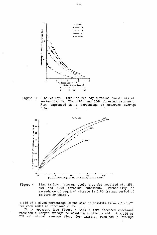
The 10 day duration flow frequency curves, or annual minimum series, of the different modelled levels of afforestation are shown in Figure 3, and confirm the reduction in the annual minima with increase in forest level. Figure 4 shows the storage/yield plots, based on the Institute of
Hydrology annual failure method, for modelled flows from the Elan Valley for different degrees of afforestation, with a probability that the storage will fail to supply the required yield in any year of 0.05 (corresponding to a return period of 20 years). The axes have been standardised by the same value of natural average annual runoff for the storage axis and average daily flow for the yield axis for all four curves so that direct comparisons can be made. A
313
%Forest • 0
a 25
û 50
a 100
Q n * ~
Reduced variate W Return Period (years)
—1 100
Figure 3 Elan Valley: modelled ten day duration annual minima series for 0%, 25%, 50%, and 100% forested catchment. Flow expressed as a percentage of observed average flow.
10 20 30 Storage (Percentage of observed average annual runoff)
Figure 4 Elan Valley: storage yield plot for modelled 0%, 25%, 50% and 100% forested catchment. Probability of exceedance of required storage Is 0.05 (return period of failure 20 years).
yield of a given percentage is the same in absolute terms of m 3.s _ 1
for each modelled catchment curve. It is apparent from Figure 4 that a more forested catchment
requires a larger storage to maintain a given yield. A yield of 20% of natural average flow, for example, requires a storage

314
equivalent to catchment with runoff for a reliability, a would supply a
3.6% of the natural average annual runoff for a 2.5% forest, and 7.6% of the natural average annual 100% forested catchment. Conversely, for this storage of 20% of natural average annual runoff yield of 62% of natural ÀDF (i.e. 5.2 m
3.s~l) from the 2.5% forested catchment but only 39% of natural ADF (i.e. 33 m3.s_1) for the completely forested catchment. This increase in the storage necessary for a given yield is much greater than that expected from a simple consideration of the reduction in average flow due to afforestation, (Figure 2). À study of flow duration curves revealed that there is a variation in the seasonal distribution of flows, with the more forested catchments having disproportionately decreased low flows (Schuch, 1973).
HORE
The Hore is a sub-catchment of the Plynlimon catchment in Mid Wales, just north of the Elan Valley. Plynlimon has been a site of Institute of Hydrology research since the late 1960s. Unlike the Elan valley, the Hore has undergone recent changes in forest cover, as a significant part of the predominantly forested catchment has been clear-felled over the years 1985-1987. From the research catchments, detailed flow, rainfall and evaporation data are available, thus providing a good opportunity for testing the Institute of Hydrology lumped conceptual model, and predicting the effects of further deforestation.
The Hore has an altitude of 365-670 a, average annual rainfall of 2540 ram.year-1 and a totai area of 3.17 km2, of which 65% was covered forest prior to 1985. Ten per cent of the catchment is covered by heather and moorland, the rest grassland. The nodel was applied to the catchment and the areas of different land use altered to simulate the recent clear felling, with the simplifying assumption that deforested areas immediately become grassland. The change in land use of the catchment over time is shown in Fiqure 5.
f 6 0 '
Ô
l-l 20-
0 -
NEATHER MOOftLAND
GRASSLAND!
\ "
ronESï
. ' - - :<:•
- N < ^ V
Figure 5 Deforestation of the Hore catchment.
315
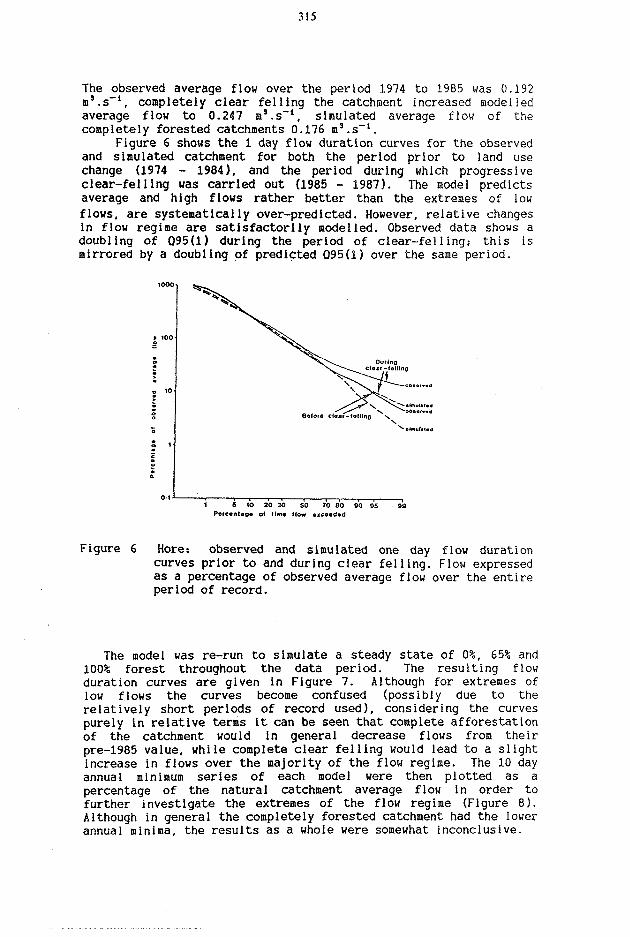
The observed average flow over the period 1974 to 1985 was 0.192 m'.s-1, completely clear felling the catchment increased modelled average flow to 0.247 a'.s-1, simulated average flow of the completely forested catchments 0.176 m 3.s _ 1.
Figure 6 shows the 1 day flow duration curves for the observed and simulated catchment for both the period prior to land use change (1974 - 1984), and the period during which progressive clear-felling was carried out (1985 - 1987). The node! predicts average and high flows rather better than the extremes of low flows, are systematically over-predicted. However, relative changes in flow regime are satisfactorily modelled. Observed data shows a doubling of Q95(l) during the period of clear-felling; this is mirrored by a doubling of predicted 095(1) over the same period.
B«fOfd ctear-fallinQ
5 K) 20 30 SO 70 80 SO S5 Percentage of (lm« flow exceeded
Figure 6 Hore.- observed and simulated one day flow duration curves prior to and during clear felling. Flow expressed as a percentage of observed average flow over the entire period of record.
The model was re-run to simulate a steady state of 0%, 65% and 100% forest throughout the data period. The resulting flow duration curves are given in Figure 7. Although for extremes of low flows the curves become confused (possibly due to the relatively short periods of record used), considering the curves purely in relative terms it can be seen that complete afforestation of the catchment would in general decrease flows from their pre-1985 value, while complete clear felling would lead to a slight increase in flows over the majority of the flow regime. The 10 day annual minimum series of each model were then plotted as a percentage of the natural catchment average flow in order to further investigate the extremes of the flow regime (Figure 8). Although in general the completely forested catchment had the lower annual minima, the results as a whole were somewhat inconclusive.

316
5 50 20 30 50 70 80 90 95 99 e n l n g e ol l ime How e x c e e d e d
Figure 7 Hore: modelled one day flow duration curves for 0%, 65% and 100% forested catchment. Flow expressed as a percentage of observed average flow.
%Foresl O
65 100
1 2 3 Reduced variate W i 1 1 1—i—i 2 5 10 25 50 100
Return period (years)
Figure 8 Hore: modelled ten day duration annual minima series for 0%, 65% and 100% forested catchment. Flow expressed as a percentage of observed average flow.
DULLER
The DoHer is a small catchment of 8.9 km2 in the Vosges of France. It is a high altitude catchment (from 580m to 1138m) with an average annual rainfall of 2110 mm and a mixed land use consisting of 77% mixed forest (fir and beech trees), 16% valley bottom meadows and 7% high pasture. The soil of the catchment is generally impermeable, and derived from the underlying rock that consists

317
mainly of Carboniferous sedimentary, volcanic and granitic associations. In most aspects, especially land use and rainfall, this catchment shows great similarity to the Hore. This made it a suitable catchment to which to apply the lumped conceptual model, some of whose parameters had been optimised on the Hore from the detailed meteorological, hydrologicai and physical data available there.
Observed average flow for the period 1976 to 1981 was 0.457 m'.s"1, with the simulated average flow for the catchment with 77% forest within three per cent of this value. The observed and simulated flow duration curves agree closely for the DoHer except in the case of very low flows. The average flow for the 100% forested catchment was predicted to decrease to 0.404 m 3.s _ 1, while the catchment with 5% forest cover had a modelled average flow of 0.565 m s.s - 1. Figure 9 shows the average hydrographs for simulated flows for the Doller, with levels of, forest set at 5% and 100%. While flows about the average remain relatively unchanged with afforestation it is clear that low flows are significantly decreased for the forested catchment. These results support conclusions reached from the other modelled catchments. The flow duration curves similarly reveal a systematic decrease in flows with increase in forest, however without the extremes of iow flow predicted for the completely forested Elan Valley case.
Although the Doller analysis is based on a very short record of available rainfall data it gives an unambiguous indication of the likely effect of a change in the level of afforestation in the catchment.
Figure 9 Doller: modelled average annual hydrograph for 5%, 77% and 100% forested catchment. Flows shown on a logarithmic scale and expressed as a percentage of observed average flow.

318
DISCUSSION
The rainfall data available for each of the three sets of simulations were very different in quality; varying from the Hore experimental basin network of five rain gauges to the single gauge used'to distribute the monthly catchment rainfall data as a daily input for the Elan Valley. Gaps in the data for the Doller gauge had to be infilled from gauges outside the catchment, and some problems were experienced with high rainfall measurements in the catchment.
From past results the model appears not to be too sensitive to the exact values of évapotranspiration used. The estimates of Penman open water and évapotranspiration for the Hore were based on data from the main Plynlimon high and low level meteorological sites, and these were also used for the nearby Elan Valley catchments simulation. These are at approximately the same altitude as the Plynlimon catchments, although some twenty kilometres away. For the data before 1969 going back to 1932 the mean annual data for the Plynlimon catchments, 1969-1984, was distributed on a daily basis using a sine function. No Penman data and insufficient meteorological data were available in the immediate area of the Doller catchment so monthly average meteorological data from Dijon was used (World Survey of Climatology, ed. Landsberg, 1970) to make an estimate of monthly Penman évapotranspiration which was then distributed on a daily basis using a sine function as before.
In spite of these deficiencies in the evaporation data the model was able to allow for differences in the initial landuse model calibration by optimisation of the relevant parameters. Any bias introduced by the use of data from outside the catchment was removed by this process, but it could not of course cope with any temporal differences introduced by using the same annual data each year.
The conceptual model has at present no module for inputs of precipitation as snow. However, while it will not simulate the hydrograph accurately during a snowfall event, it will produce an overall estimate of the total flows for the period.
Apart from problems caused by the timing and distribution of snow melt the model appears to simulate the high and middle ranges of the flow duration curves with accuracy. The objective function used to optimise the model parameters for each catchment is the sum of squares of residual errors which does tend to bias the simulation towards high flows. The use of a proportional objective function for the groundwater parameters using recession periods might overcome this problem with low flows.
The simulation of observed flows for the Elan Valley is good with slight under prediction at high and low flows {Figure 1). This may be caused by the use of a constant annual evaporation rate for the years 1932 to 1968. The overall change in water use predicted for 100% afforestation agrees well with the results obtained at Plynlimon in central Wales (Eeles et al, 1986).
The short period of deforestation from 65% to 37% forest in the Hore is again simulated well at high and medium flows before and during clear felling, but the low flows are under predicted. However, the relative percentage of ADF is maintained with the clear felling (Figure 6). The pasture and moorland area of the Hore is entirely at a high level in the catchment with the forest

319
at low levels. The flow duration curve for complete deforestation shown in Figure 7 crosses the other two at low flows, and this is probably a reflection of the lack of soil and groundwater storage at a high level; this area simply being increased to cover the whole catchment. Using grassland parameters obtained by modelling a neighbouring unforested catchment may improve the performance of the model in this respect. This problem is perhaps reflected in the modelling of the Doller catchment.
CONCLUSION
Where sufficient data are available, the lumped conceptual model can be successfully applied to a variety of catchments. Data requirements, of daily rainfall, flows and évapotranspiration estimates for calibrating the model, are small compared to those of physically based models, and simulated flows agree well with those observed. A change in the emphasis of optimisation of the model parameters may enable the low flow part of the flow regime especially to be modelled more closely.
Even with very limited meteorological data coarse predictions of the direction and extent of change in flow regime are possible using the model. By applying low flow analysis techniques to the flow data produced by models of different levels of forest in a catchment more details on the change in seasona-1 distribution of flows and the frequency of occurrence of certain levels of drought can be obtained. The combination of the lumped conceptual model and low flow analysis techniques would be valuable in any preliminary analysis of the environmental impact or implications for water resources of proposed change in afforestation of a catchment.
ACKNOWLEDGEMENTS
The research presented in this paper was carried out as part of the FREND (Flow Regimes from Experimental and Network Data) project, with funding from the British Natural Environment Research Council and the Department of the Environment. The authors would like to thank Severn Trent Water for the use of natural and simulated data from the Elan Valley catchments, and the Service Regional de l'Aménagement des Eaux d'Alsace for the use of data from the Doller catchment.
REFERENCES
Blackie, J.R. and Eeles, C.W.O. (1985) Lumped catchment models. Chapter 11 in Hydro logical Forecasting, John Wiley and Sons Ltd. (Appendix 2)
Calder, I.R. (1986) The influence of land use change on water yield in upland areas of the U.K. J. Hydro1. 88 201-211.

320
Douglas, J.R. and Jack, W.L. (1987) The impact on water resources of the afforestation of the catchments of the Elan Valley reservoirs Welsh Water, Severn-Trent Water joint report.
Eeles, C.W.O., Farquharson, F.A.K. and Harding, R.J. (1986) Report on the effects of progressive afforestation on runoff from the Elan Valley catchments. Report to Severn Trent and Welsh Water Authorities. Institute of Hydrology, Wallingford, Oxon., UK.
Gustard, A., Roald, L., Demuth, S., Lumadjeng, H. and Gross, R. (1989) Flow Regimes from Experimental and Network Data (FREND) 2 Vols. Institute of Hydrology, Wallingford, Oxon, UK
Institute of Hydrology (1980). Low flow studies report. 38 484-494.
Landsberg, H.E. (editor) 1970 World Survey of Climatology Vol.5 (ed. C.C. Wallen), Elsevier.
Law, F. (1956) The effects of afforestation upon water yields of catchment areas. J.Br.Waterwks.Assn. 38 484-494
Schuch, H. Beeinflussung des Bodenwasserhaushaltes von Hochraoorflachen sudlich des Chiemsees durch Aufforstung. TELMA 3 229-234.