
APPENDIX IV - galway.ie
105
APPENDIX IV County Galway Wind Energy Strategy Plean Forbartha Chontae na Gaillimhe // Galway County Development Plan
Transcript of APPENDIX IV - galway.ie

APPENDIX IVCounty Galway Wind Energy Strategy
Plean Forbartha Chontae na Gaillimhe // Galway County Development Plan

TABLE OF CONTENTS
Page Executive Summary ................................................................ i
1. Introduction ................................................................... 1 1.1 Overview ......................................................................................... 1 1.2 Planning and Policy Context ........................................................... 2 1.3 Aims of the Wind Energy Strategy .................................................. 8 1.4 Terms and Definitions ..................................................................... 9 1.5 Structure of the Report ................................................................. 11
2. Methodology ................................................................ 12 2.1 Introduction ................................................................................... 12 2.2 Geographic Information System ................................................... 13 2.3 Fieldwork ...................................................................................... 17 2.4 Environmental Assessment .......................................................... 18
3. Wind Energy Policies and Objectives ......................... 24 3.1 Introduction ................................................................................... 24 3.2 Wind Energy Policies .................................................................... 24 3.3 Wind Energy Objectives ............................................................... 25 3.4 Statutory Thresholds for Wind Energy Developments .................. 28
4. Landscape Capacity for Wind Energy Developments . 30 4.1 Introduction ................................................................................... 30 4.2 Strategic Guidance on Landscape Capacity for Wind Energy Developments .......................................................................................... 30
5. Development Management Guidelines ....................... 35 5.1 Introduction ................................................................................... 35
5.2 Environmental Assessment and Management ............................. 40 5.3 Wind Farm Layout, Design and Construction ............................... 59
6. Appendices ................................................................... 62 6.1 Appendix WE1 : Wind Energy Strategy Maps .............................. 63 6.2 Appendix WE2 : Terms, Acronyms and References .................... 80 6.3 Appendix WE3 : Tables and Calculations ..................................... 93 6.4 Appendix WE4: Supporting Documents ..................................... 100
Note: Information in this document relating to Built Heritage, Natural Heritage Designations and Geo-Directory is generally based on 2011 data. The data relating to the maps in this document dates generally from 2011, in particular Maps 2A, 3A, 3D, 5B, 5D &5E. Please note that this data is subject to change on an ongoing basis and due regard should be taken of same.
List of Tables
Page Table WE1 : Wind Farms Operating in County Galway, 2013 ................... 5 Table WE2 : Wind Farm Planning Applications, 1996-2013 ...................... 5 Table WE3 : Gate 3 Node Assignments for County Galway, 2011 ............ 5 Table WE4 : Potential Wind Energy Development in Galway .................... 6 Table WE5 : Influence of Spatial Analysis, SEA and HDA on WES ......... 21 Table WE6 : Criteria for Defining Areas for Wind Farm Development ..... 22 Table WE7 : Strategic Guidance on Landscape Capacity for Wind Energy Developments in Landscape Character Areas ......................................... 31 Table WE8 : Guidelines for Separation Distances for Turbines in Wind Farm Developments ................................................................................. 38 Table WE9 : Potential Impacts of Wind Energy Developments ............... 40 Table WE10 : Key Natura 2000 Sites, Qualifying Interests and Relevant Guidance/Mitigation Measures ................................................................. 42
List of Maps
Page Map WE-1B : Wind Resources and Transmission Network ..................... 64 Map WE-2A : Urban and Rural Settlements ............................................. 65 Map WE-2B: Transport and Utility Infrastructure ...................................... 66 Map WE-3A : Natural Heritage Designations ........................................... 67 Map WE-3B : Topography and Waterbodies ............................................ 68 Map WE-3C : Peatlands and Limestone Pavement ................................. 69 Map WE-3D : Built Heritage ...................................................................... 70 Map WE-4A : Landscape Value and Character Areas ............................. 71 Map WE-4B : Landscape Sensitivity and Character Areas ...................... 72 Map WE-4C : Focal Points / Views ........................................................... 73 Map WE-5A : Strategic Wind Farm Development Areas and Transmission Network ..................................................................................................... 74 Map WE-5B : Strategic Wind Farm Development Areas and Natural Heritage Designations .............................................................................. 75 Map WE-5C : Strategic Wind Farm Development Areas and Landscape Character Areas ........................................................................................ 76 Map WE-5D : Strategic Wind Farm Development Areas and Built Heritage ..................................................................................................................77 Map WE-5E : Strategic Wind Farm Development Areas and Urban and Rural Settlement ....................................................................................... 78 Map WE-5F : Strategic Wind Farm Development Areas and Transport and Utility Infrastructure ................................................................................... 79 Note:
Information in this document relating to Built Heritage, Natural Heritage Designations and Geo-Directory is generally based on 2011 data.
The data relating to the maps in this document dates generally from 2011, in particular Maps 2A, 3A, 3D, 5B, 5D &5E. Please note that this data is subject to change on an ongoing basis and due regard should be taken of same.
Appendix IV
// County Galw
ay Wind Energy Strategy

County Galway Wind Energy Strategy Page i
County Galway Wind Energy Strategy – Executive Summary
Galway County Council (GCC) has prepared a Wind Energy Strategy (WES) for County Galway. The strategy provides strategic direction to encourage renewable energy and to guide the siting and design of wind energy developments in appropriate locations within the County. The preparation of the WES has been informed by local, regional, national, EU and international agreements, policy and legislation in relation to climate change, energy security and renewable energy. The WES aims are shown opposite. The WES provides a set of policies and objectives to guide the development of wind energy projects and support infrastructure in appropriate locations in a manner that capitalises on the substantial wind resources and avoids significant adverse effects on the environment, landscape or amenities in the County.
• Revise and update the existing guidance on wind farm potential.
• Develop a Wind Energy Strategy in light of the available national guidelines Planning Guidelines for Wind Farm Development 2006 issued by the Department of Environment, Heritage and Local Government (or any updated document).
• Reflect and plan for technological advances in wind farms over the next number of years.
• More closely align the County’s wind generation policy to the existing wind energy resources.
• Support a plan led approach to wind energy development in County Galway predicated on the optimal harnessing of the County’s wind energy resource, and at a minimum requiring that 40% of Galway’s electricity needs can be met from renewable energy sources, including wind farms.
• Identify strategic areas for wind energy development of local, County, regional, and national importance.
• Work towards a target of 500 MW of wind energy in County Galway, to enable Galway to make the initial steps toward a low carbon economy by 2020. This target will enable Galway to generate the equivalent of over 70% of its electricity needs from wind energy.
• Support County Galway in reducing CO2 emissions associated with energy production, as identified in the Galway Climate Change Strategy prepared by the Galway Energy Agency (GEAL, 2001) and support the outcome of the forthcoming Local Climate Change Adaptation Plan.
• Promote the economic development of wind energy and other renewables in the County, underpinning the need for energy security, the promotion and establishment of a low carbon economy and the development of green business within the County.
• Ensure the production of wind energy is consistent with and takes account of nature conservation and environmental legislation and targets, including the conservation and protection of the designated and proposed Natura 2000 sites and Natural Heritage Areas in and adjacent to the County.
• Ensure full compliance with the requirements of the EU SEA Directive (2001/42/EC) and the associated SEA Regulations 2004 (SI No. 436 of 2004)(as amended) and SEA Guidelines 2004 (DoEHLG, 2004).
• Ensure full compliance with the requirements of the EU Habitats Directive (92/43/EEC), in particular the need for Appropriate Assessment, in line with the Natural Habitats Regulations (SI No. 94 of 1997)(& as updated), Appropriate Assessment Guidelines 2009 (DoEHLG, 2009) and the Planning and Development Act 2000-2010.
i Plean Forbartha Chontae na G
aillimhe // G
alway County D
evelopment Plan

County Galway Wind Energy Strategy Page ii
The WES designates strategic wind farm development areas in terms of their suitability for wind farm development based on strategic analysis in relation to wind resources, natural heritage designations, landscape sensitivity, infrastructure capacity, settlement growth and amenity considerations. The table opposite provides a summary of the strategic wind farm development areas identified in the County (colours in first column match those on Map WE-5A to WE-5F). The WES provides guidance in relation to the capacity of the various Landscape Character Areas (LCAs) in the County to accommodate wind farm developments, together with guidelines on the assessment, siting, design, construction and operation of wind energy developments. The WES also includes a set of appendices and is accompanied by a number of separate supporting documents, including the SEA Environmental Report and HDA Natura Impact Statement.
Strategic Wind Farm Area
Description and Guidance Location Area
(ha) % of Total
Potential Total MW
Output
Target MW by 2020
SA – Strategic
Areas
Large area in most suitable location for wind farm development and without significant environmental constraints, based on strategic-level analysis. Wind farm developments will be encouraged in this area subject to detailed environmental and visual assessment and appropriate layout and design.
LCA 10 in west of County
5,390 1% 600 (140)
220 (140)
AP – Acceptable in
Principle Areas
Smaller areas in suitable locations for wind farm development and without significant environmental constraints, based on strategic-level analysis. Wind farm developments will be facilitated in these areas subject to detailed environmental and visual assessment and appropriate layout and design.
LCA 10, 11, 12, 16
& 17 in west
6,510 1% 480 (40)
100 (40)
OC – Open To
Consideration Areas
Areas with some locations that may have potential for wind farm development due to viable wind speeds or clustering with Strategic Areas but with significant environmental constraints, based on strategic level assessment. Wind farm developments in these areas will be evaluated on a case by case basis subject to viable wind speeds, environmental resources and constraints and amenity, safety and cumulative impacts.
LCA 1, 3, 4, 5, 6 &
13 in east
LCA 9, 10, 12, 16 &
18 in west
107,965 18% 480 (55)
60 (55)
NP – Not Normally Permissible
Areas
Areas generally not suitable for wind farm development due to their overall sensitivity and constraints arising from landscape, ecological, recreational, settlement, infrastructural and/or cultural and built heritage resources, based on strategic level assessment. Wind farm developments in these areas will be discouraged, unless project level HDA and EIA can demonstrate to the satisfaction of the planning authority that environmental and other impacts can be successfully avoided, minimised and/or mitigated.
LCA 1-8 & 13 in east
LCA 9-12 & 14-25 in
west
298,125 48% (120) (120)
LW – Low Wind
Speed Areas
Areas with wind speeds less than 8m/s that would generally not provide viable locations for commercial wind farm developments.
LCA 1-8 & 13 in east LCA 11 in
west
196,403 32% 0 0
Total – – 614,393 100% 1,680 500 Note: Figures in brackets indicate MW of wind energy from existing and permitted wind farm developments.
Plean Forbartha Chontae na G
aillimhe // G
alway County D
evelopment Plan ii
Appendix IV
// County Galw
ay Wind Energy Strategy

County Galway Wind Energy Strategy Page 1
1. Introduction
1.1 Overview
Galway County Council (GCC) has prepared a Wind Energy Strategy (WES) for County Galway. This WES provides minor updates to the original WES adopted by Galway County Council in 2011, as a variation to the Galway County Development Plan 2009-2015, and is accompanied by the HDA and SEA carried out at that time. The HDA and SEA of the Galway County Development Plan has had due regard to these documents. The strategy provides strategic direction to encourage renewable energy and to guide the siting and design of wind energy developments in appropriate locations within the County. County Galway has significant wind resources and a key priority of the WES is to identify sites of strategic, national and regional importance that have the potential to accommodate wind energy development. The WES outlines the areas of wind farm potential and reviews areas of wind farm potential having regard to protected sites, habitats and species and other environmental, landscape, infrastructural and settlement considerations. Wind Resource Zones identified in previous plans were developed from research undertaken as part of the Landscape and Landscape Character Assessment for Galway County 2002 prepared on behalf of GCC, which was used to identify appropriate areas for wind farm development. Therefore, the key considerations were the landscape and visual impacts of wind farm developments. Wind potential areas were identified as Strategic Areas, Areas for Consideration and No Go Areas.
In undertaking the current strategy, landscape and visual considerations have been considered in conjunction with a range of other factors, including the need to achieve greater energy security, achieving commitments at national and international level regarding reductions in greenhouse gases, promoting renewable energy, protected areas of high biodiversity and other environmental considerations. This WES will guide development for wind farms within the County during the lifetime of the plan. A Strategic Environmental Assessment (SEA) and Habitats Directive Assessment (HDA) have been prepared in tandem with this strategy and have informed this WES. This WES takes account of updated national and regional planning guidelines, strategies and policy documents. It is also informed by issues of particular national, European and international environmental importance that have evolved, and are now accepted as being critical to the formulation and implementation of sustainable development, such as climate change, renewable and alternative energy. This WES designates strategic wind farm development areas as being: a) SA – Strategic Areas, b) AP – Acceptable in Principle, c) OC – Open for Consideration, and d) NP – Not Normally Permissible. The total land area proposed as Strategic Areas is 5,390ha, and the area proposed as Acceptable in Principle is 6,510ha. Together, these areas constitute around 2% of the total County area.
1 Plean Forbartha Chontae na G
aillimhe // G
alway County D
evelopment Plan

County Galway Wind Energy Strategy Page 2
Further detail on the environmental resources in these areas can be found in the accompanying SEA Environmental Report and HDA Natura Impact Statement.
1.2 Planning and Policy Context
The WES for County Galway has been developed with regard to the following: • Climate change, energy security and renewable energy
requirements and obligations as identified in local, regional, national, European Union (EU) and international agreements, legislation and policies.
• Galway County Development Plan and associated plans and guidance, including the Heritage Plan and the Landscape Character Assessment for Galway County.
• Wind energy development in County Galway, including existing operational wind farms, planning applications and permissions for wind farms and node assignments for connecting new wind farms to the national grid.
• Environmental assessment of the potential impacts of the WES on the environment, including protected sites, habitats and species, as a result of wind farm developments that may be permitted in County Galway on the basis of the WES.
1.2.1 Climate Change, Energy Security and Renewable
Energy
The preparation of the WES has had regard to local, regional, national, EU and international agreements, policy and legislation in relation to climate change, energy security and renewable energy. In particular, this includes the following: • Kyoto Protocol – United Nations (UN) targets for reducing
greenhouse gas (GHG) emissions as part of the UN Framework Convention on Climate Change, with the EU agreeing to an overall reduction target of 8% below 1990 levels and Ireland limiting the increase of GHG to 13% over the 1990 levels by 2008 (and any subsequent amendments).
• EU Directive 2001/77/EC – promotion of electricity produced from renewable energy sources in the internal electricity market (commonly referred to as the RES-E Directive), which required Ireland to generate 13.2% of its electricity from renewables by 2010.
• EU Renewable Energy Road Map. Renewable Energies in the 21st Century: Building a More Sustainable Future – set overall targets for renewable energy deployment in EU as a share of total energy use of 12% by 2010 and 20% by 2020.
• EU Directive 2009/28/EC – promotion of the use of energy from renewable sources, which increases Ireland’s target to 16% of final energy consumption being generated from renewables by 2020 and makes these targets legally binding.
• National Climate Change Strategy 2007-2012 – measures to meet Ireland’s climate change commitments for 2008-2012 and 2020
Plean Forbartha Chontae na G
aillimhe // G
alway County D
evelopment Plan 2
Appendix IV
// County Galw
ay Wind Energy Strategy

County Galway Wind Energy Strategy Page 3
• Government White Paper on Delivering a Sustainable Energy Solution for Ireland 2007 – national energy policy framework for 2007-2020, which increased targets for electricity from renewable energy sources to 15% by 2010 and 33% by 2020 (this target increased again in 2008 to 40% by 2020).
• Maximising Ireland’s Energy Efficiency: The National Energy Efficiency Action Plan 2009-2020, Department of Communications, Energy and Natural Resources (DoCENR) – sets a national target of 20% reduction in energy demand by 2020 through energy efficiency measures and a 33% reduction in public sector energy usage in the same period.
• Planning Guidelines for Wind Energy Development for Planning Authorities 2006, Department of the Environment Heritage and Local Government (DoEHLG) – guidelines advising planning authorities on planning for wind energy through the development plan process.
• West Regional Planning Guidelines 2010-2022, West Regional Authority (WRA) – development framework for West Region, which highlights the significant renewable energy potential of the West Region and encourages projects for the production of renewable energy sources, particularly wind energy and biomass developments, in appropriate locations.
• Galway Climate Change Strategy Report 2001, Galway Energy Agency Limited (GEAL) – sets out Galway’s consumption and environmental emissions in response to Kyoto Protocol to assess 2002-2005 baseline.
The figure below summarises the energy and climate targets for Ireland as set out under national and international commitments:
Kyoto Protocol • Limit the increase in GHG emissions to 13% above 1990 levels by
2012 (or to any agreed amendments to same). • Copenhagen Accord, December 2009
EU Commission Post-Kyoto Targets for 2020 • Reduce emissions in the non-trading sectors (agriculture, transport,
residential, commerce, waste) by 20% from 2005 base • Reduce emissions in the ETS sector by 21% from 2005 base
National and EU Targets • Renewable sources to contribute 16% of final energy consumption
(electricity, heat and transport) in 2020 • 15% of electricity generation from renewable sources by 2010; 40%
by 2020
Related National Targets • 20% increase in energy efficiency by 2020 • 30% biomass co-firing at peat plants in Ireland by 2020 • 10% renewable energy in transport by 2020
Source: WRA (2010) Regional Planning Guidelines for the West Region 2010-2022 Renewable energy is increasingly seen as a means to address climate change challenges, reduce carbon dioxide emissions and increase national energy security. The term renewable energy generally refers to electricity supplied from renewable energy sources, such as wind and solar power, geothermal, hydropower and various forms of biomass. These energy sources are considered renewable sources because their fuel sources are continuously replenished. This contrasts with fossil fuels that are considered finite resources. A shift from a fossil fuel to a renewable energy generation economy would generate the following significant benefits:
3 Plean Forbartha Chontae na G
aillimhe // G
alway County D
evelopment Plan

County Galway Wind Energy Strategy Page 4
• Reduced CO2 emissions. • Secure and stable energy supply for the long term. • Reduced reliance on expensive fuel imports. • Investment and employment in indigenous renewable energy projects,
often in rural and underdeveloped areas. In 2007, Ireland’s level of renewable energy deployment as a share of total energy use was 3%, while that of the EU was 7% (WDC, 2008). This contrasts with the EU requirement (under Directive 2009/28/EC) that 16% of Ireland’s total energy use be provided from renewable energy sources by 2020. The national target for renewable energy was increased, in October 2008, to reach 40% of electricity generated by 2020. This national target is estimated to require an installed capacity of around 6,000 MW in Ireland by 2020. Whilst this WES primarily addresses onshore wind energy developments within the functional area of County Galway, as other renewable technologies develop and become established, these will be recognised and may be reconsidered over the intended lifetime of the WES in order to achieve national and EU targets and the local objectives for renewable energy in County Galway. 1.2.2 Galway County Development Plan
The Galway County Development Plan (GCDP) takes account of the Kyoto Protocol, the National Climate Change Strategy 2007-2012, the Government’s White Paper on Delivering a Sustainable Energy Future for Ireland: Energy Policy Framework 2007-2012, the DoEHLG Guidelines for Planning Authorities on Wind Energy Development 2006 and the GCC Landscape and Landscape Character Assessment for Galway County
2002. Under Objective ER5, the Galway County Development Plan provides for the promotion and facilitation of wind farm developments in suitable locations, having regard to areas of the County designated for this purpose in the County Galway Wind Energy Strategy (WES), with the Planning Authority assessing any planning application proposals for wind energy production in accordance with the County Wind Energy Strategy, the DoEHLG Guidelines for Planning Authorities on Wind Energy Development, 2006 (or any updated/superseded documents), having due regard to the Habitats Directive and to the detailed policies, objectives and Development Standards set out in the Wind Energy Strategy. This WES reviews the previous methodology utilised in the Landscape Character Assessment for Galway County in relation to wind farms. The strategy is informed by recent and emerging planning and policy developments that affect wind farm development, including the DoEHLG Planning Guidelines for Wind Energy Development for Planning Authorities 2006, the WRA West Regional Planning Guidelines 2010-2022 and a number of EU Directives and guidelines. 1.2.3 Wind Energy Development in Galway
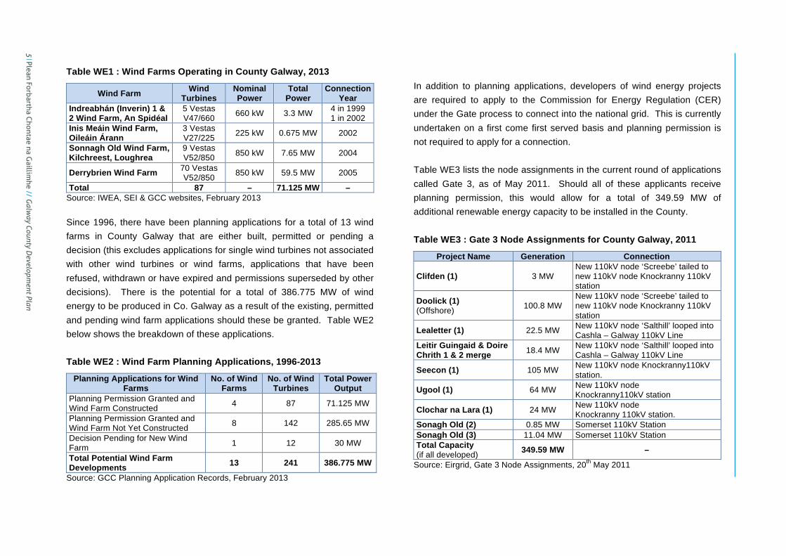
Currently, there are 4 wind farms operating in County Galway containing a total of 87 wind turbines that generate approximately 71.125 MW of energy. This compares with 239MW generated in County Donegal, which has the largest number of wind farms nationally, 32 MW in County Clare and 28.5 MW in County Mayo. Ireland’s total installed wind energy capacity is approximately 1,746.7 MW generated from 146 wind farms in 25 counties. Table WE1 below lists the wind farms currently operating in Galway:
Plean Forbartha Chontae na G
aillimhe // G
alway County D
evelopment Plan 4
Appendix IV
// County Galw
ay Wind Energy Strategy
County Galway Wind Energy Strategy Page 5
Table WE1 : Wind Farms Operating in County Galway, 2013
Wind Farm Wind Turbines
Nominal Power
Total Power
Connection Year
Indreabhán (Inverin) 1 & 2 Wind Farm, An Spidéal
5 Vestas V47/660 660 kW 3.3 MW 4 in 1999
1 in 2002 Inis Meáin Wind Farm, Oileáin Árann
3 Vestas V27/225 225 kW 0.675 MW 2002
Sonnagh Old Wind Farm, Kilchreest, Loughrea
9 Vestas V52/850 850 kW 7.65 MW 2004
Derrybrien Wind Farm 70 Vestas V52/850 850 kW 59.5 MW 2005
Total 87 – 71.125 MW – Source: IWEA, SEI & GCC websites, February 2013 Since 1996, there have been planning applications for a total of 13 wind farms in County Galway that are either built, permitted or pending a decision (this excludes applications for single wind turbines not associated with other wind turbines or wind farms, applications that have been refused, withdrawn or have expired and permissions superseded by other decisions). There is the potential for a total of 386.775 MW of wind energy to be produced in Co. Galway as a result of the existing, permitted and pending wind farm applications should these be granted. Table WE2 below shows the breakdown of these applications. Table WE2 : Wind Farm Planning Applications, 1996-2013
Planning Applications for Wind Farms
No. of Wind Farms
No. of Wind Turbines
Total Power Output
Planning Permission Granted and Wind Farm Constructed 4 87 71.125 MW
Planning Permission Granted and Wind Farm Not Yet Constructed 8 142 285.65 MW
Decision Pending for New Wind Farm 1 12 30 MW
Total Potential Wind Farm Developments 13 241 386.775 MW
Source: GCC Planning Application Records, February 2013
In addition to planning applications, developers of wind energy projects are required to apply to the Commission for Energy Regulation (CER) under the Gate process to connect into the national grid. This is currently undertaken on a first come first served basis and planning permission is not required to apply for a connection. Table WE3 lists the node assignments in the current round of applications called Gate 3, as of May 2011. Should all of these applicants receive planning permission, this would allow for a total of 349.59 MW of additional renewable energy capacity to be installed in the County. Table WE3 : Gate 3 Node Assignments for County Galway, 2011
Project Name Generation Connection
Clifden (1) 3 MW New 110kV node ‘Screebe’ tailed to new 110kV node Knockranny 110kV station
Doolick (1) (Offshore) 100.8 MW
New 110kV node ‘Screebe’ tailed to new 110kV node Knockranny 110kV station
Lealetter (1) 22.5 MW New 110kV node ‘Salthill’ looped into Cashla – Galway 110kV Line
Leitir Guingaid & Doire Chrith 1 & 2 merge 18.4 MW New 110kV node ‘Salthill’ looped into
Cashla – Galway 110kV Line
Seecon (1) 105 MW New 110kV node Knockranny110kV station.
Ugool (1) 64 MW New 110kV node Knockranny110kV station
Clochar na Lara (1) 24 MW New 110kV node Knockranny 110kV station.
Sonagh Old (2) 0.85 MW Somerset 110kV Station Sonagh Old (3) 11.04 MW Somerset 110kV Station Total Capacity (if all developed) 349.59 MW –
Source: Eirgrid, Gate 3 Node Assignments, 20th May 2011
5 Plean Forbartha Chontae na G
aillimhe // G
alway County D
evelopment Plan

County Galway Wind Energy Strategy Page 6
Planning permission has already been granted or is pending for a total of 259.55 MW in proposed wind farms in a number of the above Gate 3 areas. There is therefore potential for a further 90.04 MW of wind energy capacity that could to be granted planning permission under the Gate 3 allocations. In summary, therefore, the existing, permitted, pending and potential wind energy development in Galway is as follows: Table WE4 : Potential Wind Energy Development in Galway
Wind Energy Potential No. of Wind Farms
No. of Wind Turbines
Total Power Output
Installed Wind Energy Capacity (WEC) 4 87 71.125 MW
Permitted Wind Energy Capacity (excluding Installed WEC) 8 142 285.65MW
Pending Wind Energy Capacity (undecided planning applications for new wind farm)
1 12 30 MW
Additional Gate 3 Wind Energy Capacity (excluding Permitted and Pending WEC)
NA NA 90.04 MW
Total Potential Wind Farm Developments – – 476.815 MW
Source: GCC Planning Application Records, February 2013; EirGrid, Gate 3 Node Assignments, 30th April 2010 Appendix WE3 provides more detailed information on the installed, permitted, pending and potential wind energy developments in Galway. There are no published figures on the current or projected size of the electricity market in Galway. Utilising national figures, the electricity market and renewable energy targets for Galway (County and City) can be estimated as follows:
• According to figures published by SEI in 2009, the total final consumption of electricity in Ireland will grow from 2,665 ktoe in 2008 to 2,813 ktoe in 2020 (SEI 2009d).
• Under the White Paper on Energy (DoCMNR, 2007a), Ireland must produce 40% of its electricity from renewables by 2020.
• Applying the 40% target to the 2020 total final electricity consumption, this would require 1,125 ktoe of renewables, which is equivalent to 13,086 GWh or 4,979 MW of installed wind energy capacity (utilising a capacity factor of 30%).
• Galway’s share of the national population was approximately 5.46% in 2006 (CSO, 2006a).
• Using the above population share as a proxy, the electricity market in Galway would equal 5.46% of the national electricity market in 2020, or 154 ktoe, which is equivalent to 1,788 GWh or 680 MW of installed wind energy capacity (utilising a capacity factor of 30%).
• Therefore, 40% of the Galway electricity market in 2020 would represent 61 ktoe, which is equivalent to 715 GWh or 272 MW of installed wind energy capacity (utilising a capacity factor of 30%).
Galway will therefore be in a position to match the national 40% renewables target for electricity in 2020 based on installed and permitted wind farm developments should these be built. There is further potential to achieve a target of almost 70% for electricity generated from wind energy in Galway should all of the Gate 3 node assignments be permitted and constructed. This would enable Galway to make a significant contribution to the national 40% renewable energy target for electricity.
Plean Forbartha Chontae na G
aillimhe // G
alway County D
evelopment Plan 6
Appendix IV
// County Galw
ay Wind Energy Strategy

County Galway Wind Energy Strategy Page 7
Any future gates would allow for additional wind energy generation, which would potentially enable Galway to supply the equivalent of 100% of its electricity consumption from wind energy. There are also other renewable energy options, such as ocean or geothermal energy, which could potentially enable Galway to supply more electricity from renewable energy sources than its total electricity consumption. In such a scenario, Galway would not only be able to supply the equivalent of its electricity needs from renewable energy sources but would also be in a position to become a net exporter of electricity. 1.2.4 Electricity Transmission and Distribution
Electricity generation installations require grid connection (other than small scale stand alone generators). Depending on the amount of electricity generated, grid connection can be either through direct connection to the transmission network (110kV/220kV/400kV), controlled by EirGrid, or to a local distribution system (normally 38kV), controlled by ESB networks. The Commission for Energy Regulation (CER) regulates grid connections. Physical proximity to the grid is a consideration in the siting of new installations, but will not on its own normally determine the viability of any project, as new transmission lines can be constructed to virtually any location. In order to facilitate the expansion in electricity generation installation, particularly wind farms, the grid itself will require development and expansion. In Galway, the grid has a 400kV line in the south, a 220kV line extending north/south through the central part of the County, a number of 110kV lines in the east of the County and 38kV lines in the east and west of the County. There is also an approved 110kV line extending
from Galway City to Screebe in the west of the County which has commenced construction. It is important for the future development of electricity and wind farms in the County that these strategic pieces of infrastructure are protected from inappropriate development in their immediate environs and that their scope for development is maintained. The corridors along these routes can therefore be considered as ‘strategic infrastructure corridors’. There are also other potential strategic infrastructure corridors that would facilitate the future expansion of the electricity transmission network and provide additional capacity for future renewable energy connection, including wind energy production. In particular, there is a need for network extension and capacity improvements in the west of the County, with the potential for establishing strategic infrastructure corridors along the N59/approved Screebe line and the proposed R336 coastal road. 1.2.5 West Region and Adjoining Counties
The WES has also considered wind energy development in Galway in the context of the West Region, including Galway City, County Mayo and County Roscommon, and the other adjoining Counties of County Clare, Offaly and Tipperary North. The West Regional Planning Guidelines 2010-2022 includes the following key objective in relation to wind energy:
Objective IO54: Support the sustainable development of wind energy developments through the initiation of a Regional policy on windfarm location. The policy will be informed by Habitats Directive Assessment and by other environmental assessment including landscape character assessment and will follow DoEHLG’s Wind Energy Development Guidelines (2006) in identifying areas suitable
7 Plean Forbartha Chontae na G
aillimhe // G
alway County D
evelopment Plan

County Galway Wind Energy Strategy Page 8
for wind energy developments. Natura 2000 sites, and other ecological sites, should be placed in the ‘not normally permissible’ category unless project level HDA and/or other relevant environmental assessment determines otherwise (Please refer to CO14, CO15).
The WES for Galway has been guided by the West Regional Planning Guidelines and will also help to inform any future regional policy on wind farm location. The Galway WES has also considered any wind energy strategies and guidance available for adjoining Counties, including the County Clare Wind Energy Strategy (CCC, 2009), the Mayo Wind Energy Strategy (MCC, 2008), the County Offaly Wind Energy Strategy (OCC, 2009), the Wind Capacity Study and Outline Landscape Strategy for North Tipperary (NTCC, 2009) and the Landscape Character Assessment of County Roscommon (RCC, 2008) and Roscommon Draft Wind Energy Strategy (RCC, 2011). 1.2.6 Environmental Assessment
Wind energy has major environmental benefits: it is an inexhaustible and renewable resource and it generates electricity without the use of fossil fuels thus avoiding air pollution. However, local impacts can occur on the environment depending on location and context in relation to biodiversity, noise, archaeology, human safety and visual impact. Biodiversity impacts may include destruction of habitats and disruption of hydrological cycles in peatland systems, disruption to bird natural habitats and bird collisions and impacts on natural heritage sites, such as SACs, SPAs and NHAs. A SEA and HDA have accordingly been prepared in tandem with the WES. The SEA has been prepared in accordance with the EU Directive
on SEA (2001/42/EC), the national SEA Regulations (SI No. 436 of 2004) (as amended) and the SEA Guidelines 2004 prepared by the DoEHLG. A SEA is required to assess the likely significant adverse effects on the environment of implementing the WES as part of the statutory provisions of the GCDP. The relevant recommendations and mitigation measures from the SEA process and Environmental Report have been incorporated into the WES. The HDA has been prepared in accordance with Article 6(3) of the EU Habitats Directive (92/43/EEC), the national Natural Habitats Regulations (SI No. 94 of 1997) (as amended), the AA Guidelines 2009 prepared by the DoEHLG and the Planning and Development Act 2000 (as amended). A HDA is required to determine whether a plan or project will have a significant effect, either individually or in combination with other plans or projects, on Natura 2000 sites. The relevant recommendations and mitigation measures from the HDA process and Natura Impact Statement have been incorporated into the WES. The WES is accompanied by a separate SEA Environmental Report and HDA Natura Impact Statement which have also been considered in the SEA/AA of the CDP.
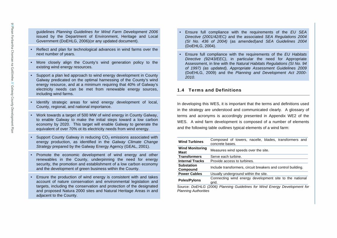
1.3 Aims of the Wind Energy Strategy
The aims of the Wind Energy Strategy are to:
• Revise and update the existing guidance on wind farm potential.
• Develop a Wind Energy Strategy in light of the available national
Plean Forbartha Chontae na G
aillimhe // G
alway County D
evelopment Plan 8
Appendix IV
// County Galw
ay Wind Energy Strategy
County Galway Wind Energy Strategy Page 9
guidelines Planning Guidelines for Wind Farm Development 2006 issued by the Department of Environment, Heritage and Local Government (DoEHLG, 2006)(or any updated document).
• Reflect and plan for technological advances in wind farms over the next number of years.
• More closely align the County’s wind generation policy to the existing wind energy resources.
• Support a plan led approach to wind energy development in County Galway predicated on the optimal harnessing of the County’s wind energy resource, and at a minimum requiring that 40% of Galway’s electricity needs can be met from renewable energy sources, including wind farms.
• Identify strategic areas for wind energy development of local, County, regional, and national importance.
• Work towards a target of 500 MW of wind energy in County Galway, to enable Galway to make the initial steps toward a low carbon economy by 2020. This target will enable Galway to generate the equivalent of over 70% ot its electricity needs from wind energy.
• Support County Galway in reducing CO2 emissions associated with energy production, as identified in the Galway Climate Change Strategy prepared by the Galway Energy Agency (GEAL, 2001).
• Promote the economic development of wind energy and other renewables in the County, underpinning the need for energy security, the promotion and establishment of a low carbon economy and the development of green business within the County.
• Ensure the production of wind energy is consistent with and takes account of nature conservation and environmental legislation and targets, including the conservation and protection of the designated and proposed Natura 2000 sites and Natural Heritage Areas in and adjacent to the County.
• Ensure full compliance with the requirements of the EU SEA Directive (2001/42/EC) and the associated SEA Regulations 2004 (SI No. 436 of 2004) (as amended)and SEA Guidelines 2004 (DoEHLG, 2004).
• Ensure full compliance with the requirements of the EU Habitats Directive (92/43/EEC), in particular the need for Appropriate Assessment, in line with the Natural Habitats Regulations (SI No. 94 of 1997) (as updated), Appropriate Assessment Guidelines 2009 (DoEHLG, 2009) and the Planning and Development Act 2000-2010.
1.4 Terms and Definitions
In developing this WES, it is important that the terms and definitions used in the strategy are understood and communicated clearly. A glossary of terms and acronyms is accordingly presented in Appendix WE2 of the WES. A wind farm development is composed of a number of elements and the following table outlines typical elements of a wind farm:
Wind Turbines Composed of towers, nacelle, blades, transformers and concrete bases.
Wind Monitoring Mast Measures wind speeds over the site.
Transformers Serve each turbine. Internal Tracks Provide access to turbines. Substation Compound Include transformers, circuit breakers and control building.
Power Cables Usually underground within the site.
Poles/Pylons Connecting wind energy development site to the national grid.
Source: DoEHLG (2006) Planning Guidelines for Wind Energy Development for Planning Authorities
9 Plean Forbartha Chontae na G
aillimhe // G
alway County D
evelopment Plan

County Galway Wind Energy Strategy Page 10
For commercial operations, turbine heights of 75m to 140m to blade tip are assumed, as these represent the range of turbines in applications in the County since 2000. The DoEHLG Planning Guidelines for Wind Energy Development for Planning Authorities 2006 acknowledge that turbine heights will change over time but provide definitions for small, medium and large turbine heights. Recent regulations also identify criteria for micro wind energy developments that would be classed as exempted development. The various turbine sizes identified in the guidelines and regulations are outlined below:
Wind Turbine
Category Turbine Size Source/Notes
Micro – Domestic
13m or less to blade tip 6m or less rotor
diameter
SI No. 83 of 2007 provides additional criteria for exempted domestic micro renewables
Micro – Industrial/ Agricultural
20m or less to blade tip 8m or less rotor
diameter
SI No. 235 of 2008 provides additional criteria for exempted industrial and agricultural micro renewables
Small Less than 60m to blade tip Planning Guidelines for Wind Energy
Development for Planning Authorities 2006 Medium 75 to 100m to blade tip
Large Over 100m to blade tip However, this WES recognises that turbine heights are increasing and there is no prescription in relation to turbine heights, each application will be assessed on its own merits against planning policy and legislation. In addition to turbine heights, the number of wind turbines in each development has been classified as follows: Wind Energy
Category Turbine
Numbers Source/Notes
Small 1 to 5 wind turbines
Sub-threshold for EIA but EIA may be considered necessary on case by case basis
Medium 6 to 10 wind turbines
Planning and Development Regulations 2001 (SI No. 600 of 2001) requires EIA for wind energy developments with more than 5 turbines or greater than 5MW total power output
Large 11 to 25 wind turbines EIA required as above
Very Large More than 25 wind turbines
Planning and Development (Amendment) Act 2010 stipulates that wind farms with more than 25 turbines or greater than 50MW total power output are considered strategic infrastructure for consideration of An Bord Pleanála under Planning and Development (Strategic Infrastructure) Act 2006
Wind turbines can be deployed singly or in groups of turbines known as wind farms. For the purposes of the WES, a wind farm would generally include a grouping of 2 or more turbines in reasonable proximity to each other. The separation distance at which 2 or more turbines would be considered to constitute a wind farm would be context specific. Whilst a single application, development or landholding with 2 or more turbines would clearly constitute a wind farm, wind turbines in different applications, developments or landholdings may also be considered to constitute a wind farm given the visual relationship between the turbines within their landscape setting. The guidance contained in the WES applies to all wind farm developments and also to single turbines where appropriate. The Strategic Wind Farm Development Areas identified in the WES will apply to all wind farm developments and the principles that have been used to identify these areas will also generally apply to single turbines. A greater level of flexibility may be appropriate, however, in the case of single turbines, particularly where the turbine is a community-based project or for autoproduction, where the size of the proposed turbine is visually
Plean Forbartha Chontae na G
aillimhe // G
alway County D
evelopment Plan 10
Appendix IV
// County Galw
ay Wind Energy Strategy

County Galway Wind Energy Strategy Page 11
acceptable and where environmental, landscape and amenity considerations can be adequately addressed at project level. An additional category of wind energy development that may be considered would be a small scale wind energy development consisting of a cluster of 2 or 3 turbines. Whilst this would generally be considered a wind farm, there may be cases where the typical separation distances and buffer areas set out in the WES may be more flexibly applied to such developments. An example would be where the wind energy development is serving a local community or is for autoproduction, where the proposed turbines are small to medium in size and where environmental, landscape and amenity considerations can be adequately addressed at project level. Autoproduction refers to the generation and consumption of electricity in a single premises by a person, company or community. Whilst the primary purpose of autoproduction is the generation and consumption of energy on site, a limited amount of surplus energy may be distributed back into the grid in some cases.
1.5 Structure of the Report
The remainder of the WES is structured as follows:
Section Two Methodology
Section Three Wind Energy Policies and Objectives
Section Four Landscape Capacity for Wind Energy Developments
Section Five Development Management Guidelines
Appendix WE1 Wind Energy Strategy Maps
Appendix WE2 Terms, Acronyms and References
Appendix WE3 Tables and Calculations
Appendix WE4 Supporting Documents
11 Plean Forbartha Chontae na G
aillimhe // G
alway County D
evelopment Plan

County Galway Wind Energy Strategy Page 12
2. Methodology
2.1 Introduction
This section presents the methodology used to review the existing guidance on wind farms in County Galway and to prepare the WES. 2.1.1 Wind Energy Resources
All economies have identified the need for greater sustainability in the provision of energy. Many countries generate their electricity requirements from a mixture of indigenous fossil fuels, nuclear fuel and renewable resources. Ireland’s main indigenous fossil fuel resources have been peat and gas. County Galway has substantial renewable energy resources by way of wind, wave, tidal, solar, biomass, etc. County Galway has world class wind energy resources. Map WE-1B illustrates the available average wind speeds in Galway and the existing and proposed transmission network. 2.1.2 Energy Requirements
In 1990, Ireland had a primary energy requirement of almost 9.5 million tonnes of oil equivalent (Mtoe). By 2008 this had increased to 16.4 Mtoe, a 72.2% growth over the 1990 figure (SEI 2009a, 2009c). This compares to a 181.6% increase in GDP over the same period and a growth in energy related CO2 emissions of 52.9%. In 2002, Galway City and County imported 95% of their energy requirements (including electricity), with peat and a 2.8MW wind farm at Indreabhán contributing the remainder (GCDB, 2002; Galway City
Development Board, 2002). Presently, Galway has a total installed wind energy capacity of 71.125 MW in four wind farms located around the County. In 2008, Galway County needed around 1,160 GWh of electricity every year to support its general economy and society and Galway City needed around 530 GWh, resulting in a combined total energy consumption of around 1,690 GWh of electricity (over 4.6 million units of electricity every day). By 2020, the County’s demand for electricity is expected to increase to approximately 1,230 GWh and the City’s to around 560 GWh, or a total of around 1,790 GWh (around 4.9 million units of electricity every day). Electricity is supplied to the County by numerous sources on the electricity transmission and distribution network (the grid). The County, in keeping with national policy and EU targets, wishes to source/generate its electricity generation from renewable resources. The degree to which County Galway can meet its electricity requirements from low carbon renewable resources will underpin its energy security and enable the County to establish a low carbon centre of commerce. If the target of 500 MW of electricity from wind is achieved, it will generate around 1,314 GWh of electricity, sufficient to power over 236,000 homes, and will reduce energy related CO2 emissions in Galway by over 750,000 tonnes.
Plean Forbartha Chontae na G
aillimhe // G
alway County D
evelopment Plan 12
Appendix IV
// County Galw
ay Wind Energy Strategy

County Galway Wind Energy Strategy Page 13
2.1.3 Legislation and Regulation
EU policies on energy security, renewable energy and climate change have resulted in a wide range of regulations and legislation seeking the development of low carbon renewable energy resources. The relevant EU and national legislation is detailed above in Section 1.2. The WES for County Galway must recognise and reflect the national targets outlined above. 2.1.4 Detailed Methodology
The methodology for this WES has been informed by the DoEHLG Planning Guidelines for Wind Energy Development for Planning Authorities 2006. Reference is also made to the relevant environmental and landscape policies in the Galway County Development Plan. A Geographic Information System (GIS) was established to map and analyse a number of important themes to consider in developing this strategy. The SEA and HDA processes have also informed this methodology and the identification of areas in the WES by highlighting significant environmental issues and assisting in developing mitigation measures reflected in the associated SEA Environmental Report and HDA Natura Impact Statement and incorporated where appropriate into the WES.
2.2 Geographic Information System
The GIS incorporates a number of key layers of information that have been assembled and analysed as part of the formulation of the WES.
2.2.1 Wind Farm Developments
The existing wind farms and planning permissions for additional wind farms in County Galway were mapped in the GIS. This data was then correlated with the Gate 3 Node Assignments in County Galway to identify additional areas where further planning applications are likely to arise in the short to medium term.
2.2.2 Wind Resources
A primary consideration is the wind resources available for wind farm developments. According to Sustainable Energy Ireland (SEI), wind turbines start operating at approximately 4 to 5 metres per second (m/s) (approximately 14-18km/h), reach a maximum output at 12 to 14m/s (approximately 43-50km/h) and automatically shut down for safety reasons at wind speeds greater than 25m/s (approximately 90 km/h). According to the Irish Wind Energy Association (IWEA), commercial wind farms would typically require average annual wind speeds of at least 8m/s at hub height to be economically viable. It is also important to note that wind speed relates to height above ground level and wind speed increases with height, e.g. there is 60% more power available at a site with an average wind speed of 7m/s compared to a site with a wind speed of 6m/s. The SEI Wind Atlas 2003 was utilised to extract data on average annual wind speeds for Galway. The Wind Atlas provides information on wind speeds modelled at 50m, 75m and 100m. For the purposes of this WES, 75m turbine heights were utilised in the GIS as this reflects the lower turbine heights for commercial wind operators. The areas considered economically viable accordingly have wind speeds of 8m/sec or more at
13 Plean Forbartha Chontae na G
aillimhe // G
alway County D
evelopment Plan

County Galway Wind Energy Strategy Page 14
75m height above ground level and these have accordingly been analysed as part of the GIS. Based on the SEI Wind Atlas 2003, it is apparent that, with the exception of the more elevated parts of the Slieve Aughty Mountain Range and areas to the north, the eastern half of the County has significantly more limited wind speed resources than the western half of the County. The average wind speed over the majority of the eastern half of Galway is shown as 7-8m/s at a height of 75m above ground level. Map WE-1B shows the average annual wind speeds in County Galway at an elevation of 75m above ground level. 2.2.3 Transmission Network
A second key consideration in identifying areas for wind farm development relates to access and proximity to the electricity transmission network. Proximity to transmission lines and ability to connect into these lines is a significant consideration for the siting of commercial wind farms. As a general rule, the larger wind energy developments (typically greater than 30-50MW) need to access the larger powerlines of 110kV or higher. However, various technical considerations will impact on the feasibility of accessing the transmission network. Galway faces considerable challenges in terms of capturing, storing and transmitting wind energy into the national grid given that the greatest wind energy resources are concentrated in the west of the County where the transmission infrastructure is most limited and also due to the difficulties associated with storing wind energy. County Galway is fortunate, however, in that a new 110kV transmission line has recently commenced
construction to Screebe that will significantly improve the electricity infrastructure in the west of the County. The east of the County has greater infrastructural capacity associated with the larger transmission lines already in the County. Future improvements in the transmission network in the County would allow for greater wind penetration into the grid from the abundant wind resources available, particularly in the west of the County. The transmission network has been mapped as part of the GIS. Almost the entire County is located within 15km of electricity power lines and therefore has strategic potential to connect into the grid, although the capacity of the network and technical, physical, environmental or landscape constraints may limit opportunities for connection, particularly in the west and northwest of the County. There are also some areas in the west of the County that are potentially suitable for wind farm development but which are isolated from the transmission network by intervening areas comprised of large Natura 2000 site/s. Map WE-1B shows the electricity transmission network in County Galway, including the existing electricity power lines and the approved 110kV Screebe extension.
2.2.4 Urban and Rural Settlements
The existing urban and rural settlements, growth areas and residential properties were mapped as part of the GIS. The An Post GeoDirectory was utilised by GCC to map all residential properties currently receiving post in County Galway. The settlements were identified based on the Settlement Strategy for County Galway as set out under the GCDP. This includes the Galway Metropolitan Area, Hub Town (Tuam), County Town
Plean Forbartha Chontae na G
aillimhe // G
alway County D
evelopment Plan 14
Appendix IV
// County Galw
ay Wind Energy Strategy

County Galway Wind Energy Strategy Page 15
(Ballinasloe), Key Towns (Loughrea, Oranmore, Gort, Athenry, Clifden, Portumna, Maigh Cuilinn), Other Villages and Other Settlements. Map WE-2A shows the urban and rural settlements and residential properties in County Galway. A buffer of 500m was used to identify the preferred minimum separation distance from all residential properties currently receiving post, in the interests of residential and visual amenity. The 500m buffer was used, in conjunction with wind speed and other data, to identify potential Strategic Areas and Acceptable in Principle Areas. This was overlaid with data on sufficient wind speeds, proximity to the grid and environmental, landscape and physical constraints to identify the various wind farm zones. Generally, a minimum buffer of 500m has been used from plan boundaries where these exist or otherwise from the settlement envelope and/or 50km/h speed limits in order to allow for the continued growth and expansion of these settlements. In the case of the Galway Gateway and the Tuam Hub, a 1km buffer was used to reflect the importance of these areas under the County Galway Settlement Strategy and their designation under the National Spatial Strategy. 2.2.5 Transport and Utility Infrastructure
The public roads, rail lines, high voltage electricity cables, telecommunications infrastructure and Galway Airport have been mapped as part of the GIS. This includes both existing infrastructure as well as major approved road or rail projects. Map WE-2B shows the transport and utility infrastructure in County Galway.
Buffer areas 200m were utilised for motorways and national roads, buffer areas of 100m have been established along physical linear features such as regional roads, rail lines and electricity lines and exclusion zones have been included for Galway Airport and telecommunication lines. These have been established in the interests of public safety and/or the effective operation of utility services. Table WE8 provides more detailed guidance on the buffers utilised for these features.
2.2.6 Natural Heritage Designations and Biodiversity
Natural heritage designations provided under European and National legislation were incorporated into the GIS. These include Natura 2000 sites consisting of candidate Special Areas of Conservation (cSACs) and Special Protection Areas (SPAs) and national sites consisting of Natural Heritage Areas (NHAs) and proposed Natural Heritage Areas (pNHAs). The following additional data was examined as part of the GIS: • National Parks and Nature Reserves • Ramsar Sites and Freshwater Pearl Mussel Sub-Catchments • Limestone Pavement in County Galway, based on available GIS data • Ecological Network in County Galway, as identified in GCDP
The HDA informed and assessed the potential impacts of this WES on sites designated as SACs and SPAs. In addition, the SEA process has assessed wider potential biodiversity impacts in relation to this strategy. All cSACs, SPAs, NHAs and pNHAs were excluded from potential Strategic Areas and Acceptable in Principle Areas. However, a limited number of NHAs are included fully or partly within the Open for Consideration Areas and these are listed in Section 5 – Development
15 Plean Forbartha Chontae na G
aillimhe // G
alway County D
evelopment Plan
County Galway Wind Energy Strategy Page 16
Management Guidelines together with appropriate guidance to ensure that they are adequately protected. Map WE-3A shows the natural heritage designations in and adjacent to County Galway, including Natura 2000 sites and NHAs. The topography and waterbodies were also mapped as part of the GIS. This shows the elevated areas within the County where wind speeds would generally be greatest and the lower lying areas where wind speeds would be lower and lakes and rivers may pose constraints to wind farm development. Map WE-3B shows the topography and waterbodies in and adjacent to County Galway. 2.2.7 Ground Conditions and Landslide Susceptibility
The issue of landslide risk associated with wind farm developments can be significant, particularly on peat soils. The nature of the ground conditions, the type of soil (mineral or peat), depth of soil, underlying bedrock, aspect and weather patterns can all contribute to landslide susceptibility. This can be a highly technical issue and will need to be addressed at a site specific level, however, preliminary information has been mapped regarding the peatland areas in the County based on available data. Whilst some very preliminary mapping has been prepared, landslide risk assessment is required on a site by site basis and policy accordingly reflects the importance of undertaking adequate modelling, risk assessment, and mitigation at planning application stage. Map WE-3C shows the areas of peatland and limestone pavement in the County based on available data. Some of the peatland areas may be susceptible to landslides depending on depth, slope, drainage and other factors.
2.2.8 Built Heritage
All Architectural Conservation Areas (ACAs) have been mapped as part of the GIS. Protected structures, as identified in the Record of Protected Structures (RPS) were also mapped within the GIS. Generally, archaeological impacts associated with wind farm developments are site specific. Nonetheless, there are significant clusters of archaeological sites or archaeological landscapes within the County on the Record of Monuments and Places (RMP), most notably in the southeast and extending across to the east of the County, along the shores of Lough Corrib and extending to the north of County and on the islands. In addition, there are a number of sites and monuments under public ownership or guardianship that represent a current or future tourism resource. Whilst not precluding wind farm development, the visual impact of wind farms on such sites and archaeological landscapes should be carefully considered. Map WE-3D shows the areas and structures of architectural heritage, as identified in the ACAs and RPS, and the sites of known archaeological resources in the County, as identified in the RMP. Buffer areas of 200m for architectural heritage and 100m for archaeological heritage have been used to avoid physical and visual impacts and in the interests of public safety where sites, monuments or structures may create an attraction for visitors. These buffers have been used to inform the designation of areas suitable for wind energy, particularly where there are significant clusters of such features. Table
Plean Forbartha Chontae na G
aillimhe // G
alway County D
evelopment Plan 16
Appendix IV
// County Galw
ay Wind Energy Strategy

County Galway Wind Energy Strategy Page 17
WE8 provides more detailed guidance on the buffers utilised for these features. 2.2.9 Landscape Character, Sensitivity and Amenity
Landscape policies and designations in the GCDP were considered in the strategy and included in the GIS. These include areas designated as landscapes of high value or sensitivity and important focal points / views. In addition, the Landscape and Landscape Character Assessment for Galway County 2002 was used as a baseline to assess capacity for areas to accommodate wind farm developments. The relevant land use designations of neighbouring planning authorities, such as scenic routes or areas of primary amenity, were also considered. This included Galway City and counties Clare, Mayo, Roscommon, Offaly and Tipperary North. In addition, viewshed analysis was undertaken for certain upland areas with strategic potential for wind farms. A viewshed is an area that is visible from a specific location based on elevation values of a digital elevation model (DEM). While these viewsheds are a useful guide, they do not take account of screening offered by vegetation or buildings so should not be considered definitive and do not replace more detailed modelling required for site specific wind farm developments. Map WE-4A and WE-4B show the landscape value and sensitivity designations in relation to the landscape character areas identified in County, as set out under the GCDP. Map WE-4C shows the focal points /views identified in the GCDP. The landscapes with the highest sensitivity rating, including Class 5 – Unique and Class 4 – Special, have been included in the Not Normally
Permissible Areas for the purposes of identifying suitable areas for wind farm developments. 2.2.10 Recreation, Tourism and Amenity
Consideration was also given to areas within the County that are of significant importance for recreation or tourism. Typically, these areas are attractive due in large part to their high quality environment. Frequently these areas are subject to natural heritage designations. In particular established tourism and recreational areas such as Conamara, Lough Corrib and coastal areas were considered to be more sensitive to wind farm developments by virtue of their high scenic value, recreational/ tourist functions, natural heritage designations or archaeological resources.
2.3 Fieldwork
Following the GIS analysis, team members undertook fieldwork in the areas of the County that were identified as potentially suitable for wind farm development based on sufficient wind speeds, proximity to the grid and the absence of significant environmental or landscape constraints. This fieldwork was undertaken in March 2011 and aimed to assess the following: • Ecological and land use issues in these areas. • Landscape and visual characteristics. • Landscape sensitivity to wind farm development, including potential
for cumulative impacts of future wind farm developments with existing and permitted wind farms in the vicinity.
• Landscape capacity for wind farm development.
17 Plean Forbartha Chontae na G
aillimhe // G
alway County D
evelopment Plan

County Galway Wind Energy Strategy Page 18
The key outcomes of the fieldwork are set out in the SEA Environmental Report and have also been incorporated into Section 4 of the WES.
2.4 Environmental Assessment
During the scoping stage of the original SEA for the WES it was recognised that the WES may have the potential to significantly impact upon Natura 2000 sites and a HDA was accordingly carried out. The potential for likely significant effects to occur triggered the need for a HDA. The original SEA and HDA helped to define areas for wind energy development and ensured that highly sensitive environmental resources were avoided or potential negative impacts are highlighted and addressed through mitigation measures. 2.4.1 Strategic Energy Options
The SEA also assessed a number of strategic alternatives for renewable and wind energy development and these are presented below. a) Option 1 – Do Nothing Scenario This option involved retaining the previous wind farm zonings in the GCDP 2009-2015 (prior to 2011 variation to include WES), to guide planning of wind farm developments in the County. The previous zonings did not adequately reflect EU and national legislation, technological changes, policy changes and updated planning guidelines for wind farm development.
b) Option 2 – Ad-hoc Planning for Wind Farm Development This option would result in wind energy applications being addressed on a case-by-case basis without an overall strategic framework to guide wind energy development in County Galway. This is not in line with existing planning guidance for wind energy development and would not facilitate an evaluation of cumulative impacts associated with wind farm development. In addition, the lack of a strategic evaluation of this land use would not be in keeping with the SEA Directive. c) Option 3 – Alternative Renewable Energy Sources This option would involve planning for alternative renewable energy sources such as biomass or tidal power in seeking to achieve a target that reflects the national target of 40% renewable energy production by 2020. Whilst other renewable energies can and will contribute to this target, in practice County Galway has a significant wind resource and at national level, Ireland has experience in planning and managing this technology. Wind energy technology is currently the most established and experienced renewable technology in this country hence the focus for the lifetime of this strategy remains on wind energy planning. Thus, while this option was not considered a realistic alternative to wind energy development, it is being pursued by Galway County Council in conjunction with the WES. d) Option 4 – Offshore Wind Energy Development This scenario would see the direction of wind farms to the offshore areas of County Galway as a means of achieving renewable energy targets. It is unlikely that the County could achieve significant renewable energy production from this offshore wind energy development within the timeframe envisaged for the WES. In addition, SEI have commenced an SEA to identify appropriate areas for offshore renewable energy
Plean Forbartha Chontae na G
aillimhe // G
alway County D
evelopment Plan 18
Appendix IV
// County Galw
ay Wind Energy Strategy
County Galway Wind Energy Strategy Page 19
production around Ireland, so this will assist in directing renewable energy production including offshore wind farms to appropriate sites. Should recommendations arise from this study that concern renewable energy in the County, these will be considered by GCC. Thus, while this option was not considered a realistic alternative to onshore wind energy development, it has been considered as part of the overall WES for County Galway. e) Option 5 – Onshore and Offshore Wind Energy Development This scenario would direct wind energy developments to both onshore and offshore areas in and around County Galway as a means of achieving renewable energy targets. It is unlikely that the County could achieve significant renewable energy production from offshore wind energy within the timeframe envisaged for this WES, however, there may be potential for a certain amount of off shore wind energy development and the WES has accordingly retained the flexibility to allow for offshore wind farm developments. f) Option 6 – Alternative Targets and Alternative Timeframes This scenario would assess different renewable energy targets and timeframes as a means of achieving a 2020 renewable energy target of 40% electricity production from renewable energy resources. The target of 500 MW has been developed in consideration of the technical, physical and environmental constraints facing wind energy development and in consultation with key agencies and represents a realistic target that can potentially be achieved over the lifetime of the WES. g) Option 7 – Strategic Approach to Wind Energy Development This is the approach taken by GCC in undertaking this work and SEA. It recognises where the principal wind resources are and matches them to
existing infrastructure – two critical considerations for wind energy development. In addition, the identification of Strategic Areas and Acceptable in Principle Areas permits a comprehensive assessment of environmental resources within and close to these areas, facilitating a more robust SEA and HDA process that informs the WES development. It allows for a medium term view of wind energy developments in the County and encourages clustering or sharing of infrastructure associated with wind energy development such as access roads. In summary, the significant environmental and energy benefits would be as follows: • Facilitates a strategic and plan-led approach to wind energy
development in the County.
• In turn, this permits the more accurate analysis of existing environmental resources, potential impacts and identification of mitigation measures where necessary.
• Facilitates the avoidance of particularly sensitive resources where necessary.
• Allows for a cumulative assessment of wind energy developments within the County.
• Allows the County and potential investors a means to progress wind energy developments within robust strategic areas in the County, assisting the County in increasing renewable energy.
19 Plean Forbartha Chontae na G
aillimhe // G
alway County D
evelopment Plan

County Galway Wind Energy Strategy Page 20
2.4.2 Spatial Wind Energy Options
The SEA also assessed a number of spatial alternatives for wind energy development and these are presented below. a) Option 7A – Concentrate Wind Energy Development in the West
of the County The west of the County has the greatest wind resource but also has more limited electricity transmission infrastructure and significantly greater constraints in terms of Natura 2000 sites, NHAs and scenic landscapes. It is unlikely that the County could achieve sufficient renewable energy production solely from wind energy in the west within the timeframe envisaged for this WES, however, there is potential for a significant amount of wind energy development in the west of the County and the WES has accordingly incorporated this as part of the strategy. b) Option 7B – Concentrate Wind Energy Development in the East
of the County The east of the County has the lowest wind resource but also has greater electricity transmission infrastructure and significantly lesser constraints in terms of Natura 2000 sites, NHAs and scenic landscapes. It is unlikely that the County could achieve significant renewable energy production solely from wind energy in the east within the timeframe envisaged for this WES, however, there is potential for a certain amount of wind energy development in the east of the County and the WES has accordingly incorporated this as part of the strategy.
c) Option 7C – Concentrate/Consolidate Wind Energy Development in a Single Large Cluster
This option would allow for the clustering of new wind farm developments in a single location in the County based on strategic analysis of the most suitable area in terms of wind resources and environmental, landscape and other factors. This approach would limit the dispersal and widespread impact of wind farms but would potentially lead to significant effects in a particular location, particularly in terms of landscape and environmental impacts. It is also unlikely that this option would be capable of achieving the wind energy targets set out in the WES given the constrained nature of any single strategic location available in the County. d) Option 7D – Disperse Wind Energy Development throughout
County This option would allow for the dispersal of wind farm developments throughout the County within potentially suitable areas. This approach would not realise opportunities for clustering wind farm developments in the most strategic locations and would result in widespread environmental and visual impacts around the County. e) Option 7E – Larger Wind Farm Clusters in Suitable Areas and
Smaller Wind Farm Developments in Potentially Suitable Areas This option would allow for the concentration of larger wind farm developments in the most suitable areas together with smaller wind farms or groupings of wind farms in other acceptable areas, subject to environmental and visual assessment. This option would have the greatest potential to meet the wind energy targets for the County whilst limiting the extent of environmental, visual and amenity impacts.
Plean Forbartha Chontae na G
aillimhe // G
alway County D
evelopment Plan 20
Appendix IV
// County Galw
ay Wind Energy Strategy

County Galway Wind Energy Strategy Page 19
production around Ireland, so this will assist in directing renewable energy production including offshore wind farms to appropriate sites. Should recommendations arise from this study that concern renewable energy in the County, these will be considered by GCC. Thus, while this option was not considered a realistic alternative to onshore wind energy development, it has been considered as part of the overall WES for County Galway. e) Option 5 – Onshore and Offshore Wind Energy Development This scenario would direct wind energy developments to both onshore and offshore areas in and around County Galway as a means of achieving renewable energy targets. It is unlikely that the County could achieve significant renewable energy production from offshore wind energy within the timeframe envisaged for this WES, however, there may be potential for a certain amount of off shore wind energy development and the WES has accordingly retained the flexibility to allow for offshore wind farm developments. f) Option 6 – Alternative Targets and Alternative Timeframes This scenario would assess different renewable energy targets and timeframes as a means of achieving a 2020 renewable energy target of 40% electricity production from renewable energy resources. The target of 500 MW has been developed in consideration of the technical, physical and environmental constraints facing wind energy development and in consultation with key agencies and represents a realistic target that can potentially be achieved over the lifetime of the WES. g) Option 7 – Strategic Approach to Wind Energy Development This is the approach taken by GCC in undertaking this work and SEA. It recognises where the principal wind resources are and matches them to
existing infrastructure – two critical considerations for wind energy development. In addition, the identification of Strategic Areas and Acceptable in Principle Areas permits a comprehensive assessment of environmental resources within and close to these areas, facilitating a more robust SEA and HDA process that informs the WES development. It allows for a medium term view of wind energy developments in the County and encourages clustering or sharing of infrastructure associated with wind energy development such as access roads. In summary, the significant environmental and energy benefits would be as follows: • Facilitates a strategic and plan-led approach to wind energy
development in the County.
• In turn, this permits the more accurate analysis of existing environmental resources, potential impacts and identification of mitigation measures where necessary.
• Facilitates the avoidance of particularly sensitive resources where necessary.
• Allows for a cumulative assessment of wind energy developments within the County.
• Allows the County and potential investors a means to progress wind energy developments within robust strategic areas in the County, assisting the County in increasing renewable energy.
21 Plean Forbartha Chontae na G
aillimhe // G
alway County D
evelopment Plan

County Galway Wind Energy Strategy Page 20
2.4.2 Spatial Wind Energy Options
The SEA also assessed a number of spatial alternatives for wind energy development and these are presented below. a) Option 7A – Concentrate Wind Energy Development in the West
of the County The west of the County has the greatest wind resource but also has more limited electricity transmission infrastructure and significantly greater constraints in terms of Natura 2000 sites, NHAs and scenic landscapes. It is unlikely that the County could achieve sufficient renewable energy production solely from wind energy in the west within the timeframe envisaged for this WES, however, there is potential for a significant amount of wind energy development in the west of the County and the WES has accordingly incorporated this as part of the strategy. b) Option 7B – Concentrate Wind Energy Development in the East
of the County The east of the County has the lowest wind resource but also has greater electricity transmission infrastructure and significantly lesser constraints in terms of Natura 2000 sites, NHAs and scenic landscapes. It is unlikely that the County could achieve significant renewable energy production solely from wind energy in the east within the timeframe envisaged for this WES, however, there is potential for a certain amount of wind energy development in the east of the County and the WES has accordingly incorporated this as part of the strategy.
c) Option 7C – Concentrate/Consolidate Wind Energy Development in a Single Large Cluster
This option would allow for the clustering of new wind farm developments in a single location in the County based on strategic analysis of the most suitable area in terms of wind resources and environmental, landscape and other factors. This approach would limit the dispersal and widespread impact of wind farms but would potentially lead to significant effects in a particular location, particularly in terms of landscape and environmental impacts. It is also unlikely that this option would be capable of achieving the wind energy targets set out in the WES given the constrained nature of any single strategic location available in the County. d) Option 7D – Disperse Wind Energy Development throughout
County This option would allow for the dispersal of wind farm developments throughout the County within potentially suitable areas. This approach would not realise opportunities for clustering wind farm developments in the most strategic locations and would result in widespread environmental and visual impacts around the County. e) Option 7E – Larger Wind Farm Clusters in Suitable Areas and
Smaller Wind Farm Developments in Potentially Suitable Areas This option would allow for the concentration of larger wind farm developments in the most suitable areas together with smaller wind farms or groupings of wind farms in other acceptable areas, subject to environmental and visual assessment. This option would have the greatest potential to meet the wind energy targets for the County whilst limiting the extent of environmental, visual and amenity impacts.
Plean Forbartha Chontae na G
aillimhe // G
alway County D
evelopment Plan 22
Appendix IV
// County Galw
ay Wind Energy Strategy
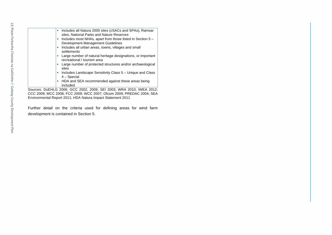
County Galway Wind Energy Strategy Page 23
• Includes all Natura 2000 sites (cSACs and SPAs), Ramsar sites, National Parks and Nature Reserves
• Includes most NHAs, apart from those listed in Section 5 – Development Management Guidelines
• Includes all urban areas, towns, villages and small settlements
• Large number of natural heritage designations, or important recreational / tourism area
• Large number of protected structures and/or archaeological sites
• Includes Landscape Sensitivity Class 5 – Unique and Class 4 – Special
• HDA and SEA recommended against these areas being included
Sources: DoEHLG 2006; GCC 2002, 2009; SEI 2003; WRA 2010; IWEA 2012; CCC 2009; MCC 2008; FCC 2009; WCC 2007; Ofcom 2009; PREDAC 2004; SEA Environmental Report 2011; HDA Natura Impact Statement 2011 Further detail on the criteria used for defining areas for wind farm development is contained in Section 5.
23 Plean Forbartha Chontae na G
aillimhe // G
alway County D
evelopment Plan
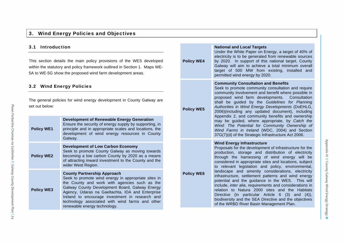
County Galway Wind Energy Strategy Page 24
3. Wind Energy Policies and Objectives
3.1 Introduction
This section details the main policy provisions of the WES developed within the statutory and policy framework outlined in Section 1. Maps WE-5A to WE-5G show the proposed wind farm development areas.
3.2 Wind Energy Policies
The general policies for wind energy development in County Galway are set out below:
Policy WE1
Development of Renewable Energy Generation Ensure the security of energy supply by supporting, in principle and in appropriate scales and locations, the development of wind energy resources in County Galway.
Policy WE2
Development of Low Carbon Economy Seek to promote County Galway as moving towards becoming a low carbon County by 2020 as a means of attracting inward investment to the County and the wider West Region.
Policy WE3
County Partnership Approach Seek to promote wind energy in appropriate sites in the County and work with agencies such as the Galway County Development Board, Galway Energy Agency, Údaras na Gaeltachta, IDA and Enterprise Ireland to encourage investment in research and technology associated with wind farms and other renewable energy technology.
Policy WE4
National and Local Targets Under the White Paper on Energy, a target of 40% of electricity is to be generated from renewable sources by 2020. In support of this national target, County Galway will aim to achieve a total minimum overall target of 500 MW from existing, installed and permitted wind energy by 2020.
Policy WE5
Community Consultation and Benefits Seek to promote community consultation and require community involvement and benefit where possible in proposed wind farm developments. Consultation shall be guided by the Guidelines for Planning Authorities in Wind Energy Developments (DoEHLG, 2006)(including any updated document), including Appendix 2, and community benefits and ownership may be guided, where appropriate, by Catch the Wind: The Potential for Community Ownership of Wind Farms in Ireland (WDC, 2004) and Section 37G(7)(d) of the Strategic Infrastructure Act 2006.
Policy WE6
Wind Energy Infrastructure Proposals for the development of infrastructure for the production, storage and distribution of electricity through the harnessing of wind energy will be considered in appropriate sites and locations, subject to relevant legislation and policy, environmental, landscape and amenity considerations, electricity infrastructure, settlement patterns and wind energy potential and the guidance in the WES. This will include, inter alia, requirements and considerations in relation to Natura 2000 sites and the Habitats Directive (in particular Article 6 (3) and (4)), biodiversity and the SEA Directive and the objectives of the WRBD River Basin Management Plan.
Plean Forbartha Chontae na G
aillimhe // G
alway County D
evelopment Plan 24
Appendix IV
// County Galw
ay Wind Energy Strategy
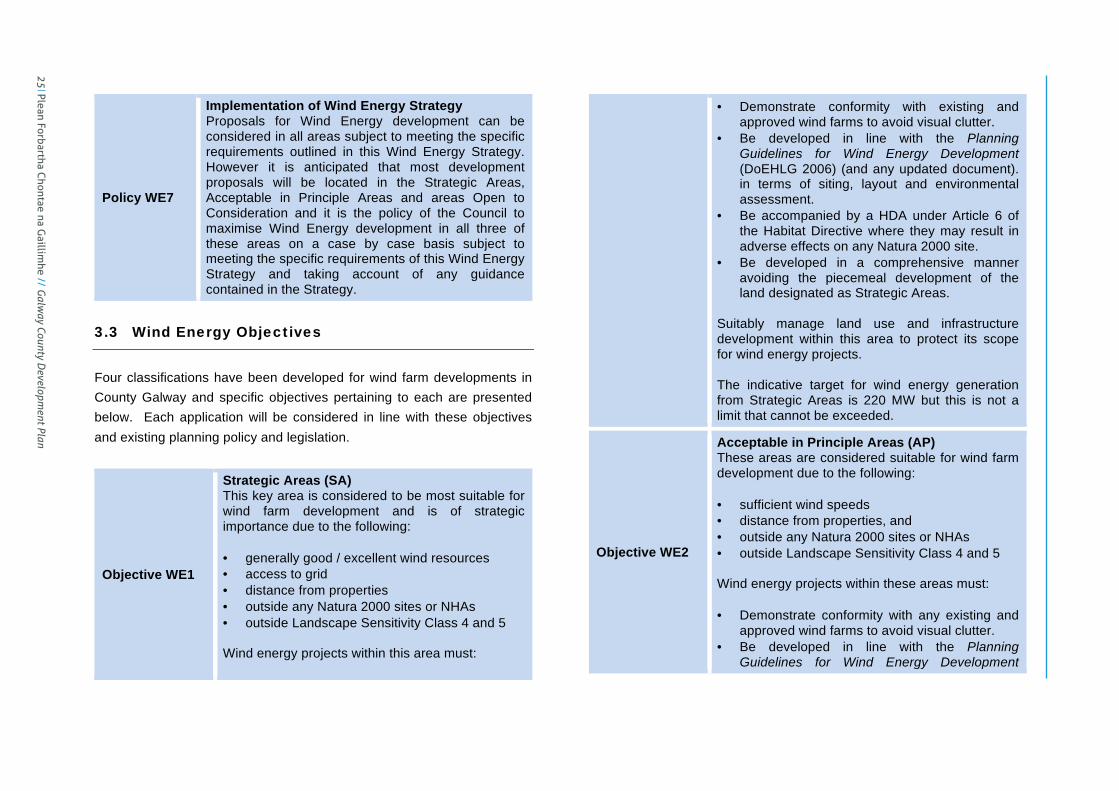
County Galway Wind Energy Strategy Page 25
Policy WE7
Implementation of Wind Energy Strategy Proposals for Wind Energy development can be considered in all areas subject to meeting the specific requirements outlined in this Wind Energy Strategy. However it is anticipated that most development proposals will be located in the Strategic Areas, Acceptable in Principle Areas and areas Open to Consideration and it is the policy of the Council to maximise Wind Energy development in all three of these areas on a case by case basis subject to meeting the specific requirements of this Wind Energy Strategy and taking account of any guidance contained in the Strategy.
3.3 Wind Energy Objectives
Four classifications have been developed for wind farm developments in County Galway and specific objectives pertaining to each are presented below. Each application will be considered in line with these objectives and existing planning policy and legislation.
Objective WE1
Strategic Areas (SA) This key area is considered to be most suitable for wind farm development and is of strategic importance due to the following: • generally good / excellent wind resources • access to grid • distance from properties • outside any Natura 2000 sites or NHAs • outside Landscape Sensitivity Class 4 and 5 Wind energy projects within this area must:
• Demonstrate conformity with existing and approved wind farms to avoid visual clutter.
• Be developed in line with the Planning Guidelines for Wind Energy Development (DoEHLG 2006) (and any updated document). in terms of siting, layout and environmental assessment.
• Be accompanied by a HDA under Article 6 of the Habitat Directive where they may result in adverse effects on any Natura 2000 site.
• Be developed in a comprehensive manner avoiding the piecemeal development of the land designated as Strategic Areas.
Suitably manage land use and infrastructure development within this area to protect its scope for wind energy projects. The indicative target for wind energy generation from Strategic Areas is 220 MW but this is not a limit that cannot be exceeded.
Objective WE2
Acceptable in Principle Areas (AP) These areas are considered suitable for wind farm development due to the following: • sufficient wind speeds • distance from properties, and • outside any Natura 2000 sites or NHAs • outside Landscape Sensitivity Class 4 and 5 Wind energy projects within these areas must: • Demonstrate conformity with any existing and
approved wind farms to avoid visual clutter. • Be developed in line with the Planning
Guidelines for Wind Energy Development
25 Plean Forbartha Chontae na G
aillimhe // G
alway County D
evelopment Plan

County Galway Wind Energy Strategy Page 26
(DoEHLG 2006) (and any updated document), in terms of siting, layout and environmental assessment.
• Be accompanied by a HDA under Article 6 of the Habitat Directive where they may result in adverse effects on any Natura 2000 site.
Suitably manage land use and infrastructure development within these areas to protect their scope for wind energy projects. The indicative target for wind energy generation from Acceptable in Principle areas is 100 MW but this is not a limit that cannot be exceeded. The approach taken to the compilation of the Wind Energy Strategy is based on a consistent and robust methodology which was not varied to take account of individual planning permissions which have been fully assessed under the Habitats Directive. However, any project which was subject to a planning application which has been granted planning permission following assessment of all factors including landscape capacity, it is considered that this project is consistent with and in full compliance with this Wind Energy Strategy.
Objective WE3
Open to Consideration Areas (OC) Wind energy applications in these areas will be evaluated on a case by case basis subject to viable wind speeds, environmental resources and constraints and amenity, safety and cumulative impacts. The indicative target for wind energy generation from Open to Consideration Areas is 60 MW but this is not a limit that cannot be exceeded.
Objective WE4
Not Normally Permissible Areas (NP) These areas are not normally considered suitable for wind farm development due to their overall sensitivity and constraints arising from landscape, ecological, recreational, settlement, infrastructural and/or cultural and built heritage resources. The HDA and SEA process in particular helped to inform the identification of these areas. Future wind farm developments will accordingly only be considered in these areas where project level HDA and EIA can demonstrate to the satisfaction of the planning authority that environmental and other impacts can be successfully avoided, minimised and/or mitigated. The approach taken to the compilation of the Wind Energy Strategy is based on a consistent and robust methodology which was not varied to take account of individual planning permissions which have been fully assessed under Habitats Directive Assessment. However, where any project has been granted planning permission following Habitats Directive Assessment which shows that the project complies with the Habitats Directive and the Birds Directive, it is considered that this project is consistent with and in full compliance with this Wind Energy Strategy.
Objective WE5
Low Wind Speed Areas (LW) These areas are generally not considered viable for wind farm development and in many cases may not be suitable due to their overall sensitivity and constraints arising primarily from amenity, settlement, infrastructural, recreational and/or cultural and built heritage resources. Any applications received for wind energy developments in these areas will be evaluated on a case by case basis subject to viable wind speeds, environmental resources and constraints and amenity, safety and cumulative impacts.
Plean Forbartha Chontae na G
aillimhe // G
alway County D
evelopment Plan 26
Appendix IV
// County Galw
ay Wind Energy Strategy
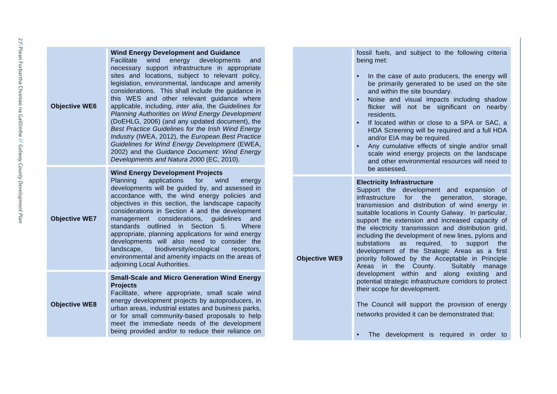
County Galway Wind Energy Strategy Page 27
Objective WE6
Wind Energy Development and Guidance Facilitate wind energy developments and necessary support infrastructure in appropriate sites and locations, subject to relevant policy, legislation, environmental, landscape and amenity considerations. This shall include the guidance in this WES and other relevant guidance where applicable, including, inter alia, the Guidelines for Planning Authorities on Wind Energy Development (DoEHLG, 2006) (and any updated document), the Best Practice Guidelines for the Irish Wind Energy Industry (IWEA, 2012), the European Best Practice Guidelines for Wind Energy Development (EWEA, 2002) and the Guidance Document: Wind Energy Developments and Natura 2000 (EC, 2010).
Objective WE7
Wind Energy Development Projects Planning applications for wind energy developments will be guided by, and assessed in accordance with, the wind energy policies and objectives in this section, the landscape capacity considerations in Section 4 and the development management considerations, guidelines and standards outlined in Section 5. Where appropriate, planning applications for wind energy developments will also need to consider the landscape, biodiversity/ecological receptors, environmental and amenity impacts on the areas of adjoining Local Authorities.
Objective WE8
Small-Scale and Micro Generation Wind Energy Projects Facilitate, where appropriate, small scale wind energy development projects by autoproducers, in urban areas, industrial estates and business parks, or for small community-based proposals to help meet the immediate needs of the development being provided and/or to reduce their reliance on
fossil fuels, and subject to the following criteria being met: • In the case of auto producers, the energy will
be primarily generated to be used on the site and within the site boundary.
• Noise and visual impacts including shadow flicker will not be significant on nearby residents.
• If located within or close to a SPA or SAC, a HDA Screening will be required and a full HDA and/or EIA may be required.
• Any cumulative effects of single and/or small scale wind energy projects on the landscape and other environmental resources will need to be assessed.
Objective WE9
Electricity Infrastructure Support the development and expansion of infrastructure for the generation, storage, transmission and distribution of wind energy in suitable locations in County Galway. In particular, support the extension and increased capacity of the electricity transmission and distribution grid, including the development of new lines, pylons and substations as required, to support the development of the Strategic Areas as a first priority followed by the Acceptable in Principle Areas in the County. Suitably manage development within and along existing and potential strategic infrastructure corridors to protect their scope for development. The Council will support the provision of energy networks provided it can be demonstrated that: • The development is required in order to
27 Plean Forbartha Chontae na G
aillimhe // G
alway County D
evelopment Plan

County Galway Wind Energy Strategy Page 28
facilitate the provision or retention of significant economic or social infrastructure.
• The route proposed has been identified with due consideration for social, economic, environmental and cultural impacts through relevant environmental assessment.
• The design is such that will achieve least environmental impact consistent with not incurring excessive cost.
• Where impacts are identified mitigation features have been included;
• Where it can be shown the proposed development is consistent with international best practice with regard to the materials and technologies that will ensure a safe, secure, reliable, economic and efficient, high quality network.
Objective WE10
Offshore Wind Energy Development Support the facilitation of offshore wind energy developments in appropriate locations and scales and with appropriate onshore support infrastructure, including landing locations for land-sea connections, subject to relevant policy, legislation, environmental, landscape, amenity, seascape and technical considerations. This shall include consideration of the Ocean Renewable Energy Development Plan prepared by the DoCENR and any future Marine Spatial Plan prepared by the DoEHLG.
Objective WE11
Habitats Directive Assessment Having regard to the provisions of the Habitats Directive (92/43/EEC), ensure that: • All activities derived from the adoption of the
Wind Energy Strategy that may give rise to significant adverse direct, indirect or secondary
impacts on the qualifying interests and conservation objectives of Natura 2000 sites, (either individually or in combination with other plans or projects), will be subject to Habitats Directive Article 6 Assessments; and
• Permission will only be granted where project-level Article 6 Assessments conclude that no likely significant effects will occur.
Appendix WE1 contains the wind energy strategy maps, which shows the location and extent of the wind farm designations referred to above.
3.4 Statutory Thresholds for Wind Energy
Developments
3.4.1 Planning Exemptions for Wind Energy Development
Micro renewable generation for domestic, agricultural and light industrial activities are now exempted development subject to criteria detailed in Statutory Instrument (SI) No. 83 of 2007, No. 235 of 2008 and No. 256 of 2008. Further information on these exempted developments is available by downloading the above statutory instruments or by contacting GCC, the Galway Energy Agency or the DoECLG. 3.4.2 EIA Requirements for Wind Energy Developments
Under the Planning and Development Regulations, 2001 (SI No. 600 of 2001), the following category of wind energy developments will require an EIA:
Plean Forbartha Chontae na G
aillimhe // G
alway County D
evelopment Plan 28
Appendix IV
// County Galw
ay Wind Energy Strategy

County Galway Wind Energy Strategy Page 29
Installations for the harnessing of wind power for energy production (wind farms) with more than 5 turbines or having a total output greater than 5 megawatts. An EIA shall be carried out for wind energy developments below the above mandatory limits if GCC (or An Bord Pleanála on appeal) considers that the development would be likely to have significant effects on the environment, by reference to the significant criteria in Annex III of the EIA Directive, as transposed in Schedule 7 of the Planning and Development Regulations, 2001. Regard should also be had to the guidance contained in EIA Guidance for Consent Authorities regarding Sub-threshold Development (DoEHLG, 2003) and Guidelines for Planning Authorities & An Bord Pleanala on Carrying Out Environmental Impact Assessment (DOECLG, March 2013).
3.4.3 Strategic Infrastructure Threshold for Wind Energy
Developments
Under the PDA 2000-2010, the following category of wind energy developments may be considered as strategic infrastructure and accordingly assessed by An Bord Pleanála: An installation for the harnessing of wind power for energy production (a wind farm) with more than 25 turbines or having a total output greater than 50 megawatts. Section 37G(7)(d) of the Planning and Development (Strategic Infrastructure) Act 2006 (No. 27 of 2006) provides for An Bord Pleanála to attach a condition requiring the construction or financing of facilities or services for the local community in the area of the proposed development.
29 Plean Forbartha Chontae na G
aillimhe // G
alway County D
evelopment Plan

County Galway Wind Energy Strategy Page 30
4. Landscape Capacity for Wind Energy Developments
4.1 Introduction
This section addresses the landscape capacity of the strategic wind farm development areas identified in the County. The purpose of this section is to advise, in broad terms, what capacity each Landscape Character Area (LCA) has for wind farm development and to indicate the scale of wind farm developments that may be acceptable within a LCA in terms of cumulative impacts. A Landscape Character Assessment was undertaken for Galway County in 2002, which defined 25 different LCAs in the County, described their key characteristics and identified their landscape values and sensitivity. As part of the fieldwork undertaken for the WES, a further assessment has been made of these LCAs in relation to their sensitivity to wind farm development. Landscape Character Types (LCTs) are used in the Planning Guidelines for Wind Energy Development (DoEHLG 2006) as a means of identifying the most appropriate scale and layout of wind energy developments in these areas. The 6 LCTs identified in these guidelines have accordingly been applied to the LCAs in County Galway. Table WE10 below presents this advice for each of the LCAs within the County. Further details are provided in Chapter Six of the Planning Guidelines for Wind Energy Development (DoEHLG 2006). Table WE7 below sets out the general advice that will be applicable for each LCA. The table is provided as a guide only to the capacity of
landscapes in the County and the Council will seek to balance landscape considerations with the strategic importance of achieving targets in the National Climate Change Strategy and renewable energy targets. Each LCA was assessed in terms of key landscape and visual characteristics and features, overall sensitivity to wind farm developments and the overall capacity of LCA to accommodate wind farms. The site sizes for wind farm developments have been classified as follows:
• Small – 1 to 5 turbines
• Medium – 6 to 10 turbines
• Large – 11 to 25 turbines
• Very Large – more than 25 turbines
4.2 Strategic Guidance on Landscape Capacity for
Wind Energy Developments
Table WE7 provides strategic guidance on the capacity of different LCAs in County Galway for wind energy developments. Appendix WE3 includes additional detail in respect of the extent of the strategic wind farm areas within each LCA. This guidance is intended as broad advice on landscape character areas and will need to be balanced against site specific assessments of the landscape capacity at project level. Map WE-5C shows the LCAs in relation to the strategic wind farm development areas and the landscapes designated as Landscape Sensitivity Rating Class 4 – Special and Class 5 – Unique.
Plean Forbartha Chontae na G
aillimhe // G
alway County D
evelopment Plan 30
Appendix IV
// County Galw
ay Wind Energy Strategy

31 Plean Forbartha Chontae na G
aillimhe // G
alway County D
evelopment Plan
County Galway Wind Energy Strategy
Table WE7 : Strategic Guidance on Landscape Capacity for Wind Energy Developments in Landscape Character Areas
Landscape Character Area
Wind Resources and
Wind Farm Potential
Landscape Value
Landscape Sensitivity
Rating
Strategic Wind Farm Areas
Landscape Sensitivity to Wind Farm Developments Landscape Capacity for Wind Farm Developments
(Appropriate Location and Size of Wind Farms in terms of Turbine No.’s)
LCTs in 2006 Planning
Guidelines
Cumulative Advice based on 2006 Planning
Guidelines and Strategic Considerations
1. Northeast Galway (Balinasloe to Ballymoe)
Low Moderate in NW Low
Class 1-Low with pockets of Class 2-Moderate
LW OC / NP Moderate Sensitivity Small in OC – Small pockets in northwest may provide
opportunities for small clusters of wind turbines.
Hilly and Flat Farmland with Lakes/Rivers
Acceptable subject to appropriate design and landscape siting and protection of heritage and amenities.
2. Shannon and Suck River Valley (between Portumna and Ballinasloe)
Low Medium Class 4-Special
LW NP High Sensitivity NP / LW
Transitional Marginal Land
with Lakes/Rivers
NP / LW
3. East Central Galway (Athenry, Ballinasloe to Portumna)
Low Moderate in W
& on high points Low
Class 1-Low with pockets of Class 2-Moderate
LW OC / NP Moderate Sensitivity Small in OC – Small pockets in northwest may provide
opportunities for small clusters of wind turbines.
Hilly and Flat Farmland
Transitional Marginal Land
Acceptable subject to appropriate design and landscape siting and protection of heritage and amenities.
4. Southeast Galway (Clarinbridge to Gort)
Low Moderate in
N/NE Medium
Class 2-Moderate
with pockets of Class 3-
High
LW OC / NP Moderate to High Sensitivity Small in OC –Small pockets in north may provide opportunities
for small clusters of wind turbines.
Hilly and Flat Farmland
Transitional Marginal Land
Acceptable subject to appropriate design and landscape siting and protection of heritage and amenities.
5. Northeast Galway (Tuam environs)
Low to Moderate Low
Class 1-Low with pockets of Class 2-Moderate
OC LW / NP Moderate Sensitivity Small in OC –Small pockets in north may provide opportunities
for small clusters of wind turbines. Hilly and Flat
Farmland
Acceptable subject to appropriate design and landscape siting and protection of heritage and amenities.
6. Slieve Aughty Mountains
Low Moderate on
ridges Medium Principally
Class 3-High NP
LW / OC High Sensitivity
Small in OC – Limited capacity due to large areas with statutory nature designation and elevated nature of hill slopes. Small pocket in northwest may provide limited opportunities for small cluster of wind turbines.
Mountain Moorland
Acceptable depending on topography and subject to appropriate design and landscape siting to minimise adverse impact and optimise aesthetic effect and protection of heritage and amenities.
7. Northwest Lough Derg Low Medium Class 4-
Special NP LW High Sensitivity NP / LW
Transitional Marginal Land
with Lakes/Rivers
NP / LW
8. Lower Burren (Co. Galway portion)
Low Moderate on
hills to W Outstanding
Class 4-Special with an area of
Class 2-Moderate
LW NP Very High Sensitivity NP / LW
Transitional Marginal Land
with Lakes/Rivers
NP / LW
9. Indreabhán to Galway City Coastline
Moderate Low to E High
Class 3-High with a parallel strip of Class
4-Special
NP OC High Sensitivity
Small in OC – Scenic coastal stretch incorporating several NHAs and southern parts with landscape sensitivity rating of Class 4-Special. Avoid Class 4 areas and immediate coastal zone, i.e. at least 100m above the high tide mark, to maintain pedestrian access to the shoreline and to minimise intrusion upon the sea backdrop of the Galway coast from the coastal road. Wind farm development may be considered in small pockets to the north of the road subject to appropriate design and siting where turbines would not intrude upon views of the scenic coast but would be seen against a backdrop to the foothills of the Connemara Mountains.
Coast
Acceptable depending on coastal landscape character and subject to appropriate design and landscape siting and protection of heritage and amenities.
10. East Conamara Mountains (Maigh Cuilinn, Sraith Salach to Glinsk)
Moderate Low in valleys High in higher
areas
High
Class 3-High with pockets of Class 4-
Special
SA / AP OC / NP
Overall: Low to Moderate Sensitivity – This large scale landscape is less sensitive to wind energy development. The forestry plantations and accompanying clearfelling and access tracks decrease overall sensitivity and the area is not adjoining any significant tourism, scenic or recreational areas. The topography also offers opportunities for screening. Very Large/Large Wind Farm: Low to Moderate Sensitivity – The
Large in SA / Medium in AP and OC – The landform and land use combined with existing access tracks and current clearfelling activity increase the capacity of this landscape to accommodate wind energy development. The large scale and rolling landform also increases the capacity of the area for such developments. A large scale wind energy development could be accommodated within this area outside Natura 2000 sites and Class 4-Special landscape sensitivity, subject to detailed assessment. Should
Mountain Moorland
Acceptable depending on topography and subject to appropriate design and landscape siting to minimise adverse impact and optimise aesthetic effect and protection of heritage and amenities.
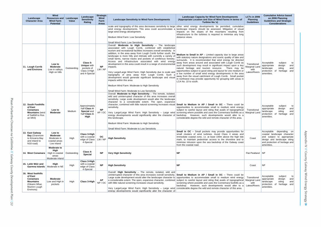
Plean Forbartha Chontae na G
aillimhe // G
alway County D
evelopment Plan 32
County Galway Wind Energy Strategy
Landscape Character Area
Wind Resources and
Wind Farm Potential
Landscape Value
Landscape Sensitivity
Rating
Strategic Wind Farm Areas
Landscape Sensitivity to Wind Farm Developments Landscape Capacity for Wind Farm Developments
(Appropriate Location and Size of Wind Farms in terms of Turbine No.’s)
LCTs in 2006 Planning
Guidelines
Cumulative Advice based on 2006 Planning
Guidelines and Strategic Considerations
scale and topography of this area decreases sensitivity to large wind energy developments. This area could accommodate a large wind energy development. Medium Wind Farm: Low Sensitivity Small Wind Farm: Low Sensitivity
other wind energy developments be permitted, cumulative landscape impacts should be assessed. Mitigation of visual impacts on the slopes of the mountains resulting from infrastructure to the turbines is required to minimise any long distance views.
11. Lough Corrib and Environs
Low to Moderate
Low in valleys High on hills
Outstanding
Class 5-Unique with pockets of
Class 3-High and 4-Special
NP LW / AP
Overall: Moderate to High Sensitivity – The landscape associated with Lough Corrib, combined with established tourism and recreational facilities increases overall sensitivity. In addition, in the area away from Lough Corrib further south, the landscape is more hilly and intimate with currently a variety of small farms, narrow tracks and pockets of coniferous forestry. Access and infrastructure associated with wind energy development in this area could result in a range of environmental impacts. Very Large/Large Wind Farm: High Sensitivity due to scale and topography of area away from Lough Corrib. Such a development would generate significant landscape and visual impacts within this area. Medium Wind Farm: Moderate to High Sensitivity Small Wind Farm: Moderate to Low Sensitivity
Medium to Small in AP – Limited capacity due to large areas with statutory nature designations and scenic quality of lake and surrounds. It is recommended that wind energy be directed away from areas around and associated with Lough Corrib as such development may result in significant impact upon a key natural heritage and tourism resource. There may be opportunities subject to good siting and layout for one medium or a low number of small wind energy developments in the area away from the visual catchment of Lough Corrib. Small pocket in northwest may provide opportunity for grouping with areas in LCA No. 10 to south.
Transitional Marginal Land
with Lakes/Rivers
Acceptable subject to appropriate design and landscape siting and protection of heritage and amenities.
12. South Foothills of East Conamara Mountains (west of Salthill to Ros an Mhíl)
Low to Moderate Medium
Approximately half Class 4-Special and half Class 3-
High
NP AP / OC
Overall: Moderate to High Sensitivity – The remote, isolated, wild and uninterrupted character of this area increases overall sensitivity. Large scale development would alter the landscape character to a considerable extent. The open, expansive character, combined with little natural screening increases visual sensitivity. Very Large/Large Wind Farm: High Sensitivity – Large wind energy developments would significantly alter the character of this landscape. Medium Wind Farm: Moderate to High Sensitivity Small Wind Farm: Moderate to Low Sensitivity
Small to Medium in AP / Small in OC – There could be opportunities to accommodate small to medium wind energy subject to careful layout and siting that avails of topographical screening where possible and uses the Connemara foothills as a backdrop. However, such developments would alter to a considerable degree the wild and remote character of this area.
Transitional Marginal Land
Acceptable subject to appropriate design and landscape siting and protection of heritage and amenities.
13. East Galway Bay (Oranmore to Kinvarra Bay and inland to N18 road)
Low to Moderate
Moderate in coastal areas
Low inland
High
Class 3-High with a coastal edge of Class
4-Special
OC LW / NP High Sensitivity
Small in OC – Small pockets may provide opportunities for small clusters of wind turbines. Avoid Class 4 areas and immediate coastal zone, i.e. at least 100m above the high tide mark, to maintain pedestrian access to the shoreline and to minimise intrusion upon the sea backdrop of the Galway coast from the coastal road.
Coast
Acceptable depending on coastal landscape character and subject to appropriate design and landscape siting and protection of heritage and amenities.
14. West Conamara
Moderate to High
High in coastal areas
Moderate inland
Outstanding Class 4-Special NP Very High Sensitivity NP Flat Peatland NP
15. Leitir Móir and Garmna Islands
High Moderate in NE High
Class 3-High with a coastal edge of Class
4-Special
NP High Sensitivity NP Coast NP
16. West foothills of East Conamara Mountains (Gleann Mhac Muirinn Lough Environs)
Moderate Low and High in
pockets High Class 3-High AP
NP / OC
Overall: High Sensitivity – The remote, isolated, wild and uninterrupted character of this area increases overall sensitivity. Large scale development would alter the landscape character to a considerable extent. The open, expansive character, combined with little natural screening increases visual sensitivity. Very Large/Large Wind Farm: High Sensitivity – Large wind energy developments would significantly alter the character of
Small to Medium in AP / Small in OC – There could be opportunities to accommodate small to medium wind energy subject to careful layout and siting that avails of topographical screening where possible and uses the Connemara foothills as a backdrop. However, such developments would alter to a considerable degree the wild and remote character of this area.
Transitional Marginal Land
with Lakes/Rivers
Acceptable subject to appropriate design and landscape siting and protection of heritage and amenities.
Appendix IV
// County Galw
ay Wind Energy Strategy

33 Plean Forbartha Chontae na G
aillimhe // G
alway County D
evelopment Plan
County Galway Wind Energy Strategy
Landscape Character Area
Wind Resources and
Wind Farm Potential
Landscape Value
Landscape Sensitivity
Rating
Strategic Wind Farm Areas
Landscape Sensitivity to Wind Farm Developments Landscape Capacity for Wind Farm Developments
(Appropriate Location and Size of Wind Farms in terms of Turbine No.’s)
LCTs in 2006 Planning
Guidelines
Cumulative Advice based on 2006 Planning
Guidelines and Strategic Considerations
this landscape. Medium Wind Farm: Moderate to High Sensitivity Small Wind Farm: Moderate to Low Sensitivity
17. An Cheathrú Rua (Cuan Chasla to Glinn Chatha)
Moderate High near coast and on higher
hills
High
Class 3-High with a coastal edge of Class
4-Special
NP AP
Overall: Moderate to High Sensitivity – The exposed and open landform increases sensitivity as views and sightlines are extensive within this area. Very Large/Large Wind Farm: High Sensitivity due to scale and topography of area. This scale of wind energy development is likely to generate extensive impacts. Medium Wind Farm: High Sensitivity – as above. Small Wind Farm: Moderate Sensitivity
Small in AP – The areas proposed for designation could accommodate one or two small wind energy developments in clusters and taking advantage of the existing road network. There would be landscape impacts but at a small scale, this area could accommodate them.
Coast
Acceptable depending on coastal landscape character and subject to appropriate design and landscape siting and protection of heritage and amenities.
18. Cuan na Beirtrí Buí and Eastern Banks
Moderate to High
High in coastal areas
Moderate inland
High Class 4-Special
NP OC High Sensitivity
Small in OC – Small pockets may provide opportunities for small clusters of wind turbines. Avoid Class 4 areas and immediate coastal zone, i.e. at least 100m above the high tide mark, to maintain pedestrian access to the shoreline and to minimise intrusion upon the sea backdrop of the Galway coast from the coastal road.
Coast
Acceptable depending on coastal landscape character and subject to appropriate design and landscape siting and protection of heritage and amnenities.
19. West Coast (Port na Feadóige to Clifden)
High Very High in W and on Errisbeg
Outstanding Class 4-Special NP Very High Sensitivity NP Coast NP
20. West Coast (Clifden to mouth of Killary Harbour)
High to Very High Outstanding
Class 3-High with a coastal edge of Class
4-Special
NP Very High Sensitivity NP Coast NP
21. Killary Harbour and Southern Banks
Moderate Very Low on lower lands
Very High on higher ground
Outstanding Class 5-Unique NP Very High Sensitivity NP Coast NP
22. Conamara National Park (including Lough Fee, Lough Inagh and Derryclare Lough)
Variable Low in valleys Very High on
summits
Outstanding Class 5-Unique NP Very High Sensitivity NP
Mountain Moorland
Transitional Marginal Land
with Lakes/Rivers
NP
23. Dúiche Sheoigheach (including Lehanagh Loughs and South Lough Mask)
Variable Very Low in
valleys Very High on
summits
Outstanding
Class 5-Unique with
road corridors of Class 4-
Special
NP Very High Sensitivity NP
Mountain Moorland
Transitional Marginal Land
with Lakes/Rivers
NP
24. Oileáin Árann High to Very
High Very high on
higher ground
Outstanding Class 5-Unique NP Very High Sensitivity NP Coast NP
25. Lough Rea Low to Moderate High Class 4-
Special OC
NP / LW High Sensitivity Small in OC – Small pocket in west may provide opportunities for small clusters of wind turbines.
Transitional Marginal Land
with Lakes/Rivers
Acceptable subject to appropriate design and landscape siting and protection of heritage and amenities.
Notes:1.Landscape Character Areas, Landscape Values and Landscape Sensitivity Ratings taken from GCC (2002) Landscape and Landscape Character Assessment and GCC Galway County Development Plan 2.Landscape Character Types (LCTs) and Cumulative Advice based on DoEHLG (2006) Planning Guidelines for Wind Energy Development. 3.Landscape Sensitivity to Wind Farm Developments based on Landscape Values and Landscape Sensitivity Rating and subject to the fieldwork assessments undertaken for the Strategic and Acceptable in Principle Areas.
County Galway Wind Energy Strategy
4.Remainder of table based on spatial analysis undertaken for WES. Text in bold denotes predominant/overall type/category and regular text there under denotes sub-‐types or less prevalent categories.

Plean Forbartha Chontae na G
aillimhe // G
alway County D
evelopment Plan 34
Appendix IV
// County Galw
ay Wind Energy Strategy

County Galway Wind Energy Strategy Page 35
5. Development Management Guidelines
5.1 Introduction
This section sets out the considerations, guidelines and standards that will guide the preparation and assessment of planning applications for wind energy developments.
5.1.1 Guidelines for Wind Energy Developments
GCC will require compliance with the DoEHLG (2006) Wind Energy Development Guidelines: Guidelines for Planning Authorities (and any updated document) in relation to planning applications for wind energy developments. Other guidelines of relevance include: • IWEA (2012) Best Practice Guidelines for the Irish Wind Energy Industry.
• EWEA (2002) European Best Practice Guidelines for Wind Energy Development.
• GCC (2002) Landscape and Landscape Character Assessment for Galway County.
• DoEHLG (2008) Circular Letter PD 3/08: Wind Energy Development – Planning Permission and Grid Connections.
• DoEHLG (2009) Circular Letter PD 6/09: Wind Energy Development – Planning Permissions and Grid Connections.
• DoEHLG (2008) Circular Letter SEA 1/08 & NPWS 1/08: Appropriate Assessment of Land Use Plans.
• DoEHLG (2009, revised 2010) Appropriate Assessment of Plans and Projects in Ireland: Guidance for Planning Authorities.
• DoEHLG (2010) Circular Letter NPW 1/10 & PSSP 2/10: Appropriate Assessment under Article 6 of the Habitats Directive: Guidance for Planning Authorities.
• DoEHLG (2006) Best Practice Guidelines on the Preparation of Waste Management Plans for Construction and Demolition Projects.
• DoEHLG (2009) The Planning System and Flood Risk Management: Guidelines for Planning Authorities & Technical Appendices.
• DoEHLG (2007) Circular Letter PD 2/07 & NPWS 1/07: Compliance Conditions in respect of Developments requiring (1) Environmental Impact Assessment (EIA); or (2) having potential impacts on Natura 2000 sites.
• DoEHLG (2010) Spatial Planning and National Roads: Consultation Draft Guidelines for Planning Authorities.
• EPA (2002) Guidelines on the Information to be Contained in Environmental Impact Statements.
• EPA/DoEHLG (2003) Environmental Impact Assessment (EIA): Guidance for Consent Authorities Regarding Sub-threshold Development.
• EPA (2003) Advice Notes on Current Practice in the Preparation of Environmental Impact Statements.
• EPA (2007) Wetlands – Protection, Conservation and Assessment, in EPA Code of Practice: Environmental Risk Assessment for Unregulated Waste Disposal Sites.
• DoAFF (2006) Forestry and Freshwater Pearl Mussel Requirements: Site Assessment and Mitigation Measures.
• GSI (2006) Landslides in Ireland.
• IGI (2002) Geology in Environmental Impact Statements: A Guide.
35 Plean Forbartha Chontae na G
aillimhe // G
alway County D
evelopment Plan

County Galway Wind Energy Strategy Page 36
• Renou-Wilson and Farrell (2009) Peatland Vulnerability to Energy-Related Developments from Climate Change Policy in Ireland: The Case of Wind Farms.
• NRA (2006) Policy Statement on Development Management and Access to National Roads.
• NRA (2008) Guidelines on the Management of Noxious Weeds and Non-Native Invasive Plant Species on National Roads.
• WDC (2004) Catch the Wind: The Potential for Community Ownership of Wind Farms in Ireland.
• EC (2010) Wind Energy Developments and Natura 2000.
• PREDAC (2004) Spatial Planning of Wind Turbines: Guidelines and Comparison of European Experiences.
• DOECLG (2011) Draft Guidelines for Planning Authorities on Drainage and Reclamation of Wetlands
Please also have regard to the following guidance in preparing planning applications for wind energy developments:
5.1.2 Pre-Planning Considerations
• Early and meaningful consultation with GCC and the relevant statutory agencies will assist in identifying environmental sensitivities and other relevant considerations during the preparation of a planning application.
• It is strongly recommended that the developer of a wind energy project engage in active consultation and dialogue with the local community at an early stage in the planning process, prior to submitting a planning application.
• Wind energy developments with more than 25 turbines or having a total output greater than 50MW may be considered as strategic infrastructure and where applicable would need to be submitted to and assessed by An Bord Pleanála.
5.1.3 Strategic Wind Farm Development Areas and
Development Location
The strategic wind farm development areas that have been designated in the WES provide the primary strategic guidance for the suitability of different locations for wind farm developments. The location and siting of wind farm developments shall accordingly be guided by the strategic wind farm development areas and associated objectives set out under Section 3.3 and depicted on the maps contained in Appendix WE1. The designation of the strategic wind farm development areas in the WES has been based on strategic level analysis utilising exclusion zones, buffer areas and separation distances to identify appropriate locations for wind farms in the County. These setbacks accordingly provide useful strategic guidance to inform the assessment of planning applications for wind farm developments. This strategic level guidance would need to be balanced, however, against a more detailed assessment of the merits and potential impacts of any particular development proposal at a local level and the specific information that is available for the assessment of such projects. Specific locations that are not within the Strategic, Acceptable in Principle or Open to Consideration areas in the WES but which may be suitable for wind energy development projects on a case by case basis based on robust project level investigation and environmental assessment, together with consideration of the scale and cumulative impact of the project, may be considered for additional wind energy development where environmental, landscape and amenity issues can be
Plean Forbartha Chontae na G
aillimhe // G
alway County D
evelopment Plan 36
Appendix IV
// County Galw
ay Wind Energy Strategy

County Galway Wind Energy Strategy Page 37
addressed to the satisfaction of the planning authority (refer to Objective WE4). The setbacks identified in the WES also provide useful strategic guidance with respect to the assessment of certain small scale wind energy projects, such as large single turbines or clusters of turbines in scenic landscapes or rural areas. A more flexible approach may be appropriate, however, for those small scale wind energy projects where environmental, landscape and amenity considerations can be satisfactorily addressed. Table WE8 summarises the separation distances for turbines in wind farm developments from other features. This includes those criteria applied at the strategic level for the purposes of defining strategic wind farm development areas (generally Strategic Areas and Acceptable in Principle Areas) and the implications for projects at the local level. The project level guidelines may also provide relevant considerations for the assessment of small scale wind energy projects, such as large single turbines and, where appropriate, medium single turbines and clusters of turbines.
5.1.4 Natural Heritage Areas
The following NHAs are included fully or partly in the Open for Consideration areas, and developments proposed for these sites will have to be subject to detailed ecological and hydrological assessment to ensure their integrity is not significantly compromised by wind energy development:
• 002431 – Oughterard District Bog NHA
• 002364 – Moycullen Bogs NHA
In addition, certain activities within these sites, such as the removal of peat or the excavation of borrow pits, may require ministerial or local authority consent as they can be considered as notifiable actions under the NHA Statutory Orders. The development of specific measures for environmental parameters discussed in the following section is a consequence of the SEA and HDA process informing the WES. These measures seek to address significant environmental impacts associated with wind energy development at strategic and project level. There is a clear commitment by GCC to ensure the implementation of these measures to facilitate proper planning and demonstrate best practice in planning for wind energy developments in the County.
5.1.5 Community Involvement and Benefit
• All wind farm developments shall require a Community Impact Statement (CIS) identifying the potential impacts of the proposed development on the local community and proposals to address any impacts identified. The CIS will also include details of all measures taken to consult with the local community and any benefits that may arise or be provided for the local community as a result of the proposed development.
• Section 37G(7)(d) of the Planning and Development (Strategic Infrastructure) Act 2006 (No. 27 of 2006) provides for An Bord Pleanála to attach a condition requiring the construction or financing of facilities or services for the local community in the area of the proposed development. Where appropriate, the option to provide for community gain should be incorporated into wind farm developments.
37 Plean Forbartha Chontae na G
aillimhe // G
alway County D
evelopment Plan

County Galway Wind Energy Strategy Page 38
Table WE8 : Guidelines for Separation Distances for Turbines in Wind Farm Developments
Criteria Strategic-Level Analysis:
Preferred Minimum Separation Distance
Project-Level Implications: Minimum Acceptable Separation Distance (Subject to Detailed Assessment)
Urban and Rural Settlement
Towns, Urban Areas, Rural Villages and Small Settlements
• 1km from plan boundaries of Galway Gateway and Tuam Hub
• 500m from other plan boundaries/ settlement envelopes
• Generally 500m from plan boundary/settlement envelope, subject to detailed assessment
Residential Properties, Schools and Other Noise-Sensitive Locations (existing and permitted)
• 500m from noise-sensitive property
• Generally 500m, but lower setback may be considered subject to achieving adequate amenity levels (noise, shadow flicker, visual impact) and agreement of affected residents
Transport and Utility Infrastructure
Motorways and National Primary and Secondary Roads (existing and proposed)
• 200m from outer edge of road • Generally 200m from outer edge of route, subject to advice from National Roads Authority
Regional Roads • 100m from outer edge of road • Generally 100m (or total turbine height if greater) from outer edge of road, subject to agreement with Planning and Road Design Sections
Other Public Roads • Context specific • Context specific, to be agreed with Planning and Road Design Sections Railway Lines (existing and proposed) • 100m from outer edge of rail line • Generally 100m (or total turbine height if greater) from outer edge of rail line,
subject to advice from Iarnród Éireann
Galway Airport • Outside existing aviation exclusion zone
• Outside existing aviation exclusion zone, subject to advice from Irish Aviation Authority and Galway Airport
Airstrips • Context specific • Context specific, subject to advice from Irish Aviation Authority Electricity Transmission Lines (existing and permitted)
• 100m from outer edge of line for 400kV, 220kV and 110kV lines
• Generally 100m (or 1.3 to 1.5 times total turbine height if greater), subject to advice from EirGrid/ESB
Electricity Distribution Lines (existing and permitted)
• Context specific for 38kV and lower voltage lines • Context specific, subject to advice from ESB
Telecommunications • 500m from CAMP masts and LOS • Context specific, subject to detailed assessment
Natural Heritage and Landscape
Natura 2000 Sites (SPAs & SACs) • Outside Natura 2000 sites (SPAs & SACs)
• Outside Natura 2000 sites, subject to HDA and advice from NPWS • Buffers to be considered as appropriate for Natura 2000 sites and bird/bat
flight paths, subject to HDA and advice from NPWS
Ramsar Sites, National Parks and Nature Reserves
• Outside Ramsar sites, National Parks and Nature Reserves
• Outside Ramsar sites, National Parks and Nature Reserves, subject to EIA and advice from NPWS
• Buffers to be considered as appropriate for Natura 2000 sites and bird/bat flight paths, subject to SEA and advice from NPWS
NHAs • Outside majority of NHAs
• Generally outside NHAs, subject to EIA and advice from NPWS • Buffers to be considered as appropriate for NHAs and bird/bat flight paths,
subject to SEA and advice from NPWS • Parts of some NHAs may be open to consideration, subject to detailed
assessment Coastal Areas • 100m from high tide mark • Context specific, subject to detailed assessment
Plean Forbartha Chontae na G
aillimhe // G
alway County D
evelopment Plan 38
Appendix IV
// County Galw
ay Wind Energy Strategy

County Galway Wind Energy Strategy Page 39
Criteria Strategic-Level Analysis:
Preferred Minimum Separation Distance
Project-Level Implications: Minimum Acceptable Separation Distance (Subject to Detailed Assessment)
Natural Heritage and Landscape
Lakes and Waterways • 100m from water’s edge • Context specific, subject to detailed assessment Indigenous Forestry/Trees • Context specific • Context specific, subject to detailed assessment
Landscape Sensitivity • Outside Class 5 – Unique and Class 4 – Special
• Outside Class 5 – Unique and Class 4 – Special, subject to detailed assessment and Landscape Impact Assessment
Peatlands/Boglands • Context specific • Context specific, but generally avoid areas with deep peat and/or steep slopes, subject to detailed assessment
Built Heritage
Architectural Heritage (ACAs & RMP)
• 200m from ACAs and Protected Structures on RPS
• 100m from ACAs and Protected Structures on RPS, subject to detailed assessment and advice of Conservation Officer
Archaeological Heritage (RMP) • 100m from Recorded Monuments on RMP
• Context specific, subject to detailed assessment and advice of Conservation Officer, archaeologist and National Monuments Section, DOAHG.
Other Landholdings and Turbines
Adjacent Landholding • 250m from adjacent boundary • 125m (or two times rotor blade diameter if greater) from adjacent boundary, unless written agreement of adjoining landowner/s to lesser distance
Other Wind Turbines • Generally three times rotor diameter in crosswind direction • Generally seven times rotor diameter in prevailing downwind direction
Source: DoEHLG, 2006; IWEA, 2012; EC, 2010; CCC, 2009; GCC, 2009, 2002; PREDAC, 2004; GIS Mapping for WES, 2010
38 Plean Forbartha Chontae na G
aillimhe // G
alway County D
evelopment Plan

County Galway Wind Energy Strategy Page 40
5.2 Environmental Assessment and Management
5.2.1 Potential Impacts of Wind Energy Developments
If not appropriately located, sited, designed and constructed, the development of wind farms and turbines have the potential to generate a range of environmental, landscape, heritage, amenity, safety and development impacts. Potential impacts that can occur as a result of wind energy development are summarised below: Table WE9 : Potential Impacts of Wind Energy Developments
Issue Potential Impacts Identified
Habitats
• Habitat Loss – Direct loss of habitat to the developments’ infrastructure, including turbine foundations, buildings, roads, quarries and borrow pits.
• Habitat Fragmentation – Fragmentation of habitats and increased edge effects.
• In Situ Habitat Degradation – Degradation of habitats through alteration or disturbance, in particular arising from changes to hydrology that may alter the surface or groundwater flows and levels, and drainage patterns critical in peatlands and river headwaters.
• Ex Situ Habitat Degradation – Degradation and loss of habitats outside the development site, especially wetland habitats that may arise from pollution, siltation and erosion originating from within the development site.
Birds
• Disturbance and Displacement – Disturbance during the construction and operational phases leading to the temporary or permanent displacement of birds from the development site and its environs.
• Collision Risk and Fatalities – Risk of bird collisions and mortalities due to birds flying into wind turbines or rotational flow behind the rotor, particularly along bird migration routes and within 200-300m of bird protection areas.
• Barrier Effect – Barrier to movement, although studies have indicated that the response by birds to wind energy development may be variable and related to species and/or
season. • Habitat Loss or Degradation – Direct loss or degradation of
habitats for breeding, feeding and/or roosting purposes, particularly in wetland sites.
Bats
• Collision Risk and Fatalities – Particularly risk of collision with rotors of turbine towers.
• Barotrauma – Caused by rapid air-pressure reduction near moving turbine blades.
• Habitat Loss or Degradation – Loss of hunting habitats or roost sites during construction of access roads, foundations, etc.
• Disturbance and Displacement – Disturbance during the construction and operational phases leading to the temporary or permanent displacement of bats from the development site and its environs.
Freshwater Species and Habitats
• Pearl Mussel – Sensitivity to siltation and impacts arising from peat mobilisation as a result of excavations.
• Fish – Excavations may give rise to mobilisation of peat particles that could smother salmonid ova, clog fish gills and generally become a chronic feature of inland fisheries.
• Habitat Loss or Alteration – Loss or alteration of freshwater habitats, particularly in rivers, due to mobilisation of peat particles and siltation as a result of excavations.
Marine Mammals (Offshore Wind Farms)
• Habitat Loss or Alteration – Loss or alteration of habitats due to underwater constructions.
• Disturbance and Displacement – Displacement, interference with normal behaviour and even physical damage due to noise pollution, e.g. during pile driving.
Peat, Ground Conditions and Landslide Susceptibility
• Ecological Functioning – Impacts on the functioning of intact peatland systems.
• Hydrology – Windfarm infrastructure and the laying of turbine foundations can cause localised drying out and compaction of peat leading to habitat destruction and increased erosion of peat.
• Fragmentation – Construction works, in particular the installing of infrastructure i.e. power lines, service roads, etc., can cause fragmentation of extensive blanket bog areas and damage to fragile hydrological systems.
• Carbon Sequestration – Disturbance of peatlands can release carbon.
• Landslide Hazard – Risk of bog burst or landslide hazard
Plean Forbartha Chontae na G
aillimhe // G
alway County D
evelopment Plan 39
Appendix IV
// County Galw
ay Wind Energy Strategy
County Galway Wind Energy Strategy Page 41
due to wind energy development, particularly in upland areas with deep peat and steeper slopes.
Amenity, Landscape and Settlement
• Noise Pollution – Including aerodynamic noise caused by rotor blade passing through the air, and mechanical noise, created by the operation of the mechanical elements in the nacelle – the generator, gearbox and other parts of the drive-train gearing mechanisms and generators associated with wind turbines.
• Shadow Flicker – Effect caused by rotating blades of wind turbines when the sun passes behind them.
• Landscape/Visual Impact – Visual impact of wind farms and turbines on landscape and visual amenity, which can affect landscape character, residential amenity, tourism and recreation.
• Settlement Growth – Potential for wind farms to restrict the future expansion of urban and rural settlements where inadequate separation distances provided.
Transport, Infrastructure and Safety
• Safety – Remote possibility of a damaged rotor blade being thrown from a turbine, or of ice flying from the blade in extremely cold conditions.
• Operations – Impacts on operations of infrastructure such as radio and telecommunications, e.g. due to electromagnetic interference and disruption caused by rotating blades.
• Road Network Impacts – Impacts on road network to facilitate construction of the project and transportation of large machinery and turbine parts to site.
• Motorist Safety – Turbines may distract motorists, particularly when they are being constructed or when they are new.
• Airport Impacts – Impacts of wind farms on nearby airports in relation to flight procedures and safeguarding aerodrome and potential interference with performance of airport navigational aids, including radar system.
• Setbacks – Safe setbacks need to be established for houses, roads, railway lines, electricity lines, airports and areas where high numbers of people are expected to congregate.
Construction
• Quarrying – Impacts associated with the quarries or borrow-pits used for the construction phase.
• Waste Disposal – Disposal or elimination of waste/surplus material from construction/site clearance, particularly
significant for peat sites.
Built Heritage
• Site Integrity – Direct impacts on the integrity of archaeological sites due to construction works.
• Visual Impacts – Visual impact on built heritage and its setting due to size, scale, proximity and dominance of wind turbines.
Source: DoEHLG, 2006; EC, 2010; IWEA, 2012; PREDAC, 2004; IFI Submission, 2010 There are a range of measures that can be employed to avoid, minimise and mitigate the impacts of wind energy developments, including appropriate location and siting, layout and design, and construction and operation. At a strategic level, the use of appropriate exclusion zones, buffer areas and separation distances can be used to ensure that wind farms are located so as to avoid or minimise such impacts. At the detailed, or project, level, appropriate siting, layout, design, construction and operational requirements can ensure that impacts are avoided, minimised or mitigated. Adequate environmental assessment and management will be essential to ensure that environmental sensitivities and potential impacts are highlighted and suitable mitigation measures and management responses are identified.
5.2.2 Assessment of Environmental Impacts
• The current requirement for EIA for wind energy developments is for installations with more than 5 turbines or having a total output greater than 5MW. GCC may require the preparation of an EIA for sub-threshold development.
• All wind energy developments, including those sub-threshold for EIS, will require HDA screening, and may require a full HDA where appropriate, under Article 6 of the Habitats Directive. All wind energy developments that are located within a Natura 2000 site or which may
40 Plean Forbartha Chontae na G
aillimhe // G
alway County D
evelopment Plan

County Galway Wind Energy Strategy Page 42
adversely affect the integrity of such sites will be required to submit a Natura Impact Statement (NIS).
• All wind energy developments should prepare an environmental constraints map to identify the most and least sensitive environmental resources on the site. This constraints map will assist in informing the size, layout and design of the wind energy development.
• An ecological impact assessment may be required where considered appropriate for those developments that are sub-threshold for EIA.
• GCC may require, as appropriate, the preparation and implementation of an Environmental Management Plan (EMP) for wind energy developments. This would incorporate measures in relation to a range of environmental issues, such as surface water, groundwater protection, slope stability, flood risk potential, waste generation and management, ecology and protection of natural heritage and habitat restoration and management. The EMP should also include proposals in relation to annual monitoring procedures, particularly in the case of NHAs or Natura 2000 designated sites (see Section 5.2.4 (e) and 5.2.13).
• In cases where additional plans are required for a particular development, for example the preparation and implementation of an Environmental Management Plan, a Surface Water Management Plan or an Inspection and Maintenance Plan, these plans must be drawn up and included with the EIS when the application is submitted.
• Consultation should be undertaken with any relevant statutory bodies and other agencies as part of the preparation of an EIS or other environmental reports. This will include consultation with the GSI in
relation to landslide risk, geological heritage sites and other relevant issues in the EIS.
5.2.3 Natura 2000 Sites and Qualifying Habitats and
Species
The assessment of environmental impacts will have particular regard to any significant effects that may arise in relation to Natura 2000 sites and protected habitats and species, in accordance with the Habitats Directive. The HDA Natura Impact Statement provides additional detail regarding the Natura 2000 sites in and adjacent to County Galway and the protected habitats and species that would need to be considered in assessing proposals for wind energy developments. Table WE10 identifies the key Natura 2000 sites, their qualifying habitats and species and relevant guidance/mitigation measures that would need to be considered under this sub-section of the WES: Table WE10 : Key Natura 2000 Sites, Qualifying Interests and Relevant Guidance/Mitigation Measures
Qualifying Habitat Natura 2000 Site Relevant Guidance/
Mitigation Measures
Turloughs
• Casteletaylor Complex SAC • Croaghill Turlough SAC • Galway Bay SAC • Levally Lough SAC • Lisnageeragh Bog SAC • Lough Lurgeen SAC • Rahasane Turlough SAC • Lough Fingall Complex SAC • Kiltiernan Turlough SAC • Williamstown Turlough SAC
• Turloughs
Mire and Heath
• Casteletaylor Complex SAC • Galway Bay SAC • Kilsallagh Bog SAC
• Peat, Mire and Heath Habitats
• Soils and Geology
Plean Forbartha Chontae na G
aillimhe // G
alway County D
evelopment Plan 41
Appendix IV
// County Galw
ay Wind Energy Strategy

County Galway Wind Energy Strategy Page 43
• Lisnageeragh Bog SAC • Lough Corrib SAC • Lough Lurgeen SAC • Rosroe Bog SAC • Shankill West Bog SAC • Lough Fingall Complex SAC • Ross Lake and Woods SAC • Maumturk Mountains SAC • Connemara Bog Complex SAC • Monivea Bog SAC
Other Terrestrial Habitats
• Casteletaylor Complex SAC • Galway Bay SAC • Lough Corrib SAC • Lough Fingall Complex SAC • Maumturk Mountains SAC • Connemara Bog Complex SAC
• Soils and Geology • Mitigation Measures in
other sub-sections
Freshwater Habitats
• Galway Bay SAC • Lough Corrib SAC • Lough Rea SAC • Lough Fingall Complex SAC • Ross Lake and Woods SAC • Maumturk Mountains SAC • Connemara Bog Complex SAC
• Water-Dependent and Coastal Habitats
• Drainage, Water Quality and Fisheries
Coastal Habitats • Galway Bay SAC
• Water-Dependent and Coastal Habitats
• Drainage, Water Quality and Fisheries
Qualifying
Species Natura 2000 Site Relevant Guidance/ Mitigation Measures
Common Seal • Galway Bay SAC • Water-Dependent and
Coastal Habitats
Otter
• Galway Bay SAC • Lough Corrib SAC • Ross Lake and Woods SAC • Connemara Bog Complex SAC
• Water-Dependent and Coastal Habitats
Freshwater Pearl Mussel • Lough Corrib SAC
• Water-Dependent and Coastal Habitats
• Freshwater Pearl Mussels
Atlantic Salmon
• Lough Corrib SAC • Connemara Bog Complex SAC
• Water-Dependent and Coastal Habitats
• Freshwater Pearl Mussels
Brook Lamprey & Sea Lamprey
• Lough Corrib SAC
• Water-Dependent and Coastal Habitats
• Freshwater Pearl Mussels
White-clawed Crayfish • Lough Corrib SAC
• Water-Dependent and Coastal Habitats
• Freshwater Pearl Mussels
Slender Niaid • Lough Corrib SAC • Connemara Bog Complex SAC
• Water-Dependent and Coastal Habitats
Varnished Hook-moss • Lough Corrib SAC • Peat, Mire and Heath
Habitats Marsh Fritillary • Connemara Bog Complex SAC • Water-Dependent and
Coastal Habitats Lesser Horseshoe Bat
• Lough Corrib SAC • Lough Fingall Complex SAC • Ross Lake and Woods SAC
• Lesser Horseshoe Bat
Wild Birds
• Inner Galway Bay SPA • Lough Corrib SPA • Rahasane Turlough SPA • Coole-Garryland SPA • Lough Rea SPA • Creganna Marsh SPA • Slive Aughty Mountains SPA
• Wild Birds • Mitigation Measures in
other sub-sections
Source: HDA Natura Impact Statement 2011 a) Wild Birds • Wind farm developments must consider the potential impacts on birds
in terms of collision, disturbance and any other impacts. It will be particularly important to assess effects in relation to breeding areas, roosting grounds and flight-lines in consultation with an appropriate authority.
42 Plean Forbartha Chontae na G
aillimhe // G
alway County D
evelopment Plan

County Galway Wind Energy Strategy Page 44
• Construction works should be timed and designed so as not to disturb breeding birds and site specific advice should be sought from a qualified and experienced ecologist.
• Yearly monitoring of wind farm developments associated with wind energy areas identified in the strategy should be undertaken by professional ecologists and funded by the relevant wind energy developer. The yearly monitoring of wild birds may be required for both pre and post construction of the wind farm and may be required until the end of the wind farm’s operational life span. Monitoring shall be agreed with GCC and shall include consultation considered necessary with other relevant statutory bodies. The methodology, responsibility and rationale for this approach should be clearly outlined by the NPWS to assist developers.
• Where nesting hen harriers or merlins are recorded within close proximity to turbines, appropriate mitigation measures may be required to avoid any potential risks to displaying birds and newly fledged birds. Advice should be sought from a qualified and experienced ecologist.
• Wind turbines will not be permitted within the known flight path of migratory wild fowl.
b) Bats A number of measures have been identified to ensure that any remaining adverse impacts to all bat species, including the lesser horseshoe bat, are avoided and mitigated. These measures are listed below: • Any proposed wind energy development occurring in wind energy
areas located within close proximity to SACs containing bats as
qualifying interests should be assessed for likely significant effects to these species and where necessary a HDA should be completed in line with relevant guidelines.
• Buffer zones will be established in areas identified as bat foraging habitats. These buffer zones will adhere to current guidance with regard to avoiding and/or minimising impacts to this species and will be implemented in consultation with relevant authorities.
• The Natural England Interim guidance on bats and wind farm development should be adhered to and a minimum buffer zone of 50m from the nearest point of the rotor swept area of a turbine and bat habitat features should be maintained. It is noted that draft guidelines for bats and wind farm developments have been launched by Bat Conservation Ireland which suggest that 200m separation distance should be maintained unless the results of detailed field surveys indicate that this distance can be reduced. This separation distance is in line with Eurobats mitigation. Once finalised, should these guidelines become the standard guidelines in Ireland for implementing mitigation measures for bats at wind farm developments, then the particulars of this guidance should be adopted.
• The removal of bat commuting and foraging habitat should be avoided during the construction and operation phase of wind energy developments. Where the removal of commuting or foraging habitat cannot be avoided, alternative habitat should be established prior to such habitat removal.
• Construction works should be timed and designed so as not to disturb breeding bats.
Plean Forbartha Chontae na G
aillimhe // G
alway County D
evelopment Plan 43
Appendix IV
// County Galw
ay Wind Energy Strategy
County Galway Wind Energy Strategy Page 45
c) Freshwater Pearl Mussels Siltation and nutrient loss from potential wind energy developments in AIP areas pose a significant risk to the pearl mussel population of the Owenriff Catchment. Therefore, without the removal of risk to pearl mussel populations wind energy developments will not be permitted in AIP areas occurring within the Owenriff Catchment. Any wind energy proposal occurring within the Owenriff Catchment will be accompanied by a detailed Surface Water Management Plan (SWMP). The objective of the SWMP will be to prevent pollution to watercourses and adverse impact to pearl mussels (as well as other Annex and non-Annex listed aquatic fauna). The SWMP will provide sufficient detail to ensure that all activities that could potentially lead to negative impacts on water quality are identified. The SWMP will be based upon a detailed understanding of the hydrology, hydrogeology and geology within and surrounding proposed wind energy development sites. Peat depth surveys and peat stability assessments will be required for the design of all SWMP for wind energy developments within the Owenriff Catchment. SWMPs and peat depth surveys shall be carried out by experienced ecologists and hydrological experts. The information to be contained within the SWMP and other relevant mitigation measures for proposed wind energy developments in AIPs occurring within the Owenriff Catchment are outlined below. Development Layouts and Buffer Zones • Wind energy development layouts will avoid areas of deep peat and
active blanket bog. Slopes in excess of 15° will be avoided.
• Construction areas will be minimised to reduce the area of exposed ground occurring during the construction phase.
• Buffer zones of a minimum of 50m from higher-order streams and 150m from lower-order watercourses. Buffer zones will be maintained in all instances except where watercourse crossings are required along proposed access track routes.
• No construction activities will be undertaken at watercourse crossings in wet weather conditions.
• All watercourse crossings will use clear span, bottomless, arch or oversize culverts.
Forest Clear-felling • Forest clear-felling for wind energy developments in the Owenriff
catchment will follow the guidance of the Forest Service, NPWS and all relevant provisions for clear-felling outlined in the forthcoming final version of the Owenriff Sub-basin Management Plan.
• The Coillte Forest Management Plan for Derradda has not identified felling methods, areas and volumes in this area as an agreed procedure has not yet been established. No clear-felling will be undertaken for wind energy developments prior to the establishment of an agreed felling procedure within the Owenriff Catchment. Subsequent to the establishment of procedures all clear-felling and replanting for wind energy developments will adhere to these procedures.
• Where forestry clear-felling is proposed, the list of national measures relating to forestry which aim to address pressures impacting on pearl mussels will be followed. These measures are reproduced from Table
44 Plean Forbartha Chontae na G
aillimhe // G
alway County D
evelopment Plan

County Galway Wind Energy Strategy Page 46
6.2 of the Owenriff Sub-basin Management Plan in an appendix to the SEA Environmental Report.
Construction Materials • Construction materials that resemble the geochemistry of local
bedrock will be used in preference of high-carbonate materials such as cement-based products which will be avoided where possible. The avoidance of high carbonate materials will ensure that changes to the predominantly acidic surface and soil water conditions with the Owenriff Catchment are avoided.
• Ready-mixed concrete should be used during the construction phase of wind energy developments.
Site Drainage and Control of Surface Runoff • Disturbance to natural drainage features should be avoided during the
construction phase of a wind energy development.
• Uncontaminated surface runoff should be diverted away from construction areas through the installation of interceptor drains upgradient of construction areas.
• Drainage waters originating in construction areas will be collected in a closed system and treated prior to controlled, diffuse release. A Sustainable Urban Drainage System (SuDS) will be installed prior to the commencement of the main construction activities and suitable prevention measures will be put in place at all times to prevent the release of sediment to drainage waters associated with construction areas and migration to adjacent watercourses.
• There will be a minimum of three stages of treatment for surface runoff from construction activities. Steps in treatment will include swales, check dams and detention ponds along with other pollution control measures such as silt fences and silt mats.
• The potential for high flow velocities will be attenuated in the drainage network through energy dissipation or multiple outflows to avoid the re-suspension of sediment.
• Swales will be used to hold water temporarily and to encourage infiltration/discharge into the ground locally to where the rainfall hits the ground. It is noted that low infiltration rates are associated with peat soils and blanket bog, which dominates the land cover within the Owenriff Catchment.
• Check dams will be placed along the swales to settle out silts and reduce flow velocities along with subsequent erosion potential. Regular outflows from the swales in the form of small drains which fan out into the surrounding vegetation with tapering drains will prevent the focusing of increased flows and preserve natural drainage conditions.
• Detention ponds will attenuate and treat runoff and will be required for all the turbine locations. These will have permanent open water to minimise the risk of sediment washout. Two ponds (primary and final) will be constructed in series at each location.
• Water depth in detention ponds will be kept to a normal depth of 0.3m with a maximum depth of 0.6m.
• Detention pond side slopes will be shallow grades such as 1 in 3 side slope.
Plean Forbartha Chontae na G
aillimhe // G
alway County D
evelopment Plan 45
Appendix IV
// County Galw
ay Wind Energy Strategy

County Galway Wind Energy Strategy Page 47
• Site drains will not discharge directly into watercourses.
• Runoff from excavations will not be pumped directly into watercourses. Where dewatering of excavations is required, water shall be pumped to the head of a treatment train in order to receive full treatment prior to re-entry to the natural drainage system.
• Dust suppression will be undertaken around construction areas during periods of dry weather. Only clean, settled water will be used for dust suppression.
Responsibilities of Contractors and Sub-contractors • All site personnel will be made aware of their environmental
responsibilities through the production of a Method Statement outlining Environmental Requirements for Contractors and Sub-contractors. The Method Statement will include environmental emergency response procedures to deal with spillages should they occur.
Oils, Fuels and Site Vehicle • Oils and fuels will be stored in designated bunded areas greater than
20m from any surface watercourse.
• Storage tanks will be tested to a recognised standard with a secondary containment system to provide at least 110% of the maximum tank capacity.
• Designated refuelling points for site-vehicles will be established 50m from any surface watercourse. Drip trays will be used at refuelling points.
• Site vehicles and delivery vehicles will not be washed down on site.
• Regular inspection of vehicles, tanks and bunds will be undertaken.
• Documented emergency procedures to deal with any accidental slippages will be established.
• Oil spill protection measures will be provided adjacent to surface watercourses.
Relevant Guidance • Good Practice Guidance notes proposed by the UK Environment
Agency/Scottish Environmental Protection Agency/Northern Ireland Environment Agency will be implemented.The relevant Guidance Notes to be adhered to will include: PPG1: General Guide to the Prevention of Pollution PPG5: Works and Maintenance In, Near or Liable to Affect Watercourses PPG10: Working at Construction and Demolition Sites PPG21: Pollution Incident Response Planning
• The construction phase and associated drainage will also have regard to the Scottish Natural Heritage guidance Good Practice during Windfarm Construction (2010).
d) Peat, Mire and Heath Habitats • Applications must have regard to the guidance in the Planning
Guidelines for Wind Energy Development for Planning Authorities 2006 (including Section 5.3 and Appendix 4) (and any updated document) in order to mitigate against potential impacts on natural heritage, slope stability and carbon output.
• The careful siting of tracks, construction compounds, cable trenches, etc. should be carried out so that areas of deep/wet peat are avoided.
52 Plean Forbartha Chontae na G
aillimhe // G
alway County D
evelopment Plan

County Galway Wind Energy Strategy Page 48
Where deep/wet peat cannot be avoided, floating roads will be used to reduce the adverse effects associated with the construction and operation of such structures.
• During construction works, the enforcement of standard pollution control measures should be undertaken to prevent potential polluting substances from entering drains and having the potential to affect water quality further downstream from wind farm areas.
• A minimum buffer zone of 50m should be implemented between wind
energy areas and the boundaries of SACs designated for the occurrence of mire and heath habitats.
• Areas of deep and active peat associated with mire habitats should be avoided by the design of appropriate wind farm layouts. Detailed peat slip risk assessments should be carried out for all proposed wind energy developments in areas where peat substrates occur.
• Construction machinery should be restricted to site roads and designated access routes to the turbine areas. Machinery should not be allowed to access, park or travel over areas outside development construction zones.
• Peat excavated during construction activity should not be stored (temporarily or permanently) on areas of adjacent mire habitats or near flushes or drains. Temporary storage of spoil material excavated during the construction phase of proposed wind energy developments should be stored at suitable locations away from surface watercourses. All spoil material excavated during the construction phase should be reinstated following the completion of the construction phase of a proposed development.
• No carbonate-rich material should be used for the construction of access tracks or foundations in mire habitats. Wherever possible aggregates of similar chemistry as site bedrock should be used for road construction and turbine foundations.
• The following NHAs are included partly within the Open to
Consideration Areas and developments proposed for these sites will have to be subject to detailed hydrological and ecological assessment to ensure their integrity is not significantly compromised by wind energy development: Oughterard District Bog NHA; and Moycullen Bog NHA.
• Particular care and management is required in relation to peat
extraction and storage and best practice in construction and management is required for peat areas. A long-term Peatland Conservation and Management Plan (PCMP) should be submitted for developments on peatlands/boglands with details on the conservation, displacement, reinstatement and/or restoration of peatland habitats. This would either form part of any EIS/EMP prepared or should be submitted as a separate report as part of the planning application where an EIS or EMP is not required. A PCMP should be developed in consultation with NPWS, should contain considerations in relation to biodiversity (e.g. control of invasive species), drainage and degradation issues and should refer to IPCC ‘Peatlands 2020 Conservation Plan: Halting the Loss of Peatland Biodiversity’
Section 5.2.6 includes additional guidance in relation to peatlands.
Plean Forbartha Chontae na G
aillimhe // G
alway County D
evelopment Plan 53
Appendix IV
// County Galw
ay Wind Energy Strategy
County Galway Wind Energy Strategy Page 49
e) Turloughs • Wind energy developments will not occur immediately adjacent to
SACs designated for the occurrence of turloughs. A suitable buffer distance will be installed between turloughs and boundaries of proposed wind energy developments. Detailed hydrology and hydrogeological assessments of the effects of excavations associated with turbine installations will be undertaken as part of the project-level assessment. Borrow pits will not be permitted in areas that will have the potential to adversely impact on hydrology of turloughs.
f) Water-Dependent and Coastal Habitats, Otters and Common
Seals • Any wind energy proposal hydrologically linked to water-dependent
qualifying interests of Natura 2000 sites should be accompanied by a detailed Surface Water Management Plan (SWMP). The objective of the SWMP will be to prevent pollution to waterbodies and water-dependent habitats such as fens.
• Wind energy development layouts will avoid areas of deep peat and active blanket bog. Slopes in excess of 15° will be avoided.
• Construction areas will be minimised to reduce the area of exposed ground occurring during the construction phase.
• Buffer zones of a minimum of 50m from higher-order streams and 150m from lower-order watercourses. Buffer zones should be maintained in all instances except where watercourse crossings are required along proposed access track routes.
• No construction activities should be undertaken at watercourse crossing in wet weather conditions.
• All watercourse crossings should use clear span, bottomless, arch or oversize culverts.
• Forest clear-felling for wind energy developments in areas hydrologically linked to water-dependent qualifying habitats should follow the guidance of the Forest Service and the NPWS.
• Disturbance to natural drainage features should be avoided during the construction phase of a wind energy development.
• Uncontaminated surface runoff should be diverted away from construction areas through the installation of interceptor drains up-gradient of construction areas.
• Drainage waters originating in construction areas should be collected in a closed system and treated prior to controlled, diffuse release. A Sustainable Urban Drainage System (SuDS) should be installed prior to the commencement of the main construction activities and suitable prevention measures should be put in place at all times to prevent the release of sediment to drainage waters associated with construction areas and migration to adjacent watercourses.
• There should be a minimum of three stages of treatment for surface runoff from construction activities. Steps in treatment should include swales, check dams and detention ponds along with other pollution control measures such as silt fences and silt mats.
• The potential for high flow velocities should be attenuated in the drainage network through energy dissipation or multiple outflows to avoid the re-suspension of sediment.
• Swales should be used to hold water temporarily and to encourage infiltration/discharge into the ground locally to where the rainfall hits
54 Plean Forbartha Chontae na G
aillimhe // G
alway County D
evelopment Plan

County Galway Wind Energy Strategy Page 50
the ground. It is noted that low infiltration rates are associated with peat soils and blanket bog, which dominates the land cover within much of the study area.
• Check dams should be placed along swales to settle out silts and reduce flow velocities along with subsequent erosion potential. Regular outflows from the swales in the form of small drains which fan out into the surrounding vegetation with tapering drains will prevent the focusing of increased flows and preserve natural drainage conditions.
• Detention ponds will attenuate and treat runoff and should be required for all the turbine locations. These should have permanent open water to minimise the risk of sediment washout. Detention pond side slopes should be shallow grades such as 1 in 3 side slope. Site drains should not discharge directly into watercourses.
• Runoff from excavations should not be pumped directly into watercourses. Where dewatering of excavations is required, water should be pumped to the head of a treatment train in order to receive full treatment prior to re-entry to the natural drainage system.
• Dust suppression should be undertaken around construction areas during periods of dry weather. Only clean, settled water should be used for dust suppression.
Adherence to the above mitigation measures will also help to ensure that potential significant effects to otters and grey seals will also be avoided. The HDA Natura Impact Statement provides additional detail on the types of water-dependent and coastal habitats and further guidance in relation to these habitats and protected mammal species.
g) Buffer Areas • Buffer areas may be required for wind energy developments close to
Natura 2000 and other protected sites in the County. The extent of the buffer areas will be dependent on the habitat type and species present. Buffer areas should be developed in consultation with GCC in the first instance and with the NPWS and Inland Fisheries Ireland (IFI) as appropriate, at the pre-planning stage of wind energy projects.
• Where a development is proposed close to a Natura 2000 site, the applicant should determine, in consultation with GCC, if a HDA is required, noting that the individual project may impact on a Natura 2000 site individually or in combination with other plans or projects (as identified in Section 5.2.12 Cumulative Impacts of Wind Farms)
• Where a development is proposed close to or within a NHA, further ecological or geological surveys should be undertaken by suitably qualified ecologists and/or geologists as appropriate.
5.2.4 Biodiversity, Flora and Fauna
a) Habitat Restoration • A habitat restoration and management plan should be developed as
part of the EIS, and the EMP where appropriate, to address reinstatement of mineral and peat soils and allow for positive ecological impacts associated with the development. Such plans should be developed in consultation with GCC.
Section 5.2.3 d) includes additional guidance in relation to peatlands, including the need for a long-term Peatland Conservation Management Plan, which will be required for wind energy developments in peatland areas.
Plean Forbartha Chontae na G
aillimhe // G
alway County D
evelopment Plan 55
Appendix IV
// County Galw
ay Wind Energy Strategy
56 Plean Forbartha Chontae na G
aillimhe // G
alway County D
evelopment Plan
County Galway Wind Energy Strategy Page 51
b) Biodiversity • The protection of non-designated habitats, species and local
biodiversity features should be promoted through site design and landscape management plans.
• Habitat mapping (including wetlands) and ecological impact assessment may be required for wind energy applications. This habitat mapping should be undertaken at an appropriate scale and in accordance with agreed national Habitat Mapping Methodology. The habitat map should be overlaid with the emerging development to highlight sensitive habitats and help assess potential impacts. The applicant shall consult with GCC and NPWS in this regard.
• Other biodiversity issues should be considered where these are
protected under Irish legislation such as the 1999 Flora Protection Order and the provisions if the Wildlife Acts 1976-2000.
c) Invasive Species • The implementation of measures to control and manage alien and
invasive species such as Japanese Knotwood (Fallopia Japonica), Giant Rhubarb (Gunnera tinctoria/manicata) and noxious weeds such as ragwort may be required as part of the EIS/EMP. In particular, attention should be paid to the potential for construction activities to introduce such species to an area. Measures to address the potential for introduction of invasive species should be included in Construction Management Plans. This should have due regard to the European Communities (Birds and Natural Habitats) Regulations 2011 which lists Restricted Non-Native Species, or any amended regulations.
d) Forestry and Clearfelling • The applicant should have regard for the Forest Service Policy on
Felling Licenses for Wind Farm Development. Consideration should also be given to the ecological impacts of replacement planting in other areas that may be required when clearfelling grant aided forestry.
e) Environmental Monitoring • Environmental monitoring may be required in particular sites where
there are concerns in relation to specific environmental matters such as impacts on wildlife or where a specific condition has been attached to a grant of planning permission.
The SEA Environmental Report and HDA Natura Impact Statement provide additional detailed information and guidance in relation to the protection of designated sites, protected habitats and species and biodiversity. 5.2.5 Drainage, Water Quality and Fisheries
Considerations for drainage, water quality and fisheries should take into account the following: • The applicant shall have regard to the relevant objectives and
measures set out in the Western River Basin Management Plan (RBMP) 2009-2015 and the Shannon International RBMP 2009-2015 and associated Programmes of Measures. In particular, works relating to construction and maintenance of wind energy developments should aim to prevent the deterioration and maintain

Plean Forbartha Chontae na G
aillimhe // G
alway County D
evelopment Plan 57
County Galway Wind Energy Strategy Page 52
high or good status for surface waters, and limit pollution inputs and prevent deterioration of groundwater.
• To avoid surface water pollution during construction works, the enforcement of standard pollution control measures will be undertaken to prevent potential polluting substances from entering drains and having the potential to affect water quality further downstream from wind farm areas.
• Where construction and maintenance of wind energy developments are proposed close to coastal and estuarine areas, adequate measures for the protection of fisheries/shellfisheries should be developed as part of the EIS/EMP. This should have due regard to the Shellfish Waters Pollution Reduction Programmes, with the most relevant Shellfish Water sites including Kilkieran, Outer Galway Bay Indreabhán, Clarinbridge/Kinvara, Aughinish and Ballyvaughan/ Poulnaclough Bay.
• Where construction and maintenance of wind energy developments are proposed close to designated salmonid fisheries, sea trout or brown trout spawning and nursery rivers, adequate measures for the protection of same will be required as part of the EIS/EMP (refer to Schedule 2 of Wild Salmon and Sea Trout Tagging Scheme Regulations 2009). The measures provided under Section 5.2.3 c) for freshwater pearl mussels should also be considered, as appropriate, for the protection of salmon, sea trout and brown trout.
• Where construction and maintenance of wind energy developments are proposed close to freshwater pearl mussel rivers (in particular Owenriff and Dawros Rivers and sub-catchments, refer to First Schedule of European Communities Environmental Objectives
(Freshwater Pearl Mussel) Regulations 2009), adequate measures for the protection of same will be required as part of the EIS/EMP (refer to relevant Sub-Catchment Plans). Section 5.2.3 c) above provides measures for wind farm areas close to Freshwater Pearl Mussel sub-catchments.
• A buffer zone along water features such as rivers and lakes may be required. These buffer zones represent a corridor for the protection of water quality and habitat. The extent of the buffer zone is site dependant and should be developed in conjunction with GCC and following consultation with Inland Fisheries Ireland.
• Specific measures should be adopted to prevent leaching of soils, phosphorous and other nutrient enrichment of surface watercourses where clearfelling is undertaken.
• Hydrogeological impacts must be carefully assessed particularly in relation to peat soils. Consultation with the GSI is recommended in relation to modelling. Such modelling must be agreed with the GSI and undertaken by competent and qualified geotechnical persons.
• The developer shall have a responsibility to demonstrate that any proposed development will not have significant impacts upon aquifers.
• Drainage networks should not discharge directly to watercourses or waterbodies but through an appropriate buffering riparian zone.
• Measures should be taken to reduce surface run-off so as to lessen the risk of bank destabilisation and erosion.
• The discharge of solids should be strictly controlled so as to avoid direct impacts on fish feeding, spawning and primary productivity within the river channel.
Appendix IV
// County Galw
ay Wind Energy Strategy

County Galway Wind Energy Strategy Page 53
• Construction activities and on-site storage of fuels and lubricants should be appropriately located and controlled.
• The EIS/EMP should include an emergency response plan in relation to spillages.
• Full consultation with Inland Fisheries Ireland regional staff regarding culvert/bridge design and mitigation measures with respect to the requirement of access roads for wind farm developments.
• Wind energy development applications close to the Owenbolishka River or within the Owenbolishka River catchment will require consultation with the Inland Fisheries Ireland regional staff.
• Proposals should be included to demonstrate that site drainage can
be satisfactorily addressed. An Inspection and Maintenance Plan should be developed for the drainage system to monitor and ensure the effectiveness of any drainage lines, silt traps and settlement ponds.
• Any EIS should address the synergistic relationships between water quality, biodiversity, soil function and ecology.
• Wind farm developers will be encouraged to become active stakeholders in, and co-operate with, any catchment management initiatives relevant to their developments.
5.2.6 Soils and Geology
• Where construction works are taking place in hydrologically sensitive habitats, works should be confined to the smallest possible area. Minimum removal of vegetation will take place so as to reduce areas
of bare peat or soil. When excavations are being undertaken, surface vegetation will be removed in sods that can be stored and later replaced around structures where bare peat/soil exists. This will ensure a more rapid re-vegetation of bare peat/soils and will help to reduce potential soil erosion that could lead to water pollution.
• The indirect impact of construction on peat habitat is generally far greater than the immediate footprint due to impacts on hydrology. EIA undertaken on peatland habitats affected by wind farm development should estimate the permanent loss due to direct and indirect effects.
• Consideration should be given to calculating the carbon output of constructing wind energy developments on peatlands.
• The careful siting of tracks, construction compounds, cable trenches, etc. will be carried out so that areas of deep/wet peat are avoided. Where deep/wet peat cannot be avoided, floating roads will be used to reduce the adverse effects associated with the construction and operation of such structures.
• Landslide susceptibility and risk assessment must be undertaken for all proposed developments, particularly in peat areas, to ensure all factors contributing to slope instability are identified and addressed appropriately. This assessment should incorporate slope stability mapping and groundcover assessment in the context of potential cumulative effects arising from multiple developments. Consultation with the GSI is required to undertake best practice landslide susceptibility modelling. Please refer to GSI (2006) Landslides in Ireland and IGI (2002) Geology in EIS: A Guide.
• The potential impacts on slope stability relating to climate change impacts, most particularly flash floods and changing weather patterns
58 Plean Forbartha Chontae na G
aillimhe // G
alway County D
evelopment Plan

County Galway Wind Energy Strategy Page 54
should be considered if possible and adaptation measures should be developed to account for same. Regard shall be given to DoEHLG (2009) Planning System and Flood Risk Management Guidelines and Technical Appendices, as these also address climate change impacts.
• The Construction Management Plan (CMP) developed as part of the planning application should address quarrying; borrow pits, soil management including storage, and opportunities for soil reinstatement.
Section 5.2.3 d) includes additional guidance in relation to peatlands, including the need for a long-term Peatland Conservation Management Plan, which will be required for wind energy developments in peatland areas. 5.2.7 Landscape and Visual Impact
a) Landscape Guidelines Certain parts of areas identified as Strategic Areas or Acceptable in Principle Areas are designated as of high landscape value in the GCDP. The DoEHLG (2006) Planning Guidelines for Wind Energy Development for Planning Authorities (page 15) state that such designations: “‘would not automatically preclude an area from future wind energy development but the inclusion of such objectives in a development plan is a material factor that will be taken into consideration in the assessment of a planning application” The GCDP includes the following objective and policy in relation to landscape character and sensitivity:
Objective LCM 2: Consideration of Landscape Sensitivity Ratings shall be an important factor in determining development uses in areas of the County. In areas of high Landscape sensitivity, the design and the choice of location of proposed development in the landscape will also be critical considerations.
Policy LCM1: Preserve and enhance the character of the landscape where, and to the extent that, in the opinion of the Planning Authority, the proper planning and sustainable development of the area requires it, including the preservation and enhancement, where possible of views and prospects and the amenities of places and features of natural beauty or interest.
The above policy and objective will be considered by the Council and balanced with the strategic importance of achieving targets in the National Climate Change Strategy and renewable energy targets. GCC will accommodate wind energy developments in areas designated as Strategic or Acceptable in Principle subject to implementation of best practice in siting and design and assessment of environmental, landscape and other impacts. Wind energy developers should have regard to the DoEHLG Planning Guidelines for Wind Energy Development for Planning Authorities 2006 (and any updated document). GCC will seek applications that demonstrate best practice as contained in these Guidelines. Wind energy developers should also consider the landscape capacity guidance contained in Section 4 and Table WE7 of the WES. This guidance is intended as broad advice based on landscape character areas and will
Plean Forbartha Chontae na G
aillimhe // G
alway County D
evelopment Plan 59
Appendix IV
// County Galw
ay Wind Energy Strategy

County Galway Wind Energy Strategy Page 55
need to be balanced against site-specific assessments of the landscape capacity at project level. Should specific recommendations arise from the proposed National Landscape Strategy and National Landscape Characterisation, any future applications must take such guidance into consideration. b) Landscape Impact Assessment All wind farm applications should be accompanied by a Landscape Impact Assessment (LIA), either as part of the EIS where appropriate or as a separate report. The LIA should include the following: • Description of proposed development, including alternatives
considered during design process. • Description of geographic location and landscape context. • Definition of study area, informed by identifying the Zone of
Theoretical Visibility. • General landscape description of the study area. • Selection of viewshed reference points from where the proposal is
examined in detail. • Assess the sensitivity of landscape from each viewshed reference
point. • Preparation of photomontages. • Estimation of likely degree of impact on landscape. • Recommendation of mitigation measures. • A landscaping plan should be submitted as part of the application. The visual linkages between established landmarks, landscape features and views may be considered as part of the landscape and visual impact
assessment. Regard must also be given to potential negative landscape impacts in adjoining counties, and the Planning Authority may request that visual impact assessments address this issue. In particular, designated scenic landscapes, views, routes and features of county, regional and local value may be considered and assessed for visual impacts. c) Landscape and Visual Mitigation Methods employed to mitigate the impact of wind turbines in the landscape setting in general will be influenced by the layout and design of the proposed wind farm. In this regard, design criteria that will contribute to effective mitigation include the following: • Turbine layout pattern to be designed to complement the existing
landscape pattern.
• Turbine height to be set to complement the scale of the receiving landscape. This relates to the size or scale of farmed fields or indeed the scale and size of the hills and undulations that define the landscape’s topography.
• The number of turbines will be carefully selected to be in scale with the receiving landscape and to avoid cumulative impacts relating to other wind farms in the area.
• In terms of infrastructure, access will ideally be routed in a manner that agrees with the existing topography. Sharp changes in level caused by excavation or the construction of retention structures or walls will be avoided. A minimal approach on earthworks will minimise damage or scarring of the landscape.
• Screen planting to infrastructure will feature native species planting, consistent with the wider landscape setting.
60 Plean Forbartha Chontae na G
aillimhe // G
alway County D
evelopment Plan

County Galway Wind Energy Strategy Page 56
5.2.8 Built and Cultural Heritage
Wind turbines and wind farms should be sited and designed to ensure that they do not unduly dominate or damage architectural and archaeological structures or sites. Adequate assessment and mitigation measures should be included as part of the EIS or as a separate report where appropriate. a) Archaeological Heritage • All planning applications within 30m (or greater where required) from a
listed archaeological site on the RMP should be accompanied by an archaeological assessment prepared by a suitably qualified archaeologist detailing the impacts which the proposed development would have on archaeology in the area and any mitigation measures proposed.
• A registered archaeologist should be present during the initial stripping of the topsoil at permitted development sites, within 30m of a listed archaeological site.
• Where developments are proposed close to National Monuments in State ownership or guardianship, and monuments subject to Preservation Orders, zones of visual amenity should be defined for them in order to assess potential impacts on the archaeological landscape and setting.
b) Architectural Heritage • Certain applications may be required to undertake an assessment of
the impacts of a proposed development on architectural character, particularly in the vicinity of towns or settlements with a rich
architectural heritage, reflected in their designation as ACAs. This will also apply to protected structures.
• Assessments should be undertaken by a conservation architect and it is advised that at preplanning stage, the Planning Authority should be contacted to determine if there is a need for such an assessment.
5.2.9 Population and Human Settlement
• Applications must have regard to the thresholds, limits and buffer zones in the Planning Guidelines for Wind Energy Development for Planning Authorities 2006 (and any updated document), in order to mitigate against potential impacts on human health in terms of shadow flicker, visual impact and noise.
• An assessment of the theoretical shadow flicker shall be prepared for all dwellings within 600m of any turbine, or for all dwellings within any distance specified by any updated Guidelines on Wind Energy issued by the DOECLG. A further assessment shall indicate the likely level of shadow flicker based on anticipated meteorological constraints. If required, mitigating measures shall be proposed and agreed with the Planning Authority.
• A Construction Management Plan (CMP) should accompany any EIS that will outline the measures taken to avoid dust impacts and negative impacts from construction traffic.
• A minimum exclusion zone of 500m will generally apply around all towns, urban areas, rural villages and small settlements identified in the settlement strategy of the GCDP. This zone may be increased to 1km in the case of the Galway Gateway and the Tuam Hub. These
Plean Forbartha Chontae na G
aillimhe // G
alway County D
evelopment Plan 61
Appendix IV
// County Galw
ay Wind Energy Strategy

County Galway Wind Energy Strategy Page 57
zones will facilitate the continued growth, development and investment into these existing settlements.
• Wind turbines will generally not be permitted to locate within 500m of any noise sensitive property, including existing or permitted dwelling houses, or within any distance specified in any updated Guidelines on Wind Energy issued by the DOECLG, except where the written consent of those persons affected by this requirement is given and subject to an adequate level of amenity being achieved in relation to noise, shadow flicker and visual impact. A planning application for a dwelling house will be considered up to a distance of 250m of an existing or permitted turbine.
5.2.10 Air and Climate
• A CMP should accompany any EIS that will outline the measures taken to avoid dust impacts and negative impacts from construction traffic
• Where developments are proposed on peat soils, carbon sinks and outputs associated with the development should be calculated. Reference is also made to discussion on wind energy construction on peat bogs and the BOGLAND project funded by the EPA, in particular Renou-Wilson and Farrell (2009) Peatland Vulnerability to Energy-Related Developments from Climate Change Policy in Ireland: The Case of Wind Farms.
• It is recognised that forestry clearance may be necessary in certain sites to facilitate wind energy developments. Consideration should be given to carbon loss from this clearance and alternative approaches such as ‘key holing’ (i.e. minimal removal of trees around proposed turbine locations) combined with replacing felled trees with short
rotation coppice/low height native woodland or short rotation forestry. Such replacement could be considered as part of the landscaping plan for a wind energy development.
5.2.11 Material Assets – Transport, Waste Management,
Energy Use and Noise
a) Transport • A Traffic Management Plan (TMP) shall be submitted with applications
including details of the road network/haulage routes, the vehicle types to be used to transport materials on and off site and proposals to address impacts on residents in relation to construction activities.
• Where the construction of new roads is required to construct/service wind energy developments, adequate and appropriate drainage measures will be required. The careful siting of tracks, construction compounds, cable trenches, etc. should be carried out so that areas of deep/wet peat are avoided. Where deep/wet peat cannot be avoided floating roads will be used to reduce the adverse effects associated with the construction and operation of such structures. The EPA guidance in relation to floating roads should also be consulted.
• Applications should include sufficient details to demonstrate that adequate access arrangements can be provided to the development site, particularly during the construction phase. This may include, inter alia, road condition surveys, Road Safety Audits, auto-track analysis, provision of passing bays, reinstatement works, etc.
• The carrying capacity, operational efficiency, safety and national investments in national roads should be protected in relation to the
62 Plean Forbartha Chontae na G
aillimhe // G
alway County D
evelopment Plan
County Galway Wind Energy Strategy Page 58
implementation of the WES and EIAs may be required to demonstrate same. Developments will need to ensure compliance with the Spatial Planning and National Roads Guidelines (DOECLG, 2012). The Highways Agency Spatial Planning Advice Note SP12/09 may also be consulted as appropriate.
• There will be a clear presumption in favour of protection of the national road network and direct access onto national roads outside the 50km/h speed limit will be restricted.
• Where proposals are located within 300m of existing and proposed Motorways, National Primary and National Secondary Roads, it is recommended that the applicant consult with the NRA, prior to making an application, in order to agree an appropriate setback distance from the road.
• In the case of all other public roads, proposed wind farms within 250m of the road, shall be subject to the agreement of the Council’s Roads Department.
b) Waste Management • A Waste Management Plan (WMP) should be submitted with
applications to address waste management impacts. In addition, please refer to Best Practice Guidelines in Reuse and Recycling of Construction and Demolition Waste 2007. The WMP should be in compliance with County policies on construction waste management.
c) Noise • In relation to noise, regard should be had to noise assessment,
mitigation and thresholds stated in the Planning Guidelines for Wind Energy Development for Planning Authorities 2006 (and any updated
document). Noise impact assessments may also be required for construction activities as part of the EIA.
• Once commissioned, the development will be monitored for noise levels. In the event that the monitoring shows that any turbine is exceeding its projected noise levels and is having a detrimental noise impact, mitigating measures shall be agreed with the Planning Authority.
• During the construction phase of works, regard should be given to the EU Noise Directive (2002/49/EC) and associated national noise regulations and any relevant actions/measures identified in a proposed Noise Action Plan for County Galway when available.
d) Aviation Safety and Navigation • Applicants are advised to consult with the Irish Aviation Authority to
obtain their comments and recommendations in relation to interference with airport navigational aids prior to the submission of any planning application.
• Wind energy developments should avoid the aviation exclusion zone for Galway Airport and other airfields in the County to ensure the safe operation of these facilities.
e) Telecommunications • The potential electromagnetic interference of any proposal shall be
assessed by the applicant in consultation with the relevant bodies prior to submission of any application.
• Proposals shall include measures to monitor the effects of the development on telecommunications and procedures to remedy any interference when the wind farm becomes operational.
Plean Forbartha Chontae na G
aillimhe // G
alway County D
evelopment Plan 63
Appendix IV
// County Galw
ay Wind Energy Strategy

County Galway Wind Energy Strategy Page 59
5.2.12 Cumulative Impacts of Wind farms
The cumulative impacts of wind energy developments in the County, and in particular in areas close to Natura 2000 sites will be carefully monitored over the lifetime of the strategy. Any proposed wind energy developments close to Natura 2000 sites will require, subject to consultation with GCC, a HDA. Such assessments will need to consider the cumulative impacts of wind energy developments with the conservation objectives of the relevant site. Furthermore, increases in the density of wind farm developments occurring within or adjacent to Natura 2000 sites will only be considered where it can be shown, following a HDA, that the development, in combination with other plans or projects, will not have an adverse effect on the conservation management objectives of associated Natura 2000 sites. 5.2.13 Monitoring
• Certain developments may be required to undertake and submit a monitoring report at appropriate intervals in the construction and operation phases to monitor mitigation measures and environmental impacts particularly in terms of soils, water quality and biodiversity. The monitoring report will be undertaken by an appropriately qualified professional and terms of monitoring will be agreed in advance with GCC.
• Certain developments may be required to inform GCC in advance of key construction activities in sensitive areas and facilitate the monitoring by GCC of construction activities to ensure mitigation measures are being implemented adequately.
5.3 Wind Farm Layout, Design and Construction
5.3.1 Layout and Design
The layout and design of wind farms should be suited to the landscape setting and site context and minimise visual impact on the landscape. a) Wind Turbines • All wind turbines shall be geared to ensure that the blades rotate in
the same direction.
• The wind turbines shall be finished to minimise their visual impact and to integrate with the landscape setting in so far as practicable.
• Following a grant of planning permission and where site conditions require it, a wind turbine may be relocated to an optimum location within the application site, provided that the separation distances to site boundaries and other features are acceptable and subject to the prior written agreement of the Planning Authority. The extent of flexibility that may be considered acceptable will be site specific but will generally not exceed 20m. Any further changes in location beyond the agreed limits will require planning permission.
b) Boundaries and Fencing • Fencing shall generally be permitted around the substation and not on
any other part of the site unless agreed as part of a rehabilitation programme for on site vegetation. The fencing shall then be permitted for the length of time required to ensure recovery of the vegetation.
c) Access Roads • Access roads within the site shall be unsurfaced and shall be located
and constructed so as to minimise their visual impact. If the
64 Plean Forbartha Chontae na G
aillimhe // G
alway County D
evelopment Plan

County Galway Wind Energy Strategy Page 60
development is decommissioned they shall be removed, unless an alternative use for them has been agreed in advance with the Planning Authority.
• Prior to commencement of development, details of access openings to the site shall be agreed with the Planning Authority.
• Prior to commencement of development, the developer shall submit and agree with the Planning Authority proposals in relation to vehicle types and use of public roads during the construction phase.
• Site road embankments and associated areas shall be contoured and seeded to the satisfaction of the Planning Authority after construction.
• Surface damage to public roads created during the construction phase shall be reinstated to the satisfaction of the Planning Authority.
d) Ancillary structures and equipment • No structures other than wind turbines, substation, monitoring mast
and other essential ancillary installations will be permitted.
• Cables from the turbine to the substation shall be located underground.
• The planning application shall include all details of all such installations and shall be provided to the Planning Authority as part of the planning process.
• Suitable landscaping proposals to reduce substation visibility shall also be submitted.
• All wind monitoring masts require planning permission. These are typically for a 40m or 50m mast required to monitor on-site wind speeds over 1-2 years.
• If a permanent, hub height mast is required, permission will be considered only if the developer demonstrates that it is necessary for the economical operation of the wind farm.
e) Grid Connection • While the grid provider is responsible for grid connections, details of
likely routes shall be included with the planning application. Connections within the wind farm will be laid underground.
5.3.2 Construction, Commissioning and Decommissioning
a) Commencement and Construction • Acceptable developments shall generally be granted planning
permission for a period of 10 years within which to carry out the proposed development.
• All liquids and hydrocarbons stored on site during construction shall be stored in a waterproof bunded area.
• Silt traps shall be provided to intercept silt laden water from the site during construction.
• All ancillary construction equipment shall be removed from the site within one month of final completion.
• Prior to commencement, the developer shall agree with the Planning Authority details of the redistribution of any excess spoil generated during the construction phase.
• If on-site borrow pits are to be used during the construction phase, the details shall be agreed with the Planning Authority beforehand. This may involve a separate planning application.
Plean Forbartha Chontae na G
aillimhe // G
alway County D
evelopment Plan 65
Appendix IV
// County Galw
ay Wind Energy Strategy

County Galway Wind Energy Strategy Page 61
• An Environmental Monitoring Report may be required during the construction phase, including mitigation measures to maintain habitats present on site in accordance with the details submitted in the EIS and with the planning application, to be submitted to the Planning Authority at a minimum of every 12 months during construction.
b) Commissioning and Decommissioning • The date of commissioning of the wind energy development shall be
notified to, and established in writing with, the Planning Authority before any commercial use of the development is commenced.
• The wind energy development shall generally be decommissioned and removed 25 years after the date of commissioning of the wind energy development unless, prior to the end of this period, planning permission has been granted for the continuation of the use of the land as a wind energy development for a further period in accordance with prevailing legislation.
• An annual monitoring programme will generally be required including details of bird usage, collisions and fatalities on the site. Annual monitoring may not be necessary in the case of certain small scale projects and/or those where bird impacts are unlikely.
• A Decommissioning Management Plan may be required for wind farm developments to ensure that the site of the development is appropriately reinstated. This may be required as part of the planning application and/or EIS or it may be required by way of a condition of planning permission.
• If any turbine has been non-operational continuously for 12 months, it shall be decommissioned by the developer unless otherwise agreed in writing with the planning authority during the 12 month period. If the
wind energy development is deemed to be operating unsatisfactorily, the Planning Authority will require that all necessary mitigation or other measures are implemented to ensure that the development complies with the conditions of planning permission.
• The sites of developments that are decommissioned shall be reinstated through the removal of on-site structures and other visually intrusive works and the re-establishment of appropriate soil and vegetation cover and drainage.
• In the case of wind energy developments that are operating satisfactorily, the Planning Authority may consider extending the lifetime of the planning permission through a subsequent application for planning permission for the continuation of the use of the land as a wind energy development for a further period, subject to the requirements of the prevailing legislation at that time.
c) Replacement, Repowering and Redevelopment • Proposals for replacing existing turbines or for the repowering or
redevelopment of existing wind energy developments will be considered in accordance with applicable legislation and policy. Such proposals will generally require planning permission, unless it can be demonstrated to the satisfaction of the planning authority that changes are of a sufficiently minor nature that they would not constitute a material change to the development and would not generate additional impacts.
• Repowering and improvement of wind energy technologies will be encouraged, subject to detailed assessment of environmental and other impacts at project level and the inclusion of the necessary measures to address any impacts identified and the transportation and construction requirements of the new development.
66 Plean Forbartha Chontae na G
aillimhe // G
alway County D
evelopment Plan

County Galway Wind Energy Strategy Page 62
6. Appendices The following appendices are included with the WES: • Appendix WE1 : Wind Energy Strategy Maps
• Appendix WE2 : Terms, Acronyms and References
• Appendix WE3 : Tables and Calculations
• Appendix WE4 : Supporting Documents
Plean Forbartha Chontae na G
aillimhe // G
alway County D
evelopment Plan 67
Appendix IV
// County Galw
ay Wind Energy Strategy

County Galway Wind Energy Strategy Page 63
6.1 Appendix WE1 : Wind Energy Strategy Maps
A number of maps have been prepared as part of the WES for County Galway. This includes the following:
Map Name Description
Map WE-1B Wind Resources and Transmission Network
• Wind speeds at 75m above ground level, based on SEI Wind Atlas for Ireland 2003, and electricity transmission network
Map WE-2A Urban and Rural Settlements • Urban areas, towns, villages and small settlements identified in GCDP Settlement Hierarchy and residential properties listed in An Post GeoDirectory
Map WE-2B Transport and Utility Infrastructure • Roads, railway lines, airports/airstrips and telecommunications infrastructure Map WE-3A Natural Heritage Designations • Natura 2000 sites (SACs and SPAs), NHAs, National Parks and Freshwater Pearl Mussel sub-catchments Map WE-3B Topography and Waterbodies • Topography, lakes, rivers, streams and ocean Map WE-3C Peatlands and Limestone Pavement • Areas of peatland and limestone pavement, based on available data Map WE-3D Built Heritage • Archaeological and architectural heritage based on RMP, RPS and ACAs
Map WE-4A Landscape Value and Landscape Character Areas • Landscape Character Areas and Landscape Values from County Galway LCA and GCDP
Map WE-4B Landscape Sensitivity and Landscape Character Areas • Landscape Character Areas and Landscape Sensitivity Ratings from County Galway LCA and GCDP
Map WE-4C Views and Prospects and Landscape Character Areas • Landscape Character Areas and Focal Points/Views from County Galway LCA and GCDP
Map WE-5A Strategic Wind Farm Development Areas and Transmission Network
• Areas with wind farm potential based on overlays of above maps and electricity transmission infrastructure (from Map WE-1B)
Map WE-5B Strategic Wind Farm Development Areas and Natural Heritage Designations • Areas with wind farm potential and Natural Heritage Designations (from Map WE-3A)
Map WE-5C Strategic Wind Farm Development Areas and Landscape Character Areas • Areas with wind farm potential and Landscape Character Areas (from Map WE-4A)
Map WE-5D Strategic Wind Farm Development Areas and Built Heritage • Areas with wind farm potential and Built Heritage (from Map WE-3D)
Map WE-5E Strategic Wind Farm Development Areas and Urban and Rural Settlements • Areas with wind farm potential and Urban and Rural Settlement (from Map WE-2A)
Map WE-5F Strategic Wind Farm Development Areas and Transport and Utility Infrastructure • Areas with wind farm potential and Transport and Utility Infrastructure (from Map WE-2B)
68 Plean Forbartha Chontae na G
aillimhe // G
alway County D
evelopment Plan

Plean Forbartha Chontae na G
aillimhe // G
alway County D
evelopment Plan 69
Appendix IV
// County Galw
ay Wind Energy Strategy

County Galway Wind Energy Strategy Page 65
Map WE-2A : Urban and Rural Settlements
70 Plean Forbartha Chontae na G
aillimhe // G
alway County D
evelopment Plan
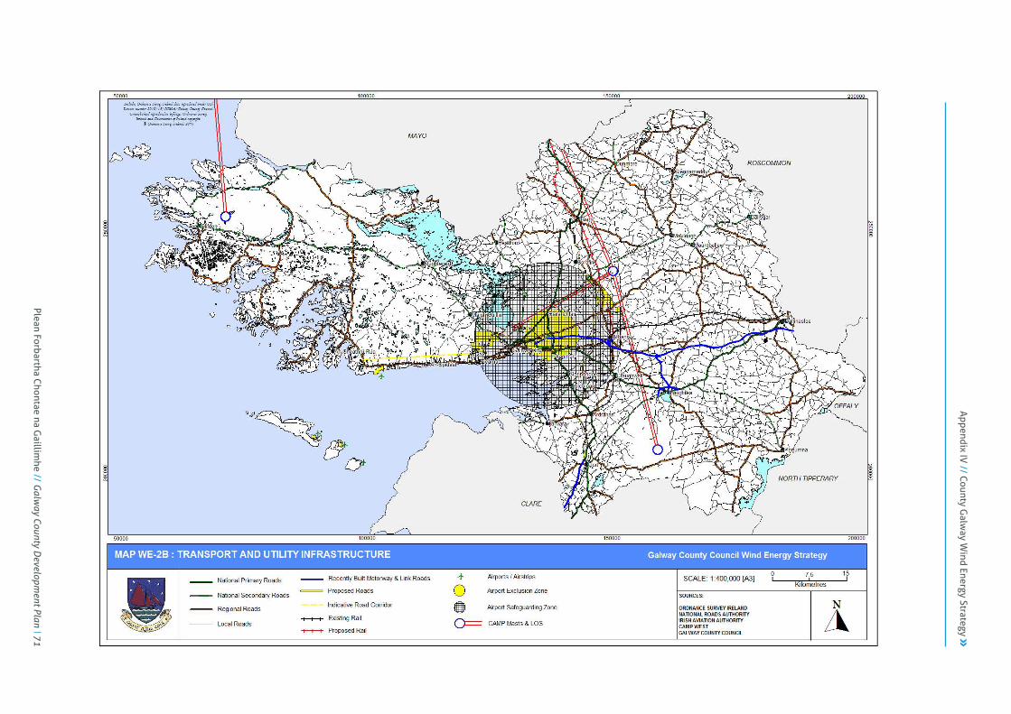
County Galway Wind Energy Strategy Page 66
Map WE-2B: Transport and Utility Infrastructure
Plean Forbartha Chontae na G
aillimhe // G
alway County D
evelopment Plan 71
Appendix IV
// County Galw
ay Wind Energy Strategy

County Galway Wind Energy Strategy Page 67
Map WE-3A : Natural Heritage Designations
72 Plean Forbartha Chontae na G
aillimhe // G
alway County D
evelopment Plan

County Galway Wind Energy Strategy Page 68
Map WE-3B : Topography and Waterbodies
Plean Forbartha Chontae na G
aillimhe // G
alway County D
evelopment Plan 73
Appendix IV
// County Galw
ay Wind Energy Strategy
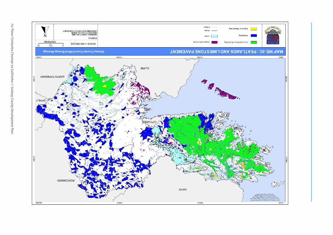
County Galway Wind Energy Strategy Page 69
Map WE-3C : Ground Conditions and Landslide Susceptibility
74 Plean Forbartha Chontae na G
aillimhe // G
alway County D
evelopment Plan

County Galway Wind Energy Strategy Page 70
Map WE-3D : Built Heritage
Plean Forbartha Chontae na G
aillimhe // G
alway County D
evelopment Plan 75
Appendix IV
// County Galw
ay Wind Energy Strategy

County Galway Wind Energy Strategy Page 71
Map WE-4A : Landscape Value and Character Areas
76 Plean Forbartha Chontae na G
aillimhe // G
alway County D
evelopment Plan
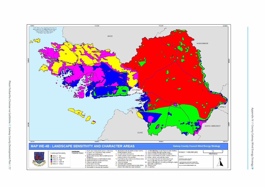
County Galway Wind Energy Strategy Page 72
Map WE-4B : Landscape Sensitivity and Character Areas
Plean Forbartha Chontae na G
aillimhe // G
alway County D
evelopment Plan 77
Appendix IV
// County Galw
ay Wind Energy Strategy

County Galway Wind Energy Strategy Page 73
Map WE-4C : Focal Points / Views
78 Plean Forbartha Chontae na G
aillimhe // G
alway County D
evelopment Plan

County Galway Wind Energy Strategy Page 74
Map WE-5A : Strategic Wind Farm Development Areas and Transmission Network
Plean Forbartha Chontae na G
aillimhe // G
alway County D
evelopment Plan 79
Appendix IV
// County Galw
ay Wind Energy Strategy

80 Plean Forbartha Chontae na G
aillimhe // G
alway County D
evelopment Plan
County Galway Wind Energy Strategy Page 75
Map WE-5B : Strategic Wind Farm Development Areas and Natural Heritage Designations

Plean Forbartha Chontae na G
aillimhe // G
alway County D
evelopment Plan 81
County Galway Wind Energy Strategy Page 76
Map WE-5C : Strategic Wind Farm Development Areas and Landscape Character Areas
Appendix IV
// County Galw
ay Wind Energy Strategy

County Galway Wind Energy Strategy Page 77
Map WE-5D : Strategic Wind Farm Development Areas and Built Heritage
82 Plean Forbartha Chontae na G
aillimhe // G
alway County D
evelopment Plan

County Galway Wind Energy Strategy Page 78
Map WE-5E : Strategic Wind Farm Development Areas and Urban and Rural Settlement
Plean Forbartha Chontae na G
aillimhe // G
alway County D
evelopment Plan 83
Appendix IV
// County Galw
ay Wind Energy Strategy

County Galway Wind Energy Strategy Page 79
Map WE-5F : Strategic Wind Farm Development Areas and Transport and Utility Infrastructure
84 Plean Forbartha Chontae na G
aillimhe // G
alway County D
evelopment Plan
County Galway Wind Energy Strategy Page 80
6.2 Appendix WE2 : Terms, Acronyms and References
6.2.1 Glossary of Terms
The following glossary of terms is taken from a number of sources, including the Wind Energy Development Guidelines (DoEHLG, 2006), the Draft SEA Checklist (EPA, 2008), the Bioenergy Action Plan for Ireland (DoCMNR, 2007b), the County Clare Wind Energy Strategy (CCC, 2009) and Sustainable Energy Ireland (SEI, 2009d).
Alternatives Description of alternative locations, alternative designs and alternative processes.
Ambient Noise The average noise level over a given period of time, usually composed of sound from many sources, near and far.
Anemometer Equipment fixed on a mast to measure wind speed over a particular site. Anemometry masts are usually slender structures fixed to the ground with guy wires.
Appropriate Assessment (AA)
Under EU Habitats Directive (92/43/EEC), an assessment of the effects of a plan or project on the Natura 2000 network. The Natura 2000 network comprises Special Protection Areas under the EU Birds Directive, Special Areas of Conservation under the EU Habitats Directive and Ramsar sites designated under the Ramsar Convention (collectively referred to as European sites). Also referred to as a Habitats Directive Assessment (HDA).
Autoproducer A person or company that generates and consumes electricity in a single premises.
Background Noise Level
A measurement of the noise level already present within the environment in the absence of wind energy development operation.
Baseline Survey Description of the existing environment against which future changes can be measured.
Berm An extended mound of soils, overburden or structure erected as a barrier to sight, sound or water.
Blade Swish The modulation of broadband noise at blade passing frequency.
Borrow Pit An area of excavation of rock and/or soil material that is used elsewhere within the site development boundaries.
Built Heritage Refers to both architectural heritage and archaeological heritage.
Capacity Factor
Measure of the actual energy produced over a period of time expressed as a percentage of the power that may have been produced if the energy generator was running at full power for that period. Also referred to as a load factor. Typically, energy outputs are 15-35% of the wind energy capacity. With a 25% capacity factor, a 1.5MW wind turbine would produce 1.5MW x 365 days x 24 hours x 25% = 3,285MWh in a year.
Commissioning The making fully operational of a project.
Cumulative Effects
Effects on the environment that result from incremental changes caused by the strategic action together with other past, present, and reasonably foreseeable future actions. These effects can result from individually minor but collectively significant actions taking place over time or space.
Cut-in Wind Speed
The wind speed at which a turbine produces a net power output. This is usually at hub height wind speeds of 4-5 metres per second (m/s).
Cut-out Wind Speed
The high wind speed at which the turbine must shut down and turn perpendicular to the wind to protect itself from being overpowered. Typically 25m/s.
Decommissioning The final closing down of a development or project when it has reached the end of its operational/useful life.
Digital Elevation Model (DEM)
The analysis uses the elevation value of each cell of the DEM to determine visibility to or from a particular cell. The location of this particular cell varies depending on the needs of the analysis. In this case, several points around the summits of the above areas were used to represent the highest points in those areas. The viewshed analysis was calculated to determine where in the remainder of the County, these points can be seen by an observer (approximately 2m in height). No additional height (i.e. turbine height) was added.
Ecology
The study of relationships between living organisms and between organisms and their environment (especially animal and plant communities), their energy flows and their interactions with their surroundings.
Environmental Impact Assessment (EIA)
An ordered exercise designed to enable the environmental impacts of a proposed development/project to be anticipated before the project is carried out.
Plean Forbartha Chontae na G
aillimhe // G
alway County D
evelopment Plan 85
Appendix IV
// County Galw
ay Wind Energy Strategy
County Galway Wind Energy Strategy Page 81
Environmental Impact Statement (EIS)
A statement of results from the ordered exercise which focuses on anticipating all environmental impacts of significance of a proposed development, prior to implementation or construction, and which specifies those measures which should be taken to eliminate or mitigate such impacts to an acceptable level.
European Site
Designated European site, also known as Natura 2000 sites and include Special Areas of Conservation (SAC) under the EU Habitats Directive 1992 that is in the listing process, an agreed candidate or designated. It also includes Special Protection Areas (SPAs) under the EU Birds Directive 1985.
Gate 3
Since December 2004, large scale commercial renewable generators (i.e. > 0.5MW) wishing to connect to the transmission or distribution systems have been subject to group processing of connection applications through a series of successive “Gates”. Renewable generator applications are processed in a “Gate” system whereby all applications that have met the defined criteria are processed in one batch (source: IWEA).
Generation
Electricity generation is the process of creating electricity from other forms of energy. For the purposes of this strategy, the term “generation” is defined as generation for storage and transmission of electricity.
Geology Science of the earth, including the composition, structure and origin of its rocks.
Geographic Information System (GIS)
A computer system that collects, stores, views and analyses geographical information and commonly creates maps as an output.
Habitat Area in which an organism or group of organisms live.
Habitats Directive Assessment (HDA)
Under EU Habitats Directive (92/43/EEC), an assessment of the effects of a plan or project on the Natura 2000 network. The Natura 2000 network comprises Special Protection Areas under the EU Birds Directive, Special Areas of Conservation under the EU Habitats Directive and Ramsar sites designated under the Ramsar Convention (collectively referred to as European sites). Also referred to as an Appropriate Assessment (AA).
Hub Height Height of wind turbine tower from the ground to the centre-line of the turbine rotor.
Hydrology Science concerned with the occurrence and circulation of water in all its phases and modes.
Key Viewpoints Places from which a development can be viewed that are crucial and sensitive with respect to observer numbers and interest.
Monitoring Repetitive and continued observation, measurement and evaluation of environmental data to follow changes over a period of time, to assess the efficiency of control measures.
Natura 2000 Site
Designated European Site. In combination Special Areas of Conservation and Special Protection Areas will constitute Natura 2000 network of protected sites for habitats and species across the EU.
Natura Impact Statement (NIS)
The statement prepared as part of Appropriate Assessment for Natura 2000 sites required under the Habitats Directive.
Natural Heritage Refers to habitats and species of flora and fauna.
Noise Any sound that has the potential to cause disturbance, discomfort or psychological stress to a subject exposed to it. Described as “unwanted sound”.
Noise Sensitive Location
In the case of wind energy development, this includes any occupied dwelling house, hostel, health building or place of worship and may include areas of particular scenic quality or special recreational amenity importance.
Rated Power Output (RPO)
Measure of the maximum capacity, or nominal power, of a wind turbine to produce electric power in megawatts, as used by wind generator manufacturers to provide a baseline for measuring performance. With a 100% capacity factor, a 1.5MW wind turbine would produce 1.5MW x 365 days x 24 hours = 13,140MWh in a year.
Renewable Energy (RE)
Ireland utilises the EU Directive 2001/77/EC definition of renewable energy, which defines renewable energy as ‘non-fossil energy sources (wind, solar, geothermal, wave, tidal, hydro and bio-energy)’.
Renewable Energy Sources (RES)
The total renewable energy contribution to final energy demand, RES, is calculated by dividing the energy from renewable sources (i.e. total electricity generated from renewable sources plus total renewable energy used directly for transport and heat) by total final consumption of energy (defined as total final demand plus in-house electricity and heat use plus transmission and distribution losses for electricity and heat). (source: SEI 2009d)
Strategic Environmental Assessment
The objective of the EU SEA Directive (2001/42/EC) is to provide for a high level of protection of the environment and to contribute to the integration of environmental
86 Plean Forbartha Chontae na G
aillimhe // G
alway County D
evelopment Plan

County Galway Wind Energy Strategy Page 82
(SEA) considerations into the preparation and adoption of plans and programmes with a view to promoting sustainable development, by ensuring that, in accordance with this Directive, an environmental assessment is carried out of certain plans and programmes which are likely to have significant effects on the environment.
Sensitivity Potential for significant change to any element in the environment that is subject to impacts.
Shadow Flicker Term used to describe the short-lived effect of shadows cast by rotating blades of wind turbines when the sun passes behind them, which occurs under certain combinations of geographical positions and time of day.
Special Area of Conservation (SAC)
Under EU Habitats Directive (92/43/EEC), area designated for habitats listed in Annex I of the Directive.
Special Protection Area (SPA)
Under EU Birds Directive (79/409/EEC), area designated for bird species listed in Annex I of the Directive, in particular internationally important concentrations of migratory and wetland birds. Designation is focused on habitats of these species.
Substation Connects the local electricity network to the electrical system of the wind energy project through a series of automatic safety switches.
Threshold Magnitude of a project, which if exceeded, will trigger the requirement for an Environmental Impact Assessment.
Total Final Consumption (TFC)
This is the measurement of energy that is delivered to energy end users in the economy. This is total primary energy, less any conversion losses that are incurred in distributing or transforming energy.
Total Primary Energy Requirement (TPER)
This is a measure of the total amount of energy consumed in Ireland for energy transformation and end use in any given year.
Total Primary Energy Supply (TPES)
This is the amount of energy available for use in Ireland for energy transformation and end use in any given year.
Visual Absorption Capacity (VAC)
This attempts to measure the inherent ability of a landscape to absorb development without loss of visual integrity, i.e. still maintain its visual character. The more complex the landscape, the higher the VAC.
Zone of Theoretical
Zone of Theoretical Visibility (previously referred to as Zone of Visual Influence) is a computer-aided procedure,
Visibility (ZTV) which aims to predict from where the turbines might be visible.
6.2.2 List of Acronyms
The following list outlines the key acronyms referred to in the WES. AA Appropriate Assessment ACA Architectural Conservation Area AE Alternative Energy AER Alternative Energy Requirement BGE Bord Gáis Eireann CAMP Computer Aided Mobilisation Project CER Commission for Energy Regulation CIS Community Impact Statement CMP Construction Management Plan CO2 Carbon Dioxide cSAC Candidate Special Area of Conservation DEM Digital Elevation Model DoCENR Department of Communications, Energy and Natural Resources DoECLG Department of Environment, Community and Local Government DoAHG Department of Arts, Heritage and the Gaeltacht DSO Distribution System Operator (ESB) du Dwelling Unit E East EIA Environmental Impact Assessment EIS Environmental Impact Statement EMP Environmental Management Plan EPA Environmental Protection Agency ESB Electricity Supply Board ESBNG ESB National Grid ETS Emission Trading System EPA Environmental Protection Agency EU European Union Gcal Gigacalorie (1,000,000 kilcalories) GCC Galway County Council GCDP Galway County Development Plan GEAL Galway Energy Association Limited GHG Greenhouse Gas GIS Geographic Information System GJ Gigajoule (1,000,000,000 joules)
Plean Forbartha Chontae na G
aillimhe // G
alway County D
evelopment Plan 87
Appendix IV
// County Galw
ay Wind Energy Strategy
County Galway Wind Energy Strategy Page 83
GSI Geological Survey Ireland GW Gigawatt (1,000MW) GWh Gigawatt Hour (1,000MWh) HDA Habitats Directive Assessment IAA Irish Aviation Authority IFI Inland Fisheries Ireland IROPI Imperative Reasons of Overriding Public Interest IWEA Irish Wind Energy Association kcal Kilcalorie (1,000 calories) kW Kilowatt (1,000 watts) ktoe Kilo-Tonnes of Oil Equivalent (1,000 toe) LAP Local Area Plan LCA Landscape Character Area LCS Landscape Character Sensitivity LCT Landscape Character Type LIA Landscape Impact Assessment m/s Metres per Second Mtoe Million Tonnes of Oil Equivalent (1,000 ktoe) MW Megawatt (1,000kW) MWh Megawatt Hour (1,000kWh) N North NA Not Applicable/Available NE North East NHA Natural Heritage Area NIS Natura Impact Statement NPWS National Parks and Wildlife Service NS Not Specified NW North West PA Planning Application PCMP Peatland Conservation and Management Plan pNHA Proposed Natural Heritage Area PP Planning Permission RBD River Basin District RBMP River Basin Management Plan RE Renewable Energy REFIT Renewable Energy Feed-In Tariff RES Renewable Energy Source/s RES-E Renewable Energy Sources for Electricity Production RES-H Renewable Energy Sources for Heating (Thermal Energy) RES-T Renewable Energy Sources for Transport (petrol & diesel)
RPO Rated Power Output RMP Record of Monuments and Places RPS Record of Protected Structures S South SAC Special Area of Conservation SE South East SEA Strategic Environmental Assessment SEAI Sustainable Energy Authority of Ireland SEI Sustainable Energy Ireland SI Statutory Instrument SPA Special Protection Area SPC Special Policy Committee SW South West SWMP Surface Water Management Plan TFC Total Final Consumption of Energy TFC-E Total Final Consumption of Energy for Electricity TFC-H Total Final Consumption of Energy for Heating TFC-T Total Final Consumption of Energy for Transport TMP Traffic Management Plan toe Tonnes of Oil Equivalent (defined as 107 kcal) TPER Total Primary Energy Requirement TPES Total Primary Energy Supply TSO Transmission System Operator (EirGrid) UN United Nations VAC Visual Absorption Capacity WDC Western Development Commission WE Wind Energy WEC Wind Energy Capacity WES Wind Energy Strategy WMP Waste Management Plan WPG Wind Powered Generation WRA West Regional Authority ZTV Zone of Theoretical Visibility
88 Plean Forbartha Chontae na G
aillimhe // G
alway County D
evelopment Plan
County Galway Wind Energy Strategy Page 84
6.2.3 List of References and Documents
The references and documents referred to in the WES are listed below. a) Key Documents 1. DoEHLG (Department of Environment, Heritage and Local Government)
(2006) Guidelines for Planning Authorities on Wind Energy Development.
2. EC (European Commission) (October 2010) Guidance Document: Wind Energy Developments and Natura 2000.
3. EWEA (European Wind Energy Association) (2002) European Best Practice Guidelines for Wind Energy Development.
4. IWEA (Irish Wind Energy Association) (2012) Best Practice Guidelines for the Irish Wind Energy Industry.
b) National Guidelines, Targets and Data 5. C4I (Community Climate Change Consortium for Ireland) (2008) Ireland in a
Warmer World: Scientific Predictions of the Irish Climate in the Twenty-First Century.
6. CER (Commission for Energy Regulation) (5 February 2010) Fuel Mix and CO2 Emission Factors Disclosure 2008.
7. CSO (Central Statistics Office) (2006a) Census 2006: Volume 1 – Population Classified by Area. Dublin: Stationary Office.
8. CSO (Central Statistics Office) (2006b) Census 2006: Volume 3 – Household Composition, Family Units and Fertility. Dublin: Stationary Office.
9. D&T (Deloitte & Touche) (December 2005) Review of the Electricity Sector in Ireland. Final Report.
10. D&T & IWEA (Deloitte & Touche & Irish Wind Energy Association (2009) Jobs and Investment in Irish Wind Energy: Powering Ireland’s Economy.
11. DoAFF (Department of Agriculture, Fisheries and Food) (2 October 2009) Forest Service Policy on the Granting of Felling Licences for Wind Farm Development. Forest Service.
12. DoCENR (Department of Communications, Energy and Natural Resources) (May 2008) Study on the Comparative Merits of Overhead Electricity Transmission Lines Versus Underground Cables. Confidential Report prepared by EcoFys Germany, University of Duisburg-Essen and Golder Associates Ireland.
13. DoCENR (Department of Communications, Energy and Natural Resources) (2009) Maximising Ireland’s Energy Efficiency: The National Energy Efficiency Action Plan 2009-2020.
14. DoCENR (Department of Communications, Energy and Natural Resources) (October 2010a) National Renewable Energy Action Plan: Ireland. Submitted under Article 4 of Directive 2009/28/EC.
15. DoCENR (Department of Communications, Energy and Natural Resources) (November 2010b) Draft Offshore Renewable Energy Development Plan (OREDP). Version 1.3 for Public Consultation.
16. DoCMNR (Department of Communications, Marine and Natural Resources) (2003) Options for Future Renewable Energy Policy, Targets and Programmes.
17. DoCMNR & DETI (Department of Communications, Marine and Natural Resources & Department of Enterprise, Trade and Investment, UK) (January 2008) All Island Grid Study.
18. DoCMNR (Department of Communications, Marine and Natural Resources) (2004) Renewable Electricity to 2010: Final Report on Policy Consideration for Renewable Electricity to 2010.
19. DoCMNR (Department of Communications, Marine and Natural Resources) (2006a) Towards a Sustainable Energy Future for Ireland. Government Green Paper.
20. DoCMNR (Department of Communications, Marine and Natural Resources) (2006b) Renewable Energy Development 2006: An Overview of Policy and Strategy Evolution.
21. DoCMNR (Department of Communications, Marine and Natural Resources) (2007a) Delivering a Sustainable Energy Future for Ireland: Energy Policy Framework 2007-2020. Government White Paper.
22. DoCMNR (Department of Communications, Marine and Natural Resources) (2007b) Bioenergy Action Plan for Ireland. Report of the Ministerial Task Force on Bioenergy.
Plean Forbartha Chontae na G
aillimhe // G
alway County D
evelopment Plan 89
Appendix IV
// County Galw
ay Wind Energy Strategy

County Galway Wind Energy Strategy Page 85
23. DoEHLG (Department of Environment, Heritage and Local Government) (2004) Architectural Heritage Protection Guidelines for Planning Authorities: Guidance on Part IV of the Planning and Development Act 2000.
24. DoEHLG (Department of Environment, Heritage and Local Government) (July 2006) Best Practice Guidelines on the Preparation of Waste Management Plans for Construction and Demolition Projects.
25. DoEHLG (Department of Environment, Heritage and Local Government) (2007) Ireland National Climate Change Strategy 2007-2012.
26. DoEHLG (Department of Environment, Heritage and Local Government) (16 July 2008) Circular Letter PD 3/08: Wind Energy Development – Planning Permission and Grid Connections.
27. DoEHLG (Department of Environment, Heritage and Local Government) (6 August 2009) Circular Letter PD 6/09: Wind Energy Development – Planning Permissions and Grid Connections.
28. DoETE (Department of Enterprise, Trade and Employment) (November 2009a) Developing the Green Economy in Ireland. Report of the High-Level Group on Green Enterprise.
29. DoETE (Department of Enterprise, Trade and Employment) (November 2009b) Developing the Green Economy in Ireland: Key Actions. Report of the High-Level Group on Green Enterprise.
30. DoT (Department of the Taoiseach) (2008) Building Ireland’s Smart Economy: A Framework for Sustainable Economic Renewal.
31. EirGrid (2009) Grid25: A Strategy for the Development of Ireland’s Electricity Grid for a Sustainable and Competitive Future.
32. EirGrid (30 April 2010) Gate 3 Node Assignments – Update 30th April 2010.
33. ESBI (ESB International) (2003) The Impacts of Increased Levels of Wind Penetration on the Electricity Systems of the Republic of Ireland and Northern Ireland. Final Report.
34. FI (Fáilte Ireland) (2007) Feasibility Study to Identify Scenic Landscapes in Ireland. Prepared by MosArt.
35. FI (Fáilte Ireland) (2008) Visitor Attitudes on the Environment: Wind Farms. 2008 / No. 3.
36. Forfas (December 2002) Assessment of the Key Competitiveness Issues and Policy Requirements Facing the Irish Electricity Market. Focus on
Irish Electricity Market, Final Report prepared by Goodbody Economic Consultants.
37. Forfas (October 2008) Environmental Goods and Services Sector on the Island of Ireland: Enterprise Opportunities and Policy Implications.
38. IAE & EI (Irish Academy of Engineering & Engineers Ireland) (February 2010) Infrastructure for an Island Population of 8 Million. Report prepared for InterTradeIreland.
39. IEA (International Energy Agency) (2007) Energy Policies of IEA Countries: Ireland 2007 Review. Paris: Stedi Media.
40. RESG (Renewable Energy Strategy Group) (2000) Strategy for Intensifying Wind Energy Deployment. Ireland.
41. SEAI (Sustainable Energy Authority of Ireland) (2010) Strategic Plan 2010-2015.
42. SEI (Sustainable Energy Ireland) (2003a) Republic of Ireland Wind Atlas 2003. Project Report No. 4Y103A-1-R1.
43. SEI (Sustainable Energy Ireland) (2003b) Attitudes towards the Development of Wind Farms in Ireland.
44. SEI (Sustainable Energy Ireland) (2004a) A Study on Renewable Energy in the New Irish Electricity Market.
45. SEI (Sustainable Energy Ireland) (2005) Study of Electricity Storage Technologies and their Potential to address Wind Energy Intermittency in Ireland. Final Report, Project RE/HC/03/001.
46. SEI (Sustainable Energy Ireland) (2008a) Energy in the Residential Sector: 2008 Report. Energy Policy Statistical Support Unit.
47. SEI (Sustainable Energy Ireland) (2008b) Passive Homes: Guidelines for the Design and Construction of Passive House Dwellings in Ireland.
48. SEI (Sustainable Energy Ireland) (2008c) A Guide to Connecting Renewable and CHP Electricity Generators to the Electricity Network.
49. SEI (Sustainable Energy Ireland) (2009a) Energy in Ireland: Key Statistics 2009. Energy Policy Statistical Support Unit.
50. SEI (Sustainable Energy Ireland) (2009b) Energy Efficiency in Ireland: 2009 Report. Energy Policy Statistical Support Unit.
51. SEI (Sustainable Energy Ireland) (2009c) Energy in Ireland 1990-2008: 2009 Report. Energy Policy Statistical Support Unit.
90 Plean Forbartha Chontae na G
aillimhe // G
alway County D
evelopment Plan

County Galway Wind Energy Strategy Page 86
52. SEI (Sustainable Energy Ireland) (2009d) Energy Forecasts for Ireland to 2020: 2009 Report. Energy Modelling Group.
53. SEI (Sustainable Energy Ireland) (2009e) Your Guide to Connecting Micro-Generation to the Electricity Network.
54. SEI (Sustainable Energy Ireland) (2009f) Energy in Transport: 2009 Report. Energy Policy Statistical Support Unit.
55. SEI (Sustainable Energy Ireland) (2009g) Retrofitted Passive Homes: Guidelines for Upgrading Existing Dwellings in Ireland to the PassivHaus Standard.
56. TEPCO (Tokyo Electric Power Company) (November 2009) Assessment of the Technical Issues relating to Significant Amounts of EHV Underground Cable in an All-Island Electricity Transmission System. Public Report.
c) National Legislation 57. MfACG (Minister for Arts, Culture and the Gaeltacht) (26 February 1997)
European Communities (Natural Habitats) Regulations 1997 (S.I. No. 94 of 1997). Dublin: The Stationary Office. (EU Habitats Directive and Appropriate Assessment)
58. MfELG (Minister for Environment and Local Government) (2001) Planning and Development Regulations 2001 (S.I. No. 600 of 2001). Dublin: The Stationary Office.
59. MfELG (Minister for Environment and Local Government) (7 March 2002) Planning and Development Regulations 2002 (S.I. No. 70 of 2002). Dublin: The Stationary Office. (Planning and Development Amendment Act 2002)
60. MfEHLG (Minister for Environment, Heritage and Local Government) (2004a) European Communities (Environmental Assessment of Certain Plans and Programmes) Regulations 2004 (S.I. No. 435 of 2004). Dublin: The Stationary Office. (SEA for plans and programmes generally not including land use plans)
61. MfEHLG (Minister for Environment, Heritage and Local Government) (2004b) Planning and Development (Strategic Environmental Assessment) Regulations 2004 (S.I. No. 436 of 2004). Dublin: The Stationary Office. (SEA for land use plans)
62. MfEHLG (Minister for Environment, Heritage and Local Government) (2005) Planning and Development Regulations 2005 (S.I. No. 364 of 2005). Dublin: The Stationary Office. (EIS and peat extraction)
63. MfEHLG (Minister for Environment, Heritage and Local Government) (2006a) European Communities (Environmental Impact Assessment) (Amendment) Regulations 2006 (S.I. No. 659 of 2006). Dublin: The Stationary Office. (Public participation in assessment of effects of certain projects on environment)
64. MfEHLG (Minister for Environment, Heritage and Local Government) (2006b) Planning and Development Regulations 2006 (S.I. No. 685 of 2006). Dublin: The Stationary Office. (Strategic Infrastructure Act)
65. MfEHLG (Minister for Environment, Heritage and Local Government) (2008) Planning and Development Regulations 2008 (S.I. No. 235 of 2008). Dublin: The Stationary Office. (Exemptions for renewable technologies)
66. Oireachtas (2000) Planning and Development Act 2000 (No. 30 of 2000). Dublin: The Stationary Office.
67. Oireachtas (2002) Planning and Development (Amendment) Act 2002 (No. 32 of 2002). Dublin: The Stationary Office.
68. Oireachtas (2006) Planning and Development (Strategic Infrastructure) Act 2006 (No. 27 of 2006). Dublin: The Stationary Office.
69. Oireachtas (2006) Planning and Development (Amendment) Act 2010 (No. 30 of 2010). Dublin: The Stationary Office.
d) Galway, Adjoining Counties and the West Region 70. CCC (Clare County Council) (14 December 2009) Clare Wind Energy
Strategy. Variation to Clare County Development Plan 2006-2011.
71. CCC (Clare County Council) (January 2010a) Clare Draft Wind Energy Strategy. Volume 5 of Draft Clare County Development Plan 2011-2017.
72. CCC (Clare County Council) (October 2010b) Clare Draft Wind Energy Strategy: Proposed Amendments. Volume 5 of Draft Clare County Development Plan 2011-2017.
73. Forfas (2010a) Regional Competitiveness Agendas: Overview, Findings and Actions.
74. Forfas (2010b) Regional Competitiveness: Volume II – Realising Potential: West.
Plean Forbartha Chontae na G
aillimhe // G
alway County D
evelopment Plan 91
Appendix IV
// County Galw
ay Wind Energy Strategy

County Galway Wind Energy Strategy Page 87
75. Galway City Development Board (2002) Galway City Strategy for Economic, Social and Cultural Development 2002-2012.
76. GCC (Galway County Council) (February 2002) Landscape and Landscape Character Assessment for Galway County. Prepared for GCC by Atkins.
77. GCC (Galway County Council) (May 2004) Landscape Assessment Re-evaluation of Specific Areas of Galway County. Prepared for GCC by Atkins.
78. GCC (Galway County Council) (25 February 2008) Gaeltacht Local Area Plan 2008-2014.
79. GCC (Galway County Council) (May 2009a) Galway County Development Plan 2009-2015. (Objective IS18 & DM Standard 25)
80. GCC (Galway County Council) (December 2009b, amended 6 July 2010) Final River Basin Management Plan for the Western River Basin District in Ireland (2009-2015). Incorporating Amendments of the Minister for the Environment, Heritage and Local Government, issued on 6th July 2010.
81. GCC (Galway County Council) (2010) Galway County Council Energy Action Plan 2010.
82. GCDB (Galway County Development Board) (2002) Working Together, Shaping Our Future: Galway County Strategy for Economic, Social and Cultural Development 2002-2012.
83. GCDB (Galway County Development Board) (2006) Working Together, Shaping Our Future: Galway County Strategy Interim Review and Programmes of Actions 2006-2008.
84. GEAL (Galway Energy Agency Ltd.) (2001) Galway Climate Change Strategy Report.
85. IWEA (Irish Wind Energy Association) (20 April 2010) IWEA Submission on ‘The Potential for Renewable Energy in County Mayo: Discussion Paper’.
86. LCC (Limerick County Council) (December 2009, amended 6 July 2010) Shannon International River Basin Management Plan (2009-2015). Incorporating Amendments of the Minister for the Environment, Heritage and Local Government, issued on 6th July 2010.
87. MCC (Mayo County Council) (2008) Mayo Wind Energy Strategy. Mayo County Development Plan 2008-2014.
88. MCC (Mayo County Council) (February 2010a) The Potential for Renewable Energy in County Mayo: Discussion Paper.
89. MCC (Mayo County Council) (December 2010b) Draft Renewable Energy Strategy for County Mayo 2010-2020.
90. NTCC (North Tipperary County Council) (April 2009) Wind Capacity Study and Outline Landscape Strategy for North Tipperary. Final Report.
91. OCC (Offaly County Council) (2009) County Offaly Wind Energy Strategy 2009-2015. Appendix to Offaly County Development Plan 2009-2015.
92. RCC (Roscommon County Council) (June 2008) Landscape Character Assessment of County Roscommon. Appendix to Roscommon County Development Plan 2008-2014.
93. RCC (Roscommon County Council) (January 2011) Roscommon Draft Wind Energy Strategy.
94. WDC (Western Development Commission) (2004) To Catch the Wind: The Potential for Community Ownership of Wind Farms in Ireland.
95. WDC (Western Development Commission) (2008) Wood Energy Strategy and Action Plan: Full Version.
96. WRA (West Regional Authority) (2004) Regional Planning Guidelines for the West Region 2004-2016.
97. WRA (West Regional Authority) (22 January 2010a) Strategic Environmental Assessment: Draft Environmental Report for the preparation of the Draft Regional Planning Guidelines for the West Region 2010-2022.
98. WRA (West Regional Authority) (22 January 2010b) Habitats Directive Assessment: Draft Screening Report for the preparation of the Draft Regional Planning Guidelines for the West Region 2010-2022.
99. WRA (West Regional Authority) (19 October 2010c) Regional Planning Guidelines for the West Region 2010-2022.
e) Other Wind Energy Strategies 100. Carlow County Council (June 2008) Wind Energy Strategy for County
Carlow. Appendix 10, County Carlow Development Plan 2009-2015.
101. FCC (Fingal County Council) (October 2009) Fingal Wind Energy Strategy.
92 Plean Forbartha Chontae na G
aillimhe // G
alway County D
evelopment Plan

County Galway Wind Energy Strategy Page 88
102. WCC (Wexford County Council) (2007) Wexford Wind Energy Development Strategy. Draft Wexford County Development Plan 2007-2013.
f) Landscape and Visual Impact Assessment 103. DoEHLG (Department of Environment, Heritage and Local Government)
(June 2000) Landscape and Landscape Assessment: Consultation Draft Guidelines for Planning Authorities.
104. NIEA (Northern Ireland Environment Agency) (August 2010) Wind Energy Development in Northern Ireland’s Landscapes: Supplementary Planning Guidance to Accompany Planning Policy Statement 18 ‘Renewable Energy’. Northern Ireland.
105. SNH (Scottish Natural Heritage) (29 March 2006) Visual Representation of Windfarms: Good Practice Guide. UK.
106. SNH (Scottish Natural Heritage) (December 2009c) Siting and Designing Windfarms in the Landscape. Version 1. UK.
g) Environmental Assessment 107. DoEHLG (Department of Environment, Heritage and Local Government)
(November 2004) Implementation of SEA Directive (2001/42/EC): Assessment of the Effects of Certain Plans and Programmes on the Environment – Guidelines for Regional Authorities and Planning Authorities.
108. DoEHLG (Department of Environment, Heritage and Local Government) (2007) Circular Letter PD 2/07 & NPWS 1/07: Compliance Conditions in respect of Developments requiring (1) Environmental Impact Assessment (EIA); or (2) having potential impacts on Natura 2000 sites.
109. DoEHLG (Department of Environment, Heritage and Local Government) (15 February 2008) Circular Letter SEA 1/08 & NPWS 1/08: Appropriate Assessment of Land Use Plans.
110. DoEHLG (Department of Environment, Heritage and Local Government) (November 2009a) The Planning System and Flood Risk Management: Guidelines for Planning Authorities.
111. DoEHLG (Department of Environment, Heritage and Local Government) (November 2009b) The Planning System and Flood Risk Management: Guidelines for Planning Authorities – Technical Appendices.
112. DoEHLG (Department of Environment, Heritage and Local Government) (10 December 2009, revised 11 February 2010) Appropriate Assessment of Plans and Projects in Ireland: Guidance for Planning Authorities.
113. DoEHLG (Department of Environment, Heritage and Local Government) (11 March 2010) Circular Letter NPW 1/10 & PSSP 2/10: Appropriate Assessment under Article 6 of the Habitats Directive: Guidance for Planning Authorities.
114. EC (European Commission) (October 2010) Guidance Document: Wind Energy Developments and Natura 2000.
115. EFG (European Federation of Geologists) (May 2003) Advice Document to the European Commission on Environmental Impact Assessment Implementation and Practice. Brussels.
116. EPA (Environmental Protection Agency) (March 2002) Guidelines on the Information to be Contained in Environmental Impact Statements. Johnstown Castle, Co. Wexford, Ireland.
117. EPA (Environmental Protection Agency) (August 2003a) Environmental Impact Assessment (EIA): Guidance for Consent Authorities regarding Sub-threshold Development. Johnstown Castle, Co. Wexford, Ireland.
118. EPA (Environmental Protection Agency) (September 2003b) Advice Notes on Current Practice (in the preparation of Environmental Impact Statements). Johnstown Castle, Co. Wexford, Ireland.
119. EPA (Environmental Protection Agency) (May 2004) Strategic Environmental Assessment and Climate Change: Guidance for Practitioners. Johnstown Castle, Co. Wexford, Ireland.
120. EPA (Environmental Protection Agency) (2007) Wetlands – Protection, Conservation and Assessment, in EPA Code of Practice: Environmental Risk Assessment for Unregulated Waste Disposal Sites.
121. EPA (Environmental Protection Agency, UK) (30 November 2010) Guidance Note on Noise Assessment of Wind Turbine Operations at EPA Licensed Sites (NG3): Issue for Consultation. Office of Environmental Enforcement (OEE).
122. European Commission (21 May 1992) Directive 92/43/EEC on the Conservation of Natural Habitats and of Wild Fauna and Flora. European Parliament and the Council of the European Union. (Habitats Directive)
123. European Commission (27 June 2001) Directive 2001/42/EC on the Assessment of the Effects of Certain Plans and Programmes on the
Plean Forbartha Chontae na G
aillimhe // G
alway County D
evelopment Plan 93
Appendix IV
// County Galw
ay Wind Energy Strategy

County Galway Wind Energy Strategy Page 89
Environment. European Parliament and the Council of the European Union. (SEA Directive)
124. IGI (Institute of Geologists of Ireland) (September 2002) Geology in Environmental Impact Statements: A Guide.
125. NRA (National Roads Authority) (2008) Guidelines on the Management of Noxious Weeds and Non-Native Invasive Plant Species on National Roads.
h) Impacts on Birds, Bats and Other Species 126. BLI (BirdLife International) (September 2003) Windfarms and Birds: An
Analysis of the Effects of Windfarms on Birds, and Guidance on Environmental Assessment Criteria and Site Selection Issues. Report prepared on behalf of Bern Convention.
127. BLI (BirdLife International) (2004) Birds in the European Union: a Status Assessment. Wageningen, The Netherlands: BirdLife International.
128. BWI (BirdWatch Ireland) (2009) Countryside Bird Survey Report 1998-2007 (Report No. 3). Joint Project of BWI and NPWS. Wexford.
129. BWI & RSPB NI (BirdWatch Ireland and Royal Society for the Protection of Birds Northern Ireland) (2007) Birds of Conservation Concern in Ireland: Red List and Amber List.
130. DoAFF (Department of Agriculture, Fisheries and Food) (2006) Forestry and Freshwater Pearl Mussel Requirements: Site Assessment and Mitigation Measures. Forest Service.
131. DoEHLG (Department of Environment, Heritage and Local Government) (March 2010) Freshwater Pearl Mussel: Bundorragha Sub-Basin Management Plan. Second Draft.
132. DoEHLG (Department of Environment, Heritage and Local Government) (March 2010) Freshwater Pearl Mussel: Dawros Sub-Basin Management Plan. Second Draft.
133. DoEHLG (Department of Environment, Heritage and Local Government) (March 2010) Freshwater Pearl Mussel: Owenriff Sub-Basin Management Plan. Second Draft.
134. LYNAS, Paul, NEWTON, Stephen F. and ROBINSON, James A. (2007) The Status of Birds in Ireland: An Analysis of Conservation Concern 2008-2013. In Irish Birds, Vol. 8, No. 2 (2007), pp. 149-166.
135. NE (Natural England) (15 October 2007) Technical Information Note TIN008: Assessing Ornithological Impacts associated with Wind Farm Developments: Surveying Recommendations. UK.
136. NE (Natural England) (11 February 2009a) Technical Information Note TIN051: Bats and Onshore Wind Turbines: Interim Guidance. UK.
137. NE (Natural England) (18 September 2009b) Technical Information Note TIN059: Bats and Single Large Wind Turbines: Joint Agencies Interim Guidance. UK.
138. NE (Natural England) (7 January 2010) Technical Information Note TIN069: Assessing the Effects of Onshore Wind Farms on Birds. UK.
139. Percival, S.M. (December 2003) Birds and Wind Farms in Ireland: A Review of Potential Issues and Impact Assessment. Report to Sustainable Energy Ireland.
140. SNH (Scottish Natural Heritage) (November 2005) Survey Methods for use in Assessing the Impacts of Onshore Windfarms on Bird Communities
i) Ground Conditions, Peat and Landslide Susceptibility 141. Connolly, John and Holden, M. (2009) Mapping Peat Soils in Ireland:
Updating the Derived Irish Peat Map. In Irish Geography, 42: 3, pp. 343-352.
142. GSI (Geological Survey of Ireland) (2003) Geological Report on the Pollatomish Landslide Area, Co. Mayo. Internal Unpublished Report.
143. GSI (Geological Survey of Ireland) (June 2006) Landslides in Ireland. Report of the Irish Landslides Working Group.
144. Lindsay, Richard and Olivia Bragg (November 2005) Wind Farms and Blanket Peat: A Report on the Derrybrien Bog Slide. Second Edition. Report prepared for the Derrybrien Development Co-operative.
145. NE (Natural England) (April 2010a) Commissioned Report NECR032: Investigating the Impacts of Windfarm Development on Peatlands in England: Part 1 – Final Report. UK.
146. NE (Natural England) (April 2010b) Commissioned Report NECR032: Investigating the Impacts of Windfarm Development on Peatlands in England: Part 2 – Appendices and References. UK.
147. SE (Scottish Executive) (December 2006) Peat Landslide Hazard and Risk Assessments: Best Practice Guide for Proposed Electricity Generation Developments. UK.
94 Plean Forbartha Chontae na G
aillimhe // G
alway County D
evelopment Plan

County Galway Wind Energy Strategy Page 90
148. Renou-Wilson, F. and C.A. Farrell (2009) Peatland Vulnerability to Energy-Related Developments from Climate Change Policy in Ireland: The Case of Wind Farms. In Mires and Peat, Vol. 4 (2008-2010), Article 8. (see http://www.mires-and-peat.net/)
149. SWAP (Scottish Wind Assessment Project) (July 2006) The Politics of Peat: Lessons from the Derrybrien Landslide. UK.
j) Impacts on Infrastructure 150. DoEHLG (Department of Environment, Heritage and Local Government)
(2012) Spatial Planning and National Roads: Guidelines for Planning Authorities.
151. IAA (Irish Aviation Authority) (2002) SI No. 14 of 2002: Irish Aviation Authority (Obstacles to Aircraft in Flight) Order, 2002.
152. HA (Highways Agency) (2009) Spatial Planning Advice Note SP12/09 Planning Applications for Wind Turbines sited near to Trunk Roads, UK.
153. NRA (National Roads Authority) (May 2006) Policy Statement on Development Management and Access to National Roads.
154. Ofcom (26 August 2009) Tall Structures and their Impact on Broadcast and other Wireless Services. UK.
155. SEI (Sustainable Energy Ireland) (September 2004c) Investigation of the Impact of Wind Turbines on the MSSR Installations at Dooncarton, Mt Gabriel and Woodcock Hill, Ireland. Final Report.
k) Offshore Wind and Ocean Energy 156. DoCENR (Department of Communications, Energy and Natural Resources)
(November 2010b) Draft Offshore Renewable Energy Development Plan (OREDP). Version 1.3 for Public Consultation.
157. DoPE & DoETI (Department of Public Enterprise and Department of Enterprise, Trade and Investment) (2000) Assessment of Offshore Wind Energy Resources in the Republic of Ireland and Northern Ireland.
158. Duwind (Delft University Wind Energy Research Institute) (December 2001) Offshore Wind Energy: Ready to Power a Sustainable Europe. Final Report, Concerted Action on Offshore Wind Energy in Europe (CA-OWEE). Netherlands.
159. EEA (European Environment Agency) (2009) Europe’s Onshore and Offshore Wind Energy Potential: An Assessment of Environmental and Economic Constraints. EEA Technical Report No. 6/2009. Copenhagen.
160. EWEA (European Wind Energy Association) (September 2009) Delivering Offshore Wind Power in Europe: Policy Recommendations for Large-Scale Deployment of Offshore Wind Power in Europe by 2020.
161. MI (Marine Institute) (April 2000) Assessment of Impact of Offshore Wind Energy Structures on the Marine Environment. Prepared by Byrne Ó Cléirigh and EcoServe.
162. MI & SEI (Marine Institute & Sustainable Energy Ireland) (November 2002) Options for the Development of Wave Energy in Ireland: A Public Consultation Document.
163. MI & SEI (Marine Institute & Sustainable Energy Ireland) (October 2005a) Ocean Energy in Ireland: An Ocean Strategy for Ireland. Submitted to the Department of Communications, Marine and Natural Resources.
164. MI & SEI (Marine Institute & Sustainable Energy Ireland) (December 2005b) Analysis of the Potential Economic Benefits of Developing Ocean Energy in Ireland. Summary Report, Marine Foresight Series No. 3.
165. MI & SEI (Marine Institute & Sustainable Energy Ireland) (December 2005c) Accessible Wave Energy Resource Atlas: Ireland: 2005. Prepared by ESB International.
166. NOW Ireland (National Offshore Wind Association of Ireland) (September 2008) Economic Appraisal of the Potential for Offshore Wind Energy Generation in Ireland. Prepared by Indecon.
167. SEI (Sustainable Energy Ireland) (2001) Offshore Electricity Generating Stations: Note for Intending Developers.
168. SEI (Sustainable Energy Ireland) (2004b) Tidal and Current Energy Resources in Ireland.
l) EU and International Guidance and Targets 169. BWEA (British Wind Energy Association) (November 1994) Best Practice
Guidelines for Wind Energy Development. UK.
170. DoE, NI (Department of the Environment, Northern Ireland) (August 2009a) Planning Policy Statement (PPS 18): Renewable Energy. Planning and Environmental Policy Group. Northern Ireland.
Plean Forbartha Chontae na G
aillimhe // G
alway County D
evelopment Plan 95
Appendix IV
// County Galw
ay Wind Energy Strategy

County Galway Wind Energy Strategy Page 91
171. DoE, NI (Department of the Environment, Northern Ireland) (August 2009b) Best Practice Guide to Planning Policy Statement 18: Renewable Energy. Planning and Environmental Policy Group. Northern Ireland.
172. EC (European Commission) (1997) White Paper for a Community Strategy and Action Plan for Renewable Energy Sources.
173. EC (European Commission) (13 September 1993) Council Directive 93/76/EEC to Limit Carbon Dioxide Emissions by Improving Energy Efficiency. European Parliament and the Council of the European Union.
174. EC (European Commission) (27 September 2001) Directive 2001/77/EC on the Promotion of Electricity from Renewable Energy Sources in the Internal Electricity Market. European Parliament and the Council of the European Union.
175. EC (European Commission) (27 April 2009) EmployRES: The Impact of Renewable Energy Policy on Economic Growth and Employment in the European Union: Final Report.
176. EC (European Commission) (October 2010) Guidance Document: Wind Energy Developments and Natura 2000.
177. EEA (European Environment Agency) (2009) Europe’s Onshore and Offshore Wind Energy Potential: An Assessment of Environmental and Economic Constraints. EEA Technical Report No. 6/2009. Copenhagen.
178. EREC (European Renewable Energy Council) (2008) Renewable Energy Technology Roadmap: 20% by 2020.
179. European Communities (25 June 2002) Directive 2002/49/EC relating to the Assessment and Management of Environmental Noise. European Parliament and the Council of the European Union.
180. European Communities (16 December 2002) Directive 2002/91/EC on the Energy Performance of Buildings. European Parliament and the Council of the European Union.
181. European Communities (8 May 2003) Directive 2003/30/EC on the Promotion of the Use of Biofuels or Other Renewable Fuels for Transport. European Parliament and the Council of the European Union.
182. European Communities (5 April 2006) Directive 2006/32/EC on Energy End-Use Efficiency and Energy Services and Repealing Council Directive 93/76/EEC. European Parliament and the Council of the European Union.
183. European Communities (10 January 2007) Renewable Energy Road Map. Renewable Energies in the 21st Century: Building a More Sustainable Future. European Parliament and the Council of the European Union.
184. European Communities (23 April 2009) Directive 2009/28/EC on the Promotion of the Use of Energy from Renewable Sources and Amending and Subsequently Repealing Directives 2001/77/EC and 2003/30/EC. European Parliament and the Council of the European Union.
185. EWEA (European Wind Energy Association) (December 2005) Large Scale Integration of Wind Energy in the European Power Supply: Analysis, Issues and Recommendation.
186. PREDAC (2004) Spatial Planning of Wind Turbines: Guidelines and Comparison of European Experiences. European Actions for Renewable Energies. CLER Project (Comité de Liaison Energies Renouvelables), France.
187. SNH (Scottish Natural Heritage) (2002, Updated March 2009a) Strategic Locational Guidance for Onshore Wind Farms in Respect of the Natural Heritage: Policy Statement No. 02/02.
188. SNH (Scottish Natural Heritage) (November 2009b) Assessing the Cumulative Effect of Onshore Wind Energy Developments. Version 3, Draft for Consultation.
189. UN (United Nations) (1992) United Nations Framework Convention on Climate Change.
190. UN (United Nations) (1998) Kyoto Protocol to the United Nations Framework Convention on Climate Change.
191. WINEUR (Wind Energy Integration in the Urban Environment) (February 2007) Urban Wind Turbines: Guidelines for Small Wind Turbines in the Built Environment. Intelligent Energy Europe.
m) Key Internet Sites 192. CER (2010/2011) Energy Regulation (www.cer.ie).
193. EirGrid (2010/2011) Electricity Transmission Network (www.eirgrid.com).
194. ESB (2010/2011) Electricity Distribution Network (www.esb.ie).
195. GCC (2010/2011) Energy (www.galway.ie).
196. IWEA (2010/2011) Wind Farm Construction (www.iwea.com).
197. SEAI (2010/2011) Renewable Energy (www.seai.ie).
96 Plean Forbartha Chontae na G
aillimhe // G
alway County D
evelopment Plan

County Galway Wind Energy Strategy Page 92
Plean Forbartha Chontae na G
aillimhe // G
alway County D
evelopment Plan 97
Appendix IV
// County Galw
ay Wind Energy Strategy

County Galway Wind Energy Strategy Page 93
6.3 Appendix WE3 : Tables and Calculations
The following tables outline the key figures, units of energy, conversion factors and statistics utilised as a basis for calculations in the WES.
6.3.1 Key Figures and Conversion Factors
The key figures and conversion factors used in calculating energy and electricity requirements as part of the WES are set out below.
Key Figure Quantity No. of Hours in 1 Year 8,760 hours Wind Energy (WE) Capacity Factor 30% Emission Factor for Electricity in 2008 0.533 tCO2/MWh Residential Final Energy Demand for Electricity in 2008 733 ktoe Residential Total Final Energy Demand in 2008 3,185 ktoe Electricity Use of Average Dwelling in 2008 (climate corrected) 5.557 MWh
Emissions of Average Dwelling from Electricity Use in 2008 3.2 tCO2
Estimated No. of Average Dwelling Units (du) supplied with Electricity per Unit of Wind Energy in 2008 473 du/MW
Source: Adapted from SEI 2009a, 2009c, 2009d; CER, 2010 Conversion Factor From: toe MWh MW of WE tCO2 To: Multiply by: toe 1 0.086 226 0.161 MWh 11.63 1 2,628 1.876 MW 0.00443 0.000381 1 0.000714 tCO2 6.199 0.533 1,401 1
Notes: 1. Adapted from SEI, 2009a; CER, 2010; WDC, 2008; CCC, 2009; www.seai.ie. 2. MW of WE (Wind Energy) calculated using a capacity factor of 30%.
6.3.2 National Energy Statistics
The national energy statistics for 2008 and projected for 2012 and 2020 are outlined below.
Energy Statistics 2008 Electricity Transport Heating Total TPER (ktoe) 5,141 5,689 5,629 16,356 TPER (% of Total) 31.4% 34.8% 34.4% 100.0% TFC (ktoe) 2,294 5,612 5,499 13,401 TFC (% of Total) 17.1% 41.9% 41.0% 100.0% TFC (% of Primary Energy) 44.6% 99.6% 97.7% 81.9% RES of TFC (ktoe) 304 56 198 618 RES of TFC (% of Total) 49.2% 9.1% 32.0% 100.0% RES of TFC (% of Energy Type) 11.9% 1.2% 3.6% 4.5%
Source: Adapted from SEI, 2009a
Final Energy Consumption 2008-2020
Final Consumption (ktoe) 2008 2012 2020
Electricity 2,665 2,500 2,813 Heating (Thermal) 5,502 5,209 5,718 Transport 5,612 5,237 6,713 Total 13,779 12,946 15,243
Source: SEI, 2009d (Table 10, pg. 20)
Renewable Energy Consumption 2008-2020
Total Final Demand (ktoe) 2008 2012 2020
RES-E (Electricity) 304 570 752 RES-H (Heating) 198 202 202 RES-T (Transport) 57 143 176 Total Renewables 558 915 1,130 Total RES Contribution (%) 4.1% 7.1% 7.4%
Source: SEI, 2009d (Table 11, pg. 21)
6.3.3 Galway Energy Estimates
The energy estimates for Galway (City and County) for 2008 and projected for 2020 are outlined below, using Galway’s share of the national population in 2006 as a proxy for its share of national energy consumption. This has been used to estimate the amount of wind energy (WE) equivalent that would be needed to supply the electricity requirements of Galway.
Population and Households 2006
2006 Population 2006 Households Occupancy Ratio No. % No. %
Galway County 159,256 3.76% 53,308 3.63% 2.91
98 Plean Forbartha Chontae na G
aillimhe // G
alway County D
evelopment Plan

County Galway Wind Energy Strategy Page 94
Galway City 72,414 1.71% 25,353 1.73% 2.67 Galway Co. & City 231,670 5.46% 78,661 5.35% 2.83 Ireland 4,239,848 100% 1,469,521 100% 2.81
Source: Adapted from CSO, 2006a, 2006b
Galway Electricity Consumption 2008-
2020 (ktoe)
% of Ireland Population/
TFC-E
2008 TFC-E (ktoe)
2020 TFC-E (ktoe)
40% of 2020 TFC-E (ktoe)
Galway County 3.76% 100 106 42 Galway City 1.71% 46 48 19 Galway Co. & City 5.46% 146 154 61 Ireland 100% 2,665 2,813 1,125
Source: Adapted from SEI, 2009d; CSO, 2006a, 2006b
Galway Electricity Consumption 2008-
2020 (MWh)
% of Ireland Population/
TFC-E
2008 TFC-E (MWh)
2020 TFC-E (MWh)
40% of 2020 TFC-E (MWh)
Galway County 3.76% 1,164,186 1,228,839 491,536 Galway City 1.71% 529,358 558,755 223,502 Galway Co. & City 5.46% 1,693,544 1,787,594 715,038 Ireland 100% 30,993,950 32,715,190 13,086,076
Source: Adapted from SEI, 2009d; CSO, 2006a, 2006b
Galway Electricity Consumption 2008-
2020 (MW of WE)
% of Ireland Population/
TFC-E
2008 TFC-E (MW of WE)
2020 TFC-E (MW of WE)
40% of 2020 TFC-E (MW
of WE) Galway County 3.76% 443 468 187 Galway City 1.71% 201 213 85 Galway Co. & City 5.46% 644 680 272 Ireland 100% 11,794 12,449 4,979
Source: Adapted from SEI, 2009d; CSO, 2006a, 2006b
Plean Forbartha Chontae na G
aillimhe // G
alway County D
evelopment Plan 99
Appendix IV
// County Galw
ay Wind Energy Strategy
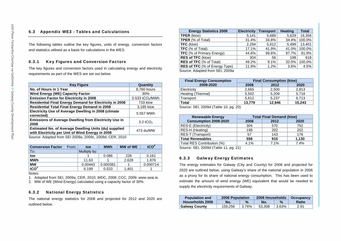
County Galway Wind Energy Strategy Page 93
6.3 Appendix WE3 : Tables and Calculations
The following tables outline the key figures, units of energy, conversion factors and statistics utilised as a basis for calculations in the WES.
6.3.1 Key Figures and Conversion Factors
The key figures and conversion factors used in calculating energy and electricity requirements as part of the WES are set out below.
Key Figure Quantity No. of Hours in 1 Year 8,760 hours Wind Energy (WE) Capacity Factor 30% Emission Factor for Electricity in 2008 0.533 tCO2/MWh Residential Final Energy Demand for Electricity in 2008 733 ktoe Residential Total Final Energy Demand in 2008 3,185 ktoe Electricity Use of Average Dwelling in 2008 (climate corrected) 5.557 MWh
Emissions of Average Dwelling from Electricity Use in 2008 3.2 tCO2
Estimated No. of Average Dwelling Units (du) supplied with Electricity per Unit of Wind Energy in 2008 473 du/MW
Source: Adapted from SEI 2009a, 2009c, 2009d; CER, 2010 Conversion Factor From: toe MWh MW of WE tCO2 To: Multiply by: toe 1 0.086 226 0.161 MWh 11.63 1 2,628 1.876 MW 0.00443 0.000381 1 0.000714 tCO2 6.199 0.533 1,401 1
Notes: 1. Adapted from SEI, 2009a; CER, 2010; WDC, 2008; CCC, 2009; www.seai.ie. 2. MW of WE (Wind Energy) calculated using a capacity factor of 30%.
6.3.2 National Energy Statistics
The national energy statistics for 2008 and projected for 2012 and 2020 are outlined below.
Energy Statistics 2008 Electricity Transport Heating Total TPER (ktoe) 5,141 5,689 5,629 16,356 TPER (% of Total) 31.4% 34.8% 34.4% 100.0% TFC (ktoe) 2,294 5,612 5,499 13,401 TFC (% of Total) 17.1% 41.9% 41.0% 100.0% TFC (% of Primary Energy) 44.6% 99.6% 97.7% 81.9% RES of TFC (ktoe) 304 56 198 618 RES of TFC (% of Total) 49.2% 9.1% 32.0% 100.0% RES of TFC (% of Energy Type) 11.9% 1.2% 3.6% 4.5%
Source: Adapted from SEI, 2009a
Final Energy Consumption 2008-2020
Final Consumption (ktoe) 2008 2012 2020
Electricity 2,665 2,500 2,813 Heating (Thermal) 5,502 5,209 5,718 Transport 5,612 5,237 6,713 Total 13,779 12,946 15,243
Source: SEI, 2009d (Table 10, pg. 20)
Renewable Energy Consumption 2008-2020
Total Final Demand (ktoe) 2008 2012 2020
RES-E (Electricity) 304 570 752 RES-H (Heating) 198 202 202 RES-T (Transport) 57 143 176 Total Renewables 558 915 1,130 Total RES Contribution (%) 4.1% 7.1% 7.4%
Source: SEI, 2009d (Table 11, pg. 21)
6.3.3 Galway Energy Estimates
The energy estimates for Galway (City and County) for 2008 and projected for 2020 are outlined below, using Galway’s share of the national population in 2006 as a proxy for its share of national energy consumption. This has been used to estimate the amount of wind energy (WE) equivalent that would be needed to supply the electricity requirements of Galway.
Population and Households 2006
2006 Population 2006 Households Occupancy Ratio No. % No. %
Galway County 159,256 3.76% 53,308 3.63% 2.91
100 Plean Forbartha Chontae na G
aillimhe // G
alway County D
evelopment Plan

County Galway Wind Energy Strategy Page 94
Galway City 72,414 1.71% 25,353 1.73% 2.67 Galway Co. & City 231,670 5.46% 78,661 5.35% 2.83 Ireland 4,239,848 100% 1,469,521 100% 2.81
Source: Adapted from CSO, 2006a, 2006b
Galway Electricity Consumption 2008-
2020 (ktoe)
% of Ireland Population/
TFC-E
2008 TFC-E (ktoe)
2020 TFC-E (ktoe)
40% of 2020 TFC-E (ktoe)
Galway County 3.76% 100 106 42 Galway City 1.71% 46 48 19 Galway Co. & City 5.46% 146 154 61 Ireland 100% 2,665 2,813 1,125
Source: Adapted from SEI, 2009d; CSO, 2006a, 2006b
Galway Electricity Consumption 2008-
2020 (MWh)
% of Ireland Population/
TFC-E
2008 TFC-E (MWh)
2020 TFC-E (MWh)
40% of 2020 TFC-E (MWh)
Galway County 3.76% 1,164,186 1,228,839 491,536 Galway City 1.71% 529,358 558,755 223,502 Galway Co. & City 5.46% 1,693,544 1,787,594 715,038 Ireland 100% 30,993,950 32,715,190 13,086,076
Source: Adapted from SEI, 2009d; CSO, 2006a, 2006b
Galway Electricity Consumption 2008-
2020 (MW of WE)
% of Ireland Population/
TFC-E
2008 TFC-E (MW of WE)
2020 TFC-E (MW of WE)
40% of 2020 TFC-E (MW
of WE) Galway County 3.76% 443 468 187 Galway City 1.71% 201 213 85 Galway Co. & City 5.46% 644 680 272 Ireland 100% 11,794 12,449 4,979
Source: Adapted from SEI, 2009d; CSO, 2006a, 2006b
Plean Forbartha Chontae na G
aillimhe // G
alway County D
evelopment Plan 101
Appendix IV
// County Galw
ay Wind Energy Strategy

County Galway Wind Energy Strategy Page 97
c) Pending Wind Energy Capacity in Galway The pending wind energy capacity in Galway refers to those wind energy developments that are the subject of current planning applications where a decision is still pending (i.e. excluding installed and permitted wind energy capacity).
Proposed Wind Farm
Wind Turbines
Nominal Power (MW)
Total Power (MW)
Total Turbine Height
Rotor Diameter
Planning Application Details
Applicant/ Operator
Market Mechanism Gate Connection
Node Target
Connection Year
Knockalough, Finisklin & Laughil 12 2.5 MW 30 126m 90m PP No. 11/1573
Appealed to ABP
Knockalough Wind Farm
Limited NS NS
New 110kV to Screeb &
Lenabower NS
Galway Total 12 – 30 – – – – – – – – Source: GCC Planning Application Records, February 2013 d) Potential Wind Energy Capacity in Galway The potential wind energy capacity in Galway refers to proposed wind energy developments that have the benefit of a Gate 3 node assignment and which are currently, or may in the future be, the subject of a planning application. The allocated capacity refers to wind farms in Gate 3 that have been granted planning permission or are pending a planning decision and the remaining capacity excludes installed, permitted and pending wind energy capacity.
Potential Wind Farm Total
Power (MW)
Connection Node
Clifden (1) 3 New 110kV node ‘Screebe’ tailed to new 110kV node Knockranny 110kV station Doolick (1) (Offshore) 100.8 New 110kV node ‘Screebe’ tailed to new 110kV node Knockranny 110kV station Lealetter (1) 22.5 New 110kV node ‘Salthill’ looped into Cashla – Galway 110kV Line Leitir Guingaid & Doire Chrith 1 & 2 merge 18.4 New 110kV node ‘Salthill’ looped into Cashla – Galway 110kV Line Seecon (1) 105 New 110kV node Knockranny 110kV station Ugool (1) 64 New 110kV node Knockranny 110kV station Clochar na Lara (1) 24 New 110kV node Knockranny110kV station Sonagh Old (2) 0.85 Somerset 110kV Station Sonagh Old (3) 11.04 Somerset 110kV Station Gate 3 Total 349.59 – Allocated Capacity 259.55 – Remaining Capacity 90.04 –
Source: Eirgrid, Gate 3 Node Assignments, 20th May 2011; GCC Planning Application Records, February 2013 Notes: 1. NA – Not Applicable/Available 2. NS – Not Specified 3. PP – Planning Permission
102 Plean Forbartha Chontae na G
aillimhe // G
alway County D
evelopment Plan

County Galway Wind Energy Strategy Page 98
6.3.5 Strategic Wind Farm Development Areas by Landscape Character Area
The strategic wind farm development areas identified in the County are shown in relation to the Landscape Character Areas below (areas in hectares). No. Landscape Character Area SA AP OC NP LW Total 1 North East Galway (Balinasloe to Ballymoe) 0 0 13,508 12,395 40,903 66,805 2 Shannon & Suck River Valley between Portumna & Ballinasloe 0 0 0 3,140 4,449 7,589 3 East central Galway (Athenry, Ballinsloe to portuna) 0 0 27,051 23,909 92,695 143,655 4 Southeast Galway (Clarinbridge to Gort) 0 0 7,463 14,149 20,589 42,200 5 Northeast Galway (Tuam environs) 0 0 45,443 14,730 24,020 84,193 6 Slieve Aughty Mountains 0 0 540 25,696 3,245 29,480 7 Northwest Loch Derg 0 0 0 3,668 2,581 6,248 8 Lower Burren (Co. Galway portion) 0 0 1 2,324 2,062 4,388 9 Indreabhán to Galway City coastline 0 0 154 4,089 0 4,242
10 East Conamara Mountains (Maigh Cuilinn, Sraith Salach, to Glinsk) 5,390 4,913 3,646 33,422 0 47,371 11 Lough Corrib & Environs 0 314 0 33,990 3,704 38,008 12 South Foothills of east Conamara Mountains (west of Salthill to Ros an Mhíl) 0 536 2,513 12,826 0 15,875 13 East Galway Bay (Oranmore to Kinvarra Bay and inland to N18 road) 0 0 5,652 3,304 1,660 10,616 14 West Conamara 0 0 0 11,376 0 11,376 15 Leitir Móir & Garmna Islands 0 0 0 4,097 0 4,097 16 West Foothills of east Conamara Mountains (Gleann Mhac Muirinn Lough environs) 0 747 73 4,688 0 5,508 17 An Ceathrú Rua (Cuan Chasla to Glinn Chatha) 0 0 0 9,523 0 9,523 18 Cuan na Beirtrí Buí & eastern banks 0 0 593 10,458 0 11,051 19 West Coast (Port na Feadóige to Clifden) 0 0 0 6,749 0 6,749 20 West Coast (Clifden to mouth of Killary Harbour) 0 0 14 11,879 0 11,893 21 Killary Harbour and southern banks 0 0 0 4,923 0 4,923 22 Conamara National Park (including Lough Fee, Lough Inagh and Derryclare Lough) 0 0 124 17,425 0 17,549 23 Dúiche Sheoigheach y (including Lehanagh Loughs and south Lough Mask) 0 0 0 23,999 0 23,999 24 Oileáin Árann 0 0 0 4,650 0 4,650 25 Lough Rea 0 0 888 1,018 496 2,402
Co. Galway Total (ha) 5,390 6,510 107,965 298,124 196,403 614,392 Source: GCC GIS Spatial Analysis, February 2013
6.3.6 Potential Yield of Strategic Wind Farm Development Areas in MW of Wind Energy
The potential yield of the strategic wind farm development areas in MW of wind energy is estimated below. This is based on two scenarios:
Plean Forbartha Chontae na G
aillimhe // G
alway County D
evelopment Plan 103
Appendix IV
// County Galw
ay Wind Energy Strategy

County Galway Wind Energy Strategy Page 99
1. Scenario 1 – Wind turbine with a rotor diameter (RD) of 80m, a rated power output (RPO) of 2MW and a footprint of 13.44ha per turbine (i.e. 560m x 240m, based on 7 x
RD in prevailing wind direction and 3 x RD in cross wind direction).
2. Scenario 2 – Wind turbine with a rotor diameter of 100m, a rated power output of 3MW and a footprint of 21ha per turbine (i.e. 700m x 300m, based on 7 x RD in prevailing wind direction and 3 x RD in cross wind direction).
Wind Farm Area Area (ha) % of Total Estimated % Developable
Scenario 1 Scenario 2 No. of Turbines Total MW Output No. of Turbines Total MW Output
SA 5,390 1% 75% 301 602 193 578 AP 6,510 1% 50% 242 484 155 465 OC 107,965 18% 3% 241 482 154 463 NP 298,125 48% 0% 0 0 0 0 LW 196,403 32% 0% 0 0 0 0
Co. Galway Total 614,393 100% 2% 784 1,568 502 1,506 Source: GCC GIS Spatial Analysis, February 2013
104 Plean Forbartha Chontae na G
aillimhe // G
alway County D
evelopment Plan

Cou
nty
Gal
way
Win
d En
ergy
Str
ateg
y
Pag
e 1
00
6
.4
Ap
pe
nd
ix W
E 4
: S
up
po
rtin
g D
oc
um
en
ts
The
WE
S is
acc
ompa
nied
by
the
follo
win
g se
para
te s
uppo
rting
doc
umen
ts:
6.4
.1
SE
A E
nvir
on
me
nta
l R
ep
ort
The
SE
A E
nviro
nmen
tal
Rep
ort
whi
ch a
ccom
pani
es t
his
Stra
tegy
set
s ou
t th
e ou
tcom
es o
f the
SE
A p
roce
ss u
nder
take
n in
acc
orda
nce
with
the
EU
Dire
ctiv
e on
S
EA
(20
01/4
2/E
C),
the
natio
nal
SE
A R
egul
atio
ns (
SI
No.
436
of
2004
) (a
s am
ende
d) a
nd t
he S
EA
Gui
delin
es 2
004
prep
ared
by
the
DoE
HLG
. A
SE
A i
s re
quire
d to
ass
ess
the
likel
y si
gnifi
cant
adv
erse
effe
cts
on t
he e
nviro
nmen
t of
im
plem
entin
g th
e W
ES
as
part
of t
he s
tatu
tory
pro
visi
ons
of t
he G
CD
P.
The
re
leva
nt r
ecom
men
datio
ns a
nd m
itiga
tion
mea
sure
s fro
m t
he S
EA
pro
cess
and
E
nviro
nmen
tal R
epor
t hav
e be
en in
corp
orat
ed in
to th
e W
ES
and
hav
e al
so b
een
cons
ider
ed in
the
SE
A c
arrie
d ou
t for
the
Cou
nty
Dev
elop
men
t Pla
n.
The
SE
A E
nviro
nmen
tal R
epor
t als
o su
mm
aris
es th
e ke
y is
sues
rais
ed d
urin
g th
e pr
e-dr
aft s
take
hold
er c
onsu
ltatio
n pr
oces
s un
derta
ken
as p
art o
f the
pre
para
tion
of
the
orig
inal
WE
S a
nd th
e sc
opin
g pr
oces
s un
derta
ken
for
the
SE
A a
nd in
dica
tes
how
thes
e is
sues
hav
e be
en a
ddre
ssed
in th
e W
ES
, SE
A a
nd H
DA
. Th
e is
sues
ra
ised
dur
ing
the
pre-
draf
t co
nsul
tatio
n an
d sc
opin
g pr
oces
ses
wer
e co
nsid
ered
an
d in
corp
orat
ed w
here
app
ropr
iate
into
the
WE
S,
SE
A a
nd H
DA
car
ried
out
at
that
tim
e.
6.4
.2
HD
A N
atu
ra I
mp
ac
t S
tate
me
nt
The
HD
A N
atur
a Im
pact
Sta
tem
ent
sets
out
the
out
com
es o
f th
e H
DA
pro
cess
un
derta
ken
in
acco
rdan
ce
with
A
rticl
e 6(
3)
of
the
EU
H
abita
ts
Dire
ctiv
e (9
2/43
/EE
C),
the
natio
nal
Nat
ural
Hab
itats
Reg
ulat
ions
(S
I N
o. 9
4 of
199
7) (
as
amen
ded)
, th
e A
A G
uide
lines
200
9 pr
epar
ed b
y th
e D
oEH
LG a
nd t
he P
lann
ing
and
Dev
elop
men
t A
ct 2
000
(as
amen
ded)
. A
HD
A i
s re
quire
d to
det
erm
ine
whe
ther
a p
lan
or p
roje
ct w
ill h
ave
a si
gnifi
cant
effe
ct,
eith
er i
ndiv
idua
lly o
r in
co
mbi
natio
n w
ith o
ther
pla
ns o
r pr
ojec
ts,
on N
atur
a 20
00 s
ites.
Th
e re
leva
nt
reco
mm
enda
tions
and
miti
gatio
n m
easu
res
from
the
HD
A p
roce
ss a
nd N
atur
a Im
pact
Sta
tem
ent
have
bee
n in
corp
orat
ed i
nto
the
WE
S a
nd h
ave
also
bee
n co
nsid
ered
in th
e H
DA
car
ried
out f
or th
e C
ount
y D
evel
opm
ent P
lan.
Plean Forbartha Chontae na Gaillimhe // Galway County Development Plan 105
Appendix IV // County Galway Wind Energy Strategy