APPENDIX I: UTILITIES B-3... · i I-81 Independent Feasibility Study 1RYHPEHU 2017 | APPENDIX I...
25
APPENDIX I: UTILITIES I-81 Independent Feasibility Study November 2017 | APPENDIX B
Transcript of APPENDIX I: UTILITIES B-3... · i I-81 Independent Feasibility Study 1RYHPEHU 2017 | APPENDIX I...
APPENDIX I: UTILITIES
I-81 Independent Feasibility Study November 2017 | APPENDIX B

i I-81 Independent Feasibility Study November 2017 | APPENDIX I
TABLE OF CONTENTS1 UTILITIES 1
1.1 Overview 1
1.2 Southern Portal 1
1.3 Almond Street Corridor - Community Grid and Green Alternative 1
1.4 BFAS Steam Distribution and Chilled Water Systems 2
1.5 Red Alternative – North Portal 3
1.6 Orange Alternative – North Portal and Viaduct Reconstruction 3
1.7 West Street – Blue Alternative 3
1.8 Utility Impacts by Alternative 4
1.9 Utility Impact Summary 22

ii APPENDIX I | I-81 Independent Feasibility Study November2017
FIGURESFIGURE 1: Utilities at Martin Luther King Boulevard – near the southern tunnel portal 1
FIGURE 2: South McBride Street Electrical Substation 1
FIGURE 3: Utilities at East Adams Street at Almond Street Intersection 1
FIGURE 4: BFAS 1st Cut Gas House-12” Natural Gas Pipe Line at 600-800psi 2
FIGURE 5: Steam Vault Replacement at Southeast Corner of South McBride Street and East Taylor Street 2
FIGURE 6: BFAS Utility Locations 2
FIGURE 7: Red Alternative Southern Portal Utility Analysis Map 5
FIGURE 8: Red Alternative Northern Portal Utility Analysis Map 7
FIGURE 9: Orange Alternative Southern Portal Utility Analysis Map 9
FIGURE 10: Orange Alternative Northern Portal Utility Analysis Map 11
FIGURE 11: Green Alternative Southern Portal Utility Analysis Map 13
FIGURE 12: Gree Alternative Northern Portal Utility Analysis Map 15
FIGURE 13: Blue Alternative Southern Portal Utility Analysis Map 17
FIGURE 14: Blue Alternative Mid Portal Utility Analysis Map 19
FIGURE 15: Blue Alternative Northern Portal Utility Analysis Map 21
TABLESTABLE 1: Red Alternative Southern Portal Utility Analysis 4
TABLE 2: Red Alternative Northern Portal Utility Analysis NOTE: Length of impact represents utilities that will be affected by alignment portal locations. 6
TABLE 3: Orange Alternative Southern Portal Utility Analysis 8
TABLE 4: Orange Alternative Northern Portal Utility Analysis 10
TABLE 5: Green Alternative Southern Portal Utility Analysis 12
TABLE 6: Green Alternative Northern Portal Utility Analysis 14
TABLE 7: Blue Alternative Southern Portal Utility Analysis NOTE: Length of impact represents utilities that will be affected by alignment portal locations. 16
TABLE 8: Blue Alternative Mid Portal Utility Analysis NOTE: Length of impact represents utilities that will be affected by alignment portal locations. 18
TABLE 9: Blue Alternative Northern Portal Utility Analysis NOTE: Length of impact represents utilities that will be affected by alignment portal locations. 20
1 APPENDIX I | I-81 Independent Feasibility Study November2017
1 UTILITIES1.1 OVERVIEWA preliminary screening has been performed to identify major utilities that could be impacted by the tunnel project (including viaducts and community grid), especially those that would be intersected by open cut construction at the tunnel portals, including:
o Southern Portal
o Central Community Grid
o BFAS Steam Distribution and Chilled Water Systems
o Northern Portals
o West Street
Research has included onsite observations, reviewing original construction plans, and current survey base mapping. Further investigation will be required during the planning and design phases.
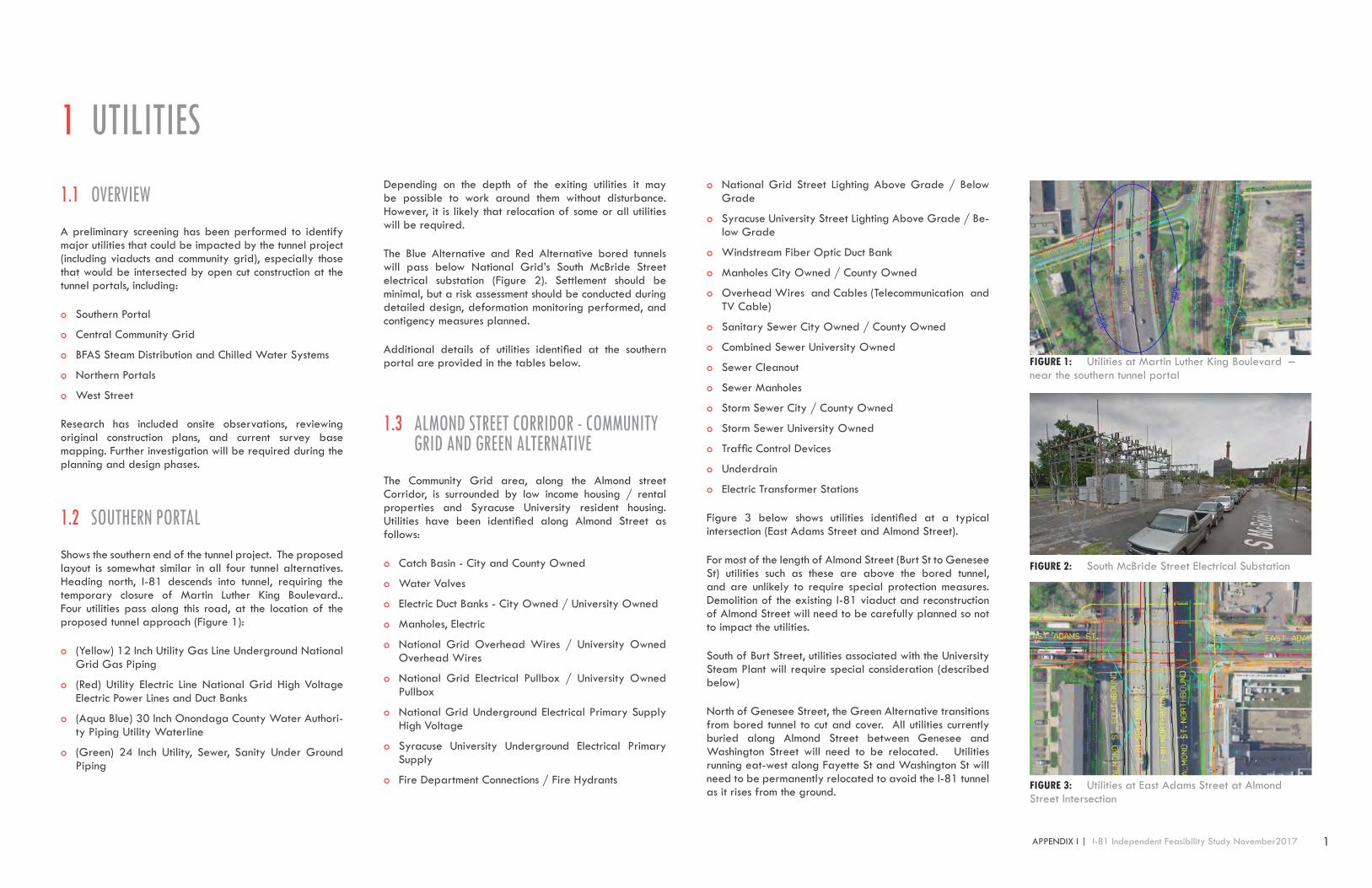
1.2 SOUTHERN PORTALShows the southern end of the tunnel project. The proposed layout is somewhat similar in all four tunnel alternatives. Heading north, I-81 descends into tunnel, requiring the temporary closure of Martin Luther King Boulevard.. Four utilities pass along this road, at the location of the proposed tunnel approach (Figure 1):
o (Yellow) 12 Inch Utility Gas Line Underground National Grid Gas Piping
o (Red) Utility Electric Line National Grid High Voltage Electric Power Lines and Duct Banks
o (Aqua Blue) 30 Inch Onondaga County Water Authori-ty Piping Utility Waterline
o (Green) 24 Inch Utility, Sewer, Sanity Under Ground Piping
Depending on the depth of the exiting utilities it may be possible to work around them without disturbance. However, it is likely that relocation of some or all utilities will be required.
The Blue Alternative and Red Alternative bored tunnels will pass below National Grid’s South McBride Street electrical substation (Figure 2). Settlement should be minimal, but a risk assessment should be conducted during detailed design, deformation monitoring performed, and contigency measures planned.
Additional details of utilities identified at the southern portal are provided in the tables below.
1.3 ALMOND STREET CORRIDOR - COMMUNITY GRID AND GREEN ALTERNATIVE
The Community Grid area, along the Almond street Corridor, is surrounded by low income housing / rental properties and Syracuse University resident housing. Utilities have been identified along Almond Street as follows:
o Catch Basin - City and County Owned
o Water Valves
o Electric Duct Banks - City Owned / University Owned
o Manholes, Electric
o National Grid Overhead Wires / University Owned Overhead Wires
o National Grid Electrical Pullbox / University Owned Pullbox
o National Grid Underground Electrical Primary Supply High Voltage
o Syracuse University Underground Electrical Primary Supply
o Fire Department Connections / Fire Hydrants
o National Grid Street Lighting Above Grade / Below Grade
o Syracuse University Street Lighting Above Grade / Be-low Grade
o Windstream Fiber Optic Duct Bank
o Manholes City Owned / County Owned
o Overhead Wires and Cables (Telecommunication and TV Cable)
o Sanitary Sewer City Owned / County Owned
o Combined Sewer University Owned
o Sewer Cleanout
o Sewer Manholes
o Storm Sewer City / County Owned
o Storm Sewer University Owned
o Traffic Control Devices
o Underdrain
o Electric Transformer Stations
Figure 3 below shows utilities identified at a typical intersection (East Adams Street and Almond Street).
For most of the length of Almond Street (Burt St to Genesee St) utilities such as these are above the bored tunnel, and are unlikely to require special protection measures. Demolition of the existing I-81 viaduct and reconstruction of Almond Street will need to be carefully planned so not to impact the utilities.
South of Burt Street, utilities associated with the University Steam Plant will require special consideration (described below)
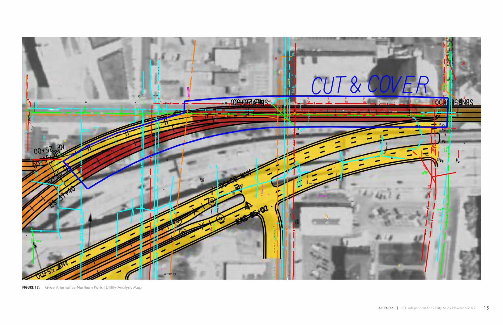
North of Genesee Street, the Green Alternative transitions from bored tunnel to cut and cover. All utilities currently buried along Almond Street between Genesee and Washington Street will need to be relocated. Utilities running eat-west along Fayette St and Washington St will need to be permanently relocated to avoid the I-81 tunnel as it rises from the ground.
FIGURE 1: Utilities at Martin Luther King Boulevard – near the southern tunnel portal
FIGURE 2: South McBride Street Electrical Substation
FIGURE 3: Utilities at East Adams Street at Almond Street Intersection

2 I-81 Independent Feasibility Study November 2017 | APPENDIX I
1.4 BFAS STEAM DISTRIBUTION AND CHILLED WATER SYSTEMS
The BFAS Steam Distribution and Chilled Water Systems Facility operation has a major role in the operation and functionality of Syracuse University’s daily operations. The facility is in operation 365 days a year, 24 hours a day, supplying services to Syracuse University academic buildings, research buildings and residence halls. The facility also supplies 40% of its services to neighboring hospital facilities and SUNY College of Environmental Science & Forestry.
BFAS Facility is located between East Taylor Street to the north, Almond Street to the east, Burt Street to the south and Oakwood Avenue to the west. The main connectivity corridor for the facility utilities to Syracuse University, medical facilities and SUNY ESF cross east-west under Almond Street. Facility utilities are at noted depths between 5 feet to 8 feet below pavement surface along the Almond Street corridor. At the time of the community grid conceptual design phases, the utilities within the BFAS Facility and surrounding premises should be reviewed at a more major scale due to the facilities 24 hour operation schedule.
The BFAS facility is powered by natural gas with two 12” supply lines branching off the National Grid primary main on Burt Street, along with its 12” supply lines from the eastern shoulder of Almond Street reaching a gas-cut station on the corner of East Taylor and Almond Street. See Figure 4 below.
The BFAS Facility supplies four steam condensate lines A, B, C & D, three of which are located leaving the facility East Taylor Street heading in the eastern direction toward University Hill. Lines A and B cross Almond Street and continue toward the University, where line D branches into the southern direction parallel to Almond Street in the southbound direction parallel to the eastern BFAS property line. Line D crosses Burt Street continuing in the southern direction parallel to Almond Street crossing at the Renwick Avenue and Van Buren Street intersection beginning its accent up the University Hill. Condensate line C picks up over in the University property. The BFAS facility has 161 active steam vaults throughout its areas of services. Figure 5 shows a replacement of a steam vault.
The BFAS Facility supplies chilled water service to 28 Syracuse University campus facilities providing services
such as air conditioning. The facility has two 24 inch lines, one supply and one return that cross the Almond Street corridor in the east and west direction. Once the supply and return reach campus facilities, there is a complex below-grade system that feeds the University buildings. Figure 6 shows the BFAS utility locations.
The BFAS facility is located immediately above the Orange Alternative bored tunnel alignment. The 115kV primary electrical feed for the plant runs along Burt, street above the bored tunnels. The feeder would need to be monitored to ensure any settlement is within permissible limits.
As noted in Appendix F, limited plant equipment is located directly above the bored tunnel alignment, but several buried and elevated ducts need to be protect. Settlement from the TBM should be minimal, but various construction activities may be required on the property, such as pulling abandoned piles from the path of the TBM, and jet grouting. Utilities would need to be protected from grout intrusion. The sensitivity of ducts and equipment to settlement would need to be determined, and displacements carefully monitored during construction.
Several steam lines run along E Taylor St, and would be passed beneath by both the Orange Alternative TBMs and the Green Alternative TBM. Settlement should be minimal but would need to be monitored.
The demolition of the existing I-81 viaduct and reconstruction as ramps to feed into the community grid will need to be carefully planned and executed to avoid impacts to steam plant utilities, and others.
FIGURE 4: BFAS 1st Cut Gas House-12” Natural Gas Pipe Line at 600-800psi
FIGURE 5: Steam Vault Replacement at Southeast Corner of South McBride Street and East Taylor Street
FIGURE 6: BFAS Utility Locations
3 APPENDIX I | I-81 Independent Feasibility Study November2017
1.5 RED ALTERNATIVE – NORTH PORTALThe North Portal of the Red Alternative is located within the existing I-81 interstate right of way, north of Butternut Street The TBM will pass beneath major sewer and electrical utilities on Butternut. No disruption to these services are anticipated. No major utilities are anticipated within I-81, as the cut and cover tunnel transitions to grade. Additional details are provided in the tables below.
1.6 ORANGE ALTERNATIVE – NORTH PORTAL AND VIADUCT RECONSTRUCTION
The north portal of the Orange Alternative is adjacent to Erie Boulevard. Reconstruction of the I-690 viaduct will span several city blocks. It is anticipated that numerous utility conflicts will be identified during detailed detail. Additional details of utilities identified in this study are provided in the tables below.
1.7 WEST STREET – BLUE ALTERNATIVEThe Blue Alternative requires extensive cut and cover construction along West Street between West Fayette and West Genesee. Primary gas supply lines and 115V feeder cables have been identified. Additional major utilities running east west are anticipated, which will need to be supported across the open cut structures. Additional details of utilities identified in this study are provided in the tables below.

4 I-81 Independent Feasibility Study November 2017 | APPENDIX I
Location & Utilities Identification Length of Impact Above Grade Length of Impact Below Grade Length of Relocation Above Grade Length of Relovaqtion Below Grade
Southern Portal, MLK. Street, Burt Street, Renwick Avenue
Cable & Communications Fiber Optic & Cable Lines 300 lf X 400 lf X
Utility Sewer Sanitary Onondaga County X 1,198 lf X 3,200 lf
Water OCWA Utility Waterline X 1,253 lf X 3,100 lf
Drainage Culvert Pipe Onondaga County X 300 lf X 600 lf
Power & Electric National Grid 1,391 lf 974 lf 2,300 lf Eliminated during highway reconstruc-tion
Natural Gas National Grid X 200 lf X 400 lf
TABLE 1: Red Alternative Southern Portal Utility AnalysisNOTE: Length of impact represents utilities that will be affected by alignment portal locations. NOTE: Length of relocation represents utilities that will need re-routing & alternate utility connections at alignment portal locations.
1.8 UTILITY IMPACTS BY ALTERNATIVE
1.8.1 RED ALIGNMENT
Utility impact investigation of the southern red alignment indicates that general utilities include fiber optic cable and communications, utility sewer, utility waterlines, drainage culvert piping, power and natural gas servicing residential housing. It is identified at E. Raynor Avenue. A 48” reinforced concrete sewer pipe runs in the eastern & western direction across the alignment connecting the University to residential housing on S. McBride Street The sewer relocation can parallel Renwick Avenue in the southern direction crossing Martin Luther King Street in the western direction re-connecting the two zones tying back into S. McBride Street Sizer Street has an existing sewer and 24” waterline traveling from Renwick Avenue with main connections at Van Buren Street. Depicting the current cut and cover zone, utilities may be incorporated into the new design to utilize existing paths of service if the portal design is adequate. Utilities present at this portal consisting of fiber optic communications are minimal and parallel I-81 in the north and southbound directions on the east and west sides. Power service crosses at Martin Luther King Street, and can remain in place during construction phases if planned during design phases or be relocated to the south. Natural gas services are present, but service lines will not affect the cut and cover zones, gas lines run in the north & south directions on the east and west sides parallel to I-81. At Martin Luther King Street, Existing I-81 highway illumination lights poles with below grade electric servicing conduit will be removed at time of reconstruction. Utility conflict alternatives may also utilize the possibility of being suspended from the eastern support of excavation (SOE) Wall to the western support of excavation (SOE) wall with mid-span support at the median for northbound and southbound lanes depending on the proposed structures at the design stage.

5 APPENDIX I | I-81 Independent Feasibility Study November2017
FIGURE 7: Red Alternative Southern Portal Utility Analysis Map

6 I-81 Independent Feasibility Study November 2017 | APPENDIX I
Location & Utilities Identification Length of Impact Above Grade Length of Impact Below Grade Length of Relocation Above Grade Length of Relovaqtion Below Grade
Northern Portal E.Division, N.Clinton, Catawba Street
Cable & Communications Fiber Optic & Cable Lines 400 lf 368 lf 780 lf 1,600 lf
Utility Sewer Sanitary Onondaga County X 400 lf X 600 lf
Water OCWA Utility Waterline X 300 lf X 500 lf
Drainage Culvert Pipe Onondaga County X 200 lf X 400 lf
Power & Electric National Grid 600 lf 2,308 lf 1,000 lf 5,500 lf
Natural Gas National Grid X 300 lf X 900 lf
TABLE 2: Red Alternative Northern Portal Utility Analysis NOTE: Length of impact represents utilities that will be affected by alignment portal locations. NOTE: Length of relocation represents utilities that will need re-routing & alternate utility connections at alignment portal locations.
Utility impact investigation of the north red alignment indicates that general utilities include fiber optic cable and communications, utility sewer, utility waterlines, power and natural gas servicing a combination of small business, large commercial space. It is identified at adjacent cross streets running between North State Street on the eastern extents of the alignment & North Clinton Street on the western extents of the alignment will have utility conflicts. These streets affected are West Division Street, Ash Street, Catawba/Spencer Street. Utilities at these conflicted cross streets where the proposed mid-cut & cover zone is located can either be re-directed along Catawba/Spencer Street or the southern end of the portal cut and cover zone. Identified on West Division Street & North Clinton Street is an electrical transformer station that has high voltage supply lines above and below grade parallel to the I81 southbound lane to the west. Some of these lines may cross at Division or Ash Street. At Ash Street natural gas and fiber optic lines are present in the eastern and western directions; these utilities if affected can be relocated to the south at the portal limits. Water and sewer are present but seem to parallel I81 in the northbound and southbound directions which will have little impact other than highway drainage structures, or falling within portal cut and cover excavation limits depending on the total width for cut and cover. Existing electrical conduit is present running in the median of I81 which services highway illumination lighting that could be removed during construction phases. Further investigation will show at the time of design the implications, and re-routes may vary depending on their importance. At time of schematic design utility conflict alternatives may also utilize the possibility of being suspended from the eastern support of excavation (SOE) wall to the western support of excavation (SOE) wall with mid-span support at the median for northbound and southbound lanes or if untouched earth remain at the farthest separation points between routes to reconnect utilities that are disturbed and maintain their original set locations.

7 APPENDIX I | I-81 Independent Feasibility Study November2017
FIGURE 8: Red Alternative Northern Portal Utility Analysis Map

8 I-81 Independent Feasibility Study November 2017 | APPENDIX I
TABLE 3: Orange Alternative Southern Portal Utility AnalysisNOTE: Length of impact represents utilities that will be affected by alignment portal locations. NOTE: Length of relocation represents utilities that will need re-routing & alternate utility connections at alignment portal locations.
1.8.2 ORANGE ALIGNMENT
Utility impact investigation of the southern orange alignment indicates that general utilities include fiber optic cable and communications, utility sewer, utility waterlines, drainage culvert piping, power and natural gas servicing residential housing. It is identified at E. Raynor Avenue. A 48” reinforced concrete sewer pipe runs in the eastern & western direction across the alignment connecting the University to residential housing on S. McBride Street. The sewer relocation can parallel Renwick Avenue in the southern direction crossing Martin Luther King Street in the western direction re-connecting the two zones tying back into S. McBride Street. Sizer Street has an existing sewer and 24” waterline traveling from Renwick Avenue. with main connections at Van Buren Street. Depicting the current cut and cover zone, utilities may be incorporated into the new design to utilize existing paths of service if the portal design is adequate. Utilities present at this portal consisting of fiber optic communications are minimal and parallel I-81 in the north and southbound directions on the east and west sides. Power service crosses at Martin Luther King Street, and can remain in place during construction phases if planned during design phases or be relocated to the south. Natural gas services are present, but service lines will not affect the cut and cover zones, gas lines run in the north & south directions on the east and west sides parallel to I-81. At Martin Luther King Street, Existing I-81 highway illumination lights poles with below grade electric servicing conduit will be removed at time of reconstruction. Utility conflict alternatives may also utilize the possibility of being suspended from the eastern support of excavation (SOE) Wall to the western support of excavation (SOE) wall with mid-span support at the median for northbound and southbound lanes depending on the proposed structures at the design stage.
Location & Utilities Identification Length of Impact Above Grade Length of Impact Below Grade Length of Relocation Above Grade Length of Relovaqtion Below Grade
Southern Portal, MLK. Street, Burt Street, Renwick Avenue
Cable & Communications Fiber Optic & Cable Lines 300 lf X 400 lf X
Utility Sewer Sanitary Onondaga County X 1,198 lf X 3,200 lf
Water OCWA Utility Waterline X 1,253 lf X 3,100 lf
Drainage Culvert Pipe Onondaga County X 300 lf X 600 lf
Power & Electric National Grid 1,391 lf 974 lf 2,300 lf Eliminated during highway reconstruction
Natural Gas National Grid X 200 lf X 400 lf

9 APPENDIX I | I-81 Independent Feasibility Study November2017
FIGURE 9: Orange Alternative Southern Portal Utility Analysis Map

10 I-81 Independent Feasibility Study November 2017 | APPENDIX I
Utility impact investigation of the northern orange alignment indicates that general utilities include fiber optic cable and communications, utility sewer, utility waterlines, drainage culvert piping, power and natural gas servicing small business, large business & residential housing. It is identified at E. Raynor Avevenue. A 72” 450 lf reinforced concrete sewer pipe runs in the western and southern direction across the alignment connecting East Willow Street & James Street. The sewer relocation can be re-routed on North State Street connecting the two zones avoiding the portal alignment limits. Major utilities are present along the James Street Corridor that runs through the cut and cover zone. These utilities can be re-routed to the north of the portal cut and cover extents if necessary. Depicting the current cut and cover zone, utilities may be incorporated into the new design to utilize existing paths of service if the portal cut and cover design presents an adequate alternative. Utilities present at the southern cut and cover zone consist of fiber optic communications, power & electric, natural gas and city water. These services can be re-routed to the southernmost location of the cut and cover zone if no other alternatives are feasible. At the southernmost point of the cut and cover zone a gas station falls within the zone limits and will need to be removed. Utility conflict alternatives may also utilize the possibility of being suspended from the eastern support of excavation (SOE) Wall to the western support of excavation (SOE) wall with mid-span support at the median for northbound and southbound lanes depending on the proposed structures at the design stage.
TABLE 4: Orange Alternative Northern Portal Utility AnalysisNOTE: Length of impact represents utilities that will be affected by alignment portal locations. NOTE: Length of relocation represents utilities that will need re-routing & alternate utility connections at alignment portal locations.
Location & Utilities Identification Length of Impact Above Grade Length of Impact Below Grade Length of Relocation Above Grade Length of Relovaqtion Below Grade
Northern Portal E. Washington, E.Genesee Street
Cable & Communications Fiber Optic & Cable Lines 200 lf 789 lf 300 lf 3,880 lf
Utility Sewer Sanitary Onondaga County X 1,100 lf X 4,004 lf
Water OCWA Utility Waterline X 400 lf X 2,154 lf
Drainage Culvert Pipe Onondaga County X 1,536 lf X 2,135 lf
Power & Electric National Grid 250 lf 890 lf 300 lf 4,186 lf
Natural Gas National Grid X 1,266 lf X 3,956 lf

11 APPENDIX I | I-81 Independent Feasibility Study November2017
FIGURE 10: Orange Alternative Northern Portal Utility Analysis Map

12 I-81 Independent Feasibility Study November 2017 | APPENDIX I
Location & Utilities Identification Length of Impact Above Grade Length of Impact Below Grade Length of Relocation Above Grade Length of Relovaqtion Below Grade
Southern Portal, MLK. Street, Burt Street, Renwick Avenue
Cable & Communications Fiber Optic & Cable Lines 300 lf X 400 lf X
Utility Sewer Sanitary Onondaga County X 1,198 lf X 3,200 lf
Water OCWA Utility Waterline X 1,253 lf X 3,100 lf
Drainage Culvert Pipe Onondaga County X 300 lf X 600 lf
Power & Electric National Grid 1,391 lf 974 lf 2,300 lf Eliminated during highway reconstruction
Natural Gas National Grid X 200 lf X 400 lf
1.8.3 GREEN ALIGNMENT
Utility impact investigation of the southern green alignment indicates that general utilities include fiber optic cable and communications, utility sewer, utility waterlines, drainage culvert piping, power and natural gas servicing residential housing. It is identified at E. Raynor Avenue. A 48” reinforced concrete sewer pipe runs in the eastern & western direction across the alignment connecting the University to residential housing on S. McBride Street. The sewer relocation can parallel Renwick Avenue in the southern direction crossing Martin Luther King Street in the western direction re-connecting the two zones tying back into S. McBride Street. Sizer Street. has an existing sewer and 24” waterline traveling from Renwick Ave. with main connections at Van Buren Street. Depicting the current cut and cover zone, utilities may be incorporated into the new design to utilize existing paths of service if the portal design is adequate. Utilities present at this portal consisting of fiber optic communications are minimal and parallel I-81 in the north and southbound directions on the east and west sides. Power service crosses at Martin Luther King Street, and can remain in place during construction phases if planned during design phases or be relocated to the south. Natural gas services are present, but service lines will not affect the cut and cover zones, gas lines run in the north & south directions on the east and west sides parallel to I-81. At Martin Luther King Street, Existing I-81 highway illumination lights poles with below grade electric servicing conduit will be removed at time of reconstruction. Utility conflict alternatives may also utilize the possibility of being suspended from the eastern support of excavation (SOE) Wall to the western support of excavation (SOE) wall with mid-span support at the median for northbound and southbound lanes depending on the proposed structures at the design stage.
TABLE 5: Green Alternative Southern Portal Utility AnalysisNOTE: Length of impact represents utilities that will be affected by alignment portal locations. NOTE: Length of relocation represents utilities that will need re-routing & alternate utility connections at alignment portal locations.

13 APPENDIX I | I-81 Independent Feasibility Study November2017
FIGURE 11: Green Alternative Southern Portal Utility Analysis Map

14 I-81 Independent Feasibility Study November 2017 | APPENDIX I
Location & Utilities Identification Length of Impact Above Grade Length of Impact Below Grade Length of Relocation Above Grade Length of Relovaqtion Below Grade
Northern Portal E. Washington, E.Genesee Street
Cable & Communications Fiber Optic & Cable Lines 200 lf 968 lf 450 lf 2,072 lf
Utility Sewer Sanitary Onondaga County X 635 lf X 1,435 lf
Water OCWA Utility Waterline X 1,773 lf X 2,785 lf
Drainage Culvert Pipe Onondaga County X 380 lf X 1,760 lf
Power & Electric National Grid 150 lf 1,050 lf 350 lf 2,272 lf
Natural Gas National Grid X 300 lf X 600 lf
Utility impact investigation of the northern green alignment indicates that general utilities include fiber optic cable and communications, utility sewer, utility waterlines, drainage culvert piping, power and natural gas. It is identified at adjacent cross streets running between South McBride Street on the western extents of the alignment & Almond Street on the eastern extents these utilities are present. Utilities service small commercial businesses & large commercial businesses along East Fayette Street, East Washington Street & East Genesee Street. Depicting the current cut and cover zone, utilities may be incorporated into the new design to utilize existing paths of service if the portal design presents adequate span support during construction phases. It should be noted that utilities running in the north and southern directions along the centerline of the alignment include 12 “ water line, 15” sewer line & fiber optic line. These utilities can be relocated to the eastern side of the new portal opening. A smaller portal cut and cover transition allows for various alternatives at the time of planning and design phases. Utilities in conflict can have two alternative routes to be relocated, one being the northern portal opening on East Water Street, the other being in the East Genesee corridor depending on final portal locations. Utility conflict alternatives may also utilize the possibility of being suspended from the eastern support of excavation (SOE) Wall to the western support of excavation (SOE) wall with mid-span support at the median for northbound and southbound lanes depending on the proposed structures at the design stage. TABLE 6: Green Alternative Northern Portal Utility Analysis
NOTE: Length of impact represents utilities that will be affected by alignment portal locations. NOTE: Length of relocation represents utilities that will need re-routing & alternate utility connections at alignment portal locations.
15 APPENDIX I | I-81 Independent Feasibility Study November2017
FIGURE 12: Gree Alternative Northern Portal Utility Analysis Map

16 I-81 Independent Feasibility Study November 2017 | APPENDIX I
Location & Utilities Identification Length of Impact Above Grade Length of Impact Below Grade Length of Relocation Above Grade Length of Relovaqtion Below Grade
Southern Portal, MLK. Street, Burt Street, Renwick Avenue
Cable & Communications Fiber Optic & Cable Lines 300 lf X 400 lf X
Utility Sewer Sanitary Onondaga County X 1,198 lf X 3,200 lf
Water OCWA Utility Waterline X 1,253 lf X 3,100 lf
Drainage Culvert Pipe Onondaga County X 300 lf X 600 lf
Power & Electric National Grid 1,391 lf 974 lf 2,300 lf Eliminated during highway recon-struction
Natural Gas National Grid X 200 lf X 400 lf
TABLE 7: Blue Alternative Southern Portal Utility Analysis NOTE: Length of impact represents utilities that will be affected by alignment portal locations. NOTE: Length of relocation represents utilities that will need re-routing & alternate utility connections at alignment portal locations.
1.8.4 BLUE ALIGNMENT
Utility impact investigation of the southern blue alignment indicates that general utilities include fiber optic cable and communications, utility sewer, utility waterlines, drainage culvert piping, power and electric, natural gas servicing residential housing. It is identified at E. Raynor Avenue. A 48” reinforced concrete sewer pipe runs in the eastern & western direction across the alignment connecting the University to residential housing on S. McBride Street. The sewer relocation can parallel Renwick Avenue in the southern direction crossing Martin Luther King Street in the western direction re-connecting the two zones tying back into S. McBride Street. Sizer Street has an existing sewer and 24” wat¬erline traveling from Renwick Avenue with main connections at Van Buren Street. Depicting the current cut and cover zone, utilities may be incorporated into the new design to utilize existing paths of service if the portal design is adequate. Utilities present at this portal consisting of fiber optic communications are minimal and parallel I-81 in the north and southbound directions on the east and west sides. Power service crosses at Martin Luther King Street, and can remain in place during construction phases if planned during design phases or be relocated to the south. Natural gas services are present, but service lines will not affect the cut and cover zones, gas lines run in the north & south directions on the east and west sides parallel to I-81. At Martin Luther King Street, Existing I-81 highway illumination lights poles with below grade electric servicing conduit will be removed at time of reconstruction. Utility conflict alternatives may also utilize the possibility of being suspended from the eastern support of excavation (SOE) Wall to the western support of excavation (SOE) wall with mid-span support at the median for northbound and southbound lanes depending on the proposed structures at the design stage.

17 APPENDIX I | I-81 Independent Feasibility Study November2017
FIGURE 13: Blue Alternative Southern Portal Utility Analysis Map

18 I-81 Independent Feasibility Study November 2017 | APPENDIX I
Location & Utilities Identification Length of Impact Above Grade Length of Impact Below Grade Length of Relocation Above Grade Length of Relovaqtion Below Grade
Mid Cut & Cover, W.Fayette Street, W.Genesee Street, Plum Street.
Cable & Communications Fiber Optic & Cable Lines 150 lf 1400 lf 300 lf 5,546 lf
Utility Sewer Sanitary Onondaga County X 2,890 lf X 3,307 lf
Water OCWA Utility Waterline X 2,583 lf X 6,173 lf
Drainage Culvert Pipe Onondaga County X 2,600 lf X 3,200 lf
Power & Electric National Grid 300 lf 4.050 lf 500 lf 8,500 lf
Natural Gas National Grid X 2,039 lf X 7,900 lf
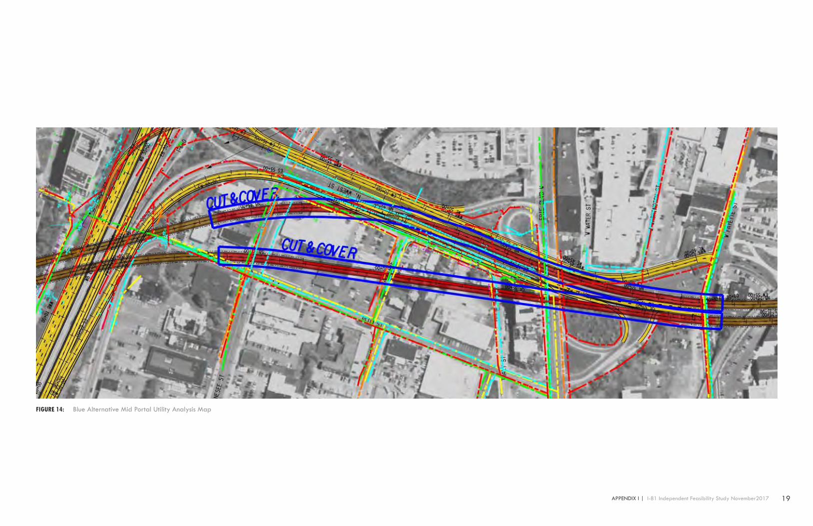
Utility impact investigation of the mid cut & cover blue alignment indicates that general utilities include fiber optic cable and communications, utility sewer, utility waterlines, power and natural gas servicing a combination of small business, large commercial space, rental residential housing. It is identified at adjacent cross streets running between North West Street on the eastern extents of the alignment & Plum Street on the western extents of the alignment will have utility conflicts. These streets include West Genesee Street, Park Avenue, Tracy Street, Erie Boulevard & West Fayette Street. Utilities at these conflicted cross streets where the proposed mid-cut & cover zone is located can either be re-directed along Northwest Street, or Plum Street. The estimated length between the proposed northbound route and southbound route can vary from an estimated width of 45 ft to a maximum width of 220 ft. At time of schematic design utility conflict alternatives may also utilize the possibility of being suspended from the eastern support of excavation (SOE) wall to the western support of excavation (SOE) wall with mid-span support at the median for northbound and southbound lanes or if untouched earth remain at the farthest separation points between routes to reconnect utilities that are disturbed and maintain their original set locations. This route re-establishing existing connections would take place between Park Avenue & West Genesee Street. If utility relocation alternatives are to re-route at the northern and southern portal points, Belden Avenue at the northern cut and cover terminus can be utilized & West Fayette Street at the most southern cut and cover terminus can be utilized for relocation routes. TABLE 8: Blue Alternative Mid Portal Utility Analysis
NOTE: Length of impact represents utilities that will be affected by alignment portal locations. NOTE: Length of relocation represents utilities that will need re-routing & alternate utility connections at alignment portal locations.
19 APPENDIX I | I-81 Independent Feasibility Study November2017
FIGURE 14: Blue Alternative Mid Portal Utility Analysis Map

20 I-81 Independent Feasibility Study November 2017 | APPENDIX I
Location & Utilities Identification Length of Impact Above Grade Length of Impact Below Grade Length of Relocation Above Grade Length of Relovaqtion Below Grade
Northern Portal, W. Court Street, Solar Street
Cable & Communications Fiber Optic & Cable Lines X X X X
Utility Sewer Sanitary Onondaga County X 551 lf X 1,775 lf
Water OCWA Utility Waterline X 506 lf X 1,851 lf
Power & Electric National Grid X 897 lf X 2,370 lf
Natural Gas National Grid X 270 lf X 1,055 lf
Utility impact investigation of the northern blue alignment indicates that general utilities includes utility sewer, utility waterlines, power and natural gas servicing a nearby commercial business, these utilities are below surface grade and service surrounding streets, these utilities are part of the utility grid infrastructure system. It is identified at West Court Street & Solar Street that the utilities are present and can be relocated within reason at the cut and cover perimeters southern end. Utility conflict alternatives may also utilize the possibility of being suspended from the eastern support of excavation (SOE) wall to the western support of excavation (SOE) wall with mid-span support at the median for northbound and southbound lanes depending on the proposed structures at the design stage. Due to the limited utilities present the designer will need to decide if its cost effective to plan excavation while maintaining these utilities with little disturbance.
TABLE 9: Blue Alternative Northern Portal Utility Analysis NOTE: Length of impact represents utilities that will be affected by alignment portal locations. NOTE: Length of relocation represents utilities that will need re-routing & alternate utility connections at alignment portal locations.

21 APPENDIX I | I-81 Independent Feasibility Study November2017
FIGURE 15: Blue Alternative Northern Portal Utility Analysis Map

22 I-81 Independent Feasibility Study November 2017 | APPENDIX I
1.9 UTILITY IMPACT SUMMARYUtility investigation and identification will be important to the design phases of this project. Maintaining active utility services without community disruption will be a crucial component. Cut and cover structures will have particular impact on utilities, requiring re-routing and alternative utility connections. Maintaining the major utilities around the University Steam Plant will be a significant requirement.