Appendix 1.1 (Reference to paragraph -1.1) Department-wise ...
Upload
hoangxuyenCategory
view
233download
7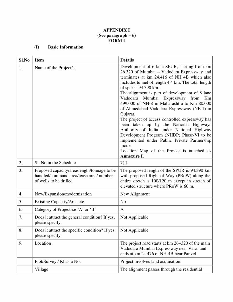
APPENDIX I
(See paragraph – 6)
FORM I (I) Basic Information
Sl.No Item Details
1. Name of the Project/s Development of 6 lane SPUR, starting from km
26.320 of Mumbai – Vadodara Expressway and
terminates at km 24.416 of NH 4B which also
includes tunnel of length 4.4 km. The total length
of spur is 94.390 km.
The alignment is part of development of 8 lane
Vadodara Mumbai Expressway from Km
499.000 of NH-8 in Maharashtra to Km 80.000
of Ahmedabad-Vadodara Expressway (NE-1) in
Gujarat.
The project of access controlled expressway has
been taken up by the National Highways
Authority of India under National Highway
Development Program (NHDP) Phase-VI to be
implemented under Public Private Partnership
mode.
Location Map of the Project is attached as
Annexure I.
2. Sl. No in the Schedule 7(f)
3. Proposed capacity/area/length/tonnage to be
handled/command area/lease area/ number
of wells to be drilled
The proposed length of the SPUR is 94.390 km
with proposed Right of Way (PRoW) along the
entire stretch is 100/120 m except in stretch of
elevated structure where PRoW is 60 m.
4. New/Expansion/modernization New Alignment
5. Existing Capacity/Area etc No
6. Category of Project i.e ‘A’ or ‘B’ A
7. Does it attract the general condition? If yes,
please specify.
Not Applicable
8. Does it attract the specific condition? If yes,
please specify.
Not Applicable
9. Location The project road starts at km 26+320 of the main
Vadodara Mumbai Expressway near Vasai and
ends at km 24.476 of NH-4B near Panvel.
Plot/Survey / Khasra No. Project involves land acquisition.
Village The alignment passes through the residential

clusters and towns of Virar, Shirsad, Bhinar,
Ganeshpuri, Akloli, Vajreswari, Zidke, Awala,
Mahapoli, Angaon, Taloli (NH 3 Crossing),
Savad (Pise), Ambivli, Bapsai (NH222
Crossing), Vasat (Jambhul), Badlapur, Juweli,
Tamsai, Koproli, Vichumbe before ending at
Panvel. There are 61 revenue villages and towns
of Palghar & Thane district and 20 revenue
villages of Raigad district (List enclosed as
Annexure II)
Tehsil Palghar District: Vasai and Vada
Thane District: Bhiwandi, Kalyan and
Ambernath
Raigad District: Panvel
District Palghar, Thane and Raigad Districts in the state
of Maharashtra
State Maharashtra.
10. Nearest railway station /airport along with
distance in kms.
The nearest railway stations(within 15 Km from
proposed alignment) are :
Vasai Railway Station
Nallasopara Station
Virar Railway Station
Panvel Railway Station
Chikale Railway Station
Khandeshwar Railway station
Mansarovar Railway station
Kalamboli Railway Station
Khargarh Railway Station
The nearest Airport is:
Chatrapati Shivaji International Airport approx.
30 km from project road.
11. Nearest Town, City, District Headquarters
along with distance in kms.
The project road is passing through districts of
Palghar, Thane and Raigad.
12. Village Panchayaths, Zilla parishad,
Municipal Corporation, Local Body
The project road is passing through above
referred towns and cities.
13. Name of the Applicant NHAI
14. Registered Address National Highways Authority of India
(Ministry of Road Transport &Highways) 15. Address for Correspondence:

G-5 & 6, Sector-10 Dwarka, New Delhi -
110075
Name Shri V.K.Sharma
Designation (Owner/Partner/CEO) Chief General Manager (LA & Env.)
Address National Highways Authority of India
(Ministry of Road Transport &Highways)
G-5 & 6, Sector-10 Dwarka, New Delhi -
Pin Code 110 075.
Email [email protected]
Telephone No 011-25074100 & 25074200
Fax No. 91-011-25093543
16. Details of Alternative Sites examined, if any
location of these sites should be shown on a
topo sheet.
The proposed alignment has been finalized after
considering all available alternate options. The
alternative alignment on google map is enclosed
as Annexure III.
17. Interlinked Projects Yes.
18. Weather separate application for interlinked
projects submitted?
No
19. If yes, date of submission No
20. If no, reason The project involves procurement of soil/earth
from the borrow areas.
As per office memorandum Dated 18th
Dec.
2012, issued by MoEF, following framework to
be followed:
i. Separate environment clearance for mining
of soil/earth from borrow areas, which are a
part of highway project are not required and
ii. The construction/widening of highways
along with the mining of soil/earth from
borrow areas to be considered as a single
project of appraisal under EIA Notification
2006. The NHAI/other agencies
implementing the highway projects while
submitting the proposal for Terms of
Reference will submit the additional details
as mentioned in above referred
memorandum.
21. Weather the proposal involves
approval/clearance under –If yes, details of
Yes, the proposal involves following clearances
which are under process

the same and their status to be given.
(a) The Forest (Conservation) Act - 1980
(b)The Wildlife (Protection) Act – 1972
(c) CRZ Notification – 1991
(a) Forest Clearance for diversion of forest land
under The Forest (Conservation) Act – 1980
(b) Obtaining Prior Clearance from the Standing
Committee of the National Board for Wild-life
as the project is located within 10 km of
Protected Areas (PAs)
22. Weather there is any Government Order/
Policy relevant/relating to the site
N/A
23. Forest Land involved (hectares) Approx. 99.713 Hectares of forest land is
involved.
24. Wheather there is any litigation pending
against the project and /or land in which the
project is propose to be set up?
(a) Name of the Court
(b) Case No.
(c) Orders /directions of the Court, if
any and its relevance with the
proposed project.
No
I hereby given undertaking that the data and information given in the application and
enclosures are true to the best of my knowledge and belief and I am aware that if any part
of the data and information submitted is found to be false or misleading at any stage, the
project will be rejected and clearance give, if any to the project will be revoked at our risk
and cost.
Signature of the Applicant with
Name and full Address
V.K.SHARMA
Chief General Manager (LA & Env.)
National Highways Authority of India,
Ministry of Road Transport & Highways
G – 5 & 6, Sector 10, Dwaraka
New Delhi 110075
Date:
Place:

(II) Activity 1. Construction, operation or decommissioning of the project involving actions, which will
cause physical changes in the locality (topography, land use, changes in water bodies, etc.)
S.No. Information/ Checklist
confirmation
Yes/No Details thereof (with approximate quantities/
rates, wherever possible) with source of
information
1.1 Permanent or temporary
change in land use, land cover
or topography including
increase in intensity of land
use (with respect to local land
use plan)
Yes CHANGE IN LAND USE
Yes, there will be both temporary and permanent
change in the land use of the area.
The temporary change in land use will be due to
setting up of Labour Camps, Hot mix plant, Crusher,
WMM Plant, etc.
Permanent Change of land use will be in the area
falling in Proposed Right of way for the construction
of 6 lane Highway and other ancillary services like
Toll Plaza, wayside amenities etc.
CHANGE IN TOPOGRAPHY
The road shall be constructed on an embankment
with average height of 4.5m and it involves tunneling
through Matheran Hill for 4.39 km from km 71+675
to km 76+121 which will change the topography in
this region.
1.2 Clearance of existing land,
vegetation and buildings?
Yes The land, vegetation and buildings falling in
proposed right of way will be cleared after
acquisition of land.
Approximately 197 structures and 13534 trees falling
within Proposed RoW will be affected due to
proposed development.
1.3 Creation of new land uses? Yes The proposed development involves construction of 6
lane Expressway along with bridges, culverts,
interchanges, flyover, ROBs and cattle/vehicular
underpasses.
The new land use will also be created where Toll
plaza, truck laybye and way side amenities have been
proposed.
1.4 Pre- construction
investigations e.g. bore house,
soil testing?
Yes Pre – Construction investigation like Bore-House,
Soil testing and testing of construction materials have
been done and results included in Feasibility Report.
1.5 Construction works? Yes The construction work includes the following
TYPE OF FEATURES SPUR
Length 94.390
Interchanges 6
Pavment type Rigid Pavement
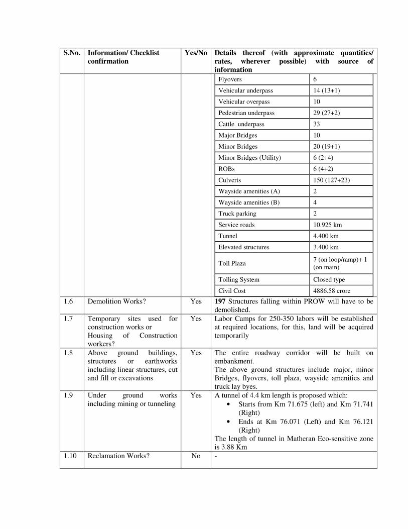
S.No. Information/ Checklist
confirmation
Yes/No Details thereof (with approximate quantities/
rates, wherever possible) with source of
information
Flyovers 6
Vehicular underpass 14 (13+1)
Vehicular overpass 10
Pedestrian underpass 29 (27+2)
Cattle underpass 33
Major Bridges 10
Minor Bridges 20 (19+1)
Minor Bridges (Utility) 6 (2+4)
ROBs 6 (4+2)
Culverts 150 (127+23)
Wayside amenities (A) 2
Wayside amenities (B) 4
Truck parking 2
Service roads 10.925 km
Tunnel 4.400 km
Elevated structures 3.400 km
Toll Plaza 7 (on loop/ramp)+ 1
(on main)
Tolling System Closed type
Civil Cost 4886.58 crore
1.6 Demolition Works? Yes 197 Structures falling within PROW will have to be
demolished.
1.7 Temporary sites used for
construction works or
Housing of Construction
workers?
Yes Labor Camps for 250-350 labors will be established
at required locations, for this, land will be acquired
temporarily
1.8 Above ground buildings,
structures or earthworks
including linear structures, cut
and fill or excavations
Yes The entire roadway corridor will be built on
embankment. The above ground structures include major, minor
Bridges, flyovers, toll plaza, wayside amenities and
truck lay byes.
1.9 Under ground works
including mining or tunneling
Yes A tunnel of 4.4 km length is proposed which:
• Starts from Km 71.675 (left) and Km 71.741
(Right)
• Ends at Km 76.071 (Left) and Km 76.121
(Right)
The length of tunnel in Matheran Eco-sensitive zone
is 3.88 Km
1.10 Reclamation Works?
No -

S.No. Information/ Checklist
confirmation
Yes/No Details thereof (with approximate quantities/
rates, wherever possible) with source of
information
1.11 Dredging
No -
1.12 Offshore structures
No -
1.13 Production and manufacturing
processes?
No Not Applicable
1.14 Facilities for Storages of
goods or materials?
Yes Construction material like aggregates, sand, cement,
fuel and bitumen will be temporary stored in covered
sheds in construction camp.
1.15 Facilities for treatment or
disposal of solid waste or
liquid effluents?
Yes Construction Stage
Liquid effluent Approx. 11.61 KL/Day of liquid effluent will be
generated from Labor camps (Approx 250-300
labours) and Construction camps, the waste generated
will be treated in Septic Tank / Sedimentation Tank
before diverting it to soak pit. Mobile toilets will also
be provided.
Solid Waste Approx. 75 kg/day of solid waste will be generated
from labor and Construction camps which will be
segregated and collected at source and later will be
disposed off through govt. authorized vendors.
1.16 Facilities for long term
housing of operational
workers?
No -
1.17 New road, rail or sea traffic
during construction or
operation?
Yes New road traffic during construction and after
completion of the expressway.
1.18 New road, rail, air waterborne
or other transport
infrastructure including new
or altered routes and stations,
ports, airports etc?
Yes Diversion/alternative approach road during
construction stage.
New service roads, during operation, leading to
vehicular underpasses and service roads in built-up
areas.
1.19 Closure or diversion of
existing transport routes or
infrastructure leading to
changes in traffic
movements?
Yes Diversion along existing national and state highways,
major district roads (MDR), other district roads
(ODR) and village roads (VR), wherever the
proposed alignment crosses, during construction
period will be undertaken as per IRC guidelines on
safety in construction zone.
1.20 New or diverted transmission
lines or pipelines?
Yes Electric Poles, High Transmission (HT) lines, gas
pipelines, water supply pipelines and other utility
lines pass through the PROW.
1.21 Impoundment, damming,
culverting, realignment or
Yes It is proposed to provide 150 culverts in the project
corridor in order to maintain natural hydrology in the

S.No. Information/ Checklist
confirmation
Yes/No Details thereof (with approximate quantities/
rates, wherever possible) with source of
information
other changes to the
hydrology of watercourses or
aquifers?
project area.
1.22 Stream crossings? Yes The proposed alignment of SPUR is crossing many
Streams. The major streams are:
Tansa, Ulhas, Vatsa, Kalu and Barvi
1.23 Abstraction or transfers of
water form ground or surface
waters?
Yes Water will be abstracted from surface and ground
source both for construction activities.
1.24 Changes in water bodies or
the land surface affecting
drainage or run-off?
No 10 major, 20 minor, 6 utility bridges and 150 culverts
have been proposed in the project corridor to
maintain natural flow of the rivers/streams/canals etc
1.25 Transport of personnel or
materials for construction,
operation or
decommissioning?
Yes The construction materials will be transported during
construction from different sources identified along
the project road.
Construction labors will be stationed at temporary
hutments/ labor camps.
1.26 Long-Term dismantling or
decommissioning or
restoration works?
No -
1.27 Ongoing activity during
decommissioning which could
have an impact on the
environment?
Yes Dismantling of labour camps after completion of
construction activities.
1.28 Influx of people to an area in
either temporarily or
permanently?
Yes Yes, there will be temporary influx of people to the
project area as labors and other people who will be
involved directly or indirectly in the construction of
Expressway. However preference will be given to
local people in the employment.
1.29 Introduction of alien species? No
1.30 Loss of native species or
genetic diversity?
No
1.31 Any other actions? No
2. Use of Natural resources for Construction or operation of the Project (such as land,
water, materials or energy, especially any resources which are non-renewable or in short
supply) :
S.No Information /Checklist
confirmation
Yes/No Details thereof (with approximate quantities / rates
wherever possible) with source of information data
2.1 Land especially
undeveloped or
agricultural land (ha)
Yes 1241.551 Ha of land will be acquired to build the
Expressway and associated facilities. This land includes
agricultural land (1031.36 Ha), Non agricultural Land
(55.977 Ha) and Forest land (99.713 Ha).

S.No Information /Checklist
confirmation
Yes/No Details thereof (with approximate quantities / rates
wherever possible) with source of information data
2.2 Water (expected source
& competing users)
unit: KLD
Yes Approx. 5,640,000 KL of water is required which will be
sourced from Rivers present in the area.
2.3 Minerals (MT) No -
2.4 Construction material-
stone, aggregates, and
/soil (expected source-
MT)
Yes
S.No Material Unit Quantity
1 Cement MT 1,230,000.00
2 Aggregate MT 4,960,000.00
3 Sand MT 2,940,000.00
4 Water KL 5,640,000.00
5 Bitumen MT 1,500.00
6 Diesel KL 30,000.00
7 Earthwork in cut Cum 7,580,000.00
8 Earthwork in fill Cum 26,800,000.00
9 Tunnel excavates
(50% rock & 50 % earth) Cum 13,67,190.00
2.5 Forests and Timber
(source- MT)
No
2.6 Energy including
electricity and fuels
(source, competing
users)
Unit: fuel (MT), energy
(MW)
Yes Approx. 30000 KL of diesel will be used in DG sets
2.7 Any other natural
resources
(Use appropriate
standard units)
No
3. Use, storage, transport, handling or production of substances or materials, which could
be harmful to human health or the environment or raise concerns about actual or perceived
risks to human health.
S.No Information /Checklist
confirmation
Yes/No Details thereof (with approximate quantities
/ rates. Wherever possible) with source of
information data
3.1 Use of substances or materials,
which are hazardous (as per
MSIHC rules) to human health or
the environment (flora, fauna, and
water supplies)
Yes Diesel- 30000 KL
Bitumen- 1500 MT
3.2 Changes in occurrence of disease or No

affect disease vectors (e.g. insect or
water borne diseases)
3.3 Affect the welfare of people e.g. by
changing living conditions?
No
The proposed project will not affect the
welfare of people. However, it will provide
connectivity to Jawahar Lal Nehru Port
Terminal (JNPT) which will reduce travel time
and traffic on other roads and will improve the
environmental quality in the area.
3.4 Vulnerable groups of people who
could be affected by the project e.g.
hospital patients, children, the
elderly etc.
Yes There will be positive impact on Vulnerable
Groups of people due to improved connectivity
as travelling to educational institutions and
health care facilities will be faster and easier.
3.5 Any other cause No
4. Production of solid wastes during construction or operation or decommissioning (MT/
month)
S.No Information /Checklist
confirmation
Yes/No Details thereof (with approximate quantities
/ rates. Wherever possible) with source of
information data
4.1 Spoil, overburden or mine wastes
Yes Overburden due to replacement of top soil.
4.2 Municipal waste (domestic and or
commercial wastes)
Yes Construction Phase Domestic waste will be generated from labour
camps which will be disposed off as per MSW
Rules 2000.
Operation Phase
Small quantity of domestic / commercial waste
will be generated during operation phase from
Toll Plazas, which will be handled as per
prevailing rules.
4.3 Hazardous waste (as per Hazardous
Waste Management Rules)
No N.A
4.4 Other industrial process wastes
No N.A
4.5 Surplus product
No N.A
4.6 Sewage sludge or other sludge from
effluent treatment
No N.A
4.7 Construction or demolition wastes
Yes Significant amount of demolition waste will be
generated due to dismantling of structures. The
construction waste generated will be reused in
the road construction activities.
4.8 Redundant machinery or equipment
No N.A
4.9 Contaminated soils or other
materials
No N.A
4.10 Agricultural wastes No N.A
S.No Information /Checklist
confirmation
Yes/No Details thereof (with approximate quantities
/ rates. Wherever possible) with source of
information data
4.11 Other solid wastes
Yes Top Soil, which will be stripped, stored and
reused in median filling and slopes of
embankment where grass turfing is proposed.
5. Release of pollutants or any hazardous, toxic or noxious substances to air (Kg/hr)
S. No Information /Checklist
confirmation
Yes/No Details thereof (with approximate quantities
/ rates. Wherever possible) with source of
information data
5.1 Emissions from combustion of
fossil fuels from stationery or
mobile sources.
Yes During Construction, emissions will be
generated from the Vehicles transporting
Construction Materials, Machineries involved
during construction and Diesel Generating Sets
which will be used as power back up.
During Operation, the emissions will be from
the mobile sources as vehicles running on
Road and from DG sets to be used as power
back up.
5.2 Emissions from production
processes
No N.A
5.3 Emissions from materials handling
including storage or transport
Yes There may be accidental spillage during
handling of material. Standard Practices as per
Hazardous waste (Management and Handling)
Rules will be adopted.
5.4 Emissions from construction
activities including plant and
equipment
Yes During Construction period the emissions will
be from Plant, Machineries, Hot Mix plant,
Crusher plant, WMM plant, Movement of
Vehicles etc
5.5 Dust or odours from handling or
materials including construction
materials, sewage and waste
Yes There will be dust generation during
construction, loading & unloading of
Construction Materials and from the Crusher
plant.
5.6 Emissions form incineration of
waste
No N.A
5.7 Emission from burning of waste in
open air (e.g. slash materials,
construction debris)
No N.A
5.8 Emissions from any other sources No N.A
6. Generation of Noise and Vibration, and Emissions of Light and Heat :
S.No Information /Checklist
confirmation
Yes/No Details thereof (with approximate quantities
/ rates. Wherever possible) with source of
information data
6.1 From operation of equipment e.g. Yes During Construction Period noise will be

engines, ventilation plant, crushes generated from equipments, machinery and,
crushers plants.
6.2 From industrial or similar processes No N.A
6.3 From construction or demolition No There will be noise and air emissions from
construction machinery during construction,
phase.
6.4 From blasting or piling Yes Controlled blasting will be practiced for cutting
hills during tunneling etc.
6.5 From construction or operational
traffic
Yes During Construction and Operation Phase
6.6 From lighting or cooling systems No N.A
6.7 From any other sources No N.A
7. Risks of contamination of land or water from releases of pollutants into the ground or
into sewers, surface waters, ground water, coastal waters or the sea:
S.No Information /Checklist confirmation Yes/No Details thereof (with approximate
quantities / rates. Wherever possible)
with source of information data
7.1 From handling, storage, use or spillage
of hazardous materials.
Yes
There may be accidental spillage.
Required Precaution will be taken in
Storage, Handling of Hazardous Materials
and accidental spillage of hazardous
materials.
7.2 From discharge of sewage or other
effluents to water or the land (expected
mode and place of discharge)
No The sewage from Workers Camp will be
discharged in septic tanks and shall
conform to norms.
During operations Sewage from Way Side
Amenities will be treated in Packaged
Treatment Plant or as per established
norms
7.3 By deposition of pollutants emitted to air
into the land or into water
Yes There will dust from back filters installed
in hot mix plant during construction
phase. This may deposit on land and
surface water.
7.4 From any other sources
No -
7.5 Is there a risk of long term build up of
pollutants in the environment from these
sources?
No
-
8. Risk of accidents during construction or operation of the Project, which could affect
human health or the environment.
S.No Information /Checklist confirmation Yes/No Details thereof (with approximate
quantities / rates. Wherever possible)
with source of information data
8.1 From explosions, spillages, fires etc from Yes, There may be accidental spillage.
storage, handling, use or production of
hazardous substances.
Required Precaution will be taken in
Storage, Handling of Hazardous
Materials and accidental spillage of
hazardous materials.
8.2 From any other causes No
8.3 Could the project be affected by natural
disasters causing environmental damage
(e.g. floods, earthquake, landslides,
cloudburst etc)?
No The project area lies in moderate
magnitude seismic Zone III. Adequate
provision will be given in design of
structures.
9. Factors which should be considered (such as consequential development) which could
lead to environmental effects or the potential for cumulative impacts with other existing or
planned activities in the locality
S.No Information /Checklist confirmation Yes/No Details thereof (with approximate
quantities / rates. Wherever
possible) with source of
information data
9.1 Lead to development of supporting, utilities,
ancillary development or development
stimulated by the project, which could have
impact on the environment e.g.
• Supporting infrastructure (roads, power
supply, waste or waste water treatment,
etc)
• Housing development
• Extractive industries
• Supply industries
• Other
Yes • Proposed development will
provide improved access and
connectivity to the industries and
business enterprises in the area.
• The project will also result in
development of supporting
infrastructures like towns, shops,
community facility in nearby
vicinity of the project.
• Such induced development is not
likely to cause any adverse
impact on environment.
9.2 Lead to after –use of the site, which could
have an impact on the environment.
No -
9.3 Set a precedent for later developments. Yes The proposed project will set
precedent for development as it is
planned to be developed in an
environment friendly manner with
controlled access and will act as a
landmark for future development in
the area.
9.4 Have cumulative effects due to proximity to
other existing or planned projects with
similar effects.
No

(III) Environmental Sensitivity
S.No
Areas
Name/Identity
Aerial distance (within 15 Km.)
proposed project location boundary
1. Areas protected under
international conventions,
national or local legislation
for their ecological,
landscape, cultural or other
related value Yes
• Matheran Eco-sensitive zone
declared as Eco-sensitive zone by
MoEF notification Dated 4th
February 2003.
• Tungareshwar Wildlife Sanctuary is
about 611 m from Chainage 1+500
km of the SPUR alignment.
• Karnala Bird Sanctuary is located
7.11 km from the boundary of the
proposed SPUR alignment.
2. Areas which are important
or sensitive for ecological
reasons- Wetlands,
watercourse or other water
bodies, coastal zone,
biosphere, mountains,
forests
Yes
• The proposed development passes
through Reserved Forest in Palghar,
Thane and Raigad District.
• The proposed alignment falls within
15 km of Coastal Regulation Zone in
the State of Maharashtra.
3. Areas used by protected,
important or sensitive
species of flora or fauna for
breeding, nesting, foraging,
resting, over wintering,
migration
Yes • The proposed alignment corridor
passes near Tungareshwar Wild Life
Sanctuary.
• The project road alignment falls
within 15 Km of Karnala Bird
Sanctuary.
4. Inland, coastal, marine or
underground waters
No
-
5. State, National boundaries No -
6. Routes or facilities used by
the public for access to
recreation or other tourist,
pilgrim area
Yes Certain village roads and other district
roads are used by the people to visit
temples. Also certain roads across the
alignment are used by tourists.
7. Defence Installations No -
8. Densely populated or built-
up area
Yes The densely populated towns along the
project road are Virar, Vasat (Jambhul),
Juweli, Koproli, Vichumbe and Panvel.
Besides these, many villages are present
along the project road.
9. Areas occupied by sensitive
man-made land uses
(hospitals, schools, places
of worship, community
facilities)
Yes Schools, Hospitals and Places of
Worship will be affected directly and
indirectly along the proposed alignment.
10. Areas containing important,
high quality or scarce
Yes Numbers of orchards like banana
plantations, mango plantations are

S.No
Areas
Name/Identity
Aerial distance (within 15 Km.)
proposed project location boundary
resources
(Ground water resources,
surface resources, forestry,
agriculture, fisheries,
tourism, minerals)
directly affected by the proposed
development.
11. Areas already subjected to
pollution or environmental
damage (those where
existing legal environmental
standards are exceeded)
No
-
12. Areas susceptible to natural
hazard which could cause
the project to present
environmental problems
(Earthquake, subsidence,
landslides, erosion, flooding
or extreme or adverse
climatic conditions)
Yes
The project area lies in moderate
magnitude seismic Zone III. Adequate
provision will be given in design of
structures.
TERMS OF REFERENCE (TOR)
FOR PREPARATION OF
ENVIRONMENTAL IMPACT ASSESSMENT (EIA)
&
ENVIRONMENTAL MANAGEMENT PLAN (EMP)
FOR
DEVELOPMENT OF 6 LANE SPUR, STARTING FROM KM 26.320 OF MUMBAI –
VADODARA EXPRESSWAY AND TERMINATES AT KM 24.416 OF NH 4B
FOR HIGHWAY PROJECT
NATIONAL HIGHWAYS AUTHORITY OF INDIA (NHAI).
January, 2015

Development of 6 lane SPUR, starting from km 26.320 of Mumbai – Vadodara Expressway and terminates at km 24.416 of NH 4B
2
1. Introduction
India has about 3.3 million kilometers of road network, which is one of the
largest road network in the world. The roads in the country are either under
administrative control of the Union Government or the State Government
concerned. Roads in the country carry about 65 percent of freight traffic and 87
percent of passenger traffic. National Highways, the primary road network of
the country, are under the Union Government. The aggregate length of
National Highways is, at present, 70548 kms which is about 2 percent of the
road network but carries about 40 percent of road traffic.
Keeping in view of the importance of the National Highways for the economic
development, the Government of India has taken up an ambitious program of
development of the National Highways under different phases of National
Highway Development Project (NHDP). One of the phases of NHDP, namely,
NHDP Phase-VI is for development of 1000 km of expressways. The
expressways carry large volumes of traffic at high speed and are access
controlled.
The National Highways Authority of India (NHAI) has been entrusted with the
implementation of, inter-alia, NHDP Phase-VI. This project has been proposed
to be implemented under Public Private Partnership mode and to be executed
as Design, Build, Finance and Operate (DBFO) contracts. The 400 km long
Vadodara - Mumbai (VM) Expressway is one of the expressways which have
been identified for implementation in the first phase.
The proposed Vadodara- Mumbai Expressway and the Spur are to be built as access controlled expressways with access allowed only at the interchanges. Based on the finding for early construction and the status of preconstruction activities, the Project has been recommended to be implemented in phases.
Keeping view of the above, Ministry of Road Transport & Highways (MoRTH) has decided that the implementation of the project has to be done in three phases. The details of phasing are given in Table 1.
Table 1: Project Phasing
Sl. No.
Phases Stretches Length
(km) State/UT
1 Phase I Main Expressway – Km 104+700 to Km 378+722
274.022 260.4 km in Gujarat; 5.5 km in DNH & 8.1 km in Maharashtra
2 Phase II
Main Expressway – Km 26+320 to Km 104+700 and
SPUR- (Km 0+00 to Km 94+390)
172.77
Main Expressway (78.38 km in Palghar,
Maharashtra)
and
SPUR (18.9 km in Palghar, 55.3 km in Thane & 20.2 km in
Raigad, Maharashtra)
3 Phase III Main Expressway – Km
0+000 to Km 26+320 26.32
26.32 km in Thane – Maharashtra

Development of 6 lane SPUR, starting from km 26.320 of Mumbai – Vadodara Expressway and terminates at km 24.416 of NH 4B
3
The TOR deals with SPUR from Km 0+00 to Km 94+390. The length of SPUR is about 94.390 Km.
Project Location
The entire alignment of the spur is a greenfield project. The project road starts at km 26+320 of the main Vadodara Mumbai expressway near Vasai and ends at km 24.476 of NH-4B near Panvel. The total length of the spur is 94.390 km out of which 18.9 km (km 0.000 to km 18.900) lies in Palghar district, 55.3 km (km 18.900 to km 74.200) lies in Thane district and 20.190 km (km 74.200 to km 94.390) lies in Raigad district of Maharashtra. The alignment passes mostly through plain and rolling terrain except in Matheran where the terrain is hilly. On its way, the alignment passes the residential clusters and towns of Virar, Shirsad, Bhinar, Ganeshpuri, Akloli, Vajreswari, Zidke, Awala, Mahapoli, Angaon, Taloli (NH 3 Crossing), Savad (Pise), Ambivli, Bapsai (NH222 Crossing), Vasat (Jambhul), Badlapur, Juweli, Tamsai, Koproli, Vichumbe before ending at Panvel.
2. PROPOSED TERMS OF REFERENCE
Proposed Terms of Reference for the EIA study of the project road has been largely formulated as per Model TOR for highway projects.
1. The study area will cover an area of 15 km either side of the corridor with emphasis on immediate vicinity (500m) of the project highway.
2. EIA procedure will be guided as per recently published the EIA Manual for highway projects.
3. Baseline environmental quality will be assessed within the study area with emphasis along the project’s vicinity with combination of primary and secondary data sources. Onsite monitoring for air quality, noise level, surface and groundwater and soil will be conducted for one season other than monsoon season.
4. Inventorization of existing engineering features/ structures, utilities and all environmental features will be done along the project highway.
5. Identification of suitable borrows areas; quarries and other construction material sources will be identified. Haul diagram for haulage purposes giving quarry charts indicating the location of selected borrow areas, quarries and the respective estimated quantities will be provided.
6. Traffic surveys and Axle load survey will be conducted and demand forecasting will be done.
3. ENVIRONMENTAL IMPACT ASSESSMENT STUDY
Study area
The immediate corridor of impact was considered 500 meters on both sides from centerline of road. The critical environmental issues (protected areas notified under wildlife (protection) Act 1972, critically polluted areas as notified by Central Pollution Control Board, notified ecosenstive areas, interstate boundaries and international boundaries) to be considered within 15 km from the alignment.
Description of Environment
The study of environment includes following:
� Topography, ground conditions, altitude, slope, etc.
� Soil type and its characteristics, soil erosion and land slide problem, geology of the area.

Development of 6 lane SPUR, starting from km 26.320 of Mumbai – Vadodara Expressway and terminates at km 24.416 of NH 4B
4
� Collection of data for Meteorological and climatological conditions including rainfall, temperature, relative humidity, wind direction and wind speed, etc. for nearest IMD stations.
� Monitoring of Ambient air quality at 5 locations shall be carried out as per the new air quality standard published by MOEF for Nitrogen Dioxide (NO2) (ug/m3), Sulphur Dioxide (SO2) (ug/m3), Particulate Matter (PM10) (ug/m3), Particulate Matter (PM2.5) (ug/m3) and Carbon Monoxide (CO), (ug/m3). Modified West and Gaeke method (IS-5182 part-II, 1969) adopted for estimation of SO2. Jacobs-Hochheiser method (IS-5182 part-IV, 1975) adopted for the estimation of NOX. Samples for Carbon monoxide collected as grab in glass tubes/bladder and determine by Gas Chromatography/ NDIR techniques. The prediction of pollutant concentration in future years based on projected traffic to be worked out using CALINE 3 model.
� Noise level measurements shall be carried out at 5 locations along the project road for residential, commercial and sensitive locations during day and night i.e. 6 am to 10 pm and 10 pm to 6 am at 10 locations as per CPCB Standards. Prediction of Noise level during Operation phase in future years to be determined using FHWA Model.
� Study of hydrology of the project road. The surface water bodies (rivers, lakes, streams, ponds) adjacent to /crossing the project road studied for their characteristics - seasonal or perennial, their water flow pattern, their catchment areas and usage. Ponds along the project road studied for their extent of impact.
� The depth of ground water table, the ground water availability in the project area, the exploitation of ground water shall be studied.
� Monitoring of Ground water at 2 locations and surface water resource at 3 locations of river Ullhas along the project road alignment and examination for physico-chemical parameters. Collection of Surface water samples Rivers. Collection of Ground water samples from most commonly used ground water sources along the project road.
� Analysis of the samples collected as per the procedures specified in 'Standard Methods for the Examination of Water and Wastewater' published by American Public Health Association (APHA).
� The natural drainage of the project region, the existing drainage pattern of the project road, runoff flow direction, possible flooding, erosion.
� Land use pattern established along the project road classifying forest land, agriculture land, water bodies, settlements (residential, commercial, industrial) along the project road. Soil Monitoring for Physio – Chemical Characteristics at 4 locations.
� Places of tourist interest, historical, archaeological places and places of religious interests (if any) identified along the project road- in the immediate vicinity and also within study area (15 km on either side of the project road).
� Ecological Sensitive Locations: Survey of sensitive ecological locations, such as wildlife sanctuary, national parks, bio reserve (if any). Ecological Studies: Study of Terrestrial and aquatic ecology along the project road. Identification of Flora and fauna in the project area. To identify whether any wild life, endangered species, migrating species is present in the project area, also whether any animal crossing occurs along the road.
� Survey of Flora along the project road. Tree enumeration within the proposed ROW including the girth size. Bare minimum tree felling to be proposed.

Development of 6 lane SPUR, starting from km 26.320 of Mumbai – Vadodara Expressway and terminates at km 24.416 of NH 4B
5
� Study of Aquatic flora and fauna in the major water bodies crossing the project road
� Study of demographic details including population, schedule caste, schedule tribe, literacy, occupation pattern in the settlements along the project road, economic and social conditions, life styles, etc. along the project road. Study of infrastructure facilities in the settlements along the project road.
� The social study will comprise socio-economic survey along the project road and reflect the number and details of Project Affected Persons (PAPs) along the project road.
Analysis of Alternatives
In- depth study of related maps, topographic sheets, physical inspection and environmental and social screening carried out in order to find out the technically and environmentally sound, most feasible alignment. Alternatives analysed considering without and with project situations and components.
Alternatives compared on the basis of their potential environmental impacts, capital and recurrent costs, suitability under local conditions, institutional training and monitoring requirements. For each alternative, the environmental costs and benefits were quantified to the extent possible and the basis for the selected alternative stated.
Analysis of alternative included alignment selection, finalization of bypasses, road widening to reduce the cutting of tree, minimum demolition of structures and land use pattern and its acquisition.
Anticipated environmental Impact and mitigation measures
The impact assessment carried out in accordance with the requirement of the Government of India and State and local level laws and guidelines. The collected primary and secondary data compiled and analysed to establish a comprehensive database and assesses the existing baseline environmental condition.
Impact assessment carried out after establishing the baseline status of the study corridor and analysis of the project data/activities. Wherever practicable, a quantitative analysis was performed. Suitable computer models were used; otherwise, the impact prediction involved quantification through mathematical computation. The project activities were linked with the existing baseline environmental conditions in order to short list the affected environmental parameters and assesses the likely impacts on such parameters. Compliance of the project with national standards has been duly checked. Following aspects were given due importance during assessment of impacts and recommending remedial measures:
� Align of the project road and topographical changes
� Roadside drainage to avoid water logging, erosion & environmental degradation. Necessary arrangements for adequate drainage along the road to avoid over flooding of surrounding area. Also suggestion of rain water harvesting structures at least 3m-5m above the highest ground water level.
� Impact on soil along the project road.
� Impact on borrow area and quarries. Suitable measures for rehabilitation of Borrow areas.
� Impact on ambient air quality due to air pollution during construction activities and vehicle movement. Prediction of concentration of air
Development of 6 lane SPUR, starting from km 26.320 of Mumbai – Vadodara Expressway and terminates at km 24.416 of NH 4B
6
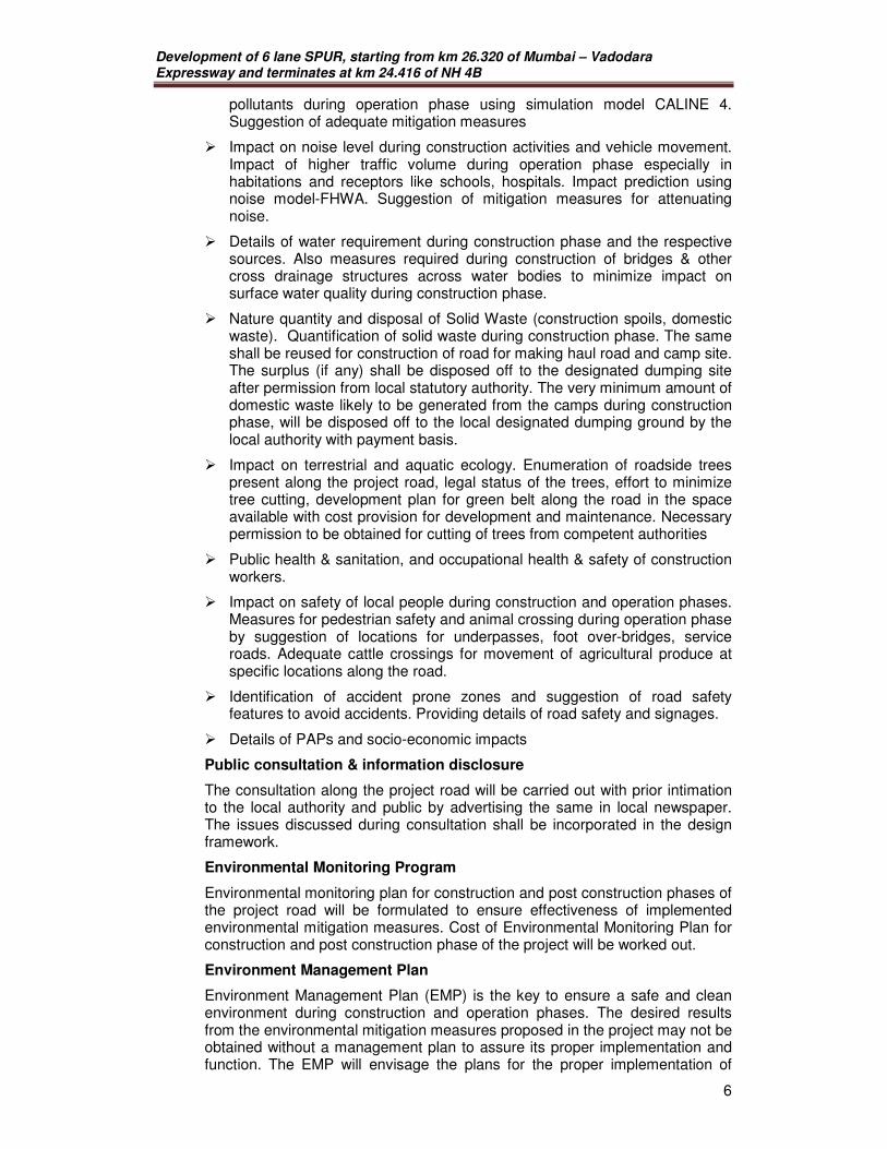
pollutants during operation phase using simulation model CALINE 4. Suggestion of adequate mitigation measures
� Impact on noise level during construction activities and vehicle movement. Impact of higher traffic volume during operation phase especially in habitations and receptors like schools, hospitals. Impact prediction using noise model-FHWA. Suggestion of mitigation measures for attenuating noise.
� Details of water requirement during construction phase and the respective sources. Also measures required during construction of bridges & other cross drainage structures across water bodies to minimize impact on surface water quality during construction phase.
� Nature quantity and disposal of Solid Waste (construction spoils, domestic waste). Quantification of solid waste during construction phase. The same shall be reused for construction of road for making haul road and camp site. The surplus (if any) shall be disposed off to the designated dumping site after permission from local statutory authority. The very minimum amount of domestic waste likely to be generated from the camps during construction phase, will be disposed off to the local designated dumping ground by the local authority with payment basis.
� Impact on terrestrial and aquatic ecology. Enumeration of roadside trees present along the project road, legal status of the trees, effort to minimize tree cutting, development plan for green belt along the road in the space available with cost provision for development and maintenance. Necessary permission to be obtained for cutting of trees from competent authorities
� Public health & sanitation, and occupational health & safety of construction workers.
� Impact on safety of local people during construction and operation phases. Measures for pedestrian safety and animal crossing during operation phase by suggestion of locations for underpasses, foot over-bridges, service roads. Adequate cattle crossings for movement of agricultural produce at specific locations along the road.
� Identification of accident prone zones and suggestion of road safety features to avoid accidents. Providing details of road safety and signages.
� Details of PAPs and socio-economic impacts
Public consultation & information disclosure
The consultation along the project road will be carried out with prior intimation to the local authority and public by advertising the same in local newspaper. The issues discussed during consultation shall be incorporated in the design framework.
Environmental Monitoring Program
Environmental monitoring plan for construction and post construction phases of the project road will be formulated to ensure effectiveness of implemented environmental mitigation measures. Cost of Environmental Monitoring Plan for construction and post construction phase of the project will be worked out.
Environment Management Plan
Environment Management Plan (EMP) is the key to ensure a safe and clean environment during construction and operation phases. The desired results from the environmental mitigation measures proposed in the project may not be obtained without a management plan to assure its proper implementation and function. The EMP will envisage the plans for the proper implementation of
Development of 6 lane SPUR, starting from km 26.320 of Mumbai – Vadodara Expressway and terminates at km 24.416 of NH 4B
7
mitigation measures to reduce the adverse environmental impacts arising out of the project activities during construction and operation phase. The following issues will be addressed in the EMP
� Preventive mitigation, compensatory & enhancement measures for minimization & abatement of the undesirable impacts caused during the construction and operation stage.
� Details of management plans (compensatory plantation, solid waste management plan, borrow area management plan, occupational safety and health plan etc.) including their implementation schedule and supervision programme.
� Identified/ recommended institutional set up for implementation of the EMP including institutional requirements, staffing and training.
� Environmental monitoring programme during construction and operation phase including parameters, locations and frequency of monitoring, monitoring mechanisms, performance indicators, implementation programme and cost.
� Environmental Management Budget: The preliminary environmental budget considering the environmental aspects for the project.
In addition to above, following information/ data will be collected and incorporated in the EIA Report:
• Topography of the project site will be described using toposheet and field observation. Filling / earth excavation will be quantified and source of filling materials and its transportation issues will be addressed in the report. Strategies will be suggested to reuse the excavated earth generated from the project site. The impact of the project on the existing drainage pattern will be addressed and mitigation measures will be suggested to counter the adverse impact on the existing drainage pattern.
• Quantification of air pollution load from the proposed project will be done. Potential environmental impacts will be assessed qualitatively and quantitatively. The changes in the quality of the environment will be predicted using appropriate available model approved by MoEF. In case the ambient air quality of the surrounding area is predicted to be critical then additional strategies will be suggested as air pollution mitigation measures.
• Availability of water and impact on other users on account of water drawl for the proposed project will be assessed using historical flow data of stream. Permission from competent authority to draw the required quantity of water will be obtained. Strategies will be suggested to ensure that the wastewater does not contaminate the environment.
• Greenery development plan will be prepared to enhance the aesthetic quality of the environment. The plan will also concentrate on measures that will be helpful in attenuating air and noise pollution levels from the project. Indigenous species and those having long-term economic value will be considered for plantation.
• The existing traffic movement pattern and intensity on the main roads will be monitored. Traffic projection will be done and the impact of additional traffic due to the proposed augmentation/strengthening work will be assessed including health and safety matters.
• Rainwater harvesting strategies within the project corridor shall be explored depending the ground water conditions in the study area.
Development of 6 lane SPUR, starting from km 26.320 of Mumbai – Vadodara Expressway and terminates at km 24.416 of NH 4B
8
• The project specific impacts and its mitigation related to safety aspects viz. (i) safety of construction workers, (ii) safety of road users including pedestrians and cyclists (iii) safety to cattle; (iv) safety of local community (iv) unsafe/ hazardous traffic conditions due to construction vehicle movement will be addressed comprehensively during design and construction stage and (v) need for safety audit will be assessed. Based on standard procedures prescribed by the National Safety Council and provisions mentioned in the Factories Act, occupational health and safety aspects of the project will be identified.
• Environmental Management Plan will be drawn up to maintain and enhance the environmental quality along the project corridor. In case the quality of the environment is expected to deteriorate beyond acceptable limits, additional strategies will be suggested. The EMP will earmarked specific staff, instruments and finances for routine environmental management as well as collection, collation and examination of various environmental data. A post-project monitoring plan will be suggested to monitor the changes in the environmental quality after implementation of the project. All necessary administrative measures will be incorporated in the EMP to achieve the following objectives:
- Reduction of adverse environmental impacts
- Improvement of environmental quality of the surrounding area
- Waste minimization, reuse and resource recovery
- Waste segregation to make the treatment and disposal cost-effective
- Establish proper monitoring mechanism with adequate infrastructure
- Potential hazards that may arise out of storage / transportation of hazardous chemicals / materials during construction work will be systematically identified using standard hazard identification procedures. Maximum credible accident scenarios will be considered for consequence analysis.
- Social impact assessment will be carried out by assessing the various developmental potential of the proposed project in the field of employment generation, improvement in physical and social infrastructure base.
- All environmental concerns directly related to the project activity, as addressed by the Public, State Administration and NGO during the public hearing process would be duly addressed in the Final EIA along with the commitments of the project promoter.
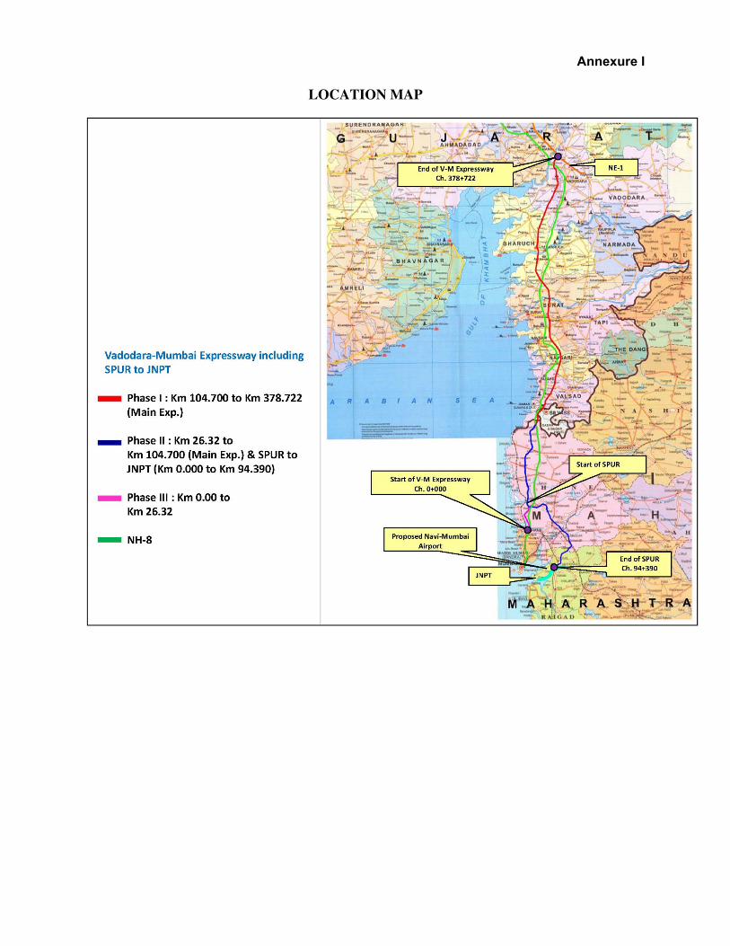
LOCATION MAP
Annexure I
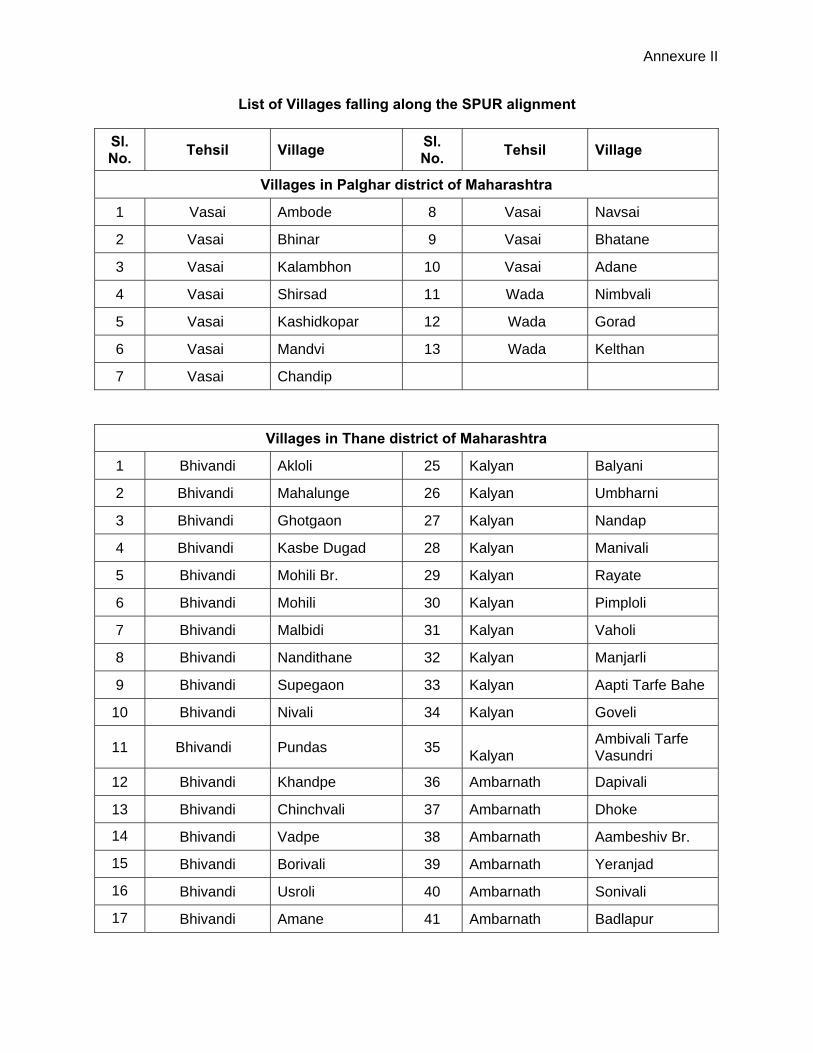
Annexure II
List of Villages falling along the SPUR alignment
Sl. No.
Tehsil Village Sl. No.
Tehsil Village
Villages in Palghar district of Maharashtra
1 Vasai Ambode 8 Vasai Navsai
2 Vasai Bhinar 9 Vasai Bhatane
3 Vasai Kalambhon 10 Vasai Adane
4 Vasai Shirsad 11 Wada Nimbvali
5 Vasai Kashidkopar 12 Wada Gorad
6 Vasai Mandvi 13 Wada Kelthan
7 Vasai Chandip
Villages in Thane district of Maharashtra
1 Bhivandi Akloli 25 Kalyan Balyani
2 Bhivandi Mahalunge 26 Kalyan Umbharni
3 Bhivandi Ghotgaon 27 Kalyan Nandap
4 Bhivandi Kasbe Dugad 28 Kalyan Manivali
5 Bhivandi Mohili Br. 29 Kalyan Rayate
6 Bhivandi Mohili 30 Kalyan Pimploli
7 Bhivandi Malbidi 31 Kalyan Vaholi
8 Bhivandi Nandithane 32 Kalyan Manjarli
9 Bhivandi Supegaon 33 Kalyan Aapti Tarfe Bahe
10 Bhivandi Nivali 34 Kalyan Goveli
11 Bhivandi Pundas 35 Kalyan Ambivali Tarfe Vasundri
12 Bhivandi Khandpe 36 Ambarnath Dapivali
13 Bhivandi Chinchvali 37 Ambarnath Dhoke
14 Bhivandi Vadpe 38 Ambarnath Aambeshiv Br.
15 Bhivandi Borivali 39 Ambarnath Yeranjad
16 Bhivandi Usroli 40 Ambarnath Sonivali
17 Bhivandi Amane 41 Ambarnath Badlapur

Annexure II
18 Bhivandi Kiravali 42 Ambarnath Sape
19 Bhivandi Sange 43 Ambarnath Joveli
20 Bhivandi Vahuli 44 Ambarnath Bhoj
21 Bhivandi Pise 45 Ambarnath Khuntvali
22 Bhivandi Kukse 46 Ambarnath Bendshil
23 Kalyan Konderi 47 Ambarnath Chamtoli
24 Kalyan Sangode 48 Ambarnath Dahivali
Villages in Raigarh District
Sl. No.
Tehsil Villages Sl. No.
Tehsil Villages
1 Panvel Vangani Tarfe Taloje
11 Panvel Vihighar
2 Panvel Karambeli Tarfe Taloje
12 Panvel Moho
3 Panvel Shirvali 13 Panvel Shivkar
4 Panvel Ambe 14 Panvel Chiple
5 Panvel Morbe 15 Panvel Devad
6 Panvel Khanav 16 Panvel Vichumbe
7 Panvel Chinchvali Tarfe Vaje
17 Panvel Usarli Kh.
8 Panvel Bhanghar Tarfe Vaje
18 Panvel Kalundre
9 Panvel Vakadi 19 Panvel Karnjade
10 Panvel Nere 20 Panvel Nandgaon
Kashidkopar
Mandvi
Sirsad
Navsaipada
Jamanpada
Bhatne
Telchapada
Adne
TiplipadaShivansai
Shivansaipada
Paro
lSh
irovli
Majiv
li
Mhas
kina
Dapiv
iMa
jivlip
ada
Kalos
hipad
aPa
licha
pada
Ugha
npad
aTil
her
Khair
pada
Kuhu
rpad
a
Kutjapada
Khad
ki Kh
urd
Khad
ki Bu
druk
h
Kuha
Chim
bipad
a
Majiv
ada
Ghob
licha
pada
Paliv
liMo
nichp
ada
Temb
havli
Ponir
dpai
Nand
urki
Kharbav
Vadu
Nav
ghar
Vodg
hor
Dung
e
Kalva
rKe
vni
Dive
Raha
n Purn
eKo
par
Kalhe
r
Kasheli
Anjur
Dive
pada
Anjur Ka
llipad
aBh
arod
ipada
Bhop
ar
Betavde
Dativli
Usarghar
Ghar
ivli
Kole
Nilaj
e
Ghes
ar Vada
vliVa
davli Ba
leNa
rivli Va
klan
Tura
mbhe
Karvi
Taloj
e Ma
zkur Patipada
Ghote
Tond
hre
Pend
har
Navd
e
Taloj
a Bud
rukh
Chandip
TulsipadaBhinar
Ambote
Ghate
gharJa
lkaipa
da
kalbhonMedhe
Tukripada
Vajreshwari
Bhivali
Ganeshpuri
Akloli
Mohlu
nge
Ghotgaonpada
Ghotg
aonVe
dhep
ada
Vedh
e
Duga
d
Vavli
Mohil
iBo
mbyd
chap
ada
Chap
arac
hpad
a
Bhen
dipad
a
Nand
ithan
e
Kara
njoti
Chav
e
Pand
risKh
aling
Khu
rdAn
gaon
Gotadichapada
Nivli
Khan
dpe
Chinc
havli
Dham
anga
onVa
dpe
Bohir
pada
Borivli
Usroli
Vash
ere
Khan
val
Amne
Chira
dpad
a
Kira
vliKo
nder
ipada
Song
ade
Sang
e
Vasu
ndri
Balya
niNa
ndep
Umbh
arna
l
Maniv
li
Desh
pand
epad
aGh
otsal
Royata
Panjrapura
Voghera
Pimp
loli Va
holi
Vasat Jombhu
Shirg
aon
Manjarli
Khar
vai
Juwe
li
Dahiv
liBh
oj
Thok
erwa
l
Phan
spad
a
Toms
aKh
airwa
di
Dund
repa
da
Dund
re
Usro
li Umro
li
Tera
ghar
Sang
toli
Ambiv
liVi
higha
r
Vakd
i
6
7
3
Industrial Area
Industrial Area
LEGEND :
Alternative Alignments
Travel Distance FromNode 1 to Node 10Alternate Alignment
Outer Recommended Alignment
Proposed Vadodara-Mumbai Expressway Alignment
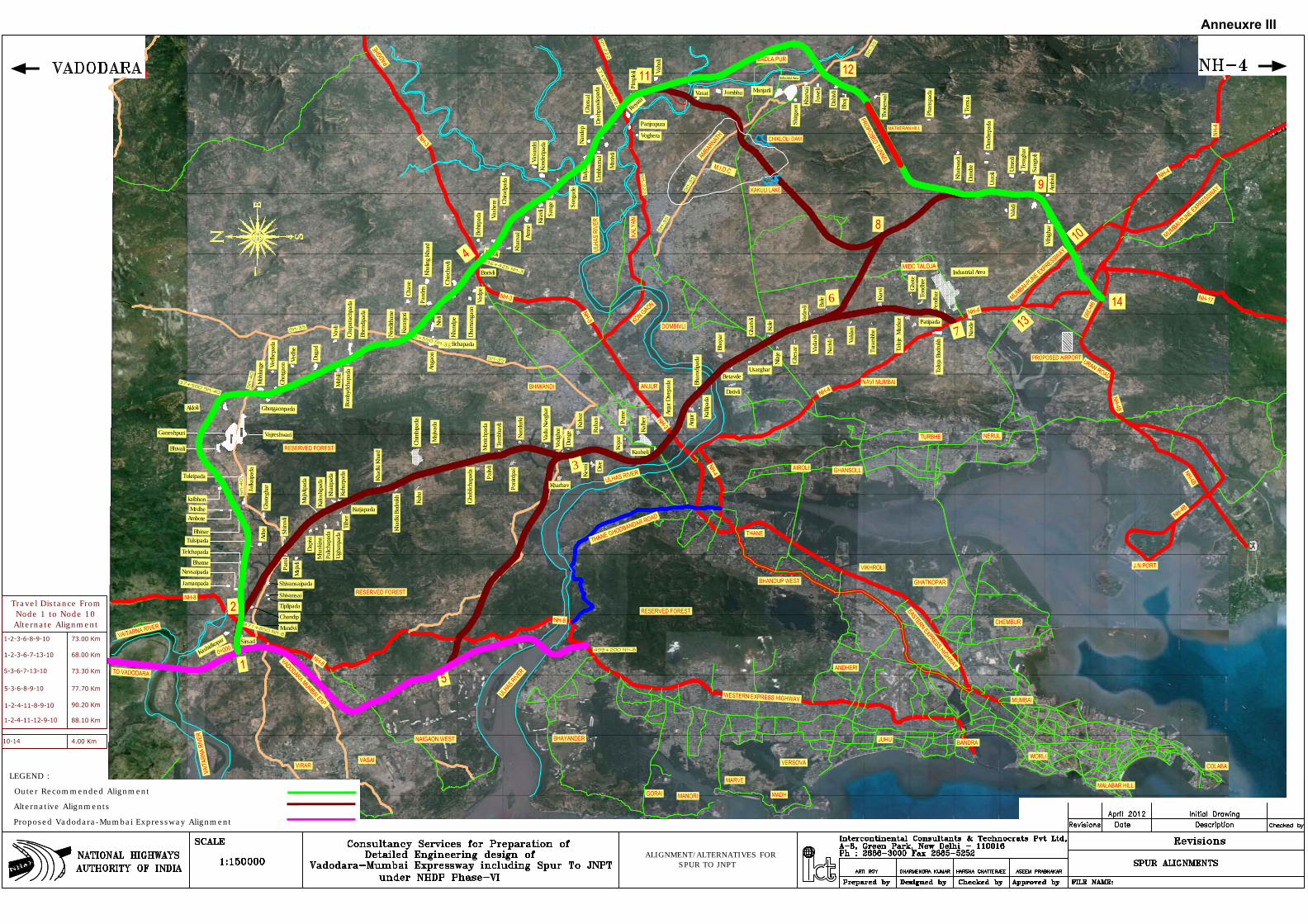
ALIGNMENT/ALTERNATIVES FOR SPUR TO JNPT
Anneuxre III


![APPENDIX I [See Chapter II, paragraph 6] Extracts from ... · [See Chapter II, paragraph 6] Extracts from Government of India (Audit and Accounts) Order, 1936, issued as an order](https://static.fdocuments.us/doc/165x107/5fc2c829a3c8d52a3f083aed/appendix-i-see-chapter-ii-paragraph-6-extracts-from-see-chapter-ii-paragraph.jpg)