Appendix I - salmonrecovery.gov APR files/2011_Dis_Gas... · QQAA//QQCC EEvvaalluuaattiioonn ooff...
39
Appendix I Includes: McNary, Ice Harbor, Lower Monumental, Little Goose, Lower Granite, and Dworshak Projects U U U S S S A A A C C C E E E W W W a a a l l l l l l a a a W W W a a a l l l l l l a a a D D D i i i s s s t t t r r r i i i c c c t t t Q Q A A / / Q Q C C E E v v a a l l u u a a t t i i o o n n o o f f t t h h e e 2 2 0 0 1 1 1 1 F F F M M M S S S T T T D D D G G G M M M o o o n n n i i i t t t o o o r r r i i i n n n g g g D D D a a a t t t a a a
Transcript of Appendix I - salmonrecovery.gov APR files/2011_Dis_Gas... · QQAA//QQCC EEvvaalluuaattiioonn ooff...

Appendix I
Includes:
McNary, Ice Harbor, Lower Monumental, Little Goose,
Lower Granite, and Dworshak Projects
UUUSSSAAACCCEEE WWWaaallllllaaa WWWaaallllllaaa DDDiiissstttrrriiicccttt QQQAAA///QQQCCC EEEvvvaaallluuuaaatttiiiooonnn ooofff ttthhheee 222000111111
FFFMMMSSS TTTDDDGGG MMMooonnniiitttooorrriiinnnggg DDDaaatttaaa
i
USACE Walla Walla District QA/QC Evaluation of the 2011 FMS TDG Monitoring Data Prepared by: Hydraulic Design and Water Quality Section Walla Walla District U.S. Army Corps of Engineers Walla Walla, Washington Prepared for: Northwestern Division Regional Office U.S. Army Corps of Engineers Portland, Oregon
November 2011
ii
TABLE OF CONTENTS
Page
ABSTRACT ......................................................................................................................... vi
1.0 INTRODUCTION ...................................................................................................... I-1
2.0 PURPOSE AND SCOPE ............................................................................................ I-1
3.0 METHODS ................................................................................................................. I-2 3.1 Data Collection .................................................................................................. I-2 3.2 Laboratory Procedures ....................................................................................... I-2 3.3 Field Procedures ................................................................................................. I-3 3.4 Defining Invalid and Missing Data Values ........................................................ I-3
4.0 RESULTS AND DISCUSSION ................................................................................. I-3 4.1 Inventory-wide Sensor QA/QC Performance .................................................... I-3
4.1.1 Pre-deployment ...................................................................................... I-3 4.1.2 Post-deployment .................................................................................... I-4
4.2 System-wide Station QA/QC Performance ....................................................... I-4 4.3 FMS Data Completeness and Station Statistics ................................................. I-4
4.3.1 Barometric Pressure ............................................................................... I-4 4.3.2 Total Dissolved Gas ............................................................................... I-5 4.3.3 Temperature ........................................................................................... I-5
4.4 Anatone Deployment Pipe Repair ...................................................................... I-6 4.5 Modem Problems at Dworshak ........................................................................... I-6
5.0 SUMMARY ................................................................................................................ I-6
iii
FIGURES I-1. Locations of Walla Walla District’s FMS stations
I-2. Explanation key for the box plot information
I-3. Summary box plots of the pre- and post-deployment check of barometric pressure versus the primary standard during the 2011 monitoring season
I-4. Summary box plots of the pre- and post-deployment check of the Hydrolab® TDG sensors with the addition of 100 and 300 psi during the 2011 monitoring season
I-5. Summary box plots of the pre- and post-deployment check of the Hydrolab® temperature sensors during the 2011 monitoring season
I-6. Box plots of the field barometric pressure check in mm Hg by site during the during the 2011 monitoring season
I-7. Box plots of the field total dissolved gas sensor check versus secondary standard in percent saturation by site during the 2011 monitoring season
I-8. Box plots of the field temperature sensor check versus primary standard in degrees C by site during the 2011 monitoring season
I-9. Work for Contract W912EF-08-D-0002 Task Order Number 13 was completed on March 13, 2011. The Anatone TDG FMS station was repaired and cleaned of sediment during this effort.
I-10. RMG employee showing high flows and the deployment pipe at Anatone, on March 13, 2011.

iv
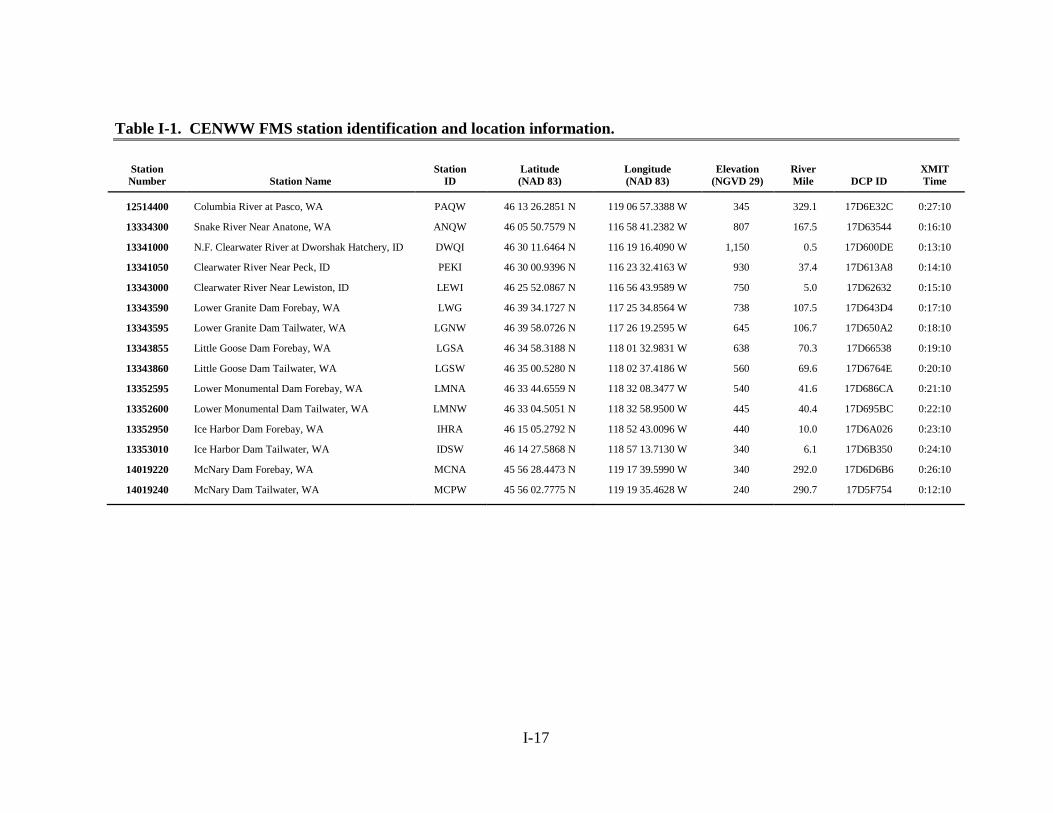
TABLES I-1. CENWW FMS station identification and location information
I-2. Summary of the laboratory results evaluating the overall differences between laboratory standards and the sensors pre- and post-deployment during the 2011 water year
I-3. Pre-deployment quality assurance data for the individual sensors utilized at the FMS stations during the 2011 water year
I-4. Post-deployment quality assurance data for the individual sensors utilized at the FMS stations during the 2011 water year
I-5. Summary of the field results for the differences between the in-place and replacement sensors during the 2011 water year
I-6. Summary of the field results for the differences between the in-place and replacement sensors by station during the 2011 water year
I-7. Database completeness with the number and percent of all missing or invalid barometric pressure, total dissolved gas, and temperature points for each FMS station during the 2011 water year as reported by the real-time DCP system
I-8. Database completeness with the number and percent of all missing or invalid barometric pressure, total dissolved gas, and temperature points for each FMS station during the 2011 water year as determined after EDL correction
I-9. Summary of the total hours of barometric pressure, total dissolved gas, and temperature data that were missing or considered invalid in the 2011 water-year provisional real-time DCP data set
I-10. Summary of the total hours of barometric pressure, total dissolved gas, and temperature data that were missing or considered invalid in the 2011 water-year EDL corrected data set
I-11. Number and percent of all missing or invalid barometric pressure data for each FMS stations during the 2011 water year based on the provisionalreal-time DCP data set, along with the reasons for those designations
I-12. Number and percent of all missing or invalid barometric pressure data for each FMS stations during the 2011 water year based on the EDL corrected data set, along with the reasons for those designations
I-13. Number and percent of all missing or invalid total dissolved gas data for each FMS stations during the 2011 water year based on the provisional real-time DCP data set, along with the reasons for those designations
I-14. Number and percent of all missing or invalid total dissolved gas data for each FMS stations during the 2011 water year based on the EDL corrected data set, along with the reasons for those designations
I-15. Number and percent of all missing or invalid temperature data for each FMS stations during the 2011 water year based on the provisional real-time DCP data set, along with the reasons for those designations
v
TABLES (continued)
I-16. Number and percent of all missing or invalid temperature data for each FMS stations during the 2011 water year based on the EDL corrected data set, along with the reasons for those designations

vi
ABSTRACT The U.S. Army Corps of Engineers (USACE), Walla Walla District (CENWW), operated fifteen fixed-monitoring system (FMS) stations (nine seasonal and six year round) for total dissolved gas (TDG), barometric pressure (BP), and temperature as part of their 2011 water-quality program. These stations are located on the Columbia, Lower Snake and Clearwater Rivers. This report provides a summary of the 2011 water-year quality assurance/ quality control (QA/QC) evaluation. Highlights include:
99.26, 98.45, and 99.18 percent of the BP, TDG, and water temperature data, respectively, were received in real-time and passed provisional QA/QC review. Percent completeness subsequently increased to 99.29, 98.49, and 99.24 for BP, TDG, and temperature, respectively, after the data was compared to the information from the electronic data logger (EDL)
64.86 percent of the invalid/missing provisional real-time BP and TDG data was due to multiple telephone modem failures at the DWQI (North fork of the Clearwater at Ahsahka) station. When the data was corrected with information from the EDL, 65.16 percent of the aberrant data was due to multiple modem failures at the DWQI station. The modem problems were corrected later in the season and there have been no more failures due to the modem at DWQI.
The sensor pre-deployment check had calculated median TDG and temperature differences of -0.2 mm Hg and -0.03°C, respectively.
The sensor post-deployment check revealed median TDG and temperature differences of 0.00 percent and 0.01°C, respectively.
.
I-1
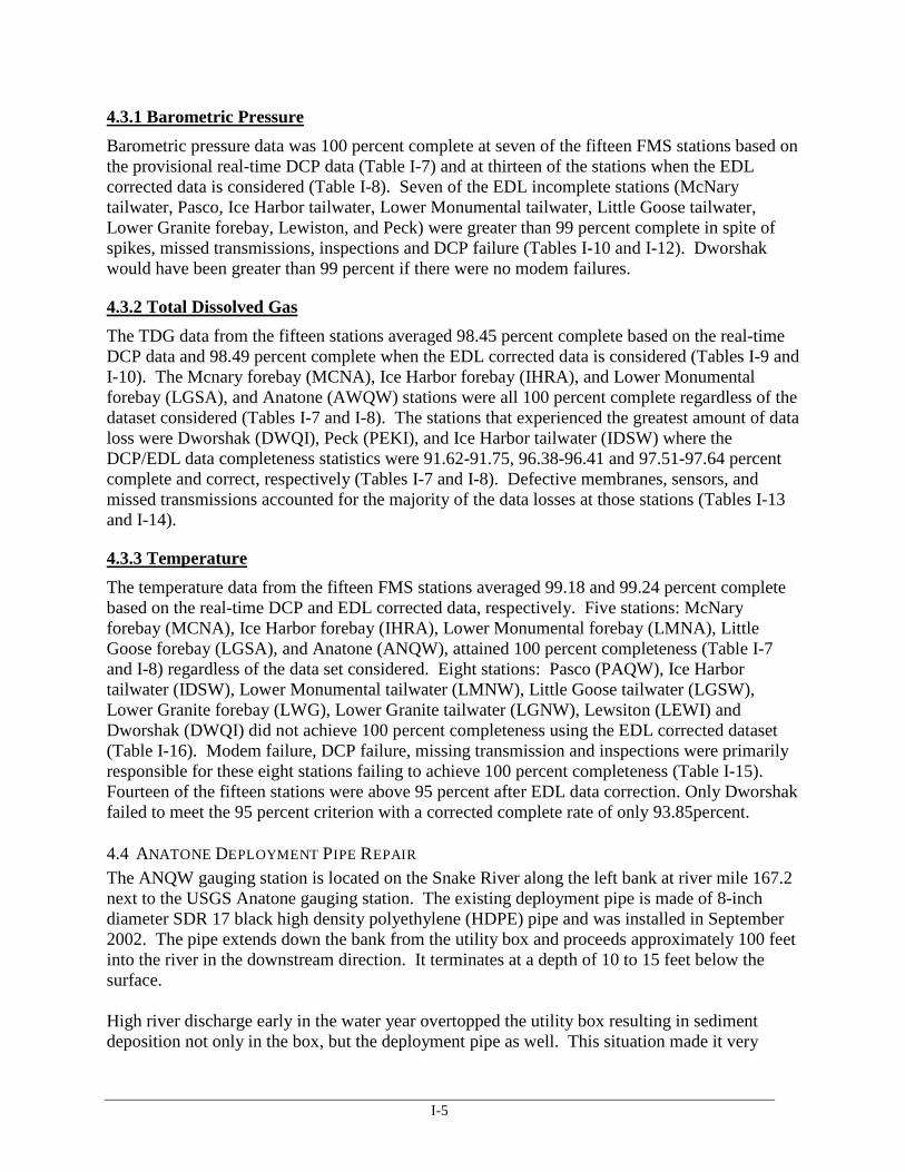
1.0 INTRODUCTION Walla Walla District (CENWW) of the U.S. Army Corps of Engineers (USACE) operated six hydropower projects: McNary, Ice Harbor, Lower Monumental, Little Goose, Lower Granite, and Dworshak dams. These six dams are included in the basin-wide fixed-monitoring system (FMS) network. Six of the stations (i.e., the tailwater stations at McNary Dam, Ice Harbor Dam, Lower Monumental Dam, Little Goose Dam, Lower Granite Dam, and Dworshak Dam) are operated throughout the year (Figure I-1; Table I-1). The remaining nine stations record data from April 1 through August 31.
Three water-quality parameters are monitored at these facilities. One is total dissolved gas (TDG). This parameter is of interest since gas supersaturation results when air is entrained as water flows over the spillways and plunges into the stilling basin where water pressure causes the air to go into solution. The river subsequently becomes shallow beyond the stilling basin and the result is water supersaturated with TDG relative to atmospheric conditions. The U.S. Environmental Protection Agency (USEPA) has established an upper limit of 110 percent TDG for protection of freshwater aquatic life. Greater than 110 percent TDG can cause gas bubble trauma in fish and adversely affect other aquatic organisms. The State of Washington rule adjustment allows the percent TDG to reach 115 percent in the forebays and 120 percent in the tailwaters when water is spilled for fish passage, as well as during high river discharge events (i.e., flows greater than the 7Q10). The one-hour maximum TDG measurement cannot exceed 125 percent TDG. Two additional parameters that influence the percent TDG are barometric pressure and water temperature. As such, measurements for these two constituents are also recorded and stored in the database.
Measurements were completed hourly at all stations and transmitted via the Geostationary Operational Environmental Satellite Program (GOES) system to USACE and U.S. Geological Survey (USGS) databases. The Corps Water Management System (CWMS) database at the Northwestern Division (CENWD) office in Portland, Oregon can be accessed at http://www.nwd-wc.usace.army.mil/report/total.html. The link to real-time USGS data for Washington is http://waterdata.usgs.gov/wa/nwis/current/ ?type =quality.
2.0 PURPOSE AND SCOPE The purpose of TDG monitoring is to provide managers, agencies, and interested parties with near real-time data for managing stream flows, spill and the percent TDG downstream from power-producing dams. As with any data collection activity, an important component that cannot be overlooked is the quality of the data. Measurement of data quality allows determination of the usefulness and relevance of the data for current and future decision processes.
This 2011report: • Describes the data collection methods. • Evaluates quality assurance/ quality control (QA/QC) data for the FMS stations at
McNary, Ice Harbor, Lower Monumental, Little Goose, and Lower Granite reservoirs. Additionally, this data-collection system provided water quality information for the Clearwater River downstream of Dworshak Dam, the Columbia River near Pasco, and the Snake River near Anatone, Washington (Figure I-1; Table I-1).

I-2
The QA/QC data includes:
1. Instrument Data: This data was used to evaluate how an instrument performed as a function of the magnitude and direction that individual sensors deviated over time from their respective laboratory standards. These relationships were determined for each sensor before and after each deployment.
2. Station Data: These data present comparisons between an in-place instrument that was deployed at a given station for a specified cycle and a newly calibrated QA/QC instrument (field standard). The Sutron® barometers at each station were evaluated with a hand-held barometer that served as a portable field standard for barometric pressure. Fifteen stations were visited for routine maintenance once every three weeks between April 1 and August 31. The six year-round stations were maintained once every four weeks for the remainder of the year.
3.0 METHODS 3.1 DATA COLLECTION The instrumentation at each FMS station consisted of components provided by CENWW and the USGS Kennewick, Washington, office. A 12-volt battery charged by a solar panel and/or 120-volt alternating-current line powered each station. Thirty-five Hydrolab® multi-parameter probes (i.e., Minisondes, MS4A’s, and MS5’s) were utilized. Twenty-six of these units were provided by CENWW and the remaining nine belong to the USGS.
3.2 LABORATORY PROCEDURES The TDG sensor measures the sum of the partial pressures of gaseous compounds dissolved in the water and reports the result in millimeters of mercury (mm Hg). The TDG sensor requires a two-step calibration procedure (i.e., adjustments are made at two points on the calibration curve) that is completed prior to and after deployment. The atmospheric pressure calibration point (Lab BP) is equal to the atmospheric pressure at the time of calibration as measured with a ParoScientific® digiquartz barometric pressure standard that is calibrated yearly at the factory. The differences between Lab BP and the pressure measured by the sensor [Δ(BP-PT)] were recorded before and after deployment. The slope of each sensor response was also evaluated to ensure that measurements were interpolated correctly over the full range of expected field values. To accomplish this task, a Heise™ PTE-1 hand held certified pressure calibrator, calibrated yearly at the factory (primary standard) and an Ashcroft digital test gauge, also calibrated yearly at the factory (primary standard), were used to apply pressure to the TDG sensor. Three hundred mm Hg were added to Lab BP during the pre-deployment check and the differences between Lab BP+300 and the sensors’ response were recorded as Δ[(BP+300)-PT]. Similar tests were completed post-deployment when 100 mm Hg was added to Lab BP, and the resulting differences were recorded as Δ[(BP+100)-PT]. Pre-deployment pressure tests were made without a membrane installed. Post-deployment tests were made with a dry membrane in place.
Each sensor also includes a sensor for reporting water temperature in degrees Celsius (°C). Sensor thermometers are factory calibrated and cannot be adjusted. However, temperature sensor performance was evaluated pre- and post-deployment by comparing instrument readings to two Barnant model 600 digital thermistors. Both of these instruments were checked quarterly against a National Institute of Standards and Technology (NIST) mercury thermometer standard.
I-3
3.3 FIELD PROCEDURES The differences in barometric pressure, water temperature, and TDG between a secondary standard instrument (i.e., replacement sensor) and the fixed-station monitors after three or four weeks of field deployment were measured and recorded as part of the field inspection and calibration procedure. These differences, defined as the secondary standard value minus the field instrument value, were used to compare and quantify the precision between two independent instruments. The Sutron® barometers were checked using a Novalynx® model 230-355 hand-held digital barometer that is calibrated yearly at the factory. The water temperature and TDG comparisons were made in situ with the secondary standard (i.e., a recently calibrated Hydrolab®) positioned alongside the field Hydrolab®.
3.4 DEFINING INVALID AND MISSING DATA VALUES The provisional real-time data were examined daily during the workweek by CENWW and/or USGS employees. Missing values and those that appeared to be outside the expected range were flagged. If a reasonable explanation (e.g., routine maintenance, DCP failure, or defective membrane) could be attributed to the incident, then the data point, or points, was not included in the final data set used for this analysis. Outlying data points that could not be attributed to a specific cause were retained.
The corrected data set was subsequently developed based on information stored in the electronic data logger (EDL). This final data set is more complete and representative of the TDG and temperature environment than the provisional one.
4.0 RESULTS AND DISCUSSION 4.1 INVENTORY-WIDE SENSOR QA/QC PERFORMANCE
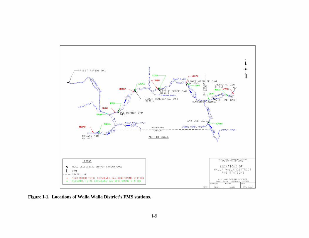
4.1.1 Pre-deployment The pre-deployment evaluation of the sensors consisted of 193 individual checks for barometric pressure (Table I-2). The evaluation of the sensor pressure sensors to the standard revealed a calculated mean of -0.13 mm Hg, and a range of -1.00 to 0.70 mm Hg (Table I-2; Figure I-3). Three hundred millimeters of mercury (mm Hg) was added to the TDG sensor in the laboratory using the laboratory barometer as the baseline standard. The difference between the barometer with 300 mm Hg of pressure and the instrument was compared against the expected value. The calculated mean was based on the 193 measurements. The sensor pressure differences ranged from -0.1 percent to 0.1 percent (Figure I-4; Tables I-2 and I-3). The calculated mean and median values were -0.01 percent and -0.02 percent, respectively (Figure I-4; Tables I-2 and I-3).
The dissimilarities between the NIST-traceable thermometer and the sensor thermisters were also quite small. The calculated average and median values for all the instruments were 0.03ºC and 0.03°C, respectively. These calculated values were based on 193 measurements, with the medians for individual sensors ranging from -0.1°C to 0.2°C (Tables I-2 and I-3; Figure I-5). The instrument manufacturer’s specification is ±0.2 °C for all instruments within a sample pool.
4.1.2 Post-deployment The evaluation of the post-deployment QA/QC data also displayed favorable results. A total of 168 data points were used for the evaluation. The differences between the laboratory barometric
I-4
pressure and that recorded by the sensors ranged from -1.40 mm Hg to 1.40 mm Hg, with a mean of -0.03 mm Hg (Tables I-2 and I-4; Figure I-3). The results of the post calibration checks using barometric pressure +100 mm Hg showed a calculated mean of -0.01 percent, and a range of -0.20 to 0.20 percent (Table I-2; Figure I-4).
There were 168 post deployment checks available for temperature evaluation. Temperature post calibration checks resulted in a calculated mean of 0.01°C with a range between -0.13°C and 0.14°C (Tables I-2 and I-4; Figure I-5).
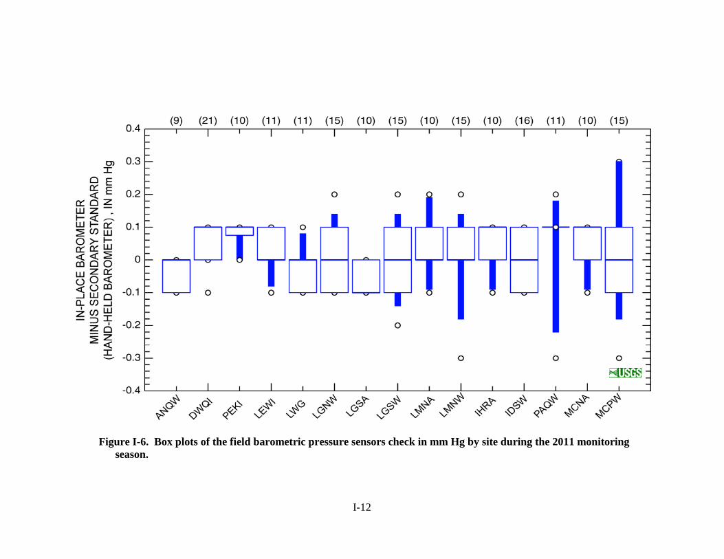
4.2 SYSTEM-WIDE STATION QA/QC PERFORMANCE The analysis of the station QA/QC data showed that the in-place barometric air pressure, TDG pressure, and temperature instruments performed well when compared to the secondary standards (Figures I-6 through I-8). A total of 183 readings were used to calculate the mean and median values for barometric pressure (Table I-5). The median of all the differences calculated between the station barometers and the secondary standards was 0.00 mm Hg (Table I-5; Figure I-6). All of the stations medians were within -0.1 to 0.1 mmHg (Table I-6). The published accuracy of the barometers is ±0.7 mm Hg.
A total of 175 readings were used to calculate the mean and median values for TDG instrument pressure (Table I-5). The overall median for the percent TDG differences between the in-place and replacement sensors was 0.0 percent saturation (Table I-5; Figure I-7). Individual median station values ranged from -0.3 percent saturation to 0.3 percent saturation (Table I-6).
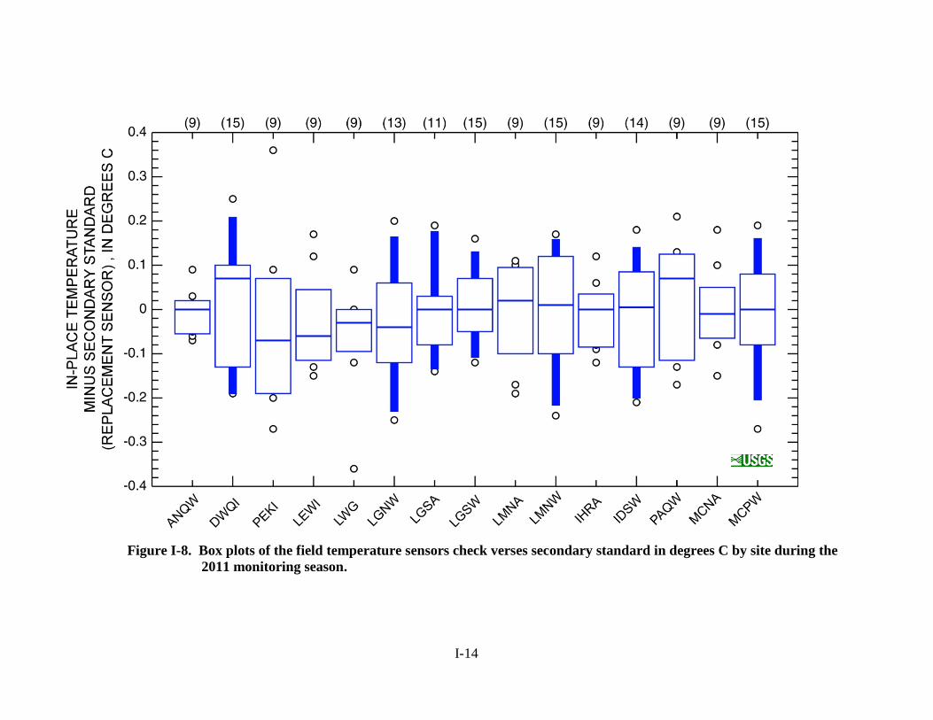
A total of 176 readings were used to calculate the temperature mean and median values (Table I-5). The calculated mean and median temperature differentials for the field data were both 0.00°C (Table I-5; Figure I-8). The stations where the calculated median value departed from the overall median to the greatest extent were the Lewiston and McNary Dam forebay stations at -0.06 and 0.09°C, respectively (Table I-6). The manufacturer’s specification for the temperature sensor is ±0.20°C.
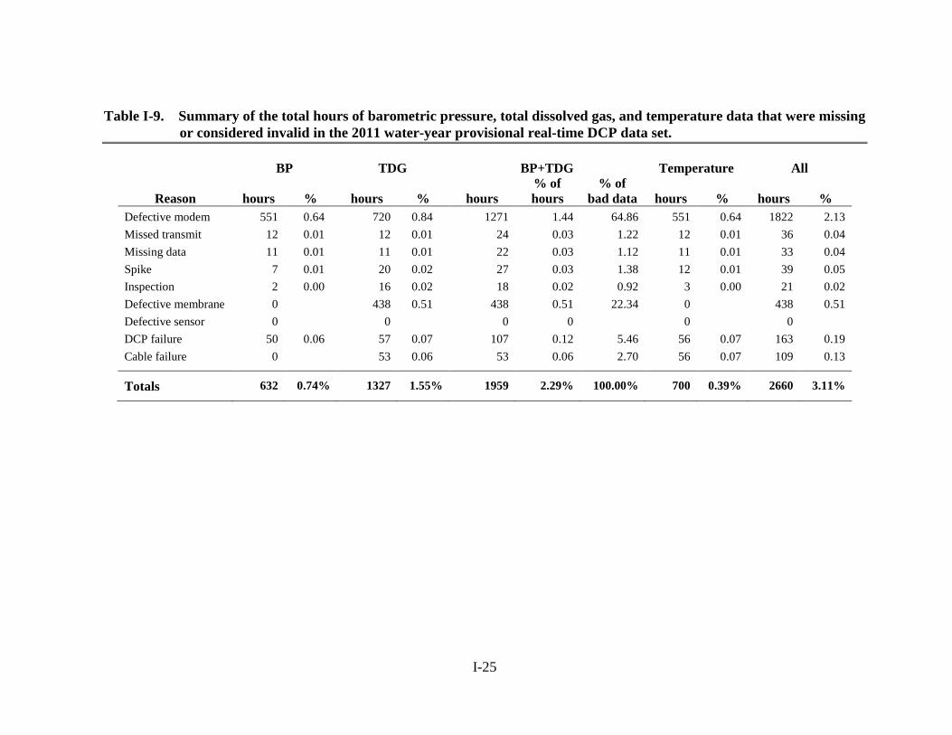
4.3 FMS DATA COMPLETENESS AND STATION STATISTICS Percent completeness can be examined from two perspectives: real-time data transmission from the DCP and corrected data based on the electronic data loggers (EDL). Percent completeness for the real-time TDG, barometric pressure, and temperature data were 98.45, 99.26, and 99.18 percent, respectively (Table I-9). The EDL corrected data set had fewer missing/anomalous data points resulting in higher percentages for the same three parameters: TDG (98.49 percent), BP (99.3 percent), and temperature (99.2 percent) (Table I-10). The most frequent reason attributed to missing or anomalous real-time/EDL data was the series of modem failures at Dworshak resulting in 1,766 hours out of the total 2,551 bad data hours (-2.06 percent of total station performance and 65.16 percent of the bad data for TDG+BP and 81.13 percent of the bad data hours for the temperature)(Tables I-9 and I-10). Regardless of the data set considered, 14 out of the 15 the stations exceeded the required 95 percent criterion for both for DCP and EDL data. The Dworshak Dam station failed to achieve the 95percent criterion for both DCP and EDL with an overall station performance of 92.91 and 93.08 percent, respectively.
I-5
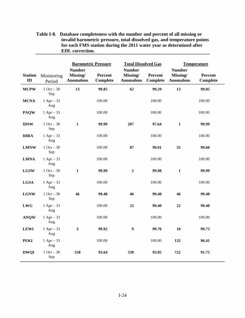
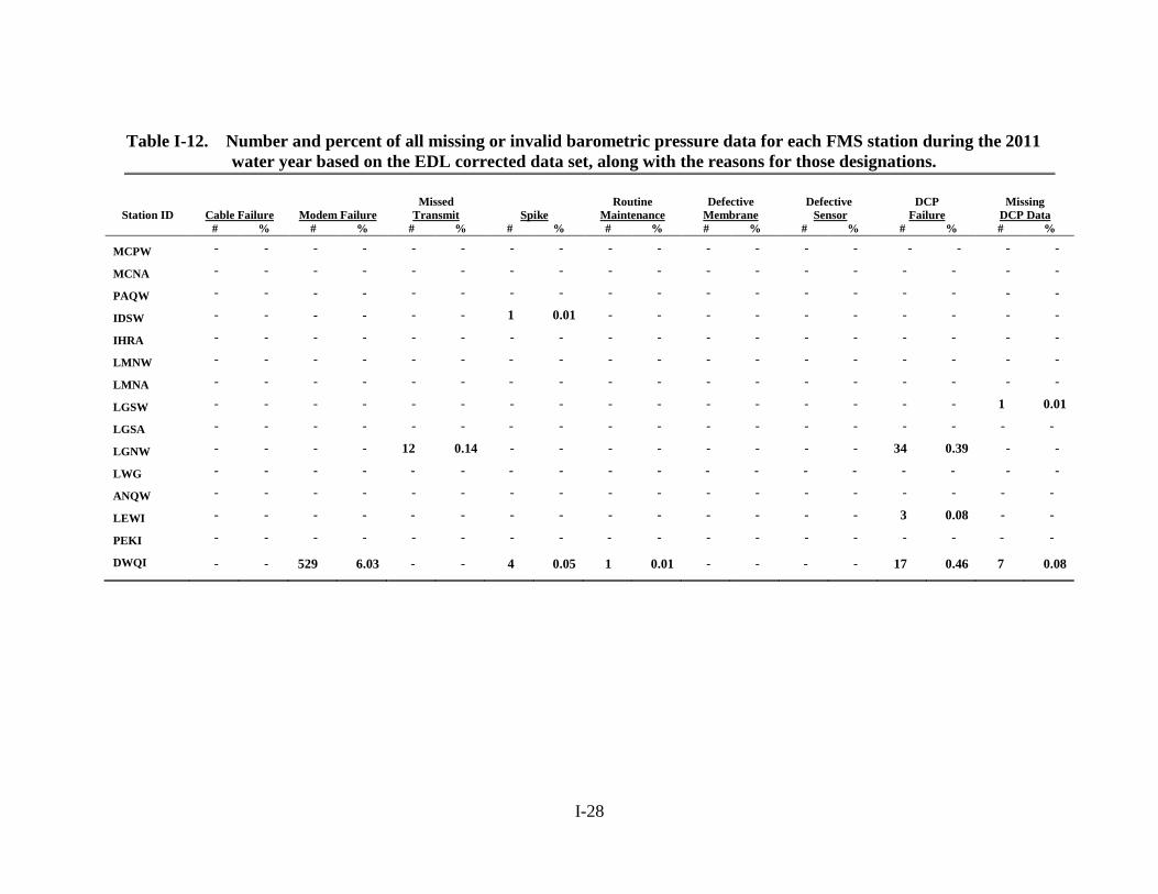
4.3.1 Barometric Pressure Barometric pressure data was 100 percent complete at seven of the fifteen FMS stations based on the provisional real-time DCP data (Table I-7) and at thirteen of the stations when the EDL corrected data is considered (Table I-8). Seven of the EDL incomplete stations (McNary tailwater, Pasco, Ice Harbor tailwater, Lower Monumental tailwater, Little Goose tailwater, Lower Granite forebay, Lewiston, and Peck) were greater than 99 percent complete in spite of spikes, missed transmissions, inspections and DCP failure (Tables I-10 and I-12). Dworshak would have been greater than 99 percent if there were no modem failures.
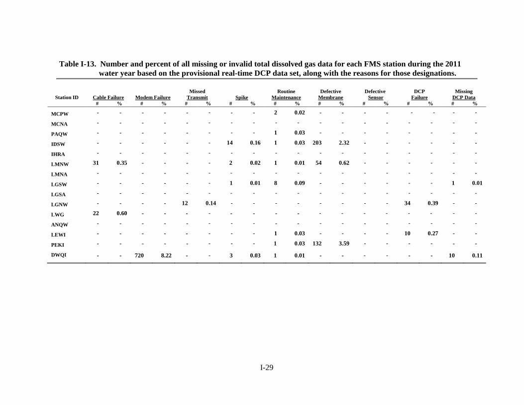
4.3.2 Total Dissolved Gas The TDG data from the fifteen stations averaged 98.45 percent complete based on the real-time DCP data and 98.49 percent complete when the EDL corrected data is considered (Tables I-9 and I-10). The Mcnary forebay (MCNA), Ice Harbor forebay (IHRA), and Lower Monumental forebay (LGSA), and Anatone (AWQW) stations were all 100 percent complete regardless of the dataset considered (Tables I-7 and I-8). The stations that experienced the greatest amount of data loss were Dworshak (DWQI), Peck (PEKI), and Ice Harbor tailwater (IDSW) where the DCP/EDL data completeness statistics were 91.62-91.75, 96.38-96.41 and 97.51-97.64 percent complete and correct, respectively (Tables I-7 and I-8). Defective membranes, sensors, and missed transmissions accounted for the majority of the data losses at those stations (Tables I-13 and I-14).
4.3.3 Temperature The temperature data from the fifteen FMS stations averaged 99.18 and 99.24 percent complete based on the real-time DCP and EDL corrected data, respectively. Five stations: McNary forebay (MCNA), Ice Harbor forebay (IHRA), Lower Monumental forebay (LMNA), Little Goose forebay (LGSA), and Anatone (ANQW), attained 100 percent completeness (Table I-7 and I-8) regardless of the data set considered. Eight stations: Pasco (PAQW), Ice Harbor tailwater (IDSW), Lower Monumental tailwater (LMNW), Little Goose tailwater (LGSW), Lower Granite forebay (LWG), Lower Granite tailwater (LGNW), Lewsiton (LEWI) and Dworshak (DWQI) did not achieve 100 percent completeness using the EDL corrected dataset (Table I-16). Modem failure, DCP failure, missing transmission and inspections were primarily responsible for these eight stations failing to achieve 100 percent completeness (Table I-15). Fourteen of the fifteen stations were above 95 percent after EDL data correction. Only Dworshak failed to meet the 95 percent criterion with a corrected complete rate of only 93.85percent.
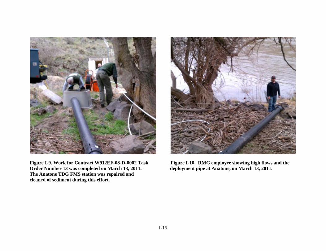
4.4 ANATONE DEPLOYMENT PIPE REPAIR The ANQW gauging station is located on the Snake River along the left bank at river mile 167.2 next to the USGS Anatone gauging station. The existing deployment pipe is made of 8-inch diameter SDR 17 black high density polyethylene (HDPE) pipe and was installed in September 2002. The pipe extends down the bank from the utility box and proceeds approximately 100 feet into the river in the downstream direction. It terminates at a depth of 10 to 15 feet below the surface. High river discharge early in the water year overtopped the utility box resulting in sediment deposition not only in the box, but the deployment pipe as well. This situation made it very
I-6
difficult to retrieve the sensor from the pipe, and eventually the rope would not move. A task order was subsequently issued to Resource Management Group (RMG) to perform three tasks: (1) clean-out the pipe, (2) repair the pulley system as needed, and (3) re-anchor the pipe. RMG was on-site during March 2011 (Figure I-9). They completed tasks one and two, but due to the higher than expected river flows they were not able to set new anchors and cables (Figure I-10). The deployment pipe worked well until later in the spring when unusually high river discharge broke the pipe loose from the moorings. The TDG sensor was subsequently deployed for the rest of the monitoring season by installing it in a steel cage and casting that into the river as far as possible. The pipe is scheduled to be rebuilt during November 2011. 4.5 MODEM PROBLEMS AT DWORSHAK The problems encountered with a faulty modem at the Dworshak project was a new fault previously not encountered since QA/QC data was first acquired and reported in 1999. The first recorded modem error occurred at midnight on October 1, 2010. Sporadic modem errors continued to occur until a new modem was purchased and installed by project personnel at the end of June 2011. An after action review suggests that when the project operator called into the DCP using the older modem it would, on some occasions, scramble the programming in the DCP so that it would not transmit or record data. It took several months for USGS contractors and project personnel to accurately diagnose the problem.
5.0 SUMMARY Hourly TDG, temperature, and barometric data recorded during the 2011 water year at fifteen FMS stations were evaluated. Six tailwater sites were maintained throughout the year and nine were monitored from April 1 through August 31.
The combined data from all stations except Dworshak exceeded the 95 percent criterion. The EDL corrected data set had a higher percent rating than the real-time DCP data for all parameters.
The USGS Kennewick field office performed routine station maintenance under a cooperative agreement; completed emergency repairs; and operated the DCPs. Their pre-deployment QA/QC checks showed a mean difference of -0.13 mm Hg when the TDG sensors were compared to barometric pressure and -0.01 percent when 300 mm Hg of pressure was added. The post-deployment evaluations had mean differences of -0.03 mm Hg and -0.01 percent when the TDG sensors were compared to barometric pressure and barometric pressure plus 100 mm Hg, respectively. The calculated mean temperature difference was 0.03°C for pre-deployment and 0.01°C for post-calibration.
The 35 instruments used to perform this years monitoring met the manufacturers’ specifications. Field checks during routine maintenance demonstrated that the air barometric pressure, percent TDG, and temperature averaged 0.02 mm Hg, 0.00 percent, and 0.00°C, respectively, when compared to the secondary standards.
The preventative maintenance schedule provided for calibration and routine maintenance at three week intervals during the fish spill season and once every four weeks during the rest of the year. Station performance was hampered primarily by a modem problem, DCP malfunction, and defective membranes.

I-7

I-8
FIGURES
I-9
Figure I-1. Locations of Walla Walla District’s FMS stations.

I-10
Figure I-2. Explanation key for the box plot information.
Figure I-3. Summary box plots of the pre-and post-deployment check of the
barometric pressure versus the primary standard during the 2011 monitoring season.
Pre deployment Post deployment
I-11
Figure I-4. Summary box plots of the pre-and post-deployment check of the
Hydrolab® TDG sensors with the addition of 100 and 300 mmHg during the 2011 monitoring season.
Figure I-5. Summary box plots of the pre- and post-deployment check of the Hydrolab® temperature sensors during the 2011 monitoring season.
Pre deployment (+300 mmHg)
Post deployment (+100 mg Hg)
Pre deployment Post deployment
I-12
Figure I-6. Box plots of the field barometric pressure sensors check in mm Hg by site during the 2011 monitoring season.

I-13
Figure I-7. Box plots of the field total dissolved gas sensor check verses secondary standard in percent saturation by
site during the 2011 monitoring season.
I-14
s is a USGS branded graph. It is absolutely accurate and this stays the way it is. WE USE SINGLE SENSORS
Figure I-8. Box plots of the field temperature sensors check verses secondary standard in degrees C by site during the
2011 monitoring season.
I-15
Figure I-9. Work for Contract W912EF-08-D-0002 Task Figure I-10. RMG employee showing high flows and the Order Number 13 was completed on March 13, 2011. deployment pipe at Anatone, on March 13, 2011. The Anatone TDG FMS station was repaired and cleaned of sediment during this effort.

I-16
TABLES
I-17
Table I-1. CENWW FMS station identification and location information.
Station Station Latitude Longitude Elevation River XMIT Number Station Name ID (NAD 83) (NAD 83) (NGVD 29) Mile DCP ID Time
12514400 Columbia River at Pasco, WA PAQW 46 13 26.2851 N 119 06 57.3388 W 345 329.1 17D6E32C 0:27:10
13334300 Snake River Near Anatone, WA ANQW 46 05 50.7579 N 116 58 41.2382 W 807 167.5 17D63544 0:16:10
13341000 N.F. Clearwater River at Dworshak Hatchery, ID DWQI 46 30 11.6464 N 116 19 16.4090 W 1,150 0.5 17D600DE 0:13:10
13341050 Clearwater River Near Peck, ID PEKI 46 30 00.9396 N 116 23 32.4163 W 930 37.4 17D613A8 0:14:10
13343000 Clearwater River Near Lewiston, ID LEWI 46 25 52.0867 N 116 56 43.9589 W 750 5.0 17D62632 0:15:10
13343590 Lower Granite Dam Forebay, WA LWG 46 39 34.1727 N 117 25 34.8564 W 738 107.5 17D643D4 0:17:10
13343595 Lower Granite Dam Tailwater, WA LGNW 46 39 58.0726 N 117 26 19.2595 W 645 106.7 17D650A2 0:18:10
13343855 Little Goose Dam Forebay, WA LGSA 46 34 58.3188 N 118 01 32.9831 W 638 70.3 17D66538 0:19:10
13343860 Little Goose Dam Tailwater, WA LGSW 46 35 00.5280 N 118 02 37.4186 W 560 69.6 17D6764E 0:20:10
13352595 Lower Monumental Dam Forebay, WA LMNA 46 33 44.6559 N 118 32 08.3477 W 540 41.6 17D686CA 0:21:10
13352600 Lower Monumental Dam Tailwater, WA LMNW 46 33 04.5051 N 118 32 58.9500 W 445 40.4 17D695BC 0:22:10
13352950 Ice Harbor Dam Forebay, WA IHRA 46 15 05.2792 N 118 52 43.0096 W 440 10.0 17D6A026 0:23:10
13353010 Ice Harbor Dam Tailwater, WA IDSW 46 14 27.5868 N 118 57 13.7130 W 340 6.1 17D6B350 0:24:10
14019220 McNary Dam Forebay, WA MCNA 45 56 28.4473 N 119 17 39.5990 W 340 292.0 17D6D6B6 0:26:10
14019240 McNary Dam Tailwater, WA MCPW 45 56 02.7775 N 119 19 35.4628 W 240 290.7 17D5F754 0:12:10

I-18
Table I-2. Summary of the laboratory results evaluating the overall differences
between laboratory standards and the sensors pre and post deployment during the 2011 water year.
Δ (BP) Δ [(BP+300)-PT] Δ [(BP+100)-PT] Δ T Deployment Statistic (mm Hg) (%) (%) (oC)
Pre Number 183 183 ---- 183
Minimum -1.0 -0.1 ---- -0.1
25 percentile -0.4 -0.1 ---- 0.0
Median -0.2 0.0 ---- 0.0
75 percentile 0.1 0.0 ---- 0.0
Maximum 0.7 0.1 ---- 0.2
Mean -0.1 0.0 ---- 0.0
Post Number 168
---- 168 168
Minimum -1.4 ---- -0.2 -0.1
25 percentile -0.5 ---- -0.1 -0.0
Median 0.0 ---- -0.0 0.0
75 percentile 0.3 ---- 0.0 0.1
Maximum 1.4 ---- 0.2 0.1
Mean 0.0 ---- 0.0 0.0
I-19
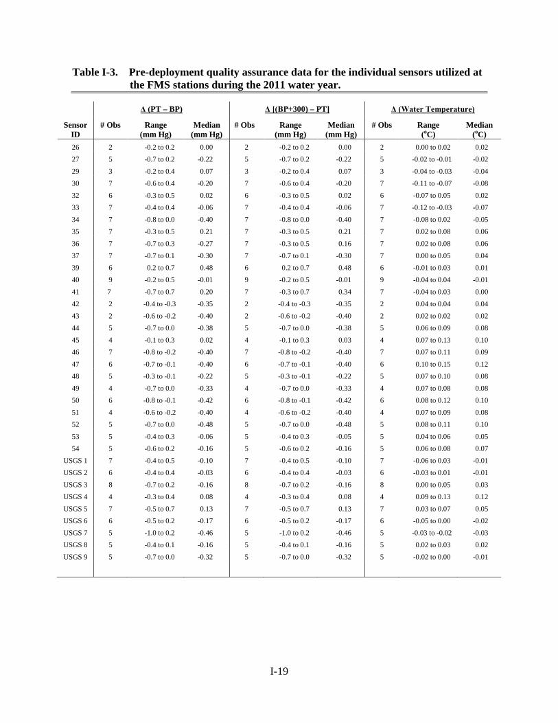
Table I-3. Pre-deployment quality assurance data for the individual sensors utilized at the FMS stations during the 2011 water year.
Δ (PT – BP) Δ [(BP+300) – PT] Δ (Water Temperature)
Sensor ID
# Obs Range (mm Hg)
Median (mm Hg)
# Obs Range (mm Hg)
Median (mm Hg)
# Obs Range (oC)
Median (oC)
26 2 -0.2 to 0.2 0.00 2 -0.2 to 0.2 0.00 2 0.00 to 0.02 0.02 27 5 -0.7 to 0.2 -0.22 5 -0.7 to 0.2 -0.22 5 -0.02 to -0.01 -0.02 29 3 -0.2 to 0.4 0.07 3 -0.2 to 0.4 0.07 3 -0.04 to -0.03 -0.04 30 7 -0.6 to 0.4 -0.20 7 -0.6 to 0.4 -0.20 7 -0.11 to -0.07 -0.08 32 6 -0.3 to 0.5 0.02 6 -0.3 to 0.5 0.02 6 -0.07 to 0.05 0.02 33 7 -0.4 to 0.4 -0.06 7 -0.4 to 0.4 -0.06 7 -0.12 to -0.03 -0.07 34 7 -0.8 to 0.0 -0.40 7 -0.8 to 0.0 -0.40 7 -0.08 to 0.02 -0.05 35 7 -0.3 to 0.5 0.21 7 -0.3 to 0.5 0.21 7 0.02 to 0.08 0.06 36 7 -0.7 to 0.3 -0.27 7 -0.3 to 0.5 0.16 7 0.02 to 0.08 0.06 37 7 -0.7 to 0.1 -0.30 7 -0.7 to 0.1 -0.30 7 0.00 to 0.05 0.04 39 6 0.2 to 0.7 0.48 6 0.2 to 0.7 0.48 6 -0.01 to 0.03 0.01 40 9 -0.2 to 0.5 -0.01 9 -0.2 to 0.5 -0.01 9 -0.04 to 0.04 -0.01 41 7 -0.7 to 0.7 0.20 7 -0.3 to 0.7 0.34 7 -0.04 to 0.03 0.00 42 2 -0.4 to -0.3 -0.35 2 -0.4 to -0.3 -0.35 2 0.04 to 0.04 0.04 43 2 -0.6 to -0.2 -0.40 2 -0.6 to -0.2 -0.40 2 0.02 to 0.02 0.02 44 5 -0.7 to 0.0 -0.38 5 -0.7 to 0.0 -0.38 5 0.06 to 0.09 0.08 45 4 -0.1 to 0.3 0.02 4 -0.1 to 0.3 0.03 4 0.07 to 0.13 0.10 46 7 -0.8 to -0.2 -0.40 7 -0.8 to -0.2 -0.40 7 0.07 to 0.11 0.09 47 6 -0.7 to -0.1 -0.40 6 -0.7 to -0.1 -0.40 6 0.10 to 0.15 0.12 48 5 -0.3 to -0.1 -0.22 5 -0.3 to -0.1 -0.22 5 0.07 to 0.10 0.08 49 4 -0.7 to 0.0 -0.33 4 -0.7 to 0.0 -0.33 4 0.07 to 0.08 0.08 50 6 -0.8 to -0.1 -0.42 6 -0.8 to -0.1 -0.42 6 0.08 to 0.12 0.10 51 4 -0.6 to -0.2 -0.40 4 -0.6 to -0.2 -0.40 4 0.07 to 0.09 0.08 52 5 -0.7 to 0.0 -0.48 5 -0.7 to 0.0 -0.48 5 0.08 to 0.11 0.10 53 5 -0.4 to 0.3 -0.06 5 -0.4 to 0.3 -0.05 5 0.04 to 0.06 0.05 54 5 -0.6 to 0.2 -0.16 5 -0.6 to 0.2 -0.16 5 0.06 to 0.08 0.07
USGS 1 7 -0.4 to 0.5 -0.10 7 -0.4 to 0.5 -0.10 7 -0.06 to 0.03 -0.01 USGS 2 6 -0.4 to 0.4 -0.03 6 -0.4 to 0.4 -0.03 6 -0.03 to 0.01 -0.01 USGS 3 8 -0.7 to 0.2 -0.16 8 -0.7 to 0.2 -0.16 8 0.00 to 0.05 0.03 USGS 4 4 -0.3 to 0.4 0.08 4 -0.3 to 0.4 0.08 4 0.09 to 0.13 0.12 USGS 5 7 -0.5 to 0.7 0.13 7 -0.5 to 0.7 0.13 7 0.03 to 0.07 0.05 USGS 6 6 -0.5 to 0.2 -0.17 6 -0.5 to 0.2 -0.17 6 -0.05 to 0.00 -0.02 USGS 7 5 -1.0 to 0.2 -0.46 5 -1.0 to 0.2 -0.46 5 -0.03 to -0.02 -0.03 USGS 8 5 -0.4 to 0.1 -0.16 5 -0.4 to 0.1 -0.16 5 0.02 to 0.03 0.02 USGS 9 5 -0.7 to 0.0 -0.32 5 -0.7 to 0.0 -0.32 5 -0.02 to 0.00 -0.01

I-20
Table I-4. Post-deployment quality assurance data for the individual sensors utilized at the FMS stations during the 2011 water year.
Δ (BP – PT) Δ [(BP+100) – PT] Δ (Water Temperature)
Sensor ID
# Obs Range (mm Hg)
Median (mm Hg)
# Obs Range (mm Hg)
Median (mm Hg)
# Obs Range (oC)
Median (oC)
26 1 0.6 to 0.6 0.60 1 -0.4 to -4.0 -0.40 1 0.00 to 0.00 0.00 27 5 -0.2 to 0.3 0.02 5 -0.8 to 0.3 0.20 5 -0.07 to -0.04 -0.06 29 2 0.1 to 0.5 0.30 2 0.1 to 0.5 0.30 2 -0.05 to -0.01 -0.03 30 6 -0.5 to 0.7 -0.03 6 -0.5 to 0.7 -0.03 6 -0.13 to -0.05 -0.09 32 6 -0.4 to 0.2 -0.03 6 -0.4 to 0.2 -0.03 6 -0.09 to -0.03 -0.06 33 6 -0.6 to 1.4 0.38 6 -0.8 to 0.8 0.05 6 -0.08 to 0.02 -0.04 34 7 -0.8 to 0.3 -0.21 7 -0.8 to 0.3 -0.21 7 -0.08 to -0.01 -0.04 35 8 -0.4 to 1.0 0.31 8 -0.4 to 0.4 0.06 8 -0.05 to 0.07 0.03 36 6 -0.9 to 0.5 -0.17 6 -0.5 to 0.5 0.00 6 0.01 to 0.05 0.04 37 6 -0.6 to 0.2 -0.17 6 -0.6 to 0.2 -0.17 6 -0.03 to 0.04 0.01 39 6 0.0 to 0.7 0.40 6 0.0 to 0.7 0.38 6 -0.02 to 0.03 0.00 40 7 -0.5 to 0.7 0.40 7 -0.5 to 0.7 0.40 7 -0.04 to 0.00 -0.02 41 7 -0.6 to 0.6 0.04 7 -0.6 to 0.3 -0.10 7 -0.04 to 0.01 -0.01 42 1 -1.3 to -1.3 -1.30 1 -1.3 to -1.3 -1.30 1 0.03 to 0.03 0.03 43 1 -1.0 to -1.0 -1.0 1 0.0 to 0.0 0.00 1 0.00 to 0.00 0.00 44 4 -0.6 to -0.1 -0.30 4 -0.6 to -0.1 -0.30 4 0.04 to 0.07 0.06 45 3 0.0 to 0.2 0.07 3 0.0 to 0.2 0.10 3 -0.08 to 0.13 0.04 46 6 -0.4 to 0.6 -0.05 6 -1.4 to 0.1 -0.40 6 0.07 to 0.10 0.08 47 5 -1.4 to 0.3 -0.58 5 -1.4 to 0.3 -0.38 5 0.08 to 0.13 0.11 48 4 -0.9 to -0.6 -0.10 4 -0.9 to 0.6 -0.10 4 0.06 to 0.07 0.06 49 3 -0.7 to 0.4 -0.30 3 -0.7 to -0.6 -0.60 3 0.07 to 0.09 0.08 50 5 -1.2 to 0.1 -0.62 5 -1.2 to 0.10 -0.62 5 0.11 to 0.14 0.12 51 3 -0.8 to 0.3 -0.13 3 -0.8 to 0.0 -0.13 3 0.03 to 0.07 0.06 52 4 -0.8 to 0.6 -0.17 4 -1.1 to 0.6 -0.42 4 0.07 to 0.11 0.09 53 4 -0.4 to 0.9 0.15 4 -0.4 to 0.1 -0.10 4 0.04 to 0.05 0.05 54 4 -0.8 to 0.3 -0.03 4 -0.8 to 0.3 -0.03 4 0.05 to 0.05 0.05
USGS 1 7 -0.8 to 1.1 0.34 7 -0.8 to 1.1 0.34 7 0.00 to 0.04 0.02 USGS 2 6 -0.2 to 1.1 0.35 6 -0.5 to 1.1 0.18 6 -0.04 to -0.02 -0.03 USGS 3 8 -0.5 to 0.5 0.11 8 -0.5 to 0.5 0.11 8 0.00 to 0.03 0.02 USGS 4 2 -0.3 to -0.1 -0.20 2 -0.3 to -0.1 -0.20 2 0.05 to 0.10 0.08 USGS 5 6 -0.5 to 1.3 0.47 6 -0.6 to 1.3 0.30 6 -0.03 to 0.04 0.01 USGS 6 5 -0.9 to -0.1 -0.44 5 -0.9 to -0.1 -0.44 5 -0.06 to 0.00 -0.03 USGS 7 4 -0.7 to -0.1 -0.43 4 -0.7 to -0.1 -0.43 4 -0.04 to -0.03 -0.03 USGS 8 4 -0.9 to -0.3 -0.38 4 -0.9 to 0.3 -0.38 4 -0.03 to 0.02 0.00
USGS 9 4 -0.7 to 0.2 -0.30 4 -0.8 to -0.1 -0.60 4 -0.06 to -0.01 -0.03
I-21
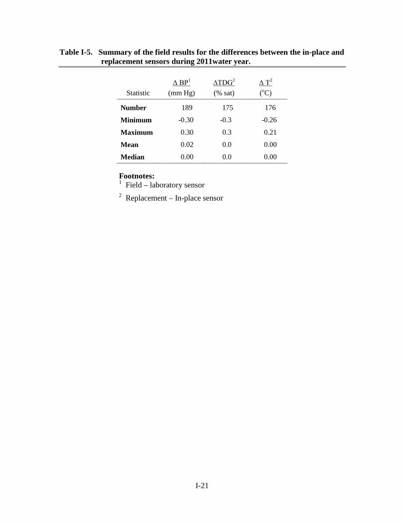
Table I-5. Summary of the field results for the differences between the in-place and replacement sensors during 2011water year.
Statistic Δ BP1 ∆TDG2 Δ T2
(mm Hg) (% sat) (oC)
Number 189 175 176
Minimum -0.30 -0.3 -0.26
Maximum 0.30 0.3 0.21
Mean 0.02 0.0 0.00
Median 0.00 0.0 0.00
Footnotes: 1 Field – laboratory sensor 2 Replacement – In-place sensor
I-22
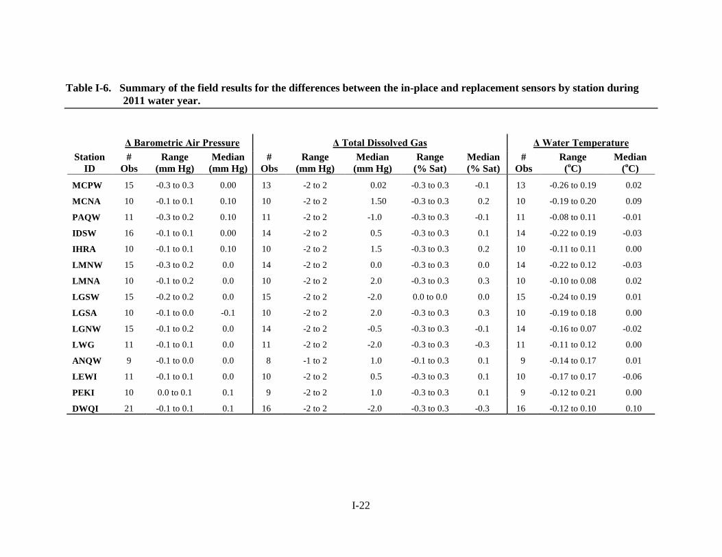
Table I-6. Summary of the field results for the differences between the in-place and replacement sensors by station during 2011 water year.
Δ Barometric Air Pressure Δ Total Dissolved Gas Δ Water Temperature Station
ID #
Obs Range
(mm Hg) Median
(mm Hg) #
Obs Range
(mm Hg) Median
(mm Hg) Range
(% Sat) Median (% Sat)
# Obs
Range (oC)
Median (oC)
MCPW 15 -0.3 to 0.3 0.00 13 -2 to 2 0.02 -0.3 to 0.3 -0.1 13 -0.26 to 0.19 0.02
MCNA 10 -0.1 to 0.1 0.10 10 -2 to 2 1.50 -0.3 to 0.3 0.2 10 -0.19 to 0.20 0.09
PAQW 11 -0.3 to 0.2 0.10 11 -2 to 2 -1.0 -0.3 to 0.3 -0.1 11 -0.08 to 0.11 -0.01
IDSW 16 -0.1 to 0.1 0.00 14 -2 to 2 0.5 -0.3 to 0.3 0.1 14 -0.22 to 0.19 -0.03
IHRA 10 -0.1 to 0.1 0.10 10 -2 to 2 1.5 -0.3 to 0.3 0.2 10 -0.11 to 0.11 0.00
LMNW 15 -0.3 to 0.2 0.0 14 -2 to 2 0.0 -0.3 to 0.3 0.0 14 -0.22 to 0.12 -0.03
LMNA 10 -0.1 to 0.2 0.0 10 -2 to 2 2.0 -0.3 to 0.3 0.3 10 -0.10 to 0.08 0.02
LGSW 15 -0.2 to 0.2 0.0 15 -2 to 2 -2.0 0.0 to 0.0 0.0 15 -0.24 to 0.19 0.01
LGSA 10 -0.1 to 0.0 -0.1 10 -2 to 2 2.0 -0.3 to 0.3 0.3 10 -0.19 to 0.18 0.00
LGNW 15 -0.1 to 0.2 0.0 14 -2 to 2 -0.5 -0.3 to 0.3 -0.1 14 -0.16 to 0.07 -0.02
LWG 11 -0.1 to 0.1 0.0 11 -2 to 2 -2.0 -0.3 to 0.3 -0.3 11 -0.11 to 0.12 0.00
ANQW 9 -0.1 to 0.0 0.0 8 -1 to 2 1.0 -0.1 to 0.3 0.1 9 -0.14 to 0.17 0.01
LEWI 11 -0.1 to 0.1 0.0 10 -2 to 2 0.5 -0.3 to 0.3 0.1 10 -0.17 to 0.17 -0.06
PEKI 10 0.0 to 0.1 0.1 9 -2 to 2 1.0 -0.3 to 0.3 0.1 9 -0.12 to 0.21 0.00
DWQI 21 -0.1 to 0.1 0.1 16 -2 to 2 -2.0 -0.3 to 0.3 -0.3 16 -0.12 to 0.10 0.10
I-23
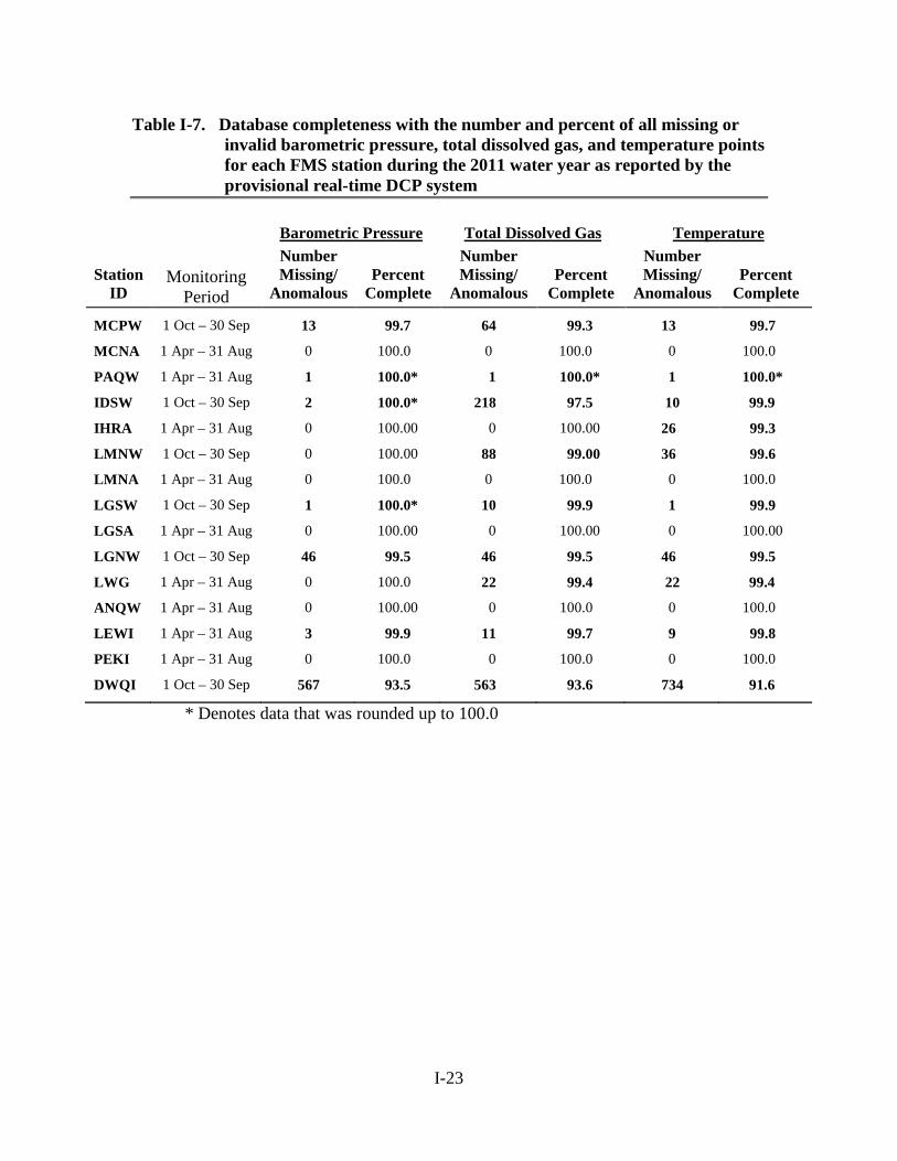
Table I-7. Database completeness with the number and percent of all missing or invalid barometric pressure, total dissolved gas, and temperature points for each FMS station during the 2011 water year as reported by the provisional real-time DCP system
Barometric Pressure Total Dissolved Gas Temperature Station
ID
Monitoring
Period
Number Missing/
Anomalous
Percent
Complete
Number Missing/
Anomalous
Percent
Complete
Number Missing/
Anomalous
Percent
Complete
MCPW 1 Oct – 30 Sep 13 99.7 64 99.3 13 99.7
MCNA 1 Apr – 31 Aug 0 100.0 0 100.0 0 100.0
PAQW 1 Apr – 31 Aug 1 100.0* 1 100.0* 1 100.0*
IDSW 1 Oct – 30 Sep 2 100.0* 218 97.5 10 99.9
IHRA 1 Apr – 31 Aug 0 100.00 0 100.00 26 99.3
LMNW 1 Oct – 30 Sep 0 100.00 88 99.00 36 99.6
LMNA 1 Apr – 31 Aug 0 100.0 0 100.0 0 100.0
LGSW 1 Oct – 30 Sep 1 100.0* 10 99.9 1 99.9
LGSA 1 Apr – 31 Aug 0 100.00 0 100.00 0 100.00
LGNW 1 Oct – 30 Sep 46 99.5 46 99.5 46 99.5
LWG 1 Apr – 31 Aug 0 100.0 22 99.4 22 99.4
ANQW 1 Apr – 31 Aug 0 100.00 0 100.0 0 100.0
LEWI 1 Apr – 31 Aug 3 99.9 11 99.7 9 99.8
PEKI 1 Apr – 31 Aug 0 100.0 0 100.0 0 100.0
DWQI 1 Oct – 30 Sep 567 93.5 563 93.6 734 91.6
* Denotes data that was rounded up to 100.0
I-24
Table I-8. Database completeness with the number and percent of all missing or invalid barometric pressure, total dissolved gas, and temperature points for each FMS station during the 2011 water year as determined after EDL correction.
Barometric Pressure Total Dissolved Gas Temperature Station
ID
Monitoring
Period
Number Missing/
Anomalous
Percent
Complete
Number Missing/
Anomalous
Percent
Complete
Number Missing/
Anomalous
Percent
Complete
MCPW 1 Oct – 30 Sep
13 99.85 62 99.29 13 99.85
MCNA 1 Apr – 31 Aug
100.00 100.00 100.00
PAQW 1 Apr – 31 Aug
100.00 100.00 100.00
IDSW 1 Oct – 30 Sep
1 99.99 207 97.64 1 99.99
IHRA 1 Apr – 31 Aug
100.00 100.00 100.00
LMNW 1 Oct – 30 Sep
100.00 87 99.01 35 99.60
LMNA 1 Apr – 31 Aug
100.00 100.00 100.00
LGSW 1 Oct – 30 Sep
1 99.99 2 99.98 1 99.99
LGSA 1 Apr – 31 Aug
100.00 100.00 100.00
LGNW 1 Oct – 30 Sep
46 99.48 46 99.48 46 99.48
LWG 1 Apr – 31 Aug
100.00 22 99.40 22 99.40
ANQW 1 Apr – 31 Aug
100.00 100.00 100.00
LEWI 1 Apr – 31 Aug
3 99.92 9 99.76 10 99.73
PEKI 1 Apr – 31 Aug
100.00 100.00 132 96.41
DWQI 1 Oct – 30 Sep
558 93.64 539 93.85 722 91.75
I-25
Table I-9. Summary of the total hours of barometric pressure, total dissolved gas, and temperature data that were missing or considered invalid in the 2011 water-year provisional real-time DCP data set.
BP TDG BP+TDG Temperature All
Reason hours % hours % hours % of hours
% of bad data hours % hours %
Defective modem 551 0.64 720 0.84 1271 1.44 64.86 551 0.64 1822 2.13 Missed transmit 12 0.01 12 0.01 24 0.03 1.22 12 0.01 36 0.04 Missing data 11 0.01 11 0.01 22 0.03 1.12 11 0.01 33 0.04 Spike 7 0.01 20 0.02 27 0.03 1.38 12 0.01 39 0.05 Inspection 2 0.00 16 0.02 18 0.02 0.92 3 0.00 21 0.02 Defective membrane 0 438 0.51 438 0.51 22.34 0 438 0.51 Defective sensor 0 0 0 0 0 0 DCP failure 50 0.06 57 0.07 107 0.12 5.46 56 0.07 163 0.19 Cable failure 0 53 0.06 53 0.06 2.70 56 0.07 109 0.13
Totals 632 0.74% 1327 1.55% 1959 2.29% 100.00% 700 0.39% 2660 3.11%

I-26
Table I-10. Summary of the total hours of barometric pressure, total dissolved gas, and temperature data that were missing or considered invalid in the 2011 water-year EDL corrected data set.
BP TDG BP+TDG Temperature All
Reason hours percent hours percent hours Percent of hours
Percent of bad data hours percent hours percent
Defective modem 529 0.62 708 0.83 1237 1.44 65.26 529 0.62 1766 2.06 Missed xmit 12 0.01 12 0.01 24 0.03 1.26 12 0.01 36 0.04 Missing data 8 0.01 11 0.01 19 0.02 1.00 10 0.01 29 0.03 Spike 5 0.01 10 0.01 15 0.02 0.79 2 0.00 17 0.02 Inspection 1 0.00 1 0.00 2 0.00 0.11 1 0.00 3 0.00 Defective membrane 0 438 0.51 438 0.51 23.05 0 438 0.51 Defective sensor 0 0 0 0 0 DCP failure 54 0.06 57 0.07 111 0.13 5.84 43 0.05 154 0.16 Cable failure 0 53 0.06 53 0.06 2.79 56 0.07 109 0.13
Totals 609 0.71 1290 1.51 1898 2.22 98.21 652 0.76 2551 2.98

I-27
Table I-11. Number and percent of all missing or invalid barometric pressure data for each FMS station during the 2011 water year based on the provisional real-time DCP data set, along with the reasons for those designations.
Station ID
Cable Failure
Modem Failure Missed
Transmit
Spike Routine
Maintenance Defective
Membrane Defective Sensor
DCP Failure
Missing DCP Data
# % # % # % # % # % # % # % # % # %
MCPW - - - - - - 2 0.02 - - - - - - - - - -
MCNA - - - - - - - - - - - - - - - - - -
PAQW - - - - - - - - 1 0.03 - - - - - - - -
IDSW - - - - - - 2 0.02 - - - - - - - - - -
IHRA - - - - - - - - - - - - - - - - - -
LMNW - - - - - - - - - - - - - - - - - -
LMNA - - - - - - - - - - - - - - - - - -
LGSW - - - - - - - - - - - - - - - - 1 0.01
LGSA - - - - - - - - - - - - - - - - - -
LGNW - - - - 12 0.14 - - - - - - - - 34 0.39 - -
LWG - - - - - - - - - - - - - - - -
ANQW - - - - - - - - - - - - - - - - - -
LEWI - - - - - - - - - - - - - - 3 0.08 - -
PEKI - - - - - - - - - - - - - - - - - -
DWQI - - 551 6.28 - - 5 0.06 1 0.01 - - - - - - 10 0.11
I-28
Table I-12. Number and percent of all missing or invalid barometric pressure data for each FMS station during the 2011 water year based on the EDL corrected data set, along with the reasons for those designations.
Station ID
Cable Failure
Modem Failure Missed
Transmit
Spike Routine
Maintenance Defective
Membrane Defective Sensor
DCP Failure
Missing DCP Data
# % # % # % # % # % # % # % # % # %
MCPW - - - - - - - - - - - - - - - - - -
MCNA - - - - - - - - - - - - - - - - - -
PAQW - - - - - - - - - - - - - - - - - -
IDSW - - - - - - 1 0.01 - - - - - - - - - -
IHRA - - - - - - - - - - - - - - - - - -
LMNW - - - - - - - - - - - - - - - - - -
LMNA - - - - - - - - - - - - - - - - - -
LGSW - - - - - - - - - - - - - - - - 1 0.01
LGSA - - - - - - - - - - - - - - - - - -
LGNW - - - - 12 0.14 - - - - - - - - 34 0.39 - -
LWG - - - - - - - - - - - - - - - - - -
ANQW - - - - - - - - - - - - - - - - - -
LEWI - - - - - - - - - - - - - - 3 0.08 - -
PEKI - - - - - - - - - - - - - - - - - -
DWQI - - 529 6.03 - - 4 0.05 1 0.01 - - - - 17 0.46 7 0.08
I-29
Table I-13. Number and percent of all missing or invalid total dissolved gas data for each FMS station during the 2011 water year based on the provisional real-time DCP data set, along with the reasons for those designations.
Station ID
Cable Failure
Modem Failure Missed
Transmit
Spike Routine
Maintenance Defective
Membrane Defective Sensor
DCP Failure
Missing DCP Data
# % # % # % # % # % # % # % # % # %
MCPW - - - - - - - - 2 0.02 - - - - - - - -
MCNA - - - - - - - - - - - - - - - - - -
PAQW - - - - - - - - 1 0.03 - - - - - - - -
IDSW - - - - - - 14 0.16 1 0.03 203 2.32 - - - - - -
IHRA - - - - - - - - - - - - - - - - - -
LMNW 31 0.35 - - - - 2 0.02 1 0.01 54 0.62 - - - - - -
LMNA - - - - - - - - - - - - - - - - - -
LGSW - - - - - - 1 0.01 8 0.09 - - - - - - 1 0.01
LGSA - - - - - - - - - - - - - - - - - -
LGNW - - - - 12 0.14 - - - - - - - - 34 0.39 - -
LWG 22 0.60 - - - - - - - - - - - - - - - -
ANQW - - - - - - - - - - - - - - - - - -
LEWI - - - - - - - - 1 0.03 - - - - 10 0.27 - -
PEKI - - - - - - - - 1 0.03 132 3.59 - - - - - -
DWQI - - 720 8.22 - - 3 0.03 1 0.01 - - - - - - 10 0.11
I-30
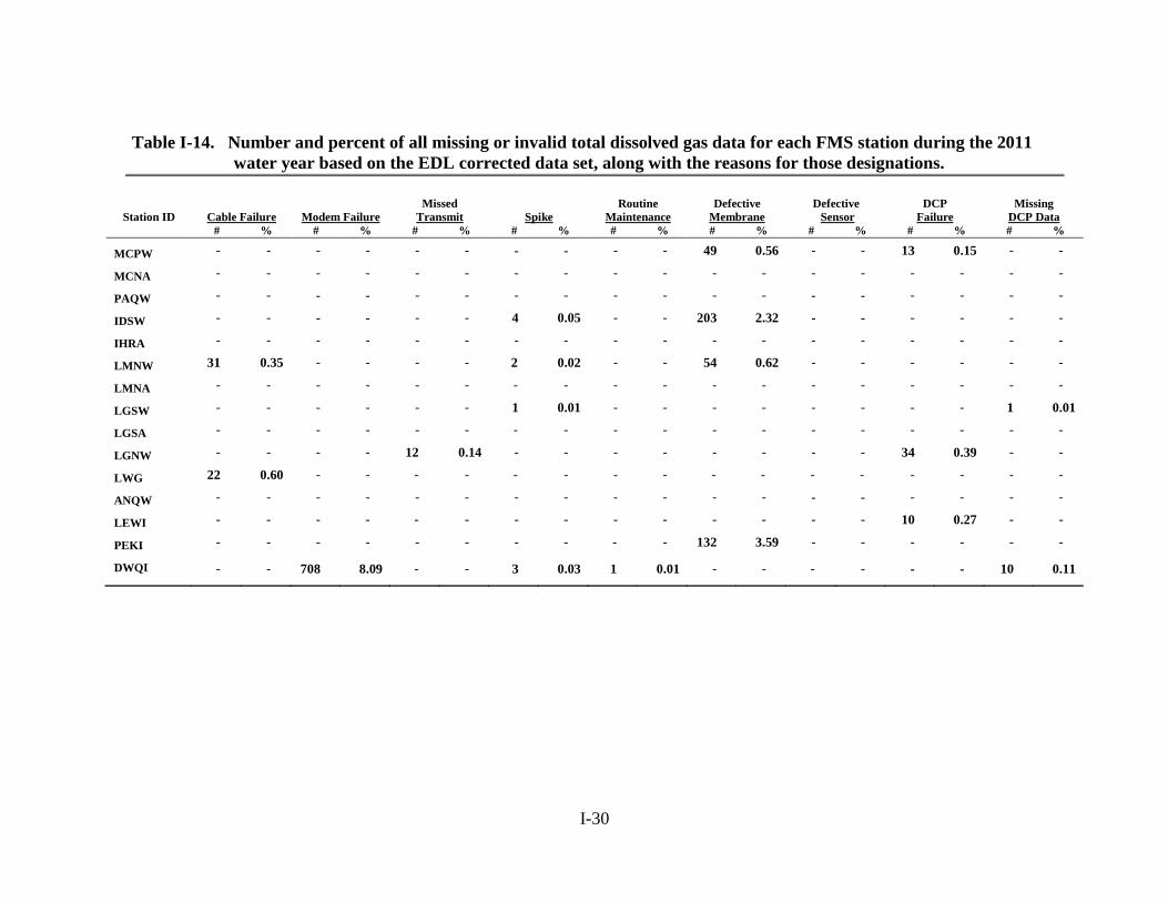
Table I-14. Number and percent of all missing or invalid total dissolved gas data for each FMS station during the 2011 water year based on the EDL corrected data set, along with the reasons for those designations.
Station ID
Cable Failure
Modem Failure Missed
Transmit
Spike Routine
Maintenance Defective
Membrane Defective Sensor
DCP Failure
Missing DCP Data
# % # % # % # % # % # % # % # % # %
MCPW - - - - - - - - - - 49 0.56 - - 13 0.15 - -
MCNA - - - - - - - - - - - - - - - - - -
PAQW - - - - - - - - - - - - - - - - - -
IDSW - - - - - - 4 0.05 - - 203 2.32 - - - - - -
IHRA - - - - - - - - - - - - - - - - - -
LMNW 31 0.35 - - - - 2 0.02 - - 54 0.62 - - - - - -
LMNA - - - - - - - - - - - - - - - - - -
LGSW - - - - - - 1 0.01 - - - - - - - - 1 0.01
LGSA - - - - - - - - - - - - - - - - - -
LGNW - - - - 12 0.14 - - - - - - - - 34 0.39 - -
LWG 22 0.60 - - - - - - - - - - - - - - - -
ANQW - - - - - - - - - - - - - - - - - -
LEWI - - - - - - - - - - - - - - 10 0.27 - -
PEKI - - - - - - - - - - 132 3.59 - - - - - -
DWQI - - 708 8.09 - - 3 0.03 1 0.01 - - - - - - 10 0.11

I-31
Table I-15. Number and percent of all missing or invalid temperature data for each FMS station during the 2011 water year based on the provisional real-time DCP data, along with the reasons for those designations.
Station ID
Cable Failure
Modem Failure Missed
Transmit
Spike Routine
Maintenance Defective
Membrane Defective Sensor
DCP Failure
Missing DCP Data
# % # % # % # % # % # % # % # % # %
MCPW - - - - - - - - - - - - - - 13 0.15 - -
MCNA - - - - - - - - - - - - - - - - - -
PAQW - - - - - - - - 1 0.03 - - - - - - - -
IDSW - - - - - - 9 0.01 1 0.01 - - - - - - - -
IHRA - - - - - - - - - - - - - - - - - -
LMNW 36 0.41 - - - - 2 0.02 - - - - - - - - - -
LMNA - - - - - - - - - - - - - - - - - -
LGSW - - - - - - - - - - - - - - - - 1 0.01
LGSA - - - - - - - - - - - - - - - - - -
LGNW - - - - 12 0.14 - - - - - - - - 34 0.39 - -
LWG 22 0.60 - - - - - - - - - - - - - - -
ANQW - - - - - - - - - - - - - - - - - -
LEWI - - - - - - - - - - - - - - 9 0.24 - -
PEKI - - - - - - - - - - - - - - - - - -
DWQI - - 551 6.09 - - 1 0.01 1 0.01 - - - - - - 10 0.11
I-32
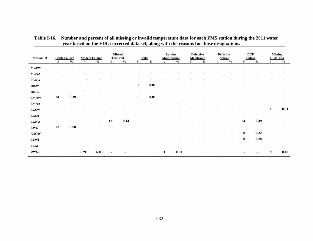
Table I-16. Number and percent of all missing or invalid temperature data for each FMS station during the 2011 water year based on the EDL corrected data set, along with the reasons for those designations.
Station ID
Cable Failure
Modem Failure Missed
Transmit
Spike Routine
Maintenance Defective
Membrane Defective Sensor
DCP Failure
Missing DCP Data
# % # % # % # % # % # % # % # % # %
MCPW - - - - - - - - - - - - - - - - - -
MCNA - - - - - - - - - - - - - - - - - -
PAQW - - - - - - - - - - - - - - - - - -
IDSW - - - - - - 1 0.01 - - - - - - - - - -
IHRA - - - - - - - - - - - - - - - - - -
LMNW 34 0.39 - - - - 1 0.01 - - - - - - - - - -
LMNA - - - - - - - - - - - - - - - - - -
LGSW - - - - - - - - - - - - - - - - 1 0.01
LGSA - - - - - - - - - - - - - - - - - -
LGNW - - - - 12 0.14 - - - - - - - - 34 0.39 - -
LWG 22 0.60 - - - - - - - - - - - - - - - -
ANQW - - - - - - - - - - - - - - 8 0.22 - -
LEWI - - - - - - - - - - - - - - 9 0.24 - -
PEKI - - - - - - - - - - - - - - - - - -
DWQI - - 529 6.03 - - - - 1 0.01 - - - - - - 9 0.10