APPENDIX G Federal and State Regulatory Databases · INDIAN LUST___ Leaking Underground storage...
146
APPENDIX G Federal and State Regulatory Databases
-
Upload
phamnguyet -
Category
Documents
-
view
214 -
download
0
Transcript of APPENDIX G Federal and State Regulatory Databases · INDIAN LUST___ Leaking Underground storage...

APPENDIX G
Federal and State Regulatory Databases

Fire Station #5McDermott DriveAl len. TX 75013
Inqui ry Number: 2681 868. 1sJanuary 20,2010
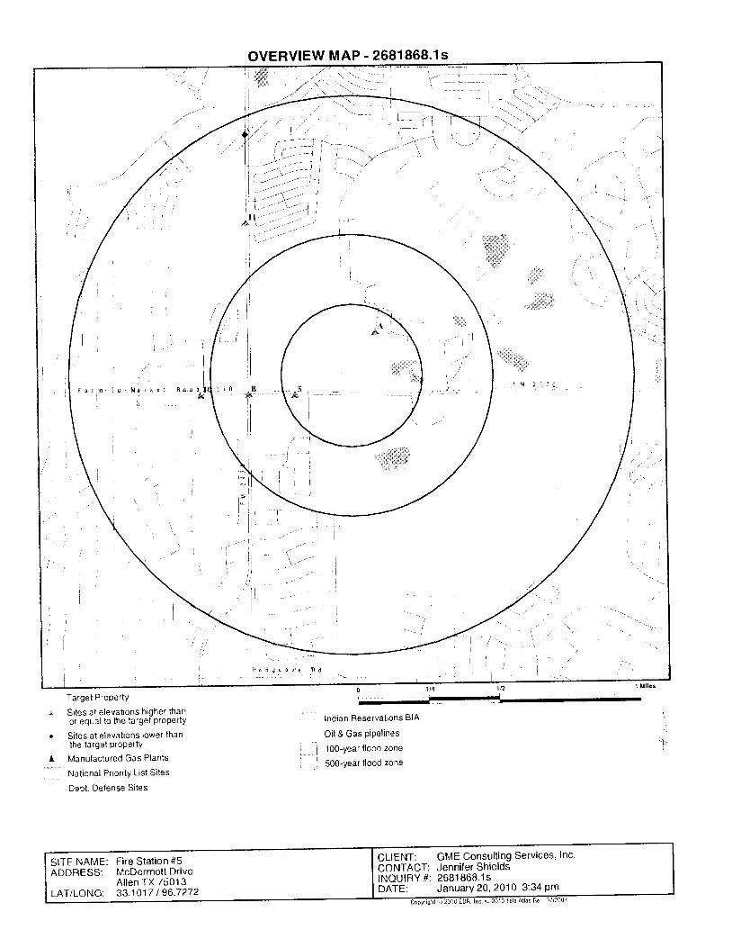
Target Property
Si tes at e levat ions higher thanor equal to the target ProPerty
Si tes at e levat ions lower thanthB target property
Manulactured Gas Plants
Nat ional Pr ior i ty L ist Si tes
Dept. Delense Si tes
OVERVIEW MAP - 2681868.1s
Indian Reservat ions BIA
Oi l & Gas piPel ines
100-year f lood zone
500-year flood zone
'I
, ]_i
l J o d g c o r l e h d
CLIENT: GME Consulting Services, Inc'CONTACT: Jennifer ShieldsINQUIFY #: 2681 868.1 sDATE: JanuarY 20,2A10 3:34 Pm
SITE NAME: Fire Stalion #5ADDRESS: McDermottDrive
Al len TX 75013LAT/LONG: 33.1017 I 96.7272

TABLE OF CONTENTS
SECTION PAGE
Execut ive Summary- ES1
2Overview Map-
Detai l Map
Map Findings Summary- - -
M a p F i n d i n g s - - - -
Orphan Summary
Zip Scan Report ztP-1
3
4
7
38
Government Records Searched/Data Currency Tracking
GEOCHECK ADDENDUM
GR-1
Physical Setting Source Addendum,
Physical Setting Source Summary- - - -
Physical Set t ing SSURGO Soi l MaP
Physical Setting Source MaP- ,
Physical Set t ing Source Map Findings- - - - -
Physical Setting Source Records Searched
Thank you for Your busrness'Please coniact EDR at 1-800-352-0050
with any questions or comments.
A-1
A-2
A-5
A-10
A-11
A-24
I hrs Repon conlarns cenarn rrrrorrlratrurr uurdrrrsu "-"' i:t'c3";ii,i,i'i"r"irn"ti.:i" tJitne target and sunoundrng_prope-4rg:-q-o-e-:.!ot exist fromnu.ouii"", Inc. lt cannot be concluded from this Report.tlother sources. Ho wannarrVtx"iir-els'in- oi i-
' L-rEo, r5'ilib"e WiiiSoilEc ri,r conruEcrr6t wlrH rHls REPdRT' ENVIRoNMENTAL
DATA REsouRces, tHc. specrRCalt-v otsclatus rne uaiiHc or ANy sucH wARRANTIES, lNcLuolNG wlrHour LlMlrATloN'
MER.HANTABTLTTv on rrrruess'ioi l panlcuLAR usE d'iipuniose, ALL RtsK ls AssuMED BY THE usER lN No EVENT SHALL
ENVTRoNMENTAL DATA REsouRcEs, tNc. BE LTABLE To nrlvoNi, wxirHER ARlslNG our oF ERRoRS oR oMlssloNs' NEGLIGENcE'
ACCIDENT OR ANY OTHER CAUSE, FOR ANY LOSS OF DAMAGE, IHCI-UOIHG' WTXO-U_T.LIM|TATION' SPECIAL' INCIDENTAL'
coNSEeuENTIAL, oR ExEMpLAai oeuaces. eHv r-reerL;ioii rie penr'or ENvtRoNMENTAL DATA REsouRcEs, lNc ls srRlcrLY
LtMlrED ro A REFUND oF rHE AMouNr PAID FoR rHls qeoii i;;t'h;;t;;*pts this Repon'A! E,..try""lfly:es' estimates' ratings'
environmentat risk tevets or risk codes provided in this Rep6rt are prouio"c ior iliuslrative plrposes only!?,n9-?',1lot intended to provrde' nor
shou ld theybe in te rp re tedasp rov id i ngany . f ac t s rega rd in ! , o r -p reb i " t i ono r f o recas to f , anye inv i r onmeh ta l r i s k fo ranyp rope r t y on l ya .Phase I
Environmentar site Assessment performed by an envrronribnidj proG"l'onal can provide rhformation regarding lhe environmental rlsK tor any
pi"ril.tv 'Xo}ii"iiiriv,
tn"i"r.iri-r5t'lon prouio.jo in this Report is nbt to be construed as legal advice'
copyright 2010 by Envrronmental Data Resources, Inc.All rights reserved' Rep-roduction in any media or format' in whole
or in part, of any report or map of Environmental oata nesouilei, r^.., "iit"
iintiates, is prohi6ited without prior written perm'ssion'
Discla imer ' Copyr ight and Trademark Not ice
rhis Report contains certain information-obtained frot 9.Y"1'9tv 9lfy!ri:.?I:ll:'.::.'J:::j^"st:lf:Y,1Y?l',?,?': I?S:IJ|.':lffJi"lf;ii
EDR and its togos (inctuding Sanborn and Sanborn Mq) ?rg ll3^d_9.arks of Environmental Data Resources, Inc or its affiliates All other
trademarks us;d h6rein are the property ell lheillsspecllle iv/rlels'
TC2681868.1s Page 1
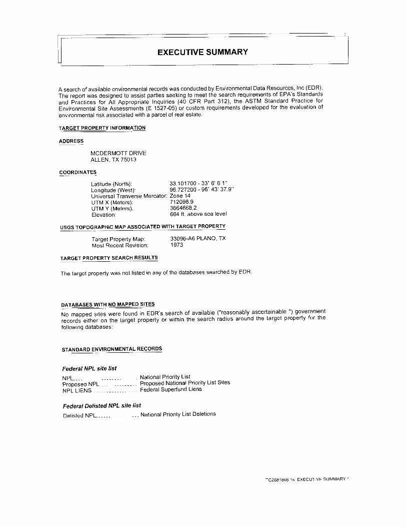
EXECUTIVE SUMMARY
A search of available environmental records was conducted by Environmental Data Resources, Inc (EDR).The report was designed to assist parties seeking to meet the search requirements of EPA's Standardsand p iact ices for Al l Appropr iate Inqui r ies (40 CFR Part 312) , the ASTM Standard Pract ice forEnvironmental Site Assessments (E 1527-OS) or custom requirements developed for the evaluation ofenvironmental risk associated with a parcel of real estate.
TARGET PROPERTY IN
ADDRESS
MCDERMOTT DRIVEALLEN, TX 75013
COORDINATES
Lat i tude (North) : 33.101700 - 33 '6 '6 1"Longitude (West): 96 727200 - 96" 43' 37 9"Universal Tranverse Mercator: Zone 14UTM X (Meters): 712098.9UTM Y (Meters): 3664668.2Elevation: 664 ft. above sea level
USGS TOPOGRAPHIC MAP ASSOCIATED WITH TARGET PROPERTY
Target Property Map: 33096-A6 PLANO' TXMost Recent Revision: 1973
TARGET PROPERTY SEARCH RESULTS
The target property was not l isted in any of the databases searched by EDR'
DATABASES WITH NO MAPPEO SIIES
No mapped sites were found in EDR's search of available ("re-asonably ascertainable ") government
records either on tne taiget property or within the search iadius around the target property for the
following databases:
STANDARD ENVIRONMENTAL RECORDS
Federal NPL site list
NPL-, - - - - - Nat ional Pr ior i tyL is tProoosed NPL Proposed National Priority List SitesNPL LIENS - - Federal Superfund Liens
Federal Delisted NPL sife list
Delisted NPL National Priority List Deletions
TC2681868,1S EXECUTIVE SUMMARY ,1

EXECUTIVE SUMMARY
Federal CERCLrS rtst
CERCLIS_ _ _ _ _ - Comprehensive Environmental Response, Compensation, and Liabil ity Information SystemFEDERAL FACILITY--- - - - , - Federal Faci l i ty Si te Informat ion l is t ing
Federal CERCLTS NFRAP sife List
CERC-NFRAP -- - - - - - CERCLIS No Further Remedia l Act ion Planned
Federal RCRA CORRACTS facilities list
CORRACTS Corrective Action Report
Federal RCRA non-CORRACIS TSD facilities list
RCRA-TSDF RCRA - Treatment, Storage and Disposal
Federal RCRA generators /ist
RCRA-LQG RCRA - Large Quantity GeneratorsRCRA-SQG - - RCRA - Small Quantity GeneratorsRCRA-CESQG RCRA - Conditionally Exempt small Quantity Generator
Federal institutional controls / engineering controls registries
US ENG CONTROLS- ,----- Engineering Controls Sites ListUS INST CONTROL ,, - - -, Sites with Institutional Controls
Federal ERNS list
ERNS- - Emergency Response Notif ication System
State- and tribal - equivalent NPL
SHWS State Superfund Registry
State and tribal landfill and/or solid waste disposal site /ists
CLI - - - - - - - - C losedLandf l l l InventoryWasteMgL Commercial Hazardous & Solid Waste Management Faci l i t ies
Sfate and tribal leaking storage tank lisfs
LPST-- - - - - - - - Leak ing Pet ro leum Storage Tank L is t ingINDIAN LUST___ Leaking Underground storage Tanks on Indian Land
State and triba! registered storage tank lists
AST , - Petroleum Storage Tank Database
INDIAN UST Underground Storage Tanks on Indian Land
FEMA UST -. Underground Storage Tank List ing
state and tribat institutional control / engineering control registries
A U L - - - - - - - S i t e s w i t h C o n t r o l s
TC2681868.1s EXECUTIVE SUMMARY 2

EXECUTIVE SUMMARY
State and tribal voluntary cleanup sites
INDIAN VCP , Voluntary Cleanup Priority ListingVCP--- - - - , - - - Voluntary Cleanup Program Database
State and tribal Brownfields sites
BROWNFIELDS --- . Brownfields Site Assessments
ADDITIONAL ENVIRONMENTAL RECORDS
Local Brownfield lists
US BROWNFIELDS-
US CDLDEL SHWSPRIORITYCLEANERS- - -US HIST CDL
Local Land Records
L IENS 2 .LUCISLIENSHIST L IENS
RCRA-NonGen , - - - -DOT OPS-
A List ino of Brownfields Sites
Local Lists of Landfill / Solid Waste Disposal Sites
ODI - - - - Open Dump InventoryDEBRIS REGION I - - - Torres Martinez Reservation l l legal Dump Site Locations
Local Lists of Hazardous waste / Contamrnafed Sites
Clandestine Drug LabsDeleted Superfund Registry SitesDry Cleaner Remediation Program Priorit ization ListNational Clandestine Laboratory Register
CERCLA Lien InformationLand Use Control lnformation SystemEnvironmental Liens ListingEnvironmental Liens Listing
Records of Emergency Release Reporfs
HMIRS Hazardous Materials Information Reporting SystemSPILLS - SPills Database
Oth er A sc e rta i n ab I e Record s
- - - - - . RCRA- Non Genera tors- - - Incident and Accident Data
DOD- - - - Department of Defense SitesFUDS- - - Formerlv Used Defense SitesCONSENT- , - - - Superfund (CERCLA) Consent DecreesR O D - - - , , - - - - - - - - - R e c o r d s O f D e c i s i o nUMTRA, - Uran ium Mi l l Ta i l ings S i tesM I N E S Mines Master Index Fi leTRIS- . - - - - - - - - Tox ic Chemica l Re lease Inventory Sys tem
TSCA - - - Toxic Substances Control Act
FTTS FIFRAJ TSCA Tracking System - FIFRA (Federal Insecticide, Fungicide, & Rodenticide
AcIVTSCA (Toxic Substances Control Act)
TC2681868.1s EXECUTIVE SUMMARY 3
EXECUTIVE SUMMARY
HIST FTTS FIFRA/TSCA Tracking System Administrative Case ListingSSTS , - Sect ionTTrackingSystemslClS ---- Integrated Compliance Information SystemPADS--- - - - - , - " PCB Act iv i tv Database SvstemMLTS . . Material Licensing Tracking SystemRADINFO -- - - - Radiat ion Informat ion DatabaseRAATS- RCRA Administrative Action Tracking SystemtoPUIC
I nnocent Owner/Operator ProgramUnderground Injection Wells Database Listing
DRYCLEANERS- Drycleaner Registration Database Listinglnd. Haz Waste-- - - - - Industr ia l & Hazardous Waste DatabaseEDAQUIF - - - - - EdwardsAqui ferPermi tsAIRS Current Emission Inventory DataUSD - Municipal Settings Designations DatabaseRWS- ---- Radioactive Waste SitesINDIAN RESERV -- - - - - - - - - Indian Reservat ionsSCRD DRYCLEANERS---- - State Coalit ion for Remediation of Drycleaners ListingCOAL ASH EPA- , - - - - - - , Coal Combust ion Residues Surface lmpoundments L is tPCB TRANSFORMER--- -, --. PCB Transformer Registration DatabaseCOAL ASH DOE Sleam-Electric Plan Operation Data
EDR PROPRIETARY RECORDS
EDR Proprietary Records
Manufactured Gas Plants----- EDR Proprietary Manufactured Gas PlantsEDR Historical Auto Stations- EDR Proprietary Historic Gas StationsEDR Historical Cleaners- - - - - EDR Proprietary Historic Dry Cleaners
Surrounding sites were identif ied in the following databases.
Elevations have been determined from the USGS Digital Elevation Model and should be evaluated ona relative (not an absolute) basis. Relative elevation information between sites of close proximityshould be i ield verif ied. Sites with an elevation equal to or higher than the target property have beendifferentiated below from sites with an elevation lower than the target property.page numbers and map identif ication numbers refer to the EDR Radius Map report where detaileddata on individual sites can be reviewed.
Sites l isted in bold italics are in multiple databases.
Unmappable (orphan) sites are not considered in the foregoing analysis'
STAN DARD ENVIRONMENTAL RECORDS
State and tribal tandfitt and/or solid wasfe disposal sife lists
SWF/LF: The solid waste Facil it ies/Landfil l sites records typically contain an inventory of solid
waste disposal facil i t ies or landfi l ls in a particular state. The data come from the Texas Commission on
Environmental Quality's permitted Solid Waste Facil it ies l ist
A review of the SWF/LF list, as provided by EDR, and dated 1110512009 has revealed that there is 1
IC2681868.1s EXECUTIVE SUMMARY 4

EXECUTIVE SUMMARY
Direction / Distance Map lD Page
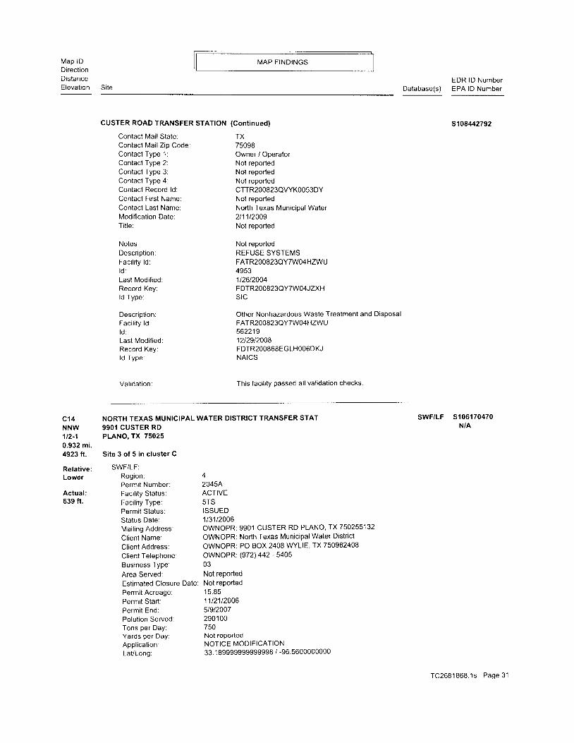
NORTH TEXAS MUNICIPALWATER DI 9901 CUSTER RD NNW 1 /2 - 1 ( 0 .932 m i . ) C14 J I
State and tribal registered storage tank lists
UST: The Underground Storage Tank database contains registered USTs. USTs are regulated underSubtit le I of the Resource Conservation and Recovery Act (RCRA). The data come from the Texas Commission onEnvironmental Quality's Petroleum Storage Tank Database.
A review of the UST list, as provided by EDR, and dated 1110512009 has revealed that there are 3 USTsites within approximately 1 mile of the target property.
Equal/Higher Elevation Address Direction / Distance Map lD Page
SWF/LF site within approximately 1 mile
Lower Elevation
TETCO 653TETCO 643
Lower Elevation
TWIN CREEKS 7D-1TWIN CREEKS PHASE 6CTOLL TX IV TWIN CREEK PHASE 68TOLL TX IV TWIN CREEKS AT SOMEPRASLA CLEANERSTETCO 653TETCO 643MMWELL CLEANERSMANSIONS AT RIDGEVIEW RANCH
Lower Elevation
of the target property
Address
,105 S CUSTER RD22OO MCDERMOTT RD
Address
401 BRMORIA DR401 BRAZORIA DR
105 S CUSTER RD22OO MCDERMOTT RD
W 114 - 112 (0 .359 mi . ) a7W 114 - 112 (0 .371 mi . ) 88
Direction / Distance Map lD
W 114 - 112 (0 .359 mi . )W 114 - 112 (0 .371 mi . )
I1 4
Page
CUSTER ROAD TRANSFER STATION 9901 CUSTER RD NNW 1/2 - 1 (0 932 mi . ) C15
ADDITIONAL ENVIRONMENTAL RECORDS
Oth e r A sce rta i n a b I e Records
FINDS: The Faci l i ty Index System contains both faci l i ty information and "pointers" to othersources of information that iontain more detai l . These include: RCRIS; Permit Compliance System (PCS);
Aerometric Information Retr ieval System (AIRS); FATES (FIFRA [Federal Insecticide Fungicide Rodenticide Act]
and TSCA Enforcement System, FTTS [FIFRA/TSCA Tracking System]; CERCLIS; DOCKET (Enforcement Docket used to
manage and track information on civi l judicial enforcement cases for al l environmental statutes); Federal
Under"ground Inject ion Control (FURS); Federal Report ing Data System (FRDS); Surface lmpoundments (SlA); TSCA
Chemicals in Commerce Information System (CICS); PADS; RCRA-J (medical waste transporters/disposers); TRIS;
and TSCA. The source of this database is the U.S. EPAJNTIS.
A review of the FINDS l ist, as provided by EDR, and dated 10/19/2009 has revealed that there are 10
FINDS sites within approximately 1 mile of the target property'
Equal/Higher Elevation Address Direction / Distance MaP lD Page
NNE 1 /8 - 1 /4 (0 .176 mi )N N E 1 / 8 - 1 / 4 ( 0 . 1 7 6 m i . )
1847 NUECES DR NE ' 1 l 8 - 1 / 4 ( 0 181 m i )1847 NUECES DR NE 1 /8 - 1 / 4 ( 0 .181 m i . )
2023W MCDERMOTT DR STE WSW 1/8 - 1/4 (0.211 mi )
A2A3A45B6B91 01 1
2300 NICDERMOTT RD STE 3 W 1/2 - 1 (0 539 mi )9601 CUSTER RD NW 1/2 - 1 (0.659 mi.)
Address Direction / Distance Map lD
NNW 1/2 - 1 (0 .937 mi . ) C l6
777888'19
1 920
Page
CUSTER SOLID WASTE TRANSFER ST 9901 CUSTER RD
TC2681868.1s EXECUTIVE SUMMARY 5

EXECUTIVE SUMMARY
ENF: Administrative Orders issued to Municipal Solid Waste, Petroleum Storage Tank andMulti-Media Sites
A reviewof the ENF list, as provided by EDR, and dated 1210212009 has revealed thatthere is 1 ENFsite within approximately 1 mile of the target property.
Lower Elevation Address Direction / Distance Map lD Page
CUSTER SOLID WASTE TRANSFER ST 9901 CUSTER RD NNW 1/2 - 1 (0.932 mi.) C12 20
TIER 2: A l ist ing of faci l i t ies which store or manufacture hazardous materials and submit achemical inventory report.
A review of the TIER 2 l ist, as provided by EDR, and dated 1213112008 has revealed that there is 1TIER 2 site within approximately 1 mile of the target property.
Lower Elevation Address Direction / Distance Map lD Page
CUSTER ROAD TRANSFER STATION 9901 CUSTER ROAD NNW 1/2 - 1 (0 932 mi ) C13 21
TC2681868.1s EXECUTIVE SUMMARY 6

EXECUTIVE SUMMARY
Due to poor or inadequate address information, the following sites were not mapped:
Si te Name Database(s)
CUSTER pUMp STAT;O5I TIER 2
COMET CLEANERS DRYCLEANERS
EXCEL CLEANERS 1OO DRYCLEANERS
PRASLA CLEANERS DRYCLEANERS
DRYTECH CLEANERS DRYCLEANERS
MAXWELL CLEANERS DRYCLEANERS
METRO ENVIRONMENTAL MANAGEMENT LAN SWF/LF
J9HNS9N RANCH LPST
2460 HWY 121 RCRA-NonGen
CALALLEN WATER PUMP STATION, CELAN SPILLS
CALALLEN PUMP STATION FOR RAW WATE SPILLS
0.5 MI, S OF INTERSECTION OF DEN4OR SPILLS
TC2681868.1S EXECUTIVE SUMMARY 7

DETAIL MAP - 2681868.1s
1 /4 t l l l c6
Target Property
Si tes at e levat ions higher thanor equal to the target ProPerty
Si tes at e levat ions lower thanthe target property
Manufactured Gas Plants
Sensi t ive Receptors
National Priority List Sites
Dept, Defense Si tes
Indian Reservat ions BIA
Oi l & Gas pipel ines
1 00-year f lood zone
500-year flood zonel
'-''','.':
CLIENT: GME Consulting Services, lnc.CONTACT: Jenniler ShieldsINQUIRY #: 2681868.1sDATE: JanuarY20,2010 3:34 Pm
SITE NAME: Fire Stalion #5ADDRESS: McDermottDrive
Al len TX 75013LAT/LONG: 33.1017 I 96.7272

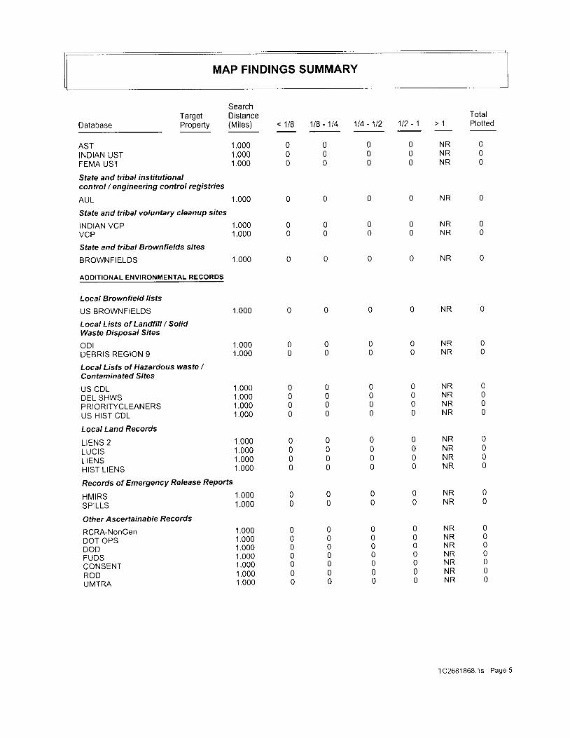
MAP FINDINGS SUMMARY
SearchTarget Distance TotalP r o - p e r t y ( M i l e s ) < 1 l B 1 1 8 - 1 1 4 1 1 4 - 1 1 2 1 1 2 - 1 > 1 P l o t t e dDatabase
STANDARD ENVIRONMENTAL RECORDS
Federal NPL site /ist
NPL 1 .OOO 0 0 0 0 NR 0
ProposedNPl 1 .000 O 0 0 0 NR 0
N P L L I E N S 1 . O O O O O O O N R O
Federal Delisted NPL site list
D e l i s t e d N P L 1 . O O O 0 0 0 0 N R 0
Federal CERCLrS rrsf
C E R C L I S 1 . 0 0 0 0 0 0 0 N R 0
FEDERALFACIL I ry I .OOO O O O O NR O
Federal CERCITS NFRAP site List
CERC-NFRAP I .OOO O O O O NR O
Federal RCRA CORRACTS facilities list
CORRACTS 1 .OOO O O O O NR O
Federat RCRA non-CORRACfS TSD facilities list
RCRA-TSDF 1 .OOO O O O O NR O
Federal RCRA generafors list
RCRA-LQG 1.OOO O O O O NR O
RCRA-SQG 1.OOO O O O O NR O
RCRA-CESQG 1.OOO O O O O NR O
Federal institutional controls /e n g i n ee ri ng co ntro I s reg i stri es
US ENG CONTROLS 1 .OOO O O O O NR O
US INST CONTROL 1 .OOO O O O O NR O
Federal ERNS ,rsf
ERNS 1 .000 o 0 0 0 NR 0
State- and tribal - equivalent NPL
SHWS 1.000 o 0 0 0 NR 0
State and tribal landfill and/orsolid waste disposa/ sife lisfs
swF/LF 1 .OOO 0 0 0 1 NR 1
c l l 1 . 0 0 0 o 0 0 0 N R 0
WasteMgt 1.000 O 0 0 0 NR 0
State and tribal leaking storage tank lists
LPST 1 .000 0 0 0 0 NR 0
I N D I A N L U S T 1 . O O O O O O O N R O
Sfate and tribal registered storage tank lists
usr 1 .000 0 0 2 1 NR 3
TC2681868.1s Page 4
MAP FINDINGS SUMMARY
DatabaseTargetProperty
SearchDistance(Mi les)
1 .0001.0001.000
1 .000
1.0001 .000
1.000
< 1 /8 118 - 114 114 - 112 112 - 1 > 1TotalPlotted
ASTINDIAN USTFEMA UST
State and tribal institutionalcontrol / engineering control registries
AUL
State and tribal voluntary cleanup sites
INDIAN VCPVCP
State and tribal Brownfields sites
BROWNFIELDS
ADDITIONAL ENVIRONMENTAL RECORDS
Local Brownfield lists
US BROWNFIELDS
Local Lists of Landfill / SolidWaste Disposal Sites
oD lDEBRIS REGION 9
Local Lists of Hazardous waste /Contaminated Sites
US CDLDEL SHWSPRIORITYCLEANERSUS HIST CDL
Local Land Records
L IENS 2LUCISL IENSHIST L IENS
Records of Emergency Release Reporfs
HMIRSSPILLS
Oth er As c e rta i n ab I e Records
RCRA-NonGenDOT OPSDODFUDSCONSENTRODUMTRA
000
000
00
0
n
000
N RN RN R
N R
O N R OO N R O
1.000
1.0001.000
1.0001.0001 .0001 .000
'1.000
1.0001.0001 .000
1.0001 .000
1.0001 .0001.0001.0001 .0001.0001.000
N R
O N R OO N R O
000
000
0
00000
0
0000
0
0
n
0
000
0
0
0
O N R OO N R OO N R OO N R O
O N R OO N R OO N R OO N R O
0
n0
00
000000
O N R OO N R O
O N R OO N R OO N R OO N R OO N R OO N R OO N R O
TC2681868 1s Page 5

MAP FINDINGS SUMMARY
Database
MINESTRISTSCAFTTSHIST FTTSSSTSI U I J
PADSMLTSRADINFOF I N D SRAATSI O PU i CDRYCLEANERSE N Flnd. Haz WasteED AQUIFAIRST I E R 2USDRWSINDIAN RESERVSCRD DRYCLEANERSCOAL ASH EPAPCB TRANSFORMERCOAL ASH DOE
EpR PROPRTETARy RECORDS
EDR Proprietary Records
Manufactured Gas PlantsEDR Historical Auto StationsEDR Historical Cleaners
TargetProperty
SearchDistance(Mi les)
1.000'1.0001 .0001.0001.0001.0001 .0001 .0001.0001.0001 .0001.0001.0001 .0001.0001.0001 .0001.0001.0001.0001 .0001.0001 .0001 .0001.0001 .0001.000
1.0001.0001.000
TotalPlotted< 118 118 - 114 114 - 112 112 - 1 > 1
00000
0000000n000000n000000
00000000
0
0000
0
000
00000
00000
0000z
0000000000000000
0000n00000
0000100010000000
N RN RN RN RN RN RN RN RN RN RN RN RN RN RN RN RN RN RN RN RN RN RN RN RN RN RN R
000o0000001 00000100010000000
000
000
000
O N R OO N R OO N R O
NOTES:
TP = Target Property
NR = Not Requested at this Search Distance
Sites may be l isted in more than one database
TC2681868.' ls Page 6
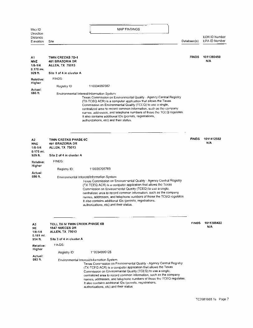
Map lDDirectionDistanceElevation Site
MAP FINDINGS
EDR lD NumberDatabase(s) EPA lD Number
A1 TWIN CREEKS 7D.1NNE 401 BRAZORIA DR1t8-114 ALLEN, TX 750130 . 1 7 6 m i .929 ft. Site 1 of 4 in cluster A
Relat ive: FINDS:H ighe r
Registry lD: 110034992382Actual :686 ft. Environmental InteresVlnformation System
Texas Commission on Environmental Quality - Agency Central Registry(TX-TCEQ ACR) is a computer application that allows the TexasCommission on Environmental Quality (TCEO) to use a single,centralized area to record common information, such as the companynames, addresses, and telephone numbers of those the TCEQ regulates
It also contains additional lDs (permits, registrations,authorizations. etc) and their status.
A2 TWIN CREEKS PHASE 6CNNE 401 BRAZORIA DR1t8-1t4 ALLEN, TX 750130.176 mi .929 ft. Site 2 of 4 in cluster A
Relative: FINDS:Higher
Registry lD: 1 10035205783Actual:686 ft. Environmental InteresVlnformation System
Texas Commission on Environmental Ouality - Agency Central Registry(TX-TCEO ACR) is a computer application that allows the TexasCommission on Environmental Quali ty (TCEa) to use a single,centralized area to record common information, such as the companynames, addresses, and telephone numbers of those the TCEQ regulatesIt also contains additional lDs (permits, registrations,authorizations, etc) and their status.
FrNDS 10113804s0N/A
FINDS 1011412582N/A
A3 TOLL TX lV TW1N CREEK PHASE 68 FINDS 1011388422
NE 1847 NUECES DR N/A
1t8-1t4 ALLEN. TX 750130 . 1 8 1 m i .954 ft. Site 3 of 4 in cluster A
Re la t i ve : F INDS:
HigherRegistry lD: 110034996128
Actual :683 ft. Environmental Interesvlnformation System
Texas Commission on Environmental Quality - Agency Central Registry
(TX-TCEO ACR) is a computer application that allows the Texas
Commission on Environmental Quality (TCEO) to use a single,
centralized area to record common information, such as the company
names, addresses, and telephone numbers of those the TCEQ regulates'
It also contains additional lDs (permits, registrations,
authorizations. etc) and their status.
TC2681868 .1s Page 7

Map lDDirect ionDistanceElevat ion Si te
MAP FINDINGS
Database(s)EDR lD NumberEPA lD Number
A4 TOLL TX IV TWIN CREEKS AT SOMERSET FINDS 1011386507
NE 1847 NUECES DR N/A
1t8-114 ALLEN, TX 750130 . 1 8 1 m i .954 ft. Site 4 of 4 in cluster A
Relat ive: FINDS:
H ighe rRegistry lD: 110035090264
Actual :683 ft. Environmental InteresVlnformation System
Texas Commission on Environmental Quality - Agency Central Registry(TX-TCEQ ACR) is a computer application that allows the Texas
Commission on Environmental Qual i ty (TCEa) to use a s ingle,centralized area to record common information, such as the companynames, addresses, and telephone numbers of lhose the TCEQ regulates.
It also contains additional lDs (permits, registrations,authorizations, etc) and their status.
5 PRASLA CLEANERS FINDS 1011312905
WSW 2023 W MCDERMOTT DR STE 260 N/A
1t8-1t4 ALLEN, TX 750130 . 2 1 1 m i .1 1 1 5 f t .
Relat ive: FINDS:
HigherRegistry lD: 110034437223
Actual :694 ft. Environmental InteresVlnformation System
Texas Commission on Environmental Quality - Agency Central Registry
(TX-TCEO ACR) is a computer application that allows the Texas
Commission on Environmental Qual i ty (TCEa) to use a s ingle,
centralized area to record common information, such as the company
names, addresses, and telephone numbers of those the TCEQ regulates
I t a lso contains addi t ional lDs (permits ' registrat ions,
authorizattons, etc) and their stalus.
86 TETCO 653 FINDS 1011366453
West 105 S CUSTER RD N/A
1t4-112 ALLEN, TX 75013
0.359 mi.1897 f t . Si te I of 4 in c luster B
Relat ive: FINDS:
Higher- Registry lD: 1 10034843329
Actual :708 ft. Environmental Interesvlnformation System
Texas Commission on Environmental Quality - Agency Central Registry
(TX-TCEO ACR) is a computer application that allows the Texas
Commission on Environmental Qual i ty (TCEO) to use a s ingle,
centralized area to record common information, such as the company
names, aooresses, and telephone numbers of those the TCEQ regulates'
It also contains additional lDs (permits, registrations,
authorizations, etc) and their status
TC2681868 .1s Page 8

Map lDDirect ionDistanceElevat ion
MAP FINDINGS
Site
O Z V J D
DFW CONVENIENCE STORES LPNot reportedPO BOX 171720SAN ANTONIO,TX78217RAYMOND MCNIECE2 1 0-821 -5900
CorporationNot reportedNot reportedOwner Contact Changed081 006003901 400000
071 504RAYMOND MCNIECENot reportedLegally-Authorized ReP of Ownerln i t ia lYesYesYesYeS200506
060209RAYMOND MCNIECEENV MGRLegally-Authorized ReP of Owner
Annual renewalYesYesYes
EDR lD NumberDatabase(s) EPA lD Number
usT uo03721448N/A
87 TETCO 653West 105 S CUSTER RO1t4-'il2 ALLEN. TX 750020.359 mi .1897 ft . Site 2 of 4 in cluster B
Relat ive:H ighe r
Actual :708 ft.
UST :Faci l i ty lD:Facility Type:Name of Faci l i ty Manager:Ti t le of Faci l i ty Manager:Faci l i ty Manager Phone:Facility Rural Box:Facility in Ozone non-attainment area:TCEQ Num:Owner lD:Date Registration Form Received:Region Number:Number of USTs:
Owner lD:Owner Name:Owner Address:Owner PO Box:Owner Ci ty,St ,Zip:Owner Contacl Name:Contaci Telephone:Owner Type:Mai l Undel iverable:Bankruptcy is in effect:Owner Amendmenl Reason Code:Owner Amendment Date:Number of Facilities reported by Owner:# Of Underground Storage Tanks:# Of Aboveground Storage Tanks:
Self-Certification Date:Signature Name:Signature Ti t le Name:Signature Type Text:Certification Submitted TYPe:
Registration Self-Certiflcation Flag:
Fees Self-Certification Flag:Financial Assurance Self-Certification flag:
Technical standards Self-Certification flag:
UST Delivery Certificate Expiration Date:
SeltCertification Date:
Signature Name:Signature Ti t le Name:
Signature Type Text:Certification Submitted TYPe:
Regislration Self-Certification Flag:
Fees Self-Certification Flag:
Financial Assurance Self-Certification flag
0072983Retai lRAYMOND MCNIECEENV MGR21 0-821 -5900Not reportedYes111 1436293603030004
Sign Name on Registration Form: L T Brown
Title of Signer of Registration Form: Compliance Tech
Date of Signature on Registration Form: 030,100
Owner Effeclive Begin Date: 07'1504
TC2681868 1s Page 9

Map lDDirect ionDistanceElevat ion Si te
MAP FINDINGS
EDR lD NumberDatabase(s) EPA lD Number
TETCO 653 (Cont inued)
Technical standards Self-Certification flag:UST Delivery Certificate Expiration Date:
Self-Certification Date:Signature Name:Signature Ti t le Name:Signature Type Text:Certification Submitted Type:Registration Self-Certification Flag:Fees Self-Certification Flag:Financial Assurance Self-Certifi cation fl ag:Technical standards Self-Certification flag:UST Delivery Certificate Expiration Date:
Self-Certification Date:Signature Name:Signature Ti t le Name:Signature Type Text:Certification Submitted Type:Registration Self-Certification Flag:Fees Self-Certification Flag:Financial Assurance Self-Certification flag:Technical standards Self-Certification fl ag:UST Delivery Certificate Expiration Date:
Self-Certification Dale:Signature Name:Signature Ti t le Name:Signature Type Text:Certification Submitted Type:Registration SeltCertification Flag:Fees SeltCertification Flag:Financial Assurance Self-Certification flag:Technical standards Self-Certification flag:UST Delivery Certificate Expiration Date:
Self-Certification Date:Signature Name:Signature Ti t le Name:Signature Type Text:Certification Submitted TYPe:Registration Self-Certification Flag:Fees Self-Certification Flag:Financial Assurance Self-Certification flagTechnical standards Self-Certification flagUST Delivery Certificate Expiration Date:
Operator lD:Operator Effective Date:Operator Type:Operalor Fi rst Name:Operator Name:Operator Bui ld ing Loc:Operator Telephone:Operator Address:Operator PO Box:
Yes201 006
093007RAYNTOND MCNIECEENV MGRLegally-Authorized Rep of OwnerAnnual renewalYesYesYesYes200806
051 208RAYMOND MCNIECEENVIRO MANAGERLegally-Authorized Rep of OwnerAnnual renewalYesYesYesYes200906
053 1 06RAYMOND MCNIECEENV MGRLegally-Authorized Rep of OwnerAnnual renewalYesYesYesYeS200706
0531 05RAYMOND MCNIECEMANAGEROwnerAnnual renewalYesYeSYesYes200606
1 3934807 1 504CorporationNot reportedDFW CONVENIENCE STORES LPNot reportedNot reportedNot reportedPO BOX 171720
u003721448
TC2681868 .1s Page 10

Nllap lDDirecl ionDistanceElevat ion
MAP FINDINGS
SiteEDR lD Number
Database(s) EPA lD Number
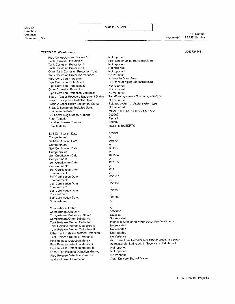
TETCO 653 (Cont inued)
Operator Ci ty,St ,Zip:Operator Conlact Name:Operator Contact Title:Operator Contact Phone:
Tank lD :Un i t lD :Tank Status:Status Date:Instal lat ion Date:Tank Regis l rat ion Date:Capaci ty:Tank Empt ied:Tank Construct ion and Containment:Tank Construct ion and Containment l l :Tank Construct ion and Containment l l l :Tank Construct ion and Containment lV:Pipe Construction and Containment:Pipe Construct ion and Containment l l :Pip ing Design and Ext . Containment 3:Piping Design and Ext. Containment 4:Type of Pip ing:Internal Tank Lin ing Date:Tank Material of Construction:Other Materials of Construction:Pipe Material of Construction:Other Construction and Containment:Pipe Connectors and Valves 1:Pipe Connectors and Valves 2:Pipe Connectors and Valves 3:Tank Corrosion Protection:Tank Corrosion Protect ion l l :Tank Corrosion Protect ion l l l :Other Tank Corrosion Protection Text:Tank Corrosion Protection Variance:Pipe Corrosion Protect ion:Pipe Corrosion Protection ll:Pipe Corrosion Protection 3:Other Conosion Protection:Pipe Corrosion Protection Variance:
Stage 1 Vapor Recovery Equipment Status:Stage 1 Equipment Installed Date:
Stage 2 Vapor Recry Equipment Status:
Stage 2 Equipment Installed Date:Equipment Instal ler :Contractor Registration Number:Tank Tested:lnstal ler L icense Number:Tank lnstal ler :
Self-Certification Date:Compartment:Self-Certification Date:Compartment:Self-Cerlification Date:Compartment:Self-Certification Date:
SAN ANTONIO X78217RAYMOND MCNIECEENV MGR210 -821 -5900
1001 93674ln UseNot reported' 12301999
030320000020000NoDouble Wal lNot reportedNot reportedNot reportedDouble Wal lNot reportedNot reportedNot reportedPressurized00000000FRP (fi berglass-reinforced plasticNot reportedFRP (fi berglass-reinforced plasticNot reported
1Not reportedFRP tank or p ip ing (noncorrodib le)Not reportedNot reportedNot reportedNo Var iancelsolated in Open AreaFRP tank or p ip ing (noncorrodib le)
Not reportedNot reportedNo Var ianceTwo-Point system or Coaxial system type
Not reportedBalance system or Assist system type
Not reportedMCALISTER CONSTRUCTION CO
000269Tested0001 07RONNIE ROBERTS
093007
0401 04A053 1 06
01 1 10 ' 1
U003721/+48
TC2681868 .1s Page 1 1
Map lDDirectionDistanceElevation
MAP F INDINGS
Site
EDR lD NumberDatabase(s) EPA lD Number
TETCO 653 (Cont inued)
Compartment:Self-Certification Date:Compartment:Self-Certification Date:Compartment:Self-Certification Date:Compartment:Self-Certification Date:Compartment:Self-Certification Date:Compartment:Self-Certification Date:Compartment:
Compartment Letter:Compartment Capacity:Compartment Substance Stored:Compartment Other Substance:Tank Release Method Detection l:Tank Release Method Detection ll:Tank Release Method Detect ion l l l :Other Tank Release Method Detection:Tank Release Detection Variance:Pipe Release Detection Method:Pipe Release Detection Method ll:Pipe Release Detection Method lll:Other Pipe Release Detection Method:Pipe Release Detection Variance:Spill and Overfill Protection:Spill and Overfill Protection ll:Spi l l and Overf i l l Protect ion l l l :Spill Overfi ll Prevenlion Variation:
Tank lD :Un i t lD :Tank Status:Status Date:lnsta l lat ion Date:Tank Registrat ion Date:Capaci ty:Tank Empt ied:Tank Construction and Containment:Tank Construct ion and Containment l l :
Tank Construct ion and Containment l l l :
Tank Construction and Containment lV;
Pipe Construction and Containment:Pipe Construct ion and Containment l l :
Pip ing Design and Ext . Containment 3:
Pip ing Design and Ext . Containment 4:
Type of PiPing:Internal Tank Lin ing Date:
Tank Material of Construction:
Olher Nlaterials of Construction:Pipe Material of Construction:Other Construction and Containment:Pipe Connectors and Valves 1:Pipe Connectors and Valves 2:
0501 03A050302A053 1 05A060209
07'1 504
05 1 208
0000000GasolineNot reportedInterstitial Monitoring within Secondary Wall/JacketNot reportedNot reportedNot reportedNo VarianceAuto. Lrne Leak Detector (3.0 gph for pressure piping)Interstitial Monitoring within Secondary Wall/JacketNot reportedNot reportedNo VarianceAuto. Delivery Shuloff ValveFactory-Built Spill Container/Bucket/Sump1No Variance
00 1 93675ln UseNot reported1 2301 99903032000001 5000NoDouble WallNot reportedNot reportedNot reportedDouble WallNot reportedNot reportedNot reportedPressurized00000000FRP (fiberglass-reinforced plasticNot reportedFRP (fi berglass-reinforced plasticNot reported31
uo03721448
TC2681868 .1s Page 12
Map lDDirectionDistanceElevat ion Si te
tvIAP FINDINGS
EDR lD NumberDatabase(s) EPA lD Number
TETCO 653 (Cont inued) U003721r148
Pipe Connectors and Valves 3: Not reportedTank Corrosion Protection: FRP tank or piping (noncorrodible)
Tank Corrosion Protection ll: Not reportedTank Corrosion Protect ion l l l : Not reportedOther Tank Corrosion Protection Texl: Not reportedTank Corrosion Prolection Variance: No VariancePipe Corrosion Protection: lsolated in Open AreaPipe Corrosion Protect ion l l : FRP tank or p ip ing (noncorrodib le)
Pipe Corrosion Protection 3: Not reported
Other Corrosion Protection: Not reportedPioe Corrosion Protection Variance: No Variance
Stage 1 Vapor Recovery Equipment Status: Two-Point system or Coaxial system type
Stage 1 Equipment Installed Date: Not reported
Stage 2 Vapor Recry Equipment Status: Balance system or Assist system type
Stage 2 Equipment Installed Date: Not reported
Equipment lnsta l ler : MCALISTER CONSTRUCTION CO
Contractor Registration Number: 000269
Tank Tested: Tested
lnstal ler L icense Number: 000107
Tank lnstal ler : RONNIE ROBERTS
Self-Certification Daie: 053106
Comoartment: A
SellCertification Date: 040104
Compartment: A
SellCertification Date: 093007
Compartment: A
Sel tcert i f icat ion Date: 071504
Compartment: A
Sel f -Cert i f icat ion Date: 053105
Compartment: A
Sel f -Cert i f icat ion Date: 011101
Compartment: A
Sel f -Cert i f icat ion Date: 050103
Comparlment: A
Self-Certification Date: 050302
Comoartment: ASelf-Certification Date: 051208
Comoartment: A
Self-Certification Date: 060209
Comoartmenl : A
ComDartment Letter: A
Compartment Capacity: 0000000
Compartment Subslance Stored: Gasoltne
Compartment Other Substance: Not reported
Tank Release lMethod Detection l: Interstitial Monitoring within Secondary Wall/Jacket
Tank Release Method Detection ll: Not reported
Tank Release Method Detection lll: Not reported
Other Tank Release Method Detection: Not reported
Tank Release Detection Variance: No Variance
Pipe Release Detection Method: Auto. Line Leak Detector (3.0 gph for pressure piping)
pipe Release Detection Method ll: Interstitial Monitoring within Secondary Wall/Jacket
Pipe Release Detection Method lll: Not reported
Other Pipe Release Detection Method: Not reported
Pipe Release Detection Variance: No Variance
Soill and Overfill Protection: Auto. Dellvery Shut-off Valve
TC2681868.1s Page 13

MAP FINDINGSMap lDDrrectronDistanceElevation Si te Database(s)
EDR lD NumberEPA lD Number
88 TETCO 643West 2200 MCOERMOTT RD'U4-1t2 PLANO, TX 750250.37' l mi.1957 ft . Site 3 of 4 in cluster B
Relative:H igher
Actual:709 ft.
UST:Faci l i ty lD:Faci l i ty Type:Name of Faci l i ty Manager:Ti t le of Faci l i ty Manager:Faci l i ty Manager Phone:Faci l i ty Rural Box:Facility in Ozone non-attainment area:
TCEQ Num:Owner lD:Date Registration Form Received:Region Number:Number of USTs:Sign Name on Registration Form:Title of Signer of Registration Form:
Date of Signature on Registration Form:
Owner Effective Begin Date:
Owner lD:Owner Name:Owner Address:Owner PO Box:
Owner Ci ty,St ,ZiP:Owner Contact Name:Contact Telephone:Owner Type:Mai l Undel iverable:Bankruptcy is in effect:Owner Amendment Reason Code:Owner Amendment Date.Number of Facilities reported by Owner:
# Of Underground Storage Tanks:
0072822RetailRAYMOND MCNIECEENV MGR210-821-5900Not reportedYes1 1 08835241001 1 300041Michael K Garrott SrEnvir Compl icance1214990831 87
52410TETCO STORES LPNot reportedPO BOX 171720
sAN ANTONIO,rX78217RAYN,4OND MCNIECE21 0-821 -5900CorporationNot reportedNot reportedOwner Contact Changed061 1 0300970390
TETCO 653 (Cont inued)
Spill and Overfill Protection ll:Spill and Overfill Protection lll:Spill Overfill Prevention Variation:
Opr His:Operator lD:Operator Name or Business Name:Operator Effective Begin Date:Operator Effective End Date:
Own Hist :Faci l i ty lD:Faci l i ty Number:Cuslomer Number:Indiv idual Name or Business Name:Owner Effective Begin Date:Owner Effective End Date:
Factory-Built Spill Container/Bucket/Sump1No Variance
049837CHEVRON USA INC083 1 8707 1 504
11114300729831 3675CHEVRON USA INC083 1 87071 504
u003721448
usT u003721451N/A
TC2681868 1s Page 14
Map lDDirect ionDistanceElevation
MAP FINDINGS
Site
EDR lD NumberDatabase(s) EPA lD Number
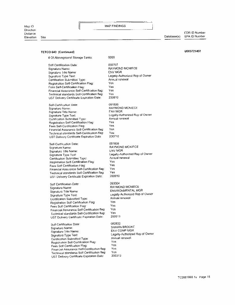
TETCO 643 {Cont inued)
# Of Aboveground Storage Tanks:
Self-Certification Date:Signature Name:Signature Ti t le Name:Signature Type Text:Certification Submitted TyPe:Registration Self-Certification Flag:Fees Self-Certification Flag:Financial Assurance Self-Certification flag:Technical standards Self-Certification flag:
UST Delivery Certificate Expiration Date:
Self-Certification Date:Signature Name:Signature Ti t le Name:Signature Type Text :Certification Submitted Type:Registration Self-Certification Flag:Fees Self-Certification Flag:Financial Assurance Self-Certification flag:
Technical standards SelFCertification flag:
UST Delivery Certificate Expiration Date:
Self-Certification Date:Signature Name:Signature Ti t le Name:Signature TyPe Text:
Certification Submitted TYPe:Registration Self-Certification Flag :
Fees Self-Certification Flag:
Financial Assurance Self-Certification flag:
Technical standards Self-Certification flag:
UST Delivery Certificate Expiration Date:
SeltCertification Date.
Signature Name:Signature Ti t le Name:
Signature TYPe Text:
Certification Submitted TYPe:
Registration Self-Certification Flag:
Fees Self-Certification Flag:
Financial Assurance Self-Certification flag:
Technical standards Self-Certification flag:
UST Delivery Certificate Expiration Date:
Self-Certif ication Date:
Signature Name:Signature Ti t le Name
Signature TYPe Text:Certification Submitted TYPe:
Registration Self-Certification Flag:
Fees Self-Certification Flag:Financial Assurance Self-Certification flag
Technical standards Self-Certification flag
UST Delivery Certificate Expiration Date:
0000
092707RAYMOND MCNIECEENV MGRLegally-Authorized Rep of OwnerAnnual renewalYesYesYesYes20081 0
091 806RAYMOND MCNIECEENV MGRLegally-Authorized Rep of OwnerAnnual renewalYesYesYesYes200710
09 1 808RAYMOND MCNIECEENV MGRLegally-Authorized ReP of OwnerAnnual renewalYesYeS
Yes
20091 0
093004RAYMOND MCNIECEENVIRONMENTAL MGRLegally-Authorized ReP of OwnerAnnual renewalYesYesYesYes20051 0
o82802SHAWN BROOKEENV COMP MGRLegallY-Authorized ReP of OwnerAnnual renewalYesYeSYesYes20031 0
u003721451
TC2681868 1s Page '15
Map lDDirectionDistanceElevat ion
MAP FINDINGS
Site Database(s)EDR lD NumberEPA lD Number
TETCO 643 (Cont inued)
Self-Certification Date:Signature Name:Signature Ti t le Name:Signature Type Text:Certification Submitted TYPe:Registration Self-Certification Flag:Fees Self-Certification Flag:Financial Assurance Self-Certification flag:
Technical standards Self-Certification flag:
UST Delivery Certificate Expiration Date:
Self-Certif ication Date:
Signature Name:Signature Title Name:
Signature TYPe Text:Certification Submitted TYPe:Registration Self-Certification Flag:
Fees Self-Certification Flag:
Financial Assurance Self-Certification flag:
Technical standards SelFCertification flag:
UST Delivery Certificate Expiration Date:
Self-Certification Date:Signature Name:Signature Ti t le Name:Signature TyPe Text:Certification Submitted TYPe:Registration Self-Certification Flag :
Fees Self-Certification Flag:Financial Assurance Self-Certification flag:
Technical standards Self-Certification flag:
UST Delivery Certificate Expiration Date:
Self-Certification Date
Signature Name:Signature Ti t le Name:Signature TyPe Text:
Cerlification Submitted TYPe:
Registration Self-Certification Flag:
Fees Self-Certification Flag:
Financial Assurance Self-Certification flag:
Technical standards Self-Certification flag:
UST Delivery Certificate Expiration Date:
Operator lD:Operator Effective Date:Operator Type:Operator First Name:Operator Name:Operator Bui lding Loc:Operator TelePhone:Operator Address:Operator PO Box:Operator CitY,St,ZiP:Operator Conlact NameOperator Contact Title:
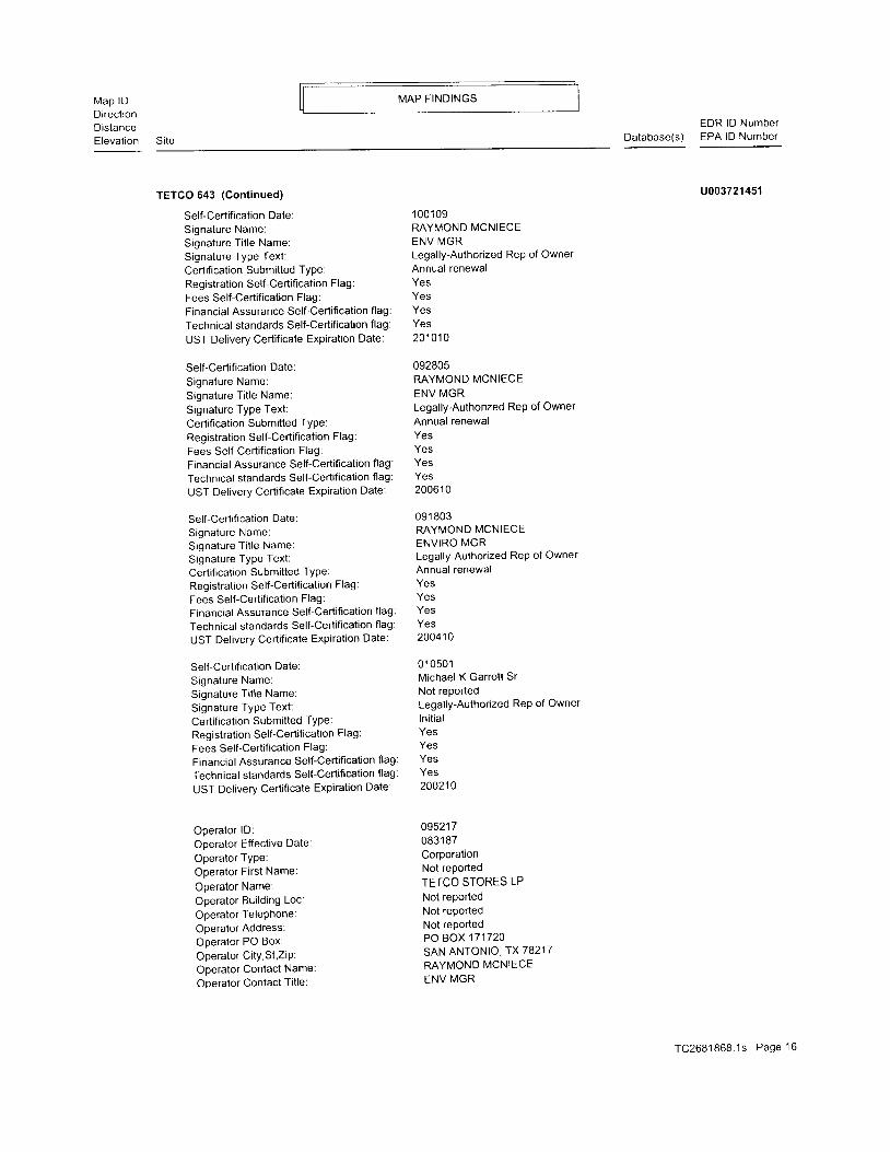
'100109
RAYMOND MCNIECEENV MGRLegally-Authorized Rep of OwnerAnnual renewalYesYesYesYes201 01 0
092805RAYMOND MCNIECEENV MGRLegally-Authonzed ReP of OwnerAnnual renewalYesYesYesYeS
20061 0
09 1 803MYMOND MCNIECEENVIRO MGRLegally-Authorized ReP of Owner
Annual renewalYesYeSYesYes200410
0 1 0501Michael K Garrott Sr
Not reportedLegally-Authorized ReP of Owner
ln i t ia lYesYesYeSYes200210
0952170831 87CorporationNot reported
TETCO STORES LP
Not reportedNot rePortedNot rePortedPO BOX 171720
SAN ANTONIO,TX78217RAYMOND MCNIECE
ENV MGR
u003721 4sl
TC2681868 .1s Page 16
Map lDDirect ionDistanceElevation
MAP F INDINGS
Site
EDR lD NumberDatabase(s) EPA lD Number
TETCO 643 (Continued)
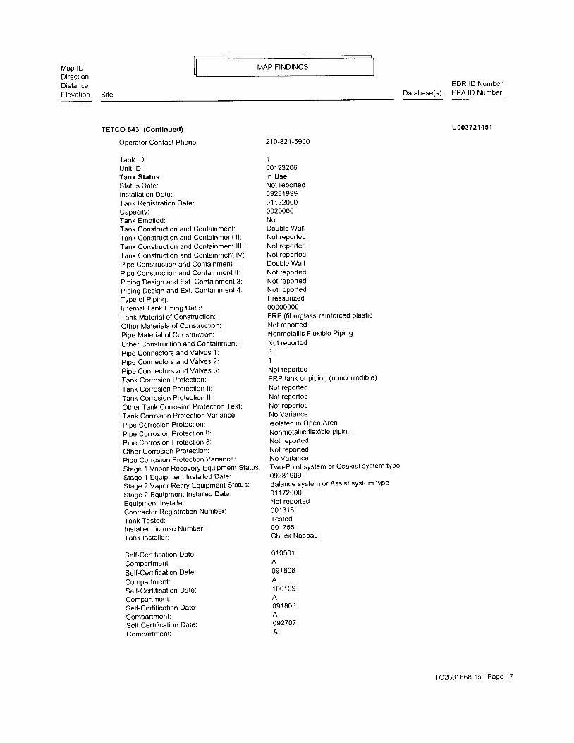
Operator Contact Phone:
Tank lD :Un i t lD :Tank Status:Status Date:lnsta l lat ion Date:Tank Registration Date:Capaci tY:Tank Empt ied:Tank Construction and Containment:Tank Construct ion and Containment l l :
Tank Construct ion and Containment l l l :Tank Conslruction and Containment lV:
Pipe Construction and Containment:Pipe Construction and Containment ll:
Piping Design and Ext. Containment 3:Pip ing Design and Ext . Containment 4:Type of Pip ing:Internal Tank Lin ing Date:Tank Material of Construclion:Other Materials of Construction:Pipe Material of Construction:
Other Construction and Containment:Pipe Connectors and Valves 1:
Pipe Connectors and Valves 2:
Pipe Connectors and Valves 3:
Tank Corrosion Protection:
Tank Corrosion Protection ll:
Tank Corrosion Protection lll:
Other Tank Corrosion Protection Text:
Tank Corrosion Protection Variance:
Pipe Corrosion Protection:Pipe Corrosion Protect ion l l :
Pipe Corrosion Protection 3:
Other Corrosion Protection:Pipe Corrosion Protection Variance:
Stage '1 Vapor Recovery Equipment Status
Stage 1 EquiPment Instal led Date:
Stage 2 Vapor Recry Equipment Status:
Stage 2 EquiPment Installed Date:
Equipment Instal ler :Contractor Registralion Number:
Tank Tested:lnstal ler L icense Number:Tank Instal ler :
Self-Certification Date:
ComPartment:Self-Certification Date:
ComPartment:Self-Certification Date:ComPartment:Self-Certification Date:
Compartment:Self-Certification Date:
Compartment:
210 -821 -5900
1001 93206ln UseNot reported09281 99901 1 320000020000NoDouble WallNot reportedNot reportedNot reportedDouble Wal lNot reportedNot reportedNot reportedPressurized00000000FRP (fiberglass-reinforced plastic
Not reportedNonmetal l ic Flexib le PiPing
Not reportedJ
1Not reportedFRP tank or p ip ing (noncorrodib le)
Not reportedNot reportedNot reportedNo Variancelsolated in Open AreaNonmetallic flexible PiPingNot reportedNot reportedNo VarianceTwo-Point system or Coaxial system type
09281 999Balance system or Assist system type
01 1 72000Not reported001 31 8Tested001 755Chuck Nadeau
01 0501A091 808
1 001 09
091 803
092707
uoo3721451
TC2681868.1s Page 17
Map lDDirectionDistanceElevat ion
MAP FINDINGS
Site Database(s)EDR lD NumberEPA lD Number
TETCO 643 (Cont inued)
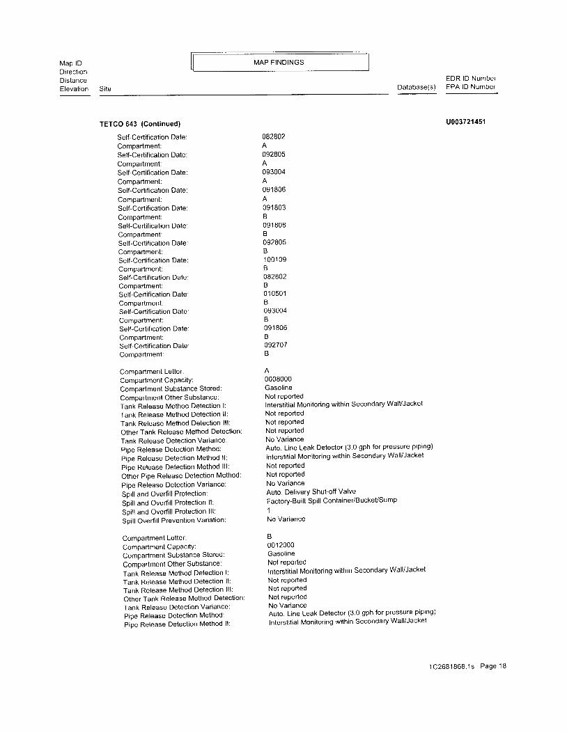
Self-Certification Date:Compartment:Self-Certification Date:Compartment:Self-Certification Date:Compartment:Self-Certification Date:
Compartment:Self-Certification Date:Compartment:Self-Certification Date:Compartment:Self-Certification Date:Compartment:SeltCertification Date:Compartment;Self-Certification Date:Compartment:Self-Certification Date:Compartment:Self-Certification Date:Compartment:Self -Certification Date:Compartment:Self-Certification Date:Compartment:
Compartmenl Letter:Compartment CaPacity:Compartment Substance Stored:
Compartment Other Substance:Tank Release Method Detection l:
Tank Release Method Detection ll:
Tank Release Method Detection lll:
Other Tank Release Method Detection:
Tank Release Detection Variance:
Pipe Release Detection Method:
Pipe Release Detection Method ll:
Pipe Release Detection Method lll:
Other Pipe Release Detection Method:
Pipe Release Detection Variance:
Spill and Overfill Protection:
Spill and Overfill Protection ll:
Spill and Overfill Protection lll:
Spill Overfill Prevention Variation:
Compartment Letter:
Compartment CaPacitY:Compartment Substance Stored:
Compartment Other Substance:
Tank Release Method Detection l:
Tank Release Method Detection ll:
Tank Release Method Detection lll:
Other Tank Release Method Detection:
Tank Release Detection Variance:
Pipe Release Detection Method:
Pipe Release Detection Method ll:
082802
092805
093004
091 806
091 803B09 1 808B092805B1 0 0 1 0 9B082802B010501B093004B091 806b
092707B
0008000GasolineNot reportedInterstitial Monitoring within Secondary Wall/JacketNot reportedNot reportedNot reportedNo VarianceAuto. Line Leak Detector (3 0 gph for pressure piping)
Interstitial Monitoring within Secondary Wall/JacketNot reportedNot reportedNo VarianceAuto. Delivery Shut-off ValveFactory-Built Spill Container/BuckeVSump1No Variance
B001 2000GasolineNot reportedInterstitial Monitoring within Secondary Wall/JacketNot reportedNot reportedNot reportedNo VarianceAuto. Line Leak Detector (3.0 gph for pressure piping)
lnterstitial Monitoring within Secondary Wall/Jacket
u003721451
TC2681868 .1s Page ' 18

MAP F INDINGSMap lDDirectionDistanceElevation Site
EDR lD NumberDatabase(s) EPA lD Number
TETCO 643 (Continued)
Pipe Release Detection Method lll:Other Pipe Release Detection MethodPipe Release Detection Variance:Spill and Overfill Protection:Spill and Overfill Protection ll:Spi l l and Overf i l l Protect ion l l l :Spill Overfill Prevenlion Variation:
Op r H i s :Operator lD:Operator Name or Business Name:
Operator Effective Begin Date:
Operator Effective End Date:
Own Hist :Faci l i ty lD:Faci l i ty Number:Customer Number:lndiv idual Name or Business Name:
Owner Effective Begin Date:
Owner Effective End Date:
Not reportedNot reportedNo VarianceAuto. Delivery Shufoff ValveFactory-Buil t Spi l l Container/Bucket/Sump1No Variance
Not reportedNol reportedNot reportedNot reported
Not reportedNot reportedNot reportedNot reportedNot reportedNot reported
u003721 451
101 1395304N/A
101 141 5404N/A
F INDS89 TETCO 643West 2200 MCDERMOTT RD
1t4-1t2 PLANO, TX 75025
0 .371 m i .1957 f t . Si te 4 of 4 in c luster B
Relat ive: FINDS:
HigherRegistry lD:
Actual :709 ft.
1 1 00351 65193
Environmental InteresUlnformation SystemTexasCommissiononEnvironmenta|Qua| i ty-AgencyCentra|Registry(TX-TCEQ ACR) is a computer application that allows the Texas
Commission on Environmental Quality (TCEa) to use a single'
cen t ra l i zeda rea lo reco rdcommon in fo rma t i on , suchaS thecompanynames, addresses, and telephone numbers of those the TCEQ regulates
It also contains additional lDs (permits, registrations'
authorizations, etc) and their status
FINDS10 MAXWELLCLEANERSWest 2300 MCDERMOTT RD STE 300'12-1 PLANO, TX 750250.539 mi .2845 ft.
F INDS:
Registry lD:
Relative:H igher
Actual:730 ft.
1 1003539', l 322
Environmental InteresUlnformation SystemTexas Commission on Environmental Quali ty - Agency Central Registry
TC2681868 .1s Page 19
Map lDDirectronDistanceElevat ion Si te
MAP FINDINGS
Database(s)EDR lD NumberEPA lD Number
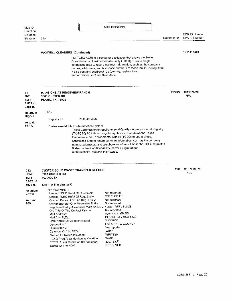
MAXWELL CLEANERS {Cont inued) 1011415404
(TX-TCEO ACR) is a computer application that allows the TexasCommission on Environmental Qual i ty (TCEO) to use a s ingle,centralized area to record common information, such as the companynames, addresses, and telephone numbers of those the TCEQ regulates.I t a lso contains addi t ional lDs (permits, registrat ions,authorizations. etc) and their status.
11 MANSIONS AT RIDGEVIEW RANCH FINDS 1011376398Nw 960l cusrER RD N/A1t2-1 PLANO, TX 750250.659 mi .3481 ft.
Relat ive: FINDS:Higher
Registry lD: 110034963136Actual:677 ft. Environmental InteresUlnformation System
Texas Commission on Environmental Quality - Agency Central Registry(TX-TCEO ACR) is a computer application that allows the TexasCommission on Environmental Quali ty (TCEO)to use a single,centralized area to record common information, such as the companynames, addresses, and telephone numbers of those the TCEQ regulates.It also contains additional lDs (permits, registrations,authorizations, etc) and their status.
C12 CUSTER SOLID WASTE TRANSFER STATION ENF 5107639075
NNW 9901 CUSTER RD N/A
112-1 PLANO, TX0.932 mi.4923 ft. Site 1 of 5 in cluster C
Retat ive: ENFORCEMENT:
Lower Unique TCEQ Ref # Of Customer: Not reported
Unique TCEQ Ref # Of Reg. Ent i ty : RN101491413Actual: Contact Person For The Reg. Entity: Not reported639 ft. Owner/operator Of A Regulated Entity: Not reported
Regulated Ent i ty Associated With An NOV: FLEET REFUELING
Org Title Of The Contact Person: Not reported
Mai l Address: 9901 CUSTER RD
Mail City,St,Zip: PLANO, TX75025-5132
Date Notice Of Violation lssued: 311312000
Descr iot ion 1. FAILURE TO COMPLY
Descriotion 2: Not rePorted
Category Of The NOV: Minor
Method Of Notice lssuance: WRITTEN
TCEQ Prog Area Monitoring Violation: WASTE
TCEQ Rule # Ci ted For The Violat ion: 330 150(7)
Status Of The NOV: RESOLVED
TC2681868.1s Page20
Map lDDirectionDistanceElevation
MAP F INDINGS
Site
EDR lD NumbetDatabase(s) EPA lD Number
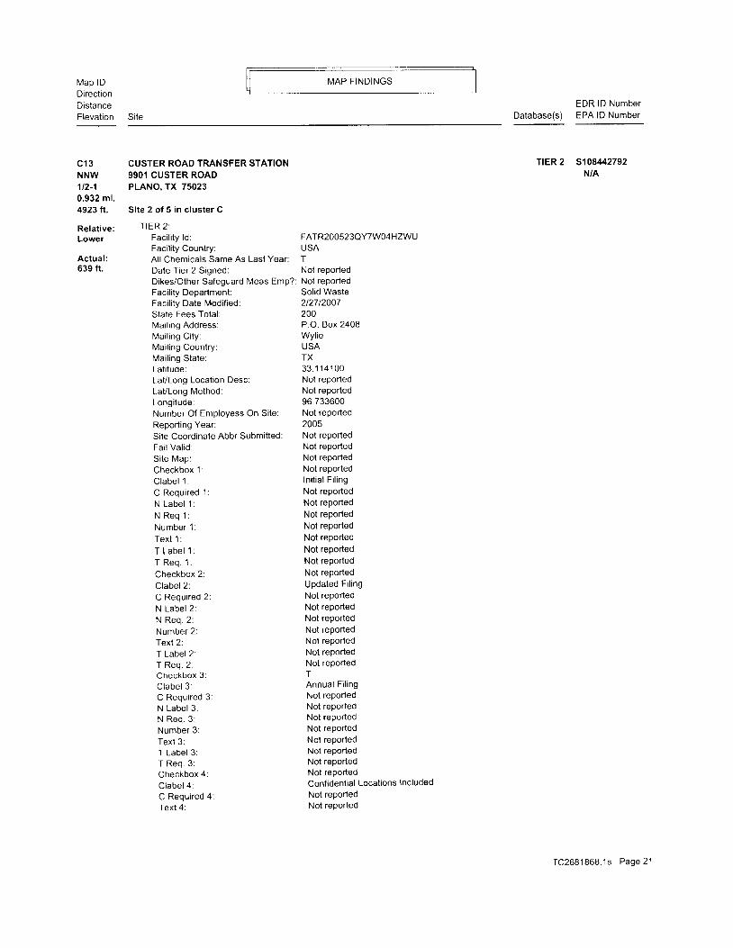
Cl3 CUSTER ROAO TMNSFER STATIONNNW 9901 CUSTER ROAD1t2-1 PLANO, TX 750230.932 mi.4923 ft. Site 2 of 5 in cluster C
Retative: TIER 2:Lower Faci l i ty ld:
Faci l i ty Country:Actual :639 fr.
T|ER 2 5108442792N/A
Al l Chemicals Same As Last Year:Date Tier 2 Signed:Dikes/Other Safeguard Meas Emp?Facility Department:Facility Date Modified :State Fees Total:Mai l ing Address:Mai l ing Ci ty:Mai l ing Country:Mai l ing State:Lat i tude:LaVLong Location Desc:LaVLong Method:Longi tude:Number Of Employess On Si te:Reporting Year:Site Coordinate Abbr Submitted:Fai l Val id:Si te Map:Checkbox 1:C labe l 1 :C Required 1:N Labe l 1 :N R e q 1 :Number 1 :Tex t 1 :
T Labe l 1 :T Req . 1 :Checkbox 2:Clabel 2:C Required 2:N Label 2.N Req . 2 :Number 2:Text 2:T Label 2:T Req . 2 :Checkbox 3:Clabel 3:C Required 3:N Label 3:N Req . 3 :Number 3:Text 3:T Label 3:T Req . 3 :Checkbox 4:Clabel 4:C Required 4:Text 4:
FATR2OO523QYTW04HZWLUSATNot reportedNot reportedSolid Waste2t27t2007200P.O. Box 2408Wyl ieUSATX33 .1 1 41 00Not reportedNot reported96.733600Not reported2005Not reportedNot reportedNot reportedNot reportedIni t ia l F i l ingNot reportedNot reportedNot reportedNot reportedNot reportedNot reportedNot reportedNot reportedUpdated Fi l ingNot reportedNot reportedNot reportedNot reportedNot reportedNot reportedNot reportedTAnnual Fi l ingNot reportedNot reportedNot reportedNot reportedNot reportedNot reportedNot reportedNot reportedConfidential Locations IncludedNot reportedNot reported
TC268 '1868 . ' 1s Page2 l
Map lDDirectionDistanceElevat ion
MAP FINDINGS
Site
EDR lD NumberDatabase(s) EPA lD Number
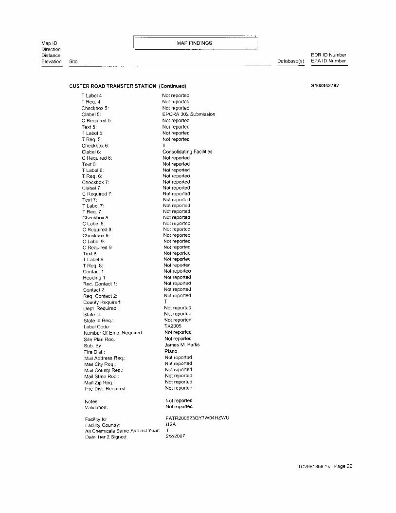
CUSTER ROAD TRANSFER STATION (Continued) s1084/-2792
T Label 4:T Req . 4 :Checkbox 5:Clabel 5.C Required 5:Text 5:T Label 5:T Req . 5 :Checkbox 6:Clabel 6:C Required 6:Text 6:T Label 6:T Req. 6:Checkbox 7:Clabel 7:C Required 7:Text 7:T Label 7:T Req 7:Checkbox 8:C Label 8:C Required 8:Checkbox 9:C Label 9:C Required 9:Text 8:T Label 8:T Req. 8:Contact 1:Head ing 1 :Req. Contact 1:Contact 2:Req. Contact 2:County Required:Dept. Required:State ld:State ld Req.:Label Code:Number Of Emp. Required:
Si te Plan Req.:Sub. By:Fire Dist . :Mai l Address Req.:Mai l Ci ty Req.:Mai l County Req.:Mai l State Req.:Mai l Z ip Req.:Fi re Dist . Required:
Notes:Val idat ion:
Faci l i ty ld:Facility Country:Al l Chemicals Same As Last Year:
Date Tier 2 Signed:
Not reportedNot reportedNot reportedEPCRA 302 SubmissionNot reportedNot reportedNot reportedNot reportedI
Consol idat ing Faci l i t iesNot reportedNot reportedNot reportedNot reportedNot reportedNot reportedNot reportedNot reportedNot reportedNot reportedNot reportedNot reportedNot reportedNot reportedNot reportedNot reportedNoi reportedNot reportedNot reportedNot reportedNot reportedNot reportedNot reportedNot reportedTNot reportedNot reportedNot reportedTX2005Not reportedNot reportedJames M. ParksPlanoNot reportedNot reportedNot reportedNot reportedNot reportedNot reported
Not reportedNot reported
FATR2O0623QYTW04HZWUUSAT21212007
TC2681868.1s Page 22
Map lDDirect ionDistanceElevation
MAP FINDINGS
Site
EDR lD NumberDatabase(s) EPA lD Number
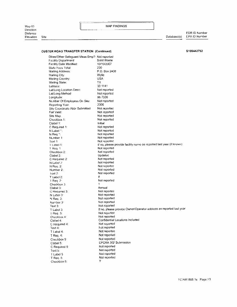
CUSTER ROAD TRANSFER STATION (Cont inued) s1 08442792
Dikes/Other Safeguard Meas Emp?:Facility Department:Facility Date Modified:State Fees Total:Mai l ing Address:Mai l ing Ci ty:Mai l ing Country:Mai l ing State:Lat i tude:LaVLong Location Desc:LaVLong Method:Longi tude:Number Of Employess On Si te:Reportrng Year:Site Coordinate Abbr Submitted:Fai l Val id:Si te Map:Checkbox 1:C labe l 1 :C Required 1:N Labe l 1 :N R e q ' l :Number 1 :Tex t 1 :T Labe l 1 :T R e q . 1 :Checkbox 2:Clabel 2:C Required 2:N Label 2:N Req . 2 :Number 2:Texl 2:T Label 2:T Req. 2:Checkbox 3:Clabel 3:C Required 3:N Label 3:N Req 3:Number 3 :Text 3:T Label 3:T Req. 3:Checkbox 4:Clabel 4:C Required 4:Text 4:T Label 4:
T Req 4:
Checkbox 5:Clabel 5:C Required 5:Text 5:T Label 5:T Req . 5 :Checkbox 6:
Not reportedSolid Waste1011012007200P.O. Box 2408Wyl ieUSATX3 3 1 1 4 1Not reportedNot reported96.7336Not reported2006Not reportedNot reportedNot reportedNot reportedln i t ia lNot reportedNot reportedNot reportedNot reportedNot reportedlf no, please provide facility name as reported last year (if known)
Not reportedNot reportedUpdatedNot reportedNot reportedNot reportedNot reportedNot reportedt fNot reportedTAnnualNot reportedNot reportedNot reportedNot reportedNot reportedlf no, please provide Owner/Operator address as reported last year
Not reportedNot reportedConfidential Locations IncludedNot reportedNot reportedNot reported
Not reported
Not reportedEPCRA 302 SubmissionNot reportedNot reportedNot reportedNot reported
TC2681868 .1s Page 23

Map lDDirectionDistanceElevat ion
MAP F INDINGS
SiteEDR lD Number
Database(s) EPA lD Number
CUSTER ROAD TRANSFER STATION (Cont inued) s108442792
Clabel 6:C Required 6:Text 6:T Label 6:T Req. 6:Checkbox 7:Clabel 7:C Required 7:Text 7:T Label 7:T Req . 7 :Checkbox 8:C Label 8:C Required 8:Checkbox 9:C Label 9:C Required 9:Text 8:T Label 8:T Req. 8:Contact 1:Head ing 1 .Req. Contact 1:Contact 2:Req. Contact 2:County Required:Dept. Required:State ld:State ld Req.:Label Code:Number Of Emp. Required:Si te Plan Req.:Sub . By :Fire Dist . :Mai l Address Req.:Mai l Ci ty Req.:Mai l County Req.:Mai l State Req.:Mai l Z ip Req :Fi re Dist . Required:
Notes:Val idat ion:
Faci l i ty ld:Facility Country:Al l Chemicals Same As Last Year
Date Tier 2 Signed:
Consol idat ing Faci l i t iesNot reportedNot reportedNot reportedNot reportedTFacility name reported same as last yearNot reportedNot reportedNot reportedNot reportedTTNot reportedTOwner/Operator address reported same as last year
Not reportedNot reportedNot reportedNot reportedNot reportedNot reportedNot reportedNot reportedNot reportedTNot reportedNot reportedNot reportedTX2006Not reportedNot reportedJames M. ParksPlanoNot reportedNot reportedNot reportedNot reportedNot reportedNot reported
Not reportedNot reported
FATR2OOT23QYTW04HZWU
Dikes/Other Safeguard Meas EmP?:
Faci l i ty Department:Facility Date Modified:State Fees Total:Mai l ing Address:Mai l ing Ci ty:Mai l ing Country:Mailing State:Lat i tude:
USAT1t1812008Not reportedSolid Waste8/5/20081 5 0P.O. Box 2408WylieUSATX3 3 . 1 1 4 1
TC2681868 .1s Page24

Map lDDirectionDistanceElevat ion
MAP FINDINGS
Si ieEDR lD Number
Database(s) EPA lD Number
CUSTER ROAD TRANSFER STATION (Gontinued)
LaVLong Location Desc:LaVLong Method:Longi tude:Number Of Employess On Si te:Report ing Year:Site Coordinate Abbr SubmittedFai l Val id:Si te Map:Checkbox 1:C labe l 1 :C Required 1:N Labe l 1 :N R e q 1 :Number 1 :Tex t 1 :T Labe l 1 :T Req . 1 :Checkbox 2:C labe l 2 :C Required 2:N Label 2:N Req . 2 :Number 2 :Iexl2.T Label 2:T Req. 2:Checkbox 3:Clabel 3:C Required 3:N Label 3:N Req. 3:Number 3:Text 3:T Label 3:T Req. 3:Checkbox 4:Clabel 4:C Required 4:Text 4:T Label 4:T Req. 4:Checkbox 5:Clabel 5:C Required 5:Text 5:T Label 5:T Req. 5:Checkbox 6:Clabel 6:C Required 6:Text 6:T Label 6:T Req . 6 :Checkbox 7:Clabel 7:C Required 7:Text 7:
Not reportedNot reported96.7336Not reported2007Not reportedNot reportedNot reportedNot reportedln i t ia lNot reportedNot reportedNot reportedNol reported34584TXT2 Number:TNot reportedUpdatedNot reporledNot reportedNot reportedNot reportedNot reportedNot reportedNot reportedTAnnualNot reportedNot reportedNot reportedNot reportedNot reportedNot reportedNot reportedNot reportedConfidential Locations Included
Not reportedNot repodedNot reportedNot reporledNot reportedEPCRA 302 SubmissionNot reportedNot reportedNot reportedNot reportedTConsolidating Facilities
Not reportedNot reportedNot reportedNot reportedNot reportedNot reportedNot reportedNot reported
s108442792
TC2681868 .1s Page25

Map lDDirectionDistanceElevation
MAP FINDINGS
Site Database(s)EDR lD NumberEPA lD Number
CUSTER ROAD TRANSFER STATION (Cont inued)
T Label 7: Not reportedT Req. 7: Not reportedCheckbox B: TC Label 8: TC Required 8: Not reportedCheckbox 9: TC Label 9: Not reportedC Required 9: Not reportedText 8: Not reportedT Label B: Not reportedT Req. 8: Not reportedContact 1: Not reportedHeading 1: Not reportedReq. Contact 1: Not reportedConiact 2: Not reportedReq. Contact 2: Not reportedCounty Required: TDept. Required: Not reportedState ld: Not reportedState ld Req.: Not reportedLabel Code: TX20O7Number Of Emp. Required: Not reportedSite Plan Req.: Not reportedSub. By: James M. ParksFire Dist . : PlanoMail Address Req.: Not rePortedMail City Req.: Not reportedMail County Req.: Not reportedMail State Req.: Not reported
Mai l Z ip Req.; Not rePortedFire Dist. Required: Not rePorted
Notes: Not rePorted
Validation: Not rePorted
Faci l i ty ld: FATR200823QY7W04HZWU
Facility Country: USA
Al l Chemicals Same As Last Year: T
Date Tier 2 Signed: 112612009
Dikes/Other Safeguard Meas Emp?: Not reported
Facrlity Department: Solid Waste
Facility Date Modified: 6/30/2009
State Fees Total : 150
Mai l ing Address: P.O. Box 2408
Mai l ing Ci ty: WYl ie
Mai l ing Country: USA
Mai l ing State: TX
Lat i tude: 33.1141
LaVLong Location Desc: Not reported
LaVLong Method: Not reported
Longi tude: 96 7336
Number Of Employess On Site: Not reported
Reporting Year: 2008
Sile Coordinate Abbr Submitted: Not reported
Fail Valid: Not reported
Site Map: Not reported
Checkbox 1: Not reported
s10842792
TC2681868 1s Page 26
Map lDDirect ionDistanceElevat ion
MAP F INDINGS
SiteEDR lD Number
Database(s) EPA lD Number
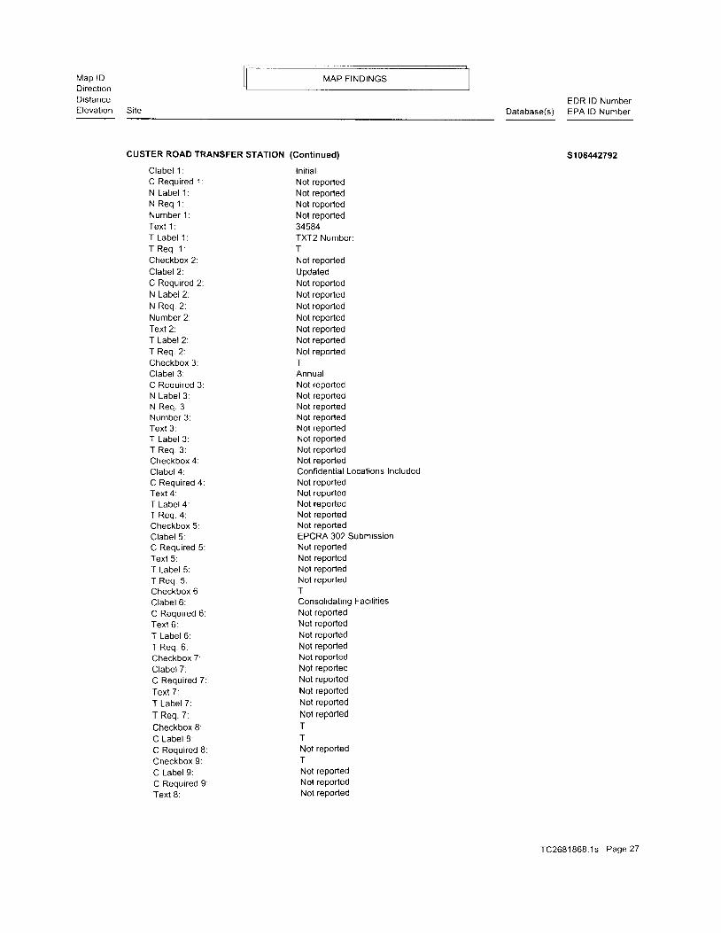
CUSTER ROAD TRANSFER STATION
Clabe l 1 :C Required 1:N Labe l 1 :N Req 1 :Number 1 :Tex t 1 :T Labe l 1 :T Req . 1 :Checkbox 2:Clabel 2:C Required 2:N Label 2:N Req . 2 :Number 2:Text 2:T Label 2:T Req 2:Checkbox 3:Clabel 3:C Required 3:N Label 3:N Req. 3:Number 3:Text 3:T Label 3:T Req 3:Checkbox 4:Clabel 4:C Required 4:Text 4:T Label 4:T Req . 4 :Checkbox 5:Clabel 5:C Required 5:Text 5:T Label 5:T Req . 5 :Checkbox 6:Clabel 6:C Required 6:Text 6:T Label 6:T Req. 6:Checkbox 7:Clabel 7:C Required 7:
Text 7:T Label 7:
T Req. 7:
Checkbox 8:C Label 8.C Required 8:Checkbox 9:C Label 9:C Required 9:Text 8:
(Cont inued)
In i t ia lNot reportedNot reportedNot reportedNot reported34584TXT2 Number:TNot reportedUpdatedNot reportedNot reportedNot reportedNot reportedNot reportedNot reportedNot reportedTAnnualNot reportedNot reportedNot reportedNot reportedNot reportedNot reportedNot reportedNot reportedConfidential Locations IncludedNot reportedNot reportedNot reportedNot reportedNot reportedEPCRA 302 SubmissionNot reportedNot reportedNot reportedNot reportedTConsol idat ing Faci l i t iesNot reportedNot reportedNot reportedNot reportedNot reportedNot reportedNot reportedNot reportedNot reported
Not reportedI
TNot reportedTNot reportedNot reportedNot reported
s108442792
TC2681868 .1s Page27
Map lDDirectionDistanceElevat ion
MAP FINDINGS
SiteEDR lD Number
Database(s) EPA lD Number
CUSTER ROAD TRANSFER STATION (Cont inued) s108442792
T Label 8:T Req . 8 :Contact 1:Head ing 1 :Req. Contact 1:Contacl 2:Req. Contact 2:County Required:Dept. Required:State ld:State ld Req.:Label Code:Number Of Emp. Required:Si te Plan Req.:Sub. By:Fire Dist . :Mai l Address Req.:Mai l Ci ty Req.:Mai l County Req.:Mai l State Req.:Mai l Z ip Req.:Firo l - l ict Ronr r i rar l '
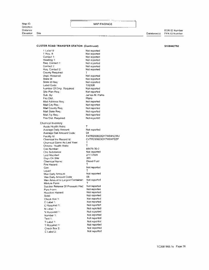
Chemical Inventory:Acute Heal th Risks:Average Daily Amount:Average Dai l Amount Code:Faci l i ty ld:Chemical Inv Record ld:Chemical Same As Last Year:Chronic Heal th Risks:Cas Number:Ehs Substance:Last Modi f ied:Days On Si te:Chemical Name:Fire Hazard:
Liquid:Max Daily Amount:Max Dai ly Amount Code:Max Amounl In Largest Container:Mixture Form:
Not reportedNot reportedNot reportedNot reportedNot reportedNot reportedNot reportedTNot reportedNot reportedNot reportedTX2008Not reportedNot reportedJames M. ParksPlanoNot reportedNot reportedNot reportedNot reportedNot reportedNot reported
TNot reported04FATR2OOS23QYTWO4HZWUcwR200823QY7W]4PZZPTT68476-30-2Not reported2t11t2009365Diesel FuelTNot reportedTNot reported05Not reportedT
Sudden Release Of Pressure Haz: Not reportedPure Form: Not rePortedReactive Hazard'. Not reported
Solid: Not rePorted
Check Box 1: Not reported
C Label 1: Not rePorted
C Required '1 : Not reported
N Label l Not reported
N Required 1: Not reported
Number 1; Not rePorted
Text 1: Not rePorted
T Label 1: Not rePorted
T Required 1: Not reported
Check Box 2: Not reported
C Label 2: Not rePorted
TC2681868.1s Page 28

Map lDDirect ionDistanceElevat ion
MAP FINDINGS
SiteEDR lD Number
Dalabase(s) EPA lD Number
CUSTER ROAD TRANSFER STATION
C Required 2:N Label 2:N Required 2:Number 2:Text 2:T Label 2:T Required 2:Check Box 3:C Label 3:C Required 3:N Label 3:N Required 3:Number 3:Text 3:T Label 3:T Required 3:Check Box 4:C Label 4:N Required 4:C Required 4:Number 4 :Text 4:T Label 4:T Required 4:Check Box 5:C Label 5:C Required 5:Text 5:T Label 5:T Required 5:Check Box 6:C Label 6:C Required 6:Text 6:T Label 6:T Required 6:Check Box 7:C Label 7:C Required 7:Text 7:T Label 7:T Required 7:Contact 1:Head ing 1 :Label Code:Contact Label:Average Dai ly Amount Req.:Contact Comment 1:Ehs Comment:Label Code:Dai ly Amount Req.:Maximum Vessel Required:Maximum Per Container:Required Head:Uni t Reqiured:Trade Secret:
(Cont inued)
Not reportedNot reportedNot reportedNot reportedNot reportedNot reportedNot reportedNot reporledNol reportedNot reportedNot reportedNot reportedNot reportedNot reportedNot reportedNot reportedNot reportedNot reportedNot reportedNot reportedNot reportedNot reportedNot reportedNot reportedNot reportedNot reportedNot reportedNot reportedNot reportedNot reportedNot reportedNot reportedNot reportedNot reportedNot reportedNot reportedNot reportedNot reportedNot reportedNot reportedNot reportedNot reportedNot reportedNot reportedTX2008Not reportedNot reportedNot reportedNot reportedTX2008Not reportedNot reportedNot reportedNot reportedNot reportedNot reported
s108,tr.2792
TC2681868.1s Page29

Map lDDirect ionDistanceElevat ion Si te
MAP FINDINGS
CUSTER ROAD TRANSFER STATION (Continued)
Chemical Inventory Location:Record Key: CLTR200823QY7W04Q00HChemical lnventoryRecordld: CWR200823QY7W04PZZPFacility Route Record ld: FATR200823QY7W04HZWUAmt Of Sub Stored Or Transported: Not reportedAmount Units: Not reoortedType Of Storage: BNumber Code/Storage Pressure: 1Number Code/Storage Temperature: 4Desc of Loc(Or Transported) Subs: South of Transfer Bui ldingLast Modif ied: 2l11l2oog
EDR lD NumberDatabase(s) EPA lD Number
s1084/2792
Contact :Contact Emai l :Contact Mai l Address:Contact Mai l Ci ty:Contact Mail Country:Contact Mail State:Contact Mai l Z ip Code:Contact Type 1:Contact Type 2:Contact Type 3:Contact Type 4:Conlact Record ld:Contact First Name:Contact Last Name:Modification Date:Ti t le:
Contact:Contact Emai l :Contact Mail Address:Contact Mai l Ci ty:Conlact Mail Country:Contact Mail State:Contact Mai l Z ip Code:Contact Type 1:Contact Type 2:Contact Type 3:Contact Type 4:Contact Record ld:Contact First Name:Contact Last Name:Modification Date:Ti t le:
Not reported505 E. Brown STWyl ieUSATX75098Emergency ContactNot reportedNot reportedNot reportedcTTR200823QW01 009D01DavidMorgan2t11t2009Mgr. of Maintenance Services
Not reported810 N. H ighway 78WylieUSATX75098Emergency ContactNot reportedNot reportedNot reportedCTTR2OOS23QXXFO3LZCOJeffMayfield2t11t2009Solid Waste Systems Mgr.
Contact:Contact Email: Not reported
Contact Mai l Address: PO BOX 2408
Contact Mail City: WYlie
Contact Mail Country: USA
TC2681868 1s Page 30
Map lDDirect ionDistanceElevat ion Si te
MAP FINDINGS
EDR lD NumberDatabase(s) EPA lD Number
CUSTER ROAD TRANSFER STATION (Gontinued)
Contact Mail State:Contact Mail Zip Code^ ^ ^ r ^ ^ + T . , ^ ^ i .u u r r r d u r I y P E r .
Contact Type 2:Contact Type 3:Contact Type 4:Contact Record ld:Contact First Name:Contact Last Name:Modification Date:Ti t le:
TX75098Owner / OperatorNol reportedNot reportedNot reportedCTTR2OOS23QVYKOO53DYNot reportedNorth Texas Municipal Water2t11t2009Not reported
s10842792
Notes: Not reportedDescr iot ion: REFUSE SYSTEMSFacility ld: FATR200B23QY7W04HZWUld: 4953Last Modified: 112612004Record Key: FDTR200823OY7WO4JZXHld Type: SIC
Description: Other Nonhazardous Waste Treatment and DisposalFacility ld: FATR200823QY7W04HZWUld: 562219Last Modified: 1212912008Record Key: FDTR200868EGLH006DKJld Type: NAICS
Val idat ion This facility passed all validation checks
C14 NORTH TEXAS MUNICIPAL WATER DISTRICT TRANSFER STAT SWF/LF 5106170470NNW 9901 CUSTER RD N/A112-1 PLANO, TX 750250.932 mi.4923 ft. Site 3 of 5 in cluster C
Relative: SWF/LF:Lower Region: 4
Permit Number: 20454Actual: Facility Status: ACTIVE639 ft. Facitity Type: 5TS
Permit Status: ISSUEDStatus Date: 113112006M a i l i n g A d d r e s s : O W N O P R : 9 9 0 1 C U S T E R R D P L A N O , f x 7 5 0 2 5 5 1 3 2Client Name: OWNOPR: North Texas Municipal Water Distr ict
Cl ient Address: OWNOPR: PO BOX 2408 WYLIE, TX 750982408Client Telephone: OWNOPR: (972) 442 - 5405Business TYPe: 03Area Served: Not rePortedEstimated Closure Date: Not reportedPermit Acreage: 15.85Permit Start: 1112112006Permit End: 51912007Polution Served: 290100Tons Per DaY: 750Yards Per DaY: Not reportedApplication: NOTICE MODIFICATIONLaVLong: 33.189999999999998 / -96 5600000000
TC2681868 .1s Page 31
Map lDDirectionDistanceElevat ion
MAP FINDINGS
SiteEDR lD Number
Database(s) EPA lD Number
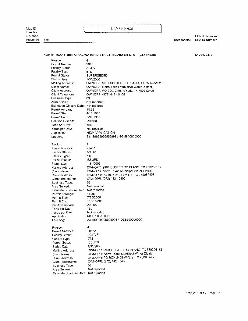
NORTH TEXAS MUNICIPAL WATER DISTRICT TPANSFER STAT (Cont inued)
Region: 4Permil Number: 2045Faci l i ty Status: ACTIVEFaci l i ty Type: 5TSPermit Status: SUPERSEDEDStatus Date: 113112006Mai l ing Address: OWNOPR: 9901 CUSTER RD PLANO, TX750255132Cl ient Name: OWNOPR: North Texas Munic ipal Water Distr ic tCl ient Address: OWNOPR: PO BOX 2408 WYLIE. TX 750982408Cl ient Telephone: OWNOPR: (972) 442 - 5405Business Type: 03Area Served: Not reoortedEstimated Closure Date: Not reportedPermit Acreage: 15.85Permit Start: 411511987Permit End: 3/30/1988Polut ion Served: 290100Tons per Day: 750Yards per Day: Not reportedAppl icat ion: NEW APPLICATIONLaVLong: 33.189999999999998 / -96.5600000000
Region; 4Permit Number: 2045AFaci l i ty Status: ACTIVEFaci l i ty Type: 5TSPermit Status: ISSUEDStatus Date: 113112006Mai l ing Address: OWNOPR: 9901 CUSTER RD PLANO, IX750255132
Cl ient Name: OWNOPR: North Texas Munic ipal Water Distr ic t
Cl ient Address: OWNOPR: PO BOX 2408 WYLIE, TX 750982408
Cl ient Telephone: OWNOPR: (972) 442'5405Business Type: 03Area Served: Not reportedEstimated Closure Date: Not reportedPermit Acreage: 15.85Permit Start: 712512006Permit End: 1112112006Polut ion Served: 290100Tons per Day: 750Yards per Day: Not rePortedAppl icat ion: MODIFICATIONLaVLong: 33.189999999999998 / -96.5600000000
Region: 4Permit Number: 20454Faci l i ty Status: ACTIVEFaci l i ty Type: 5TSPermi i Status: ISSUED
Status Date: 113112006Mailing Address: OWNOPR: 990'1 CUSTER RD PLANO, TX 750255132Client Name: OWNOPR: North Texas Municipal Water District
Cl ient Address: OWNOPR: PO BOX 2408 WYLIE, TX 750982408
Client Telephone: OWNOPR: (972) 442 - 54Os
Business Type: 03Area Served: Not rePorted
Estimated Closure Date: Not reported
s1 061 70470
TC2681868.1s Page 32
Map lDDirectronDistanceElevation
MAP F INDINGS
Si le
EDR lD NumberDatabase(s) EPA lD Number
NORTH TEXAS MUNICIPAL WATER DISTRICT TRANSFER STAT (Continued)
UST:Faci l i ty lD:Faci l i ty Type:Name of Faci l i ty Manager.Title of Facility Manager:Faci l i ty Manager Phone:Faci l i ty Rural Box:Facility in Ozone non-attainment area:
TCEQ Num:Owner lD:Date Registration Form Received:Region Number:Number of USTs:Sign Name on Registration Form:
Title of Signer of Registration Form:
Date of Signature on Registration Form:
Owner Effective Begin Date:
Owner lD:Owner Name:Owner Address:Owner PO Box:
Owner Ci tY,St ,ZiP:Owner Contact Name:
Contact TelePhone:Owner Type:Mai l Undel iverable:Bankruptcy is in effect:Owner Amendment Reason Code:
Owner Amendment Date:Number of Facilities reported by Owner
# Of Underground Storage Tanks:
# Of Aboveground Storage Tanks:
Self-Certification Date:Signature Name:Signature Title Name:
Signature Type Text:
Certilication Submitted TYPe
Registration Self-Certification Flag:
Fees Self-Certification Flag:
Financial Assurance Self-Certification flag:
Technical standards Self-Certification flag:
0046556Fleet RefuelingJEFF MAYFIELDSW MGR972-442-5405Not reportedYes061 49312364082688041CARL RIEHNEXEC. DIR081 988082688
12364NORTH TEXAS MWDNot reportedPO BOX 2408WYLIE, TX 75098JAMES PARKS972-442-5405Local GovernmentNot reportedNot reportedOwner Bi l l ing Address Changed0423080009001 10004
s106170470
usT u001277996N/A
Permit Acreage:Permit Start:Permi l End:Polution Served:Tons per Day:Yards per Day:Appl icat ion:LaVLong:
1 t r C q
10t28t20041t31t20062901 00750Not reportedMAJOR AMENDMENT33.189999999999998 / -96.5600000000
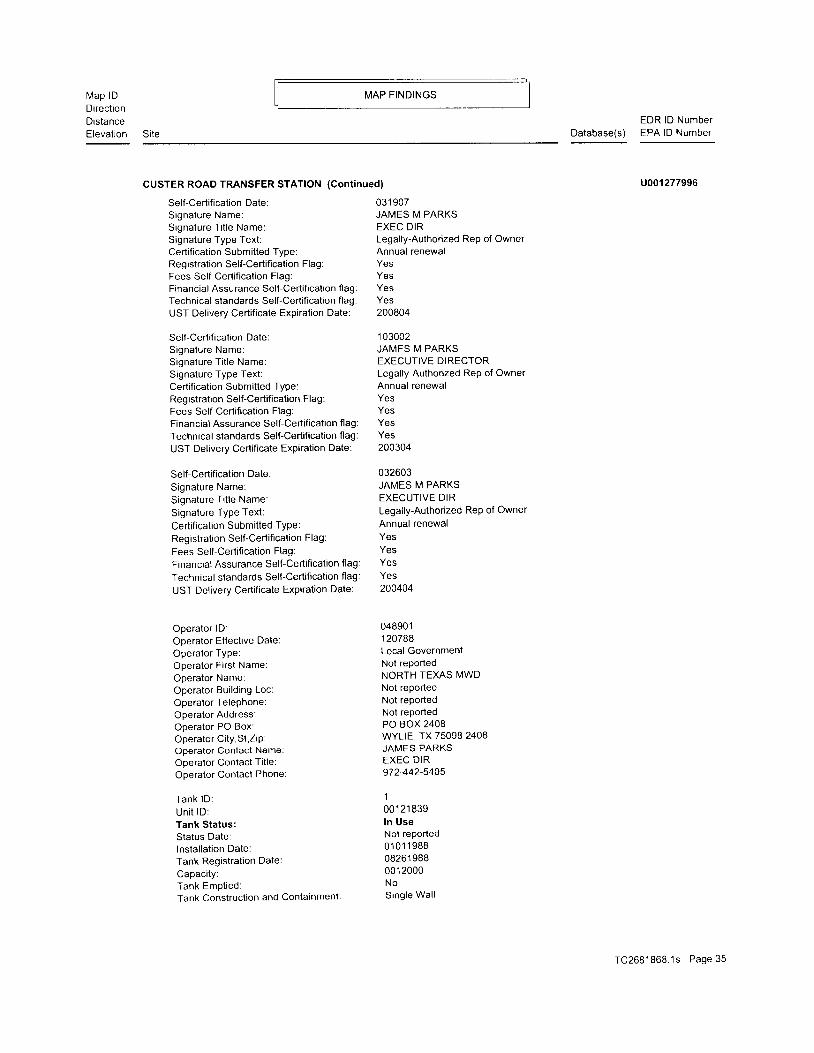
C15 CUSTER ROAD TRANSFER STATIONNNW 9901 CUSTER RD1t2-1 PLANO, TX 750230 .932 m i .4923 ft. Site 4 of 5 in cluster C
Relat ive:Lower
Actual :639 ft.
030404JAMES M PARKSEXECUTIVE DIRLegally-Authorized ReP of Owner
Annual renewalYesYesYesYes
TC2681868 1s Page J J

Map lDDirect ionDistanceElevation
MAP FINDINGS
Site
CUSTER ROAD TRANSFER STATION (Cont inued)
UST Delivery Certificate Expiration Date: 200504
Self-Certification Date:Signature Name:Signature Ti t le Name:Signature Type Text:Certification Submitted TypeRegistration Self-Certification Flag:Fees Self-Certification Flag:Financial Assurance Self-Certification flag:
Technical standards Self-Certification flag:
UST Delivery Certificate Expiration Date:
Self-Certification Date:
Signature Name:Signature Ti t le Name:
Signature Type Text:Certification Submitted TyPe:Registration Self-Certification Flag:
Fees Self-Certification Flag:Financial Assurance Self-Certification flag:
Technical standards Self-Certification flag:
UST Delivery Certificate Expiration Date:
Self-Certification Date:Signature Name:Signature Ti t le Name:Signature Type Text:
Certification Submitted TYPe:Registration Self-Certificaiion Flag:
Fees Self-Certification Flag
Financial Assurance Self-Certification flag:
Technical standards Self-Certification flag:
UST Delivery Certificate Expiration Date:
Self-Certification Date:Signalure Name:Signature Title Name:Signature Type Text:Certification Submitted TYPe:
Registration Self-Certification Flag:
Fees SeltCertification Flag:
Financial Assurance Self-Certification flag:
Technical standards Self-Certification flag:
UST Delivery Certificate ExPiration Date:
SeltCertification Date:
Signature Name:Signature Ti t le Name:
Signature TYPe Text:Certification Submitted TYPe:Registration Self-Certification Flag:
Fees Self-Certification Flag:
Financial Assurance Self-Certification flag:
Technical standards Self-Certification flag:
UST Delivery Certificate Expiration Date:
03 1 308JAMES M PARKSEXEC DIRECTORLegally-Authorized Rep of OwnerAnnual renewalYesYesYesYes200904
01 0501JAMES M PARKSEXEC DIRLegally-Authorized ReP of Ownerlnit ialYesYesYesYeS
200204
o12705JAMES M PARKSEXEC DIROwnerAnnual renewalYesYeSYeS
200604
0 3 1 1 0 9JANIES M PARKSEXEC DIRLegally-Authorized ReP of OwnerAnnual renewalYes
YesYes201 004
031 006JAMES M PARKSDIRECTORLegally-Authonzed ReP of OwnerAnnual renewalYesYesYesYes200704
EDR lD NumberDatabase(s) EPA lD Number
u001 277996
rC2681868 .1s Page 34
Map lDDirect ionDistanceElevat ion
MAP FINDINGS
Site
EDR lD NumberDatabase(s) EPA lD Number
CUSTER ROAD TRANSFER STATION (Cont inued)
Self-Certification Date:Signature Name:Signature Ti t le Name:Signature Type Text:Certification Submitted Type:Registration Self-Certification Flag:Fees SelFCertification Flag:Financial Assurance Self-Certification flag:Technical standards Self-Certification flag:UST Delivery Certificate Expiration Date:
Self-Certification Date:Signature Name:Signature Ti t le Name:Signature Type Text:Certification Submitted Type:Registralion Self-Certification Flag:Fees Self-Certification Flag:Financial Assurance Self-Certification flag:Technical standards Self-Certification flag:
UST Delivery Certificate Expiration Date:
Self-Certification Date:
Signature Name:Signature Ti t le Name:Signature Type Text:
Certification Submitted TYPe'
Registration Self-Certification Flag:
Fees Self-Certification Flag:
Frnancial Assurance Self-Certifi cation fl ag:
Technical standards Self-Certification flag:
UST Delivery Certificate Expiration Date:
Operator lD:Operator Effective Date:Operator Type:Operator Fi rst Name:Operator Name:Operator Bui ld ing Loc:Operator Telephone:Operator Address:Operator PO Box:Operator Ci ty,St ,ZiP:Operator Contact Name:Operator Contact Title:Operator Contact Phone:
Tank lD :Un i t lD :Tank Status:Status Date:lnstallation Date:Tank Registration Date:
Capaci ty:Tank Empt ied:Tank Construction and Containment:
03 1 907JAMES M PARKSEXEC DIRLegally-Authorized Rep of OwnerAnnual renewalYesYesYesYes200804
1 03002JAMES M PARKSEXECUTIVE DIRECTORLegally-Authorized Rep of OwnerAnnual renewalYesYesYesYes200304
032603JAMES M PARKSEXECUTIVE DIRLegally-Authorized ReP of OwnerAnnual renewalYesYesYesYeS200404
048901120788Local GovernmentNot reportedNORTH TEXAS MWDNot reportedNot reportedNot reportedPO BOX 2408wYLlE, TX 75098 2408JAMES PARKSEXEC DIR972442-5405
1
001 21 839ln UseNot reported01 01 1 98808261 98800 1 2000NoSingle Wal l
u001 277996
TC2681868.1s Page 35

Map lDDirectionDistanceElevat ion
MAP FINDINGS
EDR lD NumberDatabase(s) EPA lD Number
CUSTER ROAD TRANSFER STATION (Continued)
Tank Construct ion and Containment l l :Tank Construct ion and Containment l l l :
Tank Construction and Containment lV:
Pipe Construction and Containment:Pipe Construction and Containment ll:
Piping Design and Ext. Containment 3:
Pip ing Design and Ext . Containment 4:
Type of Pip ing:In lernal Tank Lin ing Date:
Tank Material of Construction:Other Materials of Construction:Pipe Material of Construction:Other Construction and Containment:Pipe Connectors and Valves 1:
Pape Connectors and Valves 2:Pipe Connectors and Valves 3:Tank Corrosion Protection:Tank Corrosion Protection ll:Tank Corrosion Protection lll:Other Tank Corrosion Protection Text:
Tank Corrosion Protection Variance:
Pipe Corrosion Prolection:Pipe Corrosion Protection ll:
Pipe Corrosion Protection 3:Other Corrosion Protection:Pipe Corrosion Protect ion Var iance:
Stage 1 Vapor Recovery Equipment Status
Stage 1 Equipment Installed Date:
Stage 2 Vapor Recry Equipmenl Status:
Stage 2 Equipment Instal led Date:
Equipment lnsta l ler :Contractor Registration Number:
Tank Tested:lnstal ler L icense Number:
Tank Instal ler :
SeltCertification Date:
Compartment:Self-Certiflcation Date:
Compartment:Self-Certification Date:
Compartment:Self-Certification Date:
Compartment:Self-Certification Date:
Compartment:Self-Certification Date:
Compartment:Self-Certification Date:
ComPartment:Self-Certification Date:
ComPartment:Self-Certification Date:
Compartment:
ComPartment Letter:
Compartment CaPacity:
Not reportedNot reportedNot reportedSingle WallNot reportedNot reportedNot reportedSuction00000000Jacketed (steel w/external nonmetallic jacket
Not reportedFRP (fi berglass-reinforced plasticNot reported312Coated Tank (steel w/exlernal polyurethane laminate)External Dielectric Coating/Laminate/Tape/WrapNot reportedNot reportedNo VarianceExternal nonmetallic .;acketFRP tank or piping (noncorrodible)External Dielectric Coating/Laminate/Tape/WrapNot reportedNo VarianceNot ReportedNot reportedNot ReportedNot reportedNot reportedNot reportedNot reportedNot reportedNot reported
01 0501
031 109A012705
03 1 308
030404
032603
1 03002
031 006
031 907A
0000000
u001 277996
TC2681868.1s Page 36
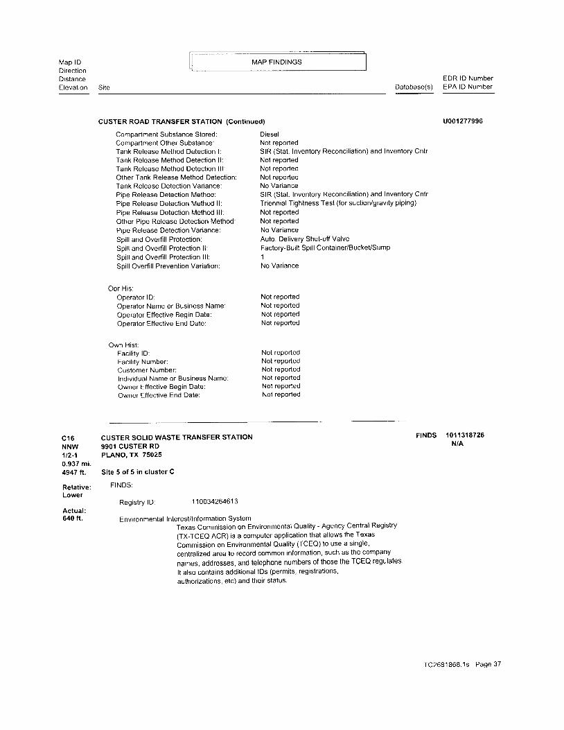
Map lDDirectionDistanceElevat ion
MAP FINDINGS
SiteEDR lD Number
Database(s) EPA lD Number
CUSTER ROAD TRANSFER STATION (Cont inued)
Comparlment Substance Stored:Compartmenl Other Substance:Tank Release Method Detection l:Tank Release Method Detection ll:Tank Release Method Detection lll:Other Tank Release Method Detection:Tank Release Detection Variance:Pipe Release Detection Method:Pipe Release Detection Method ll:Pipe Release Detection Method lll:Other Pipe Release Detection Method:Pipe Release Detection Variance:
Spill and Overfill Protection:Spill and Overfill Protection ll:Spi l l and Overf i l l Protect ion l l l :Spill Overfi ll Prevention Variation:
Op r H i s :Operator lD:Operator Name or Business Name:Operator Effective Begin Date:Operator Effective End Date:
Own Hist :Faci l i ty lD:Faci l i ty Number:Customer Number:lndiv idual Name or Business Name:Owner Effective Begin Date:Owner Effective End Date:
DieselNot reportedSIR (Stat . Inventory Reconci l iat ion) and Inventory CntrNot reportedNot reportedNot reportedNo VarianceSIR (Stat . Inventory Reconci l iat ion) and Inventory Cntr
Triennial Tightness Test (for suction/gravity piping)
Not reportedNot reportedNo VarianceAuto. Delivery Shutoff ValveFactory-Built Spill Container/BuckeUSump1No Variance
Not reportedNot reportedNot reportedNot reported
Not reportedNot reportedNot reportedNot reportedNot reportedNot reported
u001 277996
FrNDS 1011318726N/A
C16 CUSTER SOLID WASTE TRANSFER STATION
NNW 9901 CUSTER RD'lt2-1 PLANO, TX 750250.937 mi.4947 fl. Site 5 of 5 in cluster C
Relat ive: FINDS:
Lower
Actual :640 ft.
Registry lD 1 1 003426461 3
Environmental Interest/lnformation SystemTexas Commission on Environmental Quality - Agency Central Registry(TX-TCEO ACR) is a computer application that allows the Texas
Commission on Environmental Quali ty (TCEO) to use a single'
centralized area to record common information, such as the company
names,addresses ,andte |ephonenumberso f thosetheTCEQregu|a tes .It also contains additional lDs (permits, registrations,authorizations, etc) and their status.
TC2681868 .1s Page 37

@O
ooN
@
@N
F
a a a a at t n c t Ei l i l f i , P u uz z z Y z zu u u , , t u u
- i N i 6 6 5 : J . i 6 6l n 2 E ) > > > J s ' t t > >d L ! _ J L d d d t S o x . tr o F a o o o @ a t o a
o o o o o o @ oN N N
o o o o o o o a6 6 6 0 6 0 0 0
u r > oZ H . "J E / r -r L )i l i o <i z 1= d E t v +
9 J 3 . - r r i o o, - E T r - T ) i * t t^ L F F F U ' ^
H - o o o 9 . " : l - l _Y - i i i > > > l I ;- 6 t r H F F , * , P 5 - 9 9
N c o F f ^ ^ ^ 4 F N ( r ( r- " r / a 5 X X X ; L D - L ! u
- a : 3 ; = = b S - o o1 2 2 t r ; ; ; i i l r e e- - 1 @ d i @ o 5 = o o Qo . : o : - o N - 5 @ @ oN L ! - U o o o o - $ @ oe O r U e r N O o N N N
zz g 5d ; d ^ z u
z ^ * H 6: ; i +< o o a
z 2v , z
* 2 9 F Sz a l) = 4 = Y Z A Aa L F = , ^ ; u t " t
r r * f 9 p t i , r i = 2 2
3 = = = l - i , A ? g $ g= " q Z q g 3 ? 3 : i l i? 4 - - , 4 8 d { = E E iq 5 3 3 3 r f 3 E 5 gF o @ r 9 - N O N N r y ON t o S O - O N O O N T ! -o : - ' _ o - @ < o < o @n o N o - O O a o o N -o - O - @ @ @ O r N O @i j o @ o o o o o o i t @ o
E E B b B 3 3 8 3 3 3 3e o F r
a a a a u ) a a a a a a a
F
zloO
z z z z z z z z 4 , Q g oE E ! E s ! 5 = l < / i< i i i < ' i i i U o = ' a?
O
ooN
qN
o!!
o
a
EzIa
odoU
t
-az-cuo
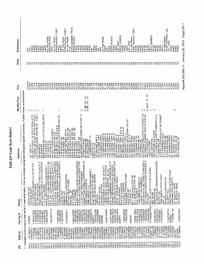
nNoo0_
N
c!
(g
G
U)
N
F
q)
@ a 3 r sO O z O Oz z E z l_ L - L O
o O o c a i a 9 , n o O 9 , i I r Ea v a . \ a . a a u d a Q u o . x u o >g: gE *Eg efi g ? ,-=< rgE i *F;r E N Z N Z N u . 1 O r E o - u . 1 o - N Z u 1 N * o -
--^33333ffi f *Df #33f *f ,,9*gg 33333-33-rf 3-3*33:q3S):f #33333;9gAgAlf Al3Eg33\======f :FH:Ff FePeIrPi i i l i==3i=s*zi2 i911gx11s*s291=====?E==i l iE=Ez*E?z-
X X X X X X X X X X X X X X X X X X X X X X X X X X X X X X X X X X X X X X X X X X X X X X X X X X X X X X X X X X X X X X X X X X X X XF F F F F F F F F F F F F F F F F F F F F F F F F F F F F F F F F F F F F F F F F F F F F F F F F F F F F F F F F F F F F F F F F F F F F
a z z z z z z z z z z z z z z z z z z z z z z z z z z z z z z z z z z z z z z z z z z z z z z z z z z z z z z z z z z z z z z z z z z z zt U U U U U U U U U u U u u u U U L! uI U U TU u U U U U I! U U u U U U U U U U U U U u U U U U U U U U U U U U U U U U U U U U U U U U U U U/ , ) J ) ) J J ) ) ) ) ) ) ) J ) J J J J J J J J J J J J J J J J ) ) J ) J J ) ) J J J J J J J J ) ) ) ) ) ) ) J ) ) ) ) ) ! ) ) ) J J ) JQ ) J J ) ) J ) ) J ) ) ) ) J ) J J J J ) ) J J J J J J ) J ) ) ) ) J ) J ) ) J ) ) ) J ) ) J J J ) ) ) ) J ) ) ) J J J ) ) ) ) ) J J ) )
o < < < < < < <
uiuiz z
i l < <
- ) r A * r [ ( o -X 8 H = 5 - ; ; ; 93 ; ; i = i = ? f 3 *x 6 : ; I : : t E 6 5o . & i j ' U t . ^ , ^ 6 I E = >r .= - - < F o6 , , ,R^aF I RR A 98
' - , ae o a E u < E g : E : : f i g g ; d d = d z
l3fi i ;=r-=:?""lEEHH "9 = ?rr7:;:;?::i77fryrr** #'k t: 'x3==::**,;3U F*-*EF555l?9iFf,F3=ssl *qqS3***8*****[ I??f i i -#F"--pHixr_;r***a4686 i f -o6 -oE22y>>E>>>>> t t *??* -_ .ua t7Z l17 ; i t i nu iu ;qu ] " .5556b I f ; f P ' * . . t r ) * *ooJ
i;AEg;=iiiilaefiIruttIItH;xxHEr*a 8frfrfrfrfrft****ZtfrZtEffiaan;nlElE*gg**F*F:H ;e?<34r rE: :u i i i i i l l : : s f rEEE5ip??HH;HH;q IHHh: : ; ;BNe; ; ;B ; ey-=-6oFr -Frsa lsanEppppRR5ppps€HHHH6F€e:RRppp: : : :=FFRRHHHHHHpNn:6p:335 i5s ; ;bbsab
N
o=
gHEEEEEEEEEEgEEEgEHEEEEEEE:EEEEEggHEeEEEEEHEEHEBEEEEEgEBgEEEEE*EEEE*E
Z I. O= z? 5a zX O< aL Z
o
N
o
co
Eo
o
,o' t i
o
E
I
qiG.E
ooool.=oo
7-
a
6
o
' 6
coo
o
ago=o
o
=6
Eo
o
o
;oc
6E
o
Gcco!Goo
oo
€;
u a )4a i i\rla =vl LUi z 7 =T q Y ? z
9 a k 0 E, . . " : , , r t s A Y J
2 " d Z - 9 ? = X 7 ot > z ; o > - . l * P F fP * U ! f r e ? U 3 ? ? . .q < f i t g e ! r + 6 5 3 > >4 ; d X 6 i H , r = 6 & s s 5 5A Z o \ z a \ z u l a O o < { : :U 6 f 9 - f - 6 Z ; = 1 - t ' o z o o < <
=HP5*HEI ie; ;H-:E6<EEgf r i O a 9 o o ? d @ t d o = g t t r t i l i l :Lt|Z a Yl Z t) l ) , rr U !J Z - I ul u ! i u L F
3EE?gEFg!5igFB=8t8s*gN)a
S ; F * h H i l : [ S g 3 F F F8PB*ERSF :HHi l } ""8 RS S E F B S S F s 3 3 s 3 3 3 3= P = g = B = F 3 C 3 3 3 3 8 Ir r r r r - r q
: 3 : :
F ;r ;EEnfr; ;B ; == 2=F,; 3: iqqqS=q rt83 ; i;qE:F1 A2 22262?fr 6 ;E?q rrr qb?Ebfr- i "a F: iEEE;l3 sr eirts zfii r**q*Eg i A
EEE;eEEnllgEE*;tussEiIHEEEEE,EEFfi EEEEHs*FEtE={ .BnaiEF 3 siF : Fafr}3FF$fr EH E n:R; ES*EHbi lsH E $R; $ BEHH$FHHH-i lH 5 s(sH 53ssbssEE = EEb i i jgEtBasgEanEHE E EEESE gE g??iE?ii F ??= ? ?F???:?=?s?:Es ? =r==H =: s
o o o O o o o o o o o o o o o o o o o o o o o o o o o o o o o o o o o o o o o o o o o o o o o o o o o o o o o o o o o o o o o o o o o o o
B B B B B B B B s e a s s a s F H H H H B F F b a a s b g H H F H H F a s a s a a h a s s a s a 3 3 3 3 3 3 3 3 3 3 E F F E F F E F E F EN N N N N N N N N N \ N N N N N N N N N N N N N T S X S T i J i J i l N N N T N N N i N N N N N N N N F N N N N N N N F N
q
o
o
U)
o
o
.=
=
toCL6'tr(Eooo! ,!)o ; io tt t - iNtouJ
E
z
e=o1!
-&
UJ
N

N
o_Nq)
(!
N
oN
b(B
(!
q
N
F
q)
6aU()sI
a a a D u ) a - :t d . u t t t o q 9 9 9U U U U U U d U A A
r, i.c t! t! ul uJ ul t4 () tsru N N) a a u r a a a a a a a e a a a o o . N ! o q g ] u t a o i l u ) d / : , i a a i a a l a i u t o a - i o . i o * o o - c o ? * r n c n S o N + @ N o ( , c o! i o o o o o o o o o o o o o o o o l i s d o r - d o o r o o ; L o d o ; r o o ; o r o ; o ; o r F o ; o d o d o ( r t r o o a * r f o * o 0 , - o d o o o6 z z z z z z z z z z z z = z z z K o u z 6 6 u z z a z z ' t 6 z u z ( t ' a z z ? y z ' , a z i r z i t z o ' , o z i z z 6 z u z u u z o i z z i z u i z u z z zr u r r u u u u u r u u u u tr tr L f - F r - A tr r r r r L o < r F r o 5 L r o C - r - u - u j i tr - r oa r F u tr F tr oa g tr u c u F S r F L u L
X X X XF F F F
z z z zU U U U) J ) J) ) J )
lEil:HFEREPgDNEFHI$HHeHgEHM!g$EeilF:giiifiFHBffiHtEFfi$€€3Pil*EEEEEFEE$r EE3fiIl3iEE!gIEiiEiEE3gEHEg?BEEEEE3?E3EHqEE3EqE3EgEqgEHE3EgE;gFF;EE;EHE ;E3El < r r e
FFFFFFFFttFFprFptFtptFnppptppttperpepeeeeFFtprtpnpFetttrnttFtFFttF trpF
X X X X X X X X X X X X X X X X X X X X X X X X X X X X X X X X X X X X X X X X X X X X X X X X X X X X X X X X X X X X X X X X X XF F F F F ; F F F i - - F F F F F F F F F F F F F F F F F F F F F F F F F F F F F F F F F F F F F F F F F F F F F F F F F F F F F F F F
z z z z z z z z z z z z z z z z z z z z z z z z z z z z z z z z z z z z z z z z z z z z z z z z z z z z z z z z z z z z z z z z z zuJU t !uuuuuuLUt !u tuLo tuu lDuuuuUJ t r JDuJ tuu l t uu tuuuuuuJ t r J t ! u l t ! uuuuuJuJ l l l u l uuuuu lu l uJ t ! l L l uuuuuuJ l l l uuuJ - - ) - ) = J J - J - ) ) J J J J J J - J J J J J J J J J J J J J ) J J J ) J J ) J ) ) J ) J ) J J ) ) ) ) J J ) J J J J ) ) J )) = = . - - J J L I L I I L J J J J J J J J J J = = - - - - J J ) J ) J ) J J ) J ) ) ) ) J J J ] J J J J J J J J J J J ) J ) ) ) )
< < a a < < < < < < < < < < < a
:
: : : i t ! i : i i l i i i i : , i i i i
= i ; v ) r ? > < u - a Z Z b=iA!:3 8Eqfia:s i 7fZ7Z2 = ,BB BB FF PP ! -
ii=i;i= arFfrgg t* rtt""r[""""t[ ilE zZ ;FiEi:H"3 E;9!Ei SFFFFFEFFSFFFF'xFTP-Xrrrxxrrr rFEt s r* iesiSEpp 6+f " '9? sxEEEssa*bbbbbbbaaaoE"rrrEEFEEFEEE?oxxxxxss E p5
,HHpadl! [x:EF9;gB,- **** j j ;Ee;; ;H;;E;5;EEEEeE333;;33:; ; ;HE=:???:5= 5I i ;* l *o= :?8 ;RHg-"b ;5122=2222* fnHHtU^g=^3H.3 . .g .HHHBtBHHhf i f i t rnnnnnbxu<zr r r r rzz
z*eo
EEs;FFf EEESiE$q==€====sg:#=EEg:::=:=:#::=====?::#=s?====2?====gEp , H H V = = = A = x e z z < < { = g F E E F E E E E E E E ; b o b r c i 6 i 6 o - r r s s d H H H H H H * B B B B B B 6 E F F F a a E a a * 6 :6 tr tr tr o o o : o : ;j o o o o I o - N |I o b o o ; ; ; ; - - - - F F '_ N N @ @ o - " - - - - - -
;
-
s r g + 2 ; b 3 g i l * " e L =
, E F H lv x x h : ; ; r t 3 B H - * E P E x ; = g E r = f r $l f r9_g ,EHZiV2= : Hg t r i $ uu HH_e66 i$? , ,8=
,-Eg?ui;u-E!'H' urrrf*= ff8$E--;F,*,,E8 cx..fsExEaieFS*Eu EZZeg gsf+gagel[:E=F ^rZ =t4ii1++px*=i:i!!Bgrssgt*iqfiirfifr*iiFeinisrs=;qec Eiiir
igaEigaEat*EEngg==,*E,,igaEEHHSESEHE3EEgE::EI::fi*sfieeTcEEE}t}*EFEFEHE?' Q - R :
EEEEEFEEEEEFEEEEEEEEFSS'EE== = E ='* E** * =u*' =u* =* E* =E =*= *===3 : : : : : : : : : : : : :
q
q
o
v,
o
.9
.:o
=
Eoo(Dt(!(J
oop 8o to - iNtor,J
oEz
e=L
o?uoIJJ
cN
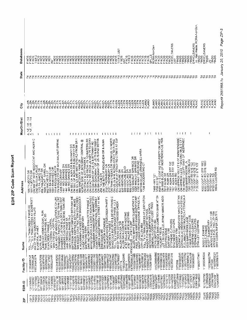
Noao_
(\
-(!
o
6
;(oP
N
*z z z z z z z z z z z z z z z z z z z z z z z z z z z z z z z z z z z z z z z z z z z z o o o o o o o o o o o o o o o o o o o o o o o o o !U U U U U U U U U U U U U U U U U U U U U U U U U U U U U U U U U U U U U U U U U U U ' Z Z 2 2 2 Z Z Z = 2 2 = - 2 2 2 2 2 2 2 2 2 2 2 2 O) ) ) J J ) J J J J J ) ) ) ) J J J J J J J J J ) ) ) J J ) J ) J J ) J ) J J J J ) J j . < ? ' a a a a a a a a < < < < < < < <) J ) ) J ) ) J ) ) J ) ) ) ) J ) J ) J J ) J ) J ) J J ) J ) ) ) ) ) J ) J J ) J ) J ) J J J J ) J ) J J ) J J J I I I I I I - j . J I I J I C )
iooE
fu9
. g g ; pF lq D i l6 U
9 E 1 , = s : = s, , . , , , N , , a a a a a a a a a a u ) a a a a a u ) a a a a u ) a a a a o o N o . , , N u , r . r . r r 2 l . r r . . r l . . r r t r f , F t r 1 u . , ,o o o d o o o o o L o o o o o o o o o o o o o o o o o o o o o o o o d o ! o ( r o o o o o o o i d o o o o o o ; L o o o o o o ; ' o o ; o r o oZ z z u J z 2 z z z ' a Z 2 z Z z Z Z Z Z Z Z Z Z Z Z Z z Z Z 4 Z Z Z Z U Z ' @ z u z z z Z z z z t - z z z z z z t a Z Z Z T T Z t p z z U z a z zr L u F tr r u r tr < tr u tr u u u r r L L L I u u u u u u u [ [ [ [ tr tr tr i r F r r L r r u r A d d L tr tr tr tr - . G tr tr tr tr tr o c u tr o L 5 r L
X X X X X XF t s F F F F
X X X X X X X X X X X X X X X X X X X X X X X X X X X X X X X X X X X X X X X X X X X X X X X X X X X X X X X X X X X X X X X XF F F F F F F F F F F F F F F F F F F F F F F t s F F F F F F F F F F F F F F F F F F F F F F F F F F F F F F F F F F F F F F F F
U Uz z< < i ! i i i : i ;
o o
r l u oF F T .a a f to o o o o i l
p p p r r _ Q
x x x x x uo o o N N s
o o o N N o@ @ 6 o O F
? Z r er p3^2f $ E:a g* =^*z? f ExZ i trEgf;q 3 ??i =u 6"ift? 2 ?7f A 3:El= 5 aP; n ;4 E=2
H. * -i---$$p;r;ilfr;! 5==E[! ageln HE ,, !=f=r*,*- - F#xxI-5518*ErIqqi**EEE i?Z "Ei\s?Err;rx**r:B _ =g""HH"etaEXnlHnnEE;iingpEgfifrfi*33?HEie?lF{5;PPB:;555555:E:e ;-?!:#gFnffBff8:i9:trr*iiapEE?Ef; ffi Sf HHs#iFEE=E\eeiii**z?Z=r:H jiiiirrEsiisF: 5 1 e : ; R i 5 E : : 3 ; i lZZZgEZS1lllva:,i a a a a a g a g N il : = E R B ? a F F F F E 6 6 6 il F : i :@ @ A a @ o @ o o o o : N s !r r U U - o F O r - F U - - r
rl.- 's=2? =FEB f=vgfr i ffip **E 3 dt z q :E'$E: l- __[EEE
--1:=z fi*=;H ft !*E ." *E: ;crH $ 3 EEg 6
EEEA EEEEEEEaaEEEEE?fuEEEEEAEEEBEETEEEIEEEEEEEHAEEfuHfuEEEEEHHIcE- EE*-- -EE-EEE-EEEEEFEEEEEEEEEEEEE=H===EE== E=EE=EE -==E=== E
@ @ d
3 3 P> > zF h U
> t = o.^ . "3??r( t z * * =
228\=2U U J T T <J J U d d UO ( J F U U ' - la a l ( t ( t v@ o S O O >gg tssS
O A N . _
O N N ' -@ o N @N O O O @o @ o o N
o o N o oo o N o o
PH$EST3 8 3 E 6 3FEBEFFo : o = o o
N N N N N N
6 0 @ o @ oN t s N N N N
gEgHEEEEEEIEE$EEIEEEEuguggsgieegEEfiEEEgEEEEFH*HBEEEiE$EilEgEHEHfEEEe;EE=e;:EEEE==FFFFFFFFp=pppE=EeEgEgF;Eeleepe;eFEEFFF;SEFEF=F;F
N FE F FEFEF F FFFEtFFtptpttFppntreFEe eaeFpEpeFeEFttFHHHEe HnHeH eEe ileF e
ooa
U'
o
q
G
=
Eoo-ot
GoooE no ; ;o to - ENuollJ
o
=
L
o
z
o-dou.J
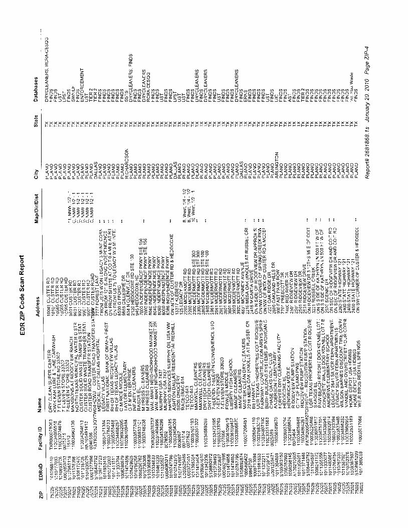
\+
Nq)
oa-
N
N
$
o
q
:z P .O zn 6 :+t
o o o o o o o o o o o ? o o o o o o S o o o o o o o o o o ? o o o o o o o o o o o o o o ? o o e o c o o $ o o o o o o o o o o o o o o o o o o tz z z z z z z z z z z J z z z z z z i z z z z z z z z z z ) 2 2 > > 2 > 2 > > > > > Z Z ) 2 2 2 2 2 2 2 2 2 2 2 2 2 2 2 2 2 2 2 2 2 2 2 2 2 2 c333:s3333333133333364333333333133333333333333?3333333P333333333333355I55 qo- o, o- o. o- o- a a o- tr a o o- o d o- tr o- - o- o- a o- L o- o- o- o. o- ci o- a o. tr o- o. o- o- o- tr o, a a o- o o- o- o- c a o o- ( a o. o- (I tL o- o- (I L (I (! (I (L o- 0- (L (I L rY
69lY< u )e o( ) zC r La l v i a q q q( - f r i l .^ 4 A; U ur uJ- uJ ul u i;z a z z t - ^ z z z n< l ! < < i iu ,. u u t!- ul rJJ LU7 - . . 5 r * , N d a a a a a a . ^ 1 . - 1 i . - - . . a a i a i a a . . . i . , n - . - - a a a q a N r t r . . ^ r r - r \ ,; o o L ; o Li o Y r E d o o o o o o 3 ; o o ; .; o o r o o l: r g o o ; o ; o o L o o o ; o > o o o o L r] o o - o r] oa o o o o o o o o o o t o? f z z a X ' z Z z > a u u z z l z z z i n i r z z T r o z z a z z Y a a z z i y z ? f z z a z z z k z E z z z Z a z ( 2 z z ' a z z u z z z z z z z z z z o zo u r 5 f r 6 u il 5 F F L L L r L u tn o u L o d r L 5 r L f 5 5 L r o r 6 L L 5 tr tr tr b tr ur tr tr tr tr f tr r tr tr < tr tr tr L L r u u u r u r tr c tr
X X X X X X X X X X X X X X X X X X X X X X X X X X X X X X X X X X X X X X X X X X X X X X X X X X X X X X X X X X X X X X X X X X X X X X XF F F F F F F F F F F F F F F F F F F F F F F F F F F F F F F F F F F F F F F F F F F F F F F F F F F F F F F F F F F F F F F F F F F F F F F
N N
= o l
3 3 9B 3 -
. - - J O r
EEeEHEEEgEHHEE:EEEEEEEBEEEEEEHgEgEHgHEEEgggCEHEEgEEEHEEHEEHEEE::EEEEEHE
l - . i - . *
i i ====- z z z z z- z z z z z
.cxi i I l i [ F ta aP He E I = F E I ; o s P 8 # - c E H!ai= HH H sse= ; ;qF : HH ?? p;E=k ; t t : :=:: l HIHH -f i ;?H E ,, ,8 i i 55l l l lE
-. q E i: - - p " g gE BEB E f r=r?r:rr=p p F r p E i: s s il * : p * = F F F E EF E E ; * + + + * E
:filjljlj.j11-frfrEfi;iEEFE;EHEEEEEEEIffiEEEEEEEEEEEEE=$EEEEeiIEHEEEEEilEH?EEFFFFE- . i 6 - - r r r l t f o l o (; : ; ; ;ooo,,, '*=,Je
-2i| l=E==?22"==i=g?:::::?:?:=:esE=;;;55?rH;"&3?d?a'?,3ts-'6b5=sEssqaa=araFe!!5EHi l ispFHsessaepRRF3H€FFFEF55EF3=ZZsAas=nkF3:F:: f ,3:RRss:P ? 9 P P 3 E 3 3 3 g F f , d i
. .?irir-g E- $H en B =.::lj= , ep ;i-;sge"; ?EW?:frtziu :: i; a z* u=; .* = ̂tE:aB:*E;=-=al:aa*$frEui*a?*= e? *8, orrrl g 4 ;; H5uit? .t*tl* ;HEHiEfrFql# f f H = E E E f :, i H B .Eus ",v8f * * ; f , = F H E H E - E = EssE? F E E ; r u = A g E 5 * E H : E : H a q A a i
l:iai?EEiEli;EE5EEEEsuuEEii*iEseEiiEEiFEEE'*-H;E*aEE-HE-=-EE,*EEE'Ea-EEuec*'E g=sE EFEEFE EEE E=E*EEE=EEE E =E*=E* E E=u=*= ==***H*=E======E E
o.Te.oIJJ
N HF FFHpFH p HHH HHEEptptpHt Hptttt apattaFtFEt aFHppteiltpH pHee rFeF eF F eF eFFEF HF
oc,o
o
o
U'
o
o
=
L
ooot
.E()oo9 39 o( ) €o . ENuoIrJ
oE
z
e=o
r

o_N
q)
oo-
i
>.(B
$
o)
d
N
E
oN
X X
a ao oz zu I
o oz z5 5o o
: !
o
{ 1 >i t
l tkv Yd Oa zX <a t
o au l
Z Ld oO O3 3a az zo o
acaa
r , l Ua;z) ao l
a qz oU <
T @O O
t r -
a lu aF Lz " n
2 U
O N
o o
N NO N
N N
oo
o
U'
o
.2i
=
Eoo-ou(EoooTt ,!)o t io t=NtolrJ
Ez
olr
o
E
uJ
o-N

GOVERNMENT REGORDS SEARCHED / DATA CURRENCY TRACKING
To maintain currency ofthe following federal and state databases, EDR contacts the appropriate governmental agencyon a monthly or quarterly basis, as required.
Number of Days to Update: Provides confirmation that EDR is reporting records that have been updated within g0 oaysfrom the date the government agency made the information available to the public.
STANDARD ENVIRONMENTAL RECORDS
Federal NPL site /isl
NPL: Nat ional Pr ior i ty L istNat ional Pr ior i t ies L ist (Superfund). The NPL is a subset of CERCLIS and ident i f ies over 1,200 s i tes for pr ior i tyc leanup under the Superfund Program. NPL si tes may encompass re lat ively large areas. As such, EDR provides polygoncoverage forover 1,000 NPL site boundaries produced by EPA's Environmental Photographic Interpretation Center(EPIC) and regional EPA of f ices
Date of Government Version: 1110112009 Source: EPADate Data Arr ived at EDR: 11/13/2009 Teleohone: N/ADate Made Act ive in Reports: 0111112010 Last EDR Contact : 0111412010Number of Days to Update: 59 Next Scheduled EDR Contact: 0412612010
Data Release Frequency: Quarterly
NPL Si te Boundar ies
Sources:
EPA's Environmental Photographic Interpretation Center (EPIC)Telephone: 202-564-7 333
EPA Region 1 EPA Region 6Telephone 617-918-1 143 Telephone: 214-655-6659
EPA Region 3 EPA Region 7Telephone 215-814-5418 Telephone: 913-551-7247
EPA Region 4 EPA Region 8Telephone 404-562-8033 Telephone: 303-312-6774
EPA Region 5 EPA Region 9Telephone 312-886-6686 Telephone: 415-947-4246
EPA Region 1OTelephone 206-553-8665
Proposed NPL: Proposed National Priority List SitesA site that has been proposed for listing on the National Priorities List through the issuance of a proposed rule
in the Federal Register. EPA then accepts public comments on the site, responds to the comments, and places on
the NPL those sites that continue to meet the requirements for listing.
Date of Governmenl Version: 1110112009 Source: EPA
Date Data Arr ived at EDR: 1 1/13/2009 Telephone: N/A
Date Made Act ive in Reports: 0111112010 Last EDR Contact : 0111412010
Number of Days to Update: 59 Next Scheduled EDR Contact: 0412612010
Data Release FrequencY: QuarterlY
NPL LIENS: Federal Superfund LiensFederal Superfund Liens. Under the authority granted the USEPA by CERCLA of 1 980, the USEPA has the authority
to file liens against real property in order to recover remedial action expenditures or when the property owner
received notification of potential liability. USEPA compiles a listing of filed notices of Superfund Liens
Date of Government Version: 10/15/1991 Source: EPA
Date Data Arrived at EDR: 0210211994 Telephone: 2Q2-564-4267
Date Made Active in Reports:03/30/1994 Last EDR Contact: 0811712OO9
Number of Days to Update: 56 Next Scheduled EDR Contact : 1111612009
Data Release Frequency: No Update Planned
TC2681868.1s Page GR-1
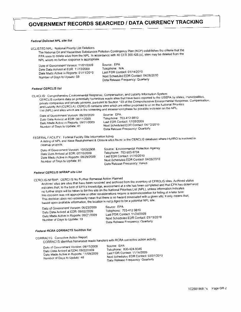
GOVERNMENT RECORDS SEARCHED / DATA CURRENCY TRACKING
Federal Delisted NPL site /ist
DELISTED NPL: National Priori ty List Delet ionsThe National oil and Hazardous Substances pollution Contingency Plan (NCP) establishes the criteria that the
EPA uses to delete srtes from the NPL. In accordance with 40 cFR 300 425 (e), sites may be deleted from the
NPL where no further response is approprlate'
Date of Government Version: 1ltO1l2OOg Source: EPA
Date Data Arrived at EDR: 1 1/1 3/2009 Telephone: N/A
Date Made Active in Reports: O1t11l2O1O Last EDR Contact: 0111412010
N u m b e r o f D a y s t o U p d a t e : 5 g N e x t S c h e d u | e d E D R C o n t a c t : 0 4 | 2 6 | 2 0 1 0Data Release Frequency: QuarterlY
Federal CERCLTS /ist
cERCLIS: Comprehenstve Environmental Response, compensation, and Liability Information System
cERCLIS contains data on potentially hazardous wasie sites that have been reported to the USEPA by states' municipalities'
prrvate companres and privale persons, pursuant to Section 103 of the comprehensive Environmental Response' compensation'
and Liability Act (cERCLA). CERCLIS contains sites whlch are either proposed to or on the National Priorities
List (NpL) and sites which are in the screening and assessment phase for possible inclusion on the NPL'
FEDERAL FACILITY: Federal Facility Site Information listrng
A| is t ingo fNPLandBaseRea l ighnment&C|osures i te "s found in theCERCL|sdatabasewhereFERRois invo |ved incleanuP Prolecls.
D a t e o f G o v e r n m e n t V e r s i o n : , 1 0 / 0 3 / 2 0 0 8 S o u r c e : E n v i r o n m e n t a | P r o t e c t i o n A g e n c yDate Data Anived at EDR: 07/10/2009 Telephone: 703-603-8794-^ . ̂Date Made Active in Reports: Ogt2gt2}Og Last EDR Contact: 0111512010
Number of Days to update: 81 Next Scheduled EDR Contact: 0412612010Data Release FrequencY: Varies
Federal CERCLTS NFRAP site List
CERCLIS-NFRAP: CERCLIS No Further Remedial Action Planned
Arch iveds i tesareS| les tha thavebeenremovedandarch ivedf romthe inventoryo fCERCL|SSi tes .Arch ivedSta tusindicates that, to the best of EPA',s knowledge, assessment at a site has been completed and that EPA has determlneo
no further steps wiil be laken to list this site on the National Priorities List (NPL), unless information indicates
this decision was nol appropriate or other considerations require a recommendation for listing at a later time'
This deciston does not necessarily mean that there is no hazard associated wilh a given site; it only means that'
baseduponava i |ab |e in fo rmat ion ' the |oca t ion isnot judgedtobeapoten t ia |NPLs i te .
Date of Government Version: 06/2312009 Source: EPA
Date Data Arrived at EDR: 09/02/2009 Telephone: 703-412-9-8]9^^^
Dare Made Active in n"po'tt' Ogl21t20}g Last EDR Contact: 1112412005
Number or Days to u;il,lt -
|:iliff:"1T..:il:;lE:,;l:l,l.,r','
Federal RCRA CORRACIS faci'ities'ist
CORRACTS: Corrective Action Report
CoRRACTSident i f ieshazardouswastehand|erswi thRcRAcorrect iveact ionact iv i ty .
Date of Government Version: 06/30/2009
Date Data Arrived at EDR: 08/1 1/2009
Date Made Active in Reports: 09l21l2log
Number of DaYs to Update: 41
Date of Government Version: 09/15/2009
Date Data Arrived at EDR: 09/2212009
Date Made Active in Reports: 11/09/2009
Number of DaYs to UPdate: 48
Source: EPATelephone: 703-412-9810Last EDR Contact: 12l28l2oog
Next Scheduled EDR Contact : O4l12l2O1O
Data Release FrequencY: Quarterly
Source: EPATeleohone: 800-424-9346Last EDR Contact: 1111612009
Next Scheduled EDR Contact : 03/01/2010
Data Release FrequencY: Quarterly
TC2681868.1s Page GR-2
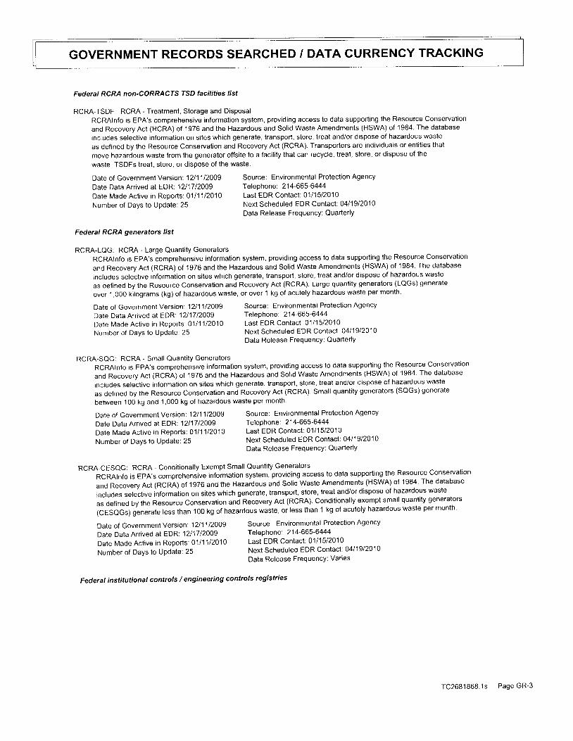
GOVERNMENT RECORDS SEARCHED / DATA CURRENCY TRACKING
Federal RCRA non-CORRACfS TSD facilities list
RCRA-TSDF: RCRA - Treatment, Storage and DisposalRCRAlnfo is EPA's comprehensive information system, providing access to data supporting the Resource Conservation
and Recovery Act (RCRA) of 1 976 and the Hazardous and Solid Waste Amendments (HSWA) of 1984. The database
includes selective information on sites which generate, transport, store, treat and/or dispose of hazardous waste
as defined by the Resource Conservation and Recovery Act (RCRA). Transporters are individuals or entities that
move hazardous waste from the generator offsite to a facility that can recycle, treat, store, or dispose of the
waste. TSDFs lreat, store, or dispose of the waste.
Date of Government Version: 1211112009 Source: Environmental Protection Agency
Date Data Arrived at EDR'. 1211712009 Telephone: 214-665-6444
Date Made Active in Reports: 0111112O1O Last EDR Contact: 0111512010
Number of Days to Update: 25 Next Scheduled EDR Contact : 0411912010
Data Release FrequencY: QuarterlY
Federal RCRA generators list
RCRA-LQG: RCRA - Large Quantity GeneratorsRCRAlnfo is EPA's comprehensive information system, providing access to data supporting the Resource Conservation
and Recovery Act (RCRA) of 1976 and the Hazardous and Solid Waste Amendments (HSWA) of 1984. The database
includes selective information on sites which generate, transport, store, treat and/or dispose of hazardous waste
as defined by the Resource Conservation and Recovery Act (RCRA). Large quantity generators (LQGs) generate
over 1,000 kilograms (kg) of hazardous waste, or over 1 kg of acutely hazardous waste per month.
Date of Government Version: 12t11tzoog Source: Environmental Protection Agency
Date Data Arr ived at EDR1211712009 Telephone: 214-665-6444
Date Made Act ive in Reports: 0111112010 Last EDR Contact : 0111512O1O
Number of Days to Update: 25 Next Scheduled EDR Contact : O4l19l2O1O
Data Release FrequencY: QuarterlY
RCRA-SOG: RCRA - Small Quantity Generators
RCRAlnfo is EpA's comprehensive information system, providing access to data supporting the Resource Conservation
and Recovery Act (RCRA) of 1976 and the Hazardous and Sol id Waste Amendments (HSWA) of 1984. The database
includes selective information on sites which generate, transport, store, treat and/or dispose of hazardous waste
as defined by the Resource Conservalion and Recovery Act (RCRA). Small quantity generators (SQGs) generate
between 100 kg and 1,000 kg of hazardous waste per month
Date of Government Version: 1211112009
Date Daia Anived at EDR:1211712OO9Date Made Active in Reports: 0111112O1O
Number of Days to UPdate: 25
Source: Environmental Protection AgencyTelephone: 214-665-6444Last EDR Contact: 0111512010Next Scheduled EDR Contact: 0411912010Data Release FrequencY: QuarterlY
RCRA-CESQG: RCRA - Conditionally Exempt Small Quantity Generators
RCRAlnfo is EpA's comprehensive information system, providing access to data supporting the Resource conservation
and Recovery Act (RCRI) of 1976 and the Hazardous and Solid Waste Amendments (HSWA) of 1984 The database
includes selective intormaiion on sites which generate, transport, store, treat and/or dispose of hazardous wasle
as defined by the Resource conservation and Recovery Act (RCRA). conditionally exempt small quantity generators
(CESaGs) generate less than 100 kg of hazardous *"it., or less than 1 kg of acutely hazardous waste per month
Date of Government version: 12t11l2OOg source: Environmental Protection Agency
Date Data Arrived al EDR' 12l17t2}Og Telephone: 214-665-6444
Date Made Active in Reports: 01l11t2o1o Last EDR Contact: 0111512010
N u m b e r o f D a y S l o U p d a t e : 2 5 N e x t S c h e d u | e d E D R C o n t a c t : 0 4 1 1 9 1 2 0 1 0Data Release FrequencY: Varies
Federal institutionat controls / engineering controls registries
TC2681868 .1s Page GR-3
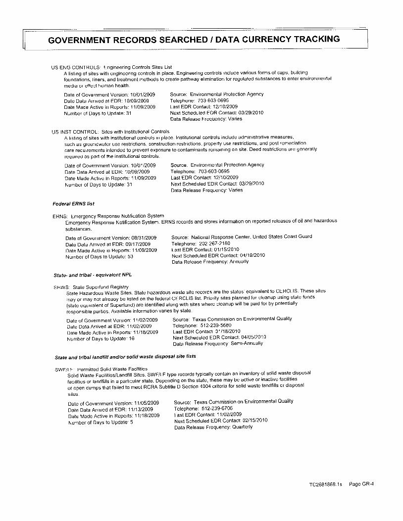
GOVERNMENT RECORDS SEARCHED / DATA CURRENCY TRACKING
US ENG CONTROLS: Engineer ing Controls Si tes ListA listing of sites with engineering controls in place. Engineering controls include various forms of caps, building
foundations, liners, and treatment methods to create pathway elimination for regulated substances to enter environmental
media or effect human health.
Dale of Government Version: 10/01/2009 Source: Environmental Protection Agency
Date Data Arrived at EDR: 10/09/2009 Telephone: 703-603-0695Date Made Active in Reports: 11l09l2)Og Last EDR Contact: 1211012009
Number of Days to Update: 31 Next Scheduled EDR Contact: 0312912010Data Release Freouencv: Varies
US INST CONTROL: Si tes wi th Inst i tut ional ControlsA listing of sites with institutional controls in place. Institutional controls include administrative measures,
such as groundwater use restrictions, construction restrictions, property use restrictions, and post remediation
care requirements Intended to prevent exposure to contaminants rematning on site. Deed restrictions are generally
required as part of the institutional controls.
Date of Government Version: 10/01/2009 Source: Environmental Protection Agency
Date Data Arrived at EDR: 10/09/2009 Telephone: 703-603-0695
Date Made Active in Reports: 11/09/2009 Last EDR Contact: 1211012009
Number of Days to update: 31 Next Scheduled EDR Contact: 0312912010
Data Release FrequencY: Varies
Federal ERNS /ist
ERNS: Emergency Response Notification SystemEmergency Response Notification System. ERNS records and stores information on reported releases of oil and hazardous
subslances.
State- and tribal - equivatent NPL
SHWS: State Superfund RegistryState Hazardous waste Sites. State hazardous waste site records are the states' equivalent to CERCLIS. These sites
may or may not atreaoy be listed on the federal CERCLIS list. Priority sites planned for cleanup using state funds
(state equivalent of Superfund) are identified along with sites where cleanup will be paid for by potentially
responsible parties. Available information varies by state.
Date of Government Version: 08/31/2009Date Data Arrived at EDR: 09/'1712009Date Made Active in Reports: 1'1109/2009
Number of Days to Update: 53
Date of Government Version: 11lO2l2OOg
Date Data Arr ived at EDR: 11/0212009Date Made Active in Reports: 11l18l2OOg
Number of Days to UPdate: 16
Date of Government Version: 11/05/2009Date Data Arrived at EDR: 1 1/1 3/2009Date Made Active in Reports: 1111812009Number of Days to UPdate: 5
Source: National Response Center, United States Coast GuardTeleohone: 202-267 -21 80Last EDR Contact: 0111512010Next Scheduled EDR Contact: O4l19l2O1OData Release FrequencY: AnnuallY
Source: Texas Commission on Environmental Quality
Telephone: 512-239-5680Last EDR Contact: 0111812010Next Scheduled EDR Contact: 0410512010
Data Release Frequency: Semi-Annually
Source: Texas Commission on Environmental QualityTeleohone: 51 2-239-6706Last EDR Contact: 1110212009Next Scheduled EDR Contact: 0211512010Data Release FrequencY: QuarterlY
State and tribat tandfilt and/or solid waste disposa, site 'ists
SWF/LF: Permitted Solid Waste Facilities
solid waste Facilities/Landfill Sites. swF/LF type records typically contain an inventory of solid waste disposal
facilities or landfills in a particular state. Depending on the state, these may be active or inactive facilities
or open dumps that faited to meet RCRA Subtitle D Section 4004 criteria for solid waste landfills or disposal
s i tes.
TC2681868.1s Page GR-4
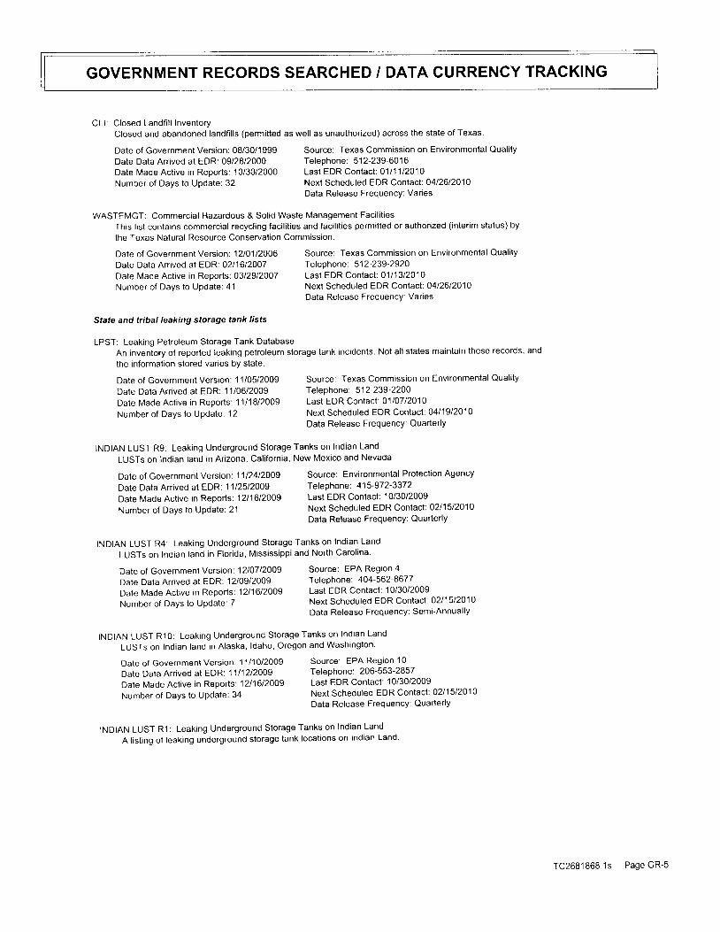
GOVERNMENT RECORDS SEARCHED / DATA CURRENCY TRACKING
CLI: Closed Landf i l l InventoryClosed and abandoned landfills (permitted as well as unauthorized) across the state of Texas.
Source: Texas Commission on Environmental QualityTeleohone: 512-239-6016Last EDR Contact : 0111112O1ONext Scheduled EDR Contact: 0412612010Data Release Frequency: Varies
WASTEMGT: Commercial Hazardous & Solid Waste Management Facilities
This list contains commercial recycling facilities and facilities permitted or authorized (interim status) by
lhe Texas Natural Resource Conservation Commission.
Source: Texas Commission on Environmental Qual i tyTelephone: 5 1 2-239 -2920
Last EDR Contact : 0111312010Next Scheduled EDR Contact: 0412612010Data Release Frequency: Var ies
An inventory of reported leaking petroleum storage tank incidents. Not all states maintain these records, and
the information stored varies by state.
Date of Government Version: 11/05/2009Date Data Arrived at EDR: 11/06/2009Date Made Active in Reports: 1111812009Number of Days to Update. 12
INDIAN LUST R9: Leaking Underground Storage Tanks on Indian LandLUSTs on Indian land in Arizona, California, New Mexico and Nevada
Date of Government Version: 08/30/1999Date Data Arrived at EDR: 09/28/2000Date Made Active in Reoorts: 10/30/2000Number of Days to Update: 32
Date of Government Version: 1210112000Date Data Arrived at EDR:0211612O07Date Made Active in Reports: 0312912007Number of Days to Update: 41
State and tribal leaking storage tank ,isfs
LPST: Leaking Pelroleum Storage Tank Database
Date of Government Version: l l l1Ol2OOg
Date Data Arr ived at EDR: 1111212009
Date Made Act ive in Reports: 12l1612009
Number of Days to UPdate: 34
Source: Texas Commission on Environmental QualityTelephone: 51 2-239 -2200
Last EDR Contact: 0110712010Next Scheduled EDR Contact: 0411912010Data Release FrequencY: QuarterlY
Source: Environmental Protection AgencyTeleohone: 415-972-3372Last EDR Contact: 10/30/2009Next Scheduled EDR Contact: 0211512010Data Release FrequencY: QuarterlY
Source: EPA Region 4Telephone: 404-562-867 7
Last EDR Contact: 10/30/2009Next Scheduled EDR Contact: 0211512010
Data Release Frequency: Semi-Annual ly
Source: EPA Region 10Telephone: 206-553-2857Last EDR Contact : 10/30/2009
Next Scheduled EDR Contact: O211512010
Data Release FrequencY: QuarterlY
Date of Governmenl Version: 1112412009Date Data Arrived at EDR. 1112512009Date Made Active in Reports: 1211612009Number of Days to UPdate: 21
INDIAN LUST R4: Leaking Underground Storage Tanks on Indian Land
LUSTs on Indian land in Flor ida, Mississ ippi and North Carol 'na
Date of Government Version: 1210712009
Date Data Arrived at EDR: 12109/2009
Date Made Acttve in Reports: 1211612009
Number of Days to UPdate: 7
INDIAN LUST R10: Leaking Underground Storage Tanks on Indian Land
LUSTs on Indian land in Alaska' ldaho, Oregon and Washington
INDIAN LUST R1: Leaking Underground Storage Tanks on Indian Land
A listing of leaking underground storage tank locations on Indian Land
TC2681868.1s Page GR

GOVERNMENT RECORDS SEARCHED / DATA CURRENCY TRAGKING
Date of Government Version: 1111212009Date Data Arr ived at EDR: 11/1212009Date Made Active in Reports: 1211612009Number of Days to Update: 34
INDIAN LUST R7: Leaking Underground Storage Tanks on Indian Land
LUSTs on Indian land in lowa, Kansas, and Nebraska
Date of Government Version: 0211912009Date Data Arrived at EDR: 02/19/2009Date Made Active in Reports: 0311612009Number of Davs to Update: 25
INDIAN LUST R6: Leaking Underground Storage Tanks on Indian Land
LUSTs on lndian land in New Mexico and Oklahoma.
Source: EPA Region 1Te lephone: 617-918-1 313Last EDR Contact: 10/30/2009Next Scheduled EDR Contact: 0211512010Data Release Frequency: Varies
Source: EPA Region 6Telephone: 21 4-665-6597Last EDR Contact: 1013012009Next Scheduled EDR Contact: O2l15l2O1OData Release Frequency: Varies
Source: EPA Region 7Telephone: 91 3-551-7003Last EDR Contact : 11lo4l20ogNext Scheduled EDR Contact: 0211512010Data Release Frequency: Var ies
Source: Texas Commission on Environmental Quality
Teleohone: 51 2-239-21 60
Last EDR Contact: 0111412010
Next Scheduled EDR Contact: O411912010
Data Release FrequencY: Quarlerly
Source: Texas Commission on Environmental Quality
Tef ephone: 51 2-239 -21 60
Last EDR Contact : 0111412010Next Scheduled EDR Contact : O4l19l2O1O
Data Release FrequencY: Quarterly
INDIAN LUST R8: Leaking Underground Storage Tanks on Indian Land
LUSTS on Indian land in colorado, Montana, North Dakota, south Dakota, Utah and wyoming.
Source: EPA Region 8Telephone : 303-31 2-627 1Last EDR Contact: 10/30/2009Next Scheduled EDR Contact: 0211512010Data Release FrequencY: QuarterlY
Date of Government Version: O3l24l20ogDate Data Arrived at EDR: 05/2012009Date Made Active in Reports: 06117l2OOgNumber of Days to Update: 28
Date of Government Version: 1210112009Date Data Arr ived at EDR: 12l01/2009Date Made Active in Reports: 1211612009
Number of Days to Update: 15
Slate and tribal registered storage tank lists
Date of Government Version: 1110512009Date Data Arrived at EDR: 11/06/2009Date Made Active in Reports: 1210812009Number of DaYs to UPdate: 32
AST; Petroleum Storage Tank DatabaseRegistered Aboveground Storage Tanks.
Date of Government Version: 11/05/2009Date Data Arrived at EDR: 11/06/2009Date Made Active in Reports: 12lO8l2OOgNumber of DaYS to UPdate: 32
UST: Petroleum Storage Tank DatabaseRegistered Underground Storage Tanks. UST's are regulated under Subtitle I of the Resource Conservation and Recovery
Act (RCRA) and must be registered with the state department responsible for administering the UST program. Available
information varies by state program.
INDIAN UST R8: Underground Storage Tanks on Indian Land
The Indian underground Storage Tank (UST) database provides information about underground storage tanks on Indian
tand in EPA Region 8 lcolorad-o, Montana, North Dakota, South Dakota, Utah, wyoming and 27 Tribal Nations)'
TC2681868.1s Page GR-6

GOVERNMENT RECORDS SEARCHED / DATA CURRENCY TRACKING
Date of Government Version: 1210112009 Source: EPA Region 8Date Data Arr ived at EDR: 12101/2009 Telephone: l ]03-312-6137Date Made Active in Reoorts: 1211612009 Last EDR Contact: 10/30/2009Number of Days to Update: 15 Next Scheduled EDR Contact : 0211512010
Data Release Freouencv: Quarterlv
INDIAN UST R5: Underground Storage Tanks on Indian LandThe Indian Underground Storage Tank (UST) database provides information aboul underground storage tanks on lndian
land in EPA Region 5 (Michigan, Minnesota and Wisconsin and Tr ibal Nat ions).
Date of Government Version: 1110512009 Source: EPA Region 5Date Data Arr ived at EDR: 1 1/05/2009 Telephone: 312-886-61 36Dale Made Active in Reoorts: 1211612009 Last EDR Contact: 1012212009
Number of Days to Update. 41 Next Scheduled EDR Contact : 1111612009Data Release Freouencv: Varies
INDIAN UST R10: Underground Storage Tanks on Indian LandThe Indian Underground Storage Tank (UST) database provides information about underground storage tanks on Indian
land in EPA Region 10 (Alaska, ldaho, Oregon, Washington, and Tr ibal Nat ions)
Date of Government Version: 11l1Ol2OOg Source: EPA Region 10Date Data Arrived at EDR 1111212OO9 Telephone: 206-553-2857Date Made Active in Reoorts: 1211612009 Last EDR Contact: 10/30/2009Number of Days lo Update: 34 Next Scheduled EDR Contact: 0211512010
Data Release Frequency: QuarterlY
INDIAN UST R1: Underground Storage Tanks on Indian LandThe Indian Underground Storage Tank (UST) database provides information about underground storage tanks on Indian
land in EPA Region 1 (Connect icut , Maine, Massachusetts, New Hampshire, Rhode ls land, Vermont and ten Tr ibal
Nat ions).
Date of Government Version: O2l19l2OOg Source: EPA, Region 1
Date Data Arr ived at EDR: 02119/2009 Telephone: 617-918-1313
Date Made Active in Reports: 03/16/2009 Last EDR Contact: 10/30/2009
Number of Days to Update: 25 Next Scheduled EDR Contact : 0211512010Data Release FrequencY: Varies
INDIAN UST R9: Underground Storage Tanks on Indian Land
The Indian Underground Storage Tank (UST) database provides information aboul underground storage tanks on Indian
tand in EPA Region 9 (Ar izona, Cal i fornia, Hawai i , Nevada, the Paci f ic ls lands, and Tr ibal Nat ions).
Date of Government Version: 1111212009 Source: EPA Region 9
Date Data Arrived at EDR. 1112012009 Telephone: 415-972-3368
Date Made Active in Reports: 12t1612009 Last EDR Contact: 10/30/2009
Number of Days to Update: 26 Next Scheduled EDR Contact: 0211512010
Data Release FrequencY: QuarterlY
INDIAN UST R4: Underground Storage Tanks on Indian Land
The Indian Underground Storage Tank (UST) database provides information about underground storage tanks on Indian
tand in EpA Region 4 (Atabami, Flor ida, Georgia, Kentucky, Mississ ippi , North Carol ina, South Carol ina, Tennessee
and Tr ibal Nat ions)
Date of Government Version: 1210712009 Source: EPA Region 4
Date Data Arrived at EDR: 12109/2009 Telephone 404-562-9424
Date Made Active in Reports: 12t16l2\Og Last EDR Contact; 10/30/2009
Number of Days to Update: 7 Next scheduled EDR Contact: 0211512010
Data Release Frequency: Semi-Annually
INDIAN UST R7: Underground Storage Tanks on Indian Land
The Indian Underground Storage Tank (UST) database provides information about underground storage tanks on Indian
land inEPAReg ionT ( | owa ,Kansas ,M issou r i ,Neb raska ,and9T r i ba |Na t i ons ) .
rC2681868.1s Page GR-7
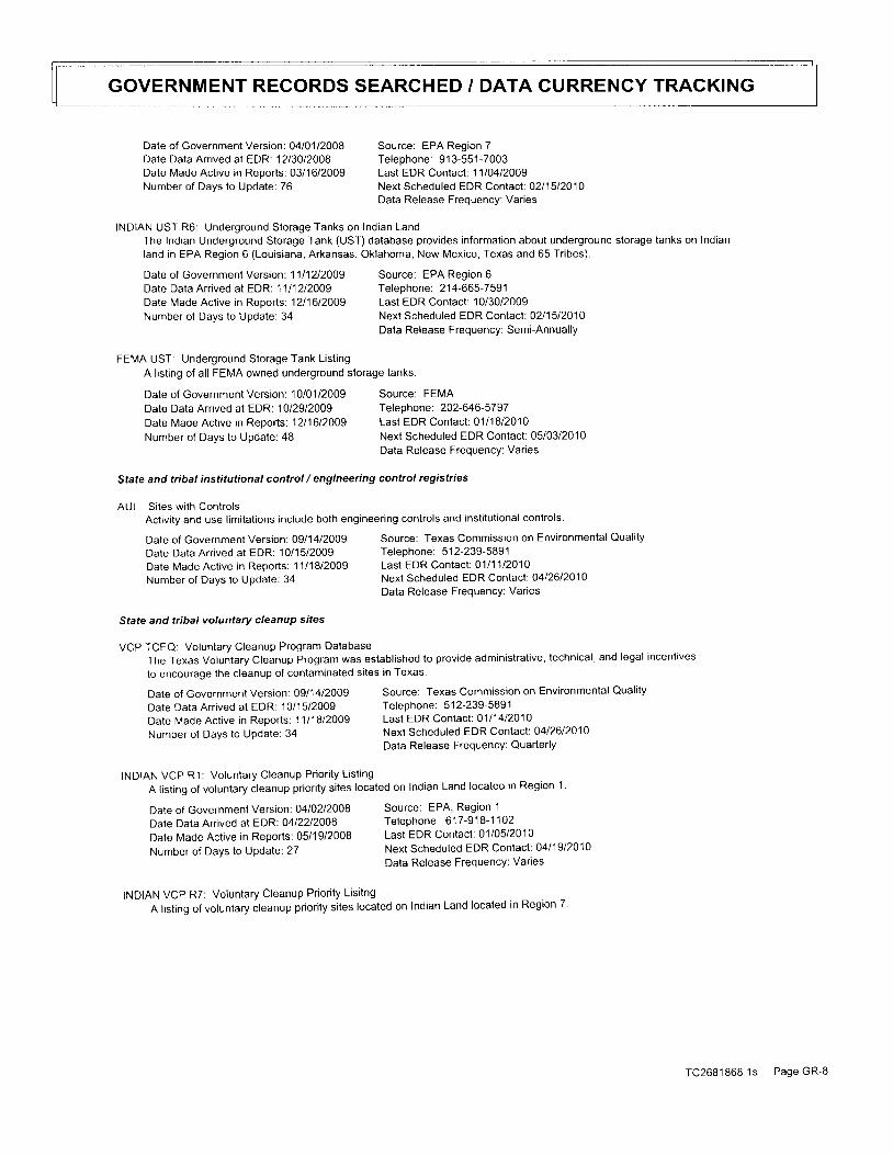
GOVERNMENT RECORDS SEARCHED / DATA CURRENGY TRACKING
INDIAN UST R6: Underground Storage Tanks on Indian LandThe Indian Underground Storage Tank (UST) database provides information about underground storage tanks on Indianland in EPA Region 6 (Louisiana, Arkansas, Oklahoma, New Mexico, Texas and 65 Tribes).
Date of Government Version: 1111212009 Source: EPA Region 6Date Data Arrived at EDR1111212009 Telephone: 214-665-7591Date Made Active in Reoorts: 12l1612009 Last EDR Contact: 10/30/2009Number of Days to Update: 34 Next Scheduled EDR Contact: 0211512010
Data Release Freouencv: Semi-Annuallv
FEMA UST: Underground Storage Tank List ingA listing of all FEMA owned underground storage tanks.
Date of Government Version: 0410112008Date Data Arraved at EDR: 12130/2008Date Made Active in Reoorts: 0311612009Number of Days to Update: 76
Date of Government Version: 1010112009Date Data Arrived at EDR: 10/29/2009Date Made Active in Reports: 1211612009Number of Days to Update: 48
Date of Government Version: Ogll4l2oogDate Dala Arr ived at EDR: 10/15/2009Date Made Act ive in Reports: 11l18l2o0gNumber of Days lo Update: 34
State and tribat voluntary cleanup sites
VCP TCEQ: Voluntary Cleanup Program Database
Date of Government Version: 0911412009Date Data Arr ived at EDR: 10/15/2009Date Made Active in Reports; 1111812009Number of Days to UPdate: 34
Date of Government Version: 0410212008Date Data Arrived at EDR: 0412212008Date Made Active in Reports: 05/19/2008Number of Days to UPdate: 27
Source: EPA Region 7Teleohone: 91 3-551-7003Last EDR Contact : 11l04l2ojgNext Scheduled EDR Contact : O2l15l2O1OData Release Frequency: Varies
Source: FEMATeleohone: 202-646-57 97Last EDR Contact: 0111812010Next Scheduled EDR Contact: 05/03/2010Data Release Frequency: Varies
Source: Texas Commission on Environmental Qual i tyTeleohone: 512-239-5891Last EDR Contact : 0111112010Next Scheduled EDR Contact: 0412612010Data Release Frequency: Varies
Source: Texas Commission on Environmental Qual i ty
Telephone: 512-239-5891Last EDR Contact : 0111412O1ONext Scheduled EDR Contact: 0412612010
Data Release Frequency: QuarterlY
Source: EPA, Region 1Tefephone: 617 -918-1 1O2Last EDR Contact: 0110512010Next Scheduled EDR Contact: 0411912010Data Release Frequency: Varies
Stale and tribal institutional control / engineering control registries
AUL: Si tes wi th ControlsActivity and use limitations include both engineering controls and institutional controls
The Texas Voluntary Cleanup Program was established to provide administrative, technical, and legal incenlives
to encourage the cleanup of contaminated sites in Texas.
INDIAN VCP R1: Voluntary Cleanup Priori ty List ingA listing of voluntary cleanup priority sites located on Indian Land located in Region 1
INDIAN VCP R7: Voluntary Cleanup Priori ty Lisi tngA listing of voluntary cleanup priority sites located on Indian Land located in Region 7.
TC2681868 1s Page GR-8
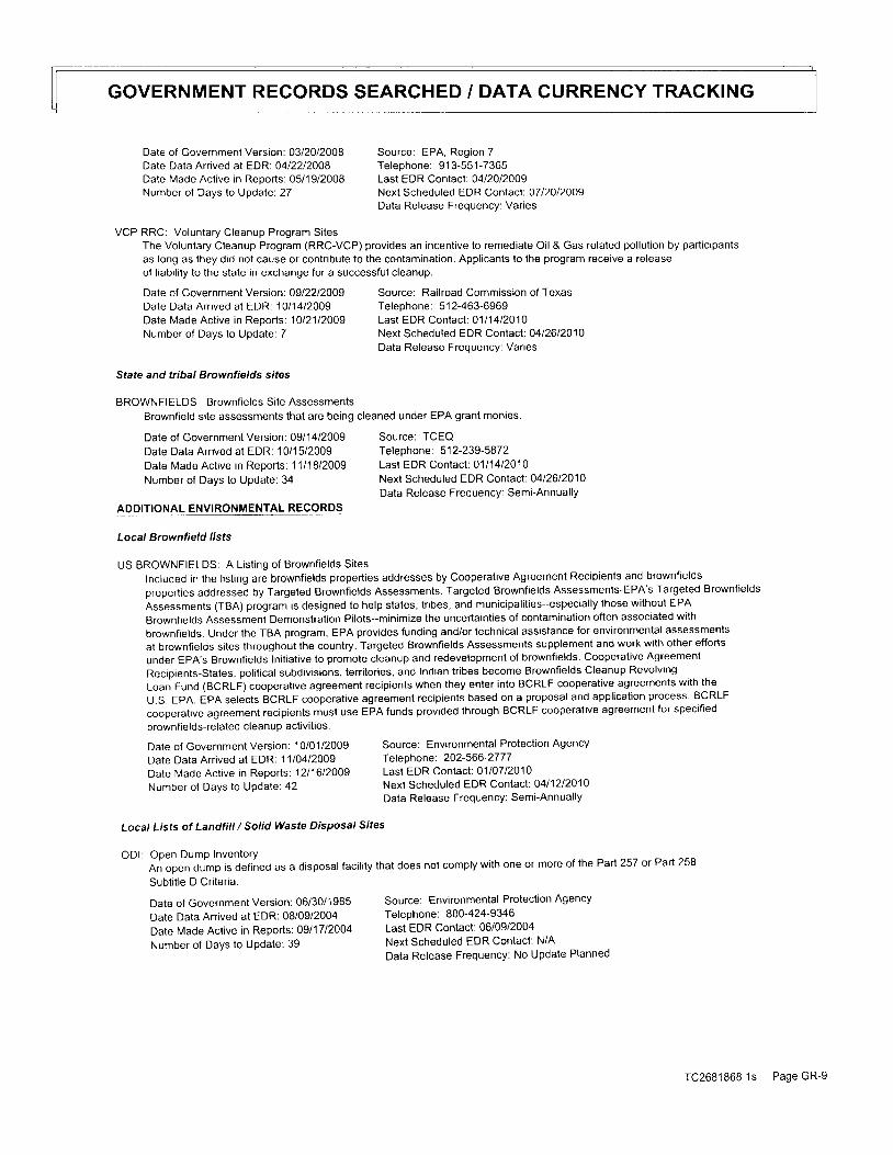
GOVERNMENT RECORDS SEARCHED / DATA CURRENCY TRACKING
Date of Government Version: 0312012008 Source: EPA, Region 7Date Data Arrived at EDR: 04l22l2OOB Teleohone: 91 3-551-7365Date Made Active in Reports: 05/19/2008 Last EDR Contact: 0412012009Number of Days to Updale:27 Next Scheduled EDR Contact: OTl2Ol2OOg
Data Release Freouencv: Varies
VCP RRC: Voluntary Cleanup Program Si tesThe Voluntary Cleanup Program (RRC-VCP) provides an incentive to remediate Oil & Gas related pollution by participants
as long as they did not cause or contribute to the contamination. Applicants to the program receive a releaseof liability to the slate in exchange for a successful cleanup.
Date of Government Version: 0912212009 Source: Railroad Commission of TexasDate Data Arr ived at EDR: '10/1412009 Telephone: 512-463-6969Date Made Active in Reports: lol2ll21)g Last EDR Contact: 0111412010Number of Days to Update: 7 Next Scheduled EDR Contact: 0412612010
Data Release Frequency: Varies
State and tribal Brownfierds sifes
BROWNFIELDS: Brownf ie lds Si te Assessments
Brownfield site assessments that are being cleaned under EPA grant monies.
Date of Government Version: 0911412009Date Data Arrived at EDR: 10/ '15/2009Date Made Actrve in Reoorts: 1111812009Number of Days to Update: 34
ADDITIONAL ENVIRONMENTAL RECORDS
Date of Government Version: 06/30/1 985Date Data Arrived at EDR: 08/09/2004Date Made Active in Reports: 0911712004Number of Days to UPdate: 39
Source: TCEQTelephone : 51 2-239 -587 2Last EDR Contact: 0111412010Next Scheduled EDR Contact: 0412612010Data Release Frequency: Semi-Annually
Source: Environmental Protection AgencyTeleohone: 800-424-9346Last EDR Contact: 06/09/2004Next Scheduled EDR Contact: N/AData Release Frequency: No Update Planned
Local Brownfield lists
US BROWNFIELDS: A List ing of Brownf ie lds Si tes
Included in the listing are brownfields properties addresses by Cooperative Agreement Recipients and brownfields
properties addressed by Targeted Brownfields Assessments. Targeted Brownfields Assessments-EPA's Targeted Brownfields
Assessments (TBA) program is designed to help states, tribes, and municipalities-especially those without EPA
Brownfields Assessment Demonstration Pilots-minimize the uncertainties of contamination often associated with
brownfields. Under the TBA program, EPA provides funding and/or technical assistance for environmental assessmenis
at brownfields Sites throughout the country. Targeted Brownfields Assessments supplement and work with other efforts
under EpA's Brownfields Initiative to promote cleanup and redevelopment of brownfields. Cooperative Agreemenl
Recipients-States, political subdivisions, territories, and Indian tribes become Brownfields Cleanup Revolving
Loan Fund (BCRLF) cooperative agreement recipients when they enler into BCRLF cooperative agreements with the
U.S. EpA. EpA selects BCRLF cooperative agreement recipients based on a proposal and application process. BCRLF
cooperalve agreement recipients musl use EPA funds provided through BCRLF cooperative agreement for specified
brownfields-related cleanup activities.
Date of Government Version: 10t0112009 Source: Environmental Protection Agency
Date Data Arrived at EDR: 1 1/04/2009 Telephone: 202-566'2777
Date Made Active in Reports: 1211612009 Last EDR Contact: 0110712010
Number of Days to update: 42 Next Scheduled EDR Contact: 0411212010
Data Release Frequency: Semi-Annual ly
Local Lists of Landfill / Solid Waste Disposal Sites
ODI: Open Dump InventoryAn open dump is defined as a disposal facility that does not comply with one or more of the Part 257 or Part 258
Subtit le D Criteria.
TC26B1868.1s Page GR-9

GOVERNMENT RECORDS SEARCHED / DATA CURRENCY TRACKING
DEBRIS REGION 9: Torres Martinez Reservation lllegal Dump Site Locations
A listing of illegal dump sites location on the Torres Martinez Indian Reservation located in eastern Riverside
County and northern lmper ia l County, Cal i fornia.
Dale of Government Version: 0111212009 Source: EPA, Region 9
Date Data Arr ived at EDR: 05/07/2009 Telephone: 415-972-3336
Date Made Active in Reports: 0912112009 Last EDR Contact: 0110712010Number of Days to Update: 137 Next Scheduled EDR Contact: 0312212010
Data Release Freouencv: Varies
Local Lists of Hazardous waste / Contaminated Sites
US CDL: Clandest ine Drug LabsA listing of clandestine drug lab locations. The U.S. Department of Justice ("the Department") provides this
web site as a public service. lt contains addresses of some locations where law enforcement agencies reported
they found chemicals or other items that indicated the presence of either clandestine drug laboratories or dumpsites
In mosl cases, the source of the entries is not the Department, and the Department has not verified the entry
and does not guarantee its accuracy. Members of the public must venfy the accuracy of all entries by, for example,
contacting local law enforcement and local health departments.
Date of Government Version: 03/01/2009 Source: Drug Enforcement Administration
Date Data Arrived at EDR 0612212O09 Telephone: 202-307-1000
Date Made Active in Reports: 0912112009 Last EDR Contact: 1211412009
Number of Days to Update: 9 '1 Next Scheduled EDR Contact : O3l22l2O1OData Release FrequencY: QuarterlY
DEL SHWS: Deleted Superfund Registry Sites
Sites have been deleted from the state Superfund registry in accordance with the Act, ?361.189
Date of Government Version: 1110212005
Date Dala Arr ived at EDR: 11/02/2009Date Made Act ive in Reports: 11l18l2OOg
Number of Days to Update: 16
PRIORITY CLEANERS: Dry Cleaner Remediation Program Prioritization List
A listing of dry cleaner related contaminated sites,
Date of Government Version: 0912212009Date Data Arrived at EDR: 12l15/2009Date Made Active in Reports: 0110812010Number of Days to UPdate: 24
Source: Texas Commission on Environmental QualityTeleohone: 51 2-239-0666Last EDR Contact: 0111812010Next Scheduled EDR Contact: 0410512010Data Release Frequency: QuarterlY
Source: Texas Commisision on Environmenatl Quali tyTelephone: 512-239-5658Last EDR Contact: 1211512009Next Scheduled EDR Contact: 0312912010Data Release FrequencY: Varies
US HIST CDL: Nat ional Clandest ine Laboratory Register
A listing of clandestine drug lab locations. The U.S. Department of Justice ("the Department") provides this
web site as a public service. lt contains addresses of some locations where law enforcement agencies reporled
they found chemtcats or other items that indicated the presence of eilher clandestine drug laboratories or dumpsites
ln most cases. the source of the entries is not the Department, and the Department has not verified the entry
and does not guarantee its accuracy. Members of the public must verify the accuracy of all entries by, for example,
contacting local law enforcement and local health departments.
Date of Government version: ogloll2ooT Source: Drug Enforcement Administration
Dale Data Arr ived at EDR: 1 1/19/2008 Telephone: 202-307-1000
Date Made Active in Reports:03/30/2009 Last EDR contact: 03/2312009
Number of Days to Update: '131 Next scheduled EDR Contact: 0612212009
Data Release Frequency: No Update Planned
Local Land Records
TC2681868.1s Page GR-10
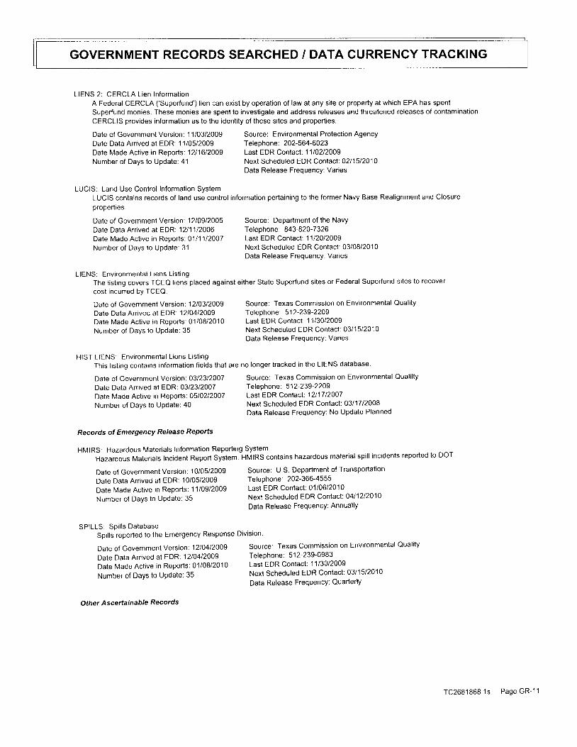
GOVERNMENT RECORDS SEARCHED / DATA CURRENCY TRACKING
LIENS 2: CERCLA Lien lnformationA Federal CERCLA ('Superfund') lien can exist by operation of law at any site or property at which EPA has spentSuperfund monies. These monies are spent to investigate and address releases and threatened releases of contaminationCERCLIS provides information as to the identity of these sites and properties.
Date of Government Version: 11l03l2jog Source: Environmental Protection AgencyDaie Data Arrived at EDR: 1 1/05/2009 Telephone: 202-564-6023Date Made Active in Reoorts: 1211612009 Last EDR Contact: 1110212009Number of Days to Update: 41 Next Scheduled EDR Contact: 0211512010
Data Release Frequency: Varies
LUCIS: Land Use Control Information SystemLUCIS contains records of land use control information pertaining to the former Navy Base Realignment and Closureproperlies.
Source: Department of the NavyTelephone : 843-820 -7 326Last EDR Contact: 1l l2Ol2OOgNext Scheduled EDR Contact: 03/08/2010Data Release Frequency: Varies
LIENS: Environmental L iens List ingThe listing covers TCEQ liens placed against either State Superfund sites or Federal Superfund sites to recover
cost incurred by TCEQ.
Date of Government Version: 1210912005Date Data Arrived at EDR. 1211112006Date Made Active in Reports: 0111112OO7Number of Days to Update: 31
Date of Government Version: 1210312009Date Data Arrived at EDR: 12lO4l2OO9Date Made Act ive in Reports:01/08/2010Number of Days to Update: 35
HIST LIENS: Environmental L iens List ing
Date of Government Version: 0312312007Date Data Arrived at EDR: 03/2312007Date Made Active in Reports: 0510212007
Number of Days to Update: 40
Date of Government Version: 10/05/2009
Date Data Arrived at EDR: 10/05/2009
Dale Made Active in Reports: 1110912009
Number of DaYS to Update: 35
SPILLS: Spi l ls DatabaseSpills reported to the Emergency Response
Date of Government Version: 12lj4l2Q0g
Date Data Arrived at EDR: 12104/2009
Date Made Active in Reports: 01/08/2010
Number of DaYS to Update: 35
Othe r Ascerta i n able Records
Source: Texas Commission on Environmental Qual i tyTeleohone: 5 1 2-239 -2209
Last EDR Contact : 11l30l2 jogNext Scheduled EDR Contact: 0311512010Data Release FrequencY: Var ies
Source: Texas Commission on Environmental Qualilty
Teleohone: 5 1 2-239-2209Last EDR Contact: 1211712OO7Next Scheduled EDR Contact: 0311712008Data Release Frequency: No Update Planned
Source: U.S. Department of TransportationTeleohone: 202-366-4555Last EDR Contact: 01/06/2010Next Scheduled EDR Contact: 0411212010Data Release FrequencY: AnnuallY
Division.
Source: Texas Commission on Environmental Quality
Teleohone: 512-239-0983Last EDR Contact: 1113012009Next Scheduled EDR Contact: 03/ '15/2010
Data Release FrequencY: QuarterlY
This listing contains information fields that are no longer tracked in the LIENS database.
Records of Emergency Rerease Reporfs
HMIRS; Hazardous Materials Information Reporting System
Hazardous Materiats Incident Report System. HMIRS contains hazardous material spill incidents reported to DOT
TC2681868.1s Page GR- l 1
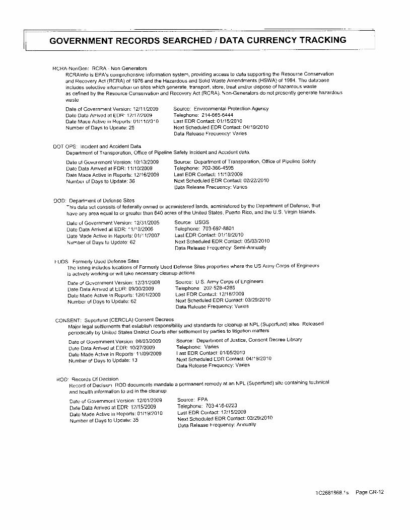
GOVERNMENT RECORDS SEARCHED / DATA CURRENCY TRACKING
RCRA-NonGen: RCRA - Non GeneratorsRCRAlnfo is EPA's comprehensive information system, providing access to data supporting the Resource Conservation
and Recovery Act (RCRA) of 1976 and the Hazardous and Solid Waste Amendments (HSWA) of 1984. The database
rncludes selective information on sites which generate, transport, store, treat and/or dispose of hazardous waste
as defined by the Resource Conservation and Recovery Act (RCRA). Non-Generators do not presently generate hazardous
wasle.
Dale of Government Version: 1211112009 Source: Environmental Protection Agency
Date Data Arrived al EDR'. 1211712OO9 Telephone: 214-665-6444Date Made Act ive in Reports: 0111112010 Last EDR Contact : 0111512010Number of Days to Update: 25 Next Scheduled EDR Contact : 0411912010
Data Release Freouencv: Varies
DOT OPS: Incident and Accident DataDepartment of Transporation, Office of Pipeline Safety Incident and Accident dala.
DOD: Deoartment of Defense SitesThis data set consists of federally owned or administered lands, administered by the Department of Defense, thai
have any area equal to or greater than 640 acres of the United States, Puerto Rico, and the U.S. Virgin lslands.
Date of Government Version: 10/13/2009Date Data Arrived at EDR: 1 1/1 0/2009Date Made Active in Reoorts: 1211612009Number of Days to Update: 36
Date of Government Version: 1213112005Date Data Anived at EDR: 11/10/2006Date Made Active in Reports: 0111112007Number of Days to Update: 62
Date of Government Version: 12lO1l20og
Date Data Anived at EDR: 12l15/2009
Date Made Active in Reports: 0111912010
Number of Days to UPdate: 35
Source: Department of Transporation, Office of Pipeline SafetyTelephone: 202-366-4595Last EDR Contact: 1111012009Next Scheduled EDR Contact: 0212212010Data Release Frequency: Varies
Source: USGSTelephone: 703-692-8801Last EDR Contact: 0111912010Next Scheduled EDR Contact: 0510312010Data Release Frequency: Semi-Annually
Source: EPATelephone: 7 03-4 1 6'0223Last EDR Contact: 1211512009Next Scheduled EDR Contact: 0312912010Data Release Frequency: AnnuallY
FUDS: Former ly Used Defense Si tesThe listing includes locations of Formerly Used Defense Sites properties where the US Army Corps of Engineers
is actively working or will take necessary cleanup actions
Date of Government version: 12t31t2O08 source: u.s. Army corps of Engineers
Date Data Arrived at EDR: 09/30/2009 Telephone 202-528-4285
Date Made Act ive in Reports: 12lo l l2OOg Last EDR Contact : 12l18l2oog
Number of Days to update: 62 Next Scheduled EDR Contact: 0312912010
Data Release FrequencY: Varies
CONSENT: Superfund (CERCLA) Consent Decrees
Major legal setlements lhat establish responsibility and standards for cleanup at NPL (Superfund) siles Released
perioOicitty by United States District Courts after settlement by parties to litigation matters
Date of Government Version: 08/03/2009 Source: Department of Justice, Consent Decree Library
Date Data Arrived at EDR 10127120O9 Telephone: Varies
Date Made Act ive in Reports: 11/09/2009 Last EDR Contact : 01/05/2010
Number of Days to update: 13 Next scheduled EDR Contact : 0411912010
Data Release Frequency: Varies
ROD: Records Of Decis ionRecord of Decis ion. ROD documents mandate a permanent remedy at an NPL (Superfund) s i te contain ing technical
and health information to aid in the cleanup'
TC2681868.1s PageGR-12
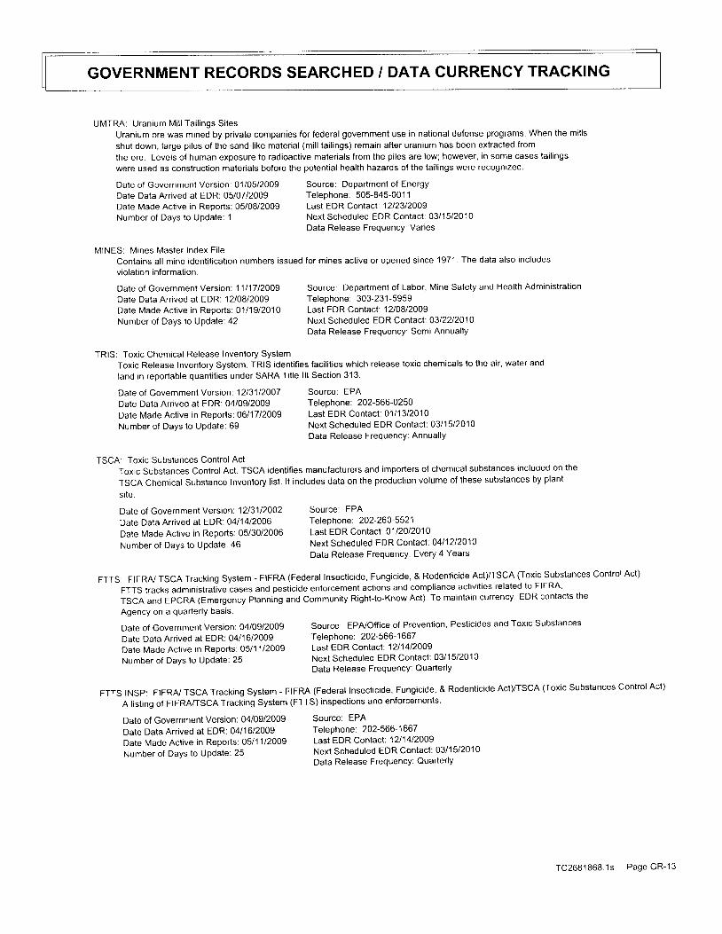
GOVERNMENT RECORDS SEARCHED / DATA CURRENCY TRACKING
UMTRA: Uranium Mi l l Tai l ings Si tesUranium ore was mined by private companies for federal government use in national defense programs. When the mills
shut down, large piles of the sand-like material (mill tailings) remain after uranium has been extracted from
the ore. Levels of human exposure to radioactive materials from the piles are low; however, in some cases tailings
were used as constructron materials before the potential health hazards of the tailings were recognized.
Date of Government Version: 01/05/2009 Source: Department of Energy
Date Data Arrived at EDR: 05/07/2009 Telephone: 505-845-001 1
Date Made Active in Reporls: 05/08/2009 Last EDR Contact: 12l23l2oogNumber of Days to Update: 1 Next Scheduled EDR Contact : 03/ '15/2010
Data Release Freouencv: Varies
MINES: Mines Master Index Fi leContains al l mine ident i f icat ion numbers issued for mines act ive or opened s ince 1971. The data also includes
vio lat ion informat ion.
Source: Department of Labor, Mine Safety and Health Admtnistration
Telephone: 303-231-5959Last EDR Contact: l2lQBlzOOgNext Scheduled EDR Contact: 0312212010Data Release Frequency: Semi-Annually
Toxic Release Inventory System. TRIS identifies facilities which release toxic chemicals to the air, water and
land in reportable quant i t ies under SARA Ti t le l l l Sect ion 313.
Date of Government Version: 11l17l2OOgDate Data Arrived at EDR: 12108/2009Dale Made Active in Reports: 0111912010Number of Days to Update: 42
TRIS: Toxic Chemical Release Inventory System
Date of Government Version: 1213112OO7Date Data Arrived at EDR: 04/09/2009Date Made Active in Reports: 0611712009Number of Days to Update: 69
Date of Government Version: 1213112002Date Data Arrived at EDR: 04/14/2006Date N4ade Active in Reports: 05/30/2006Number of Days to UPdate: 46
Source: EPATeleohone: 202-566-0250Last EDR Contact: 0111312010Next Scheduled EDR Contact: 0311512O1OData Release FrequencY: AnnuallY
Source: EPAI efeonone: zvz-zov-ccz ILast EDR Contact: 01l2Ot2OlONext Scheduled EDR Contact: 0411212010Data Release Frequency: Every 4 Years
TSCA: Toxic Substances Control ActToxic Substances Control Act. TSCA identifies manufacturers and importers of chemical substances included on the
TSCA Chemical Substance Inventory list. lt includes data on the production volume of these substances by plant
site.
FTTS: FIFRAJ TSCA Tracking System - FTFRA (Federal Insecticide, Fungicide, & Rodenticide AcI)/TSCA (Toxic Substances Control Act)
FTTS tracks adminrslrative cases and pesticide enforcement actions and compliance activities related to FIFRA
TSCA and EPCRA (Emergency Planning and Community Right-to-Know Act). To maintain currency, EDR contacts the
Agency on a quar ler ly basis
Date of Government version: 04/09/2009 Source: EPAJOffice of Prevention, Pesticides and Toxic Substances
Date Data Arr ived at EDR: 04/16/2009 Telephone: 202-566-1667
Date Made Active in Reports: 05/1 1/2009 Last EDR Contact: 1211412009
Number of Days to Update: 25 Next Scheduled EDR Contact : 03/15/2010
Data Release FrequencY: QuarterlY
FTTS tNSp: FTFRA/ TSCA Tracking system - FIFRA (Federal Insecticide, Fungicide, & Rodenticide AcI)/TSCA (Toxic substances control Act)
A tisting of FIFRA/TSCA Tracking System (FTTS) inspections and enforcements.
Date of Government Version: 04/09/2009 Source: EPA
Date Data Arrived at EDR: 04/16/2009 Telephone: 202-566-1667
Date Made Active in Reports: 05/1 1/2009 Last EDR contact; 1211412009
Number of Days to update: 25 Next Scheduled EDR Contact: 0311512010
Data Release FrequencY: Quarterly
TC2681868 .1s Page GR- l3

GOVERNMENT RECORDS SEARCHED / DATA CURRENCY TRACKING
HIST FTTS: FIFRA./TSCA Tracking System Administrative Case ListingA complete administrative case listing from the FIFRA/TSCA Tracking System (FTTS)for all ten EPA regions. Theinformation was obtained from the National Compliance Database (NCDB). NCDB supports the implementation of FIFRA(Federal Insecticide, Fungicide, and Rodenticide Act) and TSCA (Toxic Substances Control Act). Some EPA regionsare now closing out records. Because of that, and the fact that some EPA regions are not providing EPA Headquarterswith updated records, it was decided to create a HIST FTTS database. lt included records that may not be includedin the newer FTTS database updates. This database is no longer updated.
Date of Governmenl Versaon: 1O11912006 Source: Environmental Protection AgencyDate Data Arrived at EDR: 03/01/2007 Telephone: 202-564-2501Date Made Active in Reoorts: 0411012007 Last EDR Contact: 1211712007Number of Days to Update: 40 Next Scheduled EDR Contact: 0311712008
Data Release Frequency: No Update Planned
HIST FTTS INSP: FIFRA/TSCA Tracking System Inspection & Enforcement Case ListingA complete inspection and enforcement case listang from the FIFRA/TSCA Tracking System (FTTS) for all ten EPAregions. The information was obtained from the National Compliance Database (NCDB). NCDB supports the implementationof FIFRA (Federal Insecticide, Fungicide, and Rodenticide Act) and TSCA (Toxic Substances Control Act). SomeEPA regions are now closing out records. Because of that, and the fact that some EPA regions are not providlngEPA Headquarters with updated records, it was decided to creale a HIST FTTS database. lt included records thatmay not be included in the newer FTTS database updates. This database is no longer updated.
SSTS: Section 7 Tracking SystemsSection 7 of the Federal Insecticide, Fungicide and Rodenticide Act, as amended (92 Stat. 829) requires all
registered pesticide-producing establishments to submit a report to the Environmental Protection Agency by March
1st each year. Each establishment must report the types and amounts of pesticides, active ingredients and devices
being produced, and those having been produced and sold or distributed in the past year.
Date of Governmenl Version: 10/19/2006Date Data Arrived at EDR: 03/01/2007Date Made Active in Reports: O411012007Number of Days to Update: 40
Date of Government Version: 1213112OO7
Date Data Arrived at EDR: 05/19/2009Date Made Active in Reports: 0912112009
Number of Days to Update: 125
Date of Government Version: 09/01/2009
Date Data Arrived at EDR: 10/2112009
Date Made Active in Reports: 1210112009
Number of DaYs to Update: 41
Source: Environmental Protection AgencyTelephone: 202-564 -250 1Last EDR Contact: 1211712008Next Scheduled EDR Contact: O311712008Data Release Frequency: No Update Planned
Source: EPATeleohone: 202-564 -4203
Last EDR Contact: 1110212009Next Scheduled EDR Contact: O211512010
Data Release Frequency: Annual lY
Source: EPATelephone: 202-566-0500Last EDR Contact: 1012112009Next Scheduled EDR Contact: 0210112010Data Release Frequency: AnnuallY
lClS: Integrated Compliance Information SystemThe Integrated Compliance Information System (lClS) supports the information needs of the national enforcement
and comptrance program as well as the unique needs of the National Pol lutant Discharge Elimination System (NPDES)
program.
Dale of Government version: 1lt1OtzOOg Source: Environmental Protection Agency
Date Data Arrived at EDR: 1 1/1 8/2009 Telephone: 202-564-5088
Date Made Active in Reports: 01|1gl2o1o Last EDR Contact; 12123|2009
Number of Days to update: 62 Next scheduled EDR Contact: 0411212010Data Release FrequencY: QuarterlY
PADS: PCB Activity Database SYStempcB Activity Database. pAbS ldentifies generators, transporters, commercial storers and/or brokers and disposers
of PCB's who are required to notify the EPA of such activities
TC2681868 ' l s PageGR-14
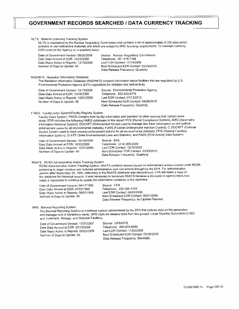
GOVERNMENT RECORDS SEARCHED / DATA CURRENGY TRACKING
MLTS: Material Licensing Tracking SystemMLTS is maintained by the Nuclear Regulatory Commission and contains a l is t of approximately 8,100 s i tes whichpossess or use radioaclive materials and which are subject to NRC licensing requirements. To maintain currency,EDR contacts the Agency on a quarterly basis.
Date of Government Version: 0912512009 Source: Nuclear Regulatory CommissionDate Data Arrived at EDR:1012312009 Telephone: 301-415-7169Date Made Act ive in Reoorts: 12l1612009 Last EDR Contact : 12l14l2OOgNumber of Days to Update: 54 Next Scheduled EDR Contact : O3l29l201o
Data Release Freeuencv: Quarterlv
RADINFO: Radiation Information DatabaseThe Radiation Information Database (RADINFO) contains informalion about facilities that are regulated by U.S.
Environmental Protection Agency (EPA) regulations for radiation and radioactivity.
Date of Government Version: 1011512009Date Data Arrived at EDR: 1 0/16/2009Date Made Active in Reports: 1210112009Number of Days to Update: 46
Source: Environmental Proteclion AgencyTelephone : 202-343-97 7 5Last EDR Contact: 0111312010Next Scheduled EDR Contact: 0412612010Data Release Frequency: Quarterly
FINDS: Faci l i ty Index System/Faci l i ty Registry SystemFacility Index System. FINDS contains both facility information and
'pointers'to other sources that contain more
detail. EDR includes the following FINDS databases in this report: PCS (Permit Compliance System), AIRS (Aerometric
lnformation Retrieval System), DOCKET (Enforcement Docket used to manage and track information on civil judicial
enforcement cases for all environmental statutes), FURS (Federal Underground Injection Control), C-DOCKET (Criminal
Docket System used to track criminal enforcement actions for all environmental statutes), FFIS (Federal Facilities
Information System), STATE (State Environmental Laws and Statutes), and PADS (PCB Activity Data System)
Date of Government Version: 1 0/1 9/2009 Source: EPA
Date Data Arr ived at EDR:1Ol22l2OOg Telephone: (214) 665-2200
Date Made Active in Reports: 12l01l2oog Last EDR Contact: 1211012009
Number of Days to Update:40 Next Scheduled EDR Contact : 0312912010Data Release FrequencY: QuarterlY
RAATS: RCRA Administrative Action Tracking SystemRCRA Administration Action Tracking System. RAATS contains records based on enforcement actions issued under RCRA
pertaining to malor violators and includes adminrstrative and civil actions brought by the EPA. For administration
actrons after September 30, 1995, data entry in the RAATS database was discontinued. EPA will retain a copy of
the database for historical records. lt was necessary to terminate RAATS because a decrease in agency resources
made it imoossible to continue to update the information contained in the database.
Date of Government Version: 0411711995 Source: EPA
Date Data Arrived at EDR: 07/03/1995 Telephone. 202-564-41O4
Date lvlade Active in Reports: 08/07/1995 Last EDR Contact: 0610212008
Number of Days to update: 35 Next scheduled EDR Contact: 09/0'1/2008Data Release Frequency: No Update Planned
BRS: Biennial Report ing SystemThe Biennial Reporting System is a national system administered by the EPA that collects daia on the generation
and management of hazardous waste. BRS captures detailed data from two groups: Large Quantity Generators (LQG)
and Treatment, Storage, and Disposal Facilities.
Dale of Government Version: 1213112007 Source: EPfuNTIS
Date Data Arrived at EDR: 02/19/2009 Telephone: 800-424-9346
Date Made Active in Reports: o5|22t2009 Last EDR Contact: 11120|2009
Number of Days to Update: 92 Next scheduled EDR Contact: 03/05/2010Data Release Frequency: Biennial ly
TC2681868 .1s Page GR-15

GOVERNMENT REGORDS SEARCHED / DATA CURRENCY TRACKING
toP Innocent Owner/Operator ProgramContains information on all sites that are in the lOP. An IOP is an innocent owner or operator whose property
is contaminated as a result of a release or migration of contamrnants from a source or sources not located onthe property, and they did not cause or contribute to the source or sources of contamination.
Date of Government Version: Ogl14l2O09 Source: Texas Commission on Environmental QualityDate Data Arr ived at EDR: 10/15/2009 Telephone: 512-239-5894Date Made Act ive in ReDorts: 11l18l2OOg Last EDR Contact : 0111412010Number of Days to Update: 34 Next Scheduled EDR Contact : 0412612010
Data Release Frequency: Quarterly
Underground InJection Wells Database ListingClass V injection wells regulated by the TCEQ. Class V wells are used to in.iect non-hazardous fluids underground.
Most Class V wel ls are used to d ispose ofwastes into or above underground sources ofdr inking water and can pose
a threal to ground water quality, if not managed properly.
Date of Governmenl Version: 1012612009 Source: Texas Commission on Environmental QualityDate Data Arrived at EDR 1012712O09 Telephone: 512-239-6627Date Made Active in Reports: 11l18l2o1g Last EDR Contact: 1012612009Number of Days to Update 22 Next Scheduled EDR Contact: 02lOBl2OlO
Data Release Frequency: Varies
DRYCLEANERS: Drycleaner Registrat ion Database List ingA listing of drycleaning facilities.
U I C
t no
Date of Government Version: 1110512009Date Data Arrived at EDR:1211412009Date Made Active in Reports: 0111112010Number of Days to Update: 28
ENFORCEMENT: Notice of Violat ions List ingA listing of permit violations.
Date of Government Version: 1210212009Date Data Arrived at EDR 1210212009Date Made Active in Reports: 01/08/2010Number of Days to UPdate: 37
Date of Government Version: 10/01/2009Date Data Arrived at EDR: 10/1 5/2009Date Made Act ive in Reports: 11l18l2OOg
Number of Days to UPdate: 34
ED AQUIF: Edwards Aqui fer Permits
Date of Government Version: 1110612009Date Data Arr ived at EDR: 11/06/2009
Date Made Active in Reports: 1111812009
Number of Days to UPdate: 12
Source: Texas Commission on Environmental QualityTelephone: 51 2-239-21 60Last EDR Contact: 1211412009Next Scheduled EDR Contact: 0312912010Data Release Frequency: Varies
Source: Texas Commission on Environmental QualityTelephone: 51 2-239-601 2Last EDR Contact: 1 1/16/2009Next Scheduled EDR Contact: 0310112010Data Release Frequency: Semi-Annually
Source: Texas Commission on Environmental Qual i ty
Teleohone: 512-239-0985Last EDR Contact : 1Ol15l2OOgNext Scheduled EDR Contact: 0112512010
Data Release Frequency: Annual lY
The information provided is for the counties
Source: Texas Commission on Environmental Quality, Austin Region
Tef ephone: 51 2-339 -2929
Last EDR Contact: 0111812010Next Scheduled EDR Contact: 0411912010
Data Release FrequencY: Varies
Haz Waste: Industrial & Hazardous Waste Database
Summary reports reported by waste handlers, generators and shippers in Texas
A listing of permits in the Edwards Aquifer Protection Program database
located in the Aust in Region (Hays, Travis, and Wi l l iamson count ies) '
TC26B1868.1s Page GR-16

GOVERNMENT RECORDS SEARCHED / DATA CURRENCY TRACKING
AIRS: Current Emission Inventory DataThe database lists by company, along with their actual emissions, the TNRCC air accounts that emit EPA crtteriaool lutants.
Date of Government Version: 0811212009Date Data Arrived at EDR: 10/20/2009Date Made Active in Reoorts: 1111812009Number of Days to Update: 29
TIER 2: Tier 2 Chemical Inventory ReportsA listing of facilities which store or manufacture
Date of Government Version: 12131|2OOBDate Data Arr ived at EDR: 08/2112009Date Made Active in Reports: OglO4l2OOgNumber of Days to Update: 14
Source: Texas Commission on Environmental QualityTelephone: N/ALast EDR Contact: 1212112009Next Scheduled EDR Contact: 0410512010Data Release Frequency: Semi-Annually
hazardous materials and submit a chemical inventory report
Source: Department of State Health ServicesTeleohone: 51 2-834-6603Last EDR Contact : 11l3ol20ogNext Scheduled EDR Contact : O311512010Data Release Frequency: Annual ly
MSD: Munic ipal Set t ings Designat ions DatabaseAn MSD is an official state designation given to property within a municipality or its extraterritorial jurisdiction
that certifies that designated groundwater at the property is not use as potable water, and is prohibited from
fulure use as potatable water because that groundwater is contaminated in excess of the applicable potable-waler
protective concentration level.
RWS: Radioactive Waste Sitessites rn the state of Texas that have been designated as Radioactive waste sites
Dale of Government Version: 12l29l2oogDate Data Arrived at EDR:1212912O09Date Made Act ive in Reports: Ol lOBl2OlONumber of Days to Update: 10
Dale of Government Version: 0712412006
Date Data Arrived at EDR'. 1211412006
Date Made Active in Reports: O112312007
Number of Days to Update: 40
INDIAN RESERV: Indian Reservat ions
Date of Government Version: 1213112005Date Data Arrived at EDR: 12108/2006Date Made Active in Reports: 0111112007Number of Days to UPdate: 34
Source: Texas Commission on Environmental QualityTeleohone: 51 2-239-4982Last EDR Contact: 12l28l2oogNext Scheduled EDR Contact: O411212010Data Release Frequency: Varies
Source: Texas Commission on Environmental QualityTeleohone: 512-239-0859Last EDR Contact: 1112412009Next Scheduled EDR Contact: 03/08/2010Data Release Frequency: Semi-Annually
Source: USGSTelephone: 202-208-37 1 0Last EDR Contact: 01/19/2010Next Scheduled EDR Contact: 05/03/2010Data Release Frequency: Semi-Annually
This map layer portrays lndian administered lands of the United States that have any area equal to or greater
than 640 acres.
scRD DRYCLEANERS: State Coalition for Remediation of Drycleaners Listing
The state coalition for Remediation of Drycteaners was established in 1998, with support from the U S EPA office
of Superfund Remediation and Technology Innovation. lt is comprised of representatives of states with established
drycleaner remediahon programs. Currently the member states are Alabama, Connecticut' Florida, lllinois' Kansas,
Minnesota, Missour i , North carol ina, oregon, south carol ina, Tennessee, Texas, and wisconsin '
Date of Government version: 11t1612009 source: Environmental Protection Agency
Date Data Arr ived at EDR: 1 1/16/2009 Telephone: 615-532-8599
Date Made Active in Reports: 01tlgtzo1o Last EDR Contact: 11/09/2009
N u m b e r o f D a y S t o U p d a t e : 6 4 N e x t S c h e d u | e d E D R C o n t a c t : o 2 l o a | 2 o I oData Release Frequency: Varies
TC2681868.1s Page GR-17

GOVERNMENT RECORDS SEARCHED / DATA CURRENCY TRI\CKING
FEDLAND: Federal and Indian LandsFederally and Indian administrated lands of the United States. Lands included are administrated by: Army Corpsof Engrneers, Bureau of Reclamation, National Wild and Scenic River, National Wildlife Refuge, Public Domain Land,Wilderness, Wilderness Study Area, Wildlife Management Area, Bureau of Indian Affairs, Bureau of Land Management,Departmenl of Justice, Forest Service, Fish and Wildlife Service, National Park Service.
Source: U.S. Geological SurveyTelephone: 888-27 5-87 47Last EDR Contact: 0111912010Next Scheduled EDR Contact: 0510312010Data Release Frequency: N/A
COAL ASH EPA: Coal Combustion Residues Surface lmpoundments ListA listing of coal combustion residues surface impoundments with high hazard poiential ratings.
Date of Government Version: 0912112009 Source: Environmental Protection AgencyDate Data Arrived at EDR: 09/2512009 Telephone: N/ADate Made Active in ReDorts: 11/09/2009 Last EDR Contact: 1211512009Number of Days to Update: 45 Next Scheduled EDR Contact: 0312912010
Data Release Freouencv: Varies
PCB TRANSFORMER: PCB Transformer Registration DatabaseThe database of PCB transformer registrations that includes all PCB registration submittals.
Source: Environmental Prolection AgencyTeleohone: 202-566-0517Last EDR Contacl : 11l13l2OOgNext Scheduled EDR Contact: O211512010Data Release Frequency: Var ies
COAL ASH DOE: Sleam-Electr ic Plan Operat ion DataA listing of power plants that store ash in surface ponds.
Date of Governmenl Version: 1213112OO5 Source: Department of Energy
Date Data Arr ived at EDR: 08/07/2009 Telephone: 202-586-8719
Date Made Active in Reports: 1Ol22l2OOg Last EDR Contact: 1012312009
Number of Days to Update: 76 Next Scheduled EDR Contact: 0210112010Data Release Frequency: Varies
EqEl Re P RLEr 4EI LE tqBq s
EDR Proprietary Records
Manufactured Gas Plants: EDR Proprietary Manufaclured Gas Plants
The EDR proprietary Manufactured Gas Plant Database includes records of coal gas plants (manufactured gas plants)
compiled by EDR's researchers. Manufactured gas sites were used in the United States from the 1800's to 1950's
to produce a gas that could be distributed and used as fuel. These plants used whale oil, rosin, coal, or a mixture
of coal, oil, and water that also produced a significant amount of waste. Many of the byproducts of the gas production,
such as coal tar (oily waste conlaining volatile and non-volatile chemicals), sludges, oils and other compounds
are potentially hazardous to human health and the environment. The byproduct from this process was frequently
disposed of directly at the plant site and can remain or spread slowly, serving as a continuous source of soil
and groundwater contamination
Date of Government Version: 1213112OO5Date Data Arrived at EDR: 02106/2006Date Made Active in Reports: 0111112007Number of Days to Update: 339
Date of Government Version: 0 '1/01/2008Date Data Arr ived at EDR: 02/18/2009Date Made Active in Reports: O5l29l2OOgNumber of Days to Update: 100
Date of Government Version: N/ADate Data Arrived at EDR: N/ADate Made Active in RePorts: N/ANumber of Days to UPdate: N/A
Source: EDR, Inc.Teleohone: N/ALast EDR Contact: N/ANext Scheduled EDR Contact: N/AData Release Frequency: No Update Planned
EDR Historical Auto Stations: EDR Proprietary Historic Gas Siations
EDR has searched selecled national colleclions of business directories and has collected listings of potential
gas station/filling statton/service station sites that were available to EDR researchers EDR',s review was limited
lo those categoiies of sources that might, in EDR's oprnion, include gas station/filling station/service station
establishments. The categories revievied included, but were not limited to gas, gas station' gasoline station'
fill ing station, auto, automobile repair, auto service station' service station' etc
TC2681868 .1s Page GR-18
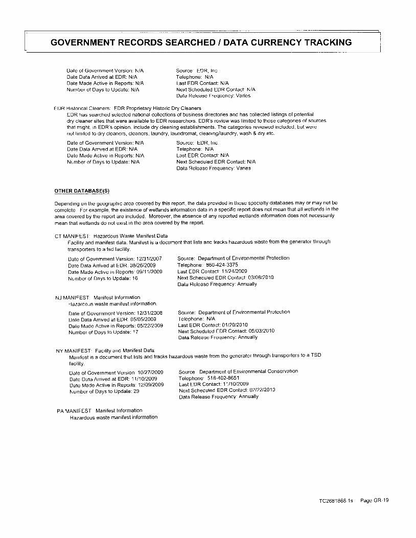
GOVERNMENT RECORDS SEARCHED / DATA CURRENCY TR^ACKING
Date of Government Version: N/A Source: EDR, Inc.Date Data Arrived at EDR: N/A Telephone: N/ADate Made Active in Reports: N/A Last EDR Contact: N/ANumber of Days to Update: N/A Next Scheduled EDR Contact: N/A
Data Release Frequency: Varies
EDR Histor ical Cleaners: EDR Propr ietary Histor ic Dry CleanersEDR has searched selected national collections of business directories and has collected listings of potential
dry cleaner sites that were available to EDR researchers. EDR's review was limited to those categories of sourcesthat might , in EDR's opin ion, inc lude dry c leaning establ ishments. The calegor ies reviewed included, but werenot limited to dry cleaners, cleaners, laundry, laundromat, cleaning/laundry, wash & dry etc.
Date of Government Version: N/A Source: EDR, Inc.Date Data Arrived at EDR: N/A Telephone: N/ADate Made Active in Reports: N/A Last EDR Contact: N/ANumber of Days to Update: N/A Next Scheduled EDR Contact: N/A
Data Release Frequency: Varies
OTHER DATA-BASE(S)
Depending on the geographic area covered by this report, the data provided in these specialty databases may or may not be
complete. For example, the existence of wetlands information data in a specific report does not mean that all wetlands in the
area covered by the report are included. Moreover, the absence of any reported wetlands informalion does not necessarily
mean that wetlands do not exist in the area covered by the report.
CT MANIFEST: Hazardous Waste Mani fest Data
Facility and manifest data. Manifest is a document that lists and tracks hazardous waste from the generator through
transporters to a tsd facility.
Date of Government Version: 1213112007 Source: Department of Environmental Protection
Date Data Arrived at EDR: 08/26/2009 Telephone: 860-424-3375
Date Made Active in Reports: 0911112009 Last EDR Contact: 1112412009
Number of Days to Update: '16 Next Scheduled EDR Contact : 03/08/2010Data Release FrequencY: Annual lY
NJ MANIFEST: Mani fest Informat ionHazardous waste manifest information.
Date of Government Version: 12t31t2OO8 Source: Department of Environmental Protection
Date Data Arrived at EDR: 05/05/2009 Telephone: N/A
Date Made Active in Reports: O5l22l2OOg Last EDR Contact: 0112012010
Number of Days to update: 17 Next Scheduled EDR Contact : 05/03/2010Data Release FrequencY: Annual lY
NY MANIFEST: Faci l i ty and Mani fest Data
Manifest is a document that lists and tracks hazardous waste from the generator through transporters to a TSD
faci l i ty .
Date of Government Version: 1Ol27t2OOg Source: Department of Environmental Conservation
Date Data Anived at EDR: 11/ ' l0 /2009 Telephone: 518-402-8651
Date Made Act ive in Reports: 12l09l2oog Last EDR Contacl : 11l1Ol2OOg
Number of Days to update: 29 Next Scheduled EDR Contact : O2l22l2O1O
Data Release FrequencY: AnnuallY
PA MANIFEST: Manifest Information
Hazardous waste manifest information.
TC268 '1868.1s PageGR-19

GOVERNMENT RECORDS SEARCHED / DATA CURRENCY TRACKING
Date of Government Version: 1213112008Date Data Arr ived at EDR: 12101/2009Date Made Active in Reports: 1211412009Number of Days to Update: 13
Rl MANIFEST: N4ani fest informat ionHazardous waste manifest information
Date of Government Version: 06/01/2009Date Data Arrived at EDR: 06/1212009Date Made Active in Reports: 0612912009Number of Days to Update: 17
VT MANIFEST: Hazardous Waste Mani fest DataHazardous waste manifest information.
Date of Governmenl Version: 03/31/2009Date Data Arrived al EDR: 04/09/2009Date Made Active in Reports: 05l20l2olgNumber of Days to Update: 41
Wl MANIFEST: Mani fest Informat ionHazardous waste manifest information.
Dale of Government Version: 1213112008 Source: Department of Natural Resources
Date Data Arrived al EDR.0711712009 Telephone: N/A
Date Made Act ive in Reports: 08/10/2009 Last EDR Contact : 12121l2OOg
Number of Days to Update: 24 Next Scheduled EDR Contact : 04lO5l2O1OData Release FrequencY: AnnuallY
Oil/Gas pipelines: This data was obtained by EDR from the USGS in '1994. lt is referred to by USGS as GeoData Digital Line Graphs
from 1:100,000-Scale Maps. lt was extracted from the transportation category including some oil, but primarily
gas pipel ines.
Electric Power Transmission Line Data
Source: PennWel l CorPorat ionTelephone: (800) 823-6277This map includes information copyrighted by PennWell Corporation. This information is provided
on a best effort basis and PennWell Corporation does not guarantee its accuracy nor warrant ils
fitness for any particular purpose. Such information has been reprinted with the permission of PennWell'
Sensitive Receptors. I here are individuals deemed sensitive receptors due to their fragile immune systems and special sensitivity
to environmental dtscharges. These sensi t ive receptors typical ly inc lude the elder ly, the s ick, and chi ldren Whi le the locat ion of a l l
sensitrve receplors cannot be determined, EDR indicates those buildings and facilities - schools, daycares, hospitals, medical centers'
and nursing homes - where individuals who are sensitive receptors are likely to be located.
AHA HosDita ls:Source: American Hospital Association, Inc.
Telephone: 31 2-280-5991The database includes a listing of hospitals based on the American Hospital Association's annual survey of hospitals
Medical Centers: Provider of Services Listing
Source: Centers for Medicare & Medicaid Services
Telephone: 41 0-786-3000
A listing of hospttats with Medicare provider number, produced by Centers of Medicare & Medicaid Services,
a federat agency within the U.S. Department of Health and Human Services'
Nursing HomesSource: National Institutes of Health
Telephone: 301 -594-6248
In fo rma t i ononMed i ca reandMed i ca idce r t i f i ednu rs i nghomes in theUn i t edS ta tes .
Source: Department of Environmental ProtectionTelephone: N/ALast EDR Contacl: 1112312009Next Scheduled EDR Contact: 03/08/2010Data Release Frequency: Annually
Source: Department of Environmental ManagemenlTelephone: 40 1 -222-27 97Last EDR Contact: 1 1/30/2009Next Scheduled EDR Contact : O3l15l2O1OData Release Frequency: Annual ly
Source: Department of Environmental ConservationTeleohone: 802-241 -3443
Last EDR Contact : 10l23l2oogNext Scheduled EDR Contact : O2lOBl201OData Release Frequency: Annually
TC2681868.1s PageGR-20

GOVERNMENT RECORDS SEARCHED / DATA CURRENGY TRACKING
Publ ic SchoolsSource: National Center for Education StatisticsTelephone: 202-502-7 300The National Center for Education Statistics' primary database on elementaryand secondary publ ic educat ion in the Uni ted States. l t is a comprehensive, annual , nat ional stat is t icaldalabase of all public elementary and secondary schools and school districts, which contains data that are
comparable across all states.Private Schools
Source: National Center for Education StatisticsTelephone: 202-502-7 300The National Center for Education Statistics' primary database on private school locations in the United States.
Daycare Centers: Child Care Facility ListSource: Department of Protective & Regulatory ServicesTelephone: 51 2-438-3265
Flood Zone Data: This data, available in select counties across the country, was obtained by EDR in 2003 & 2009 from the Federal
Emergency Management Agency (FEMA). Data depicts 1 0O-year and 500-year flood zones as defined by FEMA.
NWI: Nat ional Wet lands Inventory. This data, avai lable in select count ies across the country, was obtained by EDR
in 2002 and 2005 f rom the U.S. Fish and Wi ld l i fe Service.
sr I E EI 4 Nq 4 D_qEE9! lII_o.B t',t4l!e!
O 2010 Tele Atlas North America, Inc. All rights reserved. This material is proprietary and the subject of copyright protection
and other intellectual property rights owned by or licensed to Tele Atlas Norlh America, Inc. The use of this material is subject
lo the terms of a license agreement. You will be held liable for any unauthorized copying or disclosure of this material
TC2681868 1s Page GR-21
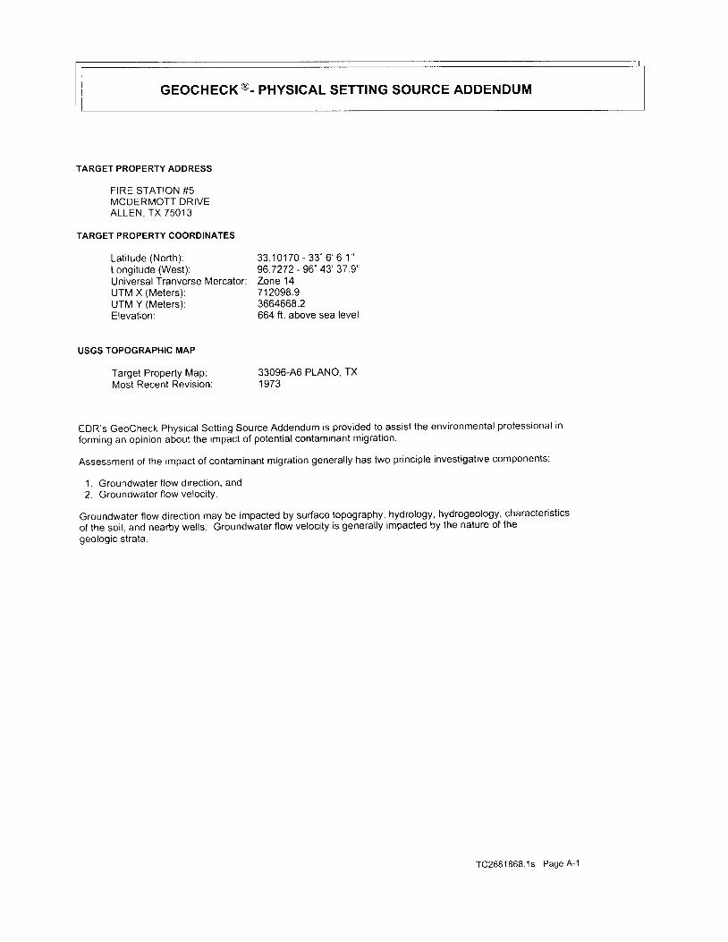
GEOCHECK@- PHYSICAL SETTING SOURCE ADDENDUM
TARGET PROPERTY ADDRESS
FIRE STATION #5MCDERMOTT DRIVEALLEN, TX 7501 3
TARGET PROPERTY COORDINATES
L a t i t u d e ( N o r t h ) : 3 3 . 1 0 1 7 0 - 3 3 ' 6 ' 6 1 "Longitude (West): 96 7272 - 96" 43' 37 9'Universal Tranverse Mercator: Zone 14UTM X (Meters ) : 712098.9UTM Y (Meters): 3664668.2Elevation: 664 ft . above sea level
USGS TOPOGRAPHIC MAP
Target Property Map: 33096-46 PLANO, TXMost Recent Revision: 1973
EDR's GeoCheck Physical Sett ing Source Addendum is provided to assist the environmental professional in
forming an opinion about the impact of potential contaminant migration.
Assessment of the impact of contaminant migration general ly has two principle investigative components:
1. Groundwater f low direct ion, and2. Groundwater f low velocity.
Groundwater 1ow direction may be impacted by surface topography, hydrology, hydrogeology, characteristics
of the soi l , and nearby wells. Groundwater f low velocity is general ly impacted by the nature of the
geologic strata.
TC2681868.1s Page A-1

GEocHEcI€ . pnvslcAL SETTING SOURCE SUMMARY
GROUNDWATER FLOW DIRECTION INFORMATION
Groundwater f low direct ion for a part icular si te is best determined by a qual i f ied environmental professionalusing site-specif ic well data. l f such data is not reasonably ascertainable, i t may be necessary to rely on othersources of information, such as surface topographic information, hydrologic information, hydrogeologic datacol lected on nearby propert ies, and regional groundwater f low information (from deep aquifers).
TOPOGRAPHIC INFORMATIONSurface topography may be indicative of the direct ion of surf icial groundwater f low. This information can be used toassist the environmental professional in forming an opinion about the impact of nearby contaminated propert ies or,should contamination exist on the target property, what downgradient si tes might be impacted.
TARGET PROPERTY TOPOGRAPHYGeneral Topographic Gradient: General ESE
SURROUNDING TOPOGRAPHY: ELEVATION PROFILES
- g - e
- e -
c
Fs0)
LlJ
c
oo
uJ
0Target Property Elevation: 664 ft.
Source: Topography has been determined from the USGS 7.5' Digital Elevation Model and should be evaluated
on a relative (not an absolute) basis. Relative elevation information between sites of close proximity
should be fleld verif ied.
\ t2 1 Mi les
TC2681868.1s Page A-2
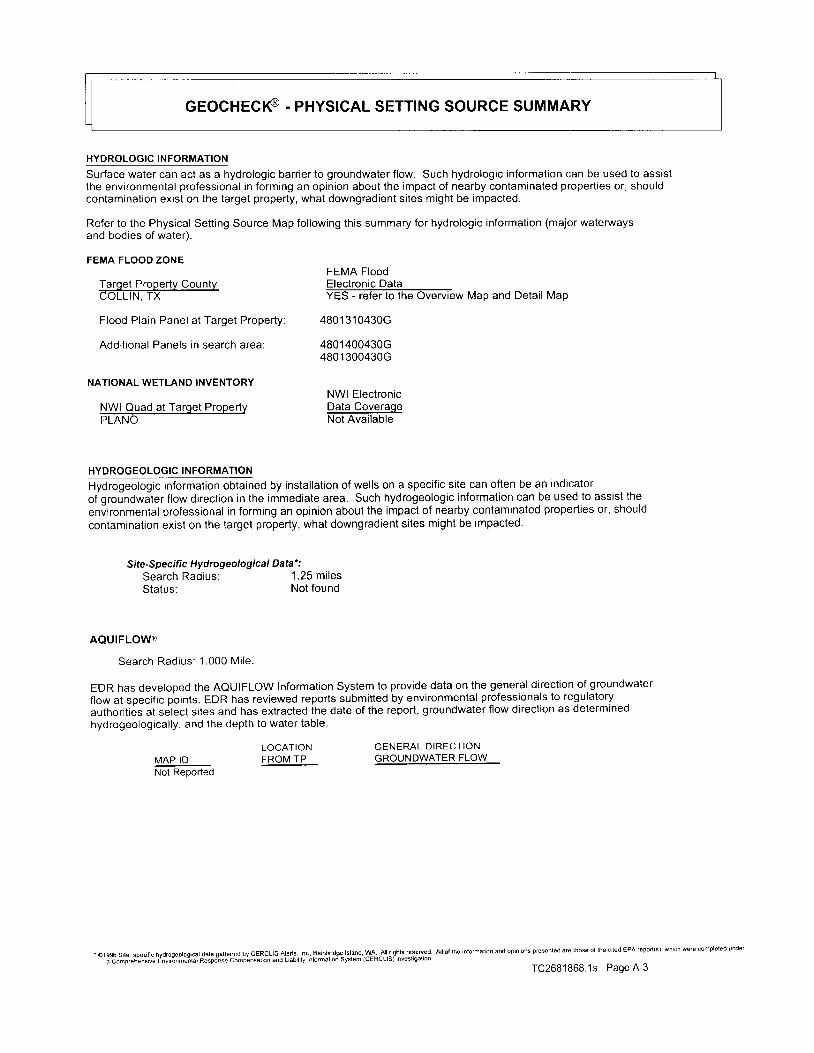
GEocHEcI€ . pnYsIcAL SETTING SOURCE SUMMARY
HYDROLOGIC INFORMATION
Surface water can act as a hydrologic barr ier to groundwater f low. Such hydrologic information can be used to assistthe environmental professional in forming an opinion about the impact of nearby contaminated propert ies or, shouldcontamination exisl on the target property, what downgradient si tes might be impacted.
Refer to the Physical Sett ing Source Map fol lowing this summary for hydrologic information (major waterwaysand bodies of water).
FEMA FLOOD ZONEFEMA Flood
Tarqet Propertv Countv Electronic DataCOLLIN, TX YES - refer to the Overview Map and Detai l Map
Flood Plain Panel at Target Property: 4801310430G
Addit ional Panels in search area: 4801400430G4801 300430G
NATIONAL WETLAND INVENTORYNWI Electronic
NWI Quad at Tarqet Propertv Data Co.ve,rgqePLANO Not Avai lable
HYDROGEOLOGIC INFORMATION- - .
Hydrogeologic information obtained by installation of wells on a specific site can oflen be an indicatoro igroundwJter f lowdirect ionintheimmediatearea. Suchhydrogeologic informat ioncanbeusedtoassis t theenvironmental professional in forming an opinion about the impact of nearby contaminated properties or, shouldcontamination exist on the target property, what downgradient sites might be impacted.
Site-Specific Hydrogeological Data' :
Search Rad ius : 1 .25 mi lesStatus: Not found
AQUIFLOWl'
Search Rad ius : 1 .000 Mi le .
EDR has developed the AQUIFLOW Information System to provide data on the general direct ion of groundwater
flow at specific points. EDR has reviewed reports submitted by environmental professionals to regulatory
authorit ies at select si tes and has extracted ihe date of the report, groundwater f low direct ion as determined
hydrogeological ly, and the depth to water table.
LOCATION GENERAL DIRECTIONMAP ID FROMTP GROUNDWATER FLOWNot Reoorted
" ; C";;;.d*;;; E*'"o".e"nrar nespo-nse compbnsatbn and Liabil[v lnfomaliori Svslem (cERcLls) inv€sligaron
TC2681868.1s Page A-3

GEoCHECI€ . PNYSICAL SETTING SOURCE SUMMARY
GROUNOWATER FLOW VGroundwater flow velocity information for a particular site is best determined by a qualif ied environmental professionalusing site specific geologic and soil strata data. lf such data are not reasonably ascertainable, it may be necessaryto rely on other sources of information, including geologic age identif lcation, rock stratigraphic unit and soilcharacteristics data collected on nearby properties and regional soil information. In general, contaminant plumesmove more quickly through sandy-gravelly types of soils than silty-clayey types of soils.
GEOLOGIC INFORMATION IN GENERAL AREA OF TARGET PROPERTY
Geologic informatron can be used by the environmental professional in forming an opin ion about the re lat ive speedat which contaminant migrat ion may be occurr ing.
ROCK STRATIGRAPHIC UNIT
Era:System:Series:Code:
MesozoicCretaceousAustin and Eagle Ford GroupsuK2 (decoded above as Era, System & Serles)
GEOLOGIC AGE IDENTIFICATION
Category: Strat i f iedSequence
Geologic Age and Rock Strat igraphic Unit Source: P.G. Schruben, R.E. Arndt and W.J. Bawiec, Geologyof the Conterminous U.S. at 1:2,500,000 Scale - a digital representation of the 1974 P.B. King and H.M. BeikmanMap, USGS Digital Data Series DDS - 1 1 (1994).
TC2681868.1s Page A-4
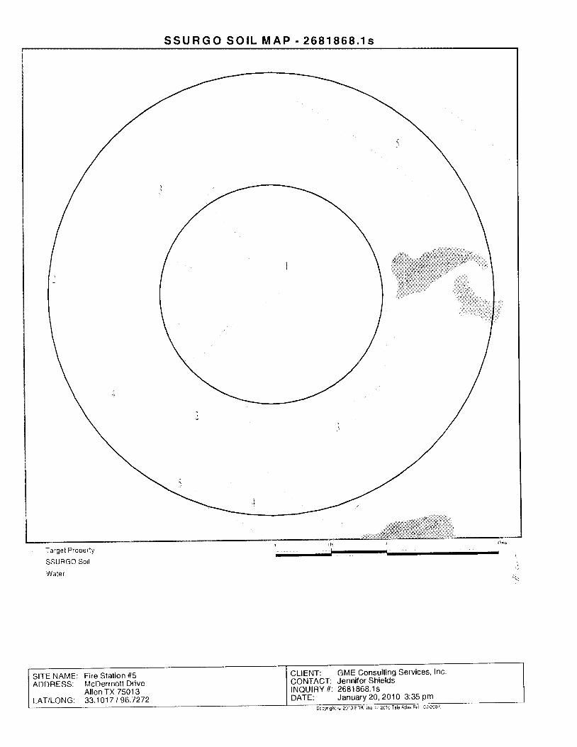
S S U R G O S O I L M A P - 2 6 8 1 8 5 8 . 1 s
Target Property
SSURGO Soil
Water
CLIENT: GME Consulting Services, Inc.CONTACT: Jenniler ShieldsINQUIRY #: 2681868. ' lsDATE: JanuarY20,2010 3:35Pm
SITE NAME: Fire Stal ion #5ADDRESS: McDermottDrive
A l len TX 75013LAT/LONG: 33.1017 I 96.7272
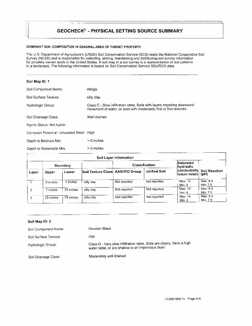
GEOCHECI€ . pnvSICAL SETTING SoURcE SUMMARY
DOMINANT SOIL COMPOSITION IN GENERAL AREA OF TARGET PROPERTY
The U.S. Department of Agriculture's (USDA) Soil Conservation Service (SCS) leads the National Cooperative SoilSurvey (NCSS) and is responsible for col lect ing, storing, maintaining and distr ibuting soi l survey informationfor privately owned lands in the United States. A soi l map in a soi l survey is a representation of soi l patternsin a landscape. The fol lowing information is based on Soil Conservation Service SSURGO data.
Soi l Map lD: 1
Soil Component Name:
Soil Surface Texture:
Hydrologic Group:
Soi l Dra inage Class:
Hydric Status: Not hydric
Corrosion Potential - Uncoated Steel: High
Depth to Bedrock Min:
Depth to Watertable Min
Altoga
silty clay
Class C - Slow infi ltration rates. Soils with layers impeding downwardmovement of water, or soils with moderately fine or f ine textures.
Well drained
> 0 inches
> 0 inches
Soil Layer Information
Boundary Classif icat ion3aturatedIydraul icconductivi tymicro m/sec
Soil Reaction(pH)Layer Upper Lower Soil Texture Class AASHTO Group Unified Soil
1 0 inches 7 inches silty clay Not reported Not reported Max: '14
Min: 4Max : 8 .4M in : 7 .9
2 7 inches 25 inches silty clay Not reported Not reported M a x : 1 4M in : 4
Max : 8 .4M in : 7 .9
3 25 inches 79 inches si l ty c lay Not reported Not reported M a x : 1 4Min: 4
Max : 8 .4M in : 7 .9
Soi l Map lD: 2
Soi l Component Name:
Soil Surface Texture:
Hydrologic Group:
Soi l Dra inage Class:
Houston Black
cray
Class D - Very slow infi ltration rates. Soils are clayey' have a highwater table, or are shallow to an impervious layer.
Moderately well drained
TC2681868.1s Page 4-6
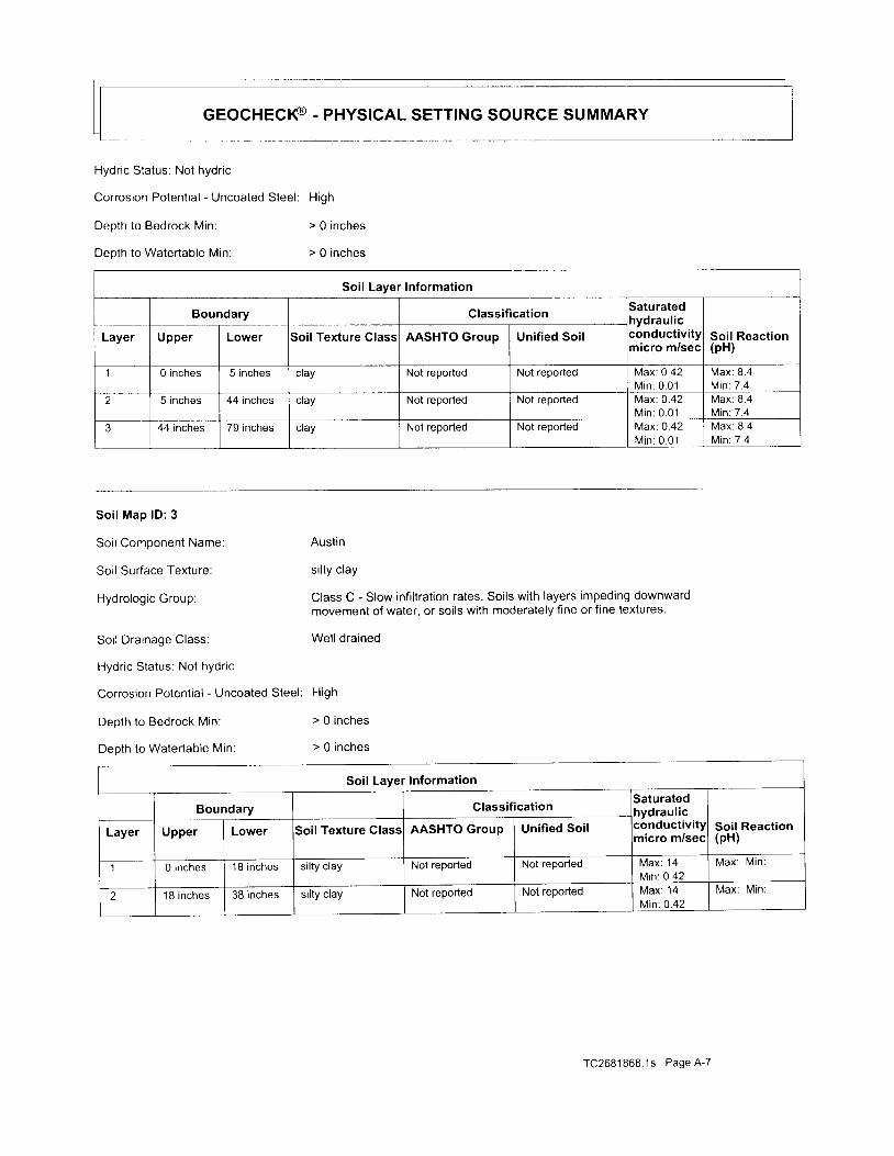
GEocHEcI€ . pnyslcAL SETTING SoURcE SUMMARY
Hydric Status: Not hydric
Corrosion Potential - Uncoated Steel: High
Depth to Bedrock Min: > 0 inches
Depth to Watertable Min: > 0 inches
Soil Layer Information
Boundary Classif icat ionSaturatedrydraul ic:onductivi tynicro m/sec
Soil Reaction(pH)
Layer Upper Lower Soil Texture Class AASHTO Group Unif ied Soil
1 0 inches 5 inches cray Not reported Not reported Max: 0.42M in : 0 .01
Max: 8.4M in : 7 .4
2 5 inches 44 inches cray Not reported Not reported Max: 0.42M in : 0 .01
Max : 8 .4M in : 7 .4
3 44 inches 79 inches cray Not reported Not reported Max: 0 .42Min : 0 .01
Max : 8 .4M in : 7 .4
Soi l Map lD : 3
So i l Component Name:
Soil Surface Texture:
Hydrologic Group:
So i l Dra inage C lass :
Hydric Status: Not hydric
Corrosion Potential - Uncoated Steel: High
Depth to Bedrock Min:
Depth to Watertable Min
Austin
si l ty clay
Class C - Slow inf i l trat ion rates. Soi ls with layers impeding downwardmovement of water, or soi ls with moderately f ine or f ine textures.
Well drained
> 0 inches
> 0 inches
Soil Layer Information
Boundary Classif icat ionSaturated[ydraul ic
Soil Reaction(pH)Layer Upper Lower Soil Texture Class AASHTO Group Unif ied Soil
micro m/sec
1 0 inches 1 I inches si l ty c lay Not reported Not reported Max : 14Min: 0.42
Max : M in :
2 '18 inches 38 inches silty clay Not reported Not reported Max : 14Min: 0.42
Max: Min :
TC2681868.1s Page A-7
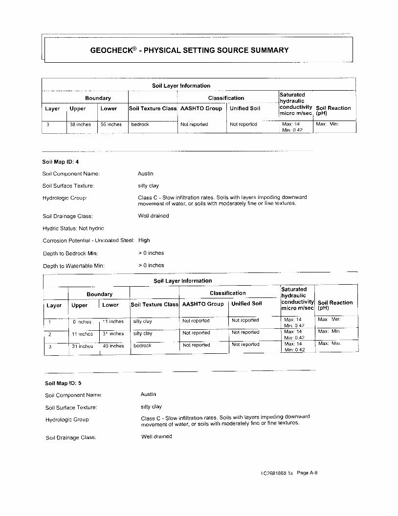
GEocHEcI€ . pnvSICAL SETTING SOURCE SUMMARY
Soil Layer Information
Boundary Classif icat ioniaturatedrydraulic
Soil Reaction(pH)
Layer Upper Lower Soil Texture Class AASHTO Group Unif ied Soil , v r l u u u r l v l l l '
nicro m/sec
3 38 inches 55 inches bedrock Not reported Not reported Max : 14M in : 0 .42
Max: Mrn:
S o i l M a p l D : 4
Soil Componenl Name: Austin
Soil Surface Texture: si l ty clay
Hydrologic Group: Class C - Slow inf i l trat ion rates. Soi ls with layers impeding downwardmovement of water, or soi ls with moderately f ine or f ine textures.
Soil Drainage Class: Well drained
Hydric Status: Not hydric
Corrosion Potential - Uncoated Steel: High
Deoth to Bedrock Min: > 0 inches
Deoth to Watertable Min: > 0 inches
Soil Layer lnformation
Boundary ClassificationSaturated Ihydraulic Iconductivityl Soil Reactionmicro m/secl (pH)Layer Upper Lower Soil Texture Class AASHTO Group Unif ied Soil
1 0 inches 11 i nches silty clay Not reported Not reported M a x : 1 4Min: 0.42
Max : M in :
2 '1 1 inches 3'1 inches silty clay Not reported Not reported N,4ax: 14M in : 0 .42
Max: Min
3 31 i nches 40 inches bedrock Not reported Not reported M a x : 1 4M in : 0 .42
Max : M in :
Soi l Map lD : 5
Soil Component Name:
Soil Surface Texture:
Hydrologic GrouP:
Soil Drainage Class:
Austin
silty clay
Class C - Slow infi ltration rates. Soils with layers impeding downwardmovement of water, or soils with moderately fine or fine textures'
Well drained
TC2681868.1s Page A-8

cEocHEct€ - pnvsrcAl SETTING souRcE suMMARy
Hydric Status: Not hydric
Corrosion Potential - Uncoated Steel: High
Depth to Bedrock Min: > 0 inches
Depth to Watertable Min: > 0 inches
LOCAL / REGIONAL WA
EDR Local /Regional Water Agency records provide water wel l in format ion to assist the environmental
professional in assessing souices that may impact ground water f low direct ion, and in forming an
opinion about the impact of contaminant migrat ion on nearby dr inking water wel ls .
WELL SEARCH DISTANCE INFORMATION
DATABASE SEARCH DISTANCE (miles)
Federal USGS 0.000
Federal FRDS PWS Nearest PWS within 1 mile
State Database 1.000
FEDERAL USGS WELL INFORMATION
MAP ID WELL IDLOCATIONFROM TP
No Wells Found
FEOERAL FRDS PUBLIC WATER SUPPLY SYSTEM INFORMATION
MAP ID WELL IDLOCATIONFROM TP
No PWS Svstem Found
Note: PWS System location is not always the same as well location
Soil Layer Information
Boundary ClassificationSaturatedIydraulic;onductivitymicro m/sec
Soil Reaction(pH)
Layer Upper Lower Soil Texture Class AASHTO Group Unified Soil
0 inches 16 inches silty clay Not reported Not reported M a x : 1 4M in : 0 .42
Max : M in :
2 16 inches 29 inches si l ty clay Not reported Not reported Max : 14Min: 0.42
Max: Min:
3 29 inches 50 inches bedrock Not reported Not reported Max : 14Min O.42
Max : M in :
TC268'1868.1s Page A-9
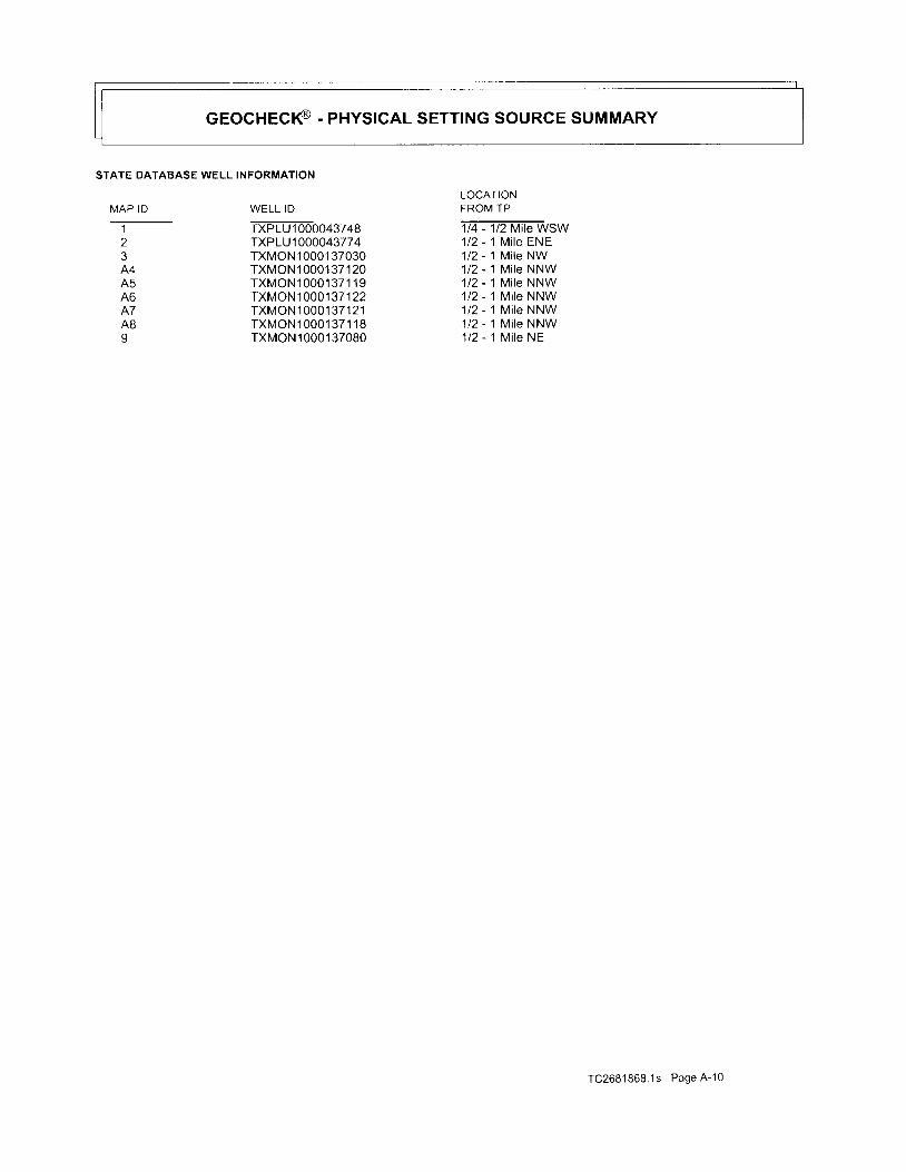
GEocHEcI€ . pnyslcAL SETTING SOURCE SUMMARY
STATE DATABASE WELL INFORMATION
MAP ID- ^ - -
I
2
A4A5A6A7ABI
WELL ID-rxpLut
oooo+szqeTXP1U1000043774TXMON 1 0001 37030TXMON1000137120TXMON10001371 19TXMON1000137122TXMON1000137121TXMON1000137118TXMONl 0001 37080
LOCATIONFROM TP- ta - tz vi te wsw1t21121t21t21t21t2112i l z
Mi le ENEMi le NWMi le NNWMi le NNWMi le NNWMi le NNWMi le NNWM i l e N E
TC2681868.1s Page A-'10
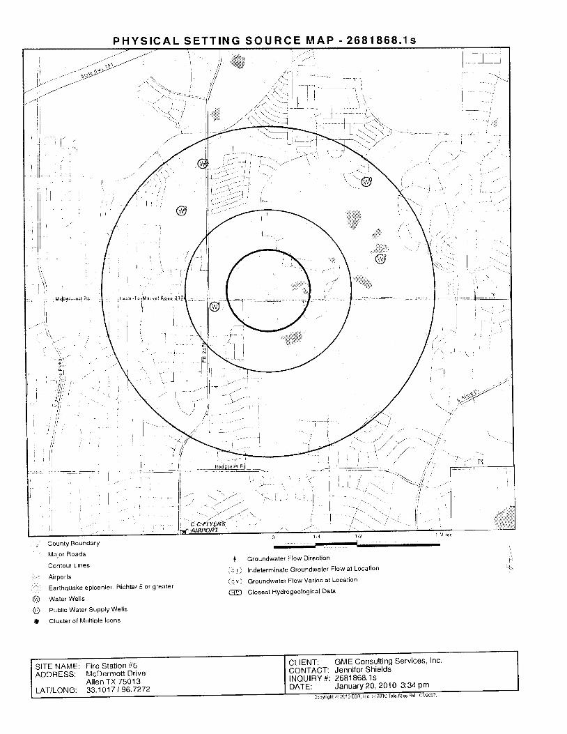
P H Y S I C A L S E T T I N G S O U R C E M A P . 2 6 8 1 8 6 8 . 1 S
l ll
| --) i
I
' . . -I
County BoundarY
Major Roads
Contour L lnes
Airports
Earthquake epicenter, Richtel 5 or greater
Water Wells
Publ ic Water SUPPIY Wel ls
c luster of Mul t ip le lcons
t( c ! )
( c v )
@
Groundwater Flow Direction
lndeterminate Groundwater Flow at Location
Groundwater Flow Varies at Location
Close6t Hydrogeological Data
I,\
@o{}
CLIENT: GME Consulting Services, Inc'CONTACT: Jennifer ShieldsINQUIRY# : 26818681sDATE: JanuarY 20,2010 3:34 Pm
SITE NAME: Fire Stat ion #5ADDRESS: McDermottDrive
A l len TX 7501 3LAT/LONG: 33.1017 I 96'7272
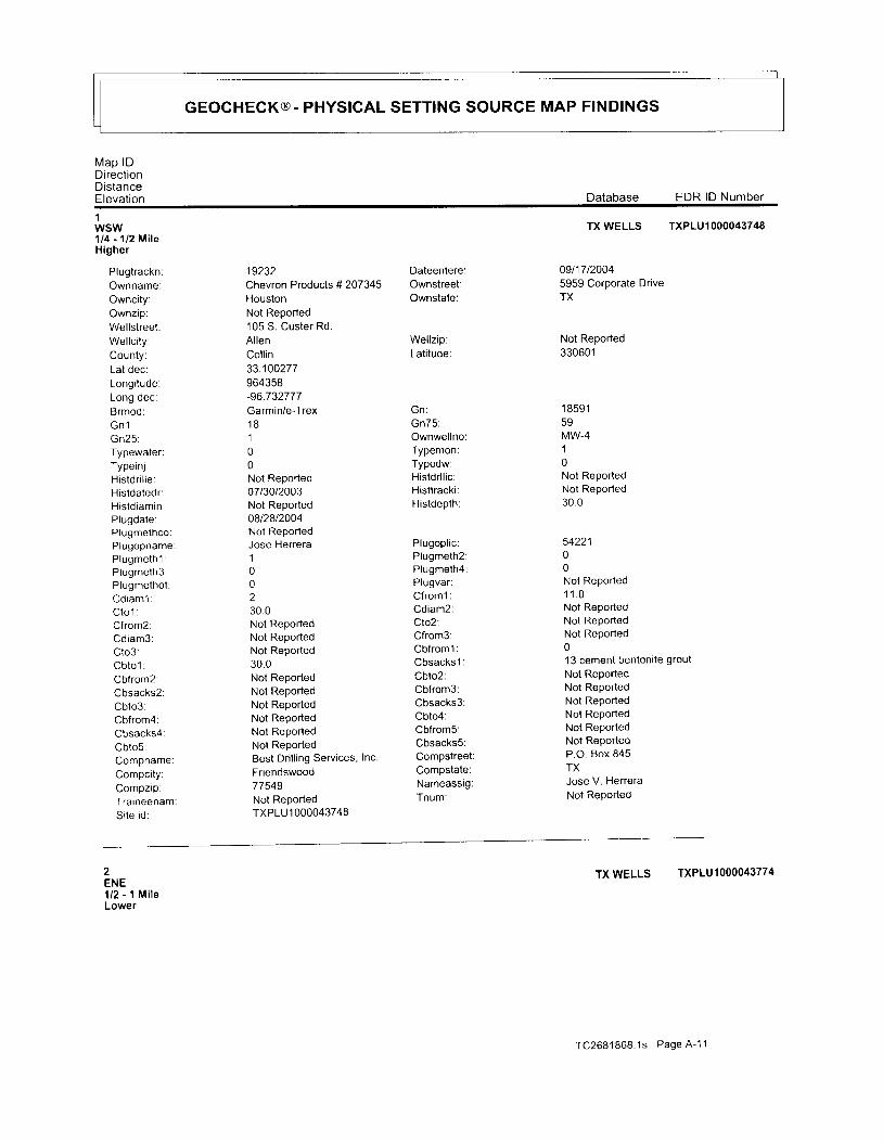
GEOCHECK@. PHYSICAL SETTING SOURCE MAP FINDINGS
M a p l DDrrectionDistanceElevation Database EDR lD Number
1wsw'U4 - 1t2 MiteHigher
Plugtrackn:Ownname:Owncity:Ownzip:Wellstreet:Wel lc i ty :County:Lal dec:Longi tude:LOng oec:Brmod:G n l :Gn25 :Typewater:Typeinj :Histdr i l le :Histdatedr:Histd iamin:Plugdate;Plugmethco:Plugopname:P lugme th l :Plugmeth3:Plugmethot :Cd iam l :C t o l :Cfrom2:Cd iam3 :Cto3:Cb to l :Cbfrom2:Cbsacks2:Cbto3Cbfrom4:Cbsacks4:Cbto5:Compname:Compci tY:CompzipTraineenamtSi te id:
19232Chevron Products # 207345HoustonNot Reported105 S. Custer Rd.AllenColl in33.100277964358-96.732777Garmin/e-Trex1 8100Not Reportedo7t30t2003Not Reported08t2812004Not ReportedJose Herrera100230.0Not ReportedNot ReportedNot Reported30.0Not ReportedNot ReportedNot ReportedNot ReportedNot ReportedNot ReportedBest Drilling Services, lnc.Friendswood77549Not ReportedTXPLU 1 000043748
Dateentere:Ownstreet:Ownstate:
Wellzip:Latitude:
b n :
Gn75:Ownwel lno:Typemon:Typedw:Histdr l l ic :Histtracki:Histdepth:
Plugopl ic :Plugmeth2:Plugmeth4:Plugvar:C f rom l :Cdiam2:Clo2.Cfrom3:Cbfroml:Cbsacks 1 :Cbto2:Cbfrom3:Cbsacks3:Cbto4:Cbfrom5:Cbsacks5:Compstreet:Compstate:Nameassig:Tnum:
TXWELLS TXPLU1OOOO43748
09t17 t20045959 Corporate DriveTX
Not Reported330601
1 8 5 9 159MW.410Not ReportedNot Reported30 .0
5422100Not Reported1 1 . 0Not ReportedNot ReportedNot Reported013 cement bentoni te grout
Not ReportedNot ReportedNot ReportedNol ReportedNot ReportedNot ReportedP.O. Box 845TXJose V. HerreraNot Reported
2ENE1/2 - 1 Mi leLower
TX WELLS TXPLU1OO()O43774
TC2681868 .1s Page A -11
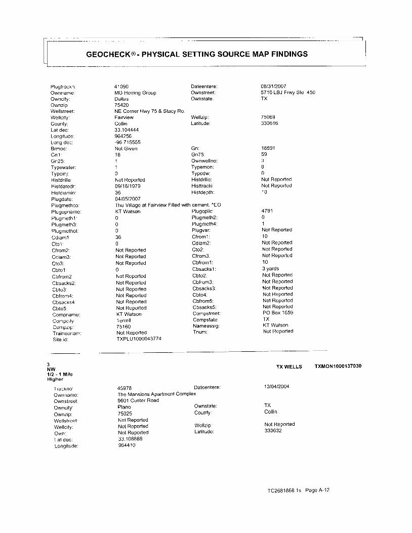
GEOCHECK@. PHYSICAL SETTING SOURCE MAP FINDINGS
Plugtrackn:Ownname:Owncity:Ownzip:Wellstreet:Wel lc i ty :County:Lat dec:Longi tude:Long dec:Brmod:G n 1 :Gn25 :Typewater:Typeinj :Histdr i l le :Histdatedr:Histd iamin:Plugdate:Plugmethco:Plugopname:Plugmethl :Plugmeth3:Plugmethot :Cd iam l :C t o l :Cfrom2:Cd iam3 :Cto3:Cb to l :Cbfrom2.Cbsacks2:Cbto3:Cbfrom4:Cbsacks4:Cbto5:Compname:Compci ty:Compzip:Traineenam:Si te id:
4 1 0 9 0MG Herring GroupDal las75420NE Corner Hwy 75 & Stacy RdFairviewCol l in33.104444964256-96 715555Not Given1 8110Not Reported09/1 8/1 9793604t0512007The Village at Fairview Filled with cement. "EOKT Watson000360Not ReportedNoi ReportedNot Reported0Not ReportedNot ReportedNot ReportedNot ReportedNot ReportedNot ReportedKT WatsonTerrell751 60Not ReportedTXPLU 1 000043774
08131120075710 LBJ Frwy Ste.450TX
7506933061 6
1 859159300Not ReportedNot Reported1 0
479101Not Reported1 0Not ReportedNot ReportedNot Reported1 03 yardsNot ReportedNot ReportedNot ReportedNot ReportedNot ReportedNot ReporledPO Box 1659TXKT WatsonNot Reported
DateentereOwnstreet:Ownstate:
Wel lz ip:Lat i tude:
bn :Gn75 :OwnwellnoTypemon:Typedw:Histdr l l ic :Histtracki:Histdepth:
Plugoplic:Plugmeth2:Plugmeth4:Plugvar:Cfroml:Cdiam2:Cto2:Cfrom3:Cbfroml:Cbsacks 1 :Cbto2:Cbfrom3:Cbsacks3:Cbto4:Cbfrom5:Cbsacks5:CompstreetCompstate:NameassigTnum:
3NW1/2 - 1 Mi leHigher
Trackno:OwnnameOwnstreetOwncity:Ownzip:WellstreetWel lc i ty :Own:Lat dec:Longi tude
45978The Mansions Apartment ComPlex9601 Custer RoadPlano75025Not ReportedNot ReportedNot Reported33.1 0888896441 0
Dateentere
Ownstate:County:
Wellzip:Lati tude:
TX WELLS TXMONIOOO13TO3O
10to412004
TXColl in
Not Reported330632
TC2681868 1s Page A'12

GEOCHECK@. PHYSICAL SETTING SOURCE MAP FINDINGS
Elev:G n :Gn75:Twn:Twr:Twrg:Ue.U in :u g lu p :Ut :Pbv:Datestart:D i a l :D ia2 :Dia2to:Dia3from:Lith log:
Dmdriven:Dmmudrotar:Dmairham:Dm;etted:Dmrevcirc:Dmother:Bcs:Bcgs:BcocrGpf:Case Screen:
Cemfroml:Nosacks 1 ;Cemto2:Cemfrom3:Nosacks3:Cementby:Dp l :Appvar:Scsv.Sca.Wat levdate:Packers:Wel lp lug4S:Wptext:Tpturbine:Tpsubmerst :Tpotherck:PumpbowldeWtbai ler :Wtestimate.Welltestdr:Watqualund:Watertype:Chemanaly:Undnatural :Undhydro:Undotherck:Undother:UndcertifY:Dr l l icno:
-96 .7361101 8 5 9 15910000000007130120047 7 t8Not ReportedNot ReportedNot Reported
00000Not Reported0Not Reported0960
4 N Steel
Brandmodel:G n 1 :Gn25:Twd:Twrp:Um:Ud:U i r :Ui j :Udw:
Pbn:Datecomp:Dial to:Dia2from:Dia3 :Dia3to:
Garmin E-Trex1 8100001000008/06/20041 060Not ReportedNot ReportedNot Reporled
O 23 Top Soil (fill) 23 245 Crm Limeslone Chalk 245 795 Gray
Shale 795 860 Sand 860 950 Sand w/shale s i rks 950 1060 Sand
Steel Screen01 0-c950Not ReportedNot Reporteddri l lerNot ReportedNot Reported1008/06/2004none0Not Reported01063000500Fresh0000Not Reported054840
1000 1060 .03Cemto l :Cemfrom2:Nosacks2:Cemto3:CementmethDs:DSV:
Scs:scp:Watlev:Artflow:
10000010Not Reported1 060
N
1 q
9001 8-cNot Reportedtremmie pressurenoneNot Reported00430Not Reported
00Not Reported10451 219501Not RePorted0
Earth Tech1647 Witt Rd #1 05
TC2681868 1s Page A-13
Dmairrotar:Dmbored:Dmcabletoo:Dmhol lowst:Dmotherck:Bco:Bcg:Bcu:Bcot:Gpt:
0 1000 4
Tpjet:Tpcyl inder:Tpother:Wtpump:Wtjetted:Welltestyi:Welltesthr:Watqua lu 1 :Stratdepth:Chemanaln:Untype:Undhaz:
CompnameCompstreet
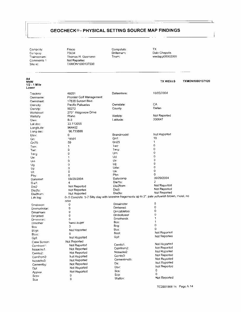
GEOCHECK@. PHYSICAL SETTING SOURCE MAP FINDINGS
Compci ty:Compzip:Traineenam:Comments 1Si te id:
Frisco75034Thomas R. GasmannNot ReportedTXMONl 0001 37030
Compstate:Dr i l lernam:Tnum:
TXDale Chepuliswwdapp00002000
A4NNW1/2 - 1 M i l eLower
Trackno:Ownname:Ownstreet :Owncity:Ownzip:Wel lst reet :Wel lc i ty :Own:Lat dec.| ^ ^ ^ i t ' r d o '
LOng oec:Elev:Gn :Gn75 :Twn;Twr:Twrg:Ue :U in :U g :up :U t :Pbv:Datestart:D i a l :D ia2 .Dia2to:Dia3from:Lith log:
Dmdriven:Dmmudrotar :Dmairham:Dmietted:Dmrevcirc:DmothertBcs:Bcgs:Bcoc:Gpf:Case ScreenCemfroml:Nosacks l :Cemto2:Cemfrom3:Nosacks3:CementbY:Dp l :Appvar:Scsv:Sca:
Dateentere:
Ownstate:County:
Wel lz ip:Lat i tude:
Brandmodel:G n 1 :Gn25:Twd:Twrp:U m :Ud :U i r :u i j :Udw:US :Pbn:Datecomp:Dia l to:
Dmairrotar:Dmbored:Dmcabletoo:Dmhollowst:Dmotherck:Bco:Bcg:Bcu:Bcot :Gpt:
Cemto l :Cemfrom2:Nosacks2:Cemto3:Cementmeth:Ds :Dsv:Scs:scp:Watlev:
00001100Not ReportedNot Reported
Not ReportedNot ReportedNot ReportedNot ReportedNot ReportedNot ReportedNot Reported00Not Reported
TC2681868 .1s Page A -14
46051Premier Golf Managemenl1 7838 Sunset Blvd.Pacific Palisades902722701 Ridgeview DrivePlanoB-333.1 1 3055964402-96.73388801 8591591001000000st2912004
Not Reported Dia2from
Not Reported Dia3:
Not ReDorted Dia3to: Not RePorted
0-.5 Concrete .5-2 Silty clay with limestne fragements up to 2", pale yellowish brown, moist, no
odor00000hand auger0Not Reported0Not RePorted
Not ReportedNot ReportedNot ReportedNot ReportedNot RePortedNot ReportedNot ReportedNot ReportedNot Reported00
TX WELLS TXMON1000137120
10t05t2004
CADallas
Not Reported330647
Not Reported1 8100000000009129120042Not ReportedNot Reported
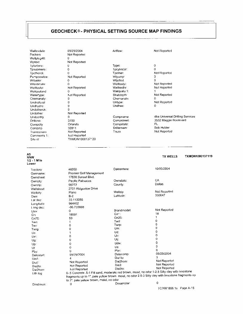
GEOCHECK@. PHYSICAL SETTING SOURCE MAP FINDINGS
Watlevdate:Packers:Wel lp lug48:Wptext:Tpturbine:Tpsubmersi :Tpotherck:PumpbowldeWtbai ler :Wtestimate:Welltestdr:Watqualund:Watertype:Chemanaly:Undnatural :Undhydro:Undotherck:Undother:Undcertify:Dr l l icno:Compci ty:Compzip:Traineenam:Comments 1Si te id:
0912912004Not Reported0Not Reported000Not Reported00Not Reported0Not Reported0000Not Reported031 50Orlando32811Not ReportedNot ReportedTXMON10001 371 20
Artflow:
Tpjet:Tpcylinder:Tpother:Wtpump:Wtietted:Welltestyi:Welltesthr:Watqualu 1:Stratdepth:Chemanaln:Untype:Undhaz:
Compname:Compstreet:Compstate:Dr i l lernam:Tnum:
Not Reported
00Not Reported00Not ReportedNot Reported1Not Reported0Not Reported0
dba Universal Drilling Services3532 Maggie BoulevardFLBob HublerNot Reported
A5NNW1/2 - 1 MileLower
Trackno:Ownname:Ownstreet:Owncity:Ownzip.Wellstreet:Wellci ty:Own:Lat dec:Longitude:l ^n . r la .
Elev:b n :Gn75 :Twn:Twr:Twrg:UC:U in :Ug :U p :U I :Pbv:Datestart:D t a l :D ia2 .Dia2to:Dia3from:Li th log:
Dmdnven:
46050Premier Golf Management17838 Sunset Blvd.Pacif ic Pal isades902722701 Ridgeview DrivePlanoB-233.1 1 3055964402-96.73388801 85915910010000009t2912004
Dateentere:
Ownstate:County:
Wel lz ip:Lat i tude:
BrandmodelG n l :Gn25:Twd:Twrp:Um:Ud :Utr :Uij:Udw:US :Pbn:Datecomp:
TXWELLS TXMON1OOO137119
10t0512004
Dallas
Not Reported330647
Not Reported1 8100000000009t2912004
a D ia l t o : 3
Not Reported Dia2from: Not Reporied
Not Reported Dia3: Not RePorted
Not Reoorted Dia3to: Not Reported
0-.5 Conciete .5-1 Fill sand, moderate red brown, moist, no odor 1-2.5 Silty clay with limestone
fragments up to .1", pale yellow brown, moist, no odor 2.5-3 Silty clay with limestone fragments up
to 2", pale yellow brown, moist, no odor0
TC2681868 1s Page A-15Dmairrotar
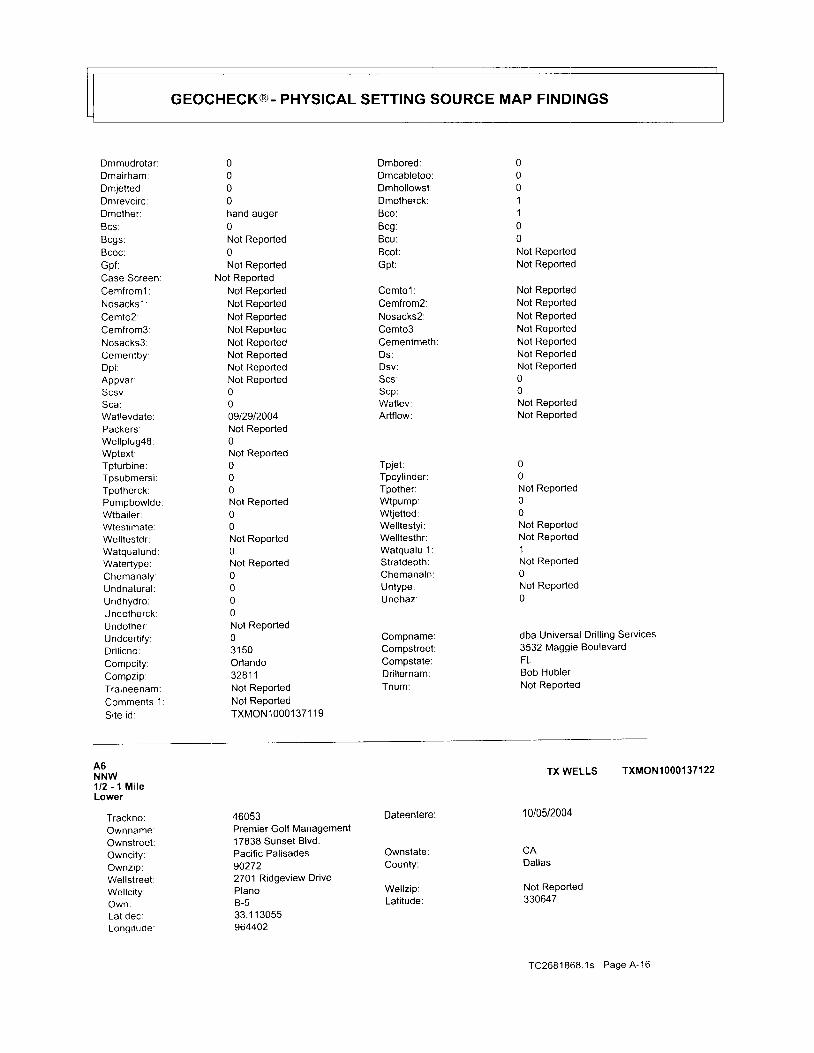
GEOCHECK@. PHYSICAL SETTING SOURCE MAP FINDINGS
Dmmudrolar:Dmairham:
Dmrevcirc:Dmother:8cs:Bcgs:Bcoc:Gpf:Case Screen:Cemfroml:Nosacks l :Cemto2:Cemfrom3:Nosacks3:Cementby:Dp l :Appvar:Scsv:Sca:Wat levdate:Packers:Wel lp lug4S:Wptext;Tpturbine:Tpsubmersi :Tpotherck:PumpbowldeWtbai ler :Wtest imate:Wel l testdr :Watqualund:Watertype:Chemanaly:Undnalural :Undhydro:Undotherck:Undother:Undcertify:Dr l l icno:Compci ty:Compzip.Traineenam;Comments 1
Si te id:
0000hand auger0Not Reported0Not Reported
Not ReportedNot ReportedNot ReportedNot ReportedNot ReportedNot ReportedNot ReportedNot ReportedNot Reported0009t2912004Not Reported0Not Reported000Not Reported00Not Reported0Not Reported0000Not Reported031 50Orlando32811Not ReportedNot ReportedTXMON10001371 19
Dmbored:Dmcabletoo:Dmhol lowst:Dmolherck:Bco:Bcg:Bcu:Bcot :Gpt:
Cemto l :Cemfrom2:Nosacks2:Cemto3:Cementmeth:Ds :Dsv:Scs:Scp:Watlev:Artflow:
Tpjet:Tpcylinder:Tpother:Wtpump:Wtjetted:Welltestyi:Welltesthr:Watqualu 1:Stratdepth:Chemanaln:Untype:Undhaz:
Compname:Compstreet:Compstate:Dr i l lernam:Tnum:
0001100Not ReportedNot Reported
Not ReportedNot ReportedNot ReportedNot ReportedNot ReporledNot ReportedNot Reported00Not ReportedNol Reported
00Not Reported00Not ReportedNot Reported1Not Reported0Not Reported0
dba Universal Drilling Services3532 Maggie BoulevardFLBob HublerNot Reported
A6NNW112 - l MileLower
Trackno:Ownname:Ownstreet:Ownci ty:Ownzip:Wel lst reet :Wel lc i ty :Own:Lat dec:Longi tude:
46053Premier Golf Management17838 Sunset Blvd.Pacific Palisades902722701 Ridgeview DrivePlanoB-533.1 1 3055964402
Dateentere:
Ownstate:County:
Wel lz ip:Latitude:
TX WELLS TXMON1000137122
1010512004
CADal las
Not Reported330647
TC2681868 .1s Page A -16

cEocHEcK@- PHYSICAL SETTING SOURCE MAP FINDINGS
Long oec:Elev:(,n:Gn75:Twn:Twr:Twrg:Ue:U in :Ug:Up:Ut :Pbv:Datestart:D i a l :D ia2 .Dia2to:Dia3from:Lith log:Dmdriven:Dmmudrolar:Dmairham:
Dmrevcirc:Dmother:Bcs:Ecgs:Bcoc:Gpf:Case Screen:Cemf rom l :Nosacks'1 :Cemto2:Cemfrom3:Nosacks3:Cementby.Dp l :Appvar:Scsv:Sca:Wat levdate:Packers:Wel lp lug4S:Wptext :Tpturbine:Tpsubmerst :Tpotherck:PumpbowldeWtbai ler :Wtestimate:Wel l testdr :Watqualund:
Watertype:Chemanaly:Undnatural :Undhydro:Undotherck:Undother:Undcertity:Dr l l icno:
-96.73388801 8591591001000000912912004
Not ReportedNot Reported
000nano auger0Not Reported0Not Reported
Not ReportedNot ReportedNot ReportedNot ReportedNot ReportedNot ReportedNot ReportedNot ReportedNot Reported000912912004Not Reported0Not Reported000Not Reported00Not Reported0Not Reported0000Not Reported031 50
BrandmodelG n 1 :Gn25 :Twd:Twrp:Um:Ud:Uir:ui j :Udw:Us:Pbn:Datecomp:Dial to:Dia2from:Dia3:
Dmcabletoo: 0
Dmhollowst: 0Dmotherck: 1
Bco: 1
Bcg: 0
Bcu: 0
Bcot:Gpt:
Cemto'l :Cemfrom2:Nosacks2:Cemto3:CementmethDs:Dsv:Scs:scp:Watlev:Artflow:
Tpjet:Tpcyl inder:Tpother:Wtpump:Wtjetted:Welltestyi:Welltesthr:Watqualu 1:Stratdepth:Chemanaln:Untype:Undhaz:
Compname:Compstreet:
Not ReportedNot Reported
Not ReportedNot ReportedNot ReportedNot ReportedNot ReportedNot ReportedNot Reported00Not ReportedNot Reported
00Not Reported00Not ReportedNot Reported1Not Reported0Not Reported0
dba Universal Drilling Services3532 Maggie Boulevard
Not Reported1 8100000000009129120044Not ReportedNot ReportedNot ReportedNot Reported Dia3to:
0-4 Shaley clay, light yellowish brown with reddish mottling, moist, no odor
I Dmairrotar: 0
O Dmbored: 0
TC2681868 .1s Page A -17
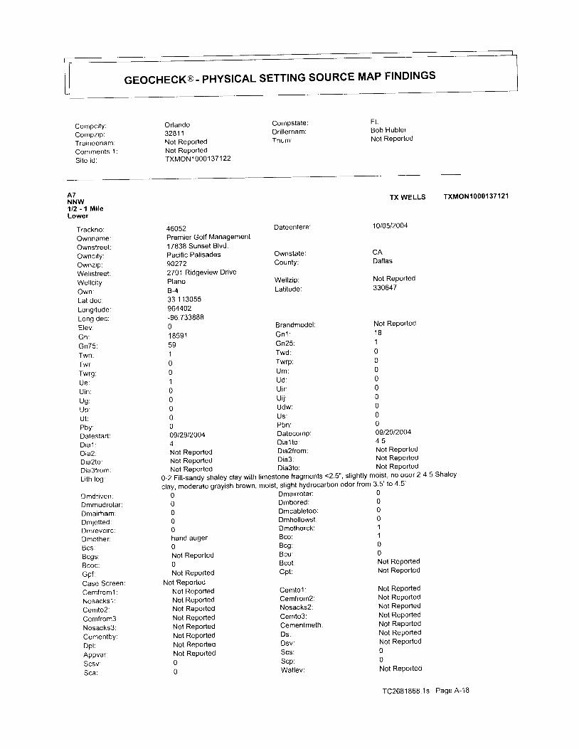
GEOCHECK@- PHYSICAL SETTING SOURCE MAP FINDINGS
Compci ty:Compzip:Traineenam:Commenls 1Si te id:
Orlando32811Not ReportedNot ReportedTXMONl 0001 371 22
Compstate:Dr i l lernam:Tnum:
FLBob HublerNot Reported
A7NNW112 -',| MileLower
Trackno:Ownname:Ownstreet:OwncitY:Ownzap:Wellstreet:Wel lc i ty :Own:Lat dec:Longi tude:Long dec:E lev .Gn :Gn75 :Twn:
Twrg.
U inUg :up :U t :Pbv:Datestart:D i a l :D iaZ .Dia2to:Dta3from:Li th log:
Dmdriven:Dmmudrotar :Dmairham:DmJetted:Dmrevctrc:Dmother:Bcs:Bcgs;Bcoc:Gpf:Case ScreenCemf rom l :Nosacks 1 :Cemto2:Cemfrom3:Nosacks3:CementbY:Dp l :Appvar:Scsv.Sca :
Dateentere:
Ownstate:County:
Wel lz ip:Lat i tude:
Brandmodel :G n 1 :Gn25 :Twd:Twrp:Um:Ud :Uir :Ui j :Udw:Us:Pbn :Datecomp:D ia l t o :
Dmcabletoo: 0
Dmhollowst: 0
Dmotherck: 1
Bco: 1
Bcg: 0
Bcu: 0
Bcot:Gpt:
Cemto l :Cemfrom2:Nosacks2:Cemto3:Cementmeth:Ds:Dsv:Scs:scp:Watlev:
Not ReportedNot Reported
Noi ReportedNot ReportedNot ReportedNot ReportedNot ReportedNot ReportedNot Reported00Not Reported
TC2681868 .1s Page A -18
46052Premier Golf Management17838 Sunset Blvd.Pacific Palisades902722701 Ridgeview DrivePlanoB-433.1 13055964402-96.73388801 85915910010000009t2912004I
Not Reported Dia2from: Not Reported
Not Reoorted Dia3: Not Reported
Not Reported Dia3to: Not RePorted
0-2 Fiil-sandy shaley clay with limestone fragments <2.5', slightly moist, no odor 2-4.5 Shaley
clay, moderate grayish brown, moist, slight hydrocarbon odor from 3 5' to 4'5'
I Dmairrotar: 0g Dmbored: 0
000hand auger0Not Reported0Not Reported
Not ReportedNot ReportedNot ReportedNot ReportedNot ReportedNot ReportedNot ReportedNot ReportedNot Reported00
TX WELLS TXMON1OOO137121
1010512004
CADal las
Not Reported330647
Not Reported' 18
10000000000912912004A E
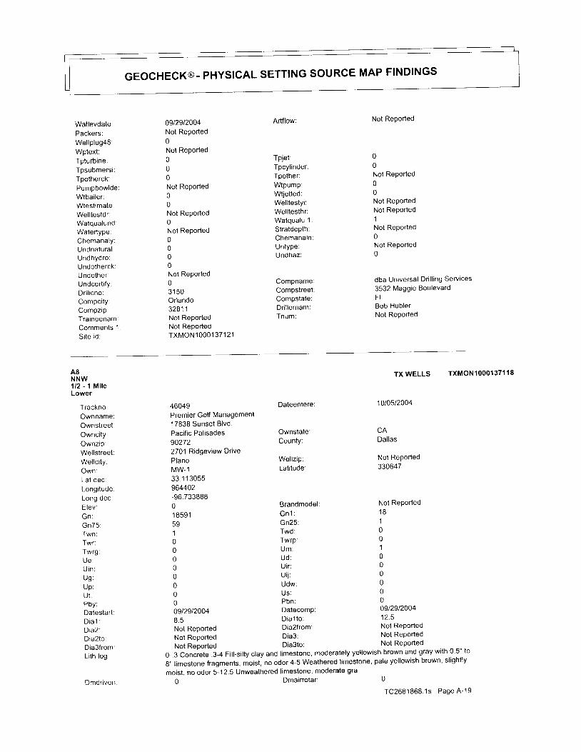
GEOCHECK@- PHYSICAL SETTING SOURCE MAP FINDINGS
Watlevdate:Packers:Wel lp lug4S:Wptext:Tpturbine:Tpsubmersi :Tpotherck:PumpbowldeWtbai ler .Wtest imatelWel l testdr :Watqualund:Watertype:ChemanalY:Undnatural :Undhydro:Undotherck:Undother:UndcerlifY:Dr l l icno:Compci ty:Compzip.Traineenam:Comments 1Si te id:
0s12912004Not Reported0Not Reported000Not Reported00Not Reported0Not Reported0000Not Reported031 50Orlando32811Not ReportedNot ReportedTXMONI 0001 371 21
Artflow:
Tpjet:Tpcyl inder:Tpother:Wtpump:Wtjetted:Welltestyi:Welltesthr:Wa tqua lu 1 :Stratdepth:ChemanalnUntype:Undhaz:
CompnameCompstreelCompstate:Dr i l lernam:Tnum:
Not Reported
00Not Reported00Not ReportedNot Reported1Not Reported0Not Reported0
dba Universal Dr i l l ing Services
3532 Maggie BoulevardFLBob HublerNot Reported
A8NNW1/2 - 1 M i l eLower
Trackno:Ownname:Ownstreet:Ownci ty:Ownzip:Wel lst reet :Wel lc i tYOwn :Lat dec:Longi tude:| ^ n ^ d o .L v , , v v e v
E lev :Gn :Gn75 :
Twrg:
U in :Ug :up :U t l
Pbv :Datestart:D i a l :D ia2 'Dia2to:Dia3from:Lith log:
Dmdriven
Dateentere:
Ownstate:County:
Wellzip:Lati tude:
BrandmodelGn'1 :Gn25:Twd:Twrp:Um:Ud:Uir:ui j :Udw:US:Pbn:Datecomp:Dial to:
46049Premier Golf Management1 7838 Sunset Blvd.Pacific Palisades902722701 Ridgeview DrivePlanoMW-133 1 1 3055964402-96.73388801 85915910000000009129120046 . 5
Not Reported Dia2from: Not Reported
Not Reported Dia3: Not RePorted
Not Reported Dia3to: Not Reported
0 ' . 3Conc re te ' 3 .4F i | | .S i | t y c | ayand | imes tone ,mode ra te | yye | | ow i shb rownandg rayw i t h0 ' 5 . . t og,, limestone fragments, moist, no odor 4-5 Weathered limestone, pale yellowish brown, slightly
moist, no odor 5-12.5 Unweathered limestone, moderate gra
TXWELLS TXMON1OOO137118
1010512004
CADallas
Not Reported330647
Not Reported1 8100100000009129120041 2 . 5
Dmairrotar: 0
TC2681868.1s Page A-19
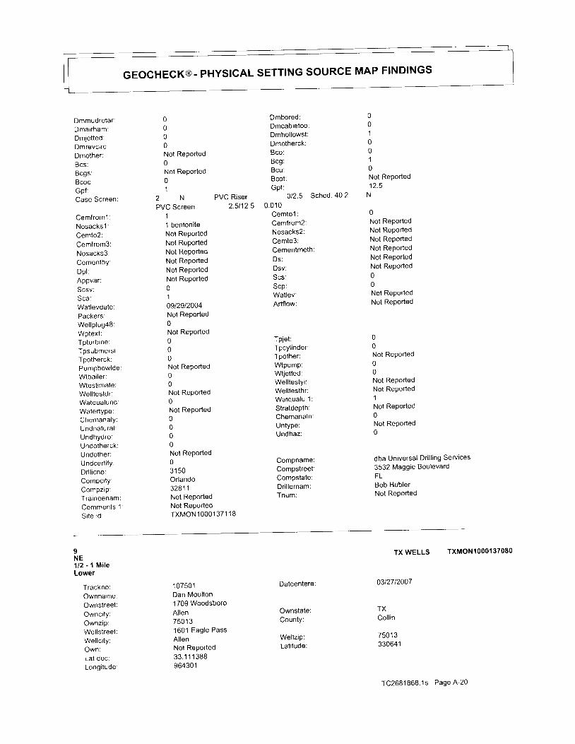
GEOCHECK@- PHYSICAL SETTING SOURCE MAP FINDINGS
Dmmudrotar :Dmairham:Dmjet ted:Dmrevcirc:Dmother:Bcs:Bcgs:Bcoc:Gpf:Case Screen:
Cemfroml:Nosacks 1 :Cemto2:Cemfrom3:Nosacks3.CementbY:Dp l :Appvar.Scsv:Sca :Wat levdate:Packers:Wel lp lu94S:Wptext .Tpturbine:Tpsubmersi :Tpotherck:PumpbowldeWtbai ler :Wlest imate:Wel l testdr :Watqualund:Watertype:Chemanaly:Undnatural :Undhydro:Undotherck:Undother:UndcertitY:Dr l l icno:ComPci tY:
Traineenam:Comments 1Si te id:
6 Dmbored:g Dmcabletoo:g Dmhollowst:g Dmotherck:
Not Reported Bco:
0 Bcg:
Not Reported Bcu:
0 Bcot:
1 Gpt:
2 N PVC Riser 012'5 Sched 40 2
PVC Screen 2.5112 5 0.010
1 Cemto l :
1 bentonite Cemfrom2:
Not Reported Nosacks2:
Not Reported Cemto3:
Not Reported Cementmeth:
Not RePorted Ds:
Not RePorted Dsv:
Not RePorted Scs:
o s"P'1 Watlev:
Ogt2gt2OO4 Artflow:Not Reported0Not Reported
0010010Not Reported1 t 4
N
0Not ReportedNot ReportedNot ReportedNot ReportedNot ReportedNot Reported00Not ReportedNot Reported
00Not Reported00Not ReportedNot Reported1Not Reported0Not Reported0
dba Universal Drilling Services
3532 Maggie BoulevardFLBob HublerNot RePorted
000Not Reported00Not Reported0Not Reported0000Not Reported031 50Orlando32811Not ReportedNot ReportedTXMON10001371 ' , l8
Tpjet:Tpcylinder:Tpother:Wtpump:Wtjetted:Welltestyi:Welltesthr:Wa tqua lu 1 :
Stratdepth:Chemanaln:Untype:Undhaz:
Compname:Compstreet:Compstate:Dr i l lernam:Tnum:
IN E1 /2 - 1 M i l eLower
Trackno:OwnnameOwnstreetOwnci tY:OwnziP:WellstreelWel lc i ty :Own:Lal dec:Longi tude
1 07501Dan Moulton1709 WoodsboroAllen7501 31601 Eagle PassAllenNot Reported33.1 1 1 38896430'1
Dateentere
Ownstate:County:
Wellzip:Lati tude:
TX WELLS TXMON1OOO137O8O
0312712007
TXColl in
7501 3330641
TC2681868.1s Page A-20

GEOCHECK@- PHYSICAL SETTING SOURCE MAP FINDINGS
Long dec:Elev:UN:Gn75:Twn:Twr:Twrg:UE :U i n :Ug :Up :U t :Pbv :Datestart:D i a l :D ia2 .Dia2to:Dia3from:Li th log:
Dmdriven:Dmmudrotar :Dmairham:Dmjetted:Dmrevcirc:Dmother:Bcs :Bcgs:Bcoc:Gpf:Case Screen:Cemfrom'1 :Nosacks l :Cemlo2:Cemfrom3:Nosacks3:Cementby:Dp l :Appvar:Scsv:Sca:Wat levdate:Packers:Wel lp lug48:Wptext:Tpturbine:Tpsubmersi :Tpotherck:Pumpbowlde:Wtbai ler :Wtestimate:Wel l testdr :Watqualund:Watertype:Chemanaly:Undnatural :Undhydro:Undotherck:Undother:UndcertifY:Dr l l icno:
-96.71 69436 1 91 8591591000010000112912007
Brandmodel :Gn' l :Gn25 :Twd:Twrp:U M :Ud :Uir :Ui j :Udw:
Pbn:Datecomp:
Garmin E-Trex1 810000000000112912007
4314 Dial to: 300
Not Reported Dia2from: Not Reported
Not Reported Dia3: Not RePorted
Not Reported Dia3to: Not Reported
0-3 Topsoil Brown 3-6 Clay Lt. Grey 6-17 Clay Brown 17-200 shale Grey 200-300 Shale and Limestone
Stringers Grey 6 Wells @ 300'00000Not Reported0Not Reported1
Not Reported1 New
3009 bags per wellNot ReportedNot ReportedNot ReportedJohnson Dri l l ingNot ReportedNot Reported0103t2612007Not Reported0Not Reported000Not Reported00Not Reported0Not Reported0000Not Reported03179
Dmairro lar :Dmbored:Dmcabletoo:Dmhollowst:Dmotherck:Bco:Bcg:Bcu:Bcot :Gpt:
Polyethelene Loops -4 to 300' SDR 11
1
0000000Pressure groutedNot Reported
0Not ReportedNot ReportedNot Reportedpressure grouted with benseal E-Z MudNot ReportedNot Reported00Not ReportedNot Reported
00Not Reported
00Not ReportedNot Reported1Not Reported1Not Reported0
Johnson Dr i l l ing Inc.
P.O. Box 448
Cemto l :Cemfrom2:Nosacks2:Cemto3:Cementmeth:Ds:Dsv:Scs:scp:Watlev:Artflow:
Tpjet:Tpcylinder:Tpother:Wtpump:Wtjetted:Welltestyi:Welltesthr:Watqualu 1:Stratdepth:Chemanaln:Untype:Undhaz:
Compname:Compstreel:
TC2681868.1s Page A-21
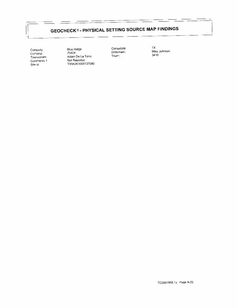
GEOCHECK@- PHYSICAL SETTING SOURCE MAP FINDINGS
Compcity:Compzip:Traineenam:Comments 1
Si te id:
Blue Ridge75424Adam De La Torre
Not ReportedTXMON 1 0001 37080
Compstate:Dri l lernam:Tnum:
TXMike Johnson341 0
TC2681868 .1s Page A -22

GEOCHECK@ - PHYSIGALSETTING SOURCERADON
MAP FINDINGS
AREA RADON INFORMATION
State Database: TX Radon
Radon Tesl Results
COLL IN
'/o>20 PC1IL Min pCi/L Max pCi/LCounty Mean Total Sites o/'>4 pCilL
Federal EPA Radon Zone for COLLIN County: 3
Note: Zone '1 indoor average level > 4 pCi/L
: Zone 2 indoor average level >= 2 pCi/L and <= 4 pCi/L
: Zone 3 indoor average level < 2 pCi/L'
3 . 2< . 52.7371 . 0
Federal Area Radon Information for COLLIN COUNTY' TX
Number of si tes tested: 28
Area Average ActivitY % <4 PCIIL
Liv ing Area - 1st Floor
Liv ing Area - 2nd Floor
Basemenl
1.157 pCi /LNot ReportedNot Reported
96%Not ReportedNot Reported
% 4-20 pCilL
4%Not ReportedNot Reported
% >20 pCilt
0%Not ReportedNot Reported
TC26B'1868.1s Page A-23
PHYS|GALSETTINGSoURcEREGoRDSSEARGHED
TOPOGRAPHIC INFORMATION
USGS 7 5' Digital Elevation Model (DEM)
Source: United States Geologic Survey
EDR acquired the USGS 7.s:Digital Eievation Model in 2002 and updated it in 2006
to the USGS 1:24,000- and t:251000-scale topographic quadrangle maps The DEM
with consistent elevation units and projection'
The 7.5 minute DEM correspondsprovides elevation data
'1Ypr9!99!9M98u4r!9!
Flood zone Data: This dara, available in select counties across the country, was obtained by EDR in 2003 & 2009 from the Federal
Emergency Management Agency (FEMA). Data depicts 1 oo-year and 500-year flood zones as defined by FENIA
NWI: National Welands Inventory. This data, available in select counties across the country, was obtained by EDR
in 2002 and 2005 f rom the U S. Fish and Wi ld l i fe Service '
HY D R OG Eo LOG I C l N FlBlYl4!qN
AOUIFLOWR Informat ion SYStem
Source: EDR proprietary database of groundwater flow information
EDR has developed the AQUIFLOW lnformation System (Als) to provide data on the general direction of groundwater
flow at specific points. EDR has reviewed reports submitted to regulatory authorities at select sites and has
extracted the date ot tne report, hydrogeologically determined groundwater flow direction and depth to water table
information.
q E LoGlc_1!l_qE!,!4I!_9!
Geologic Age and Rock Stratigraphic UnitSource: p.G. Schruben, R.E. Rrndt and W.J. Bawiec, Geology of the Conterminous U S at 1:2'500'000 Scale - A digital
representation of the 1974 P.B. King and H.M. Beikman Map, USGS Digital Data Series DDS - 11 (1994)
STATSGO: State Soil Geographic DatabaseSource. Department of Agriculture, Natural Resources Conservation Services
The U.S. Department of Agriculture's (USDA) Natural Resources Conservation Service (NRCS) leads the national
Conservation Soit survey irucsSl and is responsible for collecting, storing, maintaining and distributing soil
survey information for pnvately owned lands in the United states. A soil map in a soil survey is a representation
of soil patterns in a tanoscape. soil maps for STATSGO are compiled by generalizing more detailed (ssuRGO)
soil survey maPs.
SSURGO: Soil Survey Geographic DatabaseSource: Department of Agrtulture, Natural Resources conservation services (NRCS)
Telephone: 800-672-5559ssuRGO is the most detailed level of mapping done by the Natural Resources conservation services, mapptng
sca lesgenera l l y ranget roml :12 ,0001o1:63 ,360F ie ldmapp ingmethodsus ingnat iona ls tandardsareused loconstruct the soil maps rn the soil Survey Geographic (ssURGO) database ssuRGO digitizing duplicates the
original sott survey maps. This level of mapping is designed for use by landowners' townships and county
natural resource planning and management'
g,
FEDERAL WATER WELLS
PWS: Publ ic Water SYStemsSource: EPAJOffice of Drinking Water
Telephone: 202-564-3750Public water system data from the Federal Reporting Data system. A PWS is.any water system which provides water to at
least 25 people tor at least 60 days annually. PWSs provide water from wells, rivers and other sources
TC2681868.1s Page A-24

PHYS|GALSETT|NGSoURcEREGoRDSSEARGHED
PWS ENF: Public Water Systems Violation and Enforcement Data
Source: EPAJOffice of Drinking Water
ffjij['J:".':i;3iJ;1,t,1? data ror pubric water systems rrom the sare Drinkins water Inrormation svstem (sDWlS) aner
Augus t1995 'P r i o r t oAugus t l gg5 , t heda tacame f romtheFede ra |Repo r t i ngDa taSys tem(FRDS) .
USGS Warer Wells: USGS National Water Inventory System (NWIS)
This database contains descriptive information on sites where the uscs collects or has collected data on surface
wa te rand /o rg roundwa te r .Theg roundwa te rda ta i nc |udes in fo rma t t ononwe | | s , sp r i ngs ,ando the rsou rceso fg roundwa te r '
STATE RECORDS
Publ ic Water Supply Sources Databases
Source: Texas Commission on Environmental Qual i ty
Telephone: 51 2-239-6199
Locations of public drinking water sources maintained by the TCEQ
Groundwater Database
Source: Texas Water Development Board
Telephone: 512-936-0837
Well Report Database
Source: Department of Licensing and Regulation
Telephone: 512-936-0833
Water Wel l DatabaseSource: Harris-Galveston Coastal Subsidence District
Telephone: 281-486-1 105
Submitted Driller's Reports Database
Source: Texas Water Development Board
Telephone: 512-936-0833The submitted Driller's Reports Database is populated from the online Texas well Report submission and Retrieval
system which is a cooperative Texas Department of Licensing and Regulation (TDLR) and Texas water
Development Board (TWDB) application that registered water-well drillers use to submit their required reports'
94s-9.r4lq@Texas Oi l and Gas Wel ls:
Source Texas Rai l road Commission
Telephone: 512-463-6882Oi l and gas wel l locat ions
RADON
State Database: TX RadonSource: Department of Health
Telephone: 51 2-834-6688Rinal Report of the Texas Indoor Radon Survey
Area Radon Information
Source: USGSTelephone: 703-356-4020
The National Radon Database has been developed by the u.s Envjronmental Protection Agency
(usEpA) and rs a compilation of the EpA,/State Residlntial Radon Survey and the National Residential Radon survey'
The study covers lhe years 1986 - 1992. Where necessary data has been supplemented by information collected at
orivate sources such as universities and research institutions'
TC2681868.1s Page A-25
PHYSICAL SETTINGSOURCE REGORDS SEARCHED
EPA Radon Zones
Source: EPATelephone: 703-356-4020
sectrons 307 & 309 of IRM directed EPA to list and identify areas of U S with the potential for elevated indoor
radon levels.
OTHER
Airport Landing Facilities: Private and public use landing facilities
Source: Federal Aviation Administration, 800-457-6656
Epicenters: World earthquake epicenters, Richter 5 or greater
Source:DepartmentofCommerce,Nat ionalOceanicandAtmospher icAdministrat ion
STREET AND ADDRESS
@ 2010 Tele Aflas North America, lnc. All rights reserved. This material is proprietary and the subject of copyright protection
and other inte||ectua| property rights owned by or |icensed to Te|e At|aS North America, |nc. The use of this materia| iS SubJect
to the terms o, a license ugre";ent. you will be held liable for any unauthorized copying or disclosure of this materlal
TC2681868 1s Page 4-26
Proposed Allen Firestation #5
McDermott DriveAl len, TX 750 '13
I nquiry Number: 26607 34.2sDecember 16, 2009
TABLE OF CONTENTS
SECTION
EDR NEPACheck@
PAGE
DescriPtion 1
Map F ind ings Summary . . . ' . . ' . . " " " 2
Natural Areas.. . . . . ' . 3
Histor ic Sites' . . . ' . . . . . 6
F lood P1a in . . . . . . . . . ' 10
Wetlands.. 12
Wetlands Classi f icat ion System 14
FCC & FAA Sites. 18
Key Contacts and Government Records Searched""". ' " ' 22
Thank You for Your business'Please con[act EDR at'1-800-352-0050
with anY questions or comments'
R':J:J"T '?T'i::&"rlii-'$'t+:{r'rtdiii"d'":fif $?l?'Jr:''#Jdieiiili1iiil;J?CffiTf"T'l''C'#I6-qffig;33fl",'niil"*'o uo'other sources Ho wrnnarrvtiiitltiD bi irr/|purEo, rs MADE wH-ArSoEvER lN coNDATA REsouRcrs, tNc. specrndauiy otscurrus rHe rrraiilcbF ANy sucH wARRAIlrlES, INcLUDING wlrHour LlMlrATloN'
MERCHANTABILITV ON TITHCSS'iON N PANTTCULAR USE <Ji;JNPOSE, E[NISX IS ASSUMED BY THE USER' IN NO EVENT SHALL
ENvtRoNMENTAL DATA RESOURCES, tNC. BE LTABLE 1O lHiblie' wxirxen anrsrNG OUT OF ERRORS OR OMISSIONS', NEGLIGENCE'
AccIDENT oR ANy oTHER cAuSE, FoR ANY LosS oF onrtilci, rilcr-uolNG, wITHO-U-T-LIMITATION' SPECIAL' INCIDENTAL'
coNsEeuENTrAL, oR ExEMpLARy DAMAGEs. et,tv LraerLrrio'li riE plnr or ENVIRoNMENTAI oarl nEsouncEs' lNc ls srRlcrLY
LrMrrED ro A REFUND oF rHE AMouNr pArD FoR rHrs nEroii. iut'n"idt ""t"pts
this Report'AS 19: lry-T-lyses' estimates' ralrngs'
environmental risk tevets or risk codes provided in this Rep;rt arlii'-iruia-,-;o ioritiustrarrve plrposes only.and,are_not intended to provlde' nor
shoutd theybe in te rpre tedasprov id ingany . fac ts r "gqrorS, ; rpLs iCt ionor fo recas to f .anydnv i ronmehta l r i sk fo ranyproper ty on lyaPhase l
Environmentar site Assessment performed by an enviLonX;;ii;;i;;;io_naicin-provioe iirformation regarding the envrronmental rrsk lor any
property Additionatty, tne tnfJimlion"'p"i'"JdOl" tnit Cuport is nbt to be construeij as legal advice
copyright 2009 by Environmental Data Resources, Inc. All rights reserved- Rep-roduction in any media or format' in whole
or in part, of any reporr or map of Environmental oata nesou?ce"s,l"J. '"i'ti
iiritties, is prohiSited without prior writlen permissron'
@andr rademark No t i ce
rhis Report contains certain informatiotobtail.e-djPliXlli"^Y,:l*:'f,:*il*i::i{:::J""3'"",if:Y,il'fl'3,1'31?"3:llSlffJi"l3ii
;;;'uf,o;;;r;, ;;"i;ing sunuorn and sanborn Map.) are trademarks of Environmental Data Resources, Inc. or its affiliates All other
trademarks us6d ni:rein are the property of their respecttve owners
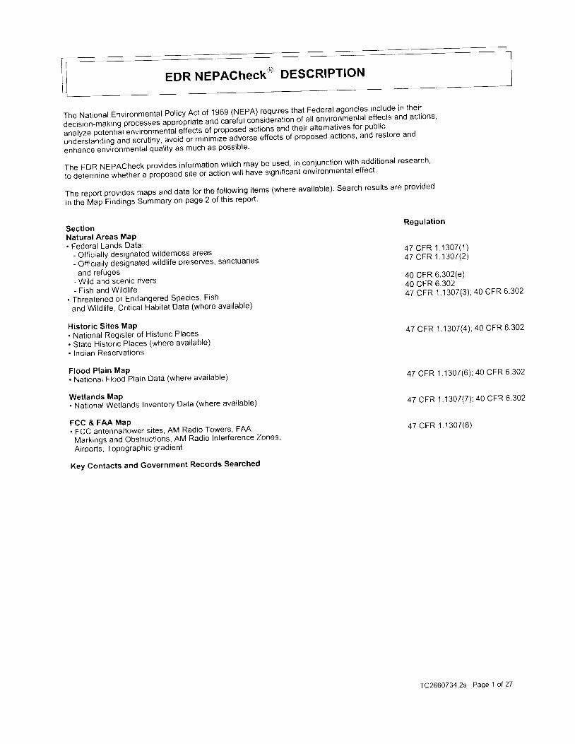
EDR NEPAChEGK@ DESCRIPTION
The National Environmental poticy Act of 1969 (NEpA) requires thal Federal agenciesil: l '3"-f,t1"^'.1.
decision-makrng pro""rr"l '"ppio'pri"t" und carbfut consideration of all environmental effects and actlons'
analyzepotential enuironmeniJl eiTects of proposed actions and their alternatives for public
understanding uno ,"rr,,nylatl iO oi-minimizd aCverse-e*elis of proposed actions' and restore and
enhance environmental quality as much as posslDle'
The EDR NEPACheck provides information which may be used, in conjunction with additional research'
to determine whether "
pi"pot"i i i te or action wil l have significant environmental effect'
Thereportprov idesmapSanddatafor thefo| |owingi tems(whereavai |ab|e) .Searchresul tsareprovidedln tfre Vap Findings Summary on page 2 of this report'
SectionNatural Areas MaP. Federal Lands Data:
- Off icial ly designated wilderness areas- Off icial ly designated wildl i fe preserves, sanctuarles
and refuges- Wild and scenlc r lvers- F ish and Wi ld l i fe
. Threatened or Endangered Species, Fish
and Wildl i fe, Crit ical Habitat Data (where avai lable)
Historic Sites MaP. National Register of Historic Places. State Historrc Places (where avai lable). lndran Reservations
F lood P la in MaP. National Flood Plain Data (where avai lable)
Wetlands MaP. National Weilands Inventory Data (where avai lable)
FCC & FAA MaP. FCC antenna/tower sites, AM Radio Towers, FAA
Markrngs and Obstructions, AM Radio Interference Zones'
Airports, TopograPhic gradient
Key Contacts and Government Records Searched
Regulation
47 CFR 1 .1 307( 1 )47 CFR 1 .1307 (2 )
40 CFR 6.302(e)40 cFR 6.30247 CFR 1.1307(3) ; 40 CFR 6.302
47 CFR 1.1307(a) ; 40 CFR 6.302
47 CFR 1 .1307(6) ; 40 CFR 6.302
47 CFR 1 1307(7) ; 40 CFR 6 302
47 CFR 1 .1307 (8 )
TC2660734.2s Page 1 ol 27
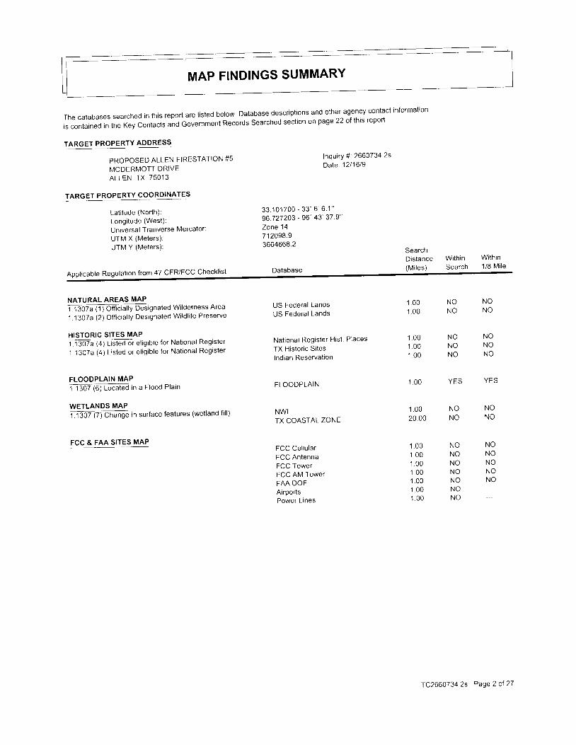
MAP FINDINGS SUMMARY
The databases searched in this report are listed below Database descriptions and other agency contact information
ls contained in the Key Contacts and GOvernment Records Searched section on page22 of this report
TARGET PROPERTY ADDRESS
PROPOSED ALLEN FIRESTATION #5
r\,4CDERMOTT DRIVEALIEN, TX 75013
Lat i tude (North) :Longi tude (West) :
Universal Tranverse Mercator:
UTM X (Meters) :
UTM Y (Meters) :
lnquiry #: 26607342sD a t e : 1 2 1 1 6 / 9
TARGET PROPERTY COORDINATES
3 3 . 1 0 1 7 0 0 - 3 3 " 6 ' , 6 . 1 "96727203 - 96 '43 '37 9 'Zone 14712098.93664668.2
Database
SearchDistance With in(Mi les) Search
Within1 /8 M i l e
Appl icable Regulat ion f rom 47 CFR/FCC Checkl is t
NATURAL AREAS MAP
il 3b%l1 ) Otficrally Designated Wilderness Area
1.1307a (2) Off ic ia l ly Designated Wi ld l i fe Preserve
HISTORIC SITES MAPTr goza(q[ is teE or et ig ib le for Nat ional Register
1 .1 3O7a (4) L isted or e l ig ib le for Nat ional Register
FLOODPLAIN MAP
1130716 Loaled rn a Flood Plain
WETLANDS MAP
Tl30? Fj Cirange in surface features (wetland fill)
FCC & FAA SITES MAP
US Federal LandsUS Federal Lands
Nat ional Register Hist . Places
TX Histor ic Si teslndian Reservat ion
FLOODPLAIN
NWITX COASTAL ZONE
FCC Cel lu larFCC AntennaFCC TowerFCC AM TowerFAA DOFAirportsPower L ines
1 0 01 0 0
1 . 0 01 0 01 0 0
1 . 0 0
1 0 020 00
1 0 01 0 01 0 01 0 0'1 .001 . 0 01 . 0 0
NONON O
YES
NONO
NONONON ONONONO
NONO
NONON O
YES
NONO
NONONONONO
N ONO
TC2660734 2s Page 2 ol 27
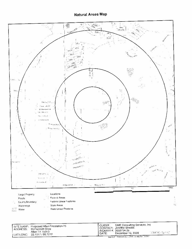
Natural Areas MaP
s
Target Property
Roads
County Boundary
Waterways
Water
Locations
Federal Areas
Federal L inear Features
State Areas
State Linear Fealures
CLIENT: GME Consult ing Services. lnc'CONTACT: Jenniler ShieldsINQUIRY #i 266O734.2sbnfE, December 16 ,2009 f ( l ( ( ' i l - l l l s Pagr l ' ' r l l
SITE NAME: Proposed Allen Fireslat ion #5ADDRESS: McDermol tDr ive
A l len TX 75013LAT/LONG: 33 .1017 I 96 .7272
i , . )

NATURAL AREAS MAP FINDINGS
Endangered SPecies- Sorri", Texas Threatened and Endangered species Database
Region: Blackland Prair iesSub Region: Blackland Prair ie
B I R D SRaptors
Common Name: BALD EAGLEScienti f ic Name: HALIAEETUS LEUCOCEPHALUS
ShorebirdsCommon Name: INTERIOR LEAST TERN
Scienti f ic Name: STERNA ANTILLARUM ATHALASSOS
Common Name: MOUNTAIN PLOVERScienti f ic Name: CHARADRIUS MONTANUS
WaterbirdsCommon Name: WHITE-FACED lB lSSc ien t i f i c Name: PLEGADIS CHIHI
F I S H E SSuckers
Common Name: BLUE SUCKERScienti f ic Name: CYCLEPTUS ELONGATUS
MAMMALSCarnivores
Common Name: RED WOLFScienti f ic Name: CANIS RUFUS
REPTILESLizards
Common Name: TEXAS HORNED LIZARDScienti f ic Name: PHRYNOSOMA CORNUTUM
SnakesCommon Name: TIMBER (CANEBRAKE) RATTLESNAKEScienti f ic Name: CROTALUS HORRIDUS
Turt lesCommon Name: ALLIGATOR SNAPPING TURTLE
Sc ien t i f i c Name: MACROCHELYS TEMMINCKI I
Common Name: CAGLES MAP TURTLEScienti f ic Name: GRAPTEMYS CAGLEI
State Status: ThreatenedFederal Status: Threatened; Proposed Delist ing
State Status: EndangeredFederal Status: Endangered
State Status: Not rePortedFederal Status: Proposed Threatened
State Status: ThreatenedFederal Status: Not rePorted
State Status: ThreatenedFederal Status: Not rePorted
State Status: EndangeredFederal Status: Endangered
State Status: ThreatenedFederal Status: Not rePorted
State Status: ThreatenedFederal Status: Not reported
State Status: ThreatenedFederal Status: Not rePorted
State Status: ThreatenedFederal Status: Candidate
rC266O7342s Page4ot27
NATURAL AREAS MAP FINDINGS
Map lDDirect ionDistanceDistance
EDR IDDatabase
No maOped sites were found in EDR's search of avai lable government records
within the search radius around the target propeny'
TC2660734.2s Page 5 of 27

Historic Sites MaP
l l ! r ' , , s 1 , , . r , 1 I i r
i-".1
Target Property
Streets
County BoundarY
waterways
Water
a Historic Sites
, Federal Histor ic Areas' State Historic Areas
' US Indi"n Beservat ions
' Scenic Trai l
CLIENT: GME Consulting Services' Inc'CONTACT: Jennifer ShieldsINOUIBY #: 2660734.2sOniE: December 16,2009 Ttl660-l ' l ls Pagc('r '1 l ' '
SITE NAME: Proposed Allen Firestation #5ADDRESS: McDermottDr ive
Al len TX 75013LAT/LONG: 33.1017 I 96.7272
HISTORIC SITES MAP FINDINGS
Map lDDirect ionDistanceDistance
EOR IDDatabase
NomappedS i teswere found inEDR 'ssea rcho fava i | ab |egove rnmen t reco rdSwithin the search radius around the target propeny'
IC26607342s Page7 of27
UNMAPPABLE HISTORIC SITES
Due to poor or inadequate address information' the following sites were not mapped:
0
Markernum:T i t le .lndexname:Address:City:Utm zone:Utm north:Year:Htc:Loc desc:Exchange Parkway, Allen Station Park
Size: 27" x 42"Repair comments:Not Reported
Repairdate:Comments:Job # 05598
Not Reported
11817Al lenAl lenNot ReportedAl lenNot ReportedNot Reported1 9980
At las number
County:Utm east:Code:Rtht :
5 0 8 5 0 1 1 8 1 7
Col l inNot RePorted
0
Marker TextFert i le land and plenti ful water drew sett lers to this area from as early as the 1840s' This part
of col l in county *u. *" ' , popr-tut"o ov 1876 when the Houston and Texas central Railroad bui l t a
water supply stop on cottonwood creek near this site. The rai lroad stop and newly created lown lots
establ ished a center of commerce for local farmers and their famil ies and provided better equrpmenl
and broader markets tor "gi i .r i tr tuiproduction.
The surrounding open prair ie soon was developed
into small family farms. ihe Houston and Texas Central Railroad f i led documents to create the
town of Al len from tn" . lu.u, L. iead survey in 1876. The vi l lage was named for Ebenezer Al len' a
former Republic and state of Texas attorney general and a founder of the Houston and Texas central
Ra i l road.Adrygoodss to ;e ,ba ;b ; ;shop,and 'scnoo l soonopened in therap id lygrowing town Sam
Bass reportedly led an outlaw gang thai robb_ed the Al len Depot on February 22' 1878' This was
probably the f irst rr"""" i ful trJin r"oOnery in Texas. By 18!a the town of Al len had three
churches, a f lour mitt , unO u poprLrt ion of SSO. In 1908 ihe Texas Traction Company bui l t an
electrrc rarlway through t"*", "-arr i"g
i t the Interurban. The cit izenry numbered 550 by 1915' Al len
;;; i";";t;'"ied in i9s3 wit'h 400 iesidents. Electric railway service ended in 1948 but railwav
i iuight r; ; i .u continued. Strong economlc-growth in the Dallas-Fort Worth area helped the town's
pop"utat ion grow to include morJthan 19'000 cit izens in the 1990s (1998)
Rth l Cond:Not Reported
TX1 00508s000 1 23TX Historic Sites
0
MarkernumTit le :lndexnameAddress:Ci ty :Utm zone:Utm north:Year:
123Allen CemeteryAllen CemeteryNot ReportedAllen1 436648721 988
Atlas number:
County:Utm east;Code:Rtht :
5085000 1 23
Col l in7 1846F O ; G Y0 rc 2660734.2s Page 8 of 27
UNMAPPABLE HISTORIC SITES
Due topoo ro r i nadequa teadd ress in fo rma t i on , t he fo l l ow ings i t eswe reno tmapped : StatusEDR IDDatabase
Htc: 0Loc desc:400 E McDermott Dr (FM 2170), Al len
Size: 27" x 42"Repair comments:None
Repairdate:Comments :Not Reported
Not Reported
Marker Text :Located on land purchased from Mr. and Mrs. John w. Whrsenant, this cemetery was formally
establ ished on Apr i l 5 , 1B'B; , ; t the tnternat ional Orderof Odd Fel lows, local Lodge No' 249
Encompassing almost tnree aires of land, the cemetery has served theAllen community for over a
cen tu ry . Theo tdes t teg ib leg ravemarke rhe re i s tha io f RebeccaL Hami l t on (d1883 ) '
although local oral tradrtron noids that earlier graves may exist, including a slave burial ground
rn tne ioutneast corner of the property. Tom6stone inscriptions reveal evidence of early
epidemics and inctude tn"-n",i"l of j number of veterans'of foretgn wars. Robert J. Cuffman (d 1918)
was kil led in the Meuse-nrgo;nl off"nsive in World War l. Mahlon Brackney served in the
Spu"irn n."rican War. Alio represented on grave markers here are notable early cit izens of the
community, including Permelia Ford, a pioneel settler, and Doctors H.N- Compton and Will iam F
Wolford. The Allen Cemetery Association, organized in 1899, cares for the historic graveyard
and sponsors an annual Decoration Day' (1988)
Rthl Cond:N/A
TX1 005087000952TX Historic Sites
0
Markernum:Tit le:lnoexname:Address:C i ty :Utm zone:Utm north:Year:Htc:Loc desc:N/A
Size :Repair comments:NiA
Repairdate:Comments:Not Reported
Marker Text:Not Reported
Rth l Cond:Not Reported
952 Atlas numberColl ingsworth Cou ntY CourthouseCollingsworth CountY CourthouseNot ReportedNot ReportedNot ReportedNot Reported00
NO MARKER - Coutlhouse
Not Reported
County:Utm eastCode:Rthl :
5087000952
Coll ingsworthNot ReportedNot Reported0
TC2660734.2s Page 9 of 27
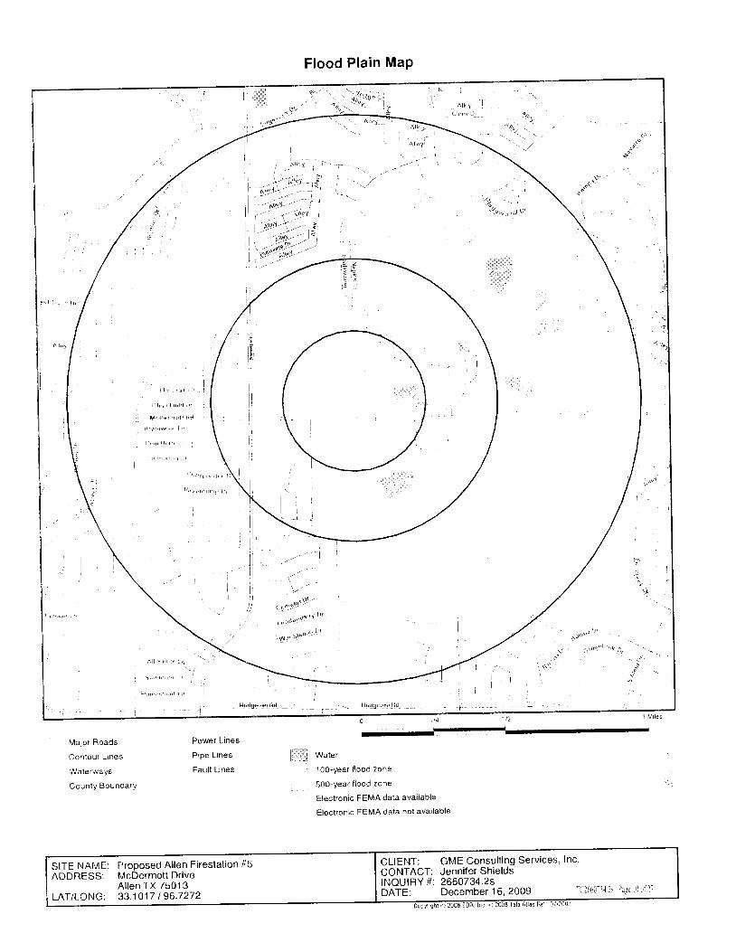
Majo t Roads
Contour L tnes
Waterways
County BoundarY
Power Lines
Pipe Lrnes
Fault LinestI
Flood Plain MaP
Water
100-year f lood 2one
500-year f lood zone
Electronic FEMA data avai lable
Electronic FEMA data not available
A l l : . r h l r l ,
5 1 , r r ' ' 1 ' , , L r . '
. I ' 1 , , r , , . s r , , . r d I I '
. i.:j
' l i
CLIENT: GME Consult ing Services, Inc.CONTACT: Jennifer ShieldsINQUIRY #i 2660734.2sbnf f : December 16 ,2009 TCl66 t - l l l s Prgc l0 i ' i 1 r
SITE NAME: Proposed Allen Firestat ion #5ADDRESS: MCDETMOTTDT|VE
Al len TX 75013LAT/LONG: 33.1017 I 96.7272
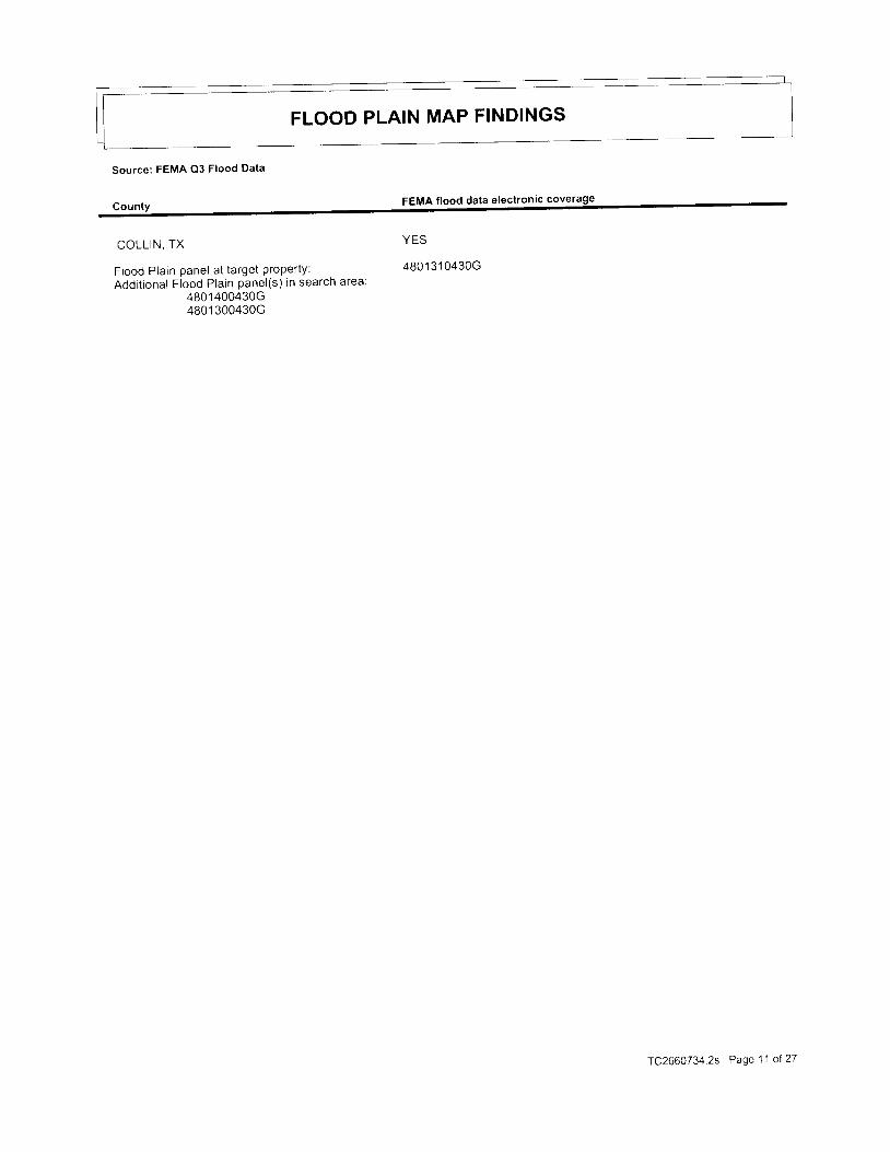
FLOOD PLAIN MAP FINDINGS
Source: FEMA Q3 Flood Data
FEMA flood data electronic coverage
COLLIN, TX
Flood Plain panel at target propeny:Addit ional Flood Plain panel(s) in search area:
4801 400430G4801 300430G
YES
4801 31 0430G
TC2660734 2s Page 11 of27
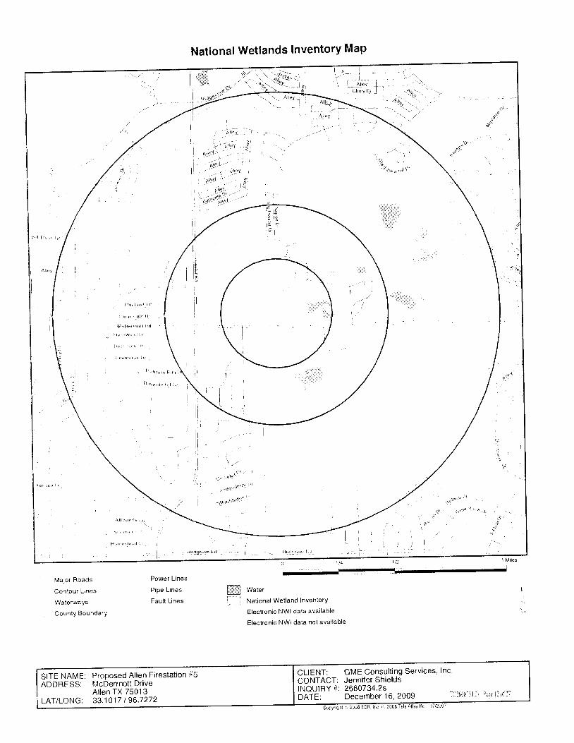
National Wetlands InventorY MaP
.j!'
rrot)r's
- '
- . r r l d ' 1 1 r , r . , ) ,
. s:!
A l l : , i r i r h l r r
f l L , r , , 5 1 , i . , , i I r i
Major Roads
Contour L tnes
Waterways
County BoundarY
Power Lines
Pipe Lines
Fault Linesffi Water
Nat ional Wet land InventorY
Electronic NWI data available
Electronic NWI data not avai lable
CLIENT: GME Consulting Services, Inc'CONTACT: Jenniler ShieldsINQUIRY #" 2660734.2sbnf er December 16, 2009 [[]661-ll ls Pagc l l L'f 1l
SITE NAME: Proposed Allen Firestalion #5ADDRESS: McDermottDr ive
Al len TX 7501 3LAT/LONG: 33.1017 I 96.7272

WETLANDS MAP FINDINGS
Source: Fish and Wildlife Service NWI data
NWI hardcopy map at target property: PlanoAdditional NWI hardcopy map(s) in search area:
Not rePorted in source data
Map lDDirectionDistanceDistance Code and De
No Sites RePorted
.See Wetland Classif icat ion System for addit ional information'TC2660734.2s Page 13 of 27
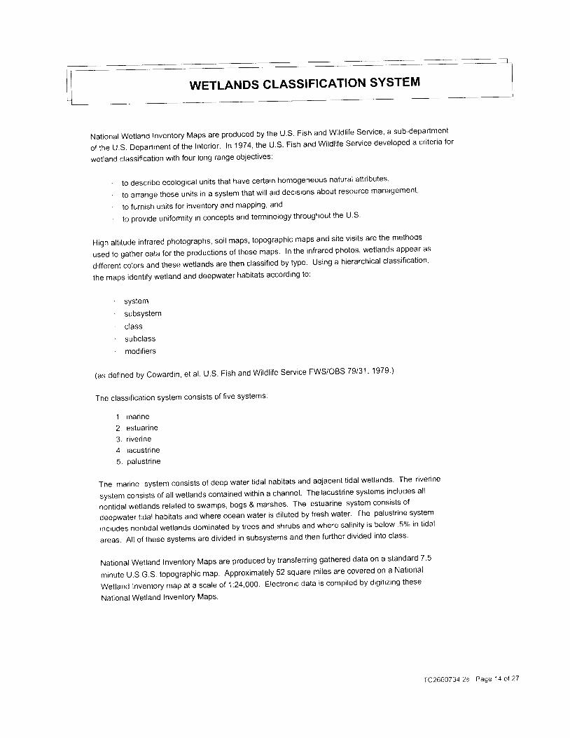
WETLANDS CLASSIFICATION SYSTEM
National wetland Inventory Maps are produced by the U.S. Fish and wildl i fe service' a sub-department
o f t h e U . S . D e p a r t m e n t o f t h e I n t e r i o r . | n 1 9 7 4 , t h e U . S . F i s h a n d W i | d | i f e S e r v i c e d e v e | o p e d a c r i t e r i a f o r
wetland classif icat ion with four long range objectives:
. t o d e s c r i b e e c o | o g i c a | u n i t s t h a t h a v e c e r t a i n h o m o g e n e o u s n a t u r a l a t t r i b u t e s ,
. to arrange tnese units in a system that wi l l aid decisions about resource managemenl '
' to furnish units for inventory and mapping, and
' t o p r o v i d e u n i f o r m i t y i n c o n c e p t s a n d t e r m i n o | o g y t h r o u g h o u t t h e U . S
Hlgh alt i tude infrared photographs, soi l maps, topographic maps and site visi ts are the methods
used to gather data for the productions of these maps. In the infrared photos' wetlands appear as
different colors and these wetlands are then classified by type. Using a hierarchical classification'
the maps identify wetland and deepwater habitats according to:
' syslem' subsystem' class' subclass' modiflers
(as defined by cowardin, et al. U.S. Fish and wildl i fe service FWS/OBS 79/31 ' 1979 )
The classificatron system consists of five systems:
1 . mar ine
2. estuarine
3. r iverine
4. lacustrtne
5. oalustr ine
T h e m a r | n e S y s r e m c o n s i s t s o f d e e p w a t e r t i d a I h a b i t a t s a n d a d j a c e n t t i d a | w e t | a n d s ' T h e r i v e r i n e
system consists of al l wetlands contained within a channel ' Thelacustr ine systems includes al l
nontrdal wetlands related to swamps, bogs & marshes' The estuarine system consists of
deepwater t idal habitats and where ocean water is di luted by fresh water' The palustr ine system
includes nontidal wetlands dominated by trees and shrubs and where sal inity is below '5% in t idal
areas. Al l of these systems are divided in subsystems and then further divided into class'
National wetland Inventory Maps are produced by transfening gathered data on a standard 7'5
m i n u t e U . S . G . S ' t o p o g r a p h i c m a p . A p p r o x i m a t e | y 5 2 S q u a r e m i | e s a r e c o v e r e d o n a N a t i o n a l
weiland lnventory map at a scale of 1:24,000. Electronic data is compiled by digit izing these
National Wetland Inventory MaPs.
TC2660734 2s Page 11 ol 27

! 5t:) >. Tj - i 2 3
x r - ) ai - c - x a , ?s - . . i 2 / 4
. . U $ ; n € r
6 t9 - r
t i
; J t t A ) 1 a Y
E : . ' t i x l . ,a 2 . - > * - -
- , l { f l r , € t -
=a
=a
c
5
d
-
E
-J
2€7.
-
J
2!
/.
F7 . -U ] F( t i& ; lz a dQ ' a e
> d 7 .
q
F
3 *
7 v
' / . 4 2 t 2 t '
'.t I: a) 'n ?. e
' Y l @ - . r . a v
c
=
!
JEc
5
.-.1Ec
oF@
oror
f
Ua
' @
p
o
O ? 3e ? h
x ? =,A 6e.CZ - c l
q
> . ad Q
c = ! - r i
6 l ) q 2 . t@ - . r . . a
[ +
i > 5I c r r . t
f,^ aa r - t )
, - - t ,* . . - a n' a : : / . c
- ^ - a q - ? 2< i ? \ + - l
' - J : - : , =
6 < . l L ) )< - - , a r , o
< BQ q
TC2660734 2s Page 15 oI 27
oF
a _J ;
- z ; Y o- F 2 aU f ; : : i i/ - 6 a d < :) O O Z \ J. i . - . r - , 9
)
.]
FzI
N
!
c
, ^ -v - - t
! - t ru l Er ' . . -Y
* - . .
o : :
" = 2= ; q' 1 . > a
i \ \ 2 i; < & )7 - - , " '
qF t r< a> -- a' 2 . 6
- a
> a
t , t
r , i - -
- l s >
d c t " '
7
;lFa
p c
B r E
' z a
c
7.
-
= , , i E E- * ) . i
_ - J 2 ? ?C ! a l * #? ; r i -- . r 3 n 9
r . e 2
m i
- . / = 9 t ), < P . Q ,
= ! E i) t 1 , - J 7- : ' ^ - =< \ x ) qc 0 -
(t
! - - ;h ^ = z v ,i , ; > 5
i !
Farita
a a7 . Hx -= -6 O
Y >r i -
F
zd
a
9F
co
F
oJazo= 2
J
F
Da
J
F
)a
rF
a
7 . - , U^ i ^ ' . ?- l = -
7 ' c z ^ 2 E t ") 6 , : A > 5C C - . t - tJ
2. , ot ; ? 2: =a 4 &
JU
F2
-t ! tl - Ai h F
a u )
F2
,Z. .t)r!, a= ; a !t ,
A O J o

ac?
E
F c c
o
r c
F O
) z. l/ : - =-. 1Z At!
E
v
= . , . ! 7r = - t
; A = 2 i " Y / )J - F : . -' J A ) Z - \ ) a
- r l f i l ' a l
F E
t ,' / =
cF
o
-:rI
q
/ , J
C ' i 3
Ea
' - - o F. , t - 6= . ? > -' . /
o ' j ,
= - t 2 = i' - l , 7 2 a t
< < & L )
t
to
z i ir - r =
t <
-J
U
z
JI
z
U);JO
F
)F7.!lFF
F
Z
. E
)l,)
na
c
Eo
E
E q,; >,4 t -
= 6
z z9 7
F B
2 >* oc nr e c
< , JO <
e F
= F; 7 .
z. tJ< d .L! Lll
; L !
7 . F
z rV =
z +; r
V]
I
- 7l ! )
F ;z - J
cuF
!
q -
Z t I
J J
7 ' 1 t 3
, t
! . D ^ a t 7 , i '6 > . a >
- . 1 - , n v '
J
6l
2I
= - - la a ; , a =
2 - 2 - , , t =. - : a ' ^ ,
= : = t !\ ' / 2 + 4- ? = : - =
i . t \ ) )
[j
F
cf? , 7 2/ . ^ ;^ -v F Y . ,
t A € ? : i ,A J a a . eJ - d - , 9
> A: l e z
t ' t :
I
7.
/ - l
a Eo d )
?
=F
)o
=A i l
! ! L A g ;m - = F _ o
t , I r ! ? : =
= - q r A j : 6 a' 4 2 ) ' " , 9 =) . ? F : l , ao - t s g E - -a i , - a 2 + 46 < 4 . & L J )( - r 6 i r . @
?.
X r a iJ 7 E 7
' 3
/ ,. f a
J t 1 v L : ;
= \ E € E : : 8 , - - v "z * a A : 3 ; 6 :7 . ; ' - c r . n g r ) c rfrl
t-l
:'i
- = -J -
Y f > a^ : r t
' : i - ' i o: l a 2 =a Q ! - - -
r a + - - t L! t a z t JJ _ c r . i f
^ 4 - 4= a . i ;F I E
I c c 6 &. < - . 1
eF
cf,? . > 27 . - , iJ F Y
> a ; - - E) n + i - ? )A a 3 2 aJ - c r - a
?-
) Z F := - ' r - ^
V E i E. l ; JX - e l
?.El
a
a ' t ' aA t a :
4 )) =A - a l
a.
r-
r i /, a a 2: - a h :q , = < _ 3- ) ) aA A t ) t t
ri? a a 2: ^ A V ' :
= < // t - =tt) U)
'a ,^
Fzoda
+u
TC2660734 2s Page 16 oI 27
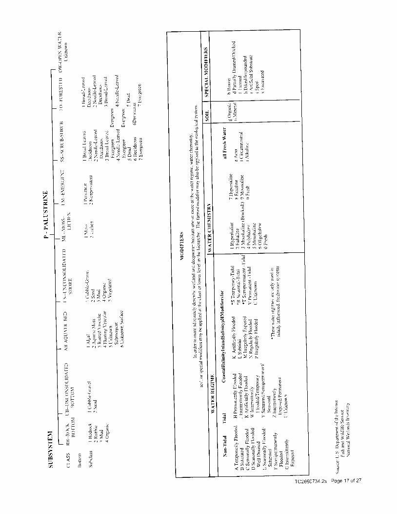
T
':4 , .i ? EE E ;
a 7 " ' v> ' - : d
t : E i l E = L- L ! J ; ? j
A { I . i . F iE - - E , t x
I C . =- - a = =* = u : t
? < u <
: 6
a z
E
- r i
/ 5 / !> . 7 € t
: E r ! 2 r
S E
t E ol E la t E: x t ] ] z
h
J
I
; l
z l; l
= l
3 ' l. a l
- . 3 |! y IE = |z e IO T Ia = |E * l- d I, i u I
e ? |
, t r
" F! >
F !
- c
! 7
- E
j 9
- st Y
i t- r -
- c
3o
c;7r
,4
h
F
t!
(,
F
F
H d ; * > q
! : ; h F EE E A : + E
L q : > = F :
^ 4 * - - i , Y = =
E E a g < ; - E i "a , Y 4 = E u 9 = > 2 -a z a 7 3 F E 7 t ?E F = U " = 9 F ' 'r A E : : l i l i Y a c
d E < ; L q , t = 1 , -E = t t > N - f
I a 9
" M d =: = = i, r ^ r r l r e -l - = > - , ' l ^ n c
i : ; = ' = - i - t ; - ti ? A E : A E : T | E A ^' = : ? 7 - ? ^ e = - F . 6
i E a i 7 i E ; z l ,i ' u n a = a d q G - a< c o - 3 - u l - r U
E!F
3 - : E . ' /' . . - = -^ F : ' 4 .
l E r t P a 4 E- o = i o > 4
i d a a l Y + :t - r ' t P : - 0 ' jr , . 1 -
* x + r ' ) E . j; , o
! ; i! :
* ? . ' ? P 6 :; 2 : ; 4 ^. L l - , ^= I I Z J =
r a - : = L ; 6^ ^ r * F P= E i - i -g : = i :
G . : d r = fE : o d J d )r . z ! & ?: l ) z / , x
U
F
> :a
z c .
7
ur,izi*ir-ae|al,Ei;;; *: i
2 d
L Z
7 . , . , ! -9 . )
/ = i - ^ E d1 ? + - = Z ' Z 'v , t J a ) z J r ') - . r . ' , t r '
! !- t J +. ? , i l _ , 7= t i ) c E 1;
- , 1 4 s - - * 1
t = 2 E = l E ao . j , a _ 9 z + i +1 7 i & . . 5 A - ta O - . t - q h €
ce)J
i
Fz.A
!
a , - c
- 1 -
: 2 . 3
: b- , b , =
5 L t
E > vx ! -i ' ! O
. c :
= c zUI
c
: t a 4
a x 2 a- c l . - , t
= 3
a =
a!F
J
'/. <' - iz ;1 c ' .
2
4 iI
2
Fa
a
=a
TC266O7 34 2s Page 17 of 27
7,
a
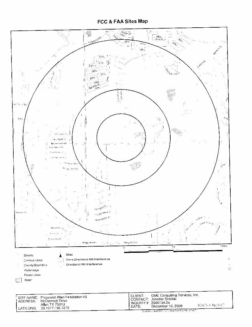
FCC & FAA Sites MaP
I::: 1
:r't!
Streets
Contour L lnes
CountY BoundarY
WaterwaYs
Power Lines
I '-
I w"tu,
Sites
Omni Directional AM Interference
Directional AM lnterference
CLIENT: GME Consulting Services, lncCONTACT: Jenniler ShieldsINQUIRY tt 2660734.2sbnf E: December 16, 2009 Tl lff i l- l l ls Pagc l i ir i l l
SITE NAME: Proposed Allen Firestat ion #5ADDRESS: McDermot tDr ive
A l len TX 75013LAT/LONG: 33 .1017 I 96 .7272
FCC & FAA SITESTOWERS
MAP FINDINGS
Map lDDirect ionDistanceDistance
EDR IDDatabase
No Sites RePorted
TC2660734 2s Page 19 of 27
FCC & FAA SITES MAP FINDINGS
AIRPORTS
No Sites RePorted.
TC2660734.2s Page 20 of 27

FCC & FAA SITES MAP FINDINGS
POWERLINES
EDR IDDatabase
No Sites Reported.
TC2660734.2s Page 21 of 27

KEY CONTACTS & GOVERNMENT RECORDS SEARCHED
Various Federal laws and executive orders address specif ic environmental concerns. NEPA requires the responsible
off ices to integrate to ,n" g"r3i i" . ip ' tu.t i iur u*Gnt tn" 'uppl icable procedures,required by these laws and executive
orders. EDR provides key contacts at agencies "nutg"d
with impiementing these laws and executive orders to
suoolement the information contained in this report '
NATURAL AREASOfficial ly designated wilderness areas
_Gpygrye nt Record s Sea rc
FED LAND: Federa l LandsSource: USGSTelephone: 703-648-5094Federal data from Bureau of Land Management, Natronal Park service, Forest service' and Fish and wildl i fe
Service.- National Parks- Forests- Monuments- Wildl i fe Sanctuaries' Preserves' Refuges- Federal Wilderness Areas.Date of Government Version: 1213112005
Egderal Contacts for
National Park Service, Intermountain Region
12795 Alameda ParkwaYDenver . COBO225303-969-2500
USDA Forest Service, Southern1720 Peacht ree Road, N.W.Atlanta, GA 30367404-347-2384
BLM- New Mexico State Off ice1474 Rodeo RoadSanta Fe, NM 87502-01 15505-438-7400
Fish & Wildl i fe Service, Region 2P.O. Box 1306 500 Go ld Ave. ' S .W.A lbuquerque, NM 87103505-248-6925
of f i c ia | |ydes ignatedwi |d | i fePreserves 'sanc tuar iesandre fugesGovernment Records Searched in This Report
FED LAND: Federa l LandsSource . u>( ,JTelephone: 703-648-5094Federal data from Bureau of Land Management, National Park Service, Forest Service' and Fish and Wildl i fe
Service.- National Parks- Forests- Monuments- Wildl i fe Sanctuaries, Preserves, Refuges- Federal Wilderness Areas.Date of Government Version: 1213112005
TC2660734.2s Page 22 of 27
KEY GONTACTS & GOVERNMENT RECORDS SEARCHED
Federal Contacts for Addit ional lnformation
Fish & Wildl i fe Service, Region 2P.O. Box l306 500 Go ld Ave. , S .W'A lbuquerque, NM 87103505-248-6925
State Contacts for Addit ional Informatiol
Oept. of Parks and Wildlife 512-389-4802
Wild and scenic r iversGovernment Records Searched in This Report
FED LAND: Federa l LandsSource : USGS
I3!1i,.Tl3i"tt?#i?,;?X1,-"t Land Manasement, Nationar park service, Forest service, and Fish and wildlire
Service.- National Parks- Forests- Monuments- Wildl i fe Sanctuaries, Preserves, Refuges- Federal Wilderness Areas.Date of Government Version: 1213112005
igqryLcqntacts for Add itiFish & Wildlife Service, Region 2P.O. Box 1306 500 Gold Ave. , S.W.Albuquerque, NM 87103505-248-6925
Endangered SPecies
Government Records Searched in This ReportO"r"
A l isting of endangered species by county'Source: Environmental Protection AgencyTelephone: 703-305-5239
TX Regional Endangered Species: Texas Threatened and Endangered Spectes
Listing and recovery ot "nJJnffio
species in Texas is coordinated by the Wildlife Diversityp;;r;; The Dept;s eer.i i t i , ig Section is responsible for the issuance of permits for the
handling of l isted .p". 'u.. The'iocations are referenced by Texas natural regions'
Source: Texas Parks and Wildlife.Telephone: 512-912-7 01 1
Federal Contacts for Additional lnformationFish & Wildlife Service, Region 2P.O. Box 1306 500 Gold Ave. ' S.W'Albuquerque, NM 87103505-248-6925
State Contacts for Additional lnfqmatiolCor""r""tio" bata CenGrJne ttature Conservancy of f exas210-224-8774
TC2660734 2s Page 23 of 27
KEY CONTACTS & GOVERNMENT RECORDS SEARCHED
LANDMARKS, HISTORICAL, AND ARCHEOLOGTCAL SITES
Historic PlacesGovernment Records Searched in This Report
National Register of Historic Places:The National Register oi-nittoti. pruces is the official federal l ist of districts' sites' buildings'
structures, and oblects"sig;if i iu"t in Ameiican niitory, architecture, archeology' engineering, and
cutture. These contrib#i; ;;;;;;r. ir"oi.g of thehistorical and cultural foundations of the nation
The National Register includes:- ntt pienittoric ind historic units of the National Park System;- National Historic Landmarks, which are properties recognized by the Secretary of the Interior as
possessrng national significance; and- properties significant i i American, state, or local prehistory a.nd.history that have been nominated
by State Historic preservation Officers, teOeraii iencies, ind others, and have been approved for
l isting by the National Park Service'Date oi Government Version: 0312312006
TX Historic Sites: Texas Historic LandmarksRecorded Texas historic landmarks'Source: Texas Historical Commission'Telephone: 51 2-463-61 00
Federal Contacts for Additional Information_Park Service; Advisory Council on Historic Preservatton'1 849 C Street NWWashington, DC 20240Phone (202\208-6843
State Contacts for Additional lnformation
Texas Historical Commission 512-463-61 00
Indian Rel ig ious Si tesGovernmeni Records Searched in This Report
lndian Reservations:Thrs map layer portrays Indian administrated lands of the United states that have any area
equal to or greater than 640 acresSource: USGSPhone: 8BB-275-8747Date of Government Version: 1213112005
Federal Contacts for Additional lnformation , __Deoartment of the Interior- Bureau of Indian AffairsOffice of Public Affairs1849 C Street, NWWashington, DC 20240-0001Office. 202-208-37 1 1Fax :202 -501 -1516
National Association of Tribal Historic Preservation Officers1411 K Street NW, Suite 700Washington, DC 20005Phone: 202-628-8476Fax. 202-628-2241
TC2660734 2s Page 24 ot 27

KEY CONTACTS & GOVERNMENT RECORDS SEARCHED
State Contacts for Addit ional lnformation
A l ist ing of local Tribat t-eaders and Bureau of Indian Affairs Representatives can be found at:
http ://www.doi. gov/b iala reas/agency. html
FLOOD PLAIN, WETLANDS AND COASTAL ZONE
Flood P la in ManagementGovernment Records Searched in This Report
Flood Zone Data: This data, avai lable in select counties across the country, was obtained by EDR in '1999 from the Federal
Emergency Management Agency (FEMA). Oata Oepicl l 169-year and 500-year f lood zones as de1ned by FEMA
Federal Contacts for Additronal Information
Fed "
t. |E t etg"ncy Ma nageme nt Agency 87 7 -3362-627
State Contacts for Addit ional lnformation _ _
@ergency Management 512-424-21 38
Wetlands ProtectionGovernment Records Searched in This Report
NWI: National weilands Inventory. This data, avarlable in select counties across the country, was obtained by EDR
in 2004 from the U.S. Fish and Wildl i fe Service'
Federal Contacts for Addit ional Informatisn
Fish & Wildl i fe Service 813-570-5412
State Contacts for Addit ional Informatign
Dept. of Parks & Wildl i fe 512-389-4802
Coastal Zone ManagementGovernment Records Searched in This Repol!
CAMA Management AreasDept. of Env., Health & Natural Resources91 9-733-2293
Federal Contacts for Addit ional Informalign
Off ice of Ocean and Coastal Resource Management
N/ORM, SSMC41305 East-West HighwaYSi lver Spr ing , Mary land 209103 0 1 - 7 1 3 - 3 1 0 2
State Contacts for Addit ional lnformation
Ceneraf f- 'onO Off ice, Coastal Division 512-463-5054
Government Records Searched in This Report
Coastal Zone BoundaryGeneral Land Off ice512-463-5144
TC2660734.2s Page 25 of 27
KEY GONTACTS & GOVERNMENT RECORDS SEARCHED
FCC & FAA SITES MAPFor NEPA actions that come under the authority of the FCC, the FCC requires evaluation of Antenna towers ano/or
supporting structures tfrat aie-io # equiipgO *itn nigh iniensity white l ights which are to be located in residential
neigf'UottiooOs, as defined by the applicable zoning law'
Government Records Searched in This Report
Cel lu larFederal Communications Commission
Mass Media Bureau2nd Floor - 445 12lh Street SWWashington DC 20554 USATelephone (202) 4 1 8-27 OO
port-io,is iopvrigni 1c1 1999 Percon Corporation' All r ights reserved'
TowerFederal Communications Commission
Mass Media Bureau2nd Floor - 445 12th Street SWWashington DC 20554 USATelephone (202) 41 B-27 0O
Portions copyrigni (C) 1999 Percon Corporation' All r ights reserved'
Antenna RegistrationFederal Communications Commission
Mass Media Bureau2nd Floor - 445 12th Street SWWashington DC 20554 USATelephone (202) 4 1 B-27 OO
port'o' i. Lopvrigni (c) 1999 Percon Corporation All r ights reserved'
AM TowerFederal Communications Commission
Mass Media Bureau2nd Floor - 445 12lh Street SWWashington DC 20554 USATelephone (202) 4 1 8-27 O0
FAA Digital Obstacle FileFederal Aviation Administration (FM)
'1305 East-West Highway, Station 5631Si lver SPr inng, MD 20910-3281Telephone: 301 -7 13-2817Describes known oosiacles of interest to aviation users in the US. Used by the Federal
Aviation Administration ifnn) anO the National Oceanic and Atmospheric Administration to
manage the National Airspace System'
Airport Landing Facil it iesFederal Aviation Administration
Telephone (800) 457-6656Private and public use landing facil i t ies'
Electric Power Transmission Line DataPennWell Corporation
Tele phone : (8OO) 823-627 7This map includes inioimation copyrighted by pennwell corporation..This information is provided
on a best effort basrsino p"nnul"1r dorporaiion does not guarantee its accuracy norwarrantjts
fitness for any particular purpose. such information has bien reprinted with the permission of Pennwell '
TC2660734.2s Page 26 of 27

KEY CONTACTS & GOVERNMENT RECORDS SEARCHED
Excessive Radio Frequency EmissionForNEPAact ionsthatcomeundertheauthor i tyof theFCC,Commissionact ionsgrant ingconstruct ionp^e-rmi ts ,l icenses to transmit or renewals thereof, equipment authortzations or modifications in existing facil i t ies' requrre
the determination of whether the particular facil i ty, operation or transmitter would cause human exposure to levels
of radro frequency in excess of certain l imits'
Federal Contacts for Additional lnformation
Office of Engineering and TechnologyFederal Communications Commission445 12Ih Street SWWashington, DC 20554Phone: 202-418-2470
OTHER CONTACT SOURCES
NEPA Single Point of ContactState Contacts for Additional Information$AeGraniSTeamGovernor's Office of Budget & PlanningP.O. Box 12428Aust in, TX 7871151 2-305-94 1 5
STREET AND ADDRESS INFORMATION
(c) 2006 Tele Aflas North America, Inc. All r ights reserved. This material is proprietary and the subject of copyright protection
and other intellectual property rights owned by or l icensed to Tele Atlas Norih Rmerici, Inc. The use of this material is subject
to the terms ot a ticense |i;J";;; i iou wilt 'ne held tiabte for any unauthorized copying or disclosure of this material
TC2660734.2s Page 27 of 27
APPENDIX H
Agency Coordination
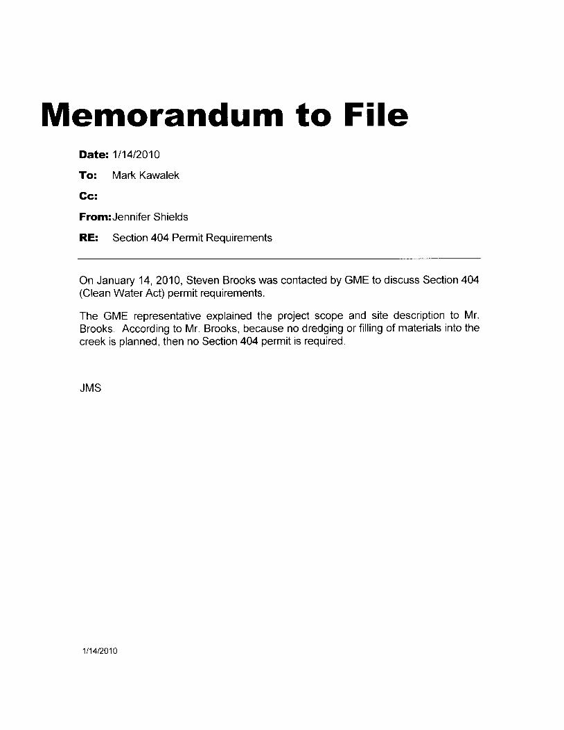
Memorandum to FileDate: 111412010
To: Mark Kawalek
Gc:
From:Jennifer Shields
RE: Section 404 Permit Requirements
On January 14,2010, Steven Brooks was contacted by GME to discuss Section 404(Clean Water Act) permit requirements.
The GME representative explained the project scope and site description to Mr.Brooks. According to Mr. Brooks, because no dredging or filling of materials into thecreek is planned, then no Section 404 permit is required.
JMS
1t14t2010

Gonsul t inServicesGeatechnical. Materia|s ancl EnvircrtrnentaI Encineerino
rH L is lEku" liii' '^': ] ' j i ! iuff , '
I ) c c e n r b e r 2 1 . 1 0 0 9
I e r l rs I I rs to r ica l ( 'on tn t i ss ion
I ) ( ) . l l o r 1J276, ' r L r r i i i r r .
' i e ) r . t s 7 8 7 1 I - : 2 7 6
. \ t t t t : \ r e l t c o l t r . t l ) i r i s i r r r r
Sub j cc t I Iistorical Inlbrmation RcquestC' i t1 o1 'Al lcnl)roposccl I'irc Station ll5Mcl)crntotl I)r iveA l l cn . ' l exas
Io \ \ 'hont I t l \4a1' ( 'onccrn:
\ \ c arc concluct ins an cnvirorunental s i te assessment fbr thc City ' o1'Al lcn. lhe prr,r . ject s i tc is aI i rc ir t . t t t ruct ol ' land locatcd on thc north side ot-McDcrnrott l ) r ive (erpprro.rrrnatclr 0. f0 nr i lc east o1'( 'L rs tc l I load) in thc C i t l ' o l 'A l len . Co l l in Cour " r ty . ' l ' e ras .
' l -hc s i tc i s cur rcn t ly o rvncc l b1 ' thc ( ' i t r o f '
, , \ l lcn. l l istoncal acr ial photographs shurv a l -ew bui ldings on t l rc Sitc l iorn at lcast l95l through20()3. houcvcr u() strurctures arc Drcscut nor.r .
Ihc yrro;roscd l lrc station wrl l include a 10.600 square fbot building and associated parking anclrlrir cs. l,tilities rvill be installed dr"rring construction, hor.vever depth of irnpact is unktrorr'tl as tltilit\'ct 'oss-scctir) l ts arc no1 available. l ' lease provicie the lbi iorving.
1 \\ i l l r l tc conslruction of thc proposcd l lre station al lbct cl istr icts, sitc. bui ldir lgs. strtrct l lrcs (\ l '
objccts. sillniflcant in Amcrican historl'. architecturc, archeology. cnginccring or ctthurc. that
arc l isrcd (or el igible fbr l ist ing) in thc National Register of I l istoric Places'/
l. \,\ ill the proposed firc station affect lndian religious site(s)'?

A slrcct map" topocraphic map (USGS 7.5" Quadrangle. Plano. Texas 1960). acnal photograph(l()05). ancl cuncrrt sitc plan for the proposed fire station are included. Ti1ank you lbr royr tin.rc andcot lpct 'at iot l . Pleasc cont l ict me i f -vou havc anv quesl ions regarding this rcscarch.
S ince rc l r ' .
( ; \ { l - Consult ing Scrvices, Inc.
/ ^ iI I \ " , { t4*t-W
. l cnn i l c r Sh ic lc lsSt t r l l ' ( i co l t l c is l
i-ANAg^{rf : i--r,ifil;"lj:, 'rxh:l iir.,;llin/ I
I I v Q $ , i t r 1 ' ' . ' l : l l . * { : l i ; i l f :
t n r t . 4 r r l z \ , i / r l i , r
$ t r ' r O i - r ; i i r , . -
uatel"frack+- _
Li fe 's bet ter outs ide.
- ! m m s 3 0 l e r :
i ? d o h H . D u q q r r sl D ' t l / o r t "
/ , f t c n o F a i c o r , M . D .? t . J . a r a l c C t l
l a r e ! ) . A x o r) . 1 . i i i c i l
I t . j - t ) a , , , l l a i t -
3 o e ' r e
. , ! t r D P a r k e iL u l k r r
, ? t i , . a ) a ' a ,. ' 1 r t t . ) . : - 1 . . J i . . . t . . .
i . ' ' , , ' i ' , : i ^
. 4 ' I I '
a_ , : , , ._
:r !,.r , ts
i ) ' a : ' ' , '
l "cbnrary 3. 20 I 0
. l cnn i l t r Sh ic ldsC M E ( ' o n s u l t i n g S c r v i c e s , l n c2530 E lcc t ron ic LancS u i r c 7 l 0I ) a l l a s . l ' X 7 5 2 2 0
I { l r : C i ty o l 'A l l cn Proposed F i re S ta t ion #-5 ( ( 'o l l in ( 'oun ty )
D c a r M s . S h r c l d s :
' l ' l rc Tcxas Parks and Wildl i fe Departnrcnt (TI)WD) has rcviewcd thc proposccl
pro. jcct rc l-crenccd abovc for potent ial in ipact to l ish and rvi ld l i fL ' resourccs. Thc
1t ro .1cc t invo lves cons t ruc t ion o f a nerv f i re s ta t ton on 1 .7 acres o f a 2 .8 -acrc t t 'ac t
o1-lanr l rvt th a tr ibLrtary of l {orvlct t Crcck bordering thc propcrty ott thc t tort l t at t t i
r i cs t s ic les .
\ \ 'a te rs o l ' the U.S.
' l ' l ,WD co l tcurs r .v i th thc Env i ronmcnta l S i tc Asscss t lc t t t (ESA) , tha t thc U.S.
Arnr1, Coqrs o1- [ngincers (USACE) should be consulted 1br potcnt ial Scct ion ;10'1
yrcrnt i t rccluircr lcnts associatcd with i tnpacts to Wzitcrs of thc tJ.S. i r lc ludi t tg
w c t l a n d s .
I{ ipar ian l - labi tat and Streatnbcd Protect ion
\\ ,9eclccl r ipar ian corr idors along streams gerreral ly provic ' le trcst ing habitat fbr
bi ;c ls. soi l stabi l izat ion fbr cnhanced waler qual i ty, and fbocl , covcr, and trarcl
corr i t lors fbr wi ldl i fc. Ripariar i habitat is a l -r igh pr ior i ty habitat typc lbr
c11pscrr. ,ut igl t by' l ' I ,W[) across thc state. As i rrcas bcccl t l re t l r t l rc clcr"clol lcd. t l te
incrcasc in i t lpcrvious cover intcrrsi f ics f loocl ing cvcnts, pror, ' ic l ing largc
vcgctatcr l br-r f ' l -ers bctw'ccn crccks ancl dcvcloptt tcnt hclps rcclucc t t t . tpacts
asJociatcd with f looding whi le also protect ing rvatcr qual i ty and r.r ' i l t l l i f c habitat .
The projcct should be clesigned and constructcd to avoid disturbancc tcr
rvctlapd, stream, and riparian areas. Thc woodcd riparian arcas sltott lcl bc
protccted by establishing a nrinin.nur.r bufl-er of 50 l 'cet alorlg thc crcek,
ihoqgh a 100-foot bLrffcr is preferrccl. The woodcd bLrl-l'cr areas shor'tlcl bc
kcpt in a natural state u' i th Very l i t t le ntai l t tct l t t t . tcc irtpLtts.
Jcnn i f 'c r Shic lc lsPage 2F c b r u a r y 3 , 2 0 1 0
Ttt prcvent excessive trampl ing and to n-r i r-r inr izc soi l disturbancc. onlvvcgclat ior-r inrpeding construct ion should bc rcmor, 'ccl . prclcrably b1,ct t t t t t lg stems at the ground surf 'ace and leaving the root svstcln j rr tuct.l tc luipr-r-rcnt should not be dr iven over vegetat ion lvhcn i t is cxtrclncly u ctancl heavy machincry should not be stored on vegetatir,'e cor.'er tbr longpcriods of t ime. Staging areas for equipmcnt should bc locatcd inprcvioLrsly disturbcd arcas or arcas of low valuc habitat .
Vcgctated swales should be incorporatcd into thc si tc plan to f i l tcr any si tcrr :nol- f that gocs toward thc crcck front thc f in ishcd {aci l i ty. Appropriatcbcst nranager-nent pract ices (BMPs) shor-r ld bc Lrt i l izcd clur i rrq cclustrLrct ionto nr ininr ize sedinrcntat i t rn to \ \ 'aterways.
( i i ty ancl cclntract personnelnr ic rohab i ta ts , i .e . , snags . b rushas thcsc provide habitat for asou rccs .
should nr inimizc disturbancc to incrtp i l cs , la l l cn logs , c reck banks . anc l poo lsvar ic ty rv i l c l l i l c spcc ics a r rd thc i r lbod
Nat ive Landscap ing
I 'hcrc has becu a dramatic increase in rvater denrand across North ' l 'cras, thus
rvatcr conservat iol t is esscl t t ia l to this area. Nat ivc vegctat ion is adaptcd to the
soi l and cl intzrtc of thc area and usual ly rcquires lcss tnaintcnarlcc aud tvatcr i t rg
than introcl trccd species. The disease tolcrance ol ' nat ive r , 'csctat ion pror, ' idcs
longcvity to thc landscape rvi thout high cost. Nat ive landscapcs ci l t - t providc att
cn joyablc outcloor spacc whi le also bcnef i t ing wi lc l l i fc such as bi lds atr t l
bLr t tc r l l i cs .
Disturbance of nat ivc vegetat ion should be avoidcd or t l r in i t l izcd during
lald al te rzrt ion act iv i t ies by usir-rg si tc planning atrcl ct)r lst l 'Lrct iorr
tcchniclues clesigncd to prcscrve cxist i r-rg nat ive trcc. shrubs. grasscs auci
lbrbs.
Nat ive vcgctat ion sl iould be incorporated into thc landscrtpc pl ln
Btrffalograss (Buchloe dactt'loides) is a nativc tLrrfgrass tltat' orlcc
cstabl is l ]ccl , requires l i t t lc water and uowit . tg. This grass shotr ld bc
planted for lawn areas rather than using introduced species such as
bcrnrudagrass.
. lenn i fc r Sh ie ldsPa_{e 3F e brLrary 3. 20 1 0
Native species appropriate for thc arca can be found r,rs ing TPWD'sWildscapcs sitc http://rvu,r.v.tpu,d.statc.tx.Lrs/hunt.uvilcilUlld/rft]dfqlpCft orthe Tcxas Plant Infbrnrat ion Database
lrttp:i i tpid.Awd.sta
I ta ren ' I 'h rea tened, and Endangered Spec ies
- l-hc Tcxas NatLrral Diversi ty Database (TXNDD) is intended to assist Lrscrs nl
avoidir tg hzirm to rare specics or signi f icant ecological fcatures. Givcn thc smal ll t roport iot t o1'pr-rbl ic versLrs pr ir , 'ate land in Tcxas, thc TXNDD does not inclucle arcl t rcscntat ivc i t rvcntory of rarc rcsources in thc state. Plcasc rrotc that abscncc o1'in[bnlat ion in the databasc docs not inrply that a specics is abscnt f l 'onr that arca.i \ l though i t is based on the bcst data avai lablc to TPWD regarcl ing rarc s;rccics.thc clata f}om thc TXNDD do not providc a dcf lni t ivc statcr-r-rcnt as to thcprcscncc, abscncc or condit ion of special species, natural comnrunit ics. or othcrsigni l icant f-caturcs r ,v i thin your projcct area. Thcsc data arc not inclr .rs ive andcannot be used as prcsence/absence data. This infornrat ion cannot LrcsLrbst i t r , r tcd lbr on-the-ground surveys. Thc TXNDD is Lrpclatcd cont inuouslybasccl ou new, r"rpdatcd and undigi t izcd records; Ior qucst ions rcgarding a rccordor to obtain digi tal data, plcasc contact txndcl(Zi l tpwd-t i , tc- t f U or l )or inda Scotta t ( . 5 1 2 ) 3 8 9 - 8 7 2 3 .
l icr ic lv o[- thc TXNDD revcalcd no occurrcnccs oi ' rare rcsol l l 'ccs rvi thir t thc
v ic in i ty o l thc p roposcd pro jec t .
' fhc 1 -PWD Annota tcd County L is ts o1- Rarc Spcc ics a rc a ra i lab lc
at f tql ' {gs.tpivcl .statc. tx.us/Tpi.r 'Endanqerc-dSrrccics/Dcsl{opDcttr l t .astr-x. - l 'hcsc
l ists proviclc intbrmation regarding rare spccics that havc potent ial to occur u' i th irr
cach county. Rarc species could potent ial ly bc impacted i f ' sui table habitat rs
l) l ' r 'su'11t l r l oI ncirr l l rc projcct s i te.
The county l ist should be uscd as a refcrcnce to dcterttr ine i f suitablc
5abitat occl lrs within thc proposcd project sitc atrd to dctcrnl inc i I ' thc
projcct woLrld impact the species or habilats.
The projcct should be dcsigned and constructcd to avoir l or tr l init lr izc
aclvcrsc irnpacts and to mitigate any impacts r.vhen rare plernt and anittlal
spccies and their habitat arc found within or near thc prolcct area.
Construction crews should be informed of thc spccics rvith special status
in the pro.icct counties and should avoid cl isturbance to sensit ivc specics i t
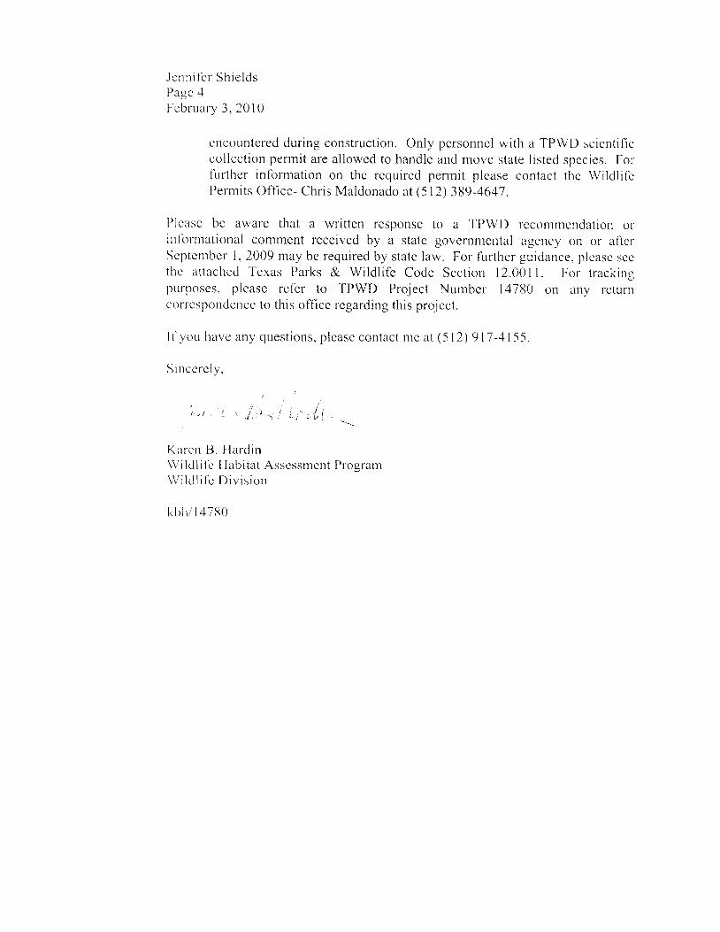
. l cnn i f -c r Sh ie ldsPagc .1
I rcbruary 3 , 201 0
ct-tcountered during construction. Only personnel with a TPWD scicntif iccol lection permit are al lowed to handle and movc state l isted species. ForI irrther inlbrnration on the requircd perrtr i t plcase contact thc Wildl i l tPern, i ts Off ice- Chris Maldonado at (5 l2) 389-4647 .
Plcase be aware that a written response to a TPWD reconrnendation orinlbrnrational commcnt received by a statc governuteutal agcncl,on or aficr-Scptcnrber 1, 2009 may be required by state law. For {urt l-re r gr-r idance, plcasc sccthc attacltccl Tcxas Parks & Wildl i fc Codc Scction 12.001 I . For trackinqpurpose s, plcase ref 'cr to TPWD Project Numbcr 14780 on alty rcturncorrcspondcncc to this off lce regarding this project.
I l ' yoL r havc any ques t i ons , p lease con tac t n t c a t (5 l2 ) 917 -41 -55 .
S in ccrc ly ,
i , t ' r L l
Krr rcn B. [ {a rc l in\ \ / i ld l i f c I - labi tat Assessr.ncnt PrograrrW i l t l l i f c I ) i v i s i o n
k b h , / 1 4 7 8 0
r - l 2 . i l 1 l i 1 . R I I S O I I R C E P R O T E C T T O N . ( a ) T h e d e p a r t r n e n t r s i . . : e
: r ' , . ; . ' . r t - h r r r r n a r y r e s p o n s i b t l i t v f o r p r o t e c t j n g t _ h e s t a t e ' s
. r ' - . i l , r f e r e : : O u r c e s .
' j , : r ' r c l e y r a r t n r e n t ' s r e s o u i : c e p r o t e c t i c r . l c t j v j t i e s . l i ' r . i L r c e :
( - ) r n v e s t i q a t i n g f i s h k : - i l s a n d a n y t y p e o f p o , l I r : t r o r
: r , : . i r - : ; . i l o s s o f f i s h o r w r l . d l l f e : : e s o u r c e s , t a k i n g n e c e s s a r y
, r - l : - : - r l . - i f y L h e c : . , i r . i s e a n d p a r t y r e s p o n s i b l e f o r : { , h e f i s h k i i i o r .
, ' - ' . j i , r r n ; r i j n g L h e m o n e t a r y v a l u e o f l o s L r e s o u r : c e s , a n c i s e t r k i i r g' r r . 1 - l r . o L r g h D r : e - s e n t a t i o n o f e v i d e n c e t o t - h e r a q e n c y r c : . ' < n o n _ s r L _ . 1 c
' r : r . J o r t h r o u g h s u . i t . . j n c o u n t y o r d i s l _ r : r c t _ c o u r r _ ;
( . 1 ) p r o v i d i n g r e c o m n e n d a t i o n s t h a t w . L 1 1 ; ; r o t e c : t f i s h a i , r i
| - , s . - r l . . l r . e s t o I o c a . l , s t a t e / a n d f e d e r a f . r g e n c i e s t h a t a p p r L . v e ,
, . - i . : r , - , , , r ) l c o n s t , r u c t d e v e l o p m e l t , a l p r o - j e c t s ;
( . 1 ) ; r r o v i . c . l i r r g r n f o r : n a L i o n o n f i s h ; _ r n c l w i i d l j l c t ( : i s o L l r c € r - q
: . i - t s l . ; ' r 1 . , ( ' ) / ; r n d f e d e r a r a g e n c i e s o r p r i v r t e o r . t c l r i z a f , i o l r s : - h a r -
- r i . r - . : , r ; r f f e r : t t . n g t - h o s e r e s o L . t r c e s ; a n c l
( , i ) p r o v i d r n g r e c o m n r e n d a t i o n s t o t h e l ' e x a - s [ J e L . a r t n r c n L o i
. , r r ' . r : s o n s c l - r c d u 1 - i n g o f i n - s t r e a m f l o w s a n d f r e s h w a t . e r i n f I o w s
: r : r 1 , j . l r i e s f o - r : t h e m a n a g e m e n t o f f i - s h a n d w i l c l l i f e r - c s o u r c e * s .
' I : : i . , L ' l ' . r f r C r V w . L l - i r s L a l - e w r ( l e j u r t s d r c t i i ; n f . ] r a t r e . t r t t \ ' . ' , s r l
n r n e n c i , r l i o n o r i n f o r m a t - i o n ; , i 1 . c o n r n e r r ' l i - L r n d e ' r S r r i r : r - o r - t i , r i - , ( i r 1
1 . c , I h r ' - - r l c i r a r t m e n t , i n w r i t - r n q c o n c e r - r r r n q t h c
r i . t t : . ' o t f i n l c n l - . A r e s p . , . 1 1 5 e n . s t , i n a l u , l c - ' J o r c . , r c i r
r . / ) r . i 1 ) r n ; n e 1 t . p r : o v i d e d b y t - h r : < i e p a r l i l e n t :
( I ) a r l c s r : r i p t : - o r - r o f a n y m o c i j f i c a l i o n m a c l e t o t . h r . :
' : : 1 | ; i : ; h , l t l r i w i l c . l I i f e r e s c l L l r c : c c l e l . : ' L s i ( ) l l , , . ) l w a L i a i . ' l l I i r l l r '
I 1 r i r i t f r o m t - i r e r e L l o m i n e n d a : r o n o r c c m r r t : i t t - , '
r . l ) . . r i r y a r l . t r e r c l i . s p o s i t i o n o f l h e r t - - c : o n t l n e ' l - t i - l a l i , ) l l r ' ] :
( . f ) i t s t a p p l i c a b l e , d f l V r e a s o r l 1 , h e a g e n c : v c l i s a q i - e e ( - l \ , ' l i i - i l
" a . - - i ( ) n o r i r - i c o r p o r a t e t h e r e c o m m e n d a L i o n o l : c o m m e n l - .
i r - . i a : r f ) c ) r l s e L l r i d e r S u i l s e c t i o n ( c ) :
l l ) n r L t s t l ' r , . t s r r b n t t l _ e d t , o L h e c l c p a l . l - i n e l l l L l l o L I a : - c : f i - . i l
L . ' : t | 1 : , a I l . h C c l a t e t h e a g e n C y n a k e s a ( ] e c i S j O I I o r t - , r k . : ; ' l i - : L ! ' l l
1 . . , : r i L o i h e r c c o n m e n r ] a t i r n o r i n f o r m a i , i o n a . l . ( r o l l L m t n l i I ' ' : : - i
r , - , r 1 t a i m i l l r t ; a l - r d
( 2 ) r s p u b l l c t n f o r n a t i o n u n c e l C i l a p t e r l - , 5 2 , C o - | I e l - n n e l l : ,
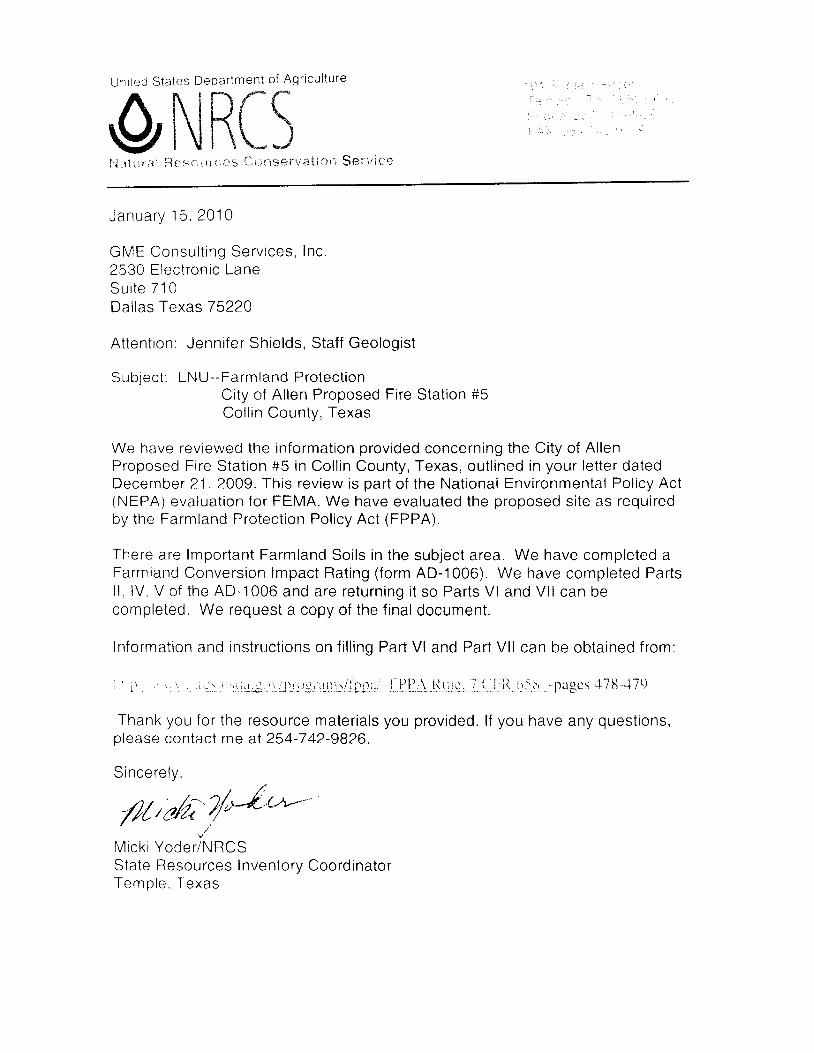
Unr ted S ta les Depa r tmen t o f Aq r i cu l t u re
/ \ h I n f ^ f , *(}i\ilthl',1 it t i,r r aJ i lji rr s r:, I, t i . r: $ [ l, tl se r v at i n l"r $ e r v i ile
. :
J a n u a r y 1 5 . 2 0 1 0
GME Consu l t ing Serv ices , Inc .2530 Electronic LaneS u i t e 7 1 0Dal las Texas 75220
Attent ion: Jenni fer Shields, Staf f Geologist
Sub jec t : LNU--Farmland Pro tec t ionCity of Al len Proposed Fire Stat ion #5Col l in Countv. Texas
We have reviewed the informat ion provided concerning the City of Al lenProposed Fire Stat ion #5 in Col l in County, Texas, out l ined in your let ter datedDecember 21 , 2OO9. This review is part of the Nat ional Environmental Pol icy Act(NEPA) evaluat ion for FEMA. We have evaluated the proposed si te as requiredby the Farmland Protect ion Pol icy Act (FPPA).
There are lmportant Farmland Soi ls in the subject area. We have completed aFarmland Conversion lmpact Rat ing ( form AD-1006). We have completed Partsl l . lV, V of the AD-l006 and are returning i t so Parts Vl and Vl l can becompleted. We request a copy of the f inal document.
Informatron and instruct ions on f i l l ing Part Vl and Part Vl l can be obtained from:
-pagcs '118-4lr)
Thank you for the resource mater ia ls you provided. l f you have any quest ions,please contact me at 254-742-9826.
S incere ly ., ' ^ / /
4/ />/r:Z'/ve'u+'-"/ / v ' v " u
/
u"
Mick i Yoder /NRCSState Resources InventorV CoordinatorTemole . Texas
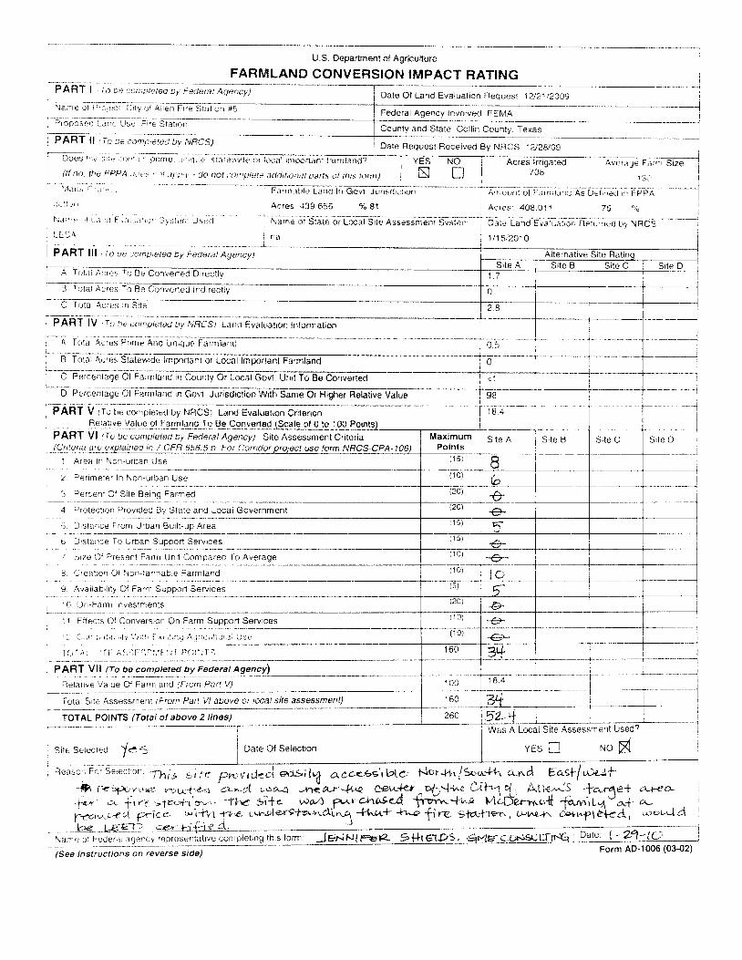
I
I
Nil;.-.tF;,Ei-C[y ol Aile. r-tre ffi- Federal Agency involved FEMA i-Ficpoleo-.ar,c 'Js-Ftre. Statron --f I
i County and State Collin Colnty, Texas II PART ll rt-o De
"o.i i lud ov uncsl Date Requesl Feceived ay ftf nCS ,Z,ZVOS
- - ' - - 1 i ; = -
Y F S N ( ) I A p r o c l r r i ^ r r A d A . . - , \ . , - c - , , , . c i - ^ il U o e s ' , ] i : i 1 i ' ] : ] l ] { ] ' . i ' . p r l m e , | l J l l i ] | j | S l i 1 ' f i \ l 1 ] t t r l i i - } i : a l l 0 1 F c { J n l 1 a t t r t i 3 n d . ) ' v E s - t l o _ - f _ - A c r e s f | g a G d - . . * A ' ; ; . i ' r e F J ' u' f:-t I -^^
1 (lf no, he FPPA.t, ' ir--( ' 1l .r l\rttt - do not (i-)!:) l) it i !e i 'Jrrtrf idil i?ll i ;r/1.i dt ttt ls tt-\n,t) . DJ U I 708 |I l l \ l I
i - t ; ; , - , . , -
"1 1r ' -r ' r ' ' j r* i i i i r i . ; leurrxrlnG,rvr Ju;rs,J"l ; ;
--* ' l i { [ i rrnr oi i . .M' i :r ; .JA;orr,, iJir , i ,FFpi.-
--]
i ; t : l r r i i
' i i a ' ' , r .
L f ' j , \
. . t ._.-PART lf f ,f o oe conp)eted by Fedlrat Agency)
A Total Al ; res To Be rnverted Direct ly'
B T r t ; , i A ' ; ,eS T l Be COnrnr6n l ' r rJ i rp^ r l \--a
T*. ;- '-;;atu
I i'AnilV ,;*i "i,,iit,l*;y tnr.sruil E;;;i;;"'r; r,,il;;*G;--*tT;;iaiA;;;
Pii,* Aiid Uillr:r.Fri'mta",xl --
B Torat Ar;ri.s Statew,dr. lrnporunt ffi' - - - T ; -
C P L , r t . L - I r l a g L [ J t F a r n l a n d i l rifl Courrly Or Local Gov1. Unil To Be Conve(ecl
0 5
0
Alternat ive
Si te B
<1
lJ Percerr lane Ol F:rrnr lnrD Percerrrage ol Farnrland rn Gorr JuriscJrcfion with sanre or t"tiger Relative Vaili-
PART V {.fo !,e corrptered by NRCS) Laf r{j Evalustlofl Critorion_ - fl.elgr]]s yqr!,e_-ol [?r'1i(lg_I.s ri9.Q!ry_engusqg]9*e!.-g.ls-lgp*19[s]PART Vf (To be campleted by Federal Agency) Site Assessment Criteria
t, - lp,ry1 e r 9 9.r e -94p8!19!!i sfE-atPJ_b,I9!,Q9r rg9! use form NRCS-CPA-
I Area ln r" lon-urDan Use
2 Penme te r I n Non -u rban Use
3 Percent Ol Si te Being Farmed
4 r)rotectron P,ovroed By Slate ano Local Government
5 D rs tance F ro rn U rban Bu r i t - up A rea
6 [J rs ta r ]ce Io UrbarT Suppor l Serv rces
' ' . ' r , , , , . o ' r r " " ,1u, , . , u f iC" . r " r " , , fu e"uru*
8 Crealron Oi Non-farrnable Farmland
9 Avar labr l r ty Ot Farm Support Serurces
10 On -Fa rm Inves tmen l s
1 1 Ellects Of Conversron On Farm SuoDort Services
Fel ; r t l ve Va iue Ol Fa tnrLand (F torn Par l V)
iotal Slte Assessrnenl (Fronl Pan Vl above or local site assessment
rOTAL POINTS (Total ol above 2 l tne6)
Site Setected Ya: Date Of Selection
ke,, LEq:!} -ceu _tiyi:! .Narr,, , of Federat agenoy represeniat ive conrplet ing this form: Jg^JAitF€t€- ?lt fc;Lp5'
i si "j
i " t, * t n i i' ii r e v e r s e s i a e S
I- - t - - - - - - -
I
i Reaio', F.;5i'eclai 1:;:o '
O videct p,l,g;lvJ c\c4.,e,6s'tbl(. Flor+i.,ij*,"u'i",1-l orr,..d Eas+./ute*if-fr 1'zyr;.rr"oa v'r,rrf{-.l ,:/..h'r:/ L$a-a -nJ.a-r**t^e Ceu-let ^q-.-l't"-. C,i11 { Atte;S "tc"rne* 6trca-
" ' - t ^ . . , , t ^ , . . - , t . f . - y - t - ^ " l l - \ ^
t L r JItn u 1*,i-r-..i,'o'' "fls pife wa,C a^.Lnk.$ ff*--+r".-a l"1l*er-*.'{t fa*ia;Jo+ ^f-f€r\-!cf ri f-tr-ic,e- ci-ln"t -t-1.'e Ltr'ple*-c?"Lrrrli"'.1 -+,lls"+ +t c finf St**t1er.. Lar!^tJ\ ,:xr,.7tekct, uoc't-'Jd
Was A Local Srte Assessmerlt Used?
vpe l--l N O E
-1
fr{r1 D_g_re | -21-tC'
Form AD-10O6 (03{2)
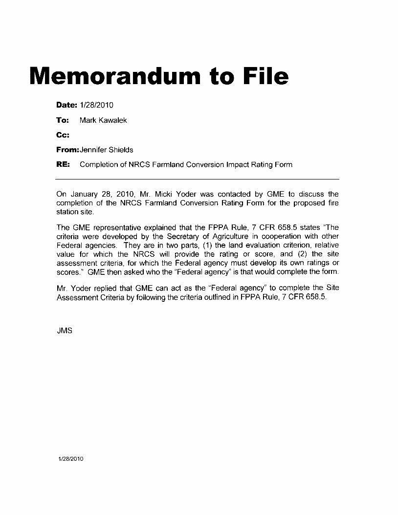
Memorandum to FileDate: 112812010
To: Mark Kawalek
Gc:
From:Jennifer Shields
RE: Completion of NRCS Farmland Conversion lmpact Rating Form
On January 28, 2010, Mr. Micki Yoder was contacted by GME to discuss thecompletion of the NRCS Farmland Conversion Rating Form for the proposed firestation site.
The GME representative explained that the FPPA Rule, 7 CFR 658.5 states "Thecriteria were developed by the Secretary of Agriculture in cooperation with otherFederal agencies. They are in two parts, (1) the land evaluation criterion, relativevalue for which the NRCS will provide the rating or score, and (2) the siteassessment criteria, for which the Federal agency must develop its own ratings orscores." GME then asked who the "Federal agency" is that would complete the form.
Mr. Yoder replied that GME can act as the "Federal agency" to complete the SiteAssessment Criteria by following the criteria outlined in FPPA Rule, 7 CFR 658.5.
JMS
1t28t2010
Nolurol Resources Conservolion Service,
1 ( ) l i r l i n g l f i { ) o l m o r ( j . i l E l c r l c y p e | s o n n e lI O n s i l i ( ' l :
, r ) U s t ' o l l t r n . l L l r a . t i s n o t f a r m l a n d o r, . r s I o l r , x r s L r r r g s t , r ' u c L u I ' e s :
r i r . \ l l o | n t t , i v r r s i L e s . l o o a L i o n s a n dr l , ' s r g r r s l h l 1 1 . w o r . r l d s c r v e t h e p | o p o s e c l
l ) L u l ) o s f r i ) i r l c ( ) n v e l L e i l h e r ' f e w e l a o l e sr t t r r r n r i a n c l r > r ' o t i t e l f i t . t m l a n c l t h a t h a s
I I o r v i : r ' r ' r : l i i L i v c r " ' a l u e :i r r i ) S p e c i i r l s i t i n g l e q u i l e m e n t s o f
' . h r ' p | o l r o s u t l p l o j e c L a t r d t h o c x L e r r t t o, " i ' i r i c l r r r l } 1 r "11- t : r ' r t i rL i ' r ' t : s i le fa i l s to sa t -i r i l \ ' t h ( ' spr :1 . : i r r l s i t i r )g l c r lu i |ements z rsl e r l l a - s L , l r o o l i g i n n l l y s e i e c l e d s i t e .
{ , ,1 r l , ' t ' t l e | t r l agonc ies n l r i , y e leoL Lo z rss r s n t h ( ' s i t . 0 a s s e s s m e n l 0 I i t e r i a | e i -i r t r \ ' t w { ) i g h l i l r g s o L h e l t . h a n l h o s es i r r , r V n r r r $ 6 5 1 1 5 ( b ) i . r n ( l ( r r ) I f a n i r g e n c yr ' l i L l s t . o d o s o . U S I ) A t c c o m m o n ( i s t h a tL I l , . i r s r ) i l r ' y r r d o p L l L s a l L e r n a L l v e\ \ ' r ' i ' t h t l D q s y s l e n l ( 1 ) L h r o u g b r u l e -
n l r l < i n q i n o o l l s L l l t , a , t i c l n r v i t , h U S D A ,
i r r r r i i 2 r r s a s y s t , e n t t o l l e L l s e d u n i -
l o I n r l ) , ' t h r o r . r g h o u l , t h e a g o n o y . U S D A| r ' r ' o m n r t : r ) t l s t h r L L h c w e i g h l i n g s s L a t e L l
t n r s 6 5 8 t ) 1 l ) ) a n d ( c ) b e l r s c d u n t , i l a n
l lqenc I : ' i ssL les i l f ina l fu lc to chanse the' , v r ' i g h L l n g s .
' r ' r i t t s i r ( l v i s i t l ) l L ] l h i l l e v a l u a t i o n s
i r r l l i i . n l t l ) ' s t ' s o f l l t o s p o c t i v o f a l m l l i n d
, ( ) | \ ' ( , r s j o l l i l l r l ) i i O L s l l o l t t i r c l e e a l l Y i l l
I l r r . j r l l r . n n i t t i i I J I O ( t o s s l l e f t l t r ' a s l l e o I( l r , s r ! r ] r i s s t ' l t r l 1 . t r L i . i l . l l ( l L h i t t . ! v h ( l l ( ' l ) o s: l l , l , ' . i 3 e n ( ' j t s t t t i t l i t ' L i l ( ' I r P P A € r V a l L t at , r o 1 ) s l ) i l r t r l l l t t ' N i l L l o l l t t ] l l l t . t v i t o n
r r { , l r L i ! l l ' o i t L ' } ' : \ c t ( N t r I ' A ) p l o c o s s
[ 1 r L l I r t ] i t ' i r g o t t ( ) y s o l v n N I f I T A I e g u l l r' . i r ) n s . s o n l e e i r t o q o l l o s o l I ) r ' o J e c t s l l l t t y
l r t r x c l L t t l t t l l l o n ' r N I I P A w h i c h n l a y
s t r ) l i r , ' c ( ) \ ' r : l o ( l u r l t l e l t , ] t c F P P A . S c c -' . 1 ( ) t ) l l ) . 1 0 ( c ) ( 4 ) o l t , h t : A c l e x c m p t s
p l ( ) l e e t s L h t r t w e r ' o b c y o n d l h e p l a n n l n g
. t l ! ( , i u r t l r v t ) t e i n e l t h o r t h e a c l i v e d e -
: r r n , r I i i o n s L l ' t . t ( l L l o n s t , i l t e O n L h e e l 1 e c1 i ! r ' t i i t t o o l t h L ' A o t . . S e o t , l o r l 1 5 4 ? ( 1 ) ) e x -
r i r ] ) l J t i i l o ( l u l s i l l o l l o f u s e o 1 f t l r l r l a n d
l o r r . r L t o l t i I ] d e f c u s e p t l l p o s c s ' f h e l e
i u I n o o t . h e l o x e n l p l i o l l s o l p f o j e c l - s b y
1 i r t f , ' ! o l J ' i l l l i l u A c L .( l / N L l n t t ) I O L I s S t a t c s a n d u n i t s o l
loe i r l g t tv t : t ' t tn le l l l i u 'e deve lop ing and
r i . t lOLr t j t . tg l ,e r l ) ( l Dva luaL jon and S i te As-
sessmenl ( L I ' lSA ) sysLems to evzr luz1 te
t h e p r o d u c t j v j t y o f a g r i o u l t u r a l l a n d
i u i ( l r l s s t t i t a l l j l i l r " f o l c o n v c f s l o n l o
n o n a q t i c t t l L r L r a l L l s e ' I ' h e l e f o l e , S t a t e s
i i n r i r t l t i t s o l l o c a i g o v e l ' n m e n L r r a y
ha i e , i . l t ' oad-v I l c l '1o In)ed an evar iua t ion
L r s i n e ( t t i t e t l l i s i l r i l i r f l o t h o s t r c o n -
usDA s 6s8.s
La ined in l i r i s l u le i lp t r l i i cab lc Lo I "o . l
e |a l ageDc ies . USI )A |ec ton l t - ]1e11( l ! i tha t[ ' h e l c s i l e s a l ( ] t o l l e e v ? r l l t a l t e r l n i t l t i l t
a j u r r s d i c t r o l l h a v i n g n S t , a l ( j o l i o c a lLFIS. { sys tem t i ra t h l rs becn appt over l
b y t h e g o v e l n i n g ) r o d 5 r o f s l t c l t j t r t i s d j r r -
t ion Lu ld h l l s been p laoed on t l t t t N l iC lS
S t a t e c o n s e l v a l i o n i s t s l i s t , a s o n e
w h i c h m e e t s l l l e p u l p o s e o l L h o I ' I ' > P A
i n b a l a n c e w j t h o t ' h r - ' l l ) u b l i ( r l ) o l l c ] ' o i )j e c t i v e s , F e d e l a l i ! g o u o i e s r . t s e t , l l r t s t ' s
t e m t o m a k 0 l h e e v a l u a t i o n .( g ) T o n l e c t . f c l ) o t U n S t c c l u i r o n l ( ' l l t s
o f s e c t i o n 1 5 4 6 o f l h e A o t . ? L r . S . C . 1 2 0 ? .
a n c l f o t d a t a o o l l e c t ' i o n p L l l p o s o s . a l t { ' I
lhe agencr - h i l s n tade a f i t t l l l t l cc i -q to t . t o t t
a p l o J o c L i n u ' h i c l t o n ( ' o l n t o l o o { t l l r l
a l l e ' r n a L i \ ' o s i L ( r s t i o l l L a i n l a t t - t . t I n t t t l s t t l r
J C ( 1 1 u t h c F i ' l ' A . t ) t o r ! r ' t l u v i j 1 'qucs tec l to t o t u l l ) 11 0op l ' o l t .he l f o l l l l
A D - 1 0 0 U , w h i c h l n ( l i c i [ L e s t h { ) l i n a ] d t ' c i
s i o n o f t h e r a g e t r c y . t o l h c N I I C S l i t l L l
o f f i o e .( h ) O n c o a F e t l e t a i a g o l l ( l y l . t i t , s p i l t -
fo |med an t r t l : r l ys is unc lc t ' L l t i l F I ' l ' . \ i i r l '
t h e c o n v c l s r o n o f a s i L e . l h n . t a g t l t l c 5 ' s
o f a s e c o n c l I f e c l e t a l a g e l l c y ' s d ( ' t o l -
m jna t lon w i lh |cga | r l t ,o t t l t l i l i o r l i i l &s
s i s t a D c e o t ' a c L i o l l s o l l l h c s n n l e s i t c r . l o
n o t r e c l u i t o a d ( l i t i o l I A I I c d u l l ( l a l l 1 f ' l ' j P . L
a n a l y s l s .
1 ,19 i ' l t 2??114. JL l l y 5 . l l l t i ' i . i 1s i r l r l c r r ( l c ( l i t t JU
I i l t 3 i l l u , . J u r l f l i . l l r ! ) 4 1
$658.5 Cr i te r ia .
T h t s s e c t i o n s t . i r t . u s t h ( l ( l l i l i ' l l i t l ( '
c l u t | c t l l t y s e u L i o l . ) l l ) ' 1 1 ( { r ) ( ) l t h r ' r \ t ' t T
U S . C . ' 1 2 0 2 ( a ) . ' l ' h t : t l t i t c t ' i t t r v e t t ' t l t ' l ' i ' l
o p c t l b y t h c S c c l e l , t r l y O l A g r i c u l t t t t o i t l
c o o p c l r l t i o l l r v t t i ' t o L h e t l f o i l e t a l r r q t ' t t
c 1 a ' s . ' l ' h e y i l l e i n t s ' o p a l t , s . ( l ) L l ) o l i l l l d
e v a l u i \ t r o n c l i t o l i o l l ' I e l a t i v c v t r l t t c l o t
w h i c h N R C S \ \ ' i l l p l o v i L l ( r l l l e t a L i l t g t i t
S L U I r ' . a ) ) r l r 3 r t l l ' S l l " i l S : " s i l ) ) ( ' l l t I i
L e l r a . i o l s ' l ) i c h o a c h F o t l t - ' t l t l r l S t ' l l ( l l '
r n u s l d e v L r l o p i L s o w l l l i l ! i l l g s o I S c o l 0 s '
T h e c t i t e l i a a l e & s l o l l o w - q :
\a ) Lc t t t ( t l i t ; tL l tL t t t io t t ( ' t i l e r io t t 1 l1?1 ' l I I t ' ( '
l / o / a c ' . ' l ' h e l z r t l c l e v n l u a t i o l l ( l l i t e l l o l l 1 s
b a s e d o n i n l o l ' m a " t i o l l 1 1 o m s e \ ' 0 l a l
sou rces i nc l ud ing na l i ona l 0oope la t l ve
so r l su r veys o I o the l a ( r cep ta l l l e so i l
surveJ's. Ni t ,CS f ic ld of f ice lechl l lcalgu i c l es . so i l po l en l i a l I a t j nSs o l so l l
producl iv i ly raLi l lgs, land c iu la l )1 l i t l "
o l ass t l j ca t i o r l s . and impo ] LanL l l l l n l -
l anc l dcLe t n l i l l a t i on - s Base r l on t h i s ) l l .
f o fma t i on . g l o t l l l s o f so i l s w l t l l i l l l t
I o c i t i qoVc t ' nn l e t l t , ' s j u t ' r sd i c t l o l l w i l l l ) t
177
s 6s8.s, . 1 ' ' i i l ) - r i t t { ' ( l : r r ] ( l i l r i s i g n e c l & s c o f e b e l w o c n( r 1 ( ) 1 0 0 . I c p r ' o s e r r t l n g l h e r e l a l i v e, , a l L r t ' . l o l u . g l i c u l t , u r a , ) p l o c i u c t i o n , o f! l ) i l a l u r l i \ n ( l t , o l ) e c o n v e r L e d b - v ! h e
l ) 1 o l e l l r : o n r l . r A l e d L o o t h e r ' l a r m l a n c i r nI j r . . s i u n L , l o c n l q o v c r | n m e n L j u | i s d i c .i . r o r . ' l ' h r s s c o l o r v i l l l ) e t . h e l l e l a t i v et . : L l L r r ' I { i r 1 i n g o n [ , ' o l m A I ) 1 0 0 6 .
l r r 5 i 1 r ' . 4 s s l s s r n e r r l ( ' r t t e r i ( r . F c d e l z r li r g r ' n L r r r f s i i . r ' r ' l o L r s c t h c f o l l o w i n g c l ' i -l r r ' r i l l o a s s e s s t , l r e s u i t a l r i l i t v o f e i l c h
1 r I r r 1 ; r - ) s i , r l s i l , e o r ' ( l e s i i l n a l l e | n a L i v e f o l
l i r , r t c ( t i o n : r . s J l r | m l l r n t l a l o n g w i t h t i r e: r ' ( r r I ' l r ' ( ) l l l t i r e l i l n r l r : v : r l r r a t i o n c r i -1 . l r i o n r - l i r s c l i b c c l i n $ 6 5 8 . 5 ( a ) . E t l c h c f i -1 { ' r ' r r ) l l w t l l i t t , 9 3 i v c t t - t : 1 s o o t c o n : 1 s c a l er r l ( ) ! o t h { ' n l a x i n r u n r f ) o i n L s s h o \ ' v n( ' ( i n ( j r t j o ) r s s l r g g o s t j n g t o p . j n t 0 r ' -
r r r I r l i r r l r : i r n [ l ] ) o t t o m s L r o r { r s a r e 1 n ( 1 1
" i r l l r l l o I ( ' i i a l l c l i 1 , o I i o r r . T h o : 1 g e n c - vl r - r i r l r l n r i r . l i o s r r o l i t r g { l c c i s i o n s i n t h oL o n l e r t o l O r r r ' l ' i p l o l J o s e L l s r t e o l i r l t e l ' -n r i L i , , ' r ' r r I t i o r r l r 5 e x a m t n i r l g L h e s i t e .
I l ) r ' s u r r o u r t r i i t - t 1 1 i l t o i r . a l t ( l L b o p I oi r l , i n r s l u r r i l r o l t I i c - s o l l h e S l a l e o t l o c a l
t i l t j l r ) l q r ; v o I n n r 0 r t l i n r v h i t : l i L h o s i L e I S
l o , . r 1 r ' , 1 \ \ ' h ( , r ' f o n c g i v e l ) l o o a l , i o n h a s
l r r o r r . l l r L r r o r r r , d e s l g t i i r l t , e l n n l j v e . e r l c l )
l l c : t : t n s l r o u l r i b t : t : o n s i c l e t e ( l a s a n a l L e l '
l L l l j \ ' f ' , s j t o . ' l ' l r c s t t , c a s s o s s n l e l l L ( l I l -
L 0 t ) ] i l 1 0 :
r l r L l o r v n t u c h l a r n t l l s i n n o n u r b a n u s e
$ i l h i n t l a ( l l u s o f 1 . 0 m i l e f t ' o m l v h e t e
t l ) r , I ) l o . l e c t , i s j r t L e n c l e d ' 1
\ l ' r | t ' l h r r n 9 { ) l ) e I ( t t ) I l t , L 5 p o i n t , s
11{ l 1 , , :10 r ) t r ( ( ' i l 1 l 1 Lo I l )o l l } l ( s ll , 1 , s . r t l r . i l L f 0 l ) t r ( r ' I l t . 0 l ) o l l l L $
7 CFR Ch . V l ( l - l { 3 Ed i f i on )
( 5 ) I I o w c l o s e i s t h e s i t e t o a r r L r I l r i r nbui l l -up ale;r ' /
The st te is 2 )n i lcs or ' urol r 1r ' { ) r } r i i r t u l l ) r t l l] l u i l t - up a l ea 15 po i r l t s
Thc s i t e i s r no | c | h rD I m i l c l l n t l c ss t i r i \ r ) :m j l 0 s l l o rn an u | l l an Du11 t -u1 r i t t t i i l t )p o j I l s
T h e s i l e i s l 0 s s t l l r r i i r r i l c l i o r I ) . l r u t i s i l o tac lJarcenL Lo ar u l l )a r ) b r r i l l , -u1r d t 0 r i i rD o i n t , s
' I ' h e s i L e i s a ( l J a u e n t t o i i n l i l l ) r l . n l ) I r l l t u l )a l c i r 0 po i r i t . s
( 6 ) I l o r v c l o s c i s t . h e s i t , e L o w i r t t ' t
l i n c s . s i r w e | l i t . t c s a D c l t o t ' o t , h 0 l l o c r l l i I
c i l i t i e s a n r l s c : v i r . : o s w h o s { ' c l l . } J r l t . j l l c s
t r . t r l c l o s ) g n r v o u l r l p r ' o m o l ( ' t 1 r ) l t -
& q l i c r - r l t u f a l L l s o ' l
1 ' \o I Ie o f l l te se t r , i c r rs i t x is l t to ; r l r . t t l l ' l l l i lm i l 0 s h o r n L i ) o s j t t ' l 5 l ) o i l l t s
S o m e o l t h e s e l Y i c e s e x i s l l l l o r e L i l r ! 1 1 I l l t l ll ess lh i l r ) l l n l i les f |om Lh! ' s j t , t ' l 0 l )o i l ) t s
A l l o 1 t h e s a | v i ( t ' s t x i s L u i l l l i t l r 2 I ] l l l i r l ) l t l i ts i t e 0 p o i n t s
( 7 ) I s t h e f a l i l l u i l i L ( s ) c o t i l r r i : l i t i 3 t l l t '
s r l t : t i r e l o : e t h o f J t o J o o l ) t t s l l t t g t ' i t s t l t t '
z \ \ : o l z r g u s t z e l a l t t t i L L l 3 t l r l i t i l l t ' l ) t l t o t l l l
t , y ' 1 ( A v e l ' a ! r e f a : n t s i z o s i t . l o : r c r l l c o t l l l t v
a | e a v a i l i r l r l e f l ' o r t t t h e N l ' l C S f i t ' l r l r . r f
l i c e s i t r e a c h S L : r L e . D t t L l l l L t e I t o l t t t h t '
l a t t r s t a v a i l a l l l e C e n s u s o l A g l i ( l t l l t t l I { "
Aofeage o f I i ' a l n l U l r iLs i r l Ope l . l t lo l l
w i t h $ 1 . 0 0 0 o I l ) l o t t ' i l l s a , l e i i . )
As l f t rge or ' la lge l l ( ) Po inLsBe low avetage deduct I po in t tb l c i t c r l t i r l l t ' t
o c n L l ) e l o w l h e a v e l a g a ( l o w r l t , o 0 l ) o l l l t s l l
5 0 D e r i e n L o l ' l l i o l u l ) e i o w r l v e l ' i r i l t r l l t , o ( l
po i r t , s
I r l l o r ! n r u t : h o 1 t , h r ) p e l i n l e l e l o l l h e ( B ) I l L h l s s i t o i s c h o s ( t t t I o l t l ) c
< l i , l r { t ) r i t , L S o l l l i n r l j r r n o n u t } - l a t t r - t s e ' l p l o J e c t . h o l v n t r r c l r o l t i t ( ' I c l l l i r j l l i l l g
\ l ' r r , . I r r . u i { J 0 l ) r ' r e { ' D 1 l U l r r ) i n l . i l . a l l t l o t t L i l e i r r t ' t r t r ' v i l l l l e c c l t t t t l t l t l t t
! ( r r ( ) l ( l l r , r 1 . . ' L ! l o , u u , r , ' i , " 1 ' l a t n - r a l l l e l l e c t t u s i ' o l i t r t ' c ' l 1 t ' l t r t l ( t ' \ \ ' l t i )
i , , , i s t . l r , i l l l 0 l ) r ' l ( { r n t , 0 l ) o l l i L s i a n d } ) n l l o l n s ' /
r t i t l l o u ' r n u c l - i o l t r l l o s i t e h a s b e e n " \ c t e i l g e t ' ( l u i i l l o r r l o ) c l l l & r r l l 5 p t ) 1 r ' t ' r r L i ) l
l r r ' r l ro r l (n t i r t t i tge( l Lua , t " " l i "o , , i " , i
L ,a ' : l i i c res ( l i IecL l ] L r { r r rv t ' r '1 ' c ( l l ) J l ' hc 1 ) r 'o l r re t I0
' . , ' , ! t o r t . i t t t i - ro t ac t , i v i t ) ' ) n ro r le l .nan i o1 ^ i i i ] i t J : ec lua l Lo r re tween 2b i i l r l 5 pL , r ' ( ! ' r ) t o t
th t r l i1s1 . 10 yLr l I IS ' l tne acr 'os ( l i t .ec t , l j ' c ro l l r 'e : l r . r l l ) I ' t l i t
J I , r r r , , t h , r i l l ) 0 l J i ' r ' c c l r L 2 0 ] ) o i n L s p r o J e c L 9 L o I p o l l l t ( s )
l , ( t r r ) l 0 l ) r , r ( r i l l 1 9 L o I p o i t r l s ( s ) A c | c a g e e t l u a l t o l c s s t , i r a n 5 p e | t i c l l t 0 1 t l l c
L t s . i h i i r r 2 i ) p ( t t ( e r l 0 p o i l l l s a c r e s d l l ' c c l l y ( r o l l v t l l l e d b l ' t h e l ) l o J e ( t u
' 1 ) l s L l l ( r s i L t s L L l ) J e c L L o S L a l e o l u n i t l ) o r l r r s
( ) l ,uca j ! . lov€r l t l I I \ t j l 11 , IX l l i c i€ rs o f l l l o - (9 ) Does t ' ) le s i t ' t ) l t : t vc r i - t v i t i l r r l r lo r r i l t '
{ t . L r n t s t o l ) t o t o . t t j r | n r ' l a n c l o l c o v e f c d c l u a t e s L l p p l } ' o f f a l n l s u p l ) o l t ' s e l \ ' l l t ) s
1 , . , ' I ) r ' ) \ ' i l ! o p | o g 1 2 1 l l l s t o - p r l o l e c t
t n l n - r - i n c t . m a r k e t s ' . ' " I
f i l - 1 1 ] . - s u l r p l t e I s '
1 a n ( l I e ( l u i p m e n t r l e t r l e | s p | o c c s s j n g i l l l c l s L o l
a g o f a c l i I t t i e s a n r l f a l ' n l e t ' s n l : \ r ' l i ( l t s 's i I i r i s l ) t ( )1 . tc t , | i l 20 l lo i r l t sS i l e I s r ] i ] | ] ] l ' o L e c L e d 0 p o i I } L S A I ] f e r l r i j | e d s t l t ' l ' i . ' t l s a l ' e a \ ' a i ] l r ] ] l t ] 5 ] ] o l l l t s
478
L 1 ( l r l ) o i r s t , h e s i l o h r - r v e S u b s l i u t l a l ( 1 ) C r l t e l t n 5 a n d t j w l l l n o t l ) o c o l ) s j ( l
, r n r l $ u l l m a i n L i l i n e ( i o l l - f a r m i r t v e s L - e | e d .n r r : n f s s u c h i l s b a | n s . o t h e I s t o r a g e e ) C f i t e r i o n U w i l l b e s c o l e d o l t [ Ib u i i c l j n q s . f f u l l l r e e s a n d v j n e s , f i e l d s c a l e o f 0 t o 2 5 p o i ' L s . a n d c . i t e t ' i o l l l ll , e I l a o e s , t i | a i t r a g e , i r f i g a t i o n . w a l e l - w i l l b e s c o r e ( l o n a s o a l o o f 0 t o 2 5w i l \ ' s , o t o l h o l s o i l a n ( l w a ! e | c o n s e r v a . - p o i n t s .I ) o n I I ) e i I S L u e s i
Nolurol Resources Conservolion Service, USDA
s ' r r j f , r e { t u j r ' f ( l s o | v i o e s i r f e a v a i l i r l ) l e I L o l
l l ( l l l l t l s r\ r ) l , r r l L l r ) r i l s { ! \ , i o 0 s i i | e : i V i i i l a l t l c 0 p o i r l L s
I t r : a i r . r i l r o u n t , o l o n - 1 a l m i r l v e s l m e n l 2 0
I ) ( ) l l ) L s\ j r r l t l r L t I i l l r t r ) u n 1 o l o n f a t l n l n v e s L l n e l l L 1 ! i
1 ' r I l ) r ) t 1 l t 1 s l
) , r , r , r , L , L I r i i l l V t ) s L r r o l I t , 0 p o i l l t , s
, l 1 r \ \ ' o r , r l r l L h ( i p r o j e c t , a t l h i s s l t e , i l y
l l r r l r . r L i n g f a I l t ' t l a n ( l t o l l o l l t r g r i c u I L t l l a I, r s r . I l r i t r l o l i t t : c l o m i l n d 1 o f f i i l r n s t l p
l ) o r t se r ' \ " i ( os so i l s l o j eopa rd i ze l he' : o r : l , i r i r - r r : r l ox i s t , enoe o f Lhese suppo l ls t ' r ' r ' i r : r ' s i l n ( l Lhus . l he v i ab i l i t y o f t hel i i r n r s l i ' m a i n l n g i n L h o & I e a ?
S r i l r s l i u ) l i i , t l I i ' ( l u c L i o t l l n t l e m i l n d f o l s u p p o l L
s i ' r ' \ i ( e s i l t , h e s i L e i s c o r t v c r L c d 1 0 p o i n L s
> o r r r e r o L i L t t : L i o t i i t t t l t l t t t l r r t t l f o f s t l p p o l L s e f v -
i I r , s i l L l t e s i L e i s c o l l v L r r L c ( l 9 L o 1 p o i n L ( $ )
\ o s r g i l i l i I l r l 1 , I e ( l u c L i o r l i t t t l c m a n d f O t s t t p
l ) ( ) r l i . r ' \ ' l { { l s i l t h L ' s i t e i s c o n v e r t c d 0
l r i ) l l l L s
1 2 t I s l l t t k i n r l i r . t i c l i l l t , e n s i L y o f L h e
p r o l r os0 t l L t so o l Lhe s j L t l su l f i c i en l Ly 1n -
I O l l ) l ) l 1 1 i l ) l c w l t , h a g l i c u l L L t r e t h a t i t l s
i j l i i ' l ' , ' 1o ( o l l t | j i ) L l Lc Lo t hc cve l l t ua l
" o r ) \ , r | s i o l t o { su1 l ' ounc l i ng l a l m lanc i t o
r r onag r i cu i L r t l ' a l use ' i
l ' r r l r o r r : L l l ) r ' ( ) J C c L i s i r l c o l l l l l d l , i l l l e w i t ' I l e x i s L
r r r r t , r ! t i r r t l L L t t l t l u s t l l r l s L l l l ( ) L l l l l l l l ) g l l i ] l n
l i r r i , . l l 0 l l o i l l t , sl ' r r ) l ) r ) s i t l l l r u l o c L l s L o l c l ' i l l ) l e l , o u x l s t ' l n $ i r g '
r i L t l l r t i l I t l s ( ' . ) 1 s t l 1 l { J L l l ) ( l i l l g i l l l n l i r l l d I
1 , I l ) o l l l l . l s lI ' l i ) l l u s t ( l l ) L ( ) j l r o l i s l l l l l j r r o l r l r l L i l ) 1 € ] w i L i l t x -
r r i l i l q i l B l i r u L l u l i r l t l - s t o l s L l f l o u l l ( l 1 ] l g
l , ! i r l l l , r t l l ( ) P ( ) l l l L - s
t t : ) ( : t ) t t i . d o t - t a p e ' \ r t r ; l s s e . s . s f n { l n l ' ' r i
l c r i c r . The f o l i o r v j ug c r ' i Le r i a a re t o be
us t ' r l l o t p l o i e ( l l s t ha ! have a l i nea l o r
col l i ( io t ' t rJ 'J)( i s i te conf ig lu 'at ion con-
n r : cL i l l g two cUs lan t po in t s , and c ross -
rng -se1'g1 ;11 ( i i f ferenl t racLs of land'' l 'hcsr tnclut ' le L l t i l i ly l ines. h ighrva5's '
l a i l t oa r l s . s l l ' ean r i n )p l oven len t ' s , and
l l oo ( i L ' o t l t f o l s ysLems . I r cde |a i agenc les
i i l ' e Lo &ssess l he su i t ab i l i l y o f each
c r r t t i t i t > l Lypo s l l e o l des ign a l ! e rn t r t i v€
f , r r pIoLt : , , t i r . , t ' r as fa|n l land along wi th
th r : i z r t t i l e va lua l l o l l i n f o l 'ma l l on L i e -
s c i l l r t i i i n . s 6 5 8 . r l ( i 1 ) . A I I c l ' i l e n a f o t c o t
s 6s8.6
l i do r - t ype s i 1 .es w j l l be sco t c t l as s l l o \ \ ' l li l ) S 6 5 8 . 5 ( b ) f o l ' o 1 . h e l ' s l l e s . e x c e p t a sn o t e d b e l o w .
$658,6 Techn ica l ass is tance.
( a ) S o c t i o n 1 5 4 3 o l l h e A L ; t , 7 L r ' S C r '
4204 s ta le rs , Tho SLro l oLa i y l s c l loo t l l
age( l Lo p lov i t l t ' , l , cch t l i c : r l l l ss is l l t t l t r t : t t r
a n y S t a l e o f u n j t o f l o c a l g o v e l ' n l l ) e l ) 1 .
o | any nonpro f lL o l g iu l i zz r . t i t l t l . as c l t ' t t : t
m r n e d b y t h e S o c t ' o t a . t y . L h a 1 , c l e s t t e ' s t o
d e v e l o p p l o S t a m s o l p o l i c i e s t o l i : l t i l
the co l l ve t s io t r o f p t c i t iuc l i vc f i r l ' n ] l t r11( l
t o n o n a g r i c u l l u t a l u s e s . '
l t l S 2 l i 2 . o 1 7
C i . ' R p a l t 2 . s u i l l i t l c A , N I I C S i s ( l o l e
g a t , e d l e a d e l s l l i p I e s p o n s l l ) i l i l y w i l i ) i l l
L I S D A t o r t h c a c t , i v i t i e s t , t e z r t o c l i n l h i s
p a | t .( l l ) I n p l ' o v i ( l i n g a s s i s t a n ( ' c t ' o 5 1 & f o s .
l o c a l t l n i l s o 1 g t l v 0 t n n e l l L . i r l l ( t l l o l l
p l o l i t o r i l a l l i z a t i o n s ' U S I ) A r v i l l l l l r t l < e
: r v a i I a l ) l e m i 1 l ) s t . r l l ( l o t l h e l s o i I s i t i f o t n t t
t io r ' l f |o t t l L l le l l l r t , jo l l i r l coopo l l l l ' l ve so l I
s u | v 0 - v l h l o u g h N R , C S l i o l t t o 1 { i t r e ' r '
( c ) A d t l i t r o n a t a s s i s t ' a n c c w l t h j l l
ava i lab lo I esourc l { l s . n la r - l ) { } ob f i l - i l l l ( l
l r o m l o c a l o l f l o € r s o l o L h e t l l S l ) A a s i l l l
c i e s . T h e A g I i c u l t , t t t a i S l z l i l i l l z i r L i o l l
& n d C o n s e l v a l i o l l S o | v i c t l a l l d t ' h t ' I f o l
e s t S e r v i c e c a n p t o v i c l e a o t i a l p l t o t t l
g r a p h s , c r o p h i s L o l y d a l & . a l l d I e l ' t t t l ( l
i n fo l n la t . io t ) . A t e i i so t lab ic feo t ' t t l t5 ' l r i '
cha tge t l . In t 'n i t l lS ' S ta tes . t i t t l f loo l . r t ' t r r
t - i v e l j x t e n s i o l l S i i l v i o e c l l t . t p l o v t r l l i t i ' I 1 r
i n L l n d e l ' s l a n ( l i r l g i i r l c i i c l e l l L l l y i l l g l a l l l l '
l & n d p l o l e c l i o t t i s s t t o s & l I ( l p l o l J I ( ' l l l s '
l e s o i \ i I I g c o l l f l i c L s . c l e v o l o p i n g r t l t o t
n a L i v e s . d c u l c l i n g o n i r p p l L l l ) l i i l t e i i ( '
t i o n s . a n d i m p l o m e n l i n g t ' h o s e c i o c l
s ions .( c l t O f f i c i a l s o f S taLc agenc i cs l oc i r l
un i t s o f gove fn rnen t . no l l l ) I ' o f ) t o l San l -
za t i ons , o r f eg j ona l , i i f ea ' S l a te - l cVe l '
o t f t e l ( l o f l i ( P S o l F , ' { l P l x l . I H I n i c S n l ' l : '
obtain assistr i r lcc by contact ' i l rg thc of
f ice of l ] ' re NITCS Stnte ool lservat lOl l ls t
A l i s l o f NaLL l l i l l Resou l ( ) c ' s Co t l s t : LV t l
t i on Se rv i oe S ta te o f l i co I ocaL lons i l p
pea rs l l l Appo l l t l i x A ' S66 i 6 o f t h i s t r t l e '
i f fut ' ther assist i lnco js t lcecled l 'cc lL l t rsts
479
APPENDIX I
lnterview Documentation

User Questionnaire (from ASTM 1527-05)
ln order to qualr f l , tbr one of the landowner l iabi l i ty protect ions offered by the Small Br-rsiness t- iabi l i ty
Rel ief and Brorvnf relds Revital izat ion Act of 2001 the user must provide the fbl lo$' ing inlbrrnat ion ( i f
avai lable) to the environmental professional. Fai lure to provide this infbrrnat ion could result in a
determinat ion that "al l appropriate i r-rquiry" is not complete'
Are yot t aware of any envi ronmental
under f tdera l , t r iba l , s tate, or local law?cleanup liens against the ProPefiYthat are l l led or recorded
(40 CFR 312.25) No.
z. Are you aware of a1y ALJLs, such as engineering controls, land use restr ict ions. or inst i tut ional
controls that are in piuce at the site and/or-have been filed or reoorded in a registry under federal'
t r ibal , state or local law' l (40 CFR 312'26) No'
3. As the user ol ' th is ESA do you have any special ized knowledge or experience related to the property
or nearb' propert ies' / l ror Lxarnple, ur. you involved in the same l ine of business as the current or
forrner occLlpants of the property or an adjoining property so that you *-9.t-r]d have specialized
k ' . * , l e c l g e . f ' t h e c h e m i c a l i a n d p r o c e s s e s u t " a b y t h i s t y p e o f b r , r s i n e s s ' l ( 4 0 c F R l l 2 ' 2 8 ) N q .
1 . Does thc purchase price being paid firr this property reasonably rellect thc l ir ir t l larket value of t lre
o-*;;;,, ' i i:;;;";;lLrde thal ihere is a diff-erence, have you co'sidered whether the lorvcr purchase, , L t - ' , q t A f \ f ' L - P 1 l ? ? Q \
ir'J.]ir'0".";r"'..",1*rnation is known or believed to be present at the property'? (40 cFR 312'29),- -^ . , - - - ^ - . : , - ^+^ t . , Q?A oo{ ) onr l o . rnnrA ised va l r re o l - the land cou ld be $42QJQ]re lalrdrpuld te $420.000.
Ilri;;hd;".was approxirnatelv $70'000 and an appraised value-qjtbe lary!, - ^ - . , , L ^
nce ls I t o f a Il!!lll-u L-9!4!-1J !4r {rlef!L-
npr who agregd !9-de!4!9
thc land to thc l l j
Are y,ou aw,are of'cornmonly known or reasonable ascertainable intbrmation about the properly that
rvoulcl help the environmental prof 'essional to ident i fy condit ions indicat ive 01're lcases or threatened
re lease'J (40 CFR 312.30) F-or example. as user,
a. [)o t'ott knorv the past Lrses o1'the property? The propertv wa-s usecl as a !1pqgslte]loiillre]950-s
urr l i l?003. -b. [)o yoLr know ol' specif-"
"h"*i""lt that are present or onct: were present at thc property'? ln
october ot'2007. a visual inspection of the site wai-q9!d!919d-19-l-d-9!t-tt)-hqzqdqur-p91rc19q!n'
pol-u.holor inut", t biph"nl i l -d "Vid.n""
of hazardous chernical storage' During this
lnvesrigarion. there was no evidql". r"""a rot p"t.. lhglnjcal-tl-ldglglaltlrdiabgJselaltud
,1Qlne"_1ank ' . nu^rd* ' * .0 ' * ' "u* iu r . * " ' ' .0 u .e" ' r d isco lo red /d is tu rbed so i !
c . D . , } " , " k @ i c a l r e l e a s e s t h a t h a v e t a k e n p l a c e a t t h e p r o p e r t y , ? N o . -d. [ )o you know o1'any environmentalcleanupsthat havetaketr place atthe properly ' / No' -
As the user o1-this tjSA, based on your knowledge and experience related to the property are there
anv obvious indicators that point toihe presen.. - l ikely presence of contaminat ion at the property ' /
( - 1 0 C ' l ; R I l l . 3 l ) N o -
Date : Januar \ 6 .2010Corrrpleted b1: Angela MosleY, EIT