Appendix F: Community Consultation - Coal Mining of Commitments - The commitments by Donaldson Coal...
160
-
Upload
vuongnguyet -
Category
Documents
-
view
232 -
download
1
Transcript of Appendix F: Community Consultation - Coal Mining of Commitments - The commitments by Donaldson Coal...


1
Donaldson CoalAbel Mine
SMP STAKEHOLDER MEETINGABEL SMP AREA 2
9 September 2010

2
Agenda
• Introduction and Meeting Objectives• Donaldson Coal Background• The Subsidence Management Plan (SMP) Process• Abel Mine
Project ApprovalMine PlanningMining MethodsArea 1 Area 2SMP Area Surface Environment Assessment
• SMP Area 1 Approvals and conditions, Management Plans, Monitoring Programs

3
Agenda
• Panel 1 (SMP Area 1) Progress to date• Subsidence Results Panel 1, impacts and remediation• SMP Area 2 Key surface features
Man made and Natural features potentially impacted by subsidence, including PropertiesRoadsPowerlinesWaterlinesDams Other infrastructure
• Abel SMP Area 2 Subsidence Assessment and Predictions• Abel SMP Area 2 Subsidence Impacts• Abel SMP Area 2 Proposed Monitoring• Abel SMP Area 2 Mining Schedule• Field Visit SMP Area 1/2

4
Meeting Objectives
1. Provide interested parties with an introduction to both the Subsidence Management Planning Process, review the approval procedure, update the results of mining Area 1 to date and outline the planning and baseline studies conducted in relation to the Abel mining proposal for Abel Area 2.
2. Consult with interested parties to identify any potential issues or relevant concerns to be considered and addressed in the preparation of the Subsidence Management Plan for Abel Area 2.

5
Location of Donaldson Coal Operations

6
Lease Areas
Current Mining Leases:ML 1461 (Donaldson O/C)ML 1618 (Abel U/G)ML 1555 (Tasman U/G)
Current Exploration Areas:EL 5337 (Tasman)EL 5498 (Tasman)EL 5497 (Abel)EL 6964 (Abel)

7
Geological & Mining Setting
Target seams are part of the East Maitland/Tomago district Four Mile creek formationSeams dips to south

8
Old Workings Borehole Seam
500m

9
SMP Application Process
Approval process introduced in March 2004 for the management of coal mining subsidence (New Approval Process for Management of Coal Mining Subsidence –NSW)
Condition of Abel’s Mining Lease 1618 that the leaseholder shall prepare a Subsidence Management Plan prior to commencing underground mining operations which will potentially lead to subsidence of the land surface
This SMP process is currently being reviewed by Industry & Investment and Department of Planning.

10
Definitions
Subsidence- Vertical movement of the land surface caused by underground coal mining. For the purposes of the SMP approval process, subsidence is defined as mining-induced movements and deformations at the ground surface where:
i) the vertical downward surface movements are greater than 20mm; or ii) the potential impacts on major surface infrastructure, structures or natural features may be significant, notwithstanding that the vertical downward surface movements are less than 20mm.
Mitigation Measures – Subsidence management measures which aim to reduce subsidence impacts, usually implemented prior to or during mining. Remediation Measures – Subsidence management measures which aim to repair any adverse effects of subsidence, usually implemented after mining. First workings- Roadways driven to form pillars. Development of main headings and panel roads to establish access to the coal in the Pillar Extraction panels.Second workings – Extraction of coal from pillars formed during development.

11
Definitions
Full extraction - Systematic mining of all safely accessible coal within the formed pillarsPartial extraction – Mining of a only a proportion of the formed pillars to reduce subsidence
Public Safety Management Plan - prepared in consultation with I & I to ensure public safety in the mining area.
Principal Residence –Principal Residence existing and defined at the date of Project Approval of this project. A Principal Residence is defined as an existing building capable of being occupied as a separate domicile and used for such purpose. Basically the main residential building on a property. Effective subsidence – 95% of predicted subsidence has occurred.Goaf – The mined-out area into which the immediate roof strata break.

12
Definitions
Statement of Commitments - The commitments by Donaldson Coal Pty Limited set out in Appendix 3 of the Project Approval.Safe, serviceable & repairable - Safe means no danger to users, serviceable means available for its intended use, and repairable means damaged components can be repairedSMP – Subsidence Management Plan
Angle of Draw – The angle between the vertical line joining the edge of the mining void with the limit of vertical subsidence (usually taken as 20mm) at the surface
Cover Depth – The depth of the coal seam from the ground surface (metres)Property Management Plan – Developed by Donaldson Coal in consultation with the property owner and Mine Subsidence Board to address the management / mitigation of any subsidence impacts.

13
SMP Requirements
SMP Area 2 Application to include:
Description of the surface area
Mine workings and extraction schedule
Subsidence predictions
Assessment of impacts and socio-economic benefits
Extracts of relevant conditions from Project Approval, Leases, Licences, Approvals
Description of previous subsidence predictions, results and impact assessments from previous approvals
Baseline monitoring / assessment including flora, fauna, surface water and groundwater
Monitoring proposals
Proposals to minimise surface impacts where required
Proposals for ground and surface water management
Proposals for rehabilitation if or where necessary
Results of consultation with relevant stakeholders (community)
Results of Risk Assessments carried out for the SMP Application
Details of ongoing community consultation process

14
SMP Preparation Stages
Stage 1 – Information Collection and Review
Initial Consultation and Advertisement Review of Statutes, Baseline Monitoring, Subsidence Prediction, Mine planning and initial Mine layout
Stage 2 – SMP Development
Assessment and consideration of community input (Stakeholder Meeting, CCC)Impact and Risk Assessment, monitoring program, mitigation / rehabilitation planningFinalise Mine planPreparation of SMP written report and Subsidence Management Plan
Stage 3 – Assessment
Submission of application to Industry & Investment NSWAdvertise and public display – opportunity for comment and submissionSMP Inter Agency review committee and Industry & Investment NSW assessment

15
SMP Preparation Stages
Stage 4 – Implementation if Approval GrantedImplement SMP subject to Approval Conditions
Stage 5 – Reporting, Review and Ongoing Consultation
Review monitoring results in relation to predictionsReview impacts in relation to predictionsReport monitoring results, impacts and compliance with SMP through AEMR, reporting as required by Approval Conditions and through Community Consultation Process

16
Abel Mine
Planning Focus November 2005
EA lodged 2006
Project approval granted June 2007
Mining Lease ML1618 granted May 2008
Abel commenced underground production from
highwall in May 2008
SMP Area 1 approved May 2010
Pillar extraction production from Area 1
commenced July 2010
SMP Area 2 = 221ha (ML1618 area = 2,755ha)
Depth of cover in SMP 2 Area 95m to 150m
Current workforce 200 including contractors
2010 planned ROM production 1.3mt.

17
Abel Mine SMP Area 2
SMP Area 2

18
Abel Mine Plan
• Commenced coal production in May 2008 and will ramp up to 4.5mtpa and maintain that rate for >20yrs
• Target seams are the Upper and Lower Donaldson which range in thickness from 1.9m to 2.6m
• Soft coking and thermal products from the Upper Donaldson. Thermal from the Lower Donaldson
• At full production of 4.5mtpa will employ >350 people
• ML1618 area = 2,755 ha• SMP Area 2 = 221ha
Upper Donaldson
Lower Donaldson

1919
Bord & PillarMining 2.4m
C r o s s S e c t i o n
ShuttleCar
Continuous Miner
Pillarof Coal
Feeder Breaker

2020
Abel Mine Plan
~ 40km of Development driveage completed to dateCurrent face areas up to 2km from Surface Portal

21
Mine Planning - Area 2
Full extraction panels with the flexibility to retain long-term stable pillars for the protection of surface features Full extraction represents up to 85% reserve recovery within a mining panelSubsidence protection by either first workings or partial extractionNo Pillar extraction below 50m depth of cover Panel width of 160m with appropriately designed barrier pillars

22
Typical Stratigraphic column (C086)
23
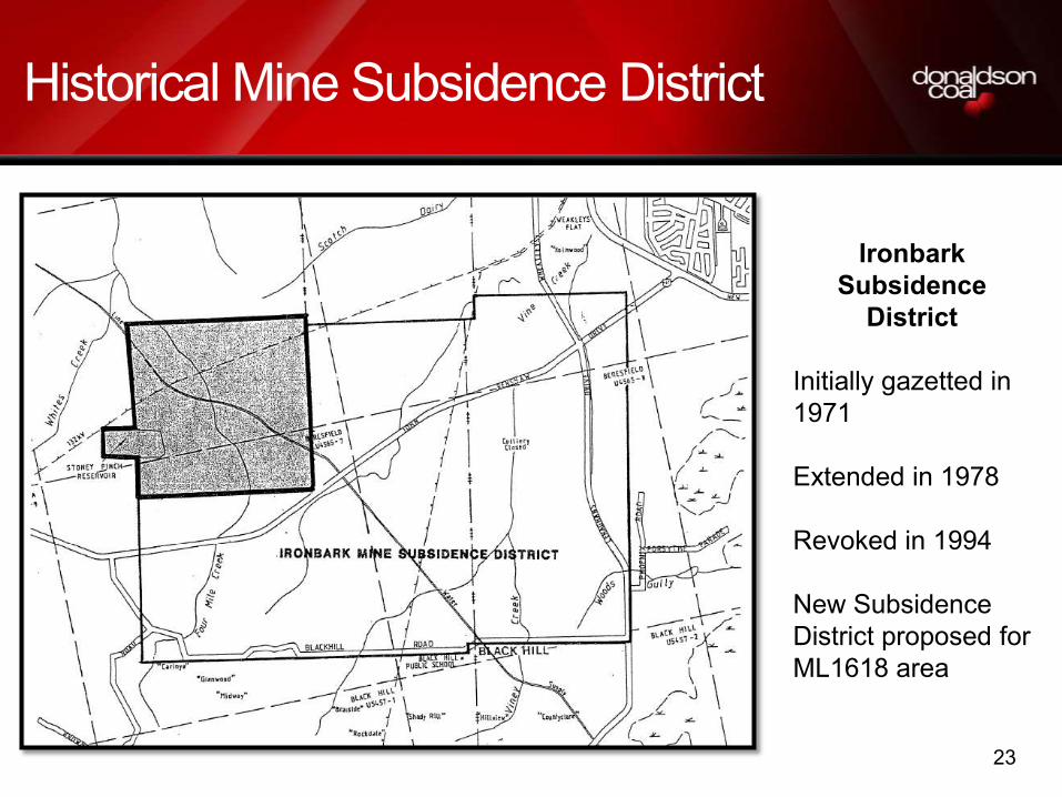
Historical Mine Subsidence District
Ironbark Subsidence
District
Initially gazetted in 1971
Extended in 1978
Revoked in 1994
New Subsidence District proposed for ML1618 area

24
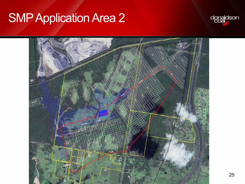
SMP Application Area 2
Embraces 221ha
Contains 6.3m tonnes of insitu
coal
Contains 3.7m tonnes of
recoverable coal
Is divided into 13 Panels & 2
areas of Main Headings
Has an operating life of ~3 years
Project Approval condition-
effective Subsidence to be
completed by June 2013
Depth of cover ranges from 95m
to 150m
Area to be re-classified as a
Subsidence District by MSB
25
SMP Application Area 2

26
SMP Area 2 Panel tonnages
Total Tonnes Length Metresdevelopment
tonnesextraction
tonnes Total
Panel 14 400 2,984 57,442 57,442 114,884
Panel 15 490 4,175 80,376 115,526 195,903
Panel 16 560 5,010 96,435 155,608 252,043
Panel 17 610 5,487 105,617 172,798 278,415
Panel 18 690 5,917 113,902 168,271 282,173
Panel 19 720 6,141 118,210 172,579 290,789
Panel 20 450 3,815 73,431 103,776 177,207
Panel 21 500 4,437 85,416 134,980 220,396
Panel 22 475 4,032 77,622 110,369 187,991
Panel 23 500 4,770 91,823 167,011 258,834
Panel 24 525 5,009 96,414 175,606 272,020
Panel 25 550 5,247 101,005 184,201 285,206
Panel 26 650 6,201 119,369 201,391 320,760
South East Mains 1100 7,403 142,508 237,616 380,124
Tailgate hdgs 1060 5,703 109,779 182,095 291,874
76,330 1,469,349 2,339,269 3,808,617

27
SMP Area 2 Schedule

28
Abel Mining Method
• Continuous miner based bord and pillar system
• Layout designed to minimise impact on sensitive surface areas while minimising resource sterilisation
• Panels 160m wide
• 4 heading layout
• 1st workings (Roadway development)
• Single Continuous Miner (CM) Unit (20-30m /shift)
• Dual CM Unit (35- 45m/shift)
• 2nd workings (Pillar extraction)
• 1,000 tonnes per shift
• 6 day rotating roster
• Depth of cover range 95m to 150m

29
Abel Typical Panel Layout - Panel 25
South Main Headings
Barrier Pillar 24.5m
Panel 25 M Devt Pillars
Time taken
1st workings 5,247m ~17 weeks
2nd workings 184,201t ~15 weeks
~32 weeks
550m

30
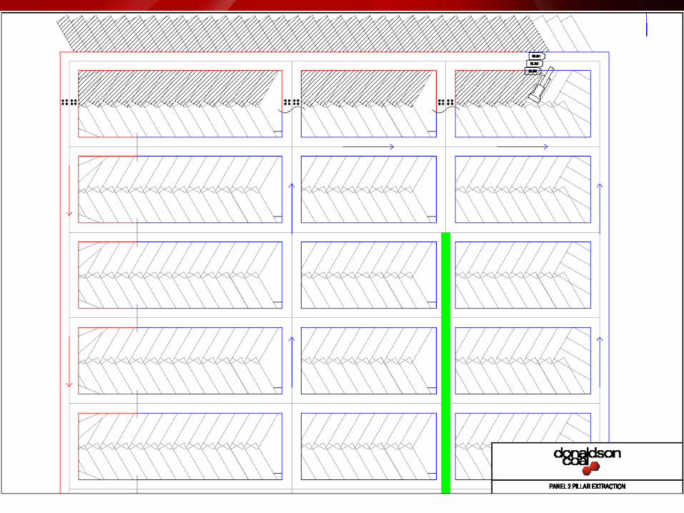
FIRST WORKINGS
Roadways driven to form pillars. Development of main headings and panel roads to establish access to the coal in the Pillar Extraction panels.

31

32

33

34

35
--------

36

37

38

39

40

41

42

43

44

45

46

47
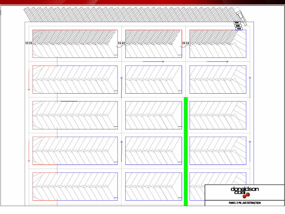
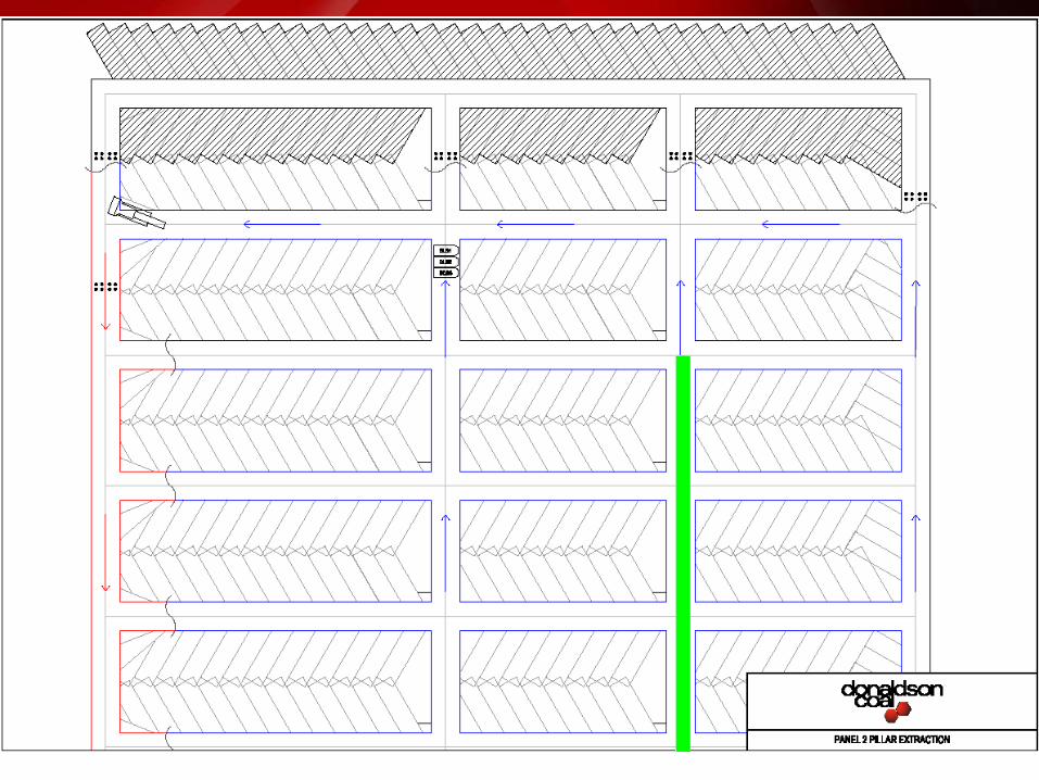
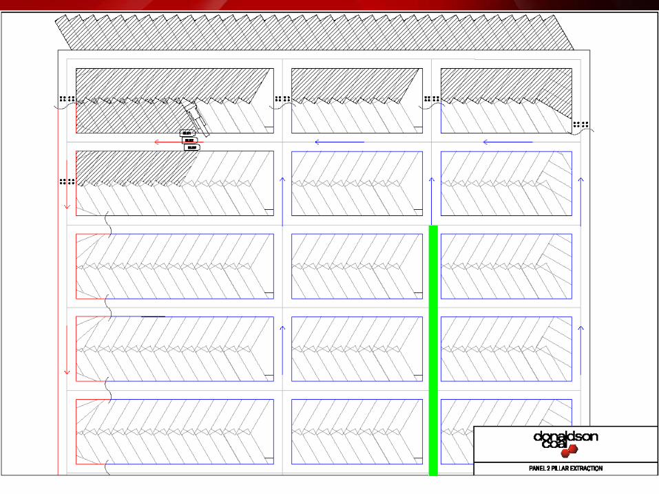
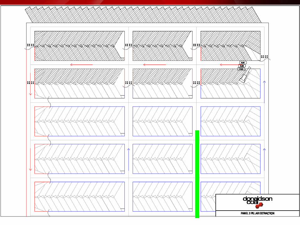
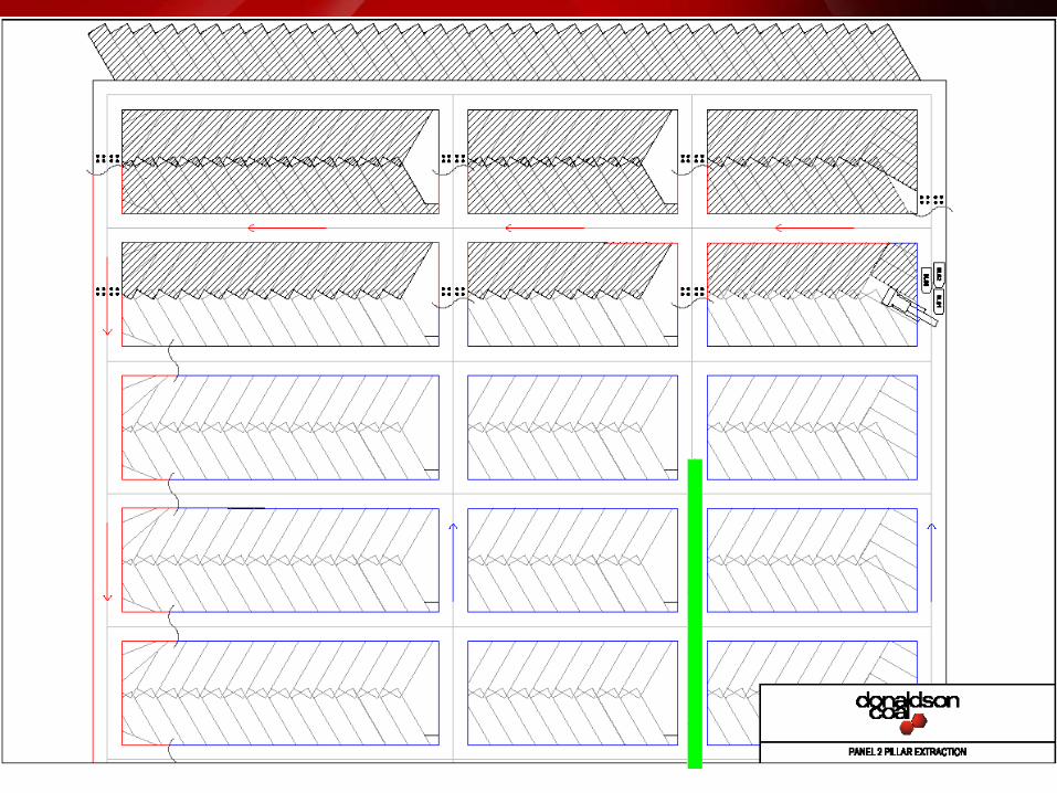
2nd WORKINGS
Once 1st workings Development is completed, 2ndary extraction commencesExtraction of coal from pillars formed during development

48

49
--

50

51

52

53

54

55

56

57

58

59
60
61

62

63
64

65

66

67

68

69

70
71

72

73

74

75

76

77

78

79

80

81

82

83

84

85

86
87

88

89

90
91

92

93
Surface Features
Abel Mine Lease- Full ML 1618 AreaPambalong Nature ReserveBlack Hill cemetryCliff LinesPrivate property and residences (100+)Numerous dams (approx 175)Black Hill schoolChurch and cemetryViney, Blue Gum, Long Gully, Buttai CreeksBoral Asphalt Plant (Black Hill Depot)Catholic Diocese LandC&A land (Black Hill Land Pty Ltd) Transgrid 330kVEA 132kV power lineRural 11kV power linesAboriginal ArtefactsTelstra/Optus Fibre optic cablesTelstra copper comms cablesHunter water pipelineAgility gas pipelinePublic RoadsState survey marksOverlying mine workingsDisused Richmond Vale railway lineBlack Hill & Stockrington Quarries
Abel Mine Lease- Area 1
Viney CreekBoral Asphalt Plant (Black Hill Depot)Catholic Diocese LandC&A land (Black Hill Land Pty Ltd) Transgrid 330kVEA 132kV power lineRural 11kV/415V power lines
Optus Fibre optic cables
Hunter water pipeline
Abel Mine Lease- Area 2
Private property (13) / Principal residences (4)2 x dams
Viney Creek
Catholic Diocese LandC&A land (Black Hill Land Pty Ltd) Transgrid 330kVEA 132kV power lineRural 11kV/415V power lines
Optus Fibre optic cablesTelstra copper comms cablesHunter water pipeline
Public Roads Black Hill Road, Taylors RoadState survey marks

94
SMP Area 2 – Key surface features
Viney Creek
Transgrid 330kV Power Line
EA 132kV/11kV Power Lines
Hunter Water buried pipeline
Optus Fibre Optic cable
Telstra cables
Black Hill Road and Taylors Road
Private Properties
Principles Residences

95
Surface Environmental Assessment
• Surface inspections and surveys conducted to identify features as part of EA Process including
• Flora/Fauna• Groundwater• Surface Water• Aboriginal & European heritage
• Monitoring programs as required by Project and SMP Approvals
• This information is reviewed and updated as part of each SMP Area submission
• Consultation with Landowners and Stakeholders
96
Area 1 Approval and Conditions, Management Plans, Monitoring Programs
Approval for Abel Area 1 SMP was obtained on 26 May 2010;Minor variations have been approved to the layout of Panels 1 and 2 due to geological structures encounteredVarious Management Plans / Programs have been implemented,
Subsidence Monitoring Program;
Environmental Management Plan;
Public Safety Management Plan;
Infrastructure Management Plans for Hunter Water Corporation and Energy Australia;
Draft Transgrid Management Plan; and
Draft Property Management Plans for both the Catholic Diocese and Black Hill Land P/L land.

97
Panel 1 progress to date
Commenced 12 July 2010Has retreated 150mPanel 2 to commence next week

98
Panel 1 Mining Notification to Landholder

99
Panel 1 subsidence predictions

100
Subsidence Results Panel 1, Impacts and Remediation
Panel Monitoring ItemSMP Prediction
For 156m wide PanelActual Survey Measurements to date
For 120m wide Panel
Panel 1 Subsidence 1.58 to 1.76m 1.10m (incomplete)
Strain 10-15mm/m 10-11mm/m
Tilt 38-53mm/m 47mm/m
Some further minor subsidence increase is anticipated as extraction of the Panel progresses
Panel ImpactsSMP Prediction
For 156m wide PanelActual Impacts to dateFor 120m wide Panel
Panel 1 Surface cracking 100-150mm 180-200mm across road only (remediated)
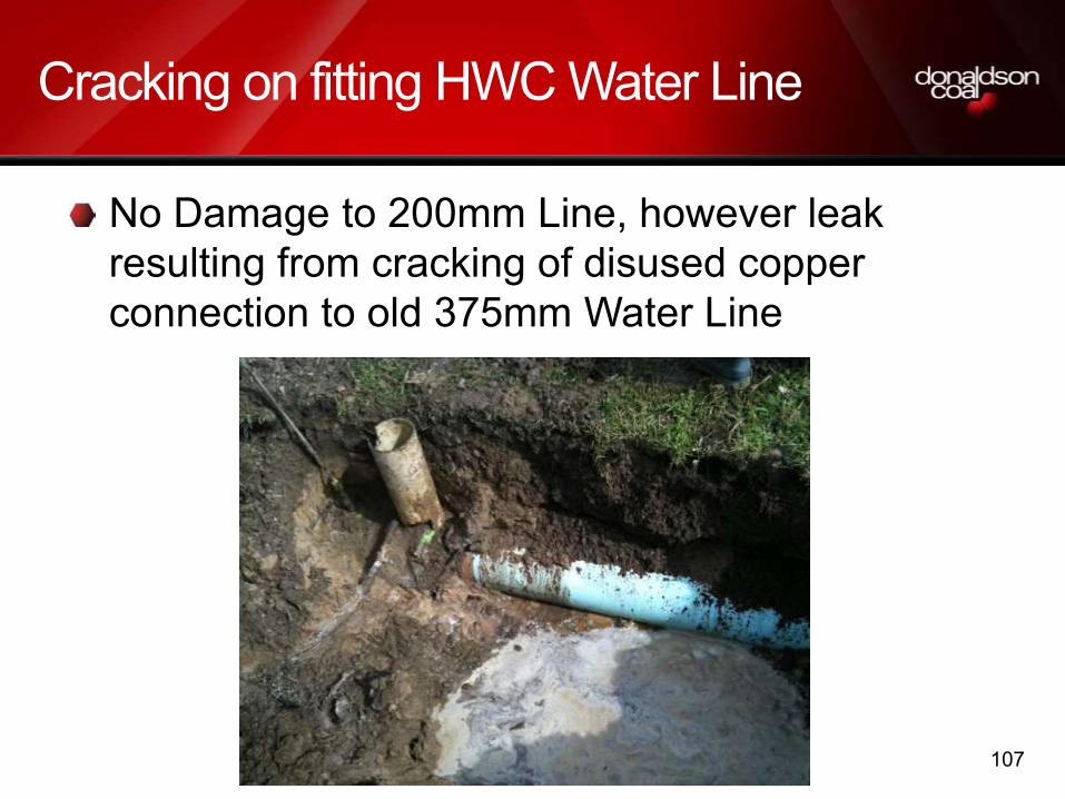
Water Line (HWC) Potential to be assessed by HWC
Minor crack on fitting fed from the HWC 200mm line
(remediated in accordance with HWC MP)
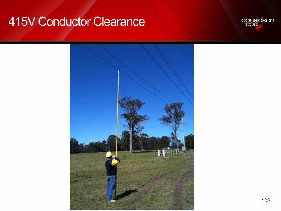
Power Line (EA) Potential for clearance loss was identified
Clearance loss on EA 415V line was observed and EA notified (remediated in accordance with EAMP)
Monitoring
Impacts

101
Subsidence cracking on access track

102
Subsidence cracking on access track
103
415V Conductor Clearance

104
415V Conductor Clearance

105
415V conductor lifting

106
11kV Power pole repairs
107
Cracking on fitting HWC Water Line
No Damage to 200mm Line, however leak resulting from cracking of disused copper connection to old 375mm Water Line

108
Subsidence Prediction Methodology
Several industry established empirical models were used to predict the maximum subsidence impact parameters and profiles for the given mining layouts. The predictions involved the following work:
(i) The development of a geotechnical model for the study area.
(ii) Review of Stage 1 results to date.
(iii) Prediction of maximum panel and barrier pillar subsidence and profiles using the DgS
Modified ACARP, 2003 subsidence model.
(iv) Subsidence, tilt, strain, horizontal displacement contours using SDPS® 3-D influence
function software.
(v) Post-mining topography, potential cracking width, ponding location and surface
gradient change contours were estimated using Surfer8® contouring software.
(vi) Estimation of sub-surface fracturing heights above the panels using empirically based
models in ACARP, 2003, Forster, 1995 and Mark, 2007.

109
Subsidence Prediction Outcomes
For the 125 m to 160 m wide panels with mining heights of 2.4 to 3.7 m and cover depths of 95m to 150m, the predicted key subsidence impact parameters include:
• Final maximum panel subsidence between 42% and 51% of the mining height e.g. 1.0m to 1.90m.
• Final barrier pillar subsidence from 0.04 m to 0.21 m
• Maximum possible surface cracking widths of between 50 mm and 200 mm and tapering to depths of 5 to 10 m (likely to be mitigated by surface clays/weathered shales). Most cracks likely to be ‘self healing’ or may not develop at surface at all.
• No cracking or ponding expected along Viney Creek, due to buffer zone.
• Engineered solutions required for man-made features.

110
Subsidence Impact Parameters
• vertical subsidence (m)rarely a direct concern, except when adjacent to water bodiesor flat terrain with watercourses (i.e. ponding)
Final maximum panel subsidence ranges from 1.0m to 1.9m for the given mining geometries.
SCZs will limit subsidence to <20mm
Ref: MSB Guidelines
111
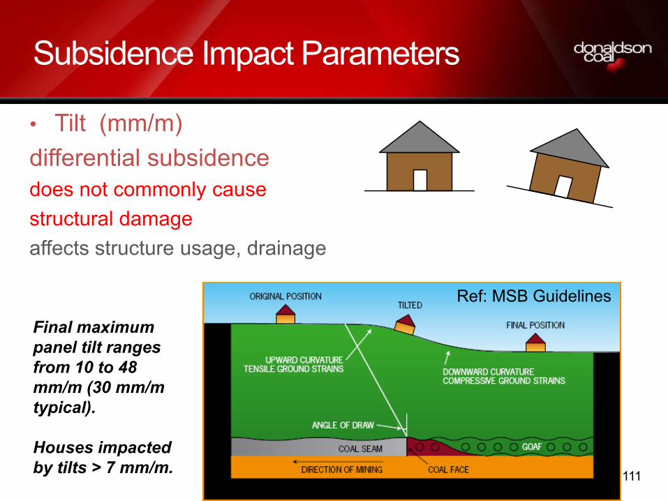
Subsidence Impact Parameters
• Tilt (mm/m)differential subsidence does not commonly cause structural damageaffects structure usage, drainage
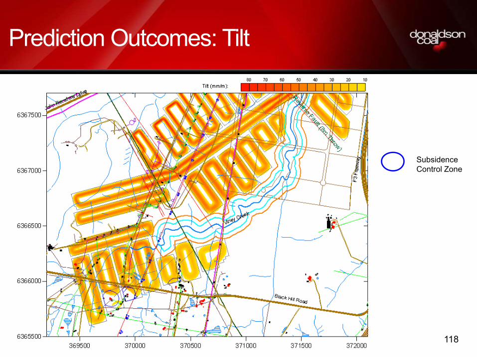
Final maximum panel tilt ranges from 10 to 48 mm/m (30 mm/m typical).
Houses impacted by tilts > 7 mm/m.
Ref: MSB Guidelines
112
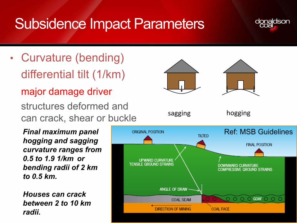
Subsidence Impact Parameters
• Curvature (bending)differential tilt (1/km)major damage driverstructures deformed and can crack, shear or buckle sagging hogging
Final maximum panel hogging and sagging curvature ranges from 0.5 to 1.9 1/km or bending radii of 2 km to 0.5 km.
Houses can crack between 2 to 10 km radii.
Ref: MSB Guidelines

113
Subsidence Impact Parameters
• horizontal strain (mm/m)tensile or compressiveassociated with curvatureand has similar damageoutcomes
Final maximum panel tensile and
compressive strain ranges from 5 to 20
mm/m (10 mm/m typical) .
Houses can crack > 3 mm/m
tensilecompressive
Ref: MSB Guidelines

114
Prediction Input: Cover Depth
SubsidenceControl Zone

115
Prediction Input: Mining Height
SubsidenceControl Zone

116
Prediction Outcomes: Subsidence

117
Predicted Subsidence at Principle Residences
Subsidence Control Zone
118
Prediction Outcomes: Tilt
Subsidence Control Zone

119
Predicted Tilt at Principle Residences
Subsidence Control Zone

120
Prediction Outcomes: Strain
Subsidence Control Zone

121
Predicted Strain at Principle Residences
Subsidence Control Zone

122
Prediction Outcomes: Surface Gradients

123
Sub Surface Fracturing Assessment
The ACARP, 2003 model predicts that heights of continuous sub-surface fracturing for the proposed mining heights are > 10 m below the surface for cover depths >100m.

124
Abel Subsidence Development Rates –Area 1
-1.2
-1.1
-1
-0.9
-0.8
-0.7
-0.6
-0.5
-0.4
-0.3
-0.2
-0.1
0
0.1
-5 -4 -3 -2 -1 0 1 2 3 4 5 6 7 8 9 10S
/Sm
ax
Time after undermining (weeks) Predicted (Retreat Rate = 32m/week) Measured Maximum on CL End of Primary Subsidence (r=32m/week)
Effective Subsidence (i.e. 90-95% Smax) complete 6 to 8 weeks after undermining
Note:Final 5-10% Smax will occur afteradjacent panels are extracted and develop over similar time frames.
Subsidence development affected by panel startingend (i.e. delayed goafing) and mine stoppage on 9/8/10for 2 weeks

125
SMP Area 2
Surface above application area comprises a combination of land owned by Black Hill Land Pty Ltd, the Catholic Diocese of Maitland and Newcastle, a narrow strip traversing the area owned by Hunter Water Corporation, ten private properties and two public roads;
Man made and natural features potentially impacted by subsidence arising from mining this area, are
Catholic Diocese of Maitland / Newcastle land, Stock water supply line; access roads and tracks; various fences, Principal Residence, disused, unoccupied residences – Property Management Plan to be prepared;Black Hill Land Pty Ltd land, access roads and tracks – Property Management Plan to be prepared;

126
Key features
Private properties and Principal Residences – Property Management Plans to be prepared – to include Mine Subsidence Board inspection, Dam Monitoring & Management Strategy and also consideration of outbuildings and other improvements as `other surface structures’. Discussions will also be held, as part of the SMP application preparation with property owners and the MSB regarding mitigation / rehabilitation and responsibilitiesBlack Hill Road – Management Plan to be prepared in consultation with Cessnock City CouncilTelstra Copper cables – Management Plan to be prepared in consultation with Telstra.Hunter Water Corporation water pipeline – Existing Infrastructure Management Plan to reviewed;Energy Australia rural 11kV and 132kV power lines – Existing Infrastructure Management Plan to reviewed;

127
Key features
Transgrid 330kV power line – Existing Infrastructure Management Plan to reviewed;Optus fibre optic cable – continued discussions relating to relocation and/or Management PlanLayout of the panels has been designed to provide management outcomes of subsidence impacts in line with the Statement of Commitments and Project ApprovalMaximum predicted subsidence in the application area ranges between 1.0m and 1.9m Maximum predicted strains from 5 to 20mm/m, and Maximum predicted tilts from 10 to 48mm/m excluding areas nominated to be protected.

128
Private PropertiesTiming Various
Detail Property Management Plan to be prepared in consultation with Property owner and MSB.Any Principal Residences to be assessed in accordance with Project ApprovalA Dam Monitoring and Management Strategy (DMMS) will be developed if required.

129
Typical Private Property Infrastructure
Principal residence
Dam
Power lines
Other Features eg Sheds
Comms cable

130
Typical Private Property Infrastructure

131
Dams
A Dam Monitoring and Management Strategy (DMMS) will be developed for all dams prior to any mining impact.

132
Catholic Diocese LandTiming Extraction- Panel 19
Detail Cattle agistment and stock watering system. Principal Residence area.
Property Management Plan Draft completed
Access agreement In place
Mining schedule agreement In place

133
Catholic Diocese Land
Irrigation system for cattle agistmentFences/gates/cattle gridsCattle yards/Holding yardsAccess tracks
133

134
Black Hill Land Pty Limited
Timing Extraction- Panel 18
Detail Black Hill Land P/L is seeking concept plan approval for industrial development
Property Management Plan Draft completed
Access agreement To be Developed
Mining schedule agreement Draft completed

135
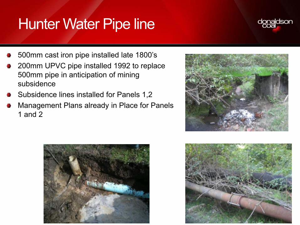
Hunter Water Pipe line
Timing Panel 21
Detail 200mm UPVC installed in 1992
Back up supply to Minmi area
Can be shut down for extended periods
Management Plan Current plan to be reviewed for Area 2
136
Hunter Water Pipe line
500mm cast iron pipe installed late 1800’s200mm UPVC pipe installed 1992 to replace 500mm pipe in anticipation of mining subsidenceSubsidence lines installed for Panels 1,2Management Plans already in Place for Panels 1 and 2

137
Energy Australia Power Lines
Timing 11kV Panel 26132kV Panel 19
Detail 11kV Feed to Black Hill132kV Feed to Beresfield
Management Plan To be reviewed for Area 2
Consultation/Inspection Continuing

138
Energy Australia 132kV Power Line
• Installed 1960’s• Feed to Beresfield area from Killingworth 330/132kV sub station• Critical power supply• Steel channel cross arm• 3 power conductors and 2 Earth wires•Spacing at ~200m across SMP area•Management plan to be developed in consultation with EA to ensure serviceability of power line•Timing Panel 19

139
Transgrid 330kV Power Line
Timing Panel 19
Detail Major feed to Tomago
Management Plan To be developed.
Consultation Continuing relating to cruciform footings

140
Transgrid 330kV double circuit steel towers
• Installed in 1982/1983• Critical feed to Tomago area• 5 suspension towers in SMP Area 2• Key issues
• Vertical displacements may reduce clearance from ground surface and lead to infringement of statutory requirements for clearance of transmission lines (6.7m)• Horizontal displacement and tilt may affect the alignment and tension of the transmission lines
• Management plan to be developed in consultation with Transgrid to ensure serviceability of power line• Timing Panel 19

141
Transgrid 330kV double circuit steel towers
Cruciform footings• Cruciform footings installed under suspension towers in 1982 in anticipation of future U/G Mining•Designed to withstand 9.1m of sub from multi level seams• The footing acts to tie the legs of the tower together to prevent spreading and to prevent the transfer of ground strains into the structure itself• The size of the footing is such that the mass can prevent overturing of the tower in the event of extreme loading• Similar towers in Newcastle district have been subsided 2m• MSB have reported that their success has led to significant reserves of coal beneath towers being mined

142
Optus Fibre Optic cable
Timing Panel 19
Detail Sydney to Brisbane
Management Plan To be developed.
Consultation/Inspection Pre mining audit of cable completed.Investigating possible relocation.

143
Optus Fibre Optic
Installed adjacent to Transgrid 330kV line in early 1980’sCable directly buried underground Designed to tolerate subsidence parameters based on F3 easement
150mm subsidence1.0 mm/m strain
Optus have own internal Management plan (similar to ones developed with other local mining companies)Donaldson Coal and Optus consulting on relocation and/or Management PlanTiming – Panel 19

144
Viney Creek
Timing Panel 19
SCZ 40m from 20mm subsidence limit to the bank
Management Plan 1st workings MP to be developed

145
Viney CreekSchedule 2 Creek (as per Strahler system)Viney Creek flows through the SMP area from south to north. It flows under John Renshaw Drive and eventually discharges into Woodberry Swamp, a wetland system of the Hunter River estuaryEphemeral flowHeavily vegetated, and in places is heavily choked with weeds and reedsDepth of cover 115m to 120m in subject areaAs per Project approval, protected by 40m barrier from stream banks to the 20mm vertical subsidence contour

146
Viney Creek

147
Viney Creek
The stream has a high capacity to reduce erosion effects from subsidence due to its significant natural and introduced (weed/reed) vegetative coverIn accordance with Project Approval Donaldson may undertake further extraction within this barrier should further studies indicate that such extraction can take place without compromising specified environmental objectivesFinal degree of extraction will depend on an iterative monitoring / assessment / prediction of a suitable degree of extraction under the creek based on observation of prior mining in similar geomorphology / mining layout / depth of cover etc situations in prior panels away from the creek.Timing Panel 19
148
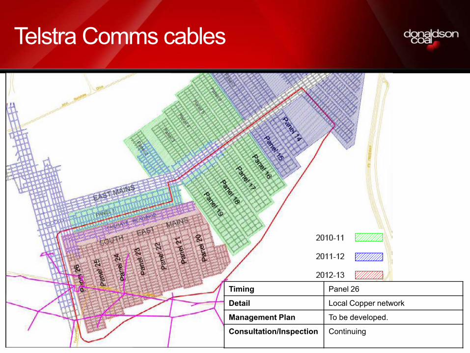
Telstra Comms cables
Timing Panel 26
Detail Local Copper network
Management Plan To be developed.
Consultation/Inspection Continuing

149
Black Hill Road
The Company shall prepare and implement a Management Plan in consultation with Cessnock City Council. This plan of management will ensure the safety and serviceability of Black Hill and Taylors public roads

150
Proposed Monitoring
Subsidence monitoring consisting of surveys, photographic and visual monitoring, including Principal Residence inspection and surveys;Dam and other improvement monitoring, pre and post mining surveys;Ecological monitoring, fauna and flora;Surface and groundwater monitoring;Infrastructure monitoring, survey, photographic and visual.Flora – specialist consultantFauna – specialist consultantGroundwater – piezometers – specialist consultantSurface water- flow, water qualitySubsidence surveysVisual inspectionsPhotographic records

151
Subsidence Monitoring
Typical Subsidence Monitoring Program for Pillar Extraction Panels • Approved by Industry & Investment NSW• Panel length ranges from 400m to 1,100m• Centre and cross line survey marks typically at 10m centres• Feno survey markers used for SMP Area 1 • Removed after effective subsidence completed

152
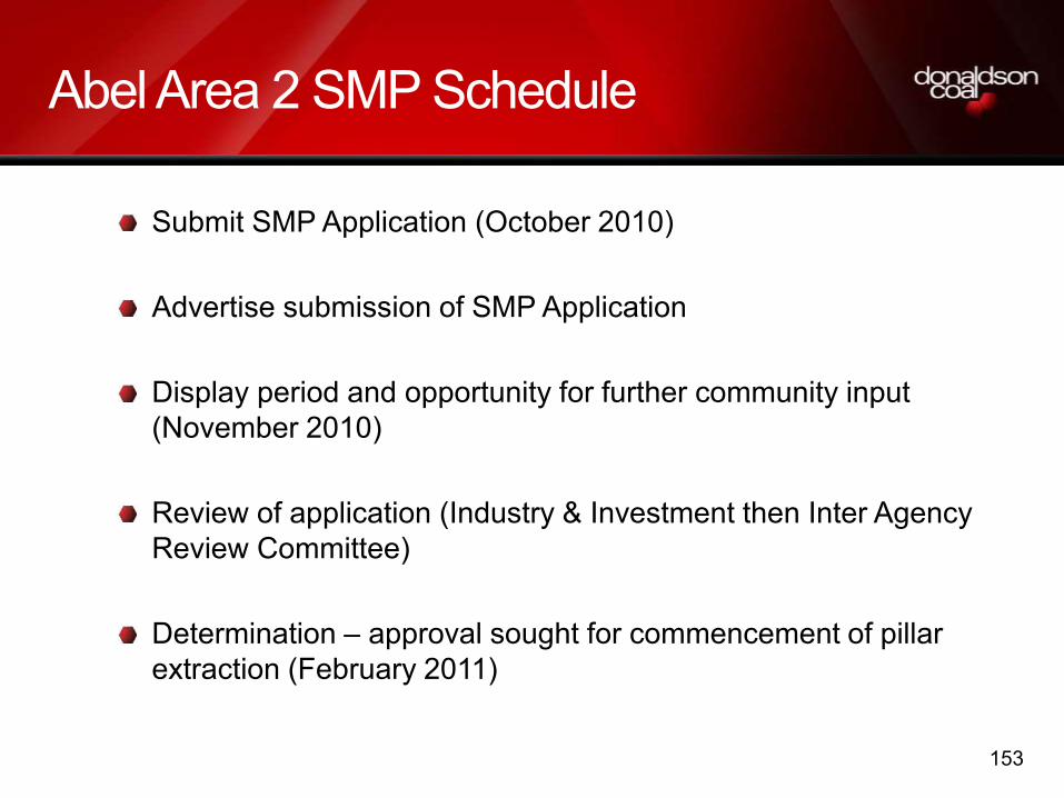
Abel Area 2 SMP Schedule
Consultation commenced in CCC meeting 2010 and will continue throughout the preparation of the SMP application with
Industry & Investment and relevant agenciesAbel Community Consultative CommitteeLandholders, andInfrastructure owners
Following this presentation and field inspection a Risk Assessment will be conducted to assess all risks and will include items raised from today. A member of the CCC will be in attendance.
Preparation of the SMP Application will then continue with the aim to lodge the document in mid October 2010.
153
Abel Area 2 SMP Schedule
Submit SMP Application (October 2010)
Advertise submission of SMP Application
Display period and opportunity for further community input (November 2010)
Review of application (Industry & Investment then Inter Agency Review Committee)
Determination – approval sought for commencement of pillar extraction (February 2011)

154
Site Inspection SMP Area 1 Panel 1
Page 1 of 2
ABEL UNDERGROUND COAL MINE
SMP Area 2 Stakeholder Meeting
Thursday 9th September 2010 (9am to 1pm) Abel Underground Mine Administration Building
Minutes
1. Opening and welcome – Tony Sutherland (Technical Services Manager – Underground Operations
2. Attendees Terry Lewin (Abel Mine CCC member), Carol Fraser (Resident), Noel & Daphne Blanch (Residents), Peter Allen (Resident), Rodney Lodge (Resident), Rod Taylor (Resident), Bruce & Joyce Doyle (Residents), Anne Clark (Resident), Doug Clark (Resident), Rosalie and Anthony Seton (Residents), Garry Moore (Mine Subsidence Board), Bruce Fraser (Transgrid), Brian Magin (Transgrid), Damien Harrigan & Sean Scanlon (Catholic Diocese of Maitland-Newcastle), Rod Sandell (Cessnock City Council), Steve Ditton (Ditton Geotechnical Services), Geoffrey Rock (Coal & Allied), Jonathon Smith (Industry & Investment NSW), Ray Ramage (Industry & Investment NSW), Colin Dove (Telstra Consultant), Johannes Honnef (Newcastle City Council), Andrew Fulton (Aquaterra), Kevin Price (Brunskill Pty Ltd), Mark McPherson, Adam Heeney, Phil Brown, Tony Sutherland, Alison Freeman (Donaldson Coal)
3. Apologies Alan Brown (Abel Mine CCC member), Karen Marler (DECCW), Mark Schneider (Telstra)
4. Meeting agenda
A PowerPoint presentation (see copy on web site) was then delivered by Tony Sutherland covering the agenda items below with Steve Ditton from Ditton Geotechnical Services giving an overview on the subsidence results from SMP Area 1 and the subsidence predictions for SMP Area 2.
• Introduction and Meeting Objectives • Donaldson Coal Background • The Subsidence Management Plan (SMP) Process • Abel Mine
o Project Approval o Mine Planning o Mining Methods o Area 1 o Area 2 o SMP Area Surface Environment Assessment
• SMP Area 1 Approvals and conditions, Management Plans, Monitoring Programs • Panel 1 (SMP Area 1) Progress to date

Page 2 of 2
• Subsidence Results Panel 1, impacts and remediation • SMP Area 2 Key surface features
Man made and Natural features potentially impacted by subsidence, including o Properties o Roads o Powerlines o Waterlines o Dams o Other infrastructure
• Abel SMP Area 2 Subsidence Assessment and Predictions • Abel SMP Area 2 Subsidence Impacts • Abel SMP Area 2 Proposed Subsidence Monitoring • Abel SMP Area 2 Mining Schedule
5. Surface Filed trip
A Field Visit of the surface areas was then undertaken of SMP Areas 1 & 2 as per attached plan. The surface area where Panel 1 had undermined was pegged out to show both the areas where the surface had already been undermined by Panel 1 and where some of the Panels of SMP Area 2 were located.
6. Lunch/ open forum
Lunch was provided on return to the mine site and an opportunity provided for informal discussions on any items for consideration in the SMP Area 2 preparation. No issues were raised.
The meeting was closed at 1pm.