APPENDIX D SPECIALIST REPORTS D1 – ENGINEERING INFORMATION ... · appendix d specialist reports...
15
APPENDIX D SPECIALIST REPORTS D1 – ENGINEERING INFORMATION D2 – BOREHOLE TESTS D3 – PRELIMINARY HERITAGE IMPACT ASSESSMENT
Transcript of APPENDIX D SPECIALIST REPORTS D1 – ENGINEERING INFORMATION ... · appendix d specialist reports...
APPENDIX D
SPECIALIST REPORTS
D1 – ENGINEERING INFORMATION
D2 – BOREHOLE TESTS
D3 – PRELIMINARY HERITAGE IMPACT
ASSESSMENT

D1 – ENGINEERING INFORMATION

G SQUARED PROJECT MANAGEMENT (PTY) LTD
REG. No. 2009 / 011799 / 07
OFFICE IN PORT ELIZABETH OFFICE IN JEFFREYS BAY
1 Kingston Road Adcock Vale 77 Silvertree Street
P.O. Box 27719 Greenacres 6057 Jeffreys Bay
Tel: 041 374 1551 Cell phone: 083 656 0708 (Diane) - Architectural
Fax: 086 546 1324 Cell phone: 084 444 9478 (Don) – Civil Engineering
E-Mail: [email protected] VAT Registration No. 4040253454
Your Ref: Our Ref: DP 3486 Mentors Development
Your Fax: Date: 19 July 2016
PROPOSED WAREHOUSING DEVELOPMENT
WATER SUPPLY
The existing boreholes were tested for pump yield by Steyns Drilling and it was
reported that borehole number 1 was run dry within 15 minutes and they recommended
that the borehole be cleaned. This borehole will be cleaned, and will be used as a stand-
by borehole in the future. Borehole number 2 yielded a constant flow of 5.2 litres per
second, which is sufficient to supply the existing facilities as well as the proposed
warehousing development. We have calculated that the borehole number two needs to
be pumped for two hours every second day to easily satisfy the demand. Drawing
DP3486/001, showing the complete site is enclosed under separate cover, for your
information. The borehole report is also enclosed under separate cover.
Borehole Number Max. annual Supply capacity Max. Daily Supply Capacity
Borehole 1 Stand-by Stand- by
Borehole 2 13,665 million litres/annum 37,440 litres/day
TOTAL 13,665 million litres/annum 37,440 litres/day
Facility Annual demand Daily demand
Mentors Plaza 6,24 million litres/annum 17,143 litres/day
Mentorskraal Country Estate Included in above Included in above
Any other use (livestock,
domestic, irrigation etc.)
Included in above Included in above
Proposed warehousing 5,24 million litres/annum 16,800 litres/day
TOTAL 11.48 million litres/annum 33,943 litres/day
SEWAGE / EFFLUENT
The farm Mentorskraal is in the process of being connected to the municipal sewerage
system, and will not have need of conservancy tanks. We will connect to the municipal
supply using 110 diameter soil pipes.

DIRECTOR: D. E. GARCIA Pr. Arch T AMSAIAT
ELECTRICITY SUPPLY
Each warehouse unit will be supplied with 3-phase electricity, connected to a nearby
400A municipal supply point. The power will be conveyed from the supply point
underground to the facility.
The capacity of these lines will be 315KVA.
WAREHOUSE DESIGN
A total of 40, 000 m² of warehousing is proposed, as per drawing DP3486/001 showing
typical construction details for the steel framed portal framed structure is enclosed
under separate cover. The warehouses will be clad with galvanized steel sheeting (Roof
and walls) with roller shutter access doors and industrial type windows providing
adequate natural lighting and ventilation. The warehouses may be portioned with brick
walls to make up different sizes of rent-able units to suit the demand from the industry.
There will be no back-up electricity supply.
Yours faithfully
D. B. Garcia Pr. Eng (Pr. No. 930170) PSAT (ST0722)
Senior Project Engineer
Structural Division
G Squared Project Management (Pty) Ltd
PROUDLY BEE COMPLIANT web page: www.g-squaredpm.com

D2 – BOREHOLE TESTS

www.steynsdrilling.co.za
PO Box 15354, Emerald Hill
PORT ELIZABETH, 6011
Phone (041) 372-1117 Fax (041) 372-
1811
E-mail: [email protected]
RE: Report for pump yield of Boreholes at Mentos Kraal
Borehole One (Bottom hole)
Pump was started and run dry within 15 min. Restart it in 10 min and it pumped 1 min before it ran dry
Recommend to clean the borehole
Borehole 2 (Borehole at gate)
Started the pump and tested the flow at 5.2 l/s
The yield was tested again after 30 min and 5.2l/s was measured again
After 30 yield was tested and remain constant
It seems as this borehole is a constant flow
If more tests or information is needed contact me at Cell 0824138118
Regards
Christo Steyn
MD Steynsdrilling

D3 – PRELIMINARY HERITAGE IMPACT
ASSESSMENT
20m -fJ!J c 9
ZョZZH Bヲ ャ セ イZZG@ 'r i::c-:-'\ "';'::r; セMMBGMM Q@MINE R A L!: ,.. Gセ LML@ !:>.' , " ;",
dl IB セNセ セセ セ[[セ@ ゥセZセ・MGセZGセG@ Lセゥ@ • ZセセZLIZL セ@
) ウセ L U ]@ _BGoセmBGGG@ Sowm"
? .
l ⦅Lセ セセ[ I ス セL [セZ サエ セセ イ セ セ@
PRELIMINARY HERITAGE IMPACT ASSESSMENT
PREPARED FOR:
MENTOORSKRAAl FAMilY TRUST
P a BOX 108
JEFFREYSBAY
6330
Tel. & Fax: 041 3672049 . Cell 0824140464/0824140472 . 4 Josephine Avenue LOR BAINE 60'/0
Member; J. A. van As: B.Se (Botany & Zoology), B.Se (Hons) (teo-PhYSiology), M.Sc (Plant Phy"ology)
Consultant: N. Sharp BSe (Botany & Zoology); BSe (Hon» (Limnology) & M.Sc. t"VHonm"Htd l mNャGQNャァセQh@

INTRODUCTION AND BACKGROUN D
The applicant, headed by Mrs. J.P.J. Hancke, is involved in Real Estate development. The proposed
mining site and immediate surrounds is earmarked for future development as either residential or
retail properties and will require a flat and stable platform. Currently the proposed mining area
constitutes a ridge on the landscape with land falling away on the western and eastern sides. In
order to achieve the mentioned goal it is essential that any future mining must be conducted from
the northern property fence towards the south and that old sites be levelled, which will be achieved
through ripping and limited blasting. In addition, the applicant is also involved in
construction/upgrading of minor access roads and requires weathered sandstone for this purpose.
The Jeffreys Bay and Humansdorp area experiences currently an extensive shortage of weathered
sandstone material for developl\lent of small enterprises, shopping malls and residential
developments. Currently there is no weathered sandstone quarry in the Jeffreys Bay area as the town
only disposes of a sandstone conglomerate quarry producing aggregate on the farm Vlakteplaas, 8km
east of Jeffery's Bay. It is therefore essential that this weathered sandstone material be made
available to construction and buildil'lg contractors in the area, as this material has to be transported
at high costs from far away sites outside Humansdorp and Port Elizabeth .
Currently the closest registered quarry concern that can produce similar material is situated more
than lskm east of Jeffrey's Bay, but ionly in limited quantities as the reserves of Swartenbosch Quarry
constitute mainly massive アオ。イエコゥセゥ」@ sandstone. The poor availability of weathered sandstone
therefore guarantees a large market which in turn will ensure a financial sustainable quarry concern.
The development activities of the ITrust will also benefit extensively from the legalization of the
quarry.
Since the site is earmarked for future development, the area applied for will not be mined to greater
depth and additionally the rock becomes almost solid below Sm. The applicant is not interested in I
entering the aggregate market. HOVl(ever, if Dendron Quarries manages to secure a niche market, it is
the agreement that the applicant will apply for a mining right on the historic mined out areas, with
the end objective to establish the flat platform for development proposes.
PERSONAL PARTICULARS OF THE APPLICANT
APPLICANT
Mentoorskraal Family Trust
POBox 108
Jeffrey's Bay
6330
Tel: 042 293 2740 Fax No. 0420293 2561
II Page @Stellenryck [nvironmental Solutions

SURFACE OWNER
Mentoorskraal Family Trust
POBox 108
Jeffrey's Bay
6330
Tel: 042 293 2740
TITLE DEED DESCR IPTION
Fax No. 042 293 2561
Portion 2 of the Farm Mentoorskraal 1336, Humansdorp division .
I I
LAND DESCRIPTION / INFORMATION
REGIONAL SETTING
I The proposed quarry is situated in the magisterial district of Humansdorp and is under control of the
Kouga Municipality. The quarry is /situated approximately 3.7 km north-west of Jeffrey's Bay and
300m north from the N2. The site is situated in a rural area surrounded by small farms.
21 Page @Stellenryck Environment;)\ Solutions

MINING METHODOLOGY
The first step in the mining process セ ゥャャ@ be the removal of topsoil and storage thereof on the northern
perimeter of each mining phase. This will be followed by the removal of the red gravel horizon
(l,Sm) that will mostly be used for internal road construction on the farm and properties developed
by the Trust. The red gravel material will be excavated by excavator and directly loaded on tipper
trucks to road construction sites or stockpiled onsite for later use during the development of this
portion of the farm . The next phasJ will comprise the ripping of moderately weathered sandstone to
a depth where refusal conditions are experienced (l,Sm). The material will be stockpiled for use at
the Trust's development sites and sble to Dendron Quarries, which will secondary crush the material
at an offsite premises to specificati!on but crushing will depend on the degree of weathering of the
material. The final activity will 「 セ@ the drilling of boreholes to a depth of approximately 3m and
charged with small amounts of explosives to improve the penetrability of the material. The material
will be sold to Dendron Quarries セ ッイ@ single stage off-site crushing. Some of this material will be
bought back from Dendron Quarries.
1 .
o · BQ BUセ@
, -'0
'.
BG セ@1"'''<
1
BGセBGGGNゥ@ I
Figure 2: Mine layout plan
I CONSTRUCTION PHASE
/
B
N
+ /'
".,1Il r
Construction activities will involvel the removal of a limited amount of topsoil and grass cover that
will be stored on the western and northern boundaries of the site.
The Jeffrey's Bay road will be use) as service road and access will be from it. The both the access and
the public road are in very good co セ 、ゥエゥッョ@ and does not required any upgrading. .
31 Page `sエ・ャャ・ョ イケ 」セ@ Environm e ntal Solutions

\
I i I I I
No office infrastructure will be established in the mining area. No Eskom and Telkom service points
are required. No weigh bridge will be constructed and material removed will be sold per volume to
prospective clients. No ィケ、イッ」。イ「ッセ@ storage facilities will be constructed since refuelling will be in
town . Waste disposal will be through depositing waste in strategically positioned containers fitted
with scavenger proof lids and will be/removed on a regular basis.
GEOLOGY
Both the old and the new mining I site are underlain by quartzitic sandstone of the Skurweberg
Formation of the Table Mountain Group of the Cape Supergroup. According to the geological map I
(3324 Port Elizabeth) published by the Council for Geoscience the study area is underlain by
quartzitic sandstone bedrock of the Skurweberg Formation with feldspathic sandstone and shale of
the Baviaanskloof Formation to the Inorth-east and south- west. Both of these formations form part
of the Table Mountain Group of the Cape Supergroup. I
Jeffreys Bay is located on the ・。ウエ・ セ ョ@ limb of a large syncline (n-shaped fold) that plunges towards
the south-east (seawards). The outt rop encountered in the study area represents the higher-lying
central component of this イ・ァゥッョ セ Q@ anticline and includes the oldest stratigraphic unit (i.e. the
Skurweberg Formation footprint) in <the area.
I <-The fold nose to the south-east of the study area represents an area characterized by a high Tracture
density and makes perfect sense h om a structural geological perspective to sight groundwater
boreholes. The break in slope associated with the above geological formations (and considerable
variation in topography and weath!!ring profile) is also a very good setting for the development of
springs and seeps, which would be :very active after significant wet conditions. Such break in slopes
and natural springs were not noted in the vicinity of the Mentorskraal Quarry during the site
investigation .
The Table Mountain Group rocks along the Kouga coastline have been eroded by marine action
during palaeo sea levels to form a :relatively flat marine terrace, which slopes marginally seawards.
The geomorphological terrain, therefore, is characterized by a regional, gentle south-easterly sloping
terrace. The regional topographic profile across the study area is dominated by the higher-lying,
erosion resistant Skurweberg Formation, which forms the prominent high ground in the region. The
shallow weathering profile of thisl Skurweberg Formation is the target material at Mentorskraal
Quarry. '
SKURWEBERG FORMATION
The Skurweberg Formation of the Nardouw Subgroup, Table Mountain Group of the Cape
Supergroup dominates the high-Iyihg ground on the north-western outskirts of Jeffreys Bay and the
study area. This formation general,ly comprises a thickly bedded, medium to coarse-grained, white
weathering quartzitic sandstone with thicknesses of up to 400 metres in the region .
This formation is eaSily identified ill the study area as the topographical high ground and short Grassy
Fynbos vegetation cover. It appears to have an orange-brown and red-brown weathering profile with ,
highly weathered outcrop exposed at depths of between 0,3 and 2,0 metres below surface at
41 Page @Ste ll enr y ck E nvir onmenta l Solutio n s
\ I I I I I i I I I I I
Mentorskraal Quarry.
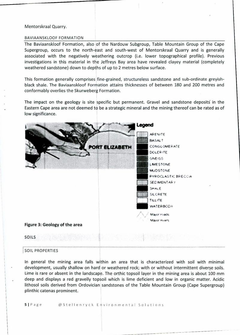
BAVIAANSKLOOF FORMATION
The Baviaanskloof Formation, also of the Nardouw Subgroup, Table Mountain Group of the Cape
Supergroup, occurs to the north-east and south-west of Mentorskraal Quarry and is generally
associated with the negatively weathering outcrop (i.e. lower topographical profile). Previous
investigations in this material in the Jeffreys Bay area have revealed clayey material (completely
weathered sandstone) down to depths of up to 2 metres below surface.
I This formation generally comprises fine-grained, structureless sandstone and sub-ordinate greyish
black shale. The Baviaanskloof Formation attains thicknesses of between 180 and 200 metres and
conformably overlies the Skurweberg Formation.
The impact on the geology is site specific but permanent. Gravel and sandstone deposits in the
Eastern Cape area are not deemed t6 be a strategic mineral and the mining thereof can be rated as of
low significance.
,," ... 1£
< .. |iッTN ゥ アLL セ セ@
\Y .. 4 rQr rtf «t'1
Figure 3: Geology of the area
SOILS 'I SOIL PROPERTIES
In general the mlnmg area falls within an area that is characterized with soil with minimal
development, usually shallow on hardl or weathered rock; with or without intermittent 、ゥカ・イセ・@ soils.
Lime is rare or absent in the landscape. The orthic topsoil layer in the mining area is about 100 mm
deep and displays a red gravelly topsoil which is lime deficient and low in organic matter. Acidic
lithosol soils derived from Ordovician lsandstones of the Table Mountain Group (Cape Supergroup)
plinthic catenas prominent.
SI Page @Stel l enryck E n vironmental So l u t ions
r I I I I I I I
\
I
I I I I I I
\
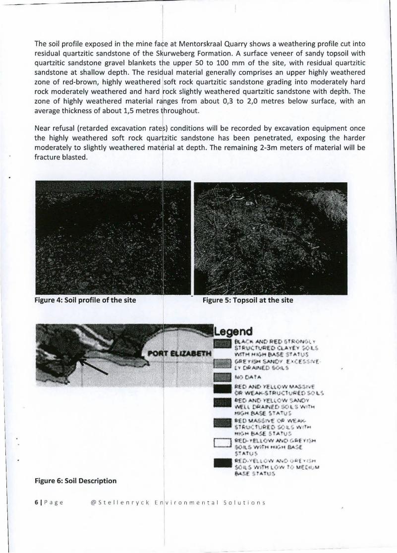
The soil profile exposed in the mine face at Mentorskraal Quarry shows a weathering profile cut into
residual quartzitic sandstone of the s セ オイキ・「・イァ@ Formation . A surface veneer of sandy topsoil with
quartzitic sandstone gravel blankets the upper 50 to 100 mm of the site, with residual quartzitic
sandstone at shallow depth. The resi t ual material generally comprises an upper highly weathered
zone of red-brown, highly weathered soft rock quartzitic sandstone grading into moderately hard
rock moderately weathered and hard ock slightly weathered quartzitic sandstone with depth. The
zone of highly weathered material rdnges from about 0,3 to 2,0 metres below surface, with an
average thickness of about 1,5 metres i hrOUghout.
Near refusal (retarded excavation rates) conditions will be recorded by excavation equipment once
the highly weathered soft rock quartzitic sandstone has been penetrated, exposing the harder
moderately to slightly weathered matJrial at depth. The remaining 2-3m meters of material will be
fracture blasted.
Figure 6: Soil Description
Figure 5: Topsoil at the site
llI..w.-'I セN 。@ !lEO セ@ Il'I 0 ' 1<>1. , iH セ v HN@ rI.lIl"[O cv. y ("r ';.0 iNN セ@"M1l .... (iH llA$e s ャBGャ セ^@
セ@ セ@ n :IH SAHOI I'. B 」エセ セBB@L セエG ᄋ@ ""',...'£.0 セ N セ@_ ..., 01- 1"
.• \lEONll) ... ·fU Qw ... a|セ@セwヲ N セャヲャ HIc G オ ェャエ oDq iNN セ@_ ID1!D ...,;0 ヲ イZエ セo キ@ '!,.""..ov ""'liU 0" BBセ HI@ 50 UI ...,.1,<
.. mMセ@ !>J .... イッセ@_ litO B セBGe@ C9 ' ... ,,"". 6"1r.-tJ.:hJR'[O YJ:t.(. .... H ..
LN セ@ .. bA.SE 6 'lATUS
" fI"E [;. ' B.LCfW » .0 (.fit ... . , .. l....--l 11iO ... ,S 'W)r ,.. G エセ h@ ヲja セ@
D t Bt vセ@_ Jt1i D-"'"[ l.\V oV .A.I .. c· HェM セヲ@ vt S-H
SOil S Wfl 'l\ LO N ! CJ .... EtA. u s r .. ョ jセ@
61 P a ge @ 5 t el l e n ry e k E nlv j r o n m en t a I So I ut i 0 n 5
---- - ------

, I
I I I I
\
legend
W av"/1 L セ セ@ I\'t
.... """, r •• "'"
Figure 7 : Soil Depth
SITES AND STRUCTURES OF ARCHAEOLOGICAL AND CULTURAL INTEREST
Archaeological and cultural sites represent the heritage of communities and are therefore protected in
terms of current legislation. In addition all structures older than 60 years are protected. The study area
revealed no caves, stone features, shelters or any rock art. The fact that the quarry area reveals very
thin soil and very compact overburden minimize the potential to find any archaeological deposits such
as human skeletal material, shell middens and fragments of marine organisms. The fact that the site is
located outside the important I km zone from the coast also reduces its potential significance.
However the greater area is rich il{ archaeological sites and since the mining site constitutes a
highpoint in the landscape it is anticipated that Stone Age tools and artifacts could possibly be found in
the area. None has been observed fiom a layman's point of view. The site revealed no historical
artifacts or features such as graves, fo1undations of buildings or other features that relates to ds>mestic
and military activities.
It is the author's opinion that the geological nature of the area would prevent the area to reveal any
natural heritage or cultural sites and the impact of the proposed quarry is rated as insignificant. Since the site hosts a common false fynbos cover it would have very little value to local communities with
regards to obtaining vegetation for medicinal purposes. Since the Khoisan and Xhosa people inhabited
the study area historically and 「・」。オウ セ@ the greater area has revealed in the past some archaeological
findings of importance the following general rules will apply during the operational phase:
I. The operator of the excavator should be briefed regarding this aspect and a reporting channel
must be developed.
2. Management will be informed when anything of interest is observed on the site and it will be
reported immediately to Dr. Bireman at the Albany Museum in Grahamstown and SAHRA's
office in East London. In such case all operations would be suspended immediately.
3. Any finding will be fenced off immediately. 4. The mitigation measures stipulated in Dr. Binnemans report will be implemented .
• ****
71 Page @SteJJen ry ck Envi r onmental So luti ons