
Appendix C Baseline Report - Cornwall · Local community stakeholders ... The site visit report for...
68
Appendix C Baseline Report
Transcript of Appendix C Baseline Report - Cornwall · Local community stakeholders ... The site visit report for...

Appendix C Baseline Report


S t age 1 Repo r t : W idemou th Bay
Cornwall Beach & Dune Management Plans
Prepared for Cornwall Council
9 July 2015
Ash House
Falcon Road Sowton Exeter Devon
EX2 7LB


III
Contents Section Page
1 Introduction ............................................................................................................................ 1 1.1 Background ......................................................................................................................... 1 1.2 Project aim, objectives and approach ................................................................................ 1 1.3 About this document .......................................................................................................... 4
2 Site Visit Report ....................................................................................................................... 5 2.1 Attendees ............................................................................................................................ 5 2.2 Site Visit Record .................................................................................................................. 5 2.3 Thoughts on Potential Management Solutions for Consideration ..................................... 6 2.4 Data Sources ....................................................................................................................... 6 2.5 Photos ................................................................................................................................. 7
3 Environmental Characteristics ................................................................................................. 9 3.1 Introduction ........................................................................................................................ 9 3.2 Methodology ....................................................................................................................... 9
3.2.1 Designated Nature Conservation sites and Protected Habitats Considered ......... 9 3.3 Environmental Setting ...................................................................................................... 10
3.3.1 Ecology ................................................................................................................. 11 3.3.2 Designated Geological Conservation Sites .......................................................... 14 3.3.3 Landscape Setting ................................................................................................ 14 3.3.4 Archaeology and Cultural Heritage ...................................................................... 14
3.4 Main human impact pressures affecting the natural dynamics of the site ...................... 14
4 Coastal Processes Understanding ........................................................................................... 16 4.1 Introduction ...................................................................................................................... 16 4.2 Shoreline Processes Overview .......................................................................................... 16
4.2.1 Key Characteristics of the Coastline Today .......................................................... 16 4.2.2 Forcing Factors ..................................................................................................... 21 4.2.3 Sediment Dynamics ............................................................................................. 25 4.2.4 Historical Shoreline Change ................................................................................. 25
4.3 New Shoreline and Beach Profile Analysis ........................................................................ 25 4.4 Summary and Recommendations ..................................................................................... 32
4.4.1 Summary .............................................................................................................. 32 4.4.2 Recommendations ............................................................................................... 32
5 Site Summary ........................................................................................................................ 33 5.1 Dune Inventory Summary ................................................................................................. 33
6 References ............................................................................................................................. 35


SECTION 1 INTRODUCTION
1
1 Introduction 1.1 Background Many of the sand dunes and beaches around Cornwall’s coast are currently experiencing erosion and sediment loss. This is a pressing concern as these sand dunes and their associated sandy beaches are one of the most important resources in Cornwall due to:
1. Their role in providing protection against the risk of coastal flooding due to the dynamic nature of beach‐dune interactions and their sheer size preventing the sea from impacting upon the hinterland behind the dune systems.
2. Their role in providing important biologically diverse habitats that cannot be easily recreated elsewhere if it were to be lost to coastal erosion or inappropriate development.
3. Their role in providing access to the sea for residents and visitors alike, which is vital to the holiday industry upon which a significant proportion of Cornwall’s economy depends.
It is vital therefore that the sand dunes and beaches around Cornwall’s coast, that represent some 15% of the total sand dune habitat in Britain, are managed in a holistic, sustainable way over the long‐term that balances the needs of each of the three distinct functions of sand dunes and beaches that combined make up the beach‐dune system, as illustrated in Figure 1.1.
Figure 1.1 The interaction of beach systems that compose the ‘beach environment’ and which must be considered together to provide a holistic approach to beach management (after James, 2000 in Frampton, A.P.R. (2010). “A review of amenity beach management”. Journal of Coastal research, 26(6), 1112‐1122, November 2010).
The approach to managing the beaches and sand dunes was investigated in between 2006 and 2009 by Halcrow on behalf of the Cornwall and Isles of Scilly Coastal Group, and led to the production of the Cornwall Sand Dune and Beach Management Strategy (Halcrow, 2009a). The main focus of the strategy is the management of flood and coastal erosion, although the habitat and tourism value of the dunes will also be considered. This 2009 project delivered an Inventory of Beaches and Dunes; a Best Practice Management Guide and two pilot Beach and Dune Management Plans (BDMPs) for Harvey’s Towans and Fistral Beach. It is this 2009 work that this current project is building upon to develop six new BDMPs and review the two pilot BDMPs (see Section 1.2).
1.2 Project aim, objectives and approach The purpose of the project is to develop six new long‐term strategic BDMPs for Constantine Bay, Porthtowan, Summerleaze, Par Sands, Widemouth Bay and Praa Sands; and review the need (or
SECTION 1 INTRODUCTION
2
otherwise) to update the two pilot BDMPs produced in 2009 for Fistral Beach and Harvey’s Towans. This will be achieved by:
1. Identifying the best management approach; in terms of monitoring and intervention (when trigger levels are reached) requirements for beach and dune systems at each individual site, based upon the best practice framework developed as part of the Cornwall Sand Dune and Beach Management Strategy produced by Halcrow in 2009.
2. Providing a long‐term (50 year) approach to each site that is based upon an up‐to‐date understanding of the beach‐dune system and coastal processes at each site, as well as predictions of future coastal evolution.
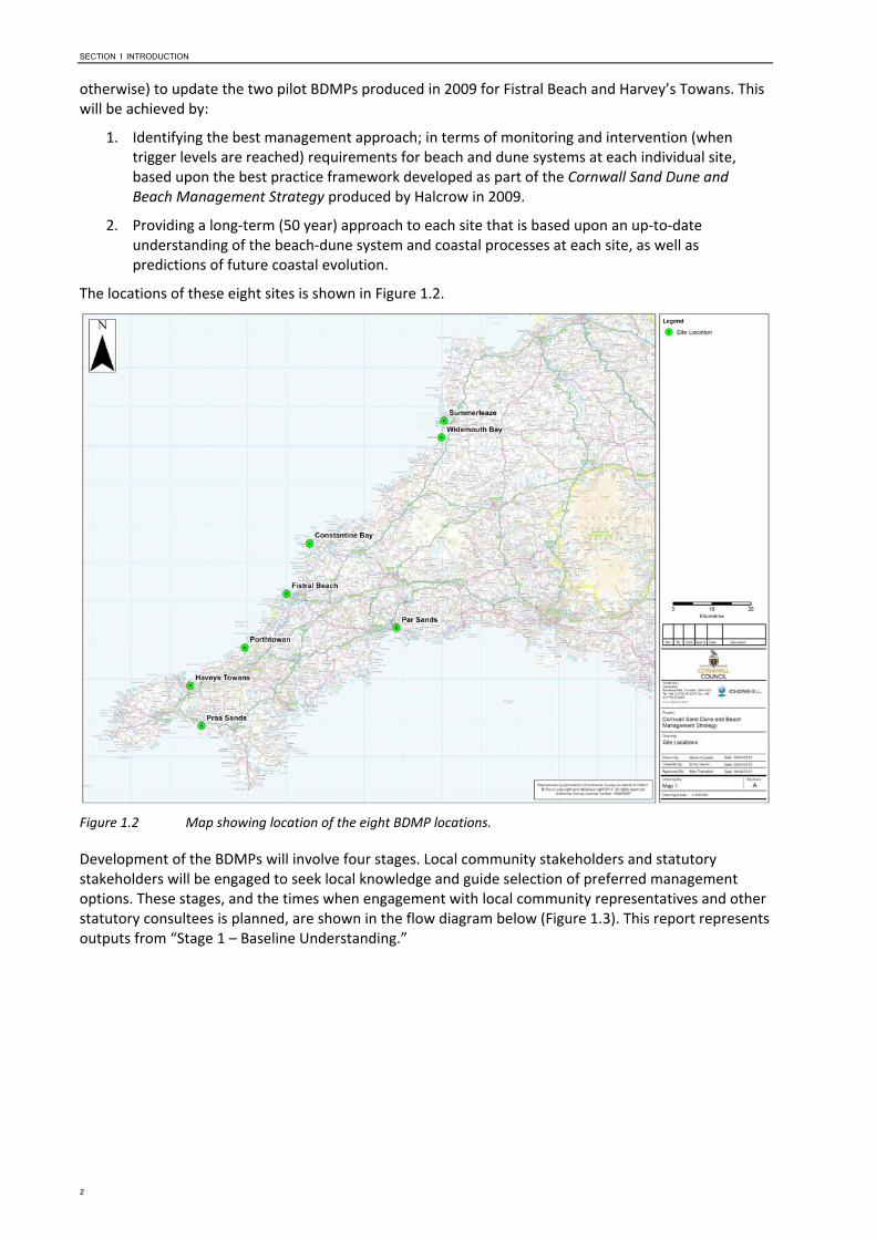
The locations of these eight sites is shown in Figure 1.2.
Figure 1.2 Map showing location of the eight BDMP locations.
Development of the BDMPs will involve four stages. Local community stakeholders and statutory stakeholders will be engaged to seek local knowledge and guide selection of preferred management options. These stages, and the times when engagement with local community representatives and other statutory consultees is planned, are shown in the flow diagram below (Figure 1.3). This report represents outputs from “Stage 1 – Baseline Understanding.”

SECTION 1 INTRODUCTION
3
Figure 1.3 Overview of the staged approach to developing BDMPs for the eight locations around Cornwall.
Stage 4 – Reporting
Produce Draft Beach and Dune Management Plans
Cornwall Council comment and review
Produce Final Beach and Dune Management Plans and Leaflets for informing general public
Stage 1 – Baseline Understanding
Inception Meeting and Develop Engagement Plan
Data collation and review Site visits (with stakeholders)
Coastal processes understanding Environmental baseline
Confirm findings with Cornwall Council
Stage 3 – Develop Future Management Options
Stage 2 – Define Issues and Objectives
Identify issues for each site
Define objectives for future management of each site
Confirm issues and objectives for future management of each site with Cornwall Council and Stakeholders
Identify appropriate management options to address issues identified
Appraise options (including environmental assessment and determination of trigger levels)
Discuss and agree preferred management approaches for each site with Cornwall Council and Stakeholders

SECTION 1 INTRODUCTION
4
1.3 About this document This report provides the results of the Stage 1 work to develop the baseline understanding of the Widemouth Bay BDMP location (see Figure 1.4). Specifically, it:
Reports the findings of a site visit made on 10th March 2015 by members of CH2M’s project team and invited stakeholders (Section 2);
Provides details of the environmental characteristics of the BDMP area (Section 3);
Describes the coastal processes and recent shoreline evolution of the beach and dune system in the area (Section 4);
Summarises the information from Sections 2, 3 and 4 into a revised dune inventory record for the site, updating the dune inventory record produced as part of the 2009 Cornwall Dune and Beach Management Strategy (Halcrow, 2009b) (Section 5).
Figure 1.4 Map showing the Widemouth Bay BDMP location and extent (red outline).

SECTION 2 SITE VISIT REPORT
5
2 Site Visit Report Over a period of four days, three members of CH2M’s project team visited the eight BDMP sites to capture information about each site and take ground‐level photos. At each site, client representatives, stakeholders and local community groups were given the opportunity to attend, meet with the project team, discuss their aims and objectives for the site, and raise any issues and concerns. Information collected during the site visits will be considered when developing later stages of the project, including:
Stage 1 – Baseline Understanding (refer to Sections 3 and 4 of this report)
Stage 2 – Define Issues and Objectives; and
Stage 3 – Develop Future Management Options.
The site visit report for the Widemouth Bay BDMP area, which was undertaken on 10th March 2015, is presented within this section and provides:
a list of attendees at each site (Section 2.1);
a record of the site visit including both factual information, comment and opinion provided stakeholders (Section 2.2);
a summary of potential management solutions identified on the day of the site visit for consideration in later stage of the project (Section 2.3);
a section on ‘Data Sources’ where CH2M’s project team were informed of, or provided with, relevant information at the site or following the site visit (Section 2.4); and
a selection of photographs taken during the site visit to highlight salient points (Section 2.5).
The information presented is a record of both information recorded during the site visit, and additional information provided by stakeholders as comments on the draft site visit report between 8th and 15th April 2015.
2.1 Attendees Name Role Organisation
Emma Allan Senior Coastal Scientist CH2M Hill
Anne‐Marie Moon Senior Coastal Scientist CH2M Hill
Gareth Cann Countryside Ranger CORMAC, Cornwall Council
Bobbie Heathcote Parish Clerk Marhamchurch Parish Council (north)
Cllr Tony Perry Parish Councillor Marhamchurch Parish Council
Cllr Ray Hockin Parish Councillor Marhamchurch Parish Council
Comments on the draft site visit report for this location were received from: Martin Clemo and Jolyon Sharpe (Cornwall Council).
2.2 Site Visit Record The northern dunes are low but there is some marram grass. The cliffs to the north are eroding; in the 1920’s the Old Salt House existed and a road ran in front of it.
At the junction of the northern cliffs/dunes, a small wooden bridge was located at the access point from dunes to beach (the current coastal path route), but was ripped out in storms in 2014. A stream flows through this area, and it is thought that the coastal path may need re‐routing, but there was evidence at the time of the site visit that sand is building back‐up again and this may not be necessary.

6
The front face of the dunes is eroding and there are boulders, which used to be buried. In the past Cornwall Council and volunteers have implemented dune management techniques to trap sand, including a fine mesh fence, although it did not prove successful and was unsightly. More recently, techniques such as planting Christmas trees and willow coppice have been implemented to help stabilise the dune front. The willow is cleared from another site and so is a waste material being reused. Where willow has been planted the dunes have begun to build behind (see Photograph 2.1).
Landwards, the sand is mobile and migrating towards the Beach House.
In front of the privately owned beach huts, sand builds‐up restricting access (see Photograph 2.2). During the site visit, we were informed that sand has built up to the roof of the beach huts.
A car park was created by flattening the dunes (that themselves had developed on a flat field that had previously existed here), but was closed down in the 2000’s as sand kept blowing onto the car park.
Sand also blows onto the road (Marine Drive), although we were informed that the volume of sand on the road was not as bad this past winter (2014/2015) compared to the previous winter (2013/2014).
At the location of the Council‐run car park (to the south of the stream), sand is blown onto the car park and requires clearing. When sand collects in the car park it cannot be returned to the beach as it may be polluted by oil, diesel etc. from cars.
Beneath the beach car park, and extending seawards beneath the beach itself, is a trans‐Atlantic subsea communications cable. There has been at least one near miss in recent times where contractors almost struck the cable.
Seaward of the car park, pebbles were removed from the beach last winter (2013/2014) by storm action to leave a significant drop at the foot of the access steps and disabled access ramp. The cobbles are now building back up and the bottom few steps are buried beneath the cobbles (see Photograph 2.3).
To the south, at Black Rock end, the dunes are more fixed but the front face is eroding to form a steep‐ cliffed face (see Photograph 2.4). There are issues with water running down dunes and eroding. Within the dune face and dunes, there are large areas of bare sand where dunes have been trampled and there are many pathways through the dunes. There are a few main paths that are very eroded. Management needs to control access.
As with Bude (Summerleaze), the beach levels are lower since the 2014 storms. The rock is more exposed and there are pebbles present where it was previously more sandy. At one point there was a slimy grey clay present between the rock at Black Rock. This was not present at the time of the site visit.
2.3 Thoughts on Potential Management Solutions for Consideration
The Beach Ranger feels sand trapping techniques would be of benefit here, possibly Christmas tree planting as trialled elsewhere could be coordinated during the winter of 2015/16. If implemented though, would need to be aware that fencing could be taken for barbecues etc. as Widemouth is a popular beach site. Plastic fencing may not look aesthetically pleasing.
Plant marram grass within the dunes to help stabilise them.
Willow could therefore be potential option, especially as it is available at no cost.
Consider implementing a ‘friends’ group to bring together local residents, businesses, landowners and beach users to help manage the site in an integrated and sustainable way in the future.
2.4 Data Sources None to report.

SECTION 2 SITE VISIT REPORT
7
2.5 Photos
Photograph 2.1 Willow planting to encourage dune development.
Photograph 2.2 Sand builds up in front of privately owned beach huts, restricting access.

8
Photograph 2.3 Build‐up of cobbles at bottom of access steps, burying bottom‐most steps.
Photograph 2.4 Eroding dune face with steep cliffing towards Black Rock end of Widemouth Bay.

SECTION 3 ENVIRONMENTAL CHARACTERISTICS
9
3 Environmental Characteristics 3.1 Introduction The purpose of this section is to identify key environmental features within and near the Study Area. This is to ensure that appropriate consideration of these features is made when developing a future Beach and Dune Management Plan for Widemouth Bay (including ongoing monitoring and maintenance works and any new works that may be required).
It should be noted that the level of detail presented in this document allows for an initial appraisal of environmental features to provide for an environmentally sustainable future management regime. This does not negate the requirement for future detailed environmental assessment which may be required to support consent applications or prejudge the scope of the assessment. Background information on possible consenting requirements and legislative drivers are described in the methodology section below.
3.2 Methodology Conservation designations and their qualifying interest features (with exception of Special Protected Areas (SPAs) see below), and UK priority Biodiversity Action Plan (BAP) habitats that lie within the study area or within 2km have been described and will require consideration during the development of the BDMPs. Only those features that are currently considered relevant to the Study Area, i.e. those that are likely to be impacted upon or are likely to have an influence on the proposed scheme, have been described.
In the case of SPA sites, they have been considered within around 150km of the BDMP Study area and on the basis of bird‐habitat connectivity in line with standard practice for habitat regulations assessments (i.e. how the birds use the habitat in a region and so depend on different resources in a regional context, for example estuarine mudflats and fully marine areas at different stages of the tidal cycle).
The designation information has been sourced using the online interactive mapping tool Magic http://www.magic.gov.uk/.
3.2.1 Designated Nature Conservation sites and Protected Habitats Considered
The following nature conservation designations and their qualifying interests have been considered:
International Nature Conservation Sites:
o The Natura 2000 European network of protected sites represents areas of the highest value for natural habitats and species of plants and animals that are rare, endangered or vulnerable in the European Community.
o Special Areas of Conservation (SACs) are strictly protected sites designated under the EC Habitats Directive, and contribute to conserving habitat and species identified in Annexes I and II of the Directive.
o Special Protection Areas (SPAs) are strictly protected sites classified in accordance with Article 4 of the EC Birds Directive, which came into force in April 1979. They are classified for rare and vulnerable birds (as listed on Annex I of the Directive), and for regularly occurring migratory species.
National and Local Conservation sites:
o Site of Special Scientific Interest (SSSI) sites are nationally designated sites, selected for being the best examples of our natural heritage in terms of wildlife habitats, geological features or landforms. A SSSI area is notified as being of special interest under the Wildlife and Countryside Act 1981. Geological SSSI sites may also afford further

10
designation as Geological Conservation Review sites (GCR) that make a special contribution to our understanding and appreciation of Earth science and the geological history of Britain, which stretches back hundreds of millions of years
o Marine Conservation Zones (MCZs). The Marine and Coastal Access Act 2009 allows for the creation of MCZs. MCZs protect a range of nationally important marine wildlife, habitats, geology and geomorphology, and can be designated anywhere in English and Welsh territorial and UK offshore waters. 27 MCZs were designated in 2013 with a further round of six recommended MCZs (rMCZ) are being considered for 2015.
o Local Nature Reserves (LNRs) are declared and managed for nature conservation by local authorities under the National Parks and Access to the Countryside Act 1949, and provide opportunities for research and education, or simply enjoying and having contact with nature.
Habitats and Species
The government has a commitment “to conserve and enhance the biological diversity within the UK and to contribute to the conservation of global biodiversity through all appropriate mechanisms”.
Former Biodiversity Action Plans (BAPs) were developed at a national and local level to protect and enhance the diversity of flora and fauna. The UK BAP (Biodiversity: The UK Action Plan, 2004) set out action plans for priority species and habitats. As a result of devolution, and new country‐level and international drivers and requirements, much of the work previously carried out by the UK BAP is now focussed at a country‐level rather than a UK‐level, and the UK BAP was succeeded by the 'UK Post‐2010 Biodiversity Framework' in July 2012. The UK list of priority habitats, however, remains an important reference source and has been used to help draw up statutory lists of priority habitats in England, as required under Section 41 (England) of the Natural Environment and Rural Communities (NERC) Act 2006. Habitats and species of principal importance, which could potentially be affected by the management options, are considered.
Heritage Designations:
o World Heritage Sites are designated to meet the UK's commitments under the World Heritage Convention. Sites are designated for their globally important cultural or natural interest and require appropriate management and protection measures.
o Historic and archaeological sites of significance are designated as historical assets by English Heritage and include listed historic buildings, scheduled monuments, registered parks and gardens, battlefields and protected wreck sites. They designation are afforded to protect against any future loss of their significance.
o Heritage Coast is a section of coast exceeding one mile in length that is of exceptionally fine scenic quality, substantially undeveloped and containing features of special significance and interest.
Landscape Designations:
o Area of Outstanding Natural Beauty (AONB) are designated under the National Parks and Access to the Countryside Act 1949, amended in the Environment Act 1995, with responsibility of care assumed by local authorities and the rural community.
3.3 Environmental Setting The Study Area contains the following nature conservation designations. These are central in the consideration of options for the beach and dune management plan:
Tintagel‐Marsland‐Clovelly Coast SAC
Boscastle to Widemouth SSSI (biological and geological)

SECTION 3 ENVIRONMENTAL CHARACTERISTICS
11
Hartland Point to Tintagel Recommended Marine Conservation Zone (under current consultation for designation 2015)
Cornwall Area of Outstanding Natural Beauty (AONB)
Heritage Coast
Archaeological and Cultural Heritage designated features.
These features are shown on Figure 3.1 and discussed in further detail below.
Figure 3.1 Environmental designation features in the vicinity of the Widemouth Bay BDMP area.
3.3.1 Ecology 3.3.1.1 Designated Nature Conservation Sites The following nature conservation designations and their qualifying interest features are all within or lie in close proximity to the Study Area and will require consideration during the development of the BMP:
The southern rocky shore section of Widemouth encompasses the northern section of the Tintagel‐Marsland‐Clovelly Coast SAC. The SAC is designated for two European protected Annex I and priority BAP habitat, vegetated sea cliffs, Old sessile oak woods with Ilex and Blechnum situated at various points along the coast and European dry heaths as a feature but not the reason for its designation.
Boscastle to Widemouth SSSI, is encompassed within the Marsland‐Clovelly Coast SAC. The SSSI is noted for its biological interest includes the unique Dizzard Oak woodland, maritime heaths and intertidal zones and geological features (noted in the geological section below).
Designated sites identified and considered or discounted for bird‐habitat connectivity between the protected area and the site, are described below (see also Figure 3.2). Sites identified as having possible connectivity will require consideration during the development of the BDMP:

12
Tamar Estuaries Complex is approximately 40km east south from Widemouth at its nearest point. The estuary system is a large marine inlet on the English Channel coast comprising the estuaries of the rivers Tamar, Lynher and Tavy. Habitats include extensive tidal mud‐flats bordered by saltmarsh communities. The mud‐flats contain extensive and varied infaunal communities rich in bivalves and other invertebrates, and feeding grounds for waterbirds in numbers of European importance. Saltmarshes provide important feeding and roosting areas for large numbers of wintering and passage waterbirds. This site qualifies under Article 4.1 of the Directive (79/409/EEC) by supporting populations of Little Egret Egretta garzetta (on passage, and a population over winter) and Avocet Recurvirostra avosetta (over winter). Unlikely to be any connectivity with Widemouth due to the lack of estuarine influence.
Falmouth Bay to St Austell Bay pSPA is approximately 50km south from Widemouth at its nearest point. The proposed SPA (pSPA) supports rare wintering birds and diving birds that are proposed for designation under the Birds Directive (2009/147/EC). The pSPA is a large area, which encompasses the Fal and Helford SAC within the pSPAs north western section. The SAC site is designated under article 4 (4) of the Habitats Directive (92/43/EEC) for the following Annex 1 habitats: Sandbanks which are slightly covered by sea water all the time; Mudflats and sandflats not covered by seawater at low tide; Large shallow inlets and bays that include low tidal sandbanks and Atlantic salt meadows (Glauco‐Puccinellietalia maritimae). Other Annex I habitats that are present as a qualifying feature of the SAC but not the primary reason for selection include Estuaries and Reefs and includes the Annex II plant species Shore dock Rumex rupestris. Connectivity with Widemouth is a possibility. Habitat described within the MCZ (mentioned above) that may support diving birds and therefore consideration is required.
The Exe Estuary SPA (approximately 76km from Widemouth at its nearest point) is a complex of coastal habitats waters, foreshore, low‐lying land, three saltmarshes and an unusual double spit across the mouth of the estuary, and the sand dunes of Dawlish Warren. The mud and sandflats support Eelgrass Zostera spp. and Enteromorpha beds, and contain an abundance of invertebrates including extensive Mussel Mytilus edulis beds, which together provide rich feeding habitats for wintering waders and wildfowl. The site qualifies under Article 4.1 of the Directive (79/409/EEC) by supporting populations of Annex I species Avocet Recurvirostra avosetta and Slavonian Grebe Podiceps auritus (over winter) and qualifies under Article 4.2 of the Directive (79/409/EEC) as a wetland of international importance for regularly supporting at least 20,000 waterfowl. There is unlikely to be any connectivity with Widemouth due to the lack of estuarine influence.
Marizion Marsh SPA/SSSI is approximately 100km south from Widemouth at its nearest point. The marsh is at the mouth of a wide coastal valley, separated from the sea by a shingle bar with fringing sand dunes. The marsh is important for passage and wintering birds associated in particular with the extensive reedbed. The site qualifies under Article 4.1 of the Directive (79/409/EEC) by supporting populations of Annex I species Aquatic Warbler Acrocephalus paludicola (in passage) and Bittern Botaurus stellaris (over winter). Connectivity unlikely due lack of freshwater habitat at the site.
The Severn Estuary SPA/SSSI (approximately 109km from Widemouth at its nearest point) is located northwest between Wales and England. It is a large estuary with extensive intertidal mud‐flats and sand‐flats, rocky platforms and islands. Saltmarsh fringes the coast backed by grazing marsh with freshwater ditches and occasional brackish ditches. The seabed is rock and gravel with sub‐tidal sandbanks. High densities of ragworms, lugworms and other invertebrates form an important food source for passage and wintering waders and large numbers of wintering waterbirds, especially swans and ducks. The site qualifies under Article 4.1 of the Directive (79/409/EEC) by supporting populations of European importance of the following species listed on Annex I of the Directive: Bewick's Swan (over winter). This site also qualifies under Article 4.2 of the Directive (79/409/EEC) by supporting populations of European importance of the following migratory species: Ringed Plover (on passage), Curlew, Dunlin, Pintail, Redshank and Shelduck. The area qualifies under Article 4.2 of the Directive (79/409/EEC)

SECTION 3 ENVIRONMENTAL CHARACTERISTICS
13
by regularly supporting at least 20,000 waterfowl. Connectivity with Widemouth is unlikely due to lack of estuarine influence and associated habitat.
Isles of Scilly SPA is approximately 150km southwest from its closest point. The SPA qualifies for its seabird assemblage of international importance and breeding seabird assemblage of European importance. The isolated nature of the islands and rocks, together with their low levels of disturbance and predation, makes them particularly suitable for nesting seabirds. This site qualifies under Article 4.1 of the Directive (79/409/EEC) by supporting populations of European importance of the following Annex I species Storm Petrel Hydrobates pelagicus and Lesser Black‐backed Gull Larus fuscus. The site also qualifies under Article 4.2 of the Directive (79/409/EEC) for regularly supporting a seabird assemblage of international importance of at least 20,000 seabirds. The SPA boundary only encompasses those areas used for nesting. The vast majority of the feeding areas used by the seabirds are marine waters outside the SPA. Connectivity with feeding areas seaward around Widemouth is possible.
Figure 3.2 Potential bird‐habitat connectivity between the protected area and the BDMP site.
3.3.1.2 Biodiversity Action Plan (BAP) Habitats The following are listed as UK priority BAP habitats and are either represented in the Study Area or are within 1km. The following habitats have been identified from http://webarchive.nationalarchives.gov.uk/20140605090108/http:/www.naturalengland.org.uk/ourwork/conservation/biodiversity/protectandmanage/habsandspeciesimportance.aspx (go to ‘list of habitats’) as likely to be found around the site:
Coastal Sand Dunes (Annex II, UK BAP priority habitat)
Maritime Cliffs and Slopes (UK priority BAP habitat)
Old sessile oak woods with Ilex and Blechnum in the British Isles (Annex II habitat)
European dry heath habitat (Annex II, UK priority BAP habitat).

14
Note, no baseline habitat assessment report has been undertaken by Cornwall Council for Widemouth to date, therefore priority BAP habitat has been identified using records described in the online environmental mapping tool MAGIC in combination with the citation descriptions of habitat as described for the designated sites. Only habitats that are considered relevant to the Study Area, i.e. they are likely to be impacted upon or are likely to have an influence on beach management options, have been described. Firm confirmation of priority BAP habitat would require an ecological assessment.
3.3.2 Designated Geological Conservation Sites Boscastle to Widemouth Biological and geological SSSI encompasses five Geological Conservation Review sites. The geological sites within the area of Widemouth include (See Figure 3.1 above):
Widemouth to Crackington ‐ This site is comprised of extensive coastal exposures, where the typically developed basinal Namurian of south‐west England is clearly exposed. The entire Namurian represented by the Crackington formation is visible within the site, and the presence of rare goniatites has been vital in unravelling the complicated local stratigraphy. The section provides an excellent display of the sedimentary features associated with shallow water turbidites, and is of considerable interest for its spectacular structural features. An outstanding site for studies of palaeogeography, sedimentation and tectonics.
Widemouth to Saltstone Strand ‐ This coastal section lies within the above site and provides exposures of a sequence of folded and faulted sandstones of the Bude Formation (in the north) and shales and sandstones of the Crackington Formation (in the south). These rocks were deformed during the Variscan mountain building episode, towards the end of the Carboniferous Period. At the northern end of this section, fold structures are generally upright but further south become steeply inclined around Saltstone. The change in style of the fold marks an important structural boundary between a region of upright folds to the north and a region of inclined or flat‐lying folds, to the south, which is a major feature of the geology of South West England. At this locality the boundary has been the subject of very detailed study and its interpretation is of great significance in understanding the geological evolution of the region.
The site Upton Coast, south of Summerleaze is a County Geology Site and features exposures of Upper Carboniferous Bude Formation sediments and structures, Quaternary at Widemouth (ERCCIS and Cornwall Wildlife Trust (2010)).
3.3.3 Landscape Setting The importance of landscape to the Widemouth area is recognised by the following nationally and regionally important designations (see Figure 3.1 above):
Widemouth is encompassed within the Cornwall Area of Outstanding Natural Beauty (Pentire Point to Widemouth) is defined by the characteristics of unspoilt rocky coast, including the highest cliffs in Cornwall. Steep‐sided wooded valleys and important historic features such as the thirteenth century Tintagel Castle, prehistoric earthworks, and Iron Age cliff fortifications.
The Pentire Point to Widemouth Heritage Coast northerly edge starts approximately 0.5km south of Widemouth beach.
3.3.4 Archaeology and Cultural Heritage There are a number of historic sites, including the nationally designated Two bowl barrows Scheduled Monument (situated on the headland directly north at Widemouth), and listed buildings located within the area (see Figure 3.1 above).
3.4 Main human impact pressures affecting the natural dynamics of the site
The following observations were made during the site visit in March 2015 (refer also to Section 2)
Trampling, erosion and loss of sand cover on dune

SECTION 3 ENVIRONMENTAL CHARACTERISTICS
15
Additional pressures on the dune system and its management include seasonal population influx and car park (pollution).
SECTION 4 COASTAL PROCESSES UNDERSTANDING
16
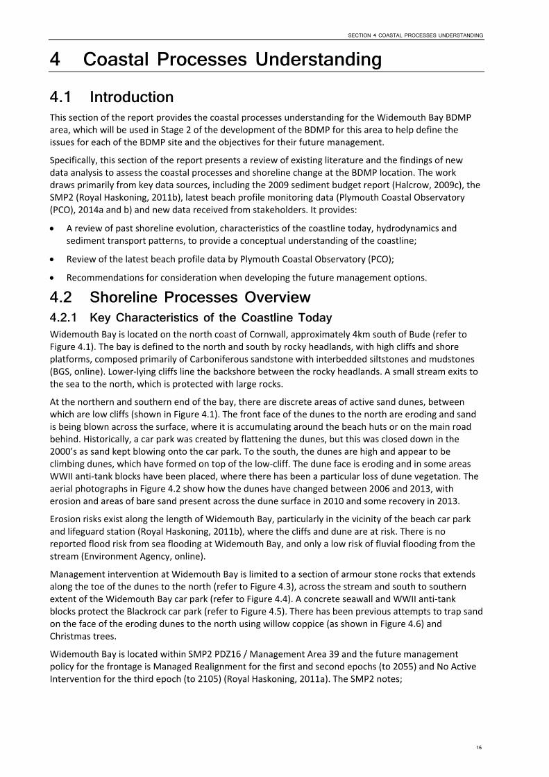
4 Coastal Processes Understanding 4.1 Introduction This section of the report provides the coastal processes understanding for the Widemouth Bay BDMP area, which will be used in Stage 2 of the development of the BDMP for this area to help define the issues for each of the BDMP site and the objectives for their future management.
Specifically, this section of the report presents a review of existing literature and the findings of new data analysis to assess the coastal processes and shoreline change at the BDMP location. The work draws primarily from key data sources, including the 2009 sediment budget report (Halcrow, 2009c), the SMP2 (Royal Haskoning, 2011b), latest beach profile monitoring data (Plymouth Coastal Observatory (PCO), 2014a and b) and new data received from stakeholders. It provides:
A review of past shoreline evolution, characteristics of the coastline today, hydrodynamics and sediment transport patterns, to provide a conceptual understanding of the coastline;
Review of the latest beach profile data by Plymouth Coastal Observatory (PCO);
Recommendations for consideration when developing the future management options.
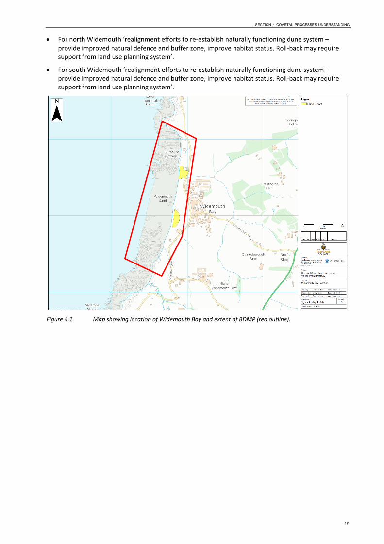
4.2 Shoreline Processes Overview 4.2.1 Key Characteristics of the Coastline Today Widemouth Bay is located on the north coast of Cornwall, approximately 4km south of Bude (refer to Figure 4.1). The bay is defined to the north and south by rocky headlands, with high cliffs and shore platforms, composed primarily of Carboniferous sandstone with interbedded siltstones and mudstones (BGS, online). Lower‐lying cliffs line the backshore between the rocky headlands. A small stream exits to the sea to the north, which is protected with large rocks.
At the northern and southern end of the bay, there are discrete areas of active sand dunes, between which are low cliffs (shown in Figure 4.1). The front face of the dunes to the north are eroding and sand is being blown across the surface, where it is accumulating around the beach huts or on the main road behind. Historically, a car park was created by flattening the dunes, but this was closed down in the 2000’s as sand kept blowing onto the car park. To the south, the dunes are high and appear to be climbing dunes, which have formed on top of the low‐cliff. The dune face is eroding and in some areas WWII anti‐tank blocks have been placed, where there has been a particular loss of dune vegetation. The aerial photographs in Figure 4.2 show how the dunes have changed between 2006 and 2013, with erosion and areas of bare sand present across the dune surface in 2010 and some recovery in 2013.
Erosion risks exist along the length of Widemouth Bay, particularly in the vicinity of the beach car park and lifeguard station (Royal Haskoning, 2011b), where the cliffs and dune are at risk. There is no reported flood risk from sea flooding at Widemouth Bay, and only a low risk of fluvial flooding from the stream (Environment Agency, online).
Management intervention at Widemouth Bay is limited to a section of armour stone rocks that extends along the toe of the dunes to the north (refer to Figure 4.3), across the stream and south to southern extent of the Widemouth Bay car park (refer to Figure 4.4). A concrete seawall and WWII anti‐tank blocks protect the Blackrock car park (refer to Figure 4.5). There has been previous attempts to trap sand on the face of the eroding dunes to the north using willow coppice (as shown in Figure 4.6) and Christmas trees.
Widemouth Bay is located within SMP2 PDZ16 / Management Area 39 and the future management policy for the frontage is Managed Realignment for the first and second epochs (to 2055) and No Active Intervention for the third epoch (to 2105) (Royal Haskoning, 2011a). The SMP2 notes;
SECTION 4 COASTAL PROCESSES UNDERSTANDING
17
For north Widemouth ‘realignment efforts to re‐establish naturally functioning dune system – provide improved natural defence and buffer zone, improve habitat status. Roll‐back may require support from land use planning system’.
For south Widemouth ‘realignment efforts to re‐establish naturally functioning dune system – provide improved natural defence and buffer zone, improve habitat status. Roll‐back may require support from land use planning system’.
Figure 4.1 Map showing location of Widemouth Bay and extent of BDMP (red outline).

18
2006
2010
2013
Figure 4.2 Historical photographs of Widemouth Bay (source: Plymouth Coastal Observatory)

SECTION 4 COASTAL PROCESSES UNDERSTANDING
19
Figure 4.3 Boulders along the dune toe of the northern dunes (taken during site visit 10th March 2015, looking north).

20
Figure 4.4 Rock revetment protecting Widemouth bay car park (taken during site visit 10th March 2015, looking south).

SECTION 4 COASTAL PROCESSES UNDERSTANDING
21
Figure 4.5 Seawall protecting Black Rock car park (taken during site visit 10th March 2015, looking south).
Figure 4.6 Willow coppice on northern dunes (taken during site visit 10th March 2015, looking north).
4.2.2 Forcing Factors 4.2.2.1 Typical Waves The coastline at Widemouth is orientated north‐west, with the beach and dunes facing approximately 310 degrees (north‐west). The predominant wave direction along the north coast of Cornwall is reported to be from the west to north‐west (approaching from 270o – 315o), however, large swell waves from the south to southwest will refract around the Lands End Peninsula and reach the most westerly facing beaches, (with reduced energy) (Royal Haskoning, 2011b), such as Widemouth Bay.
The Perranporth Directional Waverider Buoy, operated as part of the South West Regional Coastal Monitoring Programme (SWRCMP), is the nearest wave buoy to Widemouth Bay, and has been reviewed

22
for this study (refer to Figure 4.7 for the wave data point). The wave buoy is located approximately 50 miles south‐west from Widemouth Bay, and provides a record of wave height for a seven year period between 18th December 2006 and 30th June 2014. A plot of wave height in Figure 4.8 shows that the predominant wave direction in this area is from the west. The data set also indicates significant wave heights frequently exceed 5m during the winter months and that wave periods of 15 seconds and higher (i.e. powerful well waves generated by storms offshore) are not uncommon (Royal Haskoning, 2011b).
Given the distance that the Perranporth Directional Waverider Buoy is located from Widemouth Bay, it is possible that it is not picking up waves from the south‐south‐west direction that could be important for processes here.
Figure 4.7 Map showing the location of the wave data collection point.

SECTION 4 COASTAL PROCESSES UNDERSTANDING
23
Figure 4.8 Offshore wave height recorded by the Perranporth Directional Waverider Buoy between 18th December 2006 and 30th June 2014 (PCO, 2014a).
4.2.2.2 Storm Waves Storm analysis undertaken by PCO (2014d) provides an overview of the storm conditions recorded by the Perranporth Directional Waverider Buoy since 2007.
For each wave buoy in the SWRCMP, an individual storm threshold is set. A storm event is defined when significant wave heights equivalent to the 0.25 year return period (i.e. the threshold wave height (Hs) for 2 to 4 storms in an average year) occurs for set period of time (i.e. 16 hours). The significant wave height is calculated when a 5 year time series of data becomes available for the wave buoy and is then reset each year. Prior to that, the height is based on an educated conservative guess from looking at the wave data available. The reason that the 0.25 year return period is used is because the SWRCMP have found that in general there are 3 to 4 storms in any one year that result in the movement significant amounts of sediment.
For their reporting, PCO produce a storm calendar. The calendar includes a graph, where each dot represents a storm (i.e. where the Hs exceeds the storm threshold) and shows the Hs for that particular storm. PCO plot the significant wave height for the 1 year return period for that particular buoy on the graph (calculated in the same way as significant wave height for the 0.25 year return period) as a red line. Where storms plot above the red line they are considered to be more severe/extreme and are listed in a separate table. The storm calendar and table for the Perranporth Directional Waverider Buoy are presented in Figure 4.9 and Table 4.1 respectively.
The storm calendar shows that eight severe/extreme storms have exceeded the 1 year Return Period since 2007; three of those storms (38 %) occurred between October 2013 and February 2014. The

24
impact of these storms on beach change is described in Section 4.3.
Figure 4.9 Storm calendar for Perranporth (source: PCO, 2014b).
Table 4.1 Storms exceeding 1 year Return Period at Perranporth since deployment in 2007. Those occurring during the storm season October 2013 to February 2014 are shaded pink (source: PC0, 2014d).
Date Wave Height (m) Return Period
01/02/2014 7.28 Greater than 1 in 20 years
02/11/2013 7.06 1 in 10 years
27/12/2013 6.81 1 in 5 years
15/12/2011 6.75 1 in 5 years
12/03/2008 6.53 1 in 3 years
10/03/2008 6.37 1 in 2 years
11/11/2010 6.3 1 in 1 year
31/03/2010 6.25 1 in 1 year
4.2.2.3 Tides Tidal levels have been extracted from the current Admiralty Tide Tables (UKHO, 2013) for the closest location with the best available data, in this case Bude, and converted to Ordnance Datum (mOD); see Table 4.2. .

SECTION 4 COASTAL PROCESSES UNDERSTANDING
25
Table 4.2 Tide levels (in mOD) for Bude, adjusted from standard port Milford Haven.
Tidal Condition Tide Level (mOD)
Highest Astronomical Tide (HAT) Data not available
Mean High Water Spring (MHWS) 3.70
Mean High Water Neap (MHWN) 2.10
Mean Sea Level (MSL) Data not available
Mean Low Water Neap (MLWN) Data not available
Mean Low Water Spring (MLWS) Data not available
Lowest Astronomical Tide (HAT) Data not available
4.2.3 Sediment Dynamics Sediment transport at Widemouth Bay is dominated by the onshore‐offshore movement of material in response to storms and general variation in the wave climate (Royal Haskoning, 2011b).
Alongshore transport via littoral drift generally blocked by the presence of the rocky shore platforms (Royal Haskoning, 2011b). Some alongshore transport may occur due to tidal currents, though this is not thought to be significant (Royal Haskoning, 2011b).
Much of the sand on the beach at Widemouth originates from erosion of the local geology (Royal Haskoning, 2011b). New sediments are derived from:
Offshore calcium carbonate sources (marine organisms); and
Erosion of the local cliffs, although the volume that the cliffs contribute is not reported on.
4.2.4 Historical Shoreline Change Widemouth Bay was not included as one of the nine locations in the Cornwall Sand Dune and Beach Management Strategy (Halcrow, 2009b) for which a detailed study was completed. Therefore analysis and interpretation of historical change from historical maps, historical aerial photographs and beach profiles is not available. However, for the SMP2, Royal Haskoning (2011b) reviewed previous studies and reported the following:
There have been no significant changes in the coastal plan form and position over the last 100 years (Halcrow, 2002).
Studies of historic aerial photography (Royal Haskoning, 2008) showed that there has been very significant erosion and degradation of the dune system at north Widemouth since 1946, when the dune system was much more extensive and well vegetated.
4.3 New Shoreline and Beach Profile Analysis Beach profile monitoring is undertaken by PCO for the SWRCMP and provides recent data and analysis for the beach at Widemouth. A summary of the findings from the latest annual survey report (PCO, 2014a) are presented in this section and provide an overview of beach profile change in the past year, between Spring 2013 and Spring 2014, and over the longer‐term from the baseline survey in 2007 to the most recent survey in Spring 2014. It should be noted that the assessment of CSA for the profiles at Widemouth Bay exclude the dunes, covering only beach change.
In the past year, between Spring 2013 and Spring 2014 (refer to Figure 4.10), all profiles have lost material, with profiles 7b01355 to 7b01368 all losing over 30m2 of material.

26
Over the longer term, between 2007 and Spring 2014 (refer to Figure 4.11), a similar trend of beach loss has occurred, with the exception of profile 7b01365, which has gained around 3% in cross‐sectional area.
Mapping of the Mean High Water contour (refer to Figure 4.12) between 2007 and 2014 shows that the upper beach position has fluctuated over the survey period, with no clear trend. This reiterates the cross‐shore and dynamic nature of the beach discussed in Section 4.2.3.
Observations made during the site visit on the 10th March found the dunes to be generally eroding, with accumulations of wind‐blown sand across access routes to the beach and against beach‐huts (refer to Figure 4.13). The dunes to the south shows signs of erosion, which dune cliffing evident. Although some of this erosion may be attributed to recent storms, pedestrian pressure is also thought to be a cause and there are various access pathways which cross the dunes (refer to Figure 4.14)
As part of the SWRCMP, PCO have also prepared two reports (PCO, 2014d and 2014e), which examine the change to a selection of the beaches along the south‐west coast, with a view to identify how beach change occurring as a result of the 2013/2014 winter storms compares to the longer‐term behaviour of the beach. For the first report (PCO (2014d) have undertaken analysis of beach profile data to assess beach volume change over the longer term (typically between 2003 and 2013), the 2013/2014 winter storm period (typically between October/September 2013 and February 2014), and over a post‐storm period between winter 2013/2014 and summer 2014. The second report (PCO, 2014e) provides the results of topographic difference modelling undertaken by the Environment Agency. The modelling compares the last available LiDAR flown sometime before the 2013/2014 winter storms and LiDAR flown after the 2013/2014 storms. Where this analysis has been completed for the BMP sites, a summary of the changes are described below.
The long‐term volume change between the baseline survey in 2007 and Summer 2013 was 35,000m3. The net change over the 2013/2014 winter period (from December 2013 to March 2014) was ‐71,819m3, but the net change from Winter 2013/14 to Summer 2014 was 16,886m3. The percentage of beach volume recovered by Summer 2014 was therefore +24% (refer to Figure 4.15).
A topographic difference model plot has not been prepared for Widemouth Bay.

SECTION 4 COASTAL PROCESSES UNDERSTANDING
27
Figure 4.10 Beach profile change at Widemouth Spring 2013 to Spring 2014 (source: PCO, 2014a).

28
Figure 4.11 Beach profile change at Widemouth baseline 2007 to Spring 2014 (source: PCO, 2014a).

SECTION 4 COASTAL PROCESSES UNDERSTANDING
29
Figure 4.12 MHW contour change at Widemouth (source: PCO, 2014a).

30
Figure 4.13 Northern dunes with accretion of wind‐blown sand against the beach huts (taken during site visit 10th March 2015, looking north).
Figure 4.14 Southern dunes showing dune face erosion as a result of storm damage and public access, with. WWII anti‐tank blocks in back ground (taken during site visit 10th March 2015, looking south).

SECTION 4 COASTAL PROCESSES UNDERSTANDING
31
Figure 4.15 Beach volume change at Widemouth Bay (source: PCO, 2014b).

32
4.4 Summary and Recommendations 4.4.1 Summary The beach at Widemouth is west facing and subject to a dominant westerly wave regime. Alongshore transport is limited, with the movement of sediment generally across the beach. Beach profile monitoring data shows the beach to the north to be accreting and generally stable, but the beach to the south is eroding. Wind‐blown sand is a feature on the dunes to the north and south, and as also shown by the serial photographs at the time when the 2010 photograph was taken the dune vegetation is buried by sand. To the north, wind‐blown sand builds up against the beach huts and is also blown onto the main road. Aerial photographs show the dunes to the north and south of the bay to be eroding; it is likely that this is at least partially due to recreational pressures such as high footfall.
4.4.2 Recommendations The key issues at Widemouth are one of dune erosion and one of wind‐blown sand; the first, caused primarily by day‐to‐day recreational pressure, which is resulting in erosion/dissection of the dunes and therefore leaves them more vulnerable to storm attack as well losing recreational benefit. The latter, is resulting in build‐up of sand in front of the beach huts and buildings to the north of the bay and as well as blowing across the main road which generates health and safety issues, and requires maintenance which is in turn costly.
The key recommendation at Widemouth Bay is to help to trap the wind‐blown sand by retaining it on the dunes using dune management techniques before it is blown onto the beach huts and road. This would be helped by carefully managing access routes through the dunes, thereby allowing the dune vegetation to grow, trap sand and for the dunes to stabilise. Planting of new vegetation may enhance this recovery, although the suitability of the dune site should be investigated in the first instance.

SECTION 5 SITE SUMMARY
33
5 Site Summary 5.1 Dune Inventory Summary
DUNE SYSTEM WIDEMOUTH BAY
CHARACTERISTICS
LOCATION MAP
See Figure 1.2.
AERIAL PHOTOGRAPH
See Figure 4.2.
DUNE EXTENT
See Figure 1.4.
AREA OF SITE
Active 3 ha
Total 3 ha
DUNE TYPE Climbing.
Linear.
MORPHOLOGICAL FEATURES OF DUNES
Small discrete areas of active dunes.
Frontal erosion of dunes at north end of bay.
Accretion of dune sediment at south end of bay.
PAST (150 YRS) EVOLUTION OF DUNES
Analysis of historic maps indicates no significant change to coastal plan form and position.
Analysis of aerial photography shows very significant erosion and degradation of dune system since 1946.
A car park was previously constructed by flattening dunes; now closed.
VEGETATION TYPE
Yellow Dune, Grey Dune
BACKSHORE CHARACTERISTICS
Developed land rising behind
COASTAL SETTING
West facing dunes.
Small stream enters sea at north end of bay.
Rocky headlands to north and south of bay, with high cliffs and shore platforms.
High cliffs in centre of bay.
DRIVERS
LINKS TO ADJACENT COAST
There are no significant movements of sand outside of the bay.
Beach sediments are frequently and rabidly redistributed under storm conditions although the bay headlands retain material within the local area.
WIND ENERGY
No contemporary data identified. Refer to SMP1 (Halcrow, 1999) for historical data.
WAVE ENERGY
See Sections 4.2.2.1 and 4.2.2.2.
WATER LEVELS
See Section 4.2.2.3.
SEDIMENT BUDGET Majority of sediment derived from erosion of local cliffs.

34
Carbonate material is also a source of contemporary beach sediment.
PRESSURES
ENVIRONMENTAL DESIGNATIONS
Tintagel‐Marsland‐Clovelly Coast SAC.
Boscastle to Widemouth SSSI (biological and geological).
Potential UK BAP Priority Habitats with management objective (Coastal Sand Dunes; Maritime Cliff and Slope; Old sessile oak woods; European dry heath).
See Section 3.3 also.
ARCHAEOLOGY/ HERITAGE
Cornwall Area of Outstanding Natural Beauty (AONB).
Heritage Coast.
Archaeological and Cultural Heritage designated features including the nationally designated Two bowl barrows Scheduled Monument (situated on the headland directly north at Widemouth) (refer also to Section 3.3.4).
LAND USE
Land behind dune system developed for tourism and residents.
Car park within dunes.
RECREATIONAL PRESSURES
Popular with tourists and residents.
Dunes restricted and fragmented by tourism development.
Beach huts experience sand accretion in front of them.
Erosion along access route between car park and beach as well as ‘undefined’ paths.
SAND EXTRACTION/ DREDGING
None.
COASTAL DEFENCES None.
CURRENT MANAGEMENT PRACTICES
Manual beach cleaning.
Blown sand cleared car park removed from site (and so coastal system) due to pollution issues.
SHORELINE MANAGEMENT PLAN POLICY (from Royal Haskoning, 2011a)
Policy Unit 39.2 (Black Rock / south Widemouth): o Short term = Managed Realignment; medium term = Managed
Realignment; long term = No Active Intervention. o Policy intent = “Realignment efforts to re‐establish naturally
functioning dune system – provide improved natural defence and buffer zone, improve habitat status. Roll‐back may require support from land use planning system.”
Policy Unit 39.3 (North Widemouth): o Short term = Managed Realignment; medium term = Managed
Realignment; long term = No Active Intervention. o Policy intent = “Realignment efforts to re‐establish naturally
functioning dune system – provide improved natural defence and buffer zone, improve habitat status. Roll‐back may require support from land use planning system.”
MANAGED BY
Cornwall Council.

SECTION 6 REFERENCES
35
6 References ERCCIS and Cornwall Wildlife Trust (2010). County Geology Site Criteria for Cornwall and the Isles of
Scilly.
Frampton, A.P.R. (2010). A review of amenity beach management. Journal of Coastal research, 26(6), 1112‐1122, November 2010.
Halcrow (2009a). Cornwall Sand Dune and Beach Management Strategy. Report produced by Halcrow Group Limited for the Cornwall and Isles of Scilly Coastal Advisory Group, September 2009.
Halcrow (2009b). Sand Dune Inventory. Cornwall Sand Dune and Beach Management Strategy. Report produced by Halcrow Group Limited for the Cornwall and Isles of Scilly Coastal Advisory Group, September 2009.
Halcrow (2009c). Sediment Budget Report. Cornwall Sand Dune and Beach Management Strategy. Report produced by Halcrow Group Limited for the Cornwall and Isles of Scilly Coastal Advisory Group, September 2009.
Halcrow (2002). Futurecoast CD. Produced by Halcrow Group Ltd for Defra.
Halcrow (1999). Land’s End to Hartland Point Shoreline Management Plan. Volumes 1 to 4. Report produced by Halcrow Group Limited for Cornwall and Isles of Scilly Coastal Group.
Plymouth Coastal Observatory (PCO) (2014a). Annual Survey Report. Land’s End to Hartland Point. Report Number AR43. Report produced for the South West Regional Monitoring Programme, September 2014.
Plymouth Coastal Observatory (PCO) (2014b). Review of South West Coast Beach Response to Wave Conditions During the Winter of 2013‐2014. Report Number SW SR01. Report produced for the South West Regional Monitoring Programme, June 2014.
Royal Haskoning (2011a). Cornwall and Isles of Scilly Shoreline Management Plan Review (SMP2). Report for the Cornwall and Isles of Scilly Coastal Group. February 2011.
Royal Haskoning (2011b). Cornwall and Isles of Scilly SMP2. Main Report, Final. Report produced by Royal Haskoning for the Cornwall and Isles of Scilly Coastal Advisory Group, February 2011.
Royal Haskoning (2011c). Cornwall and Isles of Scilly SMP2. Appendix C, Review of Coastal Processes and Geomorphology, Final Report. Report produced by Royal Haskoning for the Cornwall and Isles of Scilly Coastal Advisory Group, February 2011. Report reference 9T8801.
United Kingdom Hydrographic Office, UKHO (2013). Admiralty Tide Tables. Volume 1. United Kingdom and Ireland. Reference NP201‐13.


Appendix D Options Appraisal

S t age 3 Repo r t : Fu tu re Managemen t Op t i ons fo r W idemou th Bay
Cornwall Beach & Dune Management Plans
Prepared for Cornwall Council
22 January 2016
Ash House
Falcon Road Sowton Exeter Devon
EX2 7LB


III
Contents Section Page
1 Introduction ............................................................................................................................ 1 1.1 Background ......................................................................................................................... 1 1.2 Project aim, objectives and approach ................................................................................ 2 1.3 About this document .......................................................................................................... 4
2 Widemouth Bay ....................................................................................................................... 5 2.1 Options Appraisal ................................................................................................................ 5 2.2 Options Summary ............................................................................................................. 15
3 References ............................................................................................................................. 17


SECTION 1 INTRODUCTION
1
1 Introduction 1.1 Background Many of the sand dunes and beaches around Cornwall’s coast are currently experiencing erosion and sediment loss. This is a pressing concern as these sand dunes and their associated sandy beaches are one of the most important resources in Cornwall due to:
1. Their role in providing protection against the risk of coastal flooding due to the dynamic nature of beach‐dune interactions and their sheer size preventing the sea from impacting upon the hinterland behind the dune systems.
2. Their role in providing important biologically diverse habitats that cannot be easily recreated elsewhere if it were to be lost to coastal erosion or inappropriate development.
3. Their role in providing access to the sea for residents and visitors alike, which is vital to the holiday industry upon which a significant proportion of Cornwall’s economy depends.
It is vital therefore that the sand dunes and beaches around Cornwall’s coast, that represent some 15% of the total sand dune habitat in Britain, are managed in a holistic, sustainable way over the long‐term that balances the needs of each of the three distinct functions of sand dunes and beaches that combined make up the beach‐dune system.
The approach to managing the beaches and sand dunes in Cornwall (refer to Figure 1.1) was investigated in between 2006 and 2009 by Halcrow (now CH2M) on behalf of the Cornwall and Isles of Scilly Coastal Group, and led to the production of the Cornwall Sand Dune and Beach Management Strategy (Halcrow, 2009). The main focus of the strategy is the management of flood and coastal erosion, although the habitat and tourism value of the dunes are also considered. This 2009 project delivered an Inventory of Beaches and Dunes; a Best Practice Management Guide and two pilot Beach and Dune Management Plans (BDMPs) for Harvey’s Towans and Fistral Beach. It is this 2009 work that this current project is building upon to develop six new BDMPs and review the two pilot BDMPs (see Section 1.2).
Figure 1.1 Map showing location of all dune locations in Cornwall assessed as part of the Cornwall Sand Dune and Beach Management Strategy (Halcrow, 2009).

SECTION 1 INTRODUCTION
2
1.2 Project aim, objectives and approach The purpose of the project is to develop six new long‐term strategic BDMPs for Constantine Bay, Porthtowan, Summerleaze, Par Sands, Widemouth Bay and Praa Sands; and review the need (or otherwise) to update the two pilot BDMPs produced in 2009 for Fistral Beach and Harvey’s Towans [NB: following Stage 1 of this project – see below – it was confirmed that the two 2009 pilot BDMPs will be updated though this project]. This will be achieved by:
1. Identifying the best management approach; in terms of monitoring and intervention (when trigger levels are reached) requirements for beach and dune systems at each individual site, based upon the best practice framework developed as part of the Cornwall Sand Dune and Beach Management Strategy produced by Halcrow in 2009.
2. Providing a long‐term (50 year) approach to each site that is based upon an up‐to‐date understanding of the beach‐dune system and coastal processes at each site, as well as predictions of future coastal evolution.
The locations of these eight sites is shown in Figure 1.2.
Figure 1.2 Map showing location of the eight BDMP locations.
Development of the BDMPs will involve four stages. Local community stakeholders and statutory stakeholders will be engaged to seek local knowledge and guide selection of preferred management options. These stages, and the times when engagement with local community representatives and other statutory consultees is planned, are shown in the flow diagram below (Figure 1.3). This report represents outputs from “Stage 3 – Develop Future Management Options.”

SECTION 1 INTRODUCTION
3
Figure 1.3 Overview of the staged approach to developing BDMPs for the eight locations around Cornwall; current stage highlighted by red box.
Stage 4 – Reporting
Produce Draft Beach and Dune Management Plans
Cornwall Council comment and review
Produce Final Beach and Dune Management Plans and Leaflets for informing general public
Stage 1 – Baseline Understanding
Inception Meeting and Develop Engagement Plan
Data collation and review Site visits (with stakeholders)
Coastal processes understanding Environmental baseline
Confirm findings with Cornwall Council
Stage 3 – Develop Future Management Options
Stage 2 – Define Issues and Objectives
Identify issues for each site
Define objectives for future management of each site
Confirm issues and objectives for future management of each site with Cornwall Council and Stakeholders
Identify appropriate management options to address issues identified
Appraise options (including environmental assessment and determination of trigger levels)
Discuss and agree preferred management approaches for each site with Cornwall Council and Stakeholders

SECTION 1 INTRODUCTION
4
1.3 About this document This report identifies and appraises potential management options to address the issues and objectives identified in Stage 2 (CH2M, 2015b) as being ‘in scope’ for the Widemouth Bay BDMP area. These issues were identified from the baseline understanding developed for this location as part of Stage 1 (CH2M, 2015a).
The potential management options to appraise have been identified using the Sand Dune Management Techniques Decision Support Tool (Halcrow, 2009), updated with additional techniques identified as part of Stage 3 of this current project. The updated tool and associated user guide will form part of the final project deliverables at the end of Stage 4 (refer to Table 1.3 above).
Each potential option is appraised technically, environmentally and economically in the following way:
Technical Appraisal considers the likely performance of different options giving consideration to the understanding of coastal processes determined in Stage 1 of the project for the BDMP location. This aspect also considers likely trigger points when either management intervention should occur or when a change in management approach will likely to be implemented.
Environmental Appraisal considers potential impacts of options upon features of environmental designation and amenity, drawing upon baseline information defined Stage 1 of the project for the BDMP location.
Economic Appraisal is based (where appropriate) upon a broad assessment of costs of each option (low: £0‐£5k per 100m run; medium: £5k‐£50k per 100m run; high: £50k + per 100m run) as informed by ‘costs’ contained in the updated Sand Dune Management Techniques Tool referred to above. The level of maintenance required for each option (None: No maintenance required; low: Maintenance required within a 10 year period; medium: maintenance required every 1 to 10 years; high: maintenance required at least yearly) is also provided, as informed by ‘maintenance’ contained in the updated Sand Dune Management Techniques Tool. Where information is available, the Present Value1 (PV) ‘SMP2 stated costs’ for implementation of the stated policy and ‘SMP2 stated benefits’ (value of properties protected) for the policy (Royal Haskoning, 2011), and associated benefit cost ratio’s2 (BCR) are also given.
The appraisal of options for Widemouth Bay is presented in the remainder of the document. The appraisal of all options is presented in tabular form, followed by a short summary discussion of what is considered the preferred approach to future management for the location, referring back to the project aims (refer to Section 1.2) and site specific objectives identified for Widemouth Bay in Stage 2 of this project (CH2M, 2015b).
1 Present value is the estimated current value of a future amount of money to be received or paid out, discounted at an appropriate rate.
2 Benefit cost ratio is a technique to value a project, directly comparing benefits and costs. The higher the BCR, the greater the benefits relative to the costs.

SECTION 2 WIDEMOUTH BAY
5
2 Widemouth Bay Widemouth Bay is located on the north coast of Cornwall, approximately 4km south of Bude (refer to Figure 2.1).
Figure 2.1 Map showing the Widemouth Bay BDMP location and extent (red outline).
2.1 Options Appraisal The following Table 2.1 contains appraisal of a range of possible options for future beach and dune management for Widemouth Bay to address the issues and objectives identified for this location as part of Stage 2 of this project (refer to Section 1.3).

SECTION 2 WIDEMOUTH BAY
6
Table 2.1 Options Appraisal Table for Widemouth Bay ID Issue Description BDMP Objective for Issue Current
Management Practice related
to issue
Sand Dune Management Category and Technique (identified from the Sand Dune Management Preliminary
Decision Assistance Tool (Halcrow, 2009); UPDATED 2015)
Short (0‐20 years), Medium (20‐50 year) or Long Term (50‐100 years) Action
Comments / Additional Categories /
Techniques To Be Investigated
Technical Appraisal of Options Environmental Appraisal of Options
Economic Appraisal of Options
1 The front face of the dunes is eroding, posing access difficulties where resulted in steep cliffing of the dune face. In places, rock armour has been placed at the dune toe, though this is unlikely to be sustainable over 50 years.
Storm events can cause reversal (erosion) of dune stabilisation measures that otherwise work with some success in the area to stabilise the dunes and encourage dune re‐growth.
Work with natural processes to minimise risk in the future, through promotion of ongoing dune restoration using methods that encourage sediment entrapment and dune growth.
Maintenance of rock armour.
STABILISATION
Planting (and to prevent access to planted/ thatched areas
Thatching (and to prevent access to planted/ thatched areas
Mulching/ Matting/ Sand Binders
Control Fencing (see also ACCESS MANAGEMENT)
ACCESS MANAGEMENT
Zoning
Boardwalks
Control Fencing
MORPHOLOGICAL MODIFICATION
Dune Fencing
Planting (see STABILISATION).
Bulldozing / Contouring (see STABILISATION).
HARD PROTECTION METHODS
Rock Revetments
Short term
Short term
Short term
Short term
Note that hard protection measures has been added here as maintenance of rock armour is an issue/objective.
The rock armour would have sustainability issues in the long term. Cliffing and undermining of the beach would be an ongoing problem in front of the hard defences. Maintenance would be acceptable under the SMP policy, but replacement would not be an option. Would inhibit the natural interaction between the beach and backshore / dunes.
Defined access pathways (boardwalks) should be incorporated to restrict access to certain areas, combined with information signage.
Stabilisation measures in the short and medium term could be incorporated, to address erosion issues, such as willow fencing and planting, which has worked well in the past. This will also help to ensure sediment is kept within the system as much as possible.
STABILISATION
Long term positive benefits to improvement of designated site features and BAP habitat. Assuming native plants are used and represent species on site.
Possible impacts from stabilisation works on designated (SAC, rMCZ and SSSI)/rare/protected species, although can be mitigated by best practice methods being applied.
HRA screening may be required to establish no likely significant effects on the SAC (and rMCZ assessment if becomes designated).
ACCESS MANAGEMENT
Positive impact to designated site features and BAP habitat from access management.
Advantages: natural processes can continue; eroded areas are able to recover; zoning limits trampling and erosion to zoned pathways and boardwalks encourage use of designated paths.
Disadvantages: Existing access routes may need to be redirected or closed; relocation of access routes and SW coastal path needs to be considered carefully as not to impact on other designated features present; may impact upon natural dune processes
An HRA screening may be required to establish no likely significant effects on the SAC (and rMCZ assessment if becomes designated). This will need to be confirmed with Natural England.
MORPHOLOGICAL MODIFICATION
Long term positive benefits to improvement of designated features and BAP habitat.
Possible impacts from fencing/planting works on designated features/protected species, although can be mitigated by best practice methods being applied.
HRA screening may be required to establish no likely significant
Planting
Cost: low/medium, (medium maintenance)
Thatching / Mulching etc
Cost: low, (high maintenance)
Control fencing
Cost: low, (medium/high maintenance)
Zoning
Cost: medium, (high maintenance)
Boardwalks
Cost: medium, (medium maintenance)
Bulldozing / contouring
Cost: low, (medium maintenance)
Rock revetment
High costs, but with relatively low maintenance

SECTION 2 WIDEMOUTH BAY
7
ID Issue Description BDMP Objective for Issue Current Management Practice related
to issue
Sand Dune Management Category and Technique (identified from the Sand Dune Management Preliminary
Decision Assistance Tool (Halcrow, 2009); UPDATED 2015)
Short (0‐20 years), Medium (20‐50 year) or Long Term (50‐100 years) Action
Comments / Additional Categories /
Techniques To Be Investigated
Technical Appraisal of Options Environmental Appraisal of Options
Economic Appraisal of Options
effects on SAC (and rMCZ assessment if becomes designated). This will need to be confirmed with Natural England.
Fencing can be destroyed by storm‐wave action. Fencing, when damaged, can be visually unattractive with possible impacts to setting of designated landscape features and setting, of archaeological/cultural heritage features. Best practise maintenance management can mitigate this.
HARD PROTECTION METHODS
Possible impacts from construction works to designated/protected species.
Possible impacts from construction works to rMCZ features by possible direct impacts and potential release of sediment into the water column to potentially smother subtidal habitats
Possible negative impact to designated geological features by inhibiting natural processes
The presence of plant on the beach may cause disturbance to birds (designated feature)
Temporary presence of plant associated with implementing any works could have a temporary adverse impact on landscape character and visual amenity.
Possible impact to designated site (SAC, SSSI and MCZ) features (geological, plants and birds) from works
HRA screening may be required to establish no likely significant effects on SAC (and rMCZ assessment if becomes designated Jan 2016). This will need to be confirmed with Natural England.
2 Cliff and dune erosion at the north end of the bay are eroding, posing risk to highway infrastructure and the coastal path (NB: access route via bridge destroyed by 2014 storms).
Reduce the risk of future coastal erosion to development and infrastructure through coastal adaptation measures (e.g. rollback of existing development) and directing future development away
ADAPT BACKSHORE MANAGEMENT/USES
Adapt Backshore Management/ Uses
Short/Medium term
SMP policy is MR. Investigate relocation of the highway and coastal path (implementation will be dependent on local planning policy and landownership) to allow erosion of the cliff and rollback of the dunes, leading to NAI in the future.
ADAPT BACKSHORE MANAGEMENT/USES
Positive impact to designated site features and BAP habitat by allowing natural processes and development/improvement of native species.
SMP2
Minor MR works
Total costs: £73k (PV)
Total benefits: £15.3k (PV)
BCR: 0.21

SECTION 2 WIDEMOUTH BAY
8
ID Issue Description BDMP Objective for Issue Current Management Practice related
to issue
Sand Dune Management Category and Technique (identified from the Sand Dune Management Preliminary
Decision Assistance Tool (Halcrow, 2009); UPDATED 2015)
Short (0‐20 years), Medium (20‐50 year) or Long Term (50‐100 years) Action
Comments / Additional Categories /
Techniques To Be Investigated
Technical Appraisal of Options Environmental Appraisal of Options
Economic Appraisal of Options
from areas at risk of coastal change.
Implementation of adaptation likely to need planning authority to define Coastal Change Management Areas in line with National Planning Policy Framework.
Impacts to highway and coastal path from rollback/removal
Long term positive benefits to designated features/BAP habitat through encouraging natural processes
Relocation of highway and coastal path would require careful consideration of impact to designated ecological/geological features in new location and impact on setting of landscape, archaeological and cultural heritage features.
HRA screening may be required to establish no likely significant effects on SAC (and rMCZ assessment if becomes designated Jan 2016).
3 Beach and dune levels vary regularly over short periods of time. Monitoring as part of the South West Regional Coastal Monitoring Programme does not occur frequently enough to detect these rapid variations. Monitoring has also only been occurring consistently since 2007 so longer‐term trends are not necessarily apparent in the available data. Continuation of monitoring is needed. The extent/coverage of monitoring and the frequency with which it occurs could both be increased to ensure it provides sufficient information covering both the beach and sand dunes to inform future management decisions.
Ensure existing coastal monitoring is continued, modified as necessary to provide greater coverage and frequency of survey to provide greater levels of data to inform future management decisions.
Monitoring by the South West Coastal Monitoring Programme since 2007.
MONITORING
Monitoring Schemes
Short term Specify locations, landward extents pf profiles and frequency of beach profiles required. Landward limited particularly important to define dune extent being monitored.
Requires ongoing commitment from coastal monitoring programme (funded nationally) and the council.
Increased extent (beach and dunes) and frequency of surveys (including post storm) will help understand dune and beach behaviour, monitor the performance of management methods and inform future management decisions to address erosion issues.
MONITORING
Will inform management decision that can assist in the promotion of these features to ensure a positive long term impact on designated sites and BAP habitat.
The regional coastal monitoring programme is funded nationally by Government. Funding for the next 5 years (to 2021/22) has recently been committed.
Monitoring
Cost: medium, (high maintenance)
4 Wind‐blown sand onto roads and car parks behind the dunes requires regular clearance by Cornwall Council. Sand removed from site due to pollution risks thus reducing overall volume of sediment in the coastal system.
Seek to minimise loss of sediment from the beach/dune system via clearance of sand blown onto road and parking areas.
Sand removal from car park.
SEDIMENT MODIFICATION
Beach Recycling and Reprofiling (see STABILISATION).
Beach Nourishment
STABILISATION
Planting (and to prevent access to planted/ thatched areas
Thatching (and to prevent access to planted/ thatched areas
Mulching/ Matting/ Sand Binders
Control Fencing (see also ACCESS MANAGEMENT)
ACCESS MANAGEMENT
Short term
Short term
Short term
Relocation of the car park in the short to medium term (implementation will be dependent on local planning policy and landownership) would reinstate natural processes at the back of the dune system, allow rollback in this location and negate the wind blow sand issue in this location. However, short term measures to reduce sand blown onto roads and car parks, such as fencing could be used, combined with redistribution of accumulated material along these fences (i.e. recycling), to ensure sediment is kept within the system as much as possible. Signage/safety messages/education boards would also be needed to discourage vandalism of fencing and access over rock armour. Defined access
SEDIMENT MODIFICATION
Beach recycling/profiling has the potential to smother designated features/protected species/BAP habitat.
HRA screening may be required to establish no likely significant effects on SAC (and rMCZ assessment if becomes designated Jan 2016). This will need to be confirmed with Natural England.
STABILISATION
Long term positive benefits to improvement of designated site features and BAP habitat. Assuming native plants are used and represent species on site.
Possible impacts from stabilisation works on designated (SAC, rMCZ
Beach recycling / reprofiling
Cost: medium, (medium maintenance)
Beach nourishment
Cost: high, (medium maintenance)
Planting
Cost: low/medium, (medium maintenance)
Thatching / Mulching etc
Cost: low, (high maintenance)
Control fencing

SECTION 2 WIDEMOUTH BAY
9
ID Issue Description BDMP Objective for Issue Current Management Practice related
to issue
Sand Dune Management Category and Technique (identified from the Sand Dune Management Preliminary
Decision Assistance Tool (Halcrow, 2009); UPDATED 2015)
Short (0‐20 years), Medium (20‐50 year) or Long Term (50‐100 years) Action
Comments / Additional Categories /
Techniques To Be Investigated
Technical Appraisal of Options Environmental Appraisal of Options
Economic Appraisal of Options
Zoning
Boardwalks
Control Fencing
pathways (boardwalks, designed for disabled access also) should be incorporated to restrict access to these areas, combined with information signage.
Would require ongoing commitment to maintain safe access routes, signage etc.
If sediment in the system become overly diminished then beach nourishment may need to be considered at a point in the future. However this is unlikely to be economically viable and lead to further encroachment of sand on roads and car parks. As such, it is not considered appropriate at this time.
and SSSI)/rare/protected species, although can be mitigated by best practice methods being applied.
HRA screening may be required to establish no likely significant effects on the SAC (and rMCZ assessment if becomes designated). This will need to be confirmed with Natural England.
ACCESS MANAGEMENT
Positive impact to designated site features and BAP habitat from access management.
Advantages: natural processes can continue; eroded areas are able to recover; zoning limits trampling and erosion to zoned pathways and boardwalks encourage use of designated paths.
Disadvantages: Existing access routes may need to be redirected or closed; relocation of access routes and SW coastal path needs to be considered carefully as not to impact on other designated features present; may impact upon natural dune processes
An HRA screening may be required to establish no likely significant effects on the SAC (and rMCZ assessment if becomes designated). This will need to be confirmed with Natural England.
Cost: low, (medium/high maintenance)
Zoning
Cost: medium, (high maintenance)
Boardwalks
Cost: medium, (medium maintenance)
5 Beneath the beach car park, and extending seawards beneath the beach/dunes, is a trans‐Atlantic sub‐sea communications cable. The cable is marked by signage.
Ensure future management of the beach and dunes does not adversely impact the sub‐sea communications cable.
Cable maintained by communications company.
NONE PREVIOUSLY DEFINED Make sure management options assessed take this into consideration.
This would need to be taken into consideration if the beach car park is relocated. However, options considered here should actively encourage sand to be retained in the dune system to limit cable exposure.
No specific actions to assess but designated sites and BAP features will need to be considered
N/A
6 Access paths covered by sand and/or eroded inhibits/hinders safe access for all visitors.
Ensure safe access to site for all visitors along defined paths and that sediment cleared is retained within beach‐dune system.
ACCESS MANAGEMENT
Zoning
Boardwalks
Control Fencing
SEDIMENT MODIFICATION
Beach Recycling and Reprofiling (see STABILISATION).
STABILISATION
Planting (and to prevent access to planted/ thatched areas
Short term
Short term
Short term
Measures to reduce sand blown onto access paths, such as fencing could be used, combined with measures to retain sand on the dune system, using stabilisation measures such as willow and planting, which has worked well in the past. This will help with health and safety issues with blown sand on access paths and will help to ensure sediment is kept within the system as much as possible. Occasional sediment recycling from path to dune may be required. Defined access pathways (boardwalks) should be incorporated
ACCESS MANAGEMENT
Positive impact to designated site features and BAP habitat from access management.
Advantages: natural processes can continue; eroded areas are able to recover; zoning limits trampling and erosion to zoned pathways and boardwalks encourage use of designated paths.
Disadvantages: Existing access routes may need to be redirected or closed; relocation of access routes and SW coastal path needs
Zoning
Cost: medium, (high maintenance)
Boardwalks
Cost: medium, (medium maintenance)
Control fencing
Cost: low, (medium/high maintenance)

SECTION 2 WIDEMOUTH BAY
10
ID Issue Description BDMP Objective for Issue Current Management Practice related
to issue
Sand Dune Management Category and Technique (identified from the Sand Dune Management Preliminary
Decision Assistance Tool (Halcrow, 2009); UPDATED 2015)
Short (0‐20 years), Medium (20‐50 year) or Long Term (50‐100 years) Action
Comments / Additional Categories /
Techniques To Be Investigated
Technical Appraisal of Options Environmental Appraisal of Options
Economic Appraisal of Options
Thatching (and to prevent access to planted/ thatched areas
Mulching/ Matting/ Sand Binders
Control Fencing (see also ACCESS MANAGEMENT)
to restrict access to key areas, combined with information signage.
Would require ongoing commitment to maintain safe access routes, signage etc.
to be considered carefully as not to impact on other designated features present; may impact upon natural dune processes
An HRA screening may be required to establish no likely significant effects on the SAC (and rMCZ assessment if becomes designated). This will need to be confirmed with Natural England.
SEDIMENT MODIFICATION
Beach recycling/profiling has the potential to smother designated features/protected species/BAP habitat.
The presence of plant on the beach may cause disturbance to breeding birds.
HRA screening may be required to establish no likely significant effects on SAC (and rMCZ assessment if becomes designated Jan 2016). This will need to be confirmed with Natural England.
STABILISATION
Long term positive benefits to improvement of designated site features and BAP habitat.
Possible impacts from stabilisation works on designated (SAC, rMCZ and SSSI)/rare/protected species, although can be mitigated by best practice methods being applied.
HRA screening may be required to establish no likely significant effects on the SAC (and rMCZ assessment if becomes designated). This will need to be confirmed with Natural England.
Beach recycling / reprofiling
Cost: medium, (medium maintenance)
Planting
Cost: low/medium, (medium maintenance)
Thatching / Mulching etc
Cost: low, (high maintenance)
7 Access by visitors through the dunes/over the dune face using non‐defined access routes causes trampling of dune vegetation and erosion of the dunes.
Minimise dune erosion caused by human access.
ACCESS MANAGEMENT
Zoning
Boardwalks
Control Fencing
PUBLIC AWARENESS
Signs and Display Boards, Guided Walks, Public Talks, Interpretative Leaflets, Wardens and Visitor Centres
Short term
Short term
Restricted routes, designated pathways (boardwalks), fenced off areas, clear information signage and zoning for activities in the dunes are all technically feasible.
Would restrict access to areas currently experiencing trampling and help re‐stabilisation and allow natural processes to continue.
Careful placement of beach huts and associated access routes to avoid damage to the dune system.
ACCESS MANAGEMENT
Positive impact to designated site features and BAP habitat from access management.
Advantages: natural processes can continue; eroded areas are able to recover; zoning limits trampling and erosion to zoned pathways and boardwalks encourage use of designated paths.
Disadvantages: Existing access routes may need to be redirected or closed; relocation of access routes and SW coastal path needs
Zoning
Cost: medium, (high maintenance)
Boardwalks
Cost: medium, (medium maintenance)
Control fencing
Cost: low, (medium/high maintenance)
Signage/boards

SECTION 2 WIDEMOUTH BAY
11
ID Issue Description BDMP Objective for Issue Current Management Practice related
to issue
Sand Dune Management Category and Technique (identified from the Sand Dune Management Preliminary
Decision Assistance Tool (Halcrow, 2009); UPDATED 2015)
Short (0‐20 years), Medium (20‐50 year) or Long Term (50‐100 years) Action
Comments / Additional Categories /
Techniques To Be Investigated
Technical Appraisal of Options Environmental Appraisal of Options
Economic Appraisal of Options
to be considered carefully as not to impact on other designated features present; may impact upon natural dune processes
An HRA screening may be required to establish no likely significant effects on the SAC (and rMCZ assessment if becomes designated). This will need to be confirmed with Natural England.
PUBLIC AWARENESS
Environmental education provided by the public awareness campaign may help to promote conservation of the dunes which would promote recovery resulting in a positive impact to designated site features and BAP habitat allowing natural processes and recovery. Positive impact on setting of landscape, archaeological and cultural features. If ignored however, dune erosion will continue.
Cost: low, (high maintenance)
9 Litter of the beach is an issue, particularly in the summer months when there is a large increase in the number of visitors to the area. Manual beach cleaning is unable to cope with the volumes of litter.
Reduce impact of human activity causing pollution of the natural environment.
Manual beach cleaning.
There is an active community stakeholder group called ‘Widemouth Task Force’ who could be really beneficial in the management of the area for the future. They currently concentrate on beach cleans and ‘pop‐up’ litter picks on other beaches.
ACCESS MANAGEMENT
Zoning
Boardwalks
Control Fencing
PUBLIC AWARENESS
Signs and Display Boards, Guided Walks, Public Talks, Interpretative Leaflets, Wardens and Visitor Centres
MANUAL MAINTENANCE
Beach cleaning
Ranger/warden
Friends of the dunes group
Short term
Short term
Short term
Signage to educate and inform, and increase waste provision (bins) to start addressing the issue in the short term. Beach / dune rangers / beach groups would reinforce the message during the summer months. Designated pathways (boardwalks), fenced off areas and zoning for activities in the dunes would help restrict access to some dune areas, concentrating access routes, and help reduce further littering issues.
Would however require ongoing commitment to maintain fences, signage, management of activities etc.
ACCESS MANAGEMENT
Positive impact to designated site features and BAP habitat from access management.
Advantages: natural processes can continue; eroded areas are able to recover; zoning limits trampling and erosion to zoned pathways and boardwalks encourage use of designated paths.
Disadvantages: Existing access routes may need to be redirected or closed; relocation of access routes and SW coastal path needs to be considered carefully as not to impact on other designated features present; may impact upon natural dune processes
An HRA screening may be required to establish no likely significant effects on the SAC (and rMCZ assessment if becomes designated). This will need to be confirmed with Natural England.
PUBLIC AWARENESS
Environmental education provided by the public awareness campaign may help to promote conservation of the dunes which would promote recovery resulting in positive impact to designated site features
Zoning
Cost: medium, (high maintenance)
Boardwalks
Cost: medium, (medium maintenance)
Control fencing
Cost: low, (medium/high maintenance)
Signage/boards
Cost: low, (high maintenance)
Beach cleaning
Cost: low, (high maintenance)
Warden
Cost: Medium (high maintenance)

SECTION 2 WIDEMOUTH BAY
12
ID Issue Description BDMP Objective for Issue Current Management Practice related
to issue
Sand Dune Management Category and Technique (identified from the Sand Dune Management Preliminary
Decision Assistance Tool (Halcrow, 2009); UPDATED 2015)
Short (0‐20 years), Medium (20‐50 year) or Long Term (50‐100 years) Action
Comments / Additional Categories /
Techniques To Be Investigated
Technical Appraisal of Options Environmental Appraisal of Options
Economic Appraisal of Options
and BAP habitat allowing natural processes and recovery. Also positive impact on setting of landscape, archaeological and cultural heritage features. If ignored however, dune erosion and littering will continue.
MANUAL MAINTENANCE
Positive long term impacts to designated site features, BAP habitat and landscape/cultural heritage features. Best practise methods are required to prevent possible trampling impacts during beach cleaning operations within zoned areas.
10 The Shoreline Management Plan policy is for Managed Realignment to occur in the short to medium term, transitioning to No Active Intervention in the long term. This aims to manage and support natural dune evolution and rollback whilst managing risks to assets in the backshore by relocating infrastructure and development away from risk areas. This policy means that there will be potential for some funding to be forthcoming for coastal flood and erosion risk management (e.g. dune management) from central Government. However, it is likely that partnership funding will be needed to fulfil all of the required funding for such activities.
Ensure future management of the area is in line with SMP policy and identify potential funding streams to enable economically sustainable beach and dune management to occur.
FUNDING
Seek funding from Environment Agency
Seek funding from Local Authority
Seek funding from sole private source
Seek match funding (government+ private).
ADAPT BACKSHORE MANAGEMENT/USES
Adapt Backshore Management/ Uses
Short term
Short/Medium term
Make sure management options assessed comply with SMP policy.
Relocation of the car park in the short to medium term (implementation will be dependent on local planning policy and landownership) would reinstate natural processes at the back of the dune system and allow rollback in this location. The location of the sub‐sea cable would need to be taken into consideration if the beach car park is relocated. Would allow natural processes to continue into the long term with unhindered natural rollback of the dune system.
To facilitate transition to long term NAI policy, planning authority will need to implement adaptation of the coastal area, aided by definition of Coastal Change Management Areas in line with the National Planning Policy Framework.
SMP Policy is MR for short to medium term, so some funding for beach or dune management activities related to managing coastal flood/erosion risk is likely to be available.
Funding for activities beyond FCERM will need to be derived from other non‐FDGiA sources (i.e. private/non‐FDGiA sources). A funding partnership could be established for this purpose.
FUNDING
An increase in funding could be beneficial if allocated towards the positive long term impact on protection of designated site features, BAP habitat and setting of landscape, archaeological and cultural heritage features
ADAPT BACKSHORE MANAGEMENT/USES
The policy of MR in short term may potentially impact designated features through the prevention of natural processes.
Positive impact to designated site features and BAP habitat from NAI long term by allowing natural processes to expose geological features and the development/improvement of native species.
Impacts to carpark from rollback/removal
Long term positive benefits to designated features/BAP habitat through encouraging natural processes
Relocation of carpark and sub‐sea cable would require careful consideration of impact to designated ecological/geological features in new location and impact on setting of landscape, archaeological and cultural heritage features.
SMP2
Minor MR works
Total costs: £73k (PV)
Total benefits: £15.3k (PV)
BCR: 0.21

SECTION 2 WIDEMOUTH BAY
13
ID Issue Description BDMP Objective for Issue Current Management Practice related
to issue
Sand Dune Management Category and Technique (identified from the Sand Dune Management Preliminary
Decision Assistance Tool (Halcrow, 2009); UPDATED 2015)
Short (0‐20 years), Medium (20‐50 year) or Long Term (50‐100 years) Action
Comments / Additional Categories /
Techniques To Be Investigated
Technical Appraisal of Options Environmental Appraisal of Options
Economic Appraisal of Options
HRA screening may be required to establish no likely significant effects on SAC (and rMCZ assessment if becomes designated Jan 2016).
11 There are potential UK Biodiversity Action Plan Priority Habitats (coastal sand dunes, maritime cliff and slope, old sessile oak woods, European dry heath) in the BDMP area, as well as non‐native invasive species that should be removed if present, though no ecological survey of the area has been completed to verify this.
Confirm presence and condition of UK BAP priority habitats, and manage appropriately any that is present.
ECOLOGICAL MODIFICATION
Maintain existing condition through for example:
Regular cutback of vegetation.
Maintaining defences that control water levels.
Allowing coastal processes to continue on maritime cliff/slope.
Improve existing condition through for example:
Removal of non‐native invasive species within the dune vegetation.
Planting with additional vegetation, such as marram grass
Short term Maintains existing ecological health of the dunes which is important in working with natural processes to provide coastal flood and erosion risk management with the aid of sand dunes.
Removal of some vegetation may make ‘uncontrolled’ access more problematic (i.e. non‐native vegetation hinders access in places) and so needs to be undertaken in combination with access management measures.
ECOLOGICAL MODIFICATION
Positive long term impact to improvement of designated site features and BAP habitat
Possible impact from cut‐back/removal of non‐native species and planting on designated site features/protected/rare species although can be mitigated by best practice methods being applied.
HRA screening may be required to establish no likely significant effects on SAC (and rMCZ assessment if becomes designated Jan 2016). This will need to be confirmed with Natural England.
Vegetation cut‐back / removal
Cost: Low, (high maintenance)
Planting
Cost: low/medium, (medium maintenance)
12 Future beach and dune management needs to consider the environmental impacts on a variety of designated features, including:
Boscastle to Widemouth SSSI.
Tintagel‐Marsland‐Clovelly Coast SAC.
Hartland Point to Tintagel recommended MCZ.
Cornwall AONB.
Historic environment features, including scheduled and non‐scheduled monuments.
Ensure the identified environmental features are considered in management decisions for future coastal flood and erosion risk management.
No techniques contained in dune management preliminary decision assistance tool for this aspect. Appraisal of environmental impacts on difference features have different requirements depending upon the nature of the designation, and environmental appraisal should always be undertaken when considering management options.
Consider the impact of potential future management measures on designated features in this options assessment.
N/A Environmental appraisal of options is provided above.
Consideration is required for:
‐ Tintagel‐Marsland‐Clovelly Coast SAC: priority BAP habitat, vegetated sea cliffs, Old sessile oak woods with Ilex and Blechnum; European dry heaths
An HRA may be required to confirm no likely significant effect from management options. This will need to be confirmed with Natural England.
‐ Hartland Point to Tintagel Recommended Marine Conservation Zone: seabed habitats and intertidal/subtidal species and habitats including reef‐building honeycomb worms.
‐ Boscastle to Widemouth SSSI: Dizzard Oak woodland, maritime heaths and intertidal zones and geological features; includes five Geological Conservation Review sites
‐ BAP Habitat: coastal sand dunes, maritime cliff and slopes, old sessile oaks woods with Ilex and
N/A

SECTION 2 WIDEMOUTH BAY
14
ID Issue Description BDMP Objective for Issue Current Management Practice related
to issue
Sand Dune Management Category and Technique (identified from the Sand Dune Management Preliminary
Decision Assistance Tool (Halcrow, 2009); UPDATED 2015)
Short (0‐20 years), Medium (20‐50 year) or Long Term (50‐100 years) Action
Comments / Additional Categories /
Techniques To Be Investigated
Technical Appraisal of Options Environmental Appraisal of Options
Economic Appraisal of Options
Blechnum in the British Isles, European dry heath
‐ Landscape Setting: Cornwall AONB, Pentire Point to Widemouth Heritage Coast,
‐ Archaeology and Cultural Heritage: Two bowl barrows Scheduled Monument, listed buildings.

SECTION 2 WIDEMOUTH BAY
15
2.2 Options Summary Widemouth Bay is bordered to the north and south by rocky headlands, with high cliffs and shore platforms. Lower‐lying cliffs line the backshore between the rocky headlands and a small stream exits to the sea to the north. Within the bay there are also discrete areas of active sand dunes. Both the dune and cliff systems experience erosion. A car park and lifeguard station is situated on top of the dunes towards the centre of the bay and a further carpark fronted by a seawall to the south of the bay. Other sections of hard defence are found within the bay, namely, armour stone along the dune toe to the north, across the stream and along the car park frontage. Cornwall Council manage Widemouth Bay beach and dune systems.
The key issues at Widemouth Bay are dune erosion and wind‐blown sand. Dune erosion, caused by recreational pressure and trampling, leaves the dunes more vulnerable and prone to wave attack. The build‐up of windblown sand in front of the beach huts and buildings to the north of the bay and as well as blowing across the main road generates health and safety issues. There are four beach huts in particular that are perpetually threatened by burial and therefore their present location is unsustainable. Previous attempts have been made to trap sand and stabilise the eroding dunes to the north, using willow coppice and Christmas trees.
The SMP policy for Widemouth Bay is Managed Realignment (MR) for the short and medium term, transitioning to No Active Intervention (NAI) in the long term. Under a policy of MR, some funding for beach or dune management activities related to managing coastal flood/erosion risk is likely to be available. However, funding for activities beyond FCERM will need to be derived from other non‐FDGiA sources (i.e. private/non‐FDGiA sources). Cliffing and undermining of the beach would be an ongoing problem in front of hard defences as they inhibit the natural interaction between the beach and backshore / dunes. Maintenance would be acceptable under the SMP policy, but replacement would not be an option. Long term management should include the relocation of the car parks and highway (implementation will be dependent on local planning policy and landownership) to allow natural processes and rollback to occur and lead to positive benefits to designated features and BAP habitat, while avoiding any impact on features elsewhere. The trigger for rollback will be when assets are assessed as being at imminent risk of loss to erosion (Halcrow, 2015), guided by ongoing monitoring. Coastal adaptation will require longer term land use planning with relevant land owners and authorities. Implementation will likely require development of Coastal Change Management Areas by the planning authority in line with National Planning Policy Framework. The location of the sub‐sea communications cable, currently under the car park, would need to be taken into consideration if the beach car park is relocated.
To work with natural processes, natural stabilisation measures, such as planting, thatching, mulching, matting or sand binders, combined with fencing and signage, would help retain sand on the dune system, and assuming native plants are used, could have long term positive effects on BAP habitats. Although these are relatively low cost measures, they would require ongoing commitment to management and maintenance. Zoning for activities and restricting access to certain areas, with the use of boardwalks and signage / information boards, could help minimise dune erosion and aid recovery of trampled areas. Redirection of existing routes would need to be considered carefully so as to not impact designated features. Environmental education provided by public awareness campaigns may help to promote conservation of the dunes and promote dune recovery. Beach / dune rangers would reinforce the messages during the summer months.
Recycling of windblown sand on access routes could be implemented, but there is potential to smother designated features using this method. Fencing would be more beneficial, combined with planting, to retain sand on the dune system, minimise loss and enhance stabilisation of the dunes. To address litter issues and reduce the impact of human activity causing pollution of the natural environment, increased provision of bins would help, combined with best practise methods to prevent possible trampling impacts during beach cleaning operations within zoned areas.
The frequency of ongoing monitoring by the regional coastal monitoring programme could be increased or supplemented by local inspection to include post‐storm events/post‐winter surveys and provide

SECTION 2 WIDEMOUTH BAY
16
greater coverage (beach, dune and cliff). This will provide information for later management decisions to inform of any patterns of dune and cliff erosion or lowering of beach levels. Removal of non‐native species would have a positive long term impact on the improvement of designated features and BAP habitat.
To feed into Stage 4, the management options discussed here have been divided into short, medium and long term interventions in Table 2.2 below. The short, medium and long terms indicated below, reflect the three SMP epochs (0‐20 years; 20‐50 years and 50‐100 years) to help focus management actions in line with the SMP.
Table 2.2 Short, medium and long term management options for Widemouth Bay Short term
Maintenance of the hard defences
Adapt backshore (relocation of assets)
Dune stabilisation (planting, thatching, mulching, control fencing)
Access management (zoning, boardwalks, control fencing)
Morphological modification (dune fencing, planting)
Public awareness (signage, wardens)
Manual maintenance (beach cleaning, rangers/wardens)
Sediment Modification (sand recycling, reprofiling)
Monitoring
Funding
Ecological modification (vegetation cut‐back)
Medium term
Adapt backshore (relocation of assets)
Long term
Adapt backshore (relocation of assets)

SECTION 3 REFERENCES
17
3 References CH2M (2015a). Stage 1 Report: Widemouth Bay. Report produced as part of the Cornwall Beach &
Dune Management Plans project for Cornwall Council, June 2015.
CH2M (2015b). Stage 2 Report: Issues and Objectives. Report produced as part of the Cornwall Beach & Dune Management Plans project for Cornwall Council, September 2015.
Halcrow (2015). Coastal Change Adaptation Planning Guidance. East Riding of Yorkshire Council, August 2015.
Halcrow (2009). Cornwall Sand Dune and Beach Management Strategy. Report produced by Halcrow Group Limited for the Cornwall and Isles of Scilly Coastal Advisory Group, September 2009.
Royal Haskoning (2011). Cornwall and Isles of Scilly Shoreline Management Plan Review (SMP2): Final Report. Report produced by Royal Haskoning for the Cornwall and Isles of Scilly Coastal Advisory Group, February 2011.

Appendix E Site Actions Summary Map


J{J{
J{ J{
J{ J{
J{
Action condition: Cliffing of dune front a longthese sections.Em ergency condition: Steep a nd da ngerous cliffing of dune front a long these sections.
Action condition: Access point erosion poseshea lth a nd sa fety risk.
Em ergency condition:Pa thwa y erosion a longthese key a ccess pa ths.
Action condition:Una ccepta b le a reaof b a re sa ndwithin these dunesta b ilisa tion zones.
Em ergency condition:Pa thwa y erosion a longthese key a ccess pa ths.
Action condition: Access point erosion poseshea lth a nd sa fety risk.
Ala n Fra m ptonEm ily Hewitt
Dra wn By : Checked By : Approved By :
Revision
Dra wing Sca le :
Dra wing N o. :
Dra wing :
Project :
A
Rub y Sim m ons
Cornwa ll Sa nd Dune a nd Bea chMa na gem ent Stra tegy
CH2M HILLGeospa tia lBurderop Pa rk, Swindon, SN 4 0QDTel: +44 (0)1793 812479 Fa x: +44(0)1793 812089www.ch2m .com
DescriptionDa teApprvdChkdByRev
Reproduced b y perm ission of Ordna nce Survey on b eha lf of HMSO.© Crown copyright a nd da ta b a se right 2015. All rights reserved.
Ordna nce Survey Licence num b er 100049047
Aeria l photogra phy courtesy of the South W est Regiona l Coa sta lMonitoring Progra m m e.¯
1:8,131
0 410205Metres
Docum ent Pa th: (\\Swin-fs-05\Geospa tia l) T:\Geospa tia l\Projects\Cornwa ll_ BDMPs\MXDs\Designa tions\W idem outh Ba y.m xd
Da te: 01/09/2016Da te: 01/09/2016Da te: 01/09/2016
Legend
J{Key loca tions to ensure a dequa te signa gea nd litter b ins a re in pla ceRock a rm our to b e m onitored a ndm a inta inedIntroduce fencing to inhib it wind-b lownsa nd rea ching ca r pa rksKey a ccess pa ths through dunes toencoura ge use of a nd thus focus a ccessm a na gem ent onZones in which to restrict a ccess a ndim plem ent dune sta b ilisa tion a ndecologica l m odifica tion m ea sures inCa r pa rk a rea s for b ea ch usersApproxim a te a rea to recycle sa nd to froma ccess pa ths
W idem outh Ba y
V isua l condition inspection should a ssess:•Genera l condition of b ea ch, dune a nd other a ssets.•Da m a ge to fencing a nd inform a tion signs.•N um b er of a nd size of b a re sa nd a rea s within dune sta b iliza tion zone.•Erosion a long a ccess routes.•Any structures which need repa ir a nd, if im plem ented, b oa rdwa lks a long a ccess routes.•V egeta tion covera ge a nd condition within dune sta b iliza tion zone.•Distrib ution a nd a b unda nce (i.e. increa se/decrea se) of inva sive species.•Growth a nd sprea d of vegeta tion in pla nted a rea s if im plem ented.•V olum e of b lown sa nd collecting on roa ds/ca r pa rks/pa ths a nd sub sequently rem oved, a nd how often rem ova l occurs.•Considera tion of whether or not trigger levels ha ve b een rea ched (see a lso overlea f a nd/or Section 4.4.2 of BDMP).

ACTION CONDITIONS AND RESPONSES FOR WIDEMOUTH BAY Criteria Response
Unacceptable area of bare sand
Area is of significant size and/ or depth to cause concern and is unlikely to recover without management.
Area of bare sand has been present for more than one year without recovering.
Area of bare sand is increasing in size.
Fence off bare sand areas to prevent access and enable recovery.
If vegetation does not establish following fencing, and area of bare sand is of concern, implement stabilisation planting following discussion with Natural England.
Implement rotation of access routes to aid recovery.
Access Points eroded to a level at which they cause a health and safety risk.
Access points eroded to form a high step which is not safe for pedestrians and is at high risk of causing injury.
Access point has been eroded to form a steep cliffed step for more than one season.
Erosion is continuing and access is becoming more difficult and/or a greater health and safety risk.
Construct boardwalks or steps along eroded access paths.
Consider re‐routing pathways away from the eroded area where possible. Fence off and stabilise the eroded access route to enable it to recover.
Introduce “dog legs” wherever possible in access routes to prevent uninhibited wind‐blow.
Cliffing of dune front
Cliffing of the dune front as a result of wave action is at a height that can cause a health and safety risk and is present along a significant length of frontage which cannot be easily avoided by visitors.
Cliffing of the dune front has been present for more than one season and hence is not likely to be a post storm response followed by recovery during calmer conditions.
Cliffing is becoming steeper and higher as erosion continues with no sign of recovery.
Cliffing erodes dune back to a point where there is an imminent risk of loss of assets.
Ensure monitoring of dune front is carried out to provide information on trends in the dune front position and to monitor whether cliffing worsens to emergency state.
If erosion of beach and dunes is a consistent issue, commission study to assess whether beach nourishment or another soft engineering solution is justified.
Fence off area that forms a health and safety issue and apply dune stabilisation measures such as planting to reduce instability and make the dunes more resilient against erosion. Most suitable if significant storm conditions are not predicted in the immediate future and dune front is not exposed to constant wave action.
If assets are deemed to be at imminent risk of loss, implement coastal adaptation measures (to be defined in CCMA that Cornwall Council is to produce).
Wind‐blown sand
Sand built up in car park and along roads. If sand is on road or car park, subject to pilot project, preference is to remove sand from road/car park and place at the back of the dunes so as to not remove sediment volume from system.
EMERGENCY CONDITIONS AND RESPONSES FOR WIDEMOUTH BAY Criteria Response
Steep and dangerous cliffing of dune front
Cliffing of the dune front leads to unstable dune front, possible with an overhang, which causes a health and safety issue.
Steep dangerous cliffing present during tourist season when high visitor numbers predicted.
Re‐profiling of the beach and/or dunes. Bulldozers can be used to move sand from lower down the beach to eroded areas, to remove dangerous overhangs from the cliffed dune face or to make the dune face less steep. The requirement for this should be carefully assessed to ensure economic justification and minimum damage to the dune system.
Fence off dangerous areas until a solution is implemented or the dune face readjusts.
Pathways eroded leading to erosion of dune system and unsafe pathways
Pathways eroded to form a very steep path or significantly cliffed path which causes significant health and safety risk to beach users such as the elderly or children.
Access point/ pathway has eroded to the magnitude stated when beach visitor numbers are significant.
Re‐route access pathways to avoid eroded areas using fencing and signage. Fence off eroded areas to enable recovery with planting and dune stabilisation methods applied as necessary.
If erosion is close to beach, and sand is available, carry out re‐profiling of pathway by adding sand to eroded areas to remove unsafe cliffing and large steps.


