APPENDIX B – BIOLOGICAL ASSESSMENT
18
UDWR Brigham Face Wildlife Management Area U.S. Fish & Wildlife Service Draft Environmental Assessment March 23, 2009 APPENDIX B – BIOLOGICAL ASSESSMENT
Transcript of APPENDIX B – BIOLOGICAL ASSESSMENT

UDWR Brigham Face Wildlife Management Area U.S. Fish & Wildlife Service Draft Environmental Assessment March 23, 2009
APPENDIX B – BIOLOGICAL ASSESSMENT

B
DR
RIGHAM
U
RAFT BIO
POPU
FACE W
U.S. Fish & WildWildlife and SRestoration
OLOGIC
ULUS TO
TRAN
ILDLIFE M
dlife Service Sport Fish Program
CAL ASS
BEN LOM
NSMISSIO
MANAGE
DeD
SESSME
MOND 34
ON PROJE
on
EMENT AR
Prepared
Prepared
March 23,
State oepartment of NaDivision of Wild
ENT
45kV
ECT
n the
REA
d for:
d by:
2009
of Utah atural Resourcdlife Resources
ces s
UDWR Brigham Face Wildlife Management Area U.S. Fish and Wildlife Service Draft Biological Assessment March 23, 2009
i
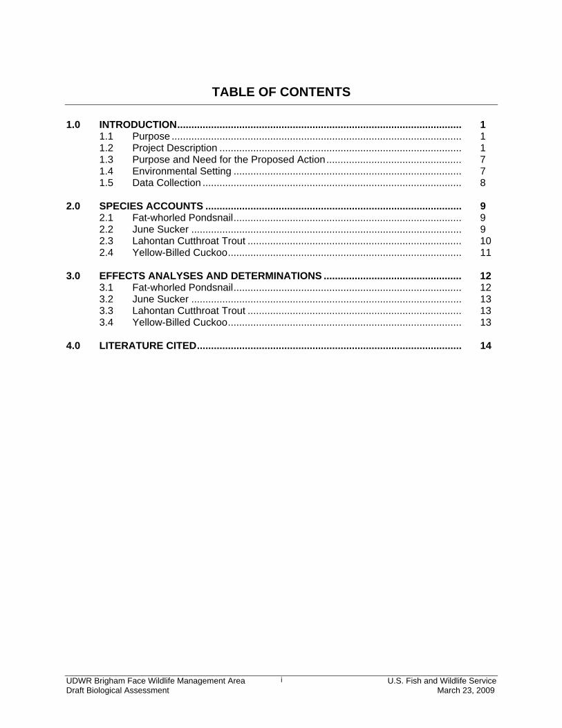
TABLE OF CONTENTS 1.0 INTRODUCTION ..................................................................................................... 1 1.1 Purpose ....................................................................................................... 1 1.2 Project Description ...................................................................................... 1 1.3 Purpose and Need for the Proposed Action ................................................ 7 1.4 Environmental Setting ................................................................................. 7 1.5 Data Collection ............................................................................................ 8 2.0 SPECIES ACCOUNTS ........................................................................................... 9 2.1 Fat-whorled Pondsnail ................................................................................. 9 2.2 June Sucker ................................................................................................ 9 2.3 Lahontan Cutthroat Trout ............................................................................ 10 2.4 Yellow-Billed Cuckoo ................................................................................... 11 3.0 EFFECTS ANALYSES AND DETERMINATIONS ................................................. 12 3.1 Fat-whorled Pondsnail ................................................................................. 12 3.2 June Sucker ................................................................................................ 13 3.3 Lahontan Cutthroat Trout ............................................................................ 13 3.4 Yellow-Billed Cuckoo ................................................................................... 13 4.0 LITERATURE CITED .............................................................................................. 14
UDWR Brigham Face Wildlife Management Area U.S. Fish and Wildlife Service Draft Biological Assessment March 23, 2009
1
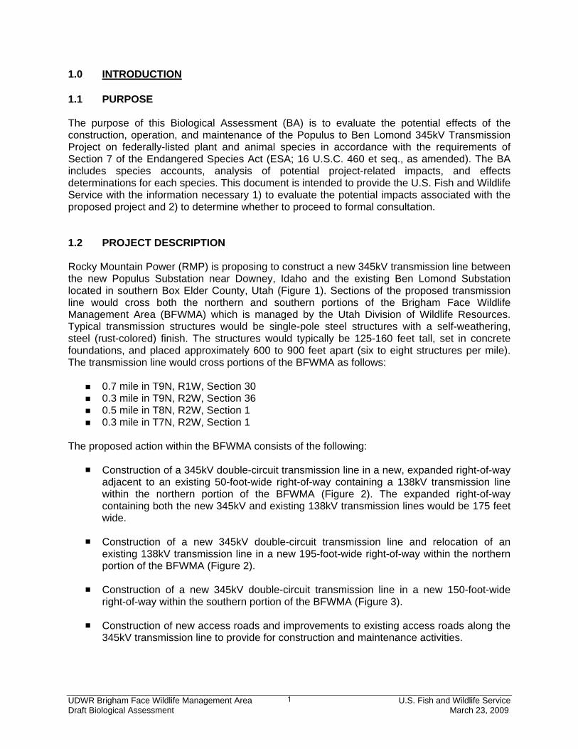
1.0 INTRODUCTION 1.1 PURPOSE The purpose of this Biological Assessment (BA) is to evaluate the potential effects of the construction, operation, and maintenance of the Populus to Ben Lomond 345kV Transmission Project on federally-listed plant and animal species in accordance with the requirements of Section 7 of the Endangered Species Act (ESA; 16 U.S.C. 460 et seq., as amended). The BA includes species accounts, analysis of potential project-related impacts, and effects determinations for each species. This document is intended to provide the U.S. Fish and Wildlife Service with the information necessary 1) to evaluate the potential impacts associated with the proposed project and 2) to determine whether to proceed to formal consultation. 1.2 PROJECT DESCRIPTION Rocky Mountain Power (RMP) is proposing to construct a new 345kV transmission line between the new Populus Substation near Downey, Idaho and the existing Ben Lomond Substation located in southern Box Elder County, Utah (Figure 1). Sections of the proposed transmission line would cross both the northern and southern portions of the Brigham Face Wildlife Management Area (BFWMA) which is managed by the Utah Division of Wildlife Resources. Typical transmission structures would be single-pole steel structures with a self-weathering, steel (rust-colored) finish. The structures would typically be 125-160 feet tall, set in concrete foundations, and placed approximately 600 to 900 feet apart (six to eight structures per mile). The transmission line would cross portions of the BFWMA as follows:
0.7 mile in T9N, R1W, Section 30 0.3 mile in T9N, R2W, Section 36 0.5 mile in T8N, R2W, Section 1 0.3 mile in T7N, R2W, Section 1
The proposed action within the BFWMA consists of the following:
Construction of a 345kV double-circuit transmission line in a new, expanded right-of-way adjacent to an existing 50-foot-wide right-of-way containing a 138kV transmission line within the northern portion of the BFWMA (Figure 2). The expanded right-of-way containing both the new 345kV and existing 138kV transmission lines would be 175 feet wide.
Construction of a new 345kV double-circuit transmission line and relocation of an
existing 138kV transmission line in a new 195-foot-wide right-of-way within the northern portion of the BFWMA (Figure 2).
Construction of a new 345kV double-circuit transmission line in a new 150-foot-wide
right-of-way within the southern portion of the BFWMA (Figure 3).
Construction of new access roads and improvements to existing access roads along the 345kV transmission line to provide for construction and maintenance activities.

I D A H OU T A H
Great
Salt
Lake
Bear River Migratory Bird Refuge
WillardBay
BEN LOMOND SUBSTATION
POPULUS SUBSTATION
Brigham FaceWMA
WeberCounty
Box ElderCounty
CacheCounty
FranklinCounty
OneidaCounty
BannockCounty
91
91
91
89
89/91
89
36
89
89/91
89
91
91
84
15
91
15
89
89
15
NorthOgden
Harrisville
FarrWestCity
Marriott-Slaterville
PleasantView
WestHaven
OgdenHuntsville
PlainCity
Lewiston
Paradise
Nibley
Cornish
Newton
Logan
Trenton
Smithfield
Clarkston
Amalga
NorthLogan
Richmond
Providence
RiverHeights
Mendon
HydePark
Hyrum
Wellsville
Millville
Garland
BrighamCity
Perry
Plymouth
Mantua
Howell
Willard
Honeyville
Tremonton
Portage
Fielding
ElwoodDeweyville
Corinne
BearRiverCity
Snowville
Franklin
Weston
Preston
Dayton
MaladCity
Clifton
Oxford
Downey
BRIDGERLAND
BRIGHAMCITY
TREASURETON
HONEYVILLE
WHEELON
WARREN
Cutler
Oneida
p:\gis\projects\pacificorp\pathc\mxds\UpdatesPost3-25\engineering preferred_GR.mxd
SOURCES: Imagery, NAIP 2006; Political Boundaries and Transportation, ESRI; Transmission Lines and Substations, PacificorpNOTE: Transmission systems and substation locations are from Pacificorp GIS Department. Information is schematic and does not necessarily represent accurate locations.
1:125,000
0 5 10Miles
Legend
Bureau of Land ManagementU.S. Forest Service
Department of DefenseNational Park ServiceU.S. Fish and Wildlife ServiceUtah Division of Wildlife ResourcesState of Utah / State of Idaho
General Reference Features345kV Transmission Line230kV Transmission Line115/138kV Transmission Line
Power PlantSubstationSubstation
46kV Subtransmission Line
Exist ing Transmission FeaturesLegendProposed 345kV Transmission Route(approximate location)
November ��, 2008
Brigham Face WMAProject Overview
POPULUS TO BEN LOMOND 345KV TRANSMISSION PROJECT
Figure 1

1
2
3
4
5
6
T9N
R2W
T9N
R1W
T9N R2WT8N R2W
T9N R1WT8N R1W
T8N
R2W
T8N
R1W
BRIGHAMCITY
413120
413120
414120
414120
415120
415120
416120
416120
417120
417120
418120
418120
4588
207
4589
207
4589
207
4590
207
4590
207
4591
207
4591
207
4592
207
4592
207
4593
207
4593
207
4594
207
4594
207
4595
207
4595
207
P:\GIS\Projects\PacifiCorp\pathc\mxds\Brigham Face WMA North preferred TOPO.mxd
Figure 2
November 26, 2008
POPULUS TO BEN LOMOND 345KV TRANSMISSION PROJECT
SOURCES: Topogaphic Maps, USGS; Political Boundaries and Transportation, ESRI; Transmission Lines and Substations, PacificorpNOTE: Transmission systems and substation locations are from Pacificorp GIS Department. Information is schematic and does not necessarily represent accurate locations.
1:6,000
1
BrighamFace
WMA
0 1,000 2,000Feet
Brigham Face WMANorthern Area
LegendLegend Existing Transmission Features
Proposed Access Roads Off ROW
Brigham Face WMA Boundary
Proposed 345kV Transmission Route
Proposed Relocation of 138kV Transmission LineAlternative 345kV Transmission Route
Transmission Line Structures (Approximate Location- StructureLocations May Change Upon Further Engineering)
U.S. Forest Service
General Reference Features
Township/Range Line138kV Transmission LineSubstation
Substation
Transmission Line Segments

7
T8N R2WT7N R2W
T8N
R2W
T8N
R1W
T7N
R2W
T7N
R1W
T8N R1WT7N R1W
411621
411621
412621
412621
413621
413621
414621
414621
415621
415621
416621
416621
4577
443
4578
443
4578
443
4579
443
4579
443
4580
443
4580
443
4581
443
4581
443
4582
443
4582
443
4583
443
4583
443
4584
443
0 1,000 2,000Feet
P:\GIS\Projects\PacifiCorp\pathc\mxds\Brigham Face WMA South Mcguire alt.mxd
Figure 3
November 26, 2008
POPULUS TO BEN LOMOND 345KV TRANSMISSION PROJECT
SOURCES: Topogaphic Maps, USGS; Political Boundaries and Transportation, ESRI; Transmission Lines and Substations, PacificorpNOTE: Transmission systems and substation locations are from Pacificorp GIS Department. Information is schematic and does not necessarily represent accurate locations.
1:6,000
BrighamFace
WMA
26
McGuire Gravel Pit
Brigham Face WMA Boundary
U.S. Forest Service
General Reference FeaturesLegendLegendProposed 345kV Transmission Route
Existing Transmission Features
Township/Range LineAlternative 345kV Transmission Route
Transmission Line Structures (Approximate Location- StructureLocations May Change Upon Further Engineering)
Brigham Face WMASouthern Area138kV Transmission Line
345kV Transmission Line
7 Transmission Line Segments

UDWR Brigham Face Wildlife Management Area U.S. Fish and Wildlife Service Draft Biological Assessment March 23, 2009
5
Construction Process Construction of the overall project is planned to meet an in-service date of May 2010. Meeting the in-service date is critical for providing adequate service and reliability to RMP’s customers. The general process for constructing the new Populus to Ben Lomond 345kV Transmission Project would involve the following:
1) surveying and staking the centerline of the transmission line; 2) constructing new access roads and improving existing access roads where necessary; 3) clearing work areas as needed; 4) augering holes for transmission line structure foundations and framing and erecting poles; 5) installing ground wires and conductors; and 6) restoring disturbed surfaces in and around construction areas.
Surveying Activities Construction survey work would consist of surveying centerline locations, tower locations, right-of-way boundaries, access and spur roads, and temporary work areas. The specified centerline and right-of way boundaries would be marked at reasonable intervals, and the temporary work areas marked at the four corners with painted laths or flags. Closer intervals may be flagged as needed. Flagging would be maintained until final cleanup and/or restoration is completed. At a minimum, reference stakes for all angle stations would be set on the right-of-way with stakes for each structure prior to construction. Access Road Improvement/Construction It is necessary to provide road access to each transmission structure. The project would utilize existing access roads wherever practical, thus minimizing the need for new road construction. In general, new roads would not exceed 16 feet in width. Roads running across slopes may be slightly wider to ensure safe access. Some short spur roads would be constructed from existing access roads to the structures, as necessary. Because RMP requires 16-foot-wide access roads, some existing roads may need to be improved and widened to meet this requirement. These roads would be identified as “improve existing” on RMP drawings. The construction contractor would lay out and stake all approved access roads in the field. To the maximum extent possible, drainages would be crossed at grade. Where at-grade crossings would not be feasible, culverts would be constructed. In addition, meandering roads may be used in some areas in response to specific geologic conditions. Typical Structure Site and Work Area Work areas would be needed at each structure site to facilitate safe operations for equipment and construction. Generally, work areas in flat terrain would require a temporary disturbance area of approximately 200 feet by 150 feet (right-of-way width). Typically, the structure footings would entail permanent disturbance of an area of approximately 8 feet by 8 feet within work areas. Vegetation in work areas would be cleared to the extent necessary. Access within the work area would be by overland travel. Generally, grading at the work area would be minimal.

UDWR Brigham Face Wildlife Management Area U.S. Fish and Wildlife Service Draft Biological Assessment March 23, 2009
6
Foundation Installation Power equipment would be used for foundation excavation. Generally, a vehicle-mounted power auger or backhoe would be used in all areas where the soil is suited to use of this equipment. In extremely sandy areas, soil stabilization by water or a gelling agent may be used prior to excavation. Following excavation, cast-in-place footings would be installed by placing reinforcing steel and a structure stub into the foundation hole, positioning the stub, and encasing it in concrete. Spoil material would be used for fill where suitable. Excess spoil material would be disposed of off-site at an approved location. Foundation excavation and installation would require use of access roads to the site by a power auger or drill, a crane, materials trucks, and concrete trucks. Immediately following excavation, foundation holes would be covered to protect the public and wildlife. If practical, fencing may be used. Soil removed from foundation holes and stockpiled at the work area would be used to backfill holes. The topmost layer of soil would be distributed over the work area. To wash concrete chutes, a depression would be created in the center of the stockpiled soil near the center of the permanently disturbed structure location site. The first 6 inches of topsoil would be placed on one side of the depression, and the remainder of the soil on the other side. Material would be washed off of the chute into the depression and the soil replaced in the same order it was removed. This technique would help salvage the seed bank. Structure Assembly and Erection Steel tubes and associated hardware would be transported to each structure site by truck. Steel members would be assembled into subsections of convenient size and weight. The assembled subsections would be hoisted into place by a large crane and then fastened together to form a complete structure. Conductor Installation Insulators, hardware, and stringing sheaves would be delivered to each structure site following erection of the structures. The structures would then be rigged with insulator strings and stringing sheaves at each ground wire and conductor position. For public protection during wire installation, guard structures would be erected over highways, railroads, power lines, structures, and other features requiring protection. Guard structures generally consist of H-frame poles placed on either side of a feature to be protected. These structures prevent ground wire, conductor, or equipment from falling on a feature. A pilot line would be pulled (i.e., strung) from pole to pole by ground equipment (e.g., ATV or 4-wheel drive truck) and threaded through the stringing sheaves at each structure. A larger diameter, stronger line would then be attached to the pilot line and strung. This process would be repeated until the ground wire and conductor are pulled through all sheaves. Ground wire and conductor would be strung using powered pulling equipment at one end and powered braking or tensioning equipment at the other end.

UDWR Brigham Face Wildlife Management Area U.S. Fish and Wildlife Service Draft Biological Assessment March 23, 2009
7
Typically, areas required for tensioning and pulling equipment would be approximately 200 feet by 200 feet. However, construction occurring in steep or rough terrain may require larger, less symmetrical pulling and tensioning areas. Ground Rod Installation Prior to wire installation, tower footing resistance along the route would be measured as a part of standard construction practices. Where resistance to remote earth for each transmission tower is greater than 25 ohms, counterpoise (grounds) would be installed to lower the resistance to 25 ohms or less. Counterpoise consists of a bare copper clad or galvanized steel cable buried at least 12 inches deep, extending from one or more structure legs for approximately 200 feet within the right-of-way. Site Reclamation Construction sites, material storage yards, and access roads would be kept in an orderly condition and free of trash throughout the construction period. Refuse and trash would be collected at the temporary material staging construction yards (i.e., pulling and tensioning areas) in a closed container until removed from the yards and disposed of in an approved manner. Oils and fuels would not be disposed of within the vicinity of the right-of-way. 1.3 PURPOSE AND NEED FOR THE PROPOSED ACTION Construction of the new 345kV transmission line is needed to meet electrical load growth and enhance transmission grid reliability in portions of northern Utah and southeastern Idaho. RMP’s 2007 Integrated Resource Plan forecasts that RMP’s network load obligation will grow during the next ten years at an annual average rate of three percent. The existing transmission capacity from southeastern Idaho into Utah is fully utilized and no additional capacity can be made available without the addition of new transmission lines. The purpose of this project is to add significant incremental transmission capacity between southeastern Idaho and northern Utah and facilitate a stronger interconnection to systems feeding Idaho, Wyoming, and the Northwest in general. RMP determined that the best means of making a significant incremental increase in the transmission capacity necessary to continue to reliably and economically serve these growing electrical loads would be to construct a new double-circuit 345kV transmission line, connecting the southeastern Idaho transmission system to the Utah load center in the Wasatch Front. The new 345kV circuits would provide access to existing and future generating resources and enhance the reliability of the existing system. 1.4 ENVIRONMENTAL SETTING The project corridor is located in the western foothills of the Wasatch Front along the boundary of Central Basin and Range and Wasatch and Uinta Mountains level III ecoregions (EPA 2002). Topography in the project area consists of moderately steep slopes and benches with westerly aspects, and the corridor crosses several small drainages. Elevations in the project corridor generally range between 4,500 feet and 5,000 feet above mean sea level (msl).
UDWR Brigham Face Wildlife Management Area U.S. Fish and Wildlife Service Draft Biological Assessment March 23, 2009
8
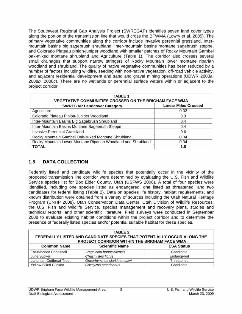
The Southwest Regional Gap Analysis Project (SWREGAP) identifies seven land cover types along the portion of the transmission line that would cross the BFWMA (Lowry et al. 2005). The primary vegetative communities along the corridor include invasive perennial grassland, Inter-mountain basins big sagebrush shrubland, Inter-mountain basins montane sagebrush steppe, and Colorado Plateau pinion-juniper woodland with smaller patches of Rocky Mountain Gambel oak-mixed montane shrubland and Agriculture (Table 1). The corridor also crosses several small drainages that support narrow stringers of Rocky Mountain lower montane riparian woodland and shrubland. The quality of native vegetative communities has been reduced by a number of factors including wildfire, seeding with non-native vegetation, off-road vehicle activity, and adjacent residential development and sand and gravel mining operations (UDWR 2008a, 2008b, 2008c). There are no wetlands or perennial surface waters within or adjacent to the project corridor.
TABLE 1 VEGETATIVE COMMUNITIES CROSSED ON THE BRIGHAM FACE WMA
SWREGAP Landcover Category Linear Miles Crossed Agriculture 0.02 Colorado Plateau Pinion-Juniper Woodland 0.3 Inter-Mountain Basins Big Sagebrush Shrubland 0.4 Inter-Mountain Basins Montane Sagebrush Steppe 0.4 Invasive Perennial Grassland 0.6 Rocky Mountain Gambel Oak-Mixed Montane Shrubland 0.04 Rocky Mountain Lower Montane Riparian Woodland and Shrubland 0.04 TOTAL 1.8
1.5 DATA COLLECTION Federally listed and candidate wildlife species that potentially occur in the vicinity of the proposed transmission line corridor were determined by evaluating the U.S. Fish and Wildlife Service species list for Box Elder County, Utah (USFWS 2008). A total of four species were identified, including one species listed as endangered, one listed as threatened, and two candidates for federal listing (Table 2). Data on species life history, habitat requirements, and known distribution were obtained from a variety of sources including the Utah Natural Heritage Program (UNHP 2008), Utah Conservation Data Center, Utah Division of Wildlife Resources, the U.S. Fish and Wildlife Service, species management and recovery plans, studies and technical reports, and other scientific literature. Field surveys were conducted in September 2008 to evaluate existing habitat conditions within the project corridor and to determine the presence of federally listed species and/or potential suitable habitat for these species.
TABLE 2 FEDERALLY LISTED AND CANDIDATE SPECIES THAT POTENTIALLY OCCUR ALONG THE
PROJECT CORRIDOR WITHIN THE BRIGHAM FACE WMA Common Name Scientific Name ESA Status
Fat-Whorled Pondsnail Stagnicola bonnevillensis Candidate June Sucker Chasmistes liorus Endangered Lahontan Cutthroat Trout Oncorhynchus clarki hensawi Threatened Yellow-Billed Cuckoo Coccyzus americanus Candidate

UDWR Brigham Face Wildlife Management Area U.S. Fish and Wildlife Service Draft Biological Assessment March 23, 2009
9
2.0 SPECIES ACCOUNTS 2.1 FAT-WHORLED PONDSNAIL (Stagnicola bonnevillensis) Status The Fat-whorled Pondsnail (Stagnicola bonnevillensis) was designated as a Candidate for federal listing on November 15, 1994 (59 FR 58982). The species has been assigned a Listing Priority Number of 8 due to imminent threats of a moderate to low magnitude (USFWS 2007). Distribution and Habitat Requirements The Fat-whorled Pondsnail occupies small, well-vegetated spring-fed ponds of between 0.25 and 1 acre in size with diverse substrates of mud, gravel, and/or rocks (Oliver and Bosworth 1999). Individuals spend their entire life history from egg to adult within the spring-fed ponds. Clark (1991) reported the extant populations of the Fat-whorled Pondsnail inhabiting three spring-fed pond systems located in an area about 3 miles long close to Utah Highway 83 (mileposts 14 and 17) northwest of Corinne, in Box Elder County, Utah. The UDWR surveys substantiate that the Fat-whorled Pondsnail has been present in five ponds north of the Great Salt Lake in Box Elder County, Utah (USFWS 2007). These springs include Shotgun Spring, Pipe Spring, and Fish Spring (all south of Utah State Route 83) as well as Horse Spring A and Horse Spring B which are connected by a culvert under Route 83. Primary Threats The primary threats to the Fat-whorled Pondsnail include pollution and a decline in water quality as a result of pipeline leaks, chemical contamination (trichloroethylene and perchlorate) from the Thiokol facility, intensive, unregulated grazing, reduced groundwater levels and spring flows associated with extended drought conditions, and the absence of formal regulatory mechanism protecting the species or its habitat (USFWS 2007). Occurrence in Project Area The Fat-whorled Pondsnail is a narrow endemic that is only known to occur in a series of small spring-fed ponds along Highway 83 in Box Elder County, Utah. The project area is located approximately 20 miles from the nearest occupied habitat. The area is outside the known range of the Fat-whorled Pondsnail and does not contain suitable habitat for this species. The Fat-whorled Pondsnail does not occur in the project area. 2.2 JUNE SUCKER (Chasmistes liorus) Status The June Sucker (Chasmistes liorus) was listed as Endangered on April 30, 1986 (51 FR 10851). The lower 4.9 miles of the main channel of the Provo River is designated as critical habitat for the species. A species recovery plan was completed in 1999 (USFWS 1999). In 2001, an Environmental Assessment was completed for the June Sucker Recovery

UDWR Brigham Face Wildlife Management Area U.S. Fish and Wildlife Service Draft Biological Assessment March 23, 2009
10
Implementation Program which will implement recovery actions and facilitate the resolution of conflicts associated with June Sucker recovery in Utah Lake drainage basin (66 FR 56840). Distribution and Habitat Requirements The June Sucker is a narrow endemic that only occurs in Utah Lake. Prior to settlement of the Utah Valley, the species was known to spawn in several large tributaries of Utah Lake, including the Spanish Fork River, Hobble Creek, and the Provo River. These tributaries entered the lake through large delta’s that created braided, slow, meandering channels. As a result of hydrological changes, the species is currently known to spawn only in the lower three miles of the Provo River from the confluence with Utah Lake upstream to the Geneva Road Diversion (Bosworth 2003). Five refugia populations have been established outside of Utah Lake for the purposes of species conservation (USFWS 1999). These populations are located at the Springville Hatchery, Camp Creek Reservoir, Red Butte Reservoir, Ogden Nature Center, and Utah Fisheries Experiment Station. Primary Threats The primary threats to the June Sucker include habitat alteration (water development, diversions, and river channelization and loss of floodplains due to urban development), pollution and a decline in water quality, hybridization with other sucker species, and competition with and predation by introduced non-native fish species (USFWS 1999). Occurrence in Project Area The June Sucker is endemic to Utah Lake and the lower Provo River in Utah County. The project area is located outside the known range of the June Sucker and does not contain suitable habitat for this species. The June Sucker does not occur in the project area. 2.3 LAHONTAN CUTTHROAT TROUT (Oncorhynchus clarki henshawi) Status The Lahontan Cutthroat Trout (Oncorhynchus clarki henshawi) was listed as Endangered on October 13, 1970 (35 FR 13520), and was subsequently reclassified as Threatened on July 16, 1975 (40 FR 29863). No critical habitat has been designated for this species. A Recovery Plan for the Lahontan Cutthroat Trout was published in 1995 (USFWS 1995). On September 9, 2008, the USFWS determined that delisting the Lahontan Cutthroat Trout is not warranted (73 FR 52257).

UDWR Brigham Face Wildlife Management Area U.S. Fish and Wildlife Service Draft Biological Assessment March 23, 2009
11
Distribution and Habitat Requirements The Lahontan Cutthroat Trout is a unique subspecies of cutthroat trout that is endemic to the Lahontan basin of northeastern California, southeastern Oregon, and northern Nevada (USFWS 1995). As part of the species recovery efforts, the Lahontan Cutthroat Trout has been reintroduced into a number of waters within the species historic range. Additionally, the species has introduced and become established in waters outside the Lahontan basin. The species currently inhabits three headwater streams and one small pond in the Pilot Peak Range in western Box Elder County, Utah including (USFWS 1995). The Lahontan Cutthroat Trout is adapted to live in saline and alkaline lakes and streams. The species inhabits a wide variety of cold-water habitats including large terminal alkaline lakes (e.g., Pyramid and Walker lakes), alpine lakes (e.g., Lake Tahoe and Independence Lake), slow meandering rivers (e.g., Humboldt River), mountain rivers (e.g., Carson and Truckee Rivers), and small headwater tributary streams (e.g., Donner and Prosser Creeks). Generally, Lahontan cutthroat trout occur in cool flowing water with available cover of well-vegetated and stable stream banks, in areas where there are stream velocity breaks, and in relatively silt free, rocky riffle-run areas (USFWS 1995). Primary Threats At the time of the species listing as Endangered, the USFWS identified the primary threats as habitat destruction and modification primarily due to dams and water developments and hybridization with introduced trout species (35 FR 13520). Current threats are considered to include isolation of populations, loss and alteration of spawning habitat, competition with non-native fish, and hybridization with non-native trout species. Occurrence in Project Area The project area is located outside the known range of the Lahontan Cutthroat Trout and does not contain suitable habitat for this species. The Lahontan Cutthroat Trout does not occur in the project area. 2.4 YELLOW-BILLED CUCKOO (Coccyzus americanus) Status The western distinct population segment of the Yellow-billed Cuckoo (Coccyzus americanus) was designated as a Candidate for federal listing on October 30, 2001 (66 FR 38611). The species has been assigned a Listing Priority Number of 3 due to imminent threats of a high magnitude. Distribution and Habitat Requirements Historic accounts indicate that the Yellow-billed Cuckoo was widespread and locally common in California and Arizona, locally common in a few river reaches in New Mexico, locally common in

UDWR Brigham Face Wildlife Management Area U.S. Fish and Wildlife Service Draft Biological Assessment March 23, 2009
12
Oregon and Washington, generally local and uncommon in scattered drainages of the arid and semiarid portions of western Colorado, western Wyoming, Idaho, Nevada, and Utah (USFWS 2007a). Historically, the Yellow-billed Cuckoo was uncommon in Utah with the only known specimens obtained from Salt Lake County in 1989 and 1913, Washington County in 1939, and sites near Hurricane in 1932, Salt Lake City in 1946, Bountiful in 1955, and Capitol Reef National Park in 1980 (Parrish et al. 2002). The only three breeding records in Utah within the last 10 years include the Provo River, Moab Sloughs, and Ouray National Wildlife Refuge (Parrish et al. 2002). Recent avian surveys of riparian habitats within the historic range in the Salt Lake Valley recorded three cuckoos in 7,000 survey hours (USFWS 2007a). The Yellow-billed Cuckoo is a riparian obligate species that requires large tracts of mature cottonwood/willow forest with a dense sub-canopy for breeding (Parrish et al. 2002). The current species distribution in Utah is not well known, but it is considered to be an extremely rare breeder in suitable riparian habitats throughout the state. Primary Threats The primary threats to this species include habitat loss, cattle grazing, and pesticide application (USFWS 2007 a). Biologists estimate that more than 90 percent of Yellow-billed Cuckoo riparian habitat in the West has been lost or degraded (USFWS 2007a). Principal causes of riparian habitat losses include development, grazing and other agricultural activities, stream channelization and stabilization, and changes in watershed hydrology associated with dams. Suitable breeding habitats have also been substantially reduced in quantity and quality by groundwater pumping and the replacement of native vegetative communities by tamarisk (Tamarix spp.). Where riparian habitat borders agricultural lands, pesticide use may affect cuckoos by reducing the prey base or by poisoning nestlings (USFWS 2007a). Occurrence in Project Area The project area is located within the known range of the Yellow-billed Cuckoo. However, the area does not contain suitable riparian habitat (mature cottonwood/willow forest with a dense sub-canopy) that is necessary to support a breeding population. There have been no reported observations of the Yellow-billed Cuckoo within the project area (Utah Birds 2008). There is a small potential for transient individuals to occasionally occur in the project area during seasonal migrations, but the area does not support resident Yellow-billed Cuckoos. 3.0 EFFECTS ANALYSES AND DETERMINATIONS 3.1 FAT-WHORLED PONDSNAIL (Stagnicola bonnevillensis) Effects Analysis — The project area does not contain potential suitable habitat for the Fat-whorled Pondsnail, and the species does not occur in this area. Effects Determination — The Proposed Project would have no effect upon the Fat-whorled Pondsnail.
UDWR Brigham Face Wildlife Management Area U.S. Fish and Wildlife Service Draft Biological Assessment March 23, 2009
13
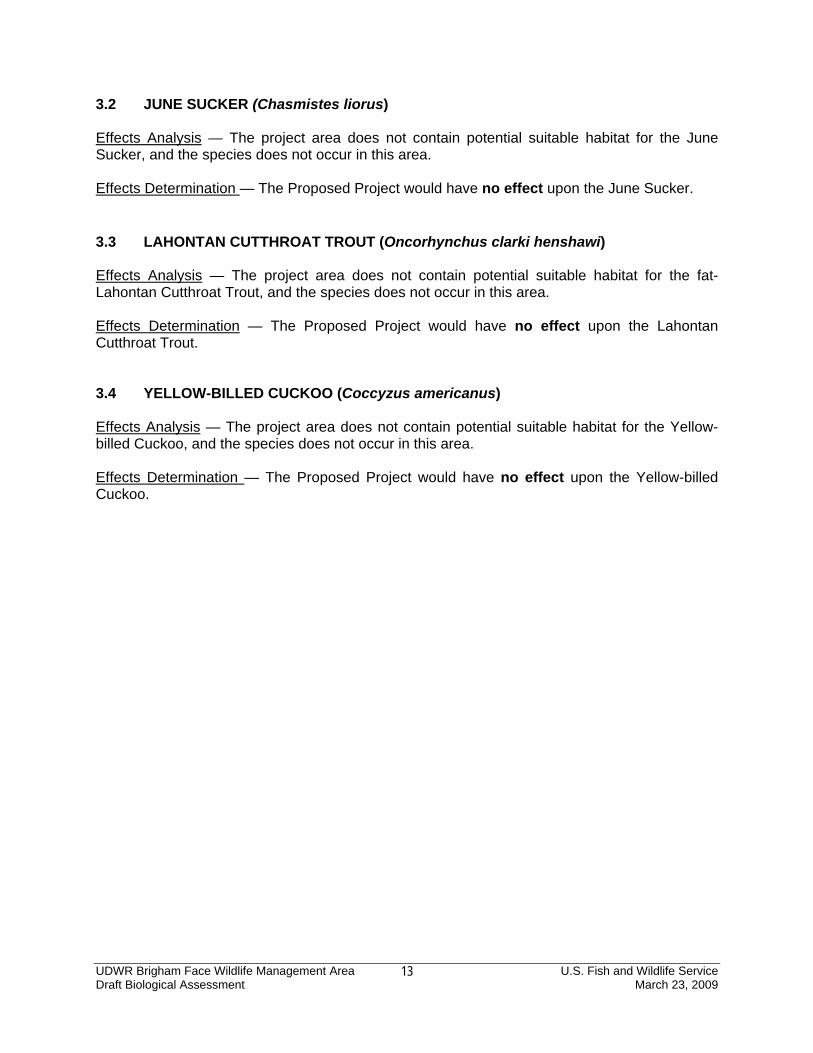
3.2 JUNE SUCKER (Chasmistes liorus) Effects Analysis — The project area does not contain potential suitable habitat for the June Sucker, and the species does not occur in this area. Effects Determination — The Proposed Project would have no effect upon the June Sucker. 3.3 LAHONTAN CUTTHROAT TROUT (Oncorhynchus clarki henshawi) Effects Analysis — The project area does not contain potential suitable habitat for the fat- Lahontan Cutthroat Trout, and the species does not occur in this area. Effects Determination — The Proposed Project would have no effect upon the Lahontan Cutthroat Trout. 3.4 YELLOW-BILLED CUCKOO (Coccyzus americanus) Effects Analysis — The project area does not contain potential suitable habitat for the Yellow-billed Cuckoo, and the species does not occur in this area. Effects Determination — The Proposed Project would have no effect upon the Yellow-billed Cuckoo.

UDWR Brigham Face Wildlife Management Area U.S. Fish and Wildlife Service Draft Biological Assessment March 23, 2009
14
4.0 LITERATURE CITED Bosworth, W. 2003. Vertebrate Information Compiled by the Utah Natural Heritage Program: A
Progress Report. Utah Division of Wildlife Resources Publication Number 03-45. 336 pp. Clarke, A. H. 1991. Status survey of selected land and freshwater gastropods in Utah, Colorado,
and Montana. Unpublished report. 102 pp. Lowry, J. H, Jr., R. D. Ramsey, K. Boykin, D. Bradford, P. Comer, S. Falzarano, W. Kepner, J.
Kirby, L. Langs, J. Prior-Magee, G. Manis, L. O’Brien, T. Sajwaj, K. A. Thomas, W. Rieth, S. Schrader, D. Schrupp, K. Schulz, B. Thompson, C. Velasquez, C. Wallace, E. Waller and B. Wolk. 2005. Southwest Regional Gap Analysis Project: Final Report on Land Cover Mapping Methods. RS/GIS Laboratory, Utah State University, Logan, Utah.
Oliver, George V. and William R. Bosworth III. 1999. Rare, imperiled, and recently extinct or
extirpated mollusks of Utah[:] a literature review. Publication number 99-29. Utah Division of Wildlife Resources, Salt Lake City. 230 pp.
Parrish, J, F. Howe, R. Norvell. 2002. Utah Partners in Flight Avian Conservation Strategy
Version 2.0. Utah Partners in Flight Program, Utah Division of Wildlife Resources Publication Number 02-27. 302 pp.
U.S. Environmental Protection Agency (EPA). 2002. Primary Distinguishing Characteristics Of
Level III Ecoregions Of The Continental United States. Available at http://www.epa.gov/wed/pages/ecoregions/level_iii.htm#Ecoregions. Accessed November 5, 2008.
U.S. Fish and Wildlife Service (USFWS). 2008. Endangered, Threatened, Proposed, and
candidate species: Utah Counties. November 2007. Available at http://www.fws.gov/mountain-prairie/endspp/countylists/utah.pdf. Accessed on November 7, 2008.
_____. 2007. U.S. Fish and Wildlife Service Species Assessment and Listing Priority
Assignment Form: Fat-whorled pondsnail (Stagnicola bonnevillensis). November 27, 2007 _____. 2007a. U.S. Fish and Wildlife Service Species Assessment and Listing Priority
Assignment Form: Yellow-billed Cuckoo (Coccyzus americanus), Western United States Distinct Population Segment. July 25, 2007
_____. 1999. June sucker (Chasmistes liorus) Recovery Plan. U.S. Fish and Wildlife Service,
Denver, CO. 61 pp. _____. 1995. Recovery Plan for the Lahontan Cutthroat Trout. Portland, Oregon. January 1995. Utah Birds. 2008. Bird Sightings and Reports. Available at http://www.utahbirds.org. Accessed
on November 6, 2008. Utah Division of Wildlife Resources (UDWR). 2008a. Trend Study 3-13-96. Available at
http://wildlife.utah.gov/range/pdf/wmu03/03-19.pdf. Accessed on November 5, 2008.

UDWR Brigham Face Wildlife Management Area U.S. Fish and Wildlife Service Draft Biological Assessment March 23, 2009
15
Utah Division of Wildlife Resources (UDWR). 2008b. Trend Study 3-13-96. Available at http://wildlife.utah.gov/range/pdf/wmu03/03-5.pdf. Accessed on November 5, 2008.
_____. 2008c. Trend Study 3-13-96. Available at http://wildlife.utah.gov/range/pdf/wmu03/03-
13.pdf. Accessed on November 5, 2008. Utah Natural Heritage Program (UNHP). 2008. Special Status Species Occurrences. GIS
database 3036_unhp_masked_pts. February 1, 2008.