Appendix A Screening Level Analysis Parameters · PDF fileEquilibrium distribution coefficient...
133
Appendix A Appendix A Screening Level Analysis Parameters
Transcript of Appendix A Screening Level Analysis Parameters · PDF fileEquilibrium distribution coefficient...

Appendix A
Appendix A Screening Level Analysis Parameters
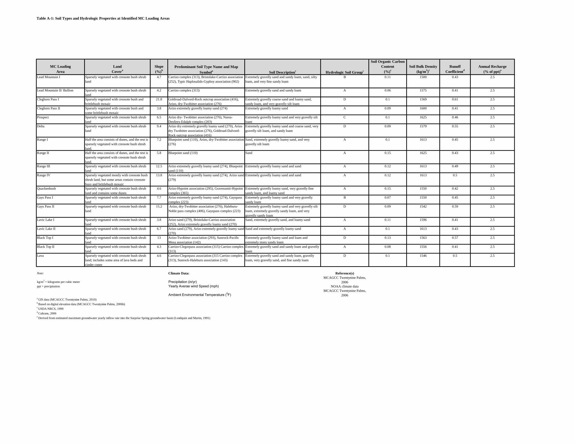
Table A-1: Soil Types and Hydrologic Properties at Identified MC Loading Areas
MC Loading Land SlopeSoil Organic Carbon
Content Soil Bulk Density Runoff Annual RechargeArea Covera (%)b (%)c (kg/m3)c Coefficientd (% of ppt)e
Lead Mountain I Sparsely vegetated with creosote bush shrub land
4.7 Carrizo complex (313), Bristolake-Carrizo association (252), Typic Haplosalids-Gypboy association (902)
Extremely gravelly sand and sandy loam, sand, silty loam, and very fine sandy loam
B 0.11 1500 0.43 2.5
Lead Mountain II/ Bullion Sparsely vegetated with creosote bush shrub land
4.2 Carrizo complex (313) Extremely gravelly sand and sandy loam A 0.06 1575 0.41 2.5
Cleghorn Pass I Sparsely vegetated with creosote bush and brittlebush mosaic
21.8 Goldroad-Dalvord-Rock outcrop association (416), Arizo, dry-Twobitter association (276)
Extremely gravelly coarse sand and loamy sand, sandy loam, and very gravelly silt loam
D 0.1 1569 0.61 2.5
Cleghorn Pass II Sparsely vegetated with creosote bush and some brittlebush mosaic
3.8 Arizo extremely gravelly loamy sand (274) Extremely gravelly loamy sand A 0.09 1600 0.41 2.5
Prospect Sparsely vegetated with creosote bush shrub land
6.5 Arizo dry- Twobitter association (276), Narea-Desfirex-Edalph complex (203)
Extremely gravelly loamy sand and very gravelly silt loam
C 0.1 1625 0.46 2.5
Delta Sparsely vegetated with creosote bush shrub land
9.4 Arizo dry extremely gravelly loamy sand (270), Arizo dry Twobitter association (276), Goldroad-Dalvord-Rock outcrop association (416)
Extremely gravelly loamy sand and coarse sand, very gravelly silt loam, and sandy loam
D 0.09 1579 0.55 2.5
Range I Half the area consists of dunes, and the rest is sparsely vegetated with creosote bush shrub land.
7.2 Bluepoint sand (110), Arizo, dry-Twobitter association (276)
Sand, extremely gravelly loamy sand, and very gravelly silt loam
A 0.1 1613 0.45 2.5
Range II Half the area consists of dunes, and the rest is sparsely vegetated with creosote bush shrub land.
5.8 Bluepoint sand (110) Sand A 0.15 1625 0.43 2.5
Range III Sparsely vegetated with creosote bush shrub land
12.5 Arizo extremely gravelly loamy sand (274), Bluepoint sand (110)
Extremely gravelly loamy sand and sand A 0.12 1613 0.49 2.5
Range IV Sparsely vegetated mostly with creosote bush shrub land, but some areas contain creosote busy and brittlebush mosaic
13.8 Arizo extremely gravelly loamy sand (274), Arizo sand (279)
Extremely gravelly loamy sand and sand A 0.12 1613 0.5 2.5
Quackenbush Sparsely vegetated with creosote bush shrub land and contains some dunes
4.6 Arizo-Hypoint association (295), Gravesumit-Hypoint complex (365)
Extremely gravelly loamy sand, very gravelly fine sandy loam, and loamy sand
A 0.15 1550 0.42 2.5
Gays Pass I Sparsely vegetated with creosote bush shrub land
7.7 Arizo extremely gravelly loamy sand (274), Gayspass complex (223)
Extremely gravelly loamy sand and very gravelly sandy loam
B 0.07 1550 0.45 2.5
Gays Pass II Sparsely vegetated with creosote bush shrub land
15.2 Arizo, dry-Twobitter association (276), Haleburu-Noble pass complex (406), Gayspass complex (223)
Extremely gravelly loamy sand and very gravelly silt loam, extremely gravelly sandy loam, and very gravelly sandy loam
D 0.09 1542 0.59 2.5
Lavic Lake I Sparsely vegetated with creosote bush shrub land
3.8 Arizo sand (279), Bristolake-Carrizo association (252), Arizo extremely gravelly loamy sand (270)
Sand, extremely gravelly sand, and loamy sand A 0.11 1596 0.41 2.5
Lavic Lake II Sparsely vegetated with creosote bush shrub land
6.7 Arizo sand (279), Arizo extremely gravelly loamy sand (270)
Sand and extremely gravelly loamy sand A 0.1 1613 0.43 2.5
Black Top I Sparsely vegetated with creosote bush shrub land
13 Arizo-Twobitter association (293), Sunrock-Pacific Mesa association (142)
Extremely gravelly loamy sand and loam and extremely stony sandy loam
D 0.13 1563 0.57 2.5
Black Top II Sparsely vegetated with creosote bush shrub land
4.3 Carrizo-Clegorpass association (315) Carrizo complex (313)
Extremely gravelly sand and sandy loam and gravelly loam
A 0.08 1556 0.41 2.5
Lava Sparsely vegetated with creosote bush shrub land; includes some area of lava beds and cinder cones
4.6 Carrizo-Clegorpass association (315 Carrizo complex (313), Sunrock-Haleburu association (143)
Extremely gravelly sand and sandy loam, gravelly loam, very gravelly sand, and fine sandy loam
D 0.1 1546 0.5 2.5
Note: Climate Data: Reference(s)
kg/m3 = kilograms per cubic meter Precipitation (in/yr)MCAGCC Twentynine Palms,
2006ppt = precipitation Yearly Averae wind Speed (mph) NOAA climate data
Ambient Environmental Temperature (0F)MCAGCC Twentynine Palms,
2006a GIS data (MCAGCC Twentynine Palms, 2010)b Based on digital elevation data (MCAGCC Twentynine Palms, 2006b)c USDA NRCS, 1999d Caltrans, 2006e Derived from estimated maximum groundwater yearly inflow rate into the Surprise Spring groundwater basin (Londquist and Martin, 1991)
Predominant Soil Type Name and Map Symbola Soil Descriptionc Hydrologic Soil Groupc
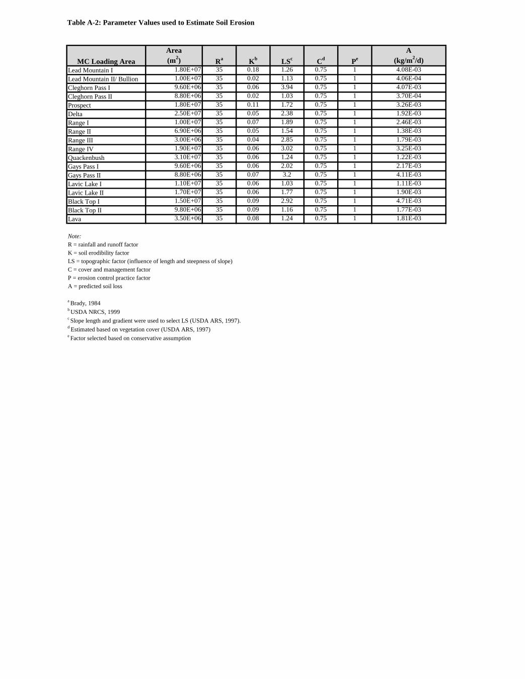
Table A-2: Parameter Values used to Estimate Soil Erosion
Area A (m2) (kg/m2/d)
Lead Mountain I 1.80E+07 35 0.18 1.26 0.75 1 4.08E-03Lead Mountain II/ Bullion 1.00E+07 35 0.02 1.13 0.75 1 4.06E-04Cleghorn Pass I 9.60E+06 35 0.06 3.94 0.75 1 4.07E-03Cleghorn Pass II 8.80E+06 35 0.02 1.03 0.75 1 3.70E-04Prospect 1.80E+07 35 0.11 1.72 0.75 1 3.26E-03Delta 2.50E+07 35 0.05 2.38 0.75 1 1.92E-03Range I 1.00E+07 35 0.07 1.89 0.75 1 2.46E-03Range II 6.90E+06 35 0.05 1.54 0.75 1 1.38E-03Range III 3.00E+06 35 0.04 2.85 0.75 1 1.79E-03Range IV 1.90E+07 35 0.06 3.02 0.75 1 3.25E-03Quackenbush 3.10E+07 35 0.06 1.24 0.75 1 1.22E-03Gays Pass I 9.60E+06 35 0.06 2.02 0.75 1 2.17E-03Gays Pass II 8.80E+06 35 0.07 3.2 0.75 1 4.11E-03Lavic Lake I 1.10E+07 35 0.06 1.03 0.75 1 1.11E-03Lavic Lake II 1.70E+07 35 0.06 1.77 0.75 1 1.90E-03Black Top I 1.50E+07 35 0.09 2.92 0.75 1 4.71E-03Black Top II 9.80E+06 35 0.09 1.16 0.75 1 1.77E-03Lava 3.50E+06 35 0.08 1.24 0.75 1 1.81E-03
Note:R = rainfall and runoff factorK = soil erodibility factorLS = topographic factor (influence of length and steepness of slope)C = cover and management factorP = erosion control practice factorA = predicted soil loss
a Brady, 1984b USDA NRCS, 1999c Slope length and gradient were used to select LS (USDA ARS, 1997).d Estimated based on vegetation cover (USDA ARS, 1997)e Factor selected based on conservative assumption
MC Loading Area Ra Kb LSc Cd Pe

Table A-3: Chemical Properties of TNT
MCAGCC Twentynine PalmsOctober, 2011TNT
Row Data Type Description Source Type Rationale Reference(s) Units
Necessary Actions /
Data Gaps
Minimum:Average: 5.72E-01Maximum:Minimum:Average: 1.47E-04Maximum:Minimum:Average: 1.10E-08Maximum:Minimum:Average: 72.4Maximum:Minimum:Average: 525Maximum:Minimum: 3.15E-01Average:Maximum: 7.88E-01Minimum:Average: 6.40E-02Maximum:Minimum:Average: 6.71E-06Maximum:Minimum:Most likey: 23.1
Maximum:
HQMC, 2009
HQMC, 2009 days
HQMC, 2009
#REF! Diffusion coefficient in water Diffusion coefficient of TNT in water
#REF! Half-life in soil Reaction half-life of TNT in soil
Henry's law constant of TNT
cm2/sec
A representative value selected by subjuect matter expert based on a compilation of academic, industrial and government references
#REF! Kow Octanol-water partition coefficient for TNT
Walsh et al., 1995
#REF! Henry's law constant
#REF! Vapor pressure Vapor pressure of TNT
unitless
mol/m3
HQMC, 2009
atm-m3/mol
#REF! Solubility Water solubility of TNTWalsh et al., 1995
Pa
Equilibrium distribution coefficient for the EOD Range
HQMC, 2009
Walsh et al., 1995 g/mol227.1
#REF! Diffusion coefficient in air Diffusion coefficient of TNT in air
Value/Result
#REF! Molecular weight Molecular weight of TNT
Installation name:
Date:
Munitions Constituent:
cm2/sec
Evaluated from the product of organic carbon partition coefficient and soil organic carbon fraction
mL/g#REF! KD
mL/g#REF! Koc Organic carbon partition coefficient for TNTHQMC, 2009
LiteratureSite DataAssumption
LiteratureSite DataAssumption
LiteratureSite DataAssumption
LiteratureSite DataAssumption
LiteratureSite DataAssumption
LiteratureSite DataAssumption
LiteratureSite DataAssumptionLiteratureSite DataAssumption
LiteratureSite DataAssumption
LiteratureSite DataAssumption
LiteratureSite DataAssumption

Table A-4: Chemical Properties of HMX
MCAGCC Twentynine PalmsOctober, 2011HMX
Row Data Type Description Source Type Rationale Reference(s) UnitsNecessary Actions /
Data GapsMinimum: 3.26E-09Average:Maximum: 4.89E-09
Minimum:Average: 1.69E-02Maximum:Minimum:Average: 4.40E-12Maximum:Minimum:Average: 2.63E-15Maximum:Minimum:Average: 1.15Maximum:Minimum:Average: 3.47Maximum:Minimum: 2.08E-03Average:Maximum: 5.21E-03Minimum:Average: 6.30E-02Maximum:Minimum:Average: 6.02E-06Maximum:Minimum:Most likely: 51.3
Maximum:
mL/g7 Koc Organic carbon partition coefficient for HMXHQMC, 2009
Value/Result
1 Source-term to ground surface soil
Yearly load to soil per unit MC loading area (from MC loading analysis)
Installation name:Date:
Munitions Constituent:
2 Molecular weight Molecular weight of HMX
4 Vapor pressure Vapor pressure of HMX
HQMC, 2009
Kg/m2
Walsh et al., 1995 296.2
9 Diffusion coefficient in air Diffusion coefficient of HMX in air HQMC, 2009 cm2/sec
11 Half-life in soil Reaction half-life of HMX in soil
10 Diffusion coefficient in water Diffusion coefficient of HMX in water
A representative value selected by subjuect matter expert based on a compilation of academic, industrial and government references
HQMC, 2009 days
HQMC, 2009 cm2/sec
Pa
g/mol
3 Solubility Water solubility of HMXWalsh et al., 1995 mol/m3
5 Henry's law constant Henry's law constant of HMX
atm-m3/mol
Walsh et al., 1995
HQMC, 2009unitless6 Kow Octanol-water partition coefficient for HMX
Evaluated from the product of organic carbon partition coefficient and soil organic carbon fraction
mL/g8 KDEquilibrium distribution coefficient for the EOD Range
LiteratureSite DataAssumption
LiteratureSite DataAssumption
LiteratureSite DataAssumption
LiteratureSite DataAssumption
LiteratureSite DataAssumption
LiteratureSite DataAssumption
LiteratureSite DataAssumption
LiteratureSite DataAssumption
LiteratureSite DataAssumption
LiteratureSite DataAssumption
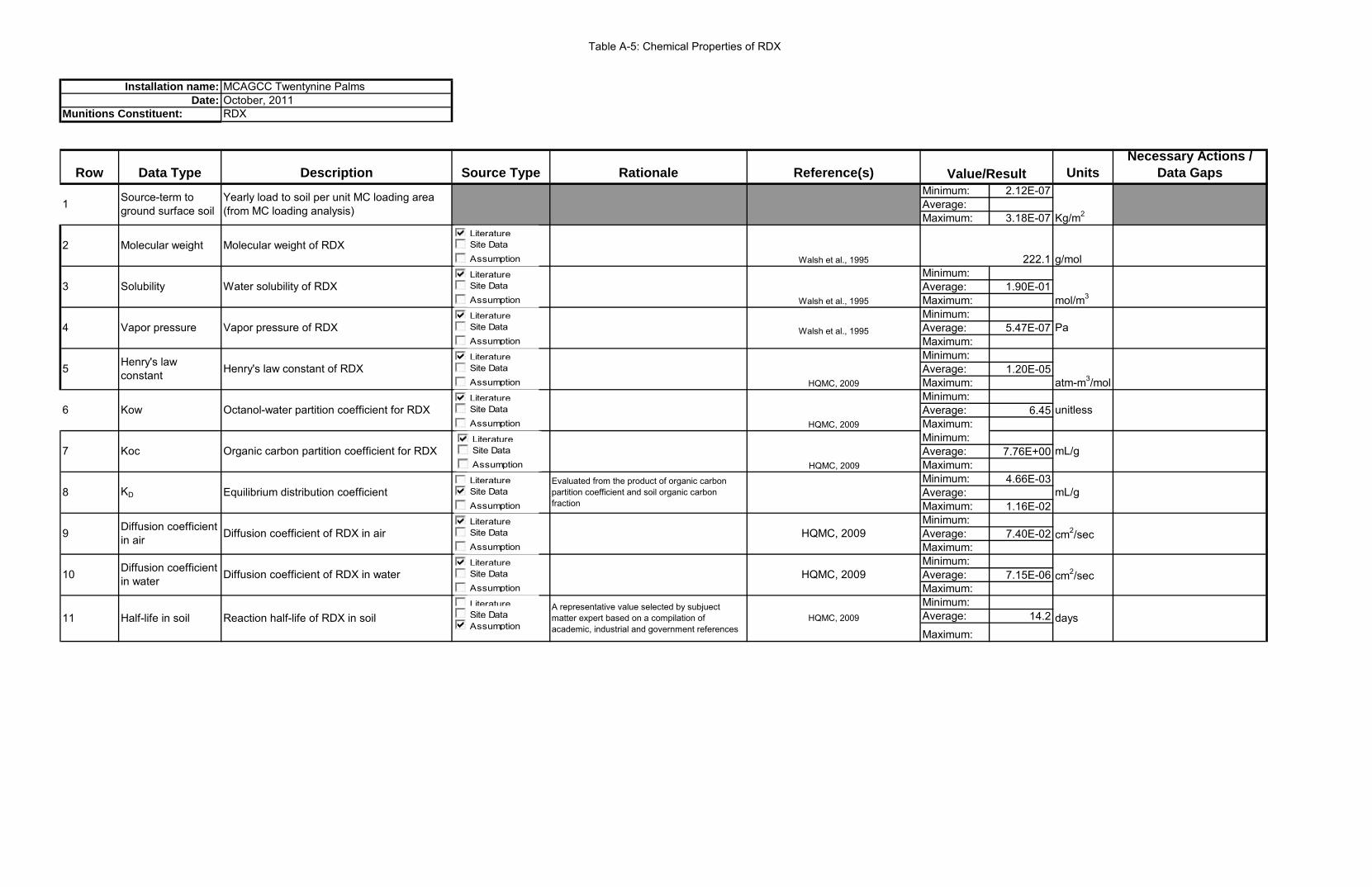
Table A-5: Chemical Properties of RDX
MCAGCC Twentynine PalmsOctober, 2011RDX
Row Data Type Description Source Type Rationale Reference(s) UnitsNecessary Actions /
Data GapsMinimum: 2.12E-07Average:Maximum: 3.18E-07
Minimum:Average: 1.90E-01Maximum:Minimum:Average: 5.47E-07Maximum:Minimum:Average: 1.20E-05Maximum:Minimum:Average: 6.45Maximum:Minimum:Average: 7.76E+00Maximum:Minimum: 4.66E-03Average:Maximum: 1.16E-02Minimum:Average: 7.40E-02Maximum:Minimum:Average: 7.15E-06Maximum:Minimum:Average: 14.2Maximum:
mL/g7 Koc Organic carbon partition coefficient for RDXHQMC, 2009
Value/Result
1 Source-term to ground surface soil
Yearly load to soil per unit MC loading area (from MC loading analysis)
Installation name:Date:
Munitions Constituent:
2 Molecular weight Molecular weight of RDX
4 Vapor pressure Vapor pressure of RDX
HQMC, 2009
Kg/m2
Walsh et al., 1995 222.1
9 Diffusion coefficient in air Diffusion coefficient of RDX in air HQMC, 2009 cm2/sec
11 Half-life in soil Reaction half-life of RDX in soil
10 Diffusion coefficient in water Diffusion coefficient of RDX in water
A representative value selected by subjuect matter expert based on a compilation of academic, industrial and government references
HQMC, 2009 days
HQMC, 2009 cm2/sec
Pa
g/mol
3 Solubility Water solubility of RDXWalsh et al., 1995 mol/m3
5 Henry's law constant Henry's law constant of RDX
atm-m3/mol
Walsh et al., 1995
HQMC, 2009unitless6 Kow Octanol-water partition coefficient for RDX
Evaluated from the product of organic carbon partition coefficient and soil organic carbon fraction
mL/g8 KD Equilibrium distribution coefficient
LiteratureSite DataAssumption
LiteratureSite DataAssumption
LiteratureSite DataAssumption
LiteratureSite DataAssumption
LiteratureSite DataAssumption
LiteratureSite DataAssumption
LiteratureSite DataAssumption
LiteratureSite DataAssumption
LiteratureSite DataAssumption
LiteratureSite DataAssumption
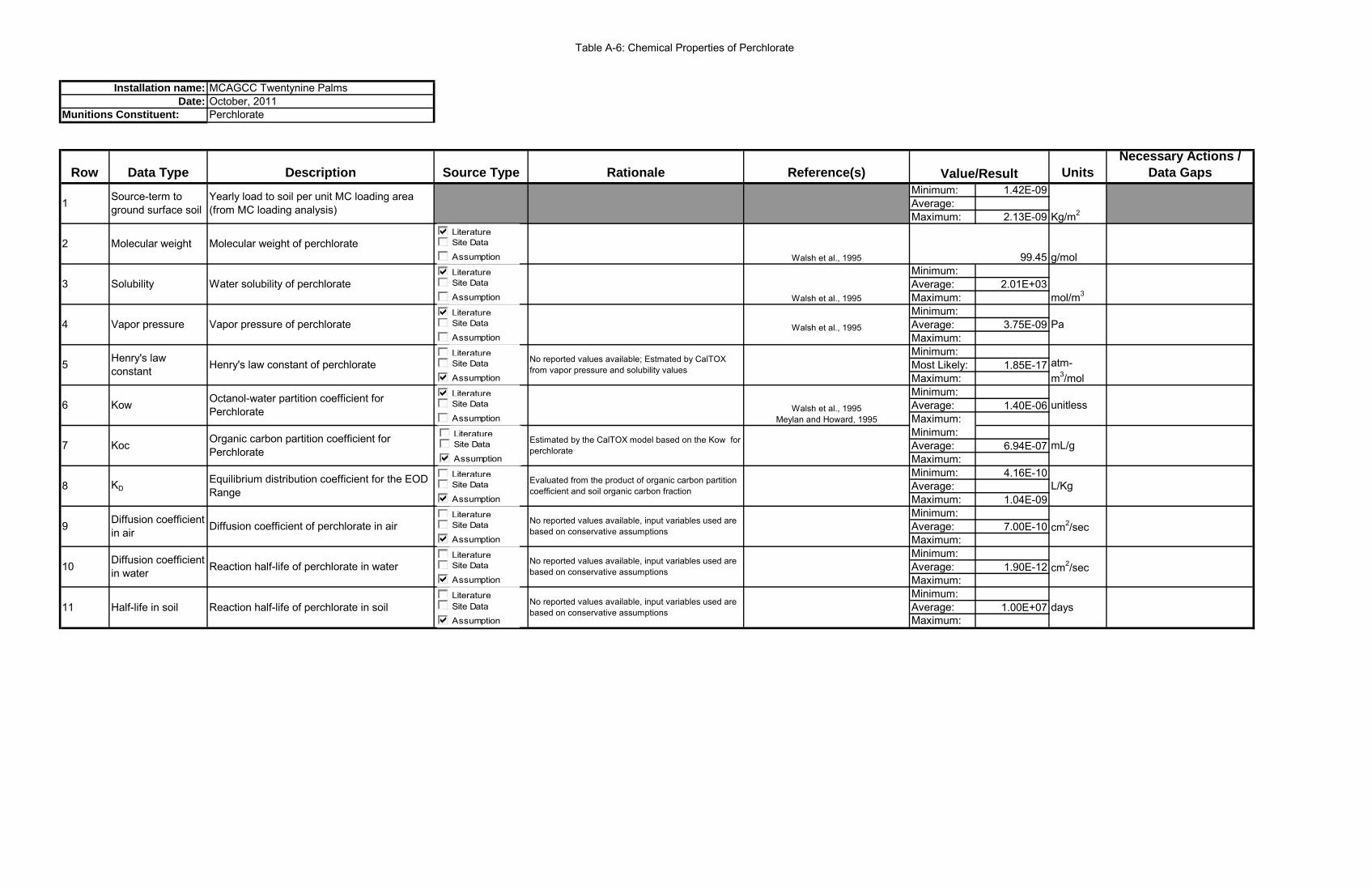
Table A-6: Chemical Properties of Perchlorate
MCAGCC Twentynine PalmsOctober, 2011Perchlorate
Row Data Type Description Source Type Rationale Reference(s) UnitsNecessary Actions /
Data GapsMinimum: 1.42E-09Average:Maximum: 2.13E-09
Minimum:Average: 2.01E+03Maximum:Minimum:Average: 3.75E-09Maximum:Minimum:Most Likely: 1.85E-17Maximum:Minimum:Average: 1.40E-06Maximum:Minimum:Average: 6.94E-07Maximum:Minimum: 4.16E-10Average:Maximum: 1.04E-09Minimum:Average: 7.00E-10Maximum:Minimum:Average: 1.90E-12Maximum:Minimum:Average: 1.00E+07Maximum:
mL/g7 Koc Organic carbon partition coefficient for Perchlorate
Estimated by the CalTOX model based on the Kow for perchlorate
Value/Result
1 Source-term to ground surface soil
Yearly load to soil per unit MC loading area (from MC loading analysis)
Installation name:Date:
Munitions Constituent:
No reported values available; Estmated by CalTOX from vapor pressure and solubility values
2 Molecular weight Molecular weight of perchlorate
4 Vapor pressure Vapor pressure of perchlorate
Kg/m2
Walsh et al., 1995 99.45
9 Diffusion coefficient in air Diffusion coefficient of perchlorate in air cm2/sec
11 Half-life in soil Reaction half-life of perchlorate in soil
10 Diffusion coefficient in water Reaction half-life of perchlorate in water
No reported values available, input variables used are based on conservative assumptions days
No reported values available, input variables used are based on conservative assumptions cm2/sec
No reported values available, input variables used are based on conservative assumptions
Pa
g/mol
3 Solubility Water solubility of perchlorateWalsh et al., 1995 mol/m3
5 Henry's law constant Henry's law constant of perchlorate atm-
m3/mol
Walsh et al., 1995
Walsh et al., 1995Meylan and Howard, 1995
unitless6 Kow Octanol-water partition coefficient for Perchlorate
Evaluated from the product of organic carbon partition coefficient and soil organic carbon fraction L/Kg8 KD
Equilibrium distribution coefficient for the EOD Range
LiteratureSite Data
Assumption
LiteratureSite Data
Assumption
LiteratureSite Data
Assumption
LiteratureSite Data
Assumption
LiteratureSite Data
Assumption
LiteratureSite Data
Assumption
LiteratureSite Data
Assumption
LiteratureSite Data
Assumption
LiteratureSite DataAssumption
LiteratureSite Data
Assumption

Table A7: Groundwater Modeling Parameters - Vadose Zone Properties for MC Loading Areas
VLEACH Parameters1) Polygon DataParameter Quackenbush Range I Range II Range III Range IVArea (feet2) 1 1 1 1 1 unit areaVertical Cell Dimension (feet) 2 1 1 2 2Number of Cells (-) 24 25 25 24 24Height of Polygon (feet) 48 25 25 48 48 Equivalent to the estimated minimum depth to water table at loading area USGS, 2011; MCAGCC Twentynine Palms, 20102) Soil ParameterParameter Quackenbush Range I Range II Range III Range IVDry Bulk Density (g/cm2) 1.569 1.528 1.528 1.688 1.7 Estimated from the porosity of the vadose zone material McWhorter and Sundada, 1977; Fetter, 1994Effective Porosity (-) 0.30 0.28 0.28 0.30 0.32 Estimated based on the vadose zone material McWhorter and Sundada, 1977Volumetric Water Content (-) 0.30 0.28 0.28 0.30 0.32 Conservatively estimated to be equivalent to effective porositySoil Organic Carbon Content (-) 0.00058 0.00058 0.00058 0.00058 0.000583a) Boundary Condition - High Recharge Low ConcentrationParameter Quackenbush Range I Range II Range III Range IVRecharge Rate (feet/year) 0.231 0.219 0.227 0.203 0.199 Estimated preferential recharge to streams as precipitation less runoff MCAGCC Twentynine Palms, 2010; Caltrans, 2006 Concentration of HMX in Recharge Water (mg/L) 1.50E-04 5.18E-06 3.73E-06 1.66E-07 1.43E-07 Results from the initial groundwater screening analysisConcentration of RDX in Recharge Water (mg/L) 5.54E-03 5.99E-03 7.37E-06 7.98E-03 2.92E-03 Results from the initial groundwater screening analysisConcentration of TNT in Recharge Water (mg/L) 1.03E-02 3.68E-03 3.35E-07 6.72E-05 5.54E-04 Results from the initial groundwater screening analysisConcentration of Perchlorate in Recharge Water (mg/L) 1.36E-04 9.67E-06 6.97E-06 2.42E-05 5.96E-06 Results from the initial groundwater screening analysisUpper Boundary Vapor Condition (mg/L) 0 0 0 0 0Lower Boundary Vapor Condition (mg/L) 0 0 0 0 0Upper Cell Number (-) 0 0 0 0 0Lower Cell Number (-) 48 25 25 48 48Initial Contaminant Concentration in Cells (µg/Kg) 0 0 0 0 03b) Boundary Condition - Low Recharge High ConcentrationParameter Quackenbush Range I Range II Range III Range IV
Recharge Rate (feet/year) 2.43E-03 2.43E-03 2.43E-03 2.43E-03 2.43E-03Estimated annual average recharge based on the annual groundwater inflow into the
Surprise Spring subbasin Londquist and Martin, 1991Concentration of HMX in Recharge Water (mg/L) 4.35E-03 1.43E-04 1.06E-04 4.24E-06 3.57E-06 Results from the initial groundwater screening analysisConcentration of RDX in Recharge Water (mg/L) 1.61E-01 1.65E-01 2.10E-04 2.03E-01 7.31E-02 Results from the initial groundwater screening analysisConcentration of TNT in Recharge Water (mg/L) 2.99E-01 1.01E-01 9.55E-06 1.71E-03 1.38E-02 Results from the initial groundwater screening analysisConcentration of Perchlorate in Recharge Water (mg/L) 3.93E-03 2.66E-04 1.99E-04 6.18E-04 1.49E-04 Results from the initial groundwater screening analysisUpper Boundary Vapor Condition (mg/L) 0 0 0 0 0Lower Boundary Vapor Condition (mg/L) 0 0 0 0 0Upper Cell Number (-) 0 0 0 0 0Lower Cell Number (-) 48 25 25 48 48Initial Contaminant Concentration in Cells (µg/Kg) 0 0 0 0 0
MC Loading AreasRationale Reference(s)
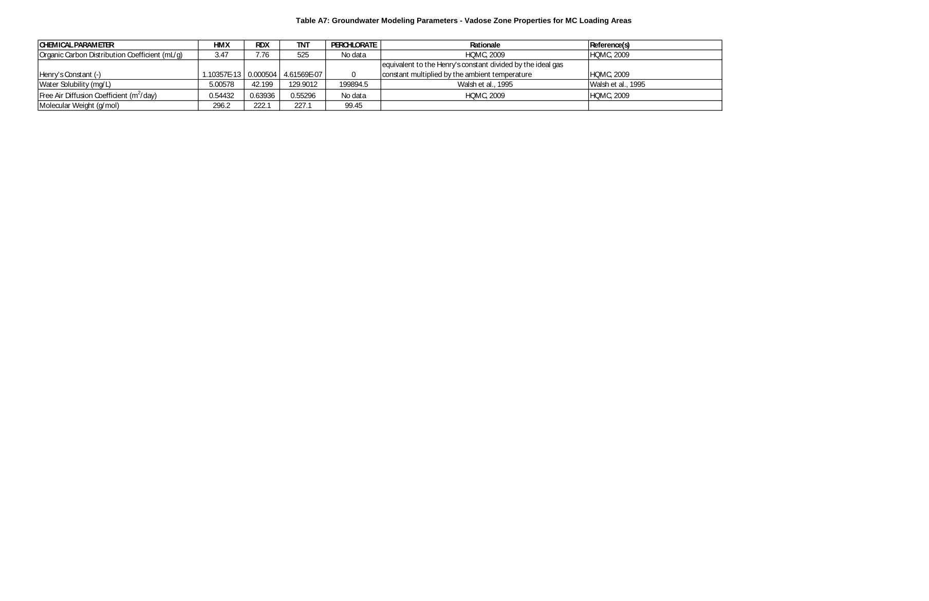
Table A7: Groundwater Modeling Parameters - Vadose Zone Properties for MC Loading Areas
CHEMICAL PARAMETER HMX RDX TNT PERCHLORATE Rationale Reference(s)Organic Carbon Distribution Coefficient (mL/g) 3.47 7.76 525 No data HQMC, 2009 HQMC, 2009
Henry’s Constant (-) 1.10357E-13 0.000504 4.61569E-07 0equivalent to the Henry's constant divided by the ideal gas constant multiplied by the ambient temperature HQMC, 2009
Water Solubility (mg/L) 5.00578 42.199 129.9012 199894.5 Walsh et al., 1995 Walsh et al., 1995Free Air Diffusion Coefficient (m2/day) 0.54432 0.63936 0.55296 No data HQMC, 2009 HQMC, 2009Molecular Weight (g/mol) 296.2 222.1 227.1 99.45
Appendix B
Appendix B Department of Defense Range and Munitions Use Subcommittee Screening Values

Operational Range Assessment Screening Values Version 6.1 Updated 01 August 2012
1
Operational Range Assessment Screening Values Background Department of Defense Directive 4715.11 and Department of Defense Instruction (DODI) 4715.14 require each service to assess its operational ranges within the continental United States (CONUS). Each service has developed their own Operational Range Assessment Program and provides their own direction and guidance for conducting its range assessments. The operational range assessment programs determine whether there has been a release or substantial threat of release of munitions constituents (MC) from an operational range to off-range areas which creates an unacceptable risk to human health and/or the environment. This document provides screening level values to assist the operational range assessment programs in determining if there may be an unacceptable risk to human health and/or the environment. As provided in the individual Services’ range assessment programs and guidance, sampling may be warranted during the range assessment process. To promote consistency across the services’ range assessment programs, the DoD Range and Munitions Use Subcommittee (RMUS), has developed screening values presented in this document to which all services will compare their surface water, groundwater and sediment sampling data. The RMUS involved toxicologists and the Tri-Service Environmental Risk Assessment Work Group (TSERAWG) in the development and review of these procedures and screening values. Screening values have been selected from a hierarchy of sources with recognized authority, acceptance and applicability. This list of screening values has been developed as a general list of commonly found MC used in various range training activities. This list is not intended to be inclusive of all munitions types nor is it intended that the entire list be monitored for all ranges to be investigated. The specific list of MC to be evaluated will be determined on a site-by-site basis during the range assessment process, based on the munitions used and, source, pathway, and receptor characteristics. To promote defensibility, the methodology and scientific basis of collecting and analyzing samples should be as rigorous as the process used to comply with standards associated with the Comprehensive Environmental Response, Compensation, and Liability Act (CERCLA) risk screening and analysis as provided in the individual services’ program direction and guidance. Sampling data will be compared to the appropriate media screening values presented here to determine if further assessment is appropriate. MC concentrations less than these conservative screening values will be considered to have no adverse impacts on human health and/or the environment, and therefore, would not require any further action.
Operational Range Assessment Screening Values Version 6.1 Updated 01 August 2012
2
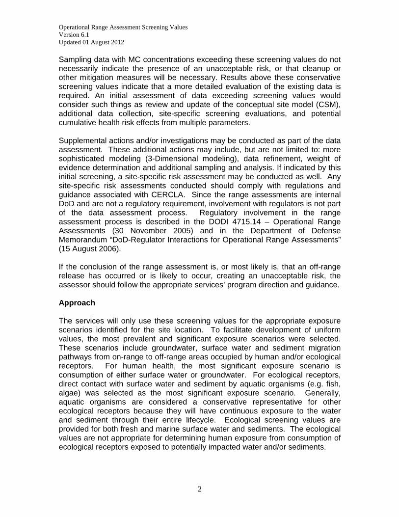
Sampling data with MC concentrations exceeding these screening values do not necessarily indicate the presence of an unacceptable risk, or that cleanup or other mitigation measures will be necessary. Results above these conservative screening values indicate that a more detailed evaluation of the existing data is required. An initial assessment of data exceeding screening values would consider such things as review and update of the conceptual site model (CSM), additional data collection, site-specific screening evaluations, and potential cumulative health risk effects from multiple parameters. Supplemental actions and/or investigations may be conducted as part of the data assessment. These additional actions may include, but are not limited to: more sophisticated modeling (3-Dimensional modeling), data refinement, weight of evidence determination and additional sampling and analysis. If indicated by this initial screening, a site-specific risk assessment may be conducted as well. Any site-specific risk assessments conducted should comply with regulations and guidance associated with CERCLA. Since the range assessments are internal DoD and are not a regulatory requirement, involvement with regulators is not part of the data assessment process. Regulatory involvement in the range assessment process is described in the DODI 4715.14 – Operational Range Assessments (30 November 2005) and in the Department of Defense Memorandum “DoD-Regulator Interactions for Operational Range Assessments” (15 August 2006). If the conclusion of the range assessment is, or most likely is, that an off-range release has occurred or is likely to occur, creating an unacceptable risk, the assessor should follow the appropriate services’ program direction and guidance. Approach The services will only use these screening values for the appropriate exposure scenarios identified for the site location. To facilitate development of uniform values, the most prevalent and significant exposure scenarios were selected. These scenarios include groundwater, surface water and sediment migration pathways from on-range to off-range areas occupied by human and/or ecological receptors. For human health, the most significant exposure scenario is consumption of either surface water or groundwater. For ecological receptors, direct contact with surface water and sediment by aquatic organisms (e.g. fish, algae) was selected as the most significant exposure scenario. Generally, aquatic organisms are considered a conservative representative for other ecological receptors because they will have continuous exposure to the water and sediment through their entire lifecycle. Ecological screening values are provided for both fresh and marine surface water and sediments. The ecological values are not appropriate for determining human exposure from consumption of ecological receptors exposed to potentially impacted water and/or sediments.

Operational Range Assessment Screening Values Version 6.1 Updated 01 August 2012
3
Multiple agencies have developed drinking water, surface water and sediment values indicting levels that should not cause adverse effects to consumers and aquatic organisms using a variety of processes and assumptions. The RMUS developed a hierarchy of sources for each of the identified exposure scenarios to guide the selection of screening values for this protocol. The hierarchies are prioritized lists of screening value sources in order of recognized authority and applicability, and are described in the Drinking Water and Surface Water Systems sections. From the prioritized list, the first, and most appropriate screening value found for each MC was selected for use in this protocol. Where there were multiple values for the same MC from the same hierarchy source, the RMUS selected the most conservative value. Other Considerations
- The screening values presented here are the default values. If there are appropriate State or local regulatory standards that are more stringent, they take precedence and will be used on a site-specific basis. Assessors will investigate state and local regulations to determine if they are appropriate.
- The screening values were selected assuming a chronic exposure to the
receptors. The assessor should verify that a specific species/MC acute value is not lower than the identified chronic value.
- These screening values are based on current existing information. The
range assessments will be based upon the information available at the time of the assessment. As EPA or other federal agencies develop new standards, regulations or guidance, or new information affecting MC tables is published, the screening values will be re-evaluated, and where appropriate, updated. A designated RMUS member will be responsible for reviewing screening values and sources at least biennially. The RMUS and TSERAWG will be involved with any updates to the screening values.
- Sampling results for metals and perchlorate will be compared to
background sampling data, if available. The range will not be considered a source of MC migration when the sampling results are less than or equivalent to background concentrations.
- The statistical analyses used by each service to compare sampling data to
screening values and/or background values will be described in individual sampling plans and are not discussed further in this document.
- In exposure scenarios where surface water has potential to impact human
health and ecological receptors, both drinking water and ecological surface water screening values need to be considered. The more
Operational Range Assessment Screening Values Version 6.1 Updated 01 August 2012
4
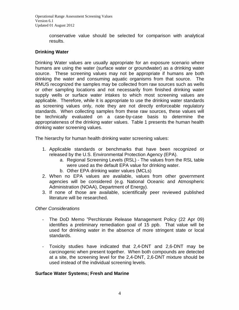
conservative value should be selected for comparison with analytical results.
Drinking Water Drinking Water values are usually appropriate for an exposure scenario where humans are using the water (surface water or groundwater) as a drinking water source. These screening values may not be appropriate if humans are both drinking the water and consuming aquatic organisms from that source. The RMUS recognized the samples may be collected from raw sources such as wells or other sampling locations and not necessarily from finished drinking water supply wells or surface water intakes to which most screening values are applicable. Therefore, while it is appropriate to use the drinking water standards as screening values only, note they are not directly enforceable regulatory standards. When collecting samples from these raw sources, these values will be technically evaluated on a case-by-case basis to determine the appropriateness of the drinking water values. Table 1 presents the human health drinking water screening values. The hierarchy for human health drinking water screening values:
1. Applicable standards or benchmarks that have been recognized or released by the U.S. Environmental Protection Agency (EPA).
a. Regional Screening Levels (RSL) - The values from the RSL table were used as the default EPA value for drinking water.
b. Other EPA drinking water values (MCLs) 2. When no EPA values are available, values from other government
agencies will be considered (e.g. National Oceanic and Atmospheric Administration (NOAA), Department of Energy).
3. If none of those are available, scientifically peer reviewed published literature will be researched.
Other Considerations
- The DoD Memo ”Perchlorate Release Management Policy (22 Apr 09)
identifies a preliminary remediation goal of 15 ppb. That value will be used for drinking water in the absence of more stringent state or local standards.
- Toxicity studies have indicated that 2,4-DNT and 2,6-DNT may be
carcinogenic when present together. When both compounds are detected at a site, the screening level for the 2,4-DNT, 2,6-DNT mixture should be used instead of the individual screening levels.
Surface Water Systems; Fresh and Marine

Operational Range Assessment Screening Values Version 6.1 Updated 01 August 2012
5
For surface water systems, the RMUS considered the scenarios of ecological receptors being exposed to surface water and sediment from either fresh or marine waters. For brackish waters, state guidance on the use of fresh or marine screening levels for the specific water bodies (bays, estuaries, rivers, etc.) should be followed. Due to the sensitivity of some of the ecological receptors, these values are not intended to be applicable for every possible type of species. These values were selected as a conservative screening tool protective of a majority of species. Therefore, when sampling, the specific species type should be taken into consideration when comparing screening values and evaluating whether there is a potential unacceptable risk. The overall hierarchy of sources for determining surface water system impacts on the ecological receptor is the same whether the focus is on fresh water or marine water. The appropriate sections and values must be selected for the exposure scenario being assessed. Ecological screening values are presented in Table 2 for Freshwater Surface Water Systems and Table 3 for Marine Surface Water Systems. The hierarchy for ecological surface water and sediment for both fresh and marine environments is listed below:
1. Applicable standards or benchmarks recognized or released by the U.S. EPA.
a. National Recommended Ambient Water Quality Criteria developed by the EPA Office of Water.
b. Ecotox Thresholds developed by EPA Office of Solid Waste and Emergency Response.
c. Ecological Screening Values developed by EPA Regions. 2. When no EPA values are available, values developed by other
government agencies will be considered. 3. If none of those are available, scientifically peer reviewed published
literature will be researched.
Other Considerations - These values are not relevant for recreational contact with surface water
by human receptors. This scenario can be evaluated if appropriate for a site-specific circumstance.
Operational Range Assessment Screening Values Version 6.1 Updated 01 August 2012
6
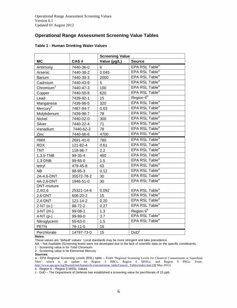
Operational Range Assessment Screening Value Tables Table 1 - Human Drinking Water Values
MC CAS #
Screening Value Value (µg/L) Source
Antimony 7440-36-0 6 EPA RSL Tablea Arsenic 7440-38-2 0.045 EPA RSL Tablea Barium 7440-39-3 2000 EPA RSL Tablea Cadmium 7440-43-9 5 EPA RSL Tablea Chromium1 7440-47-3 100 EPA RSL Tablea Copper 7440-50-8 620 EPA RSL Tablea Lead 7439-92-1 15 Region 6b Manganese 7439-96-5 320 EPA RSL Tablea Mercury2 7487-94-7 0.63 EPA RSL Tablea Molybdenum 7439-98-7 78 EPA RSL Tablea Nickel 7440-02-0 300 EPA RSL Tablea Silver 7440-22-4 71 EPA RSL Tablea Vanadium 7440-62-2 78 EPA RSL Tablea Zinc 7440-66-6 4700 EPA RSL Tablea HMX 2691-41-0 780 EPA RSL Tablea RDX 121-82-4 0.61 EPA RSL Tablea TNT 118-96-7 2.2 EPA RSL Tablea 1,3,5-TNB 99-35-4 460 EPA RSL Tablea 1,3-DNB 99-65-0 1.5 EPA RSL Tablea tetryl 479-45-8 63 EPA RSL Tablea NB 98-95-3 0.12 EPA RSL Tablea 2A-4,6-DNT 35572-78-2 30 EPA RSL Tablea 4A-2,6-DNT 1946-51-0 30 EPA RSL Tablea DNT-mixture 2,4/2,6 25321-14-6 0.092
EPA RSL Tablea
2,6-DNT 606-20-2 15 EPA RSL Tablea 2,4-DNT 121-14-2 0.20 EPA RSL Tablea 2-NT (o-) 88-72-2 0.27 EPA RSL Tablea 3-NT (m-) 99-08-1 1.3 Region 6b 4-NT (p-) 99-99-0 3.7 EPA RSL Tablea Nitroglycerin 55-63-0 1.5 EPA RSL Tablea PETN 78-11-5 16 Perchlorate 14797-73-0 15 DoDc
Notes: These values are "default" values. Local standards may be more stringent and take precedence. NA – Not Available (Screening levels were not developed due to the lack of scientific data on the specific constituents. 1 - Screening value is for Total Chromium 2 - Screening value is for Elemental Mercury Sources: a - EPA Regional Screening Levels (RSL) table – From “Regional Screening Levels for Chemical Contaminants at Superfund Sites” which is an update for Region 3 RBCs, Region 6 MSSLs, and Region 9 PRGs. From: http://www.epa.gov/reg3hwmd/risk/human/rb-concentration_table/Generic_Tables/index.htm (30 May 2012) b - Region 6 – Region 6 MSSL Values c - DoD – The Department of Defense has established a screening value for perchlorate of 15 ppb.

Operational Range Assessment Screening Values Version 6.1 Updated 01 August 2012
7
Table 2 – Ecological Freshwater Surface Water System Values Freshwater Surface Water Freshwater Sediment MC CAS # Value
(µg/L) Source Value
(mg/kg) Source
Antimony 7440-36-0 30 EPA Region 3a 12 EPA Region 4d Arsenic 7440-38-2 150 EPA NRWQC2,b 8.2 EPA OSWER*,c Barium 7440-39-3 3.9 EPA OSWERc 20 EPA Region 6f
Cadmium 7440-43-9 0.25 EPA NRWQC2,3,b 1.2 EPA OSWERc Chromium (VI) 7440-47-3 11 EPA NRWQC2,b 81 EPA OSWERc Copper 7440-50-8 9 EPA NRWQC2,3,b 34 EPA OSWERc Lead 7439-92-1 2.5 EPA NRWQC2,3,b 47 EPA OSWERc Manganese 7439-96-5 80 EPA OSWERc 460 Ontario Guidelinesk
Mercury 22967-92-6 0.77 EPA NRWQC2,b 0.15 EPA OSWERc
Molybdenum 7439-98-7 240 EPA OSWERc 4 D.D.MacDonald et al., 1994g
Nickel 7440-02-0 52 EPA NRWQC2,3,b 21 EPA OSWERc Silver 7440-22-4 3.2 EPA NRWQC2,3,b 2 EPA Region 4d
Vanadium 7440-62-2 19 EPA OSWERc 50 NOAA Screening Tablesh
Zinc 7440-66-6 120 EPA NRWQC2,3,b 150 EPA OSWERc HMX 2691-41-0 150 EPA Region 3a .0047-.47 EPA Region 41,d RDX 121-82-4 190 EPA Region 4d .013-1.3 EPA Region 41,d TNT 118-96-7 90 EPA Region 4d .092-9.2 EPA Region 41,d 1,3,5-TNB 99-35-4 11 EPA Region 4d .0024-.24 EPA Region 41,d 1,3-DNB 99-65-0 20 EPA Region 4d .0067-.67 EPA Region 41,d
tetryl 479-45-8 NA 53.4 Nipper et al., 2002j (fine grain sediment)
NB 98-95-3 270 EPA Region 4d 0.488 EPA Region 4d 2A-4,6-DNT 35572-78-2 20 EPA Region 4d NA 4A-2,6-DNT 1946-51-0 NA NA 2,6-DNT 606-20-2 42 EPA Region 4d 0.0206 EPA Region 4d 2,4-DNT 121-14-2 44 EPA Region 3a 0.0751 EPA Region 4d 2-NT (o-) 88-72-2 NA NA 3-NT (m-) 99-08-1 750 EPA Region 3a NA 4-NT (p-) 99-99-0 1900 EPA Region 3a NA Nitroglycerin 55-63-0 138 EPA Region 3a NA PETN 78-11-5 85000 EPA Region 34,a NA Perchlorate 14797-73-0 9300 Dean et al.e NA Notes: NA – Not Available (Screening levels were not developed due to the lack of scientific data on the specific constituents. * - Arsenic values for sediment will be compared to background sampling data, if available. The range will not be considered a source of MC migration when the sampling results are less than or equivalent to background concentrations.
1 - These values are dependent on the sediment TOC. The lower bound is for 1% TOC. Upper bound is for 100% TOC. To determine the site specific value, multiply the % TOC by the lower bound. E.g. for TNT in sediment w/ 5% TOC it would be: 0.46 (5*0.092=0.46) 2 - Value applies to dissolved metals 3 - The value is dependent on the hardness of the water, provided value is for a water hardness of 100 mg/L as CaCO3. 4 – For PETN, EPA Region III values came from TNRCC 2001 & 2000, which are documented sources k & l below. Sources: a - EPA Region 3, Ecological Risk Assessment Freshwater Screening Benchmarks, March 2007 b - EPA, Office of Water, Office of Science and Technology (4304T), National Recommended Water Quality Criteria, 2006.

Operational Range Assessment Screening Values Version 6.1 Updated 01 August 2012
8
c - EPA Office of Solid Waste and Emergency Response Ecotox Thresholds, January 1996 d - EPA Region 4, Ecological Risk Assessment Bulletins – Supplement to RAGS (EPA 2001) e - Dean, K.E., R.M. Palachek, J.L. Noel, R. Warbritton, J. Aufderheide, and J. Wireman. 2004. Development of Freshwater Water-Quality Criteria for Perchlorate. Environmental Toxicology and Chemistry 23(6):1441-1451. f - EPA Region 6, Screening Level Ecological Risk Assessment Protocol, Aug 1999. g – A Review of Environmental Quality Criteria and Guidelines for Priority substances in the Fraser River Basin, Prepared by D.D. MacDonald, MacDonald Environmental Sciences Limited, March 1994 h - NOAA Screening Quick Reference Tables, NOAA HAZMAT Report 99-1, Seattle WA, Coastal Protection and Restoration Division, National Oceanic and Atmospheric Administration, 12 pages. Buchman, M.F., 1999. i - Guidelines for the protection and management of aquatic sediment quality in Ontario. Ontario Ministry of the Environment. Queen's Printer of Ontario. Persaud, D., R. Jaagumagi, and A. Hayton. 1993. j - Nipper, M., R.S. Carr, J.M. Biedenbach, R.L. Hooten, and K. Miller. 2002. Toxicological and Chemical Assessment of Ordnance Compounds in Marine Sediments and Porewaters. Marine Pollution Bulletin, 44: 789-806. k - TNRCC 2000 Texas Surface water Quality Standards, Texas Administrative Code, Title 30, Chapter 307, Effective 17, 2000.

Operational Range Assessment Screening Values Version 6.1 Updated 01 August 2012
9
Table 3 – Ecological Marine Surface Water System Values Marine Surface Water Marine Sediment MC CAS # Value
(µg/L) Source Value
(mg/kg) Source
Antimony 7440-36-0 30 Suter and Tsao, 1996e 2 NOAA 1990g
Arsenic 7440-38-2 36 USEPA, 2004b 7.24 MacDonald et al., 2000*,h
Barium 7440-39-3 4 Suter and Tsao, 1996e NA
Cadmium 7440-43-9 8.8 USEPA, 2004b 0.68
MacDonald et al., 2000h
Chromium (VI) 7440-47-3 50
USEPA, 2004b 52.3
MacDonald et al., 2000h
Copper 7440-50-8 3.1 USEPA, 2004b 18.7
MacDonald et al., 2000h
Lead 7439-92-1 8.1 USEPA, 2004b 30.2
MacDonald et al., 2000h
Manganese 7439-96-5 120 Suter and Tsao, 1996e 460 Ontario Guidelinesi Mercury 22967-92-6 0.94 USEPA, 2004b 0.14 Molybdenum 7439-98-7 370 Suter and Tsao, 1996e NA
Nickel 7440-02-0 8.2 USEPA, 2004b 15.9
MacDonald et al., 2000h
Silver 7440-22-4 1.9 USEPA, 2004b 0.73
MacDonald et al., 2000h
Vanadium 7440-62-2 20 Suter and Tsao, 1996e NA
Zinc 7440-66-6 81 USEPA, 2004b 124 MacDonald et al., 2000h
HMX 2691-41-0 330 Talmage et al., 1999o .0047-.47 EPA Region 41,a
RDX 121-82-4 5000 Nipper et al., 2001k .013-1.3 EPA Region 41,a TNT 118-96-7 180 Nipper et al., 2001k .092-9.2 EPA Region 41,a 1,3,5-TNB 99-35-4 25 Nipper et al., 2001k .0024-.24 EPA Region 41,a 1,3-DNB 99-65-0 180 Nipper et al., 2001k .0067-.67 EPA Region 41,a
tetryl 479-45-8 53.4
Nipper et al., 2002l (fine grain sediment)
NB 98-95-3 66.8 USEPA, 2002c 27 Talmage and Opresko, 1995j
2A-4,6-DNT 35572-78-2 1480 TNRCC, 2001m and TNRCC, 2000n NA
4A-2,6-DNT 1946-51-0 NA NA NA 2,6-DNT 606-20-2 1000 Nipper et al., 2001k 0.55 Nipper et al., 2002l
2,4-DNT 121-14-2 480 Nipper et al., 2001k 0.23 Talmage and Opresko, 1995j
2-NT (o-) 88-72-2 NA NA NA 3-NT (m-) 99-08-1 NA NA NA 4-NT (p-) 99-99-0 NA NA NA
Nitroglycerin 55-63-0 138 TNRCC, 2001m and TNRCC, 2000n NA
PETN 78-11-5 85000
EPA Region 32,d
NA
Perchlorate 14797-73-0 9300 Dean et al., 2004f NA Notes:
Operational Range Assessment Screening Values Version 6.1 Updated 01 August 2012
10
NA – Not Available (Screening levels were not developed due to the lack of scientific data on the specific constituents. * - Arsenic values for sediment will be compared to background sampling data, if available. The range will not be considered a source of MC migration when the sampling results are less than or equivalent to background concentrations.
1 - These values are dependent on the sediment TOC. The lower bound is for 1% TOC. Upper bound is for 100% TOC. To determine the site specific value, multiply the % TOC by the lower bound. (e.g. for TNT in sediment w/ 5% TOC it would be: 0.46)(5*0.092=0.46) 2 - EPA Region III for PETN marine water refers to US EPA Region 3’s Freshwater Screening Benchmark table for a value. These values came from TNRCC 2001 & 2000, which are documented sources m & n below. Sources: a - EPA Region 4, Ecological Risk Assessment Bulletins - Supplement to RAGS (EPA 2001) b – EPA – USEPA 2009 National Recommended Water Quality Criteria Office of Water and Office of Science and Technology. c – EPA – USEPA 2002 Ecological Risk Assessment Bulletin 2/11/2002. Waste Management Division, Freshwater Surface Screening Values for Hazardous Waste Sites, February. d - EPA Region 3, Ecological Risk Assessment Freshwater Screening Benchmarks, March 2007 e – Suter and Tsao, 1996 Toxicological Benchmarks for Screening Potential Contaminants of Concern for Effects on Aquatic Biota: 196 Revision. ES/ER/Tm-96/R2. f – Dean, K.E., R.M. Palachek, J.L. Noel, R. Warbritton, J. Aufderheide, and J. Wireman. 2004. Development of Freshwater Water-Quality Criteria for Perchlorate. Environmental Toxicology and Chemistry 23(6):1441-1451. g - The potential for biological effects of sediment-sorbed contaminants tested in the national status and trends program. NOAA Technical Memorandum NOS OMA 52. Long, E.R. and L.G. Morgan. 1990. h - MacDonald, D.D., C.G. Ingersoll, and T.A. Berger. 2000. Development and evaluation of consensus-based sediment quality guidelines for freshwater ecosystems. Archives of Environmental Contamination and Toxicology, 39: 20-31. i - Guidelines for the protection and management of aquatic sediment quality in Ontario. Ontario Ministry of the Environment. Queen's Printer of Ontario. Persaud, D., R. Jaagumagi, and A. Hayton. 1993. j - Talmage, S.S., and D.M. Opresko. 1995. Draft Ecological Criteria Documents for Explosives, Oak Ridge National Laboratory, Oak Ridge, Tennessee. k – Nipper, M., R.S. Carr, J.M. Biedenbach, R.L. Hooten, K. Miller, and S. Saepoff, 2001. Development of Marine Toxicity Data for Ordnance Compounds, Archives of Environmental Contamination and Toxicology, 41:308-31. l - Nipper, M., R.S. Carr, J.M. Biedenbach, R.L. Hooten, and K. Miller. 2002. Toxicological and Chemical Assessment of Ordnance Compounds in Marine Sediments and Porewaters. Marine Pollution Bulletin, 44: 789-806. m – TNRCC 2001 Guidance for Conducting Ecological Risk Assessment and Remediation Sites in Texas, Toxicology and Risk Assessment Section, December. n – TNRCC 2000 Texas Surface water Quality Standards, Texas Administrative Code, Title 30, Chapter 307, Effective 17, 2000. o – Talmage, S.S., D.M. Opresko, C.J. Maxwell, J.E. Welsh, M. Cretelia, P.H. Reno, and F.B. Daniel. 1999. Nitroaromatic munition compounds: Environmental effects and screening values. Reviews in Environmental Contamination and Toxicology, 161: 1-156.

Appendix C
Appendix C Small Arms Range Assessment Protocol Tables

APPENDIX C
C-1
SMALL ARMS RANGE ASSESSMENT
Introduction
The purpose of the Range Environmental Vulnerability Assessment (REVA) is to
identify whether there has been a release or there is a substantial threat of a release of
munitions constituents (MC) of concern from the operational range or range complex
areas to off-range areas. This is accomplished through the use of fate and transport
modeling and analysis of the REVA indicator MC based upon site-specific environmental
conditions at the operational ranges and training areas at an installation.
For small arms ranges, the fate and transport parameters are based entirely on site-
specific geochemical properties, which cannot be determined solely by physical
observation. Therefore, small arms ranges associated with the installation are
qualitatively reviewed and assessed to identify factors that influence the potential for lead
migration at the operational range, including:
· design and layout,
· the physical and chemical characteristics of the area, and
· current and past operation and maintenance practices.
In addition, potential receptors and pathways must be identified relative to the small arms
range being assessed. The potential for an identified receptor to be impacted by MC
migration through an identified pathway will be evaluated.
MC associated with small arms ammunition commonly used at operational ranges
include lead, antimony, copper, and zinc. REVA focuses on lead as the MC indicator for
small arms ranges because lead is the most prevalent (by weight) potentially hazardous
constituent associated with small arms ammunition. No specific quantitative conclusions
can be made regarding the fate and transport of lead since it is unlike any other MC.
Lead is geochemically specific regarding its mobility in the environment. Site-specific
conditions must be known (i.e., geochemical properties) in order to quantitatively assess
lead migration. Site-specific geochemical properties are only identified via sampling and
cannot be observed physically. Without site-specific physical and chemical
APPENDIX C
C-2
characterization, lead cannot effectively be modeled using fate and transport modeling
like the other indicator MC in REVA. The scientific community has established that
metallic lead (such as recently fired, unweathered bullets and shot) generally has low
chemical reactivity and low solubility in water and is relatively inactive in the
environment under most ambient or everyday conditions. However, a portion of lead
deposited on a range may become environmentally active if the right combination of
conditions exists.
This Small Arms Range Assessment Protocol was developed in lieu of collecting site-
specific information for every small arms range. The protocol will help to determine
which ranges necessitate data collection of site-specific geochemical properties or further
assessment based the range’s overall prioritization regarding the potential for an
identified receptor to be impacted by potential lead migration through an identified
pathway.
Purpose
This Small Arms Range Assessment Protocol outlines a qualitative approach to assess the
small arms ranges in the REVA process in lieu of collecting site-specific geochemical
properties at every range. This qualitative approach helps to identify and assess factors
that influence the potential for lead to migrate at an operational range.
This protocol is to be used for:
1) Identifying the small arms ranges within the Marine Corps that have the greatest potential for environmental concern (i.e., potential for lead migration to impact identified receptors) and
2) Assessing the need for implementing further actions. Recommended further actions may include, but are not limited to, the following:
· Sampling surface water, groundwater, and/or soil
· Conducting additional studies
· Implementing best management practices (BMPs)
APPENDIX C
C-3
Data Collection and Documentation
The qualitative assessment process for a small arms range involves first capturing and
documenting its physical and environmental conditions, as well as how the range is
utilized and maintained (including dates of use and types and amounts of small arms
ammunition expended). The small arms range data collection form within Section 3 of
the REVA Reference Manual is a guide to collecting and documenting the necessary
information in order to complete the evaluation forms presented later in this protocol
(Tables 1 through 6). It includes a comprehensive list of data elements that are useful in
establishing the historical and current physical and environmental conditions, as well as
capturing the types of information on conditions that influence lead’s potential to migrate
from the range. The data collection form is organized by major topics or information
areas associated with the operational range, including the following:
· Basic range information
· Current range layout
· Current range operations
· Historical range operations
· Amount of lead potentially deposited
· Environmental Characteristics
· Potential receptors
· Surrounding land use
· Environmental activities conducted on the range
· Summary
The data collection form in the REVA Reference Manual can be modified, where needed,
to fully capture the major factors that can potentially influence lead’s ability to migrate
from each specific small arms range.
Qualitative Assessment
The small arms range can be qualitatively assessed once the conditions of the range have
been fully understood and documented. The assessment process involves a discussion of
APPENDIX C
C-4
possible factors that can influence the potential for lead to migrate off range. Several of
these factors are listed below, followed by a detailed discussion:
· Range use and range management (source)
· Surface water
· Groundwater and soil
· Pathways
· Receptors
Range Use and Range Management (Source)
The amount of lead and other MC deposited on a range is a combination of the following
factors:
· Duration of use
· Current and historical frequency of range usage
· Amount and types of small arms ammunition expended on the range
· Scope and frequency of any range maintenance activities involving the removal of lead from the range
· Presence and duration of bullet-capturing technologies
Surface Water
Under specific pH conditions, lead from shot or bullets can slowly dissolve in water.
Runoff and groundwater recharge could transport this dissolved lead off range. The
primary factors influencing the potential for dissolved lead to migrate via surface water
include, but are not limited to, the following:
· pH of the water
· Duration of water contact with the lead
· Intensity and frequency of rainfall
· Steepness of the slope containing lead
· Amount and type of vegetation on the slope
· Infiltration rate of surface soils
· Presence of engineering controls or BMPs to modify or control surface water runoff

APPENDIX C
C-5
Groundwater and Soil
The amount of lead that dissolves in water is primarily influenced by the pH of the water
and the duration of water contact with the lead. Once lead is dissolved in water, the
amount of lead that attaches to the soil and/or enters the groundwater is determined by
several factors, including the following:
· Organic carbon content of the soil
· pH of the soil
· Properties of the soil, including porosity, irreducible water content, and hydraulic conductivity
· Amount of recharge percolating through the vadose zone
· Clay content of the soil (lead attaches to clay minerals more than other soil fractions)
· Depth to groundwater
Pathways
The REVA Small Arms Range Assessment involves developing a conceptual site model
(CSM) for the range to identify the range’s physical and environmental conditions. The
CSM’s purpose is to identify if a potential for source-receptor-pathway interaction may
exist. Factors that influence the potential for a source-receptor-pathway interaction (e.g.,
heavy range use, potable water supply wells in proximity to the range), as well as factors
that decrease the potential for such interactions, should be discussed in the assessment.
Potential pathways include:
· groundwater used as a source of potable or agricultural water,
· the use of surface water downstream of a range as a source of potable or agricultural water, and
· the use of the soil, surface water, or groundwater by sensitive species.
Receptors
Receptors in REVA can include on-range and off-range personnel and sensitive species
and ecosystem areas. Factors considered when assessing the potentially complete
exposure pathways for receptors include, but are not limited to, the following:

APPENDIX C
C-6
· The number and proximity of water supply wells relative to the range
· The characteristics of nearby water supply wells (e.g., depth to groundwater, well construction details)
· The uses of the surface water or groundwater (e.g., agriculture, drinking water)
· The locations of nearby sensitive species areas, such as endangered species habitats (i.e., within proximity to the range)
Small Arms Range Assessment Protocol
This Small Arms Range Assessment Protocol is based on evaluating the potential
environmental concerns posed by MC. Environmental concern evaluation rankings for
surface water and groundwater conditions are established for each small arms range. The
rankings range between High (indicating the highest potential environmental concern)
and MINIMAL (indicating the lowest potential environmental concern). Sites for which
there is insufficient information to complete the evaluation are placed into an Evaluation
Pending ranking. Possible recommended actions are based on the relative environmental
concern evaluation rankings assigned by the protocol. High rankings necessitate further
actions. Further actions may included sampling, additional site-specific studies, and/or
BMPs. These actions will be evaluated based on site conditions for each range.
Protocol Instructions
1. For Tables 1 through 5:
a. Enter the appropriate score for each criteria in the site score column. Use the highest (i.e., most conservative) value if no information is known to complete the score. Professional judgment may be used at any time to override a designated score. If professional judgment is used, mark the score column appropriately (*) and fill in the notes section at the bottom of the table with text detailing why professional judgment was used and how it impacted the scores.
b. Sum the site scores in the last row.
2. Transfer the scores from Tables 1 through 5 onto Table 6 in the appropriate rows.
3. Use the scores in Table 6 to determine the surface water and groundwater environmental concern evaluation rankings.
APPENDIX C
C-7
Evaluation Ranking Designation
Once Table 6 is complete, the protocol finishes with two scores: the sum of surface water
elements and the sum of groundwater elements. These scores are used to identify the
appropriate evaluation ranking (High, Moderate, Minimal) for surface water and
groundwater (as mentioned in step 3 of the protocol instructions).
The surface water concern evaluation ranking and the groundwater concern evaluation
ranking identify the potential impact for lead migration for each of those pathways at the
small arms range. The ranking designations and their descriptions follow:
· High = Small arms range most likely has the potential for lead migration and environmental concern, creating the greatest level of environmental concern and requiring additional action(s).
· Moderate = Small arms range may have the potential for lead migration and environmental concern, most likely indicating that there is no immediate environmental concern, but actions may be necessary to prevent a greater concern.
· Minimal = Small arms range has minimal or no potential for lead migration and environmental concern, indicating minimal threat of environmental concern, but actions may be necessary to ensure that the no concerns elevate.
These rankings are used to determine whether additional actions are appropriate. The
higher environmental concern evaluation ranking (surface water or groundwater), as
determined in Table 6, is used to evaluate if further actions are suggested, based on the
guidelines for recommended actions (Table 7, provided on Page C-9).
The overall range evaluation rankings should be compared to each range within the
installation and to the overall rankings of all ranges across the Marine Corps. These
rankings will assist in determining how funding should best be allocated across the
Marine Corps to prevent environmental concerns due to small arms ranges.
Assessment Report
Once the Small Arms Range Assessment Protocol has been completed and appropriate
actions have been designated and implemented, the assessment should be written into a
report that describes the process taken, details the information used to score Tables 1
APPENDIX C
C-8
through 5, outlines the scores and evaluation rankings, and identifies the additional
actions taken. The report should detail whether an identified receptor is or is not
impacted by lead migration through the identified pathway(s). The completed protocol
tables should be included as an appendix to the report.
Best Management Practices for Small Arms Ranges
BMPs are important for all ranges and should be used appropriately to maintain the
sustainability of operational ranges. However, this protocol prioritizes which small arms
ranges may need BMPs to address specific possibilities of lead migration.
Following the Small Arms Range Assessment, BMPs may be recommended based on the
environmental concern evaluation ranking. Prior to selecting and implementing BMPs,
the management objectives must be established. Depending on the range-specific site
conditions and the management objectives, the following BMPs should be considered:
· Bullet and shot containment techniques (e.g., berms, backstops, traps)
· Prevention of soil erosion from berms, aprons, and other range areas
· Soil amendments
· Recovery and/or recycling of lead
Negative impacts of implementation should also be considered when selecting a BMP.
For example, using soil amendments may affect water quality of nearby water bodies or
modifying surface water runoff may impact nearby habitats.
The prevention of soil erosion can be achieved by implementing one or several of the
following practices:
· Maintaining vegetation on berms and drainageways
· Reducing runoff rates by adjusting site drainage patterns
· Providing sediment traps such as a vegetated detention basin or infiltration area
· Preventing the creation of a “point source”
APPENDIX C
C-9
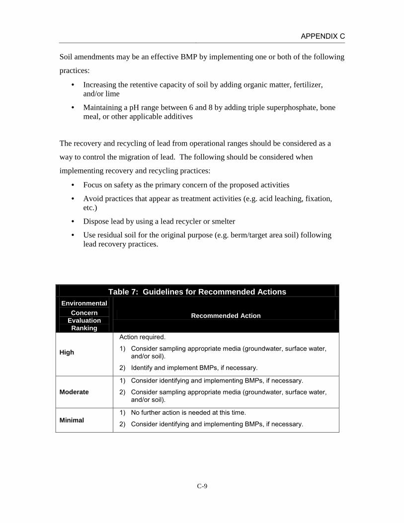
Soil amendments may be an effective BMP by implementing one or both of the following
practices:
· Increasing the retentive capacity of soil by adding organic matter, fertilizer, and/or lime
· Maintaining a pH range between 6 and 8 by adding triple superphosphate, bone meal, or other applicable additives
The recovery and recycling of lead from operational ranges should be considered as a
way to control the migration of lead. The following should be considered when
implementing recovery and recycling practices:
· Focus on safety as the primary concern of the proposed activities
· Avoid practices that appear as treatment activities (e.g. acid leaching, fixation, etc.)
· Dispose lead by using a lead recycler or smelter
· Use residual soil for the original purpose (e.g. berm/target area soil) following lead recovery practices.
Table 7: Guidelines for Recommended Actions Environmental
Concern Evaluation Ranking
Recommended Action
High
Action required.
1) Consider sampling appropriate media (groundwater, surface water, and/or soil).
2) Identify and implement BMPs, if necessary.
Moderate 1) Consider identifying and implementing BMPs, if necessary.
2) Consider sampling appropriate media (groundwater, surface water, and/or soil).
Minimal 1) No further action is needed at this time.
2) Consider identifying and implementing BMPs, if necessary.

APPENDIX C
C-10
INSTALLATION: MCAGCC TWENTYNINE PALMS LOCATION: TWENTYNINE PALMS, CALIFORNIA RANGE: MTU Range 1
(Known Distance Rifle Range) DATE: February 22, 2011 ASSESSMENT RESULTS: The Surface Water Environmental Concern Evaluation Ranking resulted in a Minimal score. Limited precipitation rates and partial engineered controls (earthen berms) reduce the potential for lead transport. While intense storms in the winter may cause runoff to act as the dominant transport mechanism, it is unlikely that lead fragments from range operations will be dissolved in runoff and transported 2.5 miles in measurable concentrations to the nearest intermittent water body (Mesquite Dry Lake). On the basis of the SARAP, there is minimal potential for lead migration and impact to surface water. The Groundwater Environmental Concern Evaluation Ranking resulted in a Moderate score. However, it is the professional judgment of the REVA Team that the overall concern for lead migration and exposure to groundwater receptors is more accurately categorized as a Minimal level. The Groundwater Pathway score is biased high based on the sandy nature of the soils, and lack of clay in the soil unit. Previous sampling data indicates that lead migration on this range is limited to a maximum of eight inches from the soil surface. In addition, the depth to groundwater and the lack of groundwater receptors in the area likely precludes any significant groundwater impacts. Therefore, on the basis of professional judgment, there is minimal potential for lead migration and impact to groundwater resources.
APPENDIX C
C-11
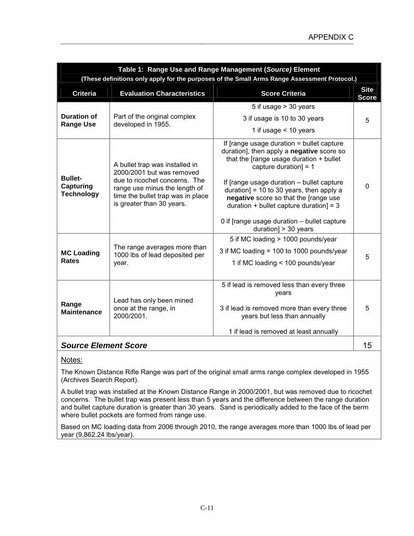
Table 1: Range Use and Range Management (Source) Element
(These definitions only apply for the purposes of the Small Arms Range Assessment Protocol.)
Criteria Evaluation Characteristics Score Criteria Site Score
Duration of Range Use
Part of the original complex developed in 1955.
5 if usage > 30 years
3 if usage is 10 to 30 years
1 if usage < 10 years 5
Bullet-Capturing Technology
A bullet trap was installed in 2000/2001 but was removed due to ricochet concerns. The range use minus the length of time the bullet trap was in place is greater than 30 years.
If [range usage duration = bullet capture duration], then apply a negative score so
that the [range usage duration + bullet capture duration] = 1
If [range usage duration – bullet capture duration] = 10 to 30 years, then apply a negative score so that the [range use duration + bullet capture duration] = 3
0 if [range usage duration – bullet capture
duration] > 30 years
0
MC Loading Rates
The range averages more than 1000 lbs of lead deposited per year.
5 if MC loading > 1000 pounds/year
3 if MC loading = 100 to 1000 pounds/year
1 if MC loading < 100 pounds/year
5
Range Maintenance
Lead has only been mined once at the range, in 2000/2001.
5 if lead is removed less than every three years
3 if lead is removed more than every three
years but less than annually
1 if lead is removed at least annually
5
Source Element Score 15
Notes: The Known Distance Rifle Range was part of the original small arms range complex developed in 1955 (Archives Search Report).
A bullet trap was installed at the Known Distance Range in 2000/2001, but was removed due to ricochet concerns. The bullet trap was present less than 5 years and the difference between the range duration and bullet capture duration is greater than 30 years. Sand is periodically added to the face of the berm where bullet pockets are formed from range use.
Based on MC loading data from 2006 through 2010, the range averages more than 1000 lbs of lead per year (9,862.24 lbs/year).
APPENDIX C
C-12
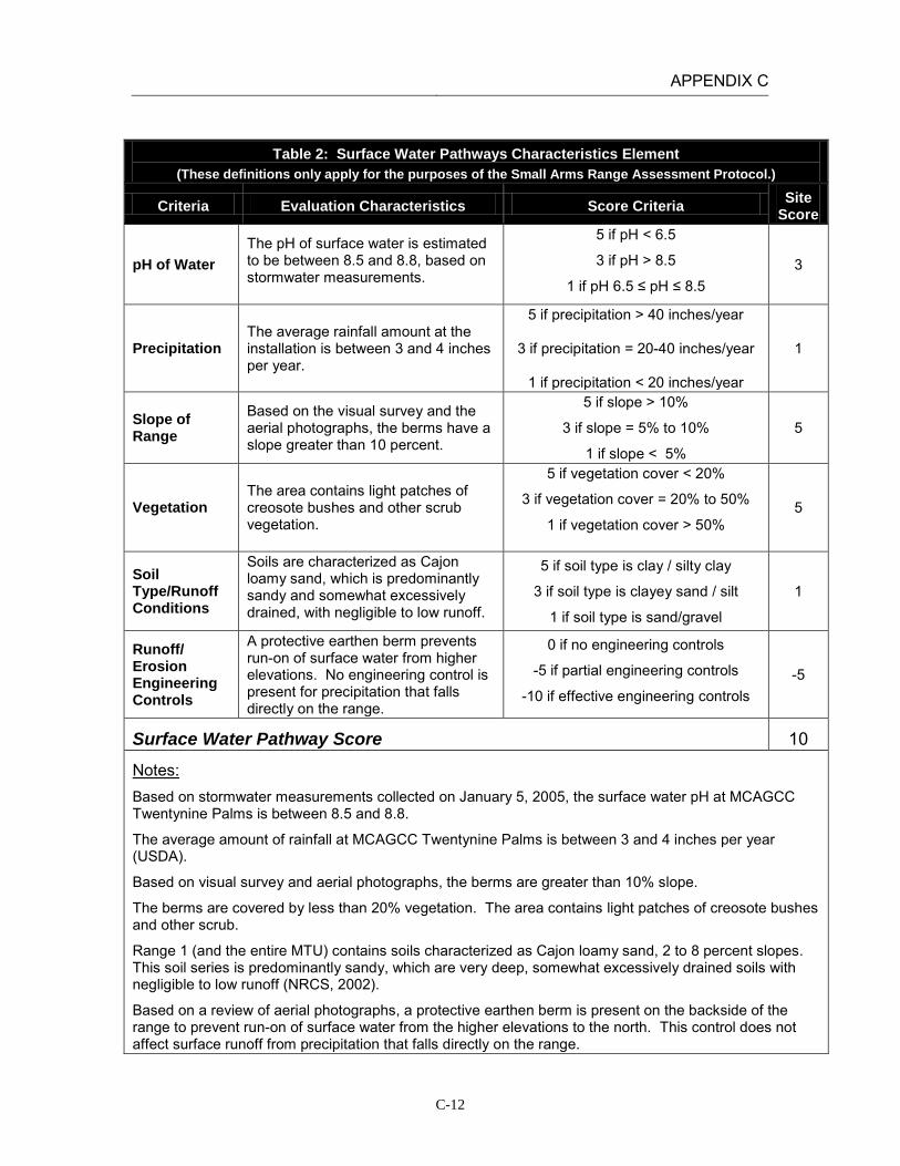
Table 2: Surface Water Pathways Characteristics Element (These definitions only apply for the purposes of the Small Arms Range Assessment Protocol.)
Criteria Evaluation Characteristics Score Criteria Site Score
pH of Water The pH of surface water is estimated to be between 8.5 and 8.8, based on stormwater measurements.
5 if pH < 6.5
3 if pH > 8.5
1 if pH 6.5 ≤ pH ≤ 8.5 3
Precipitation The average rainfall amount at the installation is between 3 and 4 inches per year.
5 if precipitation > 40 inches/year
3 if precipitation = 20-40 inches/year
1 if precipitation < 20 inches/year
1
Slope of Range
Based on the visual survey and the aerial photographs, the berms have a slope greater than 10 percent.
5 if slope > 10%
3 if slope = 5% to 10%
1 if slope < 5%
5
Vegetation The area contains light patches of creosote bushes and other scrub vegetation.
5 if vegetation cover < 20%
3 if vegetation cover = 20% to 50%
1 if vegetation cover > 50%
5
Soil Type/Runoff Conditions
Soils are characterized as Cajon loamy sand, which is predominantly sandy and somewhat excessively drained, with negligible to low runoff.
5 if soil type is clay / silty clay
3 if soil type is clayey sand / silt
1 if soil type is sand/gravel
1
Runoff/ Erosion Engineering Controls
A protective earthen berm prevents run-on of surface water from higher elevations. No engineering control is present for precipitation that falls directly on the range.
0 if no engineering controls
-5 if partial engineering controls
-10 if effective engineering controls -5
Surface Water Pathway Score 10
Notes: Based on stormwater measurements collected on January 5, 2005, the surface water pH at MCAGCC Twentynine Palms is between 8.5 and 8.8.
The average amount of rainfall at MCAGCC Twentynine Palms is between 3 and 4 inches per year (USDA).
Based on visual survey and aerial photographs, the berms are greater than 10% slope.
The berms are covered by less than 20% vegetation. The area contains light patches of creosote bushes and other scrub.
Range 1 (and the entire MTU) contains soils characterized as Cajon loamy sand, 2 to 8 percent slopes. This soil series is predominantly sandy, which are very deep, somewhat excessively drained soils with negligible to low runoff (NRCS, 2002).
Based on a review of aerial photographs, a protective earthen berm is present on the backside of the range to prevent run-on of surface water from the higher elevations to the north. This control does not affect surface runoff from precipitation that falls directly on the range.

APPENDIX C
C-13
Table 3: Groundwater Pathways Characteristics Element (These definitions only apply for the purposes of the Small Arms Range Assessment Protocol.)
Criteria Evaluation Characteristics Score
Criteria Site
Score
Depth to Groundwater
The nearest depth-to-groundwater measurement (1.3 miles west) was approximately 400 feet.
5 if depth to groundwater < 20 feet
3 if depth to groundwater = 20-99 feet
1 if depth to groundwater = 100-300 feet
0 if depth to groundwater >300 feet
0
Precipitation The average rainfall amount at the installation is between 3 and 4 inches per year.
5 if precipitation > 40 inches/year
3 if precipitation = 20-40 inches/year
1 if precipitation < 20 inches/year
1
pH of Water
The pH of groundwater is approximately 8.0, based on water quality sampling conducted in the Surprise Springs and Deadman Basins.
5 if pH < 6.5
3 if pH > 8.5
1 if pH 6.5 ≤ pH ≤ 8.5
1
pH of Soil The soils at the MTU are classified as entisols or aridisols with a pH value range of 8.0 to 9.1.
5 if pH < 6.5
3 if pH > 8.5
1 if pH 6.5 ≤ pH ≤ 8.5 1-3
Soil Type/Infiltration Conditions
Soils are characterized as Cajon loamy sand, which is predominantly sandy and somewhat excessively drained, with negligible to low runoff.
5 if soil type is sand/gravel
3 if soil type is clayey sand / silt
1 if soil type is clay / silty clay
5
Clay Content in Soil
Soils are characterized as Cajon loamy sand which is a predominantly sandy soil.
5 if soil type is sand/gravel
3 if soil type is clayey sand / silt
1 if soil type is clay / silty clay
5
Groundwater Pathway Score 13-15
Notes: The nearest depth-to-groundwater measurement is from a well approximately 1.3 mile west of the range (IRP Site 16). Depth to groundwater at that point was approximately 400 feet (Battelle 1998).
In 1952, the USGS, in conjunction with the Department of the Navy and the Marine Corps, drilled 12 test wells in the Deadman and Surprise Springs groundwater basins to assess the groundwater quality at what is now MCAGCC Twentynine Palms. Based on water quality sampling conducted in 1952, the pH of groundwater tested from ranged from 7.3 to 9.0 (Riley and Worts, 1952).
The soils at the MTU are classified as entisols and aridisols and are moderately to strongly alkaline with pH values in the range of 8.0 to 9.1 (Battelle, 1998).

APPENDIX C
C-14
Table 4: Surface Water Receptors Element
(These definitions only apply for the purposes of the Small Arms Range Assessment Protocol.)
Criteria Evaluation Characteristics
Score Criteria
Site Score
Drinking Water Usage
Surface water bodies are not used for drinking water.
10 if analytical data or observable evidence indicates that contamination in the media is present at, is moving toward, or has a reasonable potential to move toward a surface water body used as a potable water supply or if
a designation as a potable water source is unknown
5 if contamination in the media has moved or is expected to move only slightly beyond the source (tens of feet) or could move, but is not moving appreciably, toward surface water body used as a potable water
supply or if a designation as a potable water source is unknown
2 if low possibility for contamination in the media to be
present at or migrate to a point of exposure
2
Agricultural or Other Beneficial Usage
Surface water features are intermittent, with water present only after severe rainfall events. Given the distance of the closest surface water body and the high infiltration rate at the MTU, it is unlikely that lead will migrate to Mesquite Dry Lake.
5 if analytical data or observable evidence indicates that contamination in the media is present at, is moving toward, or has moved to a point of exposure or if a
designation as agricultural or other beneficial usage is unknown
3 if contamination in the media has moved only slightly beyond the source (tens of feet) or could move but is
not moving appreciably.
1 if low possibility for contamination in the media to be present at or migrate to a point of exposure
1
Sensitive Species Habitat and Threatened or Endangered Species
Given the distance of the closest surface water body and the high infiltration rate at the MTU, it is unlikely that lead will migrate to Mesquite Dry Lake.
10 if identified receptors have access to possibly contaminated media and/or are located adjacent to the
range boundary
5 if potential for receptors to have access to possibly contaminated media
1 if little or no potential for receptors to have access to
possible contaminated media
1
Surface Water Receptor Score 4
APPENDIX C
C-15
Table 4: Surface Water Receptors Element (These definitions only apply for the purposes of the Small Arms Range Assessment Protocol.)
Criteria Evaluation Characteristics
Score Criteria
Site Score
Notes: Surface water bodies at MCAGCC are not used for drinking water. Surface water features are intermittent, with water present only after severe rainfall events. The closest downstream water resource is Mesquite Dry Lake, is located approximately 2.5 miles southwest of the MTU. The MTU drains to the west through gullies that are dry except after heavy rains. The primary drainage channel for the area begins west of the access road and continues parallel to Rifle Range Road until it connects with the storm sewers along Del Valle Road (Battelle, 1998; installation GIS orthophotographs).
Lead has been sampled at the MTU by Battelle and the Navy. Lead concentrations were greatest in the berms and fell off rapidly with increasing distance from the berms. The Navy reported visible fragments of lead out to several thousand feet beyond the impact berms. However, based on the data reviewed to date no studies have been done to collect samples from the dry washes leaving the MTU. Given the distance to the closest intermittent water body receiving runoff and the high rate of infiltration through the sandy soils on range, it is unlikely that lead will migrate to Mesquite Dry Lake.

APPENDIX C
C-16
Table 5: Groundwater Receptors Element
(These definitions only apply for the purposes of the Small Arms Range Assessment Protocol.)
Criteria Evaluation Characteristics
Score Criteria
Site Score
Wells Identified as Potable Water Sources
Water supply wells are located in the Surprise Springs groundwater basin, located 10 miles west-northwest of the MTU. Surprise Springs is located upgradient of the Mesquite Basin.
10 if analytical data or observable evidence or site conditions indicate that MC may be within or
moving toward a reasonable radius of influence of a well or other point of exposure or if a
designation as a potable water source is unknown
5 if analytical data or observable evidence or site conditions indicate that MC have moved only
slightly beyond the source (tens of feet) or could move toward a reasonable radius of influence of a well or other point of exposure, but are not moving
appreciably
2 if low possibility for MC to be present at or migrate to within a reasonable radius of influence
or point of exposure
2
Wells Identified for Agricultural or Other Beneficial Usage
There are no agricultural wells located on the installation. Surface water and stormwater runoff are used for irrigation purposes.
5 if analytical data or observable evidence or site conditions indicate that MC may be within or
moving toward a reasonable radius of influence of a well or other point of exposure or if a
designation as agricultural or other beneficial usage is unknown
3 if analytical data or observable evidence or site
conditions indicate that MC have moved only slightly beyond the source (tens of feet) or could
move toward a reasonable radius of influence of a well or other point of exposure, but are not moving
appreciably
1 if low possibility for MC to be present at or migrate to within a reasonable radius of influence
of a well or point of exposure
1
Sensitive Species Habitat and Threatened and Endangered Species
There are no groundwater discharge locations near the range which could results in lead migration from groundwater to surface water.
5 if identified receptors exposed to potentially MC-impacted water from groundwater or groundwater
sources
3 if potential for receptors exposed to potentially MC-impacted water from groundwater or
groundwater sources
1 if little or no potential for receptors exposed to potentially MC-impacted water from groundwater
or groundwater sources
1
Groundwater Receptor Score 4

APPENDIX C
C-17
Table 5: Groundwater Receptors Element (These definitions only apply for the purposes of the Small Arms Range Assessment Protocol.)
Criteria Evaluation Characteristics
Score Criteria
Site Score
Notes: Water supply wells are located in the Surprise Springs groundwater basin, located 10 miles west-northwest of the MTU. Surprise Springs is located upgradient of the Mesquite Basin. The Mesquite Basin is not used as a drinking water source because of high mineral content. The known depth to groundwater near the MTU is approximately 400 feet.
There are no known agricultural wells located on the installation. Surface water and stormwater is used for irrigation purposes. Based on soil sampling results from the Small Arms Range Maintenance and Repair Project at MCAGCC Twentynine Palms (Battelle, 1998) and previous Navy studies, the vertical migration of lead in the soil column is between four and eight inches from the soil surface.
While groundwater is likely found at shallow depths near playas, there are no known groundwater discharge locations near the range which could result in lead migration from groundwater to surface water.

APPENDIX C
C-18
Table 6: Relative Environmental Concern Evaluation (These definitions only apply for the purposes of the Small Arms Range Assessment Protocol.)
Surface Water
Element Table Score
Range Use and Range Management (Source) 1 15
Surface Water Pathways 2 10
Surface Water Receptors 4 4
Sum of Surface Water Element Scores 29
Groundwater
Element Table Score
Range Use and Range Management (Source) 1 15
Groundwater Pathways 3 13-15
Groundwater Receptors 5 4
Sum of Groundwater Element Scores 32-34
The relative environmental concern evaluation ranking for each media is determined by selecting the appropriate score based on the data elements for that media:
Environmental Concern Evaluation Ranking* Score Range High 50-65 Moderate 30-49 Minimal 0-29
*Use the Environmental Concern Evaluation Ranking to determine if further actions are warranted based on the guidelines for recommended actions, as defined in Table 7.
Surface Water Environmental Concern Evaluation Ranking MINIMAL
Groundwater Environmental Concern Evaluation Ranking MODERATE*
Notes: *The Groundwater Environmental Concern Evaluation Ranking reduced to Minimal based on professional judgment of the REVA Team.
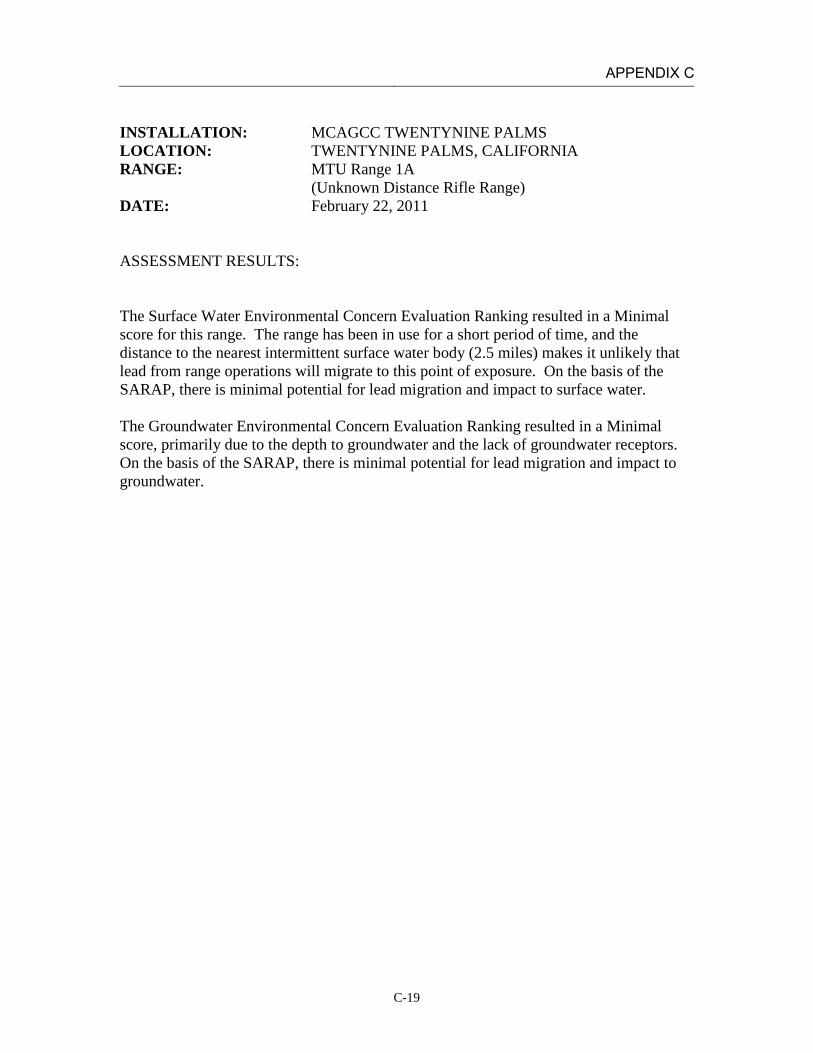
APPENDIX C
C-19
INSTALLATION: MCAGCC TWENTYNINE PALMS LOCATION: TWENTYNINE PALMS, CALIFORNIA RANGE: MTU Range 1A
(Unknown Distance Rifle Range) DATE: February 22, 2011 ASSESSMENT RESULTS: The Surface Water Environmental Concern Evaluation Ranking resulted in a Minimal score for this range. The range has been in use for a short period of time, and the distance to the nearest intermittent surface water body (2.5 miles) makes it unlikely that lead from range operations will migrate to this point of exposure. On the basis of the SARAP, there is minimal potential for lead migration and impact to surface water. The Groundwater Environmental Concern Evaluation Ranking resulted in a Minimal score, primarily due to the depth to groundwater and the lack of groundwater receptors. On the basis of the SARAP, there is minimal potential for lead migration and impact to groundwater.

APPENDIX C
C-20
Table 1: Range Use and Range Management (Source) Element
(These definitions only apply for the purposes of the Small Arms Range Assessment Protocol.)
Criteria Evaluation Characteristics Score Criteria Site Score
Duration of Range Use
The range was under construction when the Archive Search Report was being prepared (1998).
5 if usage > 30 years
3 if usage is 10 to 30 years
1 if usage < 10 years 1
Bullet-Capturing Technology
Bullet-capture technology is not used at this range.
If [range usage duration = bullet capture duration], then apply a negative score so
that the [range usage duration + bullet capture duration] = 1
If [range usage duration – bullet capture duration] = 10 to 30 years, then apply a negative score so that the [range use duration + bullet capture duration] = 3
0 if [range usage duration – bullet capture
duration] > 30 years
0
MC Loading Rates
The range about 1000 lbs of lead per year.
5 if MC loading > 1000 pounds/year
3 if MC loading = 100 to 1000 pounds/year
1 if MC loading < 100 pounds/year
5
Range Maintenance
No lead has been removed from this range.
5 if lead is removed less than every three years
3 if lead is removed more than every three
years but less than annually
1 if lead is removed at least annually
5
Source Element Score 11
Notes: The Unknown Distance Rifle Range was under construction when the Archives Search Report was being prepared in 1998 (Archives Search Report).
Lead recovery has not been conducted at this range.
Based on MC loading data from 2006 through 2010 the range averages approximately 984 lbs lead deposited per year. Given how close this average value is to the upper scoring element, the lead loading rate was conservatively assumed to be 1,000 lbs/year.

APPENDIX C
C-21
Table 2: Surface Water Pathways Characteristics Element (These definitions only apply for the purposes of the Small Arms Range Assessment Protocol.)
Criteria Evaluation Characteristics Score Criteria Site Score
pH of Water The pH of surface water is estimated to be between 8.5 and 8.8, based on stormwater measurements.
5 if pH < 6.5
3 if pH > 8.5
1 if pH 6.5 ≤ pH ≤ 8.5 3
Precipitation The average rainfall amount is between 3 and 4 inches per year.
5 if precipitation > 40 inches/year
3 if precipitation = 20-40 inches/year
1 if precipitation < 20 inches/year
1
Slope of Range
Based on the visual survey and the aerial photographs, the berms have a slope greater than 10 percent.
5 if slope > 10%
3 if slope = 5% to 10%
1 if slope < 5%
5
Vegetation The area contains light patches of creosote bushes and other scrub vegetation.
5 if vegetation cover < 20%
3 if vegetation cover = 20% to 50%
1 if vegetation cover > 50%
5
Soil Type/Runoff Conditions
Soils are characterized as Cajon loamy sand, which is predominantly sandy and somewhat excessively drained, with negligible to low runoff.
5 if soil type is clay / silty clay
3 if soil type is clayey sand / silt
1 if soil type is sand/gravel
1
Runoff/ Erosion Engineering Controls
The protective earthen berm prevents run-on of surface water from higher elevations. No engineered control is present for precipitation that falls directly on the range.
0 if no engineering controls
-5 if partial engineering controls
-10 if effective engineering controls -5
Surface Water Pathway Score 10
Notes: Based on stormwater measurements collected on January 5, 2005, the surface water pH at MCAGCC Twentynine Palms is between 8.5 and 8.8.
The average amount of rainfall at MCAGCC Twentynine Palms is between 3 and 4 inches per year (USDA).
Based on visual survey and aerial photographs, the berms are greater than 10% slope.
The berms are covered by less than 20% vegetation. The area contains light patches of creosote bushes and other scrub.
Range 1A (and the entire MTU) contains soils characterized as Cajon loamy sand, 2 to 8 percent slopes. This soil series is predominantly sandy, which are very deep, somewhat excessively drained soils with negligible to low runoff (NRCS, 2002).
Based on a review of aerial photographs, a protective earthen berm is present on the backside of the range to prevent run-on of surface water from the higher elevations to the north. This control does not affect surface runoff from precipitation that falls directly on the range.

APPENDIX C
C-22
Table 3: Groundwater Pathways Characteristics Element
(These definitions only apply for the purposes of the Small Arms Range Assessment Protocol.)
Criteria Evaluation Characteristics Score
Criteria Site
Score
Depth to Groundwater
The nearest depth-to-groundwater measurement (1.3 miles west) was approximately 400 feet.
5 if depth to groundwater < 20 feet
3 if depth to groundwater = 20-99 feet
1 if depth to groundwater = 100-300 feet
0 if depth to groundwater >300 feet
0
Precipitation The average rainfall amount is between 3 and 4 inches per year.
5 if precipitation > 40 inches/year
3 if precipitation = 20-40 inches/year
1 if precipitation < 20 inches/year
1
pH of Water
The pH of groundwater is approximately 8.0, based on water quality sampling conducted in the Surprise Springs and Deadman Basins.
5 if pH < 6.5
3 if pH > 8.5
1 if pH 6.5 ≤ pH ≤ 8.5
1
pH of Soil The soils at the MTU are classified as entisols or aridisols with a pH value range of 8.0 to 9.1.
5 if pH < 6.5
3 if pH > 8.5
1 if pH 6.5 ≤ pH ≤ 8.5 1-3
Soil Type/Infiltration Conditions
Soils are characterized as Cajon loamy sand, which is predominantly sandy and somewhat excessively drained, with negligible to low runoff.
5 if soil type is sand/gravel
3 if soil type is clayey sand / silt
1 if soil type is clay / silty clay
5
Clay Content in Soil
Soils are characterized as Cajon loamy sand which is a predominantly sandy soil.
5 if soil type is sand/gravel
3 if soil type is clayey sand / silt
1 if soil type is clay / silty clay
5
Groundwater Pathway Score 13-15
Notes: The nearest depth-to-groundwater measurement is from a well approximately 1.3 mile west of the range (IRP Site 16). Depth to groundwater at that point was approximately 400 feet (Battelle 1998).
In 1952, the USGS, in conjunction with the Department of the Navy and the Marine Corps, drilled 12 test wells in the Deadman and Surprise Springs groundwater basins to assess the groundwater quality at what is now MCAGCC Twentynine Palms. Based on water quality sampling conducted in 1952, the pH of groundwater tested from ranged from 7.3 to 9.0 (Riley and Worts, 1952).
The soils at the MTU are classified as entisols and aridisols and are moderately to strongly alkaline with pH values in the range of 8.0 to 9.1 (Battelle, 1998).

APPENDIX C
C-23
Table 4: Surface Water Receptors Element (These definitions only apply for the purposes of the Small Arms Range Assessment Protocol.)
Criteria Evaluation Characteristics
Score Criteria
Site Score
Drinking Water Usage
Surface water bodies are not used for drinking water.
10 if analytical data or observable evidence indicates that contamination in the media is present at, is moving toward, or has a reasonable potential to move toward a surface water body used as a potable water supply or if
a designation as a potable water source is unknown
5 if contamination in the media has moved or is expected to move only slightly beyond the source (tens of feet) or could move, but is not moving appreciably, toward surface water body used as a potable water
supply or if a designation as a potable water source is unknown
2 if low possibility for contamination in the media to be
present at or migrate to a point of exposure
2
Agricultural or Other Beneficial Usage
Surface water features are intermittent, with water present only after severe rainfall events. Given the distance of the closest surface water body and the high infiltration rate at the MTU, it is unlikely that lead will migrate to Mesquite Dry Lake.
5 if analytical data or observable evidence indicates that contamination in the media is present at, is moving toward, or has moved to a point of exposure or if a
designation as agricultural or other beneficial usage is unknown
3 if contamination in the media has moved only slightly beyond the source (tens of feet) or could move but is
not moving appreciably.
1 if low possibility for contamination in the media to be present at or migrate to a point of exposure
1
Sensitive Species Habitat and Threatened or Endangered Species
Given the distance of the closest surface water body and the high infiltration rate at the MTU, it is unlikely that lead will migrate to Mesquite Dry Lake.
10 if identified receptors have access to possibly contaminated media and/or are located adjacent to the
range boundary
5 if potential for receptors to have access to possibly contaminated media
1 if little or no potential for receptors to have access to
possible contaminated media
1
Surface Water Receptor Score 4

APPENDIX C
C-24
Table 4: Surface Water Receptors Element (These definitions only apply for the purposes of the Small Arms Range Assessment Protocol.)
Criteria Evaluation Characteristics
Score Criteria
Site Score
Notes: Surface water bodies at MCAGCC are not used for drinking water. Surface water features are intermittent, with water present only after severe rainfall events. The closest downstream water resource is Mesquite Dry Lake, is located approximately 2.5 miles southwest of the MTU. The MTU drains to the west through gullies that are dry except after heavy rains. The primary drainage channel for the area begins west of the access road and continues parallel to Rifle Range Road until it connects with the storm sewers along Del Valle Road (Battelle, 1998; installation GIS orthophotographs).
Lead has been sampled at the MTU by Battelle and the Navy. Lead concentrations were greatest in the berms and fell off rapidly with increasing distance from the berms. The Navy reported visible fragments of lead out to several thousand feet beyond the impact berms. However, based on the data reviewed to date no studies have been done to collect samples from the dry washes leaving the MTU. Given the distance to the closest intermittent water body receiving runoff and the high rate of infiltration through the sandy soils on range, it is unlikely that lead will migrate to Mesquite Dry Lake.

APPENDIX C
C-25
Table 5: Groundwater Receptors Element
(These definitions only apply for the purposes of the Small Arms Range Assessment Protocol.)
Criteria Evaluation Characteristics
Score Criteria
Site Score
Wells Identified as Potable Water Sources
Water supply wells are located in the Surprise Springs groundwater basin, located 10 miles west-northwest of the MTU. Surprise Springs is located upgradient of the Mesquite Basin.
10 if analytical data or observable evidence or site conditions indicate that MC may be within or
moving toward a reasonable radius of influence of a well or other point of exposure or if a
designation as a potable water source is unknown
5 if analytical data or observable evidence or site conditions indicate that MC have moved only
slightly beyond the source (tens of feet) or could move toward a reasonable radius of influence of a well or other point of exposure, but are not moving
appreciably
2 if low possibility for MC to be present at or migrate to within a reasonable radius of influence
or point of exposure
2
Wells Identified for Agricultural or Other Beneficial Usage
There are no agricultural wells located on the installation. Surface water and stormwater runoff are used for irrigation purposes.
5 if analytical data or observable evidence or site conditions indicate that MC may be within or
moving toward a reasonable radius of influence of a well or other point of exposure or if a
designation as agricultural or other beneficial usage is unknown
3 if analytical data or observable evidence or site
conditions indicate that MC have moved only slightly beyond the source (tens of feet) or could
move toward a reasonable radius of influence of a well or other point of exposure, but are not moving
appreciably
1 if low possibility for MC to be present at or migrate to within a reasonable radius of influence
of a well or point of exposure
1
Sensitive Species Habitat and Threatened and Endangered Species
There are no groundwater discharge locations near the range which could results in lead migration from groundwater to surface water.
5 if identified receptors exposed to potentially MC-impacted water from groundwater or groundwater
sources
3 if potential for receptors exposed to potentially MC-impacted water from groundwater or
groundwater sources
1 if little or no potential for receptors exposed to potentially MC-impacted water from groundwater
or groundwater sources
1
Groundwater Receptor Score 4

APPENDIX C
C-26
Table 5: Groundwater Receptors Element (These definitions only apply for the purposes of the Small Arms Range Assessment Protocol.)
Criteria Evaluation Characteristics
Score Criteria
Site Score
Notes: Water supply wells are located in the Surprise Springs groundwater basin, located 10 miles west-northwest of the MTU. Surprise Springs is located upgradient of the Mesquite Basin. The Mesquite Basin is not used as a drinking water source because of high mineral content. The known depth to groundwater near the MTU is approximately 400 feet.
There are no known agricultural wells located on the installation. Surface water and stormwater is used for irrigation purposes. Based on soil sampling results from the Small Arms Range Maintenance and Repair Project at MCAGCC Twentynine Palms (Battelle, 1998) and previous Navy studies, the vertical migration of lead in the soil column is between four and eight inches from the soil surface.
While groundwater is likely found at shallow depths near playas, there are no known groundwater discharge locations near the range which could result in lead migration from groundwater to surface water.

APPENDIX C
C-27
Table 6: Relative Environmental Concern Evaluation (These definitions only apply for the purposes of the Small Arms Range Assessment Protocol.)
Surface Water
Element Table Score
Range Use and Range Management (Source) 1 11
Surface Water Pathways 2 10
Surface Water Receptors 4 4
Sum of Surface Water Element Scores 25
Groundwater
Element Table Score
Range Use and Range Management (Source) 1 11
Groundwater Pathways 3 13-15
Groundwater Receptors 5 4
Sum of Groundwater Element Scores 28-30
The relative environmental concern evaluation ranking for each media is determined by selecting the appropriate score based on the data elements for that media:
Environmental Concern Evaluation Ranking* Score Range High 50-65 Moderate 30-49 Minimal 0-29
*Use the Environmental Concern Evaluation Ranking to determine if further actions are warranted based on the guidelines for recommended actions, as defined in Table 7.
Surface Water Environmental Concern Evaluation Ranking MINIMAL
Groundwater Environmental Concern Evaluation Ranking MINIMAL to MODERATE
Notes: Groundwater environmental score rated as Minimal based on professional judgment.

APPENDIX C
C-28
INSTALLATION: MCAGCC TWENTYNINE PALMS LOCATION: TWENTYNINE PALMS, CALIFORNIA RANGE: MTU Range 2
(Known Distance Pistol Range) DATE: February 22, 2011 ASSESSMENT RESULTS: The Surface Water Environmental Concern Evaluation Ranking resulted in a Minimal score. The presence of a bullet trap on this range greatly limits the potential for lead deposition and migration, as the majority of the lead is captured. Limited precipitation rates reduce the potential for lead migration, and there are no surface water receptors identified in proximity to the range. On the basis of the SARAP, there is minimal potential for lead migration and impact to surface water. The Groundwater Environmental Concern Evaluation Ranking resulted in a Minimal to Moderate score, primarily due to the depth to groundwater and the lack of groundwater receptors. However, based on professional judgment (depth to groundwater, lead containment on the range via the bullet trap), there is minimal potential for lead migration and impact to groundwater.

APPENDIX C
C-29
Table 1: Range Use and Range Management (Source) Element
(These definitions only apply for the purposes of the Small Arms Range Assessment Protocol.)
Criteria Evaluation Characteristics Score Criteria Site Score
Duration of Range Use
Part of the original complex developed in 1955.
5 if usage > 30 years
3 if usage is 10 to 30 years
1 if usage < 10 years 5
Bullet-Capturing Technology
A bullet trap was installed in the early 2000s. However, based on the age of the range and the timeframe when the bullet trap was installed, the duration of use is greater than 30 years.
If [range usage duration = bullet capture duration], then apply a negative score so
that the [range usage duration + bullet capture duration] = 1
If [range usage duration – bullet capture duration] = 10 to 30 years, then apply a negative score so that the [range use duration + bullet capture duration] = 3
0 if [range usage duration – bullet capture
duration] > 30 years
0
MC Loading Rates
The range averages more than 1000 lbs of lead per year, based on the MC loading data from 2006 through 2010.
5 if MC loading > 1000 pounds/year
3 if MC loading = 100 to 1000 pounds/year
1 if MC loading < 100 pounds/year
5
Range Maintenance
Lead fragments no longer enter the berm. Lead fragments are collected from the bullet trap on a quarterly basis.
5 if lead is removed less than every three years
3 if lead is removed more than every three
years but less than annually
1 if lead is removed at least annually
1
Source Element Score 11
Notes: The Known Distance Pistol Range was originally constructed in 1955 and contained a 15, 25, and 50 yard firing line (Archives Search Report).
A bullet trap was installed at the Known Distance Pistol Range in the early 2000s. However, based on the original year of range construction 1955 and the timeframe in which the bullet trap was installed, the duration of use is greater than 30 years.
Based on MC loading data from 2006 through 2010 the range averages more than 1000 lbs of lead per year (6,687.11 lbs/year). However, the range has a bullet trap which captures the majority of fired rounds. Lead was recovered from the berms of the Known Distance Pistol Range during the same project in which the bullet trap was installed. The lead fragments are captured and removed quarterly by a contractor.
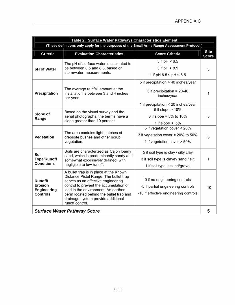
APPENDIX C
C-30
Table 2: Surface Water Pathways Characteristics Element (These definitions only apply for the purposes of the Small Arms Range Assessment Protocol.)
Criteria Evaluation Characteristics Score Criteria Site Score
pH of Water The pH of surface water is estimated to be between 8.5 and 8.8, based on stormwater measurements.
5 if pH < 6.5
3 if pH > 8.5
1 if pH 6.5 ≤ pH ≤ 8.5 3
Precipitation The average rainfall amount at the installation is between 3 and 4 inches per year.
5 if precipitation > 40 inches/year
3 if precipitation = 20-40 inches/year
1 if precipitation < 20 inches/year
1
Slope of Range
Based on the visual survey and the aerial photographs, the berms have a slope greater than 10 percent.
5 if slope > 10%
3 if slope = 5% to 10%
1 if slope < 5%
5
Vegetation The area contains light patches of creosote bushes and other scrub vegetation.
5 if vegetation cover < 20%
3 if vegetation cover = 20% to 50%
1 if vegetation cover > 50%
5
Soil Type/Runoff Conditions
Soils are characterized as Cajon loamy sand, which is predominantly sandy and somewhat excessively drained, with negligible to low runoff.
5 if soil type is clay / silty clay
3 if soil type is clayey sand / silt
1 if soil type is sand/gravel
1
Runoff/ Erosion Engineering Controls
A bullet trap is in place at the Known Distance Pistol Range. The bullet trap serves as an effective engineering control to prevent the accumulation of lead in the environment. An earthen berm located behind the bullet trap and drainage system provide additional runoff control.
0 if no engineering controls
-5 if partial engineering controls
-10 if effective engineering controls -10
Surface Water Pathway Score 5
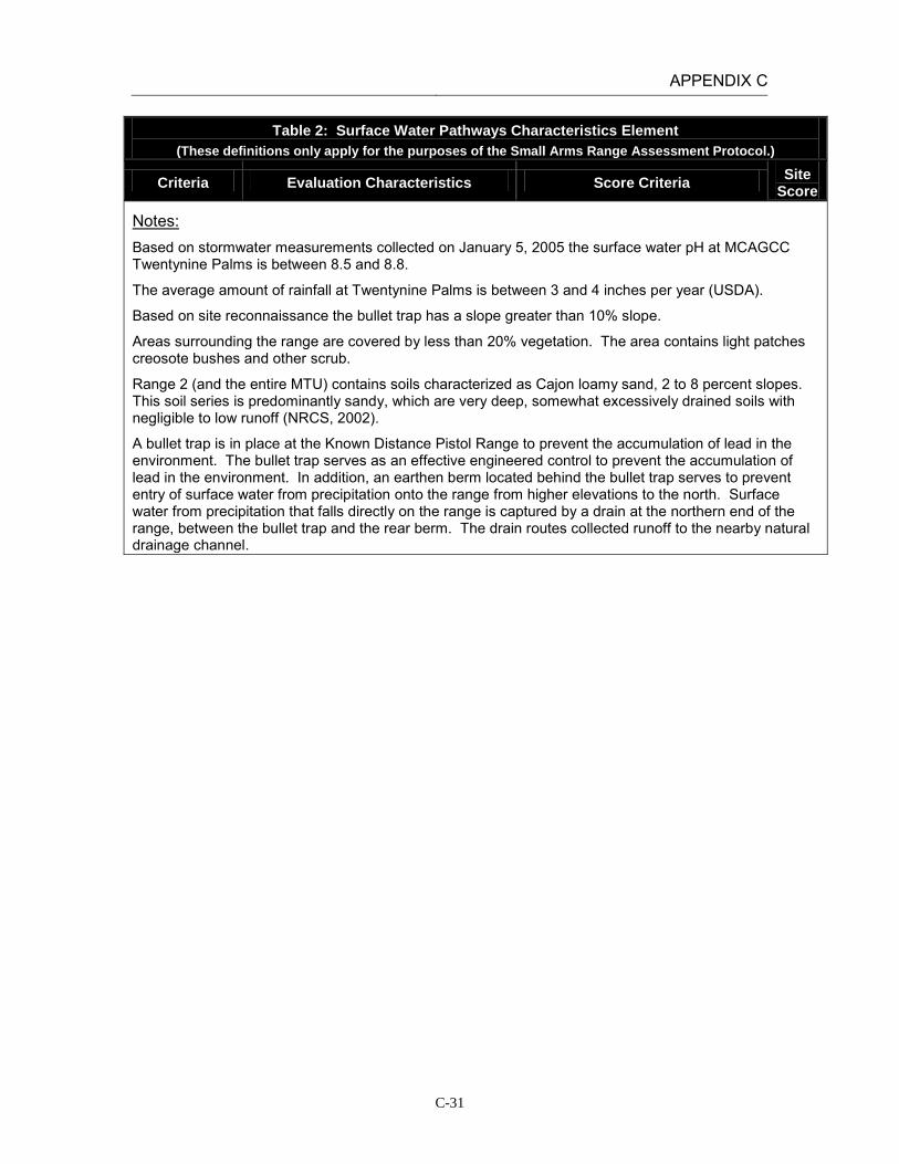
APPENDIX C
C-31
Table 2: Surface Water Pathways Characteristics Element (These definitions only apply for the purposes of the Small Arms Range Assessment Protocol.)
Criteria Evaluation Characteristics Score Criteria Site Score
Notes: Based on stormwater measurements collected on January 5, 2005 the surface water pH at MCAGCC Twentynine Palms is between 8.5 and 8.8.
The average amount of rainfall at Twentynine Palms is between 3 and 4 inches per year (USDA).
Based on site reconnaissance the bullet trap has a slope greater than 10% slope.
Areas surrounding the range are covered by less than 20% vegetation. The area contains light patches creosote bushes and other scrub.
Range 2 (and the entire MTU) contains soils characterized as Cajon loamy sand, 2 to 8 percent slopes. This soil series is predominantly sandy, which are very deep, somewhat excessively drained soils with negligible to low runoff (NRCS, 2002).
A bullet trap is in place at the Known Distance Pistol Range to prevent the accumulation of lead in the environment. The bullet trap serves as an effective engineered control to prevent the accumulation of lead in the environment. In addition, an earthen berm located behind the bullet trap serves to prevent entry of surface water from precipitation onto the range from higher elevations to the north. Surface water from precipitation that falls directly on the range is captured by a drain at the northern end of the range, between the bullet trap and the rear berm. The drain routes collected runoff to the nearby natural drainage channel.

APPENDIX C
C-32
Table 3: Groundwater Pathways Characteristics Element
(These definitions only apply for the purposes of the Small Arms Range Assessment Protocol.)
Criteria Evaluation Characteristics Score
Criteria Site
Score
Depth to Groundwater
The nearest depth-to-groundwater measurement (1.3 miles west) was approximately 400 feet.
5 if depth to groundwater < 20 feet
3 if depth to groundwater = 20-99 feet
1 if depth to groundwater = 100-300 feet
0 if depth to groundwater >300 feet
0
Precipitation The average rainfall amount at the installation is between 3 and 4 inches per year.
5 if precipitation > 40 inches/year
3 if precipitation = 20-40 inches/year
1 if precipitation < 20 inches/year
1
pH of Water
The pH of groundwater is approximately 8.0, based on water quality sampling conducted in the Surprise Springs and Deadman Basins.
5 if pH < 6.5
3 if pH > 8.5
1 if pH 6.5 ≤ pH ≤ 8.5
1
pH of Soil The soils at the MTU are classified as entisols or aridisols with a pH value range of 8.0 to 9.1.
5 if pH < 6.5
3 if pH > 8.5
1 if pH 6.5 ≤ pH ≤ 8.5 1-3
Soil Type/Infiltration Conditions
Soils are characterized as Cajon loamy sand, which is predominantly sandy and somewhat excessively drained, with negligible to low runoff.
5 if soil type is sand/gravel
3 if soil type is clayey sand / silt
1 if soil type is clay / silty clay
5
Clay Content in Soil
Soils are characterized as Cajon loamy sand which is a predominantly sandy soil.
5 if soil type is sand/gravel
3 if soil type is clayey sand / silt
1 if soil type is clay / silty clay
5
Groundwater Pathway Score 13-15
Notes: The nearest depth-to-groundwater measurement is from a well approximately 1.3 mile west of the range (IRP Site 16). Depth to groundwater at that point was approximately 400 feet (Battelle 1998).
In 1952, the USGS, in conjunction with the Department of the Navy and the Marine Corps, drilled 12 test wells in the Deadman and Surprise Springs groundwater basins to assess the groundwater quality at what is now MCAGCC Twentynine Palms. Based on water quality sampling conducted in 1952, the pH of groundwater tested from ranged from 7.3 to 9.0 (Riley and Worts, 1952).
The soils at the MTU are classified as entisols and aridisols and are moderately to strongly alkaline with pH values in the range of 8.0 to 9.1 (Battelle, 1998).

APPENDIX C
C-33
Table 4: Surface Water Receptors Element (These definitions only apply for the purposes of the Small Arms Range Assessment Protocol.)
Criteria Evaluation Characteristics
Score Criteria
Site Score
Drinking Water Usage
Surface water bodies are not used for drinking water.
10 if analytical data or observable evidence indicates that contamination in the media is present at, is moving toward, or has a reasonable potential to move toward a surface water body used as a potable water supply or if
a designation as a potable water source is unknown
5 if contamination in the media has moved or is expected to move only slightly beyond the source (tens of feet) or could move, but is not moving appreciably, toward surface water body used as a potable water
supply or if a designation as a potable water source is unknown
2 if low possibility for contamination in the media to be
present at or migrate to a point of exposure
2
Agricultural or Other Beneficial Usage
Surface water features are intermittent, with water present only after severe rainfall events. Given the distance of the closest surface water body and the high infiltration rate at the MTU, it is unlikely that lead will migrate to Mesquite Dry Lake.
5 if analytical data or observable evidence indicates that contamination in the media is present at, is moving toward, or has moved to a point of exposure or if a
designation as agricultural or other beneficial usage is unknown
3 if contamination in the media has moved only slightly beyond the source (tens of feet) or could move but is
not moving appreciably.
1 if low possibility for contamination in the media to be present at or migrate to a point of exposure
1
Sensitive Species Habitat and Threatened or Endangered Species
Given the distance of the closest surface water body and the high infiltration rate at the MTU, it is unlikely that lead will migrate to Mesquite Dry Lake.
10 if identified receptors have access to possibly contaminated media and/or are located adjacent to the
range boundary
5 if potential for receptors to have access to possibly contaminated media
1 if little or no potential for receptors to have access to
possible contaminated media
1
Surface Water Receptor Score 4

APPENDIX C
C-34
Table 4: Surface Water Receptors Element (These definitions only apply for the purposes of the Small Arms Range Assessment Protocol.)
Criteria Evaluation Characteristics
Score Criteria
Site Score
Notes: Surface water bodies at MCAGCC are not used for drinking water. Surface water features are intermittent, with water present only after severe rainfall events. The closest downstream water resource is Mesquite Dry Lake, is located approximately 2.5 miles southwest of the MTU. The MTU drains to the west through gullies that are dry except after heavy rains. The primary drainage channel for the area begins west of the access road and continues parallel to Rifle Range Road until it connects with the storm sewers along Del Valle Road (Battelle, 1998; installation GIS orthophotographs).
Lead has been sampled at the MTU by Battelle and the Navy. Lead concentrations were greatest in the berms and fell off rapidly with increasing distance from the berms. The Navy reported visible fragments of lead out to several thousand feet beyond the impact berms. However, based on the data reviewed to date no studies have been done to collect samples from the dry washes leaving the MTU. Given the distance to the closest intermittent water body receiving runoff and the high rate of infiltration through the sandy soils on range, it is unlikely that lead will migrate to Mesquite Dry Lake.
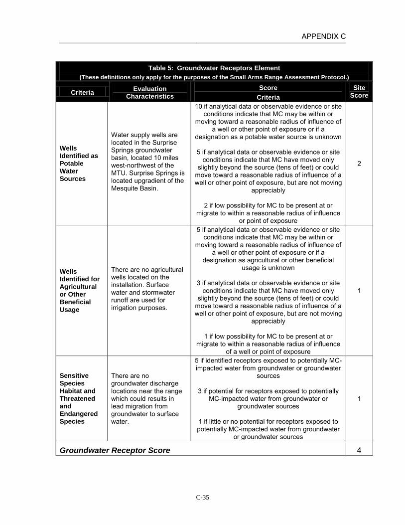
APPENDIX C
C-35
Table 5: Groundwater Receptors Element
(These definitions only apply for the purposes of the Small Arms Range Assessment Protocol.)
Criteria Evaluation Characteristics
Score Criteria
Site Score
Wells Identified as Potable Water Sources
Water supply wells are located in the Surprise Springs groundwater basin, located 10 miles west-northwest of the MTU. Surprise Springs is located upgradient of the Mesquite Basin.
10 if analytical data or observable evidence or site conditions indicate that MC may be within or
moving toward a reasonable radius of influence of a well or other point of exposure or if a
designation as a potable water source is unknown
5 if analytical data or observable evidence or site conditions indicate that MC have moved only
slightly beyond the source (tens of feet) or could move toward a reasonable radius of influence of a well or other point of exposure, but are not moving
appreciably
2 if low possibility for MC to be present at or migrate to within a reasonable radius of influence
or point of exposure
2
Wells Identified for Agricultural or Other Beneficial Usage
There are no agricultural wells located on the installation. Surface water and stormwater runoff are used for irrigation purposes.
5 if analytical data or observable evidence or site conditions indicate that MC may be within or
moving toward a reasonable radius of influence of a well or other point of exposure or if a
designation as agricultural or other beneficial usage is unknown
3 if analytical data or observable evidence or site
conditions indicate that MC have moved only slightly beyond the source (tens of feet) or could
move toward a reasonable radius of influence of a well or other point of exposure, but are not moving
appreciably
1 if low possibility for MC to be present at or migrate to within a reasonable radius of influence
of a well or point of exposure
1
Sensitive Species Habitat and Threatened and Endangered Species
There are no groundwater discharge locations near the range which could results in lead migration from groundwater to surface water.
5 if identified receptors exposed to potentially MC-impacted water from groundwater or groundwater
sources
3 if potential for receptors exposed to potentially MC-impacted water from groundwater or
groundwater sources
1 if little or no potential for receptors exposed to potentially MC-impacted water from groundwater
or groundwater sources
1
Groundwater Receptor Score 4

APPENDIX C
C-36
Table 5: Groundwater Receptors Element (These definitions only apply for the purposes of the Small Arms Range Assessment Protocol.)
Criteria Evaluation Characteristics
Score Criteria
Site Score
Notes: Water supply wells are located in the Surprise Springs groundwater basin, located 10 miles west-northwest of the MTU. Surprise Springs is located upgradient of the Mesquite Basin. The Mesquite Basin is not used as a drinking water source because of high mineral content. The known depth to groundwater near the MTU is approximately 400 feet.
There are no known agricultural wells located on the installation. Surface water and stormwater is used for irrigation purposes. Based on soil sampling results from the Small Arms Range Maintenance and Repair Project at MCAGCC Twentynine Palms (Battelle, 1998) and previous Navy studies, the vertical migration of lead in the soil column is between four and eight inches from the soil surface.
While groundwater is likely found at shallow depths near playas, there are no known groundwater discharge locations near the range which could result in lead migration from groundwater to surface water.

APPENDIX C
C-37
Table 6: Relative Environmental Concern Evaluation (These definitions only apply for the purposes of the Small Arms Range Assessment Protocol.)
Surface Water
Element Table Score
Range Use and Range Management (Source) 1 11
Surface Water Pathways 2 5
Surface Water Receptors 4 4
Sum of Surface Water Element Scores 20
Groundwater
Element Table Score
Range Use and Range Management (Source) 1 11
Groundwater Pathways 3 13-15
Groundwater Receptors 5 4
Sum of Groundwater Element Scores 28-30
The relative environmental concern evaluation ranking for each media is determined by selecting the appropriate score based on the data elements for that media:
Environmental Concern Evaluation Ranking* Score Range High 50-65 Moderate 30-49 Minimal 0-29
*Use the Environmental Concern Evaluation Ranking to determine if further actions are warranted based on the guidelines for recommended actions, as defined in Table 7.
Surface Water Environmental Concern Evaluation Ranking MINIMAL
Groundwater Environmental Concern Evaluation Ranking MINIMAL-
MODERATE*
Notes: Groundwater environmental concern evaluation ranking downgraded to Minimal based on professional judgment.

APPENDIX C
C-38
INSTALLATION: MCAGCC TWENTYNINE PALMS LOCATION: TWENTYNINE PALMS, CALIFORNIA RANGE: MTU Range 2A
(Combat Pistol Range) DATE: February 21, 2011 ASSESSMENT RESULTS: The Surface Water Environmental Concern Evaluation Ranking resulted in a Minimal score. This range has been operational for a shorter period of time than the other MTU ranges and training activities result in only moderate deposition of lead in berms. Limited precipitation rates and partial engineered controls (earthen berms) reduce the potential for lead transport, and there are no surface water receptors identified in proximity to the range. On the basis of the SARAP, there is minimal potential for lead migration and impact to surface water. The Groundwater Environmental Concern Evaluation Ranking resulted in a Minimal score, primarily due to the depth to groundwater and the lack of groundwater receptors. On the basis of the SARAP, there is minimal potential for lead migration and impact to groundwater.
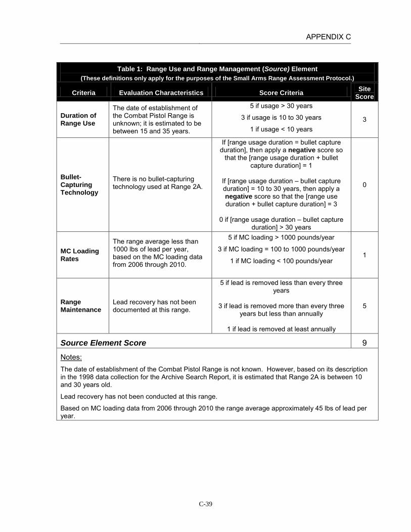
APPENDIX C
C-39
Table 1: Range Use and Range Management (Source) Element
(These definitions only apply for the purposes of the Small Arms Range Assessment Protocol.)
Criteria Evaluation Characteristics Score Criteria Site Score
Duration of Range Use
The date of establishment of the Combat Pistol Range is unknown; it is estimated to be between 15 and 35 years.
5 if usage > 30 years
3 if usage is 10 to 30 years
1 if usage < 10 years 3
Bullet-Capturing Technology
There is no bullet-capturing technology used at Range 2A.
If [range usage duration = bullet capture duration], then apply a negative score so
that the [range usage duration + bullet capture duration] = 1
If [range usage duration – bullet capture duration] = 10 to 30 years, then apply a negative score so that the [range use duration + bullet capture duration] = 3
0 if [range usage duration – bullet capture
duration] > 30 years
0
MC Loading Rates
The range average less than 1000 lbs of lead per year, based on the MC loading data from 2006 through 2010.
5 if MC loading > 1000 pounds/year
3 if MC loading = 100 to 1000 pounds/year
1 if MC loading < 100 pounds/year
1
Range Maintenance
Lead recovery has not been documented at this range.
5 if lead is removed less than every three years
3 if lead is removed more than every three
years but less than annually
1 if lead is removed at least annually
5
Source Element Score 9
Notes: The date of establishment of the Combat Pistol Range is not known. However, based on its description in the 1998 data collection for the Archive Search Report, it is estimated that Range 2A is between 10 and 30 years old.
Lead recovery has not been conducted at this range.
Based on MC loading data from 2006 through 2010 the range average approximately 45 lbs of lead per year.

APPENDIX C
C-40
Table 2: Surface Water Pathways Characteristics Element (These definitions only apply for the purposes of the Small Arms Range Assessment Protocol.)
Criteria Evaluation Characteristics Score Criteria Site Score
pH of Water The pH of surface water is estimated to be between 8.5 and 8.8, based on stormwater measurements.
5 if pH < 6.5
3 if pH > 8.5
1 if pH 6.5 ≤ pH ≤ 8.5 3
Precipitation The average rainfall amount at the installation is between 3 and 4 inches per year.
5 if precipitation > 40 inches/year
3 if precipitation = 20-40 inches/year
1 if precipitation < 20 inches/year
1
Slope of Range
Based on the visual survey and the aerial photographs, the berms have a slope greater than 10 percent.
5 if slope > 10%
3 if slope = 5% to 10%
1 if slope < 5%
5
Vegetation The area contains light patches of creosote bushes and other scrub vegetation.
5 if vegetation cover < 20%
3 if vegetation cover = 20% to 50%
1 if vegetation cover > 50%
5
Soil Type/Runoff Conditions
Soils are characterized as Cajon loamy sand, which is predominantly sandy and somewhat excessively drained, with negligible to low runoff.
5 if soil type is clay / silty clay
3 if soil type is clayey sand / silt
1 if soil type is sand/gravel
1
Runoff/ Erosion Engineering Controls
A protective earthen berm prevents run-on of surface water from higher elevations. In addition, sand is periodically added to the face of the berm.
0 if no engineering controls
-5 if partial engineering controls
-10 if effective engineering controls -5
Surface Water Pathway Score 10

APPENDIX C
C-41
Table 2: Surface Water Pathways Characteristics Element (These definitions only apply for the purposes of the Small Arms Range Assessment Protocol.)
Criteria Evaluation Characteristics Score Criteria Site Score
Notes: Based on stormwater measurements collected on January 5, 2005 the surface water pH at MCAGCC Twentynine Palms is between 8.5 and 8.8.
The average amount of rainfall at Twentynine Palms is between 3 and 4 inches per year (USDA).
Based on site reconnaissance and aerial photographs, this range contains many small berms (which protect the pop-up targets) and a large rear impact berm that are greater than 10% slope. Each berm has a slope greater than 10%.
The berms are covered by less than 20% vegetation. The area contains patches of creosote bushes and other scrub.
Range 2A (and the entire MTU) contains soils characterized as Cajon loamy sand, 2 to 8 percent slopes. This soil series is predominantly sandy, which are very deep, somewhat excessively drained soils with negligible to low runoff (NRCS, 2002).
Sand is periodically added to the face of the berm where bullet pockets are formed from range use. In addition, a protective earthen berm is present on the backside of the range to prevent run-on of surface water from the higher elevations to the north. This control does not affect surface runoff from precipitation that falls directly on the range.

APPENDIX C
C-42
Table 3: Groundwater Pathways Characteristics Element
(These definitions only apply for the purposes of the Small Arms Range Assessment Protocol.)
Criteria Evaluation Characteristics Score
Criteria Site
Score
Depth to Groundwater
The nearest depth-to-groundwater measurement (1.3 miles west) was approximately 400 feet.
5 if depth to groundwater < 20 feet
3 if depth to groundwater = 20-99 feet
1 if depth to groundwater = 100-300 feet
0 if depth to groundwater >300 feet
0
Precipitation The average rainfall amount at the installation is between 3 and 4 inches per year.
5 if precipitation > 40 inches/year
3 if precipitation = 20-40 inches/year
1 if precipitation < 20 inches/year
1
pH of Water
The pH of groundwater is approximately 8.0, based on water quality sampling conducted in the Surprise Springs and Deadman Basins.
5 if pH < 6.5
3 if pH > 8.5
1 if pH 6.5 ≤ pH ≤ 8.5
1
pH of Soil The soils at the MTU are classified as entisols or aridisols with a pH value range of 8.0 to 9.1.
5 if pH < 6.5
3 if pH > 8.5
1 if pH 6.5 ≤ pH ≤ 8.5 1-3
Soil Type/Infiltration Conditions
Soils are characterized as Cajon loamy sand, which is predominantly sandy and somewhat excessively drained, with negligible to low runoff.
5 if soil type is sand/gravel
3 if soil type is clayey sand / silt
1 if soil type is clay / silty clay
5
Clay Content in Soil
Soils are characterized as Cajon loamy sand which is a predominantly sandy soil.
5 if soil type is sand/gravel
3 if soil type is clayey sand / silt
1 if soil type is clay / silty clay
5
Groundwater Pathway Score 13-15
Notes: The nearest depth-to-groundwater measurement is from a well approximately 1.3 mile west of the range (IRP Site 16). Depth to groundwater at that point was approximately 400 feet (Battelle 1998).
In 1952, the USGS, in conjunction with the Department of the Navy and the Marine Corps, drilled 12 test wells in the Deadman and Surprise Springs groundwater basins to assess the groundwater quality at what is now MCAGCC Twentynine Palms. Based on water quality sampling conducted in 1952, the pH of groundwater tested from ranged from 7.3 to 9.0 (Riley and Worts, 1952).
The soils at the MTU are classified as entisols and aridisols and are moderately to strongly alkaline with pH values in the range of 8.0 to 9.1 (Battelle, 1998).

APPENDIX C
C-43
Table 4: Surface Water Receptors Element (These definitions only apply for the purposes of the Small Arms Range Assessment Protocol.)
Criteria Evaluation Characteristics
Score Criteria
Site Score
Drinking Water Usage
Surface water bodies are not used for drinking water.
10 if analytical data or observable evidence indicates that contamination in the media is present at, is moving toward, or has a reasonable potential to move toward a surface water body used as a potable water supply or if
a designation as a potable water source is unknown
5 if contamination in the media has moved or is expected to move only slightly beyond the source (tens of feet) or could move, but is not moving appreciably, toward surface water body used as a potable water
supply or if a designation as a potable water source is unknown
2 if low possibility for contamination in the media to be
present at or migrate to a point of exposure
2
Agricultural or Other Beneficial Usage
Surface water features are intermittent, with water present only after severe rainfall events. Given the distance of the closest surface water body and the high infiltration rate at the MTU, it is unlikely that lead will migrate to Mesquite Dry Lake.
5 if analytical data or observable evidence indicates that contamination in the media is present at, is moving toward, or has moved to a point of exposure or if a
designation as agricultural or other beneficial usage is unknown
3 if contamination in the media has moved only slightly beyond the source (tens of feet) or could move but is
not moving appreciably.
1 if low possibility for contamination in the media to be present at or migrate to a point of exposure
1
Sensitive Species Habitat and Threatened or Endangered Species
Given the distance of the closest surface water body and the high infiltration rate at the MTU, it is unlikely that lead will migrate to Mesquite Dry Lake.
10 if identified receptors have access to possibly contaminated media and/or are located adjacent to the
range boundary
5 if potential for receptors to have access to possibly contaminated media
1 if little or no potential for receptors to have access to
possible contaminated media
1
Surface Water Receptor Score 4

APPENDIX C
C-44
Table 4: Surface Water Receptors Element (These definitions only apply for the purposes of the Small Arms Range Assessment Protocol.)
Criteria Evaluation Characteristics
Score Criteria
Site Score
Notes: Surface water bodies at MCAGCC are not used for drinking water. Surface water features are intermittent, with water present only after severe rainfall events. The closest downstream water resource is Mesquite Dry Lake, is located approximately 2.5 miles southwest of the MTU. The MTU drains to the west through gullies that are dry except after heavy rains. The primary drainage channel for the area begins west of the access road and continues parallel to Rifle Range Road until it connects with the storm sewers along Del Valle Road (Battelle, 1998; installation GIS orthophotographs).
Lead has been sampled at the MTU by Battelle and the Navy. Lead concentrations were greatest in the berms and fell off rapidly with increasing distance from the berms. The Navy reported visible fragments of lead out to several thousand feet beyond the impact berms. However, based on the data reviewed to date no studies have been done to collect samples from the dry washes leaving the MTU. Given the distance to the closest intermittent water body receiving runoff and the high rate of infiltration through the sandy soils on range, it is unlikely that lead will migrate to Mesquite Dry Lake.

APPENDIX C
C-45
Table 5: Groundwater Receptors Element
(These definitions only apply for the purposes of the Small Arms Range Assessment Protocol.)
Criteria Evaluation Characteristics
Score Criteria
Site Score
Wells Identified as Potable Water Sources
Water supply wells are located in the Surprise Springs groundwater basin, located 10 miles west-northwest of the MTU. Surprise Springs is located upgradient of the Mesquite Basin.
10 if analytical data or observable evidence or site conditions indicate that MC may be within or
moving toward a reasonable radius of influence of a well or other point of exposure or if a
designation as a potable water source is unknown
5 if analytical data or observable evidence or site conditions indicate that MC have moved only
slightly beyond the source (tens of feet) or could move toward a reasonable radius of influence of a well or other point of exposure, but are not moving
appreciably
2 if low possibility for MC to be present at or migrate to within a reasonable radius of influence
or point of exposure
2
Wells Identified for Agricultural or Other Beneficial Usage
There are no agricultural wells located on the installation. Surface water and stormwater runoff are used for irrigation purposes.
5 if analytical data or observable evidence or site conditions indicate that MC may be within or
moving toward a reasonable radius of influence of a well or other point of exposure or if a
designation as agricultural or other beneficial usage is unknown
3 if analytical data or observable evidence or site
conditions indicate that MC have moved only slightly beyond the source (tens of feet) or could
move toward a reasonable radius of influence of a well or other point of exposure, but are not moving
appreciably
1 if low possibility for MC to be present at or migrate to within a reasonable radius of influence
of a well or point of exposure
1
Sensitive Species Habitat and Threatened and Endangered Species
There are no groundwater discharge locations near the range which could results in lead migration from groundwater to surface water.
5 if identified receptors exposed to potentially MC-impacted water from groundwater or groundwater
sources
3 if potential for receptors exposed to potentially MC-impacted water from groundwater or
groundwater sources
1 if little or no potential for receptors exposed to potentially MC-impacted water from groundwater
or groundwater sources
1
Groundwater Receptor Score 4

APPENDIX C
C-46
Table 5: Groundwater Receptors Element (These definitions only apply for the purposes of the Small Arms Range Assessment Protocol.)
Criteria Evaluation Characteristics
Score Criteria
Site Score
Notes: Water supply wells are located in the Surprise Springs groundwater basin, located 10 miles west-northwest of the MTU. Surprise Springs is located upgradient of the Mesquite Basin. The Mesquite Basin is not used as a drinking water source because of high mineral content. The known depth to groundwater near the MTU is approximately 400 feet.
There are no known agricultural wells located on the installation. Surface water and stormwater is used for irrigation purposes. Based on soil sampling results from the Small Arms Range Maintenance and Repair Project at MCAGCC Twentynine Palms (Battelle, 1998) and previous Navy studies, the vertical migration of lead in the soil column is between four and eight inches from the soil surface.
While groundwater is likely found at shallow depths near playas, there are no known groundwater discharge locations near the range which could result in lead migration from groundwater to surface water.

APPENDIX C
C-47
Table 6: Relative Environmental Concern Evaluation (These definitions only apply for the purposes of the Small Arms Range Assessment Protocol.)
Surface Water
Element Table Score
Range Use and Range Management (Source) 1 9
Surface Water Pathways 2 10
Surface Water Receptors 4 4
Sum of Surface Water Element Scores 23
Groundwater
Element Table Score
Range Use and Range Management (Source) 1 9
Groundwater Pathways 3 13-15
Groundwater Receptors 5 4
Sum of Groundwater Element Scores 26-28
The relative environmental concern evaluation ranking for each media is determined by selecting the appropriate score based on the data elements for that media:
Environmental Concern Evaluation Ranking* Score Range High 50-65 Moderate 30-49 Minimal 0-29
*Use the Environmental Concern Evaluation Ranking to determine if further actions are warranted based on the guidelines for recommended actions, as defined in Table 7.
Surface Water Environmental Concern Evaluation Ranking MINIMAL
Groundwater Environmental Concern Evaluation Ranking MINIMAL
Notes:

APPENDIX C
C-48
INSTALLATION: MCAGCC TWENTYNINE PALMS LOCATION: TWENTYNINE PALMS, CALIFORNIA RANGE: MTU Range 3
(Rifle Field Expedient BZO Grouping Range) DATE: February 21, 2011 ASSESSMENT RESULTS: The Surface Water Environmental Concern Evaluation Ranking resulted in a Minimal score. The presence of a bullet trap on this range greatly limits the potential for lead deposition and migration, as the majority of the lead is captured. In addition, very limited loading of lead is occurring at this range, given the activities conducted at a BZO Range. Limited precipitation reduces the potential for lead migration, and there are no surface water receptors identified in proximity to the range. On the basis of the SARAP, there is minimal potential for lead migration and impact to surface water. The Groundwater Environmental Concern Evaluation Ranking resulted in a Minimal score, primarily due to the depth to groundwater and the lack of groundwater receptors. On the basis of the SARAP, there is minimal potential for lead migration and impact to groundwater.
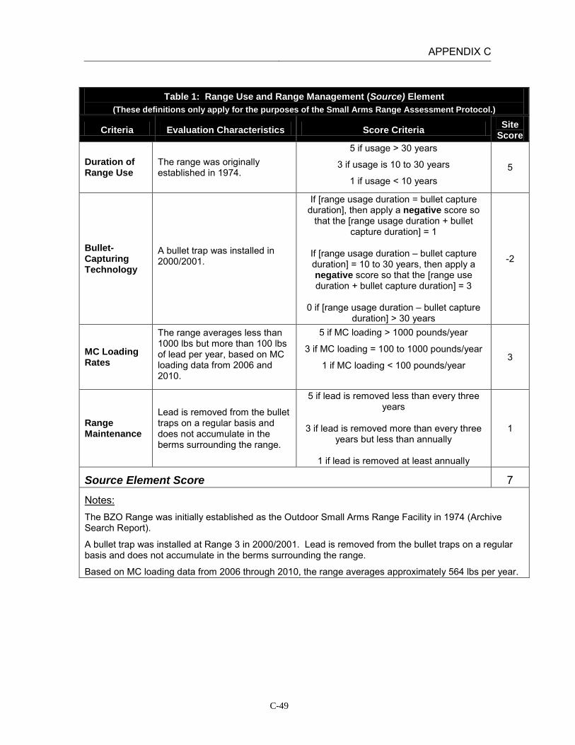
APPENDIX C
C-49
Table 1: Range Use and Range Management (Source) Element
(These definitions only apply for the purposes of the Small Arms Range Assessment Protocol.)
Criteria Evaluation Characteristics Score Criteria Site Score
Duration of Range Use
The range was originally established in 1974.
5 if usage > 30 years
3 if usage is 10 to 30 years
1 if usage < 10 years 5
Bullet-Capturing Technology
A bullet trap was installed in 2000/2001.
If [range usage duration = bullet capture duration], then apply a negative score so
that the [range usage duration + bullet capture duration] = 1
If [range usage duration – bullet capture duration] = 10 to 30 years, then apply a negative score so that the [range use duration + bullet capture duration] = 3
0 if [range usage duration – bullet capture
duration] > 30 years
-2
MC Loading Rates
The range averages less than 1000 lbs but more than 100 lbs of lead per year, based on MC loading data from 2006 and 2010.
5 if MC loading > 1000 pounds/year
3 if MC loading = 100 to 1000 pounds/year
1 if MC loading < 100 pounds/year
3
Range Maintenance
Lead is removed from the bullet traps on a regular basis and does not accumulate in the berms surrounding the range.
5 if lead is removed less than every three years
3 if lead is removed more than every three
years but less than annually
1 if lead is removed at least annually
1
Source Element Score 7
Notes: The BZO Range was initially established as the Outdoor Small Arms Range Facility in 1974 (Archive Search Report).
A bullet trap was installed at Range 3 in 2000/2001. Lead is removed from the bullet traps on a regular basis and does not accumulate in the berms surrounding the range.
Based on MC loading data from 2006 through 2010, the range averages approximately 564 lbs per year.
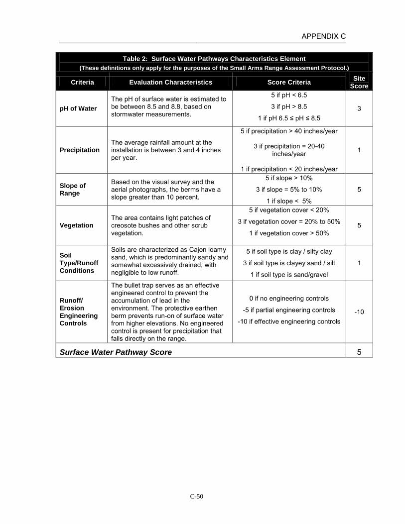
APPENDIX C
C-50
Table 2: Surface Water Pathways Characteristics Element (These definitions only apply for the purposes of the Small Arms Range Assessment Protocol.)
Criteria Evaluation Characteristics Score Criteria Site Score
pH of Water The pH of surface water is estimated to be between 8.5 and 8.8, based on stormwater measurements.
5 if pH < 6.5
3 if pH > 8.5
1 if pH 6.5 ≤ pH ≤ 8.5 3
Precipitation The average rainfall amount at the installation is between 3 and 4 inches per year.
5 if precipitation > 40 inches/year
3 if precipitation = 20-40 inches/year
1 if precipitation < 20 inches/year
1
Slope of Range
Based on the visual survey and the aerial photographs, the berms have a slope greater than 10 percent.
5 if slope > 10%
3 if slope = 5% to 10%
1 if slope < 5%
5
Vegetation The area contains light patches of creosote bushes and other scrub vegetation.
5 if vegetation cover < 20%
3 if vegetation cover = 20% to 50%
1 if vegetation cover > 50%
5
Soil Type/Runoff Conditions
Soils are characterized as Cajon loamy sand, which is predominantly sandy and somewhat excessively drained, with negligible to low runoff.
5 if soil type is clay / silty clay
3 if soil type is clayey sand / silt
1 if soil type is sand/gravel
1
Runoff/ Erosion Engineering Controls
The bullet trap serves as an effective engineered control to prevent the accumulation of lead in the environment. The protective earthen berm prevents run-on of surface water from higher elevations. No engineered control is present for precipitation that falls directly on the range.
0 if no engineering controls
-5 if partial engineering controls
-10 if effective engineering controls -10
Surface Water Pathway Score 5

APPENDIX C
C-51
Table 2: Surface Water Pathways Characteristics Element (These definitions only apply for the purposes of the Small Arms Range Assessment Protocol.)
Criteria Evaluation Characteristics Score Criteria Site Score
Notes: Based on stormwater measurements collected on January 5, 2005 the surface water pH at MCAGCC Twentynine Palms is between 8.5 and 8.8.
The average amount of rainfall at Twentynine Palms between 3 and 4 inches per year (USDA).
Based on site reconnaissance and aerial photographs the berms are greater than 10% slope.
The berms are covered by less than 20% vegetation. The area contains patches of creosote bushes and other scrub.
Range 3 (and the entire MTU) contains soils characterized as Cajon loamy sand, 2 to 8 percent slopes. This soil series is predominantly sandy, which are very deep, somewhat excessively drained soils with negligible to low runoff (NRCS, 2002).
Based on aerial photographs and site reconnaissance a bullet trap is present at Range 3 to prevent the accumulation of bullets in the berms surrounding the range. The bullet trap serves as an effective engineered control to prevent the accumulation of lead in the environment. In addition, a protective earthen berm is present on the backside of the range to prevent run-on of surface water from the higher elevations to the north. Surface water from precipitation that falls directly on the range is captured by a drain at the northeastern end of the range, between the bullet trap and the rear berm. The drain routes collected runoff to the nearby natural drainage channel.

APPENDIX C
C-52
Table 3: Groundwater Pathways Characteristics Element
(These definitions only apply for the purposes of the Small Arms Range Assessment Protocol.)
Criteria Evaluation Characteristics Score
Criteria Site
Score
Depth to Groundwater
The nearest depth-to-groundwater measurement (1.3 miles west) was approximately 400 feet.
5 if depth to groundwater < 20 feet
3 if depth to groundwater = 20-99 feet
1 if depth to groundwater = 100-300 feet
0 if depth to groundwater >300 feet
0
Precipitation The average rainfall amount at the installation is between 3 and 4 inches per year.
5 if precipitation > 40 inches/year
3 if precipitation = 20-40 inches/year
1 if precipitation < 20 inches/year
1
pH of Water
The pH of groundwater is approximately 8.0, based on water quality sampling conducted in the Surprise Springs and Deadman Basins.
5 if pH < 6.5
3 if pH > 8.5
1 if pH 6.5 ≤ pH ≤ 8.5
1
pH of Soil The soils at the MTU are classified as entisols or aridisols with a pH value range of 8.0 to 9.1.
5 if pH < 6.5
3 if pH > 8.5
1 if pH 6.5 ≤ pH ≤ 8.5 1-3
Soil Type/Infiltration Conditions
Soils are characterized as Cajon loamy sand, which is predominantly sandy and somewhat excessively drained, with negligible to low runoff.
5 if soil type is sand/gravel
3 if soil type is clayey sand / silt
1 if soil type is clay / silty clay
5
Clay Content in Soil
Soils are characterized as Cajon loamy sand which is a predominantly sandy soil.
5 if soil type is sand/gravel
3 if soil type is clayey sand / silt
1 if soil type is clay / silty clay
5
Groundwater Pathway Score 13-15
Notes: The nearest depth-to-groundwater measurement is from a well approximately 1.3 mile west of the range (IRP Site 16). Depth to groundwater at that point was approximately 400 feet (Battelle 1998).
In 1952, the USGS, in conjunction with the Department of the Navy and the Marine Corps, drilled 12 test wells in the Deadman and Surprise Springs groundwater basins to assess the groundwater quality at what is now MCAGCC Twentynine Palms. Based on water quality sampling conducted in 1952, the pH of groundwater tested from ranged from 7.3 to 9.0 (Riley and Worts, 1952).
The soils at the MTU are classified as entisols and aridisols and are moderately to strongly alkaline with pH values in the range of 8.0 to 9.1 (Battelle, 1998).

APPENDIX C
C-53
Table 4: Surface Water Receptors Element (These definitions only apply for the purposes of the Small Arms Range Assessment Protocol.)
Criteria Evaluation Characteristics
Score Criteria
Site Score
Drinking Water Usage
Surface water bodies are not used for drinking water.
10 if analytical data or observable evidence indicates that contamination in the media is present at, is moving toward, or has a reasonable potential to move toward a surface water body used as a potable water supply or if
a designation as a potable water source is unknown
5 if contamination in the media has moved or is expected to move only slightly beyond the source (tens of feet) or could move, but is not moving appreciably, toward surface water body used as a potable water
supply or if a designation as a potable water source is unknown
2 if low possibility for contamination in the media to be
present at or migrate to a point of exposure
2
Agricultural or Other Beneficial Usage
Surface water features are intermittent, with water present only after severe rainfall events. Given the distance of the closest surface water body and the high infiltration rate at the MTU, it is unlikely that lead will migrate to Mesquite Dry Lake.
5 if analytical data or observable evidence indicates that contamination in the media is present at, is moving toward, or has moved to a point of exposure or if a
designation as agricultural or other beneficial usage is unknown
3 if contamination in the media has moved only slightly beyond the source (tens of feet) or could move but is
not moving appreciably.
1 if low possibility for contamination in the media to be present at or migrate to a point of exposure
1
Sensitive Species Habitat and Threatened or Endangered Species
Given the distance of the closest surface water body and the high infiltration rate at the MTU, it is unlikely that lead will migrate to Mesquite Dry Lake.
10 if identified receptors have access to possibly contaminated media and/or are located adjacent to the
range boundary
5 if potential for receptors to have access to possibly contaminated media
1 if little or no potential for receptors to have access to
possible contaminated media
1
Surface Water Receptor Score 4

APPENDIX C
C-54
Table 4: Surface Water Receptors Element (These definitions only apply for the purposes of the Small Arms Range Assessment Protocol.)
Criteria Evaluation Characteristics
Score Criteria
Site Score
Notes: Surface water bodies at MCAGCC are not used for drinking water. Surface water features are intermittent, with water present only after severe rainfall events. The closest downstream water resource is Mesquite Dry Lake, is located approximately 2.5 miles southwest of the MTU. The MTU drains to the west through gullies that are dry except after heavy rains. The primary drainage channel for the area begins west of the access road and continues parallel to Rifle Range Road until it connects with the storm sewers along Del Valle Road (Battelle, 1998; installation GIS orthophotographs).
Lead has been sampled at the MTU by Battelle and the Navy. Lead concentrations were greatest in the berms and fell off rapidly with increasing distance from the berms. The Navy reported visible fragments of lead out to several thousand feet beyond the impact berms. However, based on the data reviewed to date no studies have been done to collect samples from the dry washes leaving the MTU. Given the distance to the closest intermittent water body receiving runoff and the high rate of infiltration through the sandy soils on range, it is unlikely that lead will migrate to Mesquite Dry Lake.

APPENDIX C
C-55
Table 5: Groundwater Receptors Element
(These definitions only apply for the purposes of the Small Arms Range Assessment Protocol.)
Criteria Evaluation Characteristics
Score Criteria
Site Score
Wells Identified as Potable Water Sources
Water supply wells are located in the Surprise Springs groundwater basin, located 10 miles west-northwest of the MTU. Surprise Springs is located upgradient of the Mesquite Basin.
10 if analytical data or observable evidence or site conditions indicate that MC may be within or
moving toward a reasonable radius of influence of a well or other point of exposure or if a
designation as a potable water source is unknown
5 if analytical data or observable evidence or site conditions indicate that MC have moved only
slightly beyond the source (tens of feet) or could move toward a reasonable radius of influence of a well or other point of exposure, but are not moving
appreciably
2 if low possibility for MC to be present at or migrate to within a reasonable radius of influence
or point of exposure
2
Wells Identified for Agricultural or Other Beneficial Usage
There are no agricultural wells located on the installation. Surface water and stormwater runoff are used for irrigation purposes.
5 if analytical data or observable evidence or site conditions indicate that MC may be within or
moving toward a reasonable radius of influence of a well or other point of exposure or if a
designation as agricultural or other beneficial usage is unknown
3 if analytical data or observable evidence or site
conditions indicate that MC have moved only slightly beyond the source (tens of feet) or could
move toward a reasonable radius of influence of a well or other point of exposure, but are not moving
appreciably
1 if low possibility for MC to be present at or migrate to within a reasonable radius of influence
of a well or point of exposure
1
Sensitive Species Habitat and Threatened and Endangered Species
There are no groundwater discharge locations near the range which could results in lead migration from groundwater to surface water.
5 if identified receptors exposed to potentially MC-impacted water from groundwater or groundwater
sources
3 if potential for receptors exposed to potentially MC-impacted water from groundwater or
groundwater sources
1 if little or no potential for receptors exposed to potentially MC-impacted water from groundwater
or groundwater sources
1
Groundwater Receptor Score 4

APPENDIX C
C-56
Table 5: Groundwater Receptors Element (These definitions only apply for the purposes of the Small Arms Range Assessment Protocol.)
Criteria Evaluation Characteristics
Score Criteria
Site Score
Notes: Water supply wells are located in the Surprise Springs groundwater basin, located 10 miles west-northwest of the MTU. Surprise Springs is located upgradient of the Mesquite Basin. The Mesquite Basin is not used as a drinking water source because of high mineral content. The known depth to groundwater near the MTU is approximately 400 feet.
There are no known agricultural wells located on the installation. Surface water and stormwater is used for irrigation purposes. Based on soil sampling results from the Small Arms Range Maintenance and Repair Project at MCAGCC Twentynine Palms (Battelle, 1998) and previous Navy studies, the vertical migration of lead in the soil column is between four and eight inches from the soil surface.
While groundwater is likely found at shallow depths near playas, there are no known groundwater discharge locations near the range which could result in lead migration from groundwater to surface water.

APPENDIX C
C-57
Table 6: Relative Environmental Concern Evaluation (These definitions only apply for the purposes of the Small Arms Range Assessment Protocol.)
Surface Water
Element Table Score
Range Use and Range Management (Source) 1 7
Surface Water Pathways 2 5
Surface Water Receptors 4 4
Sum of Surface Water Element Scores 16
Groundwater
Element Table Score
Range Use and Range Management (Source) 1 7
Groundwater Pathways 3 13-15
Groundwater Receptors 5 4
Sum of Groundwater Element Scores 24-26
The relative environmental concern evaluation ranking for each media is determined by selecting the appropriate score based on the data elements for that media:
Environmental Concern Evaluation Ranking* Score Range High 50-65 Moderate 30-49 Minimal 0-29
*Use the Environmental Concern Evaluation Ranking to determine if further actions are warranted based on the guidelines for recommended actions, as defined in Table 7.
Surface Water Environmental Concern Evaluation Ranking MINIMAL
Groundwater Environmental Concern Evaluation Ranking MINIMAL
Notes:

APPENDIX C
C-58
INSTALLATION: MCAGCC TWENTYNINE PALMS LOCATION: TWENTYNINE PALMS, CALIFORNIA RANGE: MTU Range 3A
(Multi-purpose Rifle/Pistol Range) DATE: February 21, 2011 ASSESSMENT RESULTS: The Surface Water Environmental Concern Evaluation Ranking resulted in a Minimal score. Limited precipitation rates and partial engineered controls (earthen berms) reduce the potential for lead transport. While intense storms in the winter may cause runoff to act as the dominant transport mechanism, it is unlikely that lead from range operations will be dissolved in runoff and transported 2.5 miles in measurable concentrations to the nearest intermittent water body (Mesquite Dry Lake). On the basis of the SARAP, there is minimal potential for lead migration and impact to surface water. The Groundwater Environmental Concern Evaluation Ranking resulted in a Moderate score. However, it is the professional judgment of the REVA Team that the overall concern for lead migration and exposure to groundwater receptors is more accurately categorized as a Minimal level. The Groundwater Pathway score is biased high based on the sandy nature of the soils, and lack of clay in the soil unit. Previous sampling data from nearby MTU ranges indicates that lead migration on this range is limited to a maximum of eight inches from the soil surface. In addition, the depth to groundwater and the lack of groundwater receptors in the area likely precludes any significant groundwater impacts. Therefore, on the basis of professional judgment, there is minimal potential for lead migration and impact to groundwater resources.
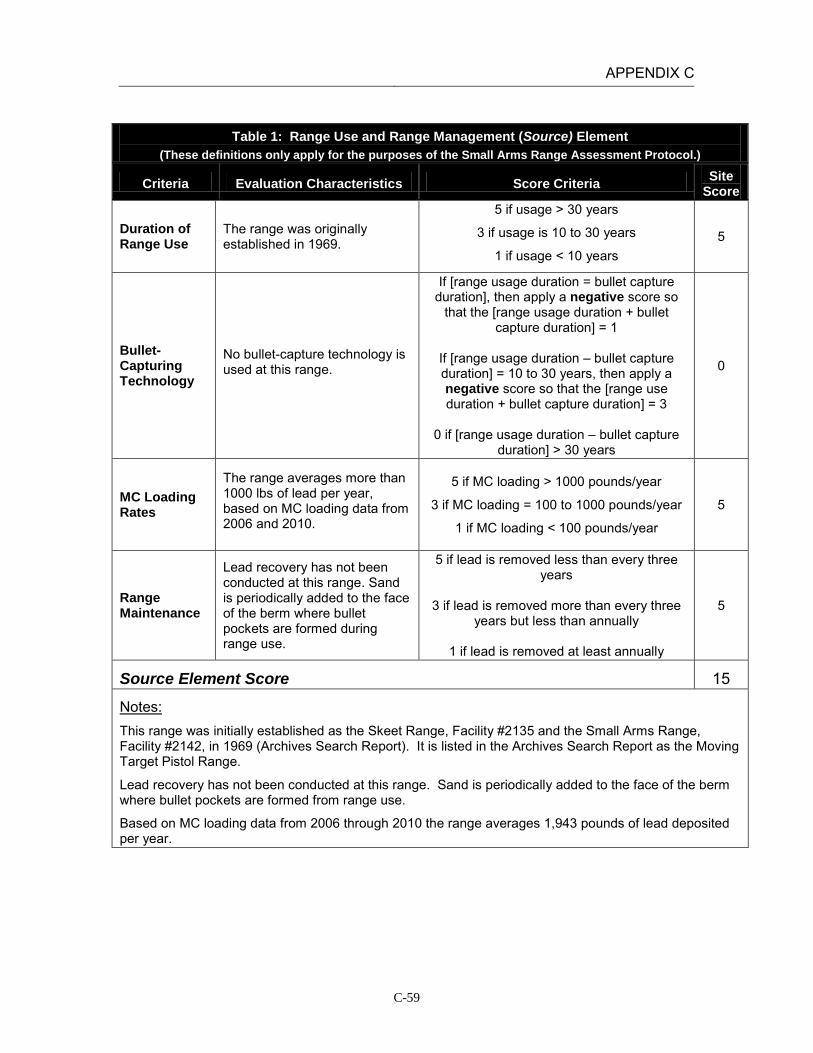
APPENDIX C
C-59
Table 1: Range Use and Range Management (Source) Element
(These definitions only apply for the purposes of the Small Arms Range Assessment Protocol.)
Criteria Evaluation Characteristics Score Criteria Site Score
Duration of Range Use
The range was originally established in 1969.
5 if usage > 30 years
3 if usage is 10 to 30 years
1 if usage < 10 years 5
Bullet-Capturing Technology
No bullet-capture technology is used at this range.
If [range usage duration = bullet capture duration], then apply a negative score so
that the [range usage duration + bullet capture duration] = 1
If [range usage duration – bullet capture duration] = 10 to 30 years, then apply a negative score so that the [range use duration + bullet capture duration] = 3
0 if [range usage duration – bullet capture
duration] > 30 years
0
MC Loading Rates
The range averages more than 1000 lbs of lead per year, based on MC loading data from 2006 and 2010.
5 if MC loading > 1000 pounds/year
3 if MC loading = 100 to 1000 pounds/year
1 if MC loading < 100 pounds/year
5
Range Maintenance
Lead recovery has not been conducted at this range. Sand is periodically added to the face of the berm where bullet pockets are formed during range use.
5 if lead is removed less than every three years
3 if lead is removed more than every three
years but less than annually
1 if lead is removed at least annually
5
Source Element Score 15
Notes: This range was initially established as the Skeet Range, Facility #2135 and the Small Arms Range, Facility #2142, in 1969 (Archives Search Report). It is listed in the Archives Search Report as the Moving Target Pistol Range.
Lead recovery has not been conducted at this range. Sand is periodically added to the face of the berm where bullet pockets are formed from range use.
Based on MC loading data from 2006 through 2010 the range averages 1,943 pounds of lead deposited per year.
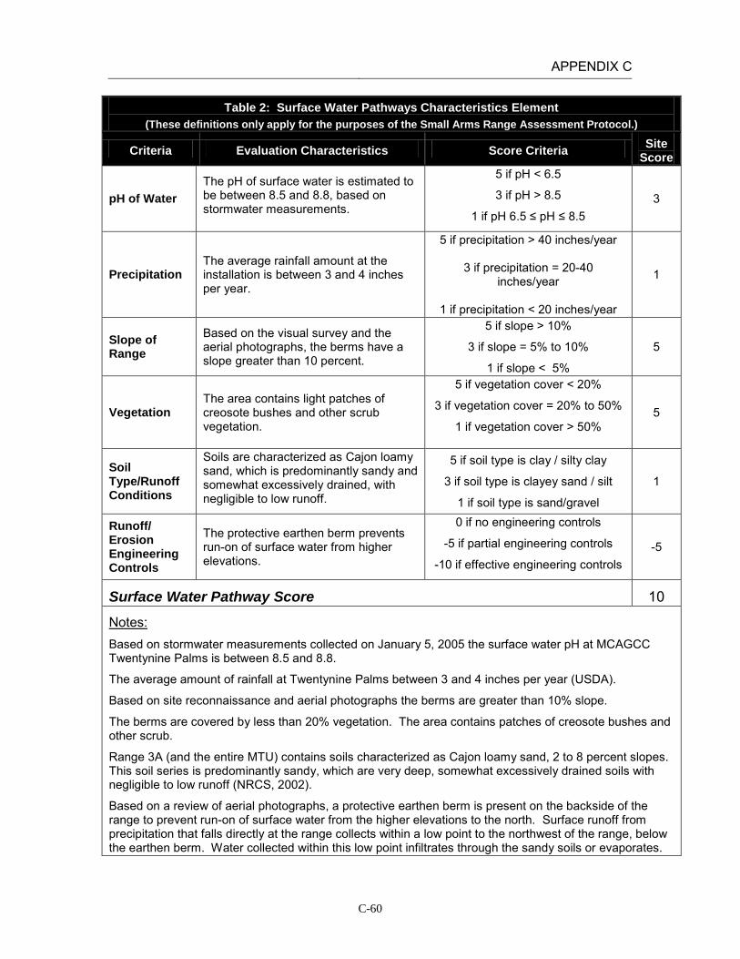
APPENDIX C
C-60
Table 2: Surface Water Pathways Characteristics Element (These definitions only apply for the purposes of the Small Arms Range Assessment Protocol.)
Criteria Evaluation Characteristics Score Criteria Site Score
pH of Water The pH of surface water is estimated to be between 8.5 and 8.8, based on stormwater measurements.
5 if pH < 6.5
3 if pH > 8.5
1 if pH 6.5 ≤ pH ≤ 8.5 3
Precipitation The average rainfall amount at the installation is between 3 and 4 inches per year.
5 if precipitation > 40 inches/year
3 if precipitation = 20-40 inches/year
1 if precipitation < 20 inches/year
1
Slope of Range
Based on the visual survey and the aerial photographs, the berms have a slope greater than 10 percent.
5 if slope > 10%
3 if slope = 5% to 10%
1 if slope < 5%
5
Vegetation The area contains light patches of creosote bushes and other scrub vegetation.
5 if vegetation cover < 20%
3 if vegetation cover = 20% to 50%
1 if vegetation cover > 50%
5
Soil Type/Runoff Conditions
Soils are characterized as Cajon loamy sand, which is predominantly sandy and somewhat excessively drained, with negligible to low runoff.
5 if soil type is clay / silty clay
3 if soil type is clayey sand / silt
1 if soil type is sand/gravel
1
Runoff/ Erosion Engineering Controls
The protective earthen berm prevents run-on of surface water from higher elevations.
0 if no engineering controls
-5 if partial engineering controls
-10 if effective engineering controls -5
Surface Water Pathway Score 10
Notes: Based on stormwater measurements collected on January 5, 2005 the surface water pH at MCAGCC Twentynine Palms is between 8.5 and 8.8.
The average amount of rainfall at Twentynine Palms between 3 and 4 inches per year (USDA).
Based on site reconnaissance and aerial photographs the berms are greater than 10% slope.
The berms are covered by less than 20% vegetation. The area contains patches of creosote bushes and other scrub.
Range 3A (and the entire MTU) contains soils characterized as Cajon loamy sand, 2 to 8 percent slopes. This soil series is predominantly sandy, which are very deep, somewhat excessively drained soils with negligible to low runoff (NRCS, 2002).
Based on a review of aerial photographs, a protective earthen berm is present on the backside of the range to prevent run-on of surface water from the higher elevations to the north. Surface runoff from precipitation that falls directly at the range collects within a low point to the northwest of the range, below the earthen berm. Water collected within this low point infiltrates through the sandy soils or evaporates.
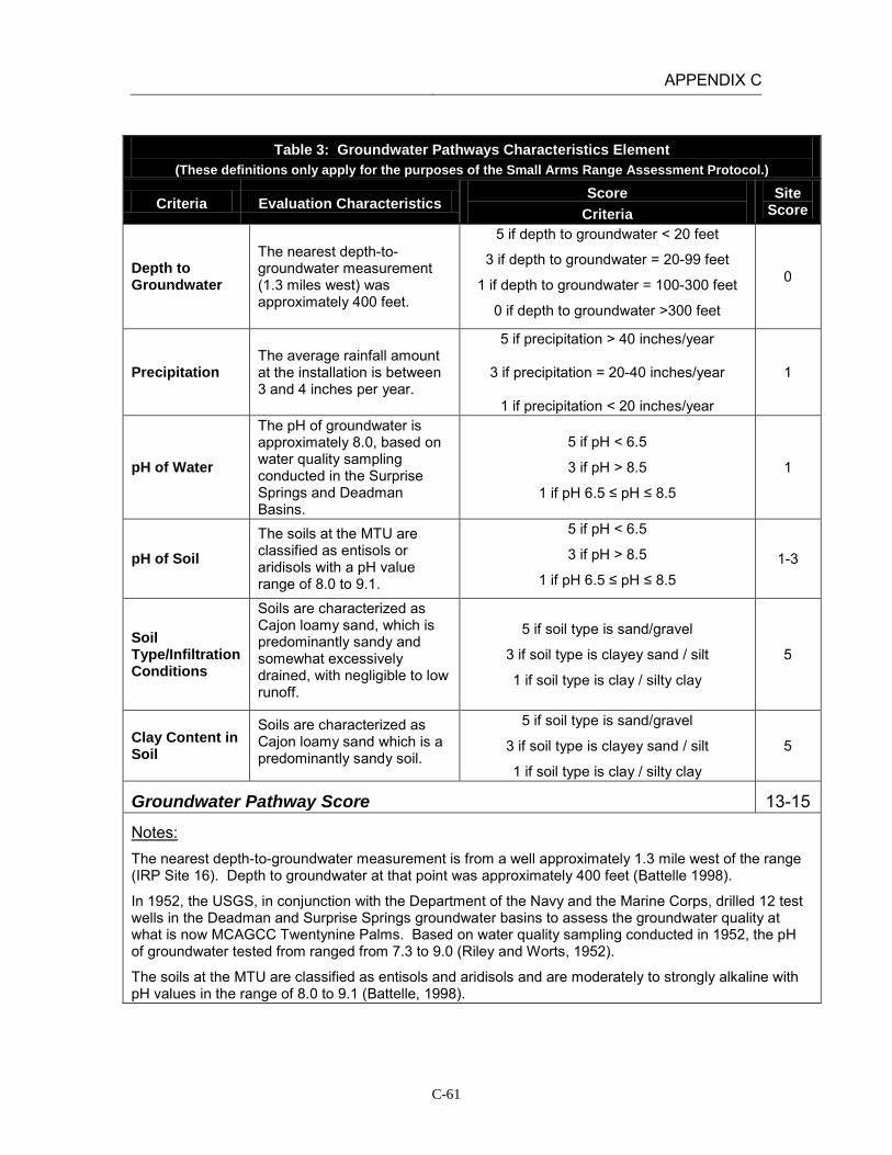
APPENDIX C
C-61
Table 3: Groundwater Pathways Characteristics Element
(These definitions only apply for the purposes of the Small Arms Range Assessment Protocol.)
Criteria Evaluation Characteristics Score
Criteria Site
Score
Depth to Groundwater
The nearest depth-to-groundwater measurement (1.3 miles west) was approximately 400 feet.
5 if depth to groundwater < 20 feet
3 if depth to groundwater = 20-99 feet
1 if depth to groundwater = 100-300 feet
0 if depth to groundwater >300 feet
0
Precipitation The average rainfall amount at the installation is between 3 and 4 inches per year.
5 if precipitation > 40 inches/year
3 if precipitation = 20-40 inches/year
1 if precipitation < 20 inches/year
1
pH of Water
The pH of groundwater is approximately 8.0, based on water quality sampling conducted in the Surprise Springs and Deadman Basins.
5 if pH < 6.5
3 if pH > 8.5
1 if pH 6.5 ≤ pH ≤ 8.5
1
pH of Soil The soils at the MTU are classified as entisols or aridisols with a pH value range of 8.0 to 9.1.
5 if pH < 6.5
3 if pH > 8.5
1 if pH 6.5 ≤ pH ≤ 8.5 1-3
Soil Type/Infiltration Conditions
Soils are characterized as Cajon loamy sand, which is predominantly sandy and somewhat excessively drained, with negligible to low runoff.
5 if soil type is sand/gravel
3 if soil type is clayey sand / silt
1 if soil type is clay / silty clay
5
Clay Content in Soil
Soils are characterized as Cajon loamy sand which is a predominantly sandy soil.
5 if soil type is sand/gravel
3 if soil type is clayey sand / silt
1 if soil type is clay / silty clay
5
Groundwater Pathway Score 13-15
Notes: The nearest depth-to-groundwater measurement is from a well approximately 1.3 mile west of the range (IRP Site 16). Depth to groundwater at that point was approximately 400 feet (Battelle 1998).
In 1952, the USGS, in conjunction with the Department of the Navy and the Marine Corps, drilled 12 test wells in the Deadman and Surprise Springs groundwater basins to assess the groundwater quality at what is now MCAGCC Twentynine Palms. Based on water quality sampling conducted in 1952, the pH of groundwater tested from ranged from 7.3 to 9.0 (Riley and Worts, 1952).
The soils at the MTU are classified as entisols and aridisols and are moderately to strongly alkaline with pH values in the range of 8.0 to 9.1 (Battelle, 1998).

APPENDIX C
C-62
Table 4: Surface Water Receptors Element (These definitions only apply for the purposes of the Small Arms Range Assessment Protocol.)
Criteria Evaluation Characteristics
Score Criteria
Site Score
Drinking Water Usage
Surface water bodies are not used for drinking water.
10 if analytical data or observable evidence indicates that contamination in the media is present at, is moving toward, or has a reasonable potential to move toward a surface water body used as a potable water supply or if
a designation as a potable water source is unknown
5 if contamination in the media has moved or is expected to move only slightly beyond the source (tens of feet) or could move, but is not moving appreciably, toward surface water body used as a potable water
supply or if a designation as a potable water source is unknown
2 if low possibility for contamination in the media to be
present at or migrate to a point of exposure
2
Agricultural or Other Beneficial Usage
Surface water features are intermittent, with water present only after severe rainfall events. Given the distance of the closest surface water body and the high infiltration rate at the MTU, it is unlikely that lead will migrate to Mesquite Dry Lake.
5 if analytical data or observable evidence indicates that contamination in the media is present at, is moving toward, or has moved to a point of exposure or if a
designation as agricultural or other beneficial usage is unknown
3 if contamination in the media has moved only slightly beyond the source (tens of feet) or could move but is
not moving appreciably.
1 if low possibility for contamination in the media to be present at or migrate to a point of exposure
1
Sensitive Species Habitat and Threatened or Endangered Species
Given the distance of the closest surface water body and the high infiltration rate at the MTU, it is unlikely that lead will migrate to Mesquite Dry Lake.
10 if identified receptors have access to possibly contaminated media and/or are located adjacent to the
range boundary
5 if potential for receptors to have access to possibly contaminated media
1 if little or no potential for receptors to have access to
possible contaminated media
1
Surface Water Receptor Score 4

APPENDIX C
C-63
Table 4: Surface Water Receptors Element (These definitions only apply for the purposes of the Small Arms Range Assessment Protocol.)
Criteria Evaluation Characteristics
Score Criteria
Site Score
Notes: Most surface water runoff from precipitation that falls on the range collects in a low spot on the range floor and infiltrates or evaporates. Some drainage during intense storms may flow to the south and west, for eventual discharge to into the Mesquite Dry Lake, located approximately 2.5 miles southwest of the MTU. Surface water bodies at MCAGCC are not used for drinking water.
Lead has been sampled at the MTU by Battelle and the Navy. Lead concentrations were greatest in the berms and fell off rapidly with increasing distance from the berms. The Navy reported visible fragments of lead out to several thousand feet beyond the impact berms. However, based on the data reviewed to date no studies have been done to collect samples from the dry washes leaving the MTU. Given the distance to the closest intermittent water body receiving runoff and the high rate of infiltration through the sandy soils on range, it is unlikely that lead will migrate to Mesquite Dry Lake.

APPENDIX C
C-64
Table 5: Groundwater Receptors Element
(These definitions only apply for the purposes of the Small Arms Range Assessment Protocol.)
Criteria Evaluation Characteristics
Score Criteria
Site Score
Wells Identified as Potable Water Sources
Water supply wells are located in the Surprise Springs groundwater basin, located 10 miles west-northwest of the MTU. Surprise Springs is located upgradient of the Mesquite Basin.
10 if analytical data or observable evidence or site conditions indicate that MC may be within or
moving toward a reasonable radius of influence of a well or other point of exposure or if a
designation as a potable water source is unknown
5 if analytical data or observable evidence or site conditions indicate that MC have moved only
slightly beyond the source (tens of feet) or could move toward a reasonable radius of influence of a well or other point of exposure, but are not moving
appreciably
2 if low possibility for MC to be present at or migrate to within a reasonable radius of influence
or point of exposure
2
Wells Identified for Agricultural or Other Beneficial Usage
There are no agricultural wells located on the installation. Surface water and stormwater runoff are used for irrigation purposes.
5 if analytical data or observable evidence or site conditions indicate that MC may be within or
moving toward a reasonable radius of influence of a well or other point of exposure or if a
designation as agricultural or other beneficial usage is unknown
3 if analytical data or observable evidence or site
conditions indicate that MC have moved only slightly beyond the source (tens of feet) or could
move toward a reasonable radius of influence of a well or other point of exposure, but are not moving
appreciably
1 if low possibility for MC to be present at or migrate to within a reasonable radius of influence
of a well or point of exposure
1
Sensitive Species Habitat and Threatened and Endangered Species
There are no groundwater discharge locations near the range which could results in lead migration from groundwater to surface water.
5 if identified receptors exposed to potentially MC-impacted water from groundwater or groundwater
sources
3 if potential for receptors exposed to potentially MC-impacted water from groundwater or
groundwater sources
1 if little or no potential for receptors exposed to potentially MC-impacted water from groundwater
or groundwater sources
1
Groundwater Receptor Score 4

APPENDIX C
C-65
Table 5: Groundwater Receptors Element (These definitions only apply for the purposes of the Small Arms Range Assessment Protocol.)
Criteria Evaluation Characteristics
Score Criteria
Site Score
Notes: While surface water may infiltrate into the subsurface at the low elevation spot on the range floor, most of the water is likely to evaporate due to the arid conditions. Water supply wells are located in the Surprise Springs groundwater basin, located 10 miles west-northwest of the MTU. Surprise Springs is located upgradient of the Mesquite Basin. The Mesquite Basin is not used as a drinking water source because of high mineral content. The known depth to groundwater near the MTU is approximately 400 feet.
There are no known agricultural wells located on the installation. Surface water and stormwater is used for irrigation purposes. Based on soil sampling results from the Small Arms Range Maintenance and Repair Project at MCAGCC Twentynine Palms (Battelle, 1998) and previous Navy studies, the vertical migration of lead in the soil column is between four and eight inches from the soil surface.
While groundwater is likely found at shallow depths near playas, there are no known groundwater discharge locations near the range which could result in lead migration from groundwater to surface water.

APPENDIX C
C-66
Table 6: Relative Environmental Concern Evaluation (These definitions only apply for the purposes of the Small Arms Range Assessment Protocol.)
Surface Water
Element Table Score
Range Use and Range Management (Source) 1 15
Surface Water Pathways 2 10
Surface Water Receptors 4 4
Sum of Surface Water Element Scores 29
Groundwater
Element Table Score
Range Use and Range Management (Source) 1 15
Groundwater Pathways 3 13-15
Groundwater Receptors 5 4
Sum of Groundwater Element Scores 32-34
The relative environmental concern evaluation ranking for each media is determined by selecting the appropriate score based on the data elements for that media:
Environmental Concern Evaluation Ranking* Score Range High 50-65 Moderate 30-49 Minimal 0-29
*Use the Environmental Concern Evaluation Ranking to determine if further actions are warranted based on the guidelines for recommended actions, as defined in Table 7.
Surface Water Environmental Concern Evaluation Ranking MINMAL
Groundwater Environmental Concern Evaluation Ranking MODERATE*
Notes: *The Groundwater Environmental Concern Evaluation Ranking reduced to Minimal based on professional judgment of the REVA Team.

APPENDIX C
C-67
INSTALLATION: MCAGCC TWENTYNINE PALMS LOCATION: TWENTYNINE PALMS, CALIFORNIA RANGE: Range 101 (Small Arms Battle Sight Zero) DATE: March 10, 2011 ASSESSMENT RESULTS: The Surface Water Environmental Concern Evaluation Ranking resulted in a Minimal score for this range. The range has been in use for a short period of time, minimal lead loading is occurring, and the distance to the nearest intermittent surface water body makes it unlikely that lead from range operations will migrate to this point of exposure. In addition, all surface water draining Range 101 is contained on-range; REVA only addresses potential migration and exposure to receptors in off-range locations. On the basis of the SARAP, there is minimal potential for lead migration and impact to surface water. The Groundwater Environmental Concern Evaluation Ranking resulted in a Minimal to Moderate score, primarily due to the depth to groundwater and the lack of groundwater receptors. However, it is the professional judgment of the REVA Team that the overall concern for lead migration and exposure to groundwater receptors is more accurately categorized as a Minimal level. The Groundwater Pathway score is biased high based on the sandy nature of the soils, and lack of clay in the soil unit. Previous sampling data from nearby MTU ranges indicates that lead migration on this range is limited to a maximum of eight inches from the soil surface. In addition, the depth to groundwater and the lack of groundwater receptors in the area likely precludes any significant groundwater impacts. Therefore, on the basis of professional judgment, there is minimal potential for lead migration and impact to groundwater resources.
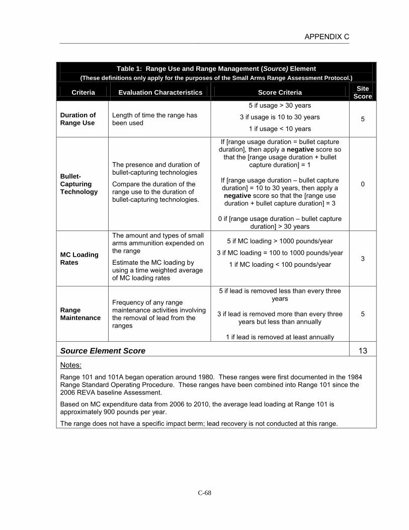
APPENDIX C
C-68
Table 1: Range Use and Range Management (Source) Element
(These definitions only apply for the purposes of the Small Arms Range Assessment Protocol.)
Criteria Evaluation Characteristics Score Criteria Site Score
Duration of Range Use
Length of time the range has been used
5 if usage > 30 years
3 if usage is 10 to 30 years
1 if usage < 10 years 5
Bullet-Capturing Technology
The presence and duration of bullet-capturing technologies
Compare the duration of the range use to the duration of bullet-capturing technologies.
If [range usage duration = bullet capture duration], then apply a negative score so
that the [range usage duration + bullet capture duration] = 1
If [range usage duration – bullet capture duration] = 10 to 30 years, then apply a negative score so that the [range use duration + bullet capture duration] = 3
0 if [range usage duration – bullet capture
duration] > 30 years
0
MC Loading Rates
The amount and types of small arms ammunition expended on the range
Estimate the MC loading by using a time weighted average of MC loading rates
5 if MC loading > 1000 pounds/year
3 if MC loading = 100 to 1000 pounds/year
1 if MC loading < 100 pounds/year
3
Range Maintenance
Frequency of any range maintenance activities involving the removal of lead from the ranges
5 if lead is removed less than every three years
3 if lead is removed more than every three
years but less than annually
1 if lead is removed at least annually
5
Source Element Score 13
Notes: Range 101 and 101A began operation around 1980. These ranges were first documented in the 1984 Range Standard Operating Procedure. These ranges have been combined into Range 101 since the 2006 REVA baseline Assessment.
Based on MC expenditure data from 2006 to 2010, the average lead loading at Range 101 is approximately 900 pounds per year.
The range does not have a specific impact berm; lead recovery is not conducted at this range.

APPENDIX C
C-69
Table 2: Surface Water Pathways Characteristics Element (These definitions only apply for the purposes of the Small Arms Range Assessment Protocol.)
Criteria Evaluation Characteristics Score Criteria Site Score
pH of Water pH below 6.5 increases the rate of lead dissolution.
5 if pH < 6.5
3 if pH > 8.5
1 if pH 6.5 ≤ pH ≤ 8.5 1-3
Precipitation Intensity and frequency of precipitation
5 if precipitation > 40 inches/year
3 if precipitation = 20-40 inches/year
1 if precipitation < 20 inches/year
1
Slope of Range
The amount of deviation from the horizontal for the berm / target area
5 if slope > 10%
3 if slope = 5% to 10%
1 if slope < 5%
1
Vegetation Approximate vegetation cover within and directly downslope of the surface danger zone
5 if vegetation cover < 20%
3 if vegetation cover = 20% to 50%
1 if vegetation cover > 50%
5
Soil Type/Runoff Conditions
Soil with a higher porosity (sands/gravels) has more infiltration and less runoff compared to soil with low porosity (silts/clays).
5 if soil type is clay / silty clay
3 if soil type is clayey sand / silt
1 if soil type is sand/gravel
1
Runoff/ Erosion Engineering Controls
The presence of engineering controls or BMPs to modify or control surface water runoff and erosion
Partial engineering controls include using erosion controls such as a proper groundcover or use of berms or backstops. Using a combination of multiple partial engineering controls may create an effective engineering control. Other effective engineering controls include bullet containment technologies.
0 if no engineering controls
-5 if partial engineering controls
-10 if effective engineering controls 0
Surface Water Pathway Score 9-11

APPENDIX C
C-70
Table 2: Surface Water Pathways Characteristics Element (These definitions only apply for the purposes of the Small Arms Range Assessment Protocol.)
Criteria Evaluation Characteristics Score Criteria Site Score
Notes: Based on USGS data the pH of precipitation in California is between 5.3 and 5.5. “Natural” rain will be slightly acidic (pH of 5.6) because of the presence of carbon dioxide in the air which forms carbonic acid when it is mixed with water. However, once the rainfall comes into contact with the ground, the pH increases. Based on stormwater measurements collected on January 5, 2005 the surface water pH at MCAGCC Twentynine Palms is between 8.5 and 8.8.
The average amount of rainfall at Twentynine Palms between 3 and 4 inches per year (USDA).
Based on aerial photographs and GIS data there is no back stop berm at Range 101. The ground slope in the area is less than 5%. A small hill is located approximately 2000 ft down range (the same distance as one of the targets). However, on average, the slope is less than 5%.
The range is covered by less than 20% vegetation. The area contains patches of creosote bushes and other scrub. The range contains soils characterized as Bluepoint sand, 2 to 8 percent slopes. This soil series is predominantly sandy, consists of very deep, somewhat excessively drained soils with very low or low runoff and rapid infiltration (NRCS, 2006).
Based on aerial photographs and site reconnaissance there are no engineered controls present at the site to prevent erosion or to control surface water. Two large surface drainages bisect the northern and central sections of the range fan.
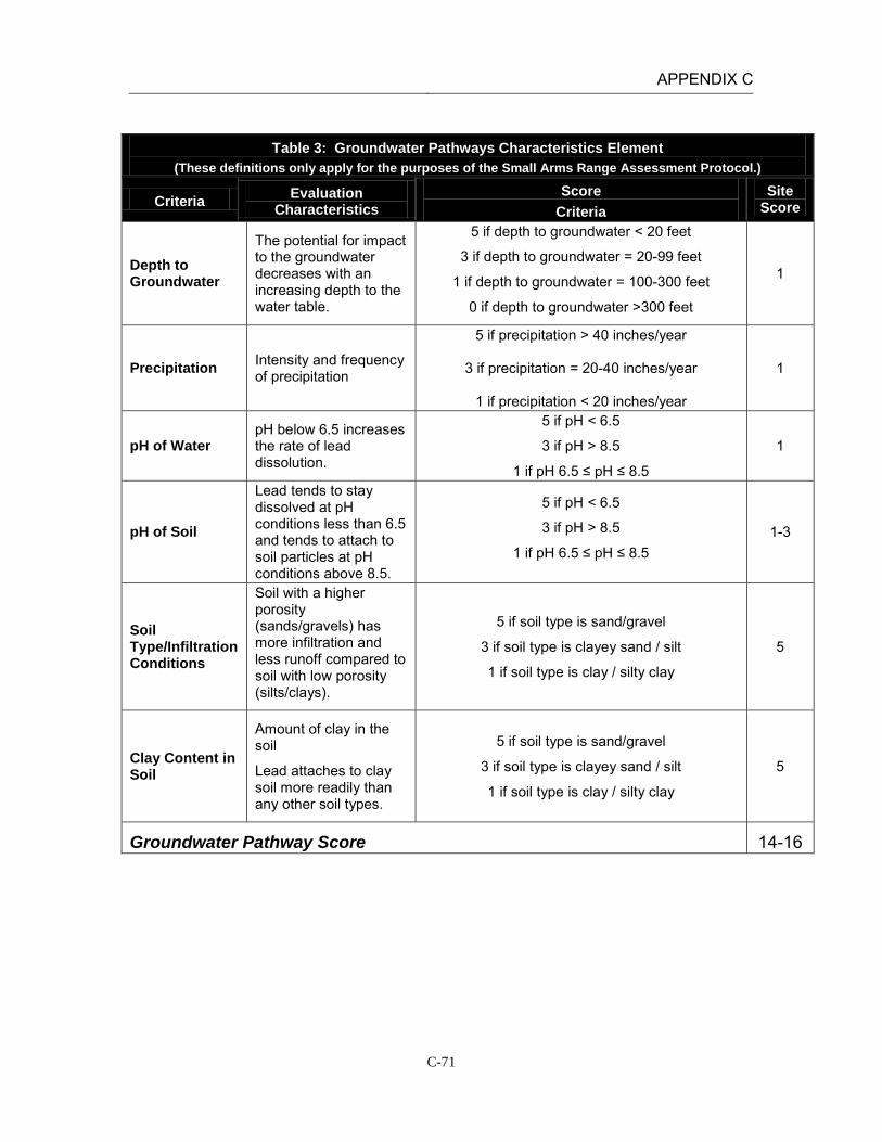
APPENDIX C
C-71
Table 3: Groundwater Pathways Characteristics Element
(These definitions only apply for the purposes of the Small Arms Range Assessment Protocol.)
Criteria Evaluation Characteristics
Score Criteria
Site Score
Depth to Groundwater
The potential for impact to the groundwater decreases with an increasing depth to the water table.
5 if depth to groundwater < 20 feet
3 if depth to groundwater = 20-99 feet
1 if depth to groundwater = 100-300 feet
0 if depth to groundwater >300 feet
1
Precipitation Intensity and frequency of precipitation
5 if precipitation > 40 inches/year
3 if precipitation = 20-40 inches/year
1 if precipitation < 20 inches/year
1
pH of Water pH below 6.5 increases the rate of lead dissolution.
5 if pH < 6.5
3 if pH > 8.5
1 if pH 6.5 ≤ pH ≤ 8.5
1
pH of Soil
Lead tends to stay dissolved at pH conditions less than 6.5 and tends to attach to soil particles at pH conditions above 8.5.
5 if pH < 6.5
3 if pH > 8.5
1 if pH 6.5 ≤ pH ≤ 8.5 1-3
Soil Type/Infiltration Conditions
Soil with a higher porosity (sands/gravels) has more infiltration and less runoff compared to soil with low porosity (silts/clays).
5 if soil type is sand/gravel
3 if soil type is clayey sand / silt
1 if soil type is clay / silty clay
5
Clay Content in Soil
Amount of clay in the soil
Lead attaches to clay soil more readily than any other soil types.
5 if soil type is sand/gravel
3 if soil type is clayey sand / silt
1 if soil type is clay / silty clay
5
Groundwater Pathway Score 14-16
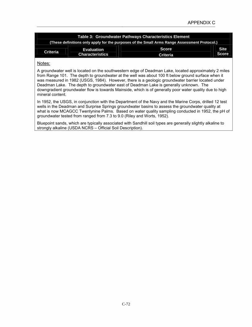
APPENDIX C
C-72
Table 3: Groundwater Pathways Characteristics Element (These definitions only apply for the purposes of the Small Arms Range Assessment Protocol.)
Criteria Evaluation Characteristics
Score Criteria
Site Score
Notes: A groundwater well is located on the southwestern edge of Deadman Lake, located approximately 2 miles from Range 101. The depth to groundwater at the well was about 100 ft below ground surface when it was measured in 1982 (USGS, 1984). However, there is a geologic groundwater barrier located under Deadman Lake. The depth to groundwater east of Deadman Lake is generally unknown. The downgradient groundwater flow is towards Mainside, which is of generally poor water quality due to high mineral content.
In 1952, the USGS, in conjunction with the Department of the Navy and the Marine Corps, drilled 12 test wells in the Deadman and Surprise Springs groundwater basins to assess the groundwater quality at what is now MCAGCC Twentynine Palms. Based on water quality sampling conducted in 1952, the pH of groundwater tested from ranged from 7.3 to 9.0 (Riley and Worts, 1952).
Bluepoint sands, which are typically associated with Sandhill soil types are generally slightly alkaline to strongly alkaline (USDA NCRS – Official Soil Description).

APPENDIX C
C-73
Table 4: Surface Water Receptors Element (These definitions only apply for the purposes of the Small Arms Range Assessment Protocol.)
Criteria Evaluation Characteristics
Score Criteria
Site Score
Drinking Water Usage
Identify if nearby surface water bodies are used as a drinking water source.
10 if analytical data or observable evidence indicates that contamination in the media is present at, is moving toward, or has a reasonable potential to move toward a surface water body used as a potable water supply or if
a designation as a potable water source is unknown
5 if contamination in the media has moved or is expected to move only slightly beyond the source (tens of feet) or could move, but is not moving appreciably, toward surface water body used as a potable water
supply or if a designation as a potable water source is unknown
2 if low possibility for contamination in the media to be
present at or migrate to a point of exposure
2
Agricultural or Other Beneficial Usage
Identify if nearby surface water bodies are used as an agricultural or other beneficial use, such as recreational (excluding drinking water).
5 if analytical data or observable evidence indicates that contamination in the media is present at, is moving toward, or has moved to a point of exposure or if a
designation as agricultural or other beneficial usage is unknown
3 if contamination in the media has moved only slightly beyond the source (tens of feet) or could move but is
not moving appreciably.
1 if low possibility for contamination in the media to be present at or migrate to a point of exposure
1
Sensitive Species Habitat and Threatened or Endangered Species
Identify if nearby surface water bodies are downgradient of or nearby any sensitive species habitat or threatened or endangered species.
10 if identified receptors have access to possibly contaminated media and/or are located adjacent to the
range boundary
5 if potential for receptors to have access to possibly contaminated media
1 if little or no potential for receptors to have access to
possible contaminated media
1
Surface Water Receptor Score 4
Notes: Surface waterbodies in the area are not used for drinking water. Range 101 drains to the west through gullies that are dry except after heavy rains (aerial photographs and topography). Two large drainage features are present in the northern and central sections of the range fan, which lead to the southern end of Deadman Lake, located approximately 1.25 miles northwest of the range. This intermittent water body is fully contained with the range boundaries; as REVA is limited to the assessment of potential off-range MC releases and exposures, there are no potential receptors for surface water at Range 101.

APPENDIX C
C-74
Table 5: Groundwater Receptors Element
(These definitions only apply for the purposes of the Small Arms Range Assessment Protocol.)
Criteria Evaluation Characteristics
Score Criteria
Site Score
Wells Identified as Potable Water Sources
Number and location of potable water or potable water supply wells relative to the location of the range
Evaluate well construction / radius of influence data and hydrogeologic setting to assess if wells are potential receptors.
10 if analytical data or observable evidence or site conditions indicate that MC may be within or
moving toward a reasonable radius of influence of a well or other point of exposure or if a
designation as a potable water source is unknown
5 if analytical data or observable evidence or site conditions indicate that MC have moved only
slightly beyond the source (tens of feet) or could move toward a reasonable radius of influence of a well or other point of exposure, but are not moving
appreciably
2 if low possibility for MC to be present at or migrate to within a reasonable radius of influence
or point of exposure
2
Wells Identified for Agricultural or Other Beneficial Usage
Number and location of agricultural wells relative to the location of the range
Evaluate well construction / radius of influence data and hydrogeologic setting to assess if wells are potential receptors.
5 if analytical data or observable evidence or site conditions indicate that MC may be within or
moving toward a reasonable radius of influence of a well or other point of exposure or if a
designation as agricultural or other beneficial usage is unknown
3 if analytical data or observable evidence or site
conditions indicate that MC have moved only slightly beyond the source (tens of feet) or could
move toward a reasonable radius of influence of a well or other point of exposure, but iare not
moving appreciably
1 if low possibility for MC to be present at or migrate to within a reasonable radius of influence
of a well or point of exposure
1
Sensitive Species Habitat and Threatened and Endangered Species
Evaluate of groundwater discharge or usage near areas of sensitive species habitat or areas where threatened and endangered species are located within proximity of the range
5 if identified receptors exposed to potentially MC-impacted water from groundwater or groundwater
sources
3 if potential for receptors exposed to potentially MC-impacted water from groundwater or
groundwater sources
1 if little or no potential for receptors exposed to potentially MC-impacted water from groundwater
or groundwater sources
1
Groundwater Receptor Score 4
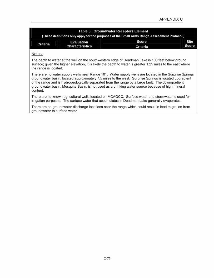
APPENDIX C
C-75
Table 5: Groundwater Receptors Element (These definitions only apply for the purposes of the Small Arms Range Assessment Protocol.)
Criteria Evaluation Characteristics
Score Criteria
Site Score
Notes: The depth to water at the well on the southwestern edge of Deadman Lake is 100 feet below ground surface; given the higher elevation, it is likely the depth to water is greater 1.25 miles to the east where the range is located.
There are no water supply wells near Range 101. Water supply wells are located in the Surprise Springs groundwater basin, located approximately 7.5 miles to the west. Surprise Springs is located upgradient of the range and is hydrogeologically separated from the range by a large fault. The downgradient groundwater basin, Mesquite Basin, is not used as a drinking water source because of high mineral content.
There are no known agricultural wells located on MCAGCC. Surface water and stormwater is used for irrigation purposes. The surface water that accumulates in Deadman Lake generally evaporates.
There are no groundwater discharge locations near the range which could result in lead migration from groundwater to surface water.

APPENDIX C
C-76
Table 6: Relative Environmental Concern Evaluation (These definitions only apply for the purposes of the Small Arms Range Assessment Protocol.)
Surface Water
Element Table Score
Range Use and Range Management (Source) 1 13
Surface Water Pathways 2 9-11
Surface Water Receptors 4 4
Sum of Surface Water Element Scores 26-28
Groundwater
Element Table Score
Range Use and Range Management (Source) 1 13
Groundwater Pathways 3 14-16
Groundwater Receptors 5 4
Sum of Groundwater Element Scores 31-33
The relative environmental concern evaluation ranking for each media is determined by selecting the appropriate score based on the data elements for that media:
Environmental Concern Evaluation Ranking* Score Range High 50-65 Moderate 30-49 Minimal 0-29
*Use the Environmental Concern Evaluation Ranking to determine if further actions are warranted based on the guidelines for recommended actions, as defined in Table 7.
Surface Water Environmental Concern Evaluation Ranking MINIMAL
Groundwater Environmental Concern Evaluation Ranking MODERATE*
Notes: Groundwater environmental score rated as Minimal based on professional judgment.
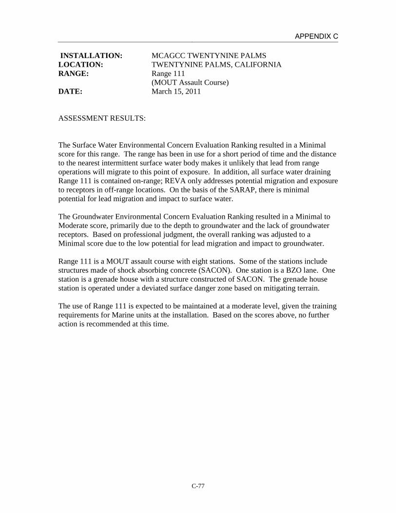
APPENDIX C
C-77
INSTALLATION: MCAGCC TWENTYNINE PALMS LOCATION: TWENTYNINE PALMS, CALIFORNIA RANGE: Range 111 (MOUT Assault Course) DATE: March 15, 2011 ASSESSMENT RESULTS: The Surface Water Environmental Concern Evaluation Ranking resulted in a Minimal score for this range. The range has been in use for a short period of time and the distance to the nearest intermittent surface water body makes it unlikely that lead from range operations will migrate to this point of exposure. In addition, all surface water draining Range 111 is contained on-range; REVA only addresses potential migration and exposure to receptors in off-range locations. On the basis of the SARAP, there is minimal potential for lead migration and impact to surface water. The Groundwater Environmental Concern Evaluation Ranking resulted in a Minimal to Moderate score, primarily due to the depth to groundwater and the lack of groundwater receptors. Based on professional judgment, the overall ranking was adjusted to a Minimal score due to the low potential for lead migration and impact to groundwater. Range 111 is a MOUT assault course with eight stations. Some of the stations include structures made of shock absorbing concrete (SACON). One station is a BZO lane. One station is a grenade house with a structure constructed of SACON. The grenade house station is operated under a deviated surface danger zone based on mitigating terrain. The use of Range 111 is expected to be maintained at a moderate level, given the training requirements for Marine units at the installation. Based on the scores above, no further action is recommended at this time.

APPENDIX C
C-78
Table 1: Range Use and Range Management (Source) Element
(These definitions only apply for the purposes of the Small Arms Range Assessment Protocol.)
Criteria Evaluation Justification Score Criteria Site Score
Duration of Range Use
Length of time the range has been used
5 if usage > 30 years
3 if usage is 10 to 30 years
1 if usage < 10 years
1
Bullet-Capturing Technology
The presence and duration of bullet-capturing technologies
Compare the duration of the range use to the duration of bullet-capturing technologies.
-3 if range usage duration = bullet capture duration
-1 if [range usage duration – bullet capture
duration] = 10 to 30 years
0 if [range usage duration – bullet capture duration] > 30 years
-1
MC Loading Rates
The amount and types of small arms ammunition expended on the range
Estimate the MC loading by using a time weighted average of MC loading rates
5 if MC loading > 1000 pounds/year
3 if MC loading = 100 to 1000 pounds/year
1 if MC loading < 100 pounds/year
5
Range Maintenance
Frequency of any range maintenance activities involving the removal of lead from the ranges
5 if lead is removed less than once every three years
3 if lead is removed more than once every
three years but less than annually
1 if lead is removed at least annually
5
Source Element Score 10
Notes: Range 111 began its current operation after 2001 (Range 111 includes portions of the range fan for the 1988 Range 113). The 2001 Range ID and Preliminary Range Assessment identifies Range 111 MAC in the planning and construction phase.
Based on MC expenditure data from 2006 to 2010, the average lead loading at Range 111 is approximately 1450 pounds per year.
The range does not have a specific impact berm; lead recovery is not conducted at this range.
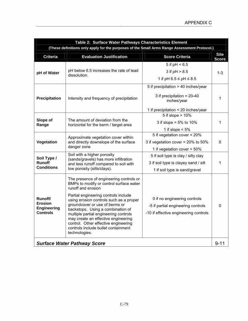
APPENDIX C
C-79
Table 2: Surface Water Pathways Characteristics Element (These definitions only apply for the purposes of the Small Arms Range Assessment Protocol.)
Criteria Evaluation Justification Score Criteria Site Score
pH of Water pH below 6.5 increases the rate of lead dissolution.
5 if pH < 6.5
3 if pH > 8.5
1 if pH 6.5 ≤ pH ≤ 8.5 1-3
Precipitation Intensity and frequency of precipitation
5 if precipitation > 40 inches/year
3 if precipitation = 20-40 inches/year
1 if precipitation < 20 inches/year
1
Slope of Range
The amount of deviation from the horizontal for the berm / target area
5 if slope > 10%
3 if slope = 5% to 10%
1 if slope < 5%
1
Vegetation Approximate vegetation cover within and directly downslope of the surface danger zone
5 if vegetation cover < 20%
3 if vegetation cover = 20% to 50%
1 if vegetation cover > 50%
5
Soil Type / Runoff Conditions
Soil with a higher porosity (sands/gravels) has more infiltration and less runoff compared to soil with low porosity (silts/clays).
5 if soil type is clay / silty clay
3 if soil type is clayey sand / silt
1 if soil type is sand/gravel
1
Runoff/ Erosion Engineering Controls
The presence of engineering controls or BMPs to modify or control surface water runoff and erosion
Partial engineering controls include using erosion controls such as a proper groundcover or use of berms or backstops. Using a combination of multiple partial engineering controls may create an effective engineering control. Other effective engineering controls include bullet containment technologies.
0 if no engineering controls
-5 if partial engineering controls
-10 if effective engineering controls
0
Surface Water Pathway Score 9-11

APPENDIX C
C-80
Table 2: Surface Water Pathways Characteristics Element (These definitions only apply for the purposes of the Small Arms Range Assessment Protocol.)
Criteria Evaluation Justification Score Criteria Site Score
Notes: Based on USGS data the pH of precipitation in California is between 5.3 and 5.5. “Natural” rain will be slightly acidic (pH of 5.6) because of the presence of carbon dioxide in the air which forms carbonic acid when it is mixed with water. However, once the rainfall comes into contact with the ground, the pH increases. Based on stormwater measurements collected on January 5, 2005 the surface water pH at MCAGCC Twentynine Palms is between 8.5 and 8.8.
The average amount of rainfall at Twentynine Palms between 3 and 4 inches per year (USDA).
There is no berm at Range 111. On average, the ground slope in the area is less than 5%.
The range is covered by less than 20% vegetation. The area contains patches of creosote bushes and other scrub.
Range 111 contains soils characterized are characterized as Arizo sands (NRCS). They are thick, excessively drained soils that formed in mixed alluvium with little to no clay.
Based on aerial photographs and site reconnaissance there are no engineered controls present at the site to prevent erosion or to control surface water.

APPENDIX C
C-81
Table 3: Groundwater Pathways Characteristics Element (These definitions only apply for the purposes of the Small Arms Range Assessment Protocol.)
Criteria Evaluation Justification Score
Criteria Site
Score
Depth to Groundwater
The potential for impact to the groundwater decreases with an increasing depth to the water table.
5 if depth to groundwater < 20 feet
3 if depth to groundwater = 20-99 feet
1 if depth to groundwater = 100-300 feet
0 if depth to groundwater > 300 feet
1
Precipitation Intensity and frequency of precipitation
5 if precipitation > 40 inches/year
3 if precipitation = 20-40 inches/year
1 if precipitation < 20 inches/year
1
pH of Groundwater
pH below 6.5 increases the rate of lead dissolution.
5 if pH < 6.5
3 if pH > 8.5
1 if pH 6.5 ≤ pH ≤ 8.5
1
pH of Soil Lead tends to stay dissolved at pH conditions less than 6.5 and tends to attach to soil particles at pH conditions above 8.5.
5 if pH < 6.5
3 if pH > 8.5
1 if pH 6.5 ≤ pH ≤ 8.5 1-3
Soil Type / Infiltration Conditions
Soil with a higher porosity (sands/gravels) has more infiltration and less runoff compared to soil with low porosity (silts/clays).
5 if soil type is sand/gravel
3 if soil type is clayey sand / silt
1 if soil type is clay / silty clay
5
Clay Content in Soil
Amount of clay in the soil
Lead attaches to clay soil more readily than any other soil types.
5 if soil type is sand/gravel
3 if soil type is clayey sand / silt
1 if soil type is clay / silty clay
5
Groundwater Pathway Score 14-16
Notes: A groundwater well is located on the southwestern edge of Deadman Lake, located approximately 6 miles south of Range 111.The depth to groundwater at the well was about 100 ft below ground surface when it was measured in 1982 (USGS, 1984). However, there is a geologic groundwater barrier located under Deadman Lake. The depth to groundwater east of Deadman Lake is generally unknown. The downgradient groundwater flow is towards Mainside, which is of generally poor water quality due to high mineral content.
In 1952, the USGS, in conjunction with the Department of the Navy and the Marine Corps, drilled 12 test wells in the Deadman and Surprise Springs groundwater basins to assess the groundwater quality at what is now MCAGCC Twentynine Palms. Based on water quality sampling conducted in 1952, the pH of groundwater tested from ranged from 7.3 to 9.0 (Riley and Worts, 1952).
Arizo sands are generally neutral to strongly alkaline (USDA NCRS – Official Soil Description).
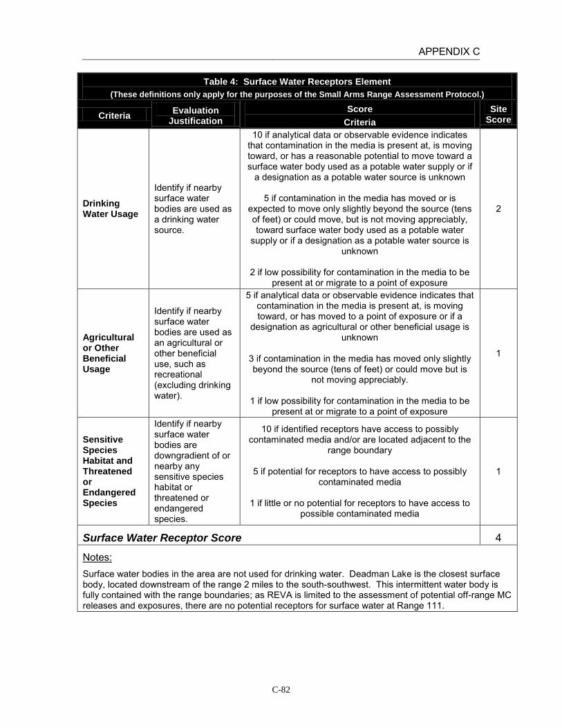
APPENDIX C
C-82
Table 4: Surface Water Receptors Element (These definitions only apply for the purposes of the Small Arms Range Assessment Protocol.)
Criteria Evaluation Justification
Score Criteria
Site Score
Drinking Water Usage
Identify if nearby surface water bodies are used as a drinking water source.
10 if analytical data or observable evidence indicates that contamination in the media is present at, is moving toward, or has a reasonable potential to move toward a surface water body used as a potable water supply or if
a designation as a potable water source is unknown
5 if contamination in the media has moved or is expected to move only slightly beyond the source (tens of feet) or could move, but is not moving appreciably, toward surface water body used as a potable water
supply or if a designation as a potable water source is unknown
2 if low possibility for contamination in the media to be
present at or migrate to a point of exposure
2
Agricultural or Other Beneficial Usage
Identify if nearby surface water bodies are used as an agricultural or other beneficial use, such as recreational (excluding drinking water).
5 if analytical data or observable evidence indicates that contamination in the media is present at, is moving toward, or has moved to a point of exposure or if a
designation as agricultural or other beneficial usage is unknown
3 if contamination in the media has moved only slightly beyond the source (tens of feet) or could move but is
not moving appreciably.
1 if low possibility for contamination in the media to be present at or migrate to a point of exposure
1
Sensitive Species Habitat and Threatened or Endangered Species
Identify if nearby surface water bodies are downgradient of or nearby any sensitive species habitat or threatened or endangered species.
10 if identified receptors have access to possibly contaminated media and/or are located adjacent to the
range boundary
5 if potential for receptors to have access to possibly contaminated media
1 if little or no potential for receptors to have access to
possible contaminated media
1
Surface Water Receptor Score 4
Notes: Surface water bodies in the area are not used for drinking water. Deadman Lake is the closest surface body, located downstream of the range 2 miles to the south-southwest. This intermittent water body is fully contained with the range boundaries; as REVA is limited to the assessment of potential off-range MC releases and exposures, there are no potential receptors for surface water at Range 111.

APPENDIX C
C-83
Table 5: Groundwater Receptors Element
(These definitions only apply for the purposes of the Small Arms Range Assessment Protocol.)
Criteria Evaluation Justification
Score Criteria
Site Score
Wells Identified as Potable Water Sources
Number and location of potable water or potable water supply wells relative to the location of the range
Evaluate well construction / radius of influence data and hydrogeologic setting to assess if wells are potential receptors.
10 if analytical data or observable evidence or site conditions indicate that MC may be within or
moving toward a reasonable radius of influence of a well or other point of exposure or if a
designation as a potable water source is unknown
5 if analytical data or observable evidence or site conditions indicate that MC have moved only
slightly beyond the source (tens of feet) or could move toward a reasonable radius of influence of a well or other point of exposure, but are not moving
appreciably
2 if low possibility for MC to be present at or migrate to within a reasonable radius of influence
or point of exposure
2
Wells Identified for Agricultural or Other Beneficial Usage
Number and location of agricultural wells relative to the location of the range
Evaluate well construction / radius of influence data and hydrogeologic setting to assess if wells are potential receptors.
5 if analytical data or observable evidence or site conditions indicate that MC may be within or
moving toward a reasonable radius of influence of a well or other point of exposure or if a
designation as agricultural or other beneficial usage is unknown
3 if analytical data or observable evidence or site
conditions indicate that MC have moved only slightly beyond the source (tens of feet) or could
move toward a reasonable radius of influence of a well or other point of exposure, but are not moving
appreciably
1 if low possibility for MC to be present at or migrate to within a reasonable radius of influence
of a well or point of exposure
1
Sensitive Species Habitat and Threatened and Endangered Species
Evaluate of groundwater discharge or usage near areas of sensitive species habitat or areas where threatened and endangered species are located within proximity of the range
5 if identified receptors exposed to potentially MC-impacted water from groundwater or groundwater
sources
3 if potential for receptors exposed to potentially MC-impacted water from groundwater or
groundwater sources
1 if little or no potential for receptors exposed to potentially MC-impacted water from groundwater
or groundwater sources
1
Groundwater Receptor Score 4

APPENDIX C
C-84
Table 5: Groundwater Receptors Element (These definitions only apply for the purposes of the Small Arms Range Assessment Protocol.)
Criteria Evaluation Justification
Score Criteria
Site Score
Notes: The depth to water at the well on the southwestern edge of Deadman Lake is 100 feet below ground surface; given the higher elevation, it is likely the depth to water is greater 6 miles to the north where the range is located.
There are no water supply wells near Range 111. Water supply wells are located in the Surprise Springs groundwater basin, located approximately 7.5 miles to the west. Surprise Springs is located upgradient of the range and is hydrogeologically separated from the range by a large fault. The downgradient groundwater basin, Mesquite Basin, is not used as a drinking water source because of high mineral content.
There are no known agricultural wells located on MCAGCC. Surface water and stormwater is used for irrigation purposes. The surface water that accumulates in Deadman Lake generally evaporates.
There are no groundwater discharge locations near the range which could result in lead migration from groundwater to surface water.

APPENDIX C
C-85
Table 6: Relative Environmental Concern Evaluation (These definitions only apply for the purposes of the Small Arms Range Assessment Protocol.)
Surface Water
Element Table Score
Range Use and Range Management (Source) 1 10
Surface Water Pathways 2 9-11
Surface Water Receptors 4 4
Sum of Surface Water Element Scores 23-25
Groundwater
Element Table Score
Range Use and Range Management (Source) 1 10
Groundwater Pathways 3 14-16
Groundwater Receptors 5 4
Sum of Groundwater Element Scores 28-30
The relative environmental concern evaluation ranking for each medium is determined by selecting the appropriate score based on the data elements for that medium:
Environmental Concern Evaluation Ranking* Score Range High 50-65 Moderate 30-49 Minimal 0-29
*Use the Environmental Concern Evaluation Ranking to determine if further actions are warranted based on the guidelines for recommended actions, as defined in Table 7.
Surface Water Environmental Concern Evaluation Ranking MINIMAL
Groundwater Environmental Concern Evaluation Ranking MINIMAL –
MODERATE*
Notes: Groundwater environmental score rated as Minimal based on professional judgment.
APPENDIX C
C-86
INSTALLATION: MCAGCC TWENTYNINE PALMS LOCATION: TWENTYNINE PALMS, CALIFORNIA RANGE: Range 205 (Live-Fire Convoy Operations Course) DATE: March 15, 2011 ASSESSMENT RESULTS: The Surface Water Environmental Concern Evaluation Ranking resulted in a Minimal score for this range. The range has been in use for a short period of time and the distance to the nearest intermittent surface water body makes it unlikely that lead from range operations will migrate to this point of exposure. In addition, all surface water draining Range 205 is contained on-range; REVA only addresses potential migration and exposure to receptors in off-range locations. On the basis of the SARAP, there is minimal potential for lead migration and impact to surface water. The Groundwater Environmental Concern Evaluation Ranking resulted in a Minimal to Moderate score, primarily due to the depth to groundwater and the lack of groundwater receptors. Based on professional judgment, the overall ranking was adjusted to a Minimal score due to the low potential for lead migration and impact to groundwater. Range 205 is a live-fire convoy operations course with five stations. The direction of the course is north, and all vehicles follow the prescribed convoy route. No live fire is allowed at station five, the improvised explosive device station. The direction of fire for all vehicle mounted weapon systems will be East/Northeast and the range is 3000 meters. Units can use all or any portion of the range. Tanks, amphibious assault vehicles (AAVs), and light armored vehicles (LAVs) use the range. Some stations include buildings constructed of shock absorbing concrete (SACON). With the exception of station one, targets are located east of the MSR. The use of Range 205 is expected to be maintained at a moderate level, given the training requirements for Marine units at the installation. Based on the scores above, no further action is recommended at this time.
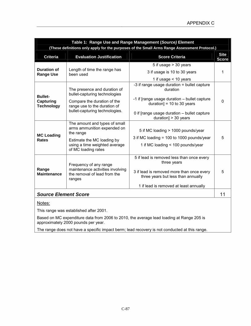
APPENDIX C
C-87
Table 1: Range Use and Range Management (Source) Element
(These definitions only apply for the purposes of the Small Arms Range Assessment Protocol.)
Criteria Evaluation Justification Score Criteria Site Score
Duration of Range Use
Length of time the range has been used
5 if usage > 30 years
3 if usage is 10 to 30 years
1 if usage < 10 years
1
Bullet-Capturing Technology
The presence and duration of bullet-capturing technologies
Compare the duration of the range use to the duration of bullet-capturing technologies.
-3 if range usage duration = bullet capture duration
-1 if [range usage duration – bullet capture
duration] = 10 to 30 years
0 if [range usage duration – bullet capture duration] > 30 years
0
MC Loading Rates
The amount and types of small arms ammunition expended on the range
Estimate the MC loading by using a time weighted average of MC loading rates
5 if MC loading > 1000 pounds/year
3 if MC loading = 100 to 1000 pounds/year
1 if MC loading < 100 pounds/year
5
Range Maintenance
Frequency of any range maintenance activities involving the removal of lead from the ranges
5 if lead is removed less than once every three years
3 if lead is removed more than once every
three years but less than annually
1 if lead is removed at least annually
5
Source Element Score 11
Notes: This range was established after 2001.
Based on MC expenditure data from 2006 to 2010, the average lead loading at Range 205 is approximately 2000 pounds per year.
The range does not have a specific impact berm; lead recovery is not conducted at this range.
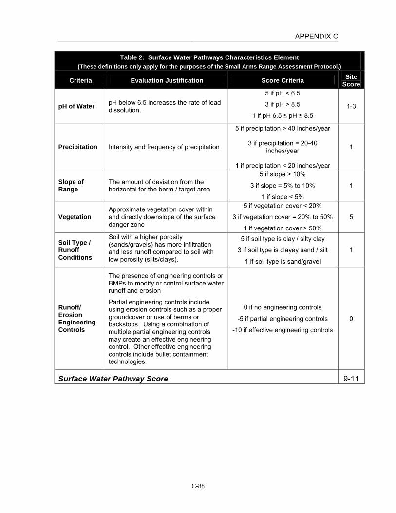
APPENDIX C
C-88
Table 2: Surface Water Pathways Characteristics Element (These definitions only apply for the purposes of the Small Arms Range Assessment Protocol.)
Criteria Evaluation Justification Score Criteria Site Score
pH of Water pH below 6.5 increases the rate of lead dissolution.
5 if pH < 6.5
3 if pH > 8.5
1 if pH 6.5 ≤ pH ≤ 8.5 1-3
Precipitation Intensity and frequency of precipitation
5 if precipitation > 40 inches/year
3 if precipitation = 20-40 inches/year
1 if precipitation < 20 inches/year
1
Slope of Range
The amount of deviation from the horizontal for the berm / target area
5 if slope > 10%
3 if slope = 5% to 10%
1 if slope < 5%
1
Vegetation Approximate vegetation cover within and directly downslope of the surface danger zone
5 if vegetation cover < 20%
3 if vegetation cover = 20% to 50%
1 if vegetation cover > 50%
5
Soil Type / Runoff Conditions
Soil with a higher porosity (sands/gravels) has more infiltration and less runoff compared to soil with low porosity (silts/clays).
5 if soil type is clay / silty clay
3 if soil type is clayey sand / silt
1 if soil type is sand/gravel
1
Runoff/ Erosion Engineering Controls
The presence of engineering controls or BMPs to modify or control surface water runoff and erosion
Partial engineering controls include using erosion controls such as a proper groundcover or use of berms or backstops. Using a combination of multiple partial engineering controls may create an effective engineering control. Other effective engineering controls include bullet containment technologies.
0 if no engineering controls
-5 if partial engineering controls
-10 if effective engineering controls
0
Surface Water Pathway Score 9-11
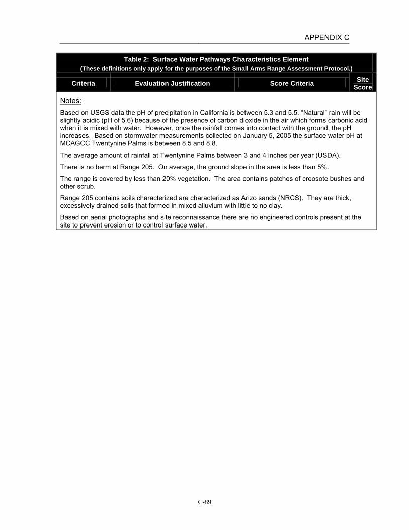
APPENDIX C
C-89
Table 2: Surface Water Pathways Characteristics Element (These definitions only apply for the purposes of the Small Arms Range Assessment Protocol.)
Criteria Evaluation Justification Score Criteria Site Score
Notes: Based on USGS data the pH of precipitation in California is between 5.3 and 5.5. “Natural” rain will be slightly acidic (pH of 5.6) because of the presence of carbon dioxide in the air which forms carbonic acid when it is mixed with water. However, once the rainfall comes into contact with the ground, the pH increases. Based on stormwater measurements collected on January 5, 2005 the surface water pH at MCAGCC Twentynine Palms is between 8.5 and 8.8.
The average amount of rainfall at Twentynine Palms between 3 and 4 inches per year (USDA).
There is no berm at Range 205. On average, the ground slope in the area is less than 5%.
The range is covered by less than 20% vegetation. The area contains patches of creosote bushes and other scrub.
Range 205 contains soils characterized are characterized as Arizo sands (NRCS). They are thick, excessively drained soils that formed in mixed alluvium with little to no clay.
Based on aerial photographs and site reconnaissance there are no engineered controls present at the site to prevent erosion or to control surface water.
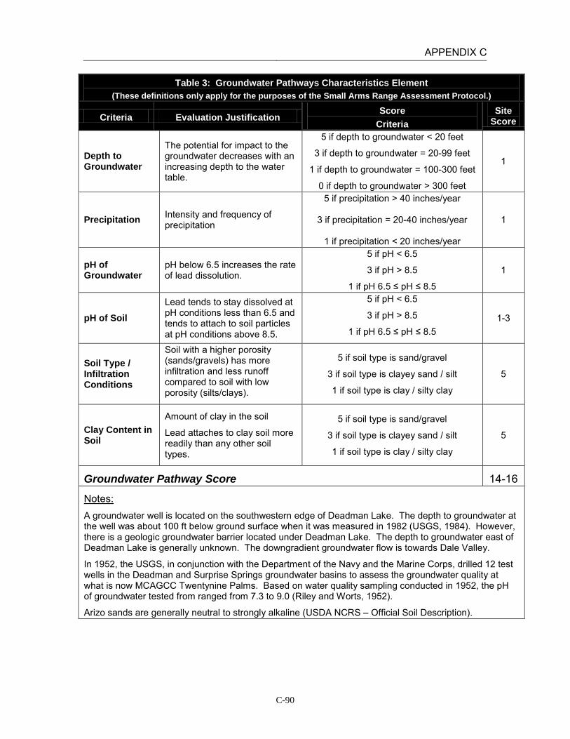
APPENDIX C
C-90
Table 3: Groundwater Pathways Characteristics Element (These definitions only apply for the purposes of the Small Arms Range Assessment Protocol.)
Criteria Evaluation Justification Score
Criteria Site
Score
Depth to Groundwater
The potential for impact to the groundwater decreases with an increasing depth to the water table.
5 if depth to groundwater < 20 feet
3 if depth to groundwater = 20-99 feet
1 if depth to groundwater = 100-300 feet
0 if depth to groundwater > 300 feet
1
Precipitation Intensity and frequency of precipitation
5 if precipitation > 40 inches/year
3 if precipitation = 20-40 inches/year
1 if precipitation < 20 inches/year
1
pH of Groundwater
pH below 6.5 increases the rate of lead dissolution.
5 if pH < 6.5
3 if pH > 8.5
1 if pH 6.5 ≤ pH ≤ 8.5
1
pH of Soil Lead tends to stay dissolved at pH conditions less than 6.5 and tends to attach to soil particles at pH conditions above 8.5.
5 if pH < 6.5
3 if pH > 8.5
1 if pH 6.5 ≤ pH ≤ 8.5 1-3
Soil Type / Infiltration Conditions
Soil with a higher porosity (sands/gravels) has more infiltration and less runoff compared to soil with low porosity (silts/clays).
5 if soil type is sand/gravel
3 if soil type is clayey sand / silt
1 if soil type is clay / silty clay
5
Clay Content in Soil
Amount of clay in the soil
Lead attaches to clay soil more readily than any other soil types.
5 if soil type is sand/gravel
3 if soil type is clayey sand / silt
1 if soil type is clay / silty clay
5
Groundwater Pathway Score 14-16
Notes: A groundwater well is located on the southwestern edge of Deadman Lake. The depth to groundwater at the well was about 100 ft below ground surface when it was measured in 1982 (USGS, 1984). However, there is a geologic groundwater barrier located under Deadman Lake. The depth to groundwater east of Deadman Lake is generally unknown. The downgradient groundwater flow is towards Dale Valley.
In 1952, the USGS, in conjunction with the Department of the Navy and the Marine Corps, drilled 12 test wells in the Deadman and Surprise Springs groundwater basins to assess the groundwater quality at what is now MCAGCC Twentynine Palms. Based on water quality sampling conducted in 1952, the pH of groundwater tested from ranged from 7.3 to 9.0 (Riley and Worts, 1952).
Arizo sands are generally neutral to strongly alkaline (USDA NCRS – Official Soil Description).

APPENDIX C
C-91
Table 4: Surface Water Receptors Element (These definitions only apply for the purposes of the Small Arms Range Assessment Protocol.)
Criteria Evaluation Justification
Score Criteria
Site Score
Drinking Water Usage
Identify if nearby surface water bodies are used as a drinking water source.
10 if analytical data or observable evidence indicates that contamination in the media is present at, is moving toward, or has a reasonable potential to move toward a surface water body used as a potable water supply or if
a designation as a potable water source is unknown
5 if contamination in the media has moved or is expected to move only slightly beyond the source (tens of feet) or could move, but is not moving appreciably, toward surface water body used as a potable water
supply or if a designation as a potable water source is unknown
2 if low possibility for contamination in the media to be
present at or migrate to a point of exposure
2
Agricultural or Other Beneficial Usage
Identify if nearby surface water bodies are used as an agricultural or other beneficial use, such as recreational (excluding drinking water).
5 if analytical data or observable evidence indicates that contamination in the media is present at, is moving toward, or has moved to a point of exposure or if a
designation as agricultural or other beneficial usage is unknown
3 if contamination in the media has moved only slightly beyond the source (tens of feet) or could move but is
not moving appreciably.
1 if low possibility for contamination in the media to be present at or migrate to a point of exposure
1
Sensitive Species Habitat and Threatened or Endangered Species
Identify if nearby surface water bodies are downgradient of or nearby any sensitive species habitat or threatened or endangered species.
10 if identified receptors have access to possibly contaminated media and/or are located adjacent to the
range boundary
5 if potential for receptors to have access to possibly contaminated media
1 if little or no potential for receptors to have access to
possible contaminated media
1
Surface Water Receptor Score 4
Notes: Surface water bodies in the area are not used for drinking water. Deadman Lake is the closest surface body, located downstream of the range 6 miles to the southwest. This intermittent water body is fully contained with the range boundaries; as REVA is limited to the assessment of potential off-range MC releases and exposures, there are no potential receptors for surface water at Range 205.

APPENDIX C
C-92
Table 5: Groundwater Receptors Element
(These definitions only apply for the purposes of the Small Arms Range Assessment Protocol.)
Criteria Evaluation Justification
Score Criteria
Site Score
Wells Identified as Potable Water Sources
Number and location of potable water or potable water supply wells relative to the location of the range
Evaluate well construction / radius of influence data and hydrogeologic setting to assess if wells are potential receptors.
10 if analytical data or observable evidence or site conditions indicate that MC may be within or
moving toward a reasonable radius of influence of a well or other point of exposure or if a
designation as a potable water source is unknown
5 if analytical data or observable evidence or site conditions indicate that MC have moved only
slightly beyond the source (tens of feet) or could move toward a reasonable radius of influence of a well or other point of exposure, but are not moving
appreciably
2 if low possibility for MC to be present at or migrate to within a reasonable radius of influence
or point of exposure
2
Wells Identified for Agricultural or Other Beneficial Usage
Number and location of agricultural wells relative to the location of the range
Evaluate well construction / radius of influence data and hydrogeologic setting to assess if wells are potential receptors.
5 if analytical data or observable evidence or site conditions indicate that MC may be within or
moving toward a reasonable radius of influence of a well or other point of exposure or if a
designation as agricultural or other beneficial usage is unknown
3 if analytical data or observable evidence or site
conditions indicate that MC have moved only slightly beyond the source (tens of feet) or could
move toward a reasonable radius of influence of a well or other point of exposure, but are not moving
appreciably
1 if low possibility for MC to be present at or migrate to within a reasonable radius of influence
of a well or point of exposure
1
Sensitive Species Habitat and Threatened and Endangered Species
Evaluate of groundwater discharge or usage near areas of sensitive species habitat or areas where threatened and endangered species are located within proximity of the range
5 if identified receptors exposed to potentially MC-impacted water from groundwater or groundwater
sources
3 if potential for receptors exposed to potentially MC-impacted water from groundwater or
groundwater sources
1 if little or no potential for receptors exposed to potentially MC-impacted water from groundwater
or groundwater sources
1
Groundwater Receptor Score 4

APPENDIX C
C-93
Table 5: Groundwater Receptors Element (These definitions only apply for the purposes of the Small Arms Range Assessment Protocol.)
Criteria Evaluation Justification
Score Criteria
Site Score
Notes: The depth to water at the well on the southwestern edge of Deadman Lake is 100 feet below ground surface; given the higher elevation, it is likely the depth to water is greater 6 miles to the north where the range is located.
There are no water supply wells near Range 205. Water supply wells are located in the Surprise Springs groundwater basin, located approximately 10 miles to the west. Surprise Springs is located upgradient of the range and is hydrogeologically separated from the range by a large fault. The downgradient groundwater basin, Dale Valley, is not used as a drinking water source.
There are no known agricultural wells located on MCAGCC. Surface water and stormwater is used for irrigation purposes. The surface water that accumulates in Deadman Lake generally evaporates.
There are no groundwater discharge locations near the range which could result in lead migration from groundwater to surface water.

APPENDIX C
C-94
Table 6: Relative Environmental Concern Evaluation (These definitions only apply for the purposes of the Small Arms Range Assessment Protocol.)
Surface Water
Element Table Score
Range Use and Range Management (Source) 1 11
Surface Water Pathways 2 9-11
Surface Water Receptors 4 4
Sum of Surface Water Element Scores 24-26
Groundwater
Element Table Score
Range Use and Range Management (Source) 1 11
Groundwater Pathways 3 14-16
Groundwater Receptors 5 4
Sum of Groundwater Element Scores 29-31
The relative environmental concern evaluation ranking for each medium is determined by selecting the appropriate score based on the data elements for that medium:
Environmental Concern Evaluation Ranking* Score Range High 50-65 Moderate 30-49 Minimal 0-29
*Use the Environmental Concern Evaluation Ranking to determine if further actions are warranted based on the guidelines for recommended actions, as defined in Table 7.
Surface Water Environmental Concern Evaluation Ranking MININAL
Groundwater Environmental Concern Evaluation Ranking MINIMAL –
MODERATE*
Notes: Groundwater environmental score rated as Minimal based on professional judgment.

APPENDIX C
C-95
INSTALLATION: MCAGCC TWENTYNINE PALMS LOCATION: TWENTYNINE PALMS, CALIFORNIA RANGE: Range 205A (Live-Fire MOUT Facility) DATE: March 15, 2011 ASSESSMENT RESULTS: The Surface Water Environmental Concern Evaluation Ranking resulted in a Minimal score for this range. The range has been in use for a short period of time, minimal lead loading is occurring, and the distance to the nearest intermittent surface water body makes it unlikely that lead from range operations will migrate to this point of exposure. In addition, all surface water draining Range 205A is contained on-range; REVA only addresses potential migration and exposure to receptors in off-range locations. On the basis of the SARAP, there is minimal potential for lead migration and impact to surface water. The Groundwater Environmental Concern Evaluation Ranking resulted in a Minimal score, primarily due to the depth to groundwater and the lack of groundwater receptors. Based on professional judgment, the overall ranking was adjusted to a Minimal score due to the low potential for lead migration and impact to groundwater. Range 205A is a live-fire MOUT facility in Prospect RTA. Range 205A includes structures constructed of shock absorbing concrete (SACON). The allowable munitions list for inside buildings and against SACON structures includes: 5.56 mm, 9mm, 12 gauge, SESAMS (AA12, AA21), and practice grenades. The allowable munitions outside buildings 9mm, 5.56 mm, 7.62 mm, 12 gauge, .50 gauge, SESAMS (AA21 AA12), practice grenades, 40 mm, 60 mm, 81 mm, pyrotechnics, IED simulators, booby trap flash simulator. Direction of fire is not prescribed at Range 205A. However, the use of other direct, indirect or aviation delivered ordnance may be incorporated into the concept of operations provided the effects from these muntions do not impact the facility buildings and stay within the scheduled RTAs. The use of Range 205A is expected to be maintained at a moderate level, given the training requirements for Marine units at the installation. Based on the scores above, no further action is recommended at this time.

APPENDIX C
C-96
Table 1: Range Use and Range Management (Source) Element
(These definitions only apply for the purposes of the Small Arms Range Assessment Protocol.)
Criteria Evaluation Justification Score Criteria Site Score
Duration of Range Use
Length of time the range has been used
5 if usage > 30 years
3 if usage is 10 to 30 years
1 if usage < 10 years
1
Bullet-Capturing Technology
The presence and duration of bullet-capturing technologies
Compare the duration of the range use to the duration of bullet-capturing technologies.
-3 if range usage duration = bullet capture duration
-1 if [range usage duration – bullet capture
duration] = 10 to 30 years
0 if [range usage duration – bullet capture duration] > 30 years
-1
MC Loading Rates
The amount and types of small arms ammunition expended on the range
Estimate the MC loading by using a time weighted average of MC loading rates
5 if MC loading > 1000 pounds/year
3 if MC loading = 100 to 1000 pounds/year
1 if MC loading < 100 pounds/year
1
Range Maintenance
Frequency of any range maintenance activities involving the removal of lead from the ranges
5 if lead is removed less than once every three years
3 if lead is removed more than once every
three years but less than annually
1 if lead is removed at least annually
5
Source Element Score 6
Notes: This range was established after 2001.
Based on MC expenditure data from 2006 to 2010, the average lead loading at Range 205A is approximately 12 pounds per year.
The range does not have a specific impact berm; lead recovery is not conducted at this range. The SACON structures help contain lead deposited in the building; thus a bullet capturing technology score was applied.

APPENDIX C
C-97
Table 2: Surface Water Pathways Characteristics Element (These definitions only apply for the purposes of the Small Arms Range Assessment Protocol.)
Criteria Evaluation Justification Score Criteria Site Score
pH of Water pH below 6.5 increases the rate of lead dissolution.
5 if pH < 6.5
3 if pH > 8.5
1 if pH 6.5 ≤ pH ≤ 8.5 1-3
Precipitation Intensity and frequency of precipitation
5 if precipitation > 40 inches/year
3 if precipitation = 20-40 inches/year
1 if precipitation < 20 inches/year
1
Slope of Range
The amount of deviation from the horizontal for the berm / target area
5 if slope > 10%
3 if slope = 5% to 10%
1 if slope < 5%
1
Vegetation Approximate vegetation cover within and directly downslope of the surface danger zone
5 if vegetation cover < 20%
3 if vegetation cover = 20% to 50%
1 if vegetation cover > 50%
5
Soil Type / Runoff Conditions
Soil with a higher porosity (sands/gravels) has more infiltration and less runoff compared to soil with low porosity (silts/clays).
5 if soil type is clay / silty clay
3 if soil type is clayey sand / silt
1 if soil type is sand/gravel
1
Runoff/ Erosion Engineering Controls
The presence of engineering controls or BMPs to modify or control surface water runoff and erosion
Partial engineering controls include using erosion controls such as a proper groundcover or use of berms or backstops. Using a combination of multiple partial engineering controls may create an effective engineering control. Other effective engineering controls include bullet containment technologies.
0 if no engineering controls
-5 if partial engineering controls
-10 if effective engineering controls
0
Surface Water Pathway Score 9-11

APPENDIX C
C-98
Table 2: Surface Water Pathways Characteristics Element (These definitions only apply for the purposes of the Small Arms Range Assessment Protocol.)
Criteria Evaluation Justification Score Criteria Site Score
Notes: Based on USGS data the pH of precipitation in California is between 5.3 and 5.5. “Natural” rain will be slightly acidic (pH of 5.6) because of the presence of carbon dioxide in the air which forms carbonic acid when it is mixed with water. However, once the rainfall comes into contact with the ground, the pH increases. Based on stormwater measurements collected on January 5, 2005 the surface water pH at MCAGCC Twentynine Palms is between 8.5 and 8.8.
The average amount of rainfall at Twentynine Palms between 3 and 4 inches per year (USDA).
There is no berm at Range 205A. On average, the ground slope in the area is less than 5%.
The range is covered by less than 20% vegetation. The area contains patches of creosote bushes and other scrub.
Range 205A contains soils characterized are characterized as Arizo sands (NRCS). They are thick, excessively drained soils that formed in mixed alluvium with little to no clay.
Based on aerial photographs and site reconnaissance there are no engineered controls present at the site to prevent erosion or to control surface water.

APPENDIX C
C-99
Table 3: Groundwater Pathways Characteristics Element (These definitions only apply for the purposes of the Small Arms Range Assessment Protocol.)
Criteria Evaluation Justification Score
Criteria Site
Score
Depth to Groundwater
The potential for impact to the groundwater decreases with an increasing depth to the water table.
5 if depth to groundwater < 20 feet
3 if depth to groundwater = 20-99 feet
1 if depth to groundwater = 100-300 feet
0 if depth to groundwater > 300 feet
1
Precipitation Intensity and frequency of precipitation
5 if precipitation > 40 inches/year
3 if precipitation = 20-40 inches/year
1 if precipitation < 20 inches/year
1
pH of Groundwater
pH below 6.5 increases the rate of lead dissolution.
5 if pH < 6.5
3 if pH > 8.5
1 if pH 6.5 ≤ pH ≤ 8.5
1
pH of Soil Lead tends to stay dissolved at pH conditions less than 6.5 and tends to attach to soil particles at pH conditions above 8.5.
5 if pH < 6.5
3 if pH > 8.5
1 if pH 6.5 ≤ pH ≤ 8.5 1-3
Soil Type / Infiltration Conditions
Soil with a higher porosity (sands/gravels) has more infiltration and less runoff compared to soil with low porosity (silts/clays).
5 if soil type is sand/gravel
3 if soil type is clayey sand / silt
1 if soil type is clay / silty clay
5
Clay Content in Soil
Amount of clay in the soil
Lead attaches to clay soil more readily than any other soil types.
5 if soil type is sand/gravel
3 if soil type is clayey sand / silt
1 if soil type is clay / silty clay
5
Groundwater Pathway Score 14-16
Notes: A groundwater well is located on the southwestern edge of Deadman Lake. The depth to groundwater at the well was about 100 ft below ground surface when it was measured in 1982 (USGS, 1984). However, there is a geologic groundwater barrier located under Deadman Lake. The depth to groundwater east of Deadman Lake is generally unknown. The downgradient groundwater flow is towards Mainside, which is of generally poor water quality due to high mineral content.
In 1952, the USGS, in conjunction with the Department of the Navy and the Marine Corps, drilled 12 test wells in the Deadman and Surprise Springs groundwater basins to assess the groundwater quality at what is now MCAGCC Twentynine Palms. Based on water quality sampling conducted in 1952, the pH of groundwater tested from ranged from 7.3 to 9.0 (Riley and Worts, 1952).
Arizo sands are generally neutral to strongly alkaline (USDA NCRS – Official Soil Description).

APPENDIX C
C-100
Table 4: Surface Water Receptors Element (These definitions only apply for the purposes of the Small Arms Range Assessment Protocol.)
Criteria Evaluation Justification
Score Criteria
Site Score
Drinking Water Usage
Identify if nearby surface water bodies are used as a drinking water source.
10 if analytical data or observable evidence indicates that contamination in the media is present at, is moving toward, or has a reasonable potential to move toward a surface water body used as a potable water supply or if
a designation as a potable water source is unknown
5 if contamination in the media has moved or is expected to move only slightly beyond the source (tens of feet) or could move, but is not moving appreciably, toward surface water body used as a potable water
supply or if a designation as a potable water source is unknown
2 if low possibility for contamination in the media to be
present at or migrate to a point of exposure
2
Agricultural or Other Beneficial Usage
Identify if nearby surface water bodies are used as an agricultural or other beneficial use, such as recreational (excluding drinking water).
5 if analytical data or observable evidence indicates that contamination in the media is present at, is moving toward, or has moved to a point of exposure or if a
designation as agricultural or other beneficial usage is unknown
3 if contamination in the media has moved only slightly beyond the source (tens of feet) or could move but is
not moving appreciably.
1 if low possibility for contamination in the media to be present at or migrate to a point of exposure
1
Sensitive Species Habitat and Threatened or Endangered Species
Identify if nearby surface water bodies are downgradient of or nearby any sensitive species habitat or threatened or endangered species.
10 if identified receptors have access to possibly contaminated media and/or are located adjacent to the
range boundary
5 if potential for receptors to have access to possibly contaminated media
1 if little or no potential for receptors to have access to
possible contaminated media
1
Surface Water Receptor Score 4
Notes: Surface water bodies in the area are not used for drinking water. Deadman Lake is the closest surface body, located downstream of the range 6 miles to the southwest. This intermittent water body is fully contained with the range boundaries; as REVA is limited to the assessment of potential off-range MC releases and exposures, there are no potential receptors for surface water at Range 205A.
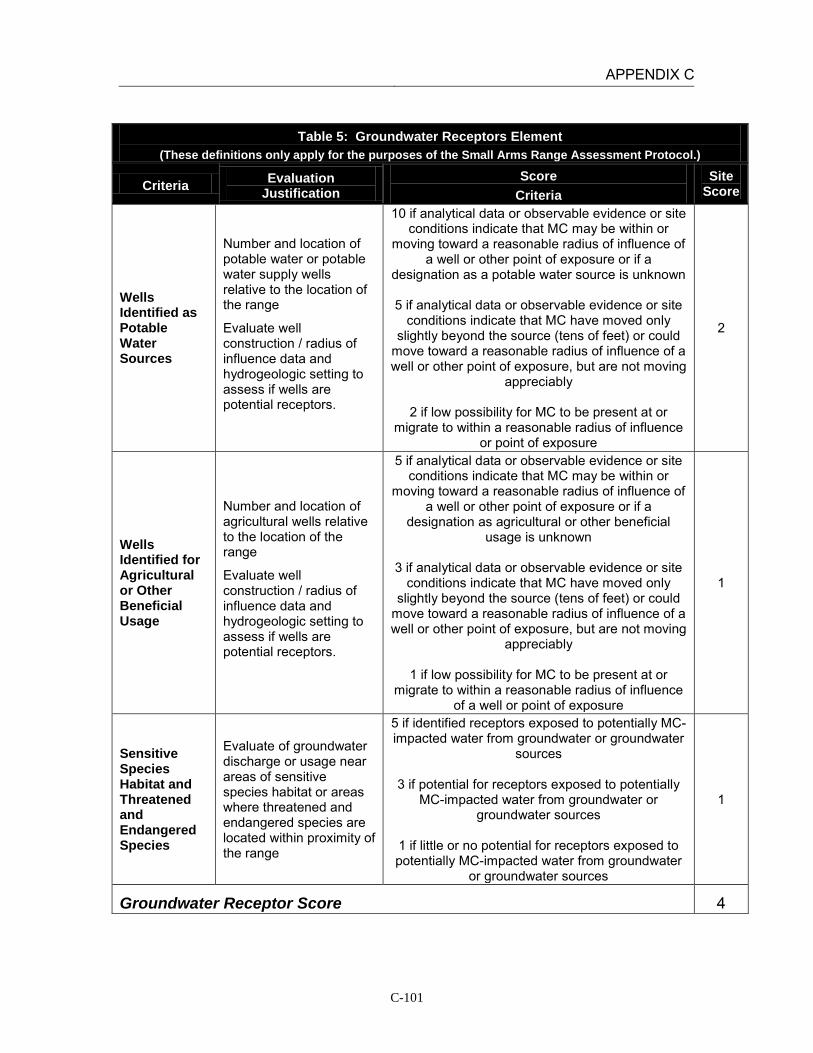
APPENDIX C
C-101
Table 5: Groundwater Receptors Element
(These definitions only apply for the purposes of the Small Arms Range Assessment Protocol.)
Criteria Evaluation Justification
Score Criteria
Site Score
Wells Identified as Potable Water Sources
Number and location of potable water or potable water supply wells relative to the location of the range
Evaluate well construction / radius of influence data and hydrogeologic setting to assess if wells are potential receptors.
10 if analytical data or observable evidence or site conditions indicate that MC may be within or
moving toward a reasonable radius of influence of a well or other point of exposure or if a
designation as a potable water source is unknown
5 if analytical data or observable evidence or site conditions indicate that MC have moved only
slightly beyond the source (tens of feet) or could move toward a reasonable radius of influence of a well or other point of exposure, but are not moving
appreciably
2 if low possibility for MC to be present at or migrate to within a reasonable radius of influence
or point of exposure
2
Wells Identified for Agricultural or Other Beneficial Usage
Number and location of agricultural wells relative to the location of the range
Evaluate well construction / radius of influence data and hydrogeologic setting to assess if wells are potential receptors.
5 if analytical data or observable evidence or site conditions indicate that MC may be within or
moving toward a reasonable radius of influence of a well or other point of exposure or if a
designation as agricultural or other beneficial usage is unknown
3 if analytical data or observable evidence or site
conditions indicate that MC have moved only slightly beyond the source (tens of feet) or could
move toward a reasonable radius of influence of a well or other point of exposure, but are not moving
appreciably
1 if low possibility for MC to be present at or migrate to within a reasonable radius of influence
of a well or point of exposure
1
Sensitive Species Habitat and Threatened and Endangered Species
Evaluate of groundwater discharge or usage near areas of sensitive species habitat or areas where threatened and endangered species are located within proximity of the range
5 if identified receptors exposed to potentially MC-impacted water from groundwater or groundwater
sources
3 if potential for receptors exposed to potentially MC-impacted water from groundwater or
groundwater sources
1 if little or no potential for receptors exposed to potentially MC-impacted water from groundwater
or groundwater sources
1
Groundwater Receptor Score 4

APPENDIX C
C-102
Table 5: Groundwater Receptors Element (These definitions only apply for the purposes of the Small Arms Range Assessment Protocol.)
Criteria Evaluation Justification
Score Criteria
Site Score
Notes: The depth to water at the well on the southwestern edge of Deadman Lake is 100 feet below ground surface; given the higher elevation, it is likely the depth to water is greater 6 miles to the north where the range is located.
There are no water supply wells near Range 205A. Water supply wells are located in the Surprise Springs groundwater basin, located approximately 10 miles to the west. Surprise Springs is located upgradient of the range and is hydrogeologically separated from the range by a large fault. The downgradient groundwater basin, Dale Valley, is not used as a drinking water source.
There are no known agricultural wells located on MCAGCC. Surface water and stormwater is used for irrigation purposes. The surface water that accumulates in Deadman Lake generally evaporates.
There are no groundwater discharge locations near the range which could result in lead migration from groundwater to surface water.
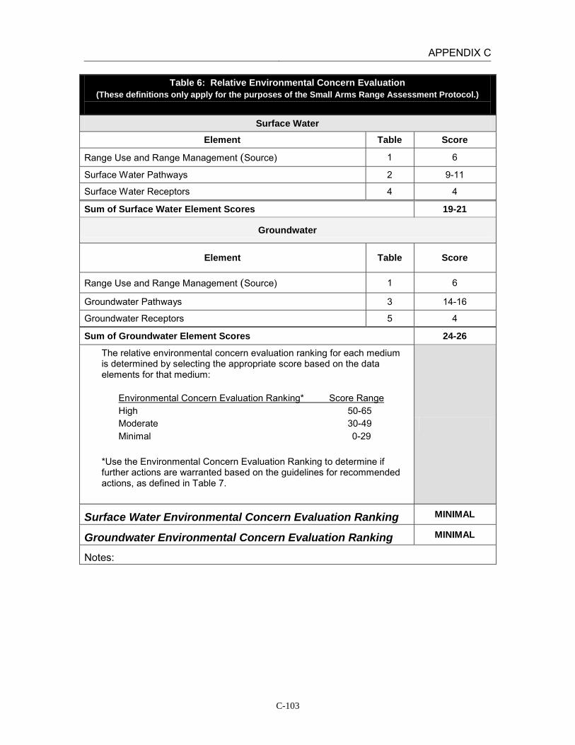
APPENDIX C
C-103
Table 6: Relative Environmental Concern Evaluation (These definitions only apply for the purposes of the Small Arms Range Assessment Protocol.)
Surface Water
Element Table Score
Range Use and Range Management (Source) 1 6
Surface Water Pathways 2 9-11
Surface Water Receptors 4 4
Sum of Surface Water Element Scores 19-21
Groundwater
Element Table Score
Range Use and Range Management (Source) 1 6
Groundwater Pathways 3 14-16
Groundwater Receptors 5 4
Sum of Groundwater Element Scores 24-26
The relative environmental concern evaluation ranking for each medium is determined by selecting the appropriate score based on the data elements for that medium:
Environmental Concern Evaluation Ranking* Score Range High 50-65 Moderate 30-49 Minimal 0-29
*Use the Environmental Concern Evaluation Ranking to determine if further actions are warranted based on the guidelines for recommended actions, as defined in Table 7.
Surface Water Environmental Concern Evaluation Ranking MINIMAL
Groundwater Environmental Concern Evaluation Ranking MINIMAL
Notes:
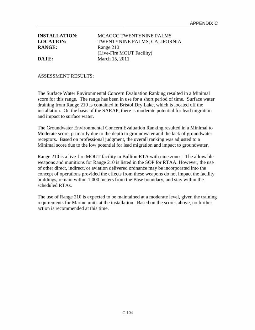
APPENDIX C
C-104
INSTALLATION: MCAGCC TWENTYNINE PALMS LOCATION: TWENTYNINE PALMS, CALIFORNIA RANGE: Range 210 (Live-Fire MOUT Facility) DATE: March 15, 2011 ASSESSMENT RESULTS: The Surface Water Environmental Concern Evaluation Ranking resulted in a Minimal score for this range. The range has been in use for a short period of time. Surface water draining from Range 210 is contained in Bristol Dry Lake, which is located off the installation. On the basis of the SARAP, there is moderate potential for lead migration and impact to surface water. The Groundwater Environmental Concern Evaluation Ranking resulted in a Minimal to Moderate score, primarily due to the depth to groundwater and the lack of groundwater receptors. Based on professional judgment, the overall ranking was adjusted to a Minimal score due to the low potential for lead migration and impact to groundwater. Range 210 is a live-fire MOUT facility in Bullion RTA with nine zones. The allowable weapons and munitions for Range 210 is listed in the SOP for RTAA. However, the use of other direct, indirect, or aviation delivered ordnance may be incorporated into the concept of operations provided the effects from these weapons do not impact the facility buildings, remain within 1,000 meters from the Base boundary, and stay within the scheduled RTAs. The use of Range 210 is expected to be maintained at a moderate level, given the training requirements for Marine units at the installation. Based on the scores above, no further action is recommended at this time.

APPENDIX C
C-105
Table 1: Range Use and Range Management (Source) Element
(These definitions only apply for the purposes of the Small Arms Range Assessment Protocol.)
Criteria Evaluation Justification Score Criteria Site Score
Duration of Range Use
Length of time the range has been used
5 if usage > 30 years
3 if usage is 10 to 30 years
1 if usage < 10 years
1
Bullet-Capturing Technology
The presence and duration of bullet-capturing technologies
Compare the duration of the range use to the duration of bullet-capturing technologies.
-3 if range usage duration = bullet capture duration
-1 if [range usage duration – bullet capture
duration] = 10 to 30 years
0 if [range usage duration – bullet capture duration] > 30 years
0
MC Loading Rates
The amount and types of small arms ammunition expended on the range
Estimate the MC loading by using a time weighted average of MC loading rates
5 if MC loading > 1000 pounds/year
3 if MC loading = 100 to 1000 pounds/year
1 if MC loading < 100 pounds/year
5
Range Maintenance
Frequency of any range maintenance activities involving the removal of lead from the ranges
5 if lead is removed less than once every three years
3 if lead is removed more than once every
three years but less than annually
1 if lead is removed at least annually
5
Source Element Score 11
Notes: This range was established after 2001.
Based on MC expenditure data from 2006 to 2010, the average lead loading at Range 205A is approximately 1400 pounds per year.
The range does not have a specific impact berm; lead recovery is not conducted at this range.

APPENDIX C
C-106
Table 2: Surface Water Pathways Characteristics Element (These definitions only apply for the purposes of the Small Arms Range Assessment Protocol.)
Criteria Evaluation Justification Score Criteria Site Score
pH of Water pH below 6.5 increases the rate of lead dissolution.
5 if pH < 6.5
3 if pH > 8.5
1 if pH 6.5 ≤ pH ≤ 8.5 1-3
Precipitation Intensity and frequency of precipitation
5 if precipitation > 40 inches/year
3 if precipitation = 20-40 inches/year
1 if precipitation < 20 inches/year
1
Slope of Range
The amount of deviation from the horizontal for the berm / target area
5 if slope > 10%
3 if slope = 5% to 10%
1 if slope < 5%
1
Vegetation Approximate vegetation cover within and directly downslope of the surface danger zone
5 if vegetation cover < 20%
3 if vegetation cover = 20% to 50%
1 if vegetation cover > 50%
5
Soil Type / Runoff Conditions
Soil with a higher porosity (sands/gravels) has more infiltration and less runoff compared to soil with low porosity (silts/clays).
5 if soil type is clay / silty clay
3 if soil type is clayey sand / silt
1 if soil type is sand/gravel
1
Runoff/ Erosion Engineering Controls
The presence of engineering controls or BMPs to modify or control surface water runoff and erosion
Partial engineering controls include using erosion controls such as a proper groundcover or use of berms or backstops. Using a combination of multiple partial engineering controls may create an effective engineering control. Other effective engineering controls include bullet containment technologies.
0 if no engineering controls
-5 if partial engineering controls
-10 if effective engineering controls
0
Surface Water Pathway Score 9-11

APPENDIX C
C-107
Table 2: Surface Water Pathways Characteristics Element (These definitions only apply for the purposes of the Small Arms Range Assessment Protocol.)
Criteria Evaluation Justification Score Criteria Site Score
Notes: Based on USGS data the pH of precipitation in California is between 5.3 and 5.5. “Natural” rain will be slightly acidic (pH of 5.6) because of the presence of carbon dioxide in the air which forms carbonic acid when it is mixed with water. However, once the rainfall comes into contact with the ground, the pH increases. Based on stormwater measurements collected on January 5, 2005 the surface water pH at MCAGCC Twentynine Palms is between 8.5 and 8.8.
The average amount of rainfall at Twentynine Palms between 3 and 4 inches per year (USDA).
There is no berm at Range 210. On average, the ground slope in the area is less than 5%.
The range is covered by less than 20% vegetation. The area contains patches of creosote bushes and other scrub.
Range 210 contains soils characterized are characterized as Carrizo sands (NRCS). They are thick, excessively drained soils that formed in mixed alluvium with little to no clay.
Based on aerial photographs and site reconnaissance there are no engineered controls present at the site to prevent erosion or to control surface water.

APPENDIX C
C-108
Table 3: Groundwater Pathways Characteristics Element (These definitions only apply for the purposes of the Small Arms Range Assessment Protocol.)
Criteria Evaluation Justification Score
Criteria Site
Score
Depth to Groundwater
The potential for impact to the groundwater decreases with an increasing depth to the water table.
5 if depth to groundwater < 20 feet
3 if depth to groundwater = 20-99 feet
1 if depth to groundwater = 100-300 feet
0 if depth to groundwater > 300 feet
1
Precipitation Intensity and frequency of precipitation
5 if precipitation > 40 inches/year
3 if precipitation = 20-40 inches/year
1 if precipitation < 20 inches/year
1
pH of Groundwater
pH below 6.5 increases the rate of lead dissolution.
5 if pH < 6.5
3 if pH > 8.5
1 if pH 6.5 ≤ pH ≤ 8.5
1
pH of Soil Lead tends to stay dissolved at pH conditions less than 6.5 and tends to attach to soil particles at pH conditions above 8.5.
5 if pH < 6.5
3 if pH > 8.5
1 if pH 6.5 ≤ pH ≤ 8.5 1-3
Soil Type / Infiltration Conditions
Soil with a higher porosity (sands/gravels) has more infiltration and less runoff compared to soil with low porosity (silts/clays).
5 if soil type is sand/gravel
3 if soil type is clayey sand / silt
1 if soil type is clay / silty clay
5
Clay Content in Soil
Amount of clay in the soil
Lead attaches to clay soil more readily than any other soil types.
5 if soil type is sand/gravel
3 if soil type is clayey sand / silt
1 if soil type is clay / silty clay
5
Groundwater Pathway Score 14-16
Notes: A groundwater well is located on the southwestern edge of Deadman Lake. The depth to groundwater at the well was about 100 ft below ground surface when it was measured in 1982 (USGS, 1984). However, there is a geologic groundwater barrier located under Deadman Lake. The depth to groundwater east of Deadman Lake is generally unknown.
In 1952, the USGS, in conjunction with the Department of the Navy and the Marine Corps, drilled 12 test wells in the Deadman and Surprise Springs groundwater basins to assess the groundwater quality at what is now MCAGCC Twentynine Palms. Based on water quality sampling conducted in 1952, the pH of groundwater tested from ranged from 7.3 to 9.0 (Riley and Worts, 1952).
Carrizo sands are generally neutral to strongly alkaline (USDA NCRS – Official Soil Description).

APPENDIX C
C-109
Table 4: Surface Water Receptors Element (These definitions only apply for the purposes of the Small Arms Range Assessment Protocol.)
Criteria Evaluation Justification
Score Criteria
Site Score
Drinking Water Usage
Identify if nearby surface water bodies are used as a drinking water source.
10 if analytical data or observable evidence indicates that contamination in the media is present at, is moving toward, or has a reasonable potential to move toward a surface water body used as a potable water supply or if
a designation as a potable water source is unknown
5 if contamination in the media has moved or is expected to move only slightly beyond the source (tens of feet) or could move, but is not moving appreciably, toward surface water body used as a potable water
supply or if a designation as a potable water source is unknown
2 if low possibility for contamination in the media to be
present at or migrate to a point of exposure
2
Agricultural or Other Beneficial Usage
Identify if nearby surface water bodies are used as an agricultural or other beneficial use, such as recreational (excluding drinking water).
5 if analytical data or observable evidence indicates that contamination in the media is present at, is moving toward, or has moved to a point of exposure or if a
designation as agricultural or other beneficial usage is unknown
3 if contamination in the media has moved only slightly beyond the source (tens of feet) or could move but is
not moving appreciably.
1 if low possibility for contamination in the media to be present at or migrate to a point of exposure
1
Sensitive Species Habitat and Threatened or Endangered Species
Identify if nearby surface water bodies are downgradient of or nearby any sensitive species habitat or threatened or endangered species.
10 if identified receptors have access to possibly contaminated media and/or are located adjacent to the
range boundary
5 if potential for receptors to have access to possibly contaminated media
1 if little or no potential for receptors to have access to
possible contaminated media
1
Surface Water Receptor Score 4
Notes: Surface water bodies in the area are not used for drinking water. Bristol Dry Lake is the closest downstream surface body, located approximately 5 miles to the northeast. This intermittent water body is not contained with the installation boundaries. Also, Bristol Dry Lake has salt mining activities, indicating a potential for human exposure pathway. However, given the distance and the low mobility for lead in the environment, there is little to no potential for receptors to have access to possibly contaminated media.

APPENDIX C
C-110
Table 5: Groundwater Receptors Element
(These definitions only apply for the purposes of the Small Arms Range Assessment Protocol.)
Criteria Evaluation Justification
Score Criteria
Site Score
Wells Identified as Potable Water Sources
Number and location of potable water or potable water supply wells relative to the location of the range
Evaluate well construction / radius of influence data and hydrogeologic setting to assess if wells are potential receptors.
10 if analytical data or observable evidence or site conditions indicate that MC may be within or
moving toward a reasonable radius of influence of a well or other point of exposure or if a
designation as a potable water source is unknown
5 if analytical data or observable evidence or site conditions indicate that MC have moved only
slightly beyond the source (tens of feet) or could move toward a reasonable radius of influence of a well or other point of exposure, but are not moving
appreciably
2 if low possibility for MC to be present at or migrate to within a reasonable radius of influence
or point of exposure
2
Wells Identified for Agricultural or Other Beneficial Usage
Number and location of agricultural wells relative to the location of the range
Evaluate well construction / radius of influence data and hydrogeologic setting to assess if wells are potential receptors.
5 if analytical data or observable evidence or site conditions indicate that MC may be within or
moving toward a reasonable radius of influence of a well or other point of exposure or if a
designation as agricultural or other beneficial usage is unknown
3 if analytical data or observable evidence or site
conditions indicate that MC have moved only slightly beyond the source (tens of feet) or could
move toward a reasonable radius of influence of a well or other point of exposure, but are not moving
appreciably
1 if low possibility for MC to be present at or migrate to within a reasonable radius of influence
of a well or point of exposure
1
Sensitive Species Habitat and Threatened and Endangered Species
Evaluate of groundwater discharge or usage near areas of sensitive species habitat or areas where threatened and endangered species are located within proximity of the range
5 if identified receptors exposed to potentially MC-impacted water from groundwater or groundwater
sources
3 if potential for receptors exposed to potentially MC-impacted water from groundwater or
groundwater sources
1 if little or no potential for receptors exposed to potentially MC-impacted water from groundwater
or groundwater sources
1
Groundwater Receptor Score 4

APPENDIX C
C-111
Table 5: Groundwater Receptors Element (These definitions only apply for the purposes of the Small Arms Range Assessment Protocol.)
Criteria Evaluation Justification
Score Criteria
Site Score
Notes: The depth to water at the well on the southwestern edge of Deadman Lake is 100 feet below ground surface; given the higher elevation, it is likely the depth to water is greater where the range is located.
There are no water supply wells near Range 210. Water supply wells are located in the Surprise Springs groundwater basin, located approximately 20 miles to the west. Surprise Springs is located upgradient of the range and is hydrogeologically separated from the range by a large fault. The downgradient groundwater basin, Bristol Valley Basin, is not used as a drinking water source because of high mineral content.
There are no known agricultural wells located on MCAGCC. Surface water and stormwater is used for irrigation purposes. The surface water that accumulates in Deadman Lake generally evaporates.
There are no groundwater discharge locations near the range which could result in lead migration from groundwater to surface water.

APPENDIX C
C-112
Table 6: Relative Environmental Concern Evaluation (These definitions only apply for the purposes of the Small Arms Range Assessment Protocol.)
Surface Water
Element Table Score
Range Use and Range Management (Source) 1 11
Surface Water Pathways 2 9-11
Surface Water Receptors 4 4
Sum of Surface Water Element Scores 24-26
Groundwater
Element Table Score
Range Use and Range Management (Source) 1 11
Groundwater Pathways 3 14-16
Groundwater Receptors 5 4
Sum of Groundwater Element Scores 29-31
The relative environmental concern evaluation ranking for each medium is determined by selecting the appropriate score based on the data elements for that medium:
Environmental Concern Evaluation Ranking* Score Range High 50-65 Moderate 30-49 Minimal 0-29
*Use the Environmental Concern Evaluation Ranking to determine if further actions are warranted based on the guidelines for recommended actions, as defined in Table 7.
Surface Water Environmental Concern Evaluation Ranking MININAL
Groundwater Environmental Concern Evaluation Ranking MINIMAL -
MODERATE
Notes: Groundwater environmental score rated as Minimal based on professional judgment.