APPENDIX A SCOPING AND COORDINATION - … · APPENDIX A SCOPING AND COORDINATION. ... quarry....
132
APPENDIX A SCOPING AND COORDINATION A-1
Transcript of APPENDIX A SCOPING AND COORDINATION - … · APPENDIX A SCOPING AND COORDINATION. ... quarry....

APPENDIX A SCOPING AND COORDINATION
A-1

This Page Intentionally Blank
A-2

Correspondence List 3/10/2005 Issue scoping request letter for quarries utilized by Bureau of Reclamation 3/14/2005 Paul Buff from the BLM State Office in Phoenix called to request an
electronic copy of the scoping letter. Thayer approved and he was emailed a copy on 3/15/2005. His contact info is: 602.417.9225, [email protected]
3/15/2005 George Meckfessel, Planning Environmental Coordinator, for Needles
Field Office of BLM called to request more detailed maps. He was specifically interested in routes to/from the quarries as it pertains to ROW permits and wants more detailed maps with routes and project area boundaries. I asked him to send me a GIS layer of their area in order to make him an accurate map. He mentioned that Manchester is going to be especially contentious and that they are getting rigorous scrutiny on all permits in and adjacent to wilderness areas from the environmental community. His contact info is: 760.326.7008, [email protected]
3/21/2005 Received voicemail from Gary Taylor, El Centro BLM asking how to
respond to scoping letter. On 3/24/2005 Kim Garvey spoke with Gary and asked him to send a letter to us with their response/concerns. His phone number is 760.337.4422.
3/22/2005 Received letter from Yuma County Department of Development Services.
Letter put in scoping file. 3/22/2005 Received email response from Pat Wall of La Paz County Community
Development Department. Email put in scoping file. 3/30/2005 Received email from Canh Nguyen, CDFG in Blythe: “Could you place
me on the mailing list for this project? CDFG would appreciate the opportunity to comment on the Programmatic EA as it pertains to the quarries in California”. Email copied to project file and name added to list.
4/1/2005 Received letter from El Centro BLM Field Office regarding the two
quarries in their jurisdiction (Pilot Knob and Paymaster). Paymaster is covered under an environmental plan that Gary Taylor is going to send to Kim G. Letter stated that the ROW is donated land and is generally not permitted for ROWs – Kim G will follow-up with their lands people.
4/1/2005 Received 2 letters from Phoenix ES Fish and Wildlife Service Office, one
in response to scoping and the other in response to the BO renewal. Kim Garvey spoke with Lesley Fitzpatrick on 4/8/2005. Kim Garvey is going
A-3

to get FWS the needed reports and acceptance of terms and conditions letter.
4/8/2005 Received response letter from Salt River Pima-Maricopa Indian
Community. They defer all consultation to CRIT through an existing agreement.
4/8/2005 Received email from Tafida Elsherif of Arizona State Land Department
asking to be including on mailing list for AZ lands and Colorado River work.
4/11/2005 Received phone call from Greg Thompson of CA BLM Marino Valley
District Office (over field offices). Wants more specific information. 4/15/2005 Received email from Stephen Fusilier of Yuma Field Office of BLM with
their concerns. 4/18/2005 Received email from Amanda Dodson a Geologist from the Lake Havasu
Field Office of BLM asking for more specific location information for the quarries in their purview.
4/19/2005 Received letter from AZ SHPO. 4/22/2005 Memorandum from Reclamation to BLM Re: their interest in participating
as a cooperating agency. 4/26/2005 Received copy of email from Steve Fusilier to Jennifer Green, Aaron
Curtis, and Jim Grace Re: providing information to Kim Garvey with hiking/biking trail information.
4/29/2005 Received phone call from Aaron Curtis of Yuma Field Office of BLM
requesting more information about Laguna Dam East Quarry. Kim Garvey called him back on 4/5/2005 to clarify issues. He is going to send me a copy of their “new” Land Use Planning Handbook. I am going to send him updated location information when that is ready.
5/3/2005 Received email from Fred Wong – be sure to include Rosy Boa,
Chuckwalla, and Gila Monster in EA analysis. Include Petalonyx linearis (long-leafed sandpaper plant) for the Laguna area.
5/5/2005 Received email from Aaron Curtis providing information on BLM
Recreation Land Use Planning Guidance and Recreation Opportunities Spectrum (ROS).
5/6/2005 Received 2 emails from Jennifer Green of Yuma Field Office of BLM
stating concerns about Quarry Operations and haul speed.
A-4

5/6/2005 Sent email to: [email protected] [email protected] [email protected] [email protected] [email protected] [email protected] [email protected] [email protected] [email protected] [email protected] [email protected] [email protected] [email protected] [email protected] [email protected] [email protected] Email included more specific location information as well as ownership
information. 5/6/2005 Received email from Jill Miller-Allert Wilderness Coordinator for the
Lake Havasu field office of BLM. Had comments about Manchester and Section 7.
5/13/2005 Received CD of GIS information for routes of travel and wilderness from
Alicia Rabas, wildlife biologist, Needles Field Office of BLM. 5/24/2005 Response from BLM California Desert District indicating their interest in
becoming a cooperating agency. 6/13/2005 Response from BLM Kingman Field Office indicating their interest in
becoming a cooperating agency. 3/14/2007 Reclamation letter to distribute the March 07 Administrative Draft EA. 3/22/2007 Email from BLM – El Centro Field Office (Erin Dreyfuss) – comments on
the March 07 Draft EA. 4/2/2007 Response from BLM – California Desert District (Alan Stein) – comments
on the March 07 Draft EA. 4/16/2007 Email from BLM – Yuma, Lake Havasu, & Kingman Field Offices –
comments on the March 07 Draft EA. 5/16/2007 Reclamation letter to distribute the May 07 Draft EA. 5/25/2007 Reclamation letter to the Tribes to distribute the May 07 Draft EA. 6/1/2007 Reclamation letter to the California State Historic Preservation Office to
distribute the May 07 Draft EA. (Same letter was sent to the Arizona State Historic Preservation Office)

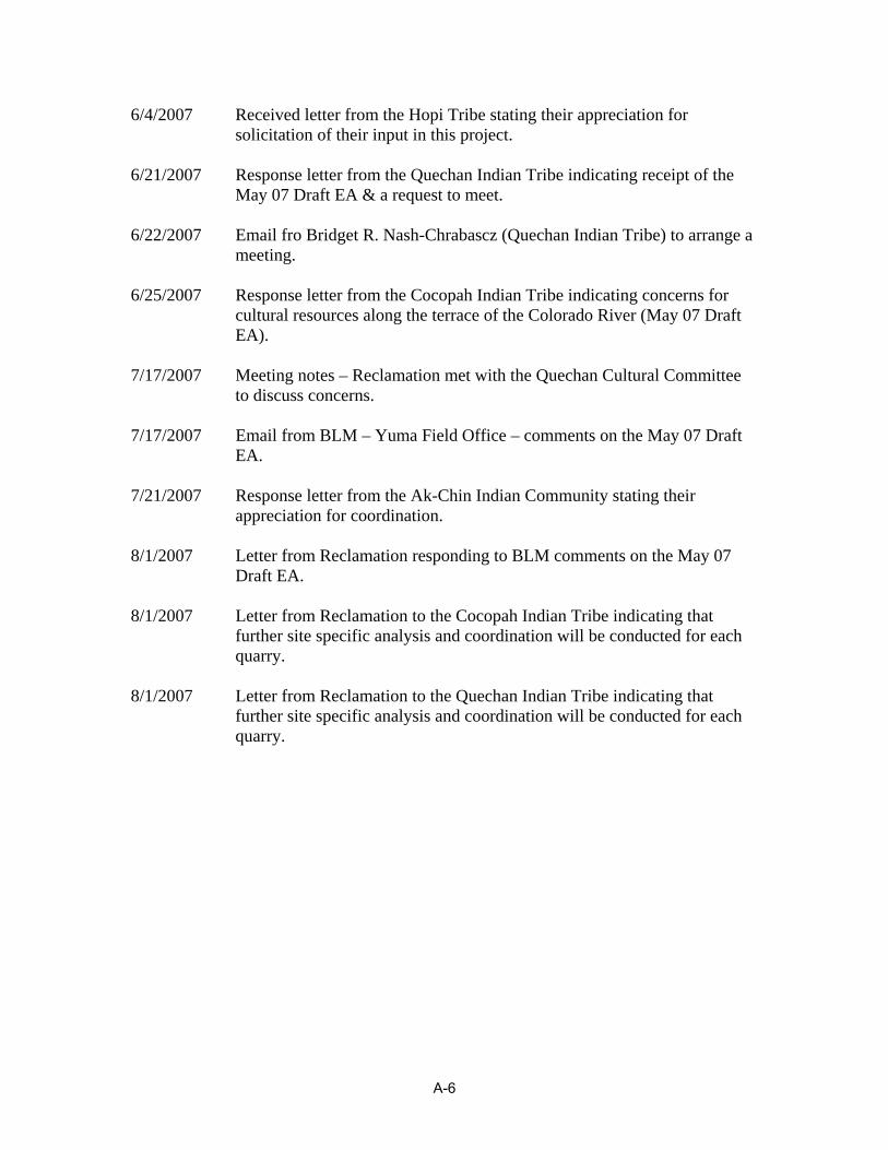
6/4/2007 Received letter from the Hopi Tribe stating their appreciation for solicitation of their input in this project.
6/21/2007 Response letter from the Quechan Indian Tribe indicating receipt of the
May 07 Draft EA & a request to meet. 6/22/2007 Email fro Bridget R. Nash-Chrabascz (Quechan Indian Tribe) to arrange a
meeting. 6/25/2007 Response letter from the Cocopah Indian Tribe indicating concerns for
cultural resources along the terrace of the Colorado River (May 07 Draft EA).
7/17/2007 Meeting notes – Reclamation met with the Quechan Cultural Committee
to discuss concerns. 7/17/2007 Email from BLM – Yuma Field Office – comments on the May 07 Draft
EA. 7/21/2007 Response letter from the Ak-Chin Indian Community stating their
appreciation for coordination. 8/1/2007 Letter from Reclamation responding to BLM comments on the May 07
Draft EA. 8/1/2007 Letter from Reclamation to the Cocopah Indian Tribe indicating that
further site specific analysis and coordination will be conducted for each quarry.
8/1/2007 Letter from Reclamation to the Quechan Indian Tribe indicating that
further site specific analysis and coordination will be conducted for each quarry.
A-6
A-7

A-8

A-9

A-10

A-11

A-12
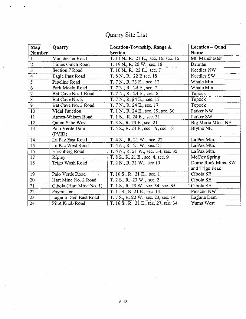
A-13

A-14

A-15
A-16

A-17

From: "Pat Wall" <[email protected]> To: <[email protected]> Date: Tuesday, March 22, 2005 15:31:13 Subject: YAO-7210 ENV-7.00 RE: U.S.D.I./BRM letter Re: Environmental Assessment/Quarrying for River Rip-Rap In response to your letter of March 10, 2005, our only identified problem is dust from trucks transporting the rocks to the riverbanks. Mitigation suggested would be the use of road sprinkler trucks in residential areas and on roads with significant traffic. Patricia L. Wall La Paz County Community Development Department CC: <[email protected]>
A-18

From: "Canh Nguyen" <[email protected]> To: <[email protected]>, <[email protected]> Date: Wednesday, March 30, 2005 10:15:01 Subject: Quarries utilized by the BOR Hi Kimberly and Rex... Could you place me on the mailing list for this project? CDFG would appreciate the opportunity to comment on the Programmatic EA as it pertains to the quarries in California. Thank you. Canh Nguyen- Environmental Scientist California Department of Fish and Game P.O. Box 2160 Blythe, CA 92226 phone: 760.921.2974 fax:760.922.5638 CC: "Chris Hayes" <[email protected]>
A-19

From: Kimberly Garvey To: [email protected] Date: Friday, April 01, 2005 12:16:58 Subject: Your request - Quarries Canh, Below is the general statement of what takes place during quarry operations. We are only doing programmatic analysis at this time - individual quarries will be permitted on an as needed basis. If you have any other questions or would like to discuss this further please call or email. Through the agency scoping process, Reclamation is trying to identify issues as early in the process as possible. Thanks for your input and Happy Friday! Quarry Operations: Work would be accomplished by a Reclamation contractor under an existing or future Indefinite Quantity Indefinite Delivery (IDIQ) or Requirements type contracts. The Contractor would be issued a Delivery Order detailing the amount and types of material required and the final delivery point, including any additional environmental restrictions. Under the contract requirements, the contractor would also be responsible for obtaining the Storm Water Pollution Prevention Plan (SWPPP) and submitting the Notice of Intent (NOI) to the Environmental Protection Agency (EPA). Copies of the approved permits and forms will be submitted to the appropriate state governing agency. Quarry operation consists of blasting as necessary to produce working benches and working materials for the mechanically operated grizzlies and screening plant. Blasting will be done in accordance with Reclamation’s “Reclamation Safety and Health Standards” and the Federal Mine Safety and Health Act (MSHA) of 1997, Title 30, Chapter 1. The MSHA standards will apply to all rock quarry, sand, gravel, and crushed stone operations. During the quarry operation, the height of the working face may exceed 40 feet. However, at the end of an individual delivery order, the final elevations of successive benches will not exceed 40-foot vertical difference and will have a back slope of 3 to 1 or a slope to match any existing prominent rock joint. The existing rock faces of the quarry will be scaled (as defined by 30 CFR, Part 56, paragraph 56.2, Definitions) prior to beginning of any quarrying operations. Quarry faces will be scaled as necessary during the operation of the quarry to eliminate danger during the progress of the work at the quarry site. Access roads will be built within the confines of the quarry and to the benches as required for the operation of the quarry. After completion of the delivery order, all worked rock faces shall be scaled and all access roads shall be blocked with oversize rock or fence as needed. Oversize rock that is produced during the blasting operation will generally be reduced to the designated riprap size and used in stockpiles in accordance
A-20

with Reclamation’s delivery orders and associated specifications. Undersized materials and fines will be graded and screened to produce gravel base materials. Materials not meeting Reclamation’s standards and specifications and any stripped materials shall be disposed of in and around the existing quarry site. Excess sub-standard materials shall be graded to a generally uniform surface to blend in with the adjacent ground surfaces. Surplus material produced during the quarry and processing operation and meeting Reclamation standards and specifications may be stockpiled on the quarry floor until needed. Stockpiles will be separated by types of materials produced (i.e. riprap, gravel base, or 1 to 4-inch material). Material will be relocated to the associated stockpile sites or banklines on an as need basis. The following is a list of equipment that may be utilized during quarry operations: •Mechanically operated grizzly and screening plant •Two or three rubber-tired front end loaders •Rock Crusher •Dozer (1 or 2) •Blade (For maintaining access and haul roads) •Water Truck (For maintaining access and haul roads) •Six to twelve haul trucks minimum, depending on the size of the vehicles and the distance to where the rock is being stockpiled or placed on the bankline •A compressor and air drill •A certified platform scale •Backhoe with ram attachment •Service Truck Kimberly L. Garvey Natural Resource Specialist Reclamation - Yuma Area Office 7301 Calle Agua Salada Yuma, AZ 85364 ph: 928.343.8227 fax: 928.343.8320 CC: Kimberly GARVEY
A-21

A-22

A-23
A-24

From: "Tafida Elsherif" <[email protected]> To: <[email protected]>, <[email protected]> Date: Friday, April 08, 2005 10:15:39 Subject: Re: Issues Scoping Request for Quarries Utilized by the Bureauof Reclamation We received your letter regarding the process of developing Environmental Assessment for Quarry operations along Colorado River. Please place me on the mailing list for this project and provide us in details with these activities for the impacts on the Arizona side along 276 river miles of the Colorado River from the International Boundary to Davis Dam. Thank you for your cooperation, looking forward to hear from you soon. Tafida Elsherif Tafida Elsherif Colorado River Project Manager Engineering Section Arizona State Land Department 1616 W. Adams St., Phoenix, AZ 85007 Voice : (602) 542-2679 Fax : (602) 364-0272 E-mail : [email protected] CC: "V. Ottozawa Chatupron" <[email protected]>
A-25

From: <[email protected]> To: <[email protected]>, <[email protected]> Date: Friday, April 15, 2005 16:53:48 Subject: Scoping Issues for the Programmatic EA for Quarry Operations Kim and Rex,, You will find listed below some of our concerns we would like addressed in the EA. I have not received anything from my wildlife biologist or archeologist and they are out of the office today. I will try to get any comments they have on Monday. One general comment - If the EA could possibly address the ability for the BLM to obtain small quantities of material from the same sites on an as needed type basis (of course we would not interfere with your operations and our needs are usually very limited) We need material every now and them and once or twice I seem to remember some tension between our two agencies on this matter. 13. Palo Verde Dam - Possible desert tortoise habitat 14. La Paz East Road - This land is proposed for transfer to the Colorado River Indian Tribe through congressional legislation 15. La Paz West Road - This land is proposed for transfer to the Colorado River Indian Tribe through congressional legislation 16. Ehrenberg Road - This land is proposed for transfer to the Colorado River Indian Tribe through congressional legislation 19. Palo Verde Road Quarry - Known cultural concerns related to the existing quarry and potential damage to Native American rock art on land adjacent to the site that according to comments when the North Baja Pipeline was built may have been caused by blasting at the quarry. 22. Paymaster Quarry - As part of the court case involving Walter's camp adjacent land owners have voice concerns about federally permitted actions which do/could damage cultural resources in the area. They had an archeologist prepare a report for them that shows 49 Native American sites/features in the area. You might want to be pro-active in dealing with this issue as one of the concerns mentioned by the adjacent landowners in the Walter's Camp lawsuit was the small rock quarry next to Walter's Camp. 23. Laguna Dam East Quarry - There are a number of hiking trails and mountain biking trails in the area. We have had concerns from the public that use the trails about the existing operations. Please address recreational concerns in your EA. 24. Pilot Knob Quarry - The known concerns about cultural issues If you have any questions please give me a call. Stephen L. Fusilier 2555 E. Gila Ridge Road Yuma, AZ 85365 (928) 317-3296
A-26

(928) 317-3250 Fax
A-27

From: <[email protected]> To: <[email protected]>, <[email protected]> Date: Monday, April 18, 2005 11:26:45 Subject: Scoping Request for BOR Quarries Kimberly and Rex- Thank you for involving us in your scoping request. We may have some comments concerning the sites near Topock, specifically the Pipeline, Park Moabi, and Bat Cave No. 1, 2, and 3 Quarries. The map and legal descriptions did not provide sufficient detail for us to determine if there were any conflicts with other resources. Could you please provide us with a map of just the Topock area and/or more detailed legal descriptions for us to determine exactly where these quarries are? We will notify you of any concerns we may have as soon as we receive information further defining these areas. I apologize for the delay in getting this message to you. Please keep the BLM Lake Havasu Field Office on your mailing list for this project. Amanda Dodson Geologist - Lake Havasu Field Office (928) 505-1218 CC: <[email protected]>, <[email protected]>, <[email protected]>
A-28

A-29

A-30

A-31

A-32

A-33

A-34

From: <[email protected]> To: <[email protected]>, <[email protected]>, <[email protected]> Date: Tuesday, April 26, 2005 13:25:19 Subject: Biking and Hiking trails Jennifer, Aaron, and Jim, Please provide Kim Garvey with BR (email address in cc) any hiking/biking trail info (maps/shape files) for the Laguna Pit area and any other recreation concerns. Pleas cc: me anything you send to her. (Aaron and Jennifer, I put copies of the location info in your mail boxes.) Stephen L. Fusilier 2555 E. Gila Ridge Road Yuma, AZ 85365 (928) 317-3296 (928) 317-3250 Fax CC: <[email protected]>, <[email protected]>
A-35

From: <[email protected]> To: "Kimberly GARVEY" <[email protected]> Date: Tuesday, May 03, 2005 11:44:12 Subject: programmatic EA I haven't seen the programmatic EA for the quarrys, but be sure to include Rosy Boa, Chuckwalla, Gila Monster in your analysis. If any quarries are going into the Big Marias, be sure to include Alversoni's Foxtail. If quarries will be in the lagunas, include petalonyx linearis (long-leaf sandpaper plant). Fred CC: "Rex Wahl" <[email protected]>, <[email protected]>, <[email protected]>
A-36

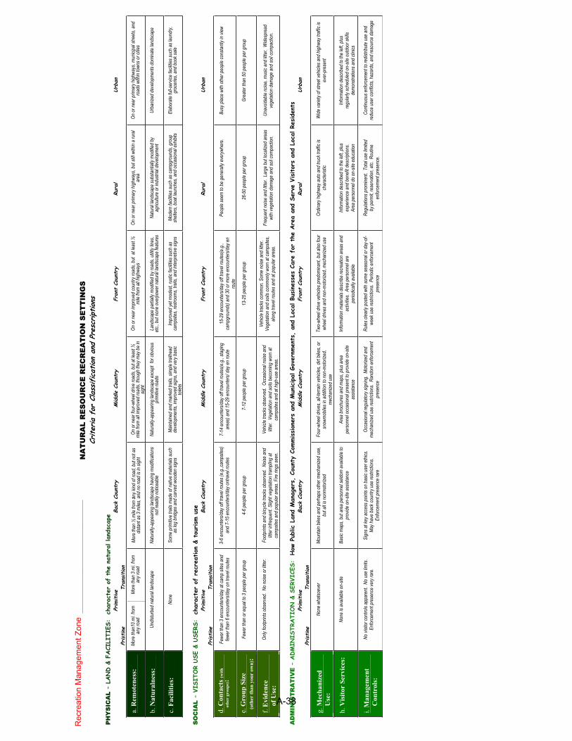
From: <[email protected]> To: <[email protected]> Date: Thursday, May 05, 2005 06:38:09 Subject: New BLM Recreation Land Use Planning Guidance Kim, As we discussed on the phone today, this pdf file provides some guidance for Recreation Land Use Planning. The table in the file lists the "Natural Resource Recreation Settings", which is what we are now using as our Recreation Opportunity Spectrum (ROS) classes. This tool allows Recreation to be described as a much more tangible resource during NEPA analysis. For example, project areas can now be classifed according to what type of recreation opportunities are currently in the Existing Environment (classes go from Primitive to Urban). Then, in the Environmental Impacts section of the NEPA document, the anticipated change in recreation opportunities can be disclosed to the public (e.g. Under the Proposed Action Alternative, the project area would provide Middle Country recreation opportunities. Under the No Action Alternative, the project area would continue to provide Back County recreation opportunities). The criteria for classification listed in the attached table is pretty straight-forward - you classify the project area according to it's physical, social, and administrative characters, then take an average of those classes to come up with the overall "BLM Recreation Opportunity Spectrum Class". I would recommend documenting this process and including it in your NEPA projects' AR, and I probably should also verify the fact that you guys came up with the appropriate class since we're primarily in charge of managing recreation - if I have a map in front of me, this can probably just be done over the phone or email. It's probably also important to note that these classifications are going to be applied throughout our entire field office for the new RMP. After the RMP has been signed, the classifications will, in theory, begin to work as management prescriptions. That's why its pretty good timing that you guys are proposing your programmatic EA now, because if we have ideas of where you'll be expanding your material pits, we can avoid overpresribing areas where recreation opportunities may be substantially altered. (See attached file: ROS CLASSES.pdf) Please get in touch if you have any questions and thanks for getting back to me so quickly. Aaron 317-3238
A-37
NA
TU
RA
L R
ES
OU
RC
E R
EC
RE
AT
ION
SE
TT
ING
S
Criter
ia f
or C
lass
ificat
ion
and
Pres
cription
s
PH
YS
ICA
L –
LAND &
FACI
LITI
ES:
cha
ract
er o
f th
e na
tura
l land
scap
e
Primitive
Back
Cou
ntry
M
iddle
Coun
try
Fron
t Co
untr
y
Ru
ral
Urba
n
Pristine
Tra
nsition
a.R
emo
ten
ess:
Mor
e th
an10
mi. f
rom
an
y roa
d M
ore
than
3 m
i. fro
m
any r
oad
Mor
e th
an ½
mile
from
any k
ind o
f roa
d, b
ut n
ot a
s dis
tant
as 3
mile
s, an
d no
road
is in
sigh
t On
or n
ear f
our-w
heel
drive
road
s, bu
t at le
ast ½
m
ile fr
om a
ll im
prov
ed ro
ads,
thou
gh th
ey m
ay be
in
sight
On o
r nea
r im
prov
ed co
untry
road
s, bu
t at
leas
t ½
mile
from
all h
ighwa
ys
On o
r nea
r prim
ary h
ighwa
ys, b
ut st
ill wi
thin
a ru
ral
area
On o
r nea
r prim
ary h
ighwa
ys, m
unici
pal s
treet
s, an
d ro
ads w
ithin
town
s or c
ities
b.
Natu
raln
ess:
Undis
turb
ed n
atur
al lan
dsca
pe
Natu
rally
-app
earin
g lan
dsca
pe h
aving
mod
ificat
ions
not r
eadil
y not
iceab
le Na
tura
lly-a
ppea
ring
lands
cape
exc
ept
for o
bviou
s pr
imitiv
e ro
ads
Land
scap
e pa
rtially
mod
ified
by ro
ads,
utilit
y line
s, et
c., b
ut n
one
over
powe
r nat
ural
lands
cape
feat
ures
Na
tura
l land
scap
e su
bsta
ntial
ly m
odifie
d by
ag
ricult
ure
or in
dustr
ial d
evelo
pmen
t Ur
baniz
ed d
evelo
pmen
ts do
mina
te la
ndsc
ape
c.F
aci
liti
es:
None
So
me
prim
itive
trails
mad
e of
nat
ive m
ater
ials s
uch
as lo
g br
idges
and
carv
ed w
oode
n sig
ns
Main
taine
d an
d m
arke
d tra
ils, s
imple
trail
head
de
velop
men
ts, im
prov
ed si
gns,
and
very
bas
ic to
ilets
Impr
oved
yet m
odes
t, rus
tic fa
cilitie
s suc
h as
ca
mps
ites,
restr
oom
s, tra
ils, a
nd in
terp
retiv
e sig
ns
Mod
ern
facil
ities s
uch
as ca
mpg
roun
ds, g
roup
sh
elter
s, bo
at la
unch
es, a
nd o
ccas
ional
exhib
its
Elab
orat
e fu
ll-ser
vice
facil
ities s
uch
as la
undr
y, gr
ocer
ies, a
nd b
ook s
ale
SO
CIA
L –
VISI
TOR
USE
& U
SERS
: c
hara
cter
of
recr
eation
& t
ourism
use
Primitive
Back
Cou
ntry
M
iddle
Coun
try
Fron
t Co
untr
y
Ru
ral
Urba
n
Pristine
Tra
nsition
d.
Co
nta
cts
(wit
h
o
ther
gro
up
s):
Fewe
r tha
n 3
enco
unte
rs/d
ay a
t cam
p sit
es a
nd
fewe
r tha
n 6
enco
unte
rs/d
ay o
n tra
vel r
oute
s 3-
6 en
coun
ters
/day
off t
rave
l rou
tes (
e.g.
,cam
psite
s)
and
7-15
enc
ount
ers/d
ay o
ntra
vel r
oute
s7-
14 e
ncou
nter
s/day
off
trave
l rou
tes(
e.g.
, sta
ging
area
s) a
nd 1
5-29
enc
ount
ers/
day e
n ro
ute
15-2
9 en
coun
ters
/day
off t
rave
l rou
tes(
e.g.
, ca
mpg
roun
ds) a
nd 3
0 or
mor
e en
coun
ters
/day
en
rout
e
Peop
le se
em to
be
gene
rally
eve
rywh
ere.
Bu
sy p
lace
with
oth
er pe
ople
cons
tant
ly in
view
e.G
rou
p S
ize
(
oth
er t
han
you
r ow
n):
Fewe
r tha
n or
equ
al to
3 pe
ople
per g
roup
4-
6 pe
ople
per g
roup
7-
12 p
eople
per
gro
up
13-2
5 pe
ople
per g
roup
26
-50
peop
le pe
r gro
up
Grea
ter t
han
50 p
eople
per
gro
up
f.E
vid
ence
of
Use
:
Only
foot
s obs
erve
d. N
o no
ise o
r litte
r. Fo
otpr
ints a
nd b
icycle
trac
ks o
bser
ved.
Nois
e an
d litt
er in
frequ
ent.
Sligh
t veg
etat
ion tr
ampli
ng a
t ca
mps
ites a
nd p
opula
r are
as. F
ire ri
ngs s
een.
Vehic
le tra
cks o
bser
ved.
Occ
asion
al no
ise a
nd
litter
. Ve
geta
tion
and
soils
bec
oming
wor
n at
ca
mps
ites a
nd a
t high
-use
are
as.
Vehic
le tra
cks c
omm
on. S
ome
noise
and
litte
r. Ve
geta
tion
and
soils
com
mon
ly wo
rn a
t cam
psite
s, alo
ng tr
avel
rout
es a
nd a
t pop
ular a
reas
. Fr
eque
nt n
oise
and
litter
. La
rge
but lo
caliz
ed a
reas
wi
th ve
geta
tion
dam
age
and
soil c
ompa
ction
. Un
avoid
able
noise
, mus
ic an
d litt
er.
Wide
spre
ad
vege
tatio
n da
mag
e an
d so
il com
pacti
on.
AD
MIN
IST
RA
TIV
E –
ADM
INIS
TRATI
ON &
SER
VICE
S:
How
Pub
lic L
and
Man
ager
s, C
ount
y Co
mmission
ers
and
Mun
icipal G
over
nmen
ts,
and
Loca
l Bu
sine
sses
Car
e fo
r th
e Are
a an
d Se
rve
Visito
rs a
nd L
ocal R
esiden
ts
Primitive
Back
Cou
ntry
M
iddle
Coun
try
Fron
t Co
untr
y
Ru
ral
Urba
n
Pristine
Tra
nsition
g.
Mec
han
ized
Use
:
None
wha
tsoev
er
Mou
ntain
bike
s and
per
haps
oth
er m
echa
nized
use
, bu
t all i
s non
mot
orize
d Fo
ur-w
heel
drive
s, all
-terra
in ve
hicles
, dirt
bike
s, or
sn
owm
obile
s in
addit
ion to
non
-mot
orize
d,
mec
haniz
ed u
se
Two-
whee
l driv
e ve
hicles
pre
dom
inant
, but
also
four
wh
eel d
rives
and
non
-mot
orize
d, m
echa
nized
use
Or
dinar
y high
way a
uto
and
truck
traff
ic is
char
acte
ristic
W
ide va
riety
of st
reet
vehic
les a
nd h
ighwa
y tra
ffic is
ev
er-p
rese
nt
h.
Vis
itor
Ser
vic
es:
None
is a
vaila
ble o
n-sit
e Ba
sic m
aps,
but a
rea
pers
onne
l seld
om a
vaila
ble to
pr
ovide
on-
site
assis
tanc
e Ar
ea b
roch
ures
and
map
s, plu
s are
a pe
rson
nel o
ccas
ional
pres
ent t
o pr
ovide
on-
site
assis
tanc
e
Info
rmat
ion m
ater
ials d
escr
ibe re
crea
tion
area
s and
ac
tivitie
s. A
rea
pers
onne
l are
pe
riodic
ally a
vaila
ble
Info
rmat
ion d
escr
ibed
to th
e lef
t, plu
s ex
perie
nce
and
bene
fit de
scrip
tions
. Ar
ea p
erso
nnel
do o
n-sit
e ed
ucat
ion
Info
rmat
ion d
escr
ibed
to th
e lef
t, plu
s re
gular
ly sc
hedu
led o
n-sit
e ou
tdoo
r skil
ls de
mon
strat
ions a
nd cl
inics
i.M
an
ag
emen
t
Co
ntr
ols
:
No vi
sitor
cont
rols
appa
rent
. No
use
limits
. En
forc
emen
t pre
senc
e ver
y rar
e.
Sign
s at k
ey a
cces
s poin
ts on
bas
ic us
er e
thics
. M
ay h
ave
back
coun
try us
e re
strict
ions.
En
forc
emen
t pre
senc
e ra
re
Occa
siona
l reg
ulato
ry si
gning
. M
otor
ized
and
mec
haniz
ed u
se re
strict
ions.
Ran
dom
enf
orce
men
t pr
esen
ce
Rules
clea
rly p
oste
d wi
th so
me
seas
onal
or d
ay-o
f-we
ek u
se re
strict
ions.
Per
iodic
enfo
rcem
ent
pres
ence
Regu
lation
s pro
mine
nt.
Tota
l use
limite
d by
per
mit,
rese
rvat
ion, e
tc. R
outin
e en
forc
emen
t pre
senc
e.
Cont
inuou
s enf
orce
men
t to r
edist
ribut
e us
e an
d re
duce
use
r con
flicts,
haza
rds,
and
reso
urce
dam
age
Re
cre
atio
n M
an
ag
em
en
t Z
on
e
___
__
__
__
___
____
__
__
___
____
_
A-38

From: <[email protected]> To: <[email protected]> Date: Thursday, May 05, 2005 17:47:56 Subject: BR quarry sites Hi Kim, I am on the ID team for the programmatic BR quarries EA. There are several issues and use conflicts associated with some of the quarry locations. Of special interest to the Yuma Field Office is the Laguna Dam Quarry pit. There is an extensive network of biking and hiking trails that run throughout that area. We have also seen a desert tortoise in the vicinity. We would like to know the geographical extent that these quarries will encompass, as well as any plans to have biological monitors at the project site in the event that a tortoise is present. These quarries have a large impact on visual resources. Is there any plan for reclamation of the quarries post extraction? I am going to forward you an email from my college Aaron Curtis, the outdoor recreation planner in our office. We have had a lot of calls from concerned recreationists wondering about the expansion of these pits. Additionally, the transportation trucks speeding along the Mittry Lake road create a public safety hazard. Additionally, I would recommend that you consult with the Native American tribes is our area (Cocopah and Quetzan), I know that they have issues with the Pilot Knob quarry. Thank-you, Jennifer
A-39

From: Kimberly Garvey To: <[email protected]>; <[email protected]>; <[email protected]>; [email protected]; [email protected]; [email protected]; [email protected]; [email protected]; [email protected]; [email protected]; [email protected]; [email protected]; [email protected]; [email protected]; [email protected]; Wong, Fred Date: Friday, May 06, 2005 11:28:24 Subject: Reclamation Programmatic EA for Quarries Hi, Based on the response I received from several of the BLM Field Offices, I wanted to send out more detailed location information. Attached is an excel spreadsheet that breaks down each of the quarry locations and what we have in our records as the existing owners. There are two tabs in the spreadsheet, one for Arizona and the other for California. The locations for some of the quarries do include part of the access routes. I am not authorized to make GIS maps of these locations. If you would like GIS maps, a request has to come directly from your office on your letterhead to Juan Ramos of this office. He can be reached at 928.343.8375 or [email protected]. Although the timeframe for initial scoping has passed, I would appreciate any new comments that you may have as soon as possible so that they may be incorporated into the EA. Please keep in mind that this is Programmatic NEPA and each site will require additional site-specific analysis and permitting when and if we want to operate it. My contact information is below if you have any questions. Please forward this to anyone in your office that may be involved as I am only sending this to folks who contacted me. Kimberly L. Garvey Natural Resource Specialist Reclamation - Yuma Area Office 7301 Calle Agua Salada Yuma, AZ 85364 ph: 928.343.8227 fax: 928.343.8320 CC: Kimberly GARVEY; Maloney, Kim; Ramos, Juan; Wahl, Rex
A-40

Cal
iforn
ia
Qua
rry
Nam
eSt
ate
Loca
tion
Qua
d N
ame
Ow
ners
hip
Acc
ess
Ow
ner
Oth
er
Agn
es-W
ilson
Roa
dC
A
T. 1
S.,
R. 2
4 E
., se
c. 3
1, E
½ W
½, E
½
T. 1
S.,
R. 2
4 E
., se
c. 3
2, W
½ e
xcep
ting
that
po
rtion
of S
ectio
ns 3
1 an
d 32
lyin
g w
ithin
the
Col
orad
o In
dian
Res
erva
tion
Par
ker S
WB
LM -
Pal
m S
prin
gsB
LM/C
RIT
Bat
Cav
e N
o. 1
Roa
dC
AT.
7 N
., R
. 24
E.,
sec.
8, S
½ N
E ¼
SW
¼
and
SE
¼ S
W ¼
Topo
ckR
ecla
mat
ion
FWS
Hav
asu
NW
Ref
uge
Bat
Cav
e N
o. 2
C
AT.
7 N
., R
. 24
E.,
sec.
17,
NE
¼ N
W ¼
To
pock
BLM
- N
eedl
esR
ecla
mat
ion/
BL
MP
revi
ousl
y S
F P
acifi
c P
rope
rties
. B
LM
rece
ntly
acq
uire
d.
Bat
Cav
e N
o. 3
Roa
dC
AT.
7 N
., R
. 24
E.,
sec.
17,
NE
¼ N
W ¼
, and
S
E ¼
NW
¼
Topo
ckB
LM -
Nee
dles
BLM
/Priv
ate
Pre
viou
sly
SF
Pac
ific
Pro
perti
es.
BLM
re
cent
ly a
cqui
red.
Eag
le P
ass
Roa
dC
AT.
8 N
., R
. 22
E.,
sec.
18,
(all)
Nee
dles
SW
Rec
lam
atio
nB
LM/P
rivat
e
Man
ches
ter R
oad
CA
T. 1
1 N
., R
21
E.,
sec.
16,
NE
¼M
t. M
anch
este
rC
AB
LM -
Nee
dles
Pal
o V
erde
Roa
dC
AT.
10
S.,
R. 2
1 E
., se
c. 1
W ½
NW
¼ N
W ¼
S
W ¼
Cib
ola
SE
Rec
lam
atio
nR
ecla
mat
ion
BLM
- Y
uma
Pal
o V
erde
Dam
(P
VID
)C
AT.
5 S
., R
. 23
E, s
ec. 1
4 E
½ N
E ¼
and
T. 5
S
., R
. 24
E.,
sec.
18
W ½
NE
¼ a
nd s
ec. 1
9 W
½ W
½B
lyth
e N
ER
ecla
mat
ion
Priv
ate
BLM
- P
alm
Spr
ings
Pag
e 1
of 3
A-41

Cal
iforn
ia
Qua
rry
Nam
eSt
ate
Loca
tion
Qua
d N
ame
Ow
ners
hip
Acc
ess
Ow
ner
Oth
er
Par
k M
oabi
Roa
dC
AT.
7 N
., R
. 24
E.,
sec.
7 S
W ¼
Wha
le M
tn.
Unk
now
n - N
eedl
es
BLM
?
Pay
mas
ter
CA
T. 1
1 S
., R
. 21
E.,
sec.
14
NW
¼ N
W ¼
NE
¼P
icac
ho N
W
BLM
- E
l C
entro
/Priv
ate
(Sou
ther
n P
acifi
La
nd C
ompa
ny)
BLM
/Priv
ate
Pilo
t Kno
b R
oad
CA
T. 1
6 S
., R
. 21
E.,
sec.
27
S ½
and
sec
. 34
(all)
Yum
a W
est
Rec
lam
atio
nR
ecla
mat
ion
BLM
- E
l Cen
tro
Pip
elin
e R
oad
CA
T. 7
N.,
R. 2
3 E
., se
c. 1
2 S
W ¼
SW
¼ S
E ¼
, W
½ S
E ¼
SW
¼ S
E ¼
, S ½
NW
¼ S
W ¼
S
E ¼
, and
SW
¼ N
E ¼
SW
¼ S
E ¼
Wha
le M
tn.
BLM
- N
eedl
esB
LM
Qui
en S
abe
Wes
tC
A
T. 3
S.,
R. 2
3 E
., se
c. 2
1 E
½ N
E ¼
NW
¼, E
½
W ½
NE
¼ N
W ¼
, SW
¼ S
W ¼
NE
¼ N
W
¼, S
E ¼
SE
¼ N
W ¼
NW
¼, N
½ S
E ¼
NW
¼
, E ½
NE
¼ S
W ¼
NW
¼, N
E ¼
SE
¼ S
W
¼ N
W ¼
, N ½
SW
¼ S
E ¼
NW
¼, a
nd N
W
¼ S
E ¼
SE
¼ N
W ¼
Big
Mar
ia M
tns
NE
BLM
- P
alm
Spr
ings
BLM
Per
mit
Rip
ley
CA
T. 8
S.,
R. 2
1 E
., se
c. 4
E ½
W ¼
, and
E ½
McC
oy S
ring
BLM
- P
alm
Spr
ings
Sec
tion
7 R
oad
CA
T. 1
0 N
., R
. 22
E.,
All
of s
ec. 7
Nee
dles
NW
Rec
lam
atio
nB
LM N
eedl
es
Pag
e 2
of 3
A-42

Cal
iforn
ia
Qua
rry
Nam
eSt
ate
Loca
tion
Qua
d N
ame
Ow
ners
hip
Acc
ess
Ow
ner
Oth
er
Vid
al J
unct
ion
CA
T. 1
N.,
R. 2
4 E
., se
c. 3
0 N
W ¼
, N ½
SW
¼,
W ½
NE
¼, N
½ N
W ¼
SE
¼, S
W ¼
NE
¼
NE
¼, a
nd N
W ¼
SE
¼ N
E ¼
and
sec
. 19
NW
¼ N
E ¼
SW
¼, N
E ¼
NW
¼ S
W ¼
, and
E
½ S
W ¼
NW
¼
T. 1
N.,
R. 2
4 E
., se
c. 3
0 A
ll Fe
dera
l Lan
d (B
LM) a
nd E
½ N
E ¼
NE
¼, N
W ¼
NE
¼ N
E
¼, a
nd N
E ¼
SE
¼ N
E ¼
, and
sec
. 19
W ½
S
W ¼
NW
¼
Par
ker N
WB
LM -
Nee
dles
BLM
Pag
e 3
of 3
A-43

From: <[email protected]> To: "Kimberly Garvey" <[email protected]> Date: Friday, May 06, 2005 14:55:45 Subject: Re: Reclamation Programmatic EA for Quarries Hi, Kimberly, Thank you for your table Listing of BOR quarries along the Colorado River. You say that you are doing a programmatic EA. I would like to see a copy to comment on. My major interest is in the two quarries in the Dead Mountain Wilderness Area, north of Needles, CA. Lake Havasu Field Office's management boundary includes some of the public lands on the California, which access to these quarries are currently crossing. Just couple of notes. Access to the Section 7 Quarry use to be just through public land managed by BLM Needles FO and private lands in section 16. LHFO has been acquiring property in section 16 to block up wilderness lands and much of that section is now public lands managed under LHFO. Please remember that the access route is cherrystemed and the Dead Mountains Wilderness Boundary is basically 100 ft from centerline of the access road which was there in October 31 , 1994. Manchester Quarry is within Dead Mountian Wilderness (no cherrystem) but on State Lands. The access to this quarry is on was for the most part on private lands except for one or two small stretches across public lands, which BOR or CA State lands had a valid ROW. Since that time BLM has done a Land exchange with Catellus Corporation and much of the private lands in that area are now public. You will need to deal with the Wilderness Issue in the EA. New ROWs are not permitted within a national designated wilderness area, but a Temporary Land Use Permit (2920) may be issued. I talked to other BOR people about 5 years ago about this issue, but they didn't respond with application for access. Only a very small section of this access is on public lands managed by LHFO, in fact in LHFO may all with the existing ROW. All of this is just from the top of my head from my time working in the Needles Field Office as their Wilderness Specialist and needs checking. Our network is down so I can not check with GIS or the Master Title Plats at this time. If you can call me if you need additional background. Please work closely with the James Abbe Wilderness Specialist in the Needles Field Office and their Lands and Mineral personnel and LHFO Lands and Mineral personnel. Thank you, Jill Miller-Allert Wilderness Coordinator Lake Havasu Field Office
A-44

(928) 505-1204 CC: <[email protected]>, <[email protected]>, <[email protected]>, <[email protected]>, <[email protected]>, <[email protected]>
A-45

tl0V-~/,UL; OFFICIAL FILE COPY- YAt
United States Department of the InteriorRECEIVJBN - 2 2005
Bureau of Land ManagementCalifornia Desert District
22835 Calle San Juan De Los LagosMoreno Valley CA 92553-9046
www.ca.blm.gov
CODi
, . T,
May 24, 2005
3600CA-6l0
To:Cynthia~oeft,Director,ResourcesManagementOffice,Bureauo~:~~'ReclamatIOn,Yuma Area Office,. ~District Manager, California Desert District 1-'-'} J JFrom:
Subject: Programmatic Environmental Assessment for Quarry Operations AlongLower Colorado River .
We received your April 22, 2005 memorandum inviting the Bureau of Land Management(BLM) to become a cooperating agency in the preparation of the ProgrammaticEnvironmental Assessment (EA) for Quarry Operations Along the Lower ColoradoRiver. We also received your March 10, 2005, Issue Scoping Request, along with themap and tables of quarry sites in California and Arizona. I am enclosing a table listingthe managing BLM Field Office and some additional comments on the site. Asdescribed, there appear to be some quarries that are not available for disposal at this time.We would be happy to work with you to identify potential conflicts.
Weare interested in becoming a cooperating agency and will work with you throughoutthe process of preparing the EA to ensure compliance with the National EnvironmentalPolicy Act of 1969 (NEPA) for BLM decisions, please be aware that BLM's funding formineral material authorizations is limited, and is not available in fiscal year 2005 tocomplete all necessary work, studies, and assessments needed for any approvals ofauthorizations that will be needed. BLM will provide whatever information we have toassist in this matter. Appropriated funding will support BLM's ability to administer theauthorizations once they are approved.
While the table you sent to us lists quarries in Arizona, this response is for those quarriesmanaged by the BLM in California. We expect that BOR will work with all BLM FieldOffices in this effort. Our Field Offices in Needles, Palm Springs and El Centro will beable to provide you with the most current information on the quarries within theirjurisdiction and on the resource concerns on public lands in the vicinity.
Disposal of mineral materials fTomthe public land sites will require BLM to review andapprove authorizations, e.g., through fTeeuse permits. If these sites are important to youroverall plan for access and availability of mineral materials in the area, BLM must be
A-46
integrated into the review process. One of the quarries appears to be on State Jandwithindesignated wilderness. A right-of-way :fromBLM would be required to access the site.Similarly, other sites may also require BLM to issue a right-of-way to authorize access.
I suggest that where BLM authorizations are necessary, the BOR make a formal requestfor permit to the appropriate field office, specifying in detail the location, description ofproposed activities, and period of activities (even if intermittent), and purpose and needfor the material. This will allow BLM to initiate the permit process. If the reviewprocess for all sites is to be completed through a programmatic EA, please be aware thatBLM must assure that the environmental review is consistent with BLM's plans, andacceptable to support approval of an authorization to sever and remove mineral materials:frompublic lands.
In addition, California state lead agencies under the Surfuce Mining and Reclamation Actof 1975 (SMARA) have approval authority for reclamation plans on federal land miningsites. This approval process should also be incorporated into your overall programmaticassessment in order to coincide with authorizations needed for the project sites.
As a Cooperating Agency, we will work with you to ensure that the EA is adequate tomeet our needs for making decisions regarding authorizations that may be required oneach of the quarries under our jurisdiction. That way, we will be in a position to adoptthe EA and prepare a Decision Record documenting the various BLM decisions coveredbytheEA .
To assist us, as well as any contractor, we need to know what existing authorizations theBOR currently has for each quarry site and what additional authorization you are seeking:fromBLM. As part of that background, we would appreciate any information on thequarries in Geographic Information System (GIS) format. This will help us understand,in greater detail, your location map (which you already provided to California FieldOffices) where you are seeking our assistance. Should you have any questions regardingthis matter, please contact AJan Stein in this office at (951) 697-5382.
cc: California State Office, Arizona State OfficeCalifornia Field Office - EI Centro, Palm Springs, NeedlesArizona Field Offices - Yuma, Lake Havasu, Kingman
A-47

Map
Qua
rry
Loc
atio
n-T
owns
hip.
Loc
atio
nM
anag
ing
Fiel
dC
omm
ents
Num
ber
Ran
ge&
Sect
ion
Qua
dO
ffic
eQ
uarr
yis
onSt
ate
Lan
dm
anag
edby
the
Stat
eL
and
Com
mis
sion
.St
ate
parc
elis
1M
anch
este
rR
oad
T.1
1N
.,R
21E
.,se
c.M
t.N
eedl
esFO
,CA
with
inth
eD
ead
Mou
ntai
nsW
ilder
ness
16,N
Ey.
.M
anch
este
rar
ea.
An
exis
ting
acce
ssro
adex
tend
s1,
120
met
ers
from
the
wild
erne
ssbo
unda
ryto
the
stat
ela
ndL
ocat
edon
publ
icla
ndas
lega
llyde
scri
bed.
2T
imes
Gul
chR
oad
T.
19N
.,R
.20W
.,D
atm
anK
ingm
anFO
,P;z
BO
Rha
sa
pend
ing
FUP
(PZ
A32
659)
sec.
18/
How
ever
,BO
Rw
ithdr
awn
land
islo
cate
din
T.
19N
.,R
.21
W.,
secs
.23
and
24.
Loc
ated
onpu
blic
land
cher
ry-s
tem
med
3Se
ctio
n7
Roa
dT
.10
N.,
R.2
2E
,A
llof
Nee
dles
NW
Nee
dles
FO,
CA
from
the
Dea
dM
ount
ains
wild
erne
ssar
ea.
sec.
7W
aspa
rtof
BO
Rw
ithdr
awal
appl
icat
ion
CA
CA
7101
,dos
edin
1998
.L
ocat
edon
publ
icla
nd.
MA
S/M
ILSs
how
s
4E
agle
Pas
sR
oad
T.8
N.,
R.2
2E
,se
c.N
eedl
esSW
Nee
dles
RA
.CA
prev
ious
copp
erpr
ospe
cts-
know
sign
ific
ant
18,(
all)
surf
aced
evel
opm
ent.
Indu
ded
inpe
ndin
gw
ithdr
awal
CA
CA
7074
file
dby
BO
R.
Loc
ated
onpu
blic
land
.D
OQ
'ssh
owno
5Pi
pelin
eR
oad
T.7
N..
R.2
3E.
Wha
leM
tn.
Nee
dles
FO,C
Adi
scer
nabl
esu
rfac
edi
stur
banc
ein
the
sec.
12ar
ea.
Rig
hts
ofw
ayar
eau
thor
ized
inse
ctio
n(C
AC
A17
204,
1183
49.1
3824
8)B
urea
uof
Parc
elis
onpu
blic
land
inC
alif
orni
a
6Pa
rkM
oabi
Roa
dT
.7N
..R
.24E
.,W
hale
Mtn
.R
ecla
mat
ion
with
draw
nto
the
BO
R.
DO
Q's
show
nose
c.7
(Nee
dles
FO.C
A)
disc
erna
bles
urfa
cedi
stur
banc
ein
the
area
.T
.7N
.,R
.24
E,
sec.
8,La
keH
avas
u FO
.Pa
rcel
desc
ribe
das
sect
ion
8is
on7
Bat
Cav
eN
O.1
Roa
dS
%N
Ey.
.SW
y..a
ndT
opoc
kA
ZU
SF&
WSp
rope
rtyH
avas
uNat
iona
lWild
life
SEy.
.SW
y..
Ref
uae.
Parc
elde
scri
bed
asse
ctio
n17
ison
publ
ic
T.7
N..
R.2
4E
..se
c.la
nd(f
orm
erly
Cat
ellu
s??
)loc
ated
inth
e8
Bat
Cav
eN
O.2
17,N
Ey.
.NW
y..
Top
ock
Nee
dles
FO
,CA
Che
meh
uevi
wild
erne
ssare
a.T
here
isa
parc
elof
BO
Rw
ithdr
awn
land
inad
jace
ntse
ctio
n16
.
A-48

Map
Qua
rry
Loc
atio
n-T
owns
hip.
Loc
atio
nM
anag
ing
Fiel
dC
omm
ents
Num
ber
Ran
ge&
Sect
ion
Qua
dO
ffic
eP
arce
ldes
crib
edas
sect
ion
17is
onpu
blic
T.
7N
.,R
.24
E,
sec.
land
(for
mer
lyC
atel
lus
??)
loca
ted
inth
e9
Bat
Cav
eN
o.3
Roa
d17
,NE
NW
,an
dT
opoc
kN
eedl
esF
O,C
AC
hem
ehue
viw
ilder
ness
area
.T
here
isa
SE
NW
parc
elof
BO
Rw
ithdr
awn
land
inad
jace
ntse
ctio
n16
.T
.1
N.,
R.2
4E
.,se
c.30
NW
,N%
SW
,W
%N
E,
N%
NW
SE
,SW
NE
NE
,and
NW
SE
NE
and
sec.
19N
WN
ES
W,
NE
NW
Par
celm
aybe
onpu
blic
land
.D
OQ
'ssh
owS
W,
and
E%
SW
10V
idal
Junc
tion
%N
W%
Par
ker
NW
Nee
dles
FO
,CA
nodi
scem
able
surf
ace
dist
urba
nce
inth
e
T.
1N
.,R
.24
E,
sec.
area
.
30A
llF
eder
alLa
nd(B
LM)
and
E%
NE
NE
,NW
NE
NE
,and
NE
SE
NE
,and
sec.
19W
Y2S
WN
WT
.1
S.,
R.2
4E
,se
c.31
,E%
W%
,E%
T.
1S
.,R
.24
E,
sec.
Par
celi
son
publ
icla
ndC
urre
ntF
UP
to11
Agn
es-W
ilson
Roa
d32
,W%
exce
ptin
gth
atP
arke
rS
WP
alm
Spr
ings
FO
,B
OR
(CA
GA
3479
5).
DO
Q's
show
nopo
rtio
nof
Sec
tions
31C
Adi
scem
able
surf
ace
dist
urba
nce
inth
ean
d32
lyin
gw
ithin
the
area
.C
olor
ado
Indi
anR
eser
vatio
nT
.3
S.,
R.2
3E
,se
c.21
E%
NE
NW
,EP
arce
lis
onpu
blic
land
.D
OQ
'ssh
owno
12Q
uien
Sab
eW
est
%W
%N
EN
W,
Big
Mar
iaP
alm
Spr
ings
FO
,di
scem
able
surf
ace
dist
urba
nce
inth
eS
WS
WN
EN
WM
tns.
NE
CA
area
.T
wo
expi
red
FU
P's
toB
OR
(GA
CA
,SE
SE
NW
%19
723,
3479
3).
NW
,N%
SE
NW
A-49

Map
Qu
arry
Lo
cati
on
-To
wn
ship
.L
oca
tio
nM
anag
ing
Fie
ldN
um
ber
Ran
ge
&S
ecti
on
Qu
adO
ffic
eC
om
men
ts
y..,
E%
NE
y..S
WY
4N
Wy.
.,N
Ey.
.SE
y..S
Wy.
.NW
y..,
N%
SW
y..
SE
Y4N
Wy.
.,and
NW
y..
SE
y..S
Ey.
.NW
y..
T.
5S
.,R
.23
E,s
ec.
14P
arce
lis
onpu
blic
land
inC
alifo
rnia
E%
NE
y..a
ndT
.5
S.,
13P
alo
Ver
deD
amR
.24
E,
sec.
18W
Y:z
Bly
the
NE
Yum
aF
O,A
Zm
anag
edby
the
Hav
asu
FO
,AZ
.D
OQ
's
NE
Y4a
ndse
c.19
WY
:zsh
owno
disc
erna
ble
surf
ace
dist
urba
nce
in
WY
:zth
ear
ea.
14La
Paz
Eas
tR
oad
T.
4N.,
R.2
1W.,
LaP
azM
tn.
Yum
aF
O,A
ZP
ublic
Land
inA
rizon
a.se
c.22
15La
Paz
Wes
tR
oad
TA
N.,R
.21
W.,
Lapa
zMtn
.Y
uma
FO
,AZ
Pub
licLa
ndin
Ariz
ona.
sec.
21
16E
hren
berg
Roa
dT
.4N
.,R
.21W
.,La
Paz
Mtn
.Y
uma
FO
,AZ
Pub
licLa
ndin
Ariz
ona.
sec.
34,s
ec.3
5
17R
iple
yT
.8
S.,
R.2
1E
,se
c.4
McC
oyP
alm
Spr
ings
FO
,A
sle
gally
desc
ribed
the
area
isne
arth
e
E%
Wy.
.,an
dE
%S
prin
gC
AH
odge
min
e,on
the
Roo
seve
ltm
ine
24K
map
.C
lose
dF
UP
toB
OR
(CA
CA
3479
6).
T.
2N.,
R.2
1W.,
Dom
eR
ock
As
lega
llyde
scrib
ed,t
hear
ealie
sw
ithin
18T
rigo
Was
hR
oad
Mtn
s.S
Wan
dY
uma
FO
,AZ
see
19T
rklo
Pea
kth
eY
uma
Pro
ving
Gro
unds
.
T.
10S
.,R
.21
E,
sec.
Par
celi
son
publ
icla
ndin
Cal
iforn
ia
19P
alo
Ver
deR
oad
1W
%N
Wy.
.NW
y..
Cib
ola
SE
.Y
uma
FO
,AZ
.m
anag
edby
the
Yum
aF
O,A
Z.
DO
Q's
SW
y..
show
nodi
scer
nabl
esu
rfac
edi
stur
banc
ein
the
area
.
20H
artM
ine
NO
.2R
oad
T.
2S.,
R.2
3W.,
Bur
eau
ofP
ublic
land
inA
rizon
aw
ithdr
awn
toth
eC
ibol
aS
ER
ecla
mat
ion
sec.
2(Y
uma
FO
,AZ
)B
OR
.
21C
ibol
a(H
artM
ine
T.
1S.,
R.2
3W.,
Cib
ola
SE
Pub
licLa
ndin
Ariz
ona.
Num
erou
scl
osed
No.
1)se
c.34
,35
Yum
aF
O,A
Zan
dex
pire
dF
UP
'sto
BO
R.
22P
aym
aste
rT
.11
S.,
R.2
1E
,se
c.P
icac
hoN
WP
arce
lis
onpu
blic
land
.D
OQ
'ssh
owno
14N
Wy.
.NW
y..N
Ey.
.E
ICen
tro
FO
,CA
disc
erna
ble
surf
ace
dist
urba
nce
inth
ear
ea.
A-50
APPENDIX A SCOPING AND COORDINATION
A-1

This Page Intentionally Blank
A-2

Correspondence List 3/10/2005 Issue scoping request letter for quarries utilized by Bureau of Reclamation 3/14/2005 Paul Buff from the BLM State Office in Phoenix called to request an
electronic copy of the scoping letter. Thayer approved and he was emailed a copy on 3/15/2005. His contact info is: 602.417.9225, [email protected]
3/15/2005 George Meckfessel, Planning Environmental Coordinator, for Needles
Field Office of BLM called to request more detailed maps. He was specifically interested in routes to/from the quarries as it pertains to ROW permits and wants more detailed maps with routes and project area boundaries. I asked him to send me a GIS layer of their area in order to make him an accurate map. He mentioned that Manchester is going to be especially contentious and that they are getting rigorous scrutiny on all permits in and adjacent to wilderness areas from the environmental community. His contact info is: 760.326.7008, [email protected]
3/21/2005 Received voicemail from Gary Taylor, El Centro BLM asking how to
respond to scoping letter. On 3/24/2005 Kim Garvey spoke with Gary and asked him to send a letter to us with their response/concerns. His phone number is 760.337.4422.
3/22/2005 Received letter from Yuma County Department of Development Services.
Letter put in scoping file. 3/22/2005 Received email response from Pat Wall of La Paz County Community
Development Department. Email put in scoping file. 3/30/2005 Received email from Canh Nguyen, CDFG in Blythe: “Could you place
me on the mailing list for this project? CDFG would appreciate the opportunity to comment on the Programmatic EA as it pertains to the quarries in California”. Email copied to project file and name added to list.
4/1/2005 Received letter from El Centro BLM Field Office regarding the two
quarries in their jurisdiction (Pilot Knob and Paymaster). Paymaster is covered under an environmental plan that Gary Taylor is going to send to Kim G. Letter stated that the ROW is donated land and is generally not permitted for ROWs – Kim G will follow-up with their lands people.
4/1/2005 Received 2 letters from Phoenix ES Fish and Wildlife Service Office, one
in response to scoping and the other in response to the BO renewal. Kim Garvey spoke with Lesley Fitzpatrick on 4/8/2005. Kim Garvey is going
A-3

to get FWS the needed reports and acceptance of terms and conditions letter.
4/8/2005 Received response letter from Salt River Pima-Maricopa Indian
Community. They defer all consultation to CRIT through an existing agreement.
4/8/2005 Received email from Tafida Elsherif of Arizona State Land Department
asking to be including on mailing list for AZ lands and Colorado River work.
4/11/2005 Received phone call from Greg Thompson of CA BLM Marino Valley
District Office (over field offices). Wants more specific information. 4/15/2005 Received email from Stephen Fusilier of Yuma Field Office of BLM with
their concerns. 4/18/2005 Received email from Amanda Dodson a Geologist from the Lake Havasu
Field Office of BLM asking for more specific location information for the quarries in their purview.
4/19/2005 Received letter from AZ SHPO. 4/22/2005 Memorandum from Reclamation to BLM Re: their interest in participating
as a cooperating agency. 4/26/2005 Received copy of email from Steve Fusilier to Jennifer Green, Aaron
Curtis, and Jim Grace Re: providing information to Kim Garvey with hiking/biking trail information.
4/29/2005 Received phone call from Aaron Curtis of Yuma Field Office of BLM
requesting more information about Laguna Dam East Quarry. Kim Garvey called him back on 4/5/2005 to clarify issues. He is going to send me a copy of their “new” Land Use Planning Handbook. I am going to send him updated location information when that is ready.
5/3/2005 Received email from Fred Wong – be sure to include Rosy Boa,
Chuckwalla, and Gila Monster in EA analysis. Include Petalonyx linearis (long-leafed sandpaper plant) for the Laguna area.
5/5/2005 Received email from Aaron Curtis providing information on BLM
Recreation Land Use Planning Guidance and Recreation Opportunities Spectrum (ROS).
5/6/2005 Received 2 emails from Jennifer Green of Yuma Field Office of BLM
stating concerns about Quarry Operations and haul speed.
A-4
5/6/2005 Sent email to: [email protected] [email protected] [email protected] [email protected] [email protected] [email protected] [email protected] [email protected] [email protected] [email protected] [email protected] [email protected] [email protected] [email protected] [email protected] [email protected] Email included more specific location information as well as ownership
information. 5/6/2005 Received email from Jill Miller-Allert Wilderness Coordinator for the
Lake Havasu field office of BLM. Had comments about Manchester and Section 7.
5/13/2005 Received CD of GIS information for routes of travel and wilderness from
Alicia Rabas, wildlife biologist, Needles Field Office of BLM. 5/24/2005 Response from BLM California Desert District indicating their interest in
becoming a cooperating agency. 6/13/2005 Response from BLM Kingman Field Office indicating their interest in
becoming a cooperating agency. 3/14/2007 Reclamation letter to distribute the March 07 Administrative Draft EA. 3/22/2007 Email from BLM – El Centro Field Office (Erin Dreyfuss) – comments on
the March 07 Draft EA. 4/2/2007 Response from BLM – California Desert District (Alan Stein) – comments
on the March 07 Draft EA. 4/16/2007 Email from BLM – Yuma, Lake Havasu, & Kingman Field Offices –
comments on the March 07 Draft EA. 5/16/2007 Reclamation letter to distribute the May 07 Draft EA. 5/25/2007 Reclamation letter to the Tribes to distribute the May 07 Draft EA. 6/1/2007 Reclamation letter to the California State Historic Preservation Office to
distribute the May 07 Draft EA. (Same letter was sent to the Arizona State Historic Preservation Office)
6/4/2007 Received letter from the Hopi Tribe stating their appreciation for solicitation of their input in this project.
6/21/2007 Response letter from the Quechan Indian Tribe indicating receipt of the
May 07 Draft EA & a request to meet. 6/22/2007 Email fro Bridget R. Nash-Chrabascz (Quechan Indian Tribe) to arrange a
meeting. 6/25/2007 Response letter from the Cocopah Indian Tribe indicating concerns for
cultural resources along the terrace of the Colorado River (May 07 Draft EA).
7/17/2007 Meeting notes – Reclamation met with the Quechan Cultural Committee
to discuss concerns. 7/17/2007 Email from BLM – Yuma Field Office – comments on the May 07 Draft
EA. 7/21/2007 Response letter from the Ak-Chin Indian Community stating their
appreciation for coordination. 8/1/2007 Letter from Reclamation responding to BLM comments on the May 07
Draft EA. 8/1/2007 Letter from Reclamation to the Cocopah Indian Tribe indicating that
further site specific analysis and coordination will be conducted for each quarry.
8/1/2007 Letter from Reclamation to the Quechan Indian Tribe indicating that
further site specific analysis and coordination will be conducted for each quarry.
A-6

A-7

A-8

From: "Pat Wall" <[email protected]> To: <[email protected]> Date: Tuesday, March 22, 2005 15:31:13 Subject: YAO-7210 ENV-7.00 RE: U.S.D.I./BRM letter Re: Environmental Assessment/Quarrying for River Rip-Rap In response to your letter of March 10, 2005, our only identified problem is dust from trucks transporting the rocks to the riverbanks. Mitigation suggested would be the use of road sprinkler trucks in residential areas and on roads with significant traffic. Patricia L. Wall La Paz County Community Development Department CC: <[email protected]>
A-18

Map
Qu
arry
Lo
cati
on
-To
wn
ship
,L
oca
tio
nM
anag
ing
Fie
ldC
om
men
tsN
um
ber
Ran
ge
&S
ecti
on
Qu
adO
ffic
e
Lagu
naD
amE
ast
T.7
S.,
R.2
2W.,
Bur
eau
ofP
ublic
land
inA
rizon
aw
ithdr
awn
toth
e23
Lagu
naD
amR
ecla
mat
ion
Roa
dse
c.23
,14
(Yum
aF
O,A
Z)
BO
R.
Par
celi
spu
blic
land
.D
OQ
'ssh
ow
24P
ilot
Kno
bR
oad
T.
16S
.,R
.21
E.,
sec.
Yum
aW
est
EIC
entr
oF
O,C
Aco
nsid
erab
lesu
rfac
edi
stur
banc
ein
the'
27S
%an
dse
c.34
(all)
area
.In
dude
din
pend
ing
with
draw
alC
AC
A72
35fil
edby
BO
R.
A-51
A-53

From: <[email protected]> To: <[email protected]> Date: 3/22/2007 12:15:41 PM Subject: Draft Programmatic EA for Quarry Operations Hi Julian - I just recieved a copy of the EA and have looked over it. I just have one concern. You did not mention Wild Horses and Burros in the EA in the Affected Environment. The Paymaster quarry/mine and Palo Verde quarry/mine are both located in the Chocolate-Mule Mountains/Picacho herd management areas. I wanted to make sure you knew that for possible addition to the final EA. Let me know what you think. Thanks! Erin Dreyfuss Natural Resource Specialist Bureau of Land Management El Centro Field Office 1661 S. 4th Street El Centro, CA 92243 (760) 337- 4436 CC: <[email protected]>, <[email protected]>
A-55

A-57

A-58

A-59

From: <[email protected]> To: "Julian DeSantiago" <[email protected]> Date: 4/16/2007 7:34:05 PM Subject: Re: Pits Programmatic EA Julian, Here are the comments for the Colorado River District (Yuma, Lake Havasu, and Kingman Field Offices) Kingman Field Office - No Comments Looks good for their area Lake Havasu Field Office - Amanda Dodson - pg.2, 38-39: Reclamation would still be required to obtain a ROW from BLM on reclamation withdrawn lands. pg. 5, 2: The BLM can issue Free Use Permits for a period of 10 years. Appendix B - provide maps of sufficient scale which shows the location of each quarry site and existing access roads and where it is located within the specific section(s) Yuma Field Office - Sandra Arnold - Request copies of the tribal consultation documentation, and recommend that information on the consultation be incorporated into the EA (Chapters 3 and 4 cultural resources). What input from tribes has been shared to date for specific pit locations? Request copies of documentation for coordination with AZ and CA SHPO. The Hart Mine is an historic site that could potentially be affected by two pit locations (Hart Mine No. 1 and No.2). Stephen Fusilier - Section 2.3, Page 8, Table-1 - On your list of Quarries in Appendix A page A-12 you list Pilot Knob Road - It is not listed on your map on page 3 as a site you are still considering nor is it listed in Table-1 as a Quarry Location Considered for programmatic Analysis but eliminated from further consideration - What is the Status of this site? Section 4.4.1, Page 34, Line 18 - The Following Quarry Sites seem to be closer to the LCR than the 5 or 10 miles mentioned - Bat Cave #1, Agnes Wilson, Quein Sabe, Palo Verde, Paymaster, and Laguna East. Section 4.4.1, Page 34, Lines 24 and 25 - The following quarries are either adjacent to or very close to potential riparian areas - Paymaster, Palo Verde, and Laguna East. Section 4.4.1, Page 34, Line 34 - Might want to revise the statements about the puma - I believe there is at least one resident and several transient mountain lions in the KOFA NWR. As state they have a wide range and the fact that there are deer, big horn sheep, and wild horses and burros the area to provide food might allow then to at least reach the area of the Hart #1 and Hart #2 quarries.
A-60
Section 4.12.2, Page 40, Line 16 - Just a typo? Should NRWs be NWRs. Stephen L. Fusilier 2555 E. Gila Ridge Road Yuma, AZ 85365 (928) 317-3296 (928) 317-3250 Fax "Julian DeSantiago" <[email protected]> 04/16/2007 10:20 AM To <[email protected]> cc "Tracey Epperley" <[email protected]> Subject Re: Pits Programmatic EA Hi Steve That will work, when you send comments electronically, please also cc Tracey Epperaly at [email protected] Thanks Julian >>> <[email protected]> 4/13/2007 5:54:19 PM >>> Julian, We have comments but due to the RMP schedule I was unable to complete the review and consolidation. I will have them to you by close of business on Monday 4/16 in email form with a hard copy to follow. Stephen L. Fusilier 2555 E. Gila Ridge Road Yuma, AZ 85365 (928) 317-3296 (928) 317-3250 Fax CC: "Tracey Epperley" <[email protected]>, <[email protected]>, <[email protected]>, <[email protected]>, <[email protected]>, <[email protected]>, <[email protected]>, <[email protected]>
A-61

From: <[email protected]> To: "Julian DeSantiago" <[email protected]> Date: 4/16/2007 7:34:05 PM Subject: Re: Pits Programmatic EA Julian, Here are the comments for the Colorado River District (Yuma, Lake Havasu, and Kingman Field Offices) Kingman Field Office - No Comments Looks good for their area Lake Havasu Field Office - Amanda Dodson - pg.2, 38-39: Reclamation would still be required to obtain a ROW from BLM on reclamation withdrawn lands. pg. 5, 2: The BLM can issue Free Use Permits for a period of 10 years. Appendix B - provide maps of sufficient scale which shows the location of each quarry site and existing access roads and where it is located within the specific section(s) Yuma Field Office - Sandra Arnold - Request copies of the tribal consultation documentation, and recommend that information on the consultation be incorporated into the EA (Chapters 3 and 4 cultural resources). What input from tribes has been shared to date for specific pit locations? Request copies of documentation for coordination with AZ and CA SHPO. The Hart Mine is an historic site that could potentially be affected by two pit locations (Hart Mine No. 1 and No.2). Stephen Fusilier - Section 2.3, Page 8, Table-1 - On your list of Quarries in Appendix A page A-12 you list Pilot Knob Road - It is not listed on your map on page 3 as a site you are still considering nor is it listed in Table-1 as a Quarry Location Considered for programmatic Analysis but eliminated from further consideration - What is the Status of this site? Section 4.4.1, Page 34, Line 18 - The Following Quarry Sites seem to be closer to the LCR than the 5 or 10 miles mentioned - Bat Cave #1, Agnes Wilson, Quein Sabe, Palo Verde, Paymaster, and Laguna East. Section 4.4.1, Page 34, Lines 24 and 25 - The following quarries are either adjacent to or very close to potential riparian areas - Paymaster, Palo Verde, and Laguna East. Section 4.4.1, Page 34, Line 34 - Might want to revise the statements about the puma - I believe there is at least one resident and several transient mountain lions in the KOFA NWR. As state they have a wide range and the fact that there are deer, big horn sheep, and wild horses and burros the area to provide food might allow then to at least reach the area of the Hart #1 and Hart #2 quarries.
A-62

Section 4.12.2, Page 40, Line 16 - Just a typo? Should NRWs be NWRs. Stephen L. Fusilier 2555 E. Gila Ridge Road Yuma, AZ 85365 (928) 317-3296 (928) 317-3250 Fax "Julian DeSantiago" <[email protected]> 04/16/2007 10:20 AM To <[email protected]> cc "Tracey Epperley" <[email protected]> Subject Re: Pits Programmatic EA Hi Steve That will work, when you send comments electronically, please also cc Tracey Epperaly at [email protected] Thanks Julian >>> <[email protected]> 4/13/2007 5:54:19 PM >>> Julian, We have comments but due to the RMP schedule I was unable to complete the review and consolidation. I will have them to you by close of business on Monday 4/16 in email form with a hard copy to follow. Stephen L. Fusilier 2555 E. Gila Ridge Road Yuma, AZ 85365 (928) 317-3296 (928) 317-3250 Fax CC: "Tracey Epperley" <[email protected]>, <[email protected]>, <[email protected]>, <[email protected]>, <[email protected]>, <[email protected]>, <[email protected]>, <[email protected]>
A-63

A-64

A-65

A-66

A-67

A-68

A-69

A-70

A-71

A-72

A-73

A-74

A-75
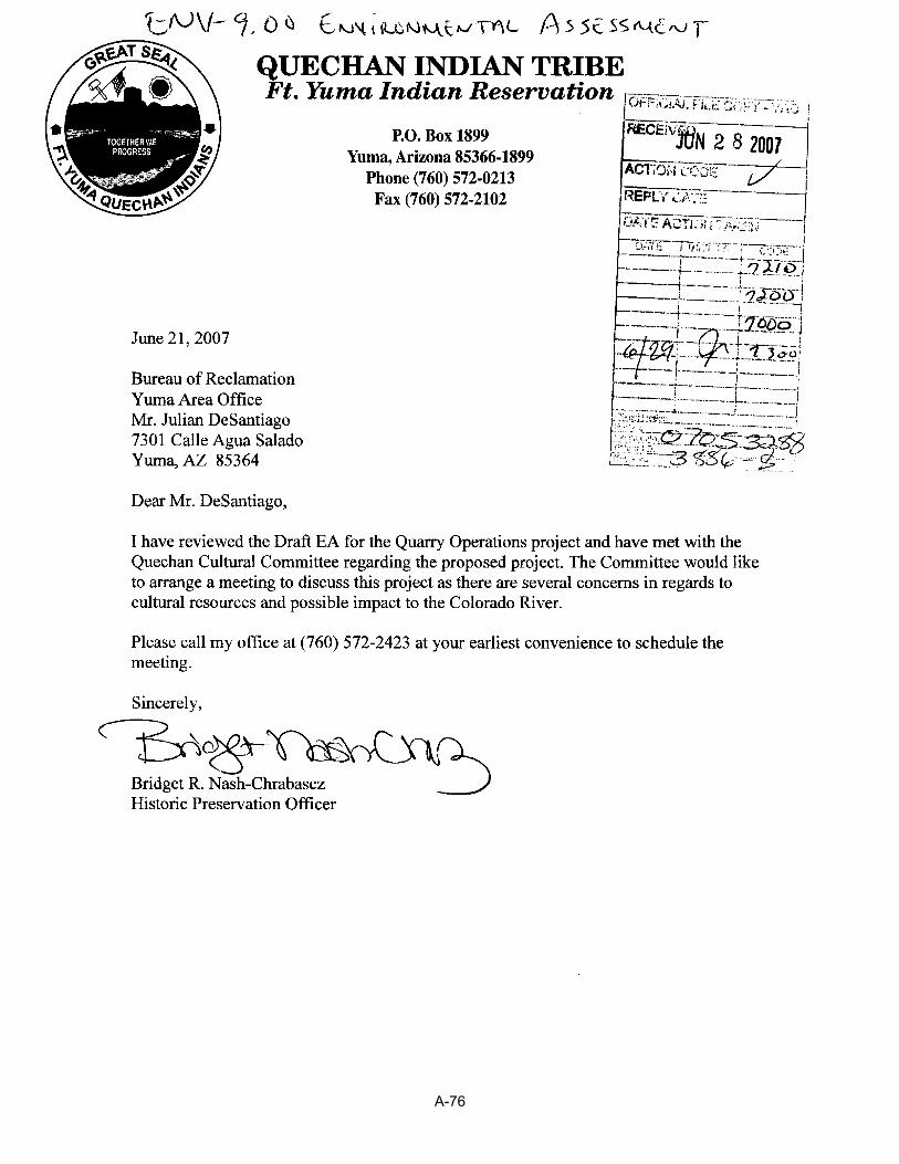
A-76
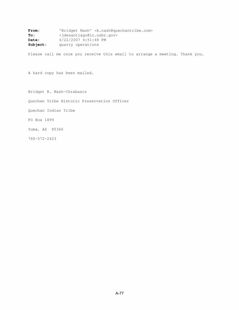
From: "Bridget Nash" <[email protected]> To: <[email protected]> Date: 6/22/2007 4:51:48 PM Subject: quarry operations Please call me once you receive this email to arrange a meeting. Thank you. A hard copy has been mailed. Bridget R. Nash-Chrabascz Quechan Tribe Historic Preservation Officer Quechan Indian Tribe PO Box 1899 Yuma, AZ 85366 760-572-2423
A-77

A-78
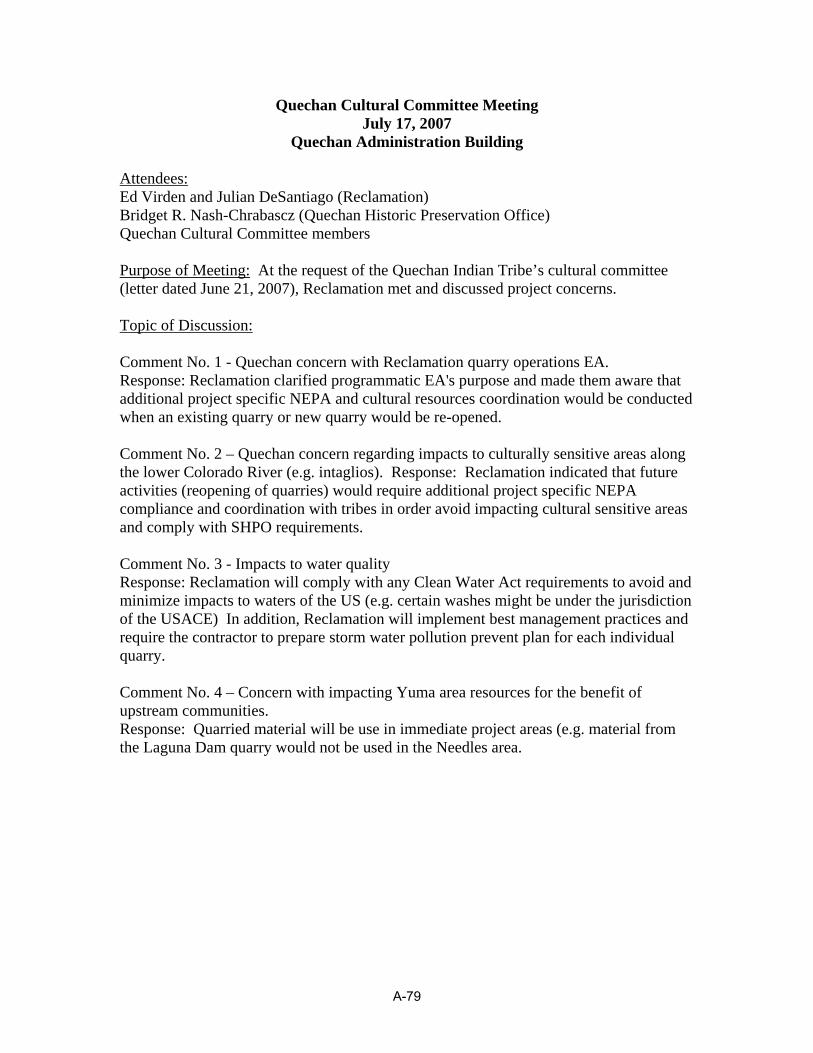
Quechan Cultural Committee Meeting July 17, 2007
Quechan Administration Building Attendees:Ed Virden and Julian DeSantiago (Reclamation) Bridget R. Nash-Chrabascz (Quechan Historic Preservation Office) Quechan Cultural Committee members Purpose of Meeting: At the request of the Quechan Indian Tribe’s cultural committee (letter dated June 21, 2007), Reclamation met and discussed project concerns. Topic of Discussion: Comment No. 1 - Quechan concern with Reclamation quarry operations EA. Response: Reclamation clarified programmatic EA's purpose and made them aware that additional project specific NEPA and cultural resources coordination would be conducted when an existing quarry or new quarry would be re-opened. Comment No. 2 – Quechan concern regarding impacts to culturally sensitive areas along the lower Colorado River (e.g. intaglios). Response: Reclamation indicated that future activities (reopening of quarries) would require additional project specific NEPA compliance and coordination with tribes in order avoid impacting cultural sensitive areas and comply with SHPO requirements. Comment No. 3 - Impacts to water quality Response: Reclamation will comply with any Clean Water Act requirements to avoid and minimize impacts to waters of the US (e.g. certain washes might be under the jurisdiction of the USACE) In addition, Reclamation will implement best management practices and require the contractor to prepare storm water pollution prevent plan for each individual quarry. Comment No. 4 – Concern with impacting Yuma area resources for the benefit of upstream communities. Response: Quarried material will be use in immediate project areas (e.g. material from the Laguna Dam quarry would not be used in the Needles area.
A-79
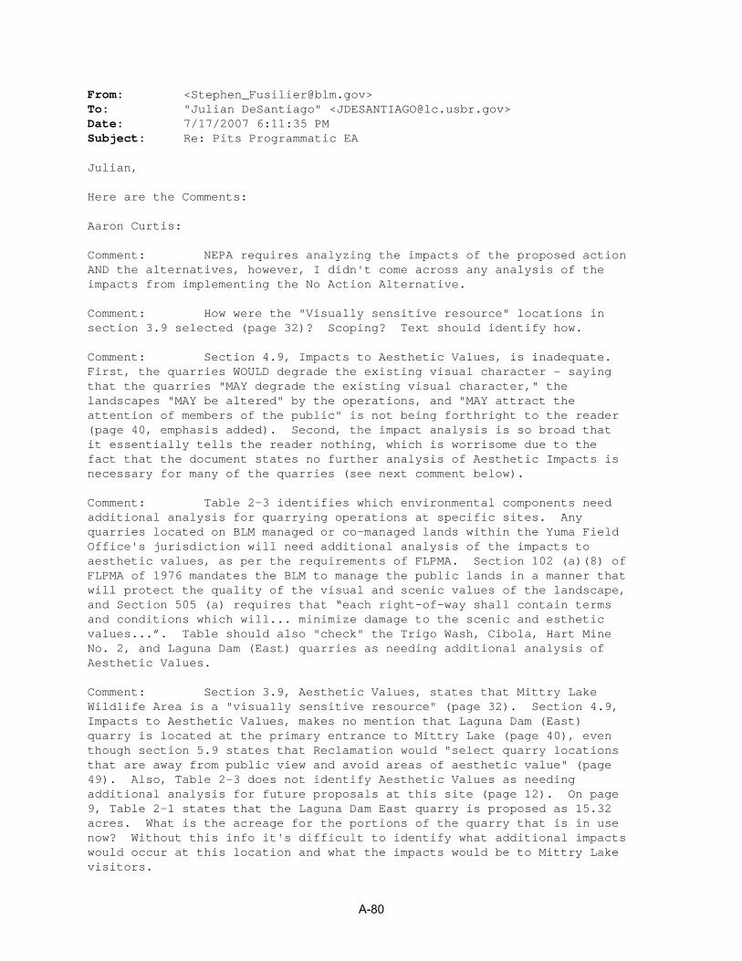
From: <[email protected]> To: "Julian DeSantiago" <[email protected]> Date: 7/17/2007 6:11:35 PM Subject: Re: Pits Programmatic EA Julian, Here are the Comments: Aaron Curtis: Comment: NEPA requires analyzing the impacts of the proposed action AND the alternatives, however, I didn't come across any analysis of the impacts from implementing the No Action Alternative. Comment: How were the "Visually sensitive resource" locations in section 3.9 selected (page 32)? Scoping? Text should identify how. Comment: Section 4.9, Impacts to Aesthetic Values, is inadequate. First, the quarries WOULD degrade the existing visual character - saying that the quarries "MAY degrade the existing visual character," the landscapes "MAY be altered" by the operations, and "MAY attract the attention of members of the public" is not being forthright to the reader (page 40, emphasis added). Second, the impact analysis is so broad that it essentially tells the reader nothing, which is worrisome due to the fact that the document states no further analysis of Aesthetic Impacts is necessary for many of the quarries (see next comment below). Comment: Table 2-3 identifies which environmental components need additional analysis for quarrying operations at specific sites. Any quarries located on BLM managed or co-managed lands within the Yuma Field Office's jurisdiction will need additional analysis of the impacts to aesthetic values, as per the requirements of FLPMA. Section 102 (a)(8) of FLPMA of 1976 mandates the BLM to manage the public lands in a manner that will protect the quality of the visual and scenic values of the landscape, and Section 505 (a) requires that “each right-of-way shall contain terms and conditions which will... minimize damage to the scenic and esthetic values...”. Table should also "check" the Trigo Wash, Cibola, Hart Mine No. 2, and Laguna Dam (East) quarries as needing additional analysis of Aesthetic Values. Comment: Section 3.9, Aesthetic Values, states that Mittry Lake Wildlife Area is a "visually sensitive resource" (page 32). Section 4.9, Impacts to Aesthetic Values, makes no mention that Laguna Dam (East) quarry is located at the primary entrance to Mittry Lake (page 40), even though section 5.9 states that Reclamation would "select quarry locations that are away from public view and avoid areas of aesthetic value" (page 49). Also, Table 2-3 does not identify Aesthetic Values as needing additional analysis for future proposals at this site (page 12). On page 9, Table 2-1 states that the Laguna Dam East quarry is proposed as 15.32 acres. What is the acreage for the portions of the quarry that is in use now? Without this info it's difficult to identify what additional impacts would occur at this location and what the impacts would be to Mittry Lake visitors.
A-80

Comment: Section 4.8, Impacts to Socioeconomic, makes no mention of potential impacts to tourism at the Yuma Field Office's Betty's Kitchen Watchable Wildlife Viewing Area and National Recreation Trail (page 40). Noise will definitely be heard from operations at the Laguna Dam (East quarry), which would degrade recreational experiences at this BLM recreation amenity fee site. Table 2-3 does not identify Noise from this quarry as needing any further analysis for this location. Jennifer Green: The main comment I have is that they should include discussion of invasive weeds. This seems to be missing from the EA. Quarries and stockpiles (disturbed areas) are often breeding grounds for invasive weeds. After the aggregate is transported from one place to another, so is weed seed. I have personally seen Brassica tournefortii in several rock quarries and gravel piles. Are there ways they could manage for these weeds so they are not transported from one area to another? This is one of our critical elements. Stephen Fusilier/Sandra Arnold: We had previously requested copies (for our archeologist's files) of the tribal and SHPO consultation documentation, and recommended that information on the consultation be incorporated into the EA (Chapters 3 and 4 cultural resources). We have not received any copies of the documentation. Section 5.5, Cultural, 4th Bullet - Change to say (at least for the pits in the Yuma Field Office) - Conduct additional cultural surveys to current standards and consultations with both the Tribes and SHPO, for existing quarries, as well as any proposed new proposed quarry areas. Section 5.5, Cultural, - Add a Sixth Bullet - Stipulations for archeological sensitivity training for material pit workers and for archaeological monitors during ground-disturbing activities would be incorporated into site-specific NEPA as appropriate. Stephen Fusilier: Table 2-3, page 12 - All sites in the Yuma Field Office would need to have Tribal Consultation due to specific concerns having been voiced to us by certain Tribes with regard to mineral material pits (so please add Cibola, Hart Mine 2, Palo Verde Road.) Table 2-3, page 12 - Need to add Ehrenberg to the list for Indian Trust Concerns since this pit is now on CRIT Reservation lands. CC: <[email protected]>, "Tracey Epperley" <[email protected]>
A-81

A-82

A-83

A-84
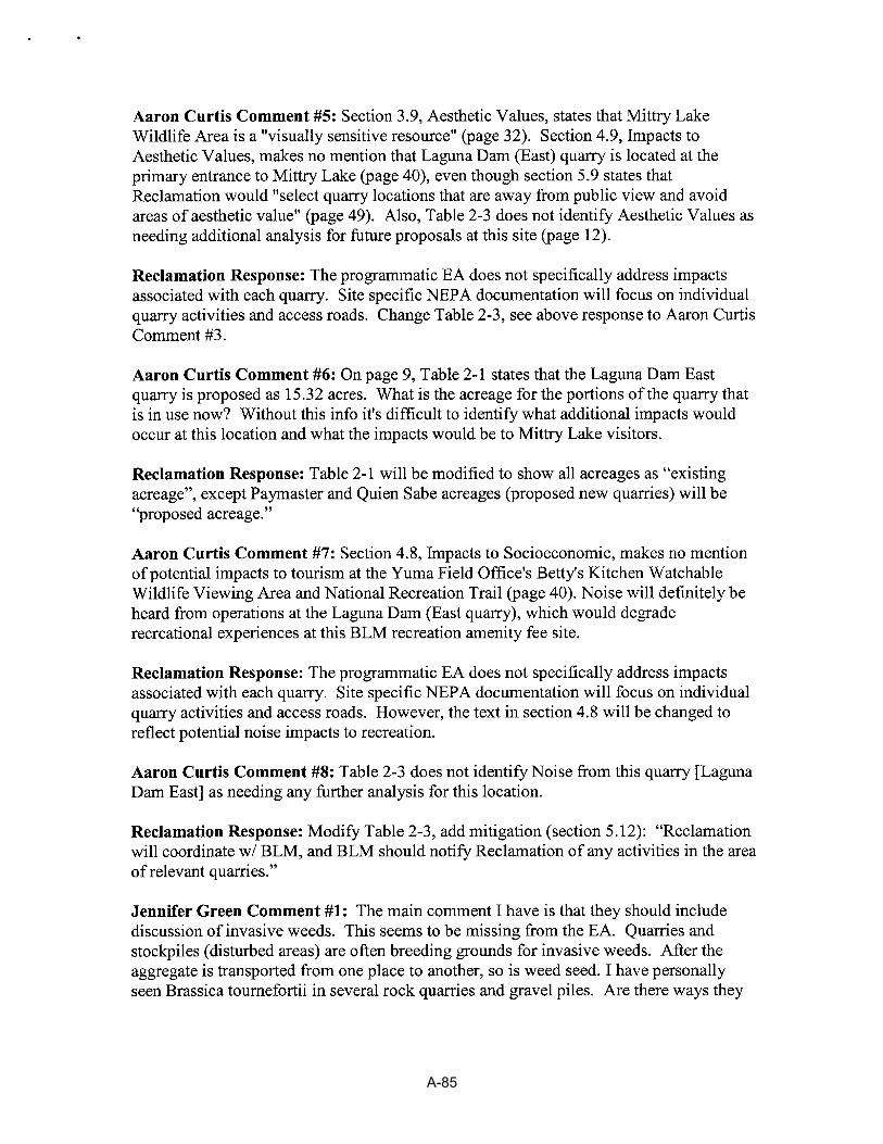
A-85

A-86
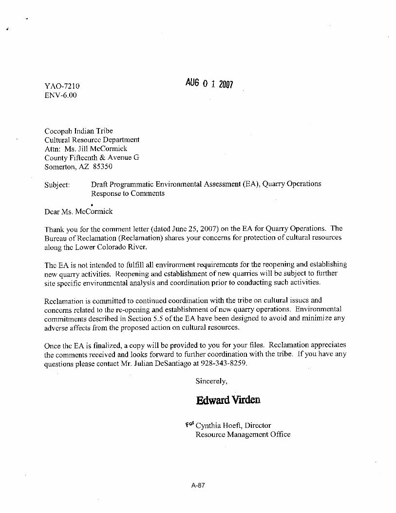
A-87

A-88

Map
Qu
arry
Lo
cati
on
-To
wn
ship
,L
oca
tio
nM
anag
ing
Fie
ldC
om
men
tsN
um
ber
Ran
ge
&S
ecti
on
Qu
adO
ffic
e
Lagu
naD
amE
ast
T.7
S.,
R.2
2W.,
Bur
eau
ofP
ublic
land
inA
rizon
aw
ithdr
awn
toth
e23
Lagu
naD
amR
ecla
mat
ion
Roa
dse
c.23
,14
(Yum
aF
O,A
Z)
BO
R.
Par
celi
spu
blic
land
.D
OQ
'ssh
ow
24P
ilot
Kno
bR
oad
T.
16S
.,R
.21
E.,
sec.
Yum
aW
est
EIC
entr
oF
O,C
Aco
nsid
erab
lesu
rfac
edi
stur
banc
ein
the'
27S
%an
dse
c.34
(all)
area
.In
dude
din
pend
ing
with
draw
alC
AC
A72
35fil
edby
BO
R.
A-51
A-52

A-53
A-54
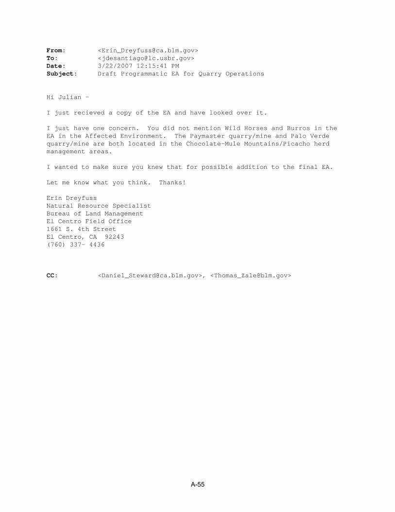
From: <[email protected]> To: <[email protected]> Date: 3/22/2007 12:15:41 PM Subject: Draft Programmatic EA for Quarry Operations Hi Julian - I just recieved a copy of the EA and have looked over it. I just have one concern. You did not mention Wild Horses and Burros in the EA in the Affected Environment. The Paymaster quarry/mine and Palo Verde quarry/mine are both located in the Chocolate-Mule Mountains/Picacho herd management areas. I wanted to make sure you knew that for possible addition to the final EA. Let me know what you think. Thanks! Erin Dreyfuss Natural Resource Specialist Bureau of Land Management El Centro Field Office 1661 S. 4th Street El Centro, CA 92243 (760) 337- 4436 CC: <[email protected]>, <[email protected]>
A-55

A-56
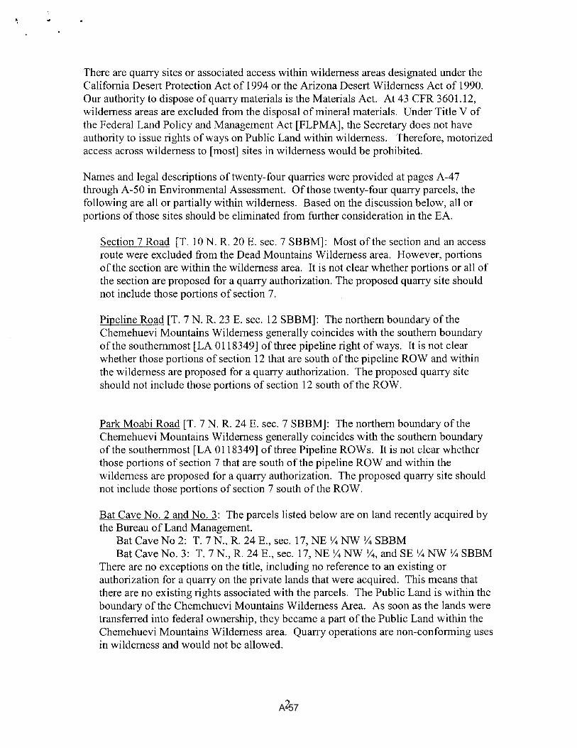
A-57

A-58

A-59

From: <[email protected]> To: "Julian DeSantiago" <[email protected]> Date: 4/16/2007 7:34:05 PM Subject: Re: Pits Programmatic EA Julian, Here are the comments for the Colorado River District (Yuma, Lake Havasu, and Kingman Field Offices) Kingman Field Office - No Comments Looks good for their area Lake Havasu Field Office - Amanda Dodson - pg.2, 38-39: Reclamation would still be required to obtain a ROW from BLM on reclamation withdrawn lands. pg. 5, 2: The BLM can issue Free Use Permits for a period of 10 years. Appendix B - provide maps of sufficient scale which shows the location of each quarry site and existing access roads and where it is located within the specific section(s) Yuma Field Office - Sandra Arnold - Request copies of the tribal consultation documentation, and recommend that information on the consultation be incorporated into the EA (Chapters 3 and 4 cultural resources). What input from tribes has been shared to date for specific pit locations? Request copies of documentation for coordination with AZ and CA SHPO. The Hart Mine is an historic site that could potentially be affected by two pit locations (Hart Mine No. 1 and No.2). Stephen Fusilier - Section 2.3, Page 8, Table-1 - On your list of Quarries in Appendix A page A-12 you list Pilot Knob Road - It is not listed on your map on page 3 as a site you are still considering nor is it listed in Table-1 as a Quarry Location Considered for programmatic Analysis but eliminated from further consideration - What is the Status of this site? Section 4.4.1, Page 34, Line 18 - The Following Quarry Sites seem to be closer to the LCR than the 5 or 10 miles mentioned - Bat Cave #1, Agnes Wilson, Quein Sabe, Palo Verde, Paymaster, and Laguna East. Section 4.4.1, Page 34, Lines 24 and 25 - The following quarries are either adjacent to or very close to potential riparian areas - Paymaster, Palo Verde, and Laguna East. Section 4.4.1, Page 34, Line 34 - Might want to revise the statements about the puma - I believe there is at least one resident and several transient mountain lions in the KOFA NWR. As state they have a wide range and the fact that there are deer, big horn sheep, and wild horses and burros the area to provide food might allow then to at least reach the area of the Hart #1 and Hart #2 quarries.
A-60

Section 4.12.2, Page 40, Line 16 - Just a typo? Should NRWs be NWRs. Stephen L. Fusilier 2555 E. Gila Ridge Road Yuma, AZ 85365 (928) 317-3296 (928) 317-3250 Fax "Julian DeSantiago" <[email protected]> 04/16/2007 10:20 AM To <[email protected]> cc "Tracey Epperley" <[email protected]> Subject Re: Pits Programmatic EA Hi Steve That will work, when you send comments electronically, please also cc Tracey Epperaly at [email protected] Thanks Julian >>> <[email protected]> 4/13/2007 5:54:19 PM >>> Julian, We have comments but due to the RMP schedule I was unable to complete the review and consolidation. I will have them to you by close of business on Monday 4/16 in email form with a hard copy to follow. Stephen L. Fusilier 2555 E. Gila Ridge Road Yuma, AZ 85365 (928) 317-3296 (928) 317-3250 Fax CC: "Tracey Epperley" <[email protected]>, <[email protected]>, <[email protected]>, <[email protected]>, <[email protected]>, <[email protected]>, <[email protected]>, <[email protected]>
A-61

From: <[email protected]> To: "Julian DeSantiago" <[email protected]> Date: 4/16/2007 7:34:05 PM Subject: Re: Pits Programmatic EA Julian, Here are the comments for the Colorado River District (Yuma, Lake Havasu, and Kingman Field Offices) Kingman Field Office - No Comments Looks good for their area Lake Havasu Field Office - Amanda Dodson - pg.2, 38-39: Reclamation would still be required to obtain a ROW from BLM on reclamation withdrawn lands. pg. 5, 2: The BLM can issue Free Use Permits for a period of 10 years. Appendix B - provide maps of sufficient scale which shows the location of each quarry site and existing access roads and where it is located within the specific section(s) Yuma Field Office - Sandra Arnold - Request copies of the tribal consultation documentation, and recommend that information on the consultation be incorporated into the EA (Chapters 3 and 4 cultural resources). What input from tribes has been shared to date for specific pit locations? Request copies of documentation for coordination with AZ and CA SHPO. The Hart Mine is an historic site that could potentially be affected by two pit locations (Hart Mine No. 1 and No.2). Stephen Fusilier - Section 2.3, Page 8, Table-1 - On your list of Quarries in Appendix A page A-12 you list Pilot Knob Road - It is not listed on your map on page 3 as a site you are still considering nor is it listed in Table-1 as a Quarry Location Considered for programmatic Analysis but eliminated from further consideration - What is the Status of this site? Section 4.4.1, Page 34, Line 18 - The Following Quarry Sites seem to be closer to the LCR than the 5 or 10 miles mentioned - Bat Cave #1, Agnes Wilson, Quein Sabe, Palo Verde, Paymaster, and Laguna East. Section 4.4.1, Page 34, Lines 24 and 25 - The following quarries are either adjacent to or very close to potential riparian areas - Paymaster, Palo Verde, and Laguna East. Section 4.4.1, Page 34, Line 34 - Might want to revise the statements about the puma - I believe there is at least one resident and several transient mountain lions in the KOFA NWR. As state they have a wide range and the fact that there are deer, big horn sheep, and wild horses and burros the area to provide food might allow then to at least reach the area of the Hart #1 and Hart #2 quarries.
A-62

Section 4.12.2, Page 40, Line 16 - Just a typo? Should NRWs be NWRs. Stephen L. Fusilier 2555 E. Gila Ridge Road Yuma, AZ 85365 (928) 317-3296 (928) 317-3250 Fax "Julian DeSantiago" <[email protected]> 04/16/2007 10:20 AM To <[email protected]> cc "Tracey Epperley" <[email protected]> Subject Re: Pits Programmatic EA Hi Steve That will work, when you send comments electronically, please also cc Tracey Epperaly at [email protected] Thanks Julian >>> <[email protected]> 4/13/2007 5:54:19 PM >>> Julian, We have comments but due to the RMP schedule I was unable to complete the review and consolidation. I will have them to you by close of business on Monday 4/16 in email form with a hard copy to follow. Stephen L. Fusilier 2555 E. Gila Ridge Road Yuma, AZ 85365 (928) 317-3296 (928) 317-3250 Fax CC: "Tracey Epperley" <[email protected]>, <[email protected]>, <[email protected]>, <[email protected]>, <[email protected]>, <[email protected]>, <[email protected]>, <[email protected]>
A-63

A-64
A-65

A-66
A-67
A-68

A-69

A-70
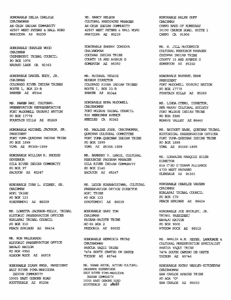
A-71
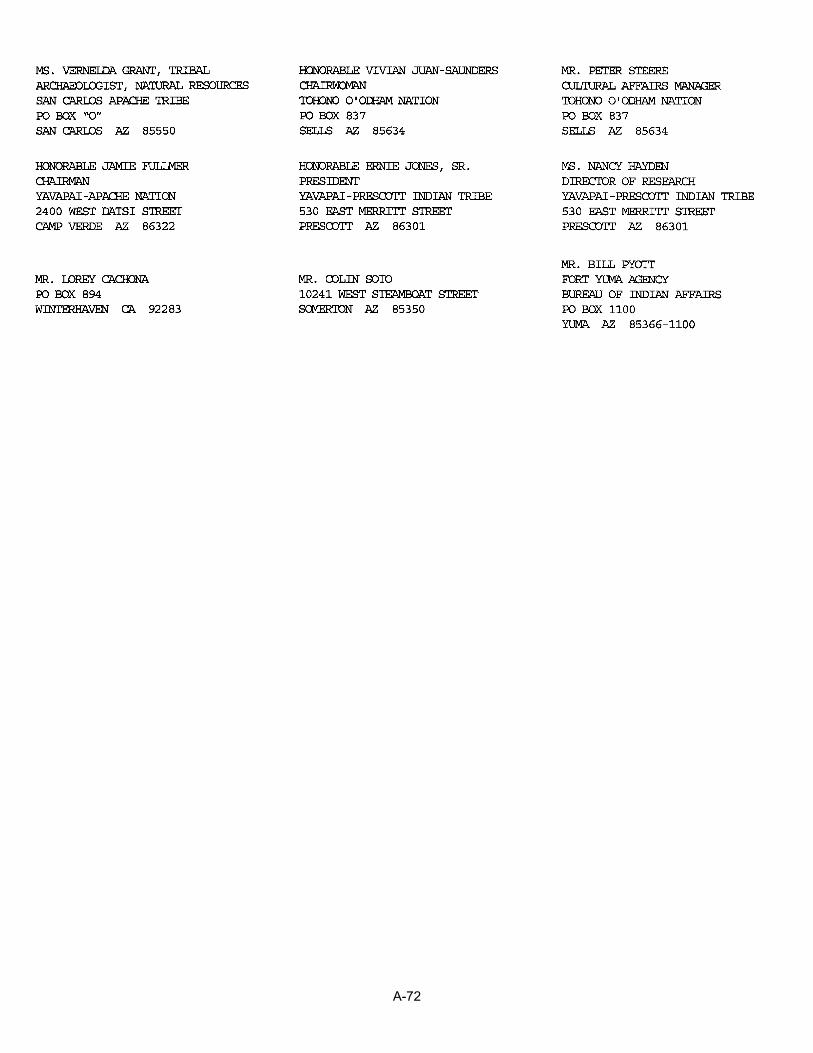
A-72

A-73
A-74

A-75

A-76

From: "Bridget Nash" <[email protected]> To: <[email protected]> Date: 6/22/2007 4:51:48 PM Subject: quarry operations Please call me once you receive this email to arrange a meeting. Thank you. A hard copy has been mailed. Bridget R. Nash-Chrabascz Quechan Tribe Historic Preservation Officer Quechan Indian Tribe PO Box 1899 Yuma, AZ 85366 760-572-2423
A-77

A-78

Quechan Cultural Committee Meeting July 17, 2007
Quechan Administration Building Attendees:Ed Virden and Julian DeSantiago (Reclamation) Bridget R. Nash-Chrabascz (Quechan Historic Preservation Office) Quechan Cultural Committee members Purpose of Meeting: At the request of the Quechan Indian Tribe’s cultural committee (letter dated June 21, 2007), Reclamation met and discussed project concerns. Topic of Discussion: Comment No. 1 - Quechan concern with Reclamation quarry operations EA. Response: Reclamation clarified programmatic EA's purpose and made them aware that additional project specific NEPA and cultural resources coordination would be conducted when an existing quarry or new quarry would be re-opened. Comment No. 2 – Quechan concern regarding impacts to culturally sensitive areas along the lower Colorado River (e.g. intaglios). Response: Reclamation indicated that future activities (reopening of quarries) would require additional project specific NEPA compliance and coordination with tribes in order avoid impacting cultural sensitive areas and comply with SHPO requirements. Comment No. 3 - Impacts to water quality Response: Reclamation will comply with any Clean Water Act requirements to avoid and minimize impacts to waters of the US (e.g. certain washes might be under the jurisdiction of the USACE) In addition, Reclamation will implement best management practices and require the contractor to prepare storm water pollution prevent plan for each individual quarry. Comment No. 4 – Concern with impacting Yuma area resources for the benefit of upstream communities. Response: Quarried material will be use in immediate project areas (e.g. material from the Laguna Dam quarry would not be used in the Needles area.
A-79

From: <[email protected]> To: "Julian DeSantiago" <[email protected]> Date: 7/17/2007 6:11:35 PM Subject: Re: Pits Programmatic EA Julian, Here are the Comments: Aaron Curtis: Comment: NEPA requires analyzing the impacts of the proposed action AND the alternatives, however, I didn't come across any analysis of the impacts from implementing the No Action Alternative. Comment: How were the "Visually sensitive resource" locations in section 3.9 selected (page 32)? Scoping? Text should identify how. Comment: Section 4.9, Impacts to Aesthetic Values, is inadequate. First, the quarries WOULD degrade the existing visual character - saying that the quarries "MAY degrade the existing visual character," the landscapes "MAY be altered" by the operations, and "MAY attract the attention of members of the public" is not being forthright to the reader (page 40, emphasis added). Second, the impact analysis is so broad that it essentially tells the reader nothing, which is worrisome due to the fact that the document states no further analysis of Aesthetic Impacts is necessary for many of the quarries (see next comment below). Comment: Table 2-3 identifies which environmental components need additional analysis for quarrying operations at specific sites. Any quarries located on BLM managed or co-managed lands within the Yuma Field Office's jurisdiction will need additional analysis of the impacts to aesthetic values, as per the requirements of FLPMA. Section 102 (a)(8) of FLPMA of 1976 mandates the BLM to manage the public lands in a manner that will protect the quality of the visual and scenic values of the landscape, and Section 505 (a) requires that “each right-of-way shall contain terms and conditions which will... minimize damage to the scenic and esthetic values...”. Table should also "check" the Trigo Wash, Cibola, Hart Mine No. 2, and Laguna Dam (East) quarries as needing additional analysis of Aesthetic Values. Comment: Section 3.9, Aesthetic Values, states that Mittry Lake Wildlife Area is a "visually sensitive resource" (page 32). Section 4.9, Impacts to Aesthetic Values, makes no mention that Laguna Dam (East) quarry is located at the primary entrance to Mittry Lake (page 40), even though section 5.9 states that Reclamation would "select quarry locations that are away from public view and avoid areas of aesthetic value" (page 49). Also, Table 2-3 does not identify Aesthetic Values as needing additional analysis for future proposals at this site (page 12). On page 9, Table 2-1 states that the Laguna Dam East quarry is proposed as 15.32 acres. What is the acreage for the portions of the quarry that is in use now? Without this info it's difficult to identify what additional impacts would occur at this location and what the impacts would be to Mittry Lake visitors.
A-80

Comment: Section 4.8, Impacts to Socioeconomic, makes no mention of potential impacts to tourism at the Yuma Field Office's Betty's Kitchen Watchable Wildlife Viewing Area and National Recreation Trail (page 40). Noise will definitely be heard from operations at the Laguna Dam (East quarry), which would degrade recreational experiences at this BLM recreation amenity fee site. Table 2-3 does not identify Noise from this quarry as needing any further analysis for this location. Jennifer Green: The main comment I have is that they should include discussion of invasive weeds. This seems to be missing from the EA. Quarries and stockpiles (disturbed areas) are often breeding grounds for invasive weeds. After the aggregate is transported from one place to another, so is weed seed. I have personally seen Brassica tournefortii in several rock quarries and gravel piles. Are there ways they could manage for these weeds so they are not transported from one area to another? This is one of our critical elements. Stephen Fusilier/Sandra Arnold: We had previously requested copies (for our archeologist's files) of the tribal and SHPO consultation documentation, and recommended that information on the consultation be incorporated into the EA (Chapters 3 and 4 cultural resources). We have not received any copies of the documentation. Section 5.5, Cultural, 4th Bullet - Change to say (at least for the pits in the Yuma Field Office) - Conduct additional cultural surveys to current standards and consultations with both the Tribes and SHPO, for existing quarries, as well as any proposed new proposed quarry areas. Section 5.5, Cultural, - Add a Sixth Bullet - Stipulations for archeological sensitivity training for material pit workers and for archaeological monitors during ground-disturbing activities would be incorporated into site-specific NEPA as appropriate. Stephen Fusilier: Table 2-3, page 12 - All sites in the Yuma Field Office would need to have Tribal Consultation due to specific concerns having been voiced to us by certain Tribes with regard to mineral material pits (so please add Cibola, Hart Mine 2, Palo Verde Road.) Table 2-3, page 12 - Need to add Ehrenberg to the list for Indian Trust Concerns since this pit is now on CRIT Reservation lands. CC: <[email protected]>, "Tracey Epperley" <[email protected]>
A-81

A-82

A-83

A-84

A-85
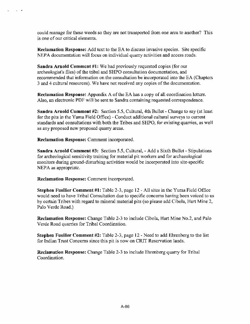
A-86

A-87
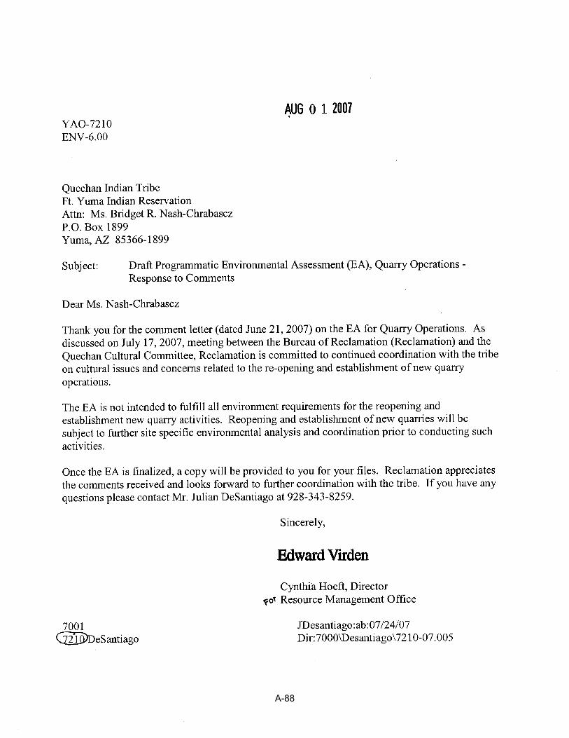
A-88