Appendix A Project Location Maps - Tennessee · Appendix A Project Location Maps. I-40 ... John...
79
D-List Categorical Exclusion I-40 at SR-222 (Exit 42) Fayette County TDOT PIN 114219.00 Appendix A Project Location Maps
-
Upload
nguyenthien -
Category
Documents
-
view
221 -
download
0
Transcript of Appendix A Project Location Maps - Tennessee · Appendix A Project Location Maps. I-40 ... John...

D-List Categorical ExclusionI-40 at SR-222 (Exit 42)Fayette CountyTDOT PIN 114219.00
Appendix A
Project Location Maps

I-40 (EXIT 42) AT SR-222(STANTON SUMMERVILLE ROAD)
PIN 114219.00
TIPTON COUNTYFAYETTE COUNTY
HAYWOOD COUNTY
BradenBraden
MasonMason
StantonStanton
Hickory WitheHickory Withe
40
70
79
222
59
194
179
Fayette County, Tennessee
PROJECT LOCATION MAP

D-List Categorical ExclusionI-40 at SR-222 (Exit 42)Fayette CountyTDOT PIN 114219.00
Project Location MapAdjacent Exits and Proposed Area of Future Megasite
D-List Categorical ExclusionI-40 at SR-222 (Exit 42)Fayette CountyTDOT PIN 114219.00
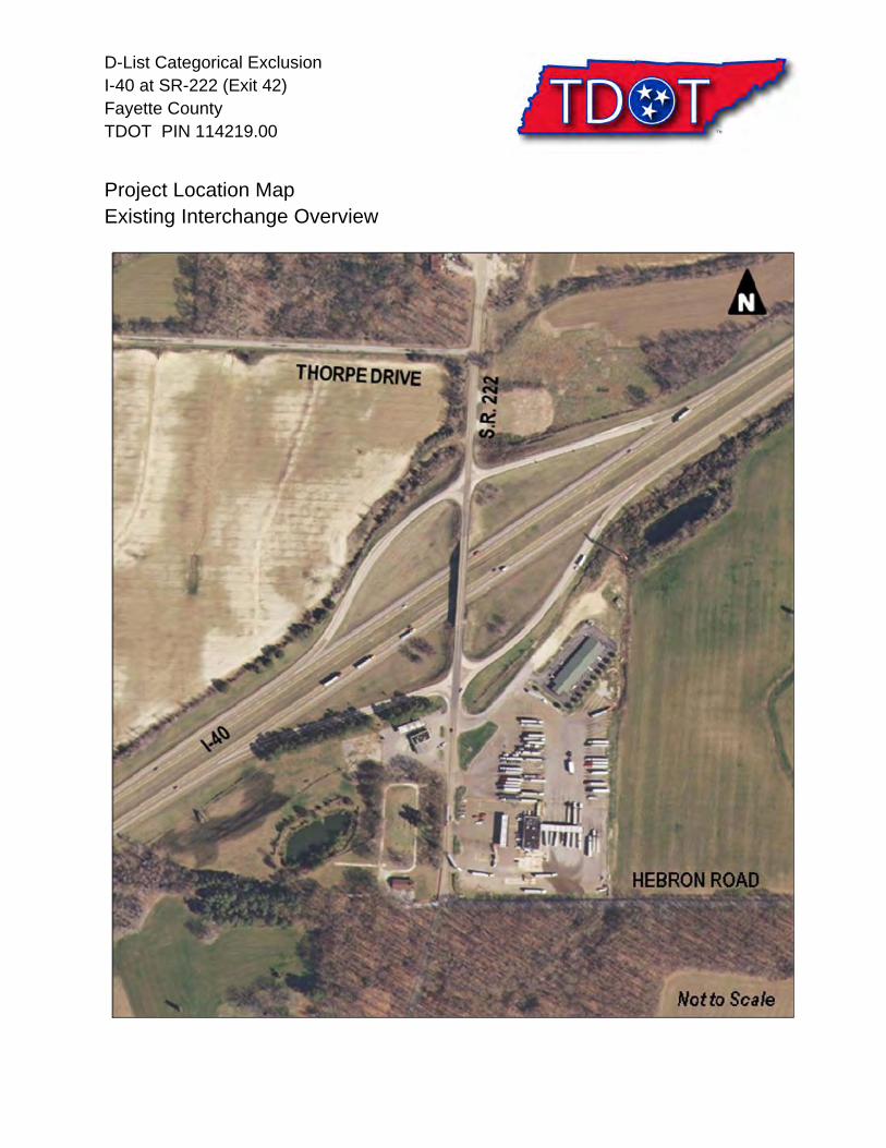
Project Location MapExisting Interchange Overview

D-List Categorical ExclusionI-40 at SR-222 (Exit 42)Fayette CountyTDOT PIN 114219.00
Appendix B
Approved Alternative 5


D-List Categorical ExclusionI-40 at SR-222 (Exit 42)Fayette CountyTDOT PIN 114219.00
Appendix C
State Transportation Improvement Program (STIP)TDOT Proposed Comprehensive Multimodal Program (TIP)

TENNESSEE DEPARTMENT OF TRANSPORTATION
GERALD NICELY, COMMISSIONER
S T I P STATE TRANSPORTATION IMPROVEMENT PROGRAM
PRODUCED BY
TENNESSEE DEPARTMENT OF TRANSPORTATION
PROGRAM DEVELOPMENT AND ADMINISTRATION DIVISION
JIM MOORE, DIRECTOR
OCTOBER 2010
THIS DOCUMENT CAN BE ACCESSED VIA TDOT’S WEBSITE AT www.TDOT.STATE.TN.US/
STIP Page 3 of 165

TENNESSEE DEPARTMENT OF TRANSPORTATION FY 2011 THRU FY 2014
TRANSPORTATION IMPROVEMENT PROGRAM TITLE 23 U.S.C., SECTIONS 105 & 135
COUNTY:
ROUTE:
TERMINI :
LENGTH IN MILES
FAYETTE
INTERCHANGE @ SR-222 I-40
24000STIP # LEAD AGENCY TDOT TOTAL PROJECT COST $10,000,000
TDOT PIN 114219.00
PROJECT DESCRIPTION: MODIFY INTERCHANGE
REMARKS
FISCAL YEAR TYPE OF WORK FUNDING TYPE TOTAL FUNDS FED FUNDS STATE FUNDS LOCAL FUNDS
2011 PE-N IM 175,000 157,500 17,500
2011 PE-D IM 325,000 292,500 32,500
24010 TDOT STIP # TDOT PIN LENGTH IN MILES LEAD AGENCY
FAYETTE $90,900,000 COUNTY: TOTAL PROJECT COST
ROUTE:
TERMINI : MEMPHIS REGIONAL INTERMODAL FACILITY CONSTRUCT INTERMODAL FACILITY FOR NORFOLK SOUTHERN RAILROAD. PROJECT DESCRIPTION:
THIS IS THE RURAL PORTION OF THIS PROJECT. THE REMAINDER OF THE PROJECT IS CONTAINED IN THE MEMPHIS TIP AS PROJECT NUMBER TN-C REMARKS
FISCAL YEAR TYPE OF WORK FUNDING TYPE TOTAL FUNDS FED FUNDS STATE FUNDS LOCAL FUNDS
ARRA/TIGER 52,500,000 38,400,000 2011 CONST 90,900,000
STIP Page 51 of 165ALL SCHEDULES SUBJECT TO AVAILABILITY OF FUNDS Page 17 of 85
afarless
Oval

TENNESSEE DEPARTMENT OF TRANSPORTATION
PROPOSED FISCAL YEARS 2012 -14 TIP PROPOSED COMPREHENSIVE MUlTIMODAl PROGRAM
APRil 28, 2011
County Route Description length Type of Work
Dickson- Nashville SmartWay Remole Travel Time Assessment for SR-840 0.0 Construction Hickman-Rutherford-Williamson-Wilson Fayette 1-40 Interchange at SR-196 (Hickory Withe Road) 0.0 Right-ol-Way
Fayette 1-40 Interchange @SR-222 0.0 Right-ol-Way
Fayette SR-76 Bridges over Overflow, lM 0.55 & North Folk Woll River, lM 0.74 0.0 Bridge
Fentress SR-28 From SR-62 at Clarkrange to North 01 South Franklin loop Road 2.8 Preliminary Engineering
US-127
Hamblen- SR-66REl SR-160 in Morristown to Interstate 81 @SR-341 5.0 Stage Construction Jefferson
Hamilton 1-75 Chattanooga SmartWay ITS Expansion 12.0 Preliminary Engineering
Bradley
Hamilton 1-124 North 01 1-24 to South 01 Tennessee River Bridge (Additional lanes) 1.5 Construction
US-27 Hamilton SR-29 Olgiati Bridge over Tennessee River (Widening) 0.0 Construction
US-27
Hamilton SR-29 North 01 Tennessee River Bridge to SR-8 (US-127) (Additional lanes) 1.6 Construction
US-27
Hamilton SR-317 (Apison Pike); Intersection at Old lee Hwy to SR-321 2.2 Right-ol-Way Construction
Hancock SR-70 Bridge over Clinch River, lM 1.65 0.0 Bridge
FY-12 FY-13 FY-14
CN
RW
RW
CN
PE
CN
PE
CN
CN
CN
RW
CN
CN
Page 4

D-List Categorical ExclusionI-40 at SR-222 (Exit 42)Fayette CountyTDOT PIN 114219.00
Appendix D
Related Area Projects


D-List Categorical ExclusionI-40 at SR-222 (Exit 42)Fayette CountyTDOT PIN 114219.00
Appendix E
Area Photos

I-40 & SR-222 (Exit 42)Fayette County, TennesseePIN 114219.00
Area Photos
Northbound on SR-222
Southbound on SR-222

I-40 & SR-222 (Exit 42)Fayette County, TennesseePIN 114219.00
Area Photos
Abandoned Service Station and USTs – Northeast Quadrant of I-40 & SR-222 Interchange
Pilot Travel Center – Southeast Quadrant of I-40 & SR-222 Interchange
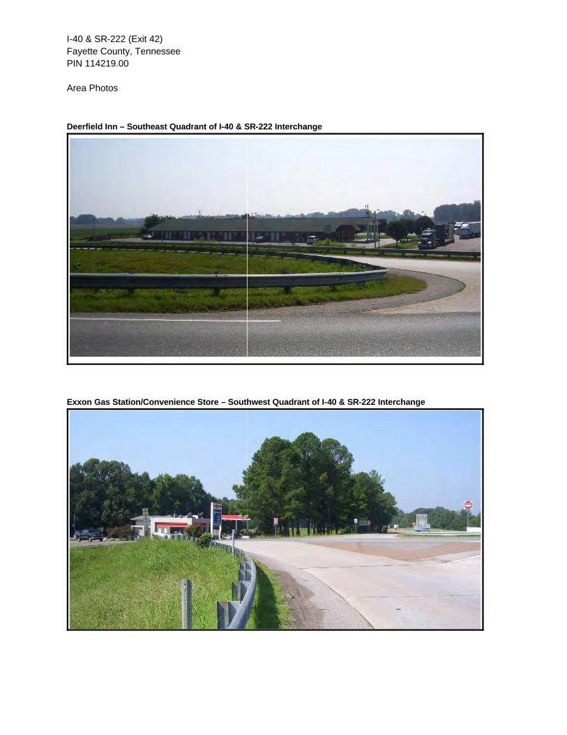
I-40 & SR-222 (Exit 42)Fayette County, TennesseePIN 114219.00
Area Photos
Deerfield Inn – Southeast Quadrant of I-40 & SR-222 Interchange
Exxon Gas Station/Convenience Store – Southwest Quadrant of I-40 & SR-222 Interchange

I-40 & SR-222 (Exit 42)Fayette County, TennesseePIN 114219.00
Area Photos
Bethlehem Hebron Chapel Church – Southwest Quadrant of I-40 & SR-222 Interchange

D-List Categorical ExclusionI-40 at SR-222 (Exit 42)Fayette CountyTDOT PIN 114219.00
Appendix F
Ecology

STATE OF TENNESSEE
DEPARTMENT OF TRANSPORTATION ENVIRONMENTAL DIVISION
SUITE 900, JAMES K. POLK BUILDING 505 DEADERICK STREET
NASHVILLE, TENNESSEE 37243-0334
MEMORANDUM To:
Lia Obaid Design Division
From:
Matt Richards Environmental Division
Date:
March 28, 2012
Subject: ENVIRONMENTAL BOUNDARIES AND MITIGATION DESIGN FOR: Fayette County, Interstate 40 Interchange at State Route 222 P.E. 24001-0147-44 PIN 114219.00
An ecological evaluation of the subject project has been conducted with the following results: X_Wetlands present: Three wetland areas are present within the project limits. Refer to attachments for locations and potential mitigation. __ No wetlands identified X Streams are present: One stream is present within the project limits. Refer to attachments for locations and potential mitigation. __No streams present in project impact area __Protected species present: X No protected species identified in project impact area __ Special haul road provisions needed: THE FOLLOWING ITEMS ARE ATTACHED FOR YOUR USE:
X
Environmental Boundaries
Mitigation Design Sketches
Narrative Mitigation Plan
Other : Marked present layout sheet

Fayette County, Interstate 40 Interchange at State Route 222 Page 2. Your assistance is appreciated. If you have any questions or comments, please contact Matt Richards in the Environmental Division at 615-532-3880 or [email protected]. xc: Jennifer Lloyd w/ attachments
Shane Hester w/ attachments Freddy Miller w/ attachments John Hewitt w/ attachments Joe Matlock w/ attachments Michael Horlacher w/ attachments Construction Rep. w/ attachments Jon Zirkle w/ attachments Project File
Reading File
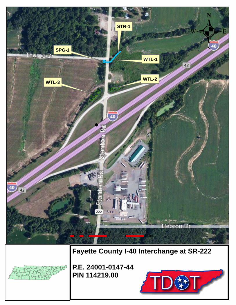
WTL-3 WTL-2
WTL-1
STR-1
SPG-1
Fayette County I-40 Interchange at SR-222
P.E. 24001-0147-44PIN 114219.00
.
0 0.04 0.08 0.12 0.160.02Miles

Ecology Field Data Sheet: Water Resources
Project: Fayette County, I-40 at SR-222 P.E. 24001-0147-44 PIN 114219.00 Date of survey: 3/22/2012 Biologist: Matt Richards Affiliation: TDOT
1-Station: from plans None provided 2-Map label and name STR-1 3-Latitude/Longitude 89 24’41.27”W 35 23’40.18”N 4-Potential impact Crossing 5-Feature description: what is it Intermittent stream blue-line on topo? (y/n) No defined channel (y/n) Yes straight or meandering Straight channel bottom width 1’ top of bank width 6’ bank height and slope ratio 3’ avg. gradient of stream (%) substratum Soil, leaves riffle/run/pool 20/0/80 width of buffer zone LB: 7’ RB: 7’ water flow Slight water depth 2”-1’ water width 1’ general water quality Clear, flowing OHWM indicators Bed and bank, vegetation absent, deposition groundwater connection Yes bank stability: LB, RB Eroding dominant species: LB, RB
Black willow, box elder, honeysuckle
overhead canopy (%) 85%
benthos
No
fish No algae or other aquatic life Algae habitat assessment score photo number (s) 1 Looking D/S from farm road crossing; 2 looking U/S from farm road crossing rainfall information 4.69” in previous two weeks
6- HUC code & name (12-digit) 080102080402, Big Muddy Creek, Lower
7-Confirmed by: Unnecessary 8-Mitigation No_____ Yes_____ : (include on Form J)
9-ETW No__X___ Yes_____
10-303 (d) List
No __X___ Yes_____: Habitat_____ Siltation_____
11-Notes Estimate size (acres) of lake or pond if applicable; provide any pertinent information needed to better describe feature; indicate if hydrologic determination form completed
Hydrology supplied by SPG-1.
Form G

2
1-Station: from plans None provided 2-Map label and name SPG-1 3-Latitude/Longitude 89 24’42.28”W 35 23’40.22”N 4-Potential impact Unknown 5-Feature description: what is it Spring blue-line on topo? (y/n) No defined channel (y/n) No straight or meandering n/a channel bottom width n/a top of bank width n/a bank height and slope ratio n/a avg. gradient of stream (%) n/a substratum Soil riffle/run/pool n/a width of buffer zone LB: 0’ RB:0’ water flow Slight water depth 1’ water width 4’ general water quality Muddy OHWM indicators n/a groundwater connection Yes bank stability: LB, RB Eroding dominant species: LB, RB
Honeysuckle, sycamore, boxelder
overhead canopy (%) 3%
benthos
No
fish No algae or other aquatic life Frogs habitat assessment score photo number (s) 3 looking SW rainfall information 4.69” in previous two weeks
6- HUC code & name (12-digit) 080102080402, Big Muddy Creek, Lower
7-Confirmed by: Unnecessary 8-Mitigation No_____ Yes_____ : (include on Form J)
9-ETW No__X___ Yes_____
10-303 (d) List
No __X___ Yes_____: Habitat_____ Siltation_____
11-Notes Estimate size (acres) of lake or pond if applicable; provide any pertinent information needed to better describe feature; indicate if hydrologic determination form completed
Unknown if proposed spur road will impact SPG-1, a spring box will be required if so. SPG-1 is the hydrology source for STR-1 and WTL-1.

US Army Corps of Engineers Atlantic and Gulf Coastal Plain Region – Interim Version
WETLAND DETERMINATION DATA FORM – Atlantic and Gulf Coastal Plain Region
Project/Site: City/County: Sampling Date:
Applicant/Owner: State: Sampling Point:
Investigator(s): Section, Township, Range:
Landform (hillslope, terrace, etc.): Local relief (concave, convex, none): Slope (%):
Subregion (LRR or MLRA): Lat: Long: Datum:
Soil Map Unit Name: NWI classification:
Are climatic / hydrologic conditions on the site typical for this time of year? Yes No (If no, explain in Remarks.)
Are Vegetation , Soil , or Hydrology significantly disturbed? Are “Normal Circumstances” present? Yes No
Are Vegetation , Soil , or Hydrology naturally problematic? (If needed, explain any answers in Remarks.)
SUMMARY OF FINDINGS – Attach site map showing sampling point locations, transects, important features, etc.
Hydrophytic Vegetation Present? Yes No Hydric Soil Present? Yes No Wetland Hydrology Present? Yes No
Is the Sampled Area within a Wetland? Yes No
Remarks:
HYDROLOGY Wetland Hydrology Indicators: Secondary Indicators (minimum of two required)Primary Indicators (minimum of one is required; check all that apply) Surface Soil Cracks (B6)
Surface Water (A1) Water-Stained Leaves (B9) Sparsely Vegetated Concave Surface (B8) High Water Table (A2) Aquatic Fauna (B13) Drainage Patterns (B10) Saturation (A3) Marl Deposits (B15) (LRR U) Moss Trim Lines (B16) Water Marks (B1) Hydrogen Sulfide Odor (C1) Dry-Season Water Table (C2) Sediment Deposits (B2) Oxidized Rhizospheres on Living Roots (C3) Crayfish Burrows (C8) Drift Deposits (B3) Presence of Reduced Iron (C4) Saturation Visible on Aerial Imagery (C9) Algal Mat or Crust (B4) Recent Iron Reduction in Tilled Soils (C6) Geomorphic Position (D2) Iron Deposits (B5) Thin Muck Surface (C7) Shallow Aquitard (D3) Inundation Visible on Aerial Imagery (B7) Other (Explain in Remarks) FAC-Neutral Test (D5)
Field Observations: Surface Water Present? Yes No Depth (inches): Water Table Present? Yes No Depth (inches): Saturation Present? Yes No Depth (inches): (includes capillary fringe)
Wetland Hydrology Present? Yes No
Describe Recorded Data (stream gauge, monitoring well, aerial photos, previous inspections), if available:
Remarks:
I-40 at SR-222, PIN 114219.00 Fayette 3/22/2012
TDOT TN WTL-1
Matt Richards
Depression Convex
✔
✔
✔
✔✔
✔
✔✔✔✔
✔
✔✔ ✔
✔
SPG-1 to west is hydrology source for WTL-1 and STR-1
✔
✔
✔1-6
0 ✔

US Army Corps of Engineers Atlantic and Gulf Coastal Plain Region – Interim Version
VEGETATION – Use scientific names of plants. Sampling Point:
Dominance Test worksheet: Number of Dominant Species That Are OBL, FACW, or FAC: (A)
Total Number of Dominant Species Across All Strata: (B)
Percent of Dominant Species That Are OBL, FACW, or FAC: (A/B)
Prevalence Index worksheet: Total % Cover of: Multiply by: OBL species x 1 = FACW species x 2 = FAC species x 3 = FACU species x 4 = UPL species x 5 = Column Totals: (A) (B)
Prevalence Index = B/A = Hydrophytic Vegetation Indicators:
Dominance Test is >50% Prevalence Index is 3.01
Problematic Hydrophytic Vegetation1 (Explain)
1Indicators of hydric soil and wetland hydrology must be present.
Absolute Dominant Indicator Tree Stratum (Plot sizes: ) % Cover Species? Status1. 2. 3. 4. 5. 6. 7.
= Total Cover Sapling Stratum ( ) 1. 2. 3. 4. 5. 6. 7.
= Total Cover Shrub Stratum ( ) 1. 2. 3. 4. 5. 6. 7.
= Total Cover Herb Stratum ( ) 1. 2. 3. 4. 5. 6. 7. 8. 9. 10. 11. 12.
= Total Cover Woody Vine Stratum ( ) 1. 2. 3. 4. 5.
= Total Cover
Hydrophytic Vegetation Present? Yes No
Remarks: (If observed, list morphological adaptations below).
Definitions of Vegetation Strata:
Tree – Woody plants, excluding woody vines, approximately 20 ft (6 m) or more in height and 3 in. (7.6 cm) or larger in diameter at breast height (DBH).
Sapling – Woody plants, excluding woody vines,approximately 20 ft (6 m) or more in height and lessthan 3 in. (7.6 cm) DBH.
Shrub – Woody plants, excluding woody vines,approximately 3 to 20 ft (1 to 6 m) in height.
Herb – All herbaceous (non-woody) plants, includingherbaceous vines, regardless of size. Includeswoody plants, except woody vines, less thanapproximately 3 ft (1 m) in height.
Woody vine – All woody vines, regardless of height.
black willow
boxelder
honeysuckel
60
10
5
yes
yes
yes
FACW
FACW
2
3
66
✔
✔
WTL-1

US Army Corps of Engineers Atlantic and Gulf Coastal Plain Region – Interim Version
SOIL Sampling Point:
Profile Description: (Describe to the depth needed to document the indicator or confirm the absence of indicators.) Depth Matrix Redox Features (inches) Color (moist) % Color (moist) % Type1 Loc2 Texture Remarks
1Type: C=Concentration, D=Depletion, RM=Reduced Matrix, CS=Covered or Coated Sand Grains. 2Location: PL=Pore Lining, M=Matrix.Hydric Soil Indicators: Indicators for Problematic Hydric Soils3:
Histosol (A1) Polyvalue Below Surface (S8) (LRR S, T, U) 1 cm Muck (A9) (LRR O) Histic Epipedon (A2) Thin Dark Surface (S9) (LRR S, T, U) 2 cm Muck (A10) (LRR S) Black Histic (A3) Loamy Mucky Mineral (F1) (LRR O) Reduced Vertic (F18) (outside MLRA 150A,B) Hydrogen Sulfide (A4) Loamy Gleyed Matrix (F2) Piedmont Floodplain Soils (F19) (LRR P, S, T) Stratified Layers (A5) Depleted Matrix (F3) Anomalous Bright Loamy Soils (F20) Organic Bodies (A6) (LRR P, T, U) Redox Dark Surface (F6) (MLRA 153B) 5 cm Mucky Mineral (A7) (LRR P, T, U) Red Parent Material (TF2) Muck Presence (A8) (LRR U) Redox Depressions (F8)
Other (Explain in Remarks) 1 cm Muck (A9) (LRR P, T) Marl (F10) (LRR U) Depleted Below Dark Surface (A11) Depleted Ochric (F11) (MLRA 151)
3Indicators of hydrophytic vegetation and Thick Dark Surface (A12) Iron-Manganese Masses (F12) (LRR O, P, T)
wetland hydrology must be present. Coast Prairie Redox (A16) (MLRA 150A) Umbric Surface (F13) (LRR P, T, U) Sandy Mucky Mineral (S1) (LRR O, S) Delta Ochric (F17) (MLRA 151) Sandy Gleyed Matrix (S4) Reduced Vertic (F18) (MLRA 150A, 150B) Sandy Redox (S5) Piedmont Floodplain Soils (F19) (MLRA 149A) Stripped Matrix (S6) Anomalous Bright Loamy Soils (F20) (MLRA 149A, 153C, 153D) Dark Surface (S7) (LRR P, S, T, U)
Restrictive Layer (if observed): Type: Depth (inches): Hydric Soil Present? Yes No Remarks:
Very Shallow Dark Surface (TF12) (LRR T, U) Depleted Dark Surface (F7)
10 10YR 6/1 90 7.5YR 5/6 5
WTL-1
✔
✔

US Army Corps of Engineers Atlantic and Gulf Coastal Plain Region – Interim Version
WETLAND DETERMINATION DATA FORM – Atlantic and Gulf Coastal Plain Region
Project/Site: City/County: Sampling Date:
Applicant/Owner: State: Sampling Point:
Investigator(s): Section, Township, Range:
Landform (hillslope, terrace, etc.): Local relief (concave, convex, none): Slope (%):
Subregion (LRR or MLRA): Lat: Long: Datum:
Soil Map Unit Name: NWI classification:
Are climatic / hydrologic conditions on the site typical for this time of year? Yes No (If no, explain in Remarks.)
Are Vegetation , Soil , or Hydrology significantly disturbed? Are “Normal Circumstances” present? Yes No
Are Vegetation , Soil , or Hydrology naturally problematic? (If needed, explain any answers in Remarks.)
SUMMARY OF FINDINGS – Attach site map showing sampling point locations, transects, important features, etc.
Hydrophytic Vegetation Present? Yes No Hydric Soil Present? Yes No Wetland Hydrology Present? Yes No
Is the Sampled Area within a Wetland? Yes No
Remarks:
HYDROLOGY Wetland Hydrology Indicators: Secondary Indicators (minimum of two required)Primary Indicators (minimum of one is required; check all that apply) Surface Soil Cracks (B6)
Surface Water (A1) Water-Stained Leaves (B9) Sparsely Vegetated Concave Surface (B8) High Water Table (A2) Aquatic Fauna (B13) Drainage Patterns (B10) Saturation (A3) Marl Deposits (B15) (LRR U) Moss Trim Lines (B16) Water Marks (B1) Hydrogen Sulfide Odor (C1) Dry-Season Water Table (C2) Sediment Deposits (B2) Oxidized Rhizospheres on Living Roots (C3) Crayfish Burrows (C8) Drift Deposits (B3) Presence of Reduced Iron (C4) Saturation Visible on Aerial Imagery (C9) Algal Mat or Crust (B4) Recent Iron Reduction in Tilled Soils (C6) Geomorphic Position (D2) Iron Deposits (B5) Thin Muck Surface (C7) Shallow Aquitard (D3) Inundation Visible on Aerial Imagery (B7) Other (Explain in Remarks) FAC-Neutral Test (D5)
Field Observations: Surface Water Present? Yes No Depth (inches): Water Table Present? Yes No Depth (inches): Saturation Present? Yes No Depth (inches): (includes capillary fringe)
Wetland Hydrology Present? Yes No
Describe Recorded Data (stream gauge, monitoring well, aerial photos, previous inspections), if available:
Remarks:
I-40 at SR-222 PIN 114219.00 Fayette 3/22/2012
TDOT TN WTL-2
Matt Richards
Depression Convex
✔
✔
Photo 5 looking east
✔
✔✔
✔
Water held between I-40 ramp and berm to north.
✔
✔
✔2-4
0 ✔

US Army Corps of Engineers Atlantic and Gulf Coastal Plain Region – Interim Version
VEGETATION – Use scientific names of plants. Sampling Point:
Dominance Test worksheet: Number of Dominant Species That Are OBL, FACW, or FAC: (A)
Total Number of Dominant Species Across All Strata: (B)
Percent of Dominant Species That Are OBL, FACW, or FAC: (A/B)
Prevalence Index worksheet: Total % Cover of: Multiply by: OBL species x 1 = FACW species x 2 = FAC species x 3 = FACU species x 4 = UPL species x 5 = Column Totals: (A) (B)
Prevalence Index = B/A = Hydrophytic Vegetation Indicators:
Dominance Test is >50% Prevalence Index is 3.01
Problematic Hydrophytic Vegetation1 (Explain)
1Indicators of hydric soil and wetland hydrology must be present.
Absolute Dominant Indicator Tree Stratum (Plot sizes: ) % Cover Species? Status1. 2. 3. 4. 5. 6. 7.
= Total Cover Sapling Stratum ( ) 1. 2. 3. 4. 5. 6. 7.
= Total Cover Shrub Stratum ( ) 1. 2. 3. 4. 5. 6. 7.
= Total Cover Herb Stratum ( ) 1. 2. 3. 4. 5. 6. 7. 8. 9. 10. 11. 12.
= Total Cover Woody Vine Stratum ( ) 1. 2. 3. 4. 5.
= Total Cover
Hydrophytic Vegetation Present? Yes No
Remarks: (If observed, list morphological adaptations below).
Definitions of Vegetation Strata:
Tree – Woody plants, excluding woody vines, approximately 20 ft (6 m) or more in height and 3 in. (7.6 cm) or larger in diameter at breast height (DBH).
Sapling – Woody plants, excluding woody vines,approximately 20 ft (6 m) or more in height and lessthan 3 in. (7.6 cm) DBH.
Shrub – Woody plants, excluding woody vines,approximately 3 to 20 ft (1 to 6 m) in height.
Herb – All herbaceous (non-woody) plants, includingherbaceous vines, regardless of size. Includeswoody plants, except woody vines, less thanapproximately 3 ft (1 m) in height.
Woody vine – All woody vines, regardless of height.
Black willow 70 FACW 1
1
100
✔
✔
WTL-2
US Army Corps of Engineers Atlantic and Gulf Coastal Plain Region – Interim Version
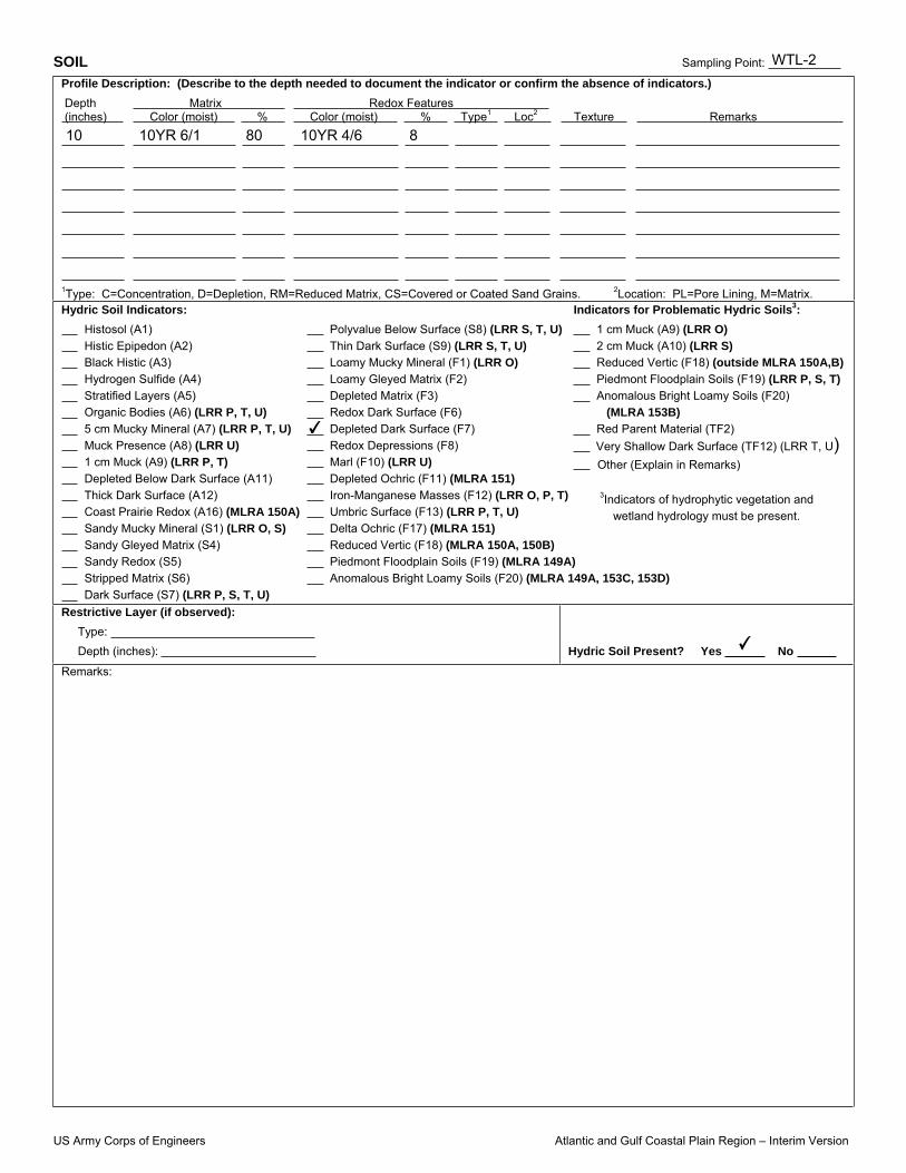
SOIL Sampling Point:
Profile Description: (Describe to the depth needed to document the indicator or confirm the absence of indicators.) Depth Matrix Redox Features (inches) Color (moist) % Color (moist) % Type1 Loc2 Texture Remarks
1Type: C=Concentration, D=Depletion, RM=Reduced Matrix, CS=Covered or Coated Sand Grains. 2Location: PL=Pore Lining, M=Matrix.Hydric Soil Indicators: Indicators for Problematic Hydric Soils3:
Histosol (A1) Polyvalue Below Surface (S8) (LRR S, T, U) 1 cm Muck (A9) (LRR O) Histic Epipedon (A2) Thin Dark Surface (S9) (LRR S, T, U) 2 cm Muck (A10) (LRR S) Black Histic (A3) Loamy Mucky Mineral (F1) (LRR O) Reduced Vertic (F18) (outside MLRA 150A,B) Hydrogen Sulfide (A4) Loamy Gleyed Matrix (F2) Piedmont Floodplain Soils (F19) (LRR P, S, T) Stratified Layers (A5) Depleted Matrix (F3) Anomalous Bright Loamy Soils (F20) Organic Bodies (A6) (LRR P, T, U) Redox Dark Surface (F6) (MLRA 153B) 5 cm Mucky Mineral (A7) (LRR P, T, U) Red Parent Material (TF2) Muck Presence (A8) (LRR U) Redox Depressions (F8)
Other (Explain in Remarks) 1 cm Muck (A9) (LRR P, T) Marl (F10) (LRR U) Depleted Below Dark Surface (A11) Depleted Ochric (F11) (MLRA 151)
3Indicators of hydrophytic vegetation and Thick Dark Surface (A12) Iron-Manganese Masses (F12) (LRR O, P, T)
wetland hydrology must be present. Coast Prairie Redox (A16) (MLRA 150A) Umbric Surface (F13) (LRR P, T, U) Sandy Mucky Mineral (S1) (LRR O, S) Delta Ochric (F17) (MLRA 151) Sandy Gleyed Matrix (S4) Reduced Vertic (F18) (MLRA 150A, 150B) Sandy Redox (S5) Piedmont Floodplain Soils (F19) (MLRA 149A) Stripped Matrix (S6) Anomalous Bright Loamy Soils (F20) (MLRA 149A, 153C, 153D) Dark Surface (S7) (LRR P, S, T, U)
Restrictive Layer (if observed): Type: Depth (inches): Hydric Soil Present? Yes No Remarks:
Very Shallow Dark Surface (TF12) (LRR T, U) Depleted Dark Surface (F7)
10 10YR 6/1 80 10YR 4/6 8
WTL-2
✔
✔

US Army Corps of Engineers Atlantic and Gulf Coastal Plain Region – Interim Version
WETLAND DETERMINATION DATA FORM – Atlantic and Gulf Coastal Plain Region
Project/Site: City/County: Sampling Date:
Applicant/Owner: State: Sampling Point:
Investigator(s): Section, Township, Range:
Landform (hillslope, terrace, etc.): Local relief (concave, convex, none): Slope (%):
Subregion (LRR or MLRA): Lat: Long: Datum:
Soil Map Unit Name: NWI classification:
Are climatic / hydrologic conditions on the site typical for this time of year? Yes No (If no, explain in Remarks.)
Are Vegetation , Soil , or Hydrology significantly disturbed? Are “Normal Circumstances” present? Yes No
Are Vegetation , Soil , or Hydrology naturally problematic? (If needed, explain any answers in Remarks.)
SUMMARY OF FINDINGS – Attach site map showing sampling point locations, transects, important features, etc.
Hydrophytic Vegetation Present? Yes No Hydric Soil Present? Yes No Wetland Hydrology Present? Yes No
Is the Sampled Area within a Wetland? Yes No
Remarks:
HYDROLOGY Wetland Hydrology Indicators: Secondary Indicators (minimum of two required)Primary Indicators (minimum of one is required; check all that apply) Surface Soil Cracks (B6)
Surface Water (A1) Water-Stained Leaves (B9) Sparsely Vegetated Concave Surface (B8) High Water Table (A2) Aquatic Fauna (B13) Drainage Patterns (B10) Saturation (A3) Marl Deposits (B15) (LRR U) Moss Trim Lines (B16) Water Marks (B1) Hydrogen Sulfide Odor (C1) Dry-Season Water Table (C2) Sediment Deposits (B2) Oxidized Rhizospheres on Living Roots (C3) Crayfish Burrows (C8) Drift Deposits (B3) Presence of Reduced Iron (C4) Saturation Visible on Aerial Imagery (C9) Algal Mat or Crust (B4) Recent Iron Reduction in Tilled Soils (C6) Geomorphic Position (D2) Iron Deposits (B5) Thin Muck Surface (C7) Shallow Aquitard (D3) Inundation Visible on Aerial Imagery (B7) Other (Explain in Remarks) FAC-Neutral Test (D5)
Field Observations: Surface Water Present? Yes No Depth (inches): Water Table Present? Yes No Depth (inches): Saturation Present? Yes No Depth (inches): (includes capillary fringe)
Wetland Hydrology Present? Yes No
Describe Recorded Data (stream gauge, monitoring well, aerial photos, previous inspections), if available:
Remarks:
I-40 at SR-222 PIN 114219.00 Fayette 3/22/2012
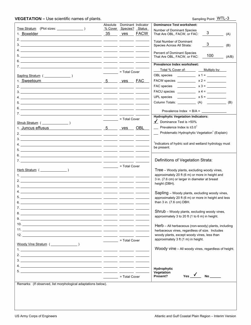
TDOT TN WTL-3
Matt Richards
Depression Convex
✔
✔
✔✔
✔
Photo 6 looking west
✔
✔✔
✔
Water held between I-40 ramp and field road to the north.
✔
✔
✔1-6
0 ✔
US Army Corps of Engineers Atlantic and Gulf Coastal Plain Region – Interim Version
VEGETATION – Use scientific names of plants. Sampling Point:
Dominance Test worksheet: Number of Dominant Species That Are OBL, FACW, or FAC: (A)
Total Number of Dominant Species Across All Strata: (B)
Percent of Dominant Species That Are OBL, FACW, or FAC: (A/B)
Prevalence Index worksheet: Total % Cover of: Multiply by: OBL species x 1 = FACW species x 2 = FAC species x 3 = FACU species x 4 = UPL species x 5 = Column Totals: (A) (B)
Prevalence Index = B/A = Hydrophytic Vegetation Indicators:
Dominance Test is >50% Prevalence Index is 3.01
Problematic Hydrophytic Vegetation1 (Explain)
1Indicators of hydric soil and wetland hydrology must be present.
Absolute Dominant Indicator Tree Stratum (Plot sizes: ) % Cover Species? Status1. 2. 3. 4. 5. 6. 7.
= Total Cover Sapling Stratum ( ) 1. 2. 3. 4. 5. 6. 7.
= Total Cover Shrub Stratum ( ) 1. 2. 3. 4. 5. 6. 7.
= Total Cover Herb Stratum ( ) 1. 2. 3. 4. 5. 6. 7. 8. 9. 10. 11. 12.
= Total Cover Woody Vine Stratum ( ) 1. 2. 3. 4. 5.
= Total Cover
Hydrophytic Vegetation Present? Yes No
Remarks: (If observed, list morphological adaptations below).
Definitions of Vegetation Strata:
Tree – Woody plants, excluding woody vines, approximately 20 ft (6 m) or more in height and 3 in. (7.6 cm) or larger in diameter at breast height (DBH).
Sapling – Woody plants, excluding woody vines,approximately 20 ft (6 m) or more in height and lessthan 3 in. (7.6 cm) DBH.
Shrub – Woody plants, excluding woody vines,approximately 3 to 20 ft (1 to 6 m) in height.
Herb – All herbaceous (non-woody) plants, includingherbaceous vines, regardless of size. Includeswoody plants, except woody vines, less thanapproximately 3 ft (1 m) in height.
Woody vine – All woody vines, regardless of height.
Boxelder
Sweetgum
Juncus effusus
35
5
5
yes
yes
yes
FACW
FAC
OBL
3
3
100
✔
✔
WTL-3

US Army Corps of Engineers Atlantic and Gulf Coastal Plain Region – Interim Version
SOIL Sampling Point:
Profile Description: (Describe to the depth needed to document the indicator or confirm the absence of indicators.) Depth Matrix Redox Features (inches) Color (moist) % Color (moist) % Type1 Loc2 Texture Remarks
1Type: C=Concentration, D=Depletion, RM=Reduced Matrix, CS=Covered or Coated Sand Grains. 2Location: PL=Pore Lining, M=Matrix.Hydric Soil Indicators: Indicators for Problematic Hydric Soils3:
Histosol (A1) Polyvalue Below Surface (S8) (LRR S, T, U) 1 cm Muck (A9) (LRR O) Histic Epipedon (A2) Thin Dark Surface (S9) (LRR S, T, U) 2 cm Muck (A10) (LRR S) Black Histic (A3) Loamy Mucky Mineral (F1) (LRR O) Reduced Vertic (F18) (outside MLRA 150A,B) Hydrogen Sulfide (A4) Loamy Gleyed Matrix (F2) Piedmont Floodplain Soils (F19) (LRR P, S, T) Stratified Layers (A5) Depleted Matrix (F3) Anomalous Bright Loamy Soils (F20) Organic Bodies (A6) (LRR P, T, U) Redox Dark Surface (F6) (MLRA 153B) 5 cm Mucky Mineral (A7) (LRR P, T, U) Red Parent Material (TF2) Muck Presence (A8) (LRR U) Redox Depressions (F8)
Other (Explain in Remarks) 1 cm Muck (A9) (LRR P, T) Marl (F10) (LRR U) Depleted Below Dark Surface (A11) Depleted Ochric (F11) (MLRA 151)
3Indicators of hydrophytic vegetation and Thick Dark Surface (A12) Iron-Manganese Masses (F12) (LRR O, P, T)
wetland hydrology must be present. Coast Prairie Redox (A16) (MLRA 150A) Umbric Surface (F13) (LRR P, T, U) Sandy Mucky Mineral (S1) (LRR O, S) Delta Ochric (F17) (MLRA 151) Sandy Gleyed Matrix (S4) Reduced Vertic (F18) (MLRA 150A, 150B) Sandy Redox (S5) Piedmont Floodplain Soils (F19) (MLRA 149A) Stripped Matrix (S6) Anomalous Bright Loamy Soils (F20) (MLRA 149A, 153C, 153D) Dark Surface (S7) (LRR P, S, T, U)
Restrictive Layer (if observed): Type: Depth (inches): Hydric Soil Present? Yes No Remarks:
Very Shallow Dark Surface (TF12) (LRR T, U) Depleted Dark Surface (F7)
10 10YR 6/2 70 10YR 3/6 20
WTL-3
✔
✔

Form J Natural Resources Mitigation Sketches/Information
Project: P.E. PIN Date of survey: Biologist: Affiliation:
Station Map label Attachments: Marked-up plans
sheet (A); notes (B); mitigation plan (C)
attached
Calculate permanent & temporary wetland
impacts & provide to (name of regional
biologist) and John Hewitt (“X”)
Apply “standard” stream relocation configuration &
instructions (“X”)
Survey boundaries as flagged in field
(“X”)
General notes and/or specific changes requested
None Provided
STR-1 A, B, C X Unknown if STR-1 will require relocation or culvert extension. In-lieu fee payment required if culvert exceeds 200’. Standard stream relocation (attached) applies if a required relocation exceeds 50’ in length.
None Provided
WTL-1 A, B, C X X Unknown if WTL-1 will be impacted. If permanent project wetland impacts exceed 0.10 acres, mitigation will be required at 2:1 ratio in the Hatchie Mitigation Bank. Temporary wetland impact instructions are attached if necessary.
None Provided
SPG-1 A Unknown if SPG-1 will be impacted. A spring box will be required to maintain flow to STR-1 if fill will cover SPG-1.
None Provided
WTL-2 A B, C X X Unknown if WTL-1 will be impacted. If permanent project wetland impacts exceed 0.10 acres, mitigation will be required at 2:1 ratio in the Hatchie Mitigation Bank. Temporary wetland impact instructions are attached if necessary.
None Provided
WTL-3 A, B, C X X Unknown if WTL-1 will be impacted. If permanent project wetland impacts exceed 0.10 acres, mitigation will be required at 2:1 ratio in the Hatchie Mitigation Bank. Temporary wetland impact instructions are attached if necessary.

Form J
Plan View Cross-Section – View Upstream
Standard Stream Mitigation (if required) Apply these measures to all applicable streams listed in Form J. Duplicate the length, bottom channel width, elevations, side slopes, meander wavelength, and curvature of the existing channels to the extent possible. Each channel should transition smoothly from its beginning elevation to its tie-in elevation in the receiving stream, without profile drops or jumps. Locate the new channels in as flat an area as possible to avoid unusually high side slopes; this may require some additional right-of-way. Channel length placed in spring-boxes or culverts counts as part of the new channel length (but may require off-site compensatory mitigation that would not be required for an open channel). Channel side slopes should mimic existing channel side slopes, unless otherwise indicated, and be stabilized using appropriate BMPs – the use of rip-rap should be avoided if possible. If rip-rap is required, the rip-rap should be embedded into the soil such that (1) the top of the rip-rap is flush with the bottom and sides of the channel, (2) the voids are filled with material similar to the original channel bottom, and (3) water will flow on top of the embedded riprap and soil material to enable the water to be visible. Plant two alternating rows of tree or shrub species on both sides of the new channels; the first row shall be bare root seedlings that are planted on the channel slope, centered on the midpoint of the slope. Along top of bank, two- to five-foot (2-5 ft) container grown trees are to be planted within one foot of the top of bank. If needed, black willow (Salix nigra) stakes will be installed along the edge of water in the new channel. The stakes will be fresh material cut in approximately foot lengths. The stakes will be installed on approximately five foot centers at the edge of water in the new channel. The stakes are to be driven in such that approximately six inches of the stake are left above ground. The bare root seedlings will be the same species as the trees, unless otherwise indicated. Rip-rap, if required, should be limited to ends of culverts. All relocated channels and their accompanying mitigation features, including trees, are to be placed in right-of-way rather than easements; this may require acquisition of additional right-of-way. Use the following specifications for planted species. SPACING FOR PLANTING ALONG RELOCATED STREAM top of bank width = ~' RELOCATED STREAM bank height = ~ bottom width = ~ * container-grown
Stream Bottom
Channel Slope
Channel Slope
Top of Bank
10’
10’
Seedlings planted midway down slope
Seedling 2-5' trees *
1’

Form J
Plan View
Tree species for stream: Item # Description Unit
Acer rubrum (red maple) 2-5' in height, containerized Each Fraxinus pennsylvanica (green ash) 2-5' in height, containerized Each Platanus occidentalis (sycamore) 2-5' in height, containerized Each Salix nigra (black willow) 18”-24" Ht, BR Each Quercus alba (white oak) 2-5' in height, containerized Each Acer negundo (boxelder) 18”-24" Ht, BR Each
Standard On-site Mitigation for Temporary Wetland Impact Areas (if required) Apply these measures to all applicable temporary wetland impact areas listed in Form J. For temporary wetland impact areas, remove the top 12" of topsoil and stockpile it until construction is complete. Once construction activities are completed, restore all temporary wetland impact areas to pre-construction conditions. This includes removing haul roads (if applicable), restoring the site to the original (pre-construction) elevation and spreading stockpiled topsoil back over the wetland site. The area of temporary impacts will be stabilized according to standard practices. Planting will be based on notes provided by Ecology. Wetland areas located outside of proposed right-of-way and construction easements are to be clearly marked and not disturbed. Tree species for temporary wetland impacts:
Item # Description Unit Seedling: Acer rubrum (red maple) 18”-24" Ht, BR Each Seedling: Fraxinus pennsylvanica (green ash) 18”-24" Ht, BR Each Seedling: Platanus occidentalis (sycamore) 18”-24" Ht, BR Each Seedling: Liquidambar styraciflua (sweetgum)18”-24" Ht, BR Each Seedling: Acer negundo (box elder) 18”-24” Ht, BR Each Ht = Height, BR = Bare Root Tree planting scheme for temporary wetland impact areas Roadway Area of permanent wetland impacts Toe of fill slope 10’ Area of temporary 10’ 10’ wetland impacts
Proposed Right-of-way

Form J Please place the following notes in the Special Notes section of the plans: Topsoil is to be removed from all areas of temporary wetland impacts and stockpiled prior to construction. Upon completion of construction activities, temporary haul roads are to be removed. Excavated material from the haul roads is to be disposed of as directed by the engineer.
Plans Notes Please add the following information verbatim to the Final Plans: CHANNEL RELOCATION SEQUENCE AND IMPLEMENTATION NOTES FOR RELOCATED STREAM CHANNELS (IGNORE REFERENCES TO ITEMS NOT SPECIFIED) 1. If the relocated channel flows into a proposed culvert, the new channel shall be relocated prior to
installation of the culvert to ensure correct elevation levels are set for the inlet. The new channel shall be excavated and stabilized during a low-water period. Rip-rap (only as shown on plans), seeding, and/or sod shall be installed immediately following channel completion. Trees shall be installed in the first planting season following channel excavation. Water shall be diverted into the new channel only after it is completely stabilized, and only during a low-water period. Stabilized means that all specified rock, erosion control blankets, seeding, sod, or materials are in place and established.
2. CHANNEL RELOCATION SEQUENCE
a. Flag edge of the new channel top bank prior to clearing. Do not clear large trees in position to shade the new channel. Leave as many trees and shrubs as possible between toe of the new highway slope and the stream.
b. Excavate the new channel "in the dry" by leaving areas of undisturbed earth (diversion berms) in place at both ends.
c. Shape channel to specifications shown. Remove loose soils and debris. d. Place topsoil, erosion control blanket. seed, sod, or other material as specified. e. Remove diversion berms, beginning with the most downstream; banks and bottom elevation of the old
channel should transition smoothly into the new channel. The elevations of the new channel bottom at each end of the relocation sequence should match the elevations of the existing channel, and a steady percent slope should be maintained throughout the relocated channel centerline or as specified.
f. Install trees according to standard specifications section 802. 3. Only rip-rap shown on plans should be used in the relocated channel reach. Any other proposed rip-rap
should be coordinated with the Environmental Division through the TDOT Construction Office. 4. Requests by any agency that would require the modification of channels, ditches, elevations, rip-rap or any
other stream mitigation items associated with the channel relocations shall be referred to the TDOT Environmental Division via the Headquarters Construction Office for coordination with all involved agencies and TDOT divisions. Tennessee Department of Environment and Conservation may make recommendations concerning erosion control via the engineer without such referral.
TREES No substitutions of tree species or sizes shall be allowed without the written approval of TDOT Environmental Division. Trees shall be of the variety requested, between 2 and 5 feet in height, containerized, and first quality. Bare root trees shall be of the variety requested, well branched, and first quality. Bare roots must be kept moist at all times. No clones or cultivars will be accepted. Any found to be incorrect species, or improperly planted, at any time prior to termination of the contract shall be removed and replaced at the contractor's expense. Stakes and wires shall be removed immediately prior to contract termination, unless otherwise directed by Environmental Division.

Form J The contractor should arrange several months ahead of time to obtain the correct tree species, as some may require some time to locate. All trees planted shall be wrapped as per section 802.07 of TDOT standard specifications for the road and bridge construction. Trees shall be watered as required through the period of establishment to ensure survival.

STATE OF TENNESSEE DEPARTMENT OF TRANSPORTATION
ENVIRONMENTAL DIVISION SUITE 900 - JAMES K. POLK BUILDING
505 DEADERICK STREET NASHVILLE, TENNESSEE 37243-0334
March 7, 2012
Mary Jennings U.S. Department of Interior Fish and Wildlife Service 446 Neal Street Cookeville, TN 38501 SUBJECT: Fayette County, I-40 Interchange at SR-22 P.E. 24001-1147-44 PIN 114219.00 Dear Ms. Jennings: The Tennessee Department of Transportation proposes to construct the subject project. A Project Location Map is attached. In compliance with the Fish and Wildlife Act of 1958, and the Endangered Species Act of 1973 (as amended), we are requesting a list of threatened or endangered species that may be present in the vicinity of the proposed construction. Please include in your reply the entire project description as listed in the subject line of this request. Your assistance in the preparation of this project is greatly appreciated. If you need additional information, please contact me at 615-532-3880. Sincerely, Matt Richards TDOT Biologist xc: Reading File Project File

Approximate Project Location
Fayette County, I-40 Interchange at SR-22
P.E. 24001-1147-44PIN 114219.00
.
0 0.3 0.6 0.9 1.20.15Miles

.
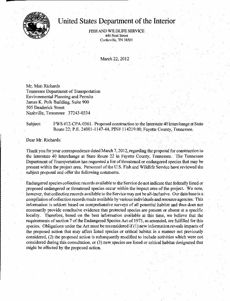
United States Department of the Interior FISH AND WILDLIFE SERVICE
3 446 Neal Street Cookeville, TN 38501
March 22, 2012
Mr. Matt Richards Tennessee Department of Transportation Environmental Planning and Permits James K. Polk Building, Suite 900 505 Deaderick Street Nashville, Tennessee 37243-0334
Subject: FWS #1 2-CPA-036 1. Proposed construction to the Interstate 40 Interchange at State Route 22; P.E. 24001-1147-44, PIN# 114219.00, Fayette county, Tennessee.
Dear Mr. Richards:
Thank you for your correspondence dated March 7, 2012, regarding the proposal for construction to the Interstate 40 Interchange at State Route 22 in Fayette County, Tennessee. The Tennessee Department of Transportation has requested a list of threatened or endangered species that may be present within the project area. Personnel of the U.S. Fish and Wildlife Service have reviewed the subject proposal and offer the following comments.
Endangered species collection records available to the Service do not indicate that federally listed or proposed endangered or threatened species occur within the impact area of the project. We note, however, that collection records available to the Service may not be all-inclusive. Our data base is a compilation of collection records made available by various individuals and resource agencies. This information is seldom based on comprehensive surveys of all potential habitat and thus does not necessarily provide conclusive evidence that protected species are present or absent at a specific locality. Therefore, based on the best information available at this time, we believe that the requirements of section 7 of the Endangered Species Act of 1973, as amended, are fulfilled for this species. Obligations under the Act must be reconsidered if (1) new information reveals impacts of the proposed action that may affect listed species or critical habitat in a manner not previously considered, (2) the proposed action is subsequently modified to include activities which were not considered during this consultation, or (3) new species are listed or critical habitat designated that might be affected by the proposed action.

Information available to the Service does not indicate that wetlands exist in the vicinity of the proposed project. However, our wetland determination has been made in the absence of a field inspection and does not constitute a wetland delineation for the purposes of Section 404 of the Clean Water Act. The Corps of Engineers should be contacted if other evidence, particularly that obtained during an on-site inspection, indicates the potential presence of wetlands.
If you have any questions regarding our comments, please contact John Griffith of my staff at 931/528-6481 (ext. 228) or by email atjohngrjfflthçJws.gov .
Sincerely,
Mary E. Jennings Field Supervisor

Species Review Form N Project: Fayette County, I-40 at SR-222 P.E. 24001-0147-44 PIN 114219.00
Page 1 of 2
Date of field study: 3/22/2012 Date TDEC database checked: 3/28/2012 Completed by: Matt Richards, TDOT Species reported within 1 mile radius of project:
Species
Scientific and common names,
followed by (A) for animal or (P) for
plant
Status Species is potentially present in R-O-W because: (A) it is listed by
TDEC within ROW
(B) habitat is present (C) observed during
site visit (D) critical habitat
present within ROW
Species is considered likely NOT present in R-O-W because: (A) Present habitat
unsuitable (B) Not observed
during site visit (C) Original record
questionable (D) Considered
extinct/extirpated
Accommodations to minimize impacts: (A) BMPs are
sufficient to protect species
(B) Special Notes are included on project plans
(C) Individuals will be impacted.
(D) Accommodations not practical due to broad habitat description or mobility of species
Habitat (include blooming, breeding or other information; where found according to TDEC
database; year last observed; reference) Notes
Fed TN None
Species reported within 1-mile to 4-mile radius of project:
Species
Scientific and common names,
followed by (A) for animal or (P) for
plant
Status Species is potentially present in R-O-W because: (A) it is listed by
TDEC within ROW
(B) habitat is present (C) observed during
site visit (D) critical habitat
present within ROW
Species is considered likely NOT present in R-O-W because: (A) Present habitat
unsuitable (B) Not observed
during site visit (C) Original record
questionable (D) Considered
extinct/extirpated
Accommodations to minimize impacts: (A) BMPs are
sufficient to protect species
(B) Special Notes are included on project plans
(C) Individuals will be impacted.
(D) Accommodations not practical due to broad habitat description or mobility of species
Habitat (include blooming, breeding or other information; where found according to TDEC
database; year last observed; reference) Notes
Fed TN None

Species Review Form N Project: Fayette County, I-40 at SR-222 P.E. 24001-0147-44 PIN 114219.00
Page 2 of 2
Migratory Birds
List significant concentrations of migratory birds encountered within the project area (rookeries, aggregations, nesting areas, etc).
Species (Scientific and Common Name)
Approximate No. of Nests (or Individuals)
Location of Nests (or Individuals) (Include Latitude & Longitude)
Nesting Dates and Reference Photograph # None USFWS letter: Yes X (attached) No (explain) Biological Assessment: Yes (response letter attached; see below) No X
Species (scientific and common names) USFWS conclusion1
1 Choose from “no effect"; "not likely to adversely affect;" "likely to adversely affect;" if “likely to adversely affect” is chosen, indicate "no jeopardy to species and no adverse modification to habitat” or “jeopardy to species, or adverse modification to habitat” based on FWS concurrence letter List Natural Areas, management areas, refuges, or similar sites within or adjacent to project (attach 7.5 minute topographic map with pertinent boundaries of area marked)
Area Name Type of Area Pertinent Notes
None
List locations that contain potential Indiana bat habitat (Provide an aerial that indicates areas checked)
Location (description; lat/long or station number) Tree Species Photograph # None

STR‐1 looking downstream from farm road crossing
SPG‐1 looking west
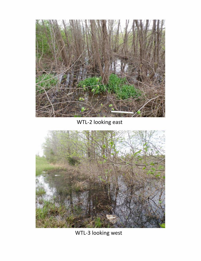
WTL‐2 looking east
WTL‐3 looking west

D-List Categorical ExclusionI-40 at SR-222 (Exit 42)Fayette CountyTDOT PIN 114219.00
Appendix G
FEMA Flood Insurance Rate Map (FIRM)

afarless
Oval
afarless
Callout
I-40 at SR-222 (Exit 42) Fayette County PIN 114219.00

D-List Categorical ExclusionI-40 at SR-222 (Exit 42)Fayette CountyTDOT PIN 114219.00
Appendix H
Air and Noise

1
Farless, Ashley
From: Joe Matlock [[email protected]]Sent: Wednesday, March 21, 2012 9:14 AMTo: Strickland, Parrish; Farless, AshleySubject: RE: Approved Concept, I-40 @ SR-222 Fayette County
Below is the air and noise statement.Matlock
From: Joe Matlock Sent: Monday, March 19, 2012 3:29 PMTo: Parrish Strickland ARCADIS; Ashley Farless ARCADISSubject: FW: Approved Concept, I-40 @ SR-222 Fayette County
Below is for your use in the CE.Matlock
From: Darlene Reiter Sent: Monday, March 19, 2012 3:18 PMTo: Joe MatlockSubject: RE: Approved Concept, I-40 @ SR-222 Fayette County
Joe –
The air quality and noise statements for this project are provided below.
AIR QUALITYTransportation ConformityThis project is located in an area that is in attainment for all regulated criteria pollutants. Therefore, conformity does not apply to this project.
Mobile Source Air Toxics (MSATs)This project involves improvements to the existing interchange including widening 1) the SR 222 bridge over I-40 and 2) the exit ramps from I-40 to provide additional turn lanes. The project will not result in any meaningful changes in traffic volumes, vehicle mix, location of the existing facility, or any other factor that would cause an increase in emissions impacts relative to the no-build alternative. As such, this project will generate minimal air quality impacts for Clean Air Act criteria pollutants and has not been linked with any special MSAT concerns per FHWA’s “Interim Guidance Update on Air Toxic Analysis in NEPA Documents.”
Moreover, EPA regulations for vehicle engines and fuels will cause overall MSAT emissions to decline significantly over the next several decades. Based on regulations now in effect, an analysis of national trends with EPA's MOBILE6.2 model forecasts a combined reduction of 72 percent in the total annual emission rate for the priority MSAT from 1999 to 2050 while vehicle-miles of travel are projected to increase by 145 percent. This will both reduce the background level of MSAT as well as the possibility of even minor MSAT emissions from this project.
NOISEThe project is Type I in accordance with the FHWA noise standards, Procedures for Abatement of Highway Traffic and Construction Noise, 23 CFR 772, and the Tennessee Department of Transportation’s Policy on Highway Traffic Noise Abatement.

2
The land uses in the project area within approximately 500 feet of I-40 include an Exxon gas station, the Pilot Travel Center, and the Deerfield Inn.
The gas station and travel center are Category F land uses that are not noise-sensitive. Motels are Category C land uses. However, the Deerfield Inn does not have any exterior areas of frequent human use. Therefore, the motel is not noise-sensitive.
Since there are no noise-sensitive land uses in the project area, a detailed noise study is not needed.
- Darlene
From: Joe MatlockSent: Monday, March 19, 2012 1:22 PMTo: B M. Richards; Darlene Reiter; Gerald Kline; Holly Barnett; Martha Carver; TDOT EnvironmentalDoc; William DavisCc: Parrish Strickland ARCADIS; Ashley Farless ARCADISSubject: FW: Approved Concept, I-40 @ SR-222 Fayette County
See attached and link.This is a little bit better image of the build alternative.
Joe W. MatlockTransportation Planner Region IVEnvironmental Documentation Office – Local ProgramsED TDOT615 741 5365
From: Melanie Bumpus Sent: Monday, March 19, 2012 11:13 AMTo: Joe MatlockSubject: Approved Concept, I-40 @ SR-222 Fayette County
http://www.tdot.state.tn.us/construction/DB1201_details.htm
Melanie BumpusRoadway Specialist 3 Tennessee Department of TransportationEnvironmental DivisionPermitting SectionSuite 900, James K Polk BuildingNashville, TN 37243phone 615.253.2466

D-List Categorical ExclusionI-40 at SR-222 (Exit 42)Fayette CountyTDOT PIN 114219.00
Appendix I
Cultural Resources


STATE OF TENNESSEE DEPARTMENT OF TRANSPORTATION
ENVIRONMENTAL DIVISION SUITE 900 - JAMES K. POLK BUILDING
505 DEADERICK STREET NASHVILLE, TENNESSEE 37243-0334
(615) 741-3655
March 23, 2012 SUBJECT: Cultural Resource, Combined Architecture and Archaeological, Assessment
for Interstate 40 at State Route 22 (Exit 42) Interchange Improvements, Fayette County, PIN 114219.00
To Whom it May Concern: The Tennessee Department of Transportation (TDOT) in cooperation with the Federal Highway Administration is proposing to improve the intersection of State Route 222 at Interstate 40, Exit 42 in Fayette County. Pursuant to regulations set forth in "36 CFR 800: Protection of Historic Properties" cultural resource staff from TDOT surveyed the general project area in an attempt to identify National Register-included or eligible properties which could be impacted by the proposed project. Historians from TDOT inventoried no National Register eligible properties that they believe the proposed project could impact. The enclosed report discusses TDOT’s survey findings. You are receiving this report because TDOT has identified you as a Fayette County party or individual with historic preservation interests. The Advisory Council on Historic Preservation Regulations specify that members of the public with interests in an undertaking and its effects on historic properties should be given reasonable opportunity to have an active role in the Section 106 process. As such, TDOT would like to give you the opportunity to participate in that process. If you feel that commenting on such projects is outside the interests of your organization, please notify me and I will remove your name from our list. If you have any comments on historic issues related to this project, please write me. Federal regulations provide that you have thirty days to respond from the receipt of this letter. Sincerely,
Holly M. Barnett, Historic Preservation Specialist Enclosure cc: Mr. E. Patrick McIntyre, TN-SHPO

STATE OF TENNESSEE DEPARTMENT OF TRANSPORTATION
ENVIRONMENTAL DIVISION SUITE 900 - JAMES K. POLK BUILDING
505 DEADERICK STREET NASHVILLE, TENNESSEE 37243-0334
(615) 741-3655
March 23, 2012
Mr. E. Patrick McIntyre State Historic Preservation Office Clover Bottom Mansion 2941 Lebanon Road Nashville, TN 37243-0442 SUBJECT: Cultural Resource, Combined Architecture and Archaeological,
Assessment for Interstate 40 at State Route 222 Interchange Improvements (Exit 42), Fayette County, PIN: 114219.00
Dear Mr. McIntyre: Enclosed is a cultural resource report concerning the above referenced project. It is the opinion of TDOT that there are no National Register listed or eligible resources within the project area of potential effect. On behalf of the Federal Highway Administration, we request your review of this report pursuant to regulations contained within 36 CFR 800. We look forward to your comments. Thank you for you help in this matter. Sincerely,
Martha Carver Historic Preservation Manager Enclosure cc: Mr. Jerry Melson

TENNESSEE DEPARTMENT OF TRANSPORTATION CULTURAL RESOURCE ASSESSMENT (Combined Historic and Archaeological Resources) Interstate 40 at State Route 222 (Exit 42) Interchange Improvements FAYETTE COUNTY
March 2012 Prepared by Holly Barnett and Gerald Kline Tennessee Department of Transportation Environmental Division Suite 900 James K. Polk Building Nashville, TN 37243-0334 Phone: (615) 741-3653
I-40 at SR 222, Exit 42, Fayette County, Page i
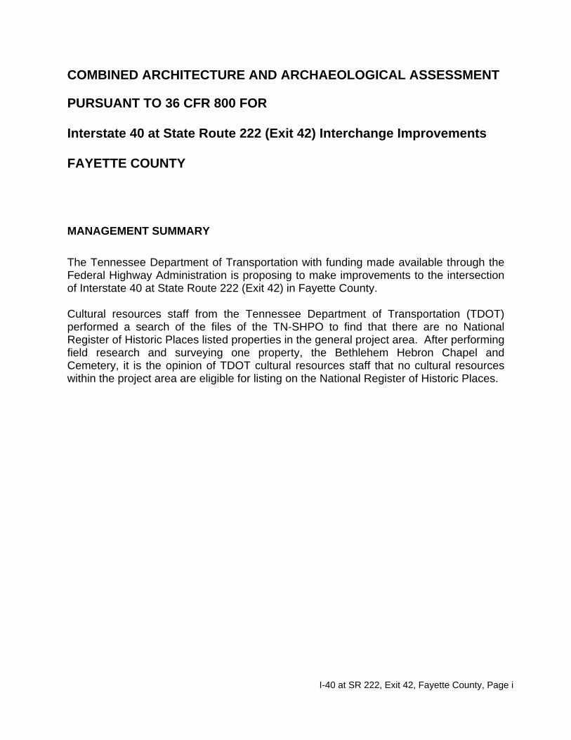
COMBINED ARCHITECTURE AND ARCHAEOLOGICAL ASSESSMENT PURSUANT TO 36 CFR 800 FOR Interstate 40 at State Route 222 (Exit 42) Interchange Improvements FAYETTE COUNTY MANAGEMENT SUMMARY The Tennessee Department of Transportation with funding made available through the Federal Highway Administration is proposing to make improvements to the intersection of Interstate 40 at State Route 222 (Exit 42) in Fayette County. Cultural resources staff from the Tennessee Department of Transportation (TDOT) performed a search of the files of the TN-SHPO to find that there are no National Register of Historic Places listed properties in the general project area. After performing field research and surveying one property, the Bethlehem Hebron Chapel and Cemetery, it is the opinion of TDOT cultural resources staff that no cultural resources within the project area are eligible for listing on the National Register of Historic Places.

I-40 at SR 222, Exit 42, Fayette County, Page ii
TABLE OF CONTENTS PAGE Statement of Determination .............................................................. 1 Project Description ........................................................................... 3 Public Participation ........................................................................... 4 Historical Overview ........................................................................... 5 Survey Methods ............................................................................... 6 Inventoried Property
Bethlehem Hebron Chapel and Cemetery ............................. 8 Conclusions ..................................................................................... 11 Bibliography .................................................................................... 11
FIGURES
1. Project Location Map .................................................................. 2 2. Aerial Layout of the Proposed Project ........................................ 3 3. View of the Project Area ............................................................. 4 4. TN-SHPO Survey Map ............................................................... 4 5. View of the Bethlehem Hebron Chapel ...................................... 8 6. Three-quarters rear view of the Bethlehem Hebron Chapel ....... 9 7. Views of the Hebron Cemetery ................................................. 10
APPENDICES
A. Fact Sheet on Section 106 B. National Register Criteria, 36 CFR 60.4 C. Criteria of Effect, 36 CFR 800.5 D. Fact Sheet on Section 4(f) E. Public Participation

I-40 at SR 222, Exit 42, Fayette County, Page 1
COMBINED ARCHITECTURE AND ARCHAEOLOGICAL ASSESSMENT PURSUANT TO 36 CFR 800 FOR Interstate 40 at State Route 222 (Exit 42) Interchange Improvements FAYETTE COUNTY STATEMENT OF DETERMINATION The Tennessee Department of Transportation with funding made available through the Federal Highway Administration is proposing to make improvements to the intersection of Interstate 40 at State Route 222 (Exit 42) in Fayette County. Federal laws require TDOT and FHWA to comply with Section 106 of the National Historic Preservation Act of 1966, as amended. Appendix A contains a fact sheet about Section 106. Regulations detailing the implementation of this act are codified at 36 CFR 800. This legislation requires TDOT and FHWA to identify any properties (either above-ground buildings, structures, objects, or historic sites or below ground archaeological sites) of historic significance. For the purposes of this legislation, historic significance is defined as those properties which are included in the National Register of Historic Places or which are eligible for inclusion in the National Register. Appendix B contains a copy of the National Register criteria, which are codified at 36 CFR 60.4. Once historic resources are identified, legislation requires these agencies to determine if the proposed project would affect the historic resource. Appendix C contains a copy of the Criteria of Effect as defined in 36 CFR 800.5. If the proposed project would have an adverse effect to a historic property, the legislation requires FHWA to provide the Advisory Council on Historic Preservation (an independent federal agency) an opportunity to comment on the effect. The U.S. Department of Transportation Act of 1966, as amended, also requires FHWA to assess the applicability of Section 4(f). This law prohibits the Secretary of Transportation from approving any project which requires the "use" of a historic property unless there is no prudent and feasible alternative to that use and unless the project includes all possible planning to minimize harm to the historic resource. Appendix D contains a fact sheet about Section 4(f). Pursuant to 36 CFR 800.4 which requires TDOT and FHWA to identify historic resources near its proposed projects, architectural historians from TDOT surveyed the area of potential environmental impact for this proposed project in an effort to identify any National Register-included or eligible properties. The historians inventoried one property, the Bethlehem Hebron Chapel and Cemetery, in the general project area. It is the opinion of TDOT that the inventoried property is not eligible for listing on the National Register of Historic Places. Cultural resource staff did not identify any additional National Register-included or eligible properties. There will not be a Section 4(f) use of a historic property. If fill material for this project must be obtained from outside the proposed right-of-way, it will be acquired in accordance with Federal Aid Provision 107.06 This document has been prepared in consultation with the TN-SHPO and will be circulated to the TN-SHPO and local historians.

I-40 at SR 222, Exit 42, Fayette County, Page 2
Project Location
Figure 1: Project Location Map I-40 at SR 222 Interchange Improvements, Exit 42, Fayette County Quad: Stanton, 423 NW

I-40 at SR 222, Exit 42, Fayette County, Page 3
PROJECT DESCRIPTION Combined Traditional/Tight Diamond Interchange The proposed project would rebuild the SR.222 bridge at the same location on the same skew angle. State Route 222 would be widened to a five-lane section of two travel lanes in each direction and a center left turn lane in each direction. All widening would be on the east side of SR 222 and the west side of SR 222 would remain on the existing location due to the church and cemetery on the south side of I-40 and all of the widening is along the east side of SR 222. The SR 222 improvements would reduce the construction impacts on SR 222 south of I-40. This proposed project would not eliminate the existing access connections along the west side of SR 222 (south side of I-40) currently within the controlled access limits. The SR 222 improvements extend approximately 700 feet north from the northern ramp terminal intersection and 1,800 feet south from the southern ramp terminal intersection. On the north side of I-40, a field drive would be connected to Thorpe Drive since it is located within the proposed controlled access limits. The SR 222 widening will create changes to the existing access to the Pilot Station and Deerfield Inn properties.
Figure 2: Aerial Layout of the Proposed Project
I-40 at SR 222, Exit 42, Fayette County, Page 4
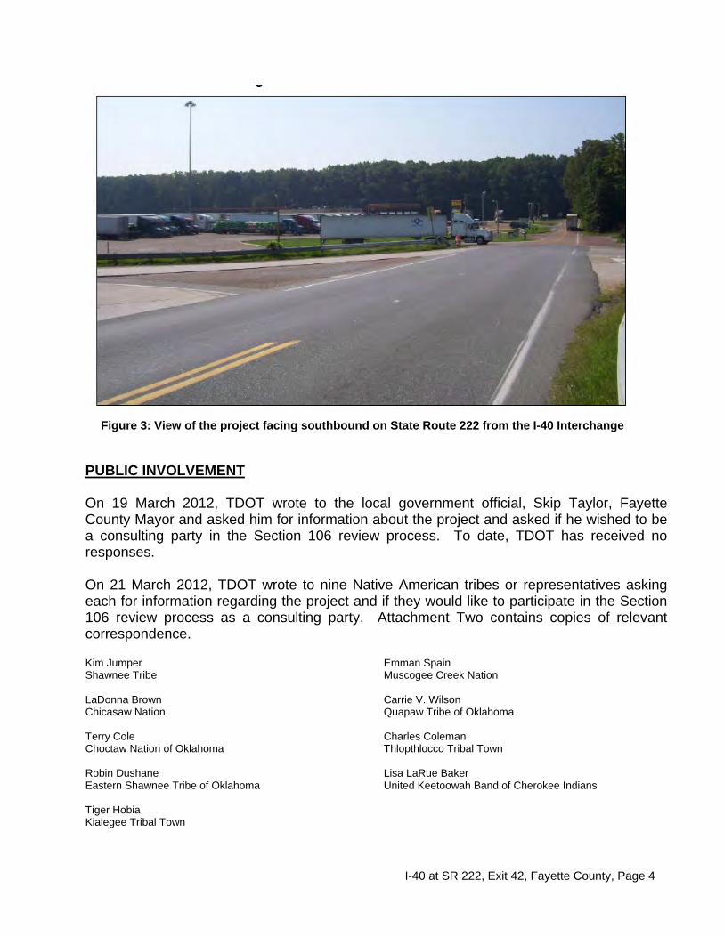
Figure 3: View of the project facing southbound on State Route 222 from the I-40 Interchange
PUBLIC INVOLVEMENT On 19 March 2012, TDOT wrote to the local government official, Skip Taylor, Fayette County Mayor and asked him for information about the project and asked if he wished to be a consulting party in the Section 106 review process. To date, TDOT has received no responses.
On 21 March 2012, TDOT wrote to nine Native American tribes or representatives asking each for information regarding the project and if they would like to participate in the Section 106 review process as a consulting party. Attachment Two contains copies of relevant correspondence.
Kim Jumper Shawnee Tribe LaDonna Brown Chicasaw Nation Terry Cole Choctaw Nation of Oklahoma Robin Dushane Eastern Shawnee Tribe of Oklahoma Tiger Hobia Kialegee Tribal Town
Emman Spain Muscogee Creek Nation Carrie V. Wilson Quapaw Tribe of Oklahoma Charles Coleman Thlopthlocco Tribal Town Lisa LaRue Baker United Keetoowah Band of Cherokee Indians
I-40 at SR 222, Exit 42, Fayette County, Page 5
TDOT has prepared a list by counties of historic groups, county historians, and other such individuals or organizations that might be interested in proposed projects. TDOT regularly updates and refines the list. TDOT will mail a copy of this report to the following groups and individuals. Attachment Two contains copies of relevant correspondence. Bethlehem Hebron Chapel and Cemetery 550 Hebron Drive Mason, TN 38049 Mayor Skip Taylor Fayette County Mayor Room 204 Fayette County Courthouse Somerville, TN 38068 Fayette County Historical Society P. O. Box 304 Somerville, TN 38068
Mrs. J. R. Morton Fayette County Historian P. O. Box 127 Moscow, TN 38057 Mr. John Sicola, Executive Director Memphis-Delta (MATCOG) Development District 1420 Union Memphis, TN 38103
BRIEF HISTORICAL OVERVIEW OF PROJECT AREA Named for the Marquis de Lafayette, the Tennessee General Assembly established Fayette County in 1824. Somerville was established as the county seat and named in honor of Lieutenant Robert Somerville, a hero of the battle of Tohopeka in Alabama. Settlers began inhabiting the area as early as 1820, with Somerville and LaGrange incorporated by 1826. Fayette County now has nine incorporated towns: Braden, Gallaway, LaGrange, Moscow, Oakland, Piperton, Rossville, Somerville, and Williston. The county has been traditionally agricultural with cotton historically serving as the primary crop. A few large plantation homes remain representing Fayette County’s role in the cotton culture of the nineteenth century, subsidized by African slaves. After the Civil War many African-Americans remained in Fayette County as tenant farmers or sharecroppers. Unfortunately, living conditions for these citizens, who made up the majority of the county’s population, did not improve. By the early 1960s Fayette County became a center of Civil Rights activity. In response to black tenant farmers who were evicted for attempting to register to vote, activists established two "tent cities" as shelter. African-American citizens also organized boycotts and marches. Through the 1970s, Civil Rights activists worked to improve the quality of life for citizens by holding voter registration drives and pushing for school integration. Fayette County has traditionally had an economy supported solely on agriculture, primarily cotton and corn. Farms large and small brought their goods to the gins in every town and villages. In recent decades, the dominance of cotton has waned with soybeans, beef cattle, dairying, and eggs becoming increasing important to the Fayette County economy. Although agriculture is still dominant in Fayette County, industry entered the county in the late twentieth century. In the 1960s Troxel Manufacturing Company opened a factory in Moscow, and several towns have industrial parks to lure companies to the county. Also suburban sprawl from Memphis in recent decades has removed numerous acres from production. Its population in 2000 stood was 28,806 (Morton, Tennessee Encyclopedia, 303-304).

I-40 at SR 222, Exit 42, Fayette County, Page 6
SURVEY RESULTS In compliance with Section 106 of the National Historic Preservation Act of 1966, as amended, (for more information, see Attachment One or www.achp.gov), cultural resource staff surveyed the area of potential environmental impact for this project in compliance with 36 CFR 800 regulations. The purpose of this survey was to identify any resources either included in or potentially eligible for inclusion in the National Register of Historic Places (eligibility criteria are set forth in 36 CFR 60.4, see Attachment One). The area surveyed included land needed for additional right-of-way as well as areas that might possibly be affected by changes in air quality, noise levels, setting, and land use (see Attachment One for the criteria of adverse effect). The U.S. DOT Act of 1966 requires the assessment of the applicability of Section 4(f) (see Attachment One). Archaeological Survey
The TDOT Archaeology Section has checked the Division of Archaeology site files and there were no sites within the proposed project area of potential effect. The TDOT Archaeology Section has field reviewed the APE for this project and find the entire area to have been highly disturbed by previous governmental, commercial, and industrial development. There is little likelihood for intact archaeological resources. Therefore, no further work is warranted for this project. If fill material for this project must be obtained from outside the proposed right-of-way, it will be acquired in accordance with Federal Aid Provision 107.06. Architectural/Historical Survey The proposed project is located in a rural built-up area of northeastern Fayette County that has development associated with the SR 222 and I-40 interchange. The APE for this project includes properties along and within the viewshed of the area that is being improved. TDOT historians also consulted the survey files and the National Register of Historic Places files of the Tennessee State Historic Preservation Office (TN-SHPO) in Nashville to identify any National Register-included properties in the general project area. There are no National Register-listed properties located within the area of potential effect of the proposed project. The TN-SHPO has not surveyed this part of Fayette County. Historians inventoried one property, the Bethlehem-Hebron Chapel, and it is the opinion of TDOT that the property is not eligible for listing in the National Register of Historic Places. Additional information about this property begins on the page 8. It is the opinion of TDOT that there are no cultural resources included in or eligible for inclusion in the National Register of Historic Places within the project area of potential effect. Therefore there will be no Section 4(f) use of a historic property.

I-40 at SR 222, Exit 42, Fayette County, Page 7
Figure 4: TN-SHPO Map with Inventoried Property Indicated Area Driven by TDOT Historians Quad: Stanton, 423 NW
Bethlehem Hebron Chapel and Cemetery
Proposed Project

I-40 at SR 222, Exit 42, Fayette County, Page 8
Figure 5: View of the façade and north elevation of Bethlehem Hebron Chapel Inventoried Property: Bethlehem Hebron Chapel and Cemetery Address: 550 Hebron Drive, Mason, TN 38049 Facing east on State Route 222, the Bethlehem Hebron Chapel and Cemetery is located just south of Interstate 40. Located on a wooded plot, the church and cemetery are located on separate parcels. The church campus contains a single building with adjoining parking lot to the south, and the cemetery to the west and north. The area to the east of the church is wooded and to the east on the opposite side of State Route 222 is a recently constructed large truck stop with convenience store. According to Fayette County historians Dorothy Rich Morton, the current chapel was known as the Bethlehem Methodist Church, which was a part of the Dancyville Circuit. During the nineteenth century, the church was a part of the Wesley and Stanton circuit (TSLA, Guide to Church Records). A banner inside the church denotes that the congregation dates to 1846 and is a part of the Brownsville District. In the Cemetery Records of Fayette County, Dorothy Rich Morton records the cemetery with both the Bethlehem and Hebron names. During the 19th century families such as Carraway Davis, Hinson, Leath, Lewis, McNabb, O’Connell, Pattat, Sorrell, and Tapp buried multiple family members in the cemetery. Burial dates are primarily from the early to mid-twentieth century with dates ranging from the 1909 to the present (Morton, Cemetery Records of Fayette County, 26). The ca. 1950 gable front church building is faced in brick and situated under a gable front roof covered in asphalt shingles. The church has a central hipped roof steeple topped with a cross. A small gabled porch under the steeple is supported by decorative metal posts. Metal framed gothic arched windows flank the double entry doors with

I-40 at SR 222, Exit 42, Fayette County, Page 9
single diamond shaped windows. The steeple, entry area, and roof eaves have been covered in vinyl siding. There is no cornerstone. A ca. 1960 decorative metal sign with scrollwork and a cross that reads “Bethlehem Hebron Chapel in memory of MB Carraway” is located near the driveway facing State Route 222. The north and south side elevations each have a series of six four-light aluminum windows. The rear elevation has a three-light wood and glass door and three four-light windows. There is a small vent in the gable peak. Just north of the church are two sets of blonde brick entry posts with simple concrete caps. The two sets of posts are linked by a circular gravel drive. The easternmost posts contain a decorative metal arch that reads “Hebron Cemetery.” The cemetery is laid out primarily in rows from north to south. A newer section of the cemetery is located to the west of the church. Gable-front churches are a common type found throughout rural areas in Tennessee. With the congregation dating to the mid-nineteenth century, much of the church’s history predates their ca. 1950 current building. The Hebron Cemetery reflects traditional markers and head stones of the nineteenth through the mid-twentieth century. Cemeteries are generally not eligible for the National Register unless they contain the grave of a significant person, have distinguished artistic merit or represent the only surviving vestige of a community. For these reasons, it is the opinion of TDOT that the Bethlehem Hebron Chapel and Cemetery is not eligible for the National Register.
Figure 6: Rear three-quarters views of the south and west elevations of the Bethlehem Hebron Chapel

I-40 at SR 222, Exit 42, Fayette County, Page 10
Figure 7: Views of the Bethlehem Hebron Cemetery Above-view of the front entry posts and sign Middle- view of the rear entry posts and drive Below-View of the cemetery facing south

I-40 at SR 222, Exit 42, Fayette County, Page 11
SOURCES
Fayette County Historical Society. The History of Fayette County, Tennessee.
Somerville, Tennessee: Fayette County Historical Society, 1986.
Folmsbee, Stanley J., Robert E. Corlew, and Enoch L. Mitchell. Tennessee: A Short History. Knoxville: University of Tennessee Press, 1969.
Morton, Dorothy Rich. Cemetery Records from Fayette County, Tennessee. Somerville: Privately Published, 1974.
_____. Fayette County. Memphis: Memphis State University Press, 1989. _____. “Fayette County.” Tennessee Encyclopedia of History and Culture.
Edited by Carroll Van West. Tennessee Historical Society, 1998. Tennessee State Library and Archives. “Guide to Church Records in the
Holdings of the Tennessee State Library and Archives, Part 1.” Mf 1188.. Available from: http://www.tennessee.gov/tsla/history/misc/church1.pdf [accessed 20 March 2012]
CONCLUSION Pursuant to Section 106 of the National Historic Preservation Act of 1966, TDOT historians surveyed the area of potential effect and surveyed one property, the Bethlehem Hebron Chapel. It is the opinion of TDOT historians that this property is not eligible for the National Register of Historic Places. Therefore there are no cultural resources listed on or eligible for listing on the National Register of Historic Places within the project area of potential effect.

APPENDIX A
SECTION 106 REVIEW, NATIONAL HISTORIC PRESERVATION ACT OF 1966
Section 106 of the National Historic Preservation Act requires that Federal agencies consider what effects their actions and/or actions they may assist, permit, or license, may have on historic properties, and that they give the Advisory Council on Historic Preservation (Council) a “reasonable opportunity to comment” on such actions. The Council is an independent Federal agency. Its role in the review of actions under Section 106 is to encourage agencies to consider, and where feasible, adopt measures that will preserve historic properties that would otherwise be damaged or destroyed. The Council’s regulations, entitled “Protection of Historic Properties” (36 CFR Part 800) govern the Section 106 process. The Council does not have the authority to require agencies to halt or abandon projects that will affect historic properties. Section 106 applies to properties that have been listed in the National Register of Historic Places (NRHP), properties that have been determined to be eligible for inclusion in the NRHP, and properties that may be eligible but have not yet been evaluated. If a property has not yet been nominated to the NRHP or determined eligible for inclusion, it is the responsibility of the Federal agency involved to ascertain its eligibility. The Council’s regulations are set forth in a process consisting of four basic steps which are as follows: 1. Initiate Section 106 Process: The Federal agency responsible for the action establishes the
undertaking, determines whether the undertaking has the potential to affect historic properties (i.e., properties listed in or eligible for listing in the National Register of Historic Places), and identifies the appropriate State Historic Preservation Officer (SHPO) or Tribal Historic Preservation Officer (THPO). At this time, the agency plans to involve the public and identify other consulting parties.
2. Identify Historic Properties: If the agency’s undertaking has the potential to affect historic properties, the agency determines the scope of appropriate identification efforts and proceeds to identify historic properties within the area of potential effects. Identification involves assessing the adequacy of existing survey data, inventories, and other information on the area’s historic properties. This process may also include conducting further studies as necessary and consulting with the SHPO/THPO, consulting parties, local governments, and other interested parties. If properties are discovered that may be eligible for the National Register, but have not been listed or determined eligible for listing, the agency consults with the SHPO/THPO and, if needed, the Keeper of the National Register to determine the eligibility status of the property.
3. Assess Adverse Effects: The agency, in consultation with the SHPO/THPO, assesses the potential effects to historic properties affected by the undertaking. The agency at this time will determine that the action will have “no adverse effect” or an “adverse effect” on historic properties. Consulting parties and interested members of the public are informed of these findings. The regulations provide specific criteria for determining whether an action will have an effect, and whether that effect will be adverse. Generally, if the action may alter the characteristics that make a property eligible for the National Register, it is recognized that the undertaking will have an effect. If those alterations may be detrimental to the property’s characteristics, including relevant qualities of the property’s environment or use, the effects are recognized as “adverse.”
4. Resolve Adverse Effects: The agency consults with the SHPO/THPO and others, including consulting parties and members of the public. The Council may choose to participate in consultation, particularly under circumstances where there are substantial impacts to historic properties, when a case presents important questions about interpretation, or if there is the potential for procedural problems. Consultation usually results in a Memorandum of Agreement (MOA).
If agreement cannot be reached, the agency, SHPO/THPO, or Council may terminate consultation. If the SHPO/THPO terminates consultation, the agency and the Council may conclude the MOA without SHPO/THPO involvement. If the SHPO/THPO terminates consultation and the undertaking is on or affecting historic properties on tribal lands, the Council must provide formal comments. The agency must request Council comments if no agreement can be reached.

APPENDIX B, PAGE 1 OF 2
ELIGIBILITY CRITERIA OF THE NATIONAL REGISTER OF HISTORIC PLACES
AS SET FORTH AT 36 CFR 60.4 The quality of significance in American history, architecture, archaeology, and culture is present in districts, sites, buildings, structures, and objects that possess integrity of location, design, setting, materials, workmanship, feeling, and association, and: • CRITERION A. that are associated with events that have made a significant contribution to
the broad patterns of our history (history); or • CRITERION B. that are associated with the lives of persons significant in our past (person);
or • CRITERION C. that embody the distinctive characteristic of a type, period, or method of
construction or that represent the work of a master, or that possess high artistic values, or that components may lack individual distinction (architecture); or
• CRITERION D. that have yielded, or may be likely to yield, information important in
prehistory or history (archaeology).
Ordinarily, cemeteries; birthplaces or graves of historical figures; properties owned by religious institutions or used for religious purposes; structures that have been moved from their original locations; reconstructed historic buildings; properties primarily commemorative in nature; and properties that have achieved significance within the past 50 years are not considered eligible for the National Register of Historic Places; however, such properties will qualify if they are integral parts of historic districts that do meet the criteria or if they fall within the following categories: • EXCEPTION A. a religious property deriving primary significance from architectural or
artistic distinction or historical importance; or • EXCEPTION B. a building or structure removed from its original location but which is
significant primarily for architectural value, or which is the surviving structure most importantly associated with a historic person or event; or
• EXCEPTION C. a birthplace or grave of a historical figure of outstanding importance if there
is no other appropriate site or building directly associated with his productive life; or • EXCEPTION D. a cemetery which derives its primary significance from graves or persons of
transcendent importance, from age, from distinctive design features, or from association with historic events; or
• EXCEPTION E. a reconstructed building when accurately executed in a suitable environment
and presented in a dignified manner as part of a restoration master plan, and when no other building or structure with the same association has survived; or
• EXCEPTION F. a property primarily commemorative in intent if design, age, tradition, or
symbolic value has invested it with its own historical significance; or • EXCEPTION G. a property achieving significance within the past 50 years if it is of
exceptional importance.

APPENDIX B, PAGE 2 OF 2
NATIONAL REGISTER OF HISTORIC PLACES
Summary Sheet Prepared by TDOT What is the National Register of Historic Places? The National Register, maintained by the Keeper of the Register within the National Park Service, Department of Interior, is the nation’s official list of districts, buildings, sites, structures, and objects significant in American history, architecture, archeology, engineering, and culture. What are the benefits and restrictions of listing? In addition to honorific recognition, listing in the National Register results in the following benefits for historic properties:
• Section 106 provides for consideration of National Register listed or
eligible properties in planning for Federal, federally licensed, and federally assisted projects;
• Eligibility for certain tax provisions for the certified rehabilitation of income-producing National Register structures such as commercial, industrial, or rental residential buildings;
• Consideration of historic values in the decision to issue a surface mining permit where coal is located in accordance with the Surface Mining Control Act of 1977; and
• Qualification of Federal grants for historic preservation, when funds are available.
Does National Register designation place any additional burdens or obligations on the property owner? Owners of private property listed in the National Register are free to maintain, manage, or dispose of their property as they choose, provided that no Federal moneys are involved. How is a property nominated to the National Register? The first step is for the owner to contact the Tennessee State Historic Preservation Office (TN-SHPO), Clover Bottom Mansion, 2941 Lebanon Road, Nashville, TN 37243-0442; 615-532-1558. Ordinarily, private individuals (or paid consultants) prepare nomination forms. The TN-SHPO submits these nominations to a State Review Board, which meets three times a year. This body reviews the nominations and votes to recommend or deny National Register listing. If approved, the TN-SHPO submits the nomination to the Keeper of the Register in Washington, D.C. for consideration for listing. The Keeper’s Office has 45 days to review the nomination, and its decision regarding National Register listing is final. How long does the nomination process take? The process varies but typically takes between eight and twelve months.

APPENDIX C
CRITERIA OF ADVERSE EFFECT Regulations codified at 36 CFR 800 require Federal agencies to assess their impacts to historic resources. The regulations provide specific criteria for determining whether an action will have an effect, and whether that effect will be adverse. These criteria are given below.
36 CFR 800.5 Assessment of Adverse Effects
(a) Apply Criteria of Adverse Effect. In consultation with the SHPO/THPO
and any Indian tribe or Native Hawaiian organization that attaches religious and cultural significance to identified historic properties, the Agency Official shall apply the criteria of adverse effect to historic properties within the area of potential effects. The Agency Official shall consider any views concerning such effects which have been provided by consulting parties and the public.
(1) Criteria of adverse effect. An adverse effect is found when an undertaking may alter, directly or indirectly, any of the characteristics of a historic property that qualify the property for inclusion in the National Register in a manner that would diminish the integrity of the property’s location, design, setting, materials, workmanship, feeling, or association. Consideration shall be given to all qualifying characteristics of a historic property, including those that may have been identified subsequent to the original evaluation of the property’s eligibility for the National Register. Adverse effects may include reasonably foreseeable effects caused by the undertaking that may occur later in time, be farther removed in distance or be cumulative.
(2) Examples of adverse effects. Adverse effects on historic properties include, but are not limited to:
(i) Physical destruction of or damage to all or part of the property; (ii) Alteration of a property, including restoration, rehabilitation, repair,
maintenance, stabilization, hazardous material remediation and provision of handicapped access that is not consistent with the Secretary’s Standards for the Treatment of Historic Properties and applicable guidelines;
(iii) Removal of the property from its historic location; (iv) Change of the character of the property’s use or of physical features
within the property’s setting that contribute to its historic significance; (v) Introduction of visual, atmospheric or audible elements that diminish
the integrity of the property’s significant historic features; (vi) Neglect of a property which causes its deterioration, except where
such neglect and deterioration are recognized qualities of a property of religious and cultural significance to an Indian tribe or Native Hawaiian organization; and
(vii) Transfer, lease or sale of property out of Federal ownership or control without adequate and legally enforceable restrictions or conditions to ensure long-term preservation of the property’s historic significance.

APPENDIX D
SECTION 4(f), TDOT SUMMARY SHEET WHAT IS SECTION 4 (f)? Codified at 49 CFR 303, "Section 4 (f)" refers to a section of the U.S. Department of Transportation Act which gives special consideration to the use of park and recreation lands, wildlife and waterfowl refuges, and historic sites by Federally assisted transportation projects. Section 4 (f) applies only to those projects using funds from the U.S. Department of Transportation. The law states: (c) The Secretary may approve a transportation program or project (other than any project for a park road or parkway under section 204 of title 23) requiring the use of publicly owned land of a public park, recreation area, or wildlife and waterfowl refuge of national, State, or local significance, or land of an historic site of national, State, or local significance (as determined by the Federal, State, or local officials having jurisdiction over the park, area, refuge, or site) only if - (1) there is no prudent or feasible alternative to using that land; and
(2) the program or project includes all possible planning to minimize harm to the park, recreation area, wildlife and waterfowl refuge, or historic site resulting from the use.
WHAT IS THE SECTION 4 (f) PROCESS FOR HISTORIC PROPERTIES? To be considered "historic," a property must either be listed in the National Register of Historic Places or be determined eligible for such listing by the Keeper of the Register or the State Historic Preservation Officer (SHPO). On any project, the primary objective is to develop a design that does not have Section 4(f) involvement. If such a design is not possible, then the Section 4 (f) documentation is prepared and circulated. Such documentation is circulated to all appropriate agencies or groups (consistent with the Section 106 process and the National Environmental Policy Act), and as applicable, to the U.S. Department of the Interior, Housing and Urban Development, and Agriculture. It is also circulated to the agency having authority over the Section 4 (f) property. For historic properties, such agencies are the SHPO and the Advisory Council on Historic Preservation (ACHP). After review of any comments received, the final Section 4(f) documentation is sent to the Federal Highway Administration (FHWA) which determines if the requirements of the Section 4(f) statute are met. If the requirements are satisfied, then the FHWA will approve the use of the Section 4 (f) property. HOW ARE SECTION 4 (f) AND SECTION 106 RELATED? Section 106 is a provision of the National Historic Preservation Act of 1966, which requires all federal agencies to consider the effects of their projects on historic properties and to provide the Advisory Council on Historic Preservation (ACHP) an opportunity to comment on those effects. The ACHP has promulgated regulations at 36 CFR 800 that describe the procedures that agencies must follow in order to comply with Section 106. Many of the Section 106 documentation requirements overlap the Section 4 (f) documentation requirements for historic properties. For this reason, for projects having a 4(f) use of a historic site, the documentation for Section 106 and Section 4 (f) is usually combined into one document and circulated to the appropriate groups described above. The consent of neither the SHPO nor the ACHP is necessary for FHWA to approve a Section 4 (f) use, but FHWA gives great consideration to comments from these agencies.

APPENDIX E
PUBLIC PARTICIPATION

Sample Letter to Native Americans

Letter to Local Government Official

D-List Categorical ExclusionI-40 at SR-222 (Exit 42)Fayette CountyTDOT PIN 114219.00
Appendix J
Hazardous Materials

HAZMAT Remarks
PIN 114219.00 Interchange @ I-40 & SR 222 – Fayette Co.
Acquisition of data using desktop resources and TDEC file reviews indicate a Moderate Risk of environmental impact to the project from two (2) sites in the northeast quadrant of the interchange. A Phase II Environmental Site Assessment involving intrusive field investigations on Parcel 005.00 Map 012 (Site 1) and Parcel 003.00 Map 005 (Site 2) will be conducted by the Design/Build Team when definitive ROW plans are completed. Site 1 is a former dump site. Site 2, a former gas station, has no record of registered USTs at TDEC. USTs may remain onsite at this property.
In the event hazardous substances/wastes are encountered within the proposed right-of-way, their disposition shall be subject to all applicable regulations, including the applicable sections of the Federal Resource Conservation and Recovery Act, as amended; and the Comprehensive Environmental Response, Compensation, and Liability Act, as amended; and the Tennessee Hazardous Waste Management Act of 1983, as amended.
I have reviewed the available environmental databases, including the TDEC Superfund Database, TDEC Registered UST database, and EPA's Enviromapper.
Bill Davis
04.20.12
For Jim Ozment