Appendix 5: Cumulative Projectscampgrounds in east Yosemite Valley will return natural functioning...
35
Cumulative Impacts Appendix 5: Cumulative Projects Introduction The Council on Environmental Quality’s regulations for implementing the National Environmental Policy Act defines cumulative effects as: …the impact on the environment which results from the incremental impact of the action when added to other past, present and reasonably foreseeable future actions regardless of what agency (Federal or non-federal) or person undertakes such actions. (40 CFR § 1508.7) The following is a scenario of projects that may have potential cumulative impact when considered along with actions called for in the Final Yosemite Fire Management Plan/EIS. The purpose of this scenario is to evaluate (1) whether the resources, ecosystems, and human communities have already been affected by past or present activities, and (2) whether other agencies or the public have plans that may affect resources in the future. The Affected Region This list of projects was developed through an iterative process with individuals, groups, and agency officials and attempts to include major projects within the affected environment relative to each impact topic. The region of evaluation was established based upon an observation of natural boundaries, the recognition of potential ecological relationships to Yosemite National Park, and with a general understanding of the common issues to be addressed in the impact analysis. The descriptions of the projects listed below were provided by those contacted either for this or other recent planning actions. The incremental impacts of the Final Yosemite Fire Management Plan/EIS were assessed, for most topics, considering the past, present and reasonably foreseeable future fire and/or fuel management projects or programs, and by considering new development projects that would affect the amount of wildland/urban interface in and near Yosemite National Park. The region of analysis included surrounding counties and federal lands as follows: Mariposa County Fire Department U.S. Forest Service – Inyo National Forest, Bishop, CA U.S. Forest Service – Stanislaus National Forest, Sonora and Groveland, CA U.S. Forest Service – Sierra National Forest, Clovis, CA U.S. Forest Service – Toiyabe National Forest, Carson City, NV U.S. Bureau of Land Management – Folsom Field Office, Folsom, CA Counties with jurisdiction over activities on and near the park boundaries, where projects would potentially represent additions to wildland/urban interface. For this category of projects, staff reviewed the list of projects compiled while completing the Yosemite Valley Plan. Yosemite Fire Management Plan/Environmental Impact Statement A5-1
Transcript of Appendix 5: Cumulative Projectscampgrounds in east Yosemite Valley will return natural functioning...

Cumulative Impacts
Appendix 5: Cumulative Projects
Introduction
The Council on Environmental Quality’s regulations for implementing the National Environmental Policy Act defines cumulative effects as:
…the impact on the environment which results from the incremental impact of the action when added to other past, present and reasonably foreseeable future actions regardless of what agency (Federal or non-federal) or person undertakes such actions. (40 CFR § 1508.7)
The following is a scenario of projects that may have potential cumulative impact when considered along with actions called for in the Final Yosemite Fire Management Plan/EIS. The purpose of this scenario is to evaluate (1) whether the resources, ecosystems, and human communities have already been affected by past or present activities, and (2) whether other agencies or the public have plans that may affect resources in the future.
The Affected Region
This list of projects was developed through an iterative process with individuals, groups, and agency officials and attempts to include major projects within the affected environment relative to each impact topic. The region of evaluation was established based upon an observation of natural boundaries, the recognition of potential ecological relationships to Yosemite National Park, and with a general understanding of the common issues to be addressed in the impact analysis. The descriptions of the projects listed below were provided by those contacted either for this or other recent planning actions.
The incremental impacts of the Final Yosemite Fire Management Plan/EIS were assessed, for most topics, considering the past, present and reasonably foreseeable future fire and/or fuel management projects or programs, and by considering new development projects that would affect the amount of wildland/urban interface in and near Yosemite National Park.
The region of analysis included surrounding counties and federal lands as follows:
Mariposa County Fire Department
U.S. Forest Service – Inyo National Forest, Bishop, CA
U.S. Forest Service – Stanislaus National Forest, Sonora and Groveland, CA
U.S. Forest Service – Sierra National Forest, Clovis, CA
U.S. Forest Service – Toiyabe National Forest, Carson City, NV
U.S. Bureau of Land Management – Folsom Field Office, Folsom, CA
Counties with jurisdiction over activities on and near the park boundaries, where projects would potentially represent additions to wildland/urban interface. For this category of projects, staff reviewed the list of projects compiled while completing the Yosemite Valley Plan.
Yosemite Fire Management Plan/Environmental Impact Statement A5-1

Cumulative Impacts
National Park Service planners evaluated each project listed from the perspective of the individual characteristics of each impact topic. Analysis of potential cumulative impacts was specific to those projects that would potentially have a compounding effect when considered with the actions of each alternative.
Cumulative Impacts Scenario
Fire and Fuels Management and Ecosystem Restoration Projects
The U.S. Forest Service has a large number of projects that will take place in the Central Sierra. For example, Stanislaus National Forest has provided the National Park service with a list of 90 projects that they plan to conduct over the next ten years; at least six of these projects would occur in the Groveland District. Sierra National Forest has provided a list of 39 projects for the next five years. The other forests are planning similar amounts of activity as they too work on responding to wildland/urban interface initiatives and meeting other fire, fuels and land management objectives. The projects listed below are representative of the types of recently completed and future projects on land managed by the U.S. Forest Service and by the National Park Service in Yosemite National Park.
Agency Name: U.S. National Park Service, Yosemite National Park
Project Name: Merced Wild and Scenic River Comprehensive Management Plan (Merced River Plan)
Description: In 1999 and 2000, the National Park Service developed a comprehensive management plan for sections of the Merced Wild and Scenic River that it administers. The purpose of the Merced River Plan would be to protect and enhance the river’s Outstandingly Remarkable Values for the benefit and enjoyment of present and future generations.
The final plan and environmental impact statement was released to the public in July 2000; the planning process was completed in August 2000, with the signing of the Record of Decision. Included in the plan are descriptions of the boundaries, the official classification of river segments, and a description of the Outstandingly Remarkable Values associated with the Merced River. The Merced River Plan’s land-use zoning prescriptions have served as a guide to protect river values during the Yosemite Valley Plan process, and have thereby directed the type of potential development and potential levels of use allowed within the river corridor in Yosemite Valley, Wawona, and El Portal.
Project Name: Protection of the Mariposa Grove of Giant Sequoias
Description: This project proposes to protect the Mariposa Grove of Giant Sequoias by mitigating impacts caused by human activities. Work will include construction of a quarter-mile of boardwalks in areas where soils have been compacted and sequoia roots have been damaged; restoration of natural drainage patterns by re-routing a quarter-mile of trails to more appropriate sites; control of invasive non-native plant species; and evaluation of the preservation efforts through a monitoring program. This project is identified as priority 9 in the approved Resources Management Plan (Project Statement number YOSE-N-305.000).
Project Name: Mariposa Grove Roadway Improvement and Giant Sequoia Restoration
Description: The National Park Service is considering alternatives for restoring giant sequoia habitat in the Lower Mariposa Grove of Giant Sequoias in Yosemite National Park by relocating
A5-2 Yosemite Fire Management Plan/Environmental Impact Statement

Cumulative Impacts
the existing parking to the South Entrance area. It is expected that water drainage improvements will be made to the Mariposa Grove Road and that the existing water supply line would then be relocated into the road corridor. At the South Entrance area, the roadway would have minor realignments to address roadway safety problems, requiring the relocation of the park’s South Entrance Station.
Project Name: Wilderness Management Plan Update
Description: The National Park Service is updating the 1989 Yosemite National Park Wilderness Management Plan. Planning for this project is anticipated during 2004 and 2005.The objective of updating the plan is to provide guidance to park operations for the successful management of Yosemite’s designated Wilderness, which covers over 95% of the park. The plan will address land management issues within the wilderness including visitor use, vegetation associations, air resources, noise issues, watersheds, soils, cultural landscapes, and other natural, cultural, and social resource variables. The plan update would also address the use of the five High Sierra Camps in Yosemite National Park.
Project Name: Tuolumne Wild and Scenic River Comprehensive Management Plan
Description: In 1984, the Tuolumne River was designated a Wild and Scenic River. The Wild and Scenic Rivers Act requires that managing agencies develop a comprehensive management plan for Wild and Scenic Rivers that flow in their jurisdiction. Plan development is anticipated to occur during 2004 and 2005. The draft planning objectives of this document include the following:
Review and finalize classifications and boundaries and establish Outstandingly Remarkable Values for the Tuolumne Wild and Scenic River
Delineate management zones and develop zoning prescriptions
Address user capacity
Project Name: Merced River at Eagle Creek Ecological Restoration
Description: This project was completed in 2003. The National Park Service restored human-caused impacts to the riverbank and floodplain at the confluence of Eagle Creek and the Merced River in Yosemite Valley. Actions included in the project were: removal of an undetermined amount of abandoned park infrastructure including a sewer line and manhole; revegetation of the damaged riverbank using brush-layering, seeding, and mulching techniques; construction of a temporary fence to guide visitor activities to resilient areas; and elimination of a road shoulder used for parking.
Project Name: East Yosemite Valley Ecological Restoration Project
Description: Ecological restoration efforts of areas formerly occupied by several abandoned campgrounds in east Yosemite Valley will return natural functioning to the riparian zone along the Merced River. Restoration efforts may include:
Removal of imported fill material
Removal of abandoned roads and infrastructure
Re-establishment of natural contours on the land
Yosemite Fire Management Plan/Environmental Impact Statement A5-3

Cumulative Impacts
Restoring natural surface and ground water movement
Replanting native vegetation
Removing non-native plant and animal species
Planning for the ecological restoration of the former campgrounds is currently underway.
Project Name: Cooks Meadow Ecological Restoration Project
Description: Completed in 2002, the Cook’s Meadow Restoration Project was a 6-year effort that restored a dynamic and diverse wetland ecosystem by filling 4 old ditches designed to drain standing water, but which were seriously affecting the natural flow of water across the meadow; removing a raised, abandoned roadbed and a trail that bisected the meadow and affected natural water flow; reconstructing the Cook’s Meadow trail on an elevated boardwalk that now allows water to flow freely and reduces foot traffic on sensitive meadow plants; installing culverts under Sentinel Road to direct runoff into the meadow, restoring the natural flow of water from the Merced River during seasonal periods of high water; and, reducing non-native plant species encroaching on native species by using manual, mechanical, and chemical control methods.
Project Name: Happy Isle Fen Ecological Restoration Project
Description: Ecological restoration will restore the filled wetland to a functional fen habitat. Restoration of the eastern arm of the fen will greatly increase the amount of this type of wetland habitat in the Valley. During the fall of 2002, selected plants were salvaged at the restoration site. Equipment was used to remove river-sand fill and the old underground drainage system on the site to expose the original soils. The area was then contoured according to an approximation of the site’s topography in 1919. Site revegetation was completed during 2003 and included planning with seedlings, cuttings, and mature salvage plants. A protective split-rail fence is being constructed around the revegetated area and should be completed by Spring 2004. Trails and wayfinding are being redesigned, as necessary. Post-revegetation monitoring will be continued for at least five years.
Agency Name: U.S. Department of Agriculture, U.S. Department of the Interior
Project Name: National Fire Plan
Description: In August of 2000, the Secretaries of Agriculture and Interior were directed to develop a plan to respond to severe wildland fires, reduce their impacts on rural communities and assure sufficient firefighting capacity in the future. The Plan called for action that federal agencies, in cooperation with States and communities, can take to reduce immediate hazards to communities in the urban-wildland interface area, and to ensure sufficient resources are available and prepared for extreme fire conditions in the future.
The National Fire Plan includes five key points:
1) Assure adequate preparedness for coming fire seasons.
2) Restore landscapes and rebuild communities damaged by wildfire.
3) Invest in projects to reduce hazardous fuels fire risk.
4) Work directly with communities to assure adequate protection
A5-4 Yosemite Fire Management Plan/Environmental Impact Statement

Cumulative Impacts
5) Be accountable, and establish adequate oversight and monitoring for results.
Agency Name: U.S. Forest Service, Pacific Southwest Region
Project Name: Sierra Nevada Forest Plan Amendment (January 2001)
Description: The framework includes the Sequoia, Sierra, Stanislaus, El Dorado, Inyo, Tahoe, Plumas, Lassen, and Modoc National Forests and the Lake Tahoe Basin Management Unit. In addition, Region 5 of the National Park Service is working with personnel from the Humboldt-Toiyabe National Forest in Region 4 to ensure coordination and compatibility of management across administrative boundaries. The record of decision of decision was issued in January 2001. The effort is focused on five problem areas: old forest ecosystems; riparian, aquatic, and meadow ecosystems; fire and fuels; the spread of noxious weeds; and lower west-side hardwood forests.
Agency Name: U.S. Forest Service, Humboldt-Toiyabe National Forest
Project Name: Forest Plan Amendment – Sierra Nevada Framework (January 2001)
Description: Amended the Forest plan to bring it into line with the Sierra Nevada Framework. Specifically to:
Protect, increase, and perpetuate old forest ecosystems and provide for the viability of native plant and animal species associated with old forest ecosystems,
Protect and restore aquatic, riparian, and meadow ecosystems and provide for the viability of native plant and animal species associated with these ecosystems,
Manage fire and fuels in a consistent manner across the national forests, coordinate management strategies with other ownerships, integrate fire and fuels management objectives with other natural resource management objectives, address the role of wildland fire, and set priorities for fire and fuels management actions,
Reduce and, where possible, reverse the spread of noxious weeds, and
Maintain and enhance hardwood forest ecosystems in the lower westside of the Sierra Nevada.
Project Name: Humboldt-Toiyabe National Forest Revision Work Plan (October 2003)
Description: The Records of Decision for the Humboldt and Toiyabe National Forest Plans were signed on August 19, 1986, and June 23, 1986, respectively (from 1986 to present, several amendments for each Forest were processed). Regulation 36 CFR 219.10(g) states that forest plans shall be revised at least every 15 years. This 15-year period ended in 2001 for both the Humboldt and Toiyabe Forest Plans. The Forest received the go ahead to begin the revision process in FY 2003. The work plan outlines the overall process that will be used to accomplish the revision effort, and describes the strategy, time schedule, and staffing needs that we now believe are required to successfully complete the forest plan revision process. The work plan is an adaptable document and is expected to change in response to new information. A Record of Decision is expected in September 2006. The broad goals of the plan are to:
Promote ecosystem health
Provide a variety of uses, values, products, and services
Yosemite Fire Management Plan/Environmental Impact Statement A5-5

Cumulative Impacts
Develop and use the best scientific information available
Ensure the acquisition and use of an appropriate corporate infrastructure
The Humboldt-Toiyabe NF has determined that the following topics should be addressed during the forest plan revision process:
Forest and Rangeland Health
Fire and Fuels
Grazing Management
Off-Highway Vehicle Management
Recreation
Land Adjustment Strategy
Agency Name: U.S. Forest Service, Inyo National Forest
Project Name: Revised Draft Environmental Impact Statement—Management Direction for the Ansel Adams, John Muir, and Dinkey Lakes Wildernesses
Description: The U.S. Forest Service is preparing a Forest Plan Amendment for wilderness direction and land and resource management plans for three designated Wilderness areas. The original planning began in 1991 and a draft EIS was released in 1997, followed by a one-year comment period. The U.S. Forest Service received over 2,000 comments. A revised draft was released to the public on August 23, 2000. The biggest issues leading to a revised draft were the lack of sufficient data to support the decisions made by the document and concerning commercial uses in the wilderness areas. The document will focus on three main areas:
Visitor use
Commercial services management
Recreational pack stock management
One of the issues related to commercial use involves commercial outfitters who begin their trips in these wilderness areas and then move into Yosemite National Park. Outfitter operations that travel to Yosemite Valley could be affected by changes in wilderness operations.
Agency Name: U.S. Forest Service, Stanislaus National Forest
Project Name: Stanislaus National Forest – Forest Plan Direction (Alpine, Calaveras, Mariposa and Tuolumne Counties, California; April 2002)
Description: The Regional Forester approved the Stanislaus National Forest Land and Resource Management Plan (Forest Plan) and Environmental Impact Statement (EIS) on October 28, 1991. This document, the Stanislaus National Forest “Forest Plan Direction” presents the current Forest Plan management direction, based on the original Forest Plan as modified the Forest Plan appeals amendment processes. The plan sets management direction, Forest goals and objectives, and
A5-6 Yosemite Fire Management Plan/Environmental Impact Statement

Cumulative Impacts
describes management practices, Forestwide standards and guidelines, management area direction, land allocation direction, and expected future conditions.
Project Name: Stanislaus National Forest – Fire Management Plan (April 2002)
Description: The Fire Management Plan (FMP) formally documents the fire program approved through the Stanislaus National Forest Land and Resource Management Plan and the Sierra Nevada Forest Plan Amendment (SNFPA) and will help achieve Forest resource management objectives. The FMP provides specific details of the fire program that most efficiently meets fire management direction. The FMP is not a decision document. Rather, it provides the operational parameters needed to implement the Land and Resource Management Plan.
The FMP tiers to the Stanislaus National Forest Land and Resource Management Plan approved in 1991 and the Sierra Nevada Forest Plan Amendment approved in 2001, together referred to throughout this document as the LRMP. The FMP complies with the National Environmental Policy Act (FSH 1909.15), as well as other State and Federal regulatory requirements.
Project Name: Stanislaus National Forest – Forest Road Analysis
Description: The Forest Roads Analysis (FRA) identifies issues, guidelines, and opportunities related to Forest roads management. The FRA will guide future management of Stanislaus National Forest roads and will not produce decisions on specific roads management actions. National Forest Roads Analyses are required by the Forest Service Chief's January 12, 2001 published roads policy, and as such, are not designed to address Off-Highway Vehicle (OHV) or Roadless Area issues.
The product of an analysis is a report for decision-makers and the public that identifies issues, problems, benefits, opportunities and guidelines to be used in subsequent site-specific road management decisions and in further analyses such as Watershed Analyses and Forest Plan revisions. The Forest Service Manual requires that at the Forest scale the Roads Analysis report must:
a. Inventory and map all classified roads, and display how these roads are intended to be managed. The inventory relies on existing data and assesses road conditions of only “major transportation routes determined to be of key importance by the forest (generally maintenance level 3, 4 and 5 roads).
b. Provide guidelines for addressing road management issues and priorities related to construction, reconstruction, maintenance, and decommissioning.
c. Identify significant social and environmental issues, concerns, and opportunities to be addressed in project level decisions.
d. Document coordination efforts with other government agencies and jurisdictions.
Project Name: Stanislaus National Forest, Forest Plan Direction (Amendment) – Motor Vehicle Travel Management (Alpine, Calaveras, Mariposa, and Tuolumne Counties, California; February 2001)
Description: The Stanislaus National Forest issued an Environmental Assessment (EA), Decision Notice and Forest Plan Amendment for on February 18, 1998. As a result of subsequent administrative appeals, the Regional Forester issued an appeal review decision on November 12, 1998. This document, the Stanislaus National Forest “Motor Vehicle Travel Management Forest
Yosemite Fire Management Plan/Environmental Impact Statement A5-7
Cumulative Impacts
Plan Direction” (Motor Vehicle Direction) presents the current Forest Plan motor vehicle travel management direction, based on the original Forest Plan Amendment as modified through the appeal review process and subsequent Forest Plan Amendments. In general, this plan replaces Off Highway Vehicle (OHV) management elements (objectives, practices, standards and guidelines, prescriptions, and monitoring requirements) with Motor Vehicle Travel Management elements and identifies a Forestwide concept for the California Backcountry Discovery Trail.
Project Name: Larson Reforestation and Fuels Reduction Draft Environmental Impact Statement
Description: The USDA Forest Service, Stanislaus National Forest proposes the Larson Reforestation and Fuel Reduction Project, to return a portion of the 1987 Stanislaus Complex fire area to a forested condition, and reduce the fuels which make the area susceptible to another stand-replacing wildfire. The Larson project area is located on National Forest System lands in Tuolumne and Mariposa Counties, California, on the Stanislaus National Forest, Groveland Ranger District. The project area is located south of Highway 120, north of the Merced River Canyon, and is bounded by Pilot Peak Lookout on the west and Yosemite National Park on the east. The project area lies primarily within the Bull Creek and Ned Gulch watersheds, with very small portions in the Merced River watershed and South Fork Tuolumne River watershed. Elevations range from 3,000 feet on Bull Creek to 6,000 feet at Pilot Peak. It includes Anderson Valley and Ned Gulch, for a total of 13,306 acres within the project boundary. The Environmental Protection Agency published a Notice of Availability for the draft EIS in the Federal Register on October 31, 2003. The 45-day comment period ends December 15, 2003.
Project Name: Emigrant Wilderness Direction (2002)
Description: The Stanislaus National Forest issued an Environmental Impact Statement (EIS), Record of Decision (ROD) and Forest Plan Amendment for the Emigrant Wilderness Management Direction (Emigrant Direction) on April 8, 1998. As a result of subsequent administrative appeals, the Regional Forester later issued an appeal review decision. This document, the “Emigrant Wilderness Management Direction” presents the current Emigrant Wilderness Management Direction, based on the original Forest Plan Amendment as modified through the appeal review process. The goal of this Emigrant Direction process is to provide specific, adequate and consistent management direction, including standards and guidelines to prevent significant degradation of the Emigrant Wilderness, in accordance with the Wilderness Act. Activities covered includes fire management.
Project Name: A-Rock Reforestation
Description: This project will occur within Mariposa County at T2S, R19-20E and T3S, R19- 20E. The Forest Service will reforest 5,000 acres within the A-Rock Fire. Reforestation activities may include burning, mechanical, and ground and serial application of herbicides. The decision notice and FONSI were signed in March 1999.
Project Name: Aspen Fuels Reduction (G020003)
Description: The project is located in Tuolumne County at the Evergreen and Aspen Valley Road junction; T1S, R19E, Sec 26 & 35. This project proposes manual and mechanical removal of under-story trees to allow 500 acres of under-burning with prescribed fire to improve spotted owl habitat and provide protection to owl habitat and general forest from stand replacing wildfire. A portion of a Spotted Owl Protected Activity Center (PAC) is included within the treatment area.
A5-8 Yosemite Fire Management Plan/Environmental Impact Statement

Cumulative Impacts
Project Name: Fire Management Action Plan for Wilderness
Description: This is a forest-wide action to incorporate the 2001 Federal Fire Policy that involves changes in terminology, funding sources, and management of wildland fires. A site-specific environmental analysis is in progress. The fire policy for wilderness allows naturally ignited fires to burn across shared boundaries (between U.S. Forest Service and National Park Service, for example) as long as the fire stays within certain prescribed conditions. As the fire burns, it is monitored and evaluated to ensure that it stays within agreed upon conditions.
Project Name: Orange Crush Fuels Program
Description: This project will occur within Mariposa County at T1S, R19E, Sec. 27, 28, 29, 32, 33 & 34. This project proposes to add 290 acres of prescribed burning of natural fuels outside the timber sale area for the Orange Crush Timber Sale (Crush Multi-Product Environmental Assessment-GO99212) and modify the original prescribed burning prescriptions. The total area to be treated with prescribed fire would be 1,018 acres.
Project Name: Rogge-Ackerson Fire Reforestation
Description: The U.S. Forest Service will reforest 4,500 acres affected by the Rogge-Ackerson fires. Reforestation activities may include burning, slash poling, deep tilling, shredding, and application of herbicides. The decision notice and FONSI was signed in March 1999.
Project Name: Granite Project —Watershed Protection and Enhancement (G049905)
Description: The project is located in Tuolumne County at T1N, T2N, R18, 19E. The watershed protection and enhancement is project proposed for 12,000 acres in the Reed, Jawbone, and Granite Creek Watersheds.
Project Name: Cherry Camping Regulation (G05355)
Description: Mariposa and Tuolumne counties; T2N R19E. Extend Forest Order for health and sanitation and fire prevention in undeveloped areas along the shoreline of Cherry Lake. A decision is expected 11/01/03.
Project Name: Early Intake/Mather Powerline Hazard Reduction (G020004)
Description: Tuolumne County. Project entails right-of-way clearance of hazard trees along powerlines. Project Name: Five Corners Hazard Tree Removal (G030226)
Description: Mariposa County Sections 16-17 T2S R19E. Project entails removal of hazard trees. A decision is expected 11/01/03.
Project Name: Five Star Hazard Tree Removal (G030225)
Description: Tuolumne County; Sections 22-23, 27-28 T1S R18-19E. Project entails removal of hazard trees. A decision is expected 11/01/03.
Project Name: Hardin 16Y Hazard Tree Removal (G030223)
Description: Tuolumne County; Section 25 T1S R18-19E. Project entails removal of hazard trees. A decision is expected 11/01/03.
Yosemite Fire Management Plan/Environmental Impact Statement A5-9

Cumulative Impacts
Project Name: Hells Hollow Road – Hazard Tree Removal (G030228)
Description: Tuolumne County; Section 32 T1S R17E. Project entails removal of hazard trees. A decision is expected 11/01/03.
Project Name: Bear Mountain Fuels Reduction (G020212)
Description: Tuolumne County; Sections 15-16, 21-23 T1S R19E. Project entails mechanical fuel reduction on 1,600 acres. A decision is expected 1/1/04.
Project Name: Highway 120 Corridor East – Private (G090961)
Description: Mariposa and Tuolumne counties; T1S R16-17E. Project entails mechanical fuel reduction on roadside corridors. A decision is expected 8/1/04.
Project Name: Road Corridor Fuels Treatment – Highway 120 East (G090959)
Description: Mariposa and Tuolumne Counties; T1S R18-19E. Project entails Mechanical fuel reduction on 317 acres of roadside corridors along Highway 120. A decision is expected 9/1/04)
Project Name: Road Corridor Fuels Treatment – Highway 120 West (G030104)
Description: Mariposa and Tuolumne Counties; T1S R17-18E. Project entails Mechanical fuel reduction on 288 acres of roadside corridors along Highway 120. A decision is expected 11/1/03)
Project Name: SWIFT Roadside Brushing Phase I (G020348a)
Description: Mariposa and Tuolumne counties; T1-2S R17-18E. Project entails mechanical fuel reduction on roadside corridors. A decision is expected 11/1/03.
Project Name: SWIFT Roadside Brushing Phase I (G020348b)
Description: Mariposa and Tuolumne counties; T1-2S R16-18E. Project entails mechanical fuel reduction on roadside corridors. A decision is expected 11/1/03.
Project Name: 3NO1 Hazard Tree and Salvage Sale (M1003-24)
Description: Tuolumne County; T2-3N R17-18E. Project entails removal of hazard and blow down trees along 21 miles of 3N01 from 2N14 to highway 108. A decision is expected 10/1/03)
Project Name: Clear Lake Aspen Restoration (M1199-3)
Description: Tuolumne County T3N R18-19E. Project entails removal of encroaching conifers from aspen stands. A decision is expected 8/18/03.
Agency: US. Forest Service, Stanislaus National Forest, National Park Service, Yosemite National Park
Project Name: Merced Burn (G090962)
Description: Mariposa and Tuolumne Counties; Sections 26-35 T2S R19E.Project entails understory and fuel reduction burn on 332 acres. A decision is expected 9/1/04)
Agency: U.S. Forest Service, Sierra National Forest
Project Name: Forest Land and Resource Management Plan (1992)
Description: This Forest Land and Resource Management Plan (Forest Plan) was developed to direct the management of Sierra National Forest. The goal of the Forest Plan is to provide a management program reflecting a mix of activities, allow use and protection of Forest resources
A5-10 Yosemite Fire Management Plan/Environmental Impact Statement

Cumulative Impacts
and fulfill legislative requirements while addressing local, Regional and National issues. To accomplish this, the Forest Plan describes how issues were dealt with, the desired future state of the Forest, forestwide management direction, management prescriptions for individual management areas; schedules of proposed and possible outputs and activities, management standards and guidelines; monitoring and evaluation requirements; and location maps The Forest Plan is applicable to all National Forest land administered by the Sierra National Forest.
Project Name: Draft Supplemental Environmental Impact Statement for the Sierra Nevada Forest Plan Amendment (Release June 2003; comment period closed 12 September 2003).
Description: The Draft Supplemental Environmental Impact Statement (SEIS) for the Sierra Nevada Forest Plan Amendment (SNFPA) responds to new information regarding several problem areas addressed in the Final Environmental Impact Statement (FEIS) for the Sierra Nevada Forest Plan Amendment (January 2001). Specifically, the Draft SEIS focuses on specific components of the following problem areas: (1) old forest ecosystems and associated species, (2) aquatic, riparian and meadow ecosystems and associated species, and (3) fire and fuels management.
The Draft SEIS presents a range of alternatives for amending the land and resource management plans for the Modoc, Lassen, Plumas, Tahoe, El Dorado, Stanislaus, Sequoia, Sierra, Inyo, and Humboldt-Toiyabe National Forests and the Lake Tahoe Basin Management Unit. One of the alternatives considered in detail is the "no action" alternative, which would continue management direction in the January 2001 Record of Decision (ROD) for the Sierra Nevada Forest Plan Amendment. The Draft SEIS describes new information since the SNFPA FEIS was completed and discloses the expected environmental consequences of the alternatives considered in detail.
Project Name: Miami Timber Stand Improvement
Description: Madera and Mariposa counties; Sections 3, 5, 9, 10, 16, 14, 15, 22, 23 T6S R21E. Project entails pre-commercial plantation thinning and release. Approximately 660 acres of hand thinning and mechanical thinning (mastication) and release. Tractor piling of slash and brush across 75-150 acres. A decision is anticipated Winter 2003.
Project Name: Fellciana Timber Stand Improvement
Description: Mariposa County; Sections 6,7.18 T4S R19E; Sections 1, 12 T4S R18E. Project entails pre-commercial plantation release and thinning. Approximately 1000 acres of plantations for thinning and release by mechanical (mastication) and hand methods. Site preparation and planting to occur. A decision is anticipated Fall 2003.
Project Name: Sonny Meadows Project
Description: Mariposa County; section 25 T5S R20E, sections 8, 9, 16-20, 28-32 T5S R21E, section 1 T6S R20 E, sections 5-8 T6S R21E. Project entails application of silvicultural and fuels reduction treatments to reduce the risk of wildfire loss. Create a buffer between developed areas and wildlands. Thin from below utilizing a combination of precommercial and commercial operations to accelerate development of old forest characteristics and maintain healthy plantations. Treatments would be within 35-40 year old pine plantations (established after a series of wildfires), young growth mixed conifer stands and brushfields. The majority of the proposed project lies within the wildland urban intermix zone. A decision is anticipated winter 2003-04.
Project Name: Redwood Creek
Description: Madera County; sections 30-32 T6S R22E, section 5 T17S R22E. Project entails fuel reduction project at Chepo Saddle area on Road 222. A decision is anticipated in Spring 2003.
Yosemite Fire Management Plan/Environmental Impact Statement A5-11

Cumulative Impacts
Project Name: Isberg Hazard
Description: Madera County; sections 6, 7 T5S R25E, sections 35, 36 T4S R24E, section 31 T4S R25E. Project entails removal of hazard trees along forest roads 5S30, 4S60 and around Granite Creek Campground. A decision is anticipated Summer 2003.
Project Name: Control of Yellow Starthistle in the Merced River Canyon
Description: Mariposa County; sections 13-16, 21 T3S R19E, section 18 T3S R20E. Project entails use of herbicides to treat Yellow Starthistle in the vicinity of Incline Road east of El Portal, along with manual and mechanized methods. A decision is anticipated winter 2003-04.
Projects that May Affect the Wildland/Urban Interface
Some projects would affect the wildland/urban interface in and near Yosemite. They might affect the amount and/or character of wildland/urban interface, the way wildland/urban interface work would be accomplished, and/or the amount of wildland/urban interface work that would be needed. These include:
Agency Name: National Park Service, Yosemite National Park
Project Name: General Management Plan/EIS
Description: Approved in 1980, the Yosemite National Park General Management Plan defines the overall management direction for the park, including major goals and objectives for ecosystem management, the general location and type of visitor services and facilities, and the kind, location, and extent of park maintenance and administrative functions and facilities.
Project Name: Concession Services Plan/SEIS
Description: Tiered off the 1980 General Management Plan (GMP) and approved in 1992, the Yosemite National Park Concession Services Plan amends the GMP and provides a finer level of detail regarding the type, location, and character of visitor services and facilities within the park.
Project Name: Yosemite Valley Plan
Description: The National Park Service Pacific West Regional Director signed the Record of Decision for the Final Yosemite Valley Plan and Supplemental Environmental Impact Statement on December 29, 2000. The purpose of the Yosemite Valley Plan is to present a comprehensive management plan for Yosemite Valley—from Happy Isles at the east end of the Valley to the intersection of the El Portal and Big Oak Flat Roads at the west end. It also presents actions in adjacent areas of the park and the El Portal Administrative Site that directly relate to actions proposed in Yosemite Valley. The specific purposes of the Yosemite Valley Plan within Yosemite Valley are to:
Restore, protect, and enhance the resources of Yosemite Valley.
Provide opportunities for high-quality, resource-based visitor experiences.
Reduce traffic congestion.
Provide effective park operations, including employee housing, to meet the mission of the National Park Service.
A5-12 Yosemite Fire Management Plan/Environmental Impact Statement
Cumulative Impacts
Yosemite Valley Plan actions will reduce fragmentation between the highly valued natural resource areas from Clark’s Bridge downstream to Swinging Bridge. Areas in the eastern portion of Yosemite Valley that have been degraded or fragmented (such as the Merced River and its tributaries, wetlands, meadows, and California black oak woodlands) will be restored to one large and dynamic river-governed ecosystem. There will be minimal new development west of the Yosemite Lodge area.
Parking for 550 day-visitors’ vehicles will be consolidated in the Yosemite Village area and (in peak season) in three out-of-Valley areas (El Portal, Badger Pass, and Hazel Green or Foresta). Shuttle buses will transport visitors to locations throughout Yosemite Valley and also between the Valley and out-of-Valley parking areas. A new visitor center and transit center will be located in Yosemite Village adjacent to day-visitor parking. Actions in this alternative will result in a major reduction of vehicular congestion in the eastern portion of Yosemite Valley during summer months.
There will be more campsites and fewer lodging units than there are today. The area of the former Upper River and Lower River Campgrounds will be restored to a mosaic of meadow, riparian, and California black oak woodland communities. The River Protection Overlay, prescribed in the Merced River Plan, will be implemented in Yosemite Valley and the El Portal Administrative Site. Southside Drive will be converted to two-way traffic from El Capitan crossover to Curry Village, and Northside Drive will be closed to motor vehicles from El Capitan crossover to Yosemite Lodge and converted to a multi-use (bicycle and pedestrian) paved trail.
Following is a list of many of the actions that will occur under the Yosemite Valley Plan in relation to existing conditions (see Volume IA, page 2-47, of the Final Yosemite Valley Plan/SEIS for a complete discussion of actions):
Facilities and services that will be removed under the Yosemite Valley Plan include: roads through Stoneman Meadow and the southern portion of Ahwahnee Meadow (including the road through the former Upper River and Lower River Campgrounds); North Pines Campground; historic Sugar Pine Bridge (to restore the hydrologic system of the Merced River); other historic structures including the concessionaire stable, Concession Headquarters, Village Garage, Cascades Diversion Dam, and five Cascades houses; the abandoned wastewater treatment plant in El Portal (from a sensitive cultural resource area); most parking (including at Lower Yosemite Fall) in east Valley, other than at lodging, campgrounds, and the Yosemite Village area; five motel buildings from Yosemite Lodge; and commercial trail rides in Yosemite Valley.
Facilities to be constructed under the Yosemite Valley Plan include: a day-visitor parking area for 550 vehicles at Yosemite Village; a visitor center and transit center near the day-visitor parking area at Yosemite Village; a new shuttle stop, restroom, enlarged viewing area near the base of Yosemite Falls, interpretive exhibits, and an informal gathering/viewing area in the Lower Yosemite Fall area; a vehicle bridge across Yosemite Creek near Yosemite Lodge; a replacement footbridge at Happy Isles near the Nature Center; lodging at Yosemite Lodge and Curry Village; campsites at Camp 4 (Sunnyside Campground); campsites east of Curry Village, in the Upper Pines and Lower Pines areas, and along Tenaya Creek; employee housing at Curry Village, Yosemite Village, El Portal, Wawona, and Foresta; and two fire stations, one in the Yosemite Village area (outside of the Yosemite Village Historic District), and one in the Curry Village area.
Yosemite Fire Management Plan/Environmental Impact Statement A5-13

Cumulative Impacts
The Yosemite Valley Plan will establish and implement: a Visitor Experience and Resource Protection (VERP) study and program to monitor existing and desired conditions for natural resources, cultural resources, and visitor experience; a traveler information and traffic management system to provide information to visitors, provide incentives for efficient use of available parking and transportation services, and manage access and parking; seasonal out-of-Valley day-visitor parking areas at Badger Pass, El Portal, and Hazel Green or Foresta; some utility hookups for recreational vehicles and shower facilities in campgrounds; and design guidelines for new construction and for rehabilitating the landscape in historic developed areas.
The Yosemite Valley Plan will convert: the Yosemite Museum/Valley District Building back to its historic function as a museum; Southside Drive from El Capitan crossover to Curry Village to two-way traffic (road widened where necessary); Northside Drive from El Capitan crossover to Yosemite Lodge from a vehicle road to a multi-use (bicycle and pedestrian) paved trail; and the trail to the base of Yosemite Falls to a route accessible by people with mobility impairments.
The Yosemite Valley Plan will increase or expand: shuttle bus service west to Bridalveil Fall and out-of-Valley parking areas; interpretive and orientation services, including a new visitor center in Yosemite Valley and visitor contact stations at or near principal park entrances; and multi-use paved trails.
The Yosemite Valley Plan will reduce: stock trails by approximately 0.5 mile (private stock use will continue on all other designated trails); lodging to approximately 961 units (including approximately 100 units at Housekeeping Camp); and traffic entering the east Valley on a typically busy day by 50 percent.
The Yosemite Valley Plan will relocate: employee housing to El Portal, Foresta, and Wawona (subject to further site planning, environmental review and public participation), leaving 723 employee beds in Yosemite Valley; National Park Service and concessionaire administrative stables operations to McCauley Ranch in Foresta; National Park Service and concessionaire headquarters out of Yosemite Valley; the historic Superintendent’s house (Residence 1) and its garage to a site within the Yosemite Village Historic District; and museum collections storage, research library, and archives consolidated in Yosemite Valley.
Project Name: Curry Village/East Yosemite Valley Campgrounds Redevelopment Project EA
Description: The Curry Village and East Yosemite Valley Campground Improvements Environmental Assessment (closed for public comment on October 11, 2003) evaluated the environmental consequences associated with this project. Approval of a Finding of No Significant Impact on the project is expected in December 2003. Specific actions in the plan include:
Adding campsites and reconfiguring some of the existing campsites to provide a better visitor experience
Providing a campground check station to consolidate the campground registration function to one location, and add an RV dump station
Improve restrooms and provide showers for campers
Provide a day use stock corral (existing stables are likely to be relocated to Foresta)
A5-14 Yosemite Fire Management Plan/Environmental Impact Statement

Cumulative Impacts
Remove the Lower Pines amphitheater and construct a new one
Redesign registration parking, realign access road, and close road through Stoneman Meadow
Remove 253 tent cabins and other existing accommodations and add 108 new hard-sided cabins with bath
Retain and rehabilitate many of the historic Curry Village buildings into guest housing
Restore Curry Orchard to natural conditions, except for 2 acres to be developed for parking
Relocate the ice rink, and centralize commercial recreation activities (skating, biking, rafting, mountain store) at that location
Increase size of store and separate grocery and gift functions; add a deli
Redesign the Pavilion and Meadowdeck as outlined in the Concession Services Plan;
Add employee dining facilities adjacent to Pavilion kitchen
Remove Boy’s Town and Huff House employee housing
Construct a fire station near Curry Village
Complete various projects to restore selected areas to natural conditions.
Project Name: Curry Village Employee Dorm Construction Project
Description: This project, called for in the Yosemite Valley Plan, includes the design and construction of new employee housing and related facilities to accommodate approximately 217 concession employees in the area west of Curry Village in Yosemite Valley. This housing will replace concessionaire units lost at several locations in the Valley during the 1997 flood. The scope of the concessionaire employee housing project includes providing parking and access, an employee wellness center, concessionaire housing and management offices, housing-related maintenance and storage facilities, and postal facilities to serve the residents of the new housing area. The housing complex will be designed in accordance with the character of the area, with particular focus on the adjacent Curry Village Historic District. The concept that was selected consists of 27 one- and two-story buildings scattered throughout the site. Preparation of the site for construction began in Fall 2003.
Project Name: East Yosemite Valley Utility Improvement Project/EA
Description: The existing utility infrastructure serving east Yosemite Valley was identified in the Yosemite Valley Plan as being inadequate due to its age, condition, inadequate capacity, inaccessibility to future facilities, and inappropriate location in environmentally sensitive areas. The East Yosemite Valley Utilities Improvement Plan/EA identifies major consolidated utility corridors to serve facilities in the east Valley. It will allow the park to design and construct utility systems that provide adequate service to existing facilities as well as those proposed in the Yosemite Valley Plan, while minimizing environmental impacts and allowing for maximum restoration of sensitive ecological areas. The utility systems addressed in the East Yosemite Valley Utilities Improvement Plan include potable water, sanitary sewage, power, and to a limited extent,
Yosemite Fire Management Plan/Environmental Impact Statement A5-15

Cumulative Impacts
communication facilities in east Yosemite Valley. A Finding of No Significant Impact for the project was signed on November 24, 2003. Construction is expected to begin in Spring 2004.
Project Name: Replacing Flood Damaged Offices in El Portal
Description: In keeping with actions called for in the Yosemite Valley Plan, the National Park Service will construct a new office building in El Portal that will replace offices lost or damaged in Yosemite Valley during the 1997 flood. This two-story structure, totaling approximately 8,584 square feet, will be located adjacent to the existing maintenance/ warehouse complex in the National Park Service administration area of El Portal. Construction will be slab-on-grade, with placement of a steel frame pre-engineered building with metal panel exterior walls. The building also will have a metal roof system. Construction is expected to begin during 2004.
Project Name: Lower Yosemite Fall Improvement Project
Description: The Lower Yosemite Fall Project consists of a series of re-landscaping, removal, restoration, and reconstruction projects at one of Yosemite Valley’s most popular natural destination areas. The project Finding of No Significant Impact was sighed in May 2002 and construction, begun in June 2002, is expected to take about two years to complete. This improvement project will:
Construct a new, large restroom facility out of the primary falls view corridor
Construct a new, covered shuttle bus stop adjacent to the area
Create a loop trail system, including a trail to the base of Lower Yosemite Fall which is fully accessible to people with mobility impairments
Reduce the perception of crowding and congestion at the main view areas and along the trail
Improve the hydrology of the braided stream system by replacing bridges with narrow openings that restrict the natural stream flow
Project Name: Yosemite Lodge Area Redevelopment Project
Description: The project collectively known as the Yosemite Lodge Area Redevelopment includes four separate actions as described in the General Management Plan and the Yosemite Valley Plan: redevelopment of Yosemite Lodge, redesign of Camp 4, relocation of Northside Drive, and design of the Indian Cultural Center. The Final Yosemite Valley Plan and its Supplemental Environmental Impact Statement could not assess the site-specific potential impacts of the project. Therefore, the site designs for this project are evaluated in an environmental assessment in Fall 2003. A Finding of No Significant Impact is expected in Winter 2003-2004, with construction starting in Spring or Summer 2004. All of the actions in the Yosemite Lodge Area Redevelopment occur in the Yosemite Lodge area of Yosemite Valley and include the following:
Redevelopment of Yosemite Lodge – The Yosemite Valley Plan calls for improving the character of Yosemite Lodge by changing from a motel-type of experience to one more connected to a national park lodge experience in Yosemite Valley. It also calls for the removal of facilities from the river protection zone and the floodplain. Construction will be phased in order to provide continuous operation of the existing Yosemite Lodge facilities.
− Phase I: Construct 90 cottage rooms (5 buildings) on available sites; construct new support buildings; demolish 88 existing lodging rooms (4 buildings); construct new guest
A5-16 Yosemite Fire Management Plan/Environmental Impact Statement

Cumulative Impacts
parking lots and circulation drives; remove existing employee housing; demolish existing post office; demolish existing parking and circulation drives; construct new overnight bus parking lot; construct new Northside Drive using existing Yosemite Creek Bridge; construct new pedestrian pathways and landscaping; install infrastructure and utility improvements to support new development; construct new shuttle bus stops; convert existing Northside Drive into multi-use paved trail (from east of existing Yosemite Creek Bridge to western edge of Camp 4)
− Phase II: Construct 44 cabin rooms (11 buildings) on available sites; demolish 40 existing lodging rooms (2 buildings); construct new parking area for cabin units; construct new Guest Registration Building; expand Camp 4; renovate existing Registration Building and Mountain Room Bar and Lounge into public space; construct new parking lots and support buildings for Camp 4 expanded campground
− Phase III: Restore existing area south of new Northside Drive to natural conditions
Camp 4 Redesign – As part of the Yosemite Lodge Area Redevelopment, Camp 4 will be redesigned to accommodate the expansion and improvements called for in the Yosemite Valley Plan.
Relocation of Northside Drive – According to the Yosemite Valley Plan, Northside Drive in the Yosemite Lodge and Camp 4 area will be relocated south of the Lodge to reduce conflicts between vehicles and pedestrians and to provide safer pedestrian access between the Lodge and the Lower Yosemite Fall area.
Indian Cultural Center Design – See project description below, under “Agency Name” National Park Service, American Indian Council of Mariposa County, Inc. (Southern Sierra Miwok).
Project Name: Yosemite Village Parking Improvement Project (Camp 6)
Description: This project was completed in 2003. In an effort to accommodate displaced parking due to the closure of the Lower Yosemite Fall parking area, expansion of the parking lot at Yosemite Village was undertaken. 65 parking spaces were added to the northeast corner of the current parking lot, in an area that had been previously disturbed. The improvements at the Yosemite Village parking area included improved wayfinding, traffic control, and surface treatment to control dust.
Project Name: El Portal Town Development Concept Plan/DEIS
Description: Planning is anticipated to start on this major project during 2004. The El Portal Town Development Concept Plan/DEIS follows from the Yosemite Valley Plan’s proposals to relocate significant National Park Service and Concession administrative and maintenance facilities and staff housing out of Yosemite Valley to El Portal. The project, possibly pursued jointly with Mariposa County, will determine which facilities and functions slated for relocation could be accommodated in other areas of Mariposa County and which must be constructed in El Portal, and will complete planning for the latter, including necessary infrastructure and circulation facilities.
Project Name: Bridalveil Horse Camp Rehabilitation
Description: This site was identified as a high priority for campground improvement in the park based on severe resource impacts due to soil loss, specifically erosion from failing roads, stock
Yosemite Fire Management Plan/Environmental Impact Statement A5-17

Cumulative Impacts
trails, social trails, and deteriorating stock campsites. Planned work includes arresting potential water pollution from stock campsites and rehabilitation of the gravel campground loop road.
Project Name: Hodgdon Meadow Campground Rehabilitation
Description: This project was identified as a priority for campground infrastructure improvement to mitigate impacts to resources.
Project Name: Tamarack Campground Rehabilitation
Description: This campground was identified as the highest priority for campground improvement based on severe resource impacts due to soil loss, specifically erosion from failing roads, trails, social trails, and deteriorating campsites. Much of the eroded soil is being deposited in a fragile creek. Planned work includes rehabilitation of the campground loop, relocation of ten campsites off Tamarack Creek, revegetation of the stream bank, and provision of additional campsites where possible within camp boundaries.
Project Name: Tuolumne Meadows Development Concept Plan
Description: Planning on this project is expected to begin in the next several years. The draft planning objectives of this document include the following:
Identify sites to be restored to natural conditions.
Incorporate restoration actions to enhance these conditions and visitor experiences.
Identify appropriate levels of development.
Produce a comprehensive design plan for National Park Service and concessionaire housing.
Assure that site layout, functional relationships, and circulation patterns will be designed in a manner with the least impact on resource values.
Project Name: Wawona Campground Rehabilitation
Description: The purpose of this project is to implement the General Management Plan goal to rehabilitate the Wawona Campground. Preliminary design plan, construction drawings, and bid documents will include the following actions: a) rehabilitate the campground entrance and loop road and individual campsite spurs, b) retrofit campsites and restrooms to meet accessibility standards, c) install low-flow toilet, replace toilet partitions, repaint, install energy efficient lights and heat, replace composition roofs with metal, and insulate and winterize the restrooms in loop A and B, d) construct showers e) replace exterior privacy partitions, f) reconstruct the amphitheater, g) remove septic tanks and leach fields, h) extend sewer, electrical service, and telephone 1.5 miles, i) replace existing signs with the new park sign system, and j) prepare a vegetation management plan which includes shoreline protection and reestablishes privacy and shade in the campground.
Project Name: Yosemite Creek Campground Restoration
Description: This campground was identified as the second highest priority for campground improvement in the park based on severe resource impacts due to soil loss, specifically erosion from failing roads, trails, social trails, and deteriorating campsites. Much of the eroded soil is being deposited in a fragile creek. Planned work includes rehabilitation of the campground loop, relocation of eight campsites off Yosemite Creek, revegetation of the stream bank, and the addition of campsites where possible within camp boundaries.
A5-18 Yosemite Fire Management Plan/Environmental Impact Statement

Cumulative Impacts
Agency Name: National Park Service, Yosemite Institute
Project Name: Environmental Education Campus Development
Description: This project proposes an educational center at Crane Flat that would enable Yosemite Institute to provide educational and interpretive programs about the park’s stories. Facilities would be operated by Yosemite Institute, and accommodate Yosemite Institute groups and park partner interpretive and educational programs, training programs, research and field seminars. The campus design and function would model sustainable energy and resource practices, and would meet accessibility standards. Existing facilities include dormitories, a shower house with bathrooms, kitchen and dining areas, field equipment storage, offices, staff housing, and indoor and outdoor spaces for meetings, training, instruction, and evening and campfire programs. Among the expanded facilities would be a science lab with hands-on study collections of common Sierra plants and vertebrates, and dissecting scopes. The EIS for this project is expected to be released during the Spring or Summer 2004.
Agency Name: National Park Service, State of California
Project Name: Sierra Nevada Research Institute – University of California, Merced
Description: The Sierra Nevada Research Institute facilities are being considered near or in both Yosemite and Sequoia-Kings Canyon National Parks. To serve Yosemite National Park, the potential project locations under consideration are Hazel Green Ranch and Wawona. At Hazel Green Ranch, the project would consist of a new facility that would include a research laboratory, operational and residential space for researchers, and a small student dormitory. At Wawona, the project would consist of providing similar facilities by adaptively using existing buildings located in the Wawona area.
Agency Name: National Park Service, American Indian Council of Mariposa County, Inc. (Southern Sierra Miwok)
Project Name: Indian Cultural Center
Description: This center, located at the site of the last historically occupied Indian village in Yosemite Valley (just west of Camp 4 and Yosemite Lodge), would provide a place for culturally associated Indian people to conduct traditional ceremonies and to practice and teach traditional lifeways. Signing of the project Finding of No Significant Impact is expected Winter 2003-2004 as part of the Yosemite Lodge Area Redevelopment Project Environmental Assessment. The project is designed with two major components—a traditional village and a modern community building. Indian Council members and volunteers will build the traditional structures. Overnight parking for scheduled activities would be provided at the Indian Cultural Center or other administrative areas. The construction schedule is dependant on fundraising by the American Indian Council of Mariposa County.
Agency Name: U.S. Forest Service, Stanislaus National Forest
Project Name: Pinecrest Basin Forest Plan Amendment (Summit Ranger District)
Description: U.S. Forest Service is evaluating how to manage the current recreational use that is occurring along the Highway 108 corridor (north of the park), particularly in the Pinecrest Lake area. There are 300 cabin permits issued in the lake area in addition to numerous campgrounds. The recreational use is excessive and methods to manage people are being explored. This project is currently in the early planning phase.
Yosemite Fire Management Plan/Environmental Impact Statement A5-19

Cumulative Impacts
Project Name: Pinecrest Fuel Reduction Project (S110016)
Description: Tuolumne County; Sections 19-21, 27-29 T4N R18E. Project entails creating a shaded fuelbreak along two prominent ridges surrounding Pinecrest; includes mechanical thinning and prescribed burning. A decision is expected 10/1/03.
Agency Name: U.S. Forest Service and Bureau of Land Management
Project Name: South Fork and Merced Wild and Scenic River Implementation Plan
Description: The U.S. Forest Service and the Bureau of Land Management developed a joint South Fork and Merced Wild and Scenic River Implementation Plan in 1991 for the segments of the main stem and South Fork of the Merced River that are under the jurisdiction of these agencies. The segments include a 15-mile portion of the main stem extending from the El Portal Administrative Site to a point 300 feet upstream of the confluence with Bear Creek; a 21-mile segment of the South Fork that flows from the park boundary to the confluence of the Merced River; and a 3-mile segment of the South Fork just upstream of Wawona, where the National Park Service has jurisdiction over the north side of the river and the U.S. Forest Service has jurisdiction over the south side. The plan calls for the long-term protection of natural and cultural resources and the management of the area for the use and enjoyment of visitors, such that the resource would be unimpaired for future use and enjoyment as a natural setting.
Agency Name: Mariposa County
Project Name: Mariposa County General Plan Update
Description: The County first adopted a Master Plan in 1965. This was replaced with the first General Plan in 1977. The 1977 Plan was revised and made comprehensive to comply with State law in 1981. The 1981 General Plan, with periodic amendments over time, is the County's current General Plan. The 2003 General Plan Update will bring all elements up to State standards. Subsequently, zoning and development codes will be updated to conform with the General Plan and State law. The 2003 General Plan Update reduces the County’s development capacity from about 88,000 to about 55,000 people. County population is expected reach about 37,000 during the 20-year lifetime of this General Plan update.
Project Name: Wawona Town Planning Area Specific Plan Update
Description: This project is intended to update the 1987 Wawona Town Plan. The current planning objectives include amendment to and/or revision of Wawona Town Zoning Ordinances to address current nonconforming uses, make the plan more reflective of other existing development, provide for minimal community growth, and seek to establish a formal process for National Park Service involvement in town planning.
Project Name: Yosemite West Special Plan
Description: Yosemite West is a neighborhood within the gates of Yosemite National Park with a growing number of homes utilized as permanent residences, second homes, condominiums, and vacation rentals. The subdivision’s lots are similar in size to suburban tracts, but are located on steep, forested hillsides adjoining the park. It has special, localized planning challenges stemming from its unique combination of land uses, ownerships, and residencies. The guiding principles for the Special Plan are simply: (1) preserve the rural and rustic nature of Yosemite West; and (2) manage vacation rental impacts on owners and residents. The Yosemite West Special Plan will resolve current land-use conflicts in Yosemite West by defining standards for land use intensity, building scale and size, site design criteria, and management tools for land use and occupancy. The Yosemite West Community Advisory Committee is currently working with Mariposa County to
A5-20 Yosemite Fire Management Plan/Environmental Impact Statement

Cumulative Impacts
work out the details of the proposed specific plan. Final adoption may depend on the timing and final adoption of the current Mariposa County General Plan Update.
Project Name: Yosemite West – Bed and Breakfast
Description: This project would be located on 31 acres of land located adjacent to and immediately west of the current Yosemite West Subdivision. Access to the site would require traveling over two segments of roadway located within Yosemite National Park. The complex would need to comply with Mariposa County zoning ordinances and State of California wastewater treatment regulations. Currently (December 2003), although some improvements have been made to the access road and a well has been drilled, no application for a project has been filed.
Project Name: Yosemite West—Wastewater Improvement Project
Description: In 2000, the community of Yosemite West received a Cease and Desist Order from the California Regional Water Control Board requiring it to improve its wastewater treatment facilities—current facilities are undersized and cannot adequately treat the volume of sewage produced by the subdivision. Also, Mariposa County has issued a moratorium on building in Yosemite West until the wastewater treatment facility is improved. Facility planning and design selection have been completed and the County will solicit bids for construction in February 2004. However, because Yosemite West is a dependent special district, State proposition 218 requires a vote of at least 51% of affected ratepayers to approve assessments for special district improvements. Therefore, a 45-day special election for current owners of property will be held in Spring 2004. If ratepayers approve the assessment, construction is expected to start in early summer, 2004, and be completed before the end of the year. The design chosen will allow limited build-out of the subdivision—each undeveloped lot will be limited to water usage equivalent to that of a 3-bedroom/2-bath residence.
Project Name: Seventh Day Adventist Camp Wawona Redevelopment and Land Exchange Joint EIR/EA
Description: Mariposa County is the lead agency on this project. The County released the Draft Environmental Impact Report for the project on December 10, 2003. The Final EIR and Environmental Assessment on the project are expected in Spring 2004.
Camp Wawona is located on private property in the Town of Wawona, a rural community in the southeastern portion of Mariposa County, California. The Proposed Action includes the following actions:
− Adopt a General Plan Amendment to create a conditional use designation for “recreational camp” or “church camp” in the Mountain Residential zoning district of the WTPASP
− Issue a Conditional Use Permit to acknowledge/approve the recreational/church camp
− Complete a land exchange between National Park Service and Seventh-day Adventists under “equal value” provisions. Based on approved land appraisals, 15.36 acres of existing Seventh-day Adventist land would be exchanged to the National Park Service in exchange for 18 acres of current National Park Service property
− Re-zone the exchanged 18 acres of National Park Service land to “Mountain Residential”
Yosemite Fire Management Plan/Environmental Impact Statement A5-21

Cumulative Impacts
− Re-zone the exchanged 15.36 acres of Seventh-day Adventist land to “Environmental Protection”
− Complete a boundary/lot line adjustment to document the property line changes that would result from the land exchange between National Park Service and Seventh-day Adventists
− Remove existing developed facilities from the 15.36 acres of Seventh-day Adventist land to be exchanged and restore that land to a natural condition
− Require the removal of existing encroachments of Camp Wawona and restore the disturbed land to a natural condition. The encroaching facilities that would be removed consist of three buildings, a portion of the Campfire Bowl area, the eastern end of the main entrance road, and a segment of the paved road to the south
Redevelop Camp Wawona to accommodate the land exchange and the plans of the Seventh-day Adventists for future operation of the camp on the reconfigured 33.09 acres of private land
Project Name: Silver Tip Resort EIR
Description: The proposed project, the SilverTip Resort Village, includes applications for amendments to the Fish Camp Town Planning Area Specific Plan, a Planned Unit Development, a Conditional Use Permit, and a Land Division. The applications and entitlements described above will permit the development and operation of a resort hotel and conference center which would consist of a four-story, 137-room hotel, conference center, 40 cabins, four small conference centers, a two-story commercial center, eight shopowner living units, a tennis court, swimming pool, decorative ponds, an on-site wastewater treatment and disposal system, a water system and storage tank(s), and related facilities to serve the proposed development. The project site encompasses approximately 47.3 acres located at the intersection of State Route 41 and Fishcamp Lane within the unincorporated community of Fish Camp in Mariposa County.
Project Name: Yosemite Motels Expansion
Description: This project site is located along the north and south sides of Highway 140 at the existing Yosemite View Lodge development, within the El Portal Town Planning Area. Permitting has been completed and construction begun on a 63-unit, 3-story motel building, conference center, and associated parking adjacent to existing building south of Highway 140. Further development phases are being considered on the north side of Highway 140, but no development applications have been submitted.
Agency Name: Tuolumne County
Project Name: General Plan Amendment: Update Housing Element of the Tuolumne County General Plan (2003)
Description: The Housing Element consists of an identification and analysis of existing and projected housing needs and a statement of goals, policies, quantified objectives, financial resources, and scheduled programs for the preservation, improvement, and development of housing. The housing element also identifies adequate sites for housing, including rental housing, factory-built housing, and mobilehomes, and makes adequate provision for the existing and projected needs of all economic segments of the community. Implementing ordinances are currently being drafted.
A5-22 Yosemite Fire Management Plan/Environmental Impact Statement

Cumulative Impacts
The unincorporated area of Tuolumne County, which consists of approximately 1.4 million acres, or 2,200 square miles, and is located in the Central Sierra portion of California stretching from the San Joaquin Valley 70 miles eastwardly to the crest of the Sierra Nevada. Tuolumne County is bordered to the north by Calaveras and Alpine Counties, to the south by Mariposa and Merced Counties, to the east by Mono County and to the west by Stanislaus County. Portions of the Stanislaus National Forest and Yosemite National Park cover the easterly section of Tuolumne County.
Project Name: Rush Creek Guest Lodging and Conference Facilities
Description: A development agreement (DA) has been approved for approximately 143 guest units and conference facilities on approximately 18 acres near the intersection of Hardin Flat Road and Highway 120, approximately one mile west of the Big Oak Flat Entrance Station to Yosemite National Park. The Rush Creek Lodge currently occupies the site. An application has been submitted for an amendment to the DA for construction of 24 employee housing units on an adjacent 2-acre parcel. Construction is expected to begin 2005.
Project Name: Evergreen Lodge Expansion
Description: The Evergreen Lodge is located on Evergreen Road just south of Camp Mather, approximately 7.5 miles from Highway 120. Expansion plans have been approved to increase the size of the Lodge from 21 guest units to approximately109 guest units with associated amenities. Construction has started; completion is expected in 2004.
Project Name: Yosemite Gateway Plaza, Big Oak Flat
Description: Original plans for this project included two hotels at 200 rooms each, a 80,000 square-foot commercial center, an IMAX-type theater, fast-food restaurants, a gas station, a 200 space RV park, an information building, and parking to serve Yosemite National Park. Several development groups have obtained permits; the site has been graded, but no construction started. All permits for the project have now expired. A new group has approached the county expressing an interest in purchasing and developing the property, with plans similar to those of the original owners; however, as of December 2003, no development applications have been submitted.
Project Name: Long Gulch Ranch Subdivision
Description: This is a 360-lot residential subdivision approved in 1996. It is located to the east of the Pine Mountain Lake. A developer is currently engaged in a feasibility study and discussions with the Tuolumne County with the prospect of developing the property. With the nearby Pine Mountain Lake airport and 18-hole golf course, and its proximity to Yosemite National Park, the development is expected to be successful.
Agency Name: Tuolumne County, Yosemite National Park, Stanislaus National Forest, Federal State Route (Highway) Administration, City and County of San Francisco, National Park Service, California State Department of Transportation.
Project Name: Evergreen Road Improvement
Description: Discussions have been held regarding the improvement of Evergreen Road through the Forest Highway program. Evergreen Road provides access to Camp Mather and the Hetch Hetchy area from Highway 120 near the Big Oak Flat Entrance Station to Yosemite National Park. The project would improve Evergreen Road and possibly reroute it east of Camp Mather to Hetch Hetchy Road. No action has been taken on this project since discussions were held in October of 1998 and the project appears to be on hold.
Yosemite Fire Management Plan/Environmental Impact Statement A5-23

Cumulative Impacts
Agency Name: Merced County
Project Name: University of California Campus, Merced
Description: A development concept is underway for a new 10,300-acre university community, which would include 8,100 acres owned by trusts, 200 acres owned by the County of Merced, and 2,000 acres that would be donated by a trust. The new development will be located north and east of Lake Yosemite, just outside of Merced, California. Currently, 150 acres are and would remain a golf course; the remaining acreage is currently undeveloped. At completion, the new community is expected to encompass 5,000 developed acres, with 31,500 residents and 31,600 students, faculty, and staff, for a total population of 63,100. The development will consist of 12,000 housing units, 825,000 square feet of commercial property, and a 2,750,000 square-foot business/employment center. This project is expected to bring significant urban development and growth to the northern portion of Merced County. The Merced campus is scheduled to open in fall 2005 and site construction is expected to begin in summer 2001. This development is located approximately 40 miles from Yosemite National Park, it requires approximately two hours of driving time on Highway 140 to reach the park. The site is located at the base of the Sierra Nevada foothills and is primarily composed of grazing land and non-native grasslands, with some wetlands.
Agency Name: City of Merced
Project Name: City of Merced General Plan
Description: By 2015, the City of Merced is expected to increase from its 1999 population of 62,000 to 133,000. The growth area was expanded from 16,000 acres to 20,500 acres in 1997 to accommodate the expected increase in population with the adoption of the City of Merced’s General Plan.
Agency Name: Mono County
Project Name: Double Eagle Resort Construction at June Lake
Description: Approved plans for this project include an 11,000 square-foot resort/spa development, a 2,960 square-foot restaurant, a 2,520 square-foot conference facility, and 22 rental cabins with a 4,000-square-foot recreation building. As of December 2003, the project is 90% finished, with completion expected in early 2004
Project Name: Hide-a-Way Down Canyon Condominiums, June Lake
Description: Construction of ten condominium units was recently completed.
Project Name: Highlands, June Lake
Description: This project approved the construction of 113 condominium units and 35 single-family residential lots. The residential lots now available for sale; construction of the condominium has not yet begun.
Project Name: Residential Development, Crowley Lake
Description: An application is pending for this project, which is still in the planning stage and includes a 48-unit multifamily apartment complex.
Project Name: RV Park Specific Plan and Construction, Bodie
Description: This project, though currently inactive, is still being planned. It will be located at the junction of U.S. 395 and S.R. 270 and will propose to impact approximately 13 acres of land on a 155-acre parcel. The project will consist of a general store, office, restroom, 10-unit motel, 600-
A5-24 Yosemite Fire Management Plan/Environmental Impact Statement

Cumulative Impacts
square-foot old west museum, 32-space RV park with a restroom/shower facility, 8 cabins, 14 tent camping spaces, and 2 single-family residences.
Project Name: Tioga Inn Improvement, Lee Vining
Description: Renovation of the old Tioga Inn is in process; several units have been completed and are available and the restaurant is functioning. The remaining units are under renovation and nearing completion.
Project Name: Hotel/Restaurant/Gas Station, Lee Vining
Description: Plans have been approved for a 120-room hotel and gas station at the intersection of Highways 395 and Highway 120. The gas station, which includes a small coffee shop, and several residential units have been completed. Construction of the hotel with banquet facilities and a restaurant, plus additional residential housing units (for a total of 10), is expected in the near future.
Project Name: East Mono Lake Residential Subdivision
Description: This project, located off State Highway 167 east of Mono Lake, comprises 14 40-acre residential lots. The project is currently in the scoping phase.
Project Name: Intrawest June Lake Resort Project
Description: Intrawest has an application pending approval for a large resort/residential development at June Mountain. The resort complex will include 50,000 square feet of commercial space and about 900 residential units, a mix single- and multi-family residential and condominiums.
Other Types of Projects
Agency Name: National Park Service
Project Name: El Portal Road Improvements Project
Description: This federal jurisdiction transportation project, which is entirely within the National Park Service’s jurisdiction, involves the reconstruction of 7.5 miles of the El Portal Road (Segments A, B, and C) from the Yosemite National Park boundary in El Portal to Cascades Diversion Dam near the intersection of El Portal Road and Big Oak Flat Road. This project improved access to Yosemite Valley and reduced safety concerns. The El Portal Road is a primary route for visitors accessing Yosemite Valley, and is the shortest all-weather route to the Valley. It also serves as the primary commuting route for park employees living in El Portal, Midpines, and Mariposa.
Project Name: Hodgdon Meadow Water and Wastewater Treatment Improvement
Description: Hodgdon Meadow is located at an elevation of 4,575 feet. During peak summer usage, water and wastewater must be provided for 70 residents, up to 440 campers (130 campsites with two restrooms), and up to 5,000 visitors per day who use the Big Oak Flat Entrance Station facilities. Improvements are required to meet state and federal regulations regarding public health and safety and to protect the natural environment. Improvements to the water system will include: providing an additional water source, improving water quality, increasing water storage capacity, improving water system controls, replacing asbestos cement pipe, equalizing system pressure, and constructing a dedicated line from treatment to storage. Improvements to the wastewater system will include: improving solids handling and effluent quality, improving the disinfection system,
Yosemite Fire Management Plan/Environmental Impact Statement A5-25

Cumulative Impacts
constructing primary and secondary treatment facilities, improving the spray field, replacing the leach field, and replacing the septic tank.
Project Name: South Fork Merced River Bridge Replacement
Description: The existing flood-damaged and temporary replacement South Fork Merced River Bridge will be replaced with a single-span structure. A Finding of No Significant Impact was signed August 4, 2003. Construction is expected to begin Winter 2003-2004.
Project Name: Rehabilitation of Tuolumne Grove Trailhead Parking
Description: This project would redesign and pave the existing Tuolumne Grove dirt trailhead parking area to accommodate automobile, buses and/or recreation vehicles for summer and winter use. It would include preparation of preliminary design plans, environmental compliance documents, construction drawings, and bid documents. Construction projects include: vault toilets; installation of signs for improved way-finding; development of a picnic area; revegetation of cut slopes; visual screening of the trailhead area from Tioga Road; and providing for accessibility for visitors with disabilities.
Project Name: Tuolumne Meadows Water and Wastewater Improvements
Description: The original objective of these improvements was to halt surface water diversion from the seasonally unpredictable and unprotected Dana Fork, and to develop a water supply from reliable and protected ground water sources. However, hydrogeological evaluations have found no aquifer capable of providing an adequate water supply. The park is steering toward using an infiltration gallery to collect water directly from the main stem of the Tuolumne River. The collection site would be placed under the Tioga Road Bridge that crosses the main stem of the Tuolumne River near Lembert Dome. Also, this project would include design and construction to improve process efficiency of the Tuolumne Meadows water and wastewater treatment facilities, which currently impose grave risks to the environment and threats to public health. Tuolumne Meadows is the largest sub alpine meadow in the Sierra Nevada; the meadow is fragile, with a short growing season, where recovery from resource damage can take years to accomplish. The treatment facilities, located at an elevation of 8,575 feet, support approximately 5,000 park visitors and 200 park staff daily from May through October. Facilities served include a 304-site campground, a visitor center, a retail sales/service station, a 104-bed lodge, food service and grocery facility, and employee housing. Work will include construction of a new wastewater treatment plant, modification of an existing pump station to transport raw sewage to the new plant location, elimination of sewage lagoons, and demolition of the existing plant. The new facility will include extended aeration, a covered 860,000-gallon effluent storage tank, sludge-handling capabilities, and an expanded spray field. The water line and electric service will be extended one mile to the new plant location and the access road will be improved. A 150,000-gallon water storage tank will be constructed. All work will be performed through contracts.
Project Name: White Wolf Water System Improvements
Description: The National Park Service proposes to design and construct upgrades to correct treatment process deficiency and capacity for the White Wolf water distribution, collection, and treatment facilities. The project includes the development of a new underground state-approved water source; the construction of a new state approved treatment facility, and the replacement of approximately 9,200 linear feet of water supply and distribution piping. The project would provide remote supervisory control and data acquisition of SCADA water treatment and improve vehicular and pedestrian access to the water treatment facility in an attempt to minimize existing safety
A5-26 Yosemite Fire Management Plan/Environmental Impact Statement

Cumulative Impacts
concerns. Once the project is complete, emphasis will be focused on the restoration and revegetation of all disturbed areas.
Agency Name: National Park Service, Yosemite National Park
Project Name: Yosemite Valley Shuttle Bus Stop Improvements
Description: This project, currently in the planning stage, consists of the preparation of preliminary design plans, environmental compliance documents, and construction drawings; and the construction of six 10 x 80 foot concrete braking pads, and the rehabilitation or replacement of 94,000 square feet of asphalt road approaches.
Agency Name: National Park Service/City and County of San Francisco
Project Name: Hetch Hetchy Road Reconstruction
Description: To maintain administrative and visitor access to O’Shaughnessy Dam, the Hetch Hetchy Reservoir, and other associated areas, the National Park Service in 1999 and 2000 improved 8.6 miles of the Hetch Hetchy Road in Yosemite National Park, Tuolumne County, California. This project included:
Repairing the roadbed
Resurfacing the road with asphalt concrete
Re-grading and paving the existing drainage ditch
Installing 15 culverts and associated inflow and outflow structures
Repairing damaged embankments and stone wall
The action stabilized the roadway, decreased annual maintenance needs, reduced the likelihood of future road closures due to flooding, improved the safety of the road, and helped ensure a safe and reliable water supply for the City and County of San Francisco.
Agency Name: U.S. Forest Service, Stanislaus National Forest
Project Name: Trumbull Peak Lookout Cabin Rental Conversion (G060356)
Description: Mariposa County; Section 9 T1S R19E. Project entails conversion of lookout to rental program and repair access trail, with Forest Plan Amendment changing site from Non-Recreation to Recreation. A decision is expected 11/01/03.
Agency Name: U.S. Forest Service, Inyo National Forest
Project Name: Geothermal Power Exploration Leases
Description: Mammoth Pacific Limited Partnership (MPLP) operates three geothermal power plants three miles east of the Town of Mammoth Lakes (the Town). MPLP also owns or controls several geothermal leases, located east and north of the Town, and has submitted plans to complete two geothermal resource exploration drilling projects on portions of leases CA-11667 and CA-14408, located east of the Town and north of State Route 203. These leases were issued in 1981 and 1985, respectively, after lengthy environmental review, including the evaluation of the impacts from a possible power production development. The leases were issued with surface use
Yosemite Fire Management Plan/Environmental Impact Statement A5-27

Cumulative Impacts
constraints as well as a commitment to pursue development of a commercially viable geothermal resource.
The proposed exploration projects, known as the Basalt Canyon geothermal exploration projects, are designed to explore for, locate and verify the existence and characteristics of such a resource. The specific objectives of the projects are to drill geologic and geophysical targets to confirm geologic information, measure temperature, sample geothermal fluid and monitor subsurface pressures. In the near future, MPLP may submit exploration proposals with similar objectives targeting other leases, located north of the Town. If commercially viable geothermal resources are discovered, commercial production, either for power generation or non-power uses, such a community heating, may be proposed. Site-specific environmental review will be completed for each exploration or production proposal.
Project Name: Tioga Pass Resort Special Use Permit Issuance
Description: Tioga Pass, Mono County. Project entails a Categorical Exclusion for the issuance of a 20-year Special Use Permit to the new owners of Tioga Pass Resort. A Decision Memo signed October 25, 2002.
Project Name: Gull Lake Recreation Residence Tract—Issuance of Temporary Permit
Description: June Lake, Mono County. Project is and environmental assessment for the issuance of 14 term permits for the Gull Lake Recreation Residence Tract and boat docks, with an expiration date of 12/31/08, to coincide with the expiration date of all recreation residence tracts on the Inyo National Forest. A decision is expected Fall 2003.
Project Name: Silver Lake Resort Development Plan
Description: June Lake Loop, Mono County. The project entails development of a plan for Silver Lake Resort, which includes additional cabins, expansion of the existing RV Park, addition of a boat dock and repair and expansion of existing facilities. A decision is expected in Spring 2003.
Agency Name: U.S. Forest Service, Toiyabe National Forest
Project Name: Twin Lakes Resort Permit Renewal
Description: Mono County. Project entails renewal of a Special Use Permit for the continued operation of the Twin Lakes Resort. A decision is expected in Fall 2003.
Project Name: Virginia Lakes Resort Permit Renewal
Description: Mono County. Project entails renewal of a Special Use Permit for the continued operation of the Virginia Lakes Resort. A decision is expected May 2003.
Agency Name: Bureau of Land Management
Project Name: Briceburg Bridge Reconstruction
Description: The Briceburg Bridge is located approximately 15 miles west of El Portal. It crosses the Merced River from Highway 140 to Burma Grade Road and provides access to a 4.5-mile frontage road on the river’s north side. Along this frontage road visitors are provided access to three Bureau of Land Management campgrounds, river frontage for river-related activities such as fishing, river-access points for rafters, and the Merced River Canyon Trail. The bridge was damaged in the flood of 1997 and was reconstructed from August to December 1999.
A5-28 Yosemite Fire Management Plan/Environmental Impact Statement

Cumulative Impacts
Project Name: Merced River Canyon Trail Acquisition
Description: A trail for walking and mountain biking runs intermittently from approximately El Portal to Lake McClure along the old railroad bed adjacent to the Merced River. The trail was heavily damaged in a recent flood and is being reconstructed, as money becomes available. Private in-holdings occur throughout the trail’s length, thus disrupting the continuity of the trail. The Bureau of Land Management is attempting to negotiate land exchanges in order to acquire some of the private land and create a continuous trail running along the canyon from the Bagby Recreation Area to Yosemite National Park.
Agency Name: Mono County, Town of Mammoth Lakes, U.S. Forest Service, Inyo National Forest Project Name: Project Sierra and Mammoth Lakes Development
Description: Intrawest, Mammoth Mountain Ski Area (MMSA) and the Town of Mammoth Lakes (TML) are pursuing a number of major projects to modernize the resort town, including some on public land and much on private land. Since January 1996, when it become a partner in MMSA and purchasing all of MMSA’s developable real estate, Intrawest has comprehensively analyzed the unique opportunities and constraints associated with the development of the Mammoth Resort Corridor. Its development properties, collectively known as Project Sierra, encompass three neighborhoods within the Resort Corridor individually known as The Village at Mammoth, Sierra Star, and Juniper Springs. Project Sierra covers approximately 240 acres and will take approximately 10 years to complete.
The investment by Intrawest and the Mammoth Mountain Ski Area of over $350 million to date in development projects and on-mountain improvements has led local businesses to follow suit with upgrades to accommodate the increased tourism. Public facility infrastructure needs for the TML are projected to reach $200,000,000 in the next ten years.
Thus a variety of agencies formed the "Public Project Development Group" to most efficiently plan and implement community goals. The Forest Service, although not a member of the PPDG, participates in community planning so that future facilities involving planning efforts affecting national forest lands, including transportation planning for the Lakes Basin, bike trails within the Town of Mammoth Lakes and many public facilities needs, including expansion of the Visitor Center, which is jointly operated by the Forest Service and the Town.
Many recreation providers operate under Special Use Permit on national forest land, including MMSA (which also operates June Mountain Ski Area, Tamarack Lodge and Mammoth Snowmobile Adventures), pack stations and equestrian centers, marinas, resorts, campgrounds, stores and a variety of other businesses, large and small. All of these are expected to benefit as a result of the increased visitation which will result from the Mammoth Lakes development.
The Forest Service is also working with Mono County communities affected by the Mammoth Lakes development to look at future community needs, as reflected in the County's General Plan, and consider land ownership adjustments to provide for community, rather than private, needs. Public meetings, sponsored by Mono County and the Town of Mammoth Lakes, provide the opportunity to hold discussions on potential exchanges within and adjacent to the Town and other communities. Some proposals involve future public facilities, and others involve land already developed under special use permit, such as recreation residences and resort businesses. These public meetings precede the NEPA process, which is a required step in all land exchanges, and are expected to result in future exchanges which receive wide public support, and meet overall Forest Service and community objectives.
Yosemite Fire Management Plan/Environmental Impact Statement A5-29

Cumulative Impacts
Agency Name: California Department of Transportation, Amtrak
Project Name: California State Rail Plan, 2001-2010; The San Joaquin
Description: The passenger rail element of the California State Rail Plan 2001-02 to 2010-11 (the State Rail Plan) is an examination of intercity passenger rail transportation in California. This element reviews the current operations of State-supported intercity rail passenger service and outlines 10-year plans for the period 2001-02 through 2010-11 for capital improvements and service expansions. The passenger rail element is covered in Part I (Chapters I through VIII) of the State Rail Plan.
In California, Amtrak currently operates all State-supported intercity rail service under the provisions of the Federal Rail Passenger Service Act (49 U.S.C. 24101). The San Joaquin runs between Oakland/Sacramento and Bakersfield, serving primarily the east San Joaquin Valley, with full service, staffed stations in Sacramento, Stockton, Modesto, Merced, Fresno, Hanford, and Bakersfield. Currently there are five round-trips per day in this corridor: four from the Bay Area to Bakersfield and back and one from Sacramento to Bakersfield and back. In 2000-01, ridership for all trains in San Joaquin corridor was 710,833.
Principal 2001-2011 Route Objectives:
Increase annual ridership 121 percent, from 711,000 to 1,572,000 passengers.
Increase annual revenues 132 percent, from $19.7 to $45.8 million.
Increase revenue/cost (farebox) ratio from 45.3 percent to 58.4 percent.
Reduce the State cost per passenger mile from 18 cents to 11 cents.
Increase frequency of daily round-trip service from 4 to 5 between Oakland and Bakersfield and from 1 to 3 between Sacramento and Bakersfield.
Reduce train running times to five and a half hours between Oakland and Bakersfield and four hours forty minutes between Sacramento and Bakersfield.
Improve the reliability (on-time performance) of trains.
Performance - The TCRP contains funding to double track portions of the San Joaquin Route, which will improve the reliability and on-time performance.
Potential Train Service Improvements – A rail corridor improvement project is underway to upgrade track, signals, etc., along the Union Pacific corridor from Sacramento to Stockton. Another project is planned for improvements to the Burlington Northern corridor between Stockton and Bakersfield. These improvements would decrease running time and increase ridership. The San Joaquin corridor is the fourth most popular corridor in the country in terms of ridership.
The most immediate service need will be for additional round-trips between Sacramento and Bakersfield. The Department will add the sixth round-trip in 2001-02, which will be the second train between Sacramento and Bakersfield. The Department’s proposed expansion of the San Joaquin Route is as follows:
A5-30 Yosemite Fire Management Plan/Environmental Impact Statement

Cumulative Impacts
2001-02 Sacramento - Bakersfield, second train to extend from Stockton to Sacramento (sixth round-trip on route).
2004-05 Sacramento - Bakersfield, third train to extend from Stockton to Sacramento (seventh round-trip on route).
2006-07 Oakland - Bakersfield, fifth train to extend from Stockton to Oakland (eighth round-trip on route).
Project Name: California Rail Plan - High-Speed Rail
Description: In 1996, the California High-Speed Rail Act founded the California High-Speed Rail Authority (CHSRA) to direct the development and implementation of intercity high-speed rail service. The Authority’s June 2000 business plan, Building a High-Speed Train System for California, found that a high-speed train system is a smart investment in mobility, an evolutionary step for transportation, and a project in keeping with California’s standards for environmental quality and economic growth. The Authority determined that the next step in the development of the project is to proceed to develop a program environmental impact report (EIR). The EIR is expected to be completed by June 2003.
Project Name: Draft California Transportation Plan (June 2003)
Description: The CTP is a long-range transportation policy plan that explores the social, economic, and technological trends and demographic changes anticipated over the next 20 years and their potential influence on travel behavior. The CTP then presents a vision for California’s future transportation system, and defines goals, policies, and strategies to reach the vision. The CTP proposes a balanced approach to the projected increase in demand for mobility and accessibility. It seeks to guide transportation investments that benefit our economy, support our communities, and safeguard our environment.
Agency Name: California State Department of Transportation; U.S. Department of Transportation; Mariposa County; Merced County Association of Governments; Mono County; National Park Service – Yosemite National Park; U.S. Forest Service – Sierra and Inyo National Forests
Project Name: Yosemite Area Regional Transportation System (YARTS)
Description: YARTS is a collaborative, inter-agency effort begun in 1992 to evaluate the feasibility of a regional transportation system. YARTS was established as a Joint Powers Authority (JPA) under California law. The National Park Service is an ex-officio partner of the JPA Commission, participating in all discussions but not as a voting member. The YARTS mission statement is as follows:
YARTS will provide a positive alternative choice for access to Yosemite National Park for visitors, employees, and residents. YARTS service is not intended to replace auto-access or trans- Sierra travel, but is intended to provide a viable alternative that offers a positive experience, maximizing comfort and convenience for riders while guaranteeing access into the park. (Yosemite Area Regional Transportation Strategy 1999:4)
YARTS began providing transit service in the Yosemite region in May of 2000, with four primary objectives:
− Increase transportation options
Yosemite Fire Management Plan/Environmental Impact Statement A5-31
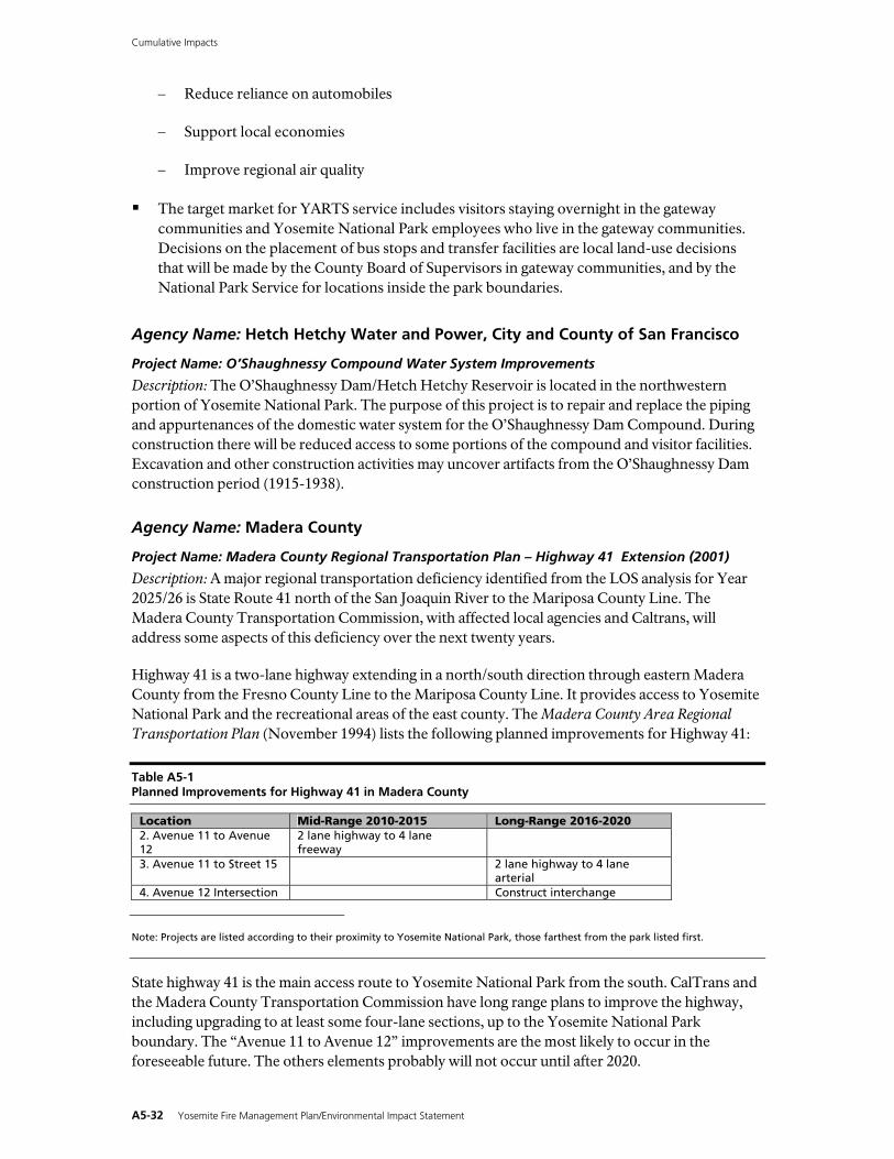
Cumulative Impacts
− Reduce reliance on automobiles
− Support local economies
− Improve regional air quality
The target market for YARTS service includes visitors staying overnight in the gateway communities and Yosemite National Park employees who live in the gateway communities. Decisions on the placement of bus stops and transfer facilities are local land-use decisions that will be made by the County Board of Supervisors in gateway communities, and by the National Park Service for locations inside the park boundaries.
Agency Name: Hetch Hetchy Water and Power, City and County of San Francisco
Project Name: O’Shaughnessy Compound Water System Improvements
Description: The O’Shaughnessy Dam/Hetch Hetchy Reservoir is located in the northwestern portion of Yosemite National Park. The purpose of this project is to repair and replace the piping and appurtenances of the domestic water system for the O’Shaughnessy Dam Compound. During construction there will be reduced access to some portions of the compound and visitor facilities. Excavation and other construction activities may uncover artifacts from the O’Shaughnessy Dam construction period (1915-1938).
Agency Name: Madera County
Project Name: Madera County Regional Transportation Plan – Highway 41 Extension (2001)
Description: A major regional transportation deficiency identified from the LOS analysis for Year 2025/26 is State Route 41 north of the San Joaquin River to the Mariposa County Line. The Madera County Transportation Commission, with affected local agencies and Caltrans, will address some aspects of this deficiency over the next twenty years.
Highway 41 is a two-lane highway extending in a north/south direction through eastern Madera County from the Fresno County Line to the Mariposa County Line. It provides access to Yosemite National Park and the recreational areas of the east county. The Madera County Area Regional Transportation Plan (November 1994) lists the following planned improvements for Highway 41:
Table A5-1 Planned Improvements for Highway 41 in Madera County
Location Mid-Range 2010-2015 Long-Range 2016-2020 2. Avenue 11 to Avenue 12
2 lane highway to 4 lane freeway
3. Avenue 11 to Street 15 2 lane highway to 4 lane arterial
4. Avenue 12 Intersection Construct interchange Note: Projects are listed according to their proximity to Yosemite National Park, those farthest from the park listed first.
State highway 41 is the main access route to Yosemite National Park from the south. CalTrans and the Madera County Transportation Commission have long range plans to improve the highway, including upgrading to at least some four-lane sections, up to the Yosemite National Park boundary. The “Avenue 11 to Avenue 12” improvements are the most likely to occur in the foreseeable future. The others elements probably will not occur until after 2020.
A5-32 Yosemite Fire Management Plan/Environmental Impact Statement

Cumulative Impacts
Project Name: Rio Mesa Area Plan
Description: This area plan encompasses approximately 15,000 acres on the east side of Highway 41, between the San Joaquin River and Highway 145. Construction of approximately 29,000 dwelling units is expected over 100 years. The elevation of the project area is almost 500 feet and lower on flat valley land. This project has an approved area plan that at this stage is conceptual. The next step would require the property owners to work together to develop sub-area plans. According to Bob Stone, Madera County Transportation Commission Planner, one developer currently (December 2003) has a project proposal before the county that is under appeal to the Board of Supervisors after having been rejected by the Madera County Planning Commissions because of water issues. He could make no estimates at this time regarding the number of units to be constructed in the next 15 to 20 years. Several different property owners are involved in this project and a timeline for progression to the next tier of planning is difficult to estimate.
Agency Name: Yosemite Sierra Visitors Bureau, Madera County
Project Name: Winter Recreation Feasibility Study
Description: The Yosemite Sierra Visitors Bureau has applied for funding for an Eastern Madera County Winter Recreation Feasibility Study to define the potential or lack of potential for winter recreation opportunities in Eastern Madera and the surrounding area. This would be accomplished through a market research study to: (1) identify if there is an interest in winter recreation opportunities, (2) identify whether this would lend itself to an anticipated winter visitation, (3) obtain feedback from existing U.S. Forest Service recreation business permit holders for the purpose of identifying better levels of service to the general public from these recreation providers, and (4) preparation of an implementation plan which relates the demand and the potential for obtaining funding and in-kind services to support recommendations, if any, from the analyses.
Agency Name: Mariposa County
Project Name: Expansion of County Transit System
Description: Mariposa County plans to use federal funds matched with the local Transportation Fund dollars for bus purchases to meet the needs of the Mariposa County Transit System. Plans are to purchase four new buses that will be used to replace existing buses. As part of this project, service has been expanded from Coulterville and Greeley Hill to Mariposa, adding one trip per week. County transit system service would potentially be merged with the Yosemite Area Regional Transportation System when YARTS is implemented.
Project Name: Incline Road Reconstruction, Foresta Road Bridge to South Fork
Description: During the flood of January 1997, Incline Road sustained substantial damage. The objective of this project was to reconstruct the roadway to pre-flood conditions from Foresta Bridge to a point near the Merced River/South Fork Merced River confluence. The project consisted of reconstructing the roadway by reinforcing the fill and resurfacing with both road base and asphalt. The project was completed in June 2000.
Project Name: Recreation Master Plan
Description: This plan, now in the early planning stage, is intended to address county wide recreational opportunities, facilities, and strategies.
Yosemite Fire Management Plan/Environmental Impact Statement A5-33
Cumulative Impacts
Project Name: Road Improvement and Circulation Policy
Description: This project will establish access standards for subdivisions and other developments; will establish State of California Fire Safety Standards, define a county grading ordinance and establish county-wide road improvement standards.
Agency Name: Mono County
Project Name: Mono County Regional Transportation Plan (October 2001)
Description: The existing transportation system in Mono County includes the highway and roadway system, transit services, aviation facilities, and non-motorized facilities (generally recreational facilities for bicyclists and pedestrians). Alternatives to the existing transportation system in the county are limited by the county’s isolation, topography, extreme weather conditions, small population, large distances between communities, large amounts of publicly owned land, and environmental constraints to developing additional facilities outside of existing developed areas.
Due to these factors, the existing highway and roadway system will continue to be the major component of the transportation system in the county. Development of new alternative routes for highways and roadways during the 20-year timeframe of this RTP is unlikely due to lack of demand for additional roads, topography, large amounts of publicly owned land, and environmental constraints to developing additional facilities outside developed areas.
The existing transportation system in the county (highway/roadway system, transit services, aviation facilities, non-motorized facilities) has been designed to accommodate increasing demand for those facilities and services over the 20-year timeframe of this RTP. Demand for additional alternative methods of transportation, other than those currently existing in the county, is not anticipated to occur over the 20-year timeframe of this RTP, given the constraints noted above.
Specifically regarding Yosemite National Park, the goal of this project is summarized as follows: “Through it’s transportation planning efforts, the Mono County Local Transportation Commission will assist in the preservation and protection of the park by strengthening the relationship between the Yosemite region and its eastern gateway.”
The objectives of this project are as summarized:
a. Support the park’s mission to preserve the resources that contribute to Yosemite’s unusual character and attractiveness;
b. Encourage diversity in visitor destinations and experiences;
c. Provide for safe and consistent transportation between Yosemite National Park and its eastern gateway; and
d. Develop transportation infrastructure that supports access to and within the gateway communities.
Project Name: Mammoth Lakes Airport Expansion
Description: The Federal Aviation Administration is preparing an EIS, currently in scoping, for expansion of the Mammoth Lakes Airport. The purpose of the expansion is to allow the airport to serve Boeing 737-type planes to land.
A5-34 Yosemite Fire Management Plan/Environmental Impact Statement

Cumulative Impacts
Project Name: Lee Vining Airport Expansion
Description: Planning is underway for the expansion of the Lee Vining Airport runway to improve landing safety. The project will not change the type or size of planes that can land and is not expected to increase use.
Yosemite Fire Management Plan/Environmental Impact Statement A5-35