APPENDIX 3. ABORIGINAL HERITAGE SITE DATA · Aboriginal Cultural Heritage Assessment. South East...
39
Wilpinjong Coal Mine, Central Tablelands of New South Wales - Modification: 162 Aboriginal Cultural Heritage Assessment. South East Archaeology Pty Ltd 2013 APPENDIX 3. ABORIGINAL HERITAGE SITE DATA 20 20 For new sites identified and recording during the present survey (including several marginally outside of the investigation area) and re-recordings of several previously reported sites.
Transcript of APPENDIX 3. ABORIGINAL HERITAGE SITE DATA · Aboriginal Cultural Heritage Assessment. South East...

Wilpinjong Coal Mine, Central Tablelands of New South Wales - Modification: 162 Aboriginal Cultural Heritage Assessment. South East Archaeology Pty Ltd 2013
APPENDIX 3.
ABORIGINAL HERITAGE SITE DATA20
20 For new sites identified and recording during the present survey (including several marginally
outside of the investigation area) and re-recordings of several previously reported sites.

Wilpinjong Coal Mine, Central Tablelands of New South Wales - Modification: 163 Aboriginal Cultural Heritage Assessment. South East Archaeology Pty Ltd 2013
Newly recorded and re-recorded open artefact sites:
Sit
e N
am
e
La
nd
form
Ele
men
t
Slo
pe
Dis
tan
ce t
o W
ate
r
Gro
un
d D
istu
rb
an
ce
Vis
ible
Ex
ten
t o
f E
vid
en
ce:
Len
gth
(m
)
Vis
ible
Ex
ten
t o
f E
vid
en
ce:
Wid
th (
m)
Vis
ible
Locu
s A
rea (
m2)
Mea
n A
rch
aeo
log
ical
Vis
ibil
ity
of
Lo
cu
s (%
)
Eff
ecti
ve
Lo
cu
s A
rea
(m
2)
# o
f A
rte
facts
# o
f A
rte
facts
/m2 o
f
Eff
ecti
ve
Lo
cu
s A
rea
Su
b-S
urfa
ce D
ep
osi
t
Comments
MGA
Reference
WCP 1 spur crest level - very
gentle
>50 low 250 130 32500 10 3250 159 0.049 probable high research potential with probable sub-surface deposits; uncertain of potential depth of deposits as >1m wombat hole; broad low elevated open crest or terrace immediately east of Cumbo Creek; many more artefacts obscured by vegetation; only visible artefacts were identified due to vehicle track, erosion scours and animal tracks; some rock stockpiles but provenance of collected material uncertain; includes previous site on road (WCP1); mostly low ground disturbance; available stone materials quartz and tuffaceous
772810: 6418120
WCP 70
ridge crest level - very
gentle
>50 mod 1 1 1 90 1 1 1.111 unlikely site WCP 70 as recorded by Navin Officer; grassy area with ground disturbance including erosion, cattle and vegetation removal; two quartz pebbles identified but not artefacts; low research potential and unlikely to be sub-surface deposits
771930: 6417903
WCP 437
spur crest level - very
gentle
>50 mod 1 0.3 0.3 80 0.2 2 8.333 possible moderate ground disturbance due to vegetation removal, animal track and Telstra cable; low research potential for possible sub-surface deposits; low quality quartz gravel present; 6m south of fence bordering Ulan-Wollar Road
769210: 6421029
WCP 438
simple slope
gentle >50 mod 180 15 2700 80 2160 27 0.012 possible low research potential; some distance from creek; on a gentle slope 75m to gate on main vehicle track from eastern most artefact; site WCP 123 still present at gate, east of this site; grassy area with moderate ground disturbance due to vehicle track, vegetation removal and erosion; site mostly extends east of the modification investigation area
767407: 6419032

Wilpinjong Coal Mine, Central Tablelands of New South Wales - Modification: 164 Aboriginal Cultural Heritage Assessment. South East Archaeology Pty Ltd 2013
Sit
e N
am
e
La
nd
form
Ele
men
t
Slo
pe
Dis
tan
ce t
o W
ate
r
Gro
un
d D
istu
rb
an
ce
Vis
ible
Ex
ten
t o
f E
vid
en
ce:
Len
gth
(m
)
Vis
ible
Ex
ten
t o
f E
vid
en
ce:
Wid
th (
m)
Vis
ible
Locu
s A
rea (
m2)
Mea
n A
rch
aeo
log
ical
Vis
ibil
ity
of
Lo
cu
s (%
)
Eff
ecti
ve
Lo
cu
s A
rea
(m
2)
# o
f A
rte
facts
# o
f A
rte
facts
/m2 o
f
Eff
ecti
ve
Lo
cu
s A
rea
Su
b-S
urfa
ce D
ep
osi
t
Comments
MGA
Reference
WCP 439
simple slope
mod >50 low 8 2 16 70 11 2 0.180 possible cleared pastoral area; slightly moderate slope; low research potential; grassy area used for pastoral practices; erosion and vegetation removal; stone materials available are tuff and quartz, with abundant tuffaceous material eroding from hillslope; artefact #1 12m north of fence (from 5m west of tree/change in fence direction)
767332: 6418374
WCP 440
simple slope
mod >50 low 1 1 1 70 0.7 1 1.428 possible cleared pastoral area north of fenceline; low research potential; grassy area used for pastoral practices; erosion and vegetaion removal; stone materials available are tuff and quartz, with abundant tuffaceous material eroding from hillslope; artefact located 8m north of fence, 11m east of point where fence changes direction
767415: 6418365
WCP 441
simple slope
mod >50 low 1 1 1 50 0.5 1 2.000 probable low-moderate research potential with probable sub-surface deposits to a depth of <0.5m; edge of near level small spur, overlooks valley; grass, bush and regrowth pine cover area; low-moderate ground disturbance with some erosion and vegetation removal; stone materials available are tuff and quartz
767691: 6418274
WCP 442
ridge crest level - very
gentle
>50 mod 2 1 2 60 1.2 10 8.333 unlikely broad crest; also natural shattered quartz in other exposures; grassy area with moderate ground disturbance due to stock, erosion and vegetation removal; sandstone outcrops; low research potential and unlikely to be sub-surface deposits
771916: 6417762
WCP 443
simple slope
gentle >50 high 1 1 1 80 0.8 1 1.250 unlikely located on vehicle track; highly disturbed area
772119: 6417750
WCP 444
simple slope
gentle >50 mod 14 2 28 50 14 2 0.143 possible broad almost very gentle simple slope; artefacts on track north of fence east of dam; grassy area with moderate ground disturbance due to track and vegetation removal; materials available include quartz and tuff; low research potential
773310: 6417737

Wilpinjong Coal Mine, Central Tablelands of New South Wales - Modification: 165 Aboriginal Cultural Heritage Assessment. South East Archaeology Pty Ltd 2013
Sit
e N
am
e
La
nd
form
Ele
men
t
Slo
pe
Dis
tan
ce t
o W
ate
r
Gro
un
d D
istu
rb
an
ce
Vis
ible
Ex
ten
t o
f E
vid
en
ce:
Len
gth
(m
)
Vis
ible
Ex
ten
t o
f E
vid
en
ce:
Wid
th (
m)
Vis
ible
Locu
s A
rea (
m2)
Mea
n A
rch
aeo
log
ical
Vis
ibil
ity
of
Lo
cu
s (%
)
Eff
ecti
ve
Lo
cu
s A
rea
(m
2)
# o
f A
rte
facts
# o
f A
rte
facts
/m2 o
f
Eff
ecti
ve
Lo
cu
s A
rea
Su
b-S
urfa
ce D
ep
osi
t
Comments
MGA
Reference
WCP 445
simple slope
gentle >50 mod -
high
1 1 1 90 0.9 1 1.111 possible low research potential; probably shallow deposit; grassy area with moderate-high ground disturbance due to erosion adjacent to dam; material available include tuff and quartz; located 15m west of dam and 15m north of fence in erosion scour
773212: 6417765
WCP 446
spur crest level - very
gentle
>50 low -
mod
1 1 1 30 0.3 1 3.333 possible broad low open ridge; very gentle; marginally outside modification study area; grassy area with low-moderate ground disturbance due to vegetation removal, erosion and pastoral use; stone materials available include tuffaceous stone and minor amounts of quartz; low research potential; probably shallow deposits
773020: 6418012
WCP 447
drainage depression
gentle <50 low 1 1 1 50 0.5 2 4.000 probable 45m east of road and 17 metres south of Eucalypt tree, near regrowth scrub
772945: 6418415
WCP 448
simple slope
gentle >50 high 60 3 180 80 144 3 0.021 possible low research potential; probably shallow deposit; high impacts - located on vehicle track opposite Upper Cumbo Road; quartz and tuff stone available; Box forest; site probably continues further west along road but not inspected as outside modification study area
774470: 6415964

Wilpinjong Coal Mine, Central Tablelands of New South Wales - Modification: 166 Aboriginal Cultural Heritage Assessment. South East Archaeology Pty Ltd 2013
SITE NAME: WCP1 (OEH #36-3-0575)
Site Type: Artefact scatter MGA Grid Reference: 772810:6418120 Date Recorded: 25/1/2013 Topographic Map: Wollar 8833-2N Recorder: Peter Kuskie
Landform Element: Spur crest Vegetation: Cleared Slope: Level - very gentle Ground Disturbance: Low Distance to Water: >50
Visible Extent of Surface
Exposures: Length (m)
Visible Extent of Surface
Exposures: Width (m)
Visible Extent of Evidence:
Length (m)
Visible Extent of Evidence:
Width (m)
Visible Locus Area (m2)
Mean Surface
Visibility of Locus
(%)
Mean Arch.
Visibility of Locus
(%)
Effective Locus
Area (m2)
# of Artefacts
# of Artefacts per m2 of Effective
Locus Area
Sub-Surface Deposit
varies varies 250 130 32500 10 10 3250 159 0.049 probable
Artefact Database:
Artefact
#
Colour Stone
Material
Lithic Item
Type
Dimensions
(mm)
Cortex
Amount
(%)
Cortex
Type
Comments MGA
Easting
MGA
Northing
1 white crystal quartz core 35x21x10 on main vehicle track, south of junction; south-west end of site but areas further south not examined because outside study area; 1 scar 1 platform
772777 6418109
2 grey chert core 42x28x21 5 terr south end of site in fenced paddock south-east of gates; four scars and four platforms
772800 6418097
3 cream tuff lithic fragment 16x14x8 1m south of fence 772800 6418112 4 red jasper flake 24x17x8 10 peb along fenceline; platform
preperation; possible edge damage at platform
772800 6418113
5 white quartz lithic fragment 12x10x4 772800 6418113 6 cream/orange tuff flake 24x38x10 5 terr 1m south of fence; example of
use of local material; broad squat flake
772800 6418113
7 white quartz lithic fragment 10x6x3 on fence 772806 6418112 8 cream tuff flake 29x15x8 20 terr on fence 772806 6418112 9 white quartz core fragment 27x17x16 in corridor between two fences 772800 6418114
10 white quartz flake - longitudinal
14x9x4 in corridor between two fences 772800 6418114
11 white quartz flake 13x6x5 in corridor between two fences 772800 6418114 12 yellow porphyritic
rhyolite core 63x48x34 60 peb one flake scar and one platform;
in corridor ('corral') between two fences
772800 6418114
13 grey/cream tuff lithic fragment 15x12x4 in corridor between two fences 772800 6418114 14 brown tuff flake 33x26x5 in corridor between two fences 772804 6418116 15 white quartz lithic fragment 12x8x6 in corridor between two fences 772804 6418116 16 translucent crystal quartz core fragment 22x13x10 in corridor between two fences 772804 6418116 17 white quartz core 24x23x13 in corridor between two fences;
four flake scars and three platforms
772804 6418116
18 red tuff lithic fragment 22x14x13 in corridor between two fences 772804 6418116 19 red tuff flake 20x13x6 in corridor between two fences 772804 6418116 20 cream tuff flake 20x15x9 in corridor between two fences 772804 6418116 21 white quartz flake - distal 18x16x6 in corridor between two fences 772804 6418116 22 white quartz core 25x22x13 30 peb in corridor between two fences; 3
flake scars and three platforms 772804 6418116
23 dark grey chert flake - longitudinal
35x34x17 30 peb in corridor between two fences; cryptocrystalline
772808 6418117

Wilpinjong Coal Mine, Central Tablelands of New South Wales - Modification: 167 Aboriginal Cultural Heritage Assessment. South East Archaeology Pty Ltd 2013
Artefact
#
Colour Stone
Material
Lithic Item
Type
Dimensions
(mm)
Cortex
Amount
(%)
Cortex
Type
Comments MGA
Easting
MGA
Northing
24 translucent crystal quartz flake 6x6x2 in corridor between two fences 772808 6418117 25 white/orange quartz lithic fragment 15x15x5 in corridor between two fences 772808 6418117 26 translucent crystal quartz flake - distal 11x7x3 east end of site and exposure in
corridor between two fences 772810 6418116
27 grey/cream chert core 22x21x13 on fenceline; artefacts #27- 59 north of fence/corral and east of road and west of other fenceline
772798 6418120
28 white quartz flake - longitudinal
17x17x7 90 peb 772798 6418120
29 dark grey petrified wood core fragment 36x20x15 10 terr north side of fence 772803 6418120 30 white quartz lithic fragment 10x8x5 north side of fence 772803 6418120 31 white quartz core 20x16x14 three flake scars and three
platforms 772803 6418120
32 white quartz core 30x25x16 50 peb three flake scars and three platforms
772803 6418120
33 red tuff core 34x20x14 10 tab one flake scar and one platform 772803 6418120 34 cream/yellow/
orange petrified wood flake 35x17x13 40 terr 2m north of fence 772808 6418118
35 grey tuff flake 30x14x5 772808 6418118 36 white quartz core 28x17x12 one flake scar and one platform 772808 6418118 37 white quartz core 19x12x10 30 peb one flake scar and one platform 772808 6418118 38 white quartz flake 29x22x12 80 peb 772808 6418118 39 grey tuff retouched piece
- utilised 20x13x5 edge damage 10mm on margin;
retouch or edge damage 8mm concave end margin; retouch along lateral margin
772808 6418118
40 cream tuff flake 34x21x10 772808 6418118 41 cream tuff flake -
proximal - utilised
20x13x6 distal end snapped; notch; edge damage along lateral margin 13mm; other margin for 18mm
772802 6418123
42 white quartz core 25x18x18 four flake scars and two platforms 772802 6418123 43 cream tuff flake 25x12x8 772806 6418122 44 cream porphyritic
rhyolite geometric microlith
23x15x6 probable geometric microlith but most of chord snapped off
772806 6418122
45 white quartz flake 25x13x9 80 peb 772806 6418122 46 white quartz flake -
proximal 18x14x6 772806 6418122
47 white quartz flake - distal 12x10x5 772806 6418122 48 white quartz flake -
longitudinal 16x8x4 772806 6418122
49 cream chert flake - proximal
20x12x4 772806 6418122
50 white quartz core 24x19x7 50 peb two flake scars and two platforms 772807 6418120 51 cream tuff flake - distal -
utilised 17x9x4 minor edge damage along lateral
margin 772807 6418120
52 cream tuff flake 10x8x2 772807 6418120 53 cream tuff flake - distal 12x10x2 772807 6418120 54 cream tuff flake 13x10x2 772807 6418120 55 white crystal quartz core fragment 19x12x8 772807 6418120 56 white crystal quartz core fragment 22x18x12 772807 6418120 57 white quartz core 34x32x15 three flake scars and two
platforms 772807 6418120
58 cream tuff lithic fragment 10x8x2 772807 6418126 59 cream chert flake 15x20x3 60 white quartz flake 12x8x3 along vehicle track, beginning at
north end with #60 and heading south
772869 6418276
61 translucent crystal quartz flake 28x24x9 20m south along road from #60 772853 6418259 62 white quartz core 30x28x19 eight flake scars, one platform
and unidirectional use 772853 6418259
63 white quartz flake 20x15x10 1m south of #61, 62 772853 6418258 64 white quartz lithic fragment 10x6x3 2m south of #63 772853 6418256 65 white quartz flake 17x6x6 2m south of #64 772853 6418256 66 white quartz lithic fragment 18x11x5 2m south of #65 772853 6418256 67 white quartz lithic fragment 17x10x8 1m south of #66 along road 772853 6418255

Wilpinjong Coal Mine, Central Tablelands of New South Wales - Modification: 168 Aboriginal Cultural Heritage Assessment. South East Archaeology Pty Ltd 2013
Artefact
#
Colour Stone
Material
Lithic Item
Type
Dimensions
(mm)
Cortex
Amount
(%)
Cortex
Type
Comments MGA
Easting
MGA
Northing
68 white quartz core fragment 17x13x10 1m south of #66 along road 772853 6418255 69 grey quartz core 24x20x14 1m south of #66 along road; six
flake scars and three platforms 772853 6418255
70 white quartz core 28x23x10 2m east along road from #69; two flake scars and two platforms
772854 6418252
71 white quartz flake 12x5x3 1m south of #69 along road; possible microblade
772851 6418252
72 white quartz flake 20x15x7 772851 6418252 73 white quartz flake 14x12x5 772851 6418252 74 white quartz lithic fragment 15x10x4 772851 6418252 75 white quartz lithic fragment 11x6x2 772851 6418252 76 white quartz flake - distal 11x10x4 772851 6418252 77 white quartz lithic fragment 3x8x2 772851 6418252 78 white quartz core 21x16x15 three flake scars and two
platforms 772851 6418252
79 purple tuff flake 35x28x10 #60-79 along road 772851 6418252
80 cream chert tula adze 40x17x9 retouched/utilised longitudinal flake - tula adze slug; in grass 5m west of fence; generally low visibilty; 10m north in grass from road and erosion, extensive step/drainage; tula like; retouch 35mm along lateral margin
772860 6418186
81 white quartz core 44x26x16 70 peb 10% visibility in grass; one flake scar and one platform
772843 6418176
82 white quartz flake 30x22x13 10 peb 5m east of fence near rock piles 772861 6415132 83 cream tuff flake 30x23x7 south of rock piles 772874 6418116 84 white quartz flake -
proximal 15x8x2 772874 6418116
85 cream tuff lithic fragment 16x13x4 middle of rock piles 772880 6418139 86 white quartz lithic fragment 23x15x9 middle of rock piles 772900 6418142 87 cream tuff microblade
core 30x30x13 four flake scars and 1 platform;
high quality tuff; east of most of the rock piles; east edge of visible site; generally 10% visibility in grass; more artefacts probably deeper below exposed soil
772909 6418126
88 purple tuff retouched piece - utilised
17x10x4 #88-96 continuation of artefacts along road, from north to south; edge damage 12mm along lateral margin; 6mm end margin; 12mm other lateral margin
772852 6418251
89 yellow/brown/red
tuff retouched piece - utilised
26x20x5 adjacent to #88; extensive retouch and edge damage around margins; 20mm/18mm/15mm
772852 6418251
90 white quartz flake 18x16x8 3m south along road 772850 6418246 91 white quartz lithic fragment 16x16x11 772850 6418246 92 brown/red tuff core 80x68x55 5 tab ten flake scares and three
platforms 772850 6418246
93 grey quartz core 22x15x10 3m south; 772850 6418243 94 white quartz core 30x26x16 2m south; six flake scars and two
platforms 772848 6418243
95 grey chert retouched flake 25x18x7 notch in lateral margin; retouch/edge damage 15mm/12mm along distal end
772848 6418243
96 grey acidic volcanic
flake 28x24x10 15m south of #95; 2m west of road; edge damage but may be due to vechicles
772841 6418226
97 cream chert flake 17x15x4 #97-138 continuation of artefact cluster north of fence and east of road
98 translucent quartz flake - longitudinal
15x12x5
99 white quartz lithic fragment 26x11x9 100 grey chert flake 24x18x3 6m east of road

Wilpinjong Coal Mine, Central Tablelands of New South Wales - Modification: 169 Aboriginal Cultural Heritage Assessment. South East Archaeology Pty Ltd 2013
Artefact
#
Colour Stone
Material
Lithic Item
Type
Dimensions
(mm)
Cortex
Amount
(%)
Cortex
Type
Comments MGA
Easting
MGA
Northing
101 grey quartzite pebble
hammerstone 70x60x50 70 peb split at one end; extreme pounding damage; 1m east of road
102 white quartz lithic fragment 20x10x10 103 white quartz core 28x15x10 one flake scar and one platform;
2m east of road 772797 6418142
104 white quartz core fragment 34x22x13 1m east of road 772796 6418142 105 cream tuff bondi point 30x10x8 tip of bondi point broken off;
possible edge damage; in main cluster of artefacts
772810 6418135
106 white quartz lithic fragment 18x13x10 772810 6418135 107 white quartz core fragment 20x13x8 one flake scar and one platform 772810 6418135 108 white quartz lithic fragment 15x8x4 772810 6418135 109 purple chert flake - medial 23x17x4 772810 6418135 110 white quartz lithic fragment 10x8x3 772810 6418135 111 white quartz flake 17x10x3 772810 6418135 112 cream/red tuff lithic fragment 32x23x10 20 terr 772810 6418135 113 white quartz lithic fragment 15x10x5 772810 6418135 114 white quartz core fragment 12x9x5 772810 6418135 115 translucent crystal quartz flake -
proximal 9x9x2 772810 6418135
116 white quartz flake 14x14x4 772810 6418135 117 white quartz lithic fragment 14x8x5 772810 6418135 118 white quartz flake -
longitudinal 12x8x4 772810 6418135
119 white quartz flake 15x16x6 772810 6418135 120 white quartz flake 9x9x3 772810 6418135 121 cream/red tuff core fragment 33x20x7 772810 6418135 122 white quartz lithic fragment 18x6x5 772822 6418146 123 cream/grey chert lithic fragment 20x10x8 772823 6418146 124 white quartz lithic fragment 18x7x4 772837 6418141 125 white quartz core fragment 26x15x13 artefacts #125-138 are on the
edge of spur, 1-10m east of road 772809 6418145
126 dark grey petrified wood flake - distal 18x13x4 772809 6418145 127 grey chert backed artefact
- portion 18x7x5 tip and chord snapped 772809 6418145
128 pink tuff core 47x28x17 40 terr three flake scars and two platforms
772809 6418145
129 white quartz lithic fragment 12x10x4 772809 6418145 130 grey/cream acidic
volcanic core 54x30x21 five flake scars and three
platforms; heavy step termination 772813 6418155
131 white quartz flake 15x14x6 772813 6418155 132 white quartz flake 20x15x5 772813 6418155 133 translucent quartz flake 7x7x2 772813 6418155 134 cream chert flake 12x10x4 772813 6418155 135 white quartz core 45x33x25 10 terr three flake scars and three
platforms 772821 6418159
136 white quartz core fragment 24x18x10 30 peb 772816 6418166 137 white quartz core 39x30x20 5 peb four flake scars and two platforms 772821 6418169 138 white quartz flake 21x15x8 772821 6418177 139 white quartz core 25x21x16 four flake scars and three
platforms; artefacts #139-160 at south part of site on east verge of road
772820 6418182
140 white quartz microblade 15x6x4 classic microblade 772820 6418182 141 white quartz flake 16x14x3 772820 6418182 142 white quartz core fragment 20x16x8 20 terr 772820 6418182 143 white quartz core 33x19x16 10 terr three flake scars and two
platforms 772820 6418182
144 white quartz flake 13x11x8 772820 6418182 145 white quartz flake -
longitudinal 16x12x2 772820 6418182
146 white quartz lithic fragment 19x10x5 772820 6418182 147 white quartz lithic fragment 22x15x9 20 peb 772820 6418182 148 grey chert flake 40x26x10 10 peb very sugary chert 772820 6418182

Wilpinjong Coal Mine, Central Tablelands of New South Wales - Modification: 170 Aboriginal Cultural Heritage Assessment. South East Archaeology Pty Ltd 2013
Artefact
#
Colour Stone
Material
Lithic Item
Type
Dimensions
(mm)
Cortex
Amount
(%)
Cortex
Type
Comments MGA
Easting
MGA
Northing
149 white quartz core fragment 20x14x12 772824 6418199 150 purple tuff flake - distal 28x20x10 minor edge damage 772824 6418199 151 white quartz core fragment 24x16x13 772824 6418199 152 red tuff flake 30x28x8 5 tab 772824 6418199 153 white quartz lithic fragment 19x14x4 772824 6418199 154 white quartz flake -
longitudinal 18x9x5 772824 6418199
155 white quartz flake 25x21x8 100 peb 772835 641821 156 grey tuff lithic fragment 16x12x6 772838 6418215 157 red tuff retouched piece 55x30x16 30 tab possible 35mm retouch along
lateral margin 772902 6418361
158 white quartz core 25x23x13 one flake scar and one platform 772902 6418354 159 cream chert flake 25x17x5 #158-160 all along east verge of
road 772902 6418354
Additional Comments: Originally recorded by Navin Officer (2005); High research potential with probable sub-surface deposits; Uncertain of potential depth of deposits as >1m wombat hole; Broad low elevated open crest or terrace immediately east of Cumbo Creek; Many more artefacts obscured by vegetation; Only visible artefacts were identified due to vehicle track, erosion scours and animal
tracks; Some rock stockpiles but provenance of collected material uncertain; Includes previous site on road (WCP1); Mostly low ground disturbance; Available stone materials quartz and tuffaceous.

Wilpinjong Coal Mine, Central Tablelands of New South Wales - Modification: 171 Aboriginal Cultural Heritage Assessment. South East Archaeology Pty Ltd 2013
Site Location: WCP1
Photographs: WCP1
View north across WCP1 from southern end of site.

Wilpinjong Coal Mine, Central Tablelands of New South Wales - Modification: 172 Aboriginal Cultural Heritage Assessment. South East Archaeology Pty Ltd 2013
View north across WCP1 from southern end of site and main cluster of artefacts north of fenced 'corral', with Cumbo Creek visible to left.
View north across main cluster of artefacts north of fenced 'corral'.

Wilpinjong Coal Mine, Central Tablelands of New South Wales - Modification: 173 Aboriginal Cultural Heritage Assessment. South East Archaeology Pty Ltd 2013
View south of artefacts along and near road, from near northern end of site (Cumbo Creek visible to right)
Jasper flake (artefact #4; left) and chert tula adze (artefact #80; right).

Wilpinjong Coal Mine, Central Tablelands of New South Wales - Modification: 174 Aboriginal Cultural Heritage Assessment. South East Archaeology Pty Ltd 2013
SITE NAME: WCP70 (OEH #36-3-0644)
Site Type: Isolated artefact MGA Grid Reference: 771930:6417903 Date Recorded: 5/3/2013 Topographic Map: Wollar 8833-2N Recorder: Peter Kuskie
Landform Element: Ridge crest Vegetation: Cleared Slope: Level - very gentle Ground Disturbance: Moderate Distance to Water: >50
Visible Extent of Surface
Exposures: Length (m)
Visible Extent of Surface
Exposures: Width (m)
Visible Extent of Evidence:
Length (m)
Visible Extent of Evidence:
Width (m)
Visible Locus Area (m2)
Mean Surface
Visibility of Locus
(%)
Mean Arch.
Visibility of Locus
(%)
Effective Locus
Area (m2)
# of Artefacts
# of Artefacts per m2 of Effective
Locus Area
Sub-Surface Deposit
12 2 1 1 1 90 90 1 1 1.111 unlikely
Artefact Database:
Artefact
#
Colour Stone
Material
Lithic Item
Type
Dimensions
(mm)
Cortex
Amount
(%)
Cortex
Type
Comments MGA
Easting
MGA
Northing
1 white quartz retouched flake 33x24x8 retouch 15mm and 12mm along lateral margin; same artefact as recorded by Navin Office as site WCP 70
771930 6417903
Additional Comments: Originally recorded by Navin Officer (2005); Grassy area with ground disturbance including erosion, cattle and vegetation removal; Two quartz pebbles also identified but not artefacts; Low research potential and unlikely to be sub-surface deposits.

Wilpinjong Coal Mine, Central Tablelands of New South Wales - Modification: 175 Aboriginal Cultural Heritage Assessment. South East Archaeology Pty Ltd 2013
Site Location: WCP70
Photograph: WCP70

Wilpinjong Coal Mine, Central Tablelands of New South Wales - Modification: 176 Aboriginal Cultural Heritage Assessment. South East Archaeology Pty Ltd 2013
SITE NAME: WCP437
Site Type: Artefact scatter MGA Grid Reference: 769210:6421029 Date Recorded: 4/3/2013 Topographic Map: Wollar 8833-2N Recorder: Peter Kuskie
Landform Element: Spur crest Vegetation: Cleared Slope: Level - very gentle Ground Disturbance: Moderate Distance to Water: >50
Visible Extent of Surface
Exposures: Length (m)
Visible Extent of Surface
Exposures: Width (m)
Visible Extent of Evidence:
Length (m)
Visible Extent of Evidence:
Width (m)
Visible Locus Area (m2)
Mean Surface
Visibility of Locus
(%)
Mean Arch.
Visibility of Locus
(%)
Effective Locus
Area (m2)
# of Artefacts
# of Artefacts per m2 of Effective
Locus Area
Sub-Surface Deposit
50+ 0.3 1 0.3 0.3 80 80 0.2 2 8.333 possible
Artefact Database:
Artefact
#
Colour Stone
Material
Lithic Item
Type
Dimensions
(mm)
Cortex
Amount
(%)
Cortex
Type
Comments MGA
Easting
MGA
Northing
1 white quartz flake 19x14x5 distal end snapped; on animal track 769210 6421029
2 white quartz lithic fragment 22x13x6 on track 1m east from #1 769211 6421029 Additional Comments: Moderate ground disturbance due to vegetation removal, animal track and Telstra cable; 6 metres south of fence bordering Ulan-Wollar Road; Low quality quartz gravel present; Low research potential.

Wilpinjong Coal Mine, Central Tablelands of New South Wales - Modification: 177 Aboriginal Cultural Heritage Assessment. South East Archaeology Pty Ltd 2013
Site Location: WCP437
Photograph: WCP437 (view north to Ulan - Wollar Road and railway)

Wilpinjong Coal Mine, Central Tablelands of New South Wales - Modification: 178 Aboriginal Cultural Heritage Assessment. South East Archaeology Pty Ltd 2013
SITE NAME: WCP438
Site Type: Artefact scatter MGA Grid Reference: 767407:6419032 Date Recorded: 24/1/2013 Topographic Map: Wollar 8833-2N Recorder: Peter Kuskie
Landform Element: Simple slope Vegetation: Cleared, Forested Slope: Gentle Ground Disturbance: Moderate Distance to Water: >50
Visible Extent of Surface
Exposures: Length (m)
Visible Extent of Surface
Exposures: Width (m)
Visible Extent of Evidence:
Length (m)
Visible Extent of Evidence:
Width (m)
Visible Locus Area (m2)
Mean Surface
Visibility of Locus
(%)
Mean Arch.
Visibility of Locus
(%)
Effective Locus
Area (m2)
# of Artefacts
# of Artefacts per m2 of Effective
Locus Area
Sub-Surface Deposit
180+ 10+ 180 15 2700 80 80 2160 27 0.012 possible
Artefact Database:
Artefact
#
Colour Stone
Material
Lithic Item
Type
Dimensions
(mm)
Cortex
Amount
(%)
Cortex
Type
Comments MGA
Easting
MGA
Northing
1 white/pink quartz flake - distal 20x15x5 on track 767407 6419032 2 white quartz lithic fragment 30x20x5 8m north of #1; off the track 767405 6419040 3 translucent crystal quartz flake 20x10x3 16m east along track from #1 767423 6419037 4 white quartz flake -
longitudinal 30x12x8 flake snapped in two; conjoin; 6m
east along track from #3 767429 6419037
5 white quartz flake - distal 15x10x5 1m north of #4 along track 767429 6419038 6 white quartz flake - distal 15x10x2 1m east of #4 on track 767429 6419038 7 white quartz lithic fragment 15x10x5 2m north of #4; just off the track 767429 6419040 8 white quartz lithic fragment 12x8x2 3m east of #7 along track 767434 6419037 9 white quartz lithic fragment 30x11x10 767434 6419037
10 grey chert retouched piece 11x12x2 retouch along length of lateral margin; same location as #8-9
767434 6419037
11 brown tuff flake 30x25x7 12m east of #8-10 767444 6419039 12 white quartz flake -
longitudinal 10x5x2 2m east of #11 767446 6419039
13 white quartz lithic fragment 28x18x5 3m north of #12 767446 6419042 14 brown tuff core 40x30x15 10 terr 16m east of #10; six scars and two
platforms 767459 6419047
15 purple tuff core 50x50x10 40 terr 25m east along track from #14; eight scars and three platforms; mineral inclusions
767486 6419045
16 white quartz flake 20x20x2 39m east along track from #15 767529 6419049 17 white/orange chert core 20x11x10 1m south of #16; five flake scars
and two platforms 767529 6419048
18 black chert flake - distal 13x10x4 13m east along track from #17 767543 6419052 19 white quartz flake 20x20x2 3m north-east of #18 767544 6419054 20 black chert flake 30x15x5 2m east of #19 767546 6419054 21 black chert flake 20x15x4 10 terr 1m north of #20 767546 6419055 22 black chert flake - distal 30x12x5 2m north-east of #21 767547 6419056 23 brown/red tuff flake 27x18x3 2m east from #22 767549 6419056 24 white quartz core 20x15x10 6m north of #23; three flake scars
and one platform 767552 6419058
25 white quartz core fragment 25x20x5 5m east of #23 767553 6419056 26 grey chert lithic fragment 6x5x2 2m north-east of #25 767557 6419055 27 black chert lithic fragment 10x10x1 767557 6419055

Wilpinjong Coal Mine, Central Tablelands of New South Wales - Modification: 179 Aboriginal Cultural Heritage Assessment. South East Archaeology Pty Ltd 2013
Additional Comments: On a gentle slope 75m to gate on main vehicle track from eastern most artefact; Site WCP 123 still present at gate, east of this site; Grassy area with moderate ground disturbance due to vehicle track, vegetation removal
and erosion; Site mostly extends east of the modification investigation area Some distance from creek; Low research potential.

Wilpinjong Coal Mine, Central Tablelands of New South Wales - Modification: 180 Aboriginal Cultural Heritage Assessment. South East Archaeology Pty Ltd 2013
Site Location: WCP438
Photograph: WCP438 (view north-east across site)

Wilpinjong Coal Mine, Central Tablelands of New South Wales - Modification: 181 Aboriginal Cultural Heritage Assessment. South East Archaeology Pty Ltd 2013
SITE NAME: WCP439
Site Type: Artefact scatter MGA Grid Reference: 767332:6418374 Date Recorded: 23/1/2013 Topographic Map: Wollar 8833-2N Recorder: Peter Kuskie
Landform Element: Simple slope Vegetation: Cleared Slope: Moderate Ground Disturbance: Low Distance to Water: >50
Visible Extent of Surface
Exposures: Length (m)
Visible Extent of Surface
Exposures: Width (m)
Visible Extent of Evidence:
Length (m)
Visible Extent of Evidence:
Width (m)
Visible Locus Area (m2)
Mean Surface
Visibility of Locus
(%)
Mean Arch.
Visibility of Locus
(%)
Effective Locus
Area (m2)
# of Artefacts
# of Artefacts per m2 of Effective
Locus Area
Sub-Surface Deposit
varies varies 8 2 16 70 70 11 2 0.180 possible
Artefact Database:
Artefact
#
Colour Stone
Material
Lithic Item
Type
Dimensions
(mm)
Cortex
Amount
(%)
Cortex
Type
Comments MGA
Easting
MGA
Northing
1 white quartz core 30x25x10 three flake scars 767330 6418364 2 white quartz lithic fragment 15x10x5 medial portion 767333 6418372
Additional Comments: Cleared pastoral area; Slightly moderate slope; Grassy area used for pastoral practices; Erosion and vegetation removal; Stone materials available are tuff and quartz, with abundant tuffaceous material eroding
from hillslope; Artefact #1 12 metres north of fence (from 5 metres west of tree/change in fence
direction); Low research potential.

Wilpinjong Coal Mine, Central Tablelands of New South Wales - Modification: 182 Aboriginal Cultural Heritage Assessment. South East Archaeology Pty Ltd 2013
Site Location: WCP439
Photograph: WCP439 (view east)

Wilpinjong Coal Mine, Central Tablelands of New South Wales - Modification: 183 Aboriginal Cultural Heritage Assessment. South East Archaeology Pty Ltd 2013
SITE NAME: WCP440
Site Type: Isolated artefact MGA Grid Reference: 767415:6418365 Date Recorded: 23/1/2013 Topographic Map: Wollar 8833-2N Recorder: Peter Kuskie
Landform Element: Simple slope Vegetation: Cleared Slope: Moderate Ground Disturbance: Low Distance to Water: >50
Visible Extent of Surface
Exposures: Length (m)
Visible Extent of Surface
Exposures: Width (m)
Visible Extent of Evidence:
Length (m)
Visible Extent of Evidence:
Width (m)
Visible Locus Area (m2)
Mean Surface
Visibility of Locus
(%)
Mean Arch.
Visibility of Locus
(%)
Effective Locus
Area (m2)
# of Artefacts
# of Artefacts per m2 of Effective
Locus Area
Sub-Surface Deposit
varies varies 1 1 1 70 70 0.7 1 1.428 possible
Artefact Database:
Artefact
#
Colour Stone
Material
Lithic Item
Type
Dimensions
(mm)
Cortex
Amount
(%)
Cortex
Type
Comments MGA
Easting
MGA
Northing
1 white quartz flake 48x18x10 10 terr 767415 6418365 Additional Comments: Cleared pastoral area north of fenceline; Grassy area used for pastoral practices; Erosion and vegetation removal; Stone materials available are tuff and quartz, with abundant tuffaceous material eroding
from hillslope; Artefact located 8 metres north of fence, 11 metres east of point where fence changes
direction; Low research potential.

Wilpinjong Coal Mine, Central Tablelands of New South Wales - Modification: 184 Aboriginal Cultural Heritage Assessment. South East Archaeology Pty Ltd 2013
Site Location: WCP440
Photograph: WCP440 (view north)
Wilpinjong Coal Mine, Central Tablelands of New South Wales - Modification: 185 Aboriginal Cultural Heritage Assessment. South East Archaeology Pty Ltd 2013
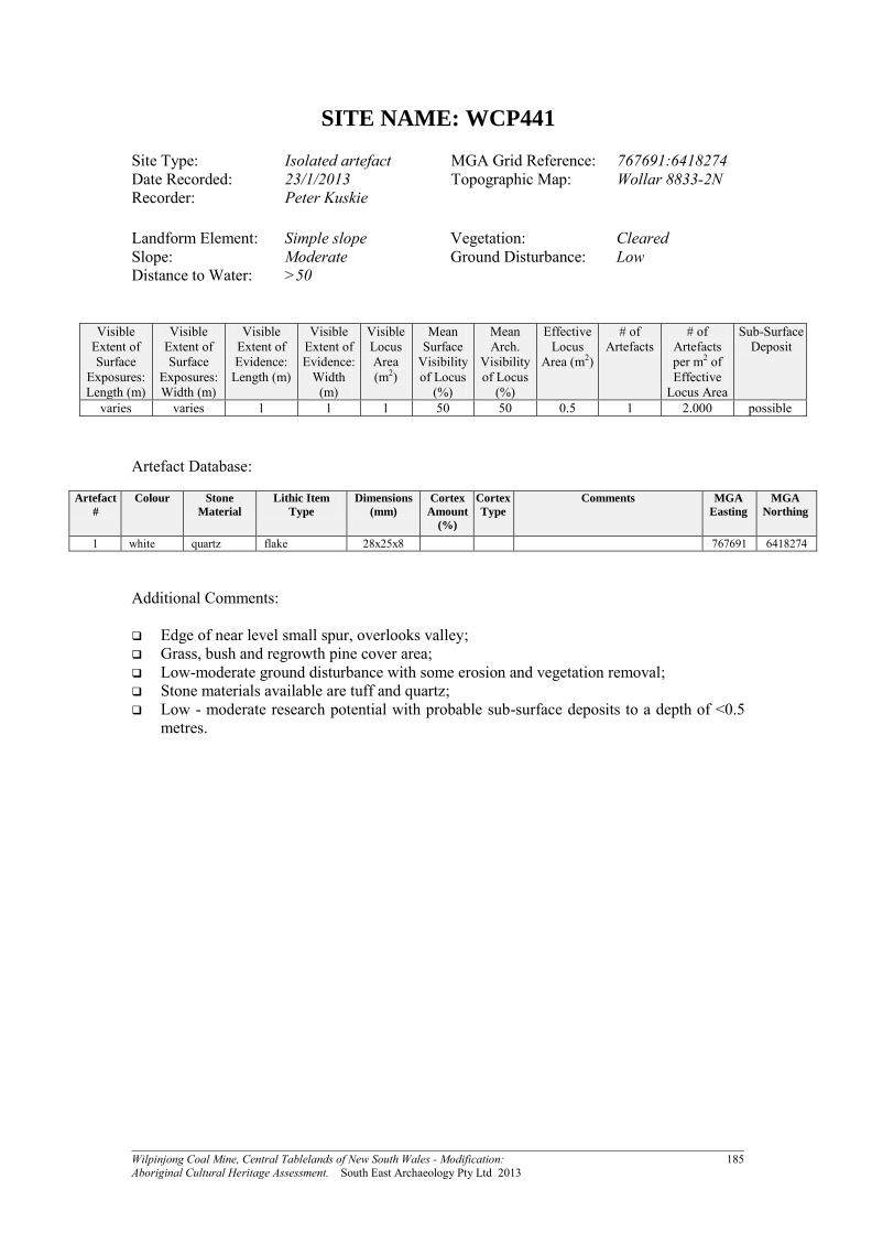
SITE NAME: WCP441
Site Type: Isolated artefact MGA Grid Reference: 767691:6418274 Date Recorded: 23/1/2013 Topographic Map: Wollar 8833-2N Recorder: Peter Kuskie
Landform Element: Simple slope Vegetation: Cleared Slope: Moderate Ground Disturbance: Low Distance to Water: >50
Visible Extent of Surface
Exposures: Length (m)
Visible Extent of Surface
Exposures: Width (m)
Visible Extent of Evidence:
Length (m)
Visible Extent of Evidence:
Width (m)
Visible Locus Area (m2)
Mean Surface
Visibility of Locus
(%)
Mean Arch.
Visibility of Locus
(%)
Effective Locus
Area (m2)
# of Artefacts
# of Artefacts per m2 of Effective
Locus Area
Sub-Surface Deposit
varies varies 1 1 1 50 50 0.5 1 2.000 possible
Artefact Database:
Artefact
#
Colour Stone
Material
Lithic Item
Type
Dimensions
(mm)
Cortex
Amount
(%)
Cortex
Type
Comments MGA
Easting
MGA
Northing
1 white quartz flake 28x25x8 767691 6418274 Additional Comments: Edge of near level small spur, overlooks valley; Grass, bush and regrowth pine cover area; Low-moderate ground disturbance with some erosion and vegetation removal; Stone materials available are tuff and quartz; Low - moderate research potential with probable sub-surface deposits to a depth of <0.5
metres.

Wilpinjong Coal Mine, Central Tablelands of New South Wales - Modification: 186 Aboriginal Cultural Heritage Assessment. South East Archaeology Pty Ltd 2013
Site Location: WCP441
Photograph: WCP441 (view north) (inset - quartz flake)

Wilpinjong Coal Mine, Central Tablelands of New South Wales - Modification: 187 Aboriginal Cultural Heritage Assessment. South East Archaeology Pty Ltd 2013
SITE NAME: WCP442
Site Type: Artefact scatter MGA Grid Reference: 771916:6417762 Date Recorded: 5/3/2013 Topographic Map: Wollar 8833-2N Recorder: Peter Kuskie
Landform Element: Ridge crest Vegetation: Cleared Slope: Level - very gentle Ground Disturbance: Moderate Distance to Water: >50
Visible Extent of Surface
Exposures: Length (m)
Visible Extent of Surface
Exposures: Width (m)
Visible Extent of Evidence:
Length (m)
Visible Extent of Evidence:
Width (m)
Visible Locus Area (m2)
Mean Surface
Visibility of Locus
(%)
Mean Arch.
Visibility of Locus
(%)
Effective Locus
Area (m2)
# of Artefacts
# of Artefacts per m2 of Effective
Locus Area
Sub-Surface Deposit
4 1 2 1 2 60 60 1.2 10 8.333 unlikely
Artefact Database:
Artefact
#
Colour Stone
Material
Lithic Item
Type
Dimensions
(mm)
Cortex
Amount
(%)
Cortex
Type
Comments MGA
Easting
MGA
Northing
1 white quartz flake - distal 14x12x4 771916 6417762 2 white quartz retouched piece 18x13x8 retouch/edge damage; 10mm
distal end; microblade in shape 771916 6417762
3 white quartz lithic fragment 24x10x7 771916 6417762 4 translucent crystal quartz blade - medial 20x16x7 771916 6417762 5 white quartz lithic fragment 15x8x6 771916 6417762 6 white quartz core fragment 20x15x7 771916 6417762 7 white quartz flake 25x17x7 771916 6417762 8 translucent quartz core 25x23x13 six flake scars and three platforms 771916 6417762 9 white quartz core 34x25x15 30 peb three flake scars and three
platforms 771916 6417762
10 white quartz core 35x28x15 30 peb four flake scars and two platforms 771916 6417762 Additional Comments: Broad crest; Also natural shattered quartz in other exposures; Grassy area with moderate ground disturbance due to stock, erosion and vegetation
removal; Sandstone outcrops; Low research potential and unlikely to be sub-surface deposits.

Wilpinjong Coal Mine, Central Tablelands of New South Wales - Modification: 188 Aboriginal Cultural Heritage Assessment. South East Archaeology Pty Ltd 2013
Site Location: WCP442
Photograph: WCP442 (view north-west)

Wilpinjong Coal Mine, Central Tablelands of New South Wales - Modification: 189 Aboriginal Cultural Heritage Assessment. South East Archaeology Pty Ltd 2013
SITE NAME: WCP443
Site Type: Isolated artefact MGA Grid Reference: 772119:6417750 Date Recorded: 5/3/2013 Topographic Map: Wollar 8833-2N Recorder: Birgitta Stephenson
Landform Element: Simple slope Vegetation: Cleared Slope: Gentle Ground Disturbance: High Distance to Water: >50
Visible Extent of Surface
Exposures: Length (m)
Visible Extent of Surface
Exposures: Width (m)
Visible Extent of Evidence:
Length (m)
Visible Extent of Evidence:
Width (m)
Visible Locus Area (m2)
Mean Surface
Visibility of Locus
(%)
Mean Arch.
Visibility of Locus
(%)
Effective Locus
Area (m2)
# of Artefacts
# of Artefacts per m2 of Effective
Locus Area
Sub-Surface Deposit
50+ 3 1 1 1 80 80 0.8 1 1.250 unlikely
Artefact Database:
Artefact
#
Colour Stone
Material
Lithic Item
Type
Dimensions
(mm)
Cortex
Amount
(%)
Cortex
Type
Comments MGA
Easting
MGA
Northing
1 white quartz lithic fragment 30x20x5 centre of track 772119 6417751 Additional Comments: Located on vehicle track; Highly disturbed area; Low research potential.

Wilpinjong Coal Mine, Central Tablelands of New South Wales - Modification: 190 Aboriginal Cultural Heritage Assessment. South East Archaeology Pty Ltd 2013
Site Location: WCP443
Photograph: WCP443

Wilpinjong Coal Mine, Central Tablelands of New South Wales - Modification: 191 Aboriginal Cultural Heritage Assessment. South East Archaeology Pty Ltd 2013
SITE NAME: WCP444
Site Type: Artefact scatter MGA Grid Reference: 773310:6417737 Date Recorded: 24/1/2013 Topographic Map: Wollar 8833-2N Recorder: Peter Kuskie
Landform Element: Simple slope Vegetation: Cleared Slope: Gentle Ground Disturbance: Moderate Distance to Water: >50
Visible Extent of Surface
Exposures: Length (m)
Visible Extent of Surface
Exposures: Width (m)
Visible Extent of Evidence:
Length (m)
Visible Extent of Evidence:
Width (m)
Visible Locus Area (m2)
Mean Surface
Visibility of Locus
(%)
Mean Arch.
Visibility of Locus
(%)
Effective Locus
Area (m2)
# of Artefacts
# of Artefacts per m2 of Effective
Locus Area
Sub-Surface Deposit
varies varies 14 2 28 50 50 14 2 0.143 possible
Artefact Database:
Artefact
#
Colour Stone
Material
Lithic Item
Type
Dimensions
(mm)
Cortex
Amount
(%)
Cortex
Type
Comments MGA
Easting
MGA
Northing
1 white quartz flake 21x15x8 on track adjacent to fence 773310 6417737 2 white quartz flake 22x20x8 773324 6417732
Additional Comments: Broad almost very gentle simple slope; Artefacts on track north of fence east of dam; Grassy area with moderate ground disturbance due to track and vegetation removal; Materials available include quartz and tuff; Low research potential.

Wilpinjong Coal Mine, Central Tablelands of New South Wales - Modification: 192 Aboriginal Cultural Heritage Assessment. South East Archaeology Pty Ltd 2013
Site Location: WCP444
Photograph: WCP444 (view west)
Wilpinjong Coal Mine, Central Tablelands of New South Wales - Modification: 193 Aboriginal Cultural Heritage Assessment. South East Archaeology Pty Ltd 2013
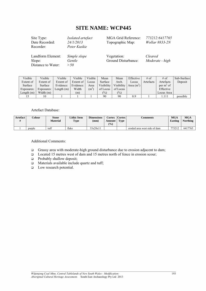
SITE NAME: WCP445
Site Type: Isolated artefact MGA Grid Reference: 773212:6417765 Date Recorded: 24/1/2013 Topographic Map: Wollar 8833-2N Recorder: Peter Kuskie
Landform Element: Simple slope Vegetation: Cleared Slope: Gentle Ground Disturbance: Moderate - high Distance to Water: >50
Visible Extent of Surface
Exposures: Length (m)
Visible Extent of Surface
Exposures: Width (m)
Visible Extent of Evidence:
Length (m)
Visible Extent of Evidence:
Width (m)
Visible Locus Area (m2)
Mean Surface
Visibility of Locus
(%)
Mean Arch.
Visibility of Locus
(%)
Effective Locus
Area (m2)
# of Artefacts
# of Artefacts per m2 of Effective
Locus Area
Sub-Surface Deposit
15 10 1 1 1 90 90 0.9 1 1.111 possible
Artefact Database:
Artefact
#
Colour Stone
Material
Lithic Item
Type
Dimensions
(mm)
Cortex
Amount
(%)
Cortex
Type
Comments MGA
Easting
MGA
Northing
1 purple tuff flake 33x28x11 eroded area west side of dam 773212 6417765 Additional Comments: Grassy area with moderate-high ground disturbance due to erosion adjacent to dam; Located 15 metres west of dam and 15 metres north of fence in erosion scour; Probably shallow deposit; Materials available include quartz and tuff; Low research potential.

Wilpinjong Coal Mine, Central Tablelands of New South Wales - Modification: 194 Aboriginal Cultural Heritage Assessment. South East Archaeology Pty Ltd 2013
Site Location: WCP445
Photograph: WCP445 (view east)

Wilpinjong Coal Mine, Central Tablelands of New South Wales - Modification: 195 Aboriginal Cultural Heritage Assessment. South East Archaeology Pty Ltd 2013
SITE NAME: WCP446
Site Type: Isolated artefact MGA Grid Reference: 773020:6418012 Date Recorded: 25/1/2013 Topographic Map: Wollar 8833-2N Recorder: Peter Kuskie
Landform Element: Spur crest Vegetation: Cleared Slope: Level - very gentle Ground Disturbance: Low - moderate Distance to Water: >50
Visible Extent of Surface
Exposures: Length (m)
Visible Extent of Surface
Exposures: Width (m)
Visible Extent of Evidence:
Length (m)
Visible Extent of Evidence:
Width (m)
Visible Locus Area (m2)
Mean Surface
Visibility of Locus
(%)
Mean Arch.
Visibility of Locus
(%)
Effective Locus
Area (m2)
# of Artefacts
# of Artefacts per m2 of Effective
Locus Area
Sub-Surface Deposit
varies varies 1 1 1 30 30 0.3 1 3.333 possible
Artefact Database:
Artefact
#
Colour Stone
Material
Lithic Item
Type
Dimensions
(mm)
Cortex
Amount
(%)
Cortex
Type
Comments MGA
Easting
MGA
Northing
1 cream tuff flake 25x18x6 high quality tuff; 9m east of isolated ironbark tree
773020 6418012
Additional Comments: Broad low open ridge; Very gently inclined; Marginally outside modification study area; Grassy area with low-moderate ground disturbance due to vegetation removal, erosion and
pastoral use; Stone materials available include tuffaceous stone and minor amounts of quartz Low research potential, probably shallow deposits.

Wilpinjong Coal Mine, Central Tablelands of New South Wales - Modification: 196 Aboriginal Cultural Heritage Assessment. South East Archaeology Pty Ltd 2013
Site Location: WCP446
Photograph: WCP446 (view west)

Wilpinjong Coal Mine, Central Tablelands of New South Wales - Modification: 197 Aboriginal Cultural Heritage Assessment. South East Archaeology Pty Ltd 2013
SITE NAME: WCP447
Site Type: Artefact scatter MGA Grid Reference: 772945:6418415 Date Recorded: 25/1/2013 Topographic Map: Wollar 8833-2N Recorder: Birgitta Stephenson
Landform Element: Simple slope Vegetation: Cleared Slope: Gentle Ground Disturbance: Low Distance to Water: >50
Visible Extent of Surface
Exposures: Length (m)
Visible Extent of Surface
Exposures: Width (m)
Visible Extent of Evidence:
Length (m)
Visible Extent of Evidence:
Width (m)
Visible Locus Area (m2)
Mean Surface
Visibility of Locus
(%)
Mean Arch.
Visibility of Locus
(%)
Effective Locus
Area (m2)
# of Artefacts
# of Artefacts per m2 of Effective
Locus Area
Sub-Surface Deposit
varies varies 1 1 1 50 50 0.5 2 4.000 probable
Artefact Database:
Artefact
#
Colour Stone
Material
Lithic Item
Type
Dimensions
(mm)
Cortex
Amount
(%)
Cortex
Type
Comments MGA
Easting
MGA
Northing
1 white quartz flake 12x10x3 772945 6418415 2 white quartz flake 13x11x3 772945 6418415
Additional Comments: 45 metres east of road and 17 metres south of Eucalypt tree, near regrowth scrub.

Wilpinjong Coal Mine, Central Tablelands of New South Wales - Modification: 198 Aboriginal Cultural Heritage Assessment. South East Archaeology Pty Ltd 2013
Site Location: WCP447
Photograph: WCP447
Wilpinjong Coal Mine, Central Tablelands of New South Wales - Modification: 199 Aboriginal Cultural Heritage Assessment. South East Archaeology Pty Ltd 2013
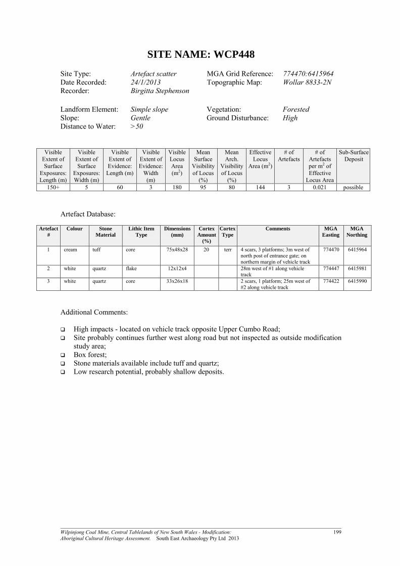
SITE NAME: WCP448
Site Type: Artefact scatter MGA Grid Reference: 774470:6415964 Date Recorded: 24/1/2013 Topographic Map: Wollar 8833-2N Recorder: Birgitta Stephenson
Landform Element: Simple slope Vegetation: Forested Slope: Gentle Ground Disturbance: High Distance to Water: >50
Visible Extent of Surface
Exposures: Length (m)
Visible Extent of Surface
Exposures: Width (m)
Visible Extent of Evidence:
Length (m)
Visible Extent of Evidence:
Width (m)
Visible Locus Area (m2)
Mean Surface
Visibility of Locus
(%)
Mean Arch.
Visibility of Locus
(%)
Effective Locus
Area (m2)
# of Artefacts
# of Artefacts per m2 of Effective
Locus Area
Sub-Surface Deposit
150+ 5 60 3 180 95 80 144 3 0.021 possible
Artefact Database:
Artefact
#
Colour Stone
Material
Lithic Item
Type
Dimensions
(mm)
Cortex
Amount
(%)
Cortex
Type
Comments MGA
Easting
MGA
Northing
1 cream tuff core 75x48x28 20 terr 4 scars, 3 platforms; 3m west of north post of entrance gate; on northern margin of vehicle track
774470 6415964
2 white quartz flake 12x12x4 28m west of #1 along vehicle track
774447 6415981
3 white quartz core 33x26x18 2 scars, 1 platform; 25m west of #2 along vehicle track
774422 6415990
Additional Comments: High impacts - located on vehicle track opposite Upper Cumbo Road; Site probably continues further west along road but not inspected as outside modification
study area; Box forest; Stone materials available include tuff and quartz; Low research potential, probably shallow deposits.

Wilpinjong Coal Mine, Central Tablelands of New South Wales - Modification: 200 Aboriginal Cultural Heritage Assessment. South East Archaeology Pty Ltd 2013
Site Location: WCP448
Photograph: WCP448 (view west)